Embed Size (px)
Citation preview
Environmental Impact Analysis Aesthetics
Draft Environmental Impact Report 4.1-1
4.1 Aesthetics
This section evaluates the proposed project for potential impacts on aesthetics, including scenic vistas, scenic resources, visual character and quality, and light and glare. Sites are grouped by nearest community in unincorporated Sonoma County.
4.1.1 Setting
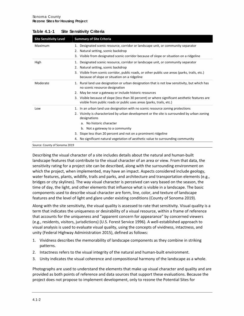
Methodology Evaluating visual impacts can be relatively subjective, but for CEQA analysis, aesthetic impacts are assessed by using methodologies that identify and describe the visual resources, determining the level of quality from public viewing locations, and estimating the level of effect changes to those views would produce. State and federal organizations have developed visual assessment guidelines for various contexts that often provide a basis for the development of local guidelines and standards.1 Sonoma County published its Visual Assessment Guidelines to provide specific steps and criteria for evaluating aesthetic impacts of development throughout the County (County of Sonoma 2019). In brief, the procedure involves determining public viewing points and describing the existing setting for each site, reviewing photographs of the site to understand potential impacts, characterizing the site’s sensitivity following the matrix offered in Table 4.1-1, and determining the potential visual dominance of the proposed project based on criteria described in Table 4.1-4. Based on this evaluation, a potential impact is determined. Where the County’s guidelines do not specifically define criteria for aspects such as overall visual unity, intactness, or vividness, described below, the Federal Highway Administration and U.S. Forest Service guidelines are applied to enhance the discussion.
As addressed in this analysis, aesthetics refers to visual impacts to the environment, both natural and built, and includes adverse changes that reduce visual quality along with potential increases in glare or light in a project area. Aesthetics or visual resource analysis assesses the visible change and anticipated viewer response to that change.
This approach is suitable for use in this program-level analysis but can also be applied to specific projects when they are proposed for any of the Potential Sites. The proposed project does not implement specific development projects, but rather would rezone the Potential Sites so that they can be developed with multi-family residential projects. Because no specific development is proposed, this analysis focuses on a “program-level” evaluation that considers what visual impacts might be if development did ensue on a given site, and if it were to fulfill maximum potential size and density. Thus, sensitivity and dominance as they relate to potential visual impacts are estimated conservatively to present maximum case scenarios for each site.
Site Sensitivity The visual sensitivity on the Potential Sites is rated based on the County’s criteria that generally characterizes a site relative to its aesthetic value to the surrounding community (County of Sonoma 2019). This determination, then, considers both the site itself and the setting in which the site occurs. Criteria used to determine site sensitivity is presented in Table 4.1-1.
1 See for example Bureau of Land Management (1984), Federal Highway Administration (2015), and U.S. Forest Service (1996).
Sonoma County Rezone Sites for Housing Project
4.1-2
Table 4.1-1 Site Sensitivity Criteria Site Sensitivity Level Summary of Site Criteria
Maximum 1. Designated scenic resource, corridor or landscape unit, or community separator 2. Natural setting, scenic backdrop 3. Visible from designated scenic corridor because of slope or situation on a ridgeline
High 1. Designated scenic resource, corridor or landscape unit, or community separator 2. Natural setting, scenic backdrop 3. Visible from scenic corridor, public roads, or other public use areas (parks, trails, etc.)
because of slope or situation on a ridgeline
Moderate 1. Rural land use designation or urban designation that is not low sensitivity, but which has no scenic resource designation
2. May be near a gateway or include historic resources 3. Visible because of slope (less than 30 percent) or where significant aesthetic features are
visible from public roads or public uses areas (parks, trails, etc.)
Low 1. In an urban land use designation with no scenic resource zoning protections 2. Vicinity is characterized by urban development or the site is surrounded by urban zoning
designations a. No historic character b. Not a gateway to a community
3. Slope less than 20 percent and not on a prominent ridgeline 4. No significant natural vegetation of aesthetic value to surrounding community
Source: County of Sonoma 2019
Describing the visual character of a site includes details about the natural and human-built landscape features that contribute to the visual character of an area or view. From that data, the sensitivity rating for a project site can be described, along with the surrounding environment on which the project, when implemented, may have an impact. Aspects considered include geology, water features, plants, wildlife, trails and parks, and architecture and transportation elements (e.g., bridges or city skylines). The way visual character is perceived can vary based on the season, the time of day, the light, and other elements that influence what is visible in a landscape. The basic components used to describe visual character are form, line, color, and texture of landscape features and the level of light and glare under existing conditions (County of Sonoma 2019).
Along with the site sensitivity, the visual quality is assessed to rate that sensitivity. Visual quality is a term that indicates the uniqueness or desirability of a visual resource, within a frame of reference that accounts for the uniqueness and “apparent concern for appearance” by concerned viewers (e.g., residents, visitors, jurisdictions) (U.S. Forest Service 1996). A well-established approach to visual analysis is used to evaluate visual quality, using the concepts of vividness, intactness, and unity (Federal Highway Administration 2015), defined as follows:
1. Vividness describes the memorability of landscape components as they combine in striking patterns.
2. Intactness refers to the visual integrity of the natural and human-built environment. 3. Unity indicates the visual coherence and compositional harmony of the landscape as a whole.
Photographs are used to understand the elements that make up visual character and quality and are provided as both points of reference and data sources that support these evaluations. Because the project does not propose to implement development, only to rezone the Potential Sites for
Environmental Impact Analysis Aesthetics
Draft Environmental Impact Report 4.1-3
residential land use, simulations or conceptualizations are not produced in this analysis. Rather, the photographs are used to understand the context in which development could occur when the sites are rezoned, and to estimate the associated impact based on potential visual dominance from public roadways or other public viewing areas, if the sites are built out to the maximum allowable density and height.
Visual Dominance After the site sensitivity is determined, visual dominance is determined based on how prominent a project would be when developed. Again, because the project does not propose specific development, this analysis assesses the potential dominance if maximum height and density are built and if most or all existing vegetation is removed. The development dominance criteria are based on the County guidelines, as follows:
1. Dominant: project elements stand out, contrast with the existing landscape (built and natural) 2. Co-Dominant: project elements attract attention equally with other features and are compatible
with surroundings 3. Subordinate: project elements can be seen but do not attract attention, repeat forms, colors,
textures of surroundings 4. Inevident: project not visible from public view due to intervening natural landforms or
vegetation
Impact Determination Finally, the visual impact significance is determined by combining the sensitivity with the visual dominance evaluations such that higher levels of sensitivity and dominance combine to create significant impacts and lesser ones to create less than significant impacts. Once the impact is determined, the County Guidelines offer measures designed to reduce impacts through design, landscaping, materials, screening, and limiting lighting. These are applied to potential impacts by sites where impacts could be significant.
CEQA analysis was conducted using knowledge of thresholds that meet the CEQA Guidelines and industry standards for the assessment of visual impacts. These criteria were then framed within the County’s Visual Assessment Guidelines language/format; while the language is somewhat different, the process is ostensibly the same as are the conclusions.
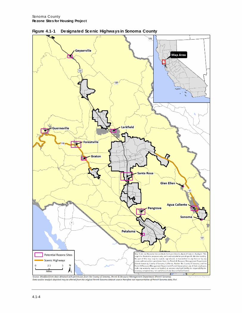
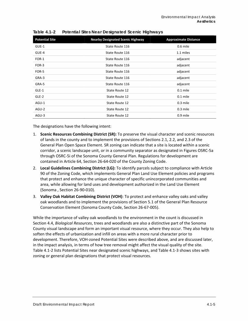
4.1.2 Scenic Zoning Many roadways throughout Sonoma County offer views of scenic areas. The General Plan designates an extensive network of scenic corridors and highways that are protected by development standards. Two roadways are officially designated as part of the State Scenic Highway system: State Route 116 from State Route 1 through Guerneville to the Sebastopol city limit, and State Route 12 from Danielli Avenue east of Santa Rosa to London Way near Agua Caliente (Caltrans 2019). Table 4.1-2 indicates the approximate distance of the Potential Sites that occur near scenic highways to that highway. Other County roadways designated as scenic corridors and potentially near the proposed project include Arnold Drive (GLE-1, GLE-2, AGU-1, AGU-2, and AGU-3) Petaluma Hill Road (PEN-5), and Bodega Avenue (PET-1, PET-2, PET-3, and PET-4). Figure 4.1-1 shows the designated scenic highways and indicates their proximity to the Potential Sites.
Sonoma County Rezone Sites for Housing Project
4.1-4
Figure 4.1-1 Designated Scenic Highways in Sonoma County
Environmental Impact Analysis Aesthetics
Draft Environmental Impact Report 4.1-5
Table 4.1-2 Potential Sites Near Designated Scenic Highways Potential Site Nearby Designated Scenic Highway Approximate Distance
GUE-1 State Route 116 0.6 mile
GUE-4 State Route 116 1.1 miles
FOR-1 State Route 116 adjacent
FOR-3 State Route 116 adjacent
FOR-5 State Route 116 adjacent
GRA-3 State Route 116 adjacent
GRA-5 State Route 116 adjacent
GLE-1 State Route 12 0.1 mile
GLE-2 State Route 12 0.1 mile
AGU-1 State Route 12 0.3 mile
AGU-2 State Route 12 0.3 mile
AGU-3 State Route 12 0.9 mile
The designations have the following intent:
1. Scenic Resources Combining District (SR): To preserve the visual character and scenic resources of lands in the county and to implement the provisions of Sections 2.1, 2.2, and 2.3 of the General Plan Open Space Element. SR zoning can indicate that a site is located within a scenic corridor, a scenic landscape unit, or in a community separator as designated in Figures OSRC-5a through OSRC-5i of the Sonoma County General Plan. Regulations for development are contained in Article 64, Section 26-64-020 of the County Zoning Code.
2. Local Guidelines Combining District (LG): To identify parcels subject to compliance with Article 90 of the Zoning Code, which implements General Plan Land Use Element policies and programs that protect and enhance the unique character of specific unincorporated communities and area, while allowing for land uses and development authorized in the Land Use Element (Sonoma , Section 26-90-010).
3. Valley Oak Habitat Combining District (VOH): To protect and enhance valley oaks and valley oak woodlands and to implement the provisions of Section 5.1 of the General Plan Resource Conservation Element (Sonoma County Code, Section 26-67-005).
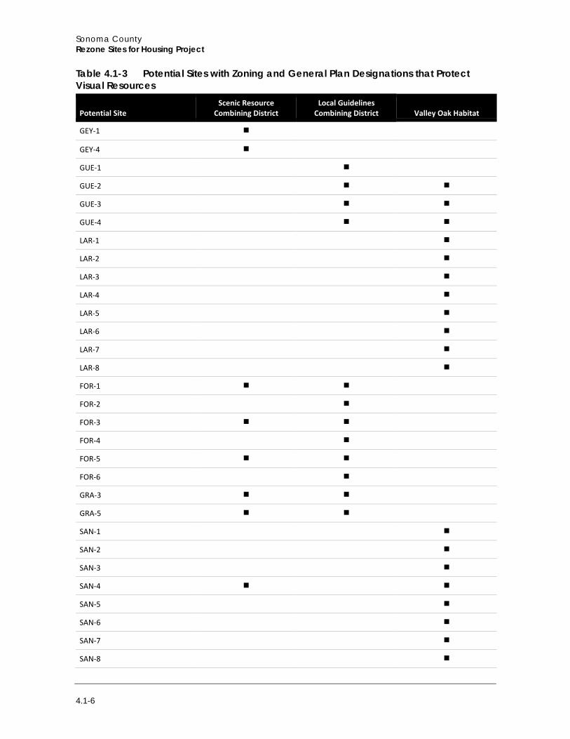
While the importance of valley oak woodlands to the environment in the count is discussed in Section 4.4, Biological Resources, trees and woodlands are also a distinctive part of the Sonoma County visual landscape and form an important visual resource, where they occur. They also help to soften the effects of urbanization and infill on areas with a more rural character prior to development. Therefore, VOH-zoned Potential Sites were described above, and are discussed later, in the impact analysis, in terms of how tree removal might affect the visual quality of the site. Table 4.1-2 lists Potential Sites near designated scenic highways, and Table 4.1-3 shows sites with zoning or general plan designations that protect visual resources.
Sonoma County Rezone Sites for Housing Project
4.1-6
Table 4.1-3 Potential Sites with Zoning and General Plan Designations that Protect Visual Resources
Potential Site Scenic Resource
Combining District Local Guidelines
Combining District Valley Oak Habitat
GEY-1
GEY-4
GUE-1
GUE-2
GUE-3
GUE-4
LAR-1
LAR-2
LAR-3
LAR-4
LAR-5
LAR-6
LAR-7
LAR-8
FOR-1
FOR-2
FOR-3
FOR-4
FOR-5
FOR-6
GRA-3
GRA-5
SAN-1
SAN-2
SAN-3
SAN-4
SAN-5
SAN-6
SAN-7
SAN-8
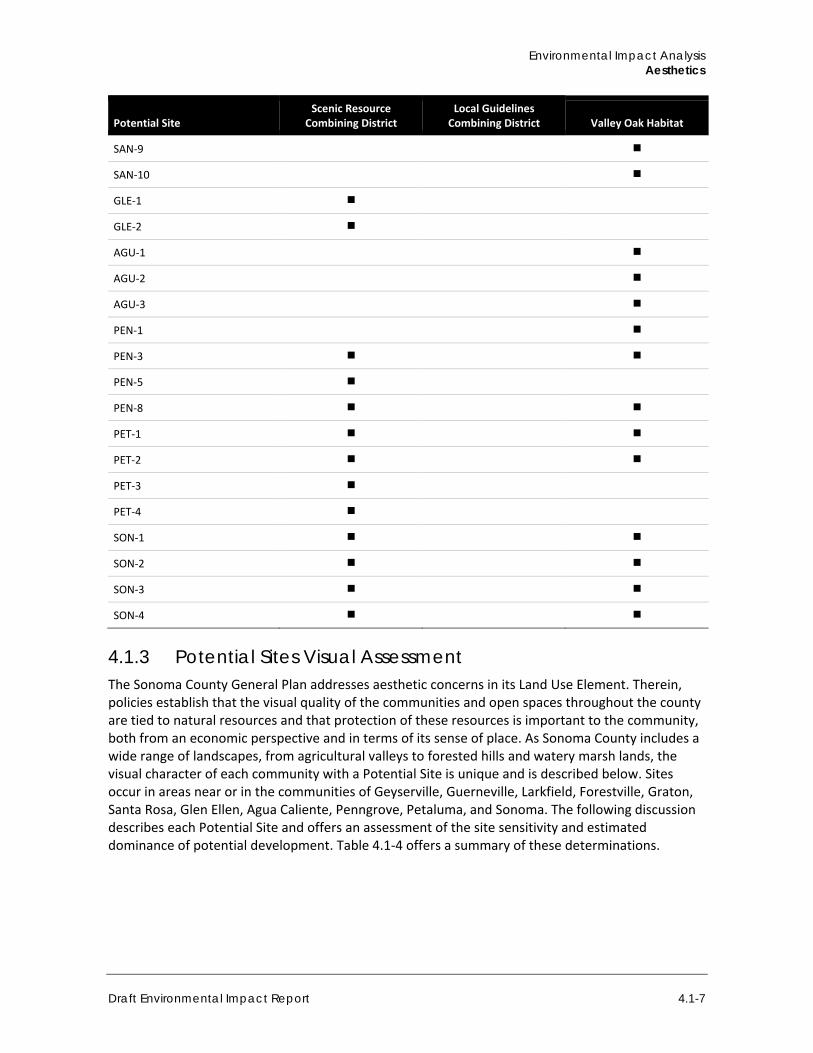
Environmental Impact Analysis Aesthetics
Draft Environmental Impact Report 4.1-7
Potential Site Scenic Resource
Combining District Local Guidelines
Combining District Valley Oak Habitat
SAN-9
SAN-10
GLE-1
GLE-2
AGU-1
AGU-2
AGU-3
PEN-1
PEN-3
PEN-5
PEN-8
PET-1
PET-2
PET-3
PET-4
SON-1
SON-2
SON-3
SON-4
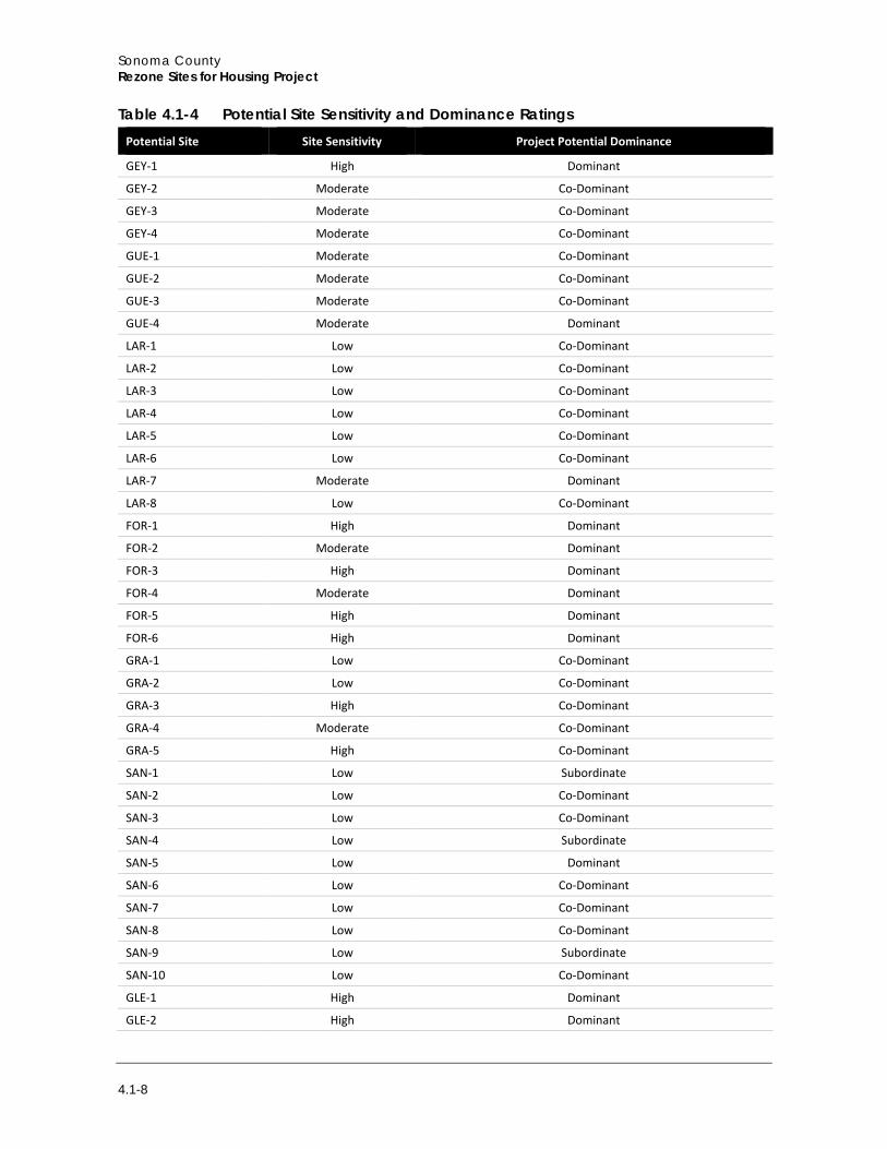
4.1.3 Potential Sites Visual Assessment The Sonoma County General Plan addresses aesthetic concerns in its Land Use Element. Therein, policies establish that the visual quality of the communities and open spaces throughout the county are tied to natural resources and that protection of these resources is important to the community, both from an economic perspective and in terms of its sense of place. As Sonoma County includes a wide range of landscapes, from agricultural valleys to forested hills and watery marsh lands, the visual character of each community with a Potential Site is unique and is described below. Sites occur in areas near or in the communities of Geyserville, Guerneville, Larkfield, Forestville, Graton, Santa Rosa, Glen Ellen, Agua Caliente, Penngrove, Petaluma, and Sonoma. The following discussion describes each Potential Site and offers an assessment of the site sensitivity and estimated dominance of potential development. Table 4.1-4 offers a summary of these determinations.
Sonoma County Rezone Sites for Housing Project
4.1-8
Table 4.1-4 Potential Site Sensitivity and Dominance Ratings Potential Site Site Sensitivity Project Potential Dominance
GEY-1 High Dominant
GEY-2 Moderate Co-Dominant
GEY-3 Moderate Co-Dominant
GEY-4 Moderate Co-Dominant
GUE-1 Moderate Co-Dominant
GUE-2 Moderate Co-Dominant
GUE-3 Moderate Co-Dominant
GUE-4 Moderate Dominant
LAR-1 Low Co-Dominant
LAR-2 Low Co-Dominant
LAR-3 Low Co-Dominant
LAR-4 Low Co-Dominant
LAR-5 Low Co-Dominant
LAR-6 Low Co-Dominant
LAR-7 Moderate Dominant
LAR-8 Low Co-Dominant
FOR-1 High Dominant
FOR-2 Moderate Dominant
FOR-3 High Dominant
FOR-4 Moderate Dominant
FOR-5 High Dominant
FOR-6 High Dominant
GRA-1 Low Co-Dominant
GRA-2 Low Co-Dominant
GRA-3 High Co-Dominant
GRA-4 Moderate Co-Dominant
GRA-5 High Co-Dominant
SAN-1 Low Subordinate
SAN-2 Low Co-Dominant
SAN-3 Low Co-Dominant
SAN-4 Low Subordinate
SAN-5 Low Dominant
SAN-6 Low Co-Dominant
SAN-7 Low Co-Dominant
SAN-8 Low Co-Dominant
SAN-9 Low Subordinate
SAN-10 Low Co-Dominant
GLE-1 High Dominant
GLE-2 High Dominant
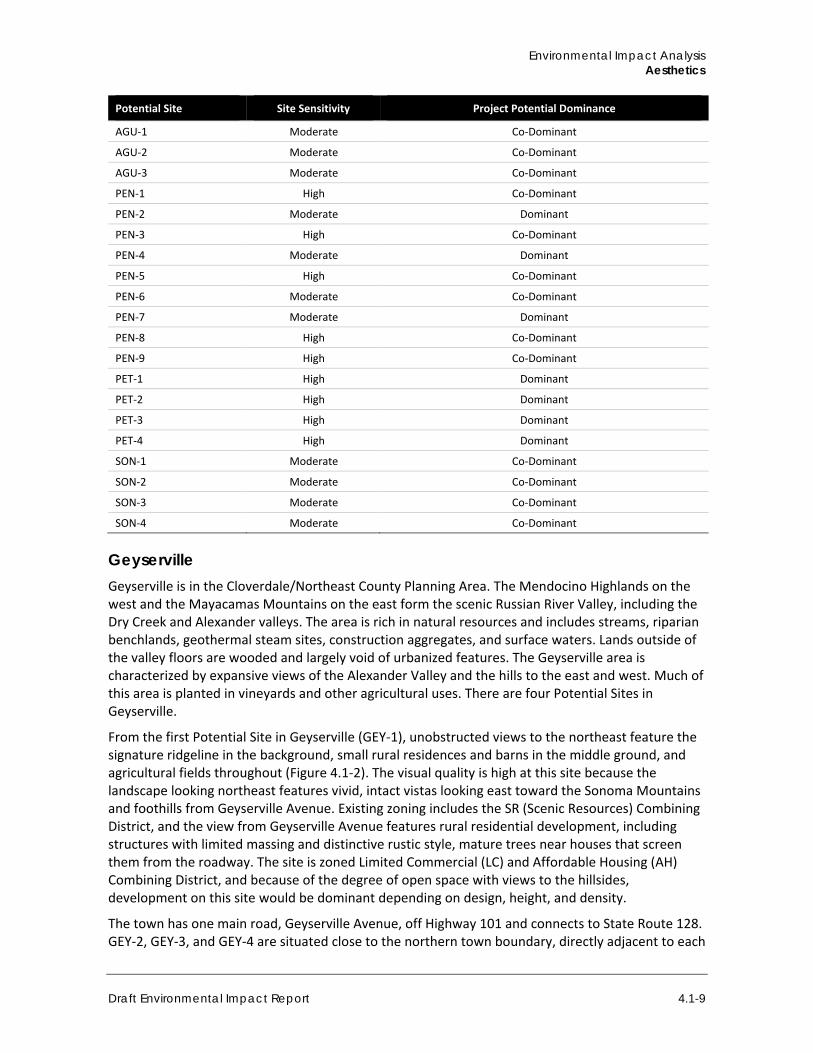
Environmental Impact Analysis Aesthetics
Draft Environmental Impact Report 4.1-9
Potential Site Site Sensitivity Project Potential Dominance
AGU-1 Moderate Co-Dominant
AGU-2 Moderate Co-Dominant
AGU-3 Moderate Co-Dominant
PEN-1 High Co-Dominant
PEN-2 Moderate Dominant
PEN-3 High Co-Dominant
PEN-4 Moderate Dominant
PEN-5 High Co-Dominant
PEN-6 Moderate Co-Dominant
PEN-7 Moderate Dominant
PEN-8 High Co-Dominant
PEN-9 High Co-Dominant
PET-1 High Dominant
PET-2 High Dominant
PET-3 High Dominant
PET-4 High Dominant
SON-1 Moderate Co-Dominant
SON-2 Moderate Co-Dominant
SON-3 Moderate Co-Dominant
SON-4 Moderate Co-Dominant
Geyserville Geyserville is in the Cloverdale/Northeast County Planning Area. The Mendocino Highlands on the west and the Mayacamas Mountains on the east form the scenic Russian River Valley, including the Dry Creek and Alexander valleys. The area is rich in natural resources and includes streams, riparian benchlands, geothermal steam sites, construction aggregates, and surface waters. Lands outside of the valley floors are wooded and largely void of urbanized features. The Geyserville area is characterized by expansive views of the Alexander Valley and the hills to the east and west. Much of this area is planted in vineyards and other agricultural uses. There are four Potential Sites in Geyserville.
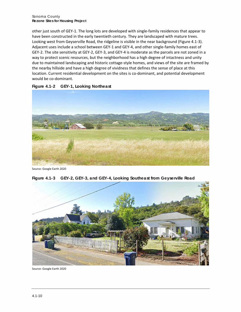
From the first Potential Site in Geyserville (GEY-1), unobstructed views to the northeast feature the signature ridgeline in the background, small rural residences and barns in the middle ground, and agricultural fields throughout (Figure 4.1-2). The visual quality is high at this site because the landscape looking northeast features vivid, intact vistas looking east toward the Sonoma Mountains and foothills from Geyserville Avenue. Existing zoning includes the SR (Scenic Resources) Combining District, and the view from Geyserville Avenue features rural residential development, including structures with limited massing and distinctive rustic style, mature trees near houses that screen them from the roadway. The site is zoned Limited Commercial (LC) and Affordable Housing (AH) Combining District, and because of the degree of open space with views to the hillsides, development on this site would be dominant depending on design, height, and density.
The town has one main road, Geyserville Avenue, off Highway 101 and connects to State Route 128. GEY-2, GEY-3, and GEY-4 are situated close to the northern town boundary, directly adjacent to each
Sonoma County Rezone Sites for Housing Project
4.1-10
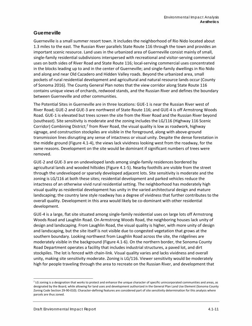
other just south of GEY-1. The long lots are developed with single-family residences that appear to have been constructed in the early twentieth century. They are landscaped with mature trees. Looking west from Geyserville Road, the ridgeline is visible in the near background (Figure 4.1-3). Adjacent uses include a school between GEY-1 and GEY-4, and other single-family homes east of GEY-2. The site sensitivity at GEY-2, GEY-3, and GEY-4 is moderate as the parcels are not zoned in a way to protect scenic resources, but the neighborhood has a high degree of intactness and unity due to maintained landscaping and historic cottage-style homes, and views of the site are framed by the nearby hillside and have a high degree of vividness that defines the sense of place at this location. Current residential development on the sites is co-dominant, and potential development would be co-dominant.
Figure 4.1-2 GEY-1, Looking Northeast
Source: Google Earth 2020
Figure 4.1-3 GEY-2, GEY-3, and GEY-4, Looking Southeast from Geyserville Road
Source: Google Earth 2020
Environmental Impact Analysis Aesthetics
Draft Environmental Impact Report 4.1-11
Guerneville Guerneville is a small summer resort town. It includes the neighborhood of Rio Nido located about 1.3 miles to the east. The Russian River parallels State Route 116 through the town and provides an important scenic resource. Land uses in the urbanized area of Guerneville consist mainly of small, single-family residential subdivisions interspersed with recreational and visitor-serving commercial uses on both sides of River Road and State Route 116; local-serving commercial uses concentrated in the blocks leading up to and in the center of Guerneville; and single-family dwellings in Rio Nido and along and near Old Cazadero and Hidden Valley roads. Beyond the urbanized area, small pockets of rural residential development and agricultural and natural resource lands occur (County of Sonoma 2016). The County General Plan notes that the view corridor along State Route 116 contains unique views of orchards, redwood stands, and the Russian River and defines the boundary between Guerneville and other communities.
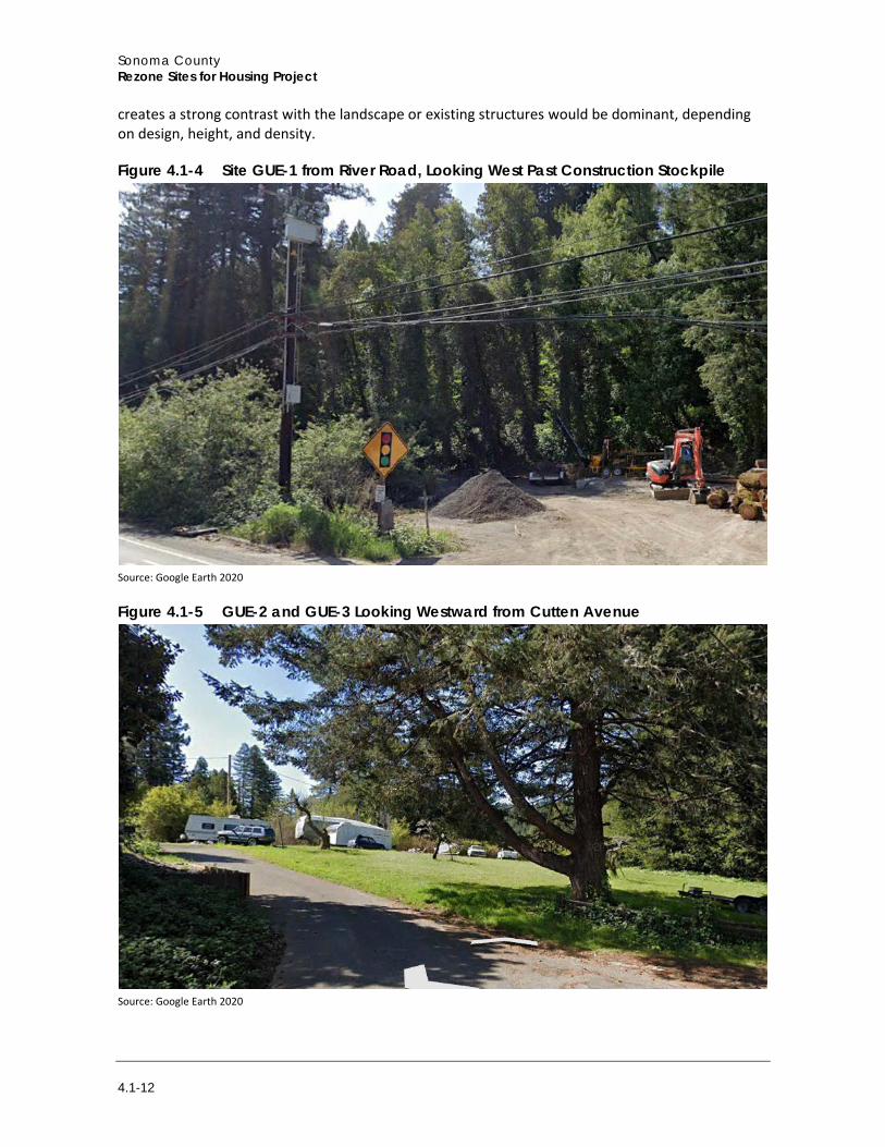
The Potential Sites in Guerneville are in three locations: GUE-1 is near the Russian River west of River Road; GUE-2 and GUE-3 are northwest of State Route 116; and GUE-4 is off Armstrong Woods Road. GUE-1 is elevated but trees screen the site from the River Road and the Russian River beyond (southeast). Site sensitivity is moderate and the zoning includes the LG/116 (Highway 116 Scenic Corridor) Combining District;2 from River Road, the visual quality is low as roadwork, highway signage, and construction stockpiles are visible in the foreground, along with above-ground transmission lines disrupting any sense of intactness or visual unity. Despite the dense forestation in the middle ground (Figure 4.1-4), the views lack vividness looking west from the roadway, for the same reasons. Development on the site would be dominant if significant numbers of trees were removed.
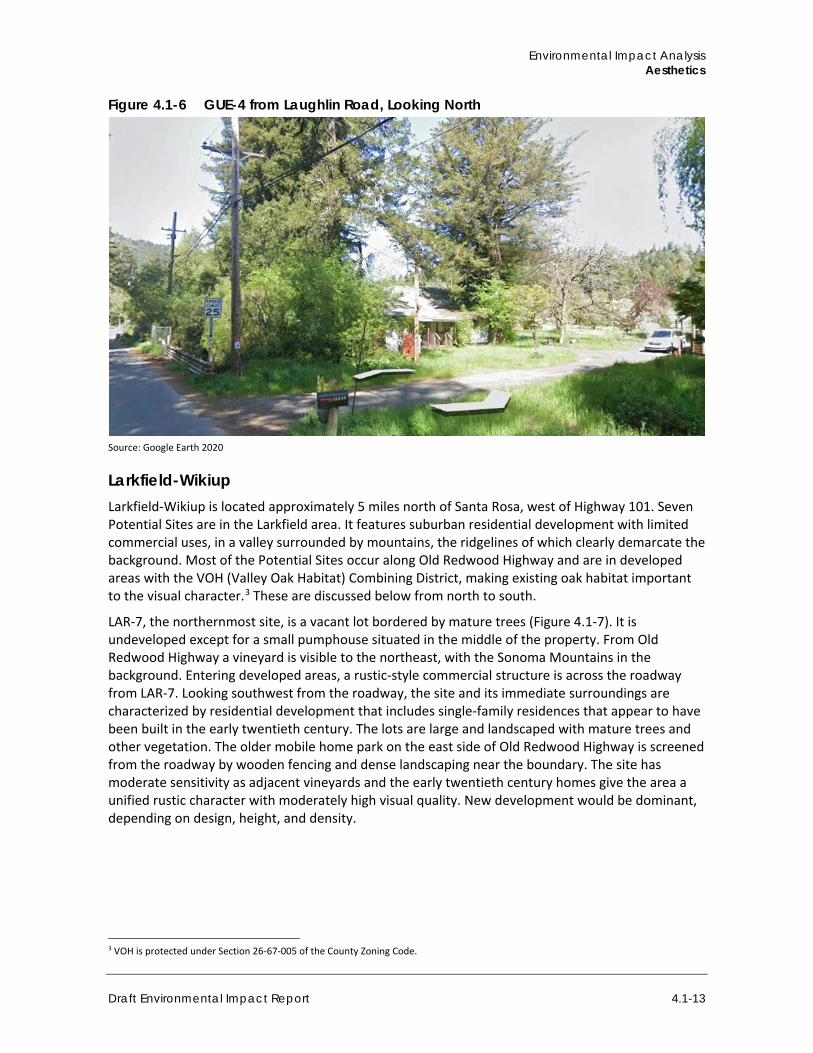
GUE-2 and GUE-3 are on undeveloped lands among single-family residences bordered by agricultural lands and wooded hillsides (Figure 4.1-5). Nearby foothills are visible from the street through the undeveloped or sparsely developed adjacent lots. Site sensitivity is moderate and the zoning is LG/116 at both these sites; residential development and parked vehicles reduce the intactness of an otherwise vivid rural residential setting. The neighborhood has moderately high visual quality as residential development has unity in the varied architectural design and mature landscaping; the country lane style roadway has a degree of vividness that further contributes to the overall quality. Development in this area would likely be co-dominant with other residential development.
GUE-4 is a large, flat site situated among single-family residential uses on large lots off Armstrong Woods Road and Laughlin Road. On Armstrong Woods Road, the neighboring houses lack unity of design and landscaping. From Laughlin Road, the visual quality is higher, with more unity of design and landscaping, but the site itself is not visible due to congested vegetation that grows at the southern boundary. Looking northwest from Laughlin Road across the site, the ridgelines are moderately visible in the background (Figure 4.1-6). On the northern border, the Sonoma County Road Department operates a facility that includes industrial structures, a paved lot, and dirt stockpiles. The lot is fenced with chain-link. Visual quality varies and lacks vividness and overall unity, making site sensitivity moderate. Zoning is LG/116. Viewer sensitivity would be moderately high for people traveling through the area to recreate on the Russian River, and development that
2 LG zoning is a designation that works to protect and enhance the unique character of specific unincorporated communities and areas, as designated by the Board, while allowing for land uses and development authorized in the General Plan Land Use Element (Sonoma County Zoning Code Section 29-90-010). Character-defining features are considered part of site sensitivity determination for this analysis where parcels are thus zoned.
Sonoma County Rezone Sites for Housing Project
4.1-12
creates a strong contrast with the landscape or existing structures would be dominant, depending on design, height, and density.
Figure 4.1-4 Site GUE-1 from River Road, Looking West Past Construction Stockpile
Source: Google Earth 2020
Figure 4.1-5 GUE-2 and GUE-3 Looking Westward from Cutten Avenue
Source: Google Earth 2020
Environmental Impact Analysis Aesthetics
Draft Environmental Impact Report 4.1-13
Figure 4.1-6 GUE-4 from Laughlin Road, Looking North
Source: Google Earth 2020
Larkfield-Wikiup Larkfield-Wikiup is located approximately 5 miles north of Santa Rosa, west of Highway 101. Seven Potential Sites are in the Larkfield area. It features suburban residential development with limited commercial uses, in a valley surrounded by mountains, the ridgelines of which clearly demarcate the background. Most of the Potential Sites occur along Old Redwood Highway and are in developed areas with the VOH (Valley Oak Habitat) Combining District, making existing oak habitat important to the visual character.3 These are discussed below from north to south.
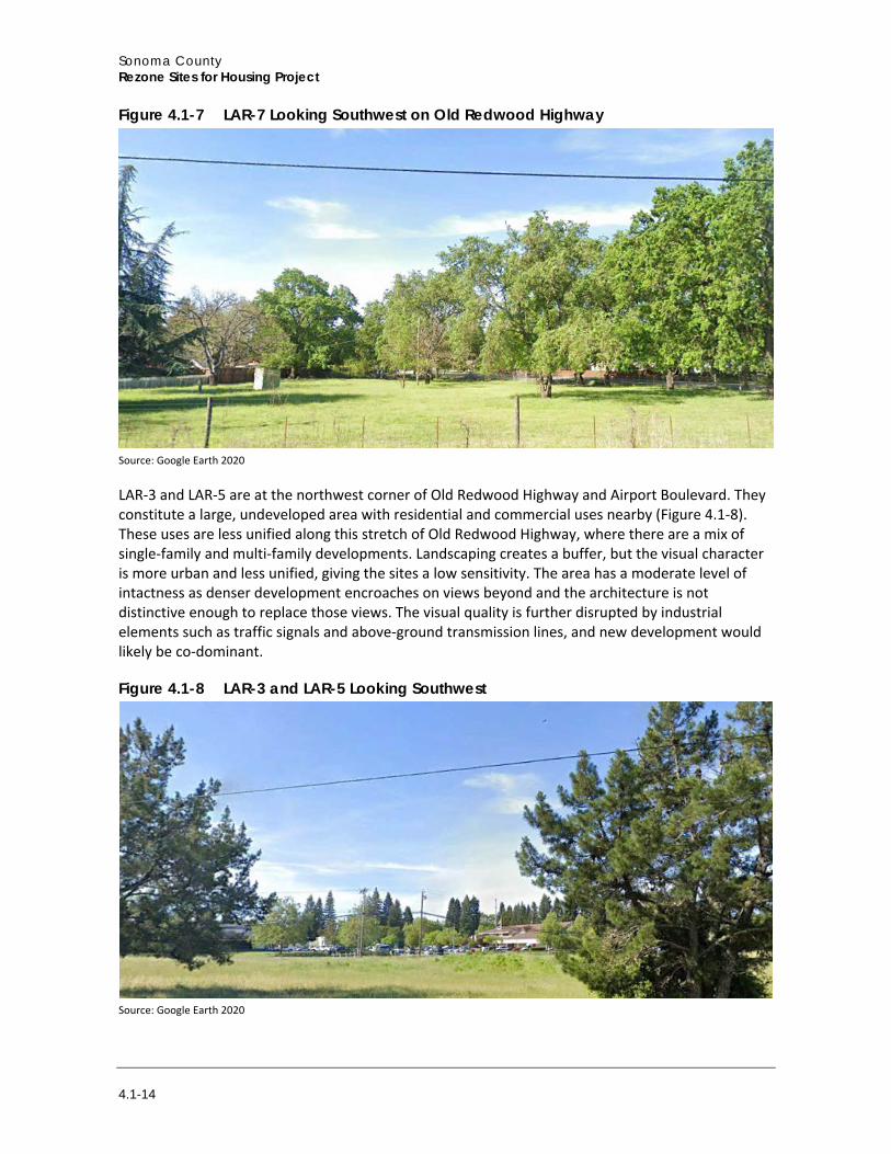
LAR-7, the northernmost site, is a vacant lot bordered by mature trees (Figure 4.1-7). It is undeveloped except for a small pumphouse situated in the middle of the property. From Old Redwood Highway a vineyard is visible to the northeast, with the Sonoma Mountains in the background. Entering developed areas, a rustic-style commercial structure is across the roadway from LAR-7. Looking southwest from the roadway, the site and its immediate surroundings are characterized by residential development that includes single-family residences that appear to have been built in the early twentieth century. The lots are large and landscaped with mature trees and other vegetation. The older mobile home park on the east side of Old Redwood Highway is screened from the roadway by wooden fencing and dense landscaping near the boundary. The site has moderate sensitivity as adjacent vineyards and the early twentieth century homes give the area a unified rustic character with moderately high visual quality. New development would be dominant, depending on design, height, and density.
3 VOH is protected under Section 26-67-005 of the County Zoning Code.
Sonoma County Rezone Sites for Housing Project
4.1-14
Figure 4.1-7 LAR-7 Looking Southwest on Old Redwood Highway
Source: Google Earth 2020
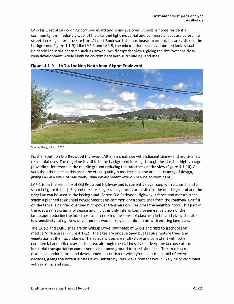
LAR-3 and LAR-5 are at the northwest corner of Old Redwood Highway and Airport Boulevard. They constitute a large, undeveloped area with residential and commercial uses nearby (Figure 4.1-8). These uses are less unified along this stretch of Old Redwood Highway, where there are a mix of single-family and multi-family developments. Landscaping creates a buffer, but the visual character is more urban and less unified, giving the sites a low sensitivity. The area has a moderate level of intactness as denser development encroaches on views beyond and the architecture is not distinctive enough to replace those views. The visual quality is further disrupted by industrial elements such as traffic signals and above-ground transmission lines, and new development would likely be co-dominant.
Figure 4.1-8 LAR-3 and LAR-5 Looking Southwest
Source: Google Earth 2020
Environmental Impact Analysis Aesthetics
Draft Environmental Impact Report 4.1-15
LAR-4 is west of LAR-5 on Airport Boulevard and is undeveloped. A mobile home residential community is immediately west of the site, and light-industrial and commercial uses are across the street. Looking across the site from Airport Boulevard, the northeastern mountains are visible in the background (Figure 4.1-9). Like LAR-3 and LAR-5, the mix of urbanized development lacks visual unity and industrial features such as power lines disrupt the views, giving the site low sensitivity. New development would likely be co-dominant with surrounding land uses.
Figure 4.1-9 LAR-4 Looking North from Airport Boulevard
Source: Google Earth 2020
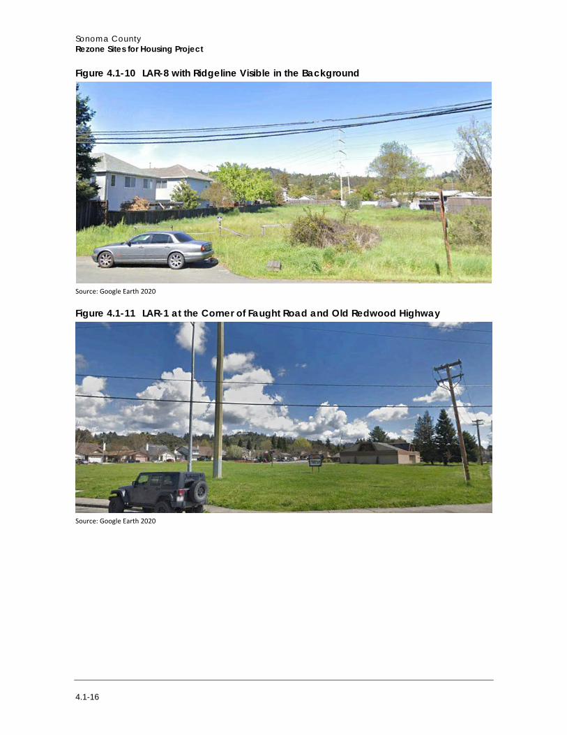
Further south on Old Redwood Highway, LAR-8 is a small site with adjacent single- and multi-family residential uses. The ridgeline is visible in the background looking through the site, but high-voltage powerlines intervene in the middle ground reducing the intactness of the view (Figure 4.1-10). As with the other sites in this area, the visual quality is moderate as the area lacks unity of design, giving LAR-8 a low site sensitivity. New development would likely be co-dominant.
LAR-1 is on the east side of Old Redwood Highway and is currently developed with a church and a school (Figure 4.1-11). Beyond the site, single-family homes are visible in the middle ground and the ridgeline can be seen in the background. Across Old Redwood Highway, a fence and mature trees shield a planned residential development and common open space area from the roadway. Graffiti on the fence is painted over and high-power transmission lines cross the neighborhood. This part of the roadway lacks unity of design and includes only intermittent longer-range views of the landscape, reducing the intactness and rendering the sense of place negligible and giving the site a low sensitivity rating. New development would likely be co-dominant with existing land uses.
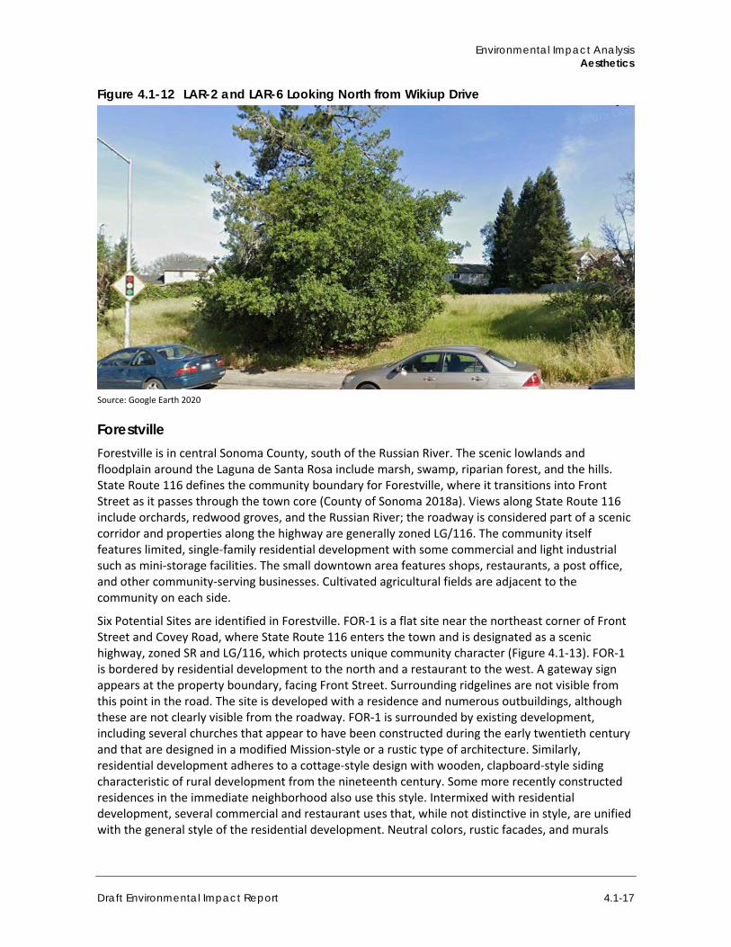
The LAR-2 and LAR-6 sites are on Wikiup Drive, southeast of LAR-1 and next to a school and medical/office uses (Figure 4.1-12). The sites are undeveloped but feature mature trees and vegetation at their boundaries. The adjacent uses are multi-story and consistent with other commercial and office uses in the area, although the vividness is relatively low because of the industrial transportation components and above-ground transmission lines. The area has no distinctive architecture, and development is consistent with typical suburban infill of recent decades, giving the Potential Sites a low sensitivity. New development would likely be co-dominant with existing land uses.
Sonoma County Rezone Sites for Housing Project
4.1-16
Figure 4.1-10 LAR-8 with Ridgeline Visible in the Background
Source: Google Earth 2020
Figure 4.1-11 LAR-1 at the Corner of Faught Road and Old Redwood Highway
Source: Google Earth 2020
Environmental Impact Analysis Aesthetics
Draft Environmental Impact Report 4.1-17
Figure 4.1-12 LAR-2 and LAR-6 Looking North from Wikiup Drive
Source: Google Earth 2020
Forestville Forestville is in central Sonoma County, south of the Russian River. The scenic lowlands and floodplain around the Laguna de Santa Rosa include marsh, swamp, riparian forest, and the hills. State Route 116 defines the community boundary for Forestville, where it transitions into Front Street as it passes through the town core (County of Sonoma 2018a). Views along State Route 116 include orchards, redwood groves, and the Russian River; the roadway is considered part of a scenic corridor and properties along the highway are generally zoned LG/116. The community itself features limited, single-family residential development with some commercial and light industrial such as mini-storage facilities. The small downtown area features shops, restaurants, a post office, and other community-serving businesses. Cultivated agricultural fields are adjacent to the community on each side.
Six Potential Sites are identified in Forestville. FOR-1 is a flat site near the northeast corner of Front Street and Covey Road, where State Route 116 enters the town and is designated as a scenic highway, zoned SR and LG/116, which protects unique community character (Figure 4.1-13). FOR-1 is bordered by residential development to the north and a restaurant to the west. A gateway sign appears at the property boundary, facing Front Street. Surrounding ridgelines are not visible from this point in the road. The site is developed with a residence and numerous outbuildings, although these are not clearly visible from the roadway. FOR-1 is surrounded by existing development, including several churches that appear to have been constructed during the early twentieth century and that are designed in a modified Mission-style or a rustic type of architecture. Similarly, residential development adheres to a cottage-style design with wooden, clapboard-style siding characteristic of rural development from the nineteenth century. Some more recently constructed residences in the immediate neighborhood also use this style. Intermixed with residential development, several commercial and restaurant uses that, while not distinctive in style, are unified with the general style of the residential development. Neutral colors, rustic facades, and murals
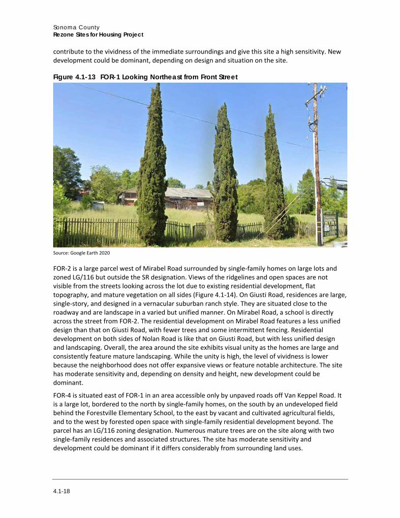
Sonoma County Rezone Sites for Housing Project
4.1-18
contribute to the vividness of the immediate surroundings and give this site a high sensitivity. New development could be dominant, depending on design and situation on the site.
Figure 4.1-13 FOR-1 Looking Northeast from Front Street
Source: Google Earth 2020
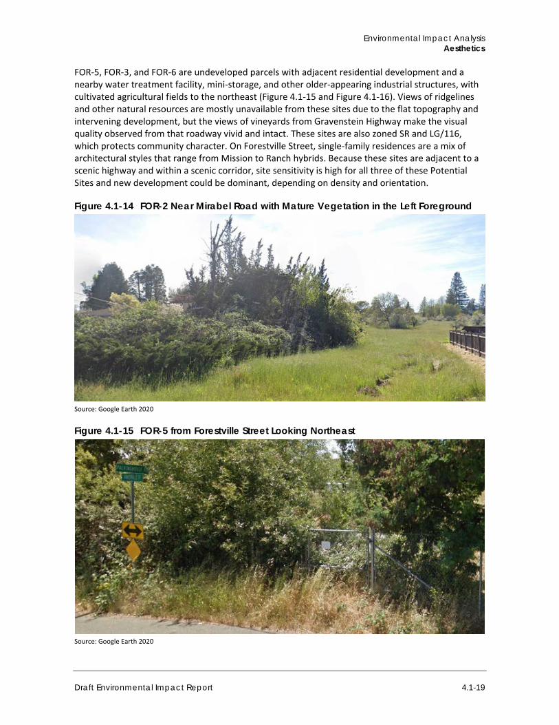
FOR-2 is a large parcel west of Mirabel Road surrounded by single-family homes on large lots and zoned LG/116 but outside the SR designation. Views of the ridgelines and open spaces are not visible from the streets looking across the lot due to existing residential development, flat topography, and mature vegetation on all sides (Figure 4.1-14). On Giusti Road, residences are large, single-story, and designed in a vernacular suburban ranch style. They are situated close to the roadway and are landscape in a varied but unified manner. On Mirabel Road, a school is directly across the street from FOR-2. The residential development on Mirabel Road features a less unified design than that on Giusti Road, with fewer trees and some intermittent fencing. Residential development on both sides of Nolan Road is like that on Giusti Road, but with less unified design and landscaping. Overall, the area around the site exhibits visual unity as the homes are large and consistently feature mature landscaping. While the unity is high, the level of vividness is lower because the neighborhood does not offer expansive views or feature notable architecture. The site has moderate sensitivity and, depending on density and height, new development could be dominant.
FOR-4 is situated east of FOR-1 in an area accessible only by unpaved roads off Van Keppel Road. It is a large lot, bordered to the north by single-family homes, on the south by an undeveloped field behind the Forestville Elementary School, to the east by vacant and cultivated agricultural fields, and to the west by forested open space with single-family residential development beyond. The parcel has an LG/116 zoning designation. Numerous mature trees are on the site along with two single-family residences and associated structures. The site has moderate sensitivity and development could be dominant if it differs considerably from surrounding land uses.
Environmental Impact Analysis Aesthetics
Draft Environmental Impact Report 4.1-19
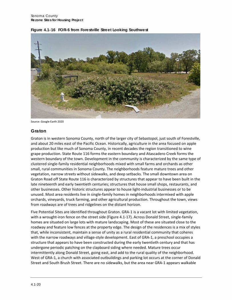
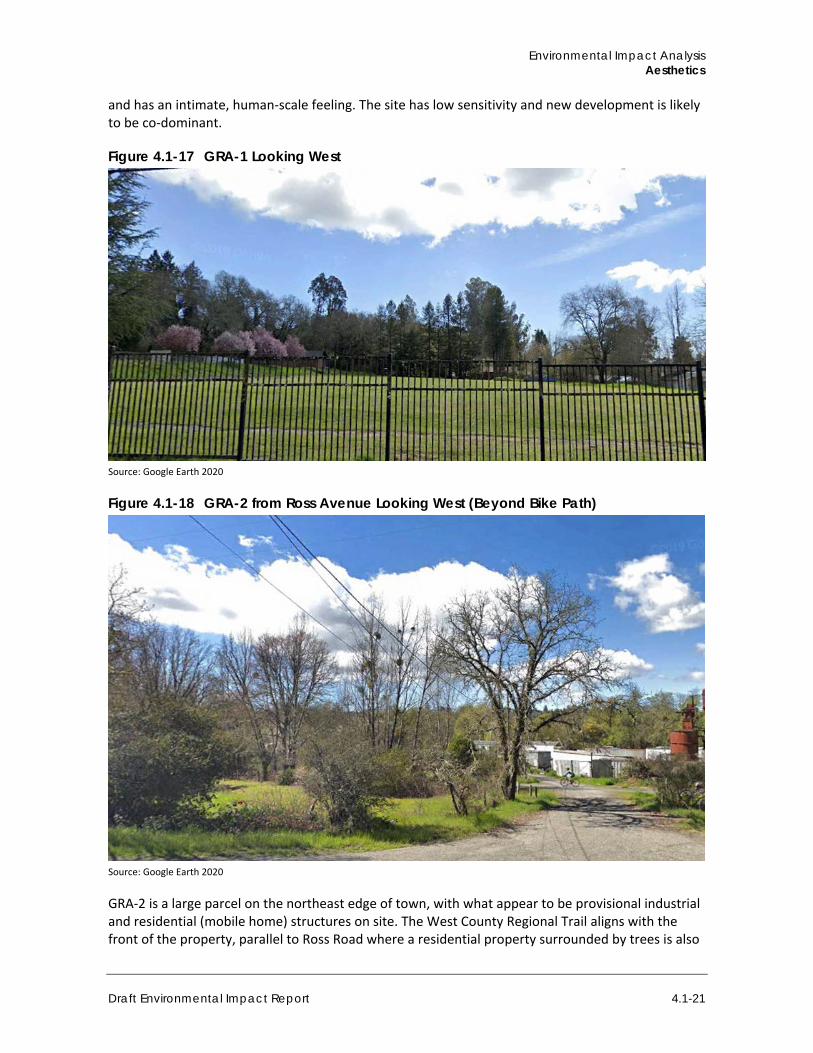
FOR-5, FOR-3, and FOR-6 are undeveloped parcels with adjacent residential development and a nearby water treatment facility, mini-storage, and other older-appearing industrial structures, with cultivated agricultural fields to the northeast (Figure 4.1-15 and Figure 4.1-16). Views of ridgelines and other natural resources are mostly unavailable from these sites due to the flat topography and intervening development, but the views of vineyards from Gravenstein Highway make the visual quality observed from that roadway vivid and intact. These sites are also zoned SR and LG/116, which protects community character. On Forestville Street, single-family residences are a mix of architectural styles that range from Mission to Ranch hybrids. Because these sites are adjacent to a scenic highway and within a scenic corridor, site sensitivity is high for all three of these Potential Sites and new development could be dominant, depending on density and orientation.
Figure 4.1-14 FOR-2 Near Mirabel Road with Mature Vegetation in the Left Foreground
Source: Google Earth 2020
Figure 4.1-15 FOR-5 from Forestville Street Looking Northeast
Source: Google Earth 2020
Sonoma County Rezone Sites for Housing Project
4.1-20
Figure 4.1-16 FOR-6 from Forestville Street Looking Southwest
Source: Google Earth 2020
Graton Graton is in western Sonoma County, north of the larger city of Sebastopol, just south of Forestville, and about 20 miles east of the Pacific Ocean. Historically, agriculture in the area focused on apple production but like much of Sonoma County, in recent decades the region transitioned to wine grape production. State Route 116 forms the eastern boundary and Atascadero Creek forms the western boundary of the town. Development in the community is characterized by the same type of clustered single-family residential neighborhoods mixed with small farms and orchards as other small, rural communities in Sonoma County. The neighborhoods feature mature trees and other vegetation, narrow streets without sidewalks, and deep setbacks. The small downtown area on Graton Road off State Route 116 is characterized by structures that appear to have been built in the late nineteenth and early twentieth centuries; structures that house small shops, restaurants, and other businesses. Other historic structures appear to house light-industrial businesses or to be unused. Most area residents live in single-family homes in neighborhoods intermixed with apple orchards, vineyards, truck farming, and other agricultural production. Throughout the town, views from roadways are of trees and ridgelines on the distant horizon.
Five Potential Sites are identified throughout Graton. GRA-1 is a vacant lot with limited vegetation, with a wrought-iron fence on the street side (Figure 4.1-17). Across Donald Street, single-family homes are situated on large lots with mature landscaping. Most of these are situated close to the roadway and feature low fences at the property edge. The design of the residences is a mix of styles that, while inconsistent, maintain a sense of unity as a rural residential community that coheres with the narrow roadways and village-style development. East of GRA-1, a preschool occupies a structure that appears to have been constructed during the early twentieth century and that has undergone periodic patching on the clapboard siding where needed. Mature trees occur intermittently along Donald Street, going east, and add to the rural quality of the neighborhood. West of GRA-1, a church with associated outbuildings and parking lot occurs at the corner of Donald Street and South Brush Street. There are no sidewalks, but the area near GRA-1 appears walkable
Environmental Impact Analysis Aesthetics
Draft Environmental Impact Report 4.1-21
and has an intimate, human-scale feeling. The site has low sensitivity and new development is likely to be co-dominant.
Figure 4.1-17 GRA-1 Looking West
Source: Google Earth 2020
Figure 4.1-18 GRA-2 from Ross Avenue Looking West (Beyond Bike Path)
Source: Google Earth 2020
GRA-2 is a large parcel on the northeast edge of town, with what appear to be provisional industrial and residential (mobile home) structures on site. The West County Regional Trail aligns with the front of the property, parallel to Ross Road where a residential property surrounded by trees is also
Sonoma County Rezone Sites for Housing Project
4.1-22
situated (Figure 4.1-18). Across Ross Road from GRA-2, residential development includes a mix of cottage-style and Modern style architecture that are unified by their shared strength of design, even though the styles themselves are quite different. Landscaping is minimal but in keeping with the design quality. Further along Ross Road, toward the heart of Graton, industrial uses occur in structures that appear to pre-date World War II and thus bring an urban quality to the neighborhood as it transitions into town. Even with the mix of uses, there is a unity to the setting that has a certain level of vividness. The visual quality at the site is low, and the site sensitivity is low. New development is likely to be co-dominant.
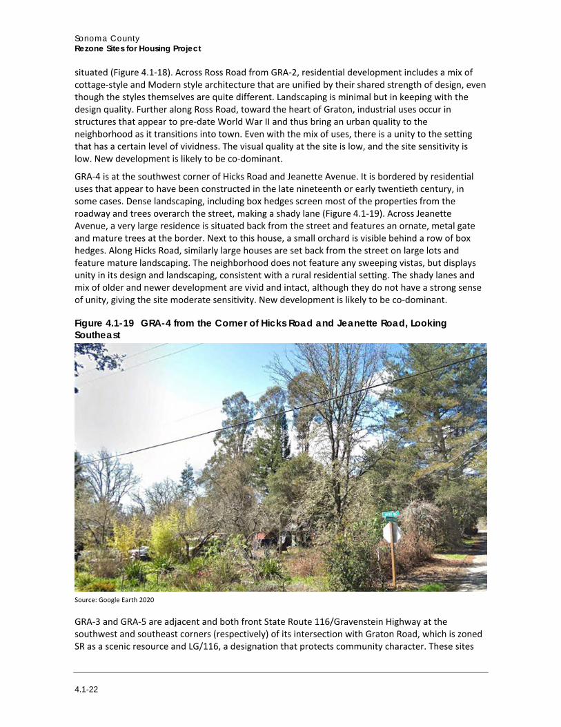
GRA-4 is at the southwest corner of Hicks Road and Jeanette Avenue. It is bordered by residential uses that appear to have been constructed in the late nineteenth or early twentieth century, in some cases. Dense landscaping, including box hedges screen most of the properties from the roadway and trees overarch the street, making a shady lane (Figure 4.1-19). Across Jeanette Avenue, a very large residence is situated back from the street and features an ornate, metal gate and mature trees at the border. Next to this house, a small orchard is visible behind a row of box hedges. Along Hicks Road, similarly large houses are set back from the street on large lots and feature mature landscaping. The neighborhood does not feature any sweeping vistas, but displays unity in its design and landscaping, consistent with a rural residential setting. The shady lanes and mix of older and newer development are vivid and intact, although they do not have a strong sense of unity, giving the site moderate sensitivity. New development is likely to be co-dominant.
Figure 4.1-19 GRA-4 from the Corner of Hicks Road and Jeanette Road, Looking Southeast
Source: Google Earth 2020
GRA-3 and GRA-5 are adjacent and both front State Route 116/Gravenstein Highway at the southwest and southeast corners (respectively) of its intersection with Graton Road, which is zoned SR as a scenic resource and LG/116, a designation that protects community character. These sites
Environmental Impact Analysis Aesthetics
Draft Environmental Impact Report 4.1-23
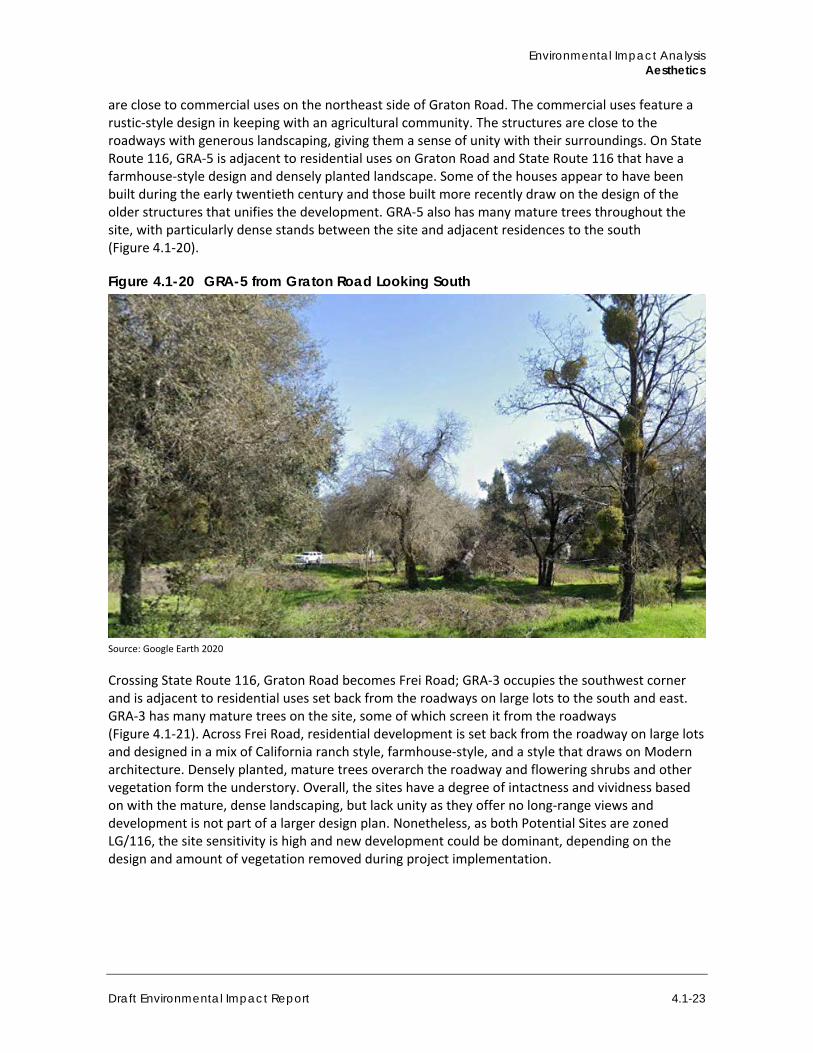
are close to commercial uses on the northeast side of Graton Road. The commercial uses feature a rustic-style design in keeping with an agricultural community. The structures are close to the roadways with generous landscaping, giving them a sense of unity with their surroundings. On State Route 116, GRA-5 is adjacent to residential uses on Graton Road and State Route 116 that have a farmhouse-style design and densely planted landscape. Some of the houses appear to have been built during the early twentieth century and those built more recently draw on the design of the older structures that unifies the development. GRA-5 also has many mature trees throughout the site, with particularly dense stands between the site and adjacent residences to the south (Figure 4.1-20).
Figure 4.1-20 GRA-5 from Graton Road Looking South
Source: Google Earth 2020
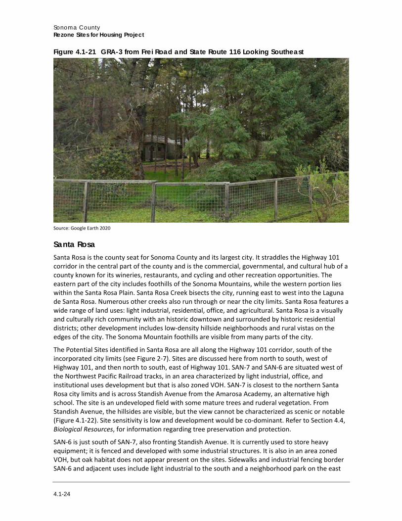
Crossing State Route 116, Graton Road becomes Frei Road; GRA-3 occupies the southwest corner and is adjacent to residential uses set back from the roadways on large lots to the south and east. GRA-3 has many mature trees on the site, some of which screen it from the roadways (Figure 4.1-21). Across Frei Road, residential development is set back from the roadway on large lots and designed in a mix of California ranch style, farmhouse-style, and a style that draws on Modern architecture. Densely planted, mature trees overarch the roadway and flowering shrubs and other vegetation form the understory. Overall, the sites have a degree of intactness and vividness based on with the mature, dense landscaping, but lack unity as they offer no long-range views and development is not part of a larger design plan. Nonetheless, as both Potential Sites are zoned LG/116, the site sensitivity is high and new development could be dominant, depending on the design and amount of vegetation removed during project implementation.
Sonoma County Rezone Sites for Housing Project
4.1-24
Figure 4.1-21 GRA-3 from Frei Road and State Route 116 Looking Southeast
Source: Google Earth 2020
Santa Rosa Santa Rosa is the county seat for Sonoma County and its largest city. It straddles the Highway 101 corridor in the central part of the county and is the commercial, governmental, and cultural hub of a county known for its wineries, restaurants, and cycling and other recreation opportunities. The eastern part of the city includes foothills of the Sonoma Mountains, while the western portion lies within the Santa Rosa Plain. Santa Rosa Creek bisects the city, running east to west into the Laguna de Santa Rosa. Numerous other creeks also run through or near the city limits. Santa Rosa features a wide range of land uses: light industrial, residential, office, and agricultural. Santa Rosa is a visually and culturally rich community with an historic downtown and surrounded by historic residential districts; other development includes low-density hillside neighborhoods and rural vistas on the edges of the city. The Sonoma Mountain foothills are visible from many parts of the city.
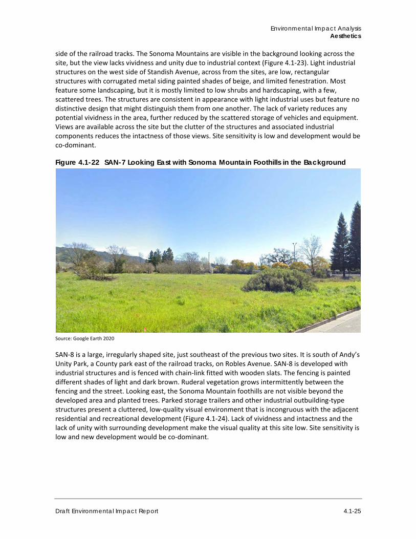
The Potential Sites identified in Santa Rosa are all along the Highway 101 corridor, south of the incorporated city limits (see Figure 2-7). Sites are discussed here from north to south, west of Highway 101, and then north to south, east of Highway 101. SAN-7 and SAN-6 are situated west of the Northwest Pacific Railroad tracks, in an area characterized by light industrial, office, and institutional uses development but that is also zoned VOH. SAN-7 is closest to the northern Santa Rosa city limits and is across Standish Avenue from the Amarosa Academy, an alternative high school. The site is an undeveloped field with some mature trees and ruderal vegetation. From Standish Avenue, the hillsides are visible, but the view cannot be characterized as scenic or notable (Figure 4.1-22). Site sensitivity is low and development would be co-dominant. Refer to Section 4.4, Biological Resources, for information regarding tree preservation and protection.
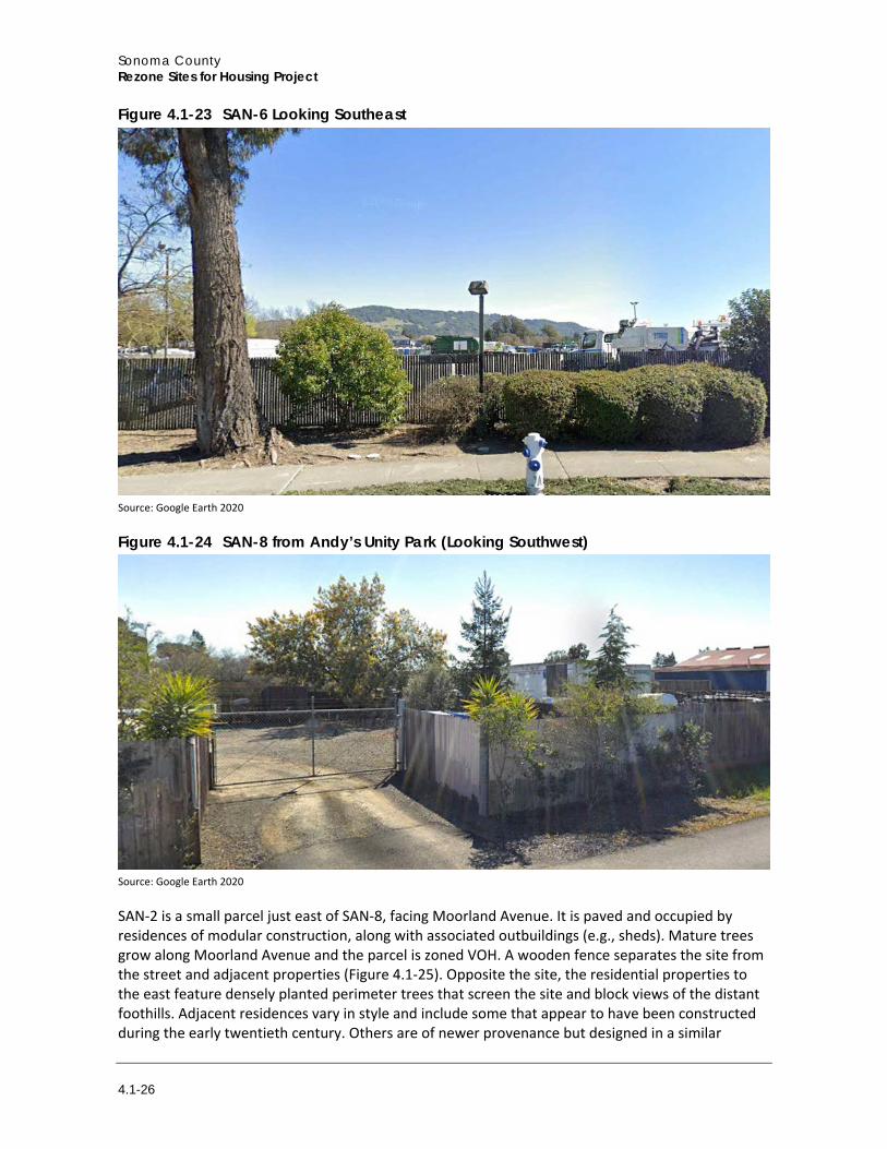
SAN-6 is just south of SAN-7, also fronting Standish Avenue. It is currently used to store heavy equipment; it is fenced and developed with some industrial structures. It is also in an area zoned VOH, but oak habitat does not appear present on the sites. Sidewalks and industrial fencing border SAN-6 and adjacent uses include light industrial to the south and a neighborhood park on the east
Environmental Impact Analysis Aesthetics
Draft Environmental Impact Report 4.1-25
side of the railroad tracks. The Sonoma Mountains are visible in the background looking across the site, but the view lacks vividness and unity due to industrial context (Figure 4.1-23). Light industrial structures on the west side of Standish Avenue, across from the sites, are low, rectangular structures with corrugated metal siding painted shades of beige, and limited fenestration. Most feature some landscaping, but it is mostly limited to low shrubs and hardscaping, with a few, scattered trees. The structures are consistent in appearance with light industrial uses but feature no distinctive design that might distinguish them from one another. The lack of variety reduces any potential vividness in the area, further reduced by the scattered storage of vehicles and equipment. Views are available across the site but the clutter of the structures and associated industrial components reduces the intactness of those views. Site sensitivity is low and development would be co-dominant.
Figure 4.1-22 SAN-7 Looking East with Sonoma Mountain Foothills in the Background
Source: Google Earth 2020
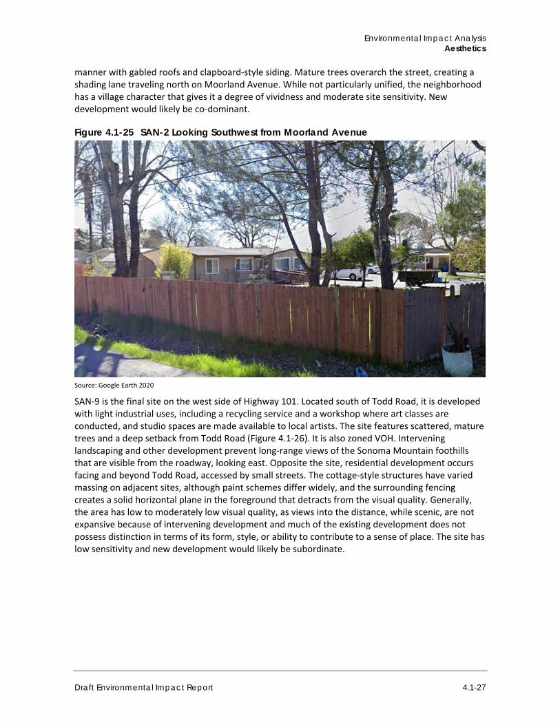
SAN-8 is a large, irregularly shaped site, just southeast of the previous two sites. It is south of Andy’s Unity Park, a County park east of the railroad tracks, on Robles Avenue. SAN-8 is developed with industrial structures and is fenced with chain-link fitted with wooden slats. The fencing is painted different shades of light and dark brown. Ruderal vegetation grows intermittently between the fencing and the street. Looking east, the Sonoma Mountain foothills are not visible beyond the developed area and planted trees. Parked storage trailers and other industrial outbuilding-type structures present a cluttered, low-quality visual environment that is incongruous with the adjacent residential and recreational development (Figure 4.1-24). Lack of vividness and intactness and the lack of unity with surrounding development make the visual quality at this site low. Site sensitivity is low and new development would be co-dominant.
Sonoma County Rezone Sites for Housing Project
4.1-26
Figure 4.1-23 SAN-6 Looking Southeast
Source: Google Earth 2020
Figure 4.1-24 SAN-8 from Andy’s Unity Park (Looking Southwest)
Source: Google Earth 2020
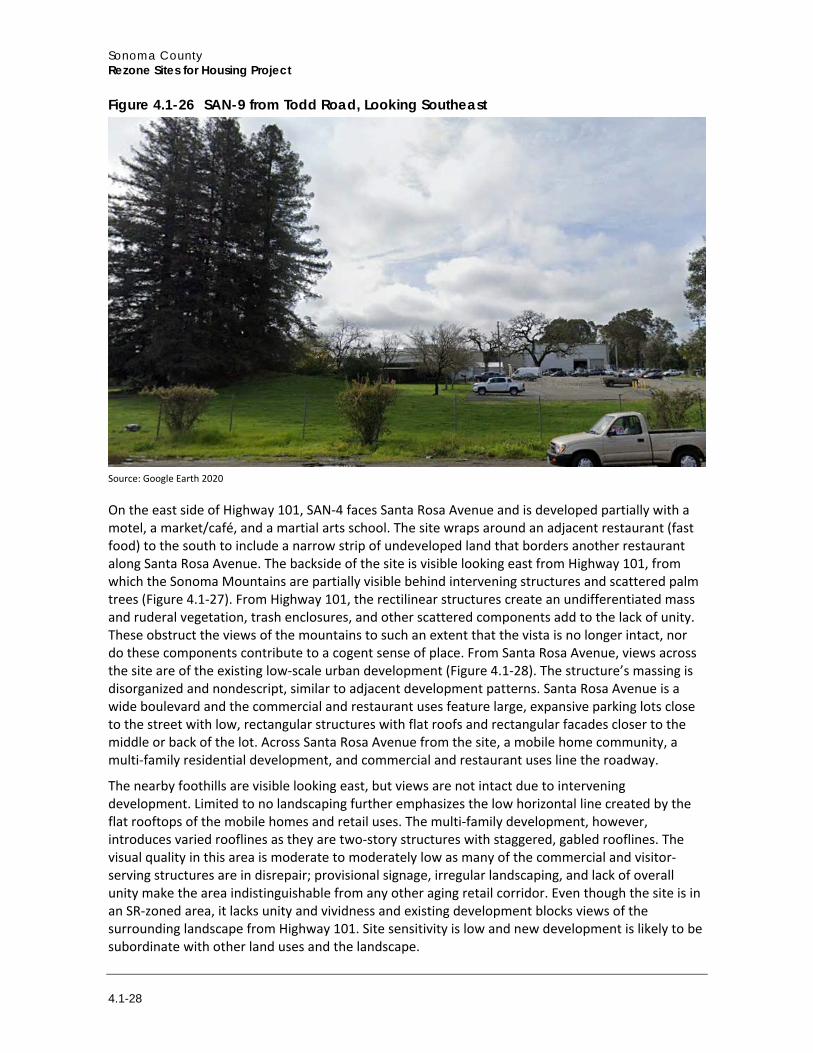
SAN-2 is a small parcel just east of SAN-8, facing Moorland Avenue. It is paved and occupied by residences of modular construction, along with associated outbuildings (e.g., sheds). Mature trees grow along Moorland Avenue and the parcel is zoned VOH. A wooden fence separates the site from the street and adjacent properties (Figure 4.1-25). Opposite the site, the residential properties to the east feature densely planted perimeter trees that screen the site and block views of the distant foothills. Adjacent residences vary in style and include some that appear to have been constructed during the early twentieth century. Others are of newer provenance but designed in a similar
Environmental Impact Analysis Aesthetics
Draft Environmental Impact Report 4.1-27
manner with gabled roofs and clapboard-style siding. Mature trees overarch the street, creating a shading lane traveling north on Moorland Avenue. While not particularly unified, the neighborhood has a village character that gives it a degree of vividness and moderate site sensitivity. New development would likely be co-dominant.
Figure 4.1-25 SAN-2 Looking Southwest from Moorland Avenue
Source: Google Earth 2020
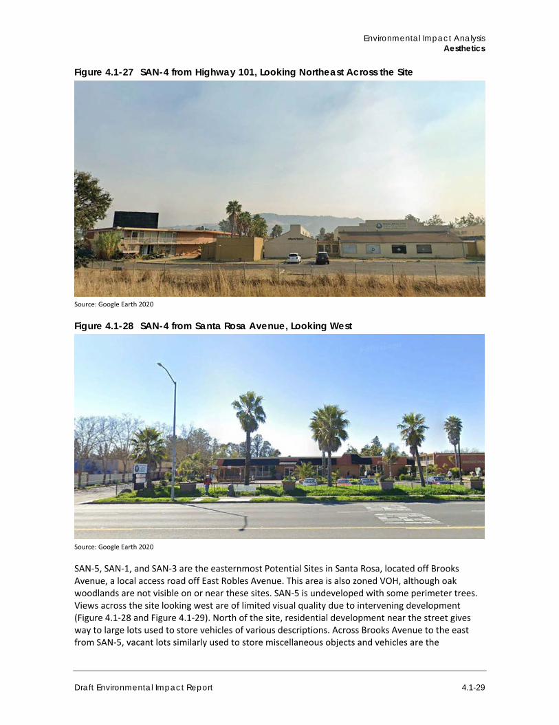
SAN-9 is the final site on the west side of Highway 101. Located south of Todd Road, it is developed with light industrial uses, including a recycling service and a workshop where art classes are conducted, and studio spaces are made available to local artists. The site features scattered, mature trees and a deep setback from Todd Road (Figure 4.1-26). It is also zoned VOH. Intervening landscaping and other development prevent long-range views of the Sonoma Mountain foothills that are visible from the roadway, looking east. Opposite the site, residential development occurs facing and beyond Todd Road, accessed by small streets. The cottage-style structures have varied massing on adjacent sites, although paint schemes differ widely, and the surrounding fencing creates a solid horizontal plane in the foreground that detracts from the visual quality. Generally, the area has low to moderately low visual quality, as views into the distance, while scenic, are not expansive because of intervening development and much of the existing development does not possess distinction in terms of its form, style, or ability to contribute to a sense of place. The site has low sensitivity and new development would likely be subordinate.
Sonoma County Rezone Sites for Housing Project
4.1-28
Figure 4.1-26 SAN-9 from Todd Road, Looking Southeast
Source: Google Earth 2020
On the east side of Highway 101, SAN-4 faces Santa Rosa Avenue and is developed partially with a motel, a market/café, and a martial arts school. The site wraps around an adjacent restaurant (fast food) to the south to include a narrow strip of undeveloped land that borders another restaurant along Santa Rosa Avenue. The backside of the site is visible looking east from Highway 101, from which the Sonoma Mountains are partially visible behind intervening structures and scattered palm trees (Figure 4.1-27). From Highway 101, the rectilinear structures create an undifferentiated mass and ruderal vegetation, trash enclosures, and other scattered components add to the lack of unity. These obstruct the views of the mountains to such an extent that the vista is no longer intact, nor do these components contribute to a cogent sense of place. From Santa Rosa Avenue, views across the site are of the existing low-scale urban development (Figure 4.1-28). The structure’s massing is disorganized and nondescript, similar to adjacent development patterns. Santa Rosa Avenue is a wide boulevard and the commercial and restaurant uses feature large, expansive parking lots close to the street with low, rectangular structures with flat roofs and rectangular facades closer to the middle or back of the lot. Across Santa Rosa Avenue from the site, a mobile home community, a multi-family residential development, and commercial and restaurant uses line the roadway.
The nearby foothills are visible looking east, but views are not intact due to intervening development. Limited to no landscaping further emphasizes the low horizontal line created by the flat rooftops of the mobile homes and retail uses. The multi-family development, however, introduces varied rooflines as they are two-story structures with staggered, gabled rooflines. The visual quality in this area is moderate to moderately low as many of the commercial and visitor-serving structures are in disrepair; provisional signage, irregular landscaping, and lack of overall unity make the area indistinguishable from any other aging retail corridor. Even though the site is in an SR-zoned area, it lacks unity and vividness and existing development blocks views of the surrounding landscape from Highway 101. Site sensitivity is low and new development is likely to be subordinate with other land uses and the landscape.
Environmental Impact Analysis Aesthetics
Draft Environmental Impact Report 4.1-29
Figure 4.1-27 SAN-4 from Highway 101, Looking Northeast Across the Site
Source: Google Earth 2020
Figure 4.1-28 SAN-4 from Santa Rosa Avenue, Looking West
Source: Google Earth 2020
SAN-5, SAN-1, and SAN-3 are the easternmost Potential Sites in Santa Rosa, located off Brooks Avenue, a local access road off East Robles Avenue. This area is also zoned VOH, although oak woodlands are not visible on or near these sites. SAN-5 is undeveloped with some perimeter trees. Views across the site looking west are of limited visual quality due to intervening development (Figure 4.1-28 and Figure 4.1-29). North of the site, residential development near the street gives way to large lots used to store vehicles of various descriptions. Across Brooks Avenue to the east from SAN-5, vacant lots similarly used to store miscellaneous objects and vehicles are the
Sonoma County Rezone Sites for Housing Project
4.1-30
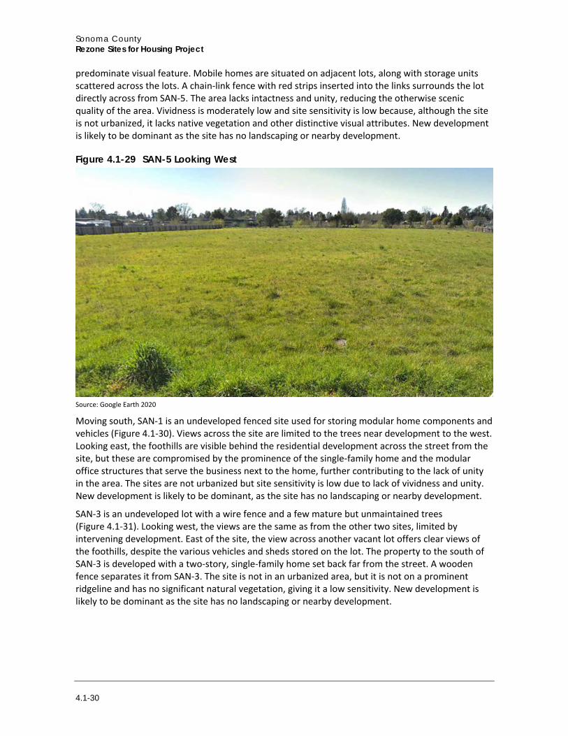
predominate visual feature. Mobile homes are situated on adjacent lots, along with storage units scattered across the lots. A chain-link fence with red strips inserted into the links surrounds the lot directly across from SAN-5. The area lacks intactness and unity, reducing the otherwise scenic quality of the area. Vividness is moderately low and site sensitivity is low because, although the site is not urbanized, it lacks native vegetation and other distinctive visual attributes. New development is likely to be dominant as the site has no landscaping or nearby development.
Figure 4.1-29 SAN-5 Looking West
Source: Google Earth 2020
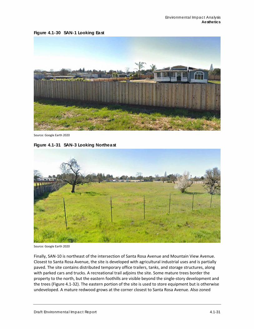
Moving south, SAN-1 is an undeveloped fenced site used for storing modular home components and vehicles (Figure 4.1-30). Views across the site are limited to the trees near development to the west. Looking east, the foothills are visible behind the residential development across the street from the site, but these are compromised by the prominence of the single-family home and the modular office structures that serve the business next to the home, further contributing to the lack of unity in the area. The sites are not urbanized but site sensitivity is low due to lack of vividness and unity. New development is likely to be dominant, as the site has no landscaping or nearby development.
SAN-3 is an undeveloped lot with a wire fence and a few mature but unmaintained trees (Figure 4.1-31). Looking west, the views are the same as from the other two sites, limited by intervening development. East of the site, the view across another vacant lot offers clear views of the foothills, despite the various vehicles and sheds stored on the lot. The property to the south of SAN-3 is developed with a two-story, single-family home set back far from the street. A wooden fence separates it from SAN-3. The site is not in an urbanized area, but it is not on a prominent ridgeline and has no significant natural vegetation, giving it a low sensitivity. New development is likely to be dominant as the site has no landscaping or nearby development.
Environmental Impact Analysis Aesthetics
Draft Environmental Impact Report 4.1-31
Figure 4.1-30 SAN-1 Looking East
Source: Google Earth 2020
Figure 4.1-31 SAN-3 Looking Northeast
Source: Google Earth 2020
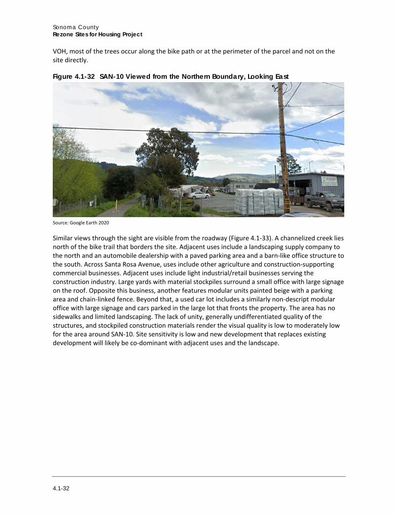
Finally, SAN-10 is northeast of the intersection of Santa Rosa Avenue and Mountain View Avenue. Closest to Santa Rosa Avenue, the site is developed with agricultural industrial uses and is partially paved. The site contains distributed temporary office trailers, tanks, and storage structures, along with parked cars and trucks. A recreational trail adjoins the site. Some mature trees border the property to the north, but the eastern foothills are visible beyond the single-story development and the trees (Figure 4.1-32). The eastern portion of the site is used to store equipment but is otherwise undeveloped. A mature redwood grows at the corner closest to Santa Rosa Avenue. Also zoned
Sonoma County Rezone Sites for Housing Project
4.1-32
VOH, most of the trees occur along the bike path or at the perimeter of the parcel and not on the site directly.
Figure 4.1-32 SAN-10 Viewed from the Northern Boundary, Looking East
Source: Google Earth 2020
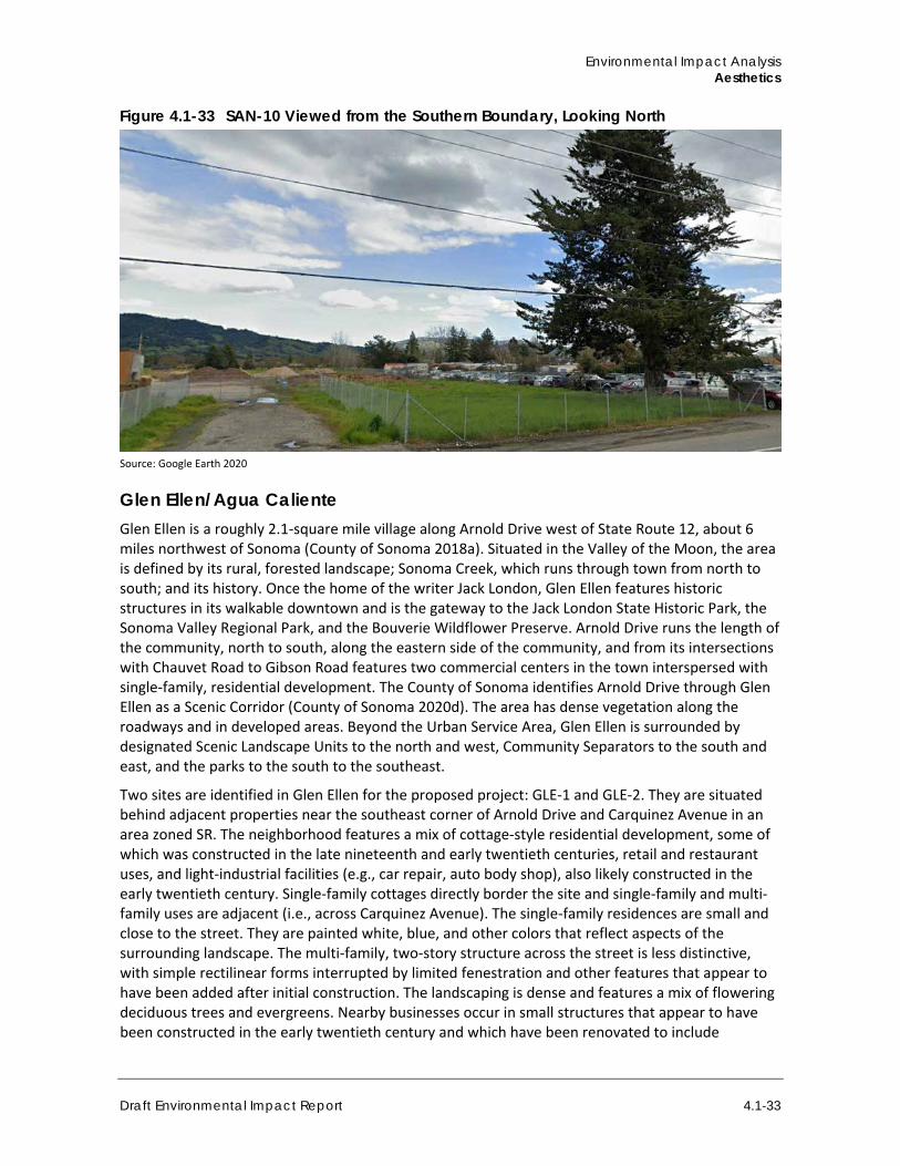
Similar views through the sight are visible from the roadway (Figure 4.1-33). A channelized creek lies north of the bike trail that borders the site. Adjacent uses include a landscaping supply company to the north and an automobile dealership with a paved parking area and a barn-like office structure to the south. Across Santa Rosa Avenue, uses include other agriculture and construction-supporting commercial businesses. Adjacent uses include light industrial/retail businesses serving the construction industry. Large yards with material stockpiles surround a small office with large signage on the roof. Opposite this business, another features modular units painted beige with a parking area and chain-linked fence. Beyond that, a used car lot includes a similarly non-descript modular office with large signage and cars parked in the large lot that fronts the property. The area has no sidewalks and limited landscaping. The lack of unity, generally undifferentiated quality of the structures, and stockpiled construction materials render the visual quality is low to moderately low for the area around SAN-10. Site sensitivity is low and new development that replaces existing development will likely be co-dominant with adjacent uses and the landscape.
Environmental Impact Analysis Aesthetics
Draft Environmental Impact Report 4.1-33
Figure 4.1-33 SAN-10 Viewed from the Southern Boundary, Looking North
Source: Google Earth 2020
Glen Ellen/Agua Caliente Glen Ellen is a roughly 2.1-square mile village along Arnold Drive west of State Route 12, about 6 miles northwest of Sonoma (County of Sonoma 2018a). Situated in the Valley of the Moon, the area is defined by its rural, forested landscape; Sonoma Creek, which runs through town from north to south; and its history. Once the home of the writer Jack London, Glen Ellen features historic structures in its walkable downtown and is the gateway to the Jack London State Historic Park, the Sonoma Valley Regional Park, and the Bouverie Wildflower Preserve. Arnold Drive runs the length of the community, north to south, along the eastern side of the community, and from its intersections with Chauvet Road to Gibson Road features two commercial centers in the town interspersed with single-family, residential development. The County of Sonoma identifies Arnold Drive through Glen Ellen as a Scenic Corridor (County of Sonoma 2020d). The area has dense vegetation along the roadways and in developed areas. Beyond the Urban Service Area, Glen Ellen is surrounded by designated Scenic Landscape Units to the north and west, Community Separators to the south and east, and the parks to the south to the southeast.
Two sites are identified in Glen Ellen for the proposed project: GLE-1 and GLE-2. They are situated behind adjacent properties near the southeast corner of Arnold Drive and Carquinez Avenue in an area zoned SR. The neighborhood features a mix of cottage-style residential development, some of which was constructed in the late nineteenth and early twentieth centuries, retail and restaurant uses, and light-industrial facilities (e.g., car repair, auto body shop), also likely constructed in the early twentieth century. Single-family cottages directly border the site and single-family and multi-family uses are adjacent (i.e., across Carquinez Avenue). The single-family residences are small and close to the street. They are painted white, blue, and other colors that reflect aspects of the surrounding landscape. The multi-family, two-story structure across the street is less distinctive, with simple rectilinear forms interrupted by limited fenestration and other features that appear to have been added after initial construction. The landscaping is dense and features a mix of flowering deciduous trees and evergreens. Nearby businesses occur in small structures that appear to have been constructed in the early twentieth century and which have been renovated to include
Sonoma County Rezone Sites for Housing Project
4.1-34
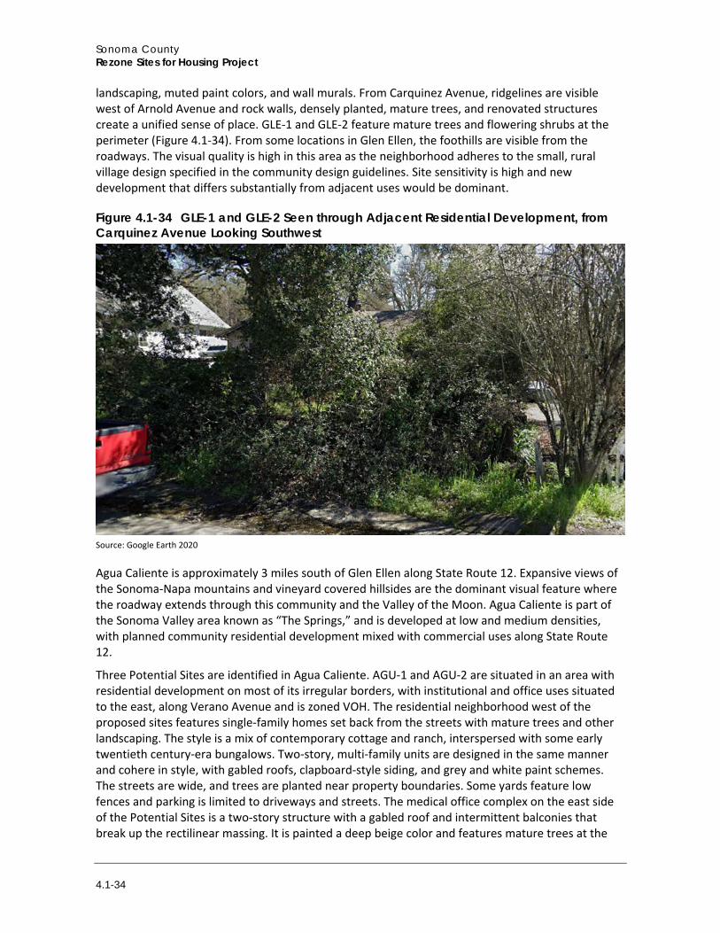
landscaping, muted paint colors, and wall murals. From Carquinez Avenue, ridgelines are visible west of Arnold Avenue and rock walls, densely planted, mature trees, and renovated structures create a unified sense of place. GLE-1 and GLE-2 feature mature trees and flowering shrubs at the perimeter (Figure 4.1-34). From some locations in Glen Ellen, the foothills are visible from the roadways. The visual quality is high in this area as the neighborhood adheres to the small, rural village design specified in the community design guidelines. Site sensitivity is high and new development that differs substantially from adjacent uses would be dominant.
Figure 4.1-34 GLE-1 and GLE-2 Seen through Adjacent Residential Development, from Carquinez Avenue Looking Southwest
Source: Google Earth 2020
Agua Caliente is approximately 3 miles south of Glen Ellen along State Route 12. Expansive views of the Sonoma-Napa mountains and vineyard covered hillsides are the dominant visual feature where the roadway extends through this community and the Valley of the Moon. Agua Caliente is part of the Sonoma Valley area known as “The Springs,” and is developed at low and medium densities, with planned community residential development mixed with commercial uses along State Route 12.
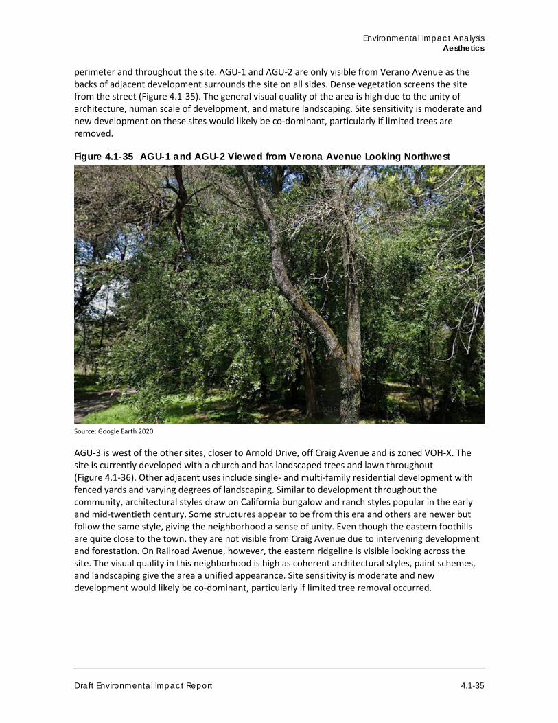
Three Potential Sites are identified in Agua Caliente. AGU-1 and AGU-2 are situated in an area with residential development on most of its irregular borders, with institutional and office uses situated to the east, along Verano Avenue and is zoned VOH. The residential neighborhood west of the proposed sites features single-family homes set back from the streets with mature trees and other landscaping. The style is a mix of contemporary cottage and ranch, interspersed with some early twentieth century-era bungalows. Two-story, multi-family units are designed in the same manner and cohere in style, with gabled roofs, clapboard-style siding, and grey and white paint schemes. The streets are wide, and trees are planted near property boundaries. Some yards feature low fences and parking is limited to driveways and streets. The medical office complex on the east side of the Potential Sites is a two-story structure with a gabled roof and intermittent balconies that break up the rectilinear massing. It is painted a deep beige color and features mature trees at the
Environmental Impact Analysis Aesthetics
Draft Environmental Impact Report 4.1-35
perimeter and throughout the site. AGU-1 and AGU-2 are only visible from Verano Avenue as the backs of adjacent development surrounds the site on all sides. Dense vegetation screens the site from the street (Figure 4.1-35). The general visual quality of the area is high due to the unity of architecture, human scale of development, and mature landscaping. Site sensitivity is moderate and new development on these sites would likely be co-dominant, particularly if limited trees are removed.
Figure 4.1-35 AGU-1 and AGU-2 Viewed from Verona Avenue Looking Northwest
Source: Google Earth 2020
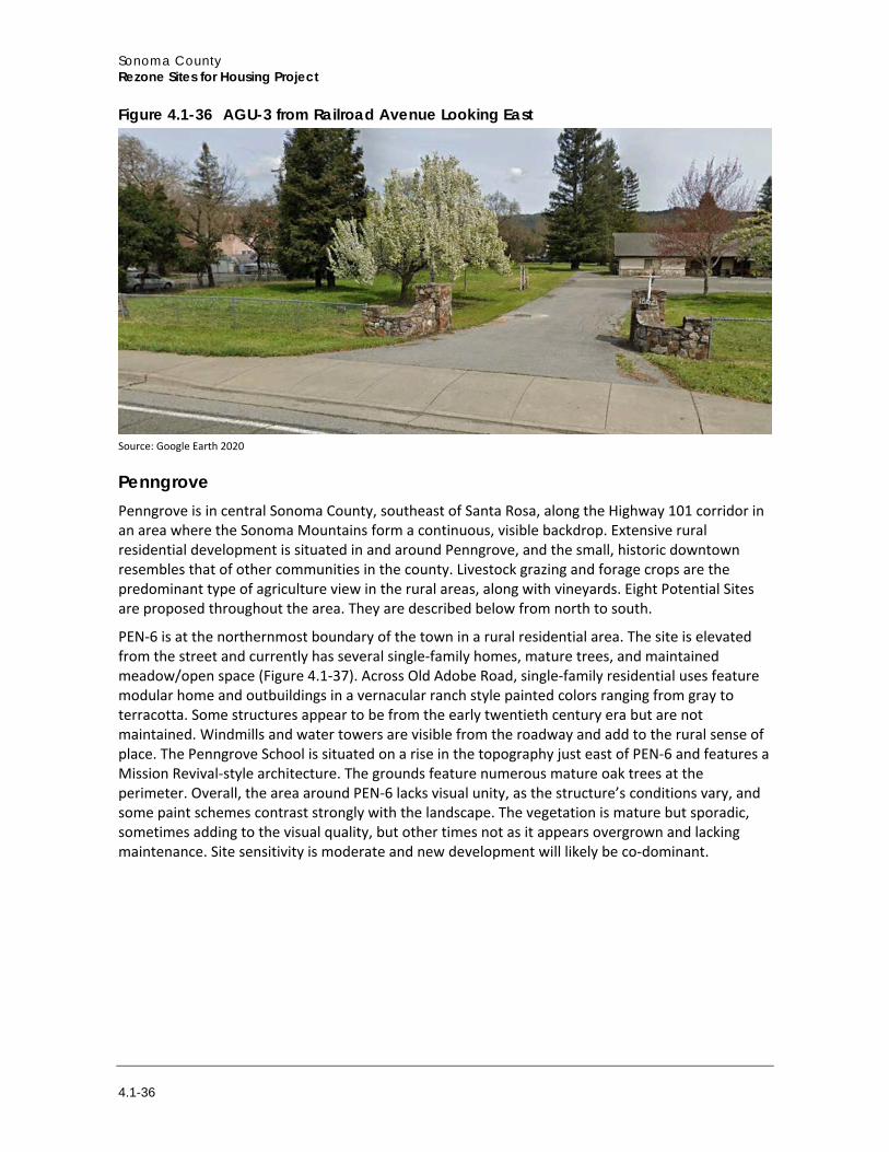
AGU-3 is west of the other sites, closer to Arnold Drive, off Craig Avenue and is zoned VOH-X. The site is currently developed with a church and has landscaped trees and lawn throughout (Figure 4.1-36). Other adjacent uses include single- and multi-family residential development with fenced yards and varying degrees of landscaping. Similar to development throughout the community, architectural styles draw on California bungalow and ranch styles popular in the early and mid-twentieth century. Some structures appear to be from this era and others are newer but follow the same style, giving the neighborhood a sense of unity. Even though the eastern foothills are quite close to the town, they are not visible from Craig Avenue due to intervening development and forestation. On Railroad Avenue, however, the eastern ridgeline is visible looking across the site. The visual quality in this neighborhood is high as coherent architectural styles, paint schemes, and landscaping give the area a unified appearance. Site sensitivity is moderate and new development would likely be co-dominant, particularly if limited tree removal occurred.
Sonoma County Rezone Sites for Housing Project
4.1-36
Figure 4.1-36 AGU-3 from Railroad Avenue Looking East
Source: Google Earth 2020
Penngrove Penngrove is in central Sonoma County, southeast of Santa Rosa, along the Highway 101 corridor in an area where the Sonoma Mountains form a continuous, visible backdrop. Extensive rural residential development is situated in and around Penngrove, and the small, historic downtown resembles that of other communities in the county. Livestock grazing and forage crops are the predominant type of agriculture view in the rural areas, along with vineyards. Eight Potential Sites are proposed throughout the area. They are described below from north to south.
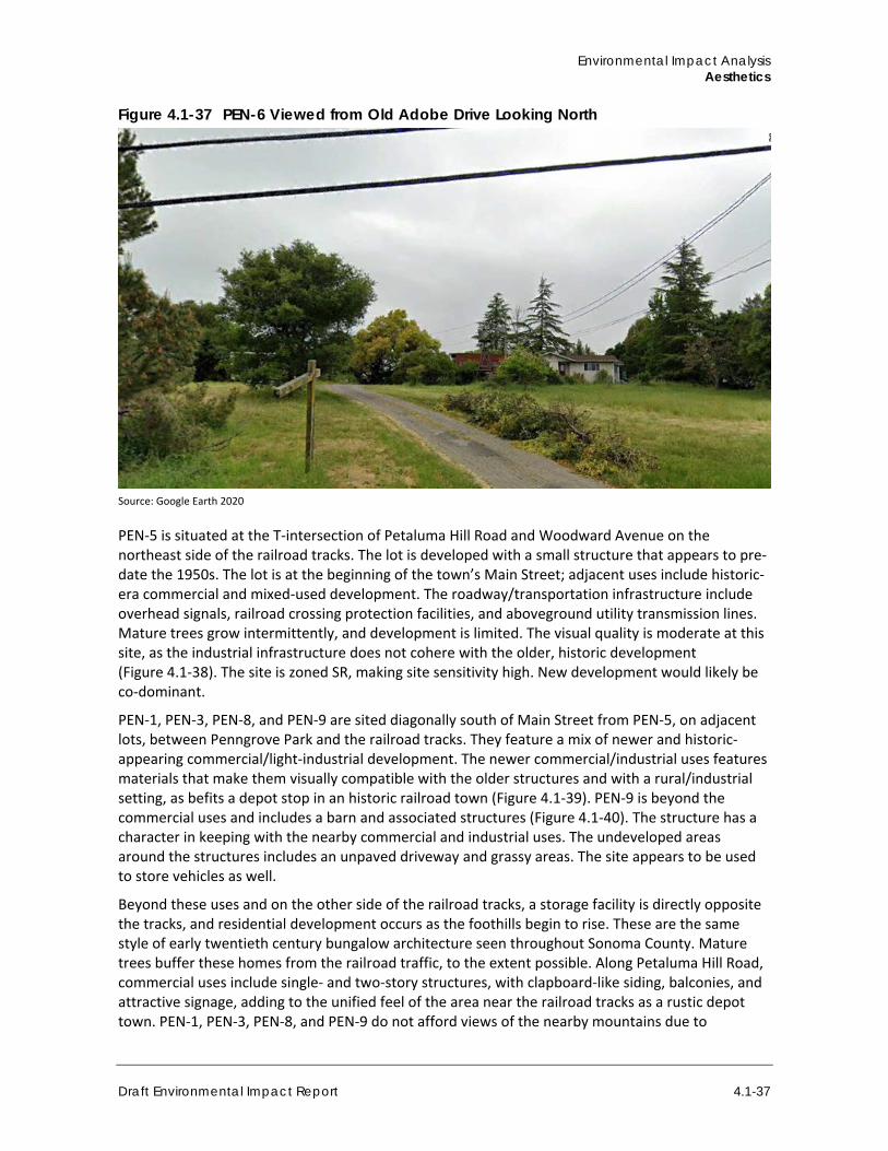
PEN-6 is at the northernmost boundary of the town in a rural residential area. The site is elevated from the street and currently has several single-family homes, mature trees, and maintained meadow/open space (Figure 4.1-37). Across Old Adobe Road, single-family residential uses feature modular home and outbuildings in a vernacular ranch style painted colors ranging from gray to terracotta. Some structures appear to be from the early twentieth century era but are not maintained. Windmills and water towers are visible from the roadway and add to the rural sense of place. The Penngrove School is situated on a rise in the topography just east of PEN-6 and features a Mission Revival-style architecture. The grounds feature numerous mature oak trees at the perimeter. Overall, the area around PEN-6 lacks visual unity, as the structure’s conditions vary, and some paint schemes contrast strongly with the landscape. The vegetation is mature but sporadic, sometimes adding to the visual quality, but other times not as it appears overgrown and lacking maintenance. Site sensitivity is moderate and new development will likely be co-dominant.
Environmental Impact Analysis Aesthetics
Draft Environmental Impact Report 4.1-37
Figure 4.1-37 PEN-6 Viewed from Old Adobe Drive Looking North
Source: Google Earth 2020
PEN-5 is situated at the T-intersection of Petaluma Hill Road and Woodward Avenue on the northeast side of the railroad tracks. The lot is developed with a small structure that appears to pre-date the 1950s. The lot is at the beginning of the town’s Main Street; adjacent uses include historic-era commercial and mixed-used development. The roadway/transportation infrastructure include overhead signals, railroad crossing protection facilities, and aboveground utility transmission lines. Mature trees grow intermittently, and development is limited. The visual quality is moderate at this site, as the industrial infrastructure does not cohere with the older, historic development (Figure 4.1-38). The site is zoned SR, making site sensitivity high. New development would likely be co-dominant.
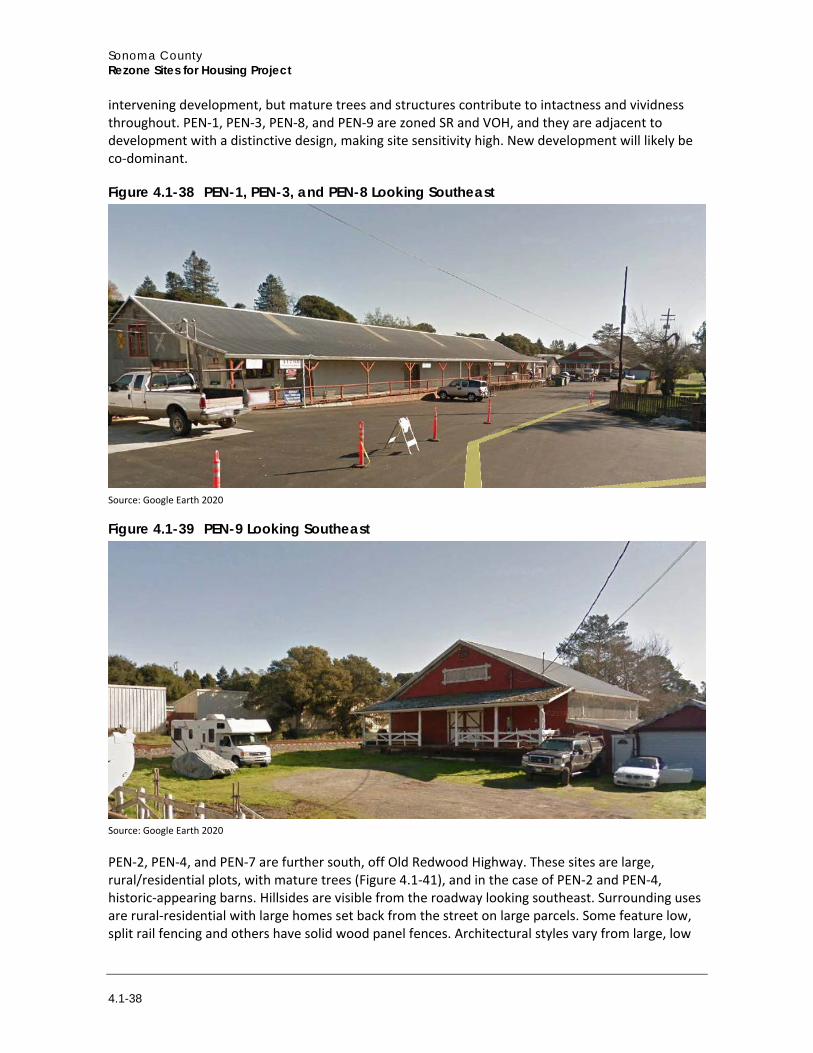
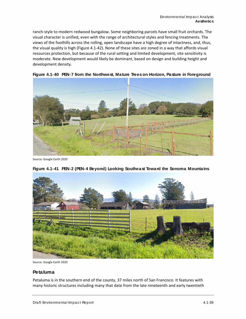
PEN-1, PEN-3, PEN-8, and PEN-9 are sited diagonally south of Main Street from PEN-5, on adjacent lots, between Penngrove Park and the railroad tracks. They feature a mix of newer and historic-appearing commercial/light-industrial development. The newer commercial/industrial uses features materials that make them visually compatible with the older structures and with a rural/industrial setting, as befits a depot stop in an historic railroad town (Figure 4.1-39). PEN-9 is beyond the commercial uses and includes a barn and associated structures (Figure 4.1-40). The structure has a character in keeping with the nearby commercial and industrial uses. The undeveloped areas around the structures includes an unpaved driveway and grassy areas. The site appears to be used to store vehicles as well.
Beyond these uses and on the other side of the railroad tracks, a storage facility is directly opposite the tracks, and residential development occurs as the foothills begin to rise. These are the same style of early twentieth century bungalow architecture seen throughout Sonoma County. Mature trees buffer these homes from the railroad traffic, to the extent possible. Along Petaluma Hill Road, commercial uses include single- and two-story structures, with clapboard-like siding, balconies, and attractive signage, adding to the unified feel of the area near the railroad tracks as a rustic depot town. PEN-1, PEN-3, PEN-8, and PEN-9 do not afford views of the nearby mountains due to
Sonoma County Rezone Sites for Housing Project
4.1-38
intervening development, but mature trees and structures contribute to intactness and vividness throughout. PEN-1, PEN-3, PEN-8, and PEN-9 are zoned SR and VOH, and they are adjacent to development with a distinctive design, making site sensitivity high. New development will likely be co-dominant.
Figure 4.1-38 PEN-1, PEN-3, and PEN-8 Looking Southeast
Source: Google Earth 2020
Figure 4.1-39 PEN-9 Looking Southeast
Source: Google Earth 2020
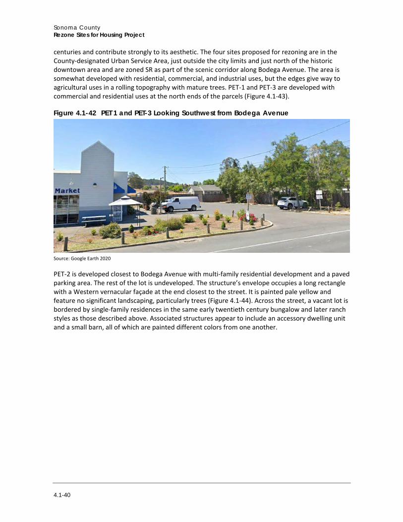
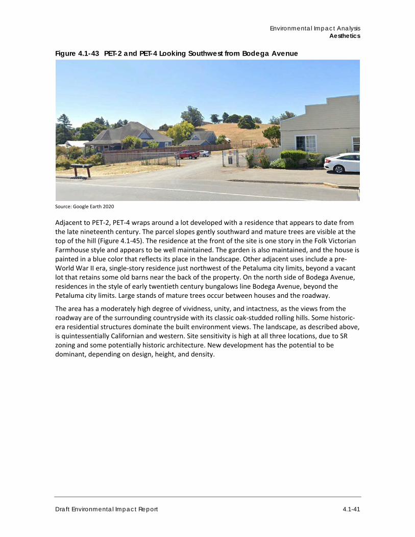
PEN-2, PEN-4, and PEN-7 are further south, off Old Redwood Highway. These sites are large, rural/residential plots, with mature trees (Figure 4.1-41), and in the case of PEN-2 and PEN-4, historic-appearing barns. Hillsides are visible from the roadway looking southeast. Surrounding uses are rural-residential with large homes set back from the street on large parcels. Some feature low, split rail fencing and others have solid wood panel fences. Architectural styles vary from large, low
Environmental Impact Analysis Aesthetics
Draft Environmental Impact Report 4.1-39
ranch-style to modern redwood bungalow. Some neighboring parcels have small fruit orchards. The visual character is unified, even with the range of architectural styles and fencing treatments. The views of the foothills across the rolling, open landscape have a high degree of intactness, and, thus, the visual quality is high (Figure 4.1-42). None of these sites are zoned in a way that affords visual resources protection, but because of the rural setting and limited development, site sensitivity is moderate. New development would likely be dominant, based on design and building height and development density.
Figure 4.1-40 PEN-7 from the Northwest, Mature Trees on Horizon, Pasture in Foreground
Source: Google Earth 2020
Figure 4.1-41 PEN-2 (PEN-4 Beyond) Looking Southeast Toward the Sonoma Mountains
Source: Google Earth 2020
Petaluma Petaluma is in the southern end of the county, 37 miles north of San Francisco. It features with many historic structures including many that date from the late nineteenth and early twentieth
Sonoma County Rezone Sites for Housing Project
4.1-40
centuries and contribute strongly to its aesthetic. The four sites proposed for rezoning are in the County-designated Urban Service Area, just outside the city limits and just north of the historic downtown area and are zoned SR as part of the scenic corridor along Bodega Avenue. The area is somewhat developed with residential, commercial, and industrial uses, but the edges give way to agricultural uses in a rolling topography with mature trees. PET-1 and PET-3 are developed with commercial and residential uses at the north ends of the parcels (Figure 4.1-43).
Figure 4.1-42 PET 1 and PET-3 Looking Southwest from Bodega Avenue
Source: Google Earth 2020
PET-2 is developed closest to Bodega Avenue with multi-family residential development and a paved parking area. The rest of the lot is undeveloped. The structure’s envelope occupies a long rectangle with a Western vernacular façade at the end closest to the street. It is painted pale yellow and feature no significant landscaping, particularly trees (Figure 4.1-44). Across the street, a vacant lot is bordered by single-family residences in the same early twentieth century bungalow and later ranch styles as those described above. Associated structures appear to include an accessory dwelling unit and a small barn, all of which are painted different colors from one another.
Environmental Impact Analysis Aesthetics
Draft Environmental Impact Report 4.1-41
Figure 4.1-43 PET-2 and PET-4 Looking Southwest from Bodega Avenue
Source: Google Earth 2020
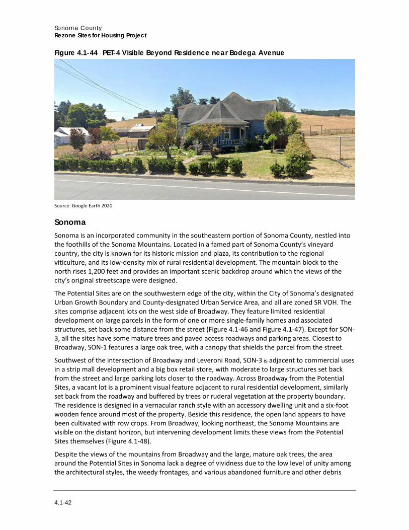
Adjacent to PET-2, PET-4 wraps around a lot developed with a residence that appears to date from the late nineteenth century. The parcel slopes gently southward and mature trees are visible at the top of the hill (Figure 4.1-45). The residence at the front of the site is one story in the Folk Victorian Farmhouse style and appears to be well maintained. The garden is also maintained, and the house is painted in a blue color that reflects its place in the landscape. Other adjacent uses include a pre-World War II era, single-story residence just northwest of the Petaluma city limits, beyond a vacant lot that retains some old barns near the back of the property. On the north side of Bodega Avenue, residences in the style of early twentieth century bungalows line Bodega Avenue, beyond the Petaluma city limits. Large stands of mature trees occur between houses and the roadway.
The area has a moderately high degree of vividness, unity, and intactness, as the views from the roadway are of the surrounding countryside with its classic oak-studded rolling hills. Some historic-era residential structures dominate the built environment views. The landscape, as described above, is quintessentially Californian and western. Site sensitivity is high at all three locations, due to SR zoning and some potentially historic architecture. New development has the potential to be dominant, depending on design, height, and density.
Sonoma County Rezone Sites for Housing Project
4.1-42
Figure 4.1-44 PET-4 Visible Beyond Residence near Bodega Avenue
Source: Google Earth 2020
Sonoma Sonoma is an incorporated community in the southeastern portion of Sonoma County, nestled into the foothills of the Sonoma Mountains. Located in a famed part of Sonoma County’s vineyard country, the city is known for its historic mission and plaza, its contribution to the regional viticulture, and its low-density mix of rural residential development. The mountain block to the north rises 1,200 feet and provides an important scenic backdrop around which the views of the city’s original streetscape were designed.
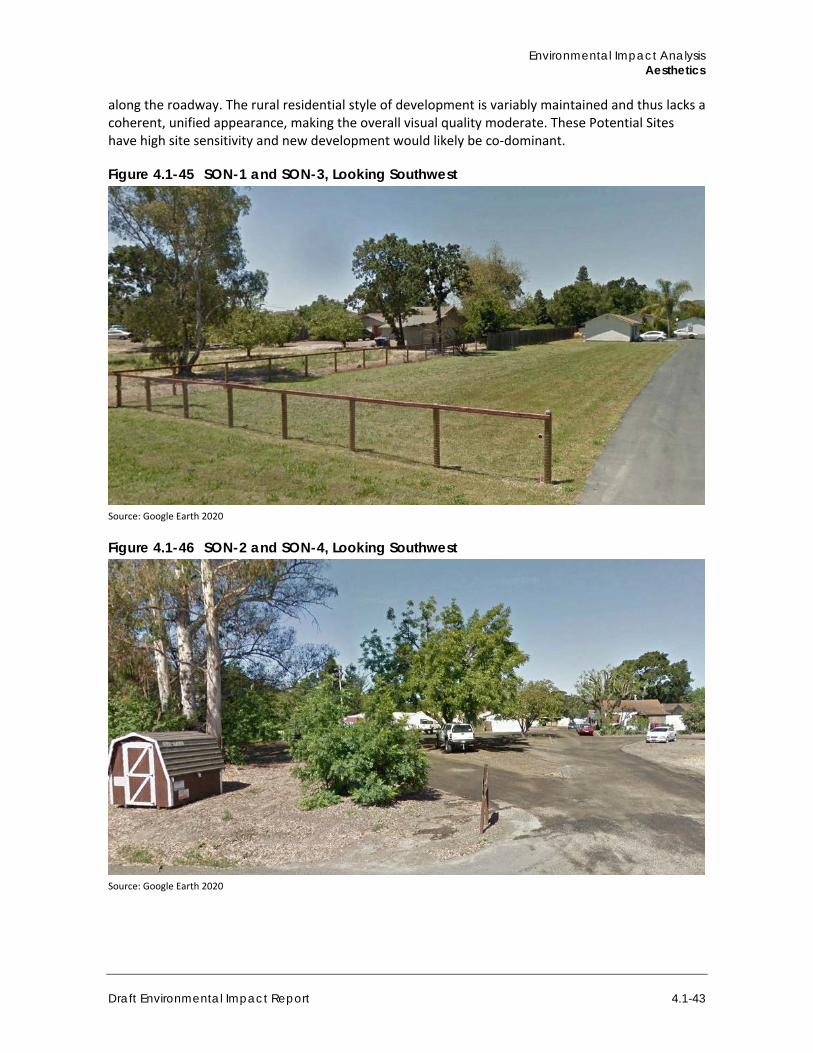
The Potential Sites are on the southwestern edge of the city, within the City of Sonoma’s designated Urban Growth Boundary and County-designated Urban Service Area, and all are zoned SR VOH. The sites comprise adjacent lots on the west side of Broadway. They feature limited residential development on large parcels in the form of one or more single-family homes and associated structures, set back some distance from the street (Figure 4.1-46 and Figure 4.1-47). Except for SON-3, all the sites have some mature trees and paved access roadways and parking areas. Closest to Broadway, SON-1 features a large oak tree, with a canopy that shields the parcel from the street.
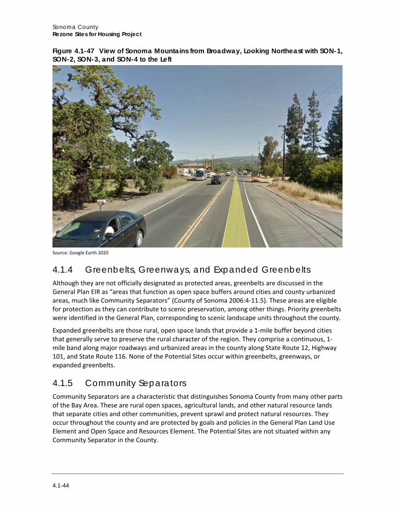
Southwest of the intersection of Broadway and Leveroni Road, SON-3 is adjacent to commercial uses in a strip mall development and a big box retail store, with moderate to large structures set back from the street and large parking lots closer to the roadway. Across Broadway from the Potential Sites, a vacant lot is a prominent visual feature adjacent to rural residential development, similarly set back from the roadway and buffered by trees or ruderal vegetation at the property boundary. The residence is designed in a vernacular ranch style with an accessory dwelling unit and a six-foot wooden fence around most of the property. Beside this residence, the open land appears to have been cultivated with row crops. From Broadway, looking northeast, the Sonoma Mountains are visible on the distant horizon, but intervening development limits these views from the Potential Sites themselves (Figure 4.1-48).
Despite the views of the mountains from Broadway and the large, mature oak trees, the area around the Potential Sites in Sonoma lack a degree of vividness due to the low level of unity among the architectural styles, the weedy frontages, and various abandoned furniture and other debris
Environmental Impact Analysis Aesthetics
Draft Environmental Impact Report 4.1-43
along the roadway. The rural residential style of development is variably maintained and thus lacks a coherent, unified appearance, making the overall visual quality moderate. These Potential Sites have high site sensitivity and new development would likely be co-dominant.
Figure 4.1-45 SON-1 and SON-3, Looking Southwest
Source: Google Earth 2020
Figure 4.1-46 SON-2 and SON-4, Looking Southwest
Source: Google Earth 2020
Sonoma County Rezone Sites for Housing Project
4.1-44
Figure 4.1-47 View of Sonoma Mountains from Broadway, Looking Northeast with SON-1, SON-2, SON-3, and SON-4 to the Left
Source: Google Earth 2020
4.1.4 Greenbelts, Greenways, and Expanded Greenbelts Although they are not officially designated as protected areas, greenbelts are discussed in the General Plan EIR as “areas that function as open space buffers around cities and county urbanized areas, much like Community Separators” (County of Sonoma 2006:4-11.5). These areas are eligible for protection as they can contribute to scenic preservation, among other things. Priority greenbelts were identified in the General Plan, corresponding to scenic landscape units throughout the county.
Expanded greenbelts are those rural, open space lands that provide a 1-mile buffer beyond cities that generally serve to preserve the rural character of the region. They comprise a continuous, 1-mile band along major roadways and urbanized areas in the county along State Route 12, Highway 101, and State Route 116. None of the Potential Sites occur within greenbelts, greenways, or expanded greenbelts.
4.1.5 Community Separators Community Separators are a characteristic that distinguishes Sonoma County from many other parts of the Bay Area. These are rural open spaces, agricultural lands, and other natural resource lands that separate cities and other communities, prevent sprawl and protect natural resources. They occur throughout the county and are protected by goals and policies in the General Plan Land Use Element and Open Space and Resources Element. The Potential Sites are not situated within any Community Separator in the County.
Environmental Impact Analysis Aesthetics
Draft Environmental Impact Report 4.1-45
4.1.6 Light and Glare For purposes of this analysis, light refers to light emissions (brightness) generated by a source of light. Stationary sources of light include exterior parking lots and security lighting; moving sources of light include the headlights of vehicles driving on roadways near the Potential Sites. Streetlights and other security lighting also serve as sources of light in the evening hours. Highly visible lights at night can disrupt views of the night sky and have the potential to be seen for miles if geography or vegetation do not intervene. Moving sources of light (i.e., vehicles) easily catch the eye and are difficult to ignore.
Light pollution is an adverse effect of man-made light and can include urban sky glow, glare, and light trespass. Excessive lighting of this type can significantly change the character of rural and natural areas by making the built environment more prominent at night and creating visual clutter (International Dark Sky Association 2020).
The current conditions in the more rural areas include limited light from moving vehicles, street lighting, and structure lighting (both interior lights that emanate from windows and exterior lights in place for security or safety). There is little light spillage from developed uses onto adjacent uses and very little interference with night sky viewing. In more developed areas, lighting is consistent with urban and suburban development, including some streetlights and external security lighting. In developed rural residential areas, light conditions are more intense than the rural areas but less than the sites at the edges of larger cities (e.g., Santa Rosa, Sonoma).
Glare is defined as focused, intense light emanated directly from a source or indirectly when light reflects from a surface. Daytime glare is caused in large part by sunlight shining on highly reflective surfaces at or above eye level. Reflective surfaces area associated with structures that have expanses of polished or glass surfaces, light-colored pavement, and the windshields of parked cars.
Throughout the county, glare is limited by various factors: forestation, limited large or expansive parking lots, and design guidelines in the General Plan that regulate the character of new development and that include placing parking areas out of the view of newly implemented streetscaping (County of Sonoma 2018a).
4.1.7 Regulatory Setting
a. Federal Regulations No existing federal regulations pertain to the visual resources in the project area.
b. State Regulations
State Scenic Highway Program Caltrans defines a scenic highway as any freeway, highway, road, or other public right-of-way, that traverses an area of exceptional scenic quality. Suitability for designation as a State scenic highway is based on vividness, intactness, and unity (Caltrans 2008):
1. Vividness is the extent to which the landscape is memorable. This is associated with the distinctiveness, diversity, and contrast of visual elements. A vivid landscape makes an immediate and lasting impression on the viewer.
2. Intactness is the integrity of visual order in the landscape and the extent to which the natural landscape is free from visual intrusions (e.g., buildings, structures, equipment, grading).
Sonoma County Rezone Sites for Housing Project
4.1-46
3. Unity is the extent to which development is sensitive to and visually harmonious with the natural landscape.
Two State-designated scenic highways are in Sonoma County, as described above, and portions of these travel near some of the Potential Sites, with those in scenic resource areas being listed in Table 4.1-2.
c. Local
Sonoma County General Plan The Scenic Resources section of the Open Space & Resource Conservation Element of the General Plan provides the following goals and policies concerning aesthetics, visual resources, and community design; they apply to the Potential Sites throughout the county, where appropriate.
Goal OSRC-1: Preserve the visual identities of communities by maintaining open space areas between cities and communities.
Objective OSRC-1.1: Preserve important open space areas in the Community Separators shown on Figures OSRC-5a through OSRC-5i of the Open Space and Resource Conservation Element. Objective OSRC-1.2: Retain a rural character and promote low intensities of development in Community Separators. Avoid their inclusion in City Urban Growth Boundaries or Spheres of Influence. Avoid their inclusion within Urbans Service Areas for unincorporated communities. Objective OSRC-1.3: Preserve existing groundwater recharge and stormwater detention areas within Community Separators. Objective OSRC-1.4: Preserve existing specimen trees and tree stands within Community Separators.
Goal OSRC-2: Retain the largely open, scenic character of important scenic landscape units.
Objective OSRC-2.1: Retain a rural, scenic character in Scenic Landscape Units with very low intensities of development. Avoid their inclusion within spheres of influence for public service providers. Objective OSRC-2.2: Protect the ridges and crests of prominent hills in Scenic Landscape Units from the silhouetting of structures against the skyline. Objective OSRC-2.3: Protect hills and ridges in Scenic Landscape Units from cuts and fills. Policy OSRC-2a: Avoid amendments to increase residential density in Scenic Landscape Units in excess of one unit per ten acres. The land use plan may designate a lower density or larger minimum lot size. Policy OSRC-2b: Avoid commercial or industrial uses in Scenic Landscape Units other than those that are permitted by the agricultural or resource land use categories. Policy OSRC-2d: Unless there are existing design guidelines that have been adopted for the affected area, require that new structures in Scenic Landscape Units meet the following criteria: (1) Site and design structures to take maximum advantage of existing topography and
vegetation to substantially screen them from view from public roads. (2) Minimize cuts and fills on hills and ridges. (3) Minimize the removal of trees and other mature vegetation. Avoid removal of specimen
trees, tree groupings, and windbreaks.
Environmental Impact Analysis Aesthetics
Draft Environmental Impact Report 4.1-47
(4) Where existing topography and vegetation would not screen structures from view from public roads, install landscaping consisting of native vegetation in natural groupings that fits with the character of the area to substantially screen structures from view. Screening with native, fire retardant plants may be required.
(5) Design structures to use building materials and color schemes that blend with the natural landscape and vegetation.
(6) On hills and ridges, avoid structures that project above the silhouette of the hill or ridge against the sky as viewed from public roads and substantially screen driveways from view where practical.
(7) To the extent feasible, cluster structures on each parcel within existing built areas and near existing natural features such as tree groupings.
Policy OSRC-2e: Use the following standards in addition to those of Policy OSRC-2d for subdivisions in Scenic Landscape Units:
(1) Establish building envelopes for structures and consider use of height limitations if necessary to further mitigate visual impacts.
(2) Use clustering to reduce visual impact where consistent with the Land Use Element. (3) Locate building sites and roadways to preserve significant existing tree stands and
significant oak trees.
Policy OSRC-2f: Identify critical scenic areas within designated Scenic Landscape Units. To the extent allowed by law, consider requiring dedication of a permanent scenic or agricultural easement at the time of subdivision for properties within these critical scenic areas. Policy OSRC-2g: Consider voluntary transfer of development rights and purchase of development rights programs and make Scenic Landscape Units eligible with owner consent. Policy OSRC-2h: For development on parcels located both within Scenic Landscape Units and adjacent to Scenic Corridors, apply the more restrictive siting and setback policies to preserve visual quality.
Goal OSRC-3: Identify and preserve roadside landscapes that have a high visual quality as they contribute to the living environment of local residents and to the County's tourism economy.
Objective OSRC-3.1: Designate the Scenic Corridors on Figures OSRC-5a through OSRC-5i along roadways that cross highly scenic areas, provide visual links to major recreation areas, give access to historic areas, or serve as scenic entranceways to cities. Objective OSRC-3.2: Provide guidelines so future land uses, development and roadway construction are compatible with the preservation of scenic values along designated Scenic Corridors. Policy OSRC-3a: Apply the Scenic Resources combining district to those portions of properties within Scenic Corridor setbacks. Policy OSRC-3b: For development on parcels located both within Scenic Landscape Units and adjacent to Scenic Corridors, apply the more restrictive siting and setback policies to preserve visual quality. Policy OSRC-3c: Establish a rural Scenic Corridor setback of 30 percent of the depth of the lot to a maximum of 200 feet from the centerline of the road unless a different setback is provided in the Land Use Policies for the Planning Areas. Prohibit development within the setback with the following exceptions:
Sonoma County Rezone Sites for Housing Project
4.1-48
(1) New barns and similar agricultural support structures added to existing farm complexes on parcels in the Diverse Agriculture, Land Extensive Agriculture, Land Intensive Agriculture, and Resources and Rural Development land use categories, and on parcels in the Rural Residential land use category with Agriculture and Residential (AR) Zoning, provided that such structures proposed within a State Scenic Highway or where local design review exists by community choice in an adopted specific or area plan are subject to administrative design review.
(2) New barns and similar agricultural support structures that do not require a use permit in the Development Code on parcels in the Diverse Agriculture, Land Extensive Agriculture, Land Intensive Agriculture, and Resources and Rural Development land use categories, and on parcels in the Rural Residential land use category with Agriculture and Residential (AR) Zoning, provided that such structures proposed within a State Scenic Highway or where local design review exists by community choice in an adopted specific or area plan are subject to administrative design review.
(3) Maintenance, restoration, reconstruction, or minor expansion of existing structures. (4) Telecommunication facilities that meet the applicable criteria established in the
Development Code. (5) Other new structures if they are subject to design review and (a) they are associated with
existing structures, (b) there is no other reasonable location for the structure, (c) the location within the setback is necessary for the use, or (d) existing vegetation and topography screen the use.
(6) Compliance with the setback would render the parcel unbuildable. (7) Satellite dishes that are not visible from the roadway. Policy OSRC-3e: In conjunction with Section 2.5 “Policy for Urban Design”, incorporate design criteria for Scenic Corridors in urban areas. Policy OSRC-3g: Avoid freeway-oriented billboards along designated Scenic Corridors. Establish design criteria for consideration of new freestanding outdoor advertising structures or signs along designated Scenic Corridors to retain visual quality. Consider amortization of existing signs subject to the limitations of State law as a condition of approval for discretionary permits.
Goal OSRC-4: Preserve and maintain views of the nighttime skies and visual character of urban, rural and natural areas, while allowing for nighttime lighting levels appropriate to the use and location.
Objective OSRC-4.1: Maintain nighttime lighting levels at the minimum necessary to provide for security and safety of the use and users to preserve nighttime skies and the nighttime character of urban, rural and natural areas. Objective OSRC-4.2: Ensure that nighttime lighting levels for new development are designed to minimize light spillage offsite or upward into the sky. Policy OSRC-4a: Require that all new development projects, County projects, and signage utilize light fixtures that shield the light source so that light is cast downward and that are no more than the minimum height and power necessary to adequately light the proposed use. Policy OSRC-4b: Prohibit continuous all-night exterior lighting in rural areas, unless it is demonstrated to the decision-making body that such lighting is necessary for security or operational purposes or that it is necessary for agricultural production or processing on a
Environmental Impact Analysis Aesthetics
Draft Environmental Impact Report 4.1-49
seasonal basis. Where lighting is necessary for the above purposes, minimize glare onto adjacent properties and into the night sky. Policy OSRC-4c: Discourage light levels that are in excess of industry and State standards.
Goal OSRC-5: Retain and enhance the unique character of each of the County’s unincorporated communities, while accommodating projected growth and housing needs.
Objective OSRC-5.1: Develop Urban Design Guidelines on a community by community basis to achieve the following: compatibility with and connections to surrounding development; community interaction and pedestrian activity; attractive public views; safe and comfortable infrastructure and streetscape improvements for bikes and pedestrians; increased public safety. Objective OSRC-5.2: Establish community character as a primary criterion for review of projects in Urban Service Areas. Policy OSRC-5a: Develop Urban Design Guidelines appropriate for each Urban Service Area in unincorporated Sonoma County that reflect the character of the community. Policy OSRC-5b: Use the following general urban design principles until Urban Design Guidelines specific to each Urban Service Area are adopted. (1) Promotion of pedestrian and/or bicycle use (2) Compatibility with adjacent development (3) Incorporation of important historical and natural resources (4) Complementary parking out of view of the streetscape (5) Opportunities for social interaction with other community members (6) Promotion of visible access to buildings and use areas (7) Appropriate lighting levels
Goal OSRC-6: Preserve the unique rural and natural character of Sonoma County for residents, businesses, visitors, and future generations.
Objective OSRC-6.1: Develop Rural Character Design Guidelines to achieve the following: preservation of existing site features contributing to rural character; siting of buildings and development features to blend in with the surrounding landscape; and allowance for rural design features in rural areas. Objective OSRC-6.2: Establish Rural Character as a primary criterion for review of discretionary projects, but not including administrative design review for single family homes on existing lots outside of Urban Service Areas. Policy OSRC-6a: Develop design guidelines for discretionary projects in rural areas, but not including administrative design review for single family homes on existing lots, that protect and reflect the rural character of Sonoma County. Use the following general design principles until these Design Guidelines are adopted, while assuring that Design Guidelines for agricultural support uses on agricultural lands are consistent with Policy AR-9h of the Agricultural Resources Element. (1) New structures blend into the surrounding landscape, rather than stand out. (2) Landscaping is included and is designed to blend in with the character of the area. (3) Paved areas are minimized and allow for informal parking areas. (4) Adequate space is provided for natural site amenities.
Sonoma County Rezone Sites for Housing Project
4.1-50
(5) Exterior lighting and signage are minimized.
The Land Use Element also includes policies that affect the visual character of new development in the county.
Goal LU-3: Locate future growth within the cities and unincorporated Urban Service Areas in a compact manner using vacant “infill” parcels and lands next to existing development at the edge of these areas.
Policy LU-3e: Until December 31, 2036, the boundaries of Urban Service Areas of unincorporated communities as shown on the Land Use Maps shall not be amended to include lands within the Community Separators as shown on the Open Space Maps unless such amendment is approved by the voters of Sonoma County. Objective LU-15.4 Maintain the “rural village” character of Forestville through design development standards that support small-scale development with substantial open space and native landscaping. Policy LU-15b: Require design review for major subdivisions within the Forestville Urban Service Boundary. Design review approval shall assure that: (1) Project scale and design is consistent with existing rural village character, (2) Project design gives priority to natural landscape over development, and preserves and
enhances significant natural features, (3) The project retains open space amenities associated with a rural lifestyle, (4) The project provides for a variety of housing types and costs, (5) Where appropriate to the natural terrain, houses are clustered to maximize open space. To
the extent allowed by law, require a long-term scenic easement for the undeveloped portion of the property, and
(6) The project includes pedestrian access connecting new homes in a nearby commercial area.
Objective LU-20.4: Implement the Sonoma Valley Redevelopment Plan and the General Plan in a consistent manner. Encourage private redevelopment by providing flexibility in the range of land uses within the Redevelopment Area.
Policy LU-20hh: All new development in the Glen Ellen area (as designated in the Glen Ellen Development and Design Guidelines) shall comply with the Glen Ellen Development and Design Guidelines, which are part of the County Development Code.
Sonoma County Code Article IV of the County Code provides general development standards that govern design, lighting, landscaping, and integration into the visual context of the area for new development. This section also details limitations on grading, removal of existing landscaping, and limitations on height and mass of buildings and structures so they do not obstruct views of the landscape where it is designated as scenic. Section 7D3 of the Sonoma County Code requires a landscape plan check for project to ensure their compliance with the Water Efficient Landscape Ordinance. The County provides pre-approved, scalable templates to ensure design and plant choice conform to the preferred and adopted protocols for residential landscaping.
Environmental Impact Analysis Aesthetics
Draft Environmental Impact Report 4.1-51
Section 26-64-010 et seq. provides general direction on development in the Scenic Resources (SR) Combining District including scenic corridors, community separators, and scenic landscape units. It specifies general limitations on scale, massing, density, and design, subject to design review.
The VOH-zoned areas are subject to ordinances that govern tree removal as follows:
Except as provided in subsection (b), when any person cuts down or removes any large valley oak, or any small valley oaks having a cumulative diameter at breast height greater than 60 inches, on any property within the VOH district, such person shall mitigate the resulting valley oak loss by one of the following measures: (1) retaining other valley oaks on the subject property, (2) planting replacement valley oaks on the subject property or on another site in the county having the geographic, soil, and other conditions necessary to sustain a viable population of valley oaks, (3) a combination of measures (1) and (2), or (4) paying an in-lieu fee, which shall be used exclusively for valley oak planting programs in the county. (Article 67, Section 26-67-030)
Finally, some landscape units and scenic corridors are subject to lighting and signage regulations that include limits on intensity, size, and design. These are subject to review and approval based on compliance with the County Code. Throughout the County Code, night sky ordinances govern the degree to which development can be lighted at night, and include stipulations about shielding, orientation, and luminosity.
Community Separators Protection Ordinance Community Separators are open space or agricultural lands that separate cities and other communities, contain urban development, and provide city and community identity by offering visual relief from continuous urbanization. On November 8, 2016, the Community Separators Protection Ordinance, commonly called Measure K, passed with 81.1 percent approval. Measure K extends voter protections to Community Separator lands for 20 years.
Glen Ellen Design Guidelines The community of Glen Ellen has specific design guidelines that govern development in the area. Key goals and policies address maintaining the natural environment, enhancing the image and aesthetic character, and preserving historic places, structures, and artifacts (County of Sonoma 1997).
Penngrove Main Street Design Guidelines The Penngrove Main Street Design Guidelines were developed to preserve the historic resources and the traditional character of Penngrove’s Main Street and promote a walkable, mixed-use, and economically viable commercial district. The guidelines were adopted with the expectation that they would encourage investment in the community’s business district by providing some assurance that future development would occur consistent with the goals of preserving and improving Penngrove’s Main Street (County of Sonoma 2010). The document offers clear, concise design guidance to assist property owners, business owners, architects, and designers in the development of project plans County staff use the guidelines during project review and decision making boards and commissions use them as a tool to evaluate development proposals and provide direction to applicants.
Sonoma County Rezone Sites for Housing Project
4.1-52
Sonoma 116 Scenic Highway Corridor Study In 1983, the State legislature passed Assembly Bill (AB) 1026, that added State Route 116 from Highway 101 near Cotati to State Route 1 near Jenner in Sonoma County to the Master Plan of the State Highways Eligible for Scenic Highway Designation. The County had already designated State Route 116 as a scenic corridor, and following the passage of AB 1026, the Sonoma County Board of Supervisors passed a resolution to request that Caltrans conduct studies leading to designation of the route as an Official State Scenic Highway. The ensuing report Caltrans published offers visual quality assessments for scenic corridor segments that include areas where State Route 116 passes close to the Potential Sites.
4.1.8 Impact Analysis The following section discusses the CEQA Guidelines Appendix G thresholds for aesthetics impacts and includes an evaluation of the setting described above relative to the thresholds listed below.
Project Characteristics and Design Review Process Sonoma County’s design review process for includes evaluation of project plans by the Sonoma County Design Review Committee, which may recommend design revision before permits are issued. Specific design guidelines exist for the community of Glen Ellen, and development there would be subject to those (County of Sonoma 1990, County Zoning Code Section 26-90-060). The Sonoma County General Plan specifies design guidelines for development in areas of Forestville considered scenic corridors. Penngrove has many historic parcels, which affect design requirements for development on adjacent parcels. Otherwise, the General Plan is silent on the detailed requirements for community design county-wide. Guerneville, Forestville, and Graton have LG/SR 116 zoned areas that are subject to Section 26-64-010 et seq. of the County’s zoning code, which specifies development criteria, including building massing, oak tree protection, and restrictions on scale and intensity.
a. Methodology and Thresholds of Significance
Methodology Aesthetics impact assessments involve qualitative analysis that is subjective but informed by the County guidelines detailed above. Reactions to the same aesthetic conditions vary according to viewer taste and interests but are basically governed by the visual compatibility with the surroundings and existing development, coherence with design guidelines established by the jurisdiction, and use of high-quality materials that blend into the landscape. Ultimately, development decisions that prescribe aesthetic or design treatments for specific projects fall under the purview of the Sonoma County Planning Division and appointed or elected bodies charged with overseeing development permits. This project involves a county-wide rezone of properties in unincorporated areas of Sonoma County, and does not constitute a specific development proposal. This analysis focuses, therefore, on a general discussion of the aesthetic impacts on the Potential Sites by type, (i.e., rural, residential, industrial), in terms of the arrangement of built space to open space, the density and intensity of development, and how new development might visually fit with the existing landscape characteristic of the area. The impacts on visual character or quality attributable to projects that could be implemented after the rezone occurs were evaluated relative to visual conditions under buildout, estimated by those experienced from existing development in
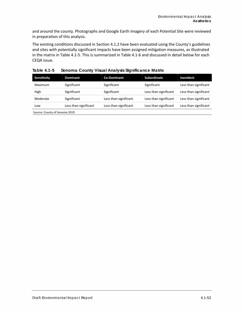
Environmental Impact Analysis Aesthetics
Draft Environmental Impact Report 4.1-53
and around the county. Photographs and Google Earth imagery of each Potential Site were reviewed in preparation of this analysis.
The existing conditions discussed in Section 4.1.2 have been evaluated using the County’s guidelines and sites with potentially significant impacts have been assigned mitigation measures, as illustrated in the matrix in Table 4.1-5. This is summarized in Table 4.1-6 and discussed in detail below for each CEQA issue.
Table 4.1-5 Sonoma County Visual Analysis Significance Matrix Sensitivity Dominant Co-Dominant Subordinate Inevident
Maximum Significant Significant Significant Less than significant
High Significant Significant Less than significant Less than significant
Moderate Significant Less than significant Less than significant Less than significant
Low Less than significant Less than significant Less than significant Less than significant
Source: County of Sonoma 2019
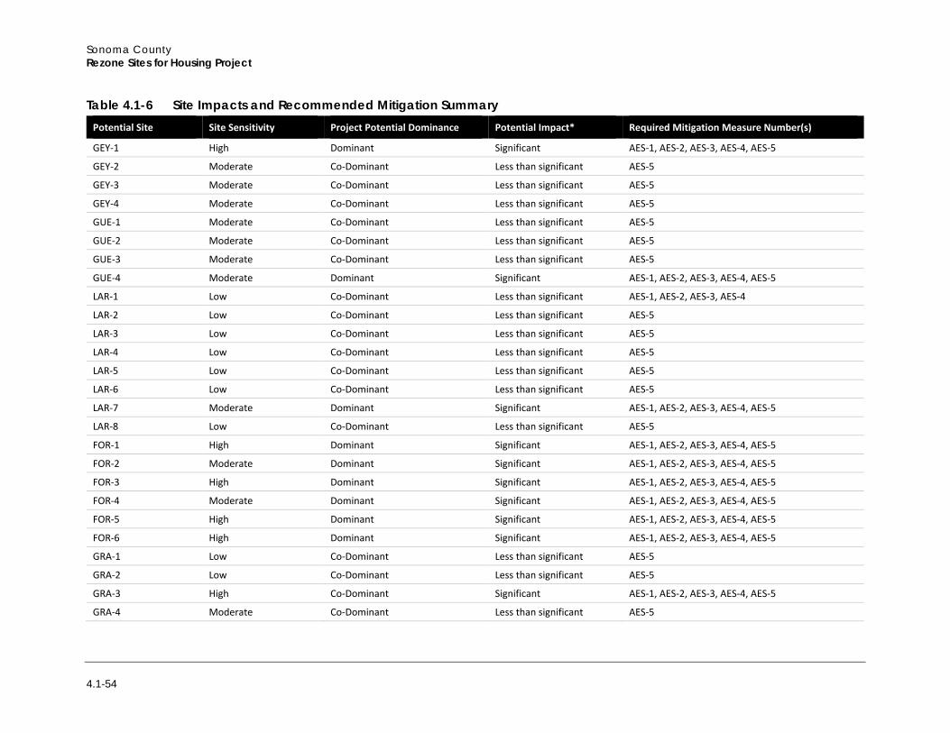
Sonoma County Rezone Sites for Housing Project
4.1-54
Table 4.1-6 Site Impacts and Recommended Mitigation Summary Potential Site Site Sensitivity Project Potential Dominance Potential Impact* Required Mitigation Measure Number(s)
GEY-1 High Dominant Significant AES-1, AES-2, AES-3, AES-4, AES-5
GEY-2 Moderate Co-Dominant Less than significant AES-5
GEY-3 Moderate Co-Dominant Less than significant AES-5
GEY-4 Moderate Co-Dominant Less than significant AES-5
GUE-1 Moderate Co-Dominant Less than significant AES-5
GUE-2 Moderate Co-Dominant Less than significant AES-5
GUE-3 Moderate Co-Dominant Less than significant AES-5
GUE-4 Moderate Dominant Significant AES-1, AES-2, AES-3, AES-4, AES-5
LAR-1 Low Co-Dominant Less than significant AES-1, AES-2, AES-3, AES-4
LAR-2 Low Co-Dominant Less than significant AES-5
LAR-3 Low Co-Dominant Less than significant AES-5
LAR-4 Low Co-Dominant Less than significant AES-5
LAR-5 Low Co-Dominant Less than significant AES-5
LAR-6 Low Co-Dominant Less than significant AES-5
LAR-7 Moderate Dominant Significant AES-1, AES-2, AES-3, AES-4, AES-5
LAR-8 Low Co-Dominant Less than significant AES-5
FOR-1 High Dominant Significant AES-1, AES-2, AES-3, AES-4, AES-5
FOR-2 Moderate Dominant Significant AES-1, AES-2, AES-3, AES-4, AES-5
FOR-3 High Dominant Significant AES-1, AES-2, AES-3, AES-4, AES-5
FOR-4 Moderate Dominant Significant AES-1, AES-2, AES-3, AES-4, AES-5
FOR-5 High Dominant Significant AES-1, AES-2, AES-3, AES-4, AES-5
FOR-6 High Dominant Significant AES-1, AES-2, AES-3, AES-4, AES-5
GRA-1 Low Co-Dominant Less than significant AES-5
GRA-2 Low Co-Dominant Less than significant AES-5
GRA-3 High Co-Dominant Significant AES-1, AES-2, AES-3, AES-4, AES-5
GRA-4 Moderate Co-Dominant Less than significant AES-5

Environmental Impact Analysis Aesthetics
Draft Environmental Impact Report 4.1-55
Potential Site Site Sensitivity Project Potential Dominance Potential Impact* Required Mitigation Measure Number(s)
GRA-5 High Co-Dominant Significant AES-1, AES-2, AES-3, AES-4, AES-5
SAN-1 Low Dominant Significant AES-1, AES-2, AES-3, AES-4, AES-5
SAN-2 Low Co-Dominant Less than significant AES-5
SAN-3 Low Dominant Less than significant AES-5
SAN-4 Low Co-Dominant Less than significant AES-5
SAN-5 Low Dominant Less than significant AES-5
SAN-6 Low Co-Dominant Less than significant AES-5
SAN-7 Low Co-Dominant Less than significant AES-5
SAN-8 Low Co-Dominant Less than significant AES-5
SAN-9 Low Co-Dominant Less than significant AES-5
SAN-10 Low Co-Dominant Less than significant AES-5
GLE-1 High Dominant Significant AES-1, AES-2, AES-3, AES-4, AES-5
GLE-2 High Dominant Significant AES-1, AES-2, AES-3, AES-4, AES-5
AGU-1 Moderate Co-Dominant Less than significant AES-1, AES-2, AES-5
AGU-2 Moderate Co-Dominant Less than significant AES-1, AES-2, AES-5
AGU-3 Moderate Co-Dominant Less than significant AES-5
PEN-1 High Co-Dominant Significant AES-1, AES-2, AES-3, AES-4, AES-5
PEN-2 Moderate Dominant Significant AES-1, AES-2 AES-3, AES-4, AES-5
PEN-3 High Co-Dominant Significant AES-1, AES-2, AES-3, AES-4, AES-5
PEN-4 Moderate Dominant Significant AES-1, AES-2, AES-3, AES-4, AES-5
PEN-5 High Co-Dominant Significant AES-1, AES-2, AES-3, AES-4, AES-5
PEN-6 Moderate Co-Dominant Less than significant AES-5
PEN-7 Moderate Dominant Significant AES-1, AES-2, AES-3, AES-4, AES-5
PEN-8 High Co-Dominant Significant AES-1, AES-2, AES-3, AES-4, AES-5
PEN-9 High Co-Dominant Significant AES-1, AES-2, AES-3, AES-4 AES-5
PET-1 High Dominant Significant AES-1, AES-2, AES-3, AES-4, AES-5
PET-2 High Dominant Significant AES-1, AES-2, AES-3, AES-4, AES-5
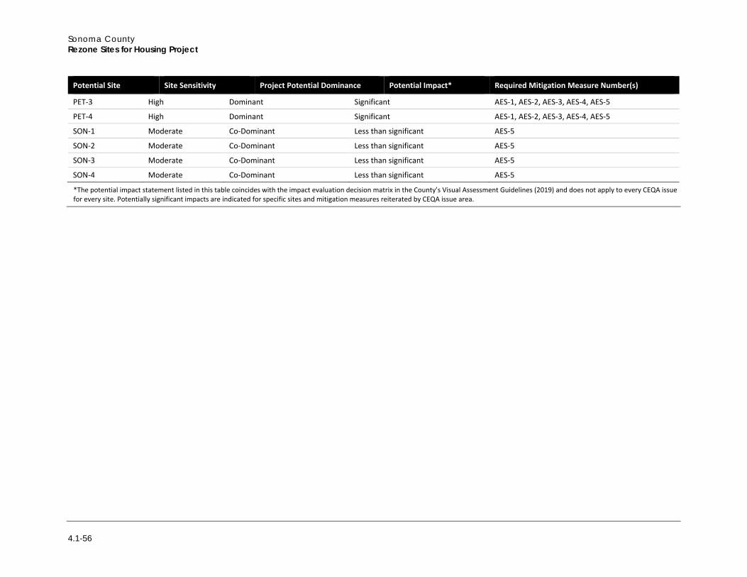
Sonoma County Rezone Sites for Housing Project
4.1-56
Potential Site Site Sensitivity Project Potential Dominance Potential Impact* Required Mitigation Measure Number(s)
PET-3 High Dominant Significant AES-1, AES-2, AES-3, AES-4, AES-5
PET-4 High Dominant Significant AES-1, AES-2, AES-3, AES-4, AES-5
SON-1 Moderate Co-Dominant Less than significant AES-5
SON-2 Moderate Co-Dominant Less than significant AES-5
SON-3 Moderate Co-Dominant Less than significant AES-5
SON-4 Moderate Co-Dominant Less than significant AES-5
*The potential impact statement listed in this table coincides with the impact evaluation decision matrix in the County’s Visual Assessment Guidelines (2019) and does not apply to every CEQA issue for every site. Potentially significant impacts are indicated for specific sites and mitigation measures reiterated by CEQA issue area.
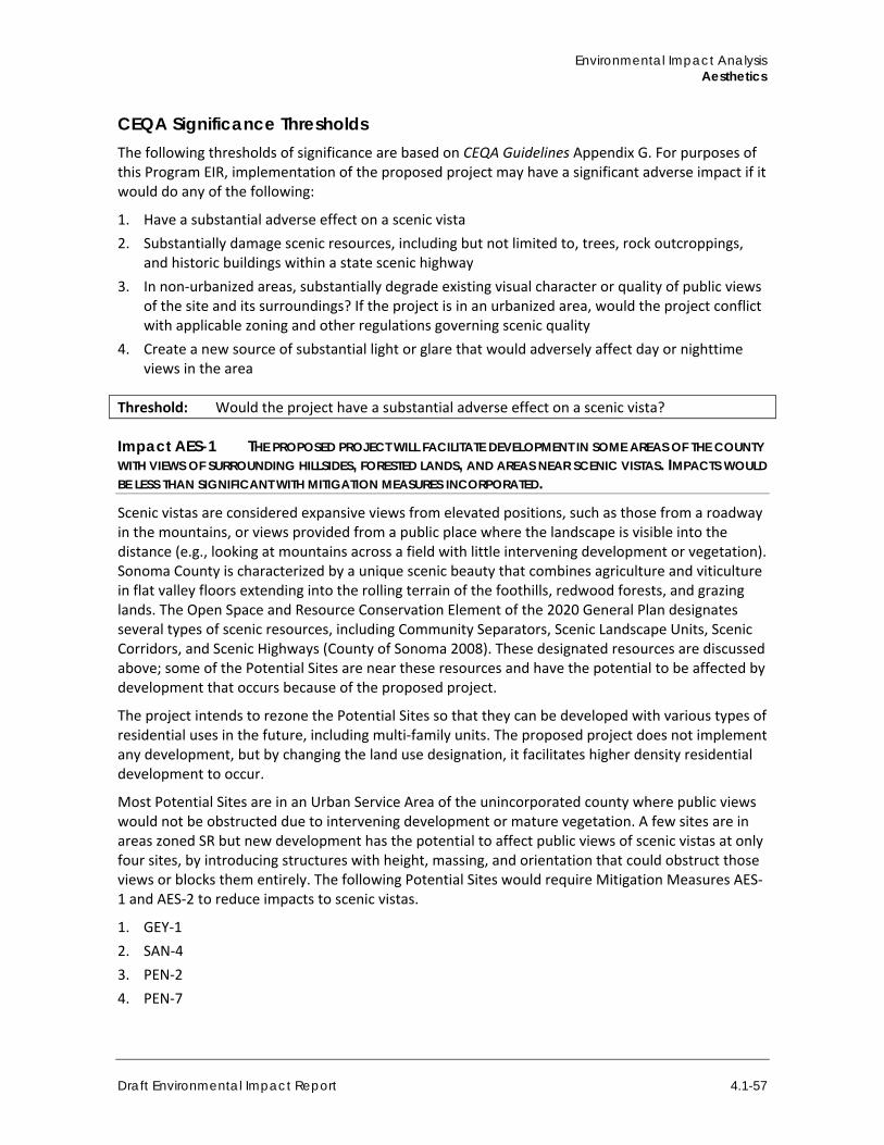
Environmental Impact Analysis Aesthetics
Draft Environmental Impact Report 4.1-57
CEQA Significance Thresholds The following thresholds of significance are based on CEQA Guidelines Appendix G. For purposes of this Program EIR, implementation of the proposed project may have a significant adverse impact if it would do any of the following:
1. Have a substantial adverse effect on a scenic vista 2. Substantially damage scenic resources, including but not limited to, trees, rock outcroppings,
and historic buildings within a state scenic highway 3. In non-urbanized areas, substantially degrade existing visual character or quality of public views
of the site and its surroundings? If the project is in an urbanized area, would the project conflict with applicable zoning and other regulations governing scenic quality
4. Create a new source of substantial light or glare that would adversely affect day or nighttime views in the area
Threshold: Would the project have a substantial adverse effect on a scenic vista?
Impact AES-1 THE PROPOSED PROJECT WILL FACILITATE DEVELOPMENT IN SOME AREAS OF THE COUNTY WITH VIEWS OF SURROUNDING HILLSIDES, FORESTED LANDS, AND AREAS NEAR SCENIC VISTAS. IMPACTS WOULD BE LESS THAN SIGNIFICANT WITH MITIGATION MEASURES INCORPORATED.
Scenic vistas are considered expansive views from elevated positions, such as those from a roadway in the mountains, or views provided from a public place where the landscape is visible into the distance (e.g., looking at mountains across a field with little intervening development or vegetation). Sonoma County is characterized by a unique scenic beauty that combines agriculture and viticulture in flat valley floors extending into the rolling terrain of the foothills, redwood forests, and grazing lands. The Open Space and Resource Conservation Element of the 2020 General Plan designates several types of scenic resources, including Community Separators, Scenic Landscape Units, Scenic Corridors, and Scenic Highways (County of Sonoma 2008). These designated resources are discussed above; some of the Potential Sites are near these resources and have the potential to be affected by development that occurs because of the proposed project.
The project intends to rezone the Potential Sites so that they can be developed with various types of residential uses in the future, including multi-family units. The proposed project does not implement any development, but by changing the land use designation, it facilitates higher density residential development to occur.
Most Potential Sites are in an Urban Service Area of the unincorporated county where public views would not be obstructed due to intervening development or mature vegetation. A few sites are in areas zoned SR but new development has the potential to affect public views of scenic vistas at only four sites, by introducing structures with height, massing, and orientation that could obstruct those views or blocks them entirely. The following Potential Sites would require Mitigation Measures AES-1 and AES-2 to reduce impacts to scenic vistas.
1. GEY-1 2. SAN-4 3. PEN-2 4. PEN-7
Sonoma County Rezone Sites for Housing Project
4.1-58
Mitigation Measures
AES-1 Project Design Constraints
Through the design review process, the project applicant shall site and design projects such that the amount of grading, numbers of tree removed, amount of cut and fill, length of roadways, height of retaining walls, and size of areas for structure envelopes is as minimal as possible without reducing the density of the project. For discretionary projects, the County may impose conservation easements to protect viewsheds and sensitive visual resources, to the extent feasible. Project designs showing that the aforementioned project elements meet these criteria shall be reviewed and approved by the County prior to building permit issuance.
AES-2 Structure Envelope Constraints
The project applicant shall adjust or move structure envelopes to avoid the locations most visible from public roads, and/or reduce the size of structures to the extent that vegetation that may screen structures is protected but project density is not reduced. Other architectural design measures can also be used to increase density but visually decrease mass (e.g., variations in roofline, fenestration, exterior finishes, and landscaping). Project designs showing these constraints shall be reviewed and approved by the County prior to building permit issuance.
Significance After Mitigation With the implementation of Mitigation Measures AES-1 and AES-2, impacts to scenic vistas at GEY-1, SAN-4, PEN-2, and PEN-7 would be reduced to less than significant.
Threshold: Would the project substantially damage scenic resources, including but not limited to, trees, rock outcroppings, and historic buildings within a state scenic highway?
Impact AES-2 POTENTIAL SITES IN FORESTVILLE AND GRATON BORDER A STATE SCENIC HIGHWAY, AND POTENTIAL SITES IN GUERNEVILLE AND GLEN ELLEN ARE PROXIMATE TO STATE SCENIC HIGHWAYS. THEREFORE, SCENIC RESOURCES COULD BE AFFECTED IF INDIVIDUAL PROJECTS ARE VISIBLE FROM THESE ROADWAYS. IMPACTS WOULD BE LESS THAN SIGNIFICANT WITH MITIGATION MEASURES INCORPORATED.
Sonoma County conducts design review in accordance with Article 82 of the Sonoma County Zoning Code. The project may include evaluation of project plans by the Sonoma County Design Review Committee, which may recommend design revision before permits are issued, when design review is a component of project approval. Design review may also be done administratively at the staff level. Specific design guidelines exist for the communities of Glen Ellen and Penngrove, and development in those areas would be subject to the relevant design guidelines (County of Sonoma 1990). Potential Sites that fall within the LG/SR 116 zoning will be subject to design review according to the zoning code. Stipulations about development close to historic sites in Penngrove are also in place. The Sonoma County General Plan specifies design guidelines for development in areas of Forestville considered scenic corridors.
Most Potential Sites are in the Urban Service Area of the unincorporated county where public views would not be obstructed due to intervening development or mature vegetation. A few sites have the potential to affect public views of scenic vistas by introducing height, massing, and orientation that could obstruct those views or blocks them entirely.
Environmental Impact Analysis Aesthetics
Draft Environmental Impact Report 4.1-59
Potential Sites in Guerneville, Forestville, Graton, and Glen Ellen border or are close to State-designated scenic highways (State Route 116 and State Route 12). Because the projects considered on some of the Potential Sites could create significant impacts, at the locations discussed below, mitigation measures AES-1 and AES-2 would be necessary to reduce impacts.
Potential Sites close enough to a state-designated scenic highway that project implementation could result in a significant impact are as follows:
1. GUE-1 2. FOR-1 3. FOR-3 4. FOR-5 5. GRA-3 6. GRA-5 7. GLE-1 8. GLE-2 9. AGU-1 10. AGU-2
Mitigation Measures AES-1 and AES-2 would be necessary to prevent removal of or damage to visual resources in a state-designated scenic roadway.
Significance After Mitigation Implementation of Mitigation Measures AES-1 and AES-2 for GUE-1, FOR-1, FOR-3, FOR-5, GRA-3, GRA-5, GLE-1, GLE-2, AGU-1, and AGU-2 would prevent removal or damage to scenic resources within a State-designated highway, particularly by changing the character of visual resources. Impacts would be reduced to less than significant.
Threshold: Would the project, in non-urbanized areas, substantially degrade the existing visual character or quality of public views of the site and its surroundings? (Public views are those that are experienced from a publicly accessible vantage point.) If the project is in an urbanized area, would the project conflict with applicable zoning and other regulations governing scenic quality?
Impact AES-3 INDIVIDUAL PROJECTS IMPLEMENTED ON POTENTIAL SITES HAVE THE POTENTIAL TO ADVERSELY AFFECT PUBLIC VIEWS AND COMMUNITY AESTHETIC CHARACTER. IN URBANIZED AREAS, THE PROJECT WOULD CONFLICT WITH REGULATIONS THAT GOVERN DEVELOPMENT DESIGN STANDARDS. IMPACTS WOULD BE LESS THAN SIGNIFICANT WITH MITIGATION MEASURES INCORPORATED.
The project would facilitate development projects at some sites that could introduce incongruous styles and massing or could degrade visual character through the necessary removal of existing, mature trees. New development that is incompatible with the natural and built conditions as they exist could cause a significant impact to the visual quality by changing the visual nature of the site from open space to densely developed residential properties, or by introducing structures with unremarkable design into a neighborhood with a distinctive character informed, in part, by the architecture.
Sonoma County Rezone Sites for Housing Project
4.1-60
The Potential Sites with high site sensitivity and where development would be dominant or co-dominant, and sites with moderate sensitivity where development would be dominant are as follows:
1. GEY-1
2. GUE-4 3. LAR-7 4. FOR-1 5. FOR-2 6. FOR-3 7. FOR-4 8. FOR-5 9. FOR-6 10. GRA-3 11. GRA-5 12. GLE-1 13. GLE-2 14. PEN-1 15. PEN-2 16. PEN-3 17. PEN-4 18. PEN-5 19. PEN-7 20. PEN-8 21. PEN-9 22. PET-1 23. PET-2 24. PET-3 25. PET-4
Development projects at all these sites would be subject to Mitigation Measures AES-1 and AES-2, listed above, and AES-3 and AES-4 described below.
Mitigation Measures Mitigation Measures AES-1 and AES-2, as detailed above, would be required, in addition to the following.
AES-3 Material Color and Texture
Projects shall be designed with exterior finishes in colors and textures consistent with the surrounding environment. Projects shall be designed with non-reflective surfaces and darker colors to avoid glare and contrast. Project designs detailing proposed materials shall be approved by the County prior to building permit approval.
Environmental Impact Analysis Aesthetics
Draft Environmental Impact Report 4.1-61
AES-4 Screening Vegetation
Project landscape plans shall be designed with screening vegetation, to the extent feasible. Project landscape plans shall be approved by the County prior to building permit approval.
Significance After Mitigation With implementation of Mitigation Measures AES-1, AES-2, AES-3, and AES-4 impacts would be reduced to less than significant at the sites listed above.
Threshold: Would the project create a new source of substantial light or glare that would adversely affect daytime or nighttime views in the area?
Impact AES-4 DEVELOPMENT FACILITATED BY THE PROJECT WOULD CREATE NEW SOURCES OF LIGHT OR GLARE THAT COULD ADVERSELY AFFECT THE VISUAL ENVIRONMENT. IMPACTS WOULD BE LESS THAN SIGNIFICANT WITH MITIGATION MEASURES INCORPORATED.
In rural areas where Potential Sites occur, very limited light and glare sources are present. In suburban areas, increased light emanates at night from streetlights, signage, and from light that spills from windows of residential and commercial uses. In more urbanized areas like Santa Rosa, a greater amount of nighttime light is present from the concentration of denser built areas and street and highway systems, all which cumulatively add to light spillage. Similarly, in areas with more vehicular travel (cities, highways), there is more glare from headlights at night over that in rural or semi-rural areas. Commercial districts with large parking lots and limited tree plantings would generate glare during the day as the sun reflects off car windshields. Furthermore, if structures are painted light colors or have extensive fenestration, and if grounds have sparse landscaping (see for example Figure 4.1-23, Figure 4.1-26, and Figure 4.1-43), then there would be an increased potential for glare to occur on a sunny day.
New development would have the potential to increase light and glare in and around the Potential Sites. Increased population would have associated increases in vehicular travel, potentially adding to the light conditions (headlights) and glare conditions (when cars are parked) in a manner that could be substantial. The County General Plan Goal OSRC-4 details the requirements to limit excess light generated by new development, preserve night sky visibility, and maintain lighting levels appropriate to rural residential uses. Nonetheless, implementation of projects at all the Potential Sites, over the course of time, would result in additional light from exterior lighting, interior light that spills from windows, and from increased vehicular travel at night associated with the increase in population. Even with the population growth anticipated by the General Plan and other regional planning documents, the impacts of complete build-out of the Potential Sites could be significant regarding light and glare. Mitigation Measure AES-5 would be required to reduce the effects of light and glare.
Mitigation Measure
AES-5 Exterior Lighting Requirements
Project designs shall incorporate exterior lighting plans meeting the following minimum requirements.
1. Lighting shall be mounted low, downward casting, and fully shielded to prevent glare. 2. Lighting shall not wash out structures or any portions of the site.
Sonoma County Rezone Sites for Housing Project
4.1-62
3. Light fixtures shall not be located at the periphery of the property and shall not spill over onto adjacent properties or into the sky.
4. Flood lights are not permitted. 5. Parking lot fixtures shall be limited to 20 feet in height. 6. All parking lot and/or streetlight fixtures shall use full cut-off fixtures. 7. Lighting shall shut off automatically after businesses close and security lighting shall be motion-
sensor activated. 8. Lighting plans should be designed to meet the appropriate Lighting Zone standards from Title 24
effective October 2005 (LZ1 for dark areas, LZ2 for rural, LZ3 for urban) or successor regulations.
Significance After Mitigation With implementation of Mitigation Measure AES-5, impacts from light and glare would be reduced to less than significant.
4.1.9 Cumulative Impacts A project’s environmental impacts are “cumulatively considerable” if the “incremental effects of an individual project are significant when viewed in connection with the effects of past projects, the effects of other current projects, and the effects of probable future project (CEQA Guidelines Section 15065[a][3]).
The geographic unit for cumulative aesthetics and visual quality impacts is the unincorporated county, especially areas in the vicinity of the Potential Sites. Cumulative development includes development associated with buildout of the County’s General Plan and adjacent incorporated city general plans, as well as foreseeable future projects from Table 3-1 that could have a direct connection to the proposed project from the perspective of visual resources. Cumulative impacts to visual resources could be cumulative considerable if project implementation would impact those resources. Projects would be subject to individual design review and environmental review that would mitigate impacts to visual resources to less than significant, as anticipated by the General Plan EIR.
Past, present, and reasonably foreseeable projects would have limited, site-specific impacts on public viewsheds and scenic resources throughout the County. Most of the projects listed in Table 3-1 would not impact public viewsheds or scenic resources given the proposed massing and heights of structures, or the proposed locations within developed areas with comparable structures. Similar to the project, those projects would undergo design review or environmental review to mitigate impacts to the extent feasible.
As discussed under the impact analysis above, Impact AES-1 would be less than significant with mitigation. Development facilitated by the project would be required to adhere to applicable zoning and development regulations and General Plan policies to mitigate environmental impacts where feasible and would undergo environmental and design review, including consideration of whether the projects would affect scenic resources in any of the scenic corridors, highways, greenbelts, or other resources defined in the General Plan. Project implementation and development on the Potential Sites could contribute to these cumulatively considerable impacts.
Scenic highways do traverse the county in some areas, near and beyond the Potential Sites. Other project-level developments would be required to adhere to applicable zoning and development regulations and General Plan policies to mitigate environmental impacts where feasible and
Environmental Impact Analysis Aesthetics
Draft Environmental Impact Report 4.1-63
discretionary projects would undergo environmental as well as design review, including consideration of whether the projects would affect visual resources within a state scenic highway. While cumulative impacts could be considerable, the project would not contribute to these cumulative impacts to visual resources in a scenic highway as the Potential Sites would be subject to the regulations and mitigation measures described above.
As described in Impact AES-3, the visual character of rural areas could change with development on specific Potential Sites. In some cases, effects of project implementation to aesthetic resources would be less than significant with mitigation. Projects implemented on the Potential Sites would contribute to cumulative impacts. Other project-level developments would be required to adhere to applicable zoning and development regulations and General Plan policies and would undergo design review to mitigate environmental impacts where feasible and would undergo environmental and design review, including consideration of whether the projects would affect aesthetic resources. With these considerations prior to project approval, cumulative impacts related to aesthetics would be less than significant and the proposed project’s contribution to potentially significant cumulative impacts related to visual quality would be cumulatively less than significant.
An increase in light and glare could be cumulative considerable as the County continues to be built out, as envisioned under the General Plan. Regulations that govern light and glare would apply to these projects, which would undergo individual environmental review. Potential impacts would similarly be mitigated to the extent feasible to prevent significant impacts. As described under Impact AES-4, the proposed project would increase the level of light and glare throughout the county and would require mitigation. Other project-level developments would be required to undergo environmental review, including consideration of whether the projects would increase light and glare. With these considerations prior to project approval and implementation of mitigation described above, or similar, cumulative impacts related to light and glare would be less than significant. Furthermore, the proposed project’s contribution to less than significant cumulative impacts related to light and glare would be less than cumulatively considerable.

Sonoma County Rezone Sites for Housing Project
4.1-64
This page intentionally left blank.