Embed Size (px)
Citation preview
INSPECTION STRATEGYFOR THE
IDENTIFICATION AND REMEDIATION
OFCONTAMINATED LAND
OCT 2001REVIEWED 2003
DEPARTMENT OF DEVELOPMENT SAFETY & REGULATION
CONTENTS
EXECUTIVE SUMMARY
CHAPTER 1 INTRODUCTION
1.1 General Policy of South Ayrshire Council1.2 Regulatory Context1.3 Definition of Contaminated Land1.4 Pollutant Linkages1.5 Requirements for a Strategic approach
CHAPTER 2 CHARACTORISTICS OF SOUTH AYRSHIRE COUNCIL AREA
2.1 Description and History2.2 Population Distribution2.3 Details of Local Authority Ownership2.4 Natural Environment2.5 Built Environment2.6 Water Resources2.7 Known Information on Contamination2.8 Geological Characteristic2.9 Specific Local Features
CHAPTER 3 THE SOUTH AYRSHIRE STRATEGY – OVERALL AIMS
3.1 The Council Priorities3.2 Site investigation and prioritisation.3.3 Remediation Action
CHAPTER 4 LOCAL AUTHORITY PRIORITY ACTION
4.1 Overall Priority4.2 Priority Actions – specific objectives and Time scales.
CHAPTER 5 PROCEDURES
5.1 Internal Management Arrangements for inspections and Identification5.2 Considering Local Authority interest in land5.3 Information5.4 Information and Complaints5.5 Information Evaluation
CHAPTER 6 GENERAL LIASION AND COMMUNICATION STRATEGY
6.1 Other Regulatory Bodies6.2 Non-Regulatory Bodies, Landowners, other Interested Parties and the Wider Community
1
CHAPTER 7 PROGRAMME FOR INSPECTION
7.1 Detailed Inspections7.2 Risk Assessment
- human- waters- other
7.3 Health and Safety Procedure7.4 Provision of Information
CHAPTER 8 REVIEW MECHANISIMS
8.1 Triggers for Undertaking Inspections8.2 Reviewing the Strategy Documents8.3 Audit
CHAPTER 9 INFORMATION MANAGEMENT
9.1 General Policy9.2 Public Register9.3 Commercial Confidentiality9.4 Issues of National Security9.5 Information Management9.6 Request for Information9.7 Provision of Information to SEPA9.8 State of Contaminated Land in Scotland Report
CHAPTER 10 OTHER SUPPORTING INFORMATION
10.1 Local Authority Contacts10.2 Information Sources
2

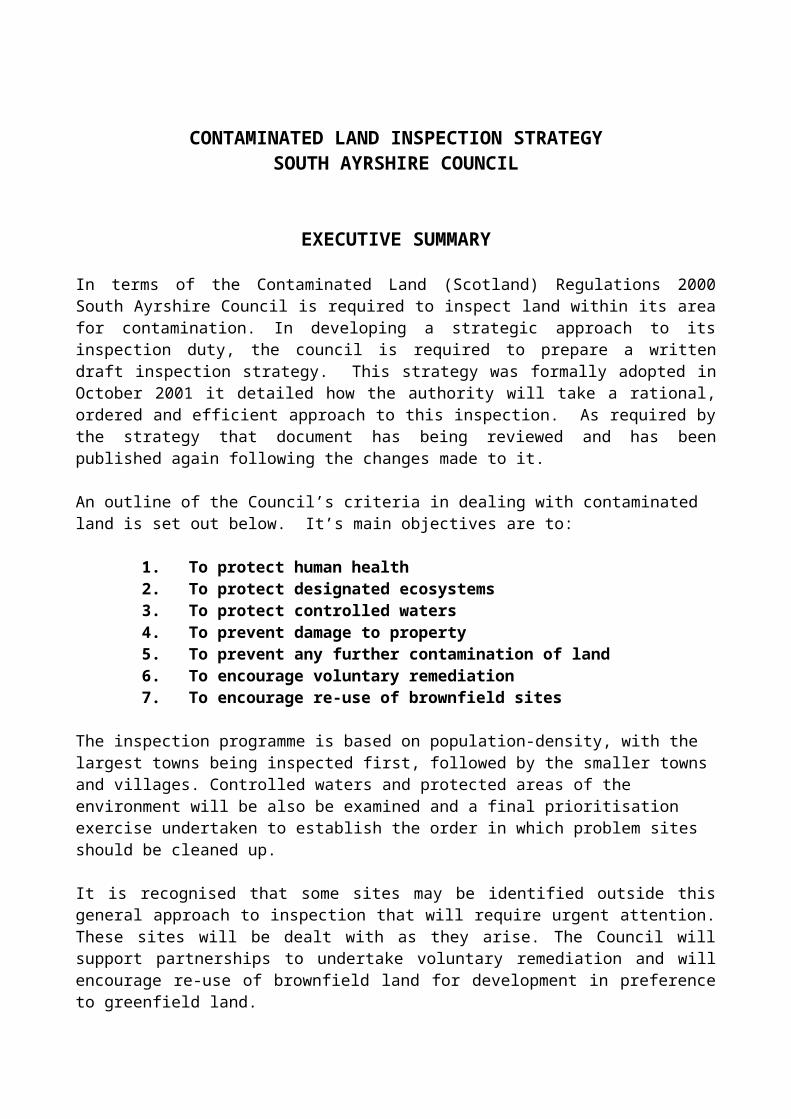
CONTAMINATED LAND INSPECTION STRATEGY SOUTH AYRSHIRE COUNCIL
EXECUTIVE SUMMARY
In terms of the Contaminated Land (Scotland) Regulations 2000 South Ayrshire Council is required to inspect land within its area for contamination. In developing a strategic approach to its inspection duty, the council is required to prepare a written draft inspection strategy. This strategy was formally adopted in October 2001 it detailed how the authority will take a rational, ordered and efficient approach to this inspection. As required by the strategy that document has being reviewed and has been published again following the changes made to it.
An outline of the Council’s criteria in dealing with contaminated land is set out below. It’s main objectives are to:
1. To protect human health2. To protect designated ecosystems3. To protect controlled waters4. To prevent damage to property5. To prevent any further contamination of land6. To encourage voluntary remediation7. To encourage re-use of brownfield sites
The inspection programme is based on population-density, with the largest towns being inspected first, followed by the smaller towns and villages. Controlled waters and protected areas of the environment will be also be examined and a final prioritisation exercise undertaken to establish the order in which problem sites should be cleaned up.
It is recognised that some sites may be identified outside this general approach to inspection that will require urgent attention. These sites will be dealt with as they arise. The Council will support partnerships to undertake voluntary remediation and will encourage re-use of brownfield land for development in preference to greenfield land.
The Council is the lead regulator on contaminated land but, wherever necessary, the Council will work in partnership with other organisations particularly the Scottish Environment Protection Agency (SEPA).
By its nature and history the identification of contamination of land cannot be definitive. This Strategy will therefore be reviewed on a regular basis to ensure that it is effective and up to date. This review is the first.
The regulations set clear criteria that must be met before land can be formally designated as contaminated land. The Council must also maintain a public register that must contain only certain information. The expectations of some members of the public may not always be met by the powers local authorities may exercise under contaminated land legislation.
CHAPTER 1
INTRODUCTION
South Ayrshire Council is required to inspect land within its area for contamination under new regulations that came into force in Scotland on the 14 th July 2000. This strategy details how that inspection process will be undertaken.
1.1 GENERAL POLICY OF SOUTH AYRSHIRE COUNCIL
This Inspection Strategy is built upon the council’s pledges and key themes as set out in its cornerstone document “A Vision of 2020”
“A Vision of 2020” is one that the community, businesses, voluntary organisations and other public agencies are able to shape and influence.
South Ayrshire Council will achieve this Vision by:
Heightening levels of community safety and security
Conserving and enhancing the natural and built environment
Working towards a sustainable community
Attracting investment in business and jobs
Preserving and enhancing the vitality and viability of existing towns and villages
Increasing the supply of quality affordable housing
Working towards improving the health of the community
Developing a community planning process
Promoting openness and transparency in the decision making process of public
services
South Ayrshire Council’s approach to local government is based on the need to be open and accountable for its actions. The Draft Inspection Strategy has therefore be made available to all interested sections of the community for consultation and comments included.
Land contamination has significant impacts on both the environment and the economy so these policy areas have been key considerations in developing this Inspection Strategy.
Environmental Issues and Local Agenda 21
4

The council’s strategy on contaminated land sits comfortably with its strategic objectives in terms of Local Agenda 21 which are:
1. To develop and implement a corporate sustainable development programme which will inform and support other strategies and service plans.
2. To measure, monitor and improve the Council’s environmental performance.
3. To improve the understanding and awareness of sustainability issues in the Council and the wider community and to encourage full community participation in the implementation of the strategy.
4. To devise and implement suitable sustainable indicators to reflect local and national priorities.
5. To establish partnerships with business, voluntary and other public sector bodies to develop sustainable initiatives.
1.2 REGULATORY CONTEXT
Under Section 78B(1) of the Environmental Protection Act 1990, the Contaminated Land (Scotland) Regulations 2000, and SEPA Circular 1/2000 Statutory Guidance on Contaminated Land, Local Authorities have a duty to carry out inspections for the purpose of identifying contaminated land within their area.
The main objective of the regime is to provide an improved system for the identification and remediation of land where contamination is causing unacceptable risks to human health or the wider environment, assessed in the context of the current use and circumstances of the land.
The Roles of South Ayrshire Council (SAC) and the Scottish Environment Protection Agency (SEPA)
Under the Part IIA regime, local authorities have been given the primary regulatory role, as they have historically had responsibility for dealing with any statutory nuisance caused by land contamination and are also the lead authorities on land use planning.
Under the new regime, South Ayrshire Council has a duty:
1. To cause its area to be inspected for contaminated land
2. To determine whether any particular site meets the statutory definition of contaminated land
5

3. To act as the enforcing authority for all contaminated land, unless the site meets the definition of a "special site" (in which case SEPA will act as the Enforcing authority).
4. To establish who may be the appropriate person(s) responsible for the remediation of the land/water
5. To decide after consultation what remediation might be required at each site and ensure that such remediation takes place by:
Reaching voluntary agreement Serving a Remediation Notice Carrying out the work themselves if no appropriate person can be
identified Apportioning the liability for meeting the costs of remediation amongst
appropriate persons.
6. To record specific information on a public register concerning their regulatory actions. The Scottish Environment Protection Agency (SEPA) has a secondary regulatory role their duties include
The provision and advice to local authorities The regulation of special sites Publishing periodic reports on the state of land contamination nationally.
1.3 DEFINITION OF CONTAMINATED LAND
What is Contaminated Land?
A statutory definition of contaminated land as given in Section 78A(2) of Part IIA of the Environmental Protection Act 1990 defines contaminated land as being:
“any land which appears to the local authority in whose area it is situated to be in such condition , by reasons of substances in, on or under the land, that –
A) Significant Harm is being caused or there is Significant Possibility of such harm being caused; or
B) Pollution of Controlled Waters is being or is likely to be caused”
It is important to remember that not all land where pollutants are present will meet the criteria of “Contaminated Land”.
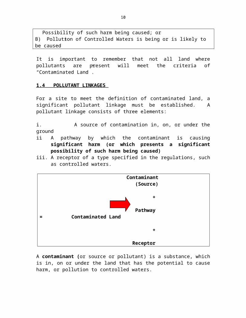
1.4 POLLUTANT LINKAGES
6
For a site to meet the definition of contaminated land, a significant pollutant linkage must be established. A pollutant linkage consists of three elements:
i. A source of contamination in, on, or under the groundii A pathway by which the contaminant is causing significant harm (or which
presents a significant possibility of such harm being caused) iii. A receptor of a type specified in the regulations, such as controlled waters.
Contaminant (Source) +
Pathway = Contaminated Land
+
Receptor
A contaminant (or source or pollutant) is a substance, which is in, on or under the land that has the potential to cause harm, or pollution to controlled waters.
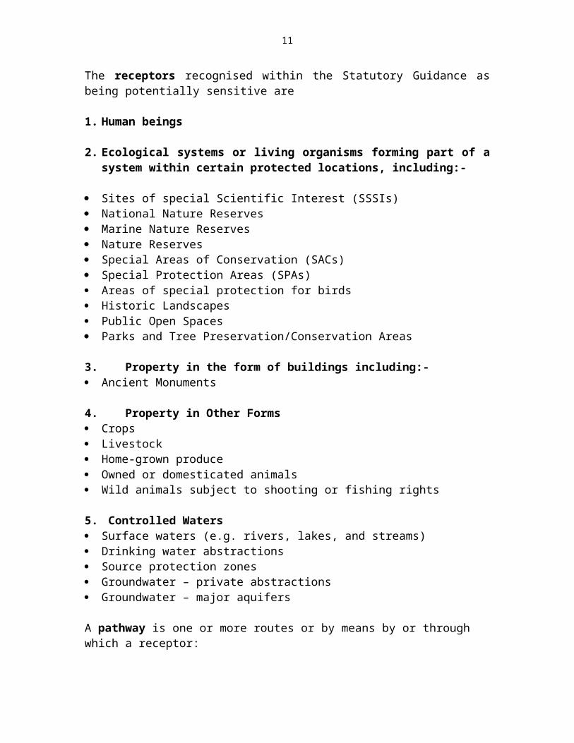
The receptors recognised within the Statutory Guidance as being potentially sensitive are
1. Human beings
2. Ecological systems or living organisms forming part of a system within certain protected locations, including:-
Sites of special Scientific Interest (SSSIs) National Nature Reserves Marine Nature Reserves Nature Reserves Special Areas of Conservation (SACs) Special Protection Areas (SPAs) Areas of special protection for birds Historic Landscapes Public Open Spaces Parks and Tree Preservation/Conservation Areas
3. Property in the form of buildings including:- Ancient Monuments
4. Property in Other Forms Crops Livestock
7

Home-grown produce Owned or domesticated animals Wild animals subject to shooting or fishing rights
5. Controlled Waters Surface waters (e.g. rivers, lakes, and streams) Drinking water abstractions Source protection zones Groundwater – private abstractions Groundwater – major aquifers A pathway is one or more routes or by means by or through which a receptor:
I. Is being exposed or affected by a contaminant, orII. Could be potentially exposed or affected.
For the land to be identified as contaminated land under the statutory definition then two stages must be established. The first being to identify the pollutant linkage and the second is to establish that it is a significant pollutant linkage. This second stage should be undertaken by using Site Specific Risk Assessment Techniques.
Once an area of contaminated land has been identified, the approach for dealing with it will be the same regardless of whether the local authority or SEPA is the regulator. There are four main stages to this approach:
1. Establishing who is the “appropriate person" to bear responsibility for the remediation (or “clean-up") of the land.
2. Deciding what remediation is required and to ensure that this occurs, either through reaching a voluntary agreement or alternatively if this cannot be achieved by serving an official remediation notice by carrying out remediation work themselves.
3. Determining who should bear what proportion of the liability for meeting the costs of the work .
4. Recording certain information about regulatory action on a public register.
1.5 REQUIREMENTS FOR A STRATEGIC APPROACH
All local authorities are required to take a strategic approach to inspecting land in their area for contamination.
The statutory guidance requires that the approach adopted should:
1. Be rational, ordered and efficient
8
2. Be proportionate to the seriousness of any actual or potential risk
3. Seek to ensure the most pressing and serious problems are located first
4. Ensure that resources are concentrated on investigating areas where the authority is most likely to identify contaminated land
5. Ensure that the local authority efficiently identifies requirements for the detailed inspection of particular areas of land.
This Contaminated Land Strategy has been developed to meet these requirements. It has been structured in terms of the Final Draft Paper entitled “Contaminated Land Inspection Strategies Advice for Scottish Local Authorities” prepared and issued by The Scottish Executive in August 2000.
9
CHAPTER 2 CHARACTERISTICS OF THE SOUTH AYRSHIRE COUNCIL AREA
This section gives the background to South Ayrshire Council and an explanation of how that influences the Council's approach to inspection for contaminated land.
GEOGRAPHICAL LOCATION – (SEE MAP 1)
South Ayrshire is located on the southwest coast of Scotland, on the Firth of Clyde, bounded by North Ayrshire to the north, East Ayrshire to the east, and Dumfries and Galloway to the South. The South Ayrshire coastline stretches for over 60 miles (96 kilometres)
2.1 DESCRIPTION/HISTORY
The mixed urban and rural character of the Council area means that there is and has been, a strong mix of industries. Not only traditional industries included agriculture, fishing, forestry and coal mining, but Aerospace and electronic industries are now well established. Leisure pursuits, particularly golf, and tourism are also important. The South Ayrshire Council area extends to some 477 square miles (123,000 hectares).
The main use of land, outwith residential use, is for agriculture. There are a number of small to medium sized industrial areas e.g. around Prestwick Airport, Heathfield (Ayr), Cockhill (Ayr), Newton (Ayr), and Grangestone (Girvan). Traditional “heavy” industries, such as foundries and coal mining have declined markedly in recent decades, being replaced by light industries such as electronics.
Coal MiningThere were two main areas of coal mining within South Ayrshire. The first extended from the centre of Prestwick south to the River Ayr, the northern boundary in Prestwick being the Kingcase Dyke, whilst the southern boundary is the outcrop of the Ayr Hard Coal seam, which roughly follows the line of the River Ayr. The coalfield extends under the sea to the west and to the east it becomes part of the Ayrshire Coalfield. The second area covered the Girvan Valley coalfield around Dailly and Kilkerran.
The first record of a coal pit being sunk occurred around 1700, but it is probable that coal was extracted from outcrops long before that date. The majority of the coal pots in Ayr, Newton-on-Ayr, Whitletts and Prestwick were closed and abandoned by 1850 which means that virtually no records or plans have survived, these closures occurring prior to the Statutory Requirement to keep Abandonment Plans. Pits exploiting the deeper coal seams inland around Annbank, Coylton, Tarbolton etc., were in production well into the 20th century, with the last pit to be closed being at Glenburn, Prestwick sunk in the 1890s and closed in 1978. The extraction of coal by mininghas now ceased, although there remain a number of quarries e.g. Hillhouse (by Troon), Tormitchell (by Barr). There are no currently preferred or search areas for opencast coal within South Ayrshire.
10
Quarrying, etc.A number of quarries were opened for the working of building stone, (most have closed). The theralite sills (Doleritic Whinstone) at Hillhouse Quarry near Troon are still utilised, mainly for road “metal”. Fireclays were extensively worked for brick production, e.g. near Dailly (Limestone coal) and near Annbank, but all such production has now ceased.
2.2 POPULATION DISTRIBUTION
The Council area contains an estimated population of some 114,000. The main town and administration centre is Ayr, with other major population centres at Troon, Prestwick, Maybole and Girvan.
2.3 DETAILS OF AUTHORITY OWNERSHIP OF LAND
The Council has various land holdings throughout the area.
2.4 NATURAL ENVIRONMENT
The approved Ayrshire Joint Structure Plan identifies areas of particular landscape quality and defines these as Sensitive Landscape Character Areas. The detailed boundaries of these areas have been identified in the Draft South Ayrshire Local Plan. However it is likely that these boundaries will be reviewed before the local plan is adopted. There are also 34 Sites of Special Scientific interest and 4 confirmed and 109 provisional Wildlife Sites within the area. A number of sites are also included in the inventory of Gardens and Design Landscapes, which is held jointly by Scottish Natural Heritage and Historic Scotland.
2.5 BUILT ENVIRONMENT
As well as its rich natural environment, the Council has a varied historic built environment, with 894 buildings or structures listed as being of special architectural or historic interest. Approximately half of these are located within Ayr. There are currently 19 conservation areas within South Ayrshire, 5 of which are considered to be outstanding. The Draft South Ayrshire Local Plan has proposed a further four conservation areas, and extensions of three existing areas.
2.6 KEY WATER RESOURCE / PROTECTION ISSUES
The West of Scotland Water Authority (WOSWA) provides water supply to the urban areas, by main from Loch Bradan, which is located to the southwest of the Council area. There are ten large raised reservoirs within the Council area (as designated by the Reservoirs Act 1975), but the majority are no longer used for water supply purposes. There are 240 private drinking water supplies in the area serving 442 properties. These may also include rivers, and streams, coastal waters, ground water aquifers etc.
11
2.7 KNOWN INFORMATION ON CONTAMINATION
The Council prepared a list of areas of suspect land, using a variety of sources to identify known areas of possible contamination, e.g. landfill sites, former gas works, mines etc. A number of former gasworks sites within South Ayrshire have been investigated and remediated.
2.8 BROAD GEOLOGICAL CHARACTERISTICS
Topographically, Scotland is divided into three distinct regions – the Highlands, the Midland Valley and the Southern Uplands. The Southern Upland Fault, separating the Midland Valley from the Southern Uplands, is located in South Ayrshire (on a line roughly from Ballantrae to Dalmellington). This divides South Ayrshire into a number of geographical areas i.e. Southern Uplands, the Ballantrae & Girvan Cover, and the Midland Valley. Generally strata South of the Southern Uplands Fault, consists of greywhacke, a sedimentary rock formed of poorly sorted sandstone with quartz, feldspar and rock fragments overlying black shales and silica material.
The Ballantrae and Girvan Cover is roughly a triangular area on the coast of the South West End of the Fault. Here the rocks are mainly igneous (ophiolites) but conglomerates, sandstones, shales and limestones are also present. Most of the South Ayrshire area is located in the Midland Valley, with the typical geological succession being: -
Drift SolidCarboniferous (Permian)
Recent and Pleistocene – Upper (Barren Red) Coal Measures(Raised beaches alluvium and boulder clays) Middle (Productive) Coal Measures
Old Red SandstoneSilurianOrdovician
2.8 HYDROLOGY (SURFACE WATERS AND GROUND WATERS) CHARACTERISTICS (MAP 2)
There are four main rivers running (Generally east to west) through the South Ayrshire Area, the Rivers Ayr, Doon, Girvan and Stinchar. There is no major aquifer present, although SEPA have delineated certain areas as “Groundwater Vulnerable”. Most of the South Ayrshire Council area is classed as moderately permeable or weakly permeable with only isolated areas classed as highly permeable.
2.9 SPECIFIC LOCAL FEATURES (AREAS OF NATURALLY METAL ENRICHED SOILS)
None are known within the South Ayrshire area.
12
CHAPTER 3
THE SOUTH AYRSHIRE STRATEGY: OVERALL AIMS
The reasons for writing this strategy were described in Section 1.2. A detailed breakdown of how the Council will meet its objectives is given in this section, prioritising actions and laying down projected timescales. The aim of the South Ayrshire Contaminated Land Strategy is to assess known and suspected areas of Polluted Land to ascertain if there is significant harm or a significant risk of harm arising from the pollution to the detriment of human health, flora and fauna, or controlled waters or where damage to buildings is possible. In the case of controlled waters where significant risk of pollution is suspected on the balance of probabilities
Action will be taken, based on the results of the assessment, to reduce the risks to such a level that the site no longer meets the definition of contaminated land.
The assessed areas will be ranked in order of priority once the nature and extent of the pollution and the number of persons or other receptors are known.
It is envisaged that fresh sites will come to light due to complaints or enquiries from the general public and these will also be assessed and prioritised in the manner outlined above. Other areas of pollution may be discovered through the redevelopment of land. These areas will have to be remediated to a level that is consistent with their proposed use, through the use of planning conditions.
In order to fulfil its statutory duties, the Council will require to identify a substantial budget for investigation of sites and for samples to be obtained from sites, where necessary.
3.1 THE COUNCIL’S PRIORITIES
Prioritisation of assessed areas will be carried out as follows: -
A Human Health.Areas where there is a strong possibility of risk to human health will receive the highest priority. These are likely to be in the larger centres of population, where a high population density exists alongside present or former industrial sites and where land is used for residential or leisure purposes and there is a strong likelihood of contamination coming into contact directly with human receptors. This phase will also include suspect land where food crops are grown or which is used as grazing by domestic food animals.
B Flora and Fauna.This phase of the assessment will be carried out after the first phase although it is anticipated that a substantial amount of information for this phase may have already been collated during the research for Phase One. Polluted land posing a significant risk of
13
harm, or where there was a risk of significant harm to local ecosystems, would be targeted at this stage.
C Controlled Waters.The third phase of the strategy will address the identification of pollutants on or under the land which are affecting the quality of controlled waters. This phase will be carried out with close consultation with SEPA, due to their wealth of knowledge and expertise with the surface and subsurface water systems within the Council’s area.
D Damage to property.Once the more immediate risks to human, animal and plant health have been addressed the Council will investigate possible damage to building structures which could result from the presence of pollutants in the ground. Dependant on the results of investigation this will allow the Council to assess whether there is a need for remediation or for special chemical resistant building materials to be used in future developments on the land.
E Prevention of further contamination.This phase will be ongoing as the inspection regime progresses. As information is received any results which indicate an urgent need to remediate land or to prevent further serious pollution of the land will immediately become the subject of consultation with current owners and/or previous polluters of the land to improve the situation in order that the land is suitable for its use.
3.2 SITE INVESTIGATION AND PRIORITISATION.
To assist in the investigation and prioritisation of suspect sites information will be required from a number of agencies both within and outwith the Council. The GIS (Geographical Information System) which the Council already uses will be used in conjunction with a system of historical mapping which can be overlaid on GIS to show how historical industrial sites relate to the current infrastructure.
The council in partnership with the Babtie Group Ltd carried out a site categorisation exercise, which allows preliminary screening exercise to be carried out using a specialised computer model. The methodology for the model is set out in the Identification, Prioritisation and Risk Ranking of Potentially Contaminated Land: Babtie Group Ltd 2000. This is based on the guidance contained in the Contaminated Land Research (CLR) Report 6, 1995 Prioritisation and Categorisation Procedure. This work involved the following steps;
Data Acquisition Identification of identified potentially contaminitive sub-areas Prioritisation of identified sub areas according to CLR 6 Part 1 Preliminary Categorisation (risk ranking) of all prioritised sub areas based upon the
information sourced. Assignment of Preliminary Priority Categories (PPC) to all sub areas.
14
The model gives a score to all pollution sources all pathways and all receptors and calculates a normalised sore (TNS) for the site. This score relates to the potential risk posed by the site, the TNS is converted into a preliminary priority category (PPC) between 1 and 4 depending on the risk posed.
Priority Category 1 Site probably or certainly not suitable for present use and environmental setting Contaminants probably or certainly present on site and very likely to have an
unacceptable impact on key targets Urgent action needed
Priority Category 2 Site may not be suitable for present use and environmental setting Contaminants probably or certainly present on site and very likely to have an
unacceptable impact on key targets Action may be needed in the medium term
Priority Category 3 Site considered for suitable for present use and environmental setting Contaminants may be present nut unlikely to have an unacceptable impact on key
receptors Action unlikely to be need whilst site remains in present use or otherwise remains
undisturbed.
Priority Category 4 Site considered suitable for present use and environmental setting. Contaminants may be present on site but unlikely to have an unacceptable impact on
key receptors. No action needed while site remains in present use and remains undisturbed.
The first model run gave us the following preliminary outputs:
Total PPC 1 137Total PPC 2 2396Total PPC 3 194Total PPC 4 25
Following the preliminary site prioritisation, sites will undergo the following:
1 A more detailed ‘desk study’ exercise2 A preliminary inspection of the site3 Final prioritisation of the site.
Details of the information sort and assessment can be found in Chapter 7 Programme for Inspection.
15
3.3 REMEDIATION ACTION.
Where it can be shown that contamination poses significant harm or a significant risk of harm to the classes of receptors noted in One, Two, Three or Four above, immediate action will be taken to identify the site owner, where contamination cannot be traced back to a former owner or site occupier. Successors of former polluting owners or occupiers may be contacted where there is clear evidence that the harm or risk of harm is attributable to a former use of the site.
Once contact has been established discussions will take place without delay to agree a remediation plan with the responsible party to remediate the site to a condition which is suitable.
Where this voluntary method fails, the Council may issue a Remediation Notice on the person or persons responsible for the land.
In cases where the owners are not the responsible persons to carry out the remediation, and the polluter cannot be found, and in cases where the land is owned, or has been contaminated by the Council or its predecessor organisations, the Council will have responsibility for remediation, unless redevelopment plans allow remediation to be made the developer’s responsibility.
The Council may incur substantial costs to meet its statutory duties of remediation at any sites, which meet the definition of contaminated land, where responsibility falls to the Council.
16
CHAPTER 4
LOCAL AUTHORITY PRIORITY ACTIONS
4.1 OVERALL PRIORITY
The main priority of the Council is to identify the most pressing and serious problems first, concentrating resources on the areas within South Ayrshire where contaminated land is most likely to be found.
4.2 PRIORITY ACTIONS - SPECIFIC OBJECTIVES AND TIMESCALES
Information from other statutory bodies (and other sources) on potentially contaminated land throughout the South Ayrshire area will be collected. From that information sites will be identified, risk assessed and prioritised for inspection, with regard to local characteristics and the risk of significant harm to key receptors.
The initial identification of sites, their risk assessment and prioritisation for inspection was completed by February 2003. Therefore now the situation within South Ayrshire has been assessed and the overall picture is clearer, sites are being inspected and investigated in order of priority rating and to a set time scale based on available resources.
It should be noted that if, during the course of data collection or/at any other time a site is identified by complaint or other means which poses an imminent risk of harming key receptors, then that site may be inspected regardless of priority rating.
“Special Sites” in terms of Section 78(c) of the Environmental Protection Act 1990 and Section 2 of the Contaminated Land (Scotland) Regulations 2000 will be passed to SEPA, as they are the responsible authority for such sites.
17
CHAPTER 5
PROCEDURES
Procedures have been drawn up to describe how contaminated land issues will be handled by the Council. This section also details the level of service the business community and members of the public can expect from the Council in dealing with these issues.
5.1 Internal Management Arrangements for Inspection and Identification
Within the Council, the Development Safety and Regulation Department has responsibility for the implementation of Part IIA of the Environment Protection Act 1990.
The Environmental Health Service of the Department will deal with implementation, co-ordination and maintenance of the strategy together with all contaminated land issues. A Senior Environmental Health Officer and an Environmental Health Officer will have responsibility for the day to day implementation of the strategy.
As part of the management arrangements Environmental Health will liase and consult with other Departments and services within the council having an input into the issues concerning contaminated land.
5.2 Considering Local Authority Interest in Land
Inspection of Council owned/leased land will be carried out in conjunction with privately owned land. Land will be inspected on a priority risk basis which is described later in this section. Equal credence will be given to private and Council owned land even although information relating to Council land may be more easily accessible.
5.3 Information Collection
The following information sources will be used to identify potential contamination sources, pathways and receptors. Other information will be utilised as available.
Information Source Information Type UseHistoric Maps Digital maps purchased from Ordnance
Survey (through Landmark)To identify sources
Historical Land Use Database
Landmark digital format working with GIS identifying potentially contaminative land use.
To identify sources
Geological maps 1:50,000 solid and drift geology maps from British Geological Society.
To characterise sources and pathways.
18
Hydrogeological Maps Ground Water Vulnerability Maps produced by British Geological Society
To identify receptors (controlled waters)
MLURI (MacAuley Land Use Research Institute) Aberdeen.
Soil Maps. To identify sources.
Environmental Health Service Records
Records of Complaints & Investigations To identify known information on contamination.
Coal Authority
Planning Application Records
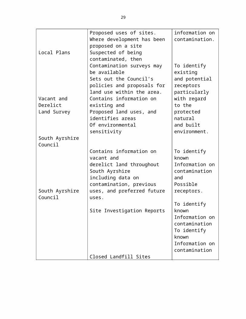
Local Plans
Vacant and DerelictLand Survey
South Ayrshire Council
South Ayrshire Council
Abandoned Mines
Planning application files may containInformation on previous, existing andProposed uses of sites. Where development has been proposed on a siteSuspected of being contaminated, thenContamination surveys may be availableSets out the Council’s policies and proposals for land use within the area.Contains information on existing andProposed land uses, and identifies areasOf environmental sensitivity
Contains information on vacant andderelict land throughout South Ayrshireincluding data on contamination, previous uses, and preferred future uses.
Site Investigation Reports
Closed Landfill Sites
To identify sources, pathways, receptorsTo identify known information on contamination.
To identify existingand potential receptorsparticularly with regardto the protected naturaland built environment.
To identify knownInformation on contamination andPossible receptors.
To identify knownInformation on contaminationTo identify knownInformation on contamination
19
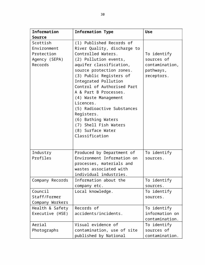
Information Source Information Type UseScottish Environment Protection Agency (SEPA) Records
(1) Published Records of River Quality, discharge to Controlled Waters.(2) Pollution events, aquifer classification, source protection zones.(3) Public Registers of Integrated Pollution Control of Authorised Part A & Part B Processes.(4) Waste Management Licences.(5) Radioactive Substances Registers.(6) Bathing Waters(7) Shell Fish Waters(8) Surface Water Classification
To identify sources of contamination, pathways, receptors.
Industry Profiles Produced by Department of Environment Information on processes, materials and wastes associated with individual industries.
To identify sources.
Company Records Information about the company etc. To identify sources.Council Staff/Former Company Workers
Local knowledge. To identify sources.
Health & Safety Executive (HSE)
Records of accidents/incidents. To identify information on contamination.
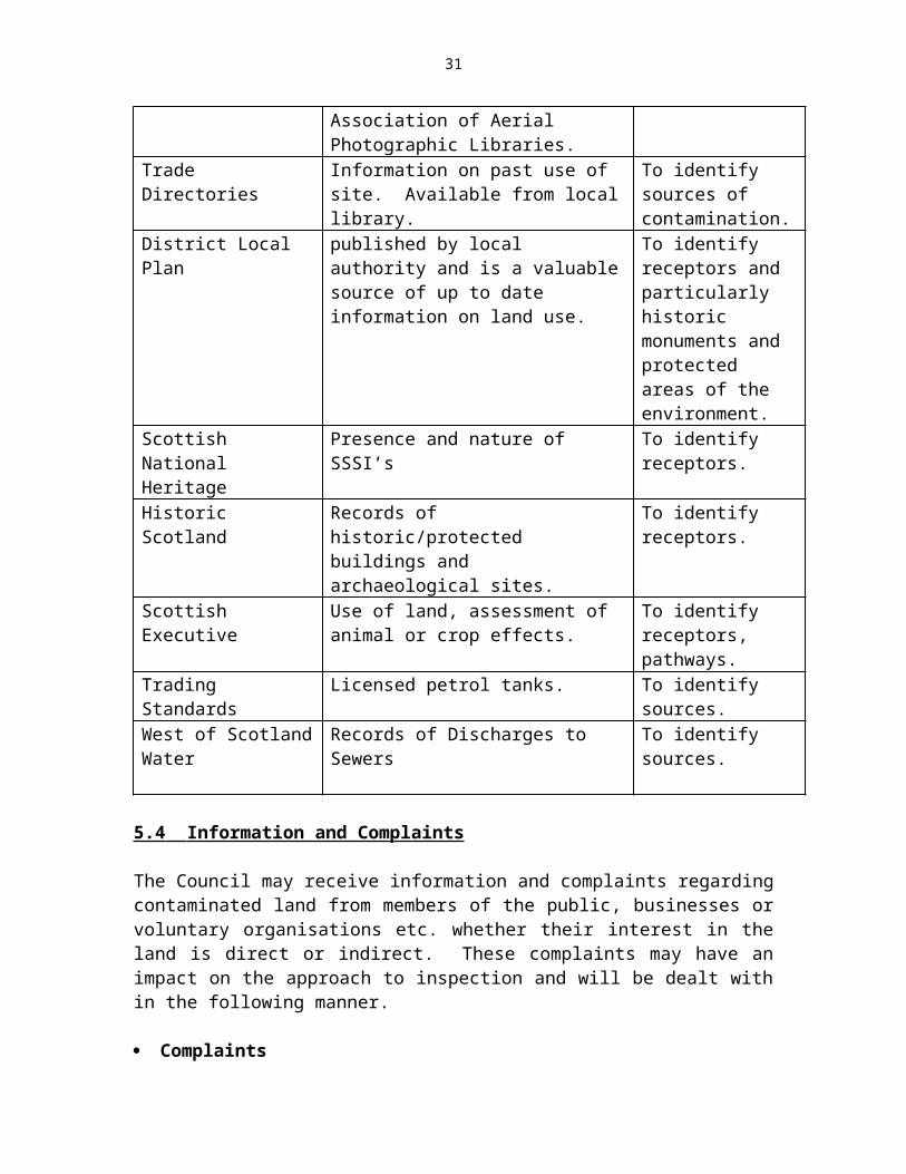
Aerial Photographs Visual evidence of contamination, use of site published by National Association of Aerial Photographic Libraries.
To identify sources of contamination.
Trade Directories Information on past use of site. Available from local library.
To identify sources of contamination.
District Local Plan published by local authority and is a valuable source of up to date information on land use.
To identify receptors and particularly historic monuments and protected areas of the environment.
Scottish National Heritage
Presence and nature of SSSI’s To identify receptors.
Historic Scotland Records of historic/protected buildings and archaeological sites.
To identify receptors.
Scottish Executive Use of land, assessment of animal or crop effects.
To identify receptors, pathways.
Trading Standards Licensed petrol tanks. To identify sources.West of Scotland Water Records of Discharges to Sewers To identify sources.
20
5.4 Information and Complaints
The Council may receive information and complaints regarding contaminated land from members of the public, businesses or voluntary organisations etc. whether their interest in the land is direct or indirect. These complaints may have an impact on the approach to inspection and will be dealt with in the following manner.
Complaints
A complaint regarding contaminated land may be received from a variety of sources and may either be submitted by telephone, in writing or in an electronic format. All such complaints will be recorded by the designated “Receiving Officer” on the specific Environmental Health Service Complaints Form (SCF) and on the IT Management System where it will be allocated a UPRN (Unique Property Reference Number) and delegated to an officer for investigation. Each complaint will be effectively and accurately investigated in terms of the Environmental Health Service Complaints Procedure Protocol and responded to within three working days. In accordance with that procedure the complainant will be advised of the outcome of the complaint on completion of the investigation.
It is important to note that for sites to be designated as contaminated land they must meet the statutory definition.
Confidentiality
All complainants will be asked to supply their names and addresses and the address-giving rise to the complaint, if different. The complainant’s details will remain confidential, unless the enquirer is an “appropriate person” in terms of Part 11A. The only circumstance in which this information might be made public would be in the case of a remediation notice being appealed in court and an adverse effect on the complainant’s health was an important reason for the original contaminated land designation.
Anonymously Supplied Information
Anonymously supplied information relating to contamination will also be logged, recorded and investigated and again be related to the priority risk assessment as required.
Voluntary Provision of Information
If a person or organisation provides information relating to contaminated land that is not directly affecting their own health, the health of their families or their property, this will not be treated as a complaint. The information will be recorded and may be acted upon. There will however be no obligation for the Council to keep the person or organisation informed of progress towards resolution, although it may choose as general good practice, to advise the informant of the outcome.
21

Anecdotal Evidence
Any anecdotal evidence provided to the Council relating to contaminated land will be noted, but no designation of contaminated land will occur without robust scientific evidence. In all cases knowledge and experience by the contaminated land officers will be used to decide if further investigation is required following a complaint or provision of information.
5.5 INFORMATION EVALUATION
The evaluation of information on actual harm or pollution of a site against the potential level and type of contaminant and any linkages with it and receptors will determine the need for further information or evidence to confirm or deny that the site is statutorily defined as contaminated land. This evaluation will assist in determining what level of priority for further investigation is merited by the site.
The number one priority for assessment will be if a linkage can be established that indicates significant harm being caused to humans. The second priority would be if a linkage can be established that indicates significant harm being caused to the environment (this includes controlled waters). Further details of risk assessment methods are set out in Chapter 7.
Where a Significant Pollutant Linkage cannot be adequately determined
Situations may arise where, on the information available it is not possible to determine whether a pollutant linkage is significant in accordance with the guidance statutorily set out. If this is the case then the council will make the determination that the site cannot be deemed statutorily contaminated but the situation will be kept under review.
If it is likely that new receptors should be introduced, for example through redevelopment of the site, then any information obtained during the investigation of the site will be made available for the planning authority and developer to review.
Other Regulatory Bodies
There are other regulatory actions that can be taken to deal with contamination on land i.e. overlaps with Planning and SEPA.
PlanningThe Scottish Executive’s Planning Advice Note 33 (revised 2000), on the “Development of Contaminated Land” sets out that the planning system has a key role to play with regard to contaminated land. This is by ensuring that when land suspected of being contaminated is the subject of a planning application, the land is made suitable for the proposed new use when planning permission is given for that new use. The remediation of such a site should be agreed through the planning application process in accordance with Planning Advice Note PAN33.
22
SEPA
Water PollutionI Advice and information will be sought from SEPA in relation to contamination of
controlled water. If SEPA identifies a risk to controlled waters from the contaminated land then the council will be notified to enable designation of the land and remedial action to take place under Part IIA.
II Pollution Prevention and Control (PPC) 2000 which aims to prevent new pollution.
III Under new legislation to regulate pollution from industrial process, site operators are required to undertake site condition survey prior to receiving a licence to operate.
If the condition of the site is such that areas of land meet the definition of contaminated land then submission of a site condition survey may trigger action under Part IIA. Existing processes will be brought under this legislation in stages under the next 5 years although it will apply to any new processes or any substantial change to an existing one.
Health & Safety & Foreign Guidelines
Some contaminants may not be covered by CLEA. In these cases reference may be made to occupational exposure levels issued by the Health & Safety Executive or other authoritative sources of information such as guidelines adopted in other countries. If guidelines from countries are referred to it will be important to bear in mind the significant difference in remediation standards between the UK and these other countries.
23
CHAPTER 6
GENERAL LIAISON AND COMMUNICATION STRATEGIES
In order that the inspection strategy can be taken forward with due regard to other regulatory bodies, non-regulatory organisations, landowners and other interested parties, an effective system for liaison and communication is required.
Where possible, direct dialogue with individuals who have been nominated as contacts for local authority liaison will be the preferred channel and in areas where no direct contact has been nominated the Council will attempt to formulate other communication lines.
Liaison and communication is a major part of the inspection strategy. As well as providing information which may help to identify potentially contaminated land, other regulatory and non-regulatory bodies, landowners and interested parties will be consulted, where sites may also have a bearing on their own particular area of concern or interests.
Consultation with the following organisations will be required in order that the inspection strategy complies with statutory guidance.
6.1 OTHER REGULATORY BODIES
The Scottish Environment Protection Agency (SEPA) A document has been formulated which provides a framework for liaison between SEPA and the local authority in carrying out their duties under Part IIA.
Under this framework the local authority will:
(i) Consult with SEPA when developing their strategies for inspection.
(ii) Determine whether SEPA has information relevant to the identification of land as contaminated.
(iii) Have regard to advice from SEPA in relation to determination of pollution of controlled waters.
(iv) Seek advice from SEPA in the designation of potential special sites.
(v) Notify SEPA of land identified as contaminated and land designated as a special site.
24
Scottish Natural Heritage (SNH)
Where contaminated sites are located near protected areas or other designated ecosystems such as SSSIs nature reserves or listed wildlife sites, SNH will be consulted with regard to any concerns that contaminants could migrate to these adjacent areas or the possible effects of remediation where the removal or remediation of soils etc may have an adverse effect on established flora and fauna.
Historic Scotland
The protection of built heritage such as conservation areas, listed buildings and ancient monuments in the local authority area will be addressed on a site to site basis with regard to the effects which contaminated land may have on them and their surroundings.
Historic Scotland will be consulted especially where remediation works are to be carried out, as alterations to such sites cannot be carried out without prior permission from the Scottish Executive.
The Scottish Executive
The local authority undertakes a Survey of Vacant and Derelict Land (SVDLS) and submits the data to the Scottish Executive. Changes in the “contaminated status” of any piece of land following investigation or complaint will be indicated to the planning service and returned in the following year’s survey for amendment of the Scottish Executive records.
The Health and Safety Executive (HSE)
As well as providing information on past or potential releases from industrial premises the HSE may be consulted where there is a perceived risk from hazardous substances present on a site which could be dangerous to the public or site workers etc.
This may be especially relevant during intrusive sampling or remediation works.
6.2 NON-REGULATORY BODIES, LANDOWNERS, OTHER INTERESTED PARTIES & THE WIDER COMMUNITY
West of Scotland Archaeological Service (WSAS)
Where suspect sites are located near archaeological sites, the service will be contacted and consulted with regard to any potential risk of contaminants migrating from the source into the area. This may be pertinent where archaeological “digs” are being conducted near contaminated land.
Miscellaneous Organisational Bodies
25

There may be areas which require to be inspected where other organisational bodies have an interest or some pertinent relationship with regard to either the area in question or adjacent land.
These organisational bodies could include:
The Royal Society for the Protection of Birds (RSPB) Forestry Commission West of Scotland Water Authority British Coal National Farmers union of Scotland (NFUS) Scottish Executive Rural Affairs Department (SERAD) Food Standards Agency Scotland (FSAS)
This list is not exhaustive and where possible all organisational bodies with interests or who may be involved with aspects of contaminated land issues should be consulted on a site to site basis.
Landowners, Occupiers and other Interested Parties
Where potentially contaminated land is to be inspected, early communication with the owner or appropriate person responsible for the land will be initiated. This is especially desirable in the case of voluntary remediation, where the Council will seek to encourage land remediation by agreement rather than by enforcement.
As it may be impossible, or impractical, to notify all stakeholders and interested parties, of the local authority’s intentions towards a specific site, the assigned contaminated land officer will be the contact point within the council for all enquiries, complaints, comments or concern with regard to the site.
The Wider Community
The Council in its commitment to address the problem of contaminated land, realises the importance of two-way communication between itself and the wider community. To this end communication between the Council and the local community will provide a forum for any discussions on concerns within the local area with regard to contaminated land issues.Individuals or groups will be able access information, put forward their views, comment on proposals, or contact the Local Authority for information on contaminated land issues by:
Accessing the contaminated land page on the Council’s web site;Contacting the relevant council officer direct by telephone or letter.
(See Appropriate Chapter 10 for Details)
26
CHAPTER 7
PROGRAMME FOR INSPECTION
7.1 DETAILED INSPECTIONS
Land that is suspected of being contaminated by reason of the former occupying industry requires a detailed inspection in order to establish the actual extent and nature of any contaminants present. This information is a pre-requisite for determining whether land is statutorily contaminated.
A detailed inspection may include any or all of the following:
STAGE 1 The collation and assessment of documentary information (a desktop study), or other information from relevant sources.
STAGE 2 A site visit (walkover survey) for visual inspection of the land and its environs; or
STAGE 3 Intrusive investigation of the land.
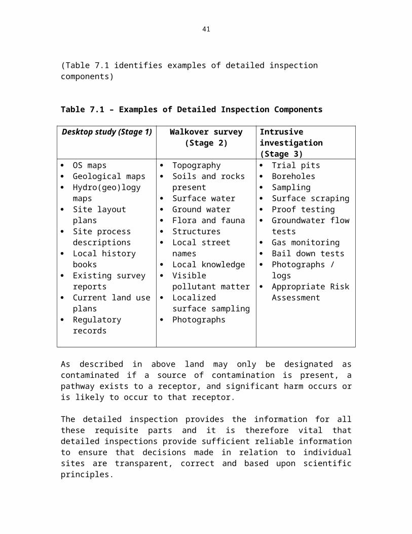
(Table 7.1 identifies examples of detailed inspection components)
Table 7.1 – Examples of Detailed Inspection Components
Desktop study (Stage 1) Walkover survey (Stage 2) Intrusive investigation (Stage 3)
OS maps Geological maps Hydro(geo)logy maps Site layout plans Site process descriptions Local history books Existing survey reports Current land use plans Regulatory records
Topography Soils and rocks present Surface water Ground water Flora and fauna Structures Local street names Local knowledge Visible pollutant matter Localized surface
sampling Photographs
Trial pits Boreholes Sampling Surface scraping Proof testing Groundwater flow tests Gas monitoring Bail down tests Photographs / logs Appropriate Risk
Assessment
As described in above land may only be designated as contaminated if a source of contamination is present, a pathway exists to a receptor, and significant harm occurs or is likely to occur to that receptor.
27

The detailed inspection provides the information for all these requisite parts and it is therefore vital that detailed inspections provide sufficient reliable information to ensure that decisions made in relation to individual sites are transparent, correct and based upon scientific principles.
Arrangements for Detailed Inspections
The Council will undertake desktop studies of all sites arising from the identification of suspect contaminated land in an order determined by risk prioritisation. Further detailed investigation in the form of a site walkover and intrusive investigation may then be required, in order to determine the way to proceed with the site in question.
A site investigation may already have been conducted by the owner, occupier or other persons, and if of acceptable standard may be accepted in lieu of further inspections. A site investigation comprising some or all of the detailed inspection stages may also be conducted voluntarily by persons. The Council reserves the right to request further inspection to be carried out if the submitted documentation does not provide an appropriate basis for due consideration of the state of the land. If the Council feel that on the balance of probabilities the site constitutes contaminated land it can require the “Appropriate Person” to undertake assessment actions to confirm the pollutant linkage. If however there is insufficient data for the council to make a determination then it is the Council’s responsibility to obtain that data under Section 108 powers.
The Council has specific powers of entry under section 108 of the Environment Act 1995 and an inspection using statutory powers of entry will only be conducted where:
1. A reasonable possibility of a pollutant linkage exists; and2. For the purposes of intrusive investigation, the pollutant linkage is likely.
In the event that a walkover survey or intrusive investigation is required, the Council may authorise a suitably qualified person to conduct such investigations and / or confirm previous findings.
Site Specific Liaison
To reduce unnecessary concern, it is the intention of South Ayrshire Council to contact owners and occupiers of land etc. only where it becomes apparent that public safety and environmental protection matters may otherwise be prejudiced.
Stage 1 inspections will therefore be conducted by the Council without prior contact with owners etc. of land. In the event that further investigation is required the owner, occupier and, if known, the appropriate person(s), will be contacted by letter in order to explain the reasons behind the proposed walkover and the possibility that further investigation may also be required. The letter will give a minimum of five working days notice of the intended inspection. Should the proposed inspection date be unsuitable, a mutually convenient date and time can be arranged.
28
In the event that documentation is available to these parties, a copy may be forwarded to the Council for its consideration.
The Contaminated Land Regime is such that voluntary investigation and remediation of land is a cornerstone principle. Arrangements for inspections carried out by persons other than the Council should therefore be discussed with the relevant officials of South Ayrshire Council.
If a site is likely by reason of its former history to be declared a special site, then SEPA will be invited to enter the discussions. Scottish Natural Heritage, Historic Scotland and other persons will also be invited to comment in regard to intrusive investigation if appropriate.
Risk Assessment and Detailed Inspection Methodology
A risk-based approach underpins this strategy in order to ensure the process is systematic and objective, and provides a consistent and defensible basis for considering uncertainties, discussing options and making decisions. It is recommended that detailed inspections be in accordance with BS10175: 2001.
7.2 RISK ASSESSMENT METHODS
The Council will take a risk-based approach to the assessment and identification ofcontaminated land. There are a number of methodologies available for assessment of the potential health and environmental impacts of land contamination including those described below. It should be noted that decisions on the most suitable technique or range of techniques will be determined on a site specific basis. The Council will ensure that risk assessment models and guideline values are suitable for the purpose for which they are being used and are appropriately applied. They should also be justifiable, authoritative and scientifically based. Human Health
Methodologies and guidance values are available to assess the potential risks to humans from contamination in the soils. Some of these are explained below.
Contaminated Land Exposure Assessment Model (CLEA): Technical Basis andAlgorithms. Contaminated Land Research Report CLR10, London: Department forEnvironment, Food and Rural Affairs (DEFRA), 2002
The CLEA model is a probabilistic exposure model developed to assess the risks to human health from contaminants in soils. The model uses data on the human toxicological effects of contaminants and can consider a number of ways that a human could be exposed to soil contaminants given a range of standard land uses. The model uses generic site conditions but can be used to calculate a series of site-specific
29
concentration values for contaminants in soil. Where Guideline Values are not available for particular contaminants from the CLEA Model, either generic assessment criteria developed elsewhere will be utilised (provided the assumptions built into the criteria are relevant to the particular case) or site specific criteria will be developed.
Soil Guideline Values (SGVs).
These are intervention values in assessment of human health from soil contaminants related to specific land uses. If the concentration falls below the appropriate SGV they can be considered not to pose unacceptable risks to human health. If used correctly, the exceedence of a SGV can indicate a potentially significant risk to human health.
Contaminants in Soils: Collation of Toxicological Data and Intake Values for Humans (TOX Reports).
The first 9 TOX reports were published in March 2002 by DEFRA and the EA. The toxicological information in the reports is used in the database for the CLEA Model. The Tox derives the Index Doses that are used to derive the SGVs.
Framework for Deriving Numeric Targets to Minimise the Adverse Human Health Effects of Long-Term Exposure to Contaminants in Soil Scotland and Northern Ireland Forum For Environmental Research, (SNIFFER), January 2000.
This report provides a methodology for deriving site-specific numeric targets for contaminant concentrations in soil that are protective of human health, using toxicological information, according to the source-pathway-receptor risk assessment framework. The exposure pathways considered are direct ingestion of soil, consumption of home-grown or allotment vegetables, inhalation of soil vapours outdoors and inhalation of soil vapours indoors. It is envisaged that the methodology can be used as both a risk assessment and risk management tool. 57 there are other regulatory actions that can be taken to deal with contamination on land i.e. overlaps with Planning and SEPA.
Interdepartmental Committee for the Redevelopment of Contaminated Land (ICRCL) Guidance Note 59/83 2nd Edition.
The Department for the Environment, Food and Rural Affairs formally withdrew this guidance on 20th December 2002. Controlled Waters
Advice will be sought from SEPA on risk assessment if controlled waters are thought to be the receptor. SEPA will undertake to keep the local authority aware of any contaminated sites, which are thought to be resulting in the pollution of controlled waters. However it should be recognised that SEPAs surface water quality monitoring program is
30
unlikely to cover many of the potential contaminants and it is limited in geographical coverage.
Risk Assessment Methodologies available include
CLR 1 – ‘Framework for assessing the Impact of Contaminated land on Ground Water and Surface Water’, available from WRc Publications
Environment Agency- R&D Publication 20: ‘Methodology for the derivation of Remedial Targets for Soil and Groundwater to Protect Water Resources’, available from WRc Publications
SNIFFER – ‘Ecological Risk Assessment Manual for Chemicals in the Aquatic Environment’ available from FWR Marlow
ConSim Model, available from Golders Associates.
Other Receptors
All potential significant harm should be assessed against relevant guidelines that are authoritative, scientifically based and justifiable.
Appointment of Consultants
Consultants may be required to undertake certain works on behalf of the Council in relation to its own land or privately owned land. All appointments of Consultants will be conducted in accordance with South Ayrshire Council’s established procedures for appointments.
7.3 HEALTH AND SAFETY PROCEDURES
The protection of health and safety of workers and the general public is paramount during the inspection and development of contaminated land. All works will therefore be expected to meet relevant health and safety legislation and associated Health and Safety Executive Guidance, Codes of Practice etc.
In the course of its inspection of a site, the Council may identify a risk arising at a workplace from contamination. In such instances, the relevant enforcing authority for health and safety matters will be notified and, if appropriate, the relevant enforcing authority for health and safety matters will become responsible for enforcing the particular pollutant linkage under health and safety legislation.
South Ayrshire Council is generally responsible for the enforcement of health and safety legislation in retail and leisure premises. The Health and Safety Executive (HSE) is responsible for factories and other high-risk premises. Further details relating to enforcement responsibilities are contained within the Health and Safety (Enforcing Authority) Regulations 1998.
31

7.4 PROVISION OF INFORMATION
Contaminated land is a phrase that has the potential to cause alarm over wide ranging issues which fall into 5 categories:-
Health considerations Environmental impact Economic impact Social impact Visual impact
South Ayrshire Council recognises that concerns raised by members of the public need to be treated as legitimate concerns.
In order to reduce concern over individual sites, it is intended that South Ayrshire Council undertake to provide generic and site specific advice to the key stakeholders (i.e. the local affected public etc.) by provision of Council documents, informative letters and public meetings as appropriate. The key areas for risk communication are viewed as being:
Strategy
1 The draft strategy to key representative groups / organisations 2 Advise the public of the strategy via appropriate press releases3 Provide a copy of the contaminated land strategy at local libraries and appropriate
council offices, for public scrutiny;
Complaints
1 Complaints made to the Council concerning contaminated land issues will be dealt with in accordance with the procedures described in Chapter 4 (4.2).
Detailed Inspections
1. Letters will be forwarded to all owners, occupiers and appropriate persons of suspected contaminated land falling within a particular risk group when that risk group is next to be considered. This will permit persons to make any representations as necessary. Letters will only be forwarded in the event that a desktop study (Stage 1) indicates further inspection is required.
2. Stage 2 and 3 detailed inspections will only occur following a letter circulated to parties listed in (1) above advising of the intention, the date (a minimum of 5 days notice) and likely time on site.
3. The results of the detailed inspection (Stages 2 and 3) will be communicated to the owners, occupiers and appropriate persons at appropriate stages, however, parties
32
must appreciate that the planning to implementation stage of any detailed inspections may involve long-term actions to ensure accurate conclusions.
4. If appropriate, the local elected member and affected parties will also be advised of any results etc. in the most appropriate manner given the specific circumstances.
Designation of Contaminated Land
South Ayrshire Council will formally notify all owners, occupiers, SEPA and appropriate persons of any decisions to designate land as statutorily contaminated.
The designation notice will include:
A description of the pollutant linkage; A summary of the evidence; A summary of the assessment of the evidence; and A summary of the way in which the Council has satisfied the requirements of the
Statutory Guidance (Part 4 and Chapter A).
Designation notices will be included in the public register with the exception of commercially confidential information and information relevant to national security.
Enforcement and Remediation Actions
All enforcement actions and voluntary statements will be entered in the public register.
Public Register
South Ayrshire Council will maintain and keep available for viewing a public register of all documents etc. as required by the Contaminated Land (Scotland) Regulations 2000.
The Council appreciate that the limited extent of Part IIA of the Environment Protection Act 1990 and the powers vested within South Ayrshire Council may fail to satisfy the hopes and expectations of many members of the public. However by the provision of adequate information, it is hoped that the public will perceive that the Council is acting responsibly and ensuring their safety at all times.
CHAPTER 8
33
REVIEW MECHANISMS
The strategy will be reviewed on a regular basis to ensure that it remains effective and up to date. This will also allow monitoring of the effectiveness of inspection in meeting legal requirements and allow any necessary reassessment of the status of particular areas of land in response to specific circumstances or events.
8.1 TRIGGERS FOR UNDERTAKING INSPECTION
There may be instances where inspections have to be carried out outwith the general inspection framework, these are as follows:-
Triggers for Undertaking Non-Routine Inspections
Unplanned events e.g. incident such as a spill has occurred. Introduction of New Receptors e.g. housing estate, trespassing by young people. Supporting Voluntary Remediation - e.g. potentially liable party wishing to
undertake a clean up before their land has been inspected by the local authority. Identification of localised health effects which appear to relate to a particular area
of land. Responding to information from other statutory bodies, owners, occupiers, or
other interested parties.
While these occurrences may trigger non-routine inspections, if this strategy is to prove effective they must not be allowed to interfere significantly with the standards laid down in the general inspection framework.
8.2 REVIEWING THE STRATEGY DOCUMENT
It is a fundamental requirement of the legislation that a review of the strategy is carried out from time to time. In some instances the strategy will be reviewed earlier. This may be as a result of:-
a. Significant changes in legislationb. Revision of guideline values for exposure assessment.c. Significant case law or other precedent.
It is important that all decisions are made and recorded in a consistent manner that will allow efficient review. The strategy will then be reviewed one year later and the findings reported to the appropriate Council Committee. If there are any significant changes to the strategy further annual reviews may be required.
If the strategy is found to be operating satisfactorily then the next review date will be set when the first inspection of the authority has been completed and the remediation of contaminated sites has been prioritised.
34

8.3 AUDIT
An internal and external audit of the strategy will take place on a regular basis.
35
CHAPTER 9
INFORMATION MANAGEMENT
9.1 GENERAL POLICY
Information collated in connection with the Council’s obligations under Part IIA of the Environmental Protection Act 1990 will be classed as research documents and as such will not be accessible by members of the public. This Council policy is in order to prevent land blight and other similar non-beneficial effects.
South Ayrshire Council remains committed to protecting the health of the public as its priority obligation and stresses that this policy does not place economics above health considerations.
Accordingly, South Ayrshire Council will maintain a public register of necessary information and will also release appropriate information to appropriate parties (e.g. owners of land, occupiers of land and appropriate persons) in administering the Part IIA regime. South Ayrshire Council will take into account the requirements of the Environmental Information Regulations 1992 and the Data Protection Act when dealing with requests for information on contaminated land.
9.2 PUBLIC REGISTER
The Contaminated Land (Scotland) Regulations 2000 require South Ayrshire Council to maintain a public register of contaminated land. The register will be regularly updated and public access available at all reasonable times and facilities for copying entries will be available for which the Council may adopt a charging policy.
The regulations clearly specify the information that must be recorded within the register:-
Contaminated land designation notices Contaminated land remediation notices; Details of Appeals against remediation and charging notices Remediation declarations (prepared by South Ayrshire Council) Remediation statements Details of Special Site designations Notifications of claimed remediation Details of relevant convictions Dates of relevant guidance Other environmental control preclusions
36
9.3 COMMERCIAL CONFIDENTIALITY & DATA PROTECTION
Commercial Confidentiality
South Ayrshire Council will not, without the relevant person’s permission, include any information on the register which:
1. Relates to the affairs of any individual or business; and2. Is commercially confidential to that individual or the person carrying on that business
(excluding valuations etc.)
Upon preparation of any information etc for the consideration of the Council, individuals are advised that information considered confidential should be highlighted in a covering letter with an explanation as to why the intimated matters should be treated as confidential. Due consideration will be given to all such information and the decision of the Council in regard to the individual items of information will be communicated to the individual prior to inclusion on the register.
The Council will also undertake to advise individuals in writing of any information that it believes to be commercially confidential. Individuals will be permitted 21 days to make representations directly to the Council, and if dissatisfied with the decision of the Council in favour of including the information in the register, the individual will be advised of their rights of appeal to the Scottish Ministers within 21 days.
In such instances the following procedures will apply:
1. If after 21 days from notification of the decision to deny information commercial confidentiality status an appeal has not been lodged, South Ayrshire Council will enter the information into the register.
2. Whilst any appeal is pending the information will not be included in the public register.
3. In the event that an appeal is upheld, the information will be excluded from the register and an exclusion statement will be entered in its place.
4. In the event that the appeal is withdrawn or the appeal is quashed, the information will be entered in the register 7 days after the decision is received.
5. Commercial confidentiality status will lapse after 4 years and the information will be entered into the register unless an application for information to be excluded is received. The same decision process will be followed for re-designations as original designations.
The Scottish Executive have the power to direct specified information or descriptions of information to be included irrespective of any commercial confidentiality.
37
Data Protection
The use of employee personal information in correspondence and reports is necessary but where required, this will be kept to a minimum. While appropriate personal information may be shared between participating organisations under the contaminated land regime this will be done only for the purpose of contaminated land management entirely on a need to know basis.
South Ayrshire Council will take appropriate technical and organisational measures to ensure against unauthorised or unlawful use of the information and against accidental loss/destruction or damage.
Where an individual provides information during the process of a complaint personal details will only be used for the purposes provided. Should the Council wish to use these details for other purposes then the individual will be advised accordingly. In the absence of Regulation requiring the provision of information for the purposes of the contaminated land regime by an individual, then the Council will seek the individual’s permission to acquire the information.
No personal information will be recorded on the public register unless specifically required by Regulations or following the informed consent of the individual concerned.
In responding to requests for information in relation to contaminated land the Council will not provide personal information unless required by statute or with the consent of the individual concerned.
The Council will take every step to ensure that all personal information collected and processed in terms of the regime will be
a. Adequate, relevant and not excessive.b. Accurate.c. Only kept for as long as necessary.d. Not transferred outwith the European Economic Area without additional
precautions.
9.4 ISSUES OF NATIONAL SECURITY
The Scottish Executive have the power to direct South Ayrshire Council to exclude from the register specific information or descriptions of information, or refer such information for determination by the Scottish Executive.
Any party may advise the Scottish Executive and South Ayrshire Council of information they believe to be of National Security status. Such information will not be entered in the public register until the Scottish Executive determine its inclusion is appropriate.
38

INFORMATION MANAGEMENT
The Council’s Geographical Information System (GIS) and a compatible database will be the primary tools used to manage information collated in pursuance of this Strategy.
Several Departments and Services will play vital roles in the area of contaminated land and information appropriate to their involvement will be shared whilst maintaining the Council’s over-arching Confidentiality Policy.
REQUESTS FOR INFORMATION
Potential developers of sites and environmental consultants may apply to the Council for information pertaining to specific sites. Information will only be provided in a general context and will not contravene the policies adopted to protect land from blight and other similar negative effects. In the majority of cases, the information provided will be information that is available from existing public documents (e.g. historical maps etc).
Information provided in this process will be guidance only. Any expressed opinions should not be regarded as factual evidence of a particular circumstance.
The following disclaimer statement will accompany all information provided:
The contents of this [fax][letter] are intended as guidance only and are based upon the best information available to South Ayrshire Council as at the date shown above. The information should not be relied upon as a statement of fact nor presented to a third party as a statement of fact. The Council accepts no liability in respect of the recipient’s (or anyone with whom they share the information) use or reliance on this information.
9.7 PROVISION OF INFORMATION TO SEPA
South Ayrshire Council is required or permitted to provide information to the Scottish Environment Protection Agency in the following circumstances:
1. To assist SEPA in its role of regulator for Special Sites.
2. To request advice from SEPA in relation to specific sites.
3. To assist SEPA prepare the Annual State of Contaminated Land in Scotland Report.
39
9.8 STATE OF CONTAMINATED LAND IN SCOTLAND REPORT
The Scottish Environment Protection Agency is required to prepare an Annual Report on the state of contaminated land in Scotland. The aims of the report are as follows:
To compile information on the general nature, extent and distribution of land identified as contaminated under Part IIA of the Environmental Protection Act 1990;
To assess the scale of the environmental impact of contaminated land and highlight where Part IIA is reducing this impact. To summarise regulatory activity under Part IIA; and To assess the effectiveness of Part IIA in addressing contaminated land.
South Ayrshire Council – SEPA Liaison
South Ayrshire Council in association with all other Scottish Local Authorities has met with SEPA to discuss the requirements of the regime and mechanisms for routine transfer of information. A framework has been agreed with a view to ensuring the efficient collation and transfer of information.
40
CHAPTER 10.
OTHER SUPPORTING INFORMATION
This section provides the following information.
1. Contact points within South Ayrshire Council in relation to all aspects of Contaminated Land.
2. Information sources used in the preparation of this Strategy.3. The methods which will be adopted by South Ayrshire Council in determining the
prioritisation of site inspections.4. References.
10.1 CONTACT POINTS WITHIN THE AUTHORITY
Graham PeterkinDirector Department of Development Safety & RegulationCounty BuildingsWellington SquareAyrKA7 1DR
Environmental Health Service Planning, Building Control & Licensing ServicesEnvironmental Protection Burns HouseTown Buildings Burns Statue Square5/9 High Street AyrAyr KA7 1UTKA7 1LX Tele: 01292 616159Tele: 01292 618222 Fax:: 01292 616263Fax: 01292 288755
Legal ServicesCounty BuildingsWellington SquareAyrKA7 1DRTele:01292 612556
41
10.2 INFORMATION SOURCES
EXTERNAL INFORMATION SOURCES
Scottish Environmental Protection Agency (SEPA)West Region Headquarters, 5 Redwood Crescent, Peel Park East Kilbride G74 5PPTel: 01355 574 688
Scottish Natural HeritageSouth West Scotland Region, Strathclyde and Ayrshire Area, 2 Beresford Terrace, AyrTel: 01292 261392
Ministry of Defence (MOD) Kentigern House, Brown Street, Glasgow G2. Tel 0141 248 7890
Railtrack PlcScottish Head Office, Buchanan House, 58 Port Dundas Road, Glasgow, G4Tel 0141 332 9811
British Gas Plc (Property Division)Weatherby, Riverview CT, 1 Castle gate Weatherby.. Tel 0990909000
The Coal AuthorityMining Reports Office, 200 Lichfield Lane, Berry HillMansfield, Nottinghamshire NG18 4RG. Tel 0845 762 6848
Ayrshire Archive CentreCraigie Estate, Ayr KA8 OSS. Tel: 01292 287584
Ordnance Survey PlcSurvey Office, Russell House, King Street, AyrTele: 01292 281504
INTERNAL INFORMATION SOURCES
Council Geological Records
Council Held Site Investigation Reports
Officers Local Knowledge
Council GIS Records
Land Remediation Reports
Internal Desk Top Study
42
10.3 REFERENCES
The Environment Act 1995 (HMSO 1995)The Environment Protection Act 1990 Part IIA Contaminated Land (HMSO 1990)The Contaminated Land (Scotland) Regulations 2000 Scottish Executive Rural Affairs Department Circular 1/2000 (12th July 2000)Scottish Executive Contaminated Land Inspection Strategies: Advice for Local Authorities Letter (31st August 2000)South Ayrshire Council Local Plan (Draft) (March 1999)Ayrshire Joint Structure Plan 1999 (Approved 2000)South Ayrshire Council Local Agenda 21 StrategySouth Ayrshire Council’s Vision of 2020 DocumentCleaSnifferDefra publications
South Ayrshire Council2003
43
APPENDIX 1
CONTAMINATED LAND RISK ASSESSMENT SYSTEM
South Ayrshire Council has purchased the Babtie Section 57 Model, which is a software package utilising the established technology of Geographical Information Systems (GIS) coupled with a robust risk based approach to pollutant linkage identification to assist the Council in identifying and prioritising contaminated land. The Model provides the Council with an auditable data management tool to prioritise those areas identified as potentially statutorily contaminated land and allows planning of more detailed inspection.
South Ayrshire Council aims to comply with the requirements of the legislation in a rational, ordered and efficient approach as described in the guidance. This strategy sets out how this is to be achieved; the Babtie S57 Model & Core Tools will assist.
(A) By establishing a methodology which identifies potentially contaminated sites in a strategic manner as required by the legislation. This has been achieved by adopting an independent semi-automated GIS based model.
(B) To prioritise the inspection of such sites in an impartial manner and based on (so far as reasonably practicable) robust, publicly available data sources. This is in accordance with South Ayrshire Council’s policy on disclosure of information based on the Local Government (Access to Information) Act 1985 which details the rights of members of the public to attend Council meetings and to inspect documents and papers and by the EU Directive on Public Access to Environmental Information (90/313/EEC) under which the public are entitled to have access to all information about the environment held by government and public authorities (unless exempt on the grounds of commercial confidentiality or national security).
(C) To provide an auditable path to prioritisation which has been achieved by incorporating a Metadata base within the Model, which provides a permanent record of the information sources used and how they have been used.
(D) To inspect sites in a cost effective manner, identifying all available previous work prior to undertaking any further investigation where required. This has been achieved by using the reporting Core Tool called the Land Quality Management Database (LQMD) to record all available previous information, to permit the addition of new information as it becomes available and in this way to ensure that data on contaminated land is recorded in an ordered and structured approach, reducing error and preventing duplication of effort.
(E) To establish a database of all relevant data pertaining to potentially contaminated sub areas and data collected during the inspection stage. The outcome of (A) to (D) will be retained in digital format and reviewed and added to as further information becomes available.
44
APPENDIX 2
GLOSSARY OF TERMS
Appropriate Person defined in section 78A(9) as:“any person who is an appropriate person, determined in accordance with section 78F….., to bear responsibility for anything which is to be done by way of remediation in any particular case.”An appropriate person is a person of Class A or B.
Class A Person: a person who is an appropriate person by virtue of section 78F(2) (that is, because he has caused or knowingly permitted a pollutant to be in, on or under the land).
Class B person: a person who is an appropriate person by virtue of section 78F(4) or (5) (that is, because he is the owner or occupier of the land in circumstances where no Class A person can be found with respect to a particular remediation action).
CLEA: Contaminated Land Exposure Assessment, a methodology for carrying out a risk assessment.
Contaminant: a substance which is in, on or under the land and which has the potential to cause harm or to cause pollution of controlled waters.
Contaminated Land: defined in section 78(A)(2) as:
“any land which appears to the local authority in whose area it is situated to be in such a condition, by reason of substances in, on or under the land, that –
(a) significant harm is being caused or there is a significant possibility of such harm being caused, or
(b) pollution of controlled waters is being, or is likely to be, caused.”
Controlled Waters: defined in section 78(A)(9) by reference to section 30A of the Control of Pollution Act 1974; this embraces territorial and coastal waters, inland fresh waters and ground waters.
Ecological System: a biological system of interacting organisms and their physical environment.
GIS: Geographical Information System
45
Groundwater: any water contaminated in underground strata, wells or boreholes.
Harm: defined in section 78(A)(4) as:
“harm to the health of living organisms or other interference with the ecological systems of which they form part and, in the case of man, includes harm to his property”.
ICRCL: Interdepartmental Committee on Remediation of Contaminated Land.
Intrusive investigations: an investigation of land (for example by exploratory excavations) which involves actions going beyond simple visual inspection of the land, limited sampling or assessment of documentary information.
Owner: defined in section 78(A)(9), in relation to any land in Scotland, as:
“a person (other than a creditor in a heritable security not in possession of the security subjects) for the time being entitled to received or who would, if the land were let, be entitled to receive the rents of the land in connection with which the word is used and includes a trustee, factor, guardian or curator and in the case of public or municipal land includes the persons to whom the management of the land is entrusted”.
Pathway: one or more routes or means by, or through, which a receptor:is being exposed to, or affected by, a contaminant, orcould be so exposed or affected.
Pollutant: a contaminant which forms part of a pollutant linkage.
Pollutant linkage: the relationship between a contaminant, a pathway and a receptor.
Pollution of controlled waters: defined in section 78(A)(9) as:
“the entry into controlled waters of any poisonous, noxious or polluting matter or any sold waste matter”.
Ramsar Site: a site protected under an international convention on protection of wetlands of international importance, especially as habitats for waterfowl, named after the city in Iran where the convention was signed.
Receptor: sometimes referred to as a target. This can include the health of a person, waters, ecosystem or property type that could be affected by contamination.
Register: the public register maintained by the enforcing authority under section 78R of particulars relating to contaminated land.
46
Remediation: generally accepted as being the carrying out of works to prevent or minimise effects of contamination. In the case of this legislation the term also encompasses assessment of the conditions of land, and subsequent monitoring of the land.
Risk Assessment: the study of
(a) the probability, or frequency, of a hazard occurring, and(b) the magnitude of the consequences
SEPA: the Scottish Environmental Protection Agency
Significant Harm: defined in section 78(A)( (5). It means any harm which is determined to be significant in accordance with the statutory guidance in Chapter A (that is, it meets one of the descriptions of types of harm in the second column of Table A of that Chapter).
Source protection zone: protection zones around certain sources of ground water used for public water supply. Within these zones, certain activities and processes are prohibited or restricted.
Special Site: any Contaminated Land designated due to:
(a) water pollution cases – wholesomeness of drinking water, surface-water classification criteria, key highly permeable aquifers;
(b) industrial cases – waste acid for lagoons, oil refining, explosives, integrated pollution control sites, nuclear sites
(c) Defence cases
SSI Site of Special Scientific Interest
Substance: defined in section 89(A)(9) as:
“any natural or artificial substance, whether in solid or liquid form or in the form of a gas or vapour”.
47


![Study of Estrogen Receptor, Progesterone Receptor, …...[CANCER RESEARCH 49,4298-4304, August 1. 1989] Study of Estrogen Receptor, Progesterone Receptor, and the Estrogen-regulated](https://img.pdfslide.us/doc/110x75/5f95792bbdbd5e0915333803/study-of-estrogen-receptor-progesterone-receptor-cancer-research-494298-4304.jpg)


![3.3 Aquatic Resources - California State Water Resources ... · Section 3.3.5 [Aquatic Resources] Potential Impacts and Mitigation. 3.3.2.1 Aquatic Species Numerous aquatic species](https://img.pdfslide.us/doc/110x75/5fdf05efaeffa42ca171b579/33-aquatic-resources-california-state-water-resources-section-335-aquatic.jpg)