Embed Size (px)
Citation preview
CBIPMP_Methodologies_Task1_v5_final
Review of the nature and type of
hazardous waste polluted sites in
India Key output Final Report Task 1: Annexure 4a - Site factsheets
Development of Methodologies for National Programme for Rehabilitation of Polluted Sites in India
Ministry of Environment and Forests, Government of India, Delhi
The World Bank, Washington, D.C.
CBIPMP_Methodologies_Task1_v5_final
Page 2 of 61
Authorisation
Title : Review of the nature and type of hazardous waste polluted sites in
India –Key output Final Report Task 1: Annexure 4a - Site factsheets
Subtitle : Development of Methodologies for National
Programme for Rehabilitation of Polluted Sites
in India
Project number : 317550
Reference number : CBIPMP_Methodologies_Task1_v4_ANNEXURE_4a_final_20130118
Revision : Final
Date May 1st, 2013
Authors : Rob Heijer
Hemant Rane
Deepak Desphande
E-mail : [email protected]
Checked by : Arthur de Groof
Signature checked :
Approved by : Paul Verhaagen
Signature approved :
Contact : Grontmij Netherlands B.V.
De Holle Bilt 22
3732 HM De Bilt
PO Box 203
3730 AE De Bilt
T +31 30 220 79 11
F +31 30 220 01 74
www.grontmij.com
CBIPMP_Methodologies_Task1_v5_final
Page 3 of 61
Table of contents
1 Introduction ........................................................................................... 4 1.1 General ................................................................................................. 4 1.2 Data sources ......................................................................................... 4
2 Site Factsheets ..................................................................................... 5
Introduction
CBIPMP_Methodologies_Task1_v5_final
Page 4 of 61
1 Introduction
1.1 General This report presents Annexure 4a to the Key output Final Report Task 1. In this Task the Review of the nature and type of hazardous waste polluted sites in In-dia is given as a part of the ‘Development of Methodologies for National Pro-gramme for Rehabilitation of Polluted Sites in India’. The objective of Task 1 is to review the available inventory on hazardous waste polluted sites and understand the nature of polluted sites in India. The Key out-put is the report, presenting both a thorough insight in the nature and types of all polluted sites in India and a typology of probably polluted sites in India. For these objectives in this task the available inventory on hazardous polluted sites is inventoried and analysed. The results are presented in the Key output Final Report of Task 1. This Annexure to that report includes the site factsheets, for background read-ing only. The purpose of the factsheets is an intermediate step in the under-standing of the sites in India and not to give an accurate description of all indi-vidual sites in India as such. For this purpose the reader is referred to the As-signment 1 database which will be developed for that reason specifically. 1.2 Data sources The site factsheets were drawn up on sites selected from the following site in-ventories:
List of 12 priority contaminated dump sites (CPCB, no specific reference);
List of 25 hazardous waste dump sites (CPCB , no specific reference);
Reports available on some of the sites.
Note. Not all sites from these lists were used to make a site factsheet, because the scope of the factsheets is not to give a description of all individual contami-nated sites in India as such, but to support the analysis of the different types of such sites in India. The site factsheets are presented in the next section of this Annexure report.
CBIPMP_Methodologies_Task1_v5_final
Page 5 of 61
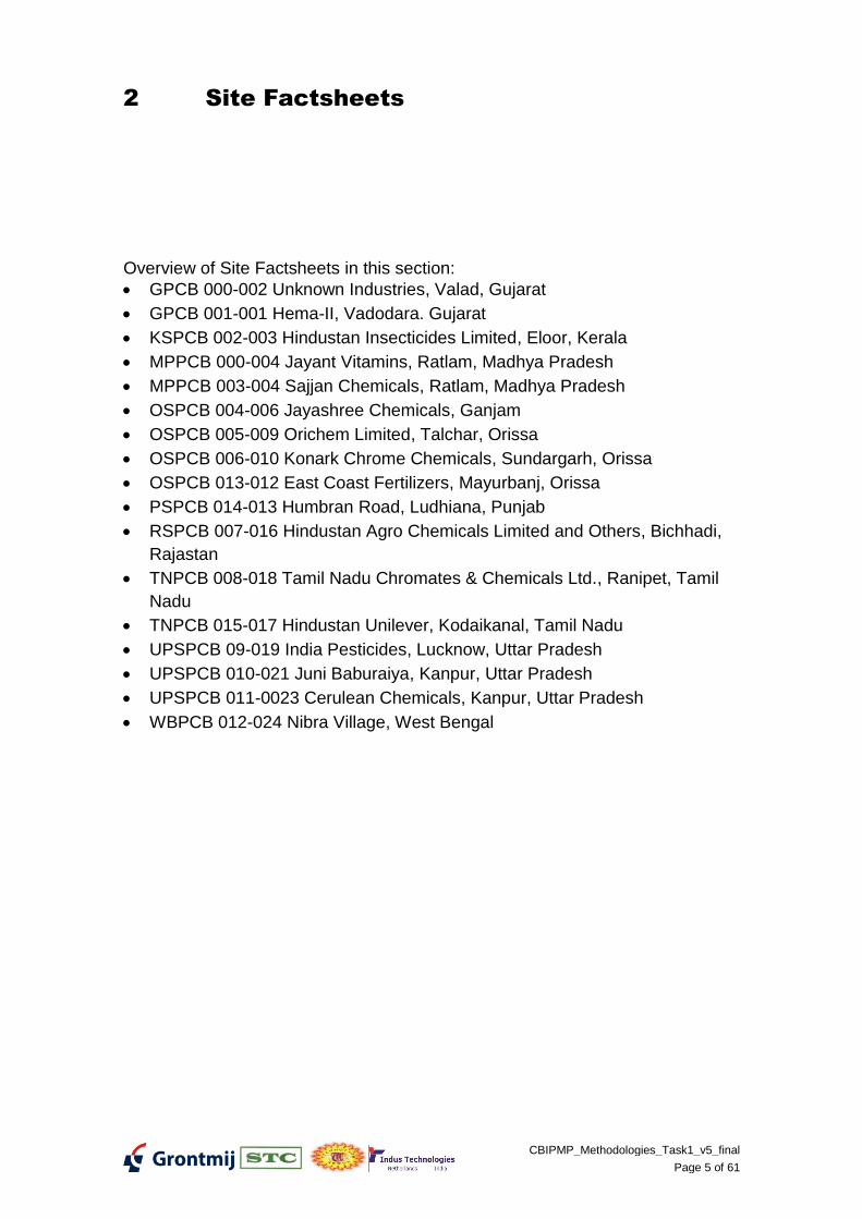
2 Site Factsheets
Overview of Site Factsheets in this section:
GPCB 000-002 Unknown Industries, Valad, Gujarat
GPCB 001-001 Hema-II, Vadodara. Gujarat
KSPCB 002-003 Hindustan Insecticides Limited, Eloor, Kerala
MPPCB 000-004 Jayant Vitamins, Ratlam, Madhya Pradesh
MPPCB 003-004 Sajjan Chemicals, Ratlam, Madhya Pradesh
OSPCB 004-006 Jayashree Chemicals, Ganjam
OSPCB 005-009 Orichem Limited, Talchar, Orissa
OSPCB 006-010 Konark Chrome Chemicals, Sundargarh, Orissa
OSPCB 013-012 East Coast Fertilizers, Mayurbanj, Orissa
PSPCB 014-013 Humbran Road, Ludhiana, Punjab
RSPCB 007-016 Hindustan Agro Chemicals Limited and Others, Bichhadi,
Rajastan
TNPCB 008-018 Tamil Nadu Chromates & Chemicals Ltd., Ranipet, Tamil
Nadu
TNPCB 015-017 Hindustan Unilever, Kodaikanal, Tamil Nadu
UPSPCB 09-019 India Pesticides, Lucknow, Uttar Pradesh
UPSPCB 010-021 Juni Baburaiya, Kanpur, Uttar Pradesh
UPSPCB 011-0023 Cerulean Chemicals, Kanpur, Uttar Pradesh
WBPCB 012-024 Nibra Village, West Bengal
Site Factsheets
CBIPMP_Methodologies_Task1_v5_final
Page 6 of 61
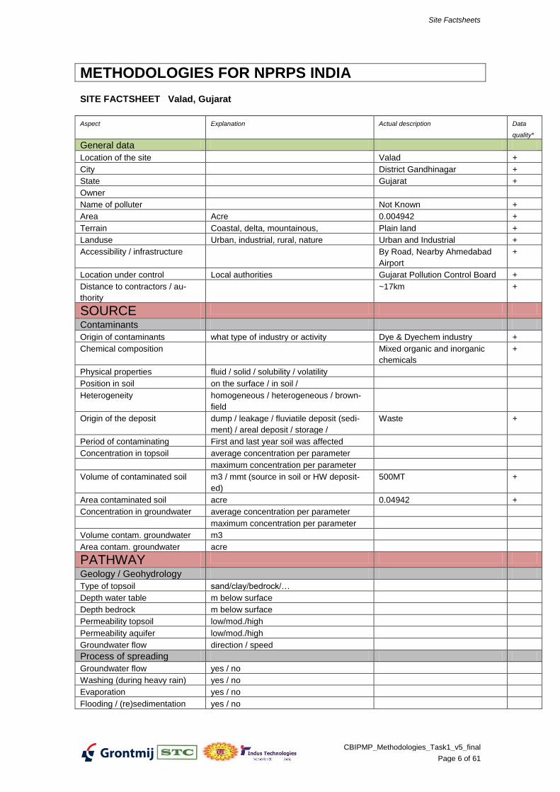
METHODOLOGIES FOR NPRPS INDIA
SITE FACTSHEET Valad, Gujarat
Aspect Explanation Actual description Data
quality*
General data
Location of the site Valad +
City District Gandhinagar +
State Gujarat +
Owner
Name of polluter Not Known +
Area Acre 0.004942 +
Terrain Coastal, delta, mountainous, Plain land +
Landuse Urban, industrial, rural, nature Urban and Industrial +
Accessibility / infrastructure By Road, Nearby Ahmedabad
Airport
+
Location under control Local authorities Gujarat Pollution Control Board +
Distance to contractors / au-
thority
~17km +
SOURCE
Contaminants
Origin of contaminants what type of industry or activity Dye & Dyechem industry +
Chemical composition Mixed organic and inorganic
chemicals
+
Physical properties fluid / solid / solubility / volatility
Position in soil on the surface / in soil /
Heterogeneity homogeneous / heterogeneous / brown-
field
Origin of the deposit dump / leakage / fluviatile deposit (sedi-
ment) / areal deposit / storage /
Waste +
Period of contaminating First and last year soil was affected
Concentration in topsoil average concentration per parameter
maximum concentration per parameter
Volume of contaminated soil m3 / mmt (source in soil or HW deposit-
ed)
500MT +
Area contaminated soil acre 0.04942 +
Concentration in groundwater average concentration per parameter
maximum concentration per parameter
Volume contam. groundwater m3
Area contam. groundwater acre
PATHWAY
Geology / Geohydrology
Type of topsoil sand/clay/bedrock/…
Depth water table m below surface
Depth bedrock m below surface
Permeability topsoil low/mod./high
Permeability aquifer low/mod./high
Groundwater flow direction / speed
Process of spreading
Groundwater flow yes / no
Washing (during heavy rain) yes / no
Evaporation yes / no
Flooding / (re)sedimentation yes / no
Site Factsheets
CBIPMP_Methodologies_Task1_v5_final
Page 7 of 61
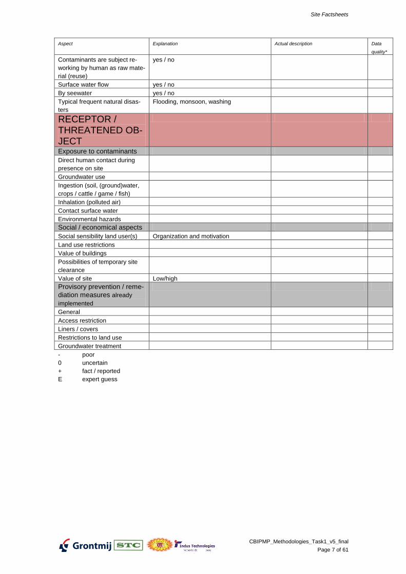
Aspect Explanation Actual description Data
quality*
Contaminants are subject re-
working by human as raw mate-
rial (reuse)
yes / no
Surface water flow yes / no
By seewater yes / no
Typical frequent natural disas-
ters
Flooding, monsoon, washing
RECEPTOR / THREATENED OB-JECT
Exposure to contaminants
Direct human contact during
presence on site
Groundwater use
Ingestion (soil, (ground)water,
crops / cattle / game / fish)
Inhalation (polluted air)
Contact surface water
Environmental hazards
Social / economical aspects
Social sensibility land user(s) Organization and motivation
Land use restrictions
Value of buildings
Possibilities of temporary site
clearance
Value of site Low/high
Provisory prevention / reme-
diation measures already
implemented
General
Access restriction
Liners / covers
Restrictions to land use
Groundwater treatment
- poor
0 uncertain
+ fact / reported
E expert guess
Site Factsheets
CBIPMP_Methodologies_Task1_v5_final
Page 8 of 61
Site Factsheets
CBIPMP_Methodologies_Task1_v5_final
Page 9 of 61
METHODOLOGIES FOR NPRPS INDIA
SITE FACTSHEET Vadodara (Hema), Gujarat
Aspect Explanation Actual description Data
quality*
General data
Location of the site Vadodara +
City
State Gujarat +
Owner
Name of polluter Hema Chemicals Unit - II +
Area Acre
Terrain Coastal, delta, mountainous,
Landuse Urban, industrial, rural, nature
Accessibility / infrastructure
Location under control Local authorities Vadodara Municipal Corporation +
Distance to contractors / au-
thority
SOURCE
Contaminants
Origin of contaminants what type of industry or activity Basic chromium sulphate pro-
duction
+
Chemical composition Cr +
Physical properties fluid / solid / solubility / volatility
Position in soil on the surface / in soil /
Heterogeneity homogeneous / heterogeneous / brown-
field
Origin of the deposit dump / leakage / fluviatile deposit (sedi-
ment) / areal deposit / storage /
Residue is dumped in industrial
plot
+
Period of contaminating First and last year soil was affected
Concentration in topsoil average concentration per parameter
maximum concentration per parameter
Volume of contaminated soil m3 / mmt (source in soil or HW deposit-
ed)
77.000 ton +
Area contaminated soil acre
Concentration in groundwater average concentration per parameter Groundwater is contaminated.
Concenrations not in dossier
+
maximum concentration per parameter
Volume contam. groundwater m3
Area contam. groundwater acre
PATHWAY
Geology / Geohydrology
Type of topsoil sand/clay/bedrock/…
Depth water table m below surface
Depth bedrock m below surface
Permeability topsoil low/mod./high
Permeability aquifer low/mod./high
Groundwater flow direction / speed
Process of spreading
Groundwater flow yes / no
Washing (during heavy rain) yes / no
Evaporation yes / no
Flooding / (re)sedimentation yes / no
Site Factsheets
CBIPMP_Methodologies_Task1_v5_final
Page 10 of 61
Aspect Explanation Actual description Data
quality*
Contaminants are subject re-
working by human as raw mate-
rial (reuse)
yes / no
Surface water flow yes / no
By seewater yes / no
Typical frequent natural disas-
ters
Flooding, monsoon, washing
RECEPTOR / THREATENED OB-JECT
Exposure to contaminants
Direct human contact during
presence on site
Groundwater use
Ingestion (soil, (ground)water,
crops / cattle / game / fish)
Inhalation (polluted air)
Contact surface water
Environmental hazards
Social / economical aspects
Social sensibility land user(s) Organization and motivation
Land use restrictions
Value of buildings
Possibilities of temporary site
clearance
Value of site Low/high
Provisory prevention / reme-
diation measures already
implemented
General DPCB has prepared a report of
the rehabilitation plan 1)
+
Access restriction
Liners / covers
Restrictions to land use
Groundwater treatment
Data/inform. used
1) “annexure” page 12 (provided by CPCB during mission 1)
- poor
0 uncertain
+ fact / reported
E expert guess
Site Factsheets
CBIPMP_Methodologies_Task1_v5_final
Page 11 of 61
METHODOLOGIES FOR NPRPS INDIA
SITE FACTSHEET Eloor Edayar, Kerala
Aspect Explanation Actual description Data
quality*
General data
Location of the site Eloor Edayar (4 sites)
Site 1: Kuzhikandom Thodu
Site 2: Ammenthuruthu
Karipadam
Site 3: Edayattuchal
Site 4: Chakkachal
+
City Cochin +
State Kerala +
Owner Site 1 : State Government of
Kerala
Site 2 & 3 : Private
Site 4 : Industrial Private Owner
+
+
+
Name of polluter Site 1 & 2: Hindustan Insecti-
cides Limited; Fertilizers and
Chemicals Travancore Ltd.,
Udyogamandalam Division; In-
dian Rare Earths Limited and
Merchem.
Site 3 & 4: Binani Zinc Ltd.
+
+
Area Acre Site 1: Kuzhikandom Thodu
2000 Acre
Site 2: Ammenthuruthu
Karipadam 62 Acre
Site 3: Edayattuchal 300 Acre
Site 4: Chakkarachal 155 Acre
+
+
+
+
Terrain Coastal, delta, mountainous, Plain Land, water bodies +
Landuse Urban, industrial, rural, nature Industrial, Rural +
Accessibility / infrastructure Road, Railway +
Location under control Local authorities Site 1 : State Government of
Kerala
Site 2 & 3 : Private owner
Site 4 : Industrial Private Owner
Authority: Kerala State Pollution
Control Board
+
+
+
+
Distance to contractors / au-
thority
10km from KSPCB Ernakulum
Regional Office
E
SOURCE
Contaminants
Origin of contaminants what type of industry or activity Site 1 & 2: Agro Chemicals
(DDT, Endosulphon, Diclofol,
Thiazoles, Sulphonamides);
Fertilizer; Rare Earth Metals;
Heavy Metals
Site 3 & 4: Zinc Ingots
+
+
Chemical composition Site 1 & 2: POPs, Heavy Metals
Site 3 & 4: Jarosite, Zinc waste
+
+
Physical properties fluid / solid / solubility / volatility Solids +
Position in soil on the surface / in soil / On the surface (contained within
industry premises) and also in
+
Site Factsheets
CBIPMP_Methodologies_Task1_v5_final
Page 12 of 61
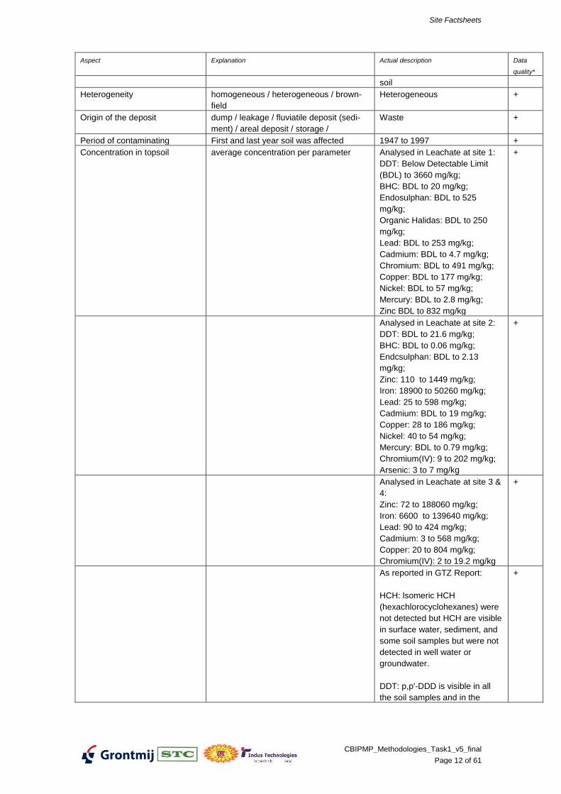
Aspect Explanation Actual description Data
quality*
soil
Heterogeneity homogeneous / heterogeneous / brown-
field
Heterogeneous +
Origin of the deposit dump / leakage / fluviatile deposit (sedi-
ment) / areal deposit / storage /
Waste +
Period of contaminating First and last year soil was affected 1947 to 1997 +
Concentration in topsoil average concentration per parameter Analysed in Leachate at site 1:
DDT: Below Detectable Limit
(BDL) to 3660 mg/kg;
BHC: BDL to 20 mg/kg;
Endosulphan: BDL to 525
mg/kg;
Organic Halidas: BDL to 250
mg/kg;
Lead: BDL to 253 mg/kg;
Cadmium: BDL to 4.7 mg/kg;
Chromium: BDL to 491 mg/kg;
Copper: BDL to 177 mg/kg;
Nickel: BDL to 57 mg/kg;
Mercury: BDL to 2.8 mg/kg;
Zinc BDL to 832 mg/kg
+
Analysed in Leachate at site 2:
DDT: BDL to 21.6 mg/kg;
BHC: BDL to 0.06 mg/kg;
Endcsulphan: BDL to 2.13
mg/kg;
Zinc: 110 to 1449 mg/kg;
Iron: 18900 to 50260 mg/kg;
Lead: 25 to 598 mg/kg;
Cadmium: BDL to 19 mg/kg;
Copper: 28 to 186 mg/kg;
Nickel: 40 to 54 mg/kg;
Mercury: BDL to 0.79 mg/kg;
Chromium(IV): 9 to 202 mg/kg;
Arsenic: 3 to 7 mg/kg
+
Analysed in Leachate at site 3 &
4:
Zinc: 72 to 188060 mg/kg;
Iron: 6600 to 139640 mg/kg;
Lead: 90 to 424 mg/kg;
Cadmium: 3 to 568 mg/kg;
Copper: 20 to 804 mg/kg;
Chromium(IV): 2 to 19.2 mg/kg
+
As reported in GTZ Report:
HCH: lsomeric HCH
(hexachlorocyclohexanes) were
not detected but HCH are visible
in surface water, sediment, and
some soil samples but were not
detected in well water or
groundwater.
DDT: p,p'-DDD is visible in all
the soil samples and in the
+
Site Factsheets
CBIPMP_Methodologies_Task1_v5_final
Page 13 of 61
Aspect Explanation Actual description Data
quality*
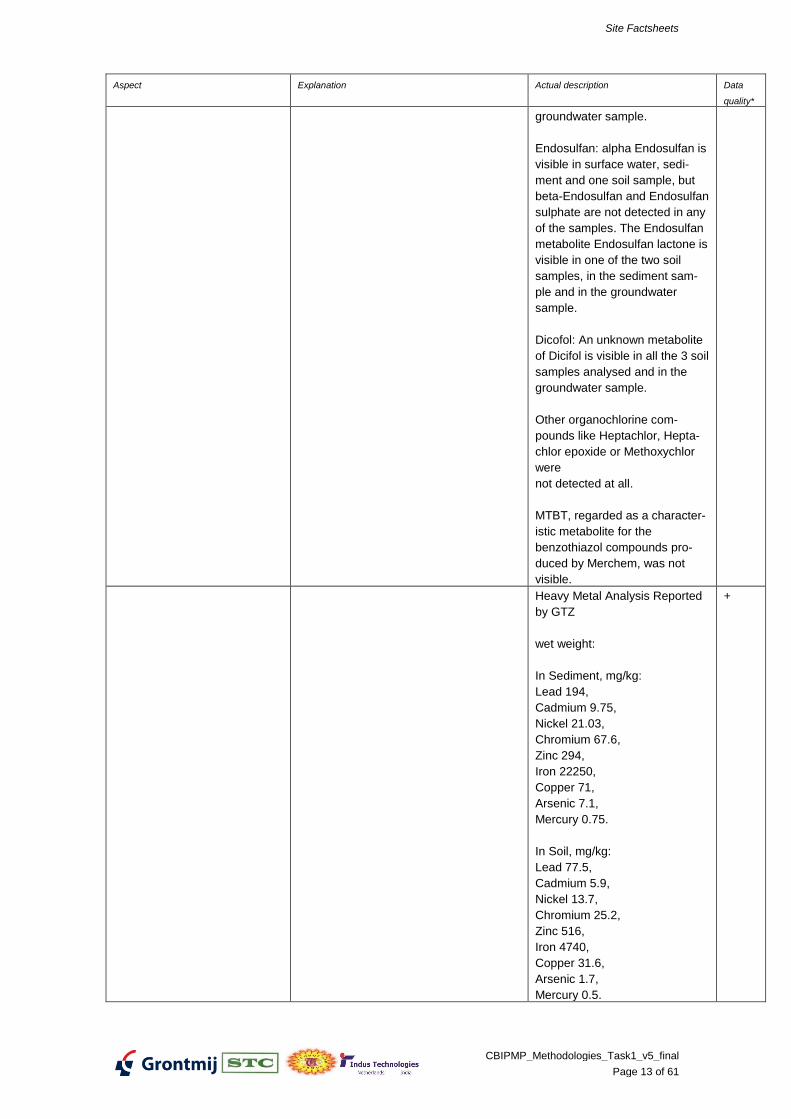
groundwater sample.
Endosulfan: alpha Endosulfan is
visible in surface water, sedi-
ment and one soil sample, but
beta-Endosulfan and Endosulfan
sulphate are not detected in any
of the samples. The Endosulfan
metabolite Endosulfan lactone is
visible in one of the two soil
samples, in the sediment sam-
ple and in the groundwater
sample.
Dicofol: An unknown metabolite
of Dicifol is visible in all the 3 soil
samples analysed and in the
groundwater sample.
Other organochlorine com-
pounds like Heptachlor, Hepta-
chlor epoxide or Methoxychlor
were
not detected at all.
MTBT, regarded as a character-
istic metabolite for the
benzothiazol compounds pro-
duced by Merchem, was not
visible.
Heavy Metal Analysis Reported
by GTZ
wet weight:
In Sediment, mg/kg:
Lead 194,
Cadmium 9.75,
Nickel 21.03,
Chromium 67.6,
Zinc 294,
Iron 22250,
Copper 71,
Arsenic 7.1,
Mercury 0.75.
In Soil, mg/kg:
Lead 77.5,
Cadmium 5.9,
Nickel 13.7,
Chromium 25.2,
Zinc 516,
Iron 4740,
Copper 31.6,
Arsenic 1.7,
Mercury 0.5.
+
Site Factsheets
CBIPMP_Methodologies_Task1_v5_final
Page 14 of 61
Aspect Explanation Actual description Data
quality*
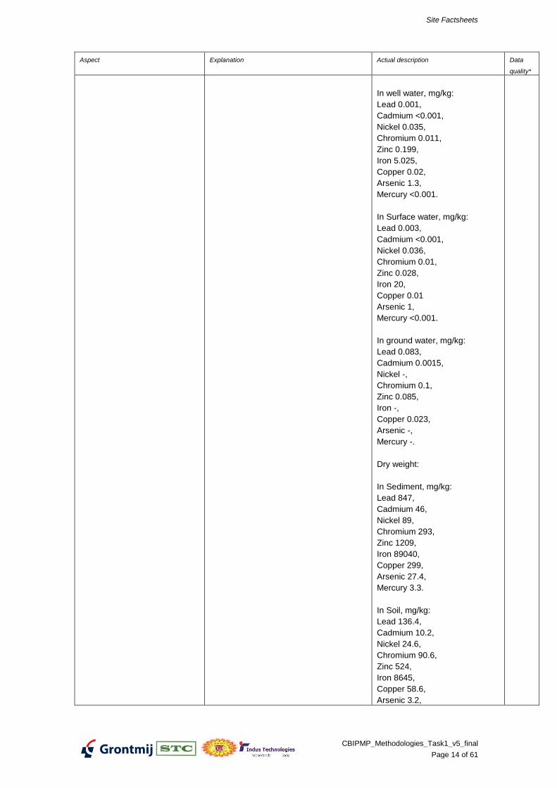
In well water, mg/kg:
Lead 0.001,
Cadmium <0.001,
Nickel 0.035,
Chromium 0.011,
Zinc 0.199,
Iron 5.025,
Copper 0.02,
Arsenic 1.3,
Mercury <0.001.
In Surface water, mg/kg:
Lead 0.003,
Cadmium <0.001,
Nickel 0.036,
Chromium 0.01,
Zinc 0.028,
Iron 20,
Copper 0.01
Arsenic 1,
Mercury <0.001.
In ground water, mg/kg:
Lead 0.083,
Cadmium 0.0015,
Nickel -,
Chromium 0.1,
Zinc 0.085,
Iron -,
Copper 0.023,
Arsenic -,
Mercury -.
Dry weight:
In Sediment, mg/kg:
Lead 847,
Cadmium 46,
Nickel 89,
Chromium 293,
Zinc 1209,
Iron 89040,
Copper 299,
Arsenic 27.4,
Mercury 3.3.
In Soil, mg/kg:
Lead 136.4,
Cadmium 10.2,
Nickel 24.6,
Chromium 90.6,
Zinc 524,
Iron 8645,
Copper 58.6,
Arsenic 3.2,
Site Factsheets
CBIPMP_Methodologies_Task1_v5_final
Page 15 of 61
Aspect Explanation Actual description Data
quality*
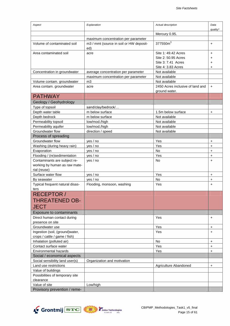
Mercury 0.95.
maximum concentration per parameter
Volume of contaminated soil m3 / mmt (source in soil or HW deposit-
ed)
377550m3 +
Area contaminated soil acre Site 1: 49.42 Acres
Site 2: 50.95 Acres
Site 3: 7.41 Acres
Site 4: 3.83 Acres
+
+
+
+
Concentration in groundwater average concentration per parameter Not available
maximum concentration per parameter Not available
Volume contam. groundwater m3 Not available
Area contam. groundwater acre 2450 Acres inclusive of land and
ground water.
+
PATHWAY
Geology / Geohydrology
Type of topsoil sand/clay/bedrock/…
Depth water table m below surface 1.5m below surface +
Depth bedrock m below surface Not available
Permeability topsoil low/mod./high Not available
Permeability aquifer low/mod./high Not available
Groundwater flow direction / speed Not available
Process of spreading
Groundwater flow yes / no Yes +
Washing (during heavy rain) yes / no Yes +
Evaporation yes / no No +
Flooding / (re)sedimentation yes / no Yes +
Contaminants are subject re-
working by human as raw mate-
rial (reuse)
yes / no No +
Surface water flow yes / no Yes +
By seawater yes / no No +
Typical frequent natural disas-
ters
Flooding, monsoon, washing Yes +
RECEPTOR / THREATENED OB-JECT
Exposure to contaminants
Direct human contact during
presence on site
Yes +
Groundwater use Yes +
Ingestion (soil, (ground)water,
crops / cattle / game / fish)
Yes +
Inhalation (polluted air) No +
Contact surface water Yes +
Environmental hazards Yes +
Social / economical aspects
Social sensibility land user(s) Organization and motivation
Land use restrictions Agriculture Abandoned +
Value of buildings
Possibilities of temporary site
clearance
Value of site Low/high
Provisory prevention / reme-
Site Factsheets
CBIPMP_Methodologies_Task1_v5_final
Page 16 of 61
Aspect Explanation Actual description Data
quality*
diation measures already
implemented
General
Access restriction No +
Liners / covers No +
Restrictions to land use Within Industry Premises +
Groundwater treatment No +
Data/inform. used
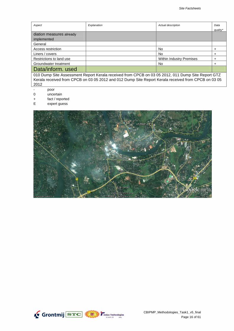
010 Dump Site Assessment Report Kerala received from CPCB on 03 05 2012, 011 Dump Site Report GTZ
Kerala received from CPCB on 03 05 2012 and 012 Dump Site Report Kerala received from CPCB on 03 05
2012
- poor
0 uncertain
+ fact / reported
E expert guess
Site Factsheets
CBIPMP_Methodologies_Task1_v5_final
Page 17 of 61
METHODOLOGIES FOR NPRPS INDIA
SITE FACTSHEET Ratlam (Jayant), Madhya Pradesh
Aspect Explanation Actual description Data
quality*
General data
Location of the site Ratlam +
City Ratlam +
State Madhya Pradesh +
Owner Ratlam Industrial Department +
Name of polluter Jayant Vitamins +
Area Acre
Terrain Coastal, delta, mountainous, Plain land +
Landuse Urban, industrial, rural, nature Industrial +
Accessibility / infrastructure Road, Railway E
Location under control Local authorities Ratlam Industrial Department
Industry Closed since year 2000
and under custody of Bank of
India
+
+
MPPC
B
Re-
port
Distance to contractors / au-
thority
110km from Ujjain Regional Of-
fice, MPPCB
E
SOURCE
Contaminants
Origin of contaminants what type of industry or activity Vitamin C, Sorbitol +
Chemical composition ETP Sludge, Nickel Oxide
Sodium Sulphate, Activated
Carbon
+
E
Physical properties fluid / solid / solubility / volatility Solids E
Position in soil on the surface / in soil / On the surface E
Heterogeneity homogeneous / heterogeneous / brown-
field
Origin of the deposit dump / leakage / fluviatile deposit (sedi-
ment) / areal deposit / storage /
Waste +
Period of contaminating First and last year soil was affected Preliminary examination +
Concentration in topsoil average concentration per parameter
maximum concentration per parameter
Volume of contaminated soil m3 / mmt (source in soil or HW deposit-
ed)
30MT of waste, 30cm depth of
soil
+
Area contaminated soil acre +
Concentration in groundwater average concentration per parameter
maximum concentration per parameter
Volume contam. groundwater m3
Area contam. groundwater acre
PATHWAY
Geology / Geohydrology
Type of topsoil sand/clay/bedrock/…
Depth water table m below surface
Depth bedrock m below surface
Permeability topsoil low/mod./high
Permeability aquifer low/mod./high
Groundwater flow direction / speed
Process of spreading
Site Factsheets
CBIPMP_Methodologies_Task1_v5_final
Page 18 of 61
Aspect Explanation Actual description Data
quality*
Groundwater flow yes / no
Washing (during heavy rain) yes / no Yes E
Evaporation yes / no
Flooding / (re)sedimentation yes / no
Contaminants are subject re-
working by human as raw mate-
rial (reuse)
yes / no
Surface water flow yes / no
By seawater yes / no
Typical frequent natural disas-
ters
Flooding, monsoon, washing
RECEPTOR / THREATENED OB-JECT
Exposure to contaminants
Direct human contact during
presence on site
Groundwater use E
Ingestion (soil, (ground)water,
crops / cattle / game / fish)
Inhalation (polluted air)
Contact surface water
Environmental hazards E
Social / economical aspects
Social sensibility land user(s) Organization and motivation
Land use restrictions
Value of buildings
Possibilities of temporary site
clearance
Value of site Low/high
Provisory prevention / reme-
diation measures already
implemented
General
Access restriction Within industry premises +
Liners / covers
Restrictions to land use Closed industry +
Groundwater treatment
- poor
0 uncertain
+ fact / reported
E expert guess
Additional Details as per MPPCB Report:
• The industry was engaged in manufacturing Vitamin-C and sorbitol. • The industry was generating ETP sludge to the tune of 109.5MT/A & 22MT/A Nickel sludge. • The industry is closed since 2000 and expected to have accumulated waste in its premises. Presently under custodian of Bank of India as per the instruction of Hon. Bombay High Court, hence entry is restricted. • But there is possibility that industry might have disposed off some waste in the premises of the industry which had to be verified by monitoring of soil, sub-soil and UG waste.

Site Factsheets
CBIPMP_Methodologies_Task1_v5_final
Page 19 of 61
Site Factsheets
CBIPMP_Methodologies_Task1_v5_final
Page 20 of 61
METHODOLOGIES FOR NPRPS INDIA
SITE FACTSHEET Ratlam (Sajjan), Madhya Pradesh
Aspect Explanation Actual description Data
quality*
General data
Location of the site Site-1: Plot No. 54-E, Dosigaon
Industrial Area, Ratlam
Site 2: Plot No. 61-B, Dosigaon
Industrial Area, Ratlam
Site 3: Khandeshara Mines,
Namali village, 16 KM away
from Dosigaon Industrial Area,
Ratlam
+
City Ratlam +
State Madhya Pradesh +
Owner Site 1, Site 2 & Site 3 : Madhya
Pradesh Audyogik Kendra Vikas
Ltd. (MPAKVN)
+
Name of polluter closed since20.06.1999 +
+
Area Site 1: 92x 7x 2.5 M x 12 no.
Concrete Pits
Site 2: 100X100 M Godown
Site 3 : 500 sqm Mine
+
+
E
Terrain Coastal, delta, mountainous, Plain land E
Landuse Urban, industrial, rural, nature Industrial, rural +
Accessibility / infrastructure Road, Rail +
Location under control Local authorities Pradesh Audyogik Kendra Vikas
Ltd. (MPAKVN)
+
Distance to contractors / au-
thority
110km from Ujjain Regional Of-
fice, MPPCB
E
SOURCE
Contaminants
Origin of contaminants what type of industry or activity H-Acid & G-Acid +
Chemical composition Site 1: Iron Sludge &Gypsum
Sludge
Site 2: Iron Sludge &Gypsum
Sludge, Incineration Ash
Site 3: Iron Sludge &Gypsum
Sludge
+
+
+
Physical properties fluid / solid / solubility / volatility Site 1: Solids
Site 2: Solids
Site 3: Solids
+
Position in soil on the surface / in soil / On the surface (contained within
industry premises) and also in
soil
+
Heterogeneity homogeneous / heterogeneous / brown-
field
Heterogeneous +
Origin of the deposit dump / leakage / fluviatile deposit (sedi-
ment) / areal deposit / storage /
Waste Site 1: Storage
Site 2: Storage
+
Site Factsheets
CBIPMP_Methodologies_Task1_v5_final
Page 21 of 61
Aspect Explanation Actual description Data
quality*
Site 3: Dump
Period of contaminating First and last year soil was affected From year 1988
Till year 1999
E
+
Concentration in topsoil average concentration per parameter Napthalene, Binapthyl Sul-
phone, 1,2 Napthyl Methylene
+
maximum concentration per parameter Napthalene, Binapthyl Sul-
phone, 1,2 Napthyl Methylene
+
Volume of contaminated soil m3 / mmt (source in soil or HW deposit-
ed)
Site 1: 20906MT
Site 2: 1156MT
Site 3: 1410MT
+
Area contaminated soil acre Site 1: 2 acre
Site 2: 2.5 acre
Site 3: 0.1 acre
+
+
E
Concentration in groundwater average concentration per parameter Coloured, Napthalene, Binapthyl
Sulphone, 1,2 Napthyl Meth-
ylene:
Chlorides: 957 mg/l
Sulphates: 180 mg/l
Phosphates: 1.5 mg/l
Nitrates : 127 mg/l
Iron :
+
maximum concentration per parameter Not available -
Volume contam. groundwater m3 - Not available -
Area contam. groundwater Sq KM 30 SqKM +
PATHWAY
Geology / Geohydrology
Type of topsoil sand/clay/bedrock/… Not available -
Depth water table feet below surface Site1: Not available
Site2: Not available
site3:300 feet below ground lev-
el at
Depth bedrock m below surface Not available
Permeability topsoil low/mod./high Not available
Permeability aquifer low/mod./high Not available
Groundwater flow direction / speed Not available
Process of spreading
Groundwater flow yes / no Yes +
Washing (during heavy rain) yes / no Yes +
Evaporation yes / no No +
Flooding / (re)sedimentation yes / no Yes +
Contaminants are subject re-
working by human as raw mate-
rial (reuse)
yes / no No +
Surface water flow yes / no Yes +
By seawater yes / no No +
Typical frequent natural disas-
ters
Flooding, monsoon, washing Yes +
RECEPTOR / THREATENED OB-JECT
Exposure to contaminants
Direct human contact during
presence on site
Yes +
Site Factsheets
CBIPMP_Methodologies_Task1_v5_final
Page 22 of 61
Aspect Explanation Actual description Data
quality*
Groundwater use Yes +
Ingestion (soil, (ground)water,
crops / cattle / game / fish)
Yes +
Inhalation (polluted air) No +
Contact surface water Yes +
Environmental hazards Yes +
Social / economical aspects
Social sensibility land user(s) Organization and motivation Health impact as skin diseases +
Land use restrictions Productivity of agricultural field
reduced
+
Value of buildings Low +
Possibilities of temporary site
clearance
Site 1 & Site 2: To Dismantle
and dispose to TSDF, Pithapur
200 km away
Site 3: To keep as is and moni-
tor
+
Value of site Low/high Low
+
Provisory prevention / reme-
diation measures already
implemented
General
Access restriction Yes +
Liners / covers No +
Restrictions to land use No +
Groundwater treatment No +
Data/inform. used
08 Dump_Site_Assessment_Madhya_Pradesh received from CPCB on 03 05 2012,011, 09 and
Dump_Site_Assessment_Madhya_Pradesh2 received from CPCB on 03 05 2012
- poor
0 uncertain
+ fact / reported
E expert guess Additional Details as per MPPCB Report:
M/s. Sajjan Chemical & Investment (P) Ltd., Ratlam was engaged in themanufacture of H-acid, G-acid and is closed since20.06.1999. • The industry was generating: 1000MT/A of Gypsum sludge, 410MT/A Iron Sludge4000MT/A of Sodium Sulphate & 1500MT/A of incinerated ash as hazardouswastes. • Some of the wastes were being disposed off in khasara No 469/1 Kandarwasa mine. The incinerated ash was stored at plot No 61B, Industrial area. • Presently all structures have been dismantled and equipments, machinery and allscrap materials have been removed from the site. • Waste debris are still lying in underground storage tanks & sheds within &near byto factory premises. • Legal action under EPA has been filed in CJM, Ratlam.
Site Factsheets
CBIPMP_Methodologies_Task1_v5_final
Page 23 of 61
Site Factsheets
CBIPMP_Methodologies_Task1_v5_final
Page 24 of 61
METHODOLOGIES FOR NPRPS INDIA
SITE FACTSHEET Ganjam (Jayashree), Orissa
Aspect Explanation Actual description Data
quality*
General data
Location of the site Ganjam +
City Ganjam +
State Orissa +
Owner Notified Area Council +
Name of polluter Jayashree Chemicals +
Area Acre 3 locations +
Terrain Coastal, delta, mountainous, Partly Waterlogged, flat mor-
phology
+
Landuse Urban, industrial, rural, nature Industrial, Rural +
Accessibility / infrastructure Road +
Location under control Local authorities Gram Panchayat, Rural Area +
Distance to contractors / au-
thority
30km from Bahrampur Regional
Office of OSPCB
E
SOURCE
Contaminants
Origin of contaminants what type of industry or activity Chlor-Alkali +
Chemical composition Brine Sludge, Mercury Sul-
phide?
+
Physical properties fluid / solid / solubility / volatility Solid +
Position in soil on the surface / in soil / On the surface and in soil +
Heterogeneity homogeneous / heterogeneous / brown-
field
Heterogeneous +
Origin of the deposit dump / leakage / fluviatile deposit (sedi-
ment) / areal deposit / storage /
Stored Waste +
Period of contaminating First and last year soil was affected 1967 to 2004 +
Concentration in topsoil average concentration per parameter Brine sludge and Hypo Sludge
Location 1: pH ~ 13; Hg
~64mg/kg
Location 2: pH ~9; Hg
~1280mg/kg; Ba compound ex-
cept BaSO4 ~2930mg/kg
Location 3: pH ~9.9; Hg
~19mg/kg
+
+
+
+
maximum concentration per parameter Location 1: Hg 81.9mg/kg
Location 2: Hg 2000mg/kg; Ba
compound except BaSO4
~7830mg/kg
Location 3: Hg 33.6mg/kg
+
+
+
Volume of contaminated soil m3 / mmt (source in soil or HW deposit-
ed)
Location 1: 5000MT
Location 2: 33000MT - 30000m3
Location 3: 18000MT - 15000 m3
+
+
+
Area contaminated soil acre Location 1: 35 Acre
Location 2: 120 Acre
Location 3: 80 Acre
+
+
+
Concentration in groundwater average concentration per parameter Hg Below Detectable Limit
0.001mg/L
+
maximum concentration per parameter
Volume contam. groundwater m3 Not available
Area contam. groundwater acre Not available
Site Factsheets
CBIPMP_Methodologies_Task1_v5_final
Page 25 of 61
Aspect Explanation Actual description Data
quality*
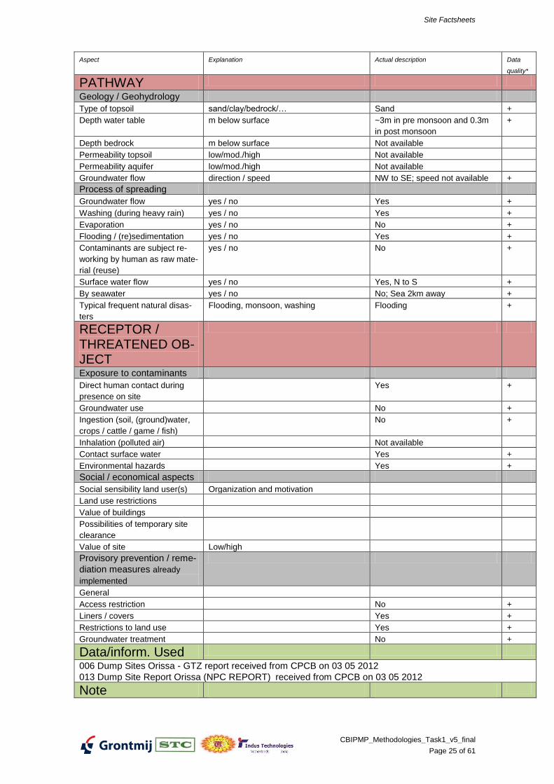
PATHWAY
Geology / Geohydrology
Type of topsoil sand/clay/bedrock/… Sand +
Depth water table m below surface ~3m in pre monsoon and 0.3m
in post monsoon
+
Depth bedrock m below surface Not available
Permeability topsoil low/mod./high Not available
Permeability aquifer low/mod./high Not available
Groundwater flow direction / speed NW to SE; speed not available +
Process of spreading
Groundwater flow yes / no Yes +
Washing (during heavy rain) yes / no Yes +
Evaporation yes / no No +
Flooding / (re)sedimentation yes / no Yes +
Contaminants are subject re-
working by human as raw mate-
rial (reuse)
yes / no No +
Surface water flow yes / no Yes, N to S +
By seawater yes / no No; Sea 2km away +
Typical frequent natural disas-
ters
Flooding, monsoon, washing Flooding +
RECEPTOR / THREATENED OB-JECT
Exposure to contaminants
Direct human contact during
presence on site
Yes +
Groundwater use No +
Ingestion (soil, (ground)water,
crops / cattle / game / fish)
No +
Inhalation (polluted air) Not available
Contact surface water Yes +
Environmental hazards Yes +
Social / economical aspects
Social sensibility land user(s) Organization and motivation
Land use restrictions
Value of buildings
Possibilities of temporary site
clearance
Value of site Low/high
Provisory prevention / reme-
diation measures already
implemented
General
Access restriction No +
Liners / covers Yes +
Restrictions to land use Yes +
Groundwater treatment No +
Data/inform. Used
006 Dump Sites Orissa - GTZ report received from CPCB on 03 05 2012
013 Dump Site Report Orissa (NPC REPORT) received from CPCB on 03 05 2012
Note
Site Factsheets
CBIPMP_Methodologies_Task1_v5_final
Page 26 of 61
Aspect Explanation Actual description Data
quality*
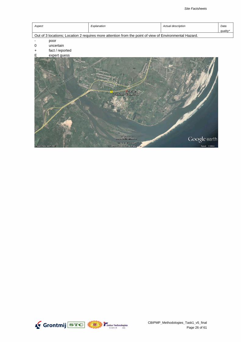
Out of 3 locations; Location 2 requires more attention from the point of view of Environmental Hazard.
- poor
0 uncertain
+ fact / reported
E expert guess
Site Factsheets
CBIPMP_Methodologies_Task1_v5_final
Page 27 of 61
METHODOLOGIES FOR NPRPS INDIA
SITE FACTSHEET Talchar (Orichem), Orissa
Aspect Explanation Actual description Data
quality*
General data
Location of the site Talchar +
City Talcher +
State Orissa +
Owner Panchayat +
Name of polluter Orichem Limited (closed indus-
try)
+
Area Acre 1 site in industry premises +
Terrain Coastal, delta, mountainous, Plain land +
Landuse Urban, industrial, rural, nature Industrial, rural +
Accessibility / infrastructure Road, Railway +
Location under control Local authorities Rural Area Panchayat +
Distance to contractors / au-
thority
113km from Cuttack Regional
Office of OSPCB
E
SOURCE
Contaminants
Origin of contaminants what type of industry or activity Chromium ore processing; ETP +
Chemical composition Sodium Chromate, Total Chro-
mium from ETP sludge
+
Physical properties fluid / solid / solubility / volatility Solid +
Position in soil on the surface / in soil / On the surface +
Heterogeneity homogeneous / heterogeneous / brown-
field
Heterogeneous +
Origin of the deposit dump / leakage / fluviatile deposit (sedi-
ment) / areal deposit / storage /
Waste +
Period of contaminating First and last year soil was affected 1983 to 1998 +
Concentration in topsoil average concentration per parameter Hexavalent Chromium
580mg/kg;
Total Chromium 17500mg/kg
+
maximum concentration per parameter Hexavalent Chromium
3340mg/kg;
Total Chromium 12300mg/kg
+
+
Volume of contaminated soil m3 / mmt (source in soil or HW deposit-
ed)
80000MT (NPC Report)
70000MT (GTZ estimate for
additional unaccounted waste)
+
+
Area contaminated soil acre 320 Acre within industry premis-
es
+
Concentration in groundwater average concentration per parameter Hexavalent Chromium 1mg/L;
Total Chromium 3mg/L
+
maximum concentration per parameter Hexavalent Chromium 1mg/L;
Total Chromium 3mg/L
+
Volume contam. groundwater m3
Area contam. groundwater acre
PATHWAY
Geology / Geohydrology
Type of topsoil sand/clay/bedrock/… Laterite +
Depth water table m below surface 4.4 m below surface in pre-
monsoon and 2.6m in post mon-
soon
+
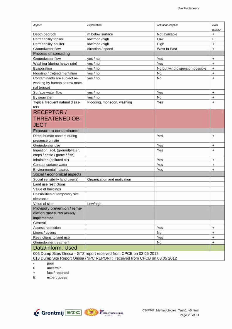
Site Factsheets
CBIPMP_Methodologies_Task1_v5_final
Page 28 of 61
Aspect Explanation Actual description Data
quality*
Depth bedrock m below surface Not available +
Permeability topsoil low/mod./high Low E
Permeability aquifer low/mod./high High +
Groundwater flow direction / speed West to East +
Process of spreading
Groundwater flow yes / no Yes +
Washing (during heavy rain) yes / no Yes +
Evaporation yes / no No but wind dispersion possible +
Flooding / (re)sedimentation yes / no No +
Contaminants are subject re-
working by human as raw mate-
rial (reuse)
yes / no No +
Surface water flow yes / no Yes +
By seawater yes / no No +
Typical frequent natural disas-
ters
Flooding, monsoon, washing Yes +
RECEPTOR / THREATENED OB-JECT
Exposure to contaminants
Direct human contact during
presence on site
Yes +
Groundwater use Yes +
Ingestion (soil, (ground)water,
crops / cattle / game / fish)
Yes +
Inhalation (polluted air) Yes +
Contact surface water Yes +
Environmental hazards Yes +
Social / economical aspects
Social sensibility land user(s) Organization and motivation
Land use restrictions
Value of buildings
Possibilities of temporary site
clearance
Value of site Low/high
Provisory prevention / reme-
diation measures already
implemented
General
Access restriction Yes +
Liners / covers No +
Restrictions to land use Yes +
Groundwater treatment No +
Data/inform. Used
006 Dump Sites Orissa - GTZ report received from CPCB on 03 05 2012
013 Dump Site Report Orissa (NPC REPORT) received from CPCB on 03 05 2012
- poor
0 uncertain
+ fact / reported
E expert guess
Site Factsheets
CBIPMP_Methodologies_Task1_v5_final
Page 29 of 61
Site Factsheets
CBIPMP_Methodologies_Task1_v5_final
Page 30 of 61
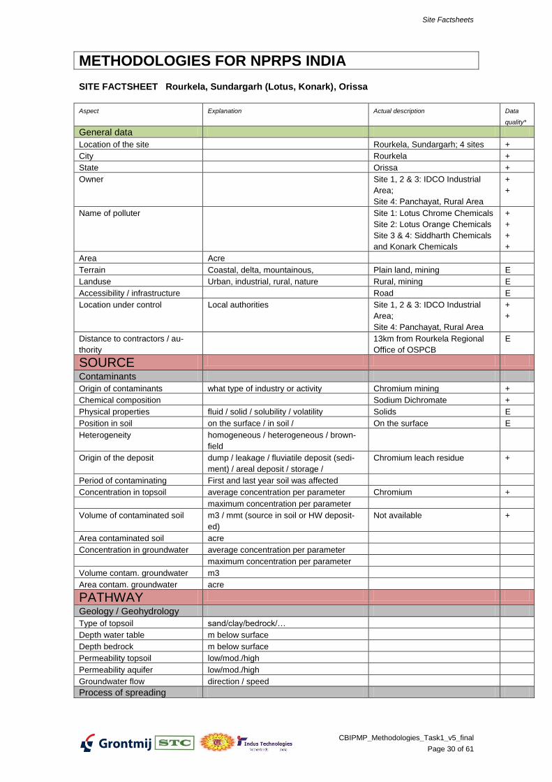
METHODOLOGIES FOR NPRPS INDIA
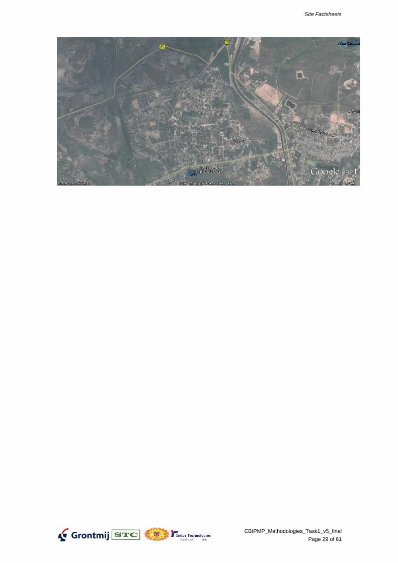
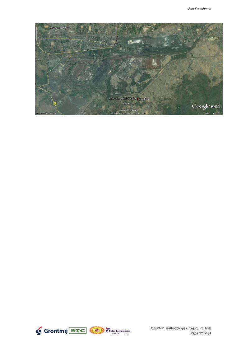
SITE FACTSHEET Rourkela, Sundargarh (Lotus, Konark), Orissa
Aspect Explanation Actual description Data
quality*
General data
Location of the site Rourkela, Sundargarh; 4 sites +
City Rourkela +
State Orissa +
Owner Site 1, 2 & 3: IDCO Industrial
Area;
Site 4: Panchayat, Rural Area
+
+
Name of polluter Site 1: Lotus Chrome Chemicals
Site 2: Lotus Orange Chemicals
Site 3 & 4: Siddharth Chemicals
and Konark Chemicals
+
+
+
+
Area Acre
Terrain Coastal, delta, mountainous, Plain land, mining E
Landuse Urban, industrial, rural, nature Rural, mining E
Accessibility / infrastructure Road E
Location under control Local authorities Site 1, 2 & 3: IDCO Industrial
Area;
Site 4: Panchayat, Rural Area
+
+
Distance to contractors / au-
thority
13km from Rourkela Regional
Office of OSPCB
E
SOURCE
Contaminants
Origin of contaminants what type of industry or activity Chromium mining +
Chemical composition Sodium Dichromate +
Physical properties fluid / solid / solubility / volatility Solids E
Position in soil on the surface / in soil / On the surface E
Heterogeneity homogeneous / heterogeneous / brown-
field
Origin of the deposit dump / leakage / fluviatile deposit (sedi-
ment) / areal deposit / storage /
Chromium leach residue +
Period of contaminating First and last year soil was affected
Concentration in topsoil average concentration per parameter Chromium +
maximum concentration per parameter
Volume of contaminated soil m3 / mmt (source in soil or HW deposit-
ed)
Not available +
Area contaminated soil acre
Concentration in groundwater average concentration per parameter
maximum concentration per parameter
Volume contam. groundwater m3
Area contam. groundwater acre
PATHWAY
Geology / Geohydrology
Type of topsoil sand/clay/bedrock/…
Depth water table m below surface
Depth bedrock m below surface
Permeability topsoil low/mod./high
Permeability aquifer low/mod./high
Groundwater flow direction / speed
Process of spreading
Site Factsheets
CBIPMP_Methodologies_Task1_v5_final
Page 31 of 61
Aspect Explanation Actual description Data
quality*
Groundwater flow yes / no
Washing (during heavy rain) yes / no Yes E
Evaporation yes / no
Flooding / (re)sedimentation yes / no
Contaminants are subject re-
working by human as raw mate-
rial (reuse)
yes / no
Surface water flow yes / no
By seawater yes / no
Typical frequent natural disas-
ters
Flooding, monsoon, washing
RECEPTOR / THREATENED OB-JECT
Exposure to contaminants
Direct human contact during
presence on site
Groundwater use
Ingestion (soil, (ground)water,
crops / cattle / game / fish)
Inhalation (polluted air)
Contact surface water
Environmental hazards Yes E
Social / economical aspects
Social sensibility land user(s) Organization and motivation
Land use restrictions
Value of buildings
Possibilities of temporary site
clearance
Value of site Low/high
Provisory prevention / reme-
diation measures already
implemented
General
Access restriction No E
Liners / covers No E
Restrictions to land use No E
Groundwater treatment No E
- poor
0 uncertain
+ fact / reported
E expert guess
Site Factsheets
CBIPMP_Methodologies_Task1_v5_final
Page 32 of 61
Site Factsheets
CBIPMP_Methodologies_Task1_v5_final
Page 33 of 61
METHODOLOGIES FOR NPRPS INDIA
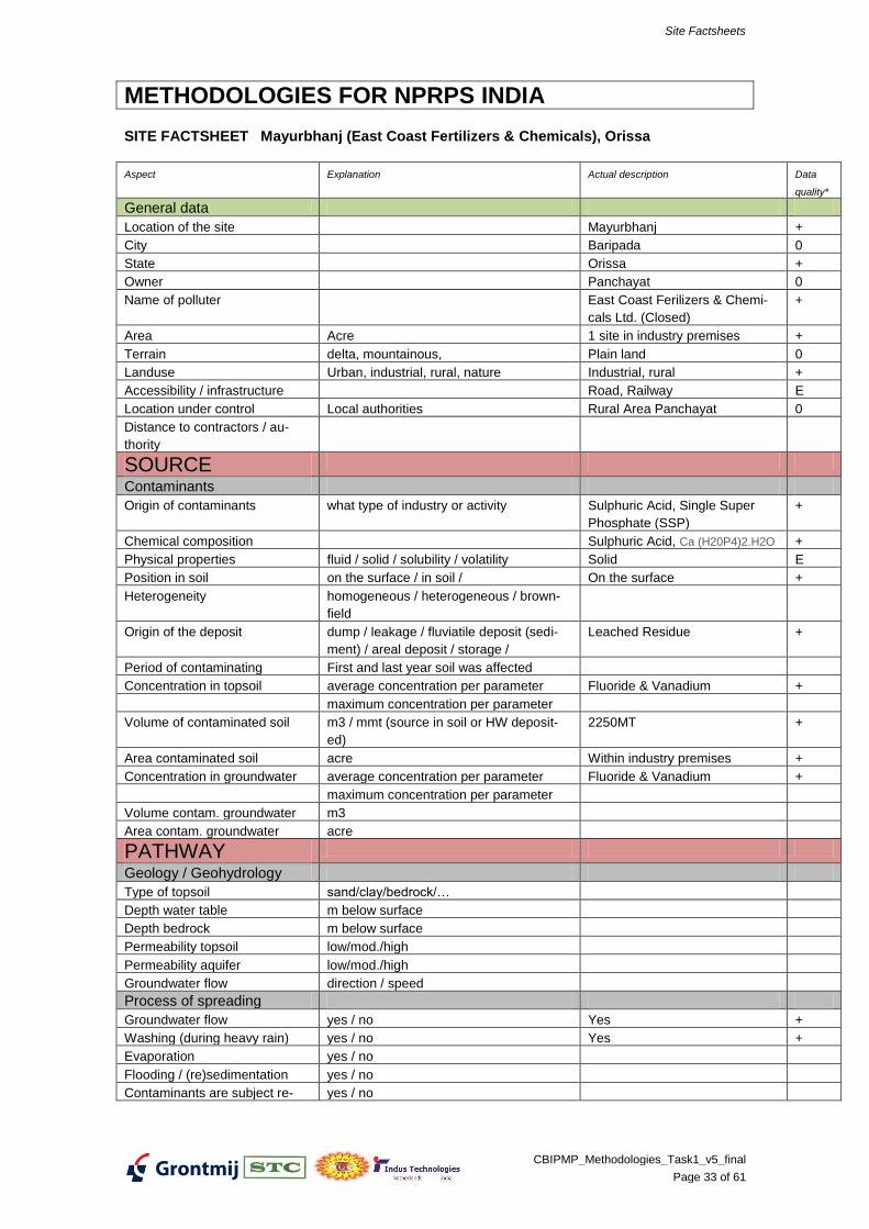
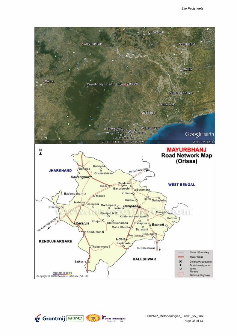
SITE FACTSHEET Mayurbhanj (East Coast Fertilizers & Chemicals), Orissa
Aspect Explanation Actual description Data
quality*
General data
Location of the site Mayurbhanj +
City Baripada 0
State Orissa +
Owner Panchayat 0
Name of polluter East Coast Ferilizers & Chemi-
cals Ltd. (Closed)
+
Area Acre 1 site in industry premises +
Terrain delta, mountainous, Plain land 0
Landuse Urban, industrial, rural, nature Industrial, rural +
Accessibility / infrastructure Road, Railway E
Location under control Local authorities Rural Area Panchayat 0
Distance to contractors / au-
thority
SOURCE
Contaminants
Origin of contaminants what type of industry or activity Sulphuric Acid, Single Super
Phosphate (SSP)
+
Chemical composition Sulphuric Acid, Ca (H20P4)2.H2O +
Physical properties fluid / solid / solubility / volatility Solid E
Position in soil on the surface / in soil / On the surface +
Heterogeneity homogeneous / heterogeneous / brown-
field
Origin of the deposit dump / leakage / fluviatile deposit (sedi-
ment) / areal deposit / storage /
Leached Residue +
Period of contaminating First and last year soil was affected
Concentration in topsoil average concentration per parameter Fluoride & Vanadium +
maximum concentration per parameter
Volume of contaminated soil m3 / mmt (source in soil or HW deposit-
ed)
2250MT +
Area contaminated soil acre Within industry premises +
Concentration in groundwater average concentration per parameter Fluoride & Vanadium +
maximum concentration per parameter
Volume contam. groundwater m3
Area contam. groundwater acre
PATHWAY
Geology / Geohydrology
Type of topsoil sand/clay/bedrock/…
Depth water table m below surface
Depth bedrock m below surface
Permeability topsoil low/mod./high
Permeability aquifer low/mod./high
Groundwater flow direction / speed
Process of spreading
Groundwater flow yes / no Yes +
Washing (during heavy rain) yes / no Yes +
Evaporation yes / no
Flooding / (re)sedimentation yes / no
Contaminants are subject re- yes / no
Site Factsheets
CBIPMP_Methodologies_Task1_v5_final
Page 34 of 61
Aspect Explanation Actual description Data
quality*
working by human as raw mate-
rial (reuse)
Surface water flow yes / no
By seawater yes / no
Typical frequent natural disas-
ters
Flooding, monsoon, washing Yes +
RECEPTOR / THREATENED OB-JECT
Exposure to contaminants
Direct human contact during
presence on site
Groundwater use Yes E
Ingestion (soil, (ground)water,
crops / cattle / game / fish)
Yes E
Inhalation (polluted air)
Contact surface water
Environmental hazards Yes +
Social / economical aspects
Social sensibility land user(s) Organization and motivation
Land use restrictions
Value of buildings
Possibilities of temporary site
clearance
Value of site Low/high
Provisory prevention / reme-
diation measures already
implemented
General
Access restriction No 0
Liners / covers No 0
Restrictions to land use
Groundwater treatment No 0
- poor
0 uncertain
+ fact / reported
E expert guess
Site Factsheets
CBIPMP_Methodologies_Task1_v5_final
Page 35 of 61
Site Factsheets
CBIPMP_Methodologies_Task1_v5_final
Page 36 of 61
METHODOLOGIES FOR NPRPS INDIA
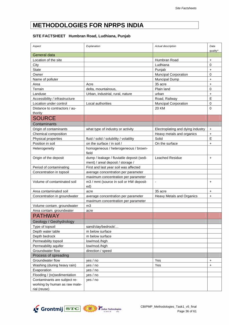
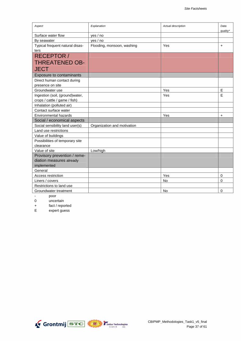
SITE FACTSHEET Humbran Road, Ludhiana, Punjab
Aspect Explanation Actual description Data
quality*
General data
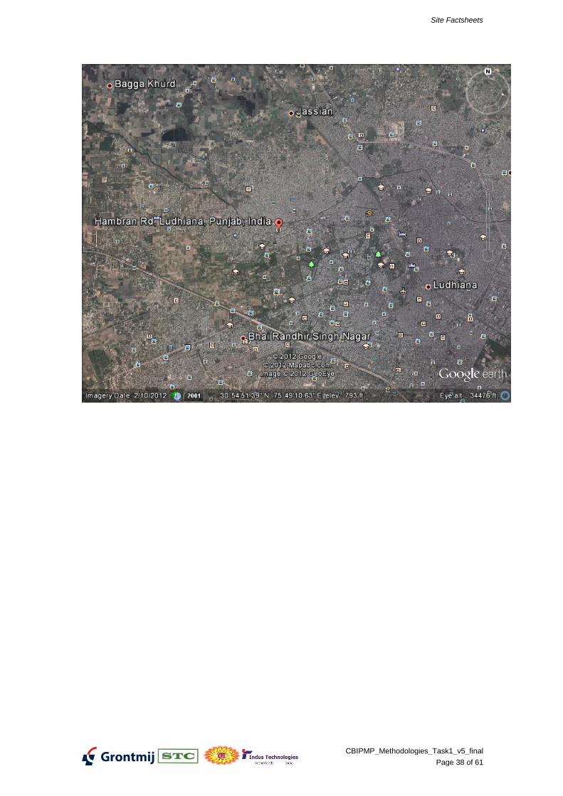
Location of the site Humbran Road +
City Ludhiana 0
State Punjab +
Owner Muncipal Corporation 0
Name of polluter Muncipal Dump +
Area Acre 35 acre +
Terrain delta, mountainous, Plain land 0
Landuse Urban, industrial, rural, nature urban +
Accessibility / infrastructure Road, Railway E
Location under control Local authorities Muncipal Corporation 0
Distance to contractors / au-
thority
20 KM 0
SOURCE
Contaminants
Origin of contaminants what type of industry or activity Electroplating and dying industry +
Chemical composition Heavy metals and organics +
Physical properties fluid / solid / solubility / volatility Solid E
Position in soil on the surface / in soil / On the surface +
Heterogeneity homogeneous / heterogeneous / brown-
field
Origin of the deposit dump / leakage / fluviatile deposit (sedi-
ment) / areal deposit / storage /
Leached Residue +
Period of contaminating First and last year soil was affected
Concentration in topsoil average concentration per parameter
maximum concentration per parameter
Volume of contaminated soil m3 / mmt (source in soil or HW deposit-
ed)
- +
Area contaminated soil acre 35 acre +
Concentration in groundwater average concentration per parameter Heavy Metals and Organics +
maximum concentration per parameter
Volume contam. groundwater m3
Area contam. groundwater acre
PATHWAY
Geology / Geohydrology
Type of topsoil sand/clay/bedrock/…
Depth water table m below surface
Depth bedrock m below surface
Permeability topsoil low/mod./high
Permeability aquifer low/mod./high
Groundwater flow direction / speed
Process of spreading
Groundwater flow yes / no Yes +
Washing (during heavy rain) yes / no Yes +
Evaporation yes / no
Flooding / (re)sedimentation yes / no
Contaminants are subject re-
working by human as raw mate-
rial (reuse)
yes / no
Site Factsheets
CBIPMP_Methodologies_Task1_v5_final
Page 37 of 61
Aspect Explanation Actual description Data
quality*
Surface water flow yes / no
By seawater yes / no
Typical frequent natural disas-
ters
Flooding, monsoon, washing Yes +
RECEPTOR / THREATENED OB-JECT
Exposure to contaminants
Direct human contact during
presence on site
Groundwater use Yes E
Ingestion (soil, (ground)water,
crops / cattle / game / fish)
Yes E
Inhalation (polluted air)
Contact surface water
Environmental hazards Yes +
Social / economical aspects
Social sensibility land user(s) Organization and motivation
Land use restrictions
Value of buildings
Possibilities of temporary site
clearance
Value of site Low/high
Provisory prevention / reme-
diation measures already
implemented
General
Access restriction Yes 0
Liners / covers No 0
Restrictions to land use
Groundwater treatment No 0
- poor
0 uncertain
+ fact / reported
E expert guess
Site Factsheets
CBIPMP_Methodologies_Task1_v5_final
Page 38 of 61
Site Factsheets
CBIPMP_Methodologies_Task1_v5_final
Page 39 of 61
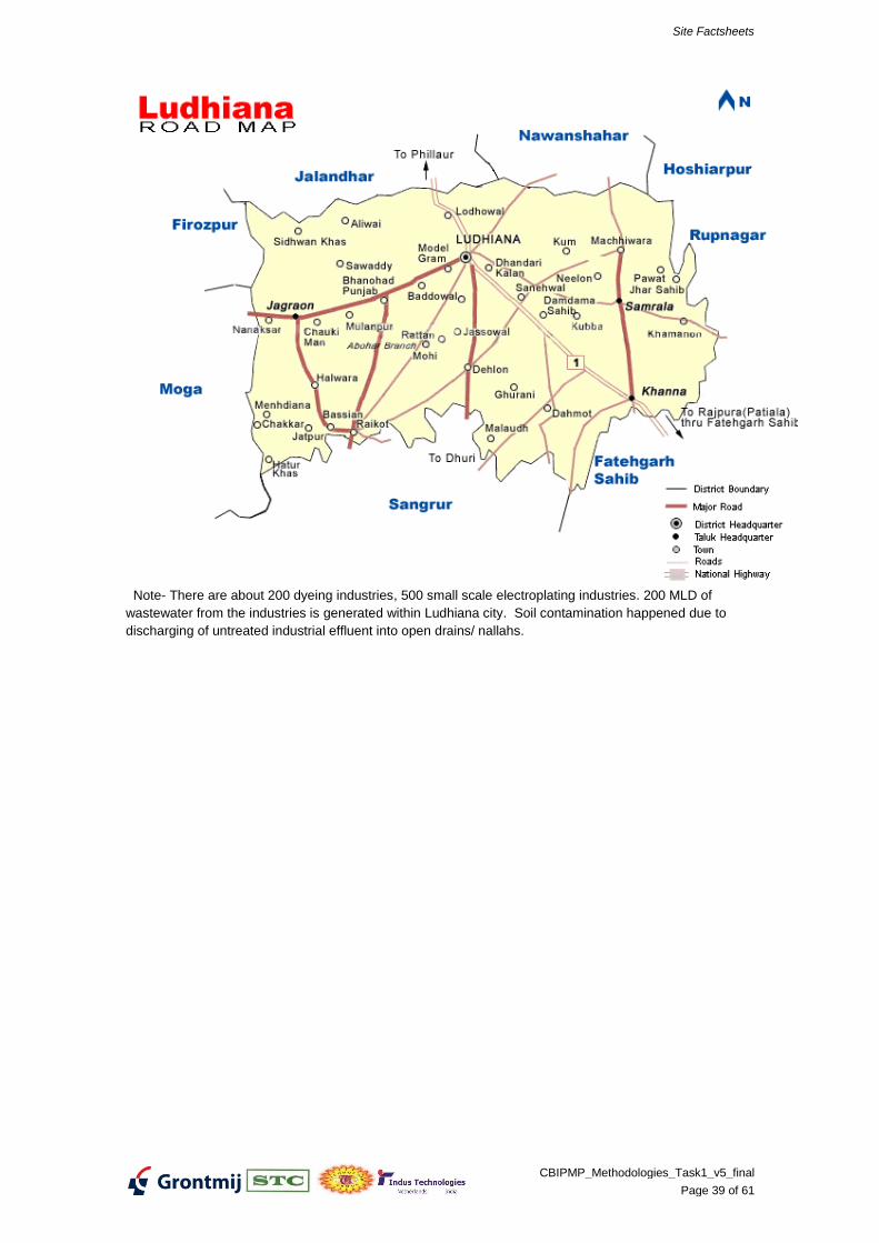
Note- There are about 200 dyeing industries, 500 small scale electroplating industries. 200 MLD of
wastewater from the industries is generated within Ludhiana city. Soil contamination happened due to
discharging of untreated industrial effluent into open drains/ nallahs.
Site Factsheets
CBIPMP_Methodologies_Task1_v5_final
Page 40 of 61
METHODOLOGIES FOR NPRPS INDIA
SITE FACTSHEET Bichadi (Hindustan Agro Chemicals), Rajasthan
Aspect Explanation Actual description Data
quality*
General data
Location of the site Bichhadi +
City Near Udaipur City E
State Rajasthan +
Owner Dropped??? +
Name of polluter subsidiary units
Silver Chemicals,
Jyoti Chemicals,
Phosphate India and
Multi Fertilizers
+
Area Acre
Terrain Coastal, delta, mountainous, Plain Land E
Landuse Urban, industrial, rural, nature Industrial +
Accessibility / infrastructure Road E
Location under control Local authorities RSPCB E
Distance to contractors / au-
thority
17km from RSPCB Udaipur Re-
gional Office
E
SOURCE
Contaminants
Origin of contaminants what type of industry or activity Agro Chemical, Fertilizer and H-
Acid
+
Chemical composition Gypsum Sludge, Iron Sludge
Inorganic and organic salts
+
Physical properties fluid / solid / solubility / volatility Solid E
Position in soil on the surface / in soil / On the surface E
Heterogeneity homogeneous / heterogeneous / brown-
field
Origin of the deposit dump / leakage / fluviatile deposit (sedi-
ment) / areal deposit / storage /
Waste +
Period of contaminating First and last year soil was affected
Concentration in topsoil average concentration per parameter Contamination +
maximum concentration per parameter
Volume of contaminated soil m3 / mmt (source in soil or HW deposit-
ed)
Area contaminated soil acre
Concentration in groundwater average concentration per parameter Contamination +
maximum concentration per parameter
Volume contam. groundwater m3
Area contam. groundwater acre
PATHWAY
Geology / Geohydrology
Type of topsoil sand/clay/bedrock/…
Depth water table m below surface
Depth bedrock m below surface
Permeability topsoil low/mod./high
Permeability aquifer low/mod./high
Groundwater flow direction / speed
Process of spreading
Groundwater flow yes / no Yes E
Site Factsheets
CBIPMP_Methodologies_Task1_v5_final
Page 41 of 61
Aspect Explanation Actual description Data
quality*
Washing (during heavy rain) yes / no Yes E
Evaporation yes / no No E
Flooding / (re)sedimentation yes / no No E
Contaminants are subject re-
working by human as raw mate-
rial (reuse)
yes / no
Surface water flow yes / no Yes E
By seawater yes / no
Typical frequent natural disas-
ters
Flooding, monsoon, washing
RECEPTOR / THREATENED OB-JECT
Exposure to contaminants
Direct human contact during
presence on site
Groundwater use
Ingestion (soil, (ground)water,
crops / cattle / game / fish)
Inhalation (polluted air)
Contact surface water Yes E
Environmental hazards Yes E
Social / economical aspects
Social sensibility land user(s) Organization and motivation
Land use restrictions
Value of buildings
Possibilities of temporary site
clearance
Value of site Low/high
Provisory prevention / reme-
diation measures already
implemented
General
Access restriction No E
Liners / covers No E
Restrictions to land use No E
Groundwater treatment No E
Data/inform. used
- poor
0 uncertain
+ fact / reported
E expert guess
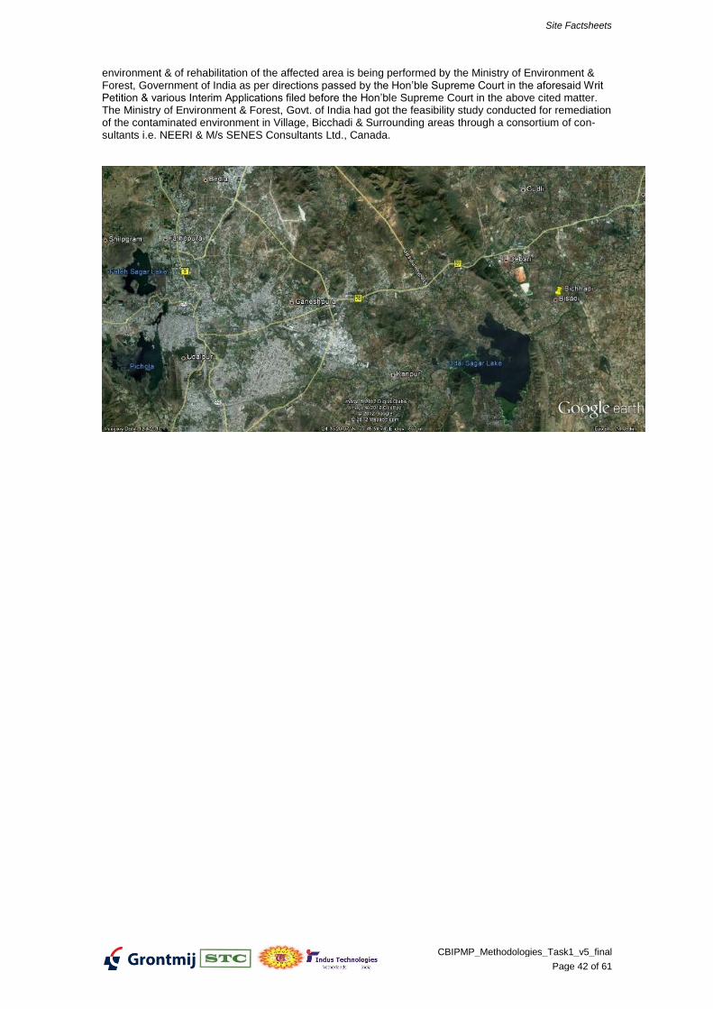
Additional Details as per RPCB Report:
The State Board has identified only one hazardous waste dump site in the State at Bichhadi, Udaipur. M/s Hindustan Agro Chemicals Ltd., Bhicchadi, Udaipur was in operation up to 1996 & discharged/dumped its hazardous waste generated by it and its subsidiary units namely M/s Silver Chemicals, M/s Jyoti Chemi-cals, M/s Phosphate India & M/s Rajasthan Multi Fertilizers in and around the premises of the industry. These units were manufacturing H-Acid, Sulphuric Acid, Oleum, Chlorosulphonic Acid, Phosphatic Fertiliz-ers & other chemical. The units were closed down by the orders dated 13.2.1996 of the Hon’ble Supreme Court of India in the Writ Petition Civil No. 967/89- Indian Council for Enviro legal Action V/s. Union of India & others. The task of remediation of the
Site Factsheets
CBIPMP_Methodologies_Task1_v5_final
Page 42 of 61
environment & of rehabilitation of the affected area is being performed by the Ministry of Environment & Forest, Government of India as per directions passed by the Hon’ble Supreme Court in the aforesaid Writ Petition & various Interim Applications filed before the Hon’ble Supreme Court in the above cited matter. The Ministry of Environment & Forest, Govt. of India had got the feasibility study conducted for remediation of the contaminated environment in Village, Bicchadi & Surrounding areas through a consortium of con-sultants i.e. NEERI & M/s SENES Consultants Ltd., Canada.
Site Factsheets
CBIPMP_Methodologies_Task1_v5_final
Page 43 of 61
METHODOLOGIES FOR NPRPS INDIA
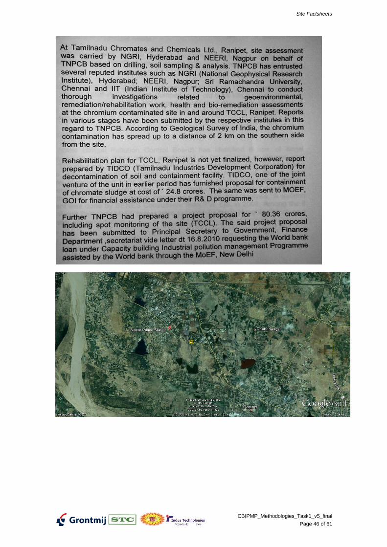
SITE FACTSHEET Ranipet (TNCC), Tamil Nadu
Aspect Explanation Actual description Data
quality*
General data
Location of the site SIPCOT Industrial Complex,
Ranipet
+
City Ranipet +
State Tamil Nadu +
Owner SIPCOT +
Name of polluter Tamilnadu Chromates & Chemi-
cals Ltd.
+
Area Acre 7.41 Acres +
Terrain Coastal, delta, mountainous, Plain land on the southern
downward side and mountain-
ous surrounding on the northern
upward side
+
Landuse Urban, industrial, rural, nature Industrial, Urban +
Accessibility / infrastructure Road, Railway +
Location under control Local authorities SIPCOT +
Distance to contractors / au-
thority
116km from TNPCB Head Quar-
ters
+
SOURCE
Contaminants
Origin of contaminants what type of industry or activity Basic Chromium Sulphate +
Chemical composition Chromium +
Physical properties fluid / solid / solubility / volatility Solid +
Position in soil on the surface / in soil / On the surface +
Heterogeneity homogeneous / heterogeneous / brown-
field
Heterogeneous; brownfield +
Origin of the deposit dump / leakage / fluviatile deposit (sedi-
ment) / areal deposit / storage /
Chromium Residue dump inside
industry premises and also out-
side industry premises
+
Period of contaminating First and last year soil was affected 1975 to 1995 +
Concentration in topsoil average concentration per parameter Cr +
maximum concentration per parameter Hexavalent Chromium
Reference NGRI Report:
300mg/kg near surface to
100mg/kg at 5m depth within
industry and north of NE- SW
natural dyke;
100mg/kg near surface to very
low concentration at 5m depth
outside NE- SW natural dyke
and within industry premises
Reference NEERI Report:
25510 to 5753mg/kg near sur-
face
within industry premises
(Waste constituent having
50mg/kg Cr+6
is Hazardous
Waste as per Part A of schedule
II of Hazardous Waste (Man-
agement, Handling and
+
Site Factsheets
CBIPMP_Methodologies_Task1_v5_final
Page 44 of 61
Aspect Explanation Actual description Data
quality*
Transboudary) Rules, 2008.
Volume of contaminated soil m3 / mmt (source in soil or HW deposit-
ed)
220,000MT +
Area contaminated soil acre 7.41 Acres +
Concentration in groundwater average concentration per parameter Cr +
maximum concentration per parameter 191.73mg/L as Cr+6
and
192.4mg/L as Total Chromium
inside Industry premises bore
well.
<0.001 mg/L as Cr+6
and
<0.003mg/L as Total Chromium
outside Industry premises bore
wells.
Cr+6
limit prescribed in Drinking
Water Indian Standard IS
10500:1991is 0.05mg/L.
+
Volume contam. groundwater m3 ~32568750m3 (between 20 to
40m depth)
+
Area contam. groundwater acre ~10000 Acres (1.125km x
0.965km in S-SE direction)
+
PATHWAY
Geology / Geohydrology
Type of topsoil sand/clay/bedrock/… Gravel Clay 3m depth +
Depth water table m below surface 3 to 4 m below ground surface +
Depth bedrock m below surface Weathered / Hard Rock for-
mation from 5m upto 10m depth
below ground surface
+
Permeability topsoil low/mod./high High +
Permeability aquifer low/mod./high High +
Groundwater flow direction / speed North to South
Filtration velocity 0.005m/d in-
side the Industry dump site and
0.0055m/d outside industry.
Actual velocity 8.11m/y inside
the Industry dump site and
11.4m/y outside industry.
+
Process of spreading
Groundwater flow yes / no No. Restricted by NE-SW dyke +
Washing (during heavy rain) yes / no Yes (Rainfall 1000mm annually) +
Evaporation yes / no No E
Flooding / (re)sedimentation yes / no No E
Contaminants are subject re-
working by human as raw mate-
rial (reuse)
yes / no No E
Surface water flow yes / no Yes. Treated Effluent from
Common Effluent Treatment
Plant in the area flows through
the dumpsite and carries chro-
mium downstream.
+
By seawater yes / no No +
Typical frequent natural disas-
ters
Flooding, monsoon, washing Yes E
RECEPTOR / THREATENED OB-
Site Factsheets
CBIPMP_Methodologies_Task1_v5_final
Page 45 of 61
Aspect Explanation Actual description Data
quality*
JECT
Exposure to contaminants
Direct human contact during
presence on site
Yes E
Groundwater use No +
Ingestion (soil, (ground)water,
crops / cattle / game / fish)
No +
Inhalation (polluted air) No +
Contact surface water Yes +
Environmental hazards Yes +
Social / economical aspects
Social sensibility land user(s) Organization and motivation
Land use restrictions
Value of buildings
Possibilities of temporary site
clearance
Value of site Low/high
Provisory prevention / reme-
diation measures already
implemented
General
Access restriction Yes E
Liners / covers No +
Restrictions to land use Yes +
Groundwater treatment No +
Data/inform. used
NEERI report March 2010 on assessment and remediation options;
NGRI report October 2008 on geoenvironmental investigations
- poor
0 uncertain
+ fact / reported
E expert guess
Site Factsheets
CBIPMP_Methodologies_Task1_v5_final
Page 46 of 61
Site Factsheets
CBIPMP_Methodologies_Task1_v5_final
Page 47 of 61
METHODOLOGIES FOR NPRPS INDIA
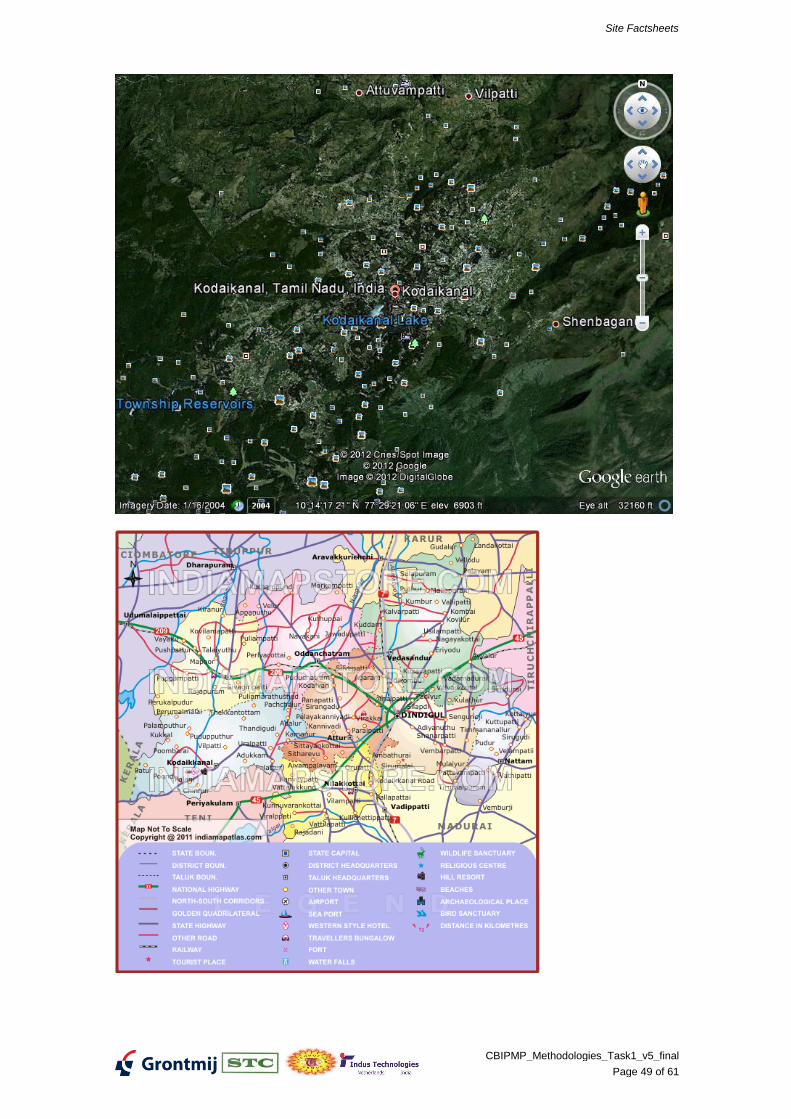
SITE FACTSHEET Kodaikanal (Hindustan Unilever), Tamil Nadu
Aspect Explanation Actual description Data
quality*
General data
Location of the site Kodaikanal +
City Kodaikanal 0
State Tamil Nadu +
Owner Panchayat 0
Name of polluter Hindustan Unilever Ltd. +
Area Acre 1 site in industry premises +
Terrain delta, mountainous, Mountainous 0
Landuse Urban, industrial, rural, nature Industrial, rural +
Accessibility / infrastructure Road, Railway E
Location under control Local authorities Rural Area Panchayat 0
Distance to contractors / au-
thority
SOURCE
Contaminants
Origin of contaminants what type of industry or activity Mercury bearing scrap from
thermometers
+
Chemical composition Mercury +
Physical properties fluid / solid / solubility / volatility Solid E
Position in soil on the surface / in soil / On the surface +
Heterogeneity homogeneous / heterogeneous / brown-
field
Origin of the deposit dump / leakage / fluviatile deposit (sedi-
ment) / areal deposit / storage /
Leached Residue +
Period of contaminating First and last year soil was affected
Concentration in topsoil average concentration per parameter Mercury +
maximum concentration per parameter
Volume of contaminated soil m3 / mmt (source in soil or HW deposit-
ed)
3 acres of mercury contaminat-
ed soil to a depth of 1m. Apprx
5000 MT of waste(?)2250MT
+
Area contaminated soil acre Within and around industry
premises, forest
+
Concentration in groundwater average concentration per parameter Mrcury +
maximum concentration per parameter
Volume contam. groundwater m3
Area contam. groundwater acre
PATHWAY
Geology / Geohydrology
Type of topsoil sand/clay/bedrock/…
Depth water table m below surface
Depth bedrock m below surface
Permeability topsoil low/mod./high
Permeability aquifer low/mod./high
Groundwater flow direction / speed
Process of spreading
Groundwater flow yes / no Yes +
Washing (during heavy rain) yes / no Yes +
Evaporation yes / no
Flooding / (re)sedimentation yes / no
Site Factsheets
CBIPMP_Methodologies_Task1_v5_final
Page 48 of 61
Aspect Explanation Actual description Data
quality*
Contaminants are subject re-
working by human as raw mate-
rial (reuse)
yes / no
Surface water flow yes / no
By seawater yes / no
Typical frequent natural disas-
ters
Flooding, monsoon, washing Yes +
RECEPTOR / THREATENED OB-JECT
Exposure to contaminants
Direct human contact during
presence on site
Groundwater use Yes E
Ingestion (soil, (ground)water,
crops / cattle / game / fish)
Yes E
Inhalation (polluted air)
Contact surface water
Environmental hazards Yes +
Social / economical aspects
Social sensibility land user(s) Organization and motivation
Land use restrictions
Value of buildings
Possibilities of temporary site
clearance
Value of site Low/high
Provisory prevention / reme-
diation measures already
implemented
General
Access restriction Yes 0
Liners / covers No 0
Restrictions to land use
Groundwater treatment No 0
- poor
0 uncertain
+ fact / reported
E expert guess
Site Factsheets
CBIPMP_Methodologies_Task1_v5_final
Page 49 of 61
Site Factsheets
CBIPMP_Methodologies_Task1_v5_final
Page 50 of 61
Mercury pollution
Air and water-borne mercury emissions have contaminated large areas of Kodaikanal and sur-rounding forests. A study conducted by the Department of Atomic Energy confirmed that Kodaikanal Lake has been contaminated by mercury emissions.,
[22][23]
Mercury pollution was reported in Kodaikanal which affected lakes in the area. The causes, originating from a Hindustan Lever thermometer factory nearby, were reported to be dispersal of elemental mercury to the atmosphere from improper storage and dispersal to water from sur-face effluents from the factory. Apart from tests conducted on Kodaikanal lake, moss samples collected from trees surrounding the Berijam Lake, located 20 km (12.4 mi) from the factory were also tested. This showed mercury level in the range of 0.2 µg/kg, while in Kodaikanal lake the lichen and moss levels were 7.9 µg/kg and 8.3 µg/kg, respectively. Fish samples tested from the Kodaikanal lake also showed Hg level in the range of 120 to 290 mg/kg confirming that pol-lution of the lake had taken place due to mercury emissions from the factory.
[24]
The Hindustan Unilever thermometer factory caused widespread mercury pollution through im-proper disposal of broken thermometer waste containing large quantities of mercury. The facto-ry sold much of this waste to a junkyard in Kodaikanal and also dumped large quantities in the forest behind the factory. The factory was eventually closed in 2001 after 18 years of operation. Hindustan Lever, have used considerable legal maneuvering to avoid paying compensation the ex-workers and their families, many of whom died or became physically handicapped as a result of mercury poisoning.
[25][26]
The ex-workers have joined to form the 559-strong Ex-Mercury Employees Welfare Association and in 2006 filed a Public Interest Litigation (PIL) suit in the Madras High Court. The association wants an economic rehabilitation scheme and a healthcare treatment and monitoring pro-gramme at the company's expense for everyone who ever worked in the factory. It also wants the company prosecuted. Hindustan Unilever denies that any of the health problems of the workers or their families was the result of mercury exposure in the factory. In 2010 the workers were still fighting for compensation.
[27]
June 2007 the Madras High Court constituted a five-member expert committee to decide on the mercury workers health claims. The last court hearing was in June 2008. The committee later failed to find sufficient evidence to link the current clinical condition of the factory workers to past mercury exposure in the factory.
[28]
Additional site remediation studies are being undertaken by national institutions, as desired by the Tamil Nadu pollution Control Board (TNPCB) and the Court's Scientific Experts Committee (SEC) during the project review meeting in January 2010. IIT Delhi is revalidating the risk as-sessment study and site specific clean-up standard; National Botanical Research Institute, Lucknow is studying impact on trees and preservation of trees; and Centre for Soil and Water Conservation Research and Training Institute, Ooty is studying the impact on soil and soil ero-sion. Based on the above study findings, results of remediation trials and recommendation of SEC, the TNPCB will take a final decision on the clean-up standard. Hindustan Unilever Ltd. (HUL) will commence soil remediation work at the factory site once
Site Factsheets
CBIPMP_Methodologies_Task1_v5_final
Page 51 of 61
METHODOLOGIES FOR NPRPS INDIA
SITE FACTSHEET Lucknow (India Pesticides), Uttar Pradesh
Date lat-
est up-
date:
20120423
Purpose: To get a feeling of the general typology of the study
Status: Draft
Author: Rob Heijer
Revisions: Based on data provided during Mission 1
Actions:
Aspect Explanation Actual description Data
quality*
General data
Location of the site Lucknow +
City
State Uttar Pradesh
Owner
Name of polluter India Pesticides Ltd. +
Area Acre
Terrain Coastal, delta, mountainous,
Landuse Urban, industrial, rural, nature
Accessibility / infrastructure
Location under control Local authorities Gram Panchayat Barabanki +
Distance to contractors / au-
thority
SOURCE
Contaminants
Origin of contaminants what type of industry or activity Lindane production +
Chemical composition HCH / pesticides
Physical properties fluid / solid / solubility / volatility +
Position in soil on the surface / in soil /
Heterogeneity homogeneous / heterogeneous / brown-
field
Origin of the deposit dump / leakage / fluviatile deposit (sedi-
ment) / areal deposit / storage /
Waste +
Period of contaminating First and last year soil was affected
Concentration in topsoil average concentration per parameter
maximum concentration per parameter
Volume of contaminated soil m3 / mmt (source in soil or HW deposit-
ed)
Approx. 36.432 tonnes +
Area contaminated soil acre
Concentration in groundwater average concentration per parameter
maximum concentration per parameter
Volume contam. groundwater m3
Area contam. groundwater acre
PATHWAY
Geology / Geohydrology
Type of topsoil sand/clay/bedrock/…
Depth water table m below surface
Depth bedrock m below surface
Permeability topsoil low/mod./high
Permeability aquifer low/mod./high
Groundwater flow direction / speed
Site Factsheets
CBIPMP_Methodologies_Task1_v5_final
Page 52 of 61
Aspect Explanation Actual description Data
quality*
Process of spreading
Groundwater flow yes / no
Washing (during heavy rain) yes / no
Evaporation yes / no
Flooding / (re)sedimentation yes / no
Contaminants are subject re-
working by human as raw mate-
rial (reuse)
yes / no
Surface water flow yes / no
By seewater yes / no
Typical frequent natural disas-
ters
Flooding, monsoon, washing
RECEPTOR / THREATENED OB-JECT
Exposure to contaminants
Direct human contact during
presence on site
Groundwater use
Ingestion (soil, (ground)water,
crops / cattle / game / fish)
Inhalation (polluted air)
Contact surface water
Social / economical aspects
Social sensibility land user(s) Organization and motivation
Land use restrictions
Value of buildings
Possibilities of temporary site
clearance
Value of site Low/high
Provisory prevention / reme-
diation measures already
implemented
General
Access restriction
Liners / covers
Restrictions to land use
Groundwater treatment
Data/inform. used
1) “annexure” page 12 (provided bij CPCB during mission 1)
Main conclusion Possible Scope Remedia-tion
Additional data needed
HW dumpsite
Pesticides
Poor data on source material
Not data on human exposure or
environmental hazards
- poor
0 uncertain
+ fact / reported
E expert guess
Site Factsheets
CBIPMP_Methodologies_Task1_v5_final
Page 53 of 61
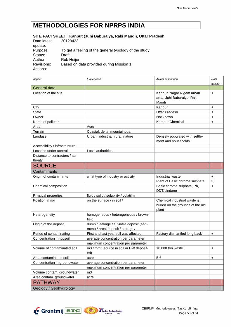
METHODOLOGIES FOR NPRPS INDIA
SITE FACTSHEET Kanput (Juhi Baburaiya, Raki Mandi), Uttar Pradesh
Date latest
update:
20120423
Purpose: To get a feeling of the general typology of the study
Status: Draft
Author: Rob Heijer
Revisions: Based on data provided during Mission 1
Actions:
Aspect Explanation Actual description Data
quality*
General data
Location of the site Kanpur, Nagar Nigam urban
area, Juhi Baburaiya, Raki
Mandi
+
City Kanpur +
State Uttar Pradesh +
Owner Not known +
Name of polluter Kampur Chemical +
Area Acre
Terrain Coastal, delta, mountainous,
Landuse Urban, industrial, rural, nature Densely populated with settle-
ment and households
Accessibility / infrastructure
Location under control Local authorities
Distance to contractors / au-
thority
SOURCE
Contaminants
Origin of contaminants what type of industry or activity Industrial waste
Plant of Basic chrome sulphate
+
3)
Chemical composition Basic chrome sulphate, Pb,
DDT/Lindane
+
Physical properties fluid / solid / solubility / volatility
Position in soil on the surface / in soil / Chemical industrial waste is
buried on the grounds of the old
plant
Heterogeneity homogeneous / heterogeneous / brown-
field
Origin of the deposit dump / leakage / fluviatile deposit (sedi-
ment) / areal deposit / storage /
Period of contaminating First and last year soil was affected Factory dismantled long back +
Concentration in topsoil average concentration per parameter
maximum concentration per parameter
Volume of contaminated soil m3 / mmt (source in soil or HW deposit-
ed)
10.000 ton waste +
Area contaminated soil acre 5-6 +
Concentration in groundwater average concentration per parameter
maximum concentration per parameter
Volume contam. groundwater m3
Area contam. groundwater acre
PATHWAY
Geology / Geohydrology
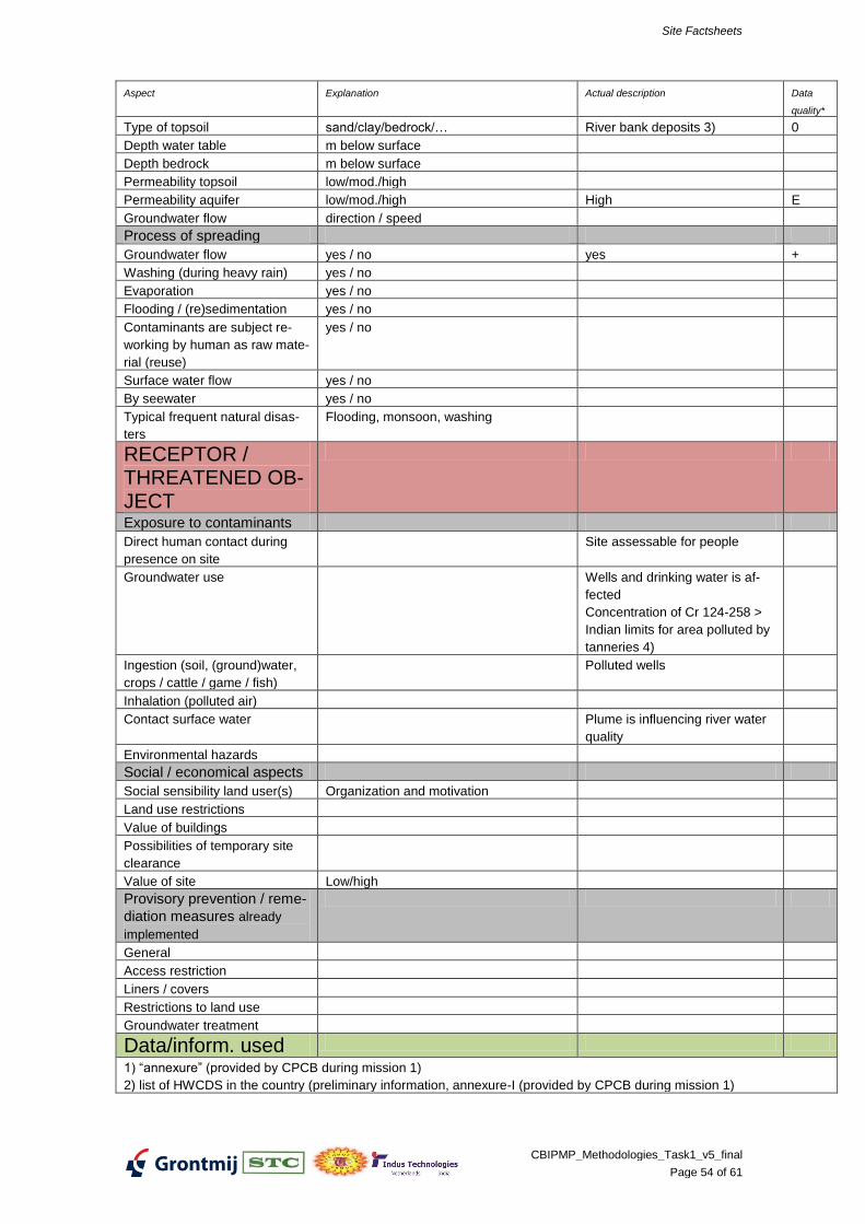
Site Factsheets
CBIPMP_Methodologies_Task1_v5_final
Page 54 of 61
Aspect Explanation Actual description Data
quality*
Type of topsoil sand/clay/bedrock/… River bank deposits 3) 0
Depth water table m below surface
Depth bedrock m below surface
Permeability topsoil low/mod./high
Permeability aquifer low/mod./high High E
Groundwater flow direction / speed
Process of spreading
Groundwater flow yes / no yes +
Washing (during heavy rain) yes / no
Evaporation yes / no
Flooding / (re)sedimentation yes / no
Contaminants are subject re-
working by human as raw mate-
rial (reuse)
yes / no
Surface water flow yes / no
By seewater yes / no
Typical frequent natural disas-
ters
Flooding, monsoon, washing
RECEPTOR / THREATENED OB-JECT
Exposure to contaminants
Direct human contact during
presence on site
Site assessable for people
Groundwater use Wells and drinking water is af-
fected
Concentration of Cr 124-258 >
Indian limits for area polluted by
tanneries 4)
Ingestion (soil, (ground)water,
crops / cattle / game / fish)
Polluted wells
Inhalation (polluted air)
Contact surface water Plume is influencing river water
quality
Environmental hazards
Social / economical aspects
Social sensibility land user(s) Organization and motivation
Land use restrictions
Value of buildings
Possibilities of temporary site
clearance
Value of site Low/high
Provisory prevention / reme-
diation measures already
implemented
General
Access restriction
Liners / covers
Restrictions to land use
Groundwater treatment
Data/inform. used
1) “annexure” (provided by CPCB during mission 1)
2) list of HWCDS in the country (preliminary information, annexure-I (provided by CPCB during mission 1)
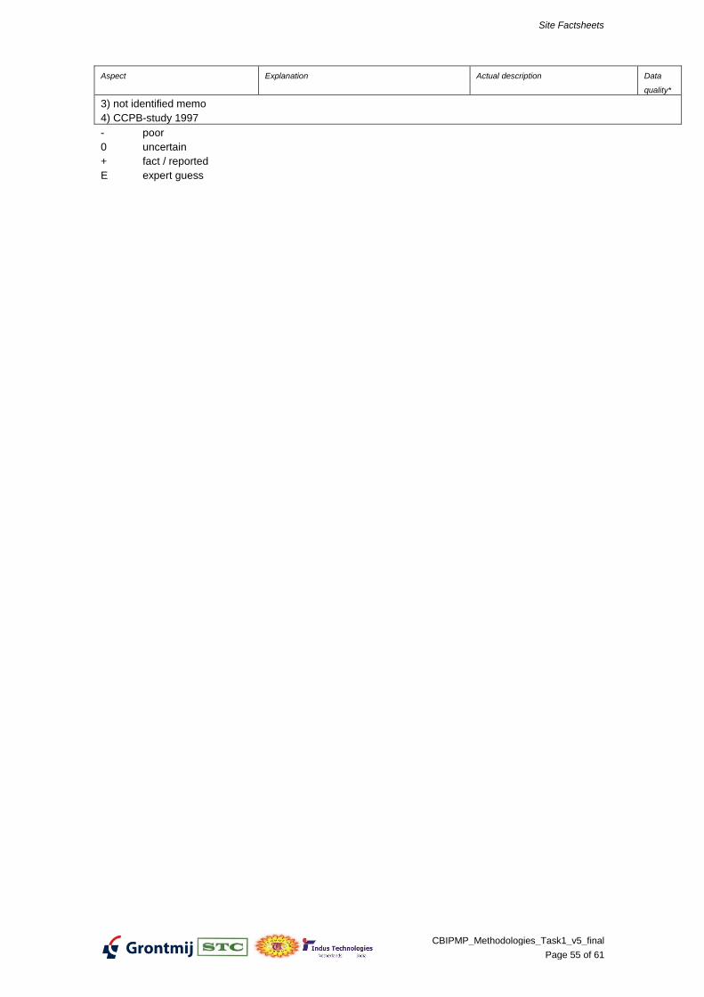
Site Factsheets
CBIPMP_Methodologies_Task1_v5_final
Page 55 of 61
Aspect Explanation Actual description Data
quality*
3) not identified memo
4) CCPB-study 1997
- poor
0 uncertain
+ fact / reported
E expert guess
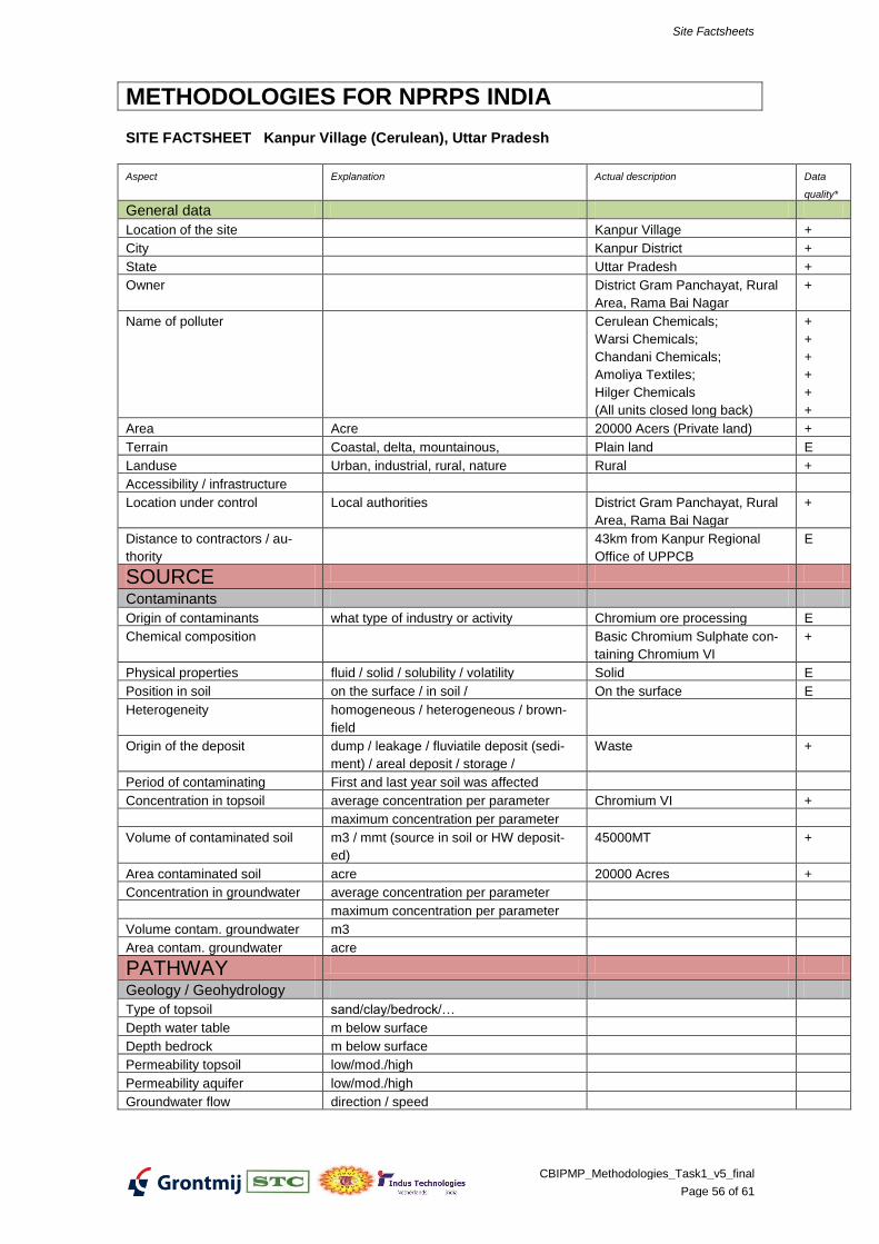
Site Factsheets
CBIPMP_Methodologies_Task1_v5_final
Page 56 of 61
METHODOLOGIES FOR NPRPS INDIA
SITE FACTSHEET Kanpur Village (Cerulean), Uttar Pradesh
Aspect Explanation Actual description Data
quality*
General data
Location of the site Kanpur Village +
City Kanpur District +
State Uttar Pradesh +
Owner District Gram Panchayat, Rural
Area, Rama Bai Nagar
+
Name of polluter Cerulean Chemicals;
Warsi Chemicals;
Chandani Chemicals;
Amoliya Textiles;
Hilger Chemicals
(All units closed long back)
+
+
+
+
+
+
Area Acre 20000 Acers (Private land) +
Terrain Coastal, delta, mountainous, Plain land E
Landuse Urban, industrial, rural, nature Rural +
Accessibility / infrastructure
Location under control Local authorities District Gram Panchayat, Rural
Area, Rama Bai Nagar
+
Distance to contractors / au-
thority
43km from Kanpur Regional
Office of UPPCB
E
SOURCE
Contaminants
Origin of contaminants what type of industry or activity Chromium ore processing E
Chemical composition Basic Chromium Sulphate con-
taining Chromium VI
+
Physical properties fluid / solid / solubility / volatility Solid E
Position in soil on the surface / in soil / On the surface E
Heterogeneity homogeneous / heterogeneous / brown-
field
Origin of the deposit dump / leakage / fluviatile deposit (sedi-
ment) / areal deposit / storage /
Waste +
Period of contaminating First and last year soil was affected
Concentration in topsoil average concentration per parameter Chromium VI +
maximum concentration per parameter
Volume of contaminated soil m3 / mmt (source in soil or HW deposit-
ed)
45000MT +
Area contaminated soil acre 20000 Acres +
Concentration in groundwater average concentration per parameter
maximum concentration per parameter
Volume contam. groundwater m3
Area contam. groundwater acre
PATHWAY
Geology / Geohydrology
Type of topsoil sand/clay/bedrock/…
Depth water table m below surface
Depth bedrock m below surface
Permeability topsoil low/mod./high
Permeability aquifer low/mod./high
Groundwater flow direction / speed
Site Factsheets
CBIPMP_Methodologies_Task1_v5_final
Page 57 of 61
Aspect Explanation Actual description Data
quality*
Process of spreading
Groundwater flow yes / no Yes E
Washing (during heavy rain) yes / no Yes E
Evaporation yes / no No E
Flooding / (re)sedimentation yes / no No E
Contaminants are subject re-
working by human as raw mate-
rial (reuse)
yes / no
Surface water flow yes / no No E
By seawater yes / no No E
Typical frequent natural disas-
ters
Flooding, monsoon, washing Yes E
RECEPTOR / THREATENED OB-JECT
Exposure to contaminants
Direct human contact during
presence on site
Groundwater use Yes E
Ingestion (soil, (ground)water,
crops / cattle / game / fish)
Yes E
Inhalation (polluted air)
Contact surface water
Environmental hazards Yes E
Social / economical aspects
Social sensibility land user(s) Organization and motivation
Land use restrictions
Value of buildings
Possibilities of temporary site
clearance
Value of site Low/high
Provisory prevention / reme-
diation measures already
implemented
General
Access restriction No E
Liners / covers No E
Restrictions to land use No E
Groundwater treatment No E
- poor
0 uncertain
+ fact / reported
E expert guess
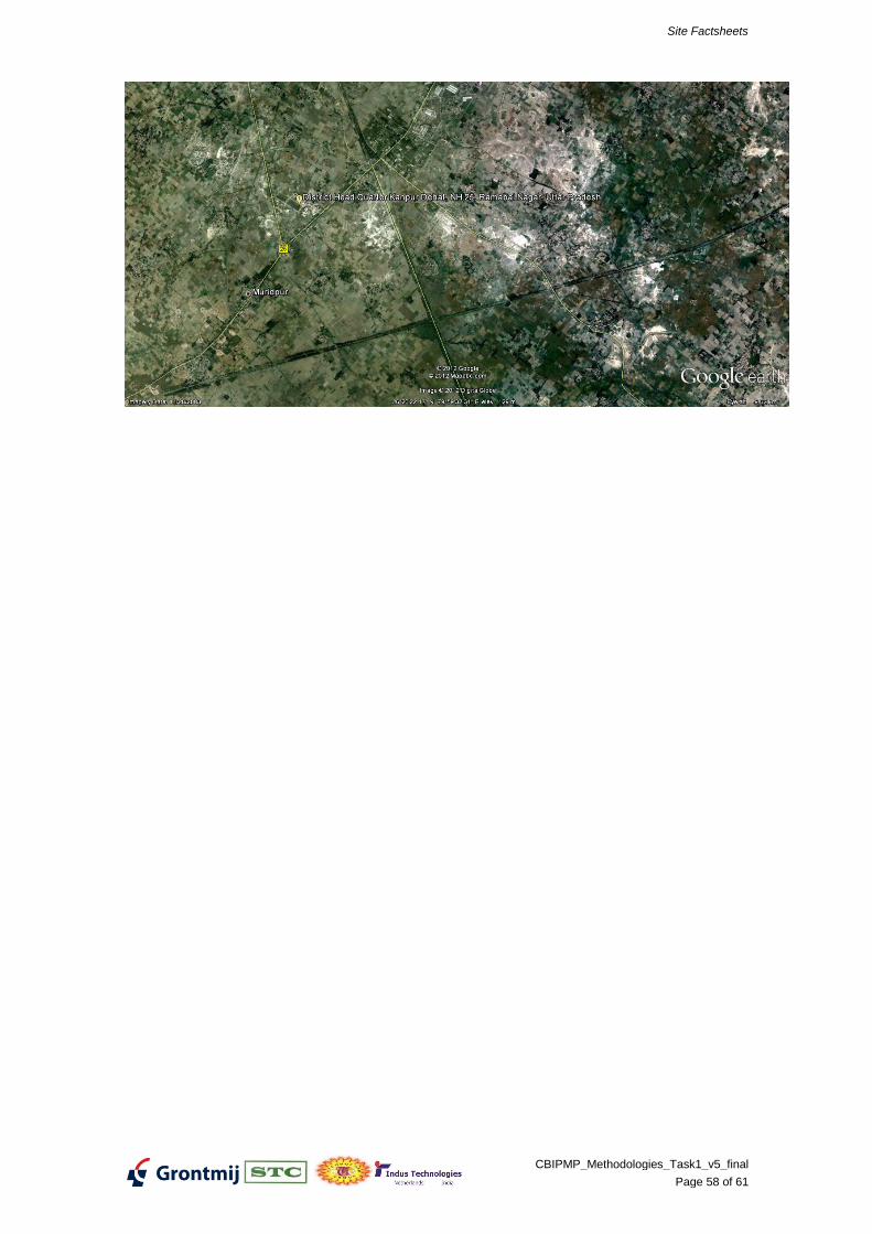
Site Factsheets
CBIPMP_Methodologies_Task1_v5_final
Page 58 of 61
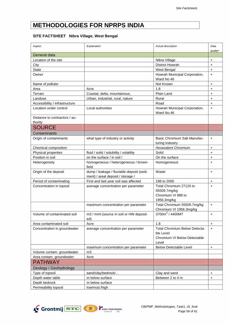
Site Factsheets
CBIPMP_Methodologies_Task1_v5_final
Page 59 of 61
METHODOLOGIES FOR NPRPS INDIA
SITE FACTSHEET Nibra Village, West Bengal
Aspect Explanation Actual description Data
quality*
General data
Location of the site Nibra Village +
City District Howrah +
State West Bengal +
Owner Howrah Municipal Corporation,
Ward No 46
+
Name of polluter Not Known +
Area Acre 1.8 +
Terrain Coastal, delta, mountainous, Plain Land +
Landuse Urban, industrial, rural, nature Rural +
Accessibility / infrastructure Road +
Location under control Local authorities Howrah Municipal Corporation,
Ward No.46
+
Distance to contractors / au-
thority
SOURCE
Contaminants
Origin of contaminants what type of industry or activity Basic Chromium Salt Manufac-
turing Industry
+
Chemical composition Hexavalent Chromium +
Physical properties fluid / solid / solubility / volatility Solid +
Position in soil on the surface / in soil / On the surface +
Heterogeneity homogeneous / heterogeneous / brown-
field
Homogeneous +
Origin of the deposit dump / leakage / fluviatile deposit (sedi-
ment) / areal deposit / storage /
Waste +
Period of contaminating First and last year soil was affected 198 to 2000 +
Concentration in topsoil average concentration per parameter Total Chromium 27120 to
55509.7mg/kg
Chromium VI 988 to
1956.3mg/kg
+
maximum concentration per parameter Total Chromium 55509.7mg/kg
Chromium VI 1956.3mg/kg
+
Volume of contaminated soil m3 / mmt (source in soil or HW deposit-
ed)
3700m3 / 4400MT +
Area contaminated soil Acre 1.8 +
Concentration in groundwater average concentration per parameter Total Chromium Below Detecta-
ble Level
Chromium VI Below Detectable
Level
+
maximum concentration per parameter Below Detectable Level +
Volume contam. groundwater m3
Area contam. groundwater Acre
PATHWAY
Geology / Geohydrology
Type of topsoil sand/clay/bedrock/… Clay and sand +
Depth water table m below surface Between 2 to 4 m +
Depth bedrock m below surface
Permeability topsoil low/mod./high
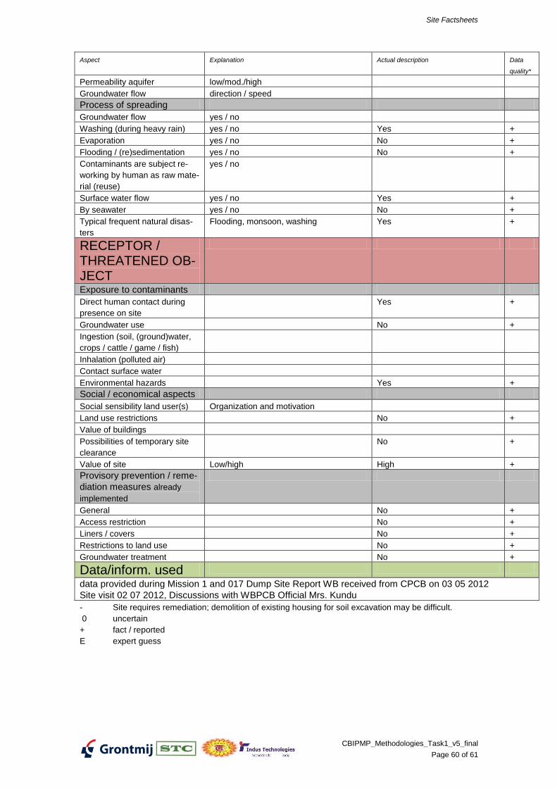
Site Factsheets
CBIPMP_Methodologies_Task1_v5_final
Page 60 of 61
Aspect Explanation Actual description Data
quality*
Permeability aquifer low/mod./high
Groundwater flow direction / speed
Process of spreading
Groundwater flow yes / no
Washing (during heavy rain) yes / no Yes +
Evaporation yes / no No +
Flooding / (re)sedimentation yes / no No +
Contaminants are subject re-
working by human as raw mate-
rial (reuse)
yes / no
Surface water flow yes / no Yes +
By seawater yes / no No +
Typical frequent natural disas-
ters
Flooding, monsoon, washing Yes +
RECEPTOR / THREATENED OB-JECT
Exposure to contaminants
Direct human contact during
presence on site
Yes +
Groundwater use No +
Ingestion (soil, (ground)water,
crops / cattle / game / fish)
Inhalation (polluted air)
Contact surface water
Environmental hazards Yes +
Social / economical aspects
Social sensibility land user(s) Organization and motivation
Land use restrictions No +
Value of buildings
Possibilities of temporary site
clearance
No +
Value of site Low/high High +
Provisory prevention / reme-
diation measures already
implemented
General No +
Access restriction No +
Liners / covers No +
Restrictions to land use No +
Groundwater treatment No +
Data/inform. used
data provided during Mission 1 and 017 Dump Site Report WB received from CPCB on 03 05 2012
Site visit 02 07 2012, Discussions with WBPCB Official Mrs. Kundu
- Site requires remediation; demolition of existing housing for soil excavation may be difficult.
0 uncertain
+ fact / reported
E expert guess
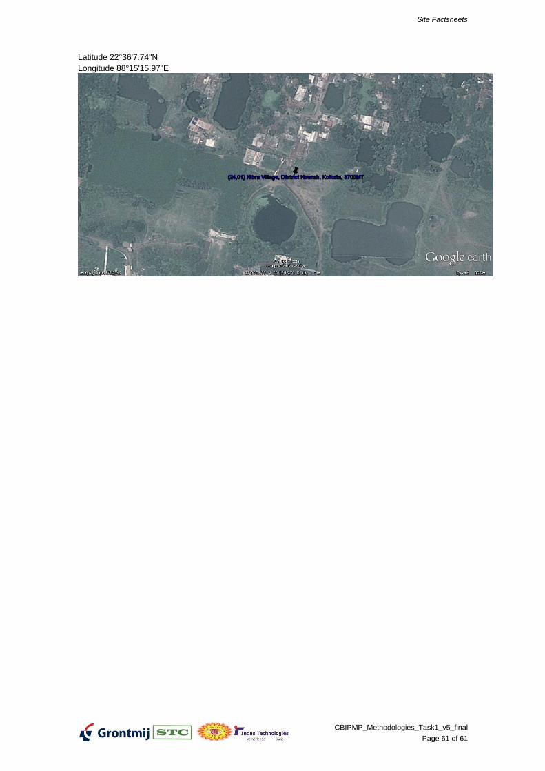
Site Factsheets
CBIPMP_Methodologies_Task1_v5_final
Page 61 of 61
Latitude 22°36'7.74"N
Longitude 88°15'15.97"E