Embed Size (px)
Citation preview
1
REVIEW OF THE AUSTRALIAN NATIONAL PLAN POST DEEPWATER HORIZON,
MONTARA AND OTHER NOTABLE MARITIME INCIDENTS
ABSTRACT
In 1973, Australia put in place national arrangements for responding to pollution from ships.
While these arrangements have served Australia well for 40 years, a number of fundamental
changes are taking place in 2013. These changes are, at least in part, the result of lessons
learned following the uncontrolled release of oil from the Montara wellhead platform in 2009.
At the same time, a major review of the arrangements has just been completed, with a
number of key findings, including the need to integrate pollution response and casualty
management into a single response strategy. A risk assessment conducted as part of the
review has indicated significant growth in shipping by 2020.
INTRODUCTION
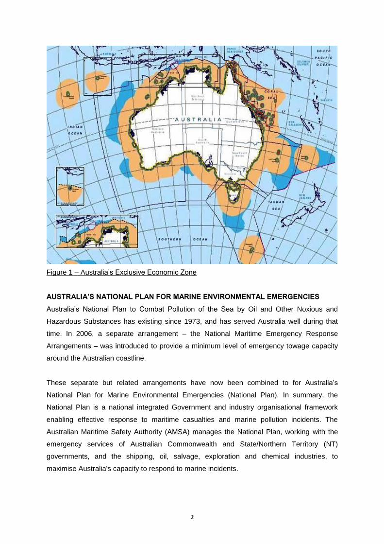
Australia is the largest island nation in the world covering ten per cent of the Earth’s surface
and has the third largest Exclusive Economic Zone (EEZ) that spans almost 60o in latitude
and 72o in longitude, encompassing approximately 8.232 million square Kilometres.
Australia’s 79 ports receive 23,700 international visits and facilitate around 10 per cent of
world sea trade.
Australia has around 12,000 islands and a coastline of approximately 60,000 Kilometres
which interacts with five of the world’s ocean climate zones, sharing maritime boundaries
with Papua New Guinea, New Zealand, Indonesia, East Timor, Solomon Islands and France.
2
Figure 1 – Australia’s Exclusive Economic Zone
AUSTRALIA’S NATIONAL PLAN FOR MARINE ENVIRONMENTAL EMERGENCIES
Australia’s National Plan to Combat Pollution of the Sea by Oil and Other Noxious and
Hazardous Substances has existing since 1973, and has served Australia well during that
time. In 2006, a separate arrangement – the National Maritime Emergency Response
Arrangements – was introduced to provide a minimum level of emergency towage capacity
around the Australian coastline.
These separate but related arrangements have now been combined to for Australia’s
National Plan for Marine Environmental Emergencies (National Plan). In summary, the
National Plan is a national integrated Government and industry organisational framework
enabling effective response to maritime casualties and marine pollution incidents. The
Australian Maritime Safety Authority (AMSA) manages the National Plan, working with the
emergency services of Australian Commonwealth and State/Northern Territory (NT)
governments, and the shipping, oil, salvage, exploration and chemical industries, to
maximise Australia's capacity to respond to marine incidents.
3
The National Plan is funded by a quarterly shipping levy applied to ships carrying more than
10 tonnes of oil as cargo or ships bunkers, with the levy charged at a rate based on vessel
tonnage.
The National Plan provides the basis for:
access to equipment and dispersant stockpiles;
equipment maintenance and storage; and,
funding and joint use of resources.
EMERGENCY TOWAGE VESSEL PROGRAM
As mentioned above, Australia’s Emergency Towage Vessel (ETV) program commenced in
2006 and provides for a minimum level of towage capability around the Australian coast to
assist vessels that are in danger of grounding, sinking or some other peril of the sea, in order
to stabilise the situation and prevent or minimise the extent of any consequential pollution of
the sea.
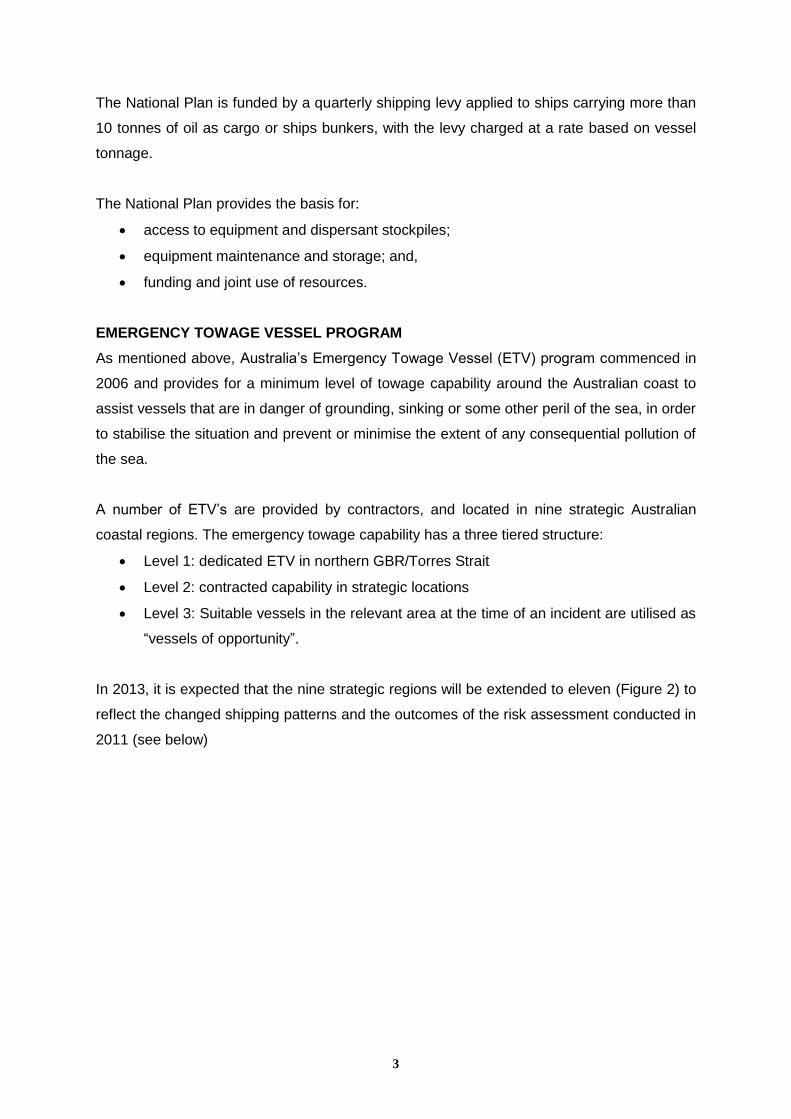
A number of ETV’s are provided by contractors, and located in nine strategic Australian
coastal regions. The emergency towage capability has a three tiered structure:
Level 1: dedicated ETV in northern GBR/Torres Strait
Level 2: contracted capability in strategic locations
Level 3: Suitable vessels in the relevant area at the time of an incident are utilised as
“vessels of opportunity”.
In 2013, it is expected that the nine strategic regions will be extended to eleven (Figure 2) to
reflect the changed shipping patterns and the outcomes of the risk assessment conducted in
2011 (see below)
4
Figure 2 – Proposed Tier 2 Emergency Towage Vessel Zones
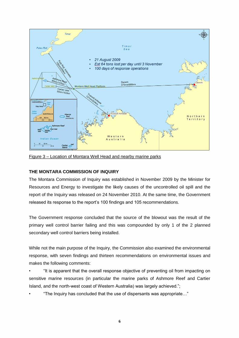
THE MONTARA WELL HEAD OIL SPILL AND RESPONSE OPERATIONS
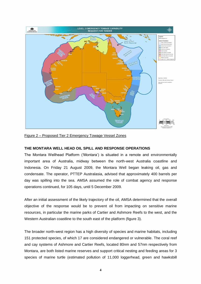
The Montara Wellhead Platform (‘Montara’) is situated in a remote and environmentally
important area of Australia, midway between the north-west Australia coastline and
Indonesia. On Friday 21 August 2009, the Montara Well began leaking oil, gas and
condensate. The operator, PTTEP Australasia, advised that approximately 400 barrels per
day was spilling into the sea. AMSA assumed the role of combat agency and response
operations continued, for 105 days, until 5 December 2009.
After an initial assessment of the likely trajectory of the oil, AMSA determined that the overall
objective of the response would be to prevent oil from impacting on sensitive marine
resources, in particular the marine parks of Cartier and Ashmore Reefs to the west, and the
Western Australian coastline to the south east of the platform (figure 3).
The broader north-west region has a high diversity of species and marine habitats, including
151 protected species, of which 17 are considered endangered or vulnerable. The coral reef
and cay systems of Ashmore and Cartier Reefs, located 80nm and 57nm respectively from
Montara, are both listed marine reserves and support critical nesting and feeding areas for 3
species of marine turtle (estimated pollution of 11,000 loggerhead, green and hawksbill
5
turtles), highly important seabird colonies (numbering in the hundreds of thousands) which
were nesting at the time of the incident and more broadly as a staging point for migratory
seabirds. The region also supports cetaceans, including humpback and pilot whales,
dolphins and significant populations of dugong.
The near shore and coastal habitats are similarly diverse, including coral reefs, seagrass
meadows, mangrove forests and sponge gardens. These habitats in turn provide critical
habitat for species such as marine turtles, cetaceans, dugong, fish, prawns, birds and
estuarine crocodiles.
Benign conditions permitted containment and recovery operations that normally are
undertaken only in enclosed waters, with some 844,000 litres of product recovered during
the operations. The downside of such benign conditions however, is that it hampered the
natural breakup of oil. Ocean currents, wind, and temperature all played integral roles in the
movement and spread of the oil, with movement generally being driven by currents rather
than wind. The majority of oil remained within 35 kilometres of the platform with patches of
sheen and weathered oil reported at various distances in different directions from the
platform due to variations in currents, wind, and temperature over the three month period.
During the first few days of the response, dispersant spraying was provided by the Hercules
aircraft from Oil Spill Response in Singapore. Spraying operations were then undertaken
using two fixed wing aircraft, normally used in crop-dusting operations. These aircraft
increased the accuracy of delivery to the sea surface, thereby reducing the amount of
dispersant required to achieve the desired outcomes.
6
Figure 3 – Location of Montara Well Head and nearby marine parks
THE MONTARA COMMISSION OF INQUIRY
The Montara Commission of Inquiry was established in November 2009 by the Minister for
Resources and Energy to investigate the likely causes of the uncontrolled oil spill and the
report of the Inquiry was released on 24 November 2010. At the same time, the Government
released its response to the report’s 100 findings and 105 recommendations.
The Government response concluded that the source of the blowout was the result of the
primary well control barrier failing and this was compounded by only 1 of the 2 planned
secondary well control barriers being installed.
While not the main purpose of the Inquiry, the Commission also examined the environmental
response, with seven findings and thirteen recommendations on environmental issues and
makes the following comments:
• “It is apparent that the overall response objective of preventing oil from impacting on
sensitive marine resources (in particular the marine parks of Ashmore Reef and Cartier
Island, and the north-west coast of Western Australia) was largely achieved.”;
• “The Inquiry has concluded that the use of dispersants was appropriate…”
7
• “The Inquiry considers that AMSA responded exceptionally well to an incident that
was beyond its first-hand experience and in a remote and difficult location. AMSA should be
commended.”
One of the key outcomes of the report with regard to well integrity and safety is the
establishment of the National Offshore Petroleum Safety and Environmental Management
Authority (NOPSEMA) on 1 January 2012. Since its inception, NOPSEMA and AMSA have
worked together to develop an explanatory note titled ‘Oil Spill Preparedness and Response
Arrangements for Offshore Petroleum Activities in Commonwealth Waters’ which defines the
individual roles to be undertaken by each body.
The Department of Resources, Energy and Tourism (RET) will develop an incident
management and coordination framework for dealing with incidents involving the offshore
petroleum industry. This central coordinating body will be responsible for facilitating
interaction and communication between stakeholders and with the public.
Other outcome of the Inquiry include:
Industry developing an Australian Well Capping and Containment Solution with the
Subsea First Response Toolkit to be located in Australia;
The Australian Marine Oil Spill Centre undertaking a review of its preparedness and
response arrangements;
AMSA involvement in comprehensive consultation on approval of oil spill contingency
plans for offshore facilities;
Assessment of the risks associated with offshore oil and gas exploration;
More rapid implementation of scientific monitoring;
Clarification of the responsibility for provision of scientific advice;
Commonwealth legislation being reviewed to identify “legislative gaps”; and,
Equitable cost sharing arrangements between the offshore petroleum and shipping
industries for both spill preparedness and response capability
REVIEW
A scheduled review of the National Plan was undertaken during 2011. Two projects were
undertaken as part of the overall review. Firstly, Det Norske Veritas (DNV) carried out an
Assessment of the Risk of Pollution from Marine Oil Spills in Australian Ports and Waters
(DNV Risk Assessment). The DNV Risk Assessment was issued in December 2011 and
reflects the IMO Environmental Risk Evaluation Criteria (2011). Secondly, a strategic review
8
of the National Plan/NMERA was undertaken by the consultants Parsons
Brinkerhoff/Thompson Clarke Shipping. The final report of the overall review was issued in
March 2012 and takes into account the DNV Risk Assessment outcomes and relevant
recommendations made by the Montara Commission of Inquiry Report.
RISK OF POLLUTION FROM MARINE OIL SPILLS
The DNV Risk Assessment included consultation with all stakeholders involved in
responding to pollution and maritime incidents in Australia, including:
All States/NT;
Ports Australia;
Great Barrier Reef Marine Park Authority;
Australian Institute of Petroleum/Australian Marine Oil Spill Centre;
Australian Shipowners Association;
Plastics and Chemicals Industry Association;
Department of Infrastructure and Transport;
Shipping Australia Limited;
Department of Resources, Energy and Tourism;
Australian Petroleum Production and Exploration Association; and,
Department of Sustainability, Environment, Water, Population and Communities
In undertaking the Risk assessment, DNV obtained data from:
Geoscience Australia;
Bureau of Infrastructure, Transport and Local Economics;
Australian Bureau of Agricultural and Resource Economics; and,
Bureau of Meteorology
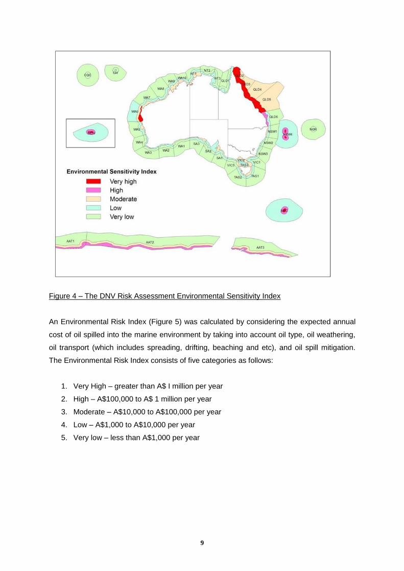
The DNV Risk Assessment divided the Australian EEZ into 120 sub-regions.
An Environmental Sensitivity Index (Figure 4) was calculated by considering the average
environmental impact of one tonne of oil spilled in a specific location, taking into account
habitats, species present, commercial resources, socio-cultural impacts, and the difficulty of
clean-up and recovery after a spill.
9
Figure 4 – The DNV Risk Assessment Environmental Sensitivity Index
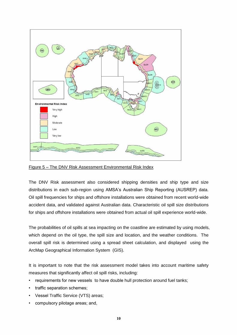
An Environmental Risk Index (Figure 5) was calculated by considering the expected annual
cost of oil spilled into the marine environment by taking into account oil type, oil weathering,
oil transport (which includes spreading, drifting, beaching and etc), and oil spill mitigation.
The Environmental Risk Index consists of five categories as follows:
1. Very High – greater than A$ I million per year
2. High – A$100,000 to A$ 1 million per year
3. Moderate – A$10,000 to A$100,000 per year
4. Low – A$1,000 to A$10,000 per year
5. Very low – less than A$1,000 per year
10
Figure 5 – The DNV Risk Assessment Environmental Risk Index
The DNV Risk assessment also considered shipping densities and ship type and size
distributions in each sub-region using AMSA’s Australian Ship Reporting (AUSREP) data.
Oil spill frequencies for ships and offshore installations were obtained from recent world-wide
accident data, and validated against Australian data. Characteristic oil spill size distributions
for ships and offshore installations were obtained from actual oil spill experience world-wide.
The probabilities of oil spills at sea impacting on the coastline are estimated by using models,
which depend on the oil type, the spill size and location, and the weather conditions. The
overall spill risk is determined using a spread sheet calculation, and displayed using the
ArcMap Geographical Information System (GIS).
It is important to note that the risk assessment model takes into account maritime safety
measures that significantly affect oil spill risks, including:
• requirements for new vessels to have double hull protection around fuel tanks;
• traffic separation schemes;
• Vessel Traffic Service (VTS) areas;
• compulsory pilotage areas; and,
11
• Emergency Towage Vessels (ETS).
DNV was also requested to estimate the risks for 2020. With offshore drilling assumed to
remain at the current level of activity the modelling predicted the following major changes:
Increase of 79% in total national port traffic;
Increase of 81% in total national traffic;
Small commercial vessels assumed to remain at present levels;
Offshore drilling assumed to remain at current levels;
Offshore oil production to reduce by 89%;
Condensate production to increase by 73% (overall decline by 35%); and
Shore based oil consumption to increase by 14%.
STRATEGIC REVIEW
The National Plan/NMERA Strategic Review commenced in January 2011 and was
completed by mid-2012, with extensive stakeholder consultation from March to May of 2011
and the consideration of written submissions from March to June of 2011. Related
documentation provided prior to and during the consultation and draft report preparation
process was also reviewed. The observations and existing knowledge and understanding
within the review team was also considered and a Strategic Stakeholder Group was formed
to oversee the project and provide feedback during the review process.
The review was undertaken to determine if current arrangements are adequate to provide an
effective response to marine casualties and pollution of the sea, and additionally to ensure
Australia meets its obligations as a signatory to the OPRC Convention and OPRC-HNS
Protocol. The review has made recommendations in order to rectify identified deficiencies.
Australia’s resource ports expect significant growth over the next 10 years and activity is
also expected to increase in the offshore petroleum and gas exploration and production
industry in remote locations and in deep water. The review took into account changes in
shipping patterns and associated risks as a result of expansion of the petroleum, LNG and
minerals sectors.
REVIEW OUTCOMES/CURRENT WORK PLANS
The review of the National Plan found that despite the many challenges facing the Australian
Maritime Safety Authority (AMSA) and the other public and private organisations involved in
spill preparedness and response, the National Plan and NMERA have served Australia well
12
over the last ten years. Nevertheless, concerns regarding the current and future
management and implementation of the National Plan and NMERA were raised, with 70
recommendations made concerning potential areas for improvement that are to be
implemented over the next 18 months.
Key outcomes from the Review, as agreed by NPMC, include a number of fundamental
changes to the National Plan and NMERA that included better integration of the National
Plan and NMERA by combining them into a single document.
The improved integration will provide clearer linkages to Australia’s obligations as a
signatory to the International Convention on Oil Pollution Preparedness, Response and Co-
operation 1990 (OPRC Convention) and its 2000 Protocol dealing with Hazardous and
Noxious Substances (OPRC-HNS Protocol).
The new Governance structure will be overseen by the National Plan Strategic Coordination
Committee (NPSCC) with membership from the Commonwealth/State/NT Governments.
The new structure includes a National Plan Strategic Industry Advisory Forum (NPSIAF),
responsible for providing industry-focused advice on strategic issues. In addition, a new
committee will provide an increased focus on preparing for, and managing incidents in,
Commonwealth waters. The first meetings were held under the new governance structure in
late 2012.
The DNV Risk Assessment identified very high maritime risk areas adjacent to and offshore
both Dampier and Townsville. A $25 million program of equipment replacement and
refurbishment is well under way and includes replenishment and replacement of the AMSA
Tier 2/Tier 3 equipment stockpiles at these towns. The review also made a recommendation
that the existing nine marine equipment stockpiles be retained and new standards developed
for equipment storage and maintenance at these sites.
The Review also resulted in a new agreement with the Commonwealth Scientific and
Industrial Research Organisation (CSIRO) to provide scientific advisory services to the
National Plan and upgrading of the National plan Research and Development Strategy
through closer links to international R&D.
FUTURE CHALLENGES
The review has resulted in a number of improvements being identified and AMSA, as
manager of the National Plan, has made resolutions for their implementation over the next
13
18 months. It is important to recognise the existing arrangements are neither broken nor
flawed and continue to serve Australia well domestically as we continue to meet our
international obligations. However, in looking forward, the future challenges facing AMSA
include effectively responding to increasing government and community awareness and
expectations, as well as the provision of appropriate resources and support systems that
enable an effective response to oil and chemical pollution incidents.
In order to ensure the ongoing effectiveness of the National Plan in a changing environment,
AMSA undertakes a regular 10 year review, which is complimented from time to time by
exercising the National Plan to determine its state of readiness. Feedback from the regular
review, exercises, maritime casualties and marine pollution incidents are utilised to upgrade
the National Plan in order to reflect changing risk profiles, and to improve response
arrangements and technologies.
Toby Stone
General Manager, Marine Environment Division
Maritime Emergency Response Commander (MERCOM)
Australian Maritime Safety Authority