Embed Size (px)
Citation preview

F I N A L R E P O R T
Review of Previous Pipeline Abandonment Program – Phase 3 Abandonment on Farmland
Prepared for
Pipeline Abandonment Research Steering Committee
February 2019
CH2M HILL Energy Canada, Ltd. 205 Quarry Park Blvd SE Calgary, Alberta T2C 3E7
AX1114181138CGY CH2M HILL ENERGY CANADA, LTD. • COMPANY PROPRIETARY I
Contents Section Page
Acronyms and Abbreviations .............................................................................................................. III
1 Project Description ............................................................................................................... 1-1 1.1 Project Location ............................................................................................................... 1-1
2 Methods ............................................................................................................................... 2-1 2.1 Records Review ................................................................................................................ 2-1
2.1.1 Engineering Review ............................................................................................. 2-1 2.1.2 Environmental Information Review .................................................................... 2-3
2.2 Field Assessment .............................................................................................................. 2-3
3 Findings ................................................................................................................................ 3-1 3.1 Evidence of Subsidence ................................................................................................... 3-1 3.2 Evidence of Soil or Water Contamination ....................................................................... 3-1 3.3 Evidence of Disruption to Drainage ................................................................................. 3-1 3.4 Pipeline Exposure ............................................................................................................. 3-1 3.5 Evidence of Issues at Watercourse Crossings .................................................................. 3-2 3.6 Evidence of Special Concerns at Road Crossings ............................................................. 3-2 3.7 Habitat and Hydrological Characteristics ......................................................................... 3-2
4 Recommendations for Future Work ...................................................................................... 4-1
5 Discussion............................................................................................................................. 5-1
6 Summary .............................................................................................................................. 6-1
7 References ............................................................................................................................ 7-1 7.1 Literature Cited ................................................................................................................ 7-1
Appendixes
A B C D
Tables
1-12-14-1B-1
Figure
A-1
Abandoned Sections Overview Existing Literature Used in the Environmental Review Historic Aerial Photographs and Photoplates General Right-of-Way Photographs
Pipeline Segments Assessed Areas of Field Survey Focus Along the Pipeline Segments Recommendations for Future Work Existing Literature Used in the Environmental Review
Regional Location

AX1114181138CGY CH2M HILL ENERGY CANADA, LTD. • COMPANY PROPRIETARY III
Acronyms and Abbreviations Allnorth Allnorth Consultants Limited
CH2M CH2M HILL Energy Canada, Ltd.
DoC depth of cover
DNV Det Norske Veritas
EI Environmental Inspector
Enbridge Enbridge Pipelines Inc.
km kilometre(s)
KP Kilometre Post
m metre(s)
NEB National Energy Board
NOVA Chemicals NOVA Chemicals Corporation
PARSC Pipeline Abandonment Research Steering Committee
PCEM Post-construction Environmental Monitoring
PTAC Petroleum Technology Alliance of Canada
the Project review of a previous pipeline abandonment program – Enbridge Line 3 Mainline pipeline
ROW right-of-way
TERA TERA Environmental Consultants
TUC Transportation and Utility Corridor
UTM universal transverse Mercator

SECTION 1
AX1114181138CGY CH2M HILL ENERGY CANADA, LTD. • COMPANY PROPRIETARY 1-1
Project Description The Pipeline Abandonment Research Steering Committee (PARSC) through the Petroleum Technology Alliance of Canada commissioned CH2M HILL Energy Canada, Ltd. (CH2M), Decom Consulting Ltd., and Allnorth Consultants Limited (Allnorth) to conduct a review of a previous pipeline abandonment program, which involved a surface assessment of three 34-inch-diameter (836.6-millimetre outside diameter) pipeline segments of the Enbridge Pipelines Inc. (Enbridge) Line 3 pipeline (the Project), abandoned between 1978 and 1980. The pipeline segments are colocated with other operating pipelines within the Enbridge Mainline right-of-way (ROW), to the immediate east of the City of Edmonton. The pipeline segments were both areas where the abandoned pipeline segment was removed and where the pipeline was abandoned in place. Segments of the pipeline that were abandoned in place were capped, filled with inert gas pressure, and had cathodic protection maintained in accordance with Section 121 of the Oil and Pipeline Regulations, SOR/78-746, September 28, 1978.
The objective of the Project is to review the condition of a medium-diameter pipeline that was abandoned more than 10 years ago, and to evaluate the outcomes achieved by the pipeline abandonment program. To evaluate the outcomes of the pipeline abandonment program, the following tasks were completed:
• Review of the pipeline abandonment methodologies that were implemented at the time of pipeline abandonment
• A field surface assessment, to determine if there was evidence of effects or potential effects of pipeline abandonment in place, as currently understood by the industry
• Identification of any effects of pipeline abandonment, to determine if there was evidence outside of the current industry understanding of the risks of pipeline abandonment
• Identification of areas along the abandoned pipeline segments where subsurface testing could be conducted to further confirm the presence or absence of those potential effects
The previously identified potential effects of pipeline abandonment in place include:
• Ground subsidence and frost heave
• Soil and groundwater contamination
• Subsidence at road, railway, and utility crossings
• Watercourse and wetland crossings
• Erosion
• Creation of water conduits
The abandoned pipeline segments were assessed using ground-based field studies to determine if there was surficial evidence of the potential environmental effects of pipeline abandonment and to suggest locations where further assessment (that is, subsurface investigation) is recommended to visualize the pipe and surrounding soil for the potential effects described in this report.
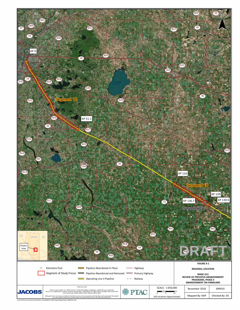
1.1 Project Location The Project is located in the White Area of Alberta between Edmonton and Sedgewick (Figure A-1 in Appendix A).
The start and end points of three pipeline segments assessed for the Project are provided in Table 1-1. The pipeline segments are located in predominantly agricultural areas, crossing numerous wetlands and several watercourses.

SECTION 1 – PROJECT DESCRIPTION
1-2 CH2M HILL ENERGY CANADA, LTD. • COMPANY PROPRIETARY AX1114181138CGY
Table 1-1. Pipeline Segments Assessed
Segment ID
Segment Start and End KPs Segment Start and End Legal Location (Approximate UTM 12U)
Approximate Length (km)
Abandoned in Place
1A KP 0.0 to KP 51.1 SE 5-53-23 W4M (343977E 5935218N) to SE 5-49-20 W4M (374023E 5895597N)
51.1
1B KP 116.0 to KP 139.0 SE 36-45-15 W4M (430321E 5863548N) to NW 19-44-12 W4M (449780E 5851382N)
23.0
Abandoned and Removed
2A KP 136.7 to KP 139.9 NE 26-44-13 W4M (447996E 5852780N) to SE 19-44-12 W4M (450570E 5850961N)
3.2
Note:
km = kilometre(s) KP = Kilometre Post UTM = universal transverse Mercator

SECTION 2
AX1114181138CGY CH2M HILL ENERGY CANADA, LTD. • COMPANY PROPRIETARY 2-1
Methods The abandoned segments of the Enbridge Line 3 pipeline, assessed as part of the Project, are located within the Enbridge Mainline ROW. In addition to the pipeline abandonment plan for the pipeline segments dated between 1978, and 1980, CH2M, Decom Consulting Ltd., and Allnorth reviewed existing information from previous projects located within the Enbridge Mainline ROW. The records review was used to determine specific locations to focus on during the field surface assessment along the abandoned pipeline segments. Focal areas included locations where the potential effects of a pipeline abandoned in place were most likely to be observed. Areas of focus are listed in Table 2-1. The records review is described in Section 2.1.
2.1 Records Review 2.1.1 Engineering Review An engineering review was conducted on documentation provided from segments of the Enbridge Line 3 pipeline between Edmonton and Hardisty that were abandoned in 1980. The objective of this review was to determine the present-day state of the pipeline segments that were abandoned and evaluate the outcomes achieved by the pipeline abandonment program implemented at the time of abandonment. Enbridge was granted a Leave to Abandon from the National Energy Board (NEB) (Order No. MO-14-80) for these pipeline segments in November 1980. The pipeline segments consisted of: • 51.631 km of pipeline abandoned in place from Enbridge’s Edmonton Pump Station/Terminal site
(KP 0.274) to the Kingman Pump Station (KP 51.3) • 20.684 km of pipeline abandoned in place from KP 116.016 to KP 136.7 Pipeline abandonment was to be performed in accordance with the Oil Pipeline Regulations, SOR/78-746, September 28, 1978. A copy of these regulations could not be obtained for reference; however, it can be assumed that pipeline abandonment procedures similar to the current requirements in Canadian Standards Association Z662-15, Section 10.16.2, were followed that state that a buried pipeline abandoned in place shall be: a) Emptied of service fluids b) Purged or appropriately cleaned, or both, in a manner that leaves no mobile materials remaining in
the pipeline c) Physically separated from any in-service piping d) Capped, plugged, or otherwise effectively sealed e) Cut off at pipeline depth f) Left unpressurized Pursuant to Leave to Abandon Order No. MO-14-80, the following activities were completed as part of the pipeline abandonment plan. • Pipeline sections were purged with an inert gas. Nitrogen was used to purge the pipeline behind a
batching pig. Nitrogen was injected at a rate of approximately 500 cubic metres per hour and took approximately 30 hours to complete. A second nitrogen injection and pig run were completed in an effort to remove as much product as possible. No mention of additional chemistry or water was included in an effort to clean the pipeline. The second run was completed within 4 hours at a considerably higher rate. It was noted that there was negligible residue collected by the second run. No sampling or laboratory analysis was completed to determine the contaminants of concern in the residual collected from these runs.

SECTION 2 – METHODS
2-2 CH2M HILL ENERGY CANADA, LTD. • COMPANY PROPRIETARY AX1114181138CGY
• The inert gas pressure and cathodic protection were maintained in accordance with Section 121 of the Oil and Pipeline Regulations, SOR/78-746, September 28, 1978.
• Pipeline segments were isolated from other active infrastructure, including the removal of pig traps attached to the segments. The ends of the pipeline segments were capped.
As a condition of the Leave to Abandon Order No. MO-14-80, Enbridge was required to cut and remove any part of the abandoned pipeline to accommodate the construction of any works or purpose required in public interest. Sections left in place where adjacent pipe was removed were also required to be capped prior to backfilling.
Enbridge opted to remove 3.2 km between KP 136.7 and KP 139.912, to evaluate removal techniques and associated costs. A report was filed with the NEB titled, Evaluation of the Procedures and Costs Developed During the Removal of 3.2 km of 864 mm Pipe in October 1980, which documented the findings of this evaluation. The removal activities listed in this report were as follows.
• Two backhoes were used to excavate the pipeline.
• Segments of the pipeline were thoroughly checked for the presence of gas and cut with an oxy-acetylene torch at approximately 100-metre (m) intervals.
• A sideboom tractor was used to remove the segments of pipe from the trench with a choke-type cable sling.
• Removal of pipe in wet areas was completed by towing the floating pipe out of the trench with the tractor located on high ground.
The abandoned pipeline segments consisted of 34-inch by 0.281 weight, API 5L X52 pipe. The corrosion reports supplied as part of this review provided insufficient detail to determine the extent of the corrosion at the time of abandonment. The information provided did not indicate the root cause for the poor condition of the pipe leading to the decision to abandon.
An inspection was completed 1 year after pipeline abandonment on the ROW where 3.2 km of the abandoned pipeline had been removed. It was noted by the inspector that significant subsidence had occurred, 20 feet (6 m) by 9 feet (3 m) to approximately 5 inches (127 millimetre) maximum depth. The subsidence occurred at the pipe joint separating the 3.2-km section of removed pipe and the pipeline section abandoned in place. No indication of subsidence occurring on the segments of the pipeline abandoned in place were reported during the inspection.
It was noted that the removal of pipe from wet areas was completed by “towing the floating pipe out of the trench with the tractor located on high ground.” (Foothills Pipe Lines [Yukon] Ltd. 1982). This provides some evidence to the possibility of pipe becoming buoyant if uncovered after the product has been displaced from the abandoned pipeline.
The pipeline abandonment activities provided no indication of the pipeline being segmented to prevent water conduits, as discussed in the Pipeline Abandonment Scoping Study (DNV, 2010).
Additional information was gathered through discussions with Enbridge Regional Operations to inform the field assessment. Enbridge Regional Operations confirmed that there is an ongoing monitoring and depth-of-cover survey program in place along the pipeline corridor that contains the abandoned pipeline. Since abandonment of the pipeline, there have been no indications of subsidence or loss of depth of cover (DoC) occurring along the abandoned pipeline ROW. Furthermore, Enbridge Regional Operations also indicated that no adverse effects regarding contamination as a result of the abandoned pipeline have been noted.
There was no additional information regarding the corrosion history of the pipeline available for review.

SECTION 2 – METHODS
AX1114181138CGY CH2M HILL ENERGY CANADA, LTD. • COMPANY PROPRIETARY 2-3
2.1.2 Environmental Information Review The Project team from CH2M, Decom Consulting Ltd., and Allnorth reviewed information from multiple sources while planning the field investigation of the abandoned pipeline segments. The following information sources were used:
• Previous project applications for pipeline abandonment and replacement along the Edmonton to Hardisty segment of the Enbridge Mainline corridor prepared on behalf of Enbridge by TERA Environmental Consultants (TERA) and CH2M; this information is filed with the NEB and is publicly available
• Operations and maintenance records and reports for Segments 1A, 1B, and 2A were provided by Enbridge
• Environmental As-Built reports prepared on behalf of Enbridge for the Edmonton to Hardisty Pipeline Replacement Project, located in the same corridor as Segments 1A, 1B, and 2A
• 2016 and 2017 Post-construction Environmental Monitoring (PCEM) reports for the Enbridge Line 2 Replacement Project and the Edmonton to Hardisty Pipeline Replacement Project
• Historical aerial photographs from various years prior to, and following, construction and abandonment of the pipeline segments
Environmental issues noted during review of the available information specific to the abandoned pipeline segments and/or within the same corridor as the abandoned pipeline segments were considered during site selection. Representative locations with issues, such as subsidence, erosion, poor vegetation growth, wetland concerns, and weed concerns were targeted for survey. Representative wetlands types were selected along the segments to determine if there was any additional evidence of the potential effects of pipeline abandonment (CH2M, 2016, 2017).
Historical aerial photographs from various years prior to, and following, construction and abandonment of the pipeline segments were reviewed to determine changes to surficial cover or local hydrology caused by pipeline abandonment. The historical aerial photographs reviewed are provided in Appendix C.
In general, the review of documents detailing pipeline abandonment in the 1970s and 1980s, in the White Area of Alberta, focused on ensuring that land use functions were returned for agricultural use (such as, proper seeding and contouring), and that the functionality of natural features were returned (such as, returning wetland habitat to pre-construction functional conditions).
Areas of focus described in Section 2.2 (Table 2-1) were informed by the records review.
2.2 Field Assessment Field information was collected by an Environmental Inspector (EI) accompanying a depth-of-cover measurement crew during summer 2018. The Project team provided the EI with detailed instructions concerning the Project objectives and a list of focal locations for additional surficial assessment. The focus areas, along with areas of incidental findings or additional areas of interest noted by the field crew and/or EI while conducting ground-based field surveys, are included in Table 2-1.

SECTION 2 – METHODS
2-4 CH2M HILL ENERGY CANADA, LTD. • COMPANY PROPRIETARY AX1114181138CGY
Table 2-1. Areas of Field Survey Focus Along the Pipeline Segments
Segment ID Location of Focus Approximate
KP Legal Location (W4M) UTM (12U)
Location Description
Ground-based Survey Location
Historic Aerial Photo and Photoplate
Reference (Appendix C)
1A Seasonal graminoid marsh (no previous concerns identified)
KP 2.2 to KP 2.5
NW 28-52-23 344702E 5933227N Wetland -- C-1
Watercourse – Goldbar Creek KP 3.1 SW 28-52-23 345057E 5932383N Watercourse -- C-1
1979 leak and repair location KP 5.7 to KP 6.6
NW 15-52-23 346210E 5930078N Residential
Leak location described as fish pond and “slough” at time of leak
-- C-2
Highway crossing KP 7.6 to KP 7.7
SE 15 and NE 10-52-23
347286E 5928460N Highway 628
Treed and cultivation
-- C-3
Area of subsidence noted in 2016, repaired in 2017 (contouring issue) KP 14.9 to KP 15.1
SW 30-51-22 351076E 5922176N Cultivation, repaired contouring at area of subsidence
Abandoned pipeline segment starts at SW 30-51-22 W4M, ends at NW 19-51-22 W4M
C-4
Seasonal graminoid marsh (issue with bare ground and poor vegetation regrowth noted in 2016 and 2017, along other pipeline segments in the ROW)
KP 15.4 to KP 15.5
NW 19-51-22 351290E 5921814N Wetland and recent pipeline PCEM concerns
Abandoned pipeline segment starts at SW 30-51-22 W4M, ends at NW 19-51-22 W4M
C-5
Shallow, open water crossing (no previous concerns identified)
KP 18.8 to KP 19.0
SW and SE 17-51-22
353059E 5918883N Wetland -- C-6
Seasonal marsh/shrubby swamp complex (no previous concerns identified)
KP 22.5 to KP 22.9
SE 4-51-22 355106E 5915525N Wetland -- C-7
Watercourse – Irvine Creek KP 24.3 to KP 24.4 SW 33-50-22 355979E 5914214N Watercourse -- C-8
Gully erosion observed in 2016 KP 26.3 to KP 26.4
SW 27-50-22 357138E 5912567N Wetland and recent pipeline PCEM concerns
Abandoned pipeline segment at SW 27-50-22 W4M
C-9
Temporary marshes and treed area (weed issue observed in 2016, willow and success species recovery noted in 2017)
KP 27.1 to KP 27.5
NW 22-50-22 357490E 5911929N Wetland and recent pipeline PCEM concerns
Treed area
Abandoned pipeline segment at NW 22-50-22 W4M
C-10
Shrubby swamps (no previous concerns identified) and road crossing
KP 38.0 to KP 38.2
NE 30 and SW 29-49-21
363254E 5902939N Wetlands and road crossings Abandoned pipeline segment starts at NE 30-49-21 W4M, ends at SW 29-49-21 W4M
C-11
Temporary marsh and treed area (no previous concerns identified)
KP 46.2 to KP 46.6
NW 12-49-21 370145E 5898082N Wetland Abandoned pipeline segment at NW 12-49-21 W4M
C-12
Subsidence and crop growth issue observed in 2016 KP 47.8 to KP 48.4
SW 7-49-20 371268E 5897339N Wetland and recent pipeline PCEM concerns
-- C-13
Semi-permanent marsh (no previous concerns identified)
KP 49.4 to KP 49.6
NE 6-49-20 372689E 5896477N Wetland -- C-14
1968 corrosion inspection/repair KP 50.6 to KP 51.1
SW and SE 5-49-20
373729E 5895798N Cultivation
Corrosion report provided for this legal location
-- C-15
End point of segment KP 51.1 SE 5-49-26 374023E 5895597N Cultivation -- C-16

SECTION 2 – METHODS
AX1114181138CGY CH2M HILL ENERGY CANADA, LTD. • COMPANY PROPRIETARY 2-5
Table 2-1. Areas of Field Survey Focus Along the Pipeline Segments
Segment ID Location of Focus Approximate
KP Legal Location (W4M) UTM (12U)
Location Description
Ground-based Survey Location
Historic Aerial Photo and Photoplate
Reference (Appendix C)
1B Start point of segment KP 116.0 SE 36-45-15 430321E 5863548N Cultivation -- C-9
Cathodic protection (ground bed location identified on as-builts) and road crossing
KP 116.1 SW 31-45-14 430411E 5863493N Cultivation -- C-9
Subsidence issue observed in 2016 KP 116.1 to KP 117.1
SW 31 and NW/NE 30-45-14
430753E 5863287N Cultivation -- C-9
Subsidence issue observed and repaired in 2016, and road crossing KP 118.9 to KP 119.4
SE 29-45-14 433199E 5861798N Cultivation Abandoned pipeline segment starts at SE 29-45-14 W4M, ends at SW 22-45-14 W4M
C-10, N/A
Cathodic protection (test lead location identified on as-builts)
KP 121.7 SW 22-45-14 435211E 5860607N Cultivation Abandoned pipeline segment starts at SE 29-45-14 W4M, ends at SW 22-45-14 W4M
C-10, N/A
Seasonal marsh (no previous concerns identified) and subsidence issue observed in 2016
KP 124.9 to KP 125.4
SE 14-45-14 438114E 5858886N Wetland -- C-10
Cathodic protection (test lead location identified on as-builts)
KP 129.2 NE 6-45-13 441652E 5856669N Cultivation -- C-11, C-12
Temporary marsh (no previous concerns identified), weeds noted in quarter-section
KP 132.6 to KP 132.9
NE 33-44-13 444772E 5854835N Wetland
Cultivation
-- C-12
Intermittent, shallow, open water wetlands (weed issue observed in 2016)
KP 135.7 to KP 136.6
NE 26-44-13 447793E 5852916N Watercourse and saline wetlands (rare type along segments)
Abandoned pipeline segment at NE 26-44-13 W4M
C-12, C-13, N/A
End point of segment KP 139.0 NW 19-44-12 449780E 5851382N Pasture/adjacent to wetland -- C-13
2A Start point of segment KP 136.7 NE 26-44-13 447996E 5852780N Pasture Removed pipeline segment at NE 26-44-13 W4M
C-14, Plate D-9
Shallow, open water wetland (no previous concerns identified)
KP 137.2 SW 25-44-13 448512E 5852512N Wetland Removed pipeline segment at SW 25-44-13 W4M
C-14, N/A
Seasonal marsh wetland (no previous concerns identified) and cultivation noted to be poorly reseeded after pipe removal
KP 138.1 to KP 138.2
SE 25-44-13 449178E 5852029N Cultivation
Wetland
Removed pipeline segment at SE 25-44-13 W4M
C-14, N/A
Crossing berm locations installed during pipeline abandonment KP 138.4 SE 25 and NE 24-44-13
449408E 5851879N Pasture Removed pipeline segment at SE 25 and NE 24-44-13 W4M
C-14, N/A
Shallow, open water wetland, extremely wet areas noted during pipeline abandonment, and a crossing berm location installed during pipeline abandonment
KP 139.0 to KP 139.9
NW and SW 19-44-12
449785E 5851379N Wetland/pasture -- C-14
End point of segment and point of oil removal by pumping KP 139.9 SE 19-44-12 450570E 5850961N Pasture/adjacent to wetland -- C-14
Note:
-- = no data collected

SECTION 3
AX1114181138CGY CH2M HILL ENERGY CANADA, LTD. • COMPANY PROPRIETARY 3-1
Findings The results of the field assessment are grouped according to the identified areas of focus in Table 2-1 and are provided in the following subsections.
3.1 Evidence of Subsidence There was no evidence of subsidence or pipeline collapse observed along the abandoned pipeline segments, nor along the removed pipeline segment. Unnatural ponded water or sunken areas along the abandoned or removed pipeline segments were not apparent during the field survey. Plates D-3 and D-4 in Appendix D show appropriate vegetation cover (such as, grasses and crops) along the abandoned pipeline segments that are consistent with the surrounding vegetation.
3.2 Evidence of Soil or Water Contamination The proposed route does not encounter any contaminated sites listed on the Federal Contaminated Sites Inventory (Treasury Board of Canada Secretariat, 2011). A rupture of the Enbridge Line 3 pipeline occurred in 2001, in Hardisty Terminal, at SE 30-42-9 W4M. The rupture is publicly listed by the NEB; however, the remediation that was conducted has not been published.
There were no obvious signs (such as, change in vegetation colour or a visible sheen on water or soil) indicating that soil or water contamination along the abandoned or removed pipeline segments (Plate D-5 in Appendix D) was observed.
3.3 Evidence of Disruption to Drainage Changes in vegetation and ponding at watercourses and wetlands may indicate changes in drainage associated with the abandoned and/or removed pipeline segments due to the formation of water conduits. Based on the review of historic aerial photography (Appendix C), it was determined that there was no disruption to drainage due to the abandonment or removal of the pipeline segments, including at the start and end points at SE 5-49-26 W4M (end segment 1A), SE 36-45-15 W4M (start segment 1B), NW 19-44-12 W4M (end segment 1B), NE 26-44-13 W4M (start segment 2A), and SE 19-44-12 W4M (end segment 2A).
The historical aerial photograph review indicated that hydrology has not been significantly impacted due to pipeline abandonment or removal, but that it has changed over time mainly due to anthropogenic disturbances, such as drainage ditches in cultivated fields (Figure C-4, Appendix C). The historical aerial photograph review also showed that land-use type (such as, cultivation and treed areas) has remained similar during pre- and post-pipeline segment abandonment and removal along the ROW. The historical aerial photographs used in the review are provided in Appendix C.
3.4 Pipeline Exposure There was no evidence of pipeline exposure at the surface along the abandoned pipeline segments.

SECTION 3 – FINDINGS
3-2 CH2M HILL ENERGY CANADA, LTD. • COMPANY PROPRIETARY AX1114181138CGY
3.5 Evidence of Issues at Watercourse Crossings No site-specific observations were made at watercourse crossings along the abandoned pipeline segments. However, historical aerial photograph review did not show any evidence of issues at watercourse crossings. Goldbar Creek, approximately located at KP 3.1 (that is, along Segment 1A), was rerouted during the course of construction of the Edmonton Transportation and Utility Corridor (TUC), but this was a designed reroute and was not directly attributable to the abandonment of Segment 1A.
3.6 Evidence of Special Concerns at Road Crossings No special concerns were observed at road crossings along the abandoned or removed pipeline segments. The areas surrounding road crossings were well-vegetated with appropriate woody vegetation and a graminoid understory (Plate D-5, Appendix D). No impounded water was observed at road crossings.
There are many county regulated or maintained road crossings along the abandoned and removed pipeline segments; however, records of additional maintenance related to subsidence at road crossings were not requested as part of this Project.
3.7 Habitat and Hydrological Characteristics Habitat conditions along the abandoned pipeline segments were determined to be functional as crops and native vegetation were well-established on the ROW. When comparing the abandoned pipeline segments to the parallel Enbridge ROWs, no notable differences were observed. For example, crops and native vegetation on the abandoned and removed pipeline segments, when compared to the active ROW, showed no difference in height or density.
There was no evidence of altered hydrology (such as stressed vegetation or drainage) as a result of erosion or the water conduit effect at wetlands along the ROW (Plate D-6, Appendix D).
No site-specific observations were made at watercourse crossings along the abandoned pipeline segments. However, historical aerial photograph review did not show any evidence of issues at watercourse crossings. Goldbar Creek, approximately located at KP 3.1 (that is, along Segment 1A), was rerouted during the course of construction of the Edmonton TUC, but this was a designed reroute and was not directly attributable to the abandonment of Segment 1A.
Weed concerns were generally not noted along the abandoned pipeline segments. However, trace amounts of Canada thistle were observed to be growing in equal amounts both on and off the abandoned ROW in upland areas.
There were no notable differences between the abandoned and removed pipeline segment ROWs assessed in the field compared to the surrounding areas identified in the aerial photograph review. There was no evidence suggesting that the abandoned pipeline altered the habitat or hydrological characteristics of the evaluated areas.

SECTION 4
AX1114181138CGY CH2M HILL ENERGY CANADA, LTD. • COMPANY PROPRIETARY 4-1
Recommendations for Future Work No areas of potential concern for pipeline abandonment risks were identified during the field assessment. Native vegetation and well-established crops were evident along the abandoned and removed pipeline segments, and wetland and watercourse hydrology did not appear to be affected by the abandoned pipeline segments (abandoned in place or removed); therefore, further field surveys of surface conditions to evaluate possible pipeline abandonment risks are not recommended at this time.
Given the location of the abandoned pipeline segments within an active pipeline corridor, subsurface investigation would be most safely executed in conjunction with integrity digs conducted adjacent to an abandoned (or removed) pipeline segment. Table 4-1 includes a list of sites where subsurface investigation could be completed in conjunction with an integrity dig.
As a general (that is, not site-specific) recommendation, Enbridge could consider logging data for a pre-determined period of time from non-destructive testing of pipeline segments exposed during integrity investigations. The results from such an effort may provide a better understanding of the current state of corrosion of the pipeline and enable a better baseline for the current understanding of corrosion modelling.
Table 4-1. Recommendations for Future Work
Site Description Legal Location (W4M) (Approximate UTM 12U)
Additional Testing
1979 leak and repair location
NW 15-52-23 (346210E 5930078N)
• Review site records from cleanup to determine if the compounds described in NOVA Chemicals’ Fate and Decomposition of Pipe Coating Materials in Abandoned Pipelines (2015) and Thorne et al.’s Trace Contaminants in Oil and Gas Pipelines (1996) were found.
Highway crossing (Highway 628)
SE 15 and NE 10-52-23 (347286E 5928460N)
• Excavate abandoned pipe under a small portion of the road and assess it for evidence of corrosion to determine if access over the abandoned pipe has caused it to de-aerate and become anodic, as described in DNV’s Understanding the Mechanisms of Corrosion and their Effects on Abandoned Pipelines (2015).
• Request municipal road maintenance records to determine if there is historical evidence of subsidence or if any additional maintenance was required to address subsidence or erosion concerns.
Subsidence issue observed and repaired in 2016, and road crossing
SE 29-45-14 (433199E 5861798N)
• Excavate abandoned pipe under a small portion of the road and assess it for evidence of corrosion to determine if access over the abandoned pipe has caused it to de-aerate and become anodic, as described in DNV’s Understanding the Mechanisms of Corrosion and their Effects on Abandoned Pipelines (2015).
Cathodic protection (ground bed location identified on as-builts) and road crossing
SW 22-45-14 (430411E 5863493N)
• Excavate the pipe and determine the presence or absence of cathodic protection test leads.
• Assess the condition of the excavated pipe in relation to the presence or absence of cathodic protection.
• Observe areas around cathodic protection for potential decay, as informed by PARSC 019, when complete.
• Collect soil samples and test for metallic by-products of cathodic protection breakdown, as informed by PARSC 019, when available.

SECTION 4 – RECOMMENDATIONS FOR FUTURE WORK
4-2 CH2M HILL ENERGY CANADA, LTD. • COMPANY PROPRIETARY AX1114181138CGY
Table 4-1. Recommendations for Future Work
Site Description Legal Location (W4M) (Approximate UTM 12U)
Additional Testing
End point of Segment 2A and point of oil removal by pumping
SE 19-44-12 (450570E 5850961N)
• Excavate in the vicinity of the start and end points of the abandoned pipeline segment.
• Assess the isolation measures installed at the time of abandonment for function.
• Characterize coating and confirm further appropriate testing based on those results.
• Collect soil samples from the area immediately surrounding the pipeline and submit for contamination screening from pipe coating degradation or contents leakage. Test for evidence of compounds described in NOVA Chemicals’ Fate and Decomposition of Pipe Coating Materials in Abandoned Pipelines (2015) and Thorne et al.’s Trace Contaminants in Oil and Gas Pipelines (1996).
• Collect soil samples for the area immediately surrounding the pipeline and submit for microbial culture to gain an understanding of whether the metabolic by-products of the bacterial population could contribute to corrosion of the pipe as discussed in Microbiologically Influenced Corrosion of Pipelines in the Oil and Gas Industry (Alabbas and Mishra, 2013).
• Collect pipe coating samples and submit for characterization (for example, coal tar enamel, polyvinyl chloride, or asphalt enamel) screening (for example, plasticizers).
• Measure the pipeline wall thickness and soil resistivity and compare them against the predictions made in DNV’s Understanding the Mechanisms of Corrosion and their Effects on Abandoned Pipelines (2015). The soil resistivity and wall thickness will be measured to determine if the resistivity is consistent with what would be expected given the wall thickness of the pipeline.
• Open the abandoned pipeline and collect samples to determine the composition, concentration, and volume of any residue left remaining in the pipe (as informed by Alberta Innovates – Technology Futures’ Cleaning of Pipelines for Abandonment [2015]). Determining the volume of residue will confirm if there is enough material to cause contamination outside of the pipe, or if the residue is present in enough volume to be mobile and cause contamination in other areas along the pipe.
Watercourse – Goldbar Creek
SW 28-52-23 (345057E 5932383N)
• Excavate the pipeline outside of the riparian area of the watercourse and assess it for through-wall corrosion.
• If through-wall corrosion is noted on the pipeline, assess the surrounding area for evidence of preferential flow of water through the pipe.
• Assess the area surrounding the pipeline for evidence of erosion or preferential flow of water along the outside of the pipe.
• Assess the area surrounding the pipeline for possible preferential water flow through the pipeline trench.

SECTION 4 – RECOMMENDATIONS FOR FUTURE WORK
AX1114181138CGY CH2M HILL ENERGY CANADA, LTD. • COMPANY PROPRIETARY 4-3
Table 4-1. Recommendations for Future Work
Site Description Legal Location (W4M) (Approximate UTM 12U)
Additional Testing
Watercourse – Irvine Creek
SE 4-51-22 (355979E 5914214N)
• Excavate the pipe outside of the riparian area of the watercourse and assess it for through-wall corrosion.
• If through-wall corrosion is noted on the pipeline, assess the surrounding area for evidence of preferential flow of water through the pipe.
• Assess the area surrounding the pipe for evidence of erosion or preferential flow of water along the outside of the pipe.
• Assess the area surrounding the pipeline for possible preferential water flow through the pipeline trench.
Seasonal graminoid marsh (no previous concerns identified)
NW 28-52-23 (344702E 5933227N)
• Excavate the pipe outside of the riparian area of the wetland and assess it for through-wall corrosion.
• If through-wall corrosion is noted on the pipeline, assess the surrounding area for evidence of preferential flow of water through the pipe.
• Assess the area surrounding the pipe for evidence of erosion or preferential flow of water along the outside of the pipe.
Seasonal marsh wetland along the ROW where abandoned pipe was removed (no previous concerns identified) and cultivation noted to be poorly reseeded after pipe removal
SE 25-44-13 (449178E 5852029N)
• Excavate the pipe outside of the riparian area of the wetland and assess it for through-wall corrosion.
• If through-wall corrosion is noted on the pipeline, assess the surrounding area for evidence of preferential flow of water through the pipe.
• Assess the area surrounding the pipe for evidence of erosion or preferential flow of water along the outside of the pipe.
Note:
DNV = Det Norske Veritas NOVA Chemicals = NOVA Chemicals Corporation
SECTION 5
AX1114181138CGY CH2M HILL ENERGY CANADA, LTD. • COMPANY PROPRIETARY 5-1
Discussion The field investigation did not identify any of the potential environmental effects of abandoning a pipeline in place as theorized by Canadian Energy Pipeline Association (2007) and DNV (2010). Future studies may be directed at potential reasons why environmental effects were not noted, focusing on abandonment techniques such as filling pipeline segments with inert gas pressure and/or maintaining cathodic protection. These abandonment techniques have been of interest in previous studies (DNV, 2015).
The location of the abandoned pipeline ROW was both beneficial and detrimental to the investigation of the potential effects of pipeline abandonment. This study took place within a corridor of active pipelines. The location of the abandoned pipeline ROW within an active corridor was beneficial to the investigators because it provided the opportunity to compare the abandoned pipeline ROW with an adjacent, active ROW, as well as an adjacent, undisturbed area within the same land-use type. The drawback to the location of the abandoned pipeline ROW is that some of the potential environmental effects may have been coincidentally mitigated by operations and maintenance activities along the adjacent active rights-of-way. In order to conclusively determine that the potential environmental effects of abandoning a pipeline in place were not observed, the same study would need to be undertaken along a single pipeline ROW.
This study was located in central Alberta, Canada, in an area of mixed land use, including agricultural and rural residential lands. This landscape is beneficial to the observation of subsidence or decreased DoC. However, agricultural activities, such as cultivation and tilling, may address minor subsidence by filling it in with soil. To conclusively determine that an abandoned pipeline may cause subsidence, additional studies should be undertaken in an area where cultivation is not ongoing (for example, an area of native prairie).
In order to avoid “landowner fatigue” (that is, having more than one or two crews access project lands in one season), Enbridge requested an EI to accompany a DoC measurement crew to conduct the field investigation. The EI was provided with the locations of interest and detailed instructions for the information to be collected. Given that this task was not the primary responsibility of the EI, all the requested data were not collected, and information is not available for all locations. For future projects, it is recommended that the environmental professional who prepares the field investigation plan also conducts the field assessment.
Finally, this Project only included a surface investigation of the abandoned pipeline ROW. To better substantiate whether contamination is present, excavation of the abandoned pipeline would be required. Table 4-1 provides recommendations for subsurface investigations to further assess the potential for contamination and the condition of the abandoned pipe. Subsurface investigations will likely have to be carefully planned to occur simultaneously with integrity digs to address the inherent safety concerns associated with excavation within an active ROW.

SECTION 6
AX1114181138CGY CH2M HILL ENERGY CANADA, LTD. • COMPANY PROPRIETARY 6-1
Summary The objectives of the Project were to conduct a surface level assessment for the potential environmental effects of pipelines abandoned in place or removed along three segments of the Enbridge Mainline corridor, and to identify areas where further subsurface assessment could be performed to provide additional information pertaining to a pipeline abandoned in place or a ROW where an abandoned pipeline has been removed. The surface level assessment did not reveal any evidence of the potential environmental effects of abandoning a pipeline in place, nor removing a pipeline entirely. Areas where additional assessment may be considered were determined using the most recent pipeline abandonment research and applying it to the locations identified during the literature review and field assessment.

SECTION 7
AX1114181138CGY CH2M HILL ENERGY CANADA, LTD. • COMPANY PROPRIETARY 7-1
References 7.1 Literature Cited Alberta Environment and Sustainable Resource Development (AESRD). 2015. Alberta Wetland Classification System. Water Policy Branch, Policy and Planning Division, Edmonton, Alberta.
Alabbas, F.M. and Mishra, B. 2013. Microbiologically Influenced Corrosion of Pipelines in the Oil and Gas Industry. Proceedings of the 8th Pacific Rim International Congress on Advanced Materials and Processing. Springer. 8 pp.
Alberta Innovates – Technology Futures. 2015. Cleaning of Pipelines for Abandonment. Prepared for the Petroleum Technology Alliance of Canada. 81 pp.
Canadian Energy Pipeline Association (CEPA). 2007. Pipeline Abandonment Assumptions: Technical and Environmental Considerations for Development of Pipeline Abandonment Strategies. Prepared for the Terminal Negative Salvage Force of the Canadian Energy Pipeline Association. 85 pp.
Canadian Standards Association Z662-15, Oil and Gas Pipeline Systems, Section 10.16.2. 2015. 731 pp.
CH2M Energy Canada (CH2M). 2016. Post-construction Environmental Monitoring Report – Year 1 for the Enbridge Pipelines Inc. Line 2 Replacement and Edmonton to Hardisty Pipeline Projects. Prepared for Enbridge Pipelines.
CH2M Energy Canada (CH2M). 2017. Post-construction Environmental Monitoring Report – Year 2 for the Enbridge Pipelines Inc. Line 2 Replacement and Edmonton to Hardisty Pipeline Projects. Prepared for Enbridge Pipelines.
Det Norske Veritas (DNV). 2010. Pipeline Abandonment Scoping Study. Prepared for the National Energy Board. 87 pp.
Det Norske Veritas (DNV). 2015. Understanding the Mechanisms of Corrosion and their Effects on Abandoned Pipelines. Prepared for the Petroleum Technology Alliance of Canada, Report No./DNV Reg. No: TAOUS813COSC (PP079627, Rev1). 95 pp.
Foothills Pipe Line [Yukon] Ltd. 1982. Main Line Replacement Program, 45.7 Kilometers of 864mm Pipe
Interprovincial Pipe Line Limited. 1980. An Evaluation of the Procedures and Costs Developed During the Removal of 3.2 km of 864 mm Pipe in October 1980. 39 pp.
NOVA Chemicals Corporation. 2015. Fate and Decomposition of Pipe Coating Materials in Abandoned Pipelines. 35 pp.
Thorne, W.E., A.C. Basso, and S.K. Dhol. 1996. Trace Contaminants in Oil and Gas Pipelines. 7 pp.
Treasury Board of Canada Secretariat. 2018. Federal Contaminated Sites Inventory. Accessed September 2018. https://www.tbs-sct.gc.ca/fcsi-rscf/home-accueil-eng.aspx.

Appendix A Abandoned Sections Overview
Segment 1A
Segment 1B
Segment 2A
UV13A
UV37
UV16A
UV26
UV613
UV625
UV623
UV608
UV617
UV629
UV631
UV611
UV616
UV605
UV619
UV13
UV53
UV609
UV14
UV15
UV216
UV825
UV45
UV630
UV850
UV824
UV831
UV860
UV814
UV861
UV29
UV857
UV834
UV28A
UV830
UV626
UV855
UV833
UV869
UV36
UV854
UV822
UV856
UV21
UV16
UV821UV56
KP 0
KP 139
KP 139.9
KP 116
KP 136.7
KP 51.1
November 2018 699910UTM Zone 12N
Service Layer Credits: Esri, HERE, Garmin, © OpenStreetMap contributors, and the GIS user communitySource: Esri, DigitalGlobe, GeoEye, Earthstar Geographics, CNES/Airbus DS, USDA, USGS, AeroGRID, IGN, and the GIS
User Community; Roads: NRCan 2015; Railway: NRCan 2012
FIGURE A-1
REGIONAL LOCATIONPARSC 015
REVIEW OF PREVIOUS ABANDONMENT PROGRAMS, PHASE 3
ABANDONMENT ON FARMLAND
Although there is no reason to believe that there are any errors associated with the data used to generate this productor in the product itself, users of these data are advised that errors in the data may be present.
¯
Mapped By: MJP Checked By: DS\\ch2mhill\common\Shares\CNR\GIS_Proj3\699910_PARSC\Maps\Report\Fig1_PARSC015.mxd
(All Locations Approximate)0 5 10
km
SCALE: 1:650,000
SKBC Alberta
ProjectArea
. Kilometre Post
Segment of Study FocusPipeline Abandoned in Place
Pipeline Abandoned and Removed
Operating Line 3 Pipeline
Highway
Primary Highway
Railway
DRAFT

Appendix B Existing Literature Used in the
Environmental Review
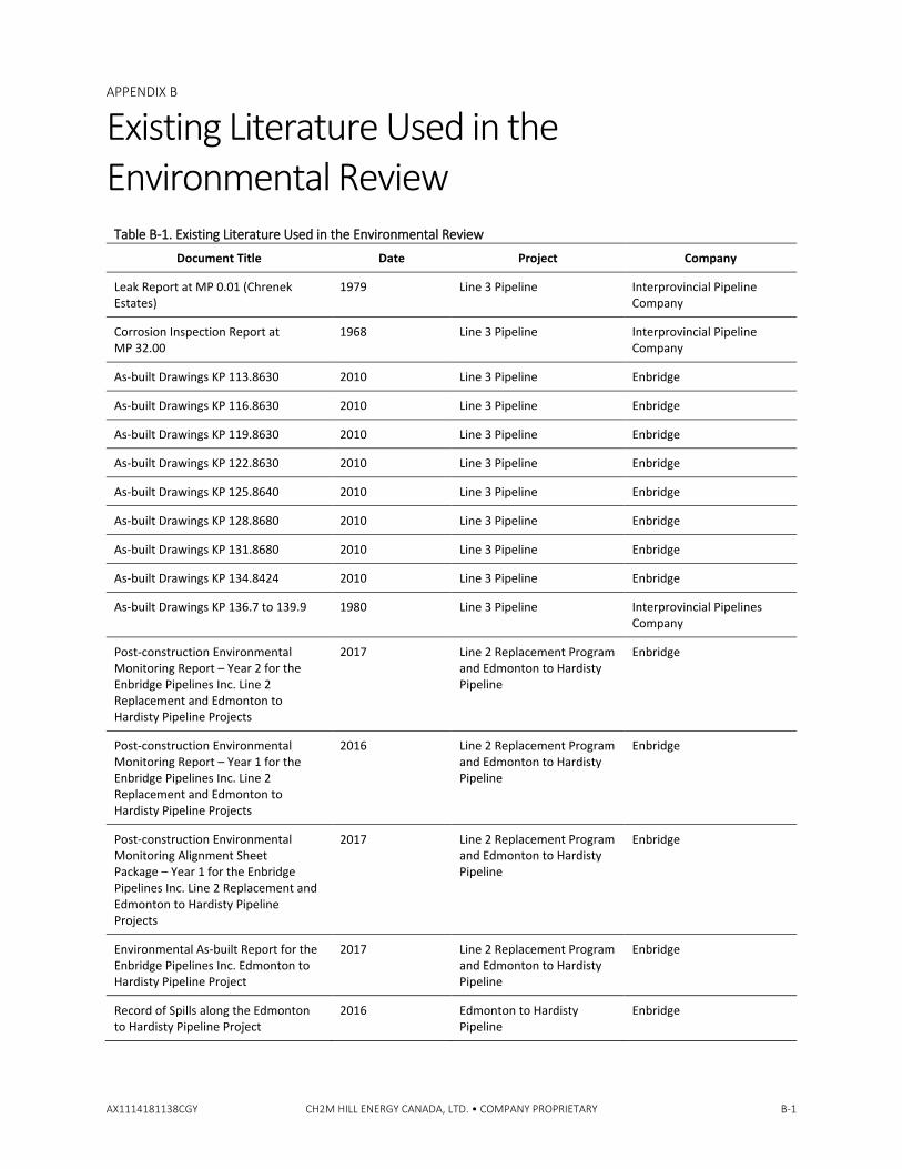
APPENDIX B
AX1114181138CGY CH2M HILL ENERGY CANADA, LTD. • COMPANY PROPRIETARY B-1
Existing Literature Used in the Environmental Review
Table B-1. Existing Literature Used in the Environmental Review
Document Title Date Project Company
Leak Report at MP 0.01 (Chrenek Estates)
1979 Line 3 Pipeline Interprovincial Pipeline Company
Corrosion Inspection Report at MP 32.00
1968 Line 3 Pipeline Interprovincial Pipeline Company
As-built Drawings KP 113.8630 2010 Line 3 Pipeline Enbridge
As-built Drawings KP 116.8630 2010 Line 3 Pipeline Enbridge
As-built Drawings KP 119.8630 2010 Line 3 Pipeline Enbridge
As-built Drawings KP 122.8630 2010 Line 3 Pipeline Enbridge
As-built Drawings KP 125.8640 2010 Line 3 Pipeline Enbridge
As-built Drawings KP 128.8680 2010 Line 3 Pipeline Enbridge
As-built Drawings KP 131.8680 2010 Line 3 Pipeline Enbridge
As-built Drawings KP 134.8424 2010 Line 3 Pipeline Enbridge
As-built Drawings KP 136.7 to 139.9 1980 Line 3 Pipeline Interprovincial Pipelines Company
Post-construction Environmental Monitoring Report – Year 2 for the Enbridge Pipelines Inc. Line 2 Replacement and Edmonton to Hardisty Pipeline Projects
2017 Line 2 Replacement Program and Edmonton to Hardisty Pipeline
Enbridge
Post-construction Environmental Monitoring Report – Year 1 for the Enbridge Pipelines Inc. Line 2 Replacement and Edmonton to Hardisty Pipeline Projects
2016 Line 2 Replacement Program and Edmonton to Hardisty Pipeline
Enbridge
Post-construction Environmental Monitoring Alignment Sheet Package – Year 1 for the Enbridge Pipelines Inc. Line 2 Replacement and Edmonton to Hardisty Pipeline Projects
2017 Line 2 Replacement Program and Edmonton to Hardisty Pipeline
Enbridge
Environmental As-built Report for the Enbridge Pipelines Inc. Edmonton to Hardisty Pipeline Project
2017 Line 2 Replacement Program and Edmonton to Hardisty Pipeline
Enbridge
Record of Spills along the Edmonton to Hardisty Pipeline Project
2016 Edmonton to Hardisty Pipeline
Enbridge

APPENDIX B - EXISTING LITERATURE USED IN THE ENVIRONMENTAL REVIEW
B-2 CH2M HILL ENERGY CANADA, LTD. • COMPANY PROPRIETARY
Table B-1. Existing Literature Used in the Environmental Review
Document Title Date Project Company
Miscellaneous as-built pipeline data provided by Enbridge for Post-construction Environmental Monitoring (including spill reports and historical contamination)
2015 Edmonton to Hardisty Pipeline
Enbridge
Notes:
Enbridge = Enbridge Pipelines Inc. KP = Kilometre Post MP = Mile Post
AX1114181138CGY

Appendix C Historic Aerial
Photographs and Photoplates

APPENDIX C
AX1114181138CGY CH2M HILL ENERGY CANADA, LTD. • COMPANY PROPRIETARY C-1
Historic Aerial Photographs and Photoplates
Historic Aerial: 32-52-23 W4M, August 15, 1967 (Image AS979). This image was taken approximately 13 years prior to the abandonment of Segment 1A.
Kilometre Post (KP) 2.2 to KP 2.5: Seasonal graminoid marsh. While there is evidence of less water than in later years, it is not uncommon for a seasonal marsh to have little or no water remaining in the late summer. Seasonal marshes are defined as mineral wetlands that are typically flooded for the growing season but have little to no surface water remaining by the end of the summer (Alberta Environment and Sustainable Resource Development, 2015)
KP 3.1: Watercourse – Goldbar Creek. No concerns identified.
Historic Aerial: 28-52-23 W4M, May 5, 1978 (Image AS2944). Segment 1A of the Line 3 pipeline was still operational at this time.
KP 2.2 to KP 2.5: Seasonal graminoid marsh (no previous concerns identified). There appears to be more water in the wetland than in the 1967 photograph, but this cannot be conclusively attributed to the construction of the Line 3 Pipeline since there is evidence of other development (i.e., a residential area) in the surrounding landscape.
KP 3.1: Watercourse – Goldbar Creek. No concerns identified.
Historic Aerial: 28-52-23 W4M, April 22, 1988 (Image AS3691). This image was taken approximately 8 years after the abandonment of Segment 1A.
KP 2.2 to KP 2.5: Seasonal graminoid marsh (no previous concerns identified). The Line 3 right--of-way (ROW) is clearly visible in this image. At this time, the pipeline segment has been abandoned and replaced. There is no evidence of alternation of the wetland size or shape in this image; however, there is evidence of increased development in the surrounding landscape.
KP 3.1: Watercourse – Goldbar Creek. The Line 3 ROW is clearly visible in this image. At this time, the pipeline segment has been abandoned and replaced. There is no evidence of altered hydrology of the creek in this image.
Legend
Area of Focus
APPENDIX C-1A
HISTORIC AERIAL PHOTOGRAPHS AND PHOTOPLATES FOR THE PARSC 015 REVIEW OF PREVIOUS ABANDONMENT PROGRAMS, PHASE 3 ABANDONMENT ON FARMLAND
November 2018 699910 Prepared by: TS

APPENDIX C - HISTORIC AERIAL PHOTOGRAPHS AND PHOTOPLATES
C-2 CH2M HILL ENERGY CANADA, LTD. • COMPANY PROPRIETARY AX1114181138CGY
Historic Aerial: 32-52-23 W4M, October 1, 2008 (Image AS5461). Segment 1A of the Line 3 Pipeline has been abandoned for approximately 28 years, at this time.
KP 2.2 to KP 2.5: Seasonal graminoid marsh (no previous concerns identified). While there is evidence of less water than in previous images, it is not uncommon for a seasonal marsh to have little or no water remaining in the late summer.
KP 3.1: Watercourse – Goldbar Creek. Segment 1A of the Line 3 Pipeline has been abandoned for approximately 28 years. There is no evidence of altered hydrology in this image.
Photoplate: Aerial view of the seasonal graminoid marsh (Google Earth, August 25, 2018). Segment 1A of the Line 3 Pipeline has been abandoned for approximately 38 years, at this time.
KP 2.2 to KP 2.5: Seasonal graminoid marsh (no previous concerns identified). There is no evidence of alternation of the wetland size or shape in this image.
Photoplate: Aerial view of Goldbar Creek (Google Earth, August 25, 2018). The creek was re-aligned within the Transportation/Utility Corridor within the last 3 years as a result of multiple utility expansion projects sharing the space.
Legend
Area of Focus
APPENDIX C-1B
HISTORIC AERIAL PHOTOGRAPHS AND PHOTOPLATES FOR THE PARSC 015 REVIEW OF PREVIOUS ABANDONMENT PROGRAMS, PHASE 3 ABANDONMENT ON FARMLAND
November 2018 699910 Prepared by: TS

APPENDIX C - HISTORIC AERIAL PHOTOGRAPHS AND PHOTOPLATES
AX1114181138CGY CH2M HILL ENERGY CANADA, LTD. • COMPANY PROPRIETARY C-3
Historic Aerial: 15 and 10-52-23 W4M, September 15, 1973 (Image AS1250). This image was taken approximately 7 years prior to the abandonment of Segment 1A.
KP 5.7 to KP 6.6: 1979 leak and repair location. This image was taken prior to the leak occurrence.
Historic Aerial: 15 and 10-52-23 W4M, May 4, 2005 (Image ED2005_2). This image was taken approximately 26 years after the leak occurred.
KP 5.7 to KP 6.6: 1979 leak and repair location. No site-specific investigations were conducted for the review of a previous pipeline abandonment program – Enbridge Line 3 Mainline pipeline (the Project); however, the Spill Report for this site indicated that the spill was cleaned up to the previous land capability and to landowner satisfaction.
Photoplate: Aerial view of KP 5.7 to KP 6.6: Leak and repair location (Google Earth, September 29, 2018). This image was taken approximately 45 years after the leak occurred.
At this scale, there does not appear to be evidence of additional issues related to the pipeline leak from 1979, and the pipeline repair appears to have been successful.
Legend
Area of Focus
APPENDIX C-2
HISTORIC AERIAL PHOTOGRAPHS AND PHOTOPLATES FOR THE PARSC 015 REVIEW OF PREVIOUS ABANDONMENT PROGRAMS, PHASE 3 ABANDONMENT ON FARMLAND
November 2018 699910 Prepared by: TS

APPENDIX C - HISTORIC AERIAL PHOTOGRAPHS AND PHOTOPLATES
C-4 CH2M HILL ENERGY CANADA, LTD. • COMPANY PROPRIETARY AX1114181138CGY
Historic Aerial: 15 and 10-52-23 W4M, September 15, 1973 (Image AS1250). This image was taken approximately 7 years prior to the abandonment of Segment 1A.
KP 7.6 to KP 7.7: Highway crossing location, the pipeline ROW is evident, but the highway does not appear to have been constructed yet.
Historic Aerial: 15 and 10-52-23 W4M, May 4, 2005 (Image ED2005_2). This image was taken approximately 25 years after the abandonment of Segment 1A.
KP 7.6 to KP 7.7: Highway crossing. There does not appear to be any evidence of subsidence at this secondary highway crossing.
Photoplate: Aerial view of Highway 628 crossing near KP 7.6 to KP 7.7 (Google Earth, September 29, 2018). This image was taken approximately 38 years after the abandonment of Segment 1A.
There appears to be evidence of work along the ROW that should be investigated at the ground level and through requesting municipal road repair records for this location.
Legend
Area of Focus
APPENDIX C-3
HISTORIC AERIAL PHOTOGRAPHS AND PHOTOPLATES FOR THE PARSC 015 REVIEW OF PREVIOUS ABANDONMENT PROGRAMS, PHASE 3 ABANDONMENT ON FARMLAND
November 2018 699910 Prepared by: TS

APPENDIX C - HISTORIC AERIAL PHOTOGRAPHS AND PHOTOPLATES
AX1114181138CGY CH2M HILL ENERGY CANADA, LTD. • COMPANY PROPRIETARY C-5
Historic Aerial: 30 and 19-51-22 W4M, May 26, 1962 (Image AS819). This image was taken approximately 18 years prior to the abandonment of Segment 1A.
KP 14.9 to KP 15.1: Area of subsidence noted in 2016, repaired in 2017 (contouring issue). The pipeline ROW is evident across the quarter-section, but the subsidence issue was not noted until the construction of another pipeline within the corridor was completed.
Photoplate: Aerial view of the subsidence area (Google Earth, September 29, 2018). This image was taken approximately 38 years after the abandonment of Segment 1A.
From this image, it appears that the entire pipeline corridor was remediated, so it is unclear if the subsidence was along the abandoned Line 3 ROW or along another ROW in the corridor.
Legend
Area of Focus
APPENDIX C-4
HISTORIC AERIAL PHOTOGRAPHS AND PHOTOPLATES FOR THE PARSC 015 REVIEW OF PREVIOUS ABANDONMENT PROGRAMS, PHASE 3 ABANDONMENT ON FARMLAND
November 2018 699910 Prepared by: TS
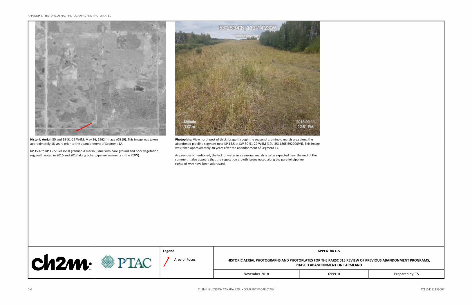
APPENDIX C - HISTORIC AERIAL PHOTOGRAPHS AND PHOTOPLATES
C-6 CH2M HILL ENERGY CANADA, LTD. • COMPANY PROPRIETARY AX1114181138CGY
Historic Aerial: 30 and 19-51-22 W4M, May 26, 1962 (Image AS819). This image was taken approximately 18 years prior to the abandonment of Segment 1A.
KP 15.4 to KP 15.5: Seasonal graminoid marsh (issue with bare ground and poor vegetation regrowth noted in 2016 and 2017 along other pipeline segments in the ROW).
Photoplate: View northwest of thick forage through the seasonal graminoid marsh area along the abandoned pipeline segment near KP 15.5 at SW 30-51-22 W4M (12U 351186E 5922009N). This image was taken approximately 38 years after the abandonment of Segment 1A.
As previously mentioned, the lack of water in a seasonal marsh is to be expected near the end of the summer. It also appears that the vegetation growth issues noted along the parallel pipeline rights-of-way have been addressed.
Legend
Area of Focus
APPENDIX C-5
HISTORIC AERIAL PHOTOGRAPHS AND PHOTOPLATES FOR THE PARSC 015 REVIEW OF PREVIOUS ABANDONMENT PROGRAMS, PHASE 3 ABANDONMENT ON FARMLAND
November 2018 699910 Prepared by: TS

APPENDIX C - HISTORIC AERIAL PHOTOGRAPHS AND PHOTOPLATES
AX1114181138CGY CH2M HILL ENERGY CANADA, LTD. • COMPANY PROPRIETARY C-7
Historic Aerial: 30 and 19-51-22 W4M, May 26, 1962 (Image AS819). This image was taken approximately 18 years prior to the abandonment of Segment 1A.
KP 18.8 to KP 19.0: Shallow, open water wetland (no previous concerns identified). The pipeline ROW is visible to the left of the shallow, open water area and runs through the bottom left corner of the pond.
Historic Aerial: 17-51-22 W4M, September 26, 1976 (Image AS299). This image was taken approximately 4 years prior to the abandonment of Segment 1A.
KP 18.8 to KP 19.0: Shallow, open wetland (no previous concerns identified). The pipeline ROW runs through the bottom left corner of the pond; there does not appear to be evidence of an altered size of the pond.
Photoplate: Aerial view of the shallow, open water wetland (Google Earth, September 29, 2018). This image was taken approximately 38 years after the abandonment of Segment 1A.
There is no evidence of alteration of the shape or size of the wetland.
Legend
Area of Focus
APPENDIX C-6
HISTORIC AERIAL PHOTOGRAPHS AND PHOTOPLATES FOR THE PARSC 015 REVIEW OF PREVIOUS ABANDONMENT PROGRAMS, PHASE 3 ABANDONMENT ON FARMLAND
November 2018 699910 Prepared by: TS
APPENDIX C - HISTORIC AERIAL PHOTOGRAPHS AND PHOTOPLATES
C-8 CH2M HILL ENERGY CANADA, LTD. • COMPANY PROPRIETARY AX1114181138CGY
Historic Aerial: 4-51-22 W4M and 33-50-22 W4M, June 2, 1969 (Image AS1006). This image was taken approximately 11 years prior to the abandonment of Segment 1A.
KP 22.5 to KP 22.9: Seasonal marsh/shrubby swamp complex (no previous concerns identified).
Historic Aerial: 4-51-22 W4M and 33-50-22 W4M, October 1, 2008 (Image AS5460B). This image was taken approximately 28 years after the abandonment of Segment 1A.
KP 22.5 to KP 22.9: Seasonal marsh/shrubby swamp complex (no previous concerns identified). The wetland is approximately the same shape and size as prior to pipeline abandonment.
Photoplate: Aerial view of seasonal marsh/shrubby swamp complex (Google Earth, September 29, 2018). This image was taken approximately 38 years after the abandonment of Segment 1A.
There is no evidence of change of the shape or size of the seasonal marsh/shrubby swamp complex.
Legend
Area of Focus
APPENDIX C-7
HISTORIC AERIAL PHOTOGRAPHS AND PHOTOPLATES FOR THE PARSC 015 REVIEW OF PREVIOUS ABANDONMENT PROGRAMS, PHASE 3 ABANDONMENT ON FARMLAND
November 2018 699910 Prepared by: TS

APPENDIX C - HISTORIC AERIAL PHOTOGRAPHS AND PHOTOPLATES
AX1114181138CGY CH2M HILL ENERGY CANADA, LTD. • COMPANY PROPRIETARY C-9
Historic Aerial: 4-51-22 W4M and 33-50-22 W4M, June 2, 1969 (Image AS1006). This image was taken approximately 11 years prior to the abandonment of Segment 1A.
KP 24.3 to KP 24.4: Watercourse – Irvine Creek. The image quality is poor, but the creek can be seen at the red arrow.
Historic Aerial: 4-51-22 W4M and 33-50-22 W4M, October 1, 2008 (Image AS5460B). This image was taken approximately 28 years after the abandonment of Segment 1A.
KP 24.3 to KP 24.4: Watercourse – Irvine Creek. There is no evidence of alternation of the trajectory of the creek.
Photoplate: Aerial view of Irvine Creek (Google Earth, September 29, 2018). This image was taken approximately 38 years after the abandonment of Segment 1A.
The creek runs through a property that is currently used to raise elk and, as such, the owner appears to have channelized Irvine Creek and created numerous dugouts on the property for watering his animals. Irvine Creek does not appear to have been altered as a result of the pipeline ROW.
Legend
Area of Focus
APPENDIX C-8
HISTORIC AERIAL PHOTOGRAPHS AND PHOTOPLATES FOR THE PARSC 015 REVIEW OF PREVIOUS ABANDONMENT PROGRAMS, PHASE 3 ABANDONMENT ON FARMLAND
November 2018 699910 Prepared by: TS

APPENDIX C - HISTORIC AERIAL PHOTOGRAPHS AND PHOTOPLATES
C-10 CH2M HILL ENERGY CANADA, LTD. • COMPANY PROPRIETARY AX1114181138CGY
Historic Aerial: 27 and 22-50-22 W4M, August 5, 1962 (Image AS819). This image was taken approximately 18 years prior to the abandonment of Segment 1A.
KP 26.3 to KP 26.4: Gully erosion observed in 2016. The erosion was observed during the Post-construction Environmental Monitoring (PCEM) of another pipeline ROW within this corridor and cannot be conclusively attributed to the abandoned Segment 1A.
Historic Aerial: 27 and 22-50-22 W4M, October 1, 2008 (Image AS5460B). This image was taken approximately 28 years after the abandonment of Segment 1A.
KP 26.3 to KP 26.4: Gully erosion observed in 2016. The erosion was observed during the PCEM of another pipeline ROW within this corridor and cannot be conclusively attributed to the abandoned Segment 1A. The pipeline corridor is visibly wider than it was in 1962.
Photoplate: Aerial view of gully erosion area noted in 2016. (Google Earth, September 29, 2018). This image was taken approximately 38 years after the abandonment of Segment 1A.
It appears that the entire pipeline corridor has been altered to address the erosion gully and, as such, it is not clear if the erosion gully can be attributed to the abandoned Segment 1A. The erosion gully does not appear to have altered the wetlands in the vicinity of the pipeline corridor.
Legend
Area of Focus
APPENDIX C-9
HISTORIC AERIAL PHOTOGRAPHS AND PHOTOPLATES FOR THE PARSC 015 REVIEW OF PREVIOUS ABANDONMENT PROGRAMS, PHASE 3 ABANDONMENT ON FARMLAND
November 2018 699910 Prepared by: TS

APPENDIX C - HISTORIC AERIAL PHOTOGRAPHS AND PHOTOPLATES
AX1114181138CGY CH2M HILL ENERGY CANADA, LTD. • COMPANY PROPRIETARY C-11
Historic Aerial: 27 and 22-50-22 W4M, August 5, 1962 (Image AS819). This image was taken approximately 18 years prior to the abandonment of Segment 1A.
KP 27.1 to KP 27.5: Temporary marshes and treed area (weed issue observed in 2016, willow and success species recovery noted in 2017). The weed issue was noted during the PCEM of another pipeline ROW in the corridor and is an incidental finding for this Project.
Historic Aerial: 27 and 22-50-22 W4M, October 1, 2008 (Image AS5460B). This image was taken approximately 28 years after the abandonment of Segment 1A.
KP 27.1 to KP 27.5: Temporary marshes and treed area (weed issue observed in 2016, willow and success species recovery noted in 2017). The pipeline corridor is visibly wider than in 1962. There is no evidence of altered size or shape of the temporary marshes.
Photoplate: Aerial view of temporary marshes and treed area (Google Earth, September 29, 2018). This image was taken approximately 38 years after the abandonment of Segment 1A.
There is no evidence of altered size or shape of the temporary marshes.
Legend
Area of Focus
APPENDIX C-10
HISTORIC AERIAL PHOTOGRAPHS AND PHOTOPLATES FOR THE PARSC 015 REVIEW OF PREVIOUS ABANDONMENT PROGRAMS, PHASE 3 ABANDONMENT ON FARMLAND
November 2018 699910 Prepared by: TS

APPENDIX C - HISTORIC AERIAL PHOTOGRAPHS AND PHOTOPLATES
C-12 CH2M HILL ENERGY CANADA, LTD. • COMPANY PROPRIETARY AX1114181138CGY
Historic Aerial: 30 and 29-49-22 W4M, May 26, 1962 (Image AS820). This image was taken approximately 18 years prior to the abandonment of Segment 1A.
KP 38.0 to KP 38.2: Shrubby swamps (no previous concerns identified) and road crossing.
Historic Aerial: 30 and 29-49-22 W4M, 2011 (Image ERJ0183H). This image was taken approximately 21 years after the abandonment of Segment 1A.
KP 38.0 to KP 38.2: Shrubby swamps (no previous concerns identified) and road crossing. The pipeline corridor is visibly wider than in 1962.
Photoplate: View northwest of abandoned pipeline segment showing tree regrowth adjacent to a road crossing near KP 38.2 at NE 30-49-22 W4M (12U 363272E 5902937N). This image was taken approximately 38 years after the abandonment of Segment 1A.
There is no evidence of subsidence at the road crossing, inferred from the lack of disturbance in the road ditch. Municipal road maintenance records should be requested to determine if subsidence has been an issue at this road crossing.
Legend
Area of Focus
APPENDIX C-11
HISTORIC AERIAL PHOTOGRAPHS AND PHOTOPLATES FOR THE PARSC 015 REVIEW OF PREVIOUS ABANDONMENT PROGRAMS, PHASE 3 ABANDONMENT ON FARMLAND
November 2018 699910 Prepared by: TS

APPENDIX C - HISTORIC AERIAL PHOTOGRAPHS AND PHOTOPLATES
AX1114181138CGY CH2M HILL ENERGY CANADA, LTD. • COMPANY PROPRIETARY C-13
Historic Aerial: 12-49-21 W4M, May 26, 1962 (Image AS820). This image was taken approximately 18 years prior to the abandonment of Segment 1A.
KP 46.2 to KP 46.6: Temporary marsh and treed area (no previous concerns identified).
Photoplate: View northwest across abandoned pipeline Segment 1A showing the temporary marsh to the east near KP 46.2 at NW 12-49-21 W4M (12U 369784E 5898334N). This image was taken approximately 38 years after the abandonment of Segment 1A.
There is no evidence of alteration of the size and shape of the marsh. There is no evidence of stressed wetland vegetation.
Legend
Area of Focus
APPENDIX C-12
HISTORIC AERIAL PHOTOGRAPHS AND PHOTOPLATES FOR THE PARSC 015 REVIEW OF PREVIOUS ABANDONMENT PROGRAMS, PHASE 3 ABANDONMENT ON FARMLAND
November 2018 699910 Prepared by: TS

APPENDIX C - HISTORIC AERIAL PHOTOGRAPHS AND PHOTOPLATES
C-14 CH2M HILL ENERGY CANADA, LTD. • COMPANY PROPRIETARY AX1114181138CGY
Historic Aerial: 12-49-21 W4M, May 26, 1962 (Image AS820). This image was taken approximately 18 years before the abandonment of Segment 1A.
KP 47.8 to KP 48.4: Subsidence and crop growth issue observed in 2016. The subsidence and crop growth issues were observed during the PCEM of another ROW within the corridor and cannot be conclusively attributed to the abandoned pipeline segment.
Historic Aerial: 12-49-21 W4M, April 12, 1984 (Image AS2929). This image was taken approximately 4 years after the abandonment of Segment 1A.
KP 47.8 to KP 48.4: Subsidence and crop growth issue observed in 2016. The pipeline corridor is visibly wider than in 1962.
Photoplate: Aerial view of subsidence area (Google Earth, 2018). This image was taken approximately 38 years after the abandonment of Segment 1A.
The pipeline corridor is visibly wider than in 1984 and the subsidence mitigation was likely applied across the entire corridor.
Legend
Area of Focus
APPENDIX C-13
HISTORIC AERIAL PHOTOGRAPHS AND PHOTOPLATES FOR THE PARSC 015 REVIEW OF PREVIOUS ABANDONMENT PROGRAMS, PHASE 3 ABANDONMENT ON FARMLAND
November 2018 699910 Prepared by: TS

APPENDIX C - HISTORIC AERIAL PHOTOGRAPHS AND PHOTOPLATES
AX1114181138CGY CH2M HILL ENERGY CANADA, LTD. • COMPANY PROPRIETARY C-15
Historic Aerial: 12-49-21 W4M, May 26, 1962 (Image AS820). This image was taken approximately 18 years prior to the abandonment of Segment 1A.
KP 49.4 to KP 49.6: Semipermanent marsh (no previous concerns identified).
Historic Aerial: 6-49-20 W4M, June 5, 2003 (Image AS5252). This image was taken approximately 23 years after the abandonment of Segment 1A.
KP 49.4 to KP 49.6: Semipermanent marsh (no previous concerns identified). The pipeline corridor is visibly wider than in 1962, and there is no evidence of alteration of the shape or size of the semipermanent marsh.
Photoplate: Aerial view of semipermanent marsh (Google Earth, September 29, 2018). This image was taken approximately 38 years after the abandonment of Segment 1A.
There is no evidence of alteration of the shape or size of the semipermanent marsh.
Legend
Area of Focus
APPENDIX C-14
HISTORIC AERIAL PHOTOGRAPHS AND PHOTOPLATES FOR THE PARSC 015 REVIEW OF PREVIOUS ABANDONMENT PROGRAMS, PHASE 3 ABANDONMENT ON FARMLAND
November 2018 699910 Prepared by: TS
APPENDIX C - HISTORIC AERIAL PHOTOGRAPHS AND PHOTOPLATES
C-16 CH2M HILL ENERGY CANADA, LTD. • COMPANY PROPRIETARY AX1114181138CGY
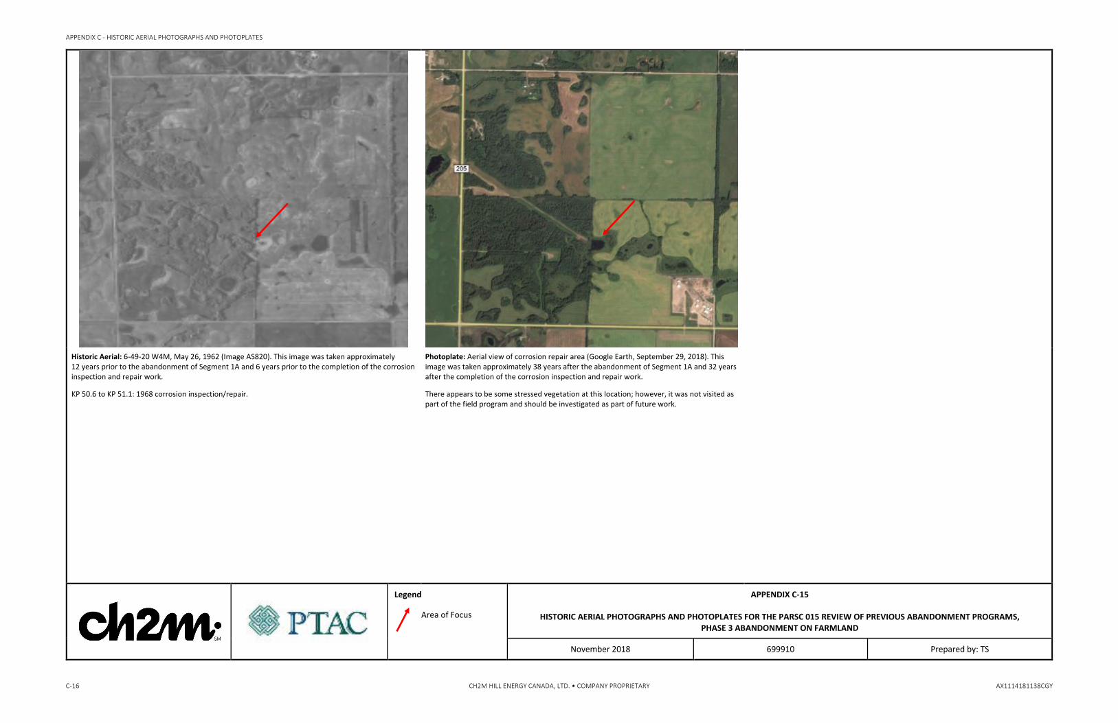
Historic Aerial: 6-49-20 W4M, May 26, 1962 (Image AS820). This image was taken approximately 12 years prior to the abandonment of Segment 1A and 6 years prior to the completion of the corrosion inspection and repair work.
KP 50.6 to KP 51.1: 1968 corrosion inspection/repair.
Photoplate: Aerial view of corrosion repair area (Google Earth, September 29, 2018). This image was taken approximately 38 years after the abandonment of Segment 1A and 32 years after the completion of the corrosion inspection and repair work.
There appears to be some stressed vegetation at this location; however, it was not visited as part of the field program and should be investigated as part of future work.
Legend
Area of Focus
APPENDIX C-15
HISTORIC AERIAL PHOTOGRAPHS AND PHOTOPLATES FOR THE PARSC 015 REVIEW OF PREVIOUS ABANDONMENT PROGRAMS, PHASE 3 ABANDONMENT ON FARMLAND
November 2018 699910 Prepared by: TS

APPENDIX C - HISTORIC AERIAL PHOTOGRAPHS AND PHOTOPLATES
AX1114181138CGY CH2M HILL ENERGY CANADA, LTD. • COMPANY PROPRIETARY C-17
Historic Aerial: 6-49-20 W4M, May 26, 1962 (Image AS820). This image was taken approximately 18 years prior to the abandonment of Segment 1A.
KP 51.1: End Point of Segment 1A.
Photoplate: Aerial view of end point of Segment 1A (Google Earth, September 29, 2018). This image was taken approximately 38 years after the abandonment of Segment 1A.
There does not appear to be any issues associated with the cutting and capping activities that took place at this location.
Legend
Area of Focus
APPENDIX C-16
HISTORIC AERIAL PHOTOGRAPHS AND PHOTOPLATES FOR THE PARSC 015 REVIEW OF PREVIOUS ABANDONMENT PROGRAMS, PHASE 3 ABANDONMENT ON FARMLAND
November 2018 699910 Prepared by: TS
APPENDIX C - HISTORIC AERIAL PHOTOGRAPHS AND PHOTOPLATES
C-18 CH2M HILL ENERGY CANADA, LTD. • COMPANY PROPRIETARY AX1114181138CGY
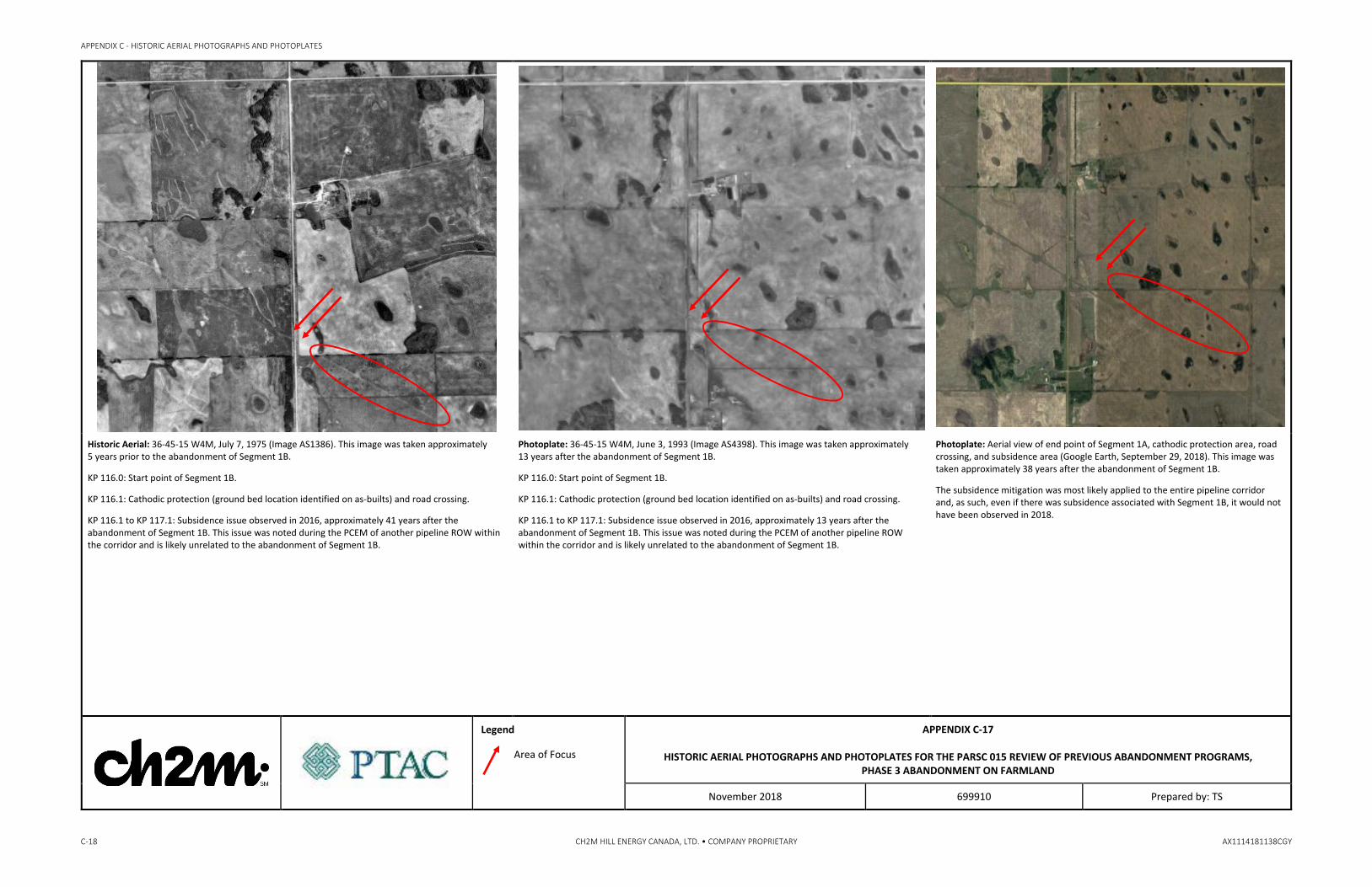
Historic Aerial: 36-45-15 W4M, July 7, 1975 (Image AS1386). This image was taken approximately 5 years prior to the abandonment of Segment 1B.
KP 116.0: Start point of Segment 1B.
KP 116.1: Cathodic protection (ground bed location identified on as-builts) and road crossing.
KP 116.1 to KP 117.1: Subsidence issue observed in 2016, approximately 41 years after the abandonment of Segment 1B. This issue was noted during the PCEM of another pipeline ROW within the corridor and is likely unrelated to the abandonment of Segment 1B.
Photoplate: 36-45-15 W4M, June 3, 1993 (Image AS4398). This image was taken approximately 13 years after the abandonment of Segment 1B.
KP 116.0: Start point of Segment 1B.
KP 116.1: Cathodic protection (ground bed location identified on as-builts) and road crossing.
KP 116.1 to KP 117.1: Subsidence issue observed in 2016, approximately 13 years after the abandonment of Segment 1B. This issue was noted during the PCEM of another pipeline ROW within the corridor and is likely unrelated to the abandonment of Segment 1B.
Photoplate: Aerial view of end point of Segment 1A, cathodic protection area, road crossing, and subsidence area (Google Earth, September 29, 2018). This image was taken approximately 38 years after the abandonment of Segment 1B.
The subsidence mitigation was most likely applied to the entire pipeline corridor and, as such, even if there was subsidence associated with Segment 1B, it would not have been observed in 2018.
Legend
Area of Focus
APPENDIX C-17
HISTORIC AERIAL PHOTOGRAPHS AND PHOTOPLATES FOR THE PARSC 015 REVIEW OF PREVIOUS ABANDONMENT PROGRAMS, PHASE 3 ABANDONMENT ON FARMLAND
November 2018 699910 Prepared by: TS

APPENDIX C - HISTORIC AERIAL PHOTOGRAPHS AND PHOTOPLATES
AX1114181138CGY CH2M HILL ENERGY CANADA, LTD. • COMPANY PROPRIETARY C-19
Historic Aerial: 22-45-14 W4M, September 19, 1967 (Image AS981). This image was taken approximately 13 years prior to the abandonment of Segment 1B.
KP 118.9 to KP 119.4: Subsidence issue observed and repaired in 2016, and road crossing. This issue was noted during the PCEM of another pipeline ROW within the corridor and is likely unrelated to the abandonment of Segment 1B.
Historic Aerial: 22-45-14 W4M, May 10, 2005 (Image AS5326). This image was taken approximately 11 years prior to the abandonment of Segment 1B.
KP 118.9 to KP 119.4: Subsidence issue observed and repaired in 2016, and road crossing. This issue was noted during the PCEM of another pipeline ROW within the corridor and is likely unrelated to the abandonment of Segment 1B.
Photoplate: Aerial view of subsidence area (Google Earth, September 29, 2018). This image was taken approximately 38 years after the abandonment of Segment 1B.
The subsidence mitigation was most likely applied to the entire pipeline corridor and, as such, even if there was subsidence associated with Segment 1B, it could not be conclusively attributed to the abandoned ROW.
Legend
Area of Focus
APPENDIX C-18
HISTORIC AERIAL PHOTOGRAPHS AND PHOTOPLATES FOR THE PARSC 015 REVIEW OF PREVIOUS ABANDONMENT PROGRAMS, PHASE 3 ABANDONMENT ON FARMLAND
November 2018 699910 Prepared by: TS
APPENDIX C - HISTORIC AERIAL PHOTOGRAPHS AND PHOTOPLATES
C-20 CH2M HILL ENERGY CANADA, LTD. • COMPANY PROPRIETARY AX1114181138CGY
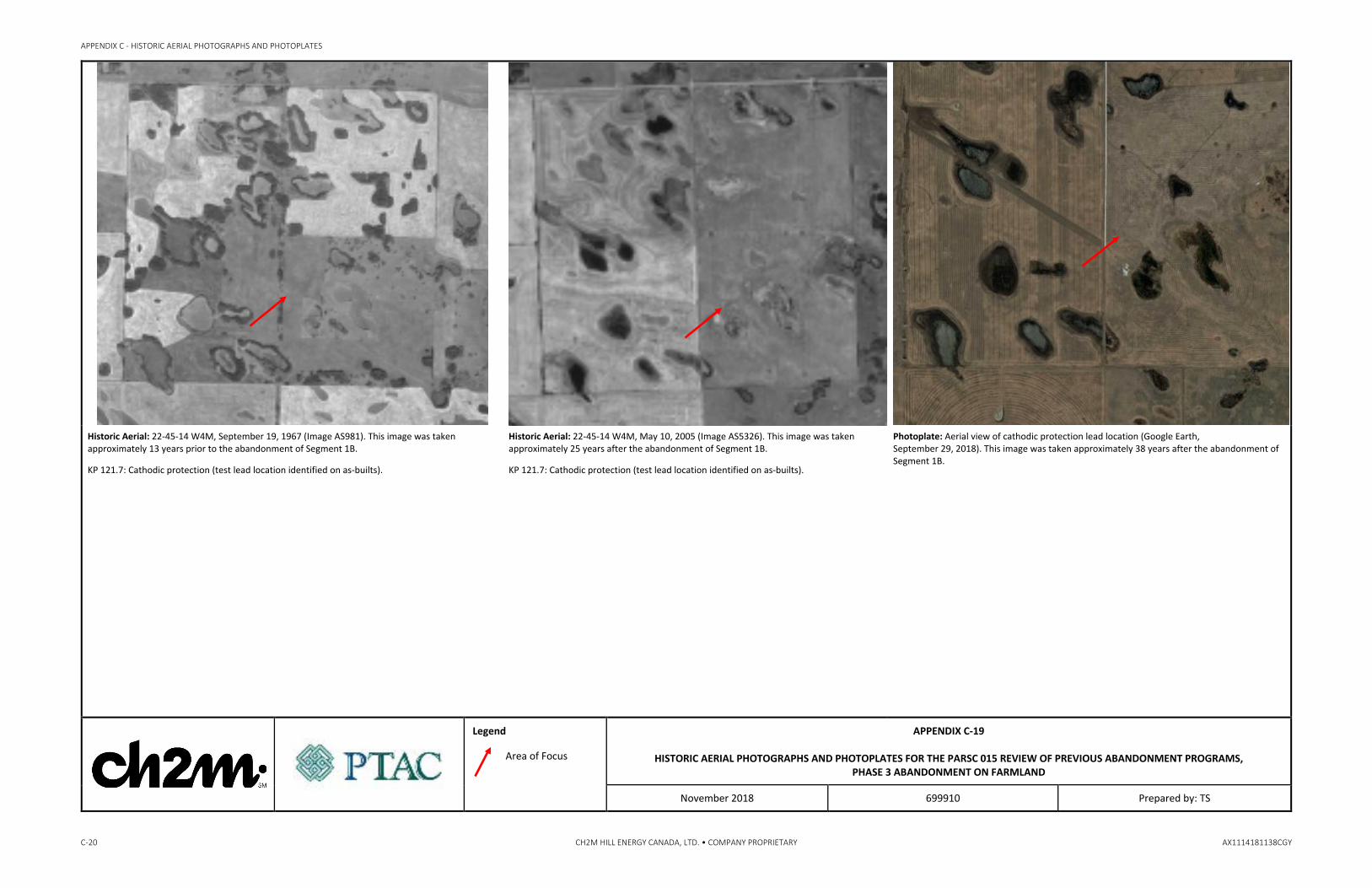
Historic Aerial: 22-45-14 W4M, September 19, 1967 (Image AS981). This image was taken approximately 13 years prior to the abandonment of Segment 1B.
KP 121.7: Cathodic protection (test lead location identified on as-builts).
Historic Aerial: 22-45-14 W4M, May 10, 2005 (Image AS5326). This image was taken approximately 25 years after the abandonment of Segment 1B.
KP 121.7: Cathodic protection (test lead location identified on as-builts).
Photoplate: Aerial view of cathodic protection lead location (Google Earth, September 29, 2018). This image was taken approximately 38 years after the abandonment of Segment 1B.
Legend
Area of Focus
APPENDIX C-19
HISTORIC AERIAL PHOTOGRAPHS AND PHOTOPLATES FOR THE PARSC 015 REVIEW OF PREVIOUS ABANDONMENT PROGRAMS, PHASE 3 ABANDONMENT ON FARMLAND
November 2018 699910 Prepared by: TS

APPENDIX C - HISTORIC AERIAL PHOTOGRAPHS AND PHOTOPLATES
AX1114181138CGY CH2M HILL ENERGY CANADA, LTD. • COMPANY PROPRIETARY C-21
Historic Aerial: 22-45-14 W4M, September 19, 1967 (Image AS981). This image was taken approximately 13 years prior to the abandonment of Segment 1B.
KP 124.9 to KP 125.4: Seasonal marsh (no previous concerns identified) and subsidence issue observed in 2016. This issue was noted during the PCEM of another pipeline ROW within the corridor and is likely unrelated to the abandonment of Segment 1B.
Historic Aerial: 22-45-14 W4M, May 10, 2005 (Image AS5326). This image was taken approximately 25 years after the abandonment of Segment 1B.
KP 124.9 to KP 125.4: Seasonal marsh (no previous concerns identified) and subsidence issue observed in 2016. This issue was noted during the PCEM of another pipeline ROW within the corridor and is likely unrelated to the abandonment of Segment 1B.
There is no evidence of change in the size or shape of the seasonal marsh.
Photoplate: Aerial view of seasonal marsh (Google Earth, September 29, 2018).
The subsidence mitigation was most likely applied to the entire pipeline corridor and, as such, even if there was subsidence associated with Segment 1B, it could not be conclusively attributed to the abandoned ROW.
There is no evidence of change in the size or shape of the seasonal marsh.
Legend
Area of Focus
APPENDIX C-20
HISTORIC AERIAL PHOTOGRAPHS AND PHOTOPLATES FOR THE PARSC 015 REVIEW OF PREVIOUS ABANDONMENT PROGRAMS, PHASE 3 ABANDONMENT ON FARMLAND
November 2018 699910 Prepared by: TS

APPENDIX C - HISTORIC AERIAL PHOTOGRAPHS AND PHOTOPLATES
C-22 CH2M HILL ENERGY CANADA, LTD. • COMPANY PROPRIETARY AX1114181138CGY
Historic Aerial: 33-44-13 W4M, September 17, 1967 (Image AS981). This image was taken approximately 13 years prior to the abandonment of Segment 1B.
KP 129.2: Cathodic protection (test lead location identified on as-builts).
Photoplate: Aerial view of cathodic protection lead location (Google Earth, September 29, 2018). This image was taken approximately 38 years after the abandonment of Segment 1B.
Legend
Area of Focus
APPENDIX C-21
HISTORIC AERIAL PHOTOGRAPHS AND PHOTOPLATES FOR THE PARSC 015 REVIEW OF PREVIOUS ABANDONMENT PROGRAMS, PHASE 3 ABANDONMENT ON FARMLAND
November 2018 699910 Prepared by: TS

APPENDIX C - HISTORIC AERIAL PHOTOGRAPHS AND PHOTOPLATES
AX1114181138CGY CH2M HILL ENERGY CANADA, LTD. • COMPANY PROPRIETARY C-23
Historic Aerial: 33-44-13 W4M, September 17, 1967 (Image AS981). This image was taken approximately 13 years prior to the abandonment of Segment 1B.
KP 132.6 to KP 132.9: Temporary marsh (no previous concerns identified) and weeds noted in the quarter-section. The weed concern was noted during the PCEM of another pipeline ROW within the corridor and is likely unrelated to the abandonment of Segment 1B.
Historic Aerial: 33-44-13 W4M, October 17, 1996 (Image AS4774). This image was taken approximately 16 years following the abandonment of Segment 1B.
KP 132.6 to KP 132.9: Temporary marsh (no previous concerns identified) and weeds noted in the quarter-section. There is no evidence of change in the shape or size of the temporary marsh. The weed concern was noted during the PCEM of another pipeline ROW within the corridor and is likely unrelated to the abandonment of Segment 1B.
Photoplate: Aerial view of temporary marsh area (Google Earth, September 29, 2018). There is evidence of the formation of additional wetlands adjacent to the pipeline corridor that may represent preferential drainage along the outside of a pipeline. However, given that the abandoned Segment 1B is colocated in a corridor with other active pipelines, the formation of these wetlands cannot be conclusively attributed to Segment 1B. Additionally, there was a significant amount of precipitation (i.e., snow and rain fall) in September 2018, that may have contributed to the accumulation of water in depressions adjacent to the pipeline corridor.
Legend
Area of Focus
APPENDIX C-22
HISTORIC AERIAL PHOTOGRAPHS AND PHOTOPLATES FOR THE PARSC 015 REVIEW OF PREVIOUS ABANDONMENT PROGRAMS, PHASE 3 ABANDONMENT ON FARMLAND
November 2018 699910 Prepared by: TS

APPENDIX C - HISTORIC AERIAL PHOTOGRAPHS AND PHOTOPLATES
C-24 CH2M HILL ENERGY CANADA, LTD. • COMPANY PROPRIETARY AX1114181138CGY
Historic Aerial: 26-44-13 W4M, September 13, 1949 (Image AS146). This image was taken approximately 31 years prior to the abandonment of Segment 1B.
KP 135.7 to KP 136.6: Intermittent, shallow, open water wetlands (weed issue observed in 2016). The intermittent wetlands are associated with an intermittent unnamed creek at this location.
KP 139: End point of Segment 1B.
Historic Aerial: 25-44-13 and 19-44-13 W4M, September 17, 1967 (Image AS981). This image was taken approximately 13 years prior to the abandonment of Segment 1B.
KP 135.7 to KP 136.6: Intermittent, shallow, open water wetlands (weed issue observed in 2016). There may be evidence of altered hydrology of the creek after the crossing of the pipeline corridor (i.e., there appears to be less water in the channel); however, Segment 1B has not yet been abandoned in this image, so it cannot be attributed to the abandoned pipeline segment.
KP 139: End point of Segment 1B.
Historic Aerial: 26-44-13 W4M, October 23, 1998 (Image AS4981). This image was taken approximately 18 years after the abandonment of Segment 1B.
KP 135.7 to KP 136.6: Intermittent, shallow, open water wetlands (weed issue observed in 2016). There is no evidence of alternation of the size or shape of the intermittent, shallow, open water wetlands associated with the intermittent unnamed creek.
The evidence of altered hydrology of the creek (i.e., less water in the channel) is now evident on both sides of the pipeline corridor. This indicates that the unnamed intermittent creek changes are not necessarily attributable to the presence of the pipeline corridor.
KP 139: End point of Segment 1B,
Legend
Area of Focus
APPENDIX C-23A
HISTORIC AERIAL PHOTOGRAPHS AND PHOTOPLATES FOR THE PARSC 015 REVIEW OF PREVIOUS ABANDONMENT PROGRAMS, PHASE 3 ABANDONMENT ON FARMLAND
November 2018 699910 Prepared by: TS

APPENDIX C - HISTORIC AERIAL PHOTOGRAPHS AND PHOTOPLATES
AX1114181138CGY CH2M HILL ENERGY CANADA, LTD. • COMPANY PROPRIETARY C-25
Photoplate: View northwest showing intermittent wetland at 26-44-13 W4M (12U 447201E 5853276N). This image was taken approximately 38 years after the abandonment of Segment 1B.
There is no evidence of the creek crossing the pipeline corridor; it appears to be cultivated through, as do the borders of the wetland.
Photoplate: Aerial view of end point of Segment 1B (Google Earth, September 29, 2018). This image was taken approximately 38 years after the abandonment of Segment 1B. There is no evidence of altered size or shape of the wetland adjacent to the end point.
Legend
Area of Focus
APPENDIX C-23B
HISTORIC AERIAL PHOTOGRAPHS AND PHOTOPLATES FOR THE PARSC 015 REVIEW OF PREVIOUS ABANDONMENT PROGRAMS, PHASE 3 ABANDONMENT ON FARMLAND
November 2018 699910 Prepared by: TS

APPENDIX C - HISTORIC AERIAL PHOTOGRAPHS AND PHOTOPLATES
C-26 CH2M HILL ENERGY CANADA, LTD. • COMPANY PROPRIETARY AX1114181138CGY
Historic Aerial: 19-44-12 W4M, September 13, 1949 (Image AS146). This image was taken approximately 31 years prior to the abandonment and removal of Segment 2A.
KP 136.6: Start point of Segment 2A.
KP 137.2: Shallow, open water wetland (no previous concerns identified).
KP 138.1 to KP 138.2: Seasonal marsh wetland (no previous concerns identified) and cultivation noted to be poorly reseeded after pipe removal.
KP 138.4: Crossing berm locations installed during pipeline abandonment.
KP 139.0 to KP 139.0: Shallow, open water wetland, extremely wet areas noted during pipeline abandonment, and crossing berm location installed during pipeline abandonment.
KP 139.9: End point of Segment 2A and point of oil removal by pumping.
Historic Aerial: 19-44-12 W4M, October 23, 1998 (Image AS4981). This image was taken approximately 18 years after the abandonment and removal of Segment 2A.
KP 136.6: Start point of Segment 2A.
KP 137.2: Shallow, open water wetland (no previous concerns identified). The wetland appears to be somewhat smaller in size than prior to pipeline abandonment. This cannot be conclusively attributed to the abandoned Segment 2A since the pipeline corridor is wider now and the wetland alteration may be the result of widening the corridor.
KP 138.1 to KP 138.2: Seasonal marsh wetland (no previous concerns identified) and cultivation noted to be poorly reseeded after pipe removal. The size and shape of the seasonal marsh do not appear to be altered as a result of the abandonment and removal of Segment 2A.
KP 138.4: Crossing berm locations installed during pipeline abandonment. The berms appear to have prevented the alteration of the size or shape of the wetland once the abandoned pipeline segment was removed.
KP 139.0 to KP 139.0: Shallow, open water wetland, extremely wet areas noted during pipeline abandonment, and crossing berm location installed during pipeline abandonment. The crossing berms appear to have prevented the alteration of the size or shape of the wetland once the abandoned pipeline segment was removed.
KP 139.9: End point of Segment 2A and point of oil removal by pumping.
Photoplate: View south of start point of Segment 2A at KP 136.6; Highway 131 on the right of the photograph (12U 448149E 5852679N).
There does not appear to be any issues associated with the abandonment, excavation, and removal of Segment 2A.
Legend
Area of Focus
APPENDIX C-24A
HISTORIC AERIAL PHOTOGRAPHS AND PHOTOPLATES FOR THE PARSC 015 REVIEW OF PREVIOUS ABANDONMENT PROGRAMS, PHASE 3 ABANDONMENT ON FARMLAND
November 2018 699910 Prepared by: TS

APPENDIX C - HISTORIC AERIAL PHOTOGRAPHS AND PHOTOPLATES
AX1114181138CGY CH2M HILL ENERGY CANADA, LTD. • COMPANY PROPRIETARY C-27
Photoplate: View northwest along ROW at KP 137.35 showing the shallow, open water wetland in the background (12U 448540E 5852427N). This image was taken approximately 38 years after the abandonment and removal of Segment 2A
There were no concerns noted along the pipeline corridor, as illustrated in this photograph.
Photoplate: View southeast within seasonal marsh wetland area near KP 138.2 (12U 449302E 5851925N). This image was taken approximately 38 years after the abandonment and removal of Segment 2A.
The area was reported to be poorly reseeded upon completion of the abandonment, excavation, removal, and reclamation of Segment 2A. Evidence of poor revegetation remains apparent in this photograph.
Photoplate: Aerial view of crossing berm location, shallow, open water wetland, and end point of Segment 2A (Google Earth, September 29, 2018). This image was taken approximately 38 years after the abandonment and removal of Segment 2A.
There is evidence of ponded water at the end point of Segment 2A. Further investigation of this location indicates subsidence across the entire corridor. The subsidence cannot be conclusively attributed to the abandonment of Segment 2A. There does not appear to be any evidence of stressed vegetation indicating that there were negligible amounts, if any, of product spilled during the purging of Segment 2A.
Legend
Area of Focus
APPENDIX C-24B
HISTORIC AERIAL PHOTOGRAPHS AND PHOTOPLATES FOR THE PARSC 015 REVIEW OF PREVIOUS ABANDONMENT PROGRAMS, PHASE 3 ABANDONMENT ON FARMLAND
November 2018 699910 Prepared by: TS

Appendix D General Right-of-Way Photographs

APPENDIX D
AX1114181138CGY CH2M HILL ENERGY CANADA, LTD. • COMPANY PROPRIETARY D‐1
General Right‐of‐Way Photographs
Plate D‐1. View northwest along the abandoned pipeline segment showing the vegetated right‐of‐way (ROW) near Kilometre Post (KP) 14.5 at SW 30‐51‐22 W4M.
Plate D‐2. View northwest of thick forage through a wetland area along the abandoned pipeline segment near KP 15.5 at SW 30‐51‐22 W4M.
Plate D‐3. View southeast along the abandoned pipeline segment showing the well‐vegetated ROW near KP 26.3 at NE 28‐50‐22 W4M.
Plate D‐4. View northwest along the abandoned pipeline showing healthy vegetation growing along the ROW near KP 27.5 at NE 22‐50‐22 W4M.

APPENDIX D ‐ GENERAL RIGHT‐OF‐WAY PHOTOGRAPHS
D‐2 CH2M HILL ENERGY CANADA, LTD. • COMPANY PROPRIETARY AX1114181138CGY
Plate D‐5. View northwest of the abandoned pipeline segment showing tree regrowth adjacent to a road crossing near KP 38.2 at NE 30‐49‐21 W4M.
Plate D‐6. View northwest across the abandoned pipeline segment showing a wetland to the east near KP 46.2 at NW 12‐49‐21 W4M.
Plate D‐7. View southeast across the abandoned pipeline segment near KP 120.8 at NW 21‐45‐14 W4M, also showing minor subsidence on the newer Line 3 to the right of the photograph.
Plate D‐8. View southeast along the abandoned pipeline segment showing a well‐vegetated area near KP 136 at NW 26‐44‐13 W4M.
Plate D‐9. View south along the abandoned pipeline segment near KP 136.7 at NE 26‐44‐13 W4M, where the removed segment begins.