Embed Size (px)
Citation preview
Review of Environmental Impact Assessment, compiling all environmental mitigation measures
Deliverable nº: D7.1
.
EC-GA nº Project full title:
295977 Demonstration of two floating wind
turbine systems for power generation
in Mediterranean deep waters
Deliverable Nº D7.1
Document name: Review of Environmental Impact
Assessment, compiling all environmental mitigation
measures
Responsible Partner: RSK
Due Date of Deliverable: December 2014
WP:7
WP leader: RSK
Task: 7.1
Task leader: Dave Watson
Version: 00
Version date: December 2014
Written by: Tim Cramp
Checked by: David Watson
Approved by: David Watson
Dissemination level: PU
Document history:
Version Date Main Modification Written by Checked by Approved by
TABLE OF CONTENTS
1. Executive Summary ...................................................................................................................................... 2
2. Acronyms ..................................................................................................................................................... 3
3. Introduction ................................................................................................................................................. 4
4. Environmental Baseline ................................................................................................................................ 4
4.1 PHYSICAL ENVIRONMENT ............................................................................................................................. 4 4.1.1 GEOLOGY ............................................................................................................................................................... 4 4.1.2 BATHYMETRY ......................................................................................................................................................... 5 4.1.3 SEDIMENT .............................................................................................................................................................. 5 4.1.4 HYDRODYNAMICS .................................................................................................................................................. 6 4.1.5 WATER QUALITY..................................................................................................................................................... 6
4.2 BIOLOGICAL ENVIRONMENT ........................................................................................................................ 8 4.2.1 BENTHIC COMMUNITIES AND HABITATS ............................................................................................................... 8 4.2.2 MACRO ALGAE ....................................................................................................................................................... 9 4.2.3 FISHERY .................................................................................................................................................................. 9 4.2.4 MARINE MAMMALS ............................................................................................................................................. 10
4.3 SOCIO-ECONOMIC ENVIRONMENT ............................................................................................................ 10 4.3.1 COMMERCIAL SHIPPING ...................................................................................................................................... 10 4.3.2 COMMERCIAL FISHING ......................................................................................................................................... 11 4.3.3 RECREATIONAL FISHING ....................................................................................................................................... 11 4.3.4 RECREATIONAL BOATING ..................................................................................................................................... 11 4.3.5 TOURISM .............................................................................................................................................................. 12
5. Environmental commitments ..................................................................................................................... 12
6. Further Work .............................................................................................................................................. 14
Environmental Baseline
19/12/14 2
1. EXECUTIVE SUMMARY
This report summarises the baseline environmental data which exist for the SEMREV test site.
Environmental and socio-economic information has been derived from two Environmental Impact
Assessments (EIAs) recently carried out for the SEMREV site.
Given that the FloatGen project is specifically designed to investigate the engineering feasibility and
environmental consequences of moored turbines, the baseline information provided focuses on the
environment at the sea surface and below (where there are differences in the design between
conventional (monopile/ jacket) and floating foundations. Potential effects on birds are not included.
A review of the EIAs shows that the area around SEMREV has no particular environmental
sensitivities, and no particular environmental features which would make the deployment, operation
and retrieval of a test device problematical.
A brief summary of the environmental commitments which the developers must make when
designing, deploying and operating their devices is also included in this report. These commitments
are based on those measures which are listed in the EIAs and within FloatGen deliverable D4.5. The
commitments are relatively generic, but will be expanded on as more information becomes available
for the floating design, and will then be included in deliverables due for submission at a later stage in
the FloatGen schedule.
Environmental Baseline
19/12/14 3
2. ACRONYMS
To be completed
Environmental Baseline
19/12/14 4
3. INTRODUCTION
The purpose of this project is to distil the differences in terms of environmental impact associated
with fixed foundations and floating moored systems for use with offshore wind turbines. It’s other
key aim is to provide a set of parameters within which the floating win turbine will be designed and
will operate. Those parameters are to a degree dependent upon the environment into which the
device is placed.
This summary of the baseline environmental information for the project area has been prepared to
assist in the formulation of a register of environmental commitments, which will eventually sit within
an environmental management plan for the FloatGen project. It is assumed that the aerial parts of
the turbines (including the tower above the water line, the nacelle and the turbine blades) would
have the same impacts whether they are supported on fixed or floating foundations, hence the
potential environmental impacts of the above water elements of offshore wind turbines have not
been considered in the in the summary. Environmental commitments in terms of the design and
operation of above-water elements (tower, nacelle and blades) will be the same as those for
conventional offshore wind turbines.
4. ENVIRONMENTAL BASELINE
It should be noted that the test site (SEMREV) has been the subject of two Environmental Impact
Assessments in recent years. These documents contain detailed, up to date, baseline information for
the SEMREV test site and have been used extensively in the production of the following summary.
4.1 PHYSICAL ENVIRONMENT
4.1.1 GEOLOGY
The continental shelf off southern Brittany (“plate-forme continentale sud-armoricaine”) is
characterised by a ridge aligned along the Hercynian structural direction WNW-ESE (from the islands
of Iles de Glénan in the north to Ile d’Yeu in the south) which is parallel to the coast.
This ridge, about 30 m deep1, consists of two domains:
- An internal domain closer to the coastline which stretches over a large area of 10km on average,
and is characterised by a complex morphology where the bedrock is showing or slightly eroded
in some places; and
1 All depths are referenced to the Carte Maritime (CM) datum
Environmental Baseline
19/12/14 5
- A widespread external domain further from the coastline, where the seabed is more regular and
is often covered by a layer of “recent” sediments.
The morphology of the bedrock is typical of past erosion, mostly caused by rivers, which took place
during the regressive phases of the Quaternary period (a period of lower sea levels). Therefore, in
the internal domain, the bedrock is represented by a complex network of palaeovalleys which have
been progressively filled by alluvial sediments. These sediments are heterogeneous and consist of
alternating series of coarse-sized sands and fine-sized sands, interspersed with clay chards (Cressard
and Augris, 1978).
4.1.2 BATHYMETRY
The bathymetry of the region of the Pays de la Loire is relatively complex. Despite this, the following
key features can be observed (see Figure 4.4 of SEVREM report (CREOCEAN, 2013)):
- To the east, the 5 m isobath defines the extent of the relatively shallow Bay of Pouliguen;
- To the west of the northern channel, between the plateau du Four (a shallow offshore bank) and
the Evens Meridian, the seabed is at a depth of 10 - 18 m; and
- Seabed deeper than 20 m can be found locally between Le Four and La Banche, and further
south, beyond the plateaus of La Lambarde and La Banche and the peninsula of Guérande.
In the vicinity of the proposed site, water depths are between 36 and 37 m.
4.1.3 SEDIMENT
The sedimentology from the coast of Croisic to the proposed site has the following characteristics:
- A thin littoral (coastal) strip about 1 km wide consisting of lithoclastic and non-carbonate
medium sized-sands. These sands structure and form the beaches of the coast of Croisic;
- Large submerged mudflats extending over a 10 km wide strip. These submerged mudflats are
located mainly to the north near the coast and stretch from the north of the peninsula of
Guérande to the Bays of Vilaine and Quiberon;
- Submerged rocky plateaus which mark the transition between the coastal domain and the ocean
domain: plateau du Four, plateau of Guérande, Pitochets, aligned along the North-West/South-
East axis; and
- A vast area of lithoclastic sands with little or no carbonates located off the rocky plateaus. These
consist of coarse-grained and gravelly sands.
Environmental Baseline
19/12/14 6
The sedimentology of the proposed site consists of medium and fine-grained sands.
4.1.4 HYDRODYNAMICS
Sedimentary dynamics
In terms of the sediment conditions, the plateau of the Bay of Biscay is considered by most authors
to be dominated by storms and very strong waves. Sediments can be mobilised at depths of up to
100 m when wave height exceeds 6 m (Barthe and Castaing, 1989). However, sediment mobilisation
is dependent on particle size and depth, tending to reduce with increasing depth (Migniot, 1977).
Notably, the proposed site is located in an area where sediment transport levels are low.
Tides and tidal streams
In the Bay of Biscay, the tides are semi-diurnal with two high tides and two low tides. On average, the
time interval between them is 6 hours and 13 minutes.
Hydrosedimentary modelling studies (CREOCEAN, 2009) which were conducted as part of the
application for consent for the SEMREV project show that flood and ebb tidal streams flow towards
north-east and south-west respectively. Current velocities do not exceed 50 cm/s in the channels
between the islands in the estuary of the Loire River. However, tidal streams can reach up to 60 cm/s
where shoals are located (such as the Plateau du Four).
Waves
Because of shoaling in shallower waters nearer the coast, and the concave alignment of the
contours, wave crests tend to be parallel to the isobaths and waves are refracted leading to wave
energy dispersion and a less significant wave height (Hs) in the area. At the SEMREV site, wave
heights commonly vary from 1.15 to 3.45 metres depending on the period considered (bimonthly,
weekly or monthly). The direction of waves is mostly between 242 to 262 degrees.
Despite being lower in intensity, the waves aligned along the west-south-west axis have a greater
exposure to the SEMREV site. Therefore, the less frequent (bimonthly) wave of 1.3 m from 240
degrees is likely to result in higher Hs around the proposed site than the weekly wave of 1.5 m from
270 degrees.
4.1.5 WATER QUALITY
Environmental Baseline
19/12/14 7
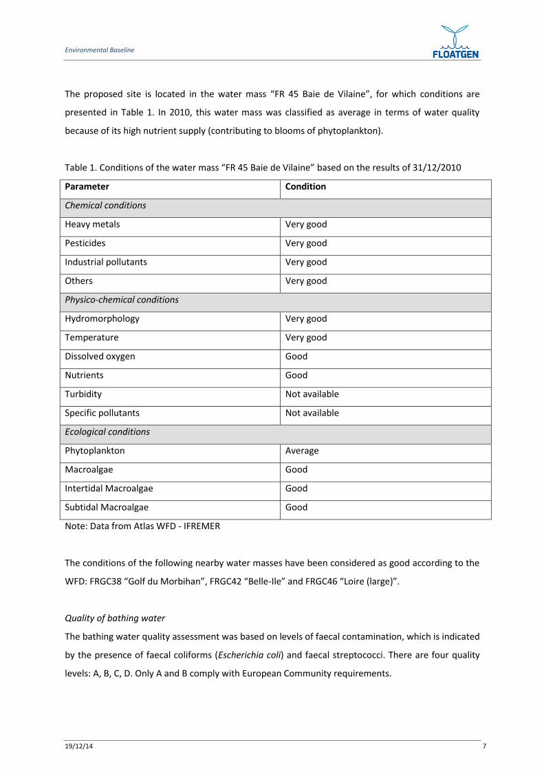
The proposed site is located in the water mass “FR 45 Baie de Vilaine”, for which conditions are
presented in Table 1. In 2010, this water mass was classified as average in terms of water quality
because of its high nutrient supply (contributing to blooms of phytoplankton).
Table 1. Conditions of the water mass “FR 45 Baie de Vilaine” based on the results of 31/12/2010
Parameter Condition
Chemical conditions
Heavy metals Very good
Pesticides Very good
Industrial pollutants Very good
Others Very good
Physico-chemical conditions
Hydromorphology Very good
Temperature Very good
Dissolved oxygen Good
Nutrients Good
Turbidity Not available
Specific pollutants Not available
Ecological conditions
Phytoplankton Average
Macroalgae Good
Intertidal Macroalgae Good
Subtidal Macroalgae Good
Note: Data from Atlas WFD - IFREMER
The conditions of the following nearby water masses have been considered as good according to the
WFD: FRGC38 “Golf du Morbihan”, FRGC42 “Belle-Ile” and FRGC46 “Loire (large)”.
Quality of bathing water
The bathing water quality assessment was based on levels of faecal contamination, which is indicated
by the presence of faecal coliforms (Escherichia coli) and faecal streptococci. There are four quality
levels: A, B, C, D. Only A and B comply with European Community requirements.
Environmental Baseline
19/12/14 8
Between 2008 and 2011, with the exception of one site (Les Sables Menus, in 2011) classified as B,
the quality of all the nearest bathing water sites was classified as A, indicating that the quality of the
bathing water near the proposed site is good.
Water quality for mollusc farming areas
The quality of water for mollusc farming areas is based on microbiological and chemical criteria. The
chemical criteria relate to the concentration of mercury, cadmium and lead in the shellfish.
For the départements of Loire-Atlantique and Morbihan, water quality for mollusc farming areas was
determined by the prefectoral orders 31 December 2009 and 17 February 2010 respectively. The
former one indicates a water quality considered as average whereas the latter indicates a water
quality considered as good.
Salinity
According to the website PREMIVER (www.premiver.org), salinity at the proposed site does not
fluctuate much throughout the year. It is characteristic of oceanic water, ranging between 33 and 35
practical salinity units (PSU). However, salinity can decrease following severe rainfall/ floods (mostly
caused by the Loire River) during winter. The difference in terms of salinity between the seabed and
sea surface is minimal.
Turbidity
Turbidity at the proposed site is low, ranging between 1 and 3 mg/l. However, as for the salinity,
turbidity is flood dependent and can reach up to 20 mg/l after heavy floods.
4.2 BIOLOGICAL ENVIRONMENT
4.2.1 BENTHIC COMMUNITIES AND HABITATS
According to the mapping of benthic communities conducted by M. Glemarec (1969), the following
habitats and communities are present in the vicinity of the SEMREV site:
- coastal sand with Ophelia borealis and Abra prismatica (at the SEMREV site)
- clean gravels with Branchiostoma Ianceolatum and Venus fasciata around the proposed site
- fine sands with Amphiura filiformis and Tellina serrata less than 1km from the proposed site
Environmental Baseline
19/12/14 9
- Sea-pen and burrowing megafauna communities (including Virgularia tuberculata)
approximately 3 km NNW of the proposed site. This habitat is protected by OSPAR (Oslo/Paris
convention for the Protection of the Marine Environment of the North-East Atlantic).
The proposed site is located within a licenced zone named “Capella” which is a scallop bed.
A survey on benthic communities, covering the proposed site, was conducted in June 2009 by
CREOCEAN. Based on the results at two of the monitoring sites (sites E and F), which are the nearest
to the proposed site, the diversity of the benthic communities is high (between 26 and 30 species per
site), though abundance is low (between 102 and 124 individuals /m2). The benthos was dominated
by annelid worms, mostly Nephthys longosetosa and Lumbriconeris latreilli. The low levels of
sediment transport in the area around the proposed site provide conditions which aloow stable
benthic communities to develop. No unique species have been identified from the area.
4.2.2 MACRO ALGAE
As part of obligations under the Water Framework Directive, monitoring surveys for subtidal macro
algae have been conducted. The site “plateau du Four” located in the water mass “FR 45 Baie de
Vilaine”, approximately 9.5 km from the SEMREV site shows an EQR (Ecological Quality Ratio) of 0.68
which indicates a good condition for the subtidal macro algae. Algal diversity is low and there are few
species. In addition, some opportunistic species are present in high density.
4.2.3 FISHERY
Each year fishery potential is evaluated by IFREMER (French Research Institute for Exploitation of the
Sea) during the EVHOE (evaluation of fisheries resources in Western Europe) surveys. These surveys
show that the principal species of fish in the vicinity of the proposed site are bass, black sea bream,
blue whiting, horse mackerel, mackerel, sardine, sprat, lesser spotted dogfish and plaice. Cuttlefish
and various species of ray are also found in the area. Edibile crab and spider crabs are commercially
exploited crustacean species caught in the area. In terms of spatial distribution, the most widespread
and abundant commercial species in the area are the blue whiting, black sea beam, common bass
and sardine.
The SEMREV site is not within a nursery area for species of commercial interest, though spawning
aggregations of adults have been observed in the area.
Environmental Baseline
19/12/14 10
4.2.4 MARINE MAMMALS
Information on marine mammals was obtained from the CRMM (Research Centre for Sea Mammals)
of La Rochelle University (data on strandings and sightings) collected as part of an offshore wind farm
project). 2,879 marine mammal strandings, of which 2,735 were cetacean species, were recorded
between 1971 and 2009.
The principal species which have been observed near the SEMREV site are common dolphin,
bottlenose dolphin and pilot whale. While they have been recorded all year round, none of these
species are considered to be resident.
4.3 SOCIO-ECONOMIC ENVIRONMENT
4.3.1 COMMERCIAL SHIPPING
Commercial shipping in the area is almost entirely and directly associated with the activity of the
Grand Port Maritime de Nantes – Saint-Nazaire (GPMNSN) which is the premier harbour complex of
the Atlantic Coast in France. Consisting of various sites distributed all along the estuary including
Saint-Nazaire, Montoire-de-Bretagne and Donges, the GPMNSN has links to 400 harbours around the
world. Each year, more than 3,000 merchant ship port-calls are recorded at the GPMNSN. Marine
transport related to energy (crude oil and refined products, LNG (Liquefied Natural Gas) and
charcoal) represented two thirds of the total external traffic in 2010. The GPMNSM has been
responsible for the creation of more than 26,000 jobs in the regions of Western France as a whole.
As such, although no recognised routes cross the SEMREV site, the following types of ship are likely
to be observed near it:
- Sand dredgers heading towards the Loire River and the north of the Bay of Biscay (Lorient,
Brest). Those sailing towards or from Lorient pass within 1 km of the proposed site whereas
those sailing towards or from Brest pass within 6 km of the proposed site;
- Ships sailing north-west to reach harbours of Lorient and Brest pass within 17.5 km, south-west
of the proposed site;
Environmental Baseline
19/12/14 11
- Commercial vessels (about 25 vessels each year) that moor to the east of Belle-Ile during bad
weather. These vessels are relatively small (between 70 and 120 m in length), and pass within 4
km, to the south-west of the proposed site;
- The oil tanker “Anatife”. Twice a year this vessel passes within 3 km of the proposed site.
4.3.2 COMMERCIAL FISHING
In 2010, there were 172 fishing boats in the département of Loire-Atlantique, of which 136 were less
than 12 m in length. There were 523 registered fishermen.
In 2008, 479 vessels were fishing in the area 23E7, which includes the proposed site. These were
coastal vessels (less than 12m in length) which spend 75% of their time in areas within 12 nautical
miles of the coast. Principal fishing practices used by these vessels are:
- Netting (glass eels) which takes place in winter
- Trawling (sole) which takes place in autumn/winter
- Nets (sole), dragging (mussels and scallops), long lining and pot fishing which take place all year
around.
Based on information from CRPMEM (Regional Committee of fisheries and fish farming of Pays de
Loire region), the proposed site is frequented by fishing vessels coming from the harbours of Croisic
and Turballe. These are part of the maritime quarter of Saint-Nazaire. However, there are also a few
fishing boats in the area from Lorient. Drift netters of Noirmoutier come to the area when fishing for
sole.
4.3.3 RECREATIONAL FISHING
Recreational fishermen from the harbours of Croisic, Batz-sur-Mer and Turballe fish in the area,
mostly between May and September. During the cuttlefish season (between July and September), up
to 30 boats per day can be observed in the vicinity of the plateau du Four.
4.3.4 RECREATIONAL BOATING
An estimated 4,000 boats sail off the coast of département of Loire-Atlantique each year between
Quiberon Bay and the harbour of Herbaudière (island of Noirmoutier) and between the two islands
Environmental Baseline
19/12/14 12
Ile d’Yeu and Belle Ile. Therefore, the SEMREV site is likely to be crossed by recreational boats
following the sailing routes below:
- Belle-Ile – Le Pouliguen – Pornichet
- Belle-Ile – Noirmoutier. This route pass within 2 km south of the proposed site
- Houat – Hoedic – Noirmoutier
The coast of the département of Loire-Atlantique has the following infrastructure intended for
recreational boating and other water sports:
- The harbour of La Baule – Le Pouligen
- Batz-sur-mer
- Recreational harbour of Croisic
- Recreational harbour of La Turballe
Boats that sail from these harbours are likely to be observed near the proposed site, especially in the
summer and during spring week-ends.
In addition, the proposed site is located between two Bays which are well suited to recreational
boating:
- Quiberon Bay with the Gulf of Morbihan and the Vilaine river provides 7,000 moorings
- Bassin de la Rochelle
4.3.5 TOURISM
With a coastal length of 133 km, 68 km of which are beaches, the département of Loire-Atlantique
attracts a lot of French tourists, mostly during summer, especially August. While the peninsula of
Guérande represents the principal tourist attraction with 13 million overnight stays per year, the
northern part of the coast, with its many harbours, provides a lot of potential for recreational
boaters.
Given these conditions, it is therefore not surprising that the tourism sector plays an important role
in the local economy. The sector represents about 20,400 jobs with a turnover of 1.6 billion Euros.
5. ENVIRONMENTAL COMMITMENTS
The EIAs produced from the SEMREV site provide generic environmental commitments to which
those companies planning to use the test site should adhere. The following environmental
Environmental Baseline
19/12/14 13
commitments are summarised from the report: SEMREV Test Site Requirements (Deliverable nº:
D4.5, 15 November 2014), more detail can be provided in that deliverable on both environmental
and engineering requirements for any device being test on the site.
The Developer must:
• allow the Organisation (SEMREV) to carry out the necessary measurements at/ nearby the
marine energy convertor
• identify any prototype specificity that could lead to an environment modification
• implement further measurement if the survey highlights an unacceptable impact which was
initially underestimated.
IFREMER recommended2 a post-experiment survey to be carried out after the prototypes have been
removed in order to identify and understand the way the marine environment had changed/
responded (or not) following the 2-3 years experimentation phase.
The Maritime Prefecture3 considers that it is not sufficient to assess only noise, electromagnetism
and scouring, and that a wider survey program will have to be defined, taking into account
hydrodynamics, sediments transport, flora, fauna, fouling, etc. Accordingly, a SEMREV environmental
management plan (marine energy convertor plus SEMREV infrastructures) is being developed to
include a range of factors such as acoustics, electromagnetic fields, wildlife surveys, water quality,
etc. The surveys which are to be undertaken as part of the environmental management plan are
intended to enhance the understanding of the marine environment and of the test site impacts on
fauna and flora and will be described further in deliverable D7.7 (within the scope of work for WP7).
The analysis of the acoustic impact of the marine energy convertor on the marine organisms must be
carried out. An acoustical measurement campaign will therefore be performed by the Organisation
using hydrophones located on the test site equipment (prototypes and/or instrumentation buoys).
The noise levels will be compared against baselines.
Measurement of additional cable parameters (including temperature, and electrical and magnetic
fields, or EMF) is critical as little is known about their potential effects (such as attraction, repulsion,
or barrier effect in fish migration).
The Environmental Authority4 considers that the landscape impact is acceptable (due to the distance
of the test site from the shore and to the height of the prototypes) and that the platform being
2 Institut Français de Recherche pour l’Exploitation de la MER, quoted in SEM-REV Test Site Requirements
(Deliverable nº: D4.5, 15 November 2014) 3 PREMAR 15/04/2013
4 Direction Régionale de l’Environnement, de l’Aménagement et du Logement, DREAL 12/02/2011 &
28/05/2013
Environmental Baseline
19/12/14 14
visible from land and sea constitutes an opportunity for measuring in situ the landscaping integration
acceptability of the offshore wind turbines.
The Developer is responsible for the design of the mooring system for the marine energy convertor
(different mooring types can be considered and the chosen one must result in the least impact upon
flora/fauna and hydrodynamics5 and the Organisation will verify the technical conformity. However,
if local scouring is expected at the bottom of the large mooring structures (gravity based anchors),
the Developer shall assess the risk of scouring at the foot of the mooring structure.
In addition, the marine energy convertor (MEC) Developer shall provide a list of all fluids on board,
permit testing of acoustic transmission frequency and power estimates, respect the height above the
sea level, the maximum blades velocity and the type and dimensions of moorings.
In accordance with the ‘Concession d’utilisation du Domaine Public Maritime’, the products and
materials used on site (i.e., fluids, paints anti-fouling, anti-corrosion products…) shall comply with
current standards. The Developers are expected to demonstrate that their products are non-toxic
(bio degradable) in the marine environment.
In case of an incident during operation likely to lead to accidental pollution, the operation
coordinator (under the Developer responsibility) shall immediately take the necessary measures in
order to limit its effect on the environment, and to avoid the repetition of the incident. The water
policy service and “Le Croisic” municipality shall be informed within 24 hours of this incident and the
mitigation measures which have been taken.
6. FURTHER WORK
Further work on environmental commitments, within environmental management plans for the
floating concept, will be carried out during later stages of the Scope of Work for WP7. The plan will
be specific for the selected concept, and the commitments will be developed to ensure that
environmental impacts are reduced as far as possible.
5 Dossier de demande d’autorisation. Authorization to extend the SEMREV test site to the use of Floating Wind
Turbines (CREOCEAN june 2012), page 260.