Embed Size (px)
Citation preview
Lake Macquarie Transport Interchange
Stage 1 – Section 2
Review of Environmental Factors
Document No. LMTI‐REP‐REF‐001‐02
For: Lake Macquarie City Council
MARCH 2016
Lake Macquarie Transport Interchange 30011465 | March 2016 Page | i
EXECUTIVE SUMMARY
The proposal
The Lake Macquarie Transport Interchange (LMTI) is strategically important for the Hunter Region
and is aimed at encouraging public transport use, reducing car dependency and providing economic
and community benefits to Lake Macquarie and the Lower Hunter.
The Glendale‐Cardiff area is one of the largest employment zones in the region and significant
growth is predicted over the next 20 years. The LMTI project will service the demand associated with
this growth through improved transport links while achieving improved environmental outcomes.
The LMTI comprises two parts:
Stage 1 being the road works and associated infrastructure, including a bridge over the rail line
(Pennant Street flyover bridge). Stage 1 is divided into two sections; and
Stage 2 being the railway station and bus/passenger interchange facility.
A Review of Environmental Factors (REF) for Stage 1 was prepared by SMEC in July 2014 to address
the environmental impacts of both Sections 1 and 2 of Stage 1 of the project. Lake Macquarie City
Council (LMCC) approved Section 1 based on the REF as submitted. This REF has been prepared to
specifically address the potential impacts associated with Section 2 of Stage 1 of the LMTI to assist
the rail authorities in assessing the impacts of the proposal on the rail line and rail operations.
Need for the proposal
The LMTI presents an opportunity to integrate a number of modes of transport which will assist in
unlocking the economic potential of the nearby industrial and commercial areas of Glendale and
Cardiff. The LMTI will be a cornerstone piece of infrastructure, which will realise the vision of the
Glendale area developing into a new regional centre. The LMTI will encourage more investment in
the area and support the intensification of land use surrounding Glendale. The LMTI will provide a
number of social benefits to the local community including improved access to public transport,
improved pedestrian and bicycle connectivity and improvements in community, entertainment,
sporting, recreation and retail facilities.
Lake Macquarie City Council (LMCC) has obtained funding for a section of the LMTI which
demonstrates the commitment to this proposal at various levels of government. The proposal is also
needed to support the objectives of the regional and state strategic plans relevant to the Lake
Macquarie area.
The LMTI Section 2 proposal is an important part of the overall LMTI project as it provides access
over the railway corridor, providing connectivity between Cardiff and Glendale.
Options considered
A number of options were considered during the concept development phase of the proposal. Four
options were considered as part of a Value Management Workshop undertaken in May 2013. All
options considered included the extension of Stockland Drive, connection to Main Road, access to
the Downer site and extension of Pennant Street over the rail corridor.
Lake Macquarie Transport Interchange 30011465 | March 2016 Page | ii
The extension of Pennant Street over the rail corridor is within the LMTI Section 2 and involved
consideration of four bridge types.
Consideration of various criteria including impacts to heritage, ecology, stakeholders,
constructability and cost was undertaken as part of the workshop. The option which was adopted
scored highest against the proposal objectives and was selected to progress to the detailed design
phase.
Statutory and planning framework
Clause 94 of State Environmental Planning Policy (Infrastructure) 2007 defines the proposal as
development that is permissible without consent. As such it is subject to assessment under Part 5 of
the Environmental Planning and Assessment Act 1979. Consideration has been given to relevant
environmental planning instruments and other potentially relevant legislation. Consideration has
also been given to the provisions of the Commonwealth Environment Protection and Biodiversity
Conservation Act 1999 (EPBC Act) and no requirement for a referral under this Act was identified.
Community and stakeholder consultation
This REF will be placed on public exhibition for comment. All submissions received will be reviewed
and considered in the review and determination of the REF. Ongoing consultation will also occur
during the construction phase with contact details of the contractor to be made publicly available.
This will allow construction‐related issues to be raised and addressed. A telephone information line
will also be established.
Environmental impacts
Biodiversity
The broader LMTI study area has been subject to a number of ecological surveys in the past. These
surveys identified six threatened fauna species and two flora species within the locality. Tall Alluvial
Forest which comprises the Endangered Ecological Community River‐flat Eucalypt Forest on Coastal
Floodplains of the NSW North Coast, Sydney Basin and South East Corner Bioregions (RFEFCF) is also
predominant in the area.
The LMTI Section 2 proposal area is located to the south of the vegetated areas associated with
Winding Creek and comprises predominantly cleared and disturbed land. It does not support any
habitat suitable for the threatened flora and fauna species or ecological communities previously
recorded in the broader LMTI study area.
The LMTI Section 2 does not involve the clearing of vegetation communities and would not have an
impact on threatened flora and fauna species, populations or ecological communities.
Traffic, transport and access
Main Road is the main arterial road in proximity to the study area. It provides part of the link
between the M1 Motorway, the Hunter Expressway and the areas of Glendale and Cardiff.
Pennant Street is a two lane road in the southern part of the LMTI Section 2 proposal area providing
access from Munibung Road to areas of the Cardiff Industrial estate. Pennant Street currently
Lake Macquarie Transport Interchange 30011465 | March 2016 Page | iii
terminates at two properties owned by Bendlink adjoining the railway corridor. The LMTI will tie in
with Pennant Street via a rail overpass. Pennant Street currently experiences relatively low traffic
volumes.
The majority of proposed works in Section 2 are ‘greenfield’ and are not expected to have a direct
impact on existing traffic in the area. The construction site will be accessed from Pennant Street and
some additional construction traffic will be apparent. Construction traffic impacts will be temporary
and will be managed through the implementation of a Traffic Management Plan (TMP). Access to the
Downer site, the electrical substation and the Bendlink properties would be maintained during
construction.
Most of the work associated with the construction of the Pennant Street Bridge would be
undertaken outside the railway possession times, with only the essential works within the railway
corridor to be undertaken within the possession times.
During operation, the LMTI proposal is not expected to have an impact on the railway corridor or on
train schedules, and it will provide a safer and more efficient road network for motorists, better
connectivity between Glendale and Cardiff, and the infrastructure necessary for the Stage 2 works.
Noise and vibration
A quantitative assessment of the potential noise impacts of the overall LMTI project on the nearest
residents from construction activities was undertaken. The assessment predicted likely impacts
when multiple plant and equipment were operating in proximity to residential areas. A number of
measures are recommended to minimise construction noise impacts where feasible. Potential noise
impacts during construction would be managed in accordance with a Construction Noise and
Vibration Management Plan (CNVMP).
The noise assessment also determined the potential impact to nearby residents resulting from the
operation of the new road. The assessment recommended architectural modifications to the subject
dwellings to ameliorate potential operational impacts to affected residents. LMCC is liaising with the
affected landowners in this regard, although none of the affected landowners relate directly to the
proposed LMTI Section 2 works (ie they are in the Section 1 impact area).
The vibration implications of the project were assessed and a management plan developed to inform
the construction activities (refer to Appendix F).
Hydrology and water quality
Winding Creek, located to the north of the Section 2 proposal area, is the main waterway that occurs
within the study area. There are no creeks within the Section 2 proposal area. An existing overland
flow path occurs to the west of the western Bendlink property and will not be impacted by the
proposal. The roads and bridge will drain into the existing stormwater system. There is adequate
capacity in the existing system to cater for the minor increase in flows from this component of the
LMTI. The proposal will not change the drainage regime.
Hydraulic studies undertaken for the LMTI indicate that the area mapped for the 1% AEP event does
not include any areas of LMTI Section 2 so there will be no impacts on the flooding of Winding Creek
due to LMTI Section 2.
Lake Macquarie Transport Interchange 30011465 | March 2016 Page | iv
The likelihood of material impacts on water quality during operation is considered low.
Hazardous materials
The LMTI proposal area was subject to a preliminary environmental site assessment (PESA) to
determine the likely presence of any hazardous or contaminated materials. Area 1 (Pennant Street
on the southern side of the railway corridor) and Area 2 (rail yard stockpile on the northern side of
the railway corridor) are located within the LMTI Section 2 proposal area. The assessment identified
that Areas 1 and 2 contained petroleum hydrocarbons, heavy metals, asbestos, ground gas and
aggressive substances such as solvents. A Fill Reuse Management Plan (FRMP) and a Soil and Water
Management Plan (SWMP) have been prepared to manage any potential impacts associated with
the disturbance of these materials.
Aboriginal heritage
The area around Winding Creek, to the north of the LMTI Section 2 proposal area, has been
identified as an area of potential archaeological sensitivity. An isolated find was identified at the
northern end of the Section 2 proposal area and is covered by an Aboriginal Heritage Impact Permit
issued to LMCC by the Office of Environment and Heritage (OEH). Archaeological excavation and
salvage, and community collection works were undertaken in accordance with Aboriginal Heritage
Impact Permit (AHIP) #C0000418. Despite all ground surfaces being inspected, no Aboriginal cultural
heritage objects were recovered from the registered locations. There are no registered locations
within the Section 2 works area.
Non‐Aboriginal heritage
The Cardiff Railway Workshops and the Great Northern Railway are listed on the heritage schedule
of the LMCC Local Environment Plan 2014 (LEP). The Great Northern Railway is also listed on
RailCorp’s Section 170 Heritage and Conservation Register. The proposal would not have an impact
on the Cardiff Railway Workshops. The Pennant Street Bridge would be constructed over the railway
corridor, with two bridge piers constructed on either side of the railway lines. The railway lines
would not be impacted and work would be undertaken in such a manner to minimise disturbance
within the railway corridor. The Sydney Trains heritage division is aware of the proposal.
Justification and conclusion
Construction of the LMTI would improve connectivity in the Glendale area and improve public
transport, therefore reducing reliance on private vehicles. The LMTI is strategically located to the
heavy rail network, M1 Motorway, the Hunter Expressway and the Port of Newcastle, therefore
providing improved access to markets throughout the state.
Potential environmental impacts associated with the LMTI Section 2 proposal have been identified.
These include construction and operation noise and vibration, biodiversity impacts, water quality
and traffic and Aboriginal heritage. Where possible, impacts have been minimised during design
development to limit the impact once works are complete. Management measures have been
identified to mitigate impacts during construction. On balance, the benefits derived from proceeding
with the proposal are considered to outweigh the potential impacts. It is therefore considered
justified.
Lake Macquarie Transport Interchange 30011465 | March 2016 Page | v
TABLE OF CONTENTS
1 Introduction ................................................................................................................................ 1
1.1 Proposal identification .................................................................................................. 1
1.2 Purpose of the report .................................................................................................... 1
2 Need and options considered ..................................................................................................... 4
2.1 Strategic need for the proposal .................................................................................... 4
2.2 Existing road and infrastructure .................................................................................... 8
2.3 Proposal objectives ....................................................................................................... 9
2.4 Alternatives and options considered .......................................................................... 10
2.5 Preferred option .......................................................................................................... 15
2.6 Design refinements ..................................................................................................... 15
3 The proposal ............................................................................................................................. 16
3.1 The proposal ................................................................................................................ 16
3.2 Design criteria ............................................................................................................. 16
3.3 Major design features ................................................................................................. 17
3.4 Construction activities ................................................................................................. 19
3.5 Ancillary facilities ......................................................................................................... 22
3.6 Public utility adjustments ............................................................................................ 23
3.7 Urban design and landscaping .................................................................................... 25
3.8 Property acquisition .................................................................................................... 26
4 Statutory planning framework ................................................................................................. 27
4.1 State and environmental planning policies ................................................................. 27
4.2 Local environment plans and strategies ..................................................................... 27
4.3 Other relevant legislation ............................................................................................ 28
4.4 Commonwealth legislation.......................................................................................... 30
4.5 Confirmation of statutory position ............................................................................. 31
5 Stakeholder and community consultation ............................................................................... 32
5.1 Consultation strategy .................................................................................................. 32
Lake Macquarie Transport Interchange 30011465 | March 2016 Page | vi
5.2 Community involvement ............................................................................................. 32
5.3 Aboriginal stakeholders ............................................................................................... 32
5.4 ISEPP consultation ....................................................................................................... 33
5.5 Government and stakeholder involvement ................................................................ 33
6 Environmental assessment ....................................................................................................... 37
6.1 Biodiversity .................................................................................................................. 37
6.2 Traffic, transport and access ....................................................................................... 40
6.3 Noise and vibration ..................................................................................................... 46
6.4 Hydrology .................................................................................................................... 54
6.5 Water quality ............................................................................................................... 57
6.6 Soils and geology ......................................................................................................... 59
6.7 Hazardous materials .................................................................................................... 60
6.8 Aboriginal heritage ...................................................................................................... 64
6.9 Non‐Aboriginal heritage .............................................................................................. 68
6.10 Socio economic and land use ...................................................................................... 71
6.11 Air quality .................................................................................................................... 75
6.12 Waste management and resource efficiency .............................................................. 76
6.13 Summary of beneficial effects ..................................................................................... 77
6.14 Summary of adverse effects ........................................................................................ 77
6.15 Cumulative impacts ..................................................................................................... 77
7 Environmental management .................................................................................................... 79
8 Conclusion ................................................................................................................................ 87
8.1 Justification ................................................................................................................. 87
8.2 Ecologically sustainable development ........................................................................ 88
8.3 Conclusion ................................................................................................................... 89
9 Certification .............................................................................................................................. 91
10 References ................................................................................................................................ 92
Lake Macquarie Transport Interchange 30011465 | March 2016 Page | vii
Appendices
A Clause 228 Factors
B Concession Application
C Matters of National Environmental Significance
D Corridor Access Plan
E RCA Acoustics Construction and Traffic Noise Report
F VIPAC Noise and Vibration Management Plan
G Hydraulic and Flooding Impacts Assessment
H Preliminary Environment Site Assessment
I Fill Reuse Management Plan
J ERM Aboriginal Heritage Assessment
K RPS Aboriginal Heritage Assessment 2014 and Aboriginal Heritage Impact Permit
L Nexus Non‐Aboriginal Heritage Assessment
M LMTI Economics Report
Tables
Table 1 Key sections of relevance to the LMTI ............................................................................. 5
Table 2 Concept Design Alignment Options .............................................................................. 10
Table 3 Overall Score– Alignment Options ................................................................................ 13
Table 4 Design Vehicles .............................................................................................................. 17
Table 5 Bus Stop Locations – Section 2 ...................................................................................... 18
Table 6 Earthworks requirements.............................................................................................. 22
Table 7 Utilities affected by the LMTI Section 2 ........................................................................ 24
Table 8 Utility Companies Contacted by LMCC .......................................................................... 24
Table 9 Land Use Zones in LMTI study area ............................................................................... 27
Table 10 Stakeholder Key Issues .................................................................................................. 34
Table 11 Rating Background Levels .............................................................................................. 46
Table 12 Noise management goals .............................................................................................. 48
Table 13 Project specific ICNG management levels ..................................................................... 49
Lake Macquarie Transport Interchange 30011465 | March 2016 Page | viii
Table 14 Plant and sound power levels ....................................................................................... 49
Table 15 Human comfort criteria ................................................................................................. 50
Table 16 BS 7385 Transient vibration guide for cosmetic damage .............................................. 50
Table 17 Permissible velocities for the assessment of short term vibrations in buildings
according to DIN 4150 ................................................................................................... 51
Table 18 Road traffic noise assessment criteria for residential land uses ................................... 52
Table 19 Potential AECs and contaminant types in Section 2 ..................................................... 63
Table 20 Proposed safeguards and management measures ....................................................... 80
Table 21 Consideration of objectives of the EP& A Act ............................................................... 87
Figures
Figure 1 Site Location .................................................................................................................... 3
Figure 2 Alignment Options ........................................................................................................ 12
Figure 3 Potential Sites for Site Compounds/Parking/Stockpiling .............................................. 23
Figure 4 Vegetation map of the overall LMTI study area ............................................................ 38
Figure 5 Road network – primary intersections .......................................................................... 43
Figure 6 Stick diagrams – 2013 existing traffic ............................................................................ 44
Figure 7 Stick diagrams – 2020 (Glendale Drive/Stockland Drive extension) ............................. 44
Figure 8 Noise Monitoring Locations .......................................................................................... 47
Figure 9 Location of Areas 1 and 2 within the LMTI Section 2 proposal area ............................. 62
Figure 10 RPS Field Survey 2014 ................................................................................................... 67
Figure 11 Indigenous and Non Indigenous Heritage Areas ........................................................... 69
Lake Macquarie Transport Interchange 30011465 | March 2016 Page | ix
GLOSSARY
ABS Australian Bureau of Statistics
ACHCR Aboriginal Cultural Heritage Consultation Requirements
AEC Area of Environmental Concern
ADTOAC Awabakal Descendants Traditional Owners Aboriginal Corporation
AEP Annual Exceedance Probability
AHD Australian Height Datum
AHIMS Aboriginal Heritage Information Management System
AHIP Aboriginal Heritage Impact Permit
AQMP Air Quality Management Plan
ARI Average Recurrence Interval
AS Australian Standard
ASA Australian Standards Association
BS British Standard
CEMP Construction Environment Management Plan
CLM Act Contaminated Land Management Act 1997
CNVMP Construction Noise and Vibration Management Plan
CoRTN Calculation of Road Traffic Noise
CSM Conceptual Site Model
dB Decibel
DBYD Dial Before You Dig
DECC Department of Environment and Climate Change
DECCW Department of Environment, Climate Change and Water
DPI Department of Primary Industries
DSS Detailed Site Services
EEC Endangered Ecological Community
Lake Macquarie Transport Interchange 30011465 | March 2016 Page | x
EIS Environmental Impact Statement
EPA Environment Protection Authority
EP&A Act Environmental Planning and Assessment Act 1979
EPBC Act Environment Protection and Biodiversity Conservation Act 1999
EPL Environment Protection Licence
ESCP Erosion and Sediment Control Plan
ESD Ecologically Sustainable Development
FM Act Fisheries Management Act 1994
FRMP Fill Reuse Management Plan
FTE Full Time Equivalent
HDC Hunter Development Corporation
HWC Hunter Water Corporation
ICNG Interim Construction Noise Guideline
INP Industrial Noise Policy
ISEPP State Environmental Planning Policy (Infrastructure) 2005
KTP Key Threatening Process
LALC Local Aboriginal Land Council
LEP Local Environment Plan
LGA Local Government Area
LHRS Lower Hunter Regional Strategy
LHTM Lower Hunter Transport Model
LMCC Lake Macquarie City Council
LMDCP Lake Macquarie Development Control Plan
LMTI Lake Macquarie Transport Interchange
LOR Limit of Reporting
MSB Mine Subsidence Board
Lake Macquarie Transport Interchange 30011465 | March 2016 Page | xi
MSDS Material Safety Data Sheet
NES (matter of) National Environmental Significance
NPW Act National Parks and Wildlife Act 1974
NPWS National Parks and Wildlife Service
NSW New South Wales
NW Act Noxious Weeds Act 1993
NZS New Zealand Standard
OD Origin‐Destination (matrix)
OEH Office of Environment and Heritage
OSD On‐site Detention
PEMP Project Environmental Management Plan
PESA Preliminary Environmental Site Assessment
PMF Probable Maximum Flood
POEO Act Protection of the Environment Operations Act 1997
PSC Pre‐stressed Concrete
RBL Rating Background Level
RDA Regional Development Australia
REF Review of Environmental Factors
RFEFCF River‐flat Eucalypt Forest on Coastal Floodplains of the NSW North Coast, Sydney Basin and South East Corner Bioregions
RMS Roads and Maritime Services
RSW Rammed Soil Wall
RTA Roads and Traffic Authority (former)
SEPP State Environmental Planning Policy
SIS Species Impact Statement
SoHI Statement of Heritage Impact
SWMP Soil and Water Management Plan
Lake Macquarie Transport Interchange 30011465 | March 2016 Page | xii
TMP Traffic Management Plan
TPH Total Petroleum Hydrocarbons
TSC Act Threatened Species Conservation Act 1995
UST Underground Storage Tanks
VFM Value for Money
WARR Act Waste Avoidance and Resource Recovery Act 2001
WMP Waste Management Plan
Lake Macquarie Transport Interchange 30011465 | March 2016 Page | 1
1 INTRODUCTION
1.1 Proposal identification
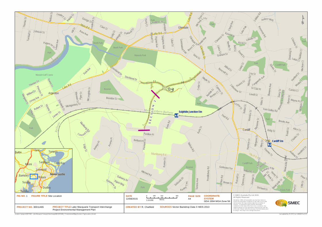
The proposed Lake Macquarie Transport Interchange (LMTI) is located in the suburb of Glendale, in
the Lake Macquarie local government area (LGA) in the Lower Hunter Region of New South Wales
(NSW). The location of the LMTI is provided in Figure 1.
The LMTI comprises two stages:
Stage 1 (Sections 1 and 2), being the road works and associated infrastructure, including a
bridge over the rail line (Pennant Street Bridge); and
Stage 2, being the railway station and bus/passenger interchange facility.
A Review of Environmental Factors (REF) for Stage 1 was prepared by SMEC Australia Pty Ltd (SMEC)
in July 2014 to address the environmental impacts of Sections 1 and 2. Lake Macquarie City Council
(LMCC) approved Section 1 based on the REF as submitted. Approval of Section 2 was deferred until
further detail was available regarding the proposal within the railway corridor.
This REF has been prepared to specifically address the potential impacts associated with Section 2 of
the LMTI (LMTI Section 2).
1.2 Purpose of the report
This REF has been prepared by SMEC on behalf of LMCC. For the purpose of this proposal, LMCC is
the proponent and a determining authority under Part 5 of the Environmental Planning and
Assessment Act 1979 (EP&A Act).
This REF describes the LMTI Section 2 proposal, describes and assesses the potential environmental
impacts, and identifies appropriate mitigation measures to minimise and manage these impacts.
Clause 228 of the Environmental Planning and Assessment Regulation 2000 outlines factors that
must be taken into consideration when an activity is to be determined under Part 5 of the EP&A Act.
This REF has been prepared with reference to these factors, so that LMCC will satisfactorily address
the requirements of Section 111 of the EP&A Act (refer to Appendix A). Under Section 111, a
determining authority must take into consideration ‘to the fullest extent possible all matter affecting
or likely to affect the environment by reason of the activity.’
The findings of the REF would be considered when assessing:
Whether the proposal is to have a significant impact on the environment and therefore the
necessity for an Environmental Impact Statement to be prepared and approval to be sought
from the Minister for Planning under Part 5.1 of the EP&A Act;
The significance of any impact on threatened species as defined by the Threatened Species
Conservation Act 1995 (TSC Act) and/or Fisheries Management Act 1994 (FM Act), in Section 5A
of the EP&A Act and therefore the requirement for a Species Impact Statement (SIS); and
The potential for the proposal to significantly impact a matter of national environmental
significance or Commonwealth land and the need to make referral to the Australian
Lake Macquarie Transport Interchange 30011465 | March 2016 Page | 2
Government Department of the Environment for a decision by the Commonwealth Minister for
the Environment on whether assessment and approval is required under the Environment
Protection and Biodiversity Conservation Act 1999 (EPBC Act).
Cardiff
Glendale
Argenton
Robert St
Lowry S
t
Reservoir Rd
Montgomery St
Mitchell Rd
Nelson Rd
Lachla
n Rd
Pendl
ebury R
d
Graham St
Frede r
ickSt
Clarence S
t
Harris
on St
Alfred St
Clare St
Thomas St
Fern Valley Rd Wansbec
k Valle
y Rd
Taylor St
Murra
y Rd
Glend ale Dr
Delasala Dr
Neilso
n St
Lovell St
Torren
s Ave
Cedar
St
A ruma P
l
William St
Kelton
St
Pearce St
Edge St
L ongworth Ave
Russe
ll St
Lilian St
McInty
re St
Laurel
Ave
Alice St
Henry St
Jersey Ave
Hill St
Brown St
Karen Ave
Bruce St
Victoria St
Turnbu
ll St
Ranto
n St
Mary S
t
Norfolk S
t
Johnson St
Charles S
t
Penna
nt St
Roath
St
Dalmeny Dr
Vena St
Hartford S
t
Veroni
ca St
Amber Way
Nadria
n Cl
Ke nley Cres
Illawa
rra Av
e
Bancroft St
Rose Ave
McLau
ghlin S
t
Elizabeth St
Piper
StWaratah St
Impala St
Newc
astle S
t
Johnstone St
Sturt Rd
Munibung Rd
Park Ave
Queen St
Queen
s Ave
Carrick Cl
Michele Cres
Patterson St
Bent St
Vides
St
George St
Darcy
St
Lalor Pd
e
Orchard St
James St
Boston Cl
Co n cord St
Delaware Dr
Manu elStPoyner Ave
David St
Chery
l Ave
Princess St
Brooks Ave
Neville St
Stockland Dr
M ariann
e St
Ripon Way
Davies St
Stephens Ave
Gorleston Tce
Ascot St
Paul S
tHend
rick St
Fifth S
t
O akla nd St
Byron
St
Glendon Cres
Joy St
Cypress St
Railway Pde
Mac St
Greenwood Pde
Macle
an Cl
Maple St
Sean C
t
View St
Lindley St
Woden Cl
Wayne PlBrandon St
Lance St
Jubilee
Rd
Emily S
t
Dewra
ng St
Pavilion Pl
Bell St
Kirby St
Aminya
Pl
Belford Pl
Marga
retSt
Fe rnd al e St
Christina StPandel A
ve
Andrew St
Bank St
Labulla Pl
Fairleig
h St
Kurla S
tDurie
Rd
Parry Cl
St Clair Pl
Luton Cl
Margaret StMary St
Stockland Dr
Thomas St
Charle
s St
Laurel Ave
Newcastle S
t
Georg
e St
Thoma
s St
William St
Munibung Rd Myall Rd
Myall Rd
Main Rd
Lake Rd
Glendale D r
Lake R
d
Lake Rd
Cardiff Stn
Sulphide Junction StnMain Northern Railway
Railw
ay
Waratah Golf Course
Park
Park
Reserve
Park
Maneela Park
Booth ParkPark
Cardiff Park
Park
Reserve
Booth Park
Park
Park
Evans Park
Park
Cardiff Park
Park
© SMEC Australia Pty Ltd 2015.All Rights Reserved
PROJECT TITLE Lake Macquarie Transport InterchangeProject Environmental Management Plan
FIGURE TITLE Site Location DATE 12/08/2015
COORDINATE SYSTEMGDA 1994 MGA Zone 56
PROJECT NO. 30011465 CREATED BY R. Chatfield SOURCES Vector Backdrop Data © MDS 2013
PAGE SIZE A4
FIG NO. 1Disclaimer: While all reasonable care has been taken toensure the information contained on this map is up to dateand accurate, this map contains data from a number ofsources - no warranty is given that the informationcontained on this map is free from error or omission. Anyreliance placed on such information shall be at the sole riskof the user. Please verify the accuracy of all information priorto using it. This map is not a design document.
Location: I:\projects\30011465 - Lake Macquarie Transport Interchange\008 DATA\008_7 Environmental\Maps\Section 2 Figs\Location_A4.mxd
0 210 420105
Metres1:15,000
Last updated by: RC10721 on 12/08/2015 at 9:51
Newcastle
Tarro
Minmi
Tomago
Kotara
Dudley
Buttai
Toronto
Teralba
Jesmond
Sandgate Fern Bay
Barnsley
SE
CT
IO
N2
Lake Macquarie Transport Interchange 30011465 | March 2016 Page | 4
2 NEED AND OPTIONS CONSIDERED
2.1 Strategic need for the proposal
2.1.1 Lower Hunter Regional Strategy
The Lower Hunter Regional Strategy (LHRS), released in 2006, was developed to provide a strategic
direction and framework for the future growth and development of the Lower Hunter Region, which
encompasses a number of local government areas including Lake Macquarie. The strategy was
developed in recognition of the future population growth of the area and sought to identify key
initiatives and strategies to accommodate the future growth sustainably.
The regional strategy provides a land use planning framework over a 25 year period with a particular
focus on housing, environment, employment, infrastructure, urban development and infrastructure.
The Lower Hunter is the seventh largest regional area in Australia with the LHRS predicting a
population increase over the planning period of approximately 160,000 and the creation of 66,000
new jobs.
The LHRS identifies existing regional centres such as Newcastle, Charlestown and Maitland, and also
emerging major regional centres including Glendale. These areas have a high concentration of
businesses with a focus on large scale retail and services. The renewal corridors, including the
Glendale‐Cardiff Main Road area, are strategic corridors which will link growth centres and improve
opportunities for economic and urban development.
The Draft Hunter Regional Plan (NSW Government, 2015a) has been prepared along with a
companion document Draft Plan for Growing Hunter City (NSW Government, 2015b). The Draft
Hunter Regional Plan would replace the Lower Hunter Regional Strategy. Both these documents are
discussed below.
Draft Hunter Regional Plan
The NSW Government has developed a Draft Hunter Regional Plan (NSW Government, 2015a) that
outlines a vision, goals and actions for the sustainable growth of the Hunter region between now
and 2036. The Draft Hunter Regional Plan provides an overarching framework to guide development
and investment in the Hunter region to 2036. For the first time strategic planning for the Lower
Hunter, Upper Hunter and Great Lakes is consolidated in this plan. Once finalised the draft Plan will
replace current strategies and plans applying to the LGAs, including the LHRS. The Draft Hunter
Regional Plan outlines a vision, goals and actions that aim to:
Protect the region’s most important asset, the environment;
Grow and diversify the economy to create jobs;
Create thriving, liveable centres;
Deliver greater housing choice
Lake Macquarie Transport Interchange 30011465 | March 2016 Page | 5
In collaboration with councils, establish a committee to drive the coordination and delivery of
the actions in the Plan.
The LMTI is consistent with the Draft Hunter Regional Plan as it enhances the opportunities for the
growth of the Glendale regional centre by improving connectivity to the area.
Draft Plan for Growing Hunter City
A Draft Plan for Growing Hunter City (NSW Government, 2015b) was released as a companion to the
Draft Regional Plan, to reflect the City’s importance as the prime location for new jobs, housing and
regional level services, and how the metropolitan area would contribute to achieving the regional
goals outlined in the Draft Hunter Regional Plan.
The City has a number of assets including a pool of skilled workers, global gateways to international
markets, a strong and growing professional services sector, and a quickly developing knowledge
economy built on education and health services. Tourism and an arts, music and university
community also occur in the City. The Draft Plan for Growing Hunter City is a plan to capitalise on
these assets and to leverage greater economic and jobs growth, more housing, and better
environmental protection. It will be a major contributor to achieving the Draft Hunter Regional
Plan’s goals to grow and diversity the Hunter economy, to protect the environment, and to support
robust regional communities.
The Draft Plan for Growing Hunter City specifically mentions the LMTI, as noted in Table 1.
Table 1: Key sections of relevance to the LMTI
Lake Macquarie Transport Interchange 30011465 | March 2016 Page | 6
Key relevant sections of the Draft Plan Relevance of LMTI
Direction 1.1: Grow and diversity centres across the City
Strategic centres and transport gateways will be the City’s main locations for jobs and specialist service and is a focus of NSW Government investment in Hunter City. Each strategic centre or transport gate has now, or has the potential for a transport interchange. Providing interchanges at strategic centres, such as Glendale, is key to delivering a transport network in Hunter City that links people to jobs and services.
Action 1.1.1: Invest in strategic centres to grow jobs and housing and create vibrant hubs of activity
Providing interchanges at strategic centres, such as Glendale, is key to delivering a transport network in Hunter City that links people to jobs and services.
The delivery of the LMTI will improve regional and inter‐regional connections and would address Action 1.1.1 in the Plan. It will improve productivity and make this location (Glendale) more attractive to business and visitors.
Direction 4.1: Grow inner west areas
The Inner West District benefits from good access to a range of jobs and services in Wallsend, Glendale and Cardiff, as well as the University of Newcastle and John Hunter Hospital in the Inner Newcastle district. The ongoing success, competitiveness, liveability and sustainability of the district relies on supporting and strengthening links to these centres, providing ready access to employment and services.
Action 4.1.1: Improve connections to and within Glendale
Major infrastructure investment is occurring at Glendale, including the LMTI and associated road works to improve access to Hunter Sports Centre. Extensions to Pennant Street over the main northern railway line will create a new direct link between Glendale and Cardiff. Maximising links from new growth areas to centres will provide new communities with good access to jobs and services. It will assist centres to grow and change. Improved connectivity between Glendale and Cardiff will assist this outcome.
The LMTI will be a major connection between Glendale and Cardiff and important to meeting the future transport needs of the Lower Hunter Region.
The LMTI will be an integral component of achieving the vision for the Glendale area outlined in the
Draft Plan for Growing Hunter City, through the provision of a transport hub and providing improved
access to the industrial estate of Cardiff and other developable land in the Glendale area. The LMTI
Section 2 is an important component of the LMTI proposal, providing the connection over the
railway corridor from Cardiff in the south to Glendale in the north.
2.1.2 NSW 2021/Hunter Regional Action Plan
NSW 2021 is the State government’s plan over a 10 year period which identifies a number of
strategic actions integrating transport, land use and services throughout the State. The Hunter
Regional Action Plan is one of a number of regional action plans that have been developed to drive
implementation of NSW 2021 at the regional level.
The Hunter Regional Action Plan identifies four major priorities for the Hunter region, these being:
Drive economic growth and diversity;
Invest in critical infrastructure and integrated transport;
Lake Macquarie Transport Interchange 30011465 | March 2016 Page | 7
Improve the liveability of our City and regional areas; and
Better support the most vulnerable members of our community.
Investment in critical infrastructure is identified as being crucial in supporting future population and
employment growth, improve access to service hubs, increase road safety and travel efficiency. The
LMTI is one of three local road transport projects identified in the action plan which is considered
significant in achieving these objectives.
2.1.3 NSW State Infrastructure Strategy 2012‐2032
The NSW State Infrastructure Strategy 2012–2032 was released on 3 October 2012. The Strategy
builds on the NSW Government’s existing public commitments to seek future opportunities for
infrastructure investment. It outlines a forward program of more than 70 urban and regional
projects and reforms across transport, freight, aviation, energy, water, health, education and social
infrastructure that should take priority over the next five, 10 and 20 years. The LMTI is an example of
a regional project which will improve local transport and access to passenger rail as part of Stage 2.
2.1.4 Hunter Regional Transport Plan
The NSW Long Term Transport Master Plan was released in December 2012 to provide a
comprehensive blueprint for the future. Associated with this, the Hunter Regional Transport Plan
outlines specific actions to address the unique challenges of the area.
For the ‘Newcastle and its metropolitan centres’, the Plan states that one of its actions is “to deliver
road upgrades in the form of the construction of the Pennant Street Bridge and associated roads at
Glendale to improve access to the retail centre and surrounding growth areas”. It also mentions the
development of the LMTI. More broadly the plan refers to the emerging regional centre of Glendale/
Cardiff and the importance of public transport networks and good road connectivity to enable these
centres to grow.
Regional Development Australia Hunter Regional Plan 2013‐2023
The Regional Development Australia (RDA) Hunter Committee has developed the Hunter Regional
Plan 2013‐2023, which outlines a vision to grow and diversity the Hunter economy over 20 years so
that it remains the biggest and most productive regional economy in Australia. It sets out the vision
for the Hunter, articulates the drivers of change, identifies strengths and weaknesses and
opportunities, and lists priorities for action. It identifies three priority areas to build a better future
for the Hunter region:
Investment;
Innovation; and
Infrastructure.
The Plan states that improving connectivity, investing in road and rail corridors, reducing congestion
and completing priority infrastructure projects will support:
Growth in productivity through improved mobility of freight and workers;
Lake Macquarie Transport Interchange 30011465 | March 2016 Page | 8
Plans to expand industries and increase employment levels;
Increases in Port export volumes;
Improvements in commuter experience; and
Better liveability across the region.
The Plan identifies the LMTI as one of the key infrastructure requirements for the region, stating that
the LMTI will improve passenger and freight mobility by creating a new transport interchange
strategically located on the main rail line to the Port of Newcastle. The LMTI has received funding
through the RDA Fund.
2.2 Existing road and infrastructure
Provided below is a description of the existing road and infrastructure as they relate to the overall
LMTI project area and the Section 2 proposal area. While this REF specifically addresses Section 2 of
the LMTI project, the description of the overall project area is provided below to place the Section 2
proposal area in context.
The study area for the overall LMTI project (refer Figure 1) comprises a mixture of current
commercial and industrial development, road and rail infrastructure and areas of urban bushland
and residential development. The key features of the study area include:
The Stockland Super Centre located in the south western area (outside the Section 1 proposal
area;
The Cardiff industrial estate located in the southern portion of the study area;
Residential areas along Main Road, Cedar Street and Glendale Drive in the northern area of the
study area (out of the Section 1 proposal area);
Hunter Sports Centre (out of the Section 1 proposal area);
Urban bushland and Winding Creek in the northern area (outside the Section 1 proposal area);
and
The Main Northern Rail Line within the Section 2 portion of the study area.
Section 1
Works in relation to Section 1 are currently under construction (approximately 60% complete), and
this section describes the completed Section 1 works.
Stockland Drive provides a connection from Lake Road, past the Stockland Shopping Centre, to
Glendale Drive and Pennant Street. The intersection is controlled via a roundabout. Glendale Drive
then runs north to connect to Main Road. Pennant Street runs in a southerly direction to connect to
the Pennant Street extension (Section 2).
Access to an industrial site operated by Downer is via an unnamed road (termed Downer Access
Road), which is accessed off the new roundabout at the Glendale Drive and Stockland Drive
intersection.
Lake Macquarie Transport Interchange 30011465 | March 2016 Page | 9
Stockland Drive, including the roundabout is signposted 40 km/h, and is a dual two‐lane road (four
lanes in total). Stockland Drive intersects provides access to the Glendale Super Centre, Hunter
Sports Centre and other facilities in the area.
Pennant Street is signposted at 50 km/h, and is a two‐lane road (one lane in each direction).
Glendale Drive between Stockland Drive and Main Road is signposted at 60 km/h, and is a dual two‐
lane road (four lanes in total).
The Downer access road is signposted at 40 km/h, and is a two‐lane road (one lane in each direction)
Main Road has a sign‐posted speed limit of 60 km/h. Main Road runs in a predominantly east–west
direction within the study area. It is a dual two‐lane road (four lanes in total) east of the intersection
with Glendale Drive and then reduces to three lanes (two eastbound, one westbound) west of the
intersection.
Glendale Drive runs between Main Road and Lake Road for approximately 700 metres. It is a sealed
road, predominantly single lane in each direction, with slip lanes at various intersections. The sign‐
posted speed limit for Glendale Drive is 60 km/h.
Section 2
Pennant Street is a two lane road on the southern side of the rail corridor providing access from
Munibung Road to areas of the Cardiff Industrial Estate. The road is signposted at 50 km/h. Pennant
Street currently terminates at two properties adjoining the rail corridor.
The Northern Rail lines consist of two main lines, two refuge lines and two siding lines. The proposed
location for Section 2 is also the location where the Downer sidings separate from the Northern Line.
On the northern boundary of the rail corridor (and within the grounds of the Glendale Super Centre)
there is an access road which is used for the delivery of freight to the retail precinct of the Glendale
Super Centre.
2.3 Proposal objectives
The objectives of the overall LMTI project are:
A project design that minimises impacts on the natural environment;
Design optimisation to ensure that the Proposal can be practically and efficiently constructed
and maintained;
Application of urban design, landscape and visual principles in the design of the Proposal
elements and meet safety requirements for pedestrians and cyclists;
Integration of the Proposal works with the existing transport system and planned road system
connections, modifications and improvements designs;
Maintain access to adjacent properties during construction;
Provide the best value for money solution; and
Maximise future land use potential.
Lake Macquarie Transport Interchange 30011465 | March 2016 Page | 10
A specific objective of the LMTI Section 2 proposal is to provide the connection over the railway
corridor with minimal disruption to rail operations (while still achieving adjacent stakeholder needs,
especially as they relate to property access).
2.4 Alternatives and options considered
A number of alternatives were considered during the development of the preferred option for the
overall proposal.
Alignment options
Four route options were developed at the 20% Advanced Concept Design Phase. These are listed in
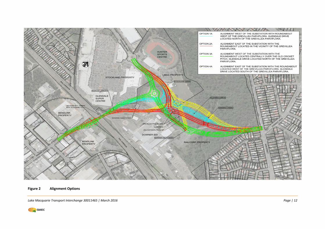
Table 2 and illustrated in Figure 2.
Table 2 Concept Design Alignment Options
Alignment Option
Description
1 Alignment west of the electrical substation within the Downer site.
2 Alignment east of the substation with the intersection located in the vicinity of the threatened species Grevillea parviflora.
3 Alignment west of the substation with the intersection located centrally over the old cricket pitch. Glendale Drive located south of the threatened species Grevillea parviflora.
4 Alignment east of the substation with the intersection located north of the threatened species Grevillea parviflora.
Each of the four alignment options listed above were further analysed with either a signalised or
roundabout intersection control at the Glendale/Stocklands/Pennant Street intersection.
At the 20% Concept Design Phase, a Value Management Workshop was held to further consider the
relative benefits and disadvantages of each of these four options, with the aim of identifying a
preferred option to take forward into detailed design.
The Value Management Workshop was held on 23 May 2013. Attendees at the workshop included
representatives of:
LMCC;
SMEC;
Stocklands;
Hunter Sports Centre;
Adjacent property owner;
RailCorp/Sydney Trains; and
Hunter Development Corporation.
Lake Macquarie Transport Interchange 30011465 | March 2016 Page | 11
Assessment criteria for each option were assessed, reviewed and agreed. Weighting for each of the
criteria was also assigned. The adopted option analysis criteria comprised:
Cost;
Constructability;
Impact to primary stakeholders;
Impact to future land use;
Impact to Aboriginal heritage;
Impact to non‐Aboriginal heritage; and
Impacts to flora and fauna.
Lake Macquarie Transport Interchange 30011465 | March 2016 Page | 12
Figure 2 Alignment Options
Lake Macquarie Transport Interchange 30011465 | March 2016 Page | 13
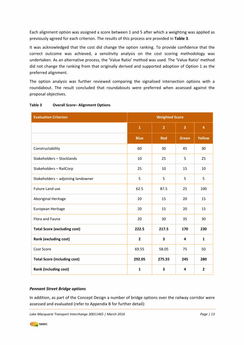
Each alignment option was assigned a score between 1 and 5 after which a weighting was applied as
previously agreed for each criterion. The results of this process are provided in Table 3.
It was acknowledged that the cost did change the option ranking. To provide confidence that the
correct outcome was achieved, a sensitivity analysis on the cost scoring methodology was
undertaken. As an alternative process, the ‘Value Ratio’ method was used. The ‘Value Ratio’ method
did not change the ranking from that originally derived and supported adoption of Option 1 as the
preferred alignment.
The option analysis was further reviewed comparing the signalised intersection options with a
roundabout. The result concluded that roundabouts were preferred when assessed against the
proposal objectives.
Table 3 Overall Score– Alignment Options
Evaluation Criterion Weighted Score
1 2 3 4
Blue Red Green Yellow
Constructability 60 30 45 30
Stakeholders – Stocklands 10 25 5 25
Stakeholders – RailCorp 25 10 15 10
Stakeholders – adjoining landowner 5 5 5 5
Future Land use 62.5 87.5 25 100
Aboriginal Heritage 20 15 20 15
European Heritage 20 15 20 15
Flora and Fauna 20 30 35 30
Total Score (excluding cost) 222.5 217.5 170 230
Rank (excluding cost) 2 3 4 1
Cost Score 69.55 58.05 75 50
Total Score (including cost) 292.05 275.55 245 280
Rank (including cost) 1 3 4 2
Pennant Street Bridge options
In addition, as part of the Concept Design a number of bridge options over the railway corridor were
assessed and evaluated (refer to Appendix B for further detail):
Lake Macquarie Transport Interchange 30011465 | March 2016 Page | 14
Bridge Option 1: Super‐T Bridge, 3 Span Super‐T bridge with piers located either side of the
tracks
Bridge Option 2: Post Tensioned Concrete Box Girder, single span concrete box girder launched
bridge;
Bridge Option 3: Cable Stay Bridge, two span cable stay‐bridge; and
Bridge Option 4: Steel Truss Half‐through deck, single span steel truss bridge.
The four bridge options were assessed based on cost, risks, impacts on adjacent properties and
derailment consequence.
Based on construction and maintenance cost benefits, Option 1 (Super T Bridge) is the most
preferred option while Option 4 is the least preferred. Options 2, 3 and 4 were considered as cost
prohibitive. They have long‐term maintenance requirements associated with steel components and
would require ongoing possessions during the life of the bridge for maintenance purposes.
In terms of structure costs alone, Options 1 and 2 were considered to be very similar. The main
differentiators between Options 1 and 2 is the ability to provide a clear span over the rail corridor,
impacts on adjacent properties and property access provision. With regard to cost, Option 1 has
clear benefits in both construction cost and ongoing maintenance cost.
Option 2 provides a clear span between abutments, but at a significant increase in cost (about $7.4
million). It also enables the bridge to be constructed with less disruption to the rail lines (four
possessions required as opposed to seven possessions for Option 1). However, it requires the
alignment to be raised by approximately 2.2 metres and requires a large area on one approach to
enable a casting/launch bed to be constructed.
Option 1 provides a clear span of all Sydney Trains rail lines but does not provide a clear span
between abutments. Piers are located beside sidings and deflection walls have been provided and
have been designed for train impact loads in accordance with AS 5100.2. Option 1 provides
significant cost benefits for both construction cost and maintenance costs.
Option 2 would require extensive additional property acquisition to accommodate the higher
alignment and the space required for the casting and launching bed. This option will preclude access
to the Bendlink Property and in doing so, fails to meet a key project objective.
Cost 1 provides clear cost benefits with negligible risk associated with not providing a clear span
between abutments and the least impact on adjacent properties.
Do nothing option
The ‘Do Nothing’ option means existing infrastructure and road services would remain in their
current form and the proposal objectives would not be achieved. If the LMTI was not to proceed, the
opportunity for future economic growth of the Glendale area would be severely hampered.
In view of this the Do Nothing option was not considered further.
Lake Macquarie Transport Interchange 30011465 | March 2016 Page | 15
2.5 Preferred option
A preferred option (Option 1) for the overall proposal was identified during the Concept Design
phase. The key features of Option 1, including those components which form part of the LMTI
Section 2 proposal, are as follows:
Extension of Pennant Street over the railway line with a 92 metre (approx.) Super T Girder
bridge (in three sections) connecting to the new four‐way roundabout (LMTI Section 2). The
Super T Bridge option provides cost benefits and negligible risk associated with not providing a
clear span between abutments and the least impact on adjacent properties, as described in
Section 2.4 ;
A 25 metre (approx.) Super T bridge over Winding Creek;
A new four lane road extending Stockland Drive through to a new four‐way roundabout;
A new two lane road connecting the Pennant Street Bridge with the new four‐way roundabout
(LMTI Section 2);
A new roundabout connecting Pennant Street, Glendale Drive, Stockland Drive and Downer
access road;
A four‐way signalised intersection between Main Road and Glendale Drive; and
Adjustment to the existing roundabout at Stockland Drive.
2.6 Design refinements
The following significant design refinements for Section 2 were applied between the 80% Advanced
Concept Design and the 80% Detailed Design:
The main drainage line has been moved from the eastern side of Pennant Street to the western
side adjacent to the shared path; and
A short water main extension and relocation/capping of internal plumbing is required to
relocate water and sewer services impacted by the southern extent of the LMTI on Pennant
Street.
Lake Macquarie Transport Interchange 30011465 | March 2016 Page | 16
3 THE PROPOSAL
3.1 The proposal
This REF has been developed to specifically address the potential impacts associated with Section 2
of Stage 1 of the LMTI. The key features of Section 2 (the proposal) comprise:
Extension of Pennant Street over the rail line connecting with the new roundabout (Glendale
Drive/Pennant Street/Stockland Drive/Downer site access) to be constructed as part of
Section 1;
Construction of a new two lane, three‐span bridge over the rail line;
Intersection upgrade through improved lane delineation at the Pennant Street/Munibung Road
intersection;
Protection and adjustment of utilities as required;
Access adjustments into adjacent private property; and
Upgrade of the existing Glendale Super Centre car park due to impact by the Pennant Street
extension.
3.2 Design criteria
The designs have been developed in accordance with the LMCC requirements and scope as provided
as part of the tender design documentation and stakeholder requirements. Where design aspects
have not been specified in the scope the following design guides have been applied for the roads:
Austroads’ Guide to Road Design and RMS’s supplements;
LMCC Development Control Plan;
LMCC Engineering Guidelines;
NSW State Transit Bus Infrastructure Guide; and
RMS R44 Specification – Earthworks.
The standards relevant to the Pennant Street Bridge and retaining wall structures for the LMTI
Section 2 proposal include (but are not limited to):
Austroads’ Guide to Road Design and NSW Roads and Maritime Services (RMS) supplements;
AS5100 – Bridge Design Code;
AS 2159 – Piling – Design and Installation;
AS 1289 – Method of Testing Soils for Engineering Purposes;
AS 4678 – Earth Retaining Structures;
ESC 215 – Transit Space;
ESC 320 – Overbridges and Footbridges;
Lake Macquarie Transport Interchange 30011465 | March 2016 Page | 17
RMS R57 – Design of Reinforced Soil Walls; and
RMS R58 – Construction of Reinforced Soil Walls.
A concession from the Australian Standards Authority (ASA) is required in relation to ESC 320 for
works within the railway corridor. The full concession details are contained in a concession
application supporting document which is attached as Appendix B.
The Department of Planning’s (2008) Development near Rail Corridors and Busy Roads – Interim
Guideline outlines the potential for electrolysis to occur within the railway corridor and outlines
measures to minimise its occurrence. The design has taken this into consideration, with further
detail of the design elements relating to the railway corridor provided in Chapter 2 of Technical Note
6 of the NSW Trains Concession.
3.3 Major design features
3.3.1 Roads
Road Alignment
The adopted design speed for Pennant Street is 60 km/h.
There are a number of roads and property accesses within the LMTI study area that cater for
different design vehicles and these are listed in Table 4.
Table 4 Design Vehicles
Locations Design Vehicle (lane correct) Check Vehicle
Downer access road 19 m semi‐trailer B‐double
Stockland Property 19 m semi‐trailer B‐double
RailCorp ‘residual land’ near
Stockland Super Centre access
12.5 m single unit truck 19 m semi‐trailer
Access off Glendale Drive to
RailCorp surplus land (northern
section)
19 m semi‐trailer B‐double
Access off Glendale Drive to
RailCorp surplus land (southern
section)
19 m semi‐trailer B‐double
In Section 2, full access to the substation would be provided during construction and operation. The
minimum horizontal design requirements are met throughout the design. The embankment batter
slopes have generally been designed at 4H: 1V. In locations where this was not achievable due to
constraints (i.e. boundary restrictions, vegetation), the gradient has been steepened. A maximum
slope of 2H: 1V has been used.
Lake Macquarie Transport Interchange 30011465 | March 2016 Page | 18
Safety Barriers
A concrete barrier will be provided on the retaining walls on the approach and departure to the
Pennant St Bridge. This will include the provision of cyclist safety rails adjacent to the shared path.
Pedestrians and Cyclists
The LMTI design has provided for improved pedestrian and cycling access in the Glendale area. A
shared path has been provided on Pennant Street extension as part of the Section 2 proposal, which
connects with the Section 1 works currently under construction.
Bus Stops
Bus stops will be provided or provision made at the locations specified in Table 5.
Table 5 Bus Stop Locations – Section 2
Street Name Travel Direction Number of Bays Type of Facility
Pennant Street Northbound 2 Indented*
Pennant Street Southbound 2 Indented*
* The facilities noted on Pennant Street are for future provision only. The listed items above are just outside
the limits of work for the Section 2 proposal, but they are included for completeness.
Street Lighting
Street lighting is proposed on Pennant Street. The location of street lighting will be outside the clear
zone on the edge of the carriageway. Street lighting on the retaining walls and Pennant Street Bridge
will be attached via brackets on the outside of the wall face / bridge parapet.
The lighting design is in accordance with AS/NZS 1158.0.
3.3.2 Bridge
The LMTI Section 2 proposal includes the construction of a bridge over the railway line. The Pennant
Street Bridge is a three‐span structure consisting of one 18.6 metre span and two 36.4 metre spans.
Between ends of deck, the overall spans are 19.5 metres and 37.3 metres respectively. The latter
spans are required to cross the existing six tracks of the Main Northern Railway Line and the stabling
yard tracks in the Downer compound. The six tracks in the main corridor are made up of two
mainlines, two refuge loops, and two sidings.
Clause 8.1 of ASA Engineering Standard ESC 320 states that new structures would be designed with a
clear span between abutments (unless supports are on platforms). In this case, a clear span is
achieved over the railway lines but not across the entire corridor and is not a clear span between
abutments. The piers would be located with sufficient clearance from tracks and overhead wiring to
comply with Sydney Trains standards. The piers have been designed with heavy construction and can
resist the collision loads indicated in AS 5100.2. Compliance with relevant Design Standard
requirements is discussed further in Section 2.8 of the concession document (Appendix B). The
document includes sketches of the bridge abutment and pier arrangement.
Lake Macquarie Transport Interchange 30011465 | March 2016 Page | 19
The three‐span bridge was chosen to provide an economical solution to achieve the required rail
clearances and to avoid existing services in this area. The bridge has a 3% two‐way crossfall on the
traffic lanes and a 2% crossfall on the pedestrian walkway. The road carriageway is 12.35 metres
wide between barriers comprising two 3.5 metre wide traffic lanes, one 3.5 metre wide pedestrian
walkway, and 1.35 metres and 0.5 metre road shoulders on the eastern and western sides
respectively. The design speed is 60 km/h.
The bridge superstructure comprises seven 1800 mm deep prestressed concrete Super‐T girders.
A protection screen is provided on both sides of the bridge. The protection screen is 2800 mm high
measured from the top of the precast concrete barrier and this part angles away from the road at
5.8 degrees. The screen continues below the top of the precast concrete barrier for 2.4 metres. This
also angles away from the road at 5.8º producing a fold in the screen level with the top of the
precast barrier. The screen is made up of individual panels that can be removed from the deck level
for any required maintenance
While the area occupied by the Pennant Street Bridge area has not been undermined, a mine
subsidence assessment was required in relation to the possibility of future mining rather than risks
posed by existing workings. The MSB has provided conditional approval for the following design
criteria;
Settlement – 200 mm
Strain – 2 mm/1 m
Tilt – 2 mm/1 m.
3.4 Construction activities
3.4.1 Plant and equipment
An indicative list of plant and equipment typically required for this type of construction is provided
below. This will ultimately be determined as part of the construction phasing.
Excavators (30, 20 and 8 tonne);
Graders;
Bulldozers;
Dump trucks;
Cranes;
Front end loaders;
Concrete trucks and pumps;
Road sweepers;
Rollers;
Light vehicles;
Water tankers;
Lake Macquarie Transport Interchange 30011465 | March 2016 Page | 20
Chain saws, air compressors, mulches;
Pneumatic hand or power tools;
Stump grinder; and
Concrete cutters.
Section 2 ‐ Pennant Street Bridge
A constructability workshop was conducted as part of the design development. The workshop
discussed a number of constructability issues and staging associated with both Sections 1 and 2.
The construction staging of the Pennant Street Bridge presents some specific issues due to the rail
corridor. These include:
Ensuring all works except for landing of Super‐T girders and construction of abutments can be
undertaken outside of track possessions;
Ensuring that excavation for pile caps can be undertaken adjacent to existing structures and
utilities;
Ensuring that piers including formwork and scaffolding, can be constructed clear of overhead
wiring and the rail corridor;
Confirmation that Super‐T Girders can be delivered using local roads;
Ensuring that Super‐T girders can be landed over the railway line during track possessions,
without cranes having to utilise existing tracks or sidings; and
Working adjacent to Abutment A.
With the above issues considered, a possible construction staging plan for the Pennant Street Bridge
has been developed. Details are provided in the concession document (Appendix B). In summary,
this will comprise:
Phase 1
Works include relocating all utilities south of the railway line. Concurrently, the Abutment B pier
would be constructed north of the railway line. There is an option to fully construct during
Phase 1, however this may result in access issues when landing the Super T girders; and
Completion of this stage of works will allow access to Pier 1.
Phase 2
Works include construction of Pier 1 and Pier 2.
At Pier 1, construction equipment, concrete agitators and concrete pumps will access the site
adjacent to Pier 1 through the existing adjoining car park. The main constructability
consideration in this stage of works is construction of the pier, including formwork and
scaffolding; and
Pier 2 can be accessed via the Downer access road which runs around the workshop.
Lake Macquarie Transport Interchange 30011465 | March 2016 Page | 21
Phase 3
Works include installation of Super‐T girders on Span 2 and Span 3.
Span 2 can be accessed adjacent to Pier 1, over the services which were relocated and/or
protected during Stage 1 works. Super‐T deliveries will also be adjacent to Pier 1;
Span 3 will be accessed at Pier 2 along the Downer access road, and at Abutment B. A mobile
crane to facilitate these works will be able to access Pier 2 along the Downer access road; and
Landing of Super‐T girders over railway lines will need to be conducted during a track
possession. This will allow for safe access and completion of works above the railway line.
Phase 4
Abutment works and retaining wall works at both abutments would be completed during this
stage of works.
Phase 5
Works include installation of Super‐T girders on Span 1 and completion of all works on the
bridge superstructure; and
Cranes and delivery of Super‐T girders will be along the adjacent car park road. All works, and
associated civil works, would be completed on the bridge during this stage of construction.
3.4.2 Earthworks
A summary of the earthworks requirements for construction of the LMTI Section 2 is presented in
Table 6.
With regard to earthworks cut and fill quantities and volume of geotechnical unsuitable materials,
Section 2 cut and fill volumes are estimated to generate surplus material which may potentially
require disposal. Reuse options should therefore be considered for the following potential volume
scenarios:
1,000m3 of topsoil;
small volumes of spoil (fill and natural) generated during underground cable trench works;
4,000m3 of “low risk” Asbestos Containing Material (ACM)/ uncontrolled fill material stockpiled
on site for re‐use on site; and
8,000m3 of non‐impacted virgin excavated natural material (VENM).
A Fill Reuse Management Plan (FRMP) has been developed to inform the material reuse options, and
the process to be followed during construction activities. The FRMP has been included as Appendix I
to this REF.
Lake Macquarie Transport Interchange 30011465 | March 2016 Page | 22
Table 6 Earthworks requirements
Location Cut/Fill/Shallow
Zone
E – Embankment
Zone
C – Cut Zone
S – Shallow Zone
Start
(Station)
End
(Station)
Length
(m)
Topsoil
(m3)
Cut
(m3)
Fill G
(m3)
Fill E
(m3)
Unsuitable
(m3)
Section 2
M1A0 – Pennant
Street to railway
bridge south
abutment
S2‐1‐S** 25 105 80 341 400 360
S2‐2‐E 105 225 120 353 2623 11950
M1A0 – Pennant
Street from railway
bridge north
abutment to Station
526
S2‐3‐E 320 425 105 572 8837
12,500 9,800
500*
S2‐4‐E 425 526 101 468 3706 500*
TOTAL 1,734 15,566 12,860 21,750 1,000
TOTAL DISPOSAL MATERIAL 15,206 1,000
*These are an estimated allowance for potential contaminants in the bund area.
** Indication that both cut and fill is required for this area. Shallow embankment treatment is not required.
Fill E ‐ Engineered fill
Fill G ‐ General fill
3.5 Ancillary facilities
It is anticipated that the ancillary sites required during Section 2 works would be for stockpile areas
and site compounds. All material for pavements and structures on the proposal will be imported
therefore there is no requirement for batching plants or large processing areas.
Figure 3 shows possible sites initially considered for site compounds, parking and stockpiling
identified for use. Upon further investigation and stakeholder discussions, only one site (Site E) was
identified as viable for the Section 1 works. The excluded sites were likely to result in unacceptable
impact on stakeholder operations and/or the environment and were therefore rejected.
Lake Macquarie Transport Interchange 30011465 | March 2016 Page | 23
The Section 2 works may utilise Sites A, B, C, D and possibly E (but it is acknowledged that it may be
too far away from the construction area to be efficient use of land). Specific discussion and
negotiation with relevant stakeholders will be undertaken by the construction contractor prior to
construction commencement.
Figure 3 Potential Sites for Site Compounds/Parking/Stockpiling
3.6 Public utility adjustments
The existing utilities on site have been located using both Dial Before You Dig information (DBYD)
obtained via the DBYD website and also surveyed information. The survey data includes Detailed
Services Search (DSS) for all services in the rail corridor.
Existing Utilities Affected
Affected services in all locations were assessed and considerations have been made in the design to
minimise the impacts on these existing services (refer Table 7). All authorities have been informed
and the following will be implemented during construction. All relocation or modification to the
services has been discussed with the appropriate authorities and the design of such undertaken in
accordance with the individual utility owner’s specifications.
Lake Macquarie Transport Interchange 30011465 | March 2016 Page | 24
Table 7 Utilities affected by the LMTI Section 2
Utility Works Status
HV Ausgrid – Street Lighting. Ausgrid certified approval received
HV Ausgrid – Pennant Street electrical relocation works. Ausgrid certified approval received
HV RailCorp/Sydney Trains – Existing overhead 66kV in
the adjoining site requires relocation underground
within the rail corridor, and through to connection
with the Sulphide Junction substation (in the Downer
site)
Concept Design has been submitted
to RailCorp/Sydney Trains for
comment/approval.
Hunter
Water
Construction of a water main, associated plumbing
reconnection works and disconnection of an internal
private sewer line associated with the subdivision of
two lots on either side of Pennant Street on the
southern side of the railway corridor.
Hunter Water Corporation (HWC)
have been provided plans.
Comments have been received and
final amendment is underway prior
to re‐submission for final approval.
Telstra Pennant Street connection Design is complete and Telstra
approval has been received.
Optus Optus assets in the vicinity of Main Road and
Pennant Street.
Some Optus assets along Main road
are ducted in Telstra’s conduits.
Design of these is complete and has
been approved by Telstra. The
Optus only relocation design, on
Pennant Street Is complete
Table 8 identifies the providers that have been contacted and their requirements.
Table 8 Utility Companies Contacted by LMCC
Utility Requirements
Jemena No requirements
Hunter Water
Corporation
Allocations for a continuous connection 250 mm water main will be required
along proposed alignment from Pennant Street to Main Road
Assessment of the construction of 65m of DN200 water main, associated
plumbing reconnection works and disconnection of an internal private sewer line
for the subdivision of land to the south of the railway corridor. This is required to
obtain a Section 50 Certificate.
Ausgrid No requirements
NBN Allocations for 2 x P100 conduits within the bridge have been requested. There
are no requirements for NBN allocation along the road.
Lake Macquarie Transport Interchange 30011465 | March 2016 Page | 25
Utility Requirements
Telstra No requirements.
Optus No requirements.
NextGen No requirements.
3.7 Urban design and landscaping
A comprehensive urban design analysis has been undertaken for the LMTI. The urban design theme
is based on the concept of ‘Travel, Destination and Place’ reflecting the site’s location on the Main
Northern Railway Line between Cockle Creek and Cardiff Railway Stations which is where the old
Sulphide Junction platform for Railway Workshop employees is situated. A historic reference to this
is proposed in the new Pennant Street Bridge design using signage and art work as a way of linking
the new interchange infrastructure with its historical and landscape context.
A purpose of the project is to link the community on the eastern side of the railway to that on the
west side, providing practical and efficient access to the LMTI as well as reducing the demand on the
existing road networks on both sides of the rail corridor.
The urban design aspects of the project seek to reinforce this location and build on the historic
development of the Cardiff/Glendale area as a place of transport, interchange, industry, shopping,
entertainment, sport, leisure and as an emerging dynamic services hub, while protecting where
possible heritage and the site’s landscape biodiversity.
The role of the LMTI is in itself a dynamic function, tying it to Glendale’s establishing identity as a
dynamic services hub. The urban design concept will strengthen this identity by introducing new
elements and adopting existing standard elements to distinguish the area within the Glendale
Township and the broader Lake Macquarie City context.
The urban design analysis separates components of the design into major and minor elements. The
former comprise:
Pennant Street Bridge;
The roundabout connecting Pennant Street, Stockland Drive and Glendale Drive;
Winding Creek Bridge; and
The intersection of main Road and Glendale Drive.
With the exception of Winding Creek Bridge which will incorporate standard RMS vehicular barriers,
specific design treatments have been identified for each of these to emphasise and reinforce the
overall design theme.
Minor design elements comprise bus shelters and seating, handrails and barriers, lighting, footpath
treatments, the noise barrier, directional walls, and cycleways. As with the major elements, specific
treatments have also been identified for these consistent with the overall design theme.
Lake Macquarie Transport Interchange 30011465 | March 2016 Page | 26
3.8 Property acquisition
The LMTI will has required the acquisition of private property at the Bendlink sites on the southern
side of the railway corridor. Negotiations with the property owner have been completed.
Formalisation of property acquisition through the RailCorp owned land in/adjacent to the Downer
Site are ongoing.
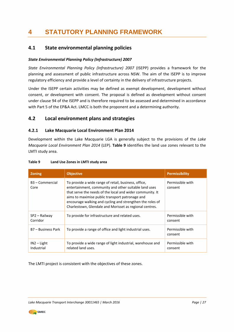
Lake Macquarie Transport Interchange 30011465 | March 2016 Page | 27
4 STATUTORY PLANNING FRAMEWORK
4.1 State environmental planning policies
State Environmental Planning Policy (Infrastructure) 2007
State Environmental Planning Policy (Infrastructure) 2007 (ISEPP) provides a framework for the
planning and assessment of public infrastructure across NSW. The aim of the ISEPP is to improve
regulatory efficiency and provide a level of certainty in the delivery of infrastructure projects.
Under the ISEPP certain activities may be defined as exempt development, development without
consent, or development with consent. The proposal is defined as development without consent
under clause 94 of the ISEPP and is therefore required to be assessed and determined in accordance
with Part 5 of the EP&A Act. LMCC is both the proponent and a determining authority.
4.2 Local environment plans and strategies
4.2.1 Lake Macquarie Local Environment Plan 2014
Development within the Lake Macquarie LGA is generally subject to the provisions of the Lake
Macquarie Local Environment Plan 2014 (LEP). Table 9 identifies the land use zones relevant to the
LMTI study area.
Table 9 Land Use Zones in LMTI study area
Zoning Objective Permissibility
B3 – Commercial Core
To provide a wide range of retail, business, office, entertainment, community and other suitable land uses that serve the needs of the local and wider community. It aims to maximise public transport patronage and encourage walking and cycling and strengthen the roles of Charlestown, Glendale and Morisset as regional centres.
Permissible with consent
SP2 – Railway Corridor
To provide for infrastructure and related uses. Permissible with consent
B7 – Business Park To provide a range of office and light industrial uses. Permissible with consent
IN2 – Light Industrial
To provide a wide range of light industrial, warehouse and related land uses.
Permissible with consent
The LMTI project is consistent with the objectives of these zones.
Lake Macquarie Transport Interchange 30011465 | March 2016 Page | 28
4.2.2 Lake Macquarie Development Control Plan 1 (Revision 11)
This revision of DCP1 (LMDCP1) was adopted by LMCC in 2014. LMDCP1 has been in force in various
forms since 2004. The objectives of this Plan are to implement the Lifestyle 2020 Strategy (the
Strategy) by facilitating ecologically sustainable development.
The objectives of this Plan support the core values of the strategy of sustainability, equity, efficiency
and, liveability to:
Promote environmentally sustainable and quality development in the City;
Provide detailed guidance to prospective applicants of LMCC’s requirements for building,
subdivision, and land development;
Elaborate on the requirements of the Lake Macquarie LEP (2014) as a key tool in the LEP’s
implementation; and
Provide detailed criteria to assist LMCC in assessing development applications (as required by
Section 79C(1)(a) of the EP&A Act).
The DCP has a number of parts, which detail the various development controls and how they apply
to the various land use zonings. There are also a number of guidelines which provide technical
guidance on the built and natural environment.
The detailed design of the LMTI has considered the requirements of DCP1 and the relevant
guidelines and is generally compliant with the requirements.
4.2.3 Lifestyle 2030 Strategy
The Strategy was released in March 2013, and provides an overall strategy for the future
development of the Lake Macquarie area. The Strategy is a revision of the Lifestyle 2020 Strategy
and continues to focus on those key areas of environmental, social and economic issues.
The strategy identifies seven key strategic directions and links them to specific outcomes. The
strategy also includes strategic plan maps and intent statements which focus on the future
development of the area. One key objective of the strategy is to focus on the improved linkages
between the various regional centres and also to support the future development of emerging
centres such as Glendale. The LMTI will be integral to supporting the outcomes of this strategy.
4.3 Other relevant legislation
Environmental Planning and Assessment Act 1979
The EP&A Act is the primary piece of planning legislation in NSW, and guides the approval and
development throughout the state of NSW. The EP&A Act and the Environmental Planning and
Assessment Regulation 2000 (EP&A Regulation) form the statutory basis for planning and
environmental assessment in NSW. The proposed works fall under Part 5 of the EP&A Act through
the effect of the ISEPP as previously noted. LMCC has an obligation to consider the environmental
impacts of the works under Section 111 of the EP&A Act. This consideration is documented through
this REF.
Lake Macquarie Transport Interchange 30011465 | March 2016 Page | 29
Clause 228(2) of the EP&A Regulation identifies the factors that a determining authority must take
into account when examining the impact of its activity on the environment. Appendix A presents
these factors and summarises the findings of the environmental assessment.
Section 112 of the EP&A Act requires the preparation of a Species Impact Statement (SIS) if the
proposed development is:
…on land that is, or is part of, critical habitat or is likely to significantly affect threatened species,
populations or communities, or their habitats.
A Species Impact Statement (SIS) was prepared for the overall LMTI project and was included in the
REF prepared by SMEC in 2014.
Threatened Species Conservation Act 1995
The Threatened Species Conservation Act 1995 (TSC Act) aims to conserve biological diversity by
protecting and encouraging the conservation of threatened species, populations and ecological
communities and their critical habitats.
An assessment of the potential impacts of the proposal on threatened species, populations,
ecological communities and critical habitat listed on the TSC Act has been undertaken in accordance
with Section 5A of the EP&A Act.
Protection of the Environment Operations Act 1997
Part 3.2 of the Protection of the Environment Operations Act 1997 (POEO Act) requires an
Environment Protection Licence (EPL) for scheduled development work and the carrying out of
scheduled activities. Schedule 1 to the Act identifies those activities which are scheduled. Clause
1(35) of the schedule identifies road works requiring an EPL for:
road construction, meaning the construction, widening or re‐routing of roads, but does not apply to the
maintenance or operation of any such road.
It further notes that an EPL would be required where the road is classified or proposed to be
classified, as a freeway, tollway or main road under the Roads Act 1993. The LMTI will not be
classified as any of these therefore an EPL is not required.
However, regardless of whether an activity is a scheduled activity or not, the proponent is still
required to ensure that pollution events do not occur during construction.
Heritage Act 1977
The Heritage Act 1977 aims to protect and preserve items of historic heritage significance. An
excavation permit under Section 60 of the Act is required to disturb or excavate any land knowing or
having reasonable cause to suspect that the disturbance or excavation will or is likely to result in a
relic being discovered, exposed, moved, damaged or destroyed. A permit is also required to disturb
or excavate any land on which the person has discovered or exposed a relic.
An assessment of historical significance was undertaken by Nexus in 2008. The report provided a
number of recommendations with regard to items of European heritage. These are detailed in
Section 6.9 .
Lake Macquarie Transport Interchange 30011465 | March 2016 Page | 30
National Parks and Wildlife Act 1974
The harming or desecrating of Aboriginal objects or places is an offence under Section 86 of the
National Parks and Wildlife Act 1974 (NPW Act) Under Section 90, an Aboriginal heritage impact
permit may be issued in relation to a specified Aboriginal object, Aboriginal place, land, activity or
person or specified types or classes of Aboriginal objects, Aboriginal places, land, activities or
persons.
As detailed in Section 6.8.2 , registered Aboriginal sites have been recorded in the overall LMTI
project area, with one occurring in the northern part of the Section 2 proposal area. These sites
would be impacted by the LMTI project. An Aboriginal Heritage Impact Permit (AHIP ID 3717), also
known as a Section 90 permit, was granted to the LMCC by the Office of Environment & Heritage
(OEH) in August 2014. It permits the collection of any artefacts which may be identified during pre‐
construction clearing and during construction.
Noxious Weeds Act 1993
The Noxious Weeds Act 1993 provides for a coordinated approach to the removal and control of
scheduled noxious weeds across the NSW. No permits or approvals are required under this Act but it
is the responsibility of LMCC to provide for the removal and proper disposal of any listed weeds
found within the proposal sites. Noxious weeds are discussed and management measures proposed
in Section 6.12.2 .
Roads Act 1993
The Roads Act 1993 provides for the declaration of public authorities such as LMCC as roads
authorities for both classified and unclassified roads, and confers certain functions (in particular, the
function of carrying out of road works) on roads authorities. LMCC proposes to carry out the
proposed works pursuant to powers conferred by the Roads Act 1993.
Water Management Act 2000
The objectives of the Water Management Act 2000 (WM Act) are to achieve a coordinated approach
in managing water resources across NSW. The WM Act and its Regulation provide a framework for
the development of water sharing plans for numerous catchments in the State. The WM Act also
details the approvals which are required for particular activities as they relate to water, groundwater
and water side land.
4.4 Commonwealth legislation
Under the Environment Protection and Biodiversity Conservation Act 1999 (EPBC Act), a referral is
required to the Australian Government for proposed actions that have the potential to significantly
impact on matters of national environmental significance or the environment of Commonwealth
land. Consideration of these matters is provided in Appendix C.
A flora and fauna assessment was prepared by Harper Somers in December 2008. It concluded that
the activity was unlikely to be a controlled action under the EPBC Act or would impacton
Commonwealth land and a referral was therefore not required. A further assessment on threatened
and migratory species listed under the EPBC Act was undertaken by Ecotone Ecological Consultants
Lake Macquarie Transport Interchange 30011465 | March 2016 Page | 31
in August 2012. It similarly concluded that the proposal would not be a controlled action and
therefore would not require referral.
4.5 Confirmation of statutory position
All relevant instruments have been reviewed for the proposal. It is concluded that ISEPP operates to
remove the development consent requirements, thereby confirming assessment of the proposal
under Part 5 of the EP&A Act.
Lake Macquarie Transport Interchange 30011465 | March 2016 Page | 32
5 STAKEHOLDER AND COMMUNITY CONSULTATION
5.1 Consultation strategy
The LMTI is a key strategic project for LMCC and the Lower Hunter Area, as it will facilitate the
greater use of public transport and provide for further development in the Glendale/Cardiff area.
The consultation strategy for the overall LMTI project was undertaken by LMCC and sought to:
Seek input from all relevant stakeholders into the design and development of the interchange;
Provide clear and timely information to the wider public on the benefits of the LMTI;
Raise awareness of the proposal to keep local communities and road users informed of the
proposal;
Provide a point of contact for stakeholders and community members; and
Provide the community an opportunity to raise any concerns associated with the proposal and
provide a forum to respond to these issues.
5.2 Community involvement
The REF for Section 2 of the LMTI will be placed on public display and adjoining neighbours notified.
This will provide the community an opportunity to comment on the proposal. All submissions
received will be considered as part of the assessment and finalisation of the REF and any
determination.
5.3 Aboriginal stakeholders
The need for consultation with Aboriginal stakeholders is outlined in the Due Diligence Code of
Practice for the Protection of Aboriginal Objects in New South Wales (DECCW 2010). The Code of
Practice requires consultation with relevant Aboriginal stakeholders where there would be or where
there is potential for ‘harm’ (as defined in Section 5 to the NPW Act) to items or places of Aboriginal
cultural heritage significance.
An Aboriginal Heritage Assessment undertaken by ERM in 2007 pre‐dates the above Code of
Practice. The assessment did however follow the Interim Community Consultation Requirements
Guideline (2004) which applied the same principles.
The process was followed whereby Aboriginal groups were invited to register their interest in the
process, and their comments sought on the proposed methodology, assessment and
recommendations. Five parties registered as part of this process, with representatives from the
Koompahtoo Local Aboriginal Land Council (LALC) and Awabakal Descendants Traditional Owners
Aboriginal Corporation (ADTOAC) attending the field surveys.
Further field survey prior to construction was a key recommendation of the ERM (2007) report.
Consequently LMCC engaged RPS to undertake further consultation and field survey in 2013 with
reference to the Due Diligence Code. This is discussed in further detail in Section 6.8.1 .
Lake Macquarie Transport Interchange 30011465 | March 2016 Page | 33
5.4 ISEPP consultation
Under Part 2, Division 1 of the ISEPP, proponents are required to consult with the relevant council(s)
with regard to impacts on:
Council‐related infrastructure or services;
Local heritage; and
Flood‐liable land.
In the Lake Macquarie LGA, water supply and treatment infrastructure is managed by HWC.
Consultation was undertaken to determine its requirements for the water mains located along Main
Road.
The Cardiff Railway workshops are listed as being of local historical significance, however the
proposed alignment of the LMTI will not impact on this area. The railway line is listed on RailCorp’s
Section 170 Heritage and Conservation Register. LMCC will consult with Sydney Trains heritage
division in regards to this proposal.
Public authorities are also required to consult with specific authorities when proposing to undertake
the following activities:
Development adjacent to land reserved under the NPW Act;
Development adjacent to an aquatic reserve;
Development in the foreshore area of Sydney Harbour;
Development comprising a fixed or floating structure in or over navigable waters; and
Particular developments located on bush fire prone land.
The proposal is not adjacent to land reserved under the NPW Act, nor is it in proximity to any marine
or aquatic reserve areas. Finally the LMTI is not an activity which triggers the need for consultation
on bush fire prone land.
Part of the LMTI study area on either side of Winding Creek is flood‐prone land. This does not extend
into the LMTI Section 2 proposal area
5.5 Government and stakeholder involvement
The Value Management Workshop held on 23 May 2013 involved representatives of LMCC and
SMEC, representatives of adjoining land owners and users, RailCorp/Sydney Trains, Hunter
Development Corporation (HDC), Stockland, Hunter Sports Centre and a private property owner.
This provided the various stakeholders with an opportunity to provide input into the design process
and identify their key issues as they relate to the LMTI proposal.
Throughout the design of the overall LMTI project various stakeholders have been consulted. Table
10 provides a summary of those consulted and a summary of the key issues which have been
considered during the design and assessment process.
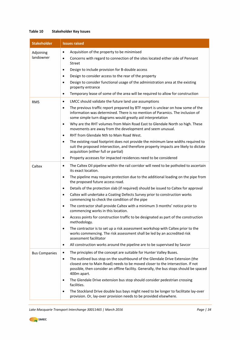
Lake Macquarie Transport Interchange 30011465 | March 2016 Page | 34
Table 10 Stakeholder Key Issues
Stakeholder Issues raised
Adjoining landowner
Acquisition of the property to be minimised
Concerns with regard to connection of the sites located either side of Pennant Street
Design to include provision for B‐double access
Design to consider access to the rear of the property
Design to consider functional usage of the administration area at the existing property entrance
Temporary lease of some of the area will be required to allow for construction
RMS LMCC should validate the future land use assumptions
The previous traffic report prepared by BTF report is unclear on how some of the information was determined. There is no mention of Paramics. The inclusion of some simple turn diagrams would greatly aid interpretation
Why are the RHT volumes from Main Road East to Glendale North so high. These movements are away from the development and seem unusual.
RHT from Glendale Nth to Main Road West.
The existing road footprint does not provide the minimum lane widths required to suit the proposed intersection, and therefore property impacts are likely to dictate acquisition (either full or partial)
Property accesses for impacted residences need to be considered
Caltex The Caltex Oil pipeline within the rail corridor will need to be potholed to ascertain its exact location.
The pipeline may require protection due to the additional loading on the pipe from the proposed future access road.
Details of the protection slab (if required) should be issued to Caltex for approval
Caltex will undertake a Coating Defects Survey prior to construction works commencing to check the condition of the pipe
The contractor shall provide Caltex with a minimum 3 months’ notice prior to commencing works in this location.
Access points for construction traffic to be designated as part of the construction methodology.
The contractor is to set up a risk assessment workshop with Caltex prior to the works commencing. The risk assessment shall be led by an accredited risk assessment facilitator
All construction works around the pipeline are to be supervised by Savcor
Bus Companies The principles of the concept are suitable for Hunter Valley Buses.
The outlined bus stop on the southbound of the Glendale Drive Extension (the closest one to Main Road) needs to be moved closer to the intersection. If not possible, then consider an offline facility. Generally, the bus stops should be spaced 400m apart.
The Glendale Drive extension bus stop should consider pedestrian crossing facilities.
The Stockland Drive double bus bays might need to be longer to facilitate lay‐over provision. Or, lay‐over provision needs to be provided elsewhere.
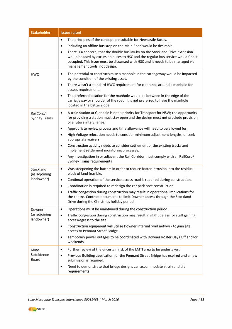
Lake Macquarie Transport Interchange 30011465 | March 2016 Page | 35
Stakeholder Issues raised
The principles of the concept are suitable for Newcastle Buses.
Including an offline bus stop on the Main Road would be desirable.
There is a concern, that the double bus lay‐by on the Stockland Drive extension would be used by excursion buses to HSC and the regular bus service would find it occupied. This issue must be discussed with HSC and it needs to be managed via management tools, not design.
HWC The potential to construct/raise a manhole in the carriageway would be impacted by the condition of the existing asset.
There wasn’t a standard HWC requirement for clearance around a manhole for access requirement.
The preferred location for the manhole would be between in the edge of the carriageway or shoulder of the road. It is not preferred to have the manhole located in the batter slope.
RailCorp/ Sydney Trains
A train station at Glendale is not a priority for Transport for NSW; the opportunity for providing a station must stay open and the design must not preclude provision of a future interchange.
Appropriate review process and time allowance will need to be allowed for.
High Voltage relocation needs to consider minimum adjustment lengths, or seek appropriate waivers.
Construction activity needs to consider settlement of the existing tracks and implement settlement monitoring processes.
Any investigation in or adjacent the Rail Corridor must comply with all RailCorp/ Sydney Trains requirements
Stockland (as adjoining landowner)
Was steepening the batters in order to reduce batter intrusion into the residual block of land feasible.
Continual operation of the service access road is required during construction.
Coordination is required to redesign the car park post construction
Traffic congestion during construction may result in operational implications for the centre. Contract documents to limit Downer access through the Stockland Drive during the Christmas holiday period.
Downer (as adjoining landowner)
Operations must be maintained during the construction period.
Traffic congestion during construction may result in slight delays for staff gaining access/egress to the site.
Construction equipment will utilise Downer internal road network to gain site access to Pennant Street Bridge.
Temporary power outages to be coordinated with Downer Roster Days Off and/or weekends.
Mine Subsidence Board
Further review of the uncertain risk of the LMTI area to be undertaken.
Previous Building application for the Pennant Street Bridge has expired and a new submission is required.
Need to demonstrate that bridge designs can accommodate strain and tilt requirements
Lake Macquarie Transport Interchange 30011465 | March 2016 Page | 36
Ongoing or future involvement
The REF will be placed on public display and adjoining land owners notified. All submissions received
will be considered as part of the assessment and final determination of the project.
Lake Macquarie Transport Interchange 30011465 | March 2016 Page | 37
6 ENVIRONMENTAL ASSESSMENT
The assessment of potential environmental impacts associated with the LMTI Section 2 proposal has
been undertaken utilising the specialist studies that were prepared for the REF prepared for
Sections 1 and 2 (SMEC 2014).
6.1 Biodiversity
6.1.1 Existing environment
The LMTI study area has been subject to a number of field investigations between 1996 and 2012 to
identify the existing biological features.
Flora
The LMTI study area contains the following habitat types:
Forested land (ranging in condition);
Cleared land (some with scattered remnant or planted trees);
Creekline aquatic habitat along Winding Creek (channelised and disturbed habitat); and
One small detention basin/pond (containing bulrushes but frequently dry) that was previously
used by the railway workshops).
The vegetation within the broader study area has been previously mapped in regional vegetation
mapping (LHCCREMS 2003) (refer to Figure 4). Alluvial Tall Moist Forest comprises the Endangered
Ecological Community (EEC) River‐flat Eucalypt Forest on Coastal Floodplain of the NSW North Coast,
Sydney Basin and South East Corner Bioregions (RFEFCF). This vegetation community is present along
Winding Creek in the northern part of the LMTI study area.
Two threatened flora species, Grevillea parviflora subsp. parviflora and Tetratheca juncea (Black‐
eyed Susan) were identified within the study area. These species are not present within the Section
2 proposal area.
Section 2 proposal area
Of the vegetation types listed above, the LMTI Section 2 proposal area supports only cleared and
disturbed land with little ecological significance. The RFEFCF EEC is not present within the LMTI
Section 2 proposal area and occurs predominantly along Winding Creek (refer to Figure 4).
There is little vegetation on the Downer site. The site comprises bitumen access roads and car parks,
concrete hardstand areas, gravel/dirt parking areas and grass and rail tracks. A fill mound located at
the rear of the site is covered with the exotic species Lantana (Lantana camara). There are a few
established trees located at the rear of the Glendale Super Centre, however the site comprises
mainly cleared land associated with car parking and access roads to the loading docks. Pennant
Street to the south of the study area is located in the Cardiff industrial estate and has been cleared
of vegetation.
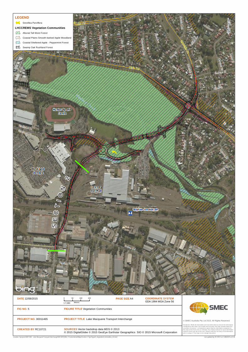
© SMEC Australia Pty Ltd 2015. All Rights Reserved
LEGENDGrevillea Parviflora
LHCCREMS Vegetation CommunitiesAlluvial Tall Moist Forest
Coastal Plains Smooth-barked Apple Woodland
Coastal Sheltered Apple - Peppermint Forest
Swamp Oak Rushland Forest
SOURCES Vector backdrop data MDS © 2013© 2015 DigitalGlobe © 2015 GeoEye Earthstar Geographics SIO © 2015 Microsoft Corporation
Location: I:\projects\30011465 - Lake Macquarie Transport Interchange\008 DATA\008_7 Environmental\Maps\Section 2 Figs\Figure5_VegetationCommunities_A4.mxd
Disclaimer: While all reasonable care has been taken to ensure the information contained on this map is up to date and accurate, this map contains data from a number of sources - no warranty is given that the information contained on this map is free from error or omission. Any reliance placed on such information shall be at the sole risk of the user. Please verify the accuracy of all information prior to using it. This map is not a design document.
COORDINATE SYSTEMGDA 1994 MGA Zone 56
PAGE SIZE A40 50 100 150
Metres1:7,000
DATE 12/08/2015
FIG NO. 5
PROJECT NO. 30011465
CREATED BY RC10721
PROJECT TITLE Lake Macquarie Transport Interchange
FIGURE TITLE Vegetation Communities
Last updated by: RC10721 on 12/08/2015 at 9:30
SE
CT
IO
N2
Lake Macquarie Transport Interchange 30011465 | March 2016 Page | 39
No threatened flora species, populations or ecological communities were recorded in the Section 2
proposal area. The potential for threatened flora to occur is low due to the cleared and disturbed
nature of the site.
Fauna
A total of 133 fauna species were recorded within the LMTI study area during the course of surveys
undertaken between 1996 and 2012. This included four amphibian, 11 reptile, 96 bird and 22
mammal species.
Supplementary field surveys undertaken by Ecotone 2011 recorded 45 species within the LMTI study
area. Of the 45 species, four are listed as Vulnerable under the TSC Act; these included the Powerful
Owl, Grey‐headed Flying‐fox, Little Bentwing‐bat and the Eastern Bentwing‐bat. One of the four
species recorded, the Grey‐headed Flying‐fox is also listed as Vulnerable under the EPBC Act. Three
of the 45 species recorded are listed as introduced species under the TSC Act; Spotted Turtle Dove,
Domestic Dog and Rabbit.
A discussion of the four threatened fauna species is provided as follows:
The Powerful Owl was recorded during all previous surveys which may indicate that a resident
breeding pair occurs or that, at the very least, the study area is a favoured hunting area. The
Powerful Owl was recorded in the Alluvial Tall Moist Forest vegetation community, however has
the potential to use other communities in the study area. The Section 2 proposal area does not
support suitable foraging or breeding habitat for this species;
The Grey‐headed Flying‐fox was recorded feeding near the private access road into the Downer
site. There was no evidence that this species camps in the study area and individuals foraging
there are most likely to originate from the Blackbutt Reserve camp. This species was recorded in
the Alluvial Tall Moist Forest vegetation communities however has the potential to use other
communities in the study area. The Section 2 proposal area does not support suitable foraging
or breeding habitat for this species;
The Eastern Bentwing‐bat was recorded on the private access road into the Downer site and in
the Downer car park. No roosting sites were recorded at the time of the surveys however local
stormwater drains are likely to be used. This species was recorded foraging over cleared land on
the edge of the bushland, however has the potential to use other communities in the study
area. While the Section 2 proposal area does not support suitable breeding habitat for this
species, it could potentially use the area for foraging;
The Little Bentwing‐bat was recorded foraging on insects around lights in the vicinity of the
playing fields to the north west of the LMTI. No roosting sites were recorded at the time of the
surveys however local stormwater drains are probably used. This species was recorded foraging
over cleared land on the edge of bushland, however has the potential to use other communities
in the study area. While the Section 2 proposal area does not support suitable breeding habitat
for this species, it could potentially use the area for foraging;
Due to the degraded and highly disturbed nature of the study area (rail corridor, commercial and
industrial areas), the Section 2 proposal area provides low value habitat for typical disturbance‐
Lake Macquarie Transport Interchange 30011465 | March 2016 Page | 40
tolerant species. It does not support suitable breeding or valuable foraging habitat for any of the
threatened species listed above.
6.1.2 Potential impacts
Construction Impacts
The proposal does not involve the clearing of vegetation communities as the Section 2 proposal area
is predominantly cleared. Some scattered established trees would be removed.
The proposal would not have an impact on threatened flora or fauna species, populations or
ecological communities as there is no suitable habitat in the proposal area, and no species,
populations or ecological communities were recorded in the Section 2 proposal area during previous
surveys.
Operational Impacts
The operation of the Proposal is not expected to have any impact on flora or fauna.
6.1.3 Safeguards and management measures
The following safeguards are proposed:
Vegetation clearance would be minimised and appropriate sediment control measures would
be installed prior to construction commencing to prevent impacts on flora and fauna;
Weed control measures would be developed to manage the dispersal and establishment of
weeds during the construction phase of the project;
Vehicles and other equipment to be used on site would be cleaned to minimise the dispersal of
seeds from weed species.
6.2 Traffic, transport and access
A set of strategic model input and output files representing the Lower Hunter region (the ‘LHTM’)
were provided by RMS to SMEC in TransCAD format. These models include origin‐destination (OD)
matrices for a two hour AM peak period, and daily traffic, for the 2006, 2016, 2026 and 2031 peak
periods. They have been used to generate growth rates for the micro simulation and intersection
modelling, and network flow diagrams from the LHTM for each year and land use assumption have
been included.
The assessment of potential traffic impacts has been discussed for the overall LMTI project to place
the LMTI Section 2 proposal into context.
6.2.1 Existing environment
Main Road is the main arterial road in proximity to the study area. Main Road provides part of the
link between the M1 Motorway, the Hunter Expressway and the areas of Glendale and Cardiff. Main
Road is a mixture of one and two lanes in each direction, and has a sign‐posted speed limit of 60
km/h.
Lake Macquarie Transport Interchange 30011465 | March 2016 Page | 41
Traffic
The LMTI will tie in with Pennant Street via a rail overpass. Pennant Street is a short section of road,
approximately 12 metres wide. Pennant Street currently experiences relatively low traffic volumes.
Other existing roads in the vicinity of the LMTI study area include:
Lowry Street: local road connecting with Main Road;
Cedar Street: local road connecting residential areas with Main Road;
Norfolk Street: Local street connecting small residential areas;
Munibung Road: this a 12 metre wide single lane road providing access to the Cardiff Industrial
Estate with Macquarie Road/Myall Road.
A set of strategic model input and output files representing the Lower Hunter region (LHTM) were
provided by RMS to SMEC. These files included OD matrices for a two‐hour AM peak period and daily
traffic for the 2006, 2016, 2026 and 2031 peak periods. These were used to inform traffic
distribution patterns after implementation of the proposed road upgrades.
The road network development assumptions incorporated into these networks, and the year in
which they are assumed to be complete, are as follows:
Pennant Street Stage 1 (2020)
Pennant Street Stage 2 (2020)
Munibung Road Extension (2020)
Frederick Street Extension to Minmi Road (2031)
Glendale Drive Extension to Newcastle Link Road (beyond 2031)
Land use growth assumptions for Glendale, including the Hunter Sports Centre, were provided by
LMCC’s Integrated Planning Department on 28 November 2013. The land use assumptions are
representative of a realistic development yield for the area and are used to generate traffic growth
forecasts over time. The land development contribution to traffic volumes was calculated for 2020
and used to inform the geometric design of the proposed upgrade.
Transport
The Pennant Street Bridge will provide access across the railway corridor. Two bridge piers will be
located within the railway corridor on either side of the railway tracks. A concession application has
been made to RailCorp/Sydney Trains for undertaking these works within the railway corridor.
Access
Pennant Street is a two lane road in the southern part of the LMTI Section 2 proposal area providing
access from Munibung Road to areas of the Cardiff Industrial Estate. Pennant Street currently
terminates at two properties owned by Bendlink adjoining the railway corridor. The railway corridor
separates the southern and northern parts of the LMTI Section 2 proposal area.
The section of the LMTI Section 2 proposal area on the northern side of the railway corridor
traverses land that is not accessible by vehicles. Nearby access roads include:
Lake Macquarie Transport Interchange 30011465 | March 2016 Page | 42
There is an access road within the grounds of the Glendale Super Centre which is used for the
delivery of freight to the retail precinct of the Glendale Super Centre;
Stockland Drive provides access from Link Road to the Glendale Super Centre; and
There is a private access road originating from Main Road which provides access to the Downer
site.
6.2.2 Potential impacts
Construction
Traffic
There will be disruption to traffic passage during the construction phase. The proposed works in
Section 2 are ‘greenfield’ and are not expected to directly impact upon existing traffic, however the
construction site will be accessed from the existing Pennant Street and therefore some additional
construction traffic will be apparent.
It is anticipated that peak construction vehicle traffic entering the construction area on a daily basis
for Stage 1 would comprise:
Approximately 50 light vehicles for construction workers;
Approximately 10 heavy vehicles delivering materials and equipment; and
A further 10–15 heavy vehicles remaining on site for the duration of the works.
Transport
The construction contractor will liase with RailCorp/Sydney Trains to plan the construction work
proposed within the railway corridor. Work will be undertaken in such a manner as to minimise the
number of track possessions required. The concession application included in Appendix B of this REF
contains a description of the staging of the works, including that required during possessions.
Access
Access to the Bendlink properties on either side of the southern approach to the Pennant Street
Bridge would be maintained during construction. Full access to the electrical substation would also
be provided in accordance with the Corridor Access Plan (Appendix D) which illustrates the existing
corridor maintenance access locations and existing access road to the substation.
Operation
Traffic
Traffic counts on the road network were conducted in 2013. The traffic analysis focused on the three
main intersections most likely to be impacted by the overall LMTI project, these being:
1. Lake Road/Main Road Intersection;
2. Glendale Drive/Main Road Intersection; and
3. Lake Road/Frederick St/Stockland Drive Intersection (roundabout).
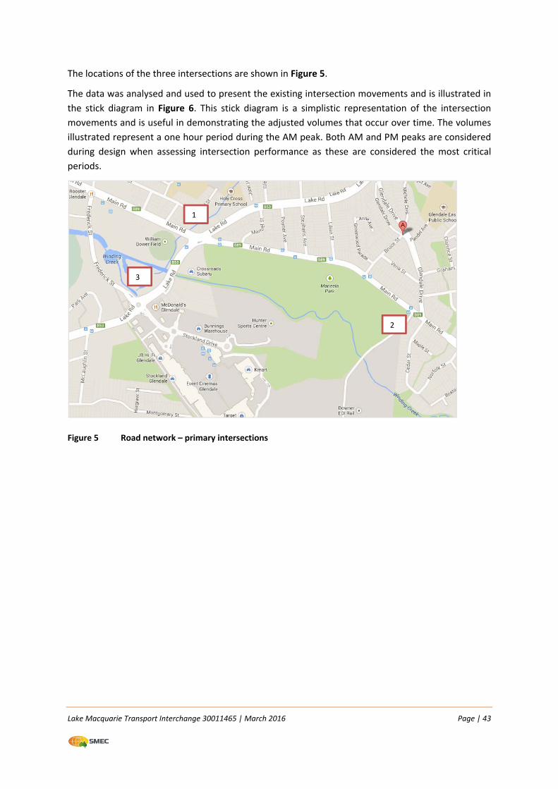
Lake Macquarie Transport Interchange 30011465 | March 2016 Page | 43
The locations of the three intersections are shown in Figure 5.
The data was analysed and used to present the existing intersection movements and is illustrated in
the stick diagram in Figure 6. This stick diagram is a simplistic representation of the intersection
movements and is useful in demonstrating the adjusted volumes that occur over time. The volumes
illustrated represent a one hour period during the AM peak. Both AM and PM peaks are considered
during design when assessing intersection performance as these are considered the most critical
periods.
Figure 5 Road network – primary intersections
1
2
3
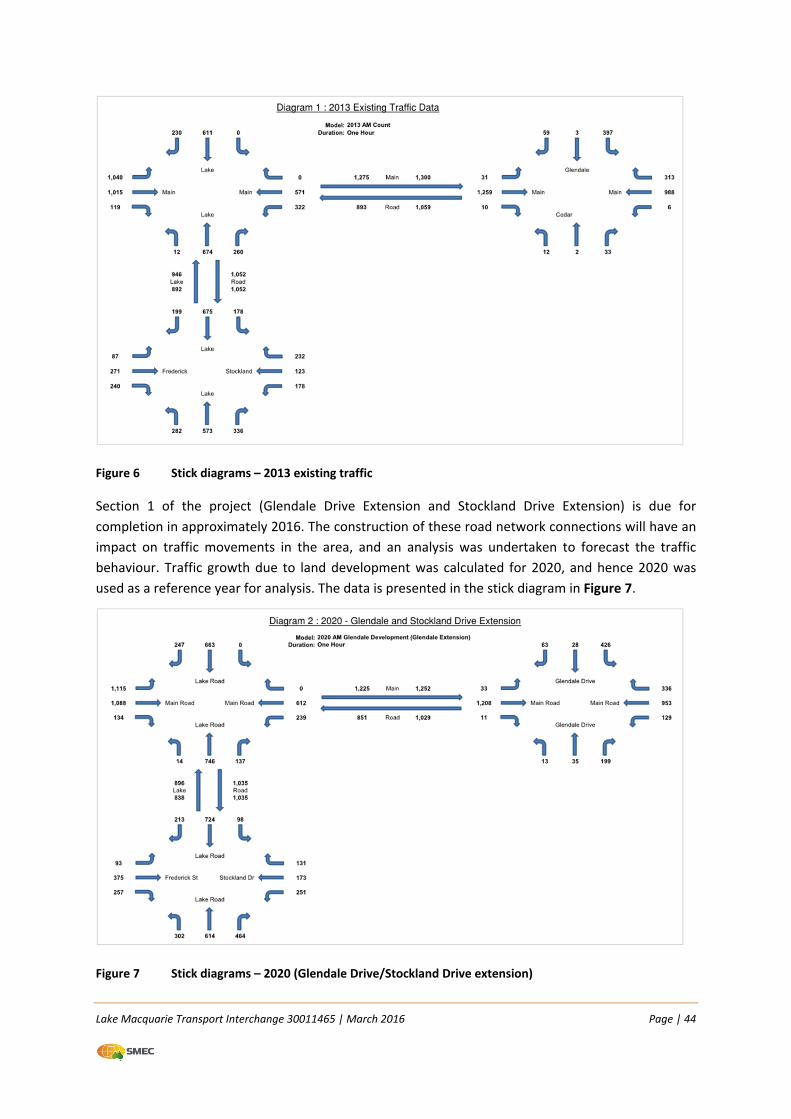
Lake Macquarie Transport Interchange 30011465 | March 2016 Page | 44
Figure 6 Stick diagrams – 2013 existing traffic
Section 1 of the project (Glendale Drive Extension and Stockland Drive Extension) is due for
completion in approximately 2016. The construction of these road network connections will have an
impact on traffic movements in the area, and an analysis was undertaken to forecast the traffic
behaviour. Traffic growth due to land development was calculated for 2020, and hence 2020 was
used as a reference year for analysis. The data is presented in the stick diagram in Figure 7.
Figure 7 Stick diagrams – 2020 (Glendale Drive/Stockland Drive extension)
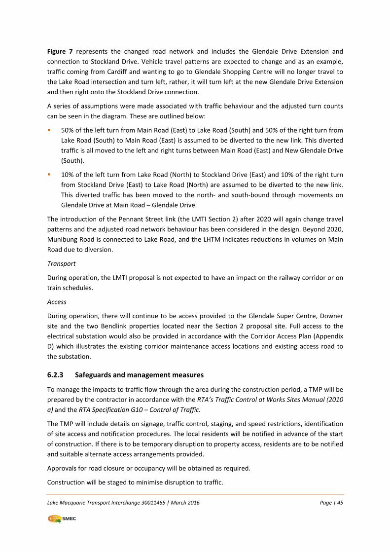
Lake Macquarie Transport Interchange 30011465 | March 2016 Page | 45
Figure 7 represents the changed road network and includes the Glendale Drive Extension and
connection to Stockland Drive. Vehicle travel patterns are expected to change and as an example,
traffic coming from Cardiff and wanting to go to Glendale Shopping Centre will no longer travel to
the Lake Road intersection and turn left, rather, it will turn left at the new Glendale Drive Extension
and then right onto the Stockland Drive connection.
A series of assumptions were made associated with traffic behaviour and the adjusted turn counts
can be seen in the diagram. These are outlined below:
50% of the left turn from Main Road (East) to Lake Road (South) and 50% of the right turn from
Lake Road (South) to Main Road (East) is assumed to be diverted to the new link. This diverted
traffic is all moved to the left and right turns between Main Road (East) and New Glendale Drive
(South).
10% of the left turn from Lake Road (North) to Stockland Drive (East) and 10% of the right turn
from Stockland Drive (East) to Lake Road (North) are assumed to be diverted to the new link.
This diverted traffic has been moved to the north‐ and south‐bound through movements on
Glendale Drive at Main Road – Glendale Drive.
The introduction of the Pennant Street link (the LMTI Section 2) after 2020 will again change travel
patterns and the adjusted road network behaviour has been considered in the design. Beyond 2020,
Munibung Road is connected to Lake Road, and the LHTM indicates reductions in volumes on Main
Road due to diversion.
Transport
During operation, the LMTI proposal is not expected to have an impact on the railway corridor or on
train schedules.
Access
During operation, there will continue to be access provided to the Glendale Super Centre, Downer
site and the two Bendlink properties located near the Section 2 proposal site. Full access to the
electrical substation would also be provided in accordance with the Corridor Access Plan (Appendix
D) which illustrates the existing corridor maintenance access locations and existing access road to
the substation.
6.2.3 Safeguards and management measures
To manage the impacts to traffic flow through the area during the construction period, a TMP will be
prepared by the contractor in accordance with the RTA’s Traffic Control at Works Sites Manual (2010
a) and the RTA Specification G10 – Control of Traffic.
The TMP will include details on signage, traffic control, staging, and speed restrictions, identification
of site access and notification procedures. The local residents will be notified in advance of the start
of construction. If there is to be temporary disruption to property access, residents are to be notified
and suitable alternate access arrangements provided.
Approvals for road closure or occupancy will be obtained as required.
Construction will be staged to minimise disruption to traffic.
Lake Macquarie Transport Interchange 30011465 | March 2016 Page | 46
Property access will be maintained for the duration of the construction period.
6.3 Noise and vibration
6.3.1 Existing environment
RCA Acoustics was engaged to prepare a Construction Noise and Vibration Impact Assessment and a
Traffic Noise Impact Assessment for the LMTI proposal. These are provided in Appendix E.
The LMTI is located within a mixture of urban, commercial and industrial areas. Major noise sources
that contribute to the current acoustic environment include the railway and arterial roads. There are
no sensitive receivers in the immediate proximity of the LMTI, with the nearest school located
approximately 900 metres to the north.
In accordance with the NSW Industrial Noise Policy (INP) the area is defined as suburban. Within the
Glendale area the acoustic environment is typical of suburban areas, influenced by roads and traffic
in the area.
Unattended noise surveys were undertaken from 8–15 May 2013 (refer Figure 8) at the eastern end
of Montgomery Street and outside 15 Cedar Street. The sites were selected based on their proximity
to Section 1 and 2 of the LMTI. The survey recorded seven days of continuous 15 minute percentile
sound level data with no significant periods of unfavourable weather conditions.
Rating Background Levels (RBL) are provided in Table 11.
Table 11 Rating Background Levels
Daytime 7 am – 6pm
Mon to Fri 8am – 1pm Sat
Evening 6pm – 11pm
Night time 11pm – 7am
Montgomery Street
(near the railway line)
RBL 40 41 39
Existing LAeq Level 57 50 48
Cedar Street
(near Main Road)
RBL 45 41 35
Existing LAeq Level 60 50 50
The results in Table 11 indicate that noise levels near the railway line are similar/lower than those
further from the railway. This is because the noise logger at Cedar Street (further away from the
railway line) is affected by traffic at Main Road (which is a continuous noise), consequently bringing
up the background (L90) readings. The noise at Montgomery Street (near the railway line) is of short
duration and therefore has lower L90 readings.
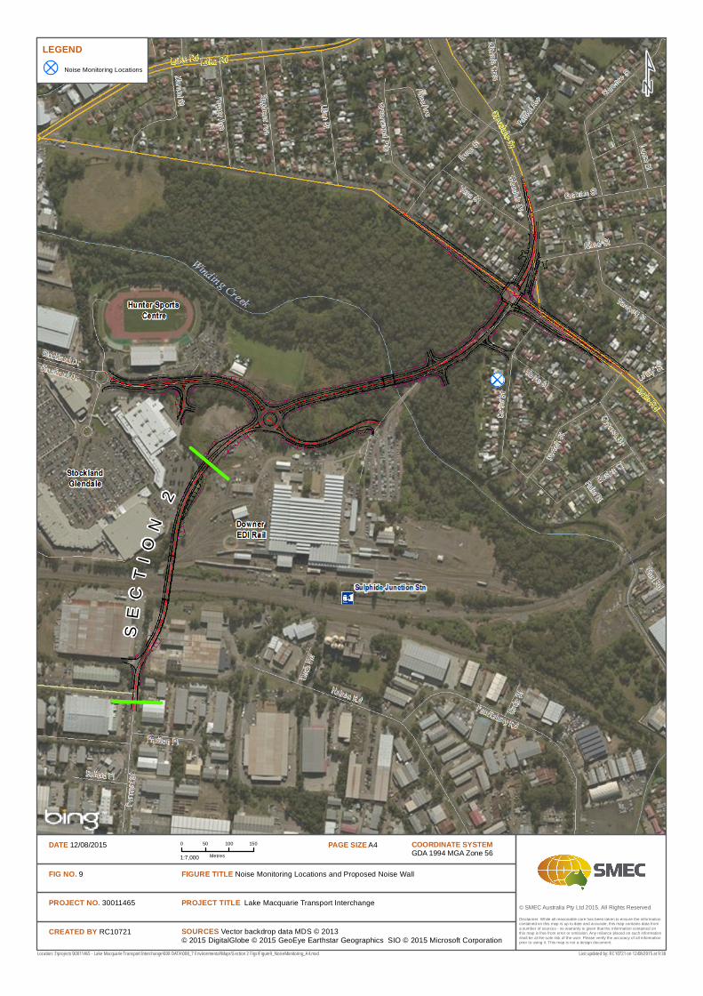
© SMEC Australia Pty Ltd 2015. All Rights Reserved
LEGENDNoise Monitoring Locations
SOURCES Vector backdrop data MDS © 2013© 2015 DigitalGlobe © 2015 GeoEye Earthstar Geographics SIO © 2015 Microsoft Corporation
Location: I:\projects\30011465 - Lake Macquarie Transport Interchange\008 DATA\008_7 Environmental\Maps\Section 2 Figs\Figure9_NoiseMonitoring_A4.mxd
Disclaimer: While all reasonable care has been taken to ensure the information contained on this map is up to date and accurate, this map contains data from a number of sources - no warranty is given that the information contained on this map is free from error or omission. Any reliance placed on such information shall be at the sole risk of the user. Please verify the accuracy of all information prior to using it. This map is not a design document.
COORDINATE SYSTEMGDA 1994 MGA Zone 56
PAGE SIZE A40 50 100 150
Metres1:7,000
DATE 12/08/2015
FIG NO. 9
PROJECT NO. 30011465
CREATED BY RC10721
PROJECT TITLE Lake Macquarie Transport Interchange
FIGURE TITLE Noise Monitoring Locations and Proposed Noise Wall
Last updated by: RC10721 on 12/08/2015 at 9:30
SE
CT
IO
N2
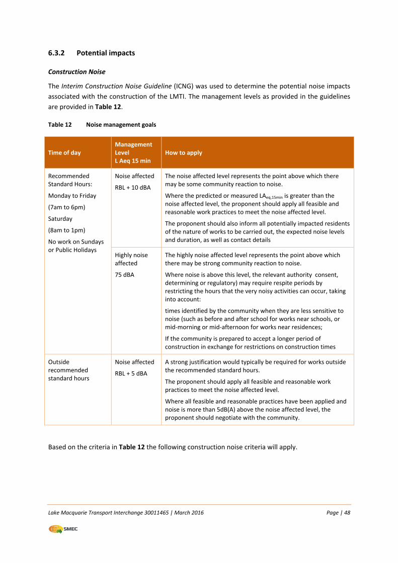
Lake Macquarie Transport Interchange 30011465 | March 2016 Page | 48
6.3.2 Potential impacts
Construction Noise
The Interim Construction Noise Guideline (ICNG) was used to determine the potential noise impacts
associated with the construction of the LMTI. The management levels as provided in the guidelines
are provided in Table 12.
Table 12 Noise management goals
Time of day Management Level L Aeq 15 min
How to apply
Recommended Standard Hours:
Monday to Friday
(7am to 6pm)
Saturday
(8am to 1pm)
No work on Sundays or Public Holidays
Noise affected
RBL + 10 dBA
The noise affected level represents the point above which there may be some community reaction to noise.
Where the predicted or measured LAeq,15min is greater than the noise affected level, the proponent should apply all feasible and reasonable work practices to meet the noise affected level.
The proponent should also inform all potentially impacted residents of the nature of works to be carried out, the expected noise levels and duration, as well as contact details
Highly noise affected
75 dBA
The highly noise affected level represents the point above which there may be strong community reaction to noise.
Where noise is above this level, the relevant authority consent, determining or regulatory) may require respite periods by restricting the hours that the very noisy activities can occur, taking into account:
times identified by the community when they are less sensitive to noise (such as before and after school for works near schools, or mid‐morning or mid‐afternoon for works near residences;
If the community is prepared to accept a longer period of construction in exchange for restrictions on construction times
Outside recommended standard hours
Noise affected
RBL + 5 dBA
A strong justification would typically be required for works outside the recommended standard hours.
The proponent should apply all feasible and reasonable work practices to meet the noise affected level.
Where all feasible and reasonable practices have been applied and noise is more than 5dB(A) above the noise affected level, the proponent should negotiate with the community.
Based on the criteria in Table 12 the following construction noise criteria will apply.
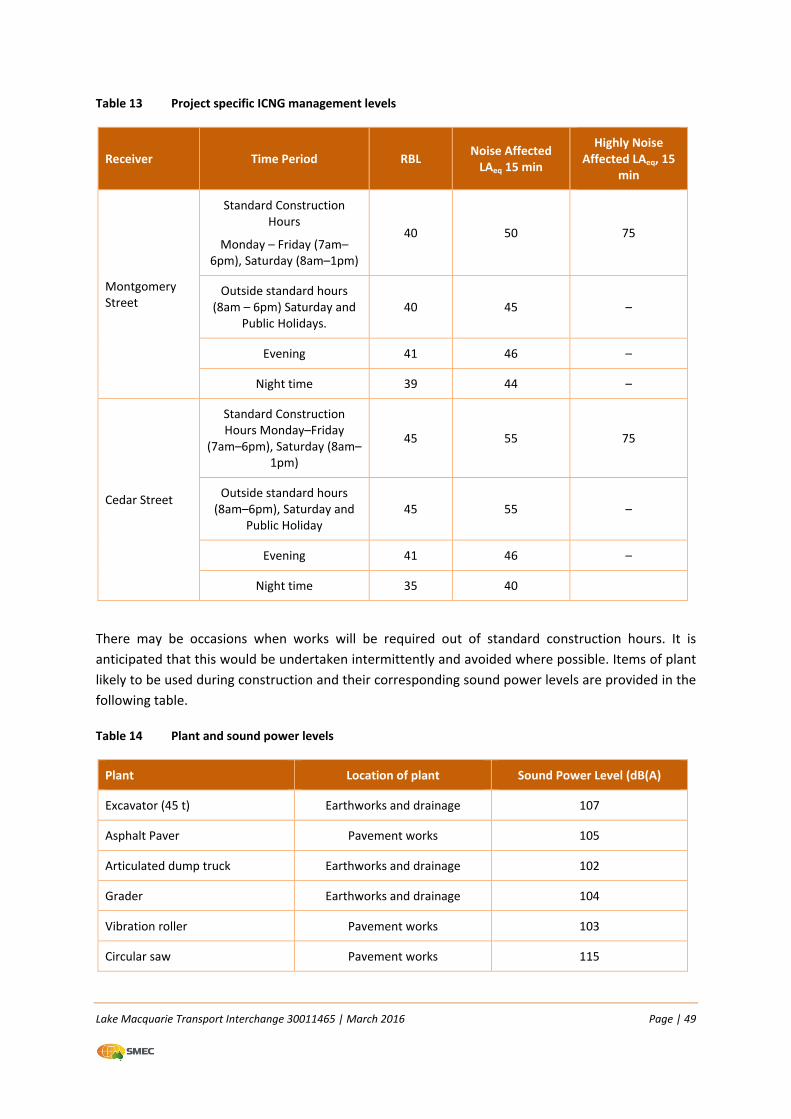
Lake Macquarie Transport Interchange 30011465 | March 2016 Page | 49
Table 13 Project specific ICNG management levels
Receiver Time Period RBL Noise Affected LAeq 15 min
Highly Noise Affected LAeq, 15
min
Montgomery Street
Standard Construction Hours
Monday – Friday (7am–6pm), Saturday (8am–1pm)
40 50 75
Outside standard hours (8am – 6pm) Saturday and
Public Holidays. 40 45 –
Evening 41 46 –
Night time 39 44 –
Cedar Street
Standard Construction Hours Monday–Friday
(7am–6pm), Saturday (8am–1pm)
45 55 75
Outside standard hours (8am–6pm), Saturday and
Public Holiday 45 55 –
Evening 41 46 –
Night time 35 40
There may be occasions when works will be required out of standard construction hours. It is
anticipated that this would be undertaken intermittently and avoided where possible. Items of plant
likely to be used during construction and their corresponding sound power levels are provided in the
following table.
Table 14 Plant and sound power levels
Plant Location of plant Sound Power Level (dB(A)
Excavator (45 t) Earthworks and drainage 107
Asphalt Paver Pavement works 105
Articulated dump truck Earthworks and drainage 102
Grader Earthworks and drainage 104
Vibration roller Pavement works 103
Circular saw Pavement works 115
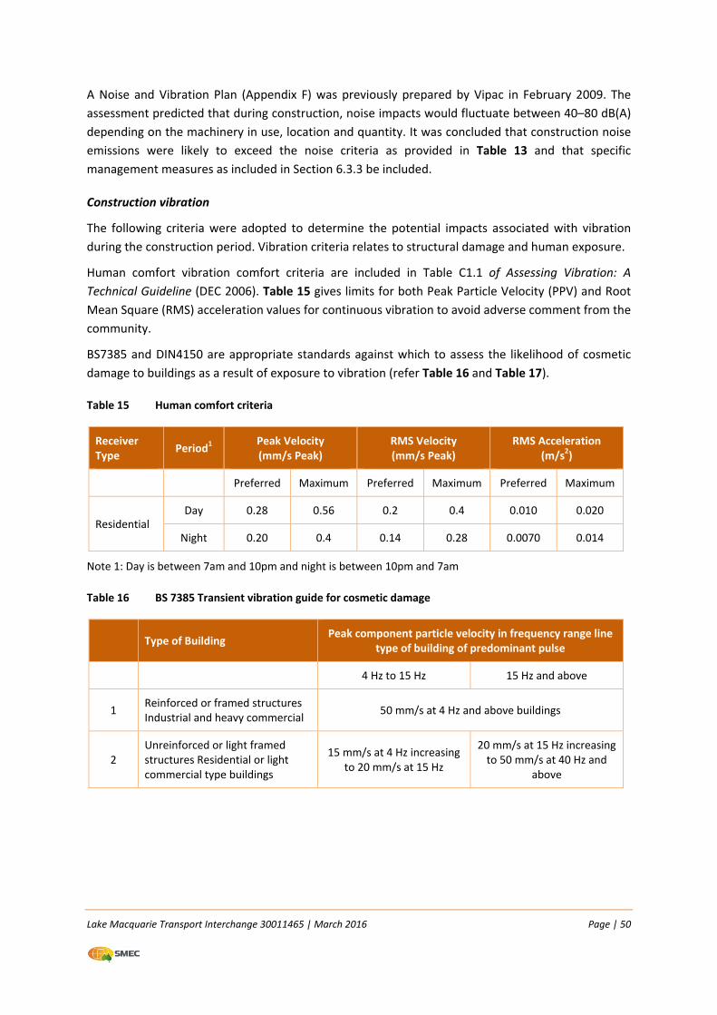
Lake Macquarie Transport Interchange 30011465 | March 2016 Page | 50
A Noise and Vibration Plan (Appendix F) was previously prepared by Vipac in February 2009. The
assessment predicted that during construction, noise impacts would fluctuate between 40–80 dB(A)
depending on the machinery in use, location and quantity. It was concluded that construction noise
emissions were likely to exceed the noise criteria as provided in Table 13 and that specific
management measures as included in Section 6.3.3 be included.
Construction vibration
The following criteria were adopted to determine the potential impacts associated with vibration
during the construction period. Vibration criteria relates to structural damage and human exposure.
Human comfort vibration comfort criteria are included in Table C1.1 of Assessing Vibration: A
Technical Guideline (DEC 2006). Table 15 gives limits for both Peak Particle Velocity (PPV) and Root
Mean Square (RMS) acceleration values for continuous vibration to avoid adverse comment from the
community.
BS7385 and DIN4150 are appropriate standards against which to assess the likelihood of cosmetic
damage to buildings as a result of exposure to vibration (refer Table 16 and Table 17).
Table 15 Human comfort criteria
Receiver Type
Period1 Peak Velocity (mm/s Peak)
RMS Velocity (mm/s Peak)
RMS Acceleration (m/s2)
Preferred Maximum Preferred Maximum Preferred Maximum
Residential Day 0.28 0.56 0.2 0.4 0.010 0.020
Night 0.20 0.4 0.14 0.28 0.0070 0.014
Note 1: Day is between 7am and 10pm and night is between 10pm and 7am
Table 16 BS 7385 Transient vibration guide for cosmetic damage
Type of Building Peak component particle velocity in frequency range line
type of building of predominant pulse
4 Hz to 15 Hz 15 Hz and above
1 Reinforced or framed structures Industrial and heavy commercial
50 mm/s at 4 Hz and above buildings
2 Unreinforced or light framed structures Residential or light commercial type buildings
15 mm/s at 4 Hz increasing to 20 mm/s at 15 Hz
20 mm/s at 15 Hz increasing to 50 mm/s at 40 Hz and
above
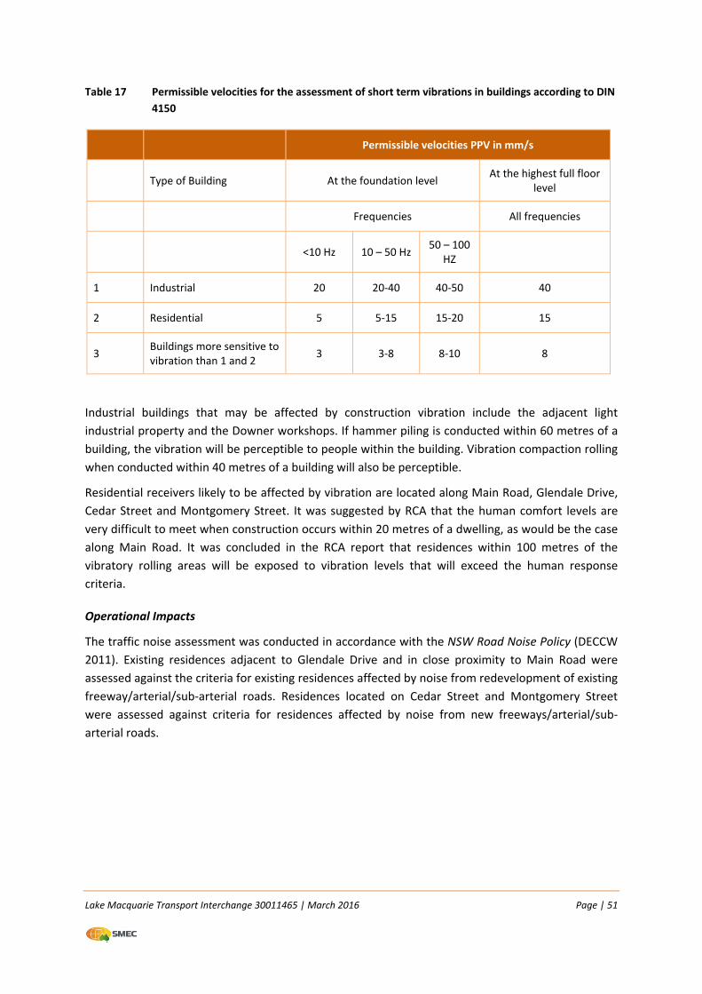
Lake Macquarie Transport Interchange 30011465 | March 2016 Page | 51
Table 17 Permissible velocities for the assessment of short term vibrations in buildings according to DIN
4150
Permissible velocities PPV in mm/s
Type of Building At the foundation level At the highest full floor
level
Frequencies All frequencies
<10 Hz 10 – 50 Hz 50 – 100
HZ
1 Industrial 20 20‐40 40‐50 40
2 Residential 5 5‐15 15‐20 15
3 Buildings more sensitive to vibration than 1 and 2
3 3‐8 8‐10 8
Industrial buildings that may be affected by construction vibration include the adjacent light
industrial property and the Downer workshops. If hammer piling is conducted within 60 metres of a
building, the vibration will be perceptible to people within the building. Vibration compaction rolling
when conducted within 40 metres of a building will also be perceptible.
Residential receivers likely to be affected by vibration are located along Main Road, Glendale Drive,
Cedar Street and Montgomery Street. It was suggested by RCA that the human comfort levels are
very difficult to meet when construction occurs within 20 metres of a dwelling, as would be the case
along Main Road. It was concluded in the RCA report that residences within 100 metres of the
vibratory rolling areas will be exposed to vibration levels that will exceed the human response
criteria.
Operational Impacts
The traffic noise assessment was conducted in accordance with the NSW Road Noise Policy (DECCW
2011). Existing residences adjacent to Glendale Drive and in close proximity to Main Road were
assessed against the criteria for existing residences affected by noise from redevelopment of existing
freeway/arterial/sub‐arterial roads. Residences located on Cedar Street and Montgomery Street
were assessed against criteria for residences affected by noise from new freeways/arterial/sub‐
arterial roads.
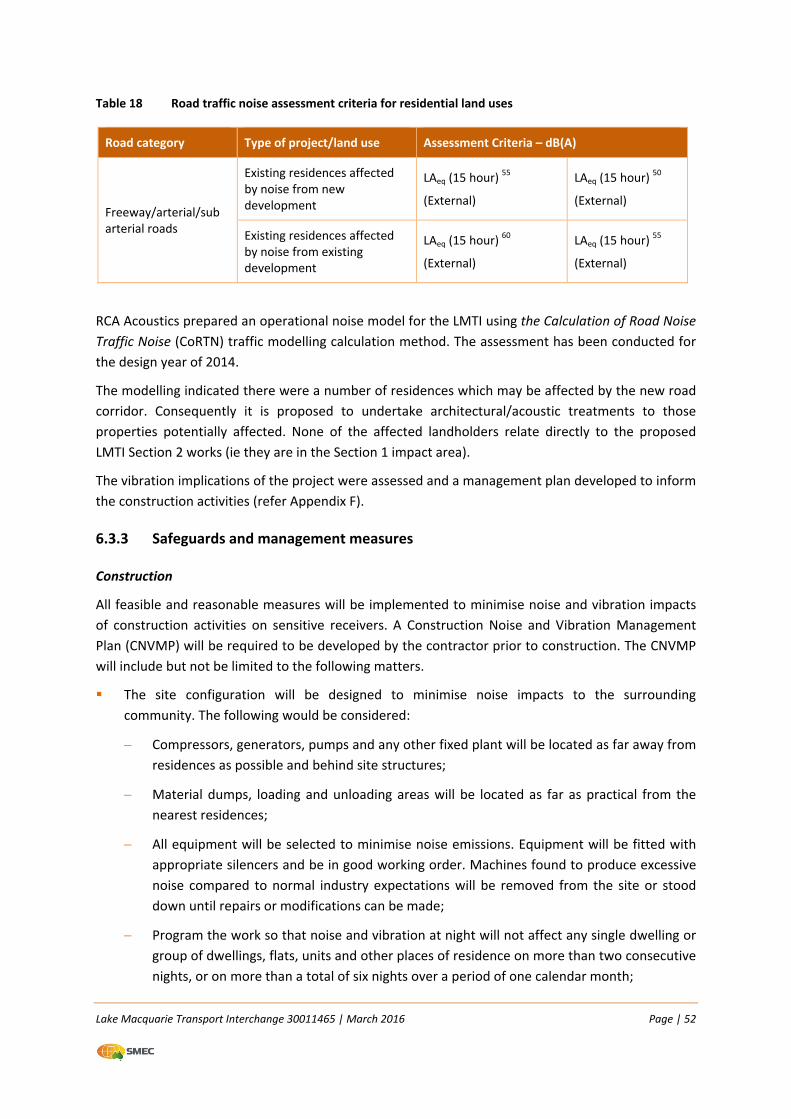
Lake Macquarie Transport Interchange 30011465 | March 2016 Page | 52
Table 18 Road traffic noise assessment criteria for residential land uses
Road category Type of project/land use Assessment Criteria – dB(A)
Freeway/arterial/sub arterial roads
Existing residences affected by noise from new development
LAeq (15 hour) 55
(External)
LAeq (15 hour) 50
(External)
Existing residences affected by noise from existing development
LAeq (15 hour) 60
(External)
LAeq (15 hour) 55
(External)
RCA Acoustics prepared an operational noise model for the LMTI using the Calculation of Road Noise
Traffic Noise (CoRTN) traffic modelling calculation method. The assessment has been conducted for
the design year of 2014.
The modelling indicated there were a number of residences which may be affected by the new road
corridor. Consequently it is proposed to undertake architectural/acoustic treatments to those
properties potentially affected. None of the affected landholders relate directly to the proposed
LMTI Section 2 works (ie they are in the Section 1 impact area).
The vibration implications of the project were assessed and a management plan developed to inform
the construction activities (refer Appendix F).
6.3.3 Safeguards and management measures
Construction
All feasible and reasonable measures will be implemented to minimise noise and vibration impacts
of construction activities on sensitive receivers. A Construction Noise and Vibration Management
Plan (CNVMP) will be required to be developed by the contractor prior to construction. The CNVMP
will include but not be limited to the following matters.
The site configuration will be designed to minimise noise impacts to the surrounding
community. The following would be considered:
Compressors, generators, pumps and any other fixed plant will be located as far away from
residences as possible and behind site structures;
Material dumps, loading and unloading areas will be located as far as practical from the
nearest residences;
All equipment will be selected to minimise noise emissions. Equipment will be fitted with
appropriate silencers and be in good working order. Machines found to produce excessive
noise compared to normal industry expectations will be removed from the site or stood
down until repairs or modifications can be made;
Program the work so that noise and vibration at night will not affect any single dwelling or
group of dwellings, flats, units and other places of residence on more than two consecutive
nights, or on more than a total of six nights over a period of one calendar month;
Lake Macquarie Transport Interchange 30011465 | March 2016 Page | 53
When night work is programmed in stages to comply with this requirement, the periods of
work should be separated by not less than one week;
If programmed night work is postponed for any reason, the work should be reprogrammed
and the programming requirements described above apply again;
Very noisy activities should be programmed for normal working hours. If the work cannot
be undertaken during the day, it should be completed before 11:00 pm;
To reduce the annoyance associated with reversing alarms, broadband reversing alarms
(audible movement alarms) will be used for all site equipment. Satisfactory compliance
with occupational health and safety requirements will need to be achieved and a safety risk
assessment may need to be undertaken to determine that safety is not compromised;
General construction activities will be limited to the recommended construction hours
where feasible and reasonable. Should any out of hours work be required, works will be
undertaken in line with procedures contained in the Environmental Noise Management
Manual Practice Note vii – Roadworks Outside Normal Working Hours (RTA 2001). This will
include notifying affected residents in the local community of any works planned to be
undertaken outside the standard hours; and
All site workers will undergo site induction which will include an awareness of the potential
impacts for noise and vibration on local residents and encouraged to take practical and
reasonable measures to minimise the impact during the course of their activities.
Vibration mitigation measures
Prior to any construction works within 50 metres of any buildings, structures or utilities, the
contractor will undertake a building condition survey; and
Prior to rolling and compacting activities adjacent to residences within 20 metres, the resident
will be informed of the nature of the works, duration and project contact details.
Notification and Complaints Handling
The local community that could be affected by the proposed works will be contacted and
informed of the proposed work, location, days and dates of work, and hours involved. The
contact will be made a minimum five days prior to commencement of works; and
A 24 hour community liaison phone number and permanent site contact will be provided so
that complaints can be received and responded to within 24 hours.
Compliance noise and vibration monitoring
Compliance noise and vibration monitoring will be undertaken upon receipt of a complaint. The
results of the monitoring will be reported as soon as possible. If exceedances are detected, the
situation will be reviewed in order to identify means to minimise the impacts to residences; and
During compaction activities vibration monitoring will be undertaken at the closest residence
affected.
Lake Macquarie Transport Interchange 30011465 | March 2016 Page | 54
Operational
The following mitigation measures are recommended to achieve the operational noise criteria:
Architectural/acoustic treatment will be applied to residences impacted by increases in
operational noise.
6.4 Hydrology
6.4.1 Existing environment
A flood impact assessment was prepared by SMEC for the overall LMTI project and is included in
Appendix G.
The proposed bridge over Winding Creek is located approximately 50 metres downstream of the
existing bridge crossing. A tributary of Winding Creek bisects the allotment bounded by Main Road
to the north, Downer access road to the west and Winding Creek to the south. This tributary is a
concrete‐lined open channel running in a general north‐south direction through a residential area,
with an ultimate confluence with Winding Creek approximately 250 metres upstream of the existing
bridge crossing.
The Winding Creek catchment (including Brush Creek) has an area of approximately 23 km2 (WMA
2013). Winding Creek together with its tributaries forms around the Charlestown area at an
elevation of approximately 100 mAHD. After draining heavily vegetated areas in its headwaters, the
creek transitions to a concrete lined channel adjacent to Elizabeth Street in Cardiff South where it
then flows under Myall Road, Macquarie Road and then under the Railway Bridge at Cardiff where it
then transitions back into a natural heavily vegetated channel through to the subject site. Winding
Creek then flows in a generally westerly direction past the suburb of Argenton until it joins Cockle
Creek, before flowing into Lake Macquarie.
Under flood conditions, Winding Creek overflows its banks and inundates the low lying floodplain
around the suburbs of Cardiff, Glendale, Edgeworth, Barnsley and Argenton.
The section of Winding Creek and associated floodplain within the location of the proposed bridge is
typically heavily vegetated with evidence of erosion and scouring within the section of channel
adjacent to the current Winding Creek Bridge crossing.
A number of studies have previously been undertaken at the site, most recently in January 2013
WMA Water (WMA) for the ‘Winding Creek and Lower Cockle Creek Flood Study’. Modelling for the
WMA 2013 study utilised the 2D TUFLOW modelling software package. This model extended from
the Winding Creek intersection point with Hillsborough Road to the confluence of Winding
Creek/Cockle Creek, downstream to Lake Macquarie. Floods assessed in the study were the 50, 20,
10, 5, 2, 1 and 0.5% AEP storm events and the Probable Maximum Flood (PMF).
A series of flood maps were prepared for the flood‐affected areas of the study and surrounding
areas. As a separate investigation, WMA also undertook the Flood Impact Assessment of the
Proposed Interchange at Glendale (11 January 2013). This investigation was commissioned by LMCC
in order to achieve the following:
Lake Macquarie Transport Interchange 30011465 | March 2016 Page | 55
Estimate the size of on‐site detention (OSD) system(s) that will be required to mitigate the
increase in peak runoff flows produced by the increase in impervious area as a result of the
proposed road works; and
Assess the potential changes in flood behaviour on surrounding floodplain users due to the
construction of a new bridge over Winding Creek.
This study was however undertaken prior to the road design being completed. Nevertheless, the
design adopted the following criteria with regard to flooding:
The Glendale Drive extension is to have one‐way traffic in each direction in a 5% AEP and is to
be trafficable for emergency vehicles in the 1% AEP event.
A 300 mm freeboard was provided for major structures between the peak water level and the
underside of the structure.
Positioning of the soffit of the bridge above the 100 year average recurrence interval (ARI)
(1% AEP) flood level to allow some freeboard for floating debris; and noting that Section D5.14
of LMCC Engineering Guidelines states that
a minimum of 0.3 m between the 100 year ARI (1% AEP) flood level and the underside of any major
structure is required to allow for passage of debris without blockage;
Velocity‐Depth (v.d) relationship for the 100 year ARI (1% AEP) design storm event should be
less than 0.4 m2/s;
No property damage for events up to the 100 year ARI (1% AEP) design storm event. Section
D5.14 of LMCC Engineering Guidelines states that
all major structures in urban areas, including bridges and culverts, shall be designed for the 100 year ARI
(1% AEP) storm event without afflux. Some afflux and upstream inundation may be permitted in certain
rural and urban areas provided the increased upstream flooding is minimal and does not inundate
private property;
No structural damage to the bridge and bridge abutments for the 2000 year ARI (0.05% AEP)
design storm.
Section 2
Winding Creek, located to the north of the Section 2 proposal area, is the main waterway that occurs
within the LMTI study area. There are no creeks within the Section 2 proposal area. An existing
overland flow path occurs to the west of the western Bendlink property and will not be impacted by
the proposal. The proposed roads and bridge will drain into the existing stormwater system. There is
adequate capacity in the existing system to cater for the minor increase in flows from this
component of the LMTI. The proposal will not change the drainage regime.
6.4.2 Potential impacts
Construction
Construction activities are not expected to have any material impacts on hydrology and flooding.
Lake Macquarie Transport Interchange 30011465 | March 2016 Page | 56
Operation
The modelling for the flood impact assessment was undertaken using the HEC‐RAS hydraulic model.
This is a one dimensional model that performs hydraulic calculations of both steady and unsteady
flow. The SMEC HEC‐RAS model was calibrated to the WMA TUFLOW model based on flood levels
reported in the 2013 WMA Draft Flood Study as at the time of calibrating the model the WMA
TUFLOW model had not been finalised. The TUFLOW model was only finalised in the late stages of
this project. However, a number of parameters in the SMEC HEC‐RAS model were updated based on
the final TUFLOW model, including peak discharges and tailwater levels for a range of design storm
events.
The HEC‐RAS hydraulic model was used to assess the flood impact due to the proposed
development, particularly at the location of the proposed Winding Creek Bridge Crossing and the
surrounding properties. The model was also required to calculate the flood levels/velocities at the
proposed bridge, and also to assess the scour depth at the proposed bridge abutments.
A number of design storm events were simulated in order to assess any potential changes in flood
extents as a result of the proposed road and Winding Creek crossing, including the PMF event, with
particular focus on results of the 1% AEP design storm event in order to assess both the 100 year
flood level at the location of the proposed bridge as well as to estimate the velocity‐depth
relationship at low points along the proposed road alignment within the Winding Creek floodplain.
The focus of the erosion and scour analysis has been based on two particular events, these being the
1% AEP year and 0.05% AEP events, in accordance with the requirements of the AUSTROADS AP‐
23/94 Waterway Design — A Guide to the Hydraulic Design of Bridges.
Flooding behaviour was assessed at a number of locations within Winding Creek and also within the
Cedar Street tributary flowing into Winding Creek.
The hydraulic modelling concluded the following:
The proposed Winding Creek Bridge soffit level is positioned above the 1% AEP flood level with
about 660 mm freeboard;
The proposed road level is flood free for flood events up to and including the 5% AEP event. The
estimated 1% AEP flood depth over the low point in the road (Glendale Drive) leading up to the
bridge is about 276 mm (at edge of outer lane), however there is no overtopping at the crest of
the low point in the road for the 1% AEP design storm event;
There are no flooding impacts downstream of the proposed bridge for the 1% AEP event;
There are no significant flooding impacts at the proposed bridge and upstream of the proposed
bridge for events up to and including the 1% AEP event;
There is an afflux immediately upstream of the proposed bridge for design storm events greater
than the 1% AEP with an estimated 210 mm (0.05% AEP) and 770 mm (PMF). This level of afflux
is unavoidable for any new bridge configuration;
There is an afflux immediately upstream of the Cedar Street culvert crossing for design storm
events greater than the 1% AEP with an estimated 6 mm (0.05 %AEP) and 190 mm (PMF);
Lake Macquarie Transport Interchange 30011465 | March 2016 Page | 57
The approximate number of properties currently affected by flooding upstream of the Winding
Creek bridge are of the order of 45 properties for the 1% AEP event, 74 properties affected for
the 0.05% AEP event and 120 properties for the PMF event. Flood levels at these properties are
expected to rise for the 0.05% AEP and PMF flood events, however it is not predicted to be a
significant number of additional properties affected in these more extreme events (i.e. flood
extent maps indicate that there may be up to six additional properties affected in the PMF
event, as a result of increase afflux in this extreme event); and
Changes in velocities appear to be localised around the proposed bridge flow area and do not
change significantly upstream/downstream of the proposed bridge.
Section 2
The area mapped as within the 1% AEP event does not include any areas of Section 2 so there will be
no impacts on the flooding of Winding Creek due to LMTI Section 2. There are some drainage
impacts that need to be managed but these are standard design details included in the project
design.
6.4.3 Safeguards and management measures
Based on the hydraulic modelling that was undertaken the following recommendations were
provided and subsequently incorporated into the design:
The bridge abutments are to include scour protection;
Abutment foundations should also be piled and keyed into bedrock
Scour protection at the proposed bridge abutment will require the addition of two layers of 550
mm rip‐rap wrapped around the toe of the bridge abutment
Detailed design would ensure that there would be no additional drainage into the rail corridor.
Plans for the Pennant Street Bridge would ensure continuation and amplification of current
drainage to ensure there are no impacts on current track operation.
6.5 Water quality
6.5.1 Existing environment
The overall LMTI project site is located within the catchment of Winding Creek. Winding Creek is a
tributary of Cockle Creek, and has approximately three per cent of the Lake Macquarie catchment.
The catchment of Winding Creek is highly urbanised and is a major carrier of stormwater in Lake
Macquarie. Major tributaries of the creek include Tickhole Creek to the north east and Munibung
Creek to the south west. The northern extent of the Section 2 site is located approximately 450
metres to the southwest of Winding Creek.
Due to the highly urbanised catchment, Winding Creek is subject to variable water quality due to
contaminated stormwater runoff. Stormwater detention and silt traps have been installed
throughout the catchment to minimise the impact to the creek from contaminated stormwater.
There is stormwater drainage infrastructure present on Pennant Street.
Lake Macquarie Transport Interchange 30011465 | March 2016 Page | 58
6.5.2 Potential impacts
Construction
Construction of Section 1 of the LMTI has the potential to impact on Winding Creek due to the
proximity of the proposed activities, including the construction of the Winding Creek Bridge, to
Winding Creek. This has been assessed in the REF prepared for Section 1 (SMEC, 2014).
Construction of Section 2, including the construction of the Pennant Street Bridge and the relocation
of utilities such as the water main associated with the Bendlink properties, is not expected to have
an adverse impact on the water quality of Winding Creek primarily due to its distance away from the
creek and also because of the environmental controls which would be implemented during
construction. The northern extent of Section 2 is approximately 450 metres to the southwest of the
creek and there are no other creeklines in proximity to the Section 2 site.
Without appropriate safeguards, pollutants (fuels, chemicals or wastewater from accidental spills,
and sediment from stockpiles) could potentially enter stormwater drains and flow into nearby
waterways.
Operation
The proposal is unlikely to pose a risk to the water quality of Winding Creek. The detailed design has
taken stormwater management into consideration and the proposal is designed and will be
constructed with the relevant Sydney Trains and Council standards and requirements.
6.5.3 Safeguards and management measures
To minimise the impact to water quality of Winding Creek during the new bridge construction as Soil
and Water Management Plan has been developed. This is to be adopted along with the following:
Development of an Erosion and Sediment Control Plan (ESCP) in accordance with Managing
Urban Stormwater: Soils and Construction, 4th ed Landcom (2004) (‘the Blue Book’) and LMCC
DCP No.1 Section 2.1.11 Erosion Prevention and Sediment Control;
All controls are to be in place, prior to construction works commencing;
Ensure that all plant and equipment are well maintained and any refuelling or maintenance is
undertaken off site. Spill control equipment is to be located in proximity to the work area in the
case of an accidental spill;
Designated areas for waste receptacles are in place, so all rubbish and other stored materials
are located away from stormwater drains;
All staff and contractors undergo a site induction which is to include training in emergency
response procedures in the event of a spill; and
Ensure areas are stabilised and rehabilitated as soon as possible to reduce potential for
sediment‐laden runoff.
Management of operational impacts on water quality will be addressed through:
Lake Macquarie Transport Interchange 30011465 | March 2016 Page | 59
The drainage design provides for Gross Pollutant Traps (GPTs) to improve the quality of road
runoff; and
The proposed GPTs have some capacity to separate and store floating oil passing through the
drainage system.
6.6 Soils and geology
6.6.1 Existing environment
The Department of Mineral Resources (1995) Newcastle Coalfield Regional Geology map (1:100,000)
indicates that the site lies predominantly within the Boolaroo Sub‐Group, which comprises a series
of formations including sandstone, siltstone, shale and conglomerate. The northern and southern
parts of the site lie near geological boundaries between the Boolaroo Sub‐group and the underlying
Adamstown Sub‐group.
The near surface soils are generally clays and sandy or gravelly clays derived from the underlying
sedimentary bedrock.
The hydrogeology of the area is expected to be controlled by surface water in Winding Creek, with
groundwater flow expected to be generally north to northeast towards Winding Creek.
The ground surface of the LMTI Section 2 proposal area has been disturbed in the past:
The majority of the Bendlink site on the southern side of the railway corridor is concrete hardstand.
The rear of the property comprises a fill mound joining natural ground along the Pennant Street
boundary with the concrete hardstand behind a half built retaining wall;
The Downer rail site comprises bitumen access roads and car parks, concrete hardstand areas,
gravel/dirt parking areas, grass and rail tracks; and
The rear of the Glendale Super Centre property comprises a fill mound covered in grass and shrubby
bushland, car parks and access roads to the loading docks.
This is discussed further in Section 6.7
6.6.2 Potential impacts
Construction
Construction related activities which have the potential to disturb soil and cause erosion include:
Excavation for the installation of bridge abutments and scour protection;
Cut and fill for the new road alignment both south and north of the new bridge;
Stockpiling of excavated and imported materials;
Removal of existing pavement from the existing road alignment;
Movement of vehicles in the construction areas, driving off road and entering and existing the
construction area; and
Rehabilitation and landscaping activities.
Lake Macquarie Transport Interchange 30011465 | March 2016 Page | 60
6.6.3 Safeguards and management measures
An erosion and sediment control plan (ESCP) will be prepared for the site in accordance with
Managing Urban Stormwater–Soils and Construction, 4th Edition (Landcom 2004) to manage
potential erosion and sedimentation risks during construction. The ESCP will be prepared by the
contractor and include identification of local drainage features, waterways, catchment areas and the
direction of on‐site and off‐site water flow, and the location and sizing of sediment controls
including silt fences, straw bales, sumps and basins.
Erosion and sediment control measures will be implemented and maintained in order to:
Prevent sediment moving off‐site and sediment laden water entering any watercourse, drainage
lines, or drain inlets;
Reduce water velocity and retain sediment on site;
Minimise the risk of material transported from site to surrounding pavement surfaces;
Divert clean water around the site;
Weather (wind and rain) forecasts will be used to inform timing of high risk activities likely to
create soil erosion and sediment mobilisation;
Erosion and sedimentation controls will be checked and maintained on a regular basis (including
clearing of sediment from behind barriers) and records kept and provided on request;
Erosion and sediment control measures will be retained until the works are complete or areas
are stabilised;
Disturbed areas will be progressively stabilised and rehabilitated as far as practicable during the
works;
Stockpile sites will be located on level ground and as far from waterways and drainage lines as
practicable;
Topsoil will be stockpiled separately for possible reuse for landscaping and rehabilitation;
During excavation, all staff will monitor signs of potential contamination such as the presence of
waste and/or other imported materials, odours, soil colouring and floating oil layers in
groundwater.
Visual monitoring of local water quality (e.g. turbidity, hydrocarbon spills/slicks) will be
undertaken on a regular basis as part of the overall LMTI project to identify any potential spills,
or deficient erosion and sediment controls.
6.7 Hazardous materials
6.7.1 Existing environment
A preliminary environmental site assessment (PESA) for the overall LMTI project was undertaken by
SMEC and is included as Appendix H. The areas referred to in the PESA that relate to the Section 2
proposal area are (refer Figure 9):
Lake Macquarie Transport Interchange 30011465 | March 2016 Page | 61
Area 1 (Pennant Street on the southern side of the railway corridor); and
Area 2 (Rail yard stockpile on the northern side of the railway corridor).
A review of previous reports was undertaken by SMEC prior to undertaking a site visit. A summary of
the findings from the KME report is provided below.
There is a western fill area (rail yard and fill embankment facing Glendale Super Centre) with
principal contaminants suspected found to be present are metals exceeding the guidelines;
The former natural bushland (now Glendale Super Centre) was generally considered to be
relatively free of contamination. However the soil in the localised area was impacted by waste
dumping and was revealed to have metal contamination exceeding guidelines and groundwater
was impacted with zinc, oil and grease;
Asbestos was identified in the fill embankment in Area 2;
Several areas of the site were not investigated due to access restrictions. These include the
covered areas of the brewery site, the rail corridor and buildings. Further investigation will be
required at the site to allow a Remedial Action Plan to be prepared for the site.
Preliminary environmental site assessment (PESA)
A site walkover was undertaken by a SMEC Environmental Scientist on 29 April 2013. This was to
field check the information previously reviewed and identify any additional areas which had not
been adequately investigated previously.
Based on the site visit and review of previous investigations, a conceptual site model was developed
that identified potential contaminants of concern and areas of environmental concern.
A number of potential areas of environmental concern (AECs) are summarised in Table 19.
© SMEC Australia Pty Ltd 2015. All Rights Reserved
LEGENDArea 1Area 2Area 3Area 4Area 5GW site
SOURCES vector layers MDS © 2013© 2010 DigitalGlobe © 2010 GeoEye Earthstar Geographics SIO © 2015 Microsoft Corporation
Location: I:\projects\30011465 - Lake Macquarie Transport Interchange\008 DATA\008_7 Environmental\Maps\Sampling\Figure10_SamplingPriorityAreas_A4.mxd
Disclaimer: While all reasonable care has been taken to ensure the information contained on this map is up to date and accurate, this map contains data from a number of sources - no warranty is given that the information contained on this map is free from error or omission. Any reliance placed on such information shall be at the sole risk of the user. Please verify the accuracy of all information prior to using it. This map is not a design document.
COORDINATE SYSTEMGDA 1994 MGA Zone 56
PAGE SIZE A40 50 100 150
Metres1:6,000
DATE 12/08/2015
FIG NO. 10
PROJECT NO. 30011465
CREATED BY RC10721
PROJECT TITLE Lake Macquarie Transport Interchange
FIGURE TITLE Sampling priority areas
Last updated by: RC10721 on 12/08/2015 at 9:55
Lake Macquarie Transport Interchange 30011465 | March 2016 Page | 63
Table 19 Potential AECs and contaminant types in Section 2
AEC Source Type Contaminant Types
Area 1 ‐ Pennant Street Unknown Fill Petroleum Hydrocarbons
Heavy metals
Asbestos
Ground gas
Aggressive substances (e.g. solvents)
Brewery site Ethanol, methanol, esters
Area 2 ‐ Rail Yard Stockpile Unknown Fill Petroleum Hydrocarbons
Heavy metals
Asbestos
Ground gas
Aggressive substances (e.g. solvents)
6.7.2 Potential impacts
Construction
The presence and disturbance of contaminated materials may result in the following impacts:
Potential impacts to the surrounding environment through release of contaminants via airborne
or water runoff once the soils are disturbed as part of the construction;
Impacts to workers who would be exposed to contaminated material and asbestos containing
materials;
Inappropriate disposal of materials to offsite facilities which may not be licensed to receive the
contaminated materials; and
Inappropriate storage of materials potentially mixed with clean materials which may not be
suitable for reuse on the site.
6.7.3 Safeguards and management measures
Based on the site surveys previously undertaken on site the following management measures will be
undertaken:
A Fill Re‐Use Management Plan (FRMP) has been developed and will be implemented
(Appendix I) that:
Improves the current status of contamination as demonstrated by the Conceptual Site
Model (CSM) where sensitive receptors have been identified;
Provides a framework for implementation during construction phases of development;
Lake Macquarie Transport Interchange 30011465 | March 2016 Page | 64
Includes Incidental Finds Protocol for visible asbestos if encountered during General Solid
Waste and Restricted Solid Waste removal works in terms of underlying clean layer;
Includes an Unexpected Finds Protocol in terms of other potential contaminants and
waste;
Provides controls and management in terms of excavation, stockpile placement, footprint
validation and offsite disposal tracking dockets;
Discusses beneficial re‐use and resource recovery in other fill areas in terms of stockpile
management including stockpile tracking, stockpile testing and classification during all
construction phase of the alignment; and
Determines contamination (if any) within the rail corridor, not previously assessed.
A Soil and Water Management Plan (SWMP) will be implemented to manage potential
groundwater discharges and reticulation activities. Surface water quality will be managed by
implementation of a periodic and/or event based testing program.
6.8 Aboriginal heritage
6.8.1 Existing environment
An Aboriginal Heritage Assessment was undertaken by ERM in 2007 (Appendix J) which covered an
area of 33.5 hectares of the study area. The site had been subject to two previous assessments in
1997 and 2001, however a third study was commissioned given the time lapsed.
The survey covered the predominantly vegetated area between Main Road and Winding Creek. It
was noted that a review of historical aerial photographs identified that most of the site had
previously been cleared, which would impact on the likelihood of Aboriginal artefacts remaining in
the area.
Prior to European settlement in the Lake Macquarie area, the Awabakal and Guringai people
inhabited the area. The area was attractive due to its high abundance of food and water. Previous
archaeological surveys undertaken in the general locality have recorded a wide range of artefacts
including middens, stone artefacts, scarred trees and stone extraction and quarry areas.
A search was undertaken of the Aboriginal Heritage Information Management System (AHIMS)
Aboriginal Sites Database in January 2007. The search covered an area within a 10 km x 11 km area
around the study area.
The search identified 84 recorded sites that comprised the following:
56 stone artefacts;
21 axe grinding grooves;
Four middens;
One scarred tree;
One stone arrangement; and
Lake Macquarie Transport Interchange 30011465 | March 2016 Page | 65
One possible stone extraction site.
Subsequent survey undertaken by RPS in 2014 identified another scarred tree within the study area.
This is further discussed in the following sections.
The previous investigations undertaken in the vicinity of the study area identified a total of nine
Aboriginal sites of which five were recorded within the study area. The survey undertaken by ERM in
2007 sought to relocate these five sites, as well as locate any further artefacts.
Fieldwork was undertaken in February 2007 by ERM archaeologists who were accompanied by two
local Aboriginal community representatives. Visibility during the survey was poor (estimated at <1%)
due to dense vegetation cover. The area was traversed on foot, with particular focus on those areas
of high archaeological potential such as Winding Creek.
The survey did not identify any new archaeological sites. Of the five previously recorded sites, the
survey team was able to locate three. The first site is located on a floodplain area adjacent to
Winding Creek. The site is exposed to ongoing sheet erosion and had been quite disturbed with
dumping of rubbish. Four stone artefacts of mudstone and tuff were identified and recorded. The
second site is also located adjacent to Winding Creek consisting of an area of 4m x 2m with 26 stone
artefacts recorded. The third site is located in a tributary 25 metres from Winding Creek. Two stone
artefacts were identified, with ongoing erosion noted.
While not within the study area of the 2007 survey, a scarred tree was previously recorded which is
approximately 50 metres south of the proposed road alignment. Scarred trees are where bark has
been removed for use in instruments or canoes.
The area within 100 metres of Winding Creek was considered to have a high potential for further
surface and subsurface archaeological material (refer Figure 10).
RPS Field Investigation 2014
Based on the recommendations provided in the ERM report, LMCC engaged RPS to prepare an
Aboriginal Cultural Heritage Assessment Report for the proposal (Appendix K).
The Aboriginal Cultural Heritage Consultation Requirements (ACHCR) is a four stage process which
stipulates specific timeframes for components of each stage. Stage 1 requires that Aboriginal people
who hold cultural information are identified, notified and invited to register an expression of interest
in the assessment. As a result of Stage 1, 22 parties registered their interest in the project.
Of the 22 parties, three accompanied RPS on the field investigation which was undertaken in January
2014. The survey area was split into three units (refer to Figure 10) which included:
Survey Unit 1: original bushland intersected with inundated areas and intersected with dirt
tracks and impacted by erosion;
Survey Unit 2: an area of high levels of disturbance and modification. Land use in the area was
predominantly existing development, roads and industrial areas; and
Survey Unit 3: comprised portion of land to the south west of Winding Creek and to the north
east following a portion of the verge of Main Road. Current land use is the existing bridge and
access road.

Lake Macquarie Transport Interchange 30011465 | March 2016 Page | 66
The survey identified a new scarred tree (RPS ST1) which is located approximately five metres east of
an existing dirt track. A single scar facing east was identified on a mature eucalypt tree. This tree is
located within the Section 1 proposal footprint.
Section 2 of the LMTI proposal falls within the Survey Unit 2 study area. An isolated find (38‐4‐0175)
was recorded at the northern end of the Section 2 proposal area. Archaeological excavation and
salvage and community collection works were undertaken in accordance with Aboriginal Heritage
Impact Permit (AHIP) #C0000418. Despite all ground surfaces being inspected, no Aboriginal cultural
heritage objects were recovered from the registered locations. There are no registered locations
within the Section 2 works area.
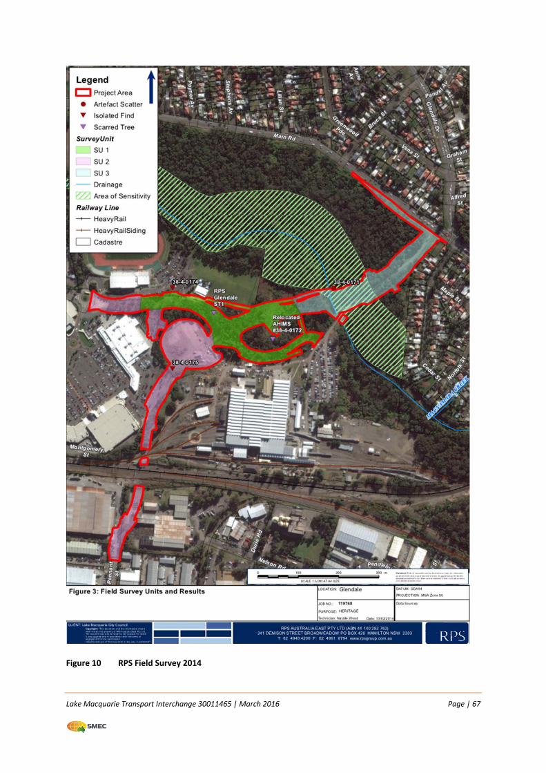
Lake Macquarie Transport Interchange 30011465 | March 2016 Page | 67
Figure 10 RPS Field Survey 2014
Lake Macquarie Transport Interchange 30011465 | March 2016 Page | 68
6.8.2 Potential impacts
Construction
The potential that further Aboriginal artefacts may be uncovered within the Section 2 proposal area
is low. Surveys undertaken for the LMTI project identified parts of the Section 1 proposal area as
having high potential for further artefacts but not Section 2.
The Aboriginal Cultural Heritage Assessment report prepared by RPS concluded that there are five
sites and one area of archaeological sensitivity in the overall LMTI project area which will require
management during the construction phase. LMCC applied for a Section 90 permit (Aboriginal
Heritage Impact Permit – AHIP) for the LMTI Stage 1 and the permit was issued by OEH in October
2014. The conditions in Schedules B3 and C1 of the permit apply to the isolated find (38‐4‐0174)
located in the northern part of Section 2.
6.8.3 Safeguards and management measures
The following safeguards are proposed:
An Aboriginal Heritage Impact Permit (AHIP) has been issued to LMCC by the OEH. The proposal would be undertaken in accordance with the conditions outlined in the permit;
All employees and contractors involved in the construction works will be advised of their obligations under the National Parks and Wildlife Act 1974 (NPW Act) where it is an offence to knowingly destroy, deface or damage Aboriginal objects without the written permission of OEH;
If an Aboriginal object/s is identified in the proposal area during works, then all work in the immediate area must cease and the area be cordoned off. OEH must be notified by ringing the Enviroline 131 555 so that the site can be adequately assessed and managed; and
In the event that skeletal remains are uncovered, work must cease immediately in that area and the area be cordoned off.
6.9 Non‐Aboriginal heritage
6.9.1 Existing environment
An Assessment of Historical Archaeology and Heritage Values was prepared by Nexus Archaeology
and Heritage in 2008 (Appendix L). The purpose of the assessment was to identify the presence of
any non–Aboriginal heritage items within the overall LMTI project area and determine the potential
impact to those due to the construction of a new road and associated infrastructure. The locations
of items identified as being of historical value are shown in Figure 11.
The study was undertaken with reference to the NSW Heritage Manual which provides a framework
for the assessment to determine the heritage value of a particular area. The area had been the
subject of previous studies associated with the development of the 2004 LEP. During these studies
two sites were recorded:
Cardiff Railway Workshops (Reference 98 on the LEP): 460 Main Road Cardiff; and
Great Northern Railway (Reference 189 on the LEP): passes through Lake Macquarie from
Glendale to Wyee.
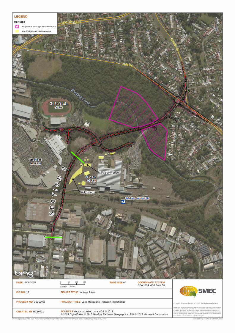
© SMEC Australia Pty Ltd 2015. All Rights Reserved
LEGENDHeritage
Indigenous Heritage Sensitive Area
Non-Indigenous Heritage Area
SOURCES Vector backdrop data MDS © 2013© 2015 DigitalGlobe © 2015 GeoEye Earthstar Geographics SIO © 2015 Microsoft Corporation
Location: I:\projects\30011465 - Lake Macquarie Transport Interchange\008 DATA\008_7 Environmental\Maps\Section 2 Figs\Figure12_HeritageAreas_A4.mxd
Disclaimer: While all reasonable care has been taken to ensure the information contained on this map is up to date and accurate, this map contains data from a number of sources - no warranty is given that the information contained on this map is free from error or omission. Any reliance placed on such information shall be at the sole risk of the user. Please verify the accuracy of all information prior to using it. This map is not a design document.
COORDINATE SYSTEMGDA 1994 MGA Zone 56
PAGE SIZE A40 50 100 150
Metres1:7,000
DATE 12/08/2015
FIG NO. 12
PROJECT NO. 30011465
CREATED BY RC10721
PROJECT TITLE Lake Macquarie Transport Interchange
FIGURE TITLE Heritage Areas
Last updated by: RC10721 on 12/08/2015 at 9:31
Rail Sidings
Dog Spike Shed
SE
CT
IO
N2
Lake Macquarie Transport Interchange 30011465 | March 2016 Page | 70
A review of the Hunter Regional Environmental Plan 1989 (Heritage) did not identify any items of
historical value in proximity to the study area. Similarly, searches of the State Heritage Register,
National Heritage List, Register of the National Estate and the National Trust did not list any items
other than those listed in the LEP.
Historical context
The land of the study area was originally part of a 2560 hectare land grant to George Weller in 1829.
This was part of a family estate which was shared among his three brothers. Development of the
land holding was limited with the exception of some housing allotments near Cockle Creek.
Parish maps from 1885 identify the route of the Great Northern Railway and the development of
Lake Road. Parish maps dating from 1922 indicate the existence of the railway line in its current
alignment as well as Main Road. The review of the historical maps indicates that the site was
undeveloped until the establishment of the railway workshops in 1924. In the years following the
establishment of the workshops, significant urban growth took place, including the Cardiff industrial
estate to the south of the railway line.
Cardiff Railway Workshops
The Cardiff Railway Workshops officially opened in 1928, and at the time were considered as a
benchmark in railway engineering. The workshops included separate areas for various activities and
initially became responsible for the maintenance of passenger and standard goods locomotives. The
rail industry experienced many changes over the 20th century, with the electrification of parts of the
rail line and the shift from steam to diesel locomotives.
Consequently, changes were initiated in the workshop plant and equipment. In 1977 the workshops
commenced their first involvement into the Per Way material, which saw the relocation of the dog
spike manufacturing plant (Dog Spike Shed) from Honeysuckle.
Further changes in activities at the workshops continued throughout the 1980s and 1990s. In 1997
the site converted to the Cardiff Maintenance Centre, which primarily undertook major repairs and
maintenance of older class locomotives. Between 1993 and 1994 these maintenance activities were
transferred to a new facility at Port Waratah.
Dog Spike Shed
As previously stated contents of the Dog Spike Shed were originally located at Honeysuckle and were
relocated to the workshop precinct in 1977. Dog spikes are used to secure the sleepers to the
footing of the railway. The original dog spike forges have been assessed as being of 1920s origin.
Materials which were relocated included machinery and other items of hardware.
Heritage values
The heritage assessment was undertaken with reference to the four values of the Australia Charter
for the Conservation of Places of Cultural Significance. These are generally accepted as historical,
aesthetic, scientific and social.
Lake Macquarie Transport Interchange 30011465 | March 2016 Page | 71
In a broad context, the workshops are a confirmation of the industrial heritage which is strongly
associated with the Newcastle area. The presence of the Dog Spike Shed also signals the Cardiff
Railway Workshops as the successor of the similar function of the now defunct Honeysuckle Railway
Workshops. The assessment by Nexus evaluated the Dog Spike Workshop as rare at a State level,
given the presence and range of the plant and machinery which remains in situ.
A Statement of Heritage Impact (SoHI) was prepared for the LMTI study area which considered the
impact of the proposal if it required the removal of the rail lines and the Dog Spike Shed building and
its contents. It was concluded that with the exception of the contents of the Dog Spike Shed, that
any proposed works could be viewed as an adaptive re‐use.
6.9.2 Potential impacts
The LMTI Section 2 route alignment is located approximately 60m north of the Dog Spike Shed and
railway line. Disturbance to this area of heritage significance will therefore be avoided.
The Pennant Street Bridge would span over the top of the railway without direct impact. The
underground services would be bored under the railway without direct impact to the railway line.
Bridge piers would be located within the railway corridor but with sufficient clearance from tracks
and overhead wiring to comply with Sydney Trains standards. Again, there would be no direct impact
on the railway line itself.
6.9.3 Safeguards and management measures
The following safeguards and management measures will be put in place:
LMCC will inform Sydney Trains heritage division about this proposal prior to the
commencement of work;
Ensure all staff and contractors are aware of their obligations under Heritage Act 1977;
Establishment of ‘no go’ areas; and
In the event that unexpected finds are uncovered during the construction all works must cease
in the vicinity of the area and contact with LMCC must be made.
6.10 Socio economic and land use
6.10.1 Existing environment
Economics
Over the past 10 years, the economy of the Hunter Region has experienced significant growth and
diversification. The gross regional product is estimated at $35 million, which is 9.24 % of the NSW
total and nearly three per cent of the national total. Whilst the Region was previously dependent on
heavy industry and mining, health and business service sectors are now a major contributor.
The median weekly income for families with children was $2,317 per week which is consistent with
the national average of $2,310. Home ownership (therefore without a mortgage), however, at 38.4%
is higher than the national average of 32.1 % (ABS 2012).
Lake Macquarie Transport Interchange 30011465 | March 2016 Page | 72
The Lake Macquarie LGA has a range of industries which contribute to the local economy, with
12,000 businesses currently operating in the area. The Glendale area has been identified in the LHRS
as an emerging regional centre which will support a mix of residential, commercial and recreational
services. The nearby Cardiff Industrial Estate, which accommodates a number of businesses, will
benefit through improved connectivity to the wider regional transport network.
LMCC commissioned an Economic Impact Assessment in 2011 (Appendix M), to determine the
potential impact the proposal may have in terms of regional employment and income for the
construction and operational phases.
There are three major development sites in the area which will be positively impacted by Stage 1 of
the LMTI. These are:
Cardiff Industrial Site: 93 hectares which can be developed into a mixture of commercial and
retail bulky goods with an estimated value of $630 million;
Pasminco Site: 130 hectare site which can accommodate a mixture of residential, commercial,
light industrial and mixed use with an estimated value of $750 million; and
Stockland Site: further redevelopment of the site for commercial, some residential and retail
expansion with an estimated value of $100 million.
It is estimated that when combined, the three projects have the ability to create 11,393 full time
equivalent (FTE) jobs over a 16 year construction period. Once operational they will have the ability
to create 10,092 direct jobs across the retail, commercial, bulky goods and industrial sectors. The
LMTI will be critical in realising the delivery of these projects through the improvement in precinct
connectivity and reduction in road congestion.
Demographics
The Lake Macquarie statistical area has a population of approximately 190,000 people, with a
growth rate of over two per cent between 2007 and 2011. This is the highest population of the all
the LGAs which make up the Hunter Region. The average age in the LGA is 41, with an even
distribution of age groups, with the highest represented in the 50‐54 age brackets. Children between
the ages of 0–14 years made up over 18 per cent of the population.
Over 86 per cent of the population was born in Australia, with people born in New Zealand and the
United Kingdom being the other two common countries of origin. Typical of suburban areas, the
majority of residents live in detached dwellings. There are over 53,000 families residing in the LGA
with an average of 1.8 children per family.
The area has a relatively low unemployment rate of 5.5 per cent when compared with the national
rate (approximately 5.7 per cent census 2011). Retail, manufacturing and health care are the key
sectors for employment, followed by education and construction. Within these sectors the most
common occupations were recorded as managers, technical trades and administration roles. Census
data from 2001 indicates there has been a steady decrease over the 10 year period of people
seeking employment.
Lake Macquarie Transport Interchange 30011465 | March 2016 Page | 73
Community services
The Lake Macquarie area enjoys a range of community services. In proximity to the proposed LMTI is
the Hunter Sports Centre, which provides facilities for track and field, gymnastics and other sports.
There are numerous cycleway, walking tracks and public reserves, particularly around the vicinity of
Lake Macquarie. The lake also provides the opportunity for a variety of water based sports including
sailing and rowing.
There is one public hospital located at Belmont, and other private hospitals at Gateshead and
Toronto. In proximity to the LMTI, there is Glendale Public School, Glendale Technology High,
Macquarie College and Rudolph Steiner School.
The area is serviced by both public and private bus operators. The main northern rail line which is
adjacent to the LMTI runs services between Sydney and Newcastle for both passenger and freight
trains.
Land use
The land use in the vicinity of the LMTI is a combination of developed areas and native bushland. The
following land uses exist in proximity to the overall LMTI project area:
Retail and recreational land use to the north west, specifically the Stocklands Glendale,
Bunnings and the Hunter Sports Centre;
Industrial areas, specifically the Downer site and the Cardiff industrial estate to the south;
Residential areas to the east along Main Street, Cedar Street and Glendale Drive;
Rail corridor running east west; and
Bushland east of Main Street up to the boundaries of the Hunter Sports Centre and Downer
site. The area is also intersected by Winding Creek.
Specifically in relation to Section 2:
Land on the western side of the northern approach is owned by Stockland and operated as the
Glendale Super Centre. A portion of the car park falls within the proposal area. Land on the
eastern side of the northern approach of the Pennant Street bridge is RailCorp land which is
leased by Downer;
Land beside the southern approach (on both sides) is owned by Bendlink. The site to the west of
Pennant Street is used by Toll as a transport/distribution facility. Land on the eastern side is a
former brewery, is currently used as a distribution centre, and is being developed as a self‐
storage facility.
The rail corridor at the site of the Pennant Street Bridge consists of six tracks; two main lines,
two refuge lines and two siding lines.
6.10.2 Potential impacts
Any impacts associated with the proposal are likely to be associated with the construction phase,
and therefore will be short term. The potential impacts that may be experienced due to the overall
LMTI project may include:
Lake Macquarie Transport Interchange 30011465 | March 2016 Page | 74
Potential temporary disruption to access to commercial and industrial areas;
Temporary disruption to parking due to the upgrade of the Glendale Super Centre car park;
Short term impacts to traffic on Pennant St;
Impacts to amenity during construction, particularly with regard to noise and dust emissions;
and
Impacts to the adjacent light industrial property during construction requiring temporary access
and occupation.
The LMTI includes a number of positive aspects for the region. The LMTI will integrate a number of
modes of transport which will unlock the economic potential of the nearby industrial and
commercial areas of Glendale and Cardiff. The LMTI is considered as a cornerstone piece of
infrastructure, which will realise the vision of the Glendale area developing into a new regional
centre.
The LMTI will encourage more investment in the area and support the intensification of land use
within the Glendale and Cardiff areas. Specifically the economic benefits of the LMTI will be:
Creation of direct and indirect jobs to support the development of the area;
Encourage additional civic facilities and services due to improved transport connectivity;
Improve land valuations as a result of improved access and transport;
Enhance the Glendale area as a “destination” through the provision of recreational and tourism
facilities;
Attract investment to the area as a result of improved transport systems and proximity to other
links with other regional centres.
The LMTI will also provide a number of social benefits to the local community. Specifically the
LMTI will provide:
Improved travel time for local road users between home recreation and work place
destinations;
Improved access to a wider range of modes of public and private transport;
Enhance the Glendale area as a place of recreation which will provide a wide range of
facilities;
Improve public transport for people with disabilities; and
Improved pedestrian and bicycle links to the redevelopment of Glendale, creating access to
community facilities, entertainment, sporting, recreation and retail areas.
6.10.3 Safeguards and management measures
A TMP will be prepared to ensure traffic and access controls are implemented and maintained
during lane or road closures. The TMP is to include procedures for notifying directly impacted
residences, businesses, emergency services, utility authorities, transport industry groups and
government stakeholders;
Lake Macquarie Transport Interchange 30011465 | March 2016 Page | 75
The TMP is to include a construction communications plan including requirements to provide
details and timing of proposed activities to affected residents, 24 hour contact name and
number for complaints and details of a notification plan for changed conditions during the
construction period; and
Required property acquisition will proceed in accordance with the Land Acquisition (Just Terms
Compensation) Act 1991.
6.11 Air quality
6.11.1 Existing environment
The air quality in the vicinity of the Section 2 proposal area is typical of an urban area surrounded by
a mixed use of commercial, industrial and bushland areas.
Key contributors to existing air quality would include:
Emissions from vehicles along the existing road network and accessing the Glendale centre;
Emissions from diesel locomotives which transit along the rail corridor; and
Fugitive emissions associated with industrial activities within the Cardiff Industrial Estate.
Air quality in the area would generally be considered fair to good, depending on the prevailing
meteorology. OEH has three air quality monitoring stations in the Lower Hunter Valley located at
Beresfield, Wallsend and Newcastle which measure particulate matter (both 10 µm and 2.5 µm) SO2,
NO2 and ozone. A review of monthly averages over a 12 month period between June 2012 and June
2013 indicated that air quality in the area was generally considered good to very good. Particulate
matter was higher in summer as would be expected with drier conditions, with NO2 being lower on
average in summer. SO2 was reported as consistent throughout the year.
6.11.2 Potential impacts
Potential impacts to air quality as a result of the proposal may include:
Increase in dust emissions due to construction related activities such as excavation and
stockpiling of imported fill; and
Emissions associated with plant and machinery used during construction.
6.11.3 Safeguards and management measures
The safeguard measures to be implemented during construction to minimise any impacts to air
quality, will include but not be limited to the following:
In dry and windy conditions, the unsealed areas will be watered via a tanker so minimise any
dust generation;
Any materials which need to be stockpiled for an extended period will be either covered or
stabilised with a growing medium to avoid airborne dust;
All plant and machinery is to be well maintained to minimise any emissions from engine
combustion;
Lake Macquarie Transport Interchange 30011465 | March 2016 Page | 76
All loaded trucks will be covered when either exiting the construction area, all loaded trucks
using public roads or on extended routes within the site will be covered;
Stabilisation of all disturbed areas as soon as practicable to prevent or minimise air borne dust;
and
Where feasible avoid plant idling when not in use to minimise engine emissions.
6.12 Waste management and resource efficiency
6.12.1 Potential impacts
Construction works would generate several waste streams including spoil from excavation and
trenching, cleared vegetation, packaging materials, general litter including recyclables and food
waste, and wastewater.
Resource use would include fuels for construction plant and machinery, electricity for construction
site facilities, together with the raw materials and energy used to produce the infrastructure to be
installed.
6.12.2 Safeguards and management measures
Construction
A waste management plan (WMP) will be prepared as part of the Construction Environment
Management Plan (CEMP) to detail waste types and quantities and methods for segregation,
handling, storing and disposal in accordance with the waste hierarchy (Avoid, Reuse, Recycle, Energy
Recovery and Disposal). The following control measures will be observed:
Wherever possible, suitable excavated spoil will be reused on site for backfilling, landscaping
and other purposes (refer to Fill Reuse Management Plan – Appendix I);
Excess soil and other wastes requiring disposal will be assessed against the Waste Classification
Guidelines (DECC 2009) (refer to Fill Reuse Management Plan – Appendix I);
Waste transportation will be undertaken by a licensed contractor capable of transporting the
waste;
Waste will be disposed of to an appropriately licensed waste facility with supporting waste
classification and tracking documentation;
Packaging will be kept to a minimum wherever possible;
Labelled bins will be provided for recyclable wastes, green waste, and food waste, and labelled
containers for other waste materials; the site supervisor will ensure the bins and containers
were covered or closed, and cleared as required to avoid overflows;
Food scraps will be removed from site each day to discourage fauna from entering the site; and
The site will be cleaned up following completion of construction and all wastes removed and
disposed of appropriately.
Lake Macquarie Transport Interchange 30011465 | March 2016 Page | 77
6.13 Summary of beneficial effects
The LMTI will provide a number of benefits to the Lake Macquarie area and the Lower Hunter. Specifically these benefits will include:
Improved access to public transport and servicing of the Glendale and Cardiff areas;
Improved connection between the Glendale and Cardiff areas, therefore improving access to
the major transport routes and value of the commercial and industrial areas;
Facilitating the development of other large areas in the vicinity of the project and therefore
generating local employment; and
Improved general amenity of the Glendale area through incorporating urban design principles
and landscaping and improvements in cycling facilities and pedestrian access.
6.14 Summary of adverse effects
This REF for Section 2 of the LMTI has identified a number of adverse impacts associated with the
LMTI:
Construction noise and vibration impacts;
Potential for traffic noise impacts at nearby industrial, commercial and retail areas due to the
proximity of a new road;
Temporary impacts to traffic during construction; and
Disturbance of contaminated soils.
6.15 Cumulative impacts
Stage 1 of the LMTI comprises the construction of Section 1 and Section 2. The potential cumulative
impacts have been considered as a whole for Stage 1.
Cumulative impacts can be both positive and negative and may occur in a number of ways as
follows:
As multiple impacts on a single receiver. An example may be an increase in noise and air
emissions associated with construction activities;
As similar impacts at multiple locations associated with a proposal; and
In conjunction with impacts from other projects, for example when construction activities occur
concurrently from projects in general proximity to each other.
The Glendale area is currently well developed, providing a number of services to the Lake Macquarie
region. The LMTI would have a positive cumulative impact, through the connection of various
precincts (e.g. Cardiff and Glendale) and improving access and general amenity of the area as
discussed in Section 6.10 Further, the LMTI will assist in the future redevelopment of three major
areas (Cardiff Industrial Estate, Pasminco and Stockland), which will create substantial employment
opportunities throughout the construction and operational phases.
Lake Macquarie Transport Interchange 30011465 | March 2016 Page | 78
The potential impacts of the LMTI during construction and operation have been predicted to be
acceptable, providing the various mitigation measures are implemented as outlined in this REF.
Negative cumulative impacts can occur when development in one particular area are undertaken
concurrently. The cumulative impacts can place pressure on the availability of services and available
resources. A review of the NSW P&I website and LMCC website was undertaken on 9 April 2014.
There were no development proposals either approved or proposed in the locality which may result
in unacceptable cumulative impacts.
Lake Macquarie Transport Interchange 30011465 | March 2016 Page | 79
7 ENVIRONMENTAL MANAGEMENT
7.1.1 Environmental management plans
Throughout this REF, a number of safeguards and management measures have been identified in
order to minimise adverse environmental, social and economic impacts that could potentially arise
from the proposal. These management measures will be implemented during the construction and
operation of the proposal. The identified safeguards and management measures will be
incorporated into contractual arrangements with the future contractor. A CEMP will be prepared by
the Contractor to describe these safeguards and management measures, how they would be
implemented and who would be responsible for their implementation.
7.1.2 Summary of safeguards and management measures
Environmental safeguards outlined in this document will be incorporated into the proposal and
during construction and operation of the proposal. These safeguards will minimise any potential
adverse impacts arising from the proposed works on the surrounding environment. The safeguards
and management measures are summarised in Table 20.
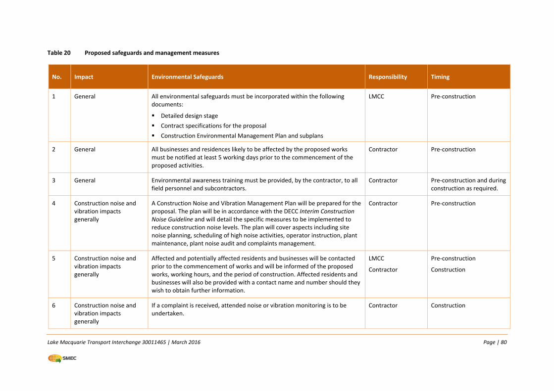
Lake Macquarie Transport Interchange 30011465 | March 2016 Page | 80
Table 20 Proposed safeguards and management measures
No. Impact Environmental Safeguards Responsibility Timing
1 General All environmental safeguards must be incorporated within the following documents:
Detailed design stage
Contract specifications for the proposal
Construction Environmental Management Plan and subplans
LMCC Pre‐construction
2 General All businesses and residences likely to be affected by the proposed works must be notified at least 5 working days prior to the commencement of the proposed activities.
Contractor Pre‐construction
3 General Environmental awareness training must be provided, by the contractor, to all field personnel and subcontractors.
Contractor Pre‐construction and during construction as required.
4 Construction noise and vibration impacts generally
A Construction Noise and Vibration Management Plan will be prepared for the proposal. The plan will be in accordance with the DECC Interim Construction Noise Guideline and will detail the specific measures to be implemented to reduce construction noise levels. The plan will cover aspects including site noise planning, scheduling of high noise activities, operator instruction, plant maintenance, plant noise audit and complaints management.
Contractor Pre‐construction
5 Construction noise and vibration impacts generally
Affected and potentially affected residents and businesses will be contacted prior to the commencement of works and will be informed of the proposed works, working hours, and the period of construction. Affected residents and businesses will also be provided with a contact name and number should they wish to obtain further information.
LMCC
Contractor
Pre‐construction
Construction
6 Construction noise and vibration impacts generally
If a complaint is received, attended noise or vibration monitoring is to be undertaken.
Contractor Construction
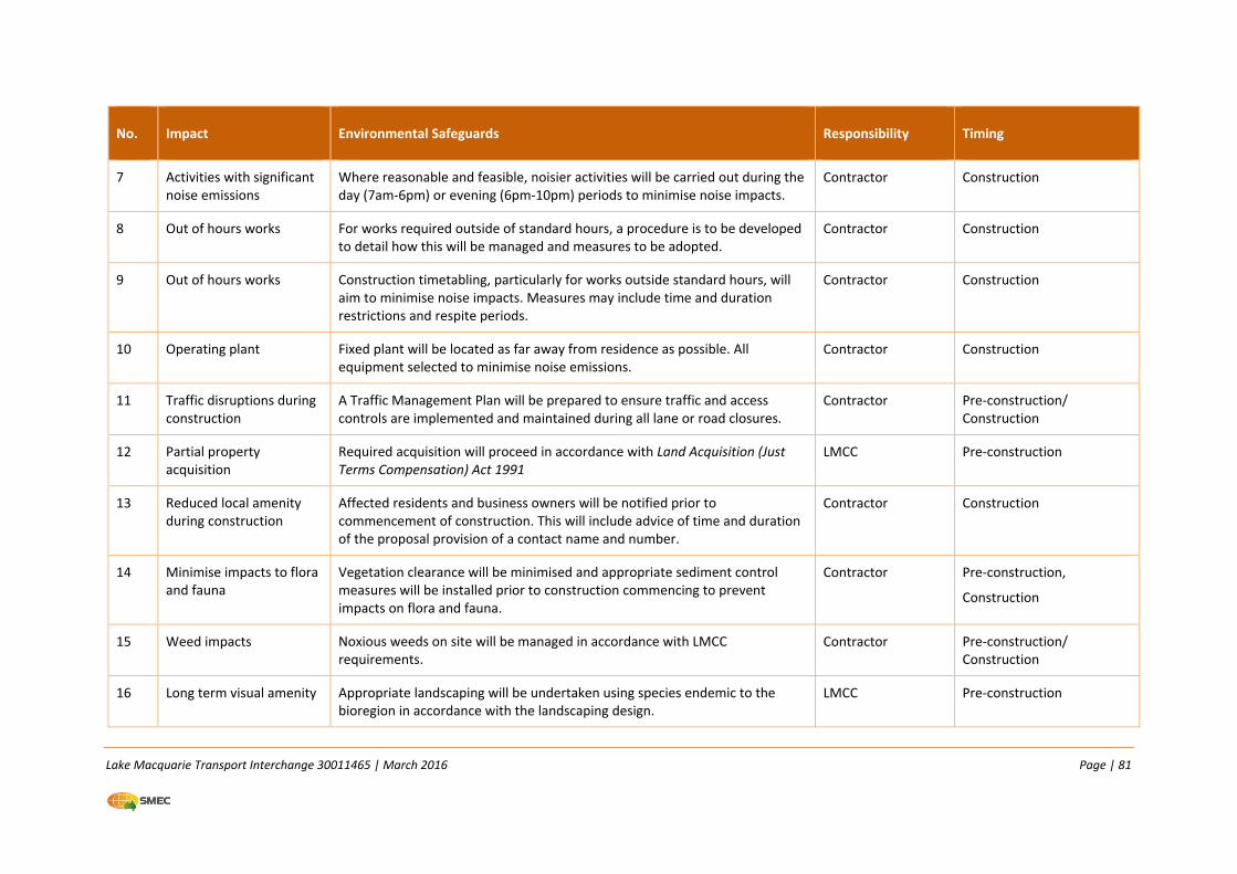
Lake Macquarie Transport Interchange 30011465 | March 2016 Page | 81
No. Impact Environmental Safeguards Responsibility Timing
7 Activities with significant noise emissions
Where reasonable and feasible, noisier activities will be carried out during the day (7am‐6pm) or evening (6pm‐10pm) periods to minimise noise impacts.
Contractor Construction
8 Out of hours works For works required outside of standard hours, a procedure is to be developed to detail how this will be managed and measures to be adopted.
Contractor Construction
9 Out of hours works Construction timetabling, particularly for works outside standard hours, will aim to minimise noise impacts. Measures may include time and duration restrictions and respite periods.
Contractor Construction
10 Operating plant Fixed plant will be located as far away from residence as possible. All equipment selected to minimise noise emissions.
Contractor Construction
11 Traffic disruptions during construction
A Traffic Management Plan will be prepared to ensure traffic and access controls are implemented and maintained during all lane or road closures.
Contractor Pre‐construction/ Construction
12 Partial property acquisition
Required acquisition will proceed in accordance with Land Acquisition (Just Terms Compensation) Act 1991
LMCC Pre‐construction
13 Reduced local amenity during construction
Affected residents and business owners will be notified prior to commencement of construction. This will include advice of time and duration of the proposal provision of a contact name and number.
Contractor Construction
14 Minimise impacts to flora and fauna
Vegetation clearance will be minimised and appropriate sediment control measures will be installed prior to construction commencing to prevent impacts on flora and fauna.
Contractor Pre‐construction,
Construction
15 Weed impacts Noxious weeds on site will be managed in accordance with LMCC requirements.
Contractor Pre‐construction/ Construction
16 Long term visual amenity Appropriate landscaping will be undertaken using species endemic to the bioregion in accordance with the landscaping design.
LMCC Pre‐construction
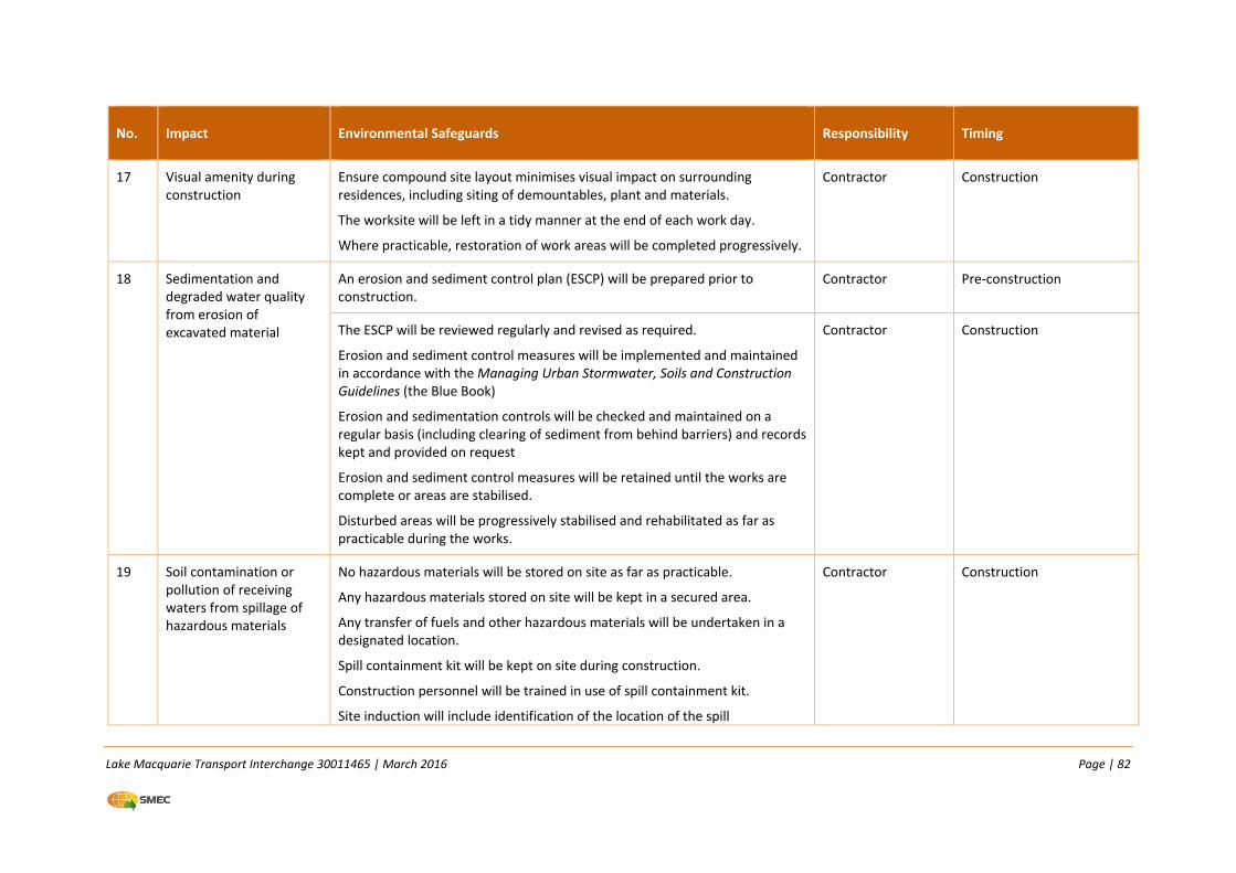
Lake Macquarie Transport Interchange 30011465 | March 2016 Page | 82
No. Impact Environmental Safeguards Responsibility Timing
17 Visual amenity during construction
Ensure compound site layout minimises visual impact on surrounding residences, including siting of demountables, plant and materials.
The worksite will be left in a tidy manner at the end of each work day.
Where practicable, restoration of work areas will be completed progressively.
Contractor Construction
18 Sedimentation and degraded water quality from erosion of excavated material
An erosion and sediment control plan (ESCP) will be prepared prior to construction.
Contractor Pre‐construction
The ESCP will be reviewed regularly and revised as required.
Erosion and sediment control measures will be implemented and maintained in accordance with the Managing Urban Stormwater, Soils and Construction Guidelines (the Blue Book)
Erosion and sedimentation controls will be checked and maintained on a regular basis (including clearing of sediment from behind barriers) and records kept and provided on request
Erosion and sediment control measures will be retained until the works are complete or areas are stabilised.
Disturbed areas will be progressively stabilised and rehabilitated as far as practicable during the works.
Contractor Construction
19 Soil contamination or pollution of receiving waters from spillage of hazardous materials
No hazardous materials will be stored on site as far as practicable.
Any hazardous materials stored on site will be kept in a secured area.
Any transfer of fuels and other hazardous materials will be undertaken in a designated location.
Spill containment kit will be kept on site during construction.
Construction personnel will be trained in use of spill containment kit.
Site induction will include identification of the location of the spill
Contractor Construction
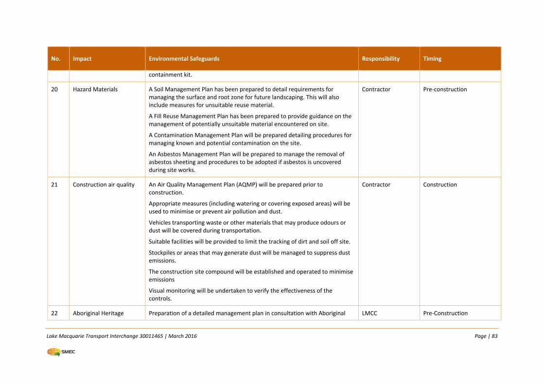
Lake Macquarie Transport Interchange 30011465 | March 2016 Page | 83
No. Impact Environmental Safeguards Responsibility Timing
containment kit.
20 Hazard Materials A Soil Management Plan has been prepared to detail requirements for managing the surface and root zone for future landscaping. This will also include measures for unsuitable reuse material.
A Fill Reuse Management Plan has been prepared to provide guidance on the management of potentially unsuitable material encountered on site.
A Contamination Management Plan will be prepared detailing procedures for managing known and potential contamination on the site.
An Asbestos Management Plan will be prepared to manage the removal of asbestos sheeting and procedures to be adopted if asbestos is uncovered during site works.
Contractor Pre‐construction
21 Construction air quality An Air Quality Management Plan (AQMP) will be prepared prior to construction.
Appropriate measures (including watering or covering exposed areas) will be used to minimise or prevent air pollution and dust.
Vehicles transporting waste or other materials that may produce odours or dust will be covered during transportation.
Suitable facilities will be provided to limit the tracking of dirt and soil off site.
Stockpiles or areas that may generate dust will be managed to suppress dust emissions.
The construction site compound will be established and operated to minimise emissions
Visual monitoring will be undertaken to verify the effectiveness of the controls.
Contractor Construction
22 Aboriginal Heritage Preparation of a detailed management plan in consultation with Aboriginal LMCC Pre‐Construction
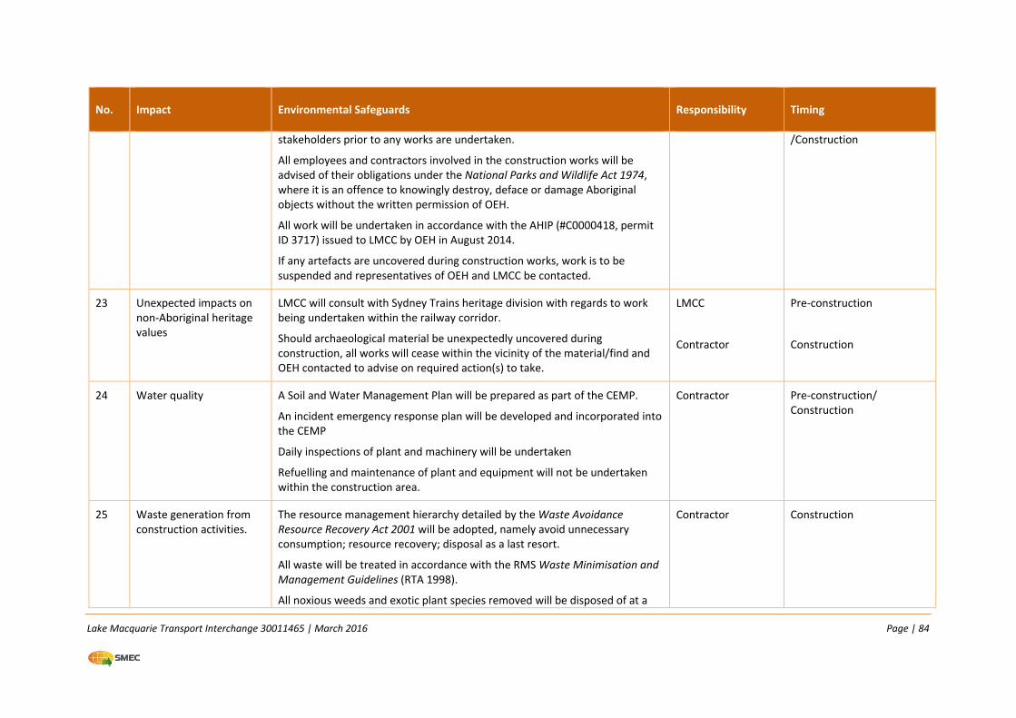
Lake Macquarie Transport Interchange 30011465 | March 2016 Page | 84
No. Impact Environmental Safeguards Responsibility Timing
stakeholders prior to any works are undertaken.
All employees and contractors involved in the construction works will be advised of their obligations under the National Parks and Wildlife Act 1974, where it is an offence to knowingly destroy, deface or damage Aboriginal objects without the written permission of OEH.
All work will be undertaken in accordance with the AHIP (#C0000418, permit ID 3717) issued to LMCC by OEH in August 2014.
If any artefacts are uncovered during construction works, work is to be suspended and representatives of OEH and LMCC be contacted.
/Construction
23 Unexpected impacts on non‐Aboriginal heritage values
LMCC will consult with Sydney Trains heritage division with regards to work being undertaken within the railway corridor.
Should archaeological material be unexpectedly uncovered during construction, all works will cease within the vicinity of the material/find and OEH contacted to advise on required action(s) to take.
LMCC
Contractor
Pre‐construction
Construction
24 Water quality A Soil and Water Management Plan will be prepared as part of the CEMP.
An incident emergency response plan will be developed and incorporated into the CEMP
Daily inspections of plant and machinery will be undertaken
Refuelling and maintenance of plant and equipment will not be undertaken within the construction area.
Contractor Pre‐construction/ Construction
25 Waste generation from construction activities.
The resource management hierarchy detailed by the Waste Avoidance Resource Recovery Act 2001 will be adopted, namely avoid unnecessary consumption; resource recovery; disposal as a last resort.
All waste will be treated in accordance with the RMS Waste Minimisation and Management Guidelines (RTA 1998).
All noxious weeds and exotic plant species removed will be disposed of at a
Contractor Construction
Lake Macquarie Transport Interchange 30011465 | March 2016 Page | 85
No. Impact Environmental Safeguards Responsibility Timing
licensed landfill facility.
Surplus soils and wastes generated from the proposal will be reused or disposed of according to their classification, as outlined in the Fill Reuse Management Plan.
All work areas will be maintained, kept free of rubbish and cleaned up regularly.

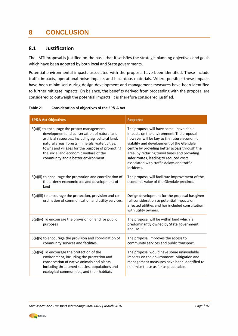
Lake Macquarie Transport Interchange 30011465 | March 2016 Page | 87
8 CONCLUSION
8.1 Justification
The LMTI proposal is justified on the basis that it satisfies the strategic planning objectives and goals
which have been adopted by both local and State governments.
Potential environmental impacts associated with the proposal have been identified. These include
traffic impacts, operational noise impacts and hazardous materials. Where possible, these impacts
have been minimised during design development and management measures have been identified
to further mitigate impacts. On balance, the benefits derived from proceeding with the proposal are
considered to outweigh the potential impacts. It is therefore considered justified.
Table 21 Consideration of objectives of the EP& A Act
EP&A Act Objectives Response
5(a)(i) to encourage the proper management, development and conservation of natural and artificial resources, including agricultural land, natural areas, forests, minerals, water, cities, towns and villages for the purpose of promoting the social and economic welfare of the community and a better environment.
The proposal will have some unavoidable impacts on the environment. The proposal however will be key to the future economic viability and development of the Glendale centre by providing better access through the area, by reducing travel times and providing safer routes, leading to reduced costs associated with traffic delays and traffic incidents.
5(a)(ii) to encourage the promotion and coordination of the orderly economic use and development of land
The proposal will facilitate improvement of the economic value of the Glendale precinct.
5(a)(iii) to encourage the protection, provision and co‐ordination of communication and utility services.
Design development for the proposal has given full consideration to potential impacts on affected utilities and has included consultation with utility owners.
5(a)(iv) To encourage the provision of land for public purposes
The proposal will be within land which is predominantly owned by State government and LMCC.
5(a)(v) to encourage the provision and coordination of community services and facilities.
The proposal improves the access to community services and public transport.
5(a)(vi) To encourage the protection of the environment, including the protection and conservation of native animals and plants, including threatened species, populations and ecological communities, and their habitats
The proposal would have some unavoidable impacts on the environment. Mitigation and management measures have been identified to minimise these as far as practicable.
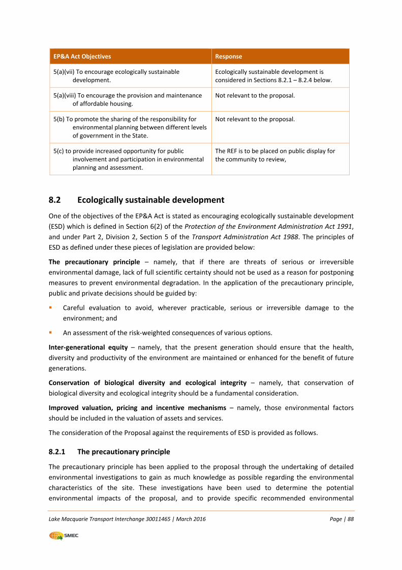
Lake Macquarie Transport Interchange 30011465 | March 2016 Page | 88
EP&A Act Objectives Response
5(a)(vii) To encourage ecologically sustainable development.
Ecologically sustainable development is considered in Sections 8.2.1 – 8.2.4 below.
5(a)(viii) To encourage the provision and maintenance of affordable housing.
Not relevant to the proposal.
5(b) To promote the sharing of the responsibility for environmental planning between different levels of government in the State.
Not relevant to the proposal.
5(c) to provide increased opportunity for public involvement and participation in environmental planning and assessment.
The REF is to be placed on public display for the community to review,
8.2 Ecologically sustainable development
One of the objectives of the EP&A Act is stated as encouraging ecologically sustainable development
(ESD) which is defined in Section 6(2) of the Protection of the Environment Administration Act 1991,
and under Part 2, Division 2, Section 5 of the Transport Administration Act 1988. The principles of
ESD as defined under these pieces of legislation are provided below:
The precautionary principle – namely, that if there are threats of serious or irreversible
environmental damage, lack of full scientific certainty should not be used as a reason for postponing
measures to prevent environmental degradation. In the application of the precautionary principle,
public and private decisions should be guided by:
Careful evaluation to avoid, wherever practicable, serious or irreversible damage to the
environment; and
An assessment of the risk‐weighted consequences of various options.
Inter‐generational equity – namely, that the present generation should ensure that the health,
diversity and productivity of the environment are maintained or enhanced for the benefit of future
generations.
Conservation of biological diversity and ecological integrity – namely, that conservation of
biological diversity and ecological integrity should be a fundamental consideration.
Improved valuation, pricing and incentive mechanisms – namely, those environmental factors
should be included in the valuation of assets and services.
The consideration of the Proposal against the requirements of ESD is provided as follows.
8.2.1 The precautionary principle
The precautionary principle has been applied to the proposal through the undertaking of detailed
environmental investigations to gain as much knowledge as possible regarding the environmental
characteristics of the site. These investigations have been used to determine the potential
environmental impacts of the proposal, and to provide specific recommended environmental
Lake Macquarie Transport Interchange 30011465 | March 2016 Page | 89
management measures for the proposed works to avoid or reduce the likelihood of serious or
irreversible damage to the environment and that any residual impacts are minimised.
8.2.2 Intergenerational equity
Intergenerational equity is concerned with the equitable distribution of economic, social and
environmental costs and benefits across present and future generations. The impacts of the
proposal have been identified as being short term and manageable. Benefits would be experienced
over a longer period associated with opening of the LMTI.
8.2.3 Conservation of biological diversity and ecological integrity
This REF includes an assessment of clause 228 factors (Appendix A) that broadly consider biological
diversity and ecological integrity of the proposal area. Unlike the Section 1 proposal area which
contains an EEC, threatened flora species and habitat for threatened fauna species, the LMTI Section
2 proposal area is cleared and disturbed and does not support any flora, fauna or habitats of
conservation value.
The REF prepared by SMEC in 2014 provides detail on how the biological diversity and ecological
integrity of the study area (Section 1) will be managed.
8.2.4 Improved valuation, pricing and incentive mechanisms
The principle of internalising environmental costs into decision making requires consideration of all
environmental resources which may be affected by a proposal, including air, water, land and living
things. While it is often difficult to place a reliable monetary value on the residual, environmental
and social effects of the proposal, the value placed on environmental resources within and around
the section of Glendale affected by the proposal is reflected in the extent of environmental
investigations, planning and design of impact mitigation measures to avoid or minimise adverse
environmental impacts.
8.3 Conclusion
The proposed activity is subject to the provisions of Part 5 of the EP&A Act. This REF has examined
and taken into account to the fullest extent practicable all matters affecting or likely to affect the
environment by reason of the proposed activity.
The proposal as described in the REF best meets the project objectives but will still result in some
impacts on the environment. Mitigation measures as detailed in this REF would ameliorate or
minimise these expected impacts. On balance, the proposed activity is considered to be justified.
Accordingly, the potential environmental impacts arising out of the carrying out of work are not
likely to be significant.
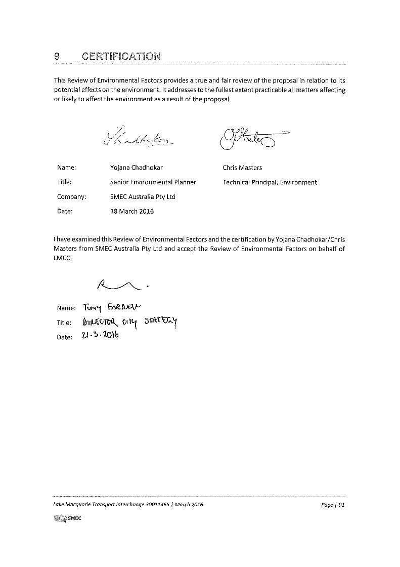
Lake Macquarie Transport Interchange 30011465 | March 2016 Page | 92
10 REFERENCES
Better Transport Future (2012) Lake Macquarie Transport Interchange, Traffic Impact Assessment.
DEC (2006) Assessing Vibration: A Technical Guideline.
DECC (2009) BioBanking Assessment Methodology and Credit Calculator Operational manual
DECCW, (2010) Due Diligence Code of Practice for the Protection of Aboriginal Objects in New South
Wales.
DECCW NSW (2011) Road Noise Policy
Department of Mineral Resources (1995) Newcastle Coalfields Regional Geology (1:1,00,00).
Department of Planning (2006) Lower Hunter Regional Strategy
Department of Planning (2008) Development near Rail Corridors and Busy Roads – Interim Guideline.
Department of Planning, Sydney.
Ecotone Ecological Consultants (2012) Lake Macquarie Transport Interchange, assessment of Impact
on Threatened and Migratory Species Listed Under the Commonwealth EPBC Act
ERM (June 2007) Glendale Land Release Aboriginal Heritage Assessment. Prepare for RailCorp.
Landcom (2004) Managing Urban Stormwater: Soils and Construction Guidelines 4th Edition (the Blue
Book). Prepared by Landcom/Department of Housing, Sydney.
Lake Macquarie City Council, Environmental Sustainability Action Plan 2011‐ ‐ 2018
Lake Macquarie City Council (2006) Submission to Infrastructure Australia, Lake Macquarie Transport
Interchange.
LHCCREMS (2003), Extant Vegetation of the Lower Hunter and Central Coast, Revised Version. Lower
Hunter and Central Coast Regional Biodiversity Conservation Strategy.
National Native Title Tribunal – application and determination search
NSW Environment Protection Authority Industrial Noise Policy (January 2000)
NSW Government (2012) Hunter Regional Action Plan, NSW 2021.
NSW Government (2013) The Lower Hunter over the next 20 years: A Discussion Paper.
NSW Government (2015a) Draft Hunter Regional Plan.
NSW Government (2015b) Draft Plan for Growing Hunter City.
NSW Heritage Office State Heritage Register/Inventory
NSW Office of Environment and Heritage Atlas of NSW Wildlife – fish species
NSW Office of Environment and Heritage Contaminated Lands Records
OEH, Aboriginal Heritage Information Management System, accessed July 2013.
OEH (2011) Guide to investigating, assessing and reporting on Aboriginal heritage in NSW.
Lake Macquarie Transport Interchange 30011465 | March 2016 Page | 93
OEH (2009) BioBanking Assessment Methodology, OEH, Sydney
RDA Hunter (2013) Hunter Regional Plan 2013‐2023. Regional Development Australia Hunter,
Newcastle
RPS HSO (2008) Flora and Fauna Assessment for Proposed Glendale Transport Interchange at
Pennant Street Link, Glendale.
RTA (2001) Environmental Noise Management Manual ‐ Practice Note vii – Roadworks Outside
Normal Working Hours.
RTA (2010) Traffic Control at Works Site manual.
SMEC (2014) Lake Macquarie Transport Interchange Stage 1 – Review of Environmental Factors,
prepared for Lake Macquarie City Council.
Terras Landscape Architects (2013) Landscape Master Plan Lake Macquarie Transport Interchange.
Waterwatch New South Wales, (2008) The Water Watcher, Winding Creek Catchment.
WMA Water (2013) Winding Creek and Lower Cockle Creek Flood Study Final Report.