Embed Size (px)
Citation preview

REVIEW ARTICLE
CURRENT SCIENCE, VOL. 109, NO. 2, 25 JULY 2015 271
*For correspondence. (e-mail: [email protected])
Tectonic framework and evolutionary history of the Bengal Basin in the Indian subcontinent A. B. Roy1,* and Alokesh Chatterjee2 1Department of Geology, Presidency University, Kolkata 700 073, India 2Hoogli Moshin College, Hoogli 712 101, India
The Bengal Basin evolved as a rift-controlled exten-sional basin along the NNE–SSW trending Basin Mar-gin Fault coevally with the 85 East Ridge in the Bay of Bengal during the short-lived hotspot activity south of Bhubaneswar. The basin opening post-dated the Kereguelen Plume magmatism (at ~116 Ma), but pre-dated the phase of continental collision that triggered the rise of the Himalaya in the north. Supply of sedi-ments in the initial stages of basin opening was from the west, mainly through the denudation and erosion of the uplifted Precambrian Shield. Following virtu-ally similar tectonic and depositional pattern in the entire basin, an abrupt change in depositional pattern was recorded during the Oligocene with the emer-gence of easterly source of sediments derived from the uplifting of Indo-Myanmarese Ranges. Between the Oligocene and Late Pleistocene different parts of the Sylhet Trough (the best-studied region in the deeper part of the Bengal Basin) received huge vol-umes of sediments, which resulted in deposition meas-uring between 10 km and over 17 km in thickness. This was followed by an equally sudden drop in the sediment supply from the east due to the basin inver-sion concurrently with the westward advance of the Indo-Burmese mountain front during early and mid-Pleistocene. Followed by a short hiatus, the deposi-tional scenario changed completely with the arrival of thick volumes of sediment during the late Pleistocene–Holocene, which covered the entire Bengal basin with the sediments brought by the Ganga and Brahma-putra from the Himalayan sources. Keywords: Basin evolution tectonics, extensional rift basin, depositional pattern, palaeogeographic setting, sediment supply. THE Bengal Basin in the eastern part of the Indian sub-continent constitutes the largest fluvio-deltaic to shallow marine sedimentary basin on Earth today1. This onshore basin coupled with the offshore Bengal Fan under the Bay of Bengal forms the biggest sediment dispersal sys-tem known in the modern world2–4. The ‘onshore’ basin is drained by two major rivers: Ganga and Brahmaputra (known as Jamuna in Bengal), and Meghna (emerging from the point of confluence of the Ganga and Brah-
maputra). There are large numbers of rainfed, small tribu-tary rivers originating from the western highland of the Chhotanagpur Plateau. Evolving within a prograde delta system, the basin shows development of the thickest (over 18 km) Neogene to Recent sedimentary piles in the world today5. In spite of all these superlative attributes, little atten-tion has been paid to understanding the history and tectonic evolution of the Bengal Basin, barring some in-explicit suggestions and speculations as follows: (i) The basin is the result of the subduction of the Indian
Plate below the Eurasian and the Burmese Plates6,7. (ii) The Bengal Basin has developed largely over a rem-
nant ocean basin and rifted eastern continental mar-gin of India8.
(iii) The Bengal Basin is a foreland basin containing a succession of dominantly deltaic sediments derived primarily from the erosion of the Himalaya and Indo-Burmese ranges9.
(v) The Bengal Basin evolved in isolated graben-controlled basins on the basement at the time of the break-up of Gondwana land1.
The present article is aimed at understanding the precise tectonic framework and depositional history of this ‘enigmatic’ sedimentary basin that cuts across the politi-cal boundary of India and Bangladesh in the eastern part of the Indian subcontinent.
Extent of the Bengal Basin
The Bengal Basin is constrained on all sides by different fault-controlled tectonic features, except in the south where the rivers drain into the Bay of Bengal. The south-eastern boundary of the Bengal Basin coincides with the eastern margin of the Chittagong–Tripura Fold Belt (CTFB) flanking the western fringe of the Indo-Myanmarese Ranges (Figure 1). The Syhlet Trough (also known as the Surma Trough/Basin)10,11, which occurs north of the CTFB is an active subsiding basin12 accom-modating the thickest (between 16 and 18 km) Neogene sediments on Earth13. North of this active basin occurs the Shillong Plateau which also marks the northwestern boundary of the Chittagong–Tripura basins. The spectacular

REVIEW ARTICLE
CURRENT SCIENCE, VOL. 109, NO. 2, 25 JULY 2015 272
E–W trending subvertical Dauki Fault marks the southern wall-like boundary of the rectangular horst of the Shillong Plateau14–16, thought as a giant ‘pop-up’ struc-ture17,18. In the northeastern part, the Bengal Basin abuts against the N–S face of the western boundary of the Shillong Plateau. The two terranes are separated by a prominent fault19–22 which continues northward up to the Himalaya. A dislocation surface named the Jamuna Fault22 passes through the point of inflection of the sharply bent Brah-maputra River course from E–W to N–S. This part of the Brahmaputra draining the Bengal Basin is known as the Jamuna River. In the north, the Bengal Basin extends up to the Hima-layan Frontal Thrust (HFT) which separates the Himala-yan domain from the Indo-Gangetic Alluvial Plain in the south23,24. In the northwestern part, the N–S running Malda–Kishengarh Fault detected in the satellite imagery22 may be considered as the likely northwestern margin of the Bengal Basin. The Bengal Basin in its western and southwestern parts consists of an easterly inclined shelf, separated from the Precambrian Shield rocks (along with the younger cov-ers) by a prominent zone of dislocation and cataclasis25,26. In short, the entire Bengal Basin is constrained by tec-tonic boundaries (Figure 1) which evolved at different geological times between the Upper Cretaceous and Upper Neogene22.
Basin geometry, tectonic setting and lithostratigraphy
The geometry of the Bengal Basin is asymmetric having thinner, gently sloping sediment cover in the western and northern parts, which thicken in the basin-ward direc-tion9,27. Available information indicates a considerable heterogeneity in different parts of the basin in terms of stratigraphy, sedimentation tectonics and basin evolution
Figure 1. Satellite imagery of the eastern part of the Indian subconti-nent showing geomorphotectonic setting of the Bengal Basin.
history over the entire belt. The stratigraphy in particular differs considerably in different parts, reflecting contrast in the pattern as well as the history of deposition in indi-vidual basins6. Keeping these in mind, we would prefer to subdivide the entire basin into smaller sub-basins: (1) Northern Sub-basin, (2) Western Sub-basin and (3) Southeastern Sub-basin (Figure 2). Northern Sub-basin: The Northern Sub-basin lies bet-ween the ‘saddle’ of the Garo–Rajmahal Gap (submerged ridge) in the south and the Himalayan Front (marked by HFT). Bore-hole data indicate that the shallowest part of the basin is in the south, where the thickness of Neogene sediments overlying the Precambrian basement and the Phanerozoic Gondwana rift-basin rocks28 varies between 128 and 1160 m (refs 29 and 30). The southern margin of the submerged ridge along the Garo–Rajmahal is a fault zone which is continuous with the east-west-oriented Dauki Fault. North of the saddle zone occur the Neogene sediments deposited in tectoni-cally down-warped frontal belt of the Himalaya22. Western Sub-basin: The westernmost part of the Bengal Basin shows the occurrence of laterite and lateritic soils, the protoliths of which include ferruginous sandstone, red shale, grit and gravel beds containing dicotyledonous fossil wood31. Moving eastward, red soils change over to
Figure 2. Tectonic framework of the Bengal Basin1,6,22. 1, Northern Sub-basin; 2, Western Sub-basin; 3, Southeastern Sub-basin; J–F, Jamuna Fault; M–K–F, Malda–Kishenganj Fault; S–F, Sylhet Fault; E–S–B, Eocene Shelf-break; BCGH, Barisal–Chandpur Gravity High; CTFB, Chitagong–Tripura Fold Belt. Discontinuous lines represent domains of tectonic boundaries.

REVIEW ARTICLE
CURRENT SCIENCE, VOL. 109, NO. 2, 25 JULY 2015 273
Table 1. Stratigraphic succession of the Western Sub-basin of the Bengal Basin1,32,40,54
Southwestern part North-central part
Group Formation Lithology Group Formation Lithology
(Holocene) Alluvium Sand, clay and gravel Alluvium Sand, clay and gravel Barind (Plio-Pleistocene) Barind Clay, minor sand Barind Barind Clay Clay Sand and clay Dihing Bhagirathi (Oligocene to Debogram/Ranaghat Sandstone, siltstone, Dupi Tila Dupi Tila Sandstone, Late Pliocene) shale siltstone, gravel Pandua/Malta Sand/mud stone Jamalganj Jamalganj Shale, sandstone, siltstone Memari/Burdwan Sand/mud stone Bogra Bogra Jayantia (U. Palaeocene Kopili Shale, mudstone, Jaintia Kopili Shale Shale, sandstone to Eocene) sandstone Sylhet Limestone Limestone with Sylhet limestone Limestone with sandstone sandstone Jalangi Sandstone, Tura Sandstone Sandstone, shale, mudstone coal Rajmahal Ghatal Sandstone, limestone, shale Bolpur Mudstone, sandstone and trapwash Dhananjaypur Grey shale Rajmahal Trap Basalt, andesite, intertrappeans
Basement: Precambrian Shield rocks along with the cover Gondwana coal-bearing rift basins.
Figure 3. Gravity anomaly pattern of the western part of the Bengal Basin32. The western Basin Margin Fault (discontinuous red line) coin-cides with the zone of crowding of gravity contours.
grey alluvium along the Basin Margin Fault, which is a zone of dislocation26 running along the N15E–S15W trend and marked by the crowding of gravity contours32 (Figure 3). Eastward from this line is the stable shelf having a low southeasterly gradient, and characterized by a number of down-to-basin growth faults. The sediment thickness increases uniformly from about 500 m near the western margin to over 6500 m near Kolkata33. A narrow (between 25 and 100 km wide) ‘hinge zone’ has been recognized, which is thought to constitute the easternmost boundary of the western shelf zone34. It is the line along which the dip of the sedimentary cover steep-ens abruptly from very low (~2) to 6–12. Beyond this line, the slope assumes the same very low dip in the southeasterly direction9. Use of the term ‘hinge zone’ for the feature described above is ‘misleading’ because geomorphologically it merely represents a shelf-break marking the top of the fore-setting Eocene Sylhet Limestone33. Theoretically also the use of ‘hinge’ for the feature appears inappropri-ate, as it neither represents a fold hinge nor a hinge of a rotational fault. Shelf-break, as suggested by Khan and Agarwal33, appears a more appropriate term to describe the linear feature marking the easternmost line of the Western Sub-basin. Unlike the Northern Sub-basin, the stratigraphic succession of the Western Sub-basin shows virtually complete lithostratigraphic succession from Lower Creta-ceous to most recent alluvium (Table 1).

REVIEW ARTICLE
CURRENT SCIENCE, VOL. 109, NO. 2, 25 JULY 2015 274
Southeastern Sub-basin: Constrained between Eocene shelf-break in the west and the easternmost margin of the CTFB in Figure 2, the Southeastern Sub-basin shows a huge sediment thickness ranging between 10 and 18 km. A Continent–Ocean Crust Basalt (COB) line has been recognized between the shelf-break in the west and the Barisal–Chandpur Gravity High (BCGH) in the east1,5,6,9,22,35. Contradictory views have also been ex-pressed by some authors36,37, who doubted the existence of ocean crust in the eastern and southeastern parts of the Bengal Basin, arguing that the actual subduction zone is situated further east of the CTFB. Indirect evidence for the occurrence of ensialic basin floor comes from the East Gondwana palaeo-reconstruction of Kent38 (Figure 4), who linked up Rajmahal–Sylhet–Mikir Hills and the Bengal Basin flood basalts with those that occur in the Narutalistic Plateau (offshore Australia), Burnbury (SW Australia) and the Beaver Lake in Antarctica, as parts of extensive subaerial flood basalt province. Pres-ence of ensialic crust is also implied in the suggested presence of continent-derived sediments in this part of the Bengal Basin7,28. The Deep Basin has been sub-divided into the follow-ing tectonic domains1,12,35: (1) Sylhet Trough; (2) Tan-gail–Tripura High (also known as Madhupur High); (3) Faridpur Trough; (4) Barisal Chandpur High; (5) Hatia Trough (Figure 3). Although most of the Bengal Basin is slowly subsiding, subsidence in the trough zones is more rapid39. The Sylhet Trough in the Southeastern Sub-basin is the deepest part of the Bengal Basin, which is marked by a zone negative gravity anomaly (–84 mgl)35. The Tangail–Tripura High is a NW–SE trending band of relatively uplifted basement. This is approximately a 100 km wide zone recognized by the analysis of gravity and aeromagnetic data40. The gravity data help subdivide the Eastern Sub-basin belt into two actively subsiding troughs: Faridpur Trough and Hatia Trough separated by
Figure 4. East Gondwana palaeo-reconstruction of Kent38 showing the extent of the Rajmahal flood basalts. AUS, Australia.
a narrow zone (60 km wide) of Barisal–Chandpur High35. Faridpur Trough occurring south of Tangail–Tripura High spans from 75 to 125 km in width between Eocene shelf-break in the west and the Barisal–Chandpur High in the southeast (Figure 3). Hatia Trough extends south of the deltaic area into the Bay of Bengal, where the basin edge is confined near the 200 m bathymetric contour. Geo-physical data indicate that the Hatia Trough is an 18 km deep depression extending southwards to about 18N lati-tude27, well within the domain of the ocean crust25. For the purpose of understanding the stratigraphy which shows wide variability in different parts of the Southeast-ern Sub-basin, the entire belt has been divided into three geotectonic provinces: (1) stable shelf, (2) deep basin, and (3) Chittagong–Tripura Fold Belt (Provinces 1, 2 and 3 of Alam et al.1). Stratigraphic successions of different geotectonic provinces are indicated in Tables 2–4.
Tectonics of basin evolution
The Bengal Basin is bounded by faults on all its sides (Figure 2). The study of satellite imagery provides enough evidence of the control of lineament/fault in the drainage pattern within the Bengal Basin. Spectacular straight running courses of Jamuna (name of Brahmapu-tra in the Bengal Basin), Tista and some other rivers indi-cate control of lineaments in drainage development. An excellent example of lineament control is noted in the case of Damodar River which shows abrupt change in its course from easterly to southerly at a place near Bardha-man (former Burdwan). The sharp southerly bend of the river (Figure 5) follows the trend of the western Basin Margin Fault. Apart from these, two significant features in the satel-lite imagery that draw immediate attention are: (i) the E–W oriented Dauki Fault (lineament) marking the south-ern margin of the rectangular-shaped Shillong Plateau, and (ii) the pair of NNW–SSE lineaments mapped as Tista and Ganga Lineaments respectively22 (Figure 6). The two lineaments are sub-parallel to each other, but differ in trend by about 15. A careful study of the satel-lite imagery reveals the presence of another ‘not-so-well marked’ trace of a dried-up stream channel a little north of the Ganga Lineament, having N30W–S30E trend parallel to the trend of the Tista Lineament. This dying river skirts Dhaka before joining Meghna River in the south. Historical records help confirm that the shrunken river channel was the original course of the Ganga in the early 17th century41. The course of the pristine river shifted southward and finally assumed the present course of Padma. The left over ‘original’ channel has been renamed Buriganga (meaning ‘Old Ganga’). Considering the geo-morphological change in the course of the river, we may conclude that the trace of the present-day Buriganga was the pristine orientation of the Ganga Lineament22.

REVIEW ARTICLE
CURRENT SCIENCE, VOL. 109, NO. 2, 25 JULY 2015 275
Table 2. Stratigraphic succession of the Stable Shelf zone of the Eastern Sub-basin1,54,55
Chronostratigraphy Group Formation Lithology
Holocene Alluvium Silt, clay, sand and gravel Plio-Pleistocene Barind Barind Clay Clay, minor sand Dihing Sand and clay Early Pliocene–Late Miocene Dupi Tila Dupi Tila Claystone, siltstone, sandstone and gravel Early to Middle Miocene Jamalganj Jamalganj Shale, sandstone, siltstone Oligocene Bogra Bogra Siltstone, black shale and fine-grained sandstone Palaeocene to Late Eocene Jaintia Kopili Shale Shale, mudstone, sandstone Sylhet Limestone Limestone with sandstone Tura Sandstone Sandstone, mudstone Rajmahal (Early to Late Cretaceous) Sibganj Trapwash Sandstone, volcanics with clay Rajmahal Traps Basalt, andesite
Basement complex with cover Gondwana formations.
Table 3. Stratigraphic succession of the Shyllet Trough (Deep Basin) of the Eastern Sub-basin1,54,55
Group (chronostratigraphy) Formation Lithology (simplified) Thickness (m)
(Holocene) Alluvium 0–6 Dihing (Pleistocene) Dihing Clay with silty sand 3–15 Dupi Tila (Late Pliocene) Upper Dupi Tila Lower Dupi Tila Sandstone, silt with lignite fragments, 250 fossil wood, mottled clay Fining upward sequence Tipam (Mio-Pliocene) Girujan Clay Clay with calcareous nodules 1000 Tipam Sandstone Sandstone with minor clay 2500 Surma (Early Pliocene to Miocene) Boka Bil Mudstone, siltstone, sandstone 1500 Bhuban Siltstone, sandstone, mudstone 3500 Barail (Oligocene) Undifferentiated Sandstones, siltstone, mudstone 1500 Jaintia (Palaeocene–Eocene) Kopili Shale Fossil-bearing mudstone 40–90 Sylhet Limestone Numulitic limestone 250 Tura Sandstone Dominantly sandstone 170–360 Pre-Palaeocene Undifferentiated sedimentary rocks with volcanics (?) on basement complex ?
Table 4. Stratigraphic succession of the Chittagong–Tripura Fold Belt1
Group
Chronostratigraphy Evans15 Alam et al.1 Lithology
Recent Alluvium Alluvium Alluvium Plio-Pleistocene Tipam Kaptai Sandstone, siltstone, shale Late Miocene Surma Group Mininja Sandstone, pebbles and clay balls Early to Middle Miocene Sitapahar Sandstone, shale Oligocene Barail Chittagong Mostly in subsurface
Basement (unknown). Because of the lack of any information on the base-ment underlying the thick sediment-covered Bengal Basin, attention had to be shifted to the adjacent horst-like rectangular block of Shillong Plateau, which shows development of a conjugate lineament/fracture system trending N30E–S30W and N30W–S30E respecti-vely22. The former trend matches with the Tista–Buriganga Lineament. By contrast, the N30E–S30W trending set of fractures is not traceable in the alluvial-covered Bengal Basin. We may, however, logically pre-sume that the N30E–S30W set of lineaments had also developed in the basement rocks of the Bengal Basin, which are now under thick cover of sediment.
In short, the satellite imagery study coupled with geo-logical evidence suggests the occurrence of three sets of lineaments in the Precambrian basement rocks of the Bengal Basin: E–W (Dauki Fault), N30W–S30E (Tista Fault) and N30E–S30W trend (extrapolated). These lineament/fracture systems which make 120 angle bet-ween each other form a triple-point intersection south-west of the Shillong Plateau (Figure 6). Tectonically, a triple-point intersection of lineaments/ fractures develops because of local doming up of the crust during upwelling of the mantle plume. As far as the Bengal Basin is concerned, besides the development of fractures, mantle upwelling caused extrusion of tholeiite
REVIEW ARTICLE
CURRENT SCIENCE, VOL. 109, NO. 2, 25 JULY 2015 276
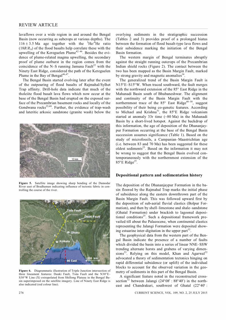
lavaflows over a wide region in and around the Bengal Basin (now occurring as subcrops at various depths). The 116 3.5 Ma age together with the 3He/4He ratio (18R/RA) of the flood basalts help correlate these with the upwelling of the Kereguelen Plume42–46. Besides the evi-dence of plume-related magma upwelling, the secondary proof of plume outburst in the region comes from the coincidence of the N–S running Jamuna Fault22 with the Ninety East Ridge, considered the path of the Kereguelen Plume in the Bay of Bengal46,47. The Bengal Basin started evolving later after the event of the outpouring of flood basalts of Rajmahal/Sylhet Trap affinity. Drill-hole data indicate that much of the tholeiite flood basalt lava flows which now occur at the base of the Bengal Basin had erupted on the exposed sur-face of the Precambrian basement rocks and locally of the Gondwana rocks25,48. Further, the evidence of trap-wash and lateritic arkosic sandstone (granite wash) below the
Figure 5. Satellite image showing sharp bending of the Damodar River east of Bradhaman indicating influence of tectonic fabric in con-trolling the course of the river.
Figure 6. Diagrammatic illustration of Triple Junction intersection of three lineament features: Dauki Fault, Tista Fault and the N30E–S30W Line (X) extrapolated from Shillong Plateau in the Bengal Ba-sin superimposed on the satellite imagery. Line of Ninety East Ridge is also indicated (red colour line).
overlying sediments in the stratigraphic succession (Tables 2 and 3) provides proof of a prolonged hiatus between the formation of flood basalt-type lava flows and their subsidence marking the initiation of the Bengal Basin formation. The western margin of Bengal terminates abruptly against the straight running outcrops of the Precambrian Indian shield rocks (Figure 2). The contact between the two has been mapped as the Basin Margin Fault, marked by strong gravity and magnetic anomalies34. The generalized trend of the Basin Margin Fault is N15E–S15W. When traced southward, the fault merges with the northward extension of the 85 East Ridge in the Mahanadi Basin south of Bhubaneshwar. The alignment and continuity of the Basin Margin Fault with the northernmost trace of the 85 East Ridge48–50, suggest possibility of their being co-genetic features. According to Michael and Krishna51, the 85E Ridge volcanism started at anomaly 33r time (~80 Ma) in the Mahanadi Basin by a short-lived hotspot. Against the backdrop of this information, the age of deposition of the Dhananjay-pur Formation occurring at the base of the Bengal Basin succession assumes significance (Table 1). Based on the study of microfossils, a Campanian–Maastrichtian age (i.e. between 83 and 70 Ma) has been suggested for these oldest sediments25. Based on the information it may not be wrong to suggest that the Bengal Basin evolved con-temporaneously with the northernmost extension of the 85E Ridge25.
Depositional pattern and sedimentation history
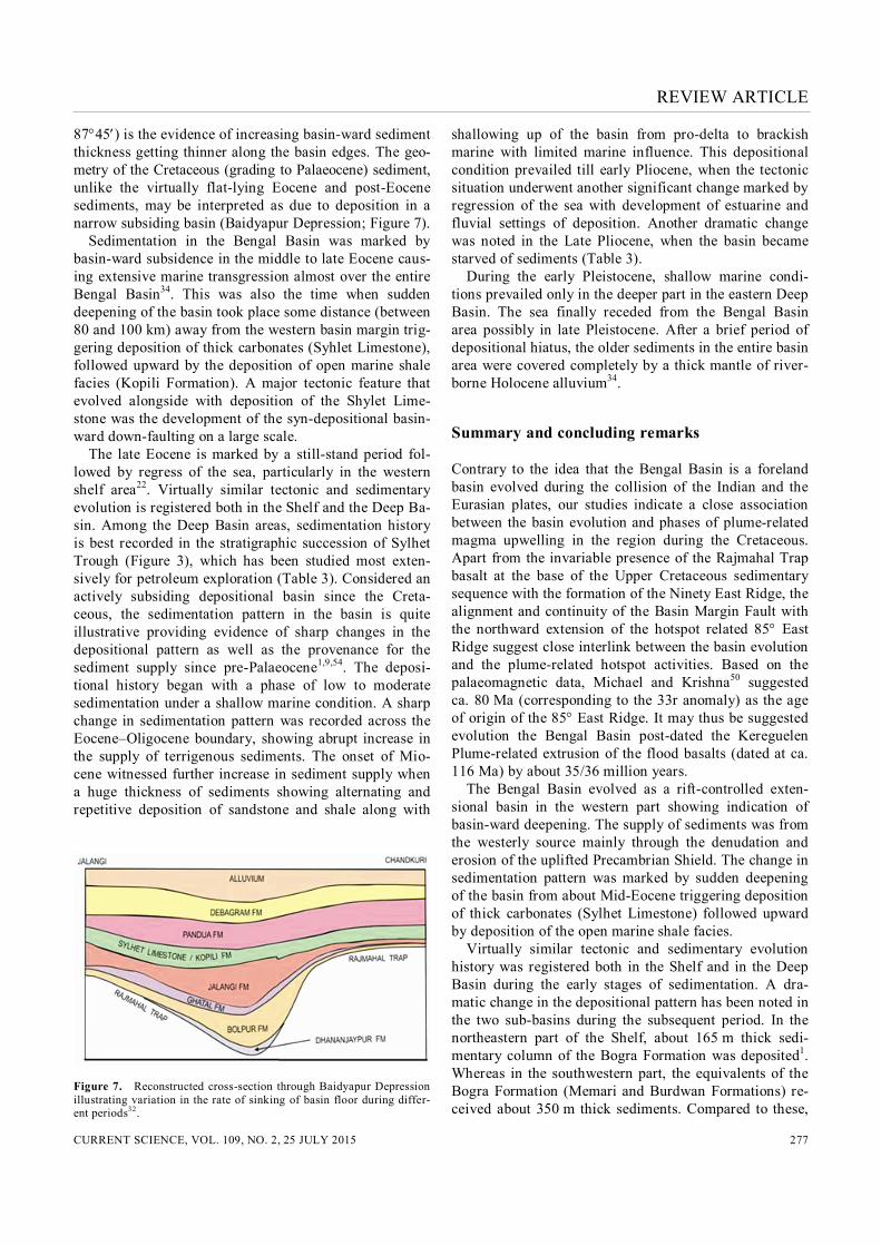
The deposition of the Dhananjaypur Formation in the ba-sin floored by the Rajmahal Trap marks the initial phase of subsidence along the eastern downthrown part of the Basin Margin Fault. This was followed upward first by the deposition of sub-aerial fluvial clastics (Bolpur For-mation), and then by shell–limestone and shale–sandstone (Ghatal Formation) under brackish to lagoonal deposi-tional conditions25. Such a depositional framework pre-vailed till about the Palaeocene, when continental clastics representing the Jalangi Formation were deposited show-ing estuarine inter-digitation in the upper part52. The geophysical data from the western part of the Ben-gal Basin indicate the presence of a number of faults which divided the basin into a series of linear NNE–SSW trending alternate horsts and grabens of varying dimen-sions53. Relying on this model, Khan and Agarwal33 advocated a theory of sedimentation tectonics hinging on rapid differential subsidence (or uplift) of the individual blocks to account for the observed variation in the geo-metry of sediments in this part of the Bengal Basin. A significant feature noted in the reconstructed cross-section32 between Jalangi (2408 : 8840) in the north-east and Chandrakuri, southwest of Ghatal (2240 :
REVIEW ARTICLE
CURRENT SCIENCE, VOL. 109, NO. 2, 25 JULY 2015 277
8745) is the evidence of increasing basin-ward sediment thickness getting thinner along the basin edges. The geo-metry of the Cretaceous (grading to Palaeocene) sediment, unlike the virtually flat-lying Eocene and post-Eocene sediments, may be interpreted as due to deposition in a narrow subsiding basin (Baidyapur Depression; Figure 7). Sedimentation in the Bengal Basin was marked by basin-ward subsidence in the middle to late Eocene caus-ing extensive marine transgression almost over the entire Bengal Basin34. This was also the time when sudden deepening of the basin took place some distance (between 80 and 100 km) away from the western basin margin trig-gering deposition of thick carbonates (Syhlet Limestone), followed upward by the deposition of open marine shale facies (Kopili Formation). A major tectonic feature that evolved alongside with deposition of the Shylet Lime-stone was the development of the syn-depositional basin-ward down-faulting on a large scale. The late Eocene is marked by a still-stand period fol-lowed by regress of the sea, particularly in the western shelf area22. Virtually similar tectonic and sedimentary evolution is registered both in the Shelf and the Deep Ba-sin. Among the Deep Basin areas, sedimentation history is best recorded in the stratigraphic succession of Sylhet Trough (Figure 3), which has been studied most exten-sively for petroleum exploration (Table 3). Considered an actively subsiding depositional basin since the Creta-ceous, the sedimentation pattern in the basin is quite illustrative providing evidence of sharp changes in the depositional pattern as well as the provenance for the sediment supply since pre-Palaeocene1,9,54. The deposi-tional history began with a phase of low to moderate sedimentation under a shallow marine condition. A sharp change in sedimentation pattern was recorded across the Eocene–Oligocene boundary, showing abrupt increase in the supply of terrigenous sediments. The onset of Mio-cene witnessed further increase in sediment supply when a huge thickness of sediments showing alternating and repetitive deposition of sandstone and shale along with
Figure 7. Reconstructed cross-section through Baidyapur Depression illustrating variation in the rate of sinking of basin floor during differ-ent periods32.
shallowing up of the basin from pro-delta to brackish marine with limited marine influence. This depositional condition prevailed till early Pliocene, when the tectonic situation underwent another significant change marked by regression of the sea with development of estuarine and fluvial settings of deposition. Another dramatic change was noted in the Late Pliocene, when the basin became starved of sediments (Table 3). During the early Pleistocene, shallow marine condi-tions prevailed only in the deeper part in the eastern Deep Basin. The sea finally receded from the Bengal Basin area possibly in late Pleistocene. After a brief period of depositional hiatus, the older sediments in the entire basin area were covered completely by a thick mantle of river-borne Holocene alluvium34.
Summary and concluding remarks
Contrary to the idea that the Bengal Basin is a foreland basin evolved during the collision of the Indian and the Eurasian plates, our studies indicate a close association between the basin evolution and phases of plume-related magma upwelling in the region during the Cretaceous. Apart from the invariable presence of the Rajmahal Trap basalt at the base of the Upper Cretaceous sedimentary sequence with the formation of the Ninety East Ridge, the alignment and continuity of the Basin Margin Fault with the northward extension of the hotspot related 85 East Ridge suggest close interlink between the basin evolution and the plume-related hotspot activities. Based on the palaeomagnetic data, Michael and Krishna50 suggested ca. 80 Ma (corresponding to the 33r anomaly) as the age of origin of the 85 East Ridge. It may thus be suggested evolution the Bengal Basin post-dated the Kereguelen Plume-related extrusion of the flood basalts (dated at ca. 116 Ma) by about 35/36 million years. The Bengal Basin evolved as a rift-controlled exten-sional basin in the western part showing indication of basin-ward deepening. The supply of sediments was from the westerly source mainly through the denudation and erosion of the uplifted Precambrian Shield. The change in sedimentation pattern was marked by sudden deepening of the basin from about Mid-Eocene triggering deposition of thick carbonates (Sylhet Limestone) followed upward by deposition of the open marine shale facies. Virtually similar tectonic and sedimentary evolution history was registered both in the Shelf and in the Deep Basin during the early stages of sedimentation. A dra-matic change in the depositional pattern has been noted in the two sub-basins during the subsequent period. In the northeastern part of the Shelf, about 165 m thick sedi-mentary column of the Bogra Formation was deposited1. Whereas in the southwestern part, the equivalents of the Bogra Formation (Memari and Burdwan Formations) re-ceived about 350 m thick sediments. Compared to these,

REVIEW ARTICLE
CURRENT SCIENCE, VOL. 109, NO. 2, 25 JULY 2015 278
a much thicker column of over 1500 m of undifferenti-ated Berail sediments was deposited in the northern part of the Sylhet Trough. The gross thickness difference in the sedimentary packages of the Shelf and the Deep Basin provides a clear hint about the diverse source of sedi-ments for the two basins. While the westerly source from the peneplained rocks of peninsular India continued to supply sediments in the Shelf region, the input for the much thicker deposits in the Sylhet Trough must have come from an easterly source, which in all probability emerged due the sudden uplift in the source area in the Indo-Myanmarese Ranges. Further, the occurrence of much thinner Oligocene succession represented by the Bogra Formation in the northern part of the Shelf Basin (much thinner than the equivalent of Memari and Burd-wan Formations), precludes any possibility of sediment input from the northern Himalayan source at least till the Oligocene. Between the Oligocene and Late Pleistocene, different parts of the Sylhet Trough received huge vol-umes of sediments which made up over 10 km (ref. 55) to more than 17 km (ref. 13) columns of sediment succes-sion. This was followed by an abrupt drop in the sedi-ment thickness from about 1000 m in the preceding Mid-Pliocene to about 250 m in the Late Pliocene (Table 4). Such a sudden reduction in sediment thickness may be interpreted as due to stoppage in supply resulting from the obstruction created in the drainage due to the west-ward advancement of the Indo-Myanmarese mountain front. By Holocene, sedimentation was virtually stopped in the Sylhet Trough, suggesting complete blockage in the drainage system. Regarding the contribution from the Himalaya in the formation of the thick Cenozoic succession of the Bengal Basin, mention has already been made about the absence of any evidence of sediment supply coming from the northern side till at least Oligocene. Even afterwards, the supply of sediments from the Himalaya did not start before the formation of alluvial plains drained by the Ganga and Brahmaputra. The occurrence of clay beds (Barind Clay) predating the thick Holocene alluvial deposit marks a depositional hiatus in the northern part of the Bengal Basin. We may, therefore, conclude that the Himalayan sediments did not reach the Bengal Basin before the late Pleistocene53. The sedimentation model presented here ipso facto im-plies that the deposition in the entire Deep Basin follows the pattern observed in the Sylhet Trough. The suggested fragmentation of the Deep Basin between the ‘troughs’ and ‘highs’ in all likelihood is marked by geophysical, mainly gravity and magnetic parameters, and not due to any significant variation in depositional thickness.
1. Alam, M., Alam, M. M., Curray, J. R., Chowdhury, M. L. R. and Gani, M. R., An overview of the sedimentary geology of the Ben-gal Basin in relation to the regional tectonic framework and basin-fill history. Sediment. Geol., 2003, 155, 179–208.
2. Kuehl, S. A., Hairu, T. M. and Moore, W. S., Shelf sedimentation off the Ganges–Brahmaputra river system: evidence of sediment bypassing to the Bengal fan. Geology, 1989, 17, 1132–1135.
3. Milliman, J. D., Rutkowski, C. and Meybeck, M., River discharge to sea: a global river index (GLORI). LOICZ Reports and Studies, LOICZ Core Project Office, Institute for Sea Research (NIOZ), 1995, p. 125.
4. Goodbred, S. L., Kuehl, S. A., Steckler, M. S. and Sarkar, M. H., Controls on facies distribution and stratigraphic preservation in the Ganges–Brahmaputra delta sequence. Sediment. Geol., 2003, 155, 301–316.
5. Gani, M. R. and Alam, M. M., Trench-slope controlled deep-sea clastics in the exposed lower Surma Group in the southeastern fold belt of the Bengal Basin, Bangladesh. Sediment. Geol., 1999, 127, 221–236.
6. Mukherhee, A., Fryar, A. E. and Thomas, W. A., Geologic, geo-morphic and hydrologic framework and evolution of the Bengal Basin, India and Bangladesh. J. Asian Earth Sci., 2009, 34, 227–244.
7. Farhaduzzaman, Md., Abdullah, W. H. and Islam, Md. A., Hydro-carbon source potential and depositional environment of Surma Group shales of Bengal Basin, Bangladesh. J. Jeol. Soc. India, 2014, 83, 433–446.
8. Graham, S. A., Dickinson, W. R. and Ingersol, R. V., Himalaya–Bengal model for flysch dispersal in the Appalachian–Oachita system. Geol. Soc. Am. Bull., 1975, 86, 273–286.
9. Uddin, A. and Lundberg, N., Miocene sedimentation and subsi-dence during continent–continent collision, Bengal basin, Bangla-desh. Sediment. Geol., 2004, 164, 131–146.
10. Najman, Y. M. R. et al., The Paleogene record of Himalayan ero-sion: Bengal Basin, Bangladesh. Earth Planet. Sci. Lett., 2008, 273, 1–14.
11. Abdulla, R., Hossain, D. and Alam, M. R., Delineation using geo-physical data of the hydrocarbon bearing zone in the Begumganj Structure, Hatia Trough, southern Bengal Basin, Bangladesh. J. Geol. Soc. India, 2013, 82, 271–276.
12. Alam, M., Geology and depositional history of Cenozoic sedi-ments of the Bengal Basin of Bangladesh. Palaeogeogr., Palaeo-climatol., Palaeoecol., 1989, 69, 125–139.
13. Hillar, K. and Elahi, M., Structural growth and hydrocarbon en-trapment in the Surma basin, Bangladesh. In Petroleum Resources of China and Related Subjects (eds Wager, H. C. et al.), Circum-Pacific Council for Energy and Mineral Resources, Earth Science Series, Houston, Texas, 1988, vol. 10, pp. 657–669.
14. Nandy, D. R., Tectonics, seismicity and gravity of northeastern India and adjoining areas. Geology of Nagaland Ophiolites. Geol. Surv. India, Mem., 1986, 119, 13–17.
15. Biswas, S. and Grasemann, B., Quantitative morphotectonics of the southern Shillong Plateau (Bangladesh/India). Aust. J. Earth Sci., 2004, 97, 82–93.
16. Duarah, B. P. and Phukan, S., Understanding the tectonic behav-iour of the Shillong Plateau, India. J. Geol. Soc. India, 2011, 77, 105–112.
17. Yin, An, Dubey, C. S., Kelty, T. K., Webb, A. A. G., Harrison, T. M., Chou, C. Y. and Célérier, J., Geologic correlation of the Himalayan orogen and Indian craton: Part 2. Structural geology, geochronology, and tectonic evolution of the Eastern Himalaya. Bull. Geol. Soc. Am., 2009; doi:10.1130/B26461.1.
18. Islam, Md. S., Shinjo, R. and Kayal, J. R., Pop-up tectonics of the Shillong Plateau in northeastern India: insight from numerical simulations. Gondwana Res., 2011, 20, 395–404.
19. Evans, P., The tectonic framework of Assam. J. Geol. Soc. India, 1964, 5, 80–96.
20. Desikachar, S. V., A review of the tectonic and geological history of eastern India in terms of plate tectonic theory. J. Geol. Soc. India, 1974, 15, 137–149.
21. Srivastava, R. K. and Sinha, A. K., Geochemistry of Early Creta-ceous alkaline Ultramafic–mafic complex from Jasra, Karbi

REVIEW ARTICLE
CURRENT SCIENCE, VOL. 109, NO. 2, 25 JULY 2015 279
Anglong, Shillong Plateau, northeastern India. Gondwana Res., 2004, 7, 549–651.
22. Nandy, D. R., Geodynamics of Northeastern India and Adjoining Region, ACB Publications, Kolkata, 2001, p. 209.
23. Acharyya, S. K., The Cenozoic foreland basin and tectonics of the Eastern Himalaya: problems and perspectives. Himalayan Geol., 1994, 15, 3–21.
24. Ganguly, S., Petroleum geology and exploration history of the Bengal Basin in India and Bangladesh. Indian J. Geol., 1997, 69, 41–48.
25. Das Gupta, A. B. and Mukherjee, B., Geology of NW Bengal Basin, Geological Society of India Publication, Bangalore, 2006, p. 154.
26. Matin, A. and Mishra, S., Repeated cataclasis in a reactivated fault zone – an example from Bengal Basin Margin Fault, Jharkhand, India. J. Virtual Explor., Electronic Edition, ISSN 1441-8142, 32, paper 6, 2009; doi:10.3809/jvirtex.2009.00247.
27. Curray, J. R., Emmel, F. J. and Moore, D. G., The Bengal Fan: Morphology, Geometry, Stratigraphy, history and processes. Mar. Pet. Geol., 1993, 19, 1191–1223.
28. Khan, A. A., Sattar, G. H. and Rahman, T., Tectogenesis of the Gondwana Rifted basins of Bangladesh in the so-called Garo–Rajmahal Gap and their pre-drift regional tectonic correlation. In Proceedings of the Ninth International Gondwana Symposium, Oxford-IBH, New Delhi, 1994, pp. 647–655.
29. Rahman, M. J. J., Sayem, A. S. M. and McCann, T., Geochemistry and provenance of the Miocene sandstones of the Surma Group from the Sitapahar Anticline, southeastern Bengal Basin, Bangla-desh. J. Geol. Soc. India, 2014, 83, 447–456.
30. Ameen, S. M., Wilde, S. A., Kabir, M. Z., Akon, E. Z., Chowd-hury, K. R. and Khan, S. H., Paleoproterozoic granitoids in the basement of Bangladesh: a piece of the Indian shield or an exotic fragment of the Gondwana jigsaw? Gondwana Res., 2007, 12, 380–387.
31. Das Gupta, A. B., Geology of Bengal Basin. Q. J. Geol., Min. Metall. Soc. India, 1997, 69, 161–176.
32. Chandra, M., Mallik, S., Das, D. Thakur, R. K. and Sinha, M. K., Lithostatigraphy of Indian Petroliferous Basin, Document-IX. E, ONGC, Dehradun, 1993.
33. Khan, A. A. and Agarwal, B. N. P., The crustal structure of west-ern Bangladesh from gravity data. Tectonophysics, 1993, 219, 341–353.
34. Sengupta, S., Geological and geophysical studies in the western part of the Bengal Basin, India. Am. Assoc. Pet. Geol., Bull., 1966, 50, 1001–1017.
35. Samsuddin, A. H. M. and Abdulla, S. K. M., Geologic evolution of the Bengal Basin: its implication in hydrocarbon exploration in Bangladesh. Indian J. Geol., 1997, 69, 93–121.
36. Acharyya, S. K., Break-up of the greater Indo-Australian continent and accretion of blocks framing south and east. Asian J. Geodyn., 1998, 26, 149–170.
37. Mukhopadhyay, M. and Dasgupta, S., Deep structure and tectonics of Burmese Arc; constraints from earthquake and gravity data. Tectonophysics, 1998, 149, 299–322.
38. Kent, R., Lithospheric uplift in eastern Gondwana: evidence for a long-lived mantle plume system. Geology, 1991, 19, 19–23.
39. Hoque, M. and Alam, M., Subsidence in the lower deltaic areas of Bangladesh. Mar. Geodesy, 1997, 20(1), 105–120.
40. Biswas, B., Results of exploration of petroleum in western part of the Bengal basin, India. In Proceedings of the 2nd Symposium on
Development of Petroleum Resources ECAFE, Mineral Resource Development Series No. 18, 241–250. Flood basalt province, northeast India. Chem. Geol., 1963, 121, 133–141.
41. Majumdar, R. C., History of Ancient Bengal, Tulshi Prakashani, Kolkata, 1971, p. 457.
42. Pantulu, M. J. D., Gopalan, K. and Krishnamurthy, P., Isotopic and chemical compositions of Sylhet Traps basalts: links to the Rajmahal Traps and Kereguelen hotspot. Trans. Am. Geophys. Un-ion, 1992, 72, 328.
43. Baksi, A. K., Petrogenesis and timing of volcanism in the Rajma-hal. Chem. Geol., 1995, 121, 133–141.
44. Basu, A. R., Weaver, K. L. and Sengupta, S., A plume head and tail in the Bengal basin and Bay of Bengal: Rajmahal and Sylhet Traps with surrounding alkali volcanism and the Ninety East Ridge. EOS Trans., Am. Geophys. Union, 2001, v.p. VI12A-0950.
45. Ghatak, A. and Basu, A. R., Remnants of the Kereguelen Plume in eastern India: evidence from Nd–Sr–Pb isotopic and trace element geochemistry of Sylhet Traps, Shillong Plateau. Trans. Am. Geo-phys. Union, 2006, 87, 52.
46. Ghatak, A. and Basu, A. R., Vestiges of the Kereguelen plume in the Sylhet Traps, northeastern India. Earth Planet. Sci. Lett., 2011, 308, 52–64.
47. Sager, W. W., Zhang, J., Korenaga, J., Sano, T., Koppers, A. A. P. and Mahony, J. J., An immense shield volcano within the Shatsky Rise oceanic plateau, northwest Pacific Ocean. Nature Geosci., 2013, 6, 976–981; doi:10.1038/ngeo1934.
48. Ramana, M. V. et al., Structure and origin of the 85 East Ridge. J. Geophys. Res., 1997, 102, 17,995–18,012.
49. Bastia, R., Radhakrishna, M., Das, S., Kale, A. S. and Catuneanu, O., Delineation of the 85 E ridge and its structure in the Mahanadi Offshore Basin, Eastern Continental Margin of India (ECMI), from seismic reflection imaging. Mar. Pet. Geol., 2010, 27, 1841–1848.
50. Michael, L. and Krishna, K. S., Dating of the 85E Ridge (north-eastern Indian Ocean) using marine magnetic anomalies. Curr. Sci., 2011, 100, 1314–1322.
51. Royburman, A., Geology and hydrocarbon prospects of West Bengal. Pet. Asia J., 1983, VI, 51–56.
52. Venkataraman, D., Petroleum prospects and a review and reinter-pretation of a part of West Bengal. Pet. Asia J., 1984, 147–166.
53. Najman, Y. et al., The record of Himalayan erosion preserved in the sedimentary rocks of the Hatia Trough of the Bengal Basin and the Chittagong Hill Tracts, Bangladesh. Basin Res., 2012, 24, 499–519; doi:10.1111/j.1365-2117.2011.00540.x.
54. Zaher, M. A. and Rahman, A., Prospects and investigations for minerals in the northeastern part of Bangladesh. In Petroleum and Mineral Resources of Bangladesh, Seminar and Exhibition, Dhaka, 1980, pp. 9–18.
55. Imam, B., Energy Resources of Bangladesh, UGC, Dhaka, 2013, 2nd edn, p. 324.
ACKNOWLEDGEMENTS. A.B.R. thanks the Indian National Sci-ence Academy, New Delhi, for funds under the Honorary Scientist Scheme. We thank D. R. Nandy (formerly with Geological Survey of India) and Rashed Abdullah (Jahangirnagar University, Dhaka) for use-ful discussions on the Bengal Basin. Received 16 January 2015; revised accepted 8 May 2015