Embed Size (px)
Citation preview
Nat. Hazards Earth Syst. Sci., 16, 349–369, 2016
www.nat-hazards-earth-syst-sci.net/16/349/2016/
doi:10.5194/nhess-16-349-2016
© Author(s) 2016. CC Attribution 3.0 License.
Review article: A review and critical analysis of the efforts towards
urban flood risk management in the Lagos region of Nigeria
U. C. Nkwunonwo1,2, M. Whitworth2, and B. Baily3
1Department of Geoinformatics and Surveying, University of Nigeria, Enugu Campus, Nigeria2School of Earth and Environmental Sciences, University of Portsmouth, Portsmouth, UK3Department of Geography, University of Portsmouth, Portsmouth, UK
Correspondence to: U. C. Nkwunonwo ([email protected])
Received: 28 April 2015 – Published in Nat. Hazards Earth Syst. Sci. Discuss.: 16 June 2015
Revised: 18 January 2016 – Accepted: 22 January 2016 – Published: 5 February 2016
Abstract. Urban flooding has been and will continue to be
a significant problem for many cities across the developed
and developing world. Crucial to the amelioration of the ef-
fects of these floods is the need to formulate a sound flood
management policy, which is driven by knowledge of the fre-
quency and magnitude of impacts of these floods. Within the
area of flood research, attempts are being made to gain a bet-
ter understanding of the causes, impacts, and pattern of ur-
ban flooding. According to the United Nations office for dis-
aster reduction (UNISDR), flood risk is conceptualized on
the basis of three integral components which are frequently
adopted during flood damage estimation. These components
are: probability of flood hazard, the level of exposure, and
vulnerabilities of elements at risk. Reducing the severity of
each of these components is the objective of flood risk man-
agement under the UNISDR guideline and idea of “living
with floods”. On the basis of this framework, the present re-
search reviews flood risk within the Lagos area of Nigeria
over the period 1968–2012. During this period, floods have
caused harm to millions of people physically, emotionally,
and economically. Arguably over this period the efforts of
stakeholders to address the challenges appear to have been
limited by, amongst other things, a lack of reliable data, a
lack of awareness amongst the population affected, and a lack
of knowledge of flood risk mitigation. It is the aim of this re-
search to assess the current understanding of flood risk and
management in Lagos and to offer recommendations towards
future guidance.
1 Introduction
Flood events and impacts in recent times have arguably been
unprecedented and affected the lives of hundreds of mil-
lions of people across the world. These impacts have been
shared by both developed and developing countries (DCs)
with rapid urban expansion taking place in many flood-prone
areas. Concerns for flooding and the associated human im-
pacts are clearly of global significance, especially when al-
lied with the fears of climatic change and associated changes
in rainfall events and sea level rise (Kundzewicz et al. 2014).
The rapidly growing urban environments in many areas cor-
respond with a lack of urban planning strategies, the deterio-
ration and lack of capacity of urban drainage infrastructure
and an increased rate of development on floodplains (Gill
2004; CII, 2001). Additionally, the increasing densities of
populations (particularly in the urban areas of most DCs such
as Nigeria), alongside the poor level of awareness and the
limited efforts of many stakeholders towards flood risk re-
duction are critical issues undermining possible efforts to-
wards addressing the hazard (Action Aid, 2006; McMichael
et al., 2006; Raaijmakers et al., 2008). The present research
attempts to clarify these issues using a synthesis and analysis
of available historical flood data in the Lagos area of Nigeria,
spanning the period 1968 to 2012. This research also reviews
the current status and awareness of pluvial flood risk within
Lagos and makes recommendations to help improve the man-
agement of these events.
Published by Copernicus Publications on behalf of the European Geosciences Union.
350 U. C. Nkwunonwo et al.: A critical review of Lagos urban flood risk management
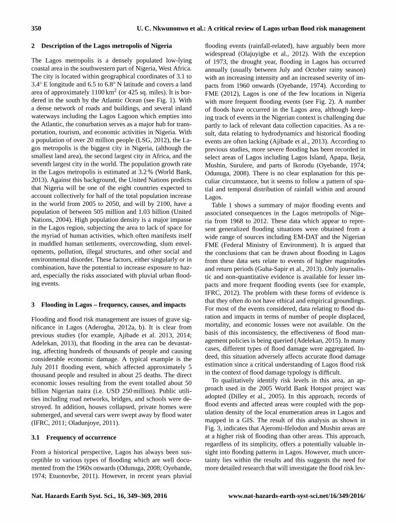
2 Description of the Lagos metropolis of Nigeria
The Lagos metropolis is a densely populated low-lying
coastal area in the southwestern part of Nigeria, West Africa.
The city is located within geographical coordinates of 3.1 to
3.4◦ E longitude and 6.5 to 6.8◦ N latitude and covers a land
area of approximately 1100 km2 (or 425 sq. miles). It is bor-
dered in the south by the Atlantic Ocean (see Fig. 1). With
a dense network of roads and buildings, and several inland
waterways including the Lagos Lagoon which empties into
the Atlantic, the conurbation serves as a major hub for trans-
portation, tourism, and economic activities in Nigeria. With
a population of over 20 million people (LSG, 2012), the La-
gos metropolis is the biggest city in Nigeria, (although the
smallest land area), the second largest city in Africa, and the
seventh largest city in the world. The population growth rate
in the Lagos metropolis is estimated at 3.2 % (World Bank,
2013). Against this background, the United Nations predicts
that Nigeria will be one of the eight countries expected to
account collectively for half of the total population increase
in the world from 2005 to 2050, and will by 2100, have a
population of between 505 million and 1.03 billion (United
Nations, 2004). High population density is a major impasse
in the Lagos region, subjecting the area to lack of space for
the myriad of human activities, which often manifests itself
in muddled human settlements, overcrowding, slum envel-
opments, pollution, illegal structures, and other social and
environmental disorder. These factors, either singularly or in
combination, have the potential to increase exposure to haz-
ard, especially the risks associated with pluvial urban flood-
ing events.
3 Flooding in Lagos – frequency, causes, and impacts
Flooding and flood risk management are issues of grave sig-
nificance in Lagos (Aderogba, 2012a, b). It is clear from
previous studies (for example, Ajibade et al. 2013, 2014;
Adelekan, 2013), that flooding in the area can be devastat-
ing, affecting hundreds of thousands of people and causing
considerable economic damage. A typical example is the
July 2011 flooding event, which affected approximately 5
thousand people and resulted in about 25 deaths. The direct
economic losses resulting from the event totalled about 50
billion Nigerian naira (i.e. USD 250 million). Public utili-
ties including road networks, bridges, and schools were de-
stroyed. In addition, houses collapsed, private homes were
submerged, and several cars were swept away by flood water
(IFRC, 2011; Oladunjoye, 2011).
3.1 Frequency of occurrence
From a historical perspective, Lagos has always been sus-
ceptible to various types of flooding which are well docu-
mented from the 1960s onwards (Odunuga, 2008; Oyebande,
1974; Etuonovbe, 2011). However, in recent years pluvial
flooding events (rainfall-related), have arguably been more
widespread (Olajuyigbe et al., 2012). With the exception
of 1973, the drought year, flooding in Lagos has occurred
annually (usually between July and October rainy season)
with an increasing intensity and an increased severity of im-
pacts from 1960 onwards (Oyebande, 1974). According to
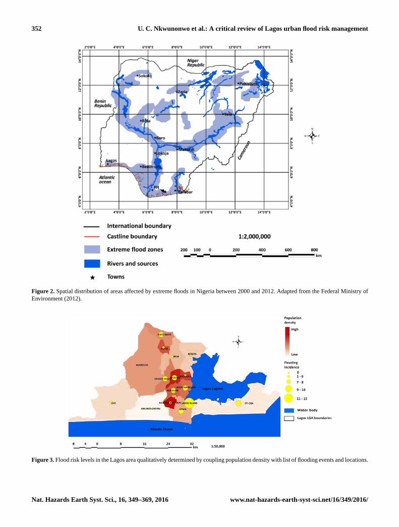
FME (2012), Lagos is one of the few locations in Nigeria
with more frequent flooding events (see Fig. 2). A number
of floods have occurred in the Lagos area, although keep-
ing track of events in the Nigerian context is challenging due
partly to lack of relevant data collection capacities. As a re-
sult, data relating to hydrodynamics and historical flooding
events are often lacking (Ajibade et al., 2013). According to
previous studies, more severe flooding has been recorded in
select areas of Lagos including Lagos Island, Apapa, Ikeja,
Mushin, Surulere, and parts of Ikorodu (Oyebande, 1974;
Odunuga, 2008). There is no clear explanation for this pe-
culiar circumstance, but it seems to follow a pattern of spa-
tial and temporal distribution of rainfall within and around
Lagos.
Table 1 shows a summary of major flooding events and
associated consequences in the Lagos metropolis of Nige-
ria from 1968 to 2012. These data which appear to repre-
sent generalized flooding situations were obtained from a
wide range of sources including EM-DAT and the Nigerian
FME (Federal Ministry of Environment). It is argued that
the conclusions that can be drawn about flooding in Lagos
from these data sets relate to events of higher magnitudes
and return periods (Guha-Sapir et al., 2013). Only journalis-
tic and non-quantitative evidence is available for lesser im-
pacts and more frequent flooding events (see for example,
IFRC, 2012). The problem with these forms of evidence is
that they often do not have ethical and empirical groundings.
For most of the events considered, data relating to flood du-
ration and impacts in terms of number of people displaced,
mortality, and economic losses were not available. On the
basis of this inconsistency, the effectiveness of flood man-
agement policies is being queried (Adelekan, 2015). In many
cases, different types of flood damage were aggregated. In-
deed, this situation adversely affects accurate flood damage
estimation since a critical understanding of Lagos flood risk
in the context of flood damage typology is difficult.
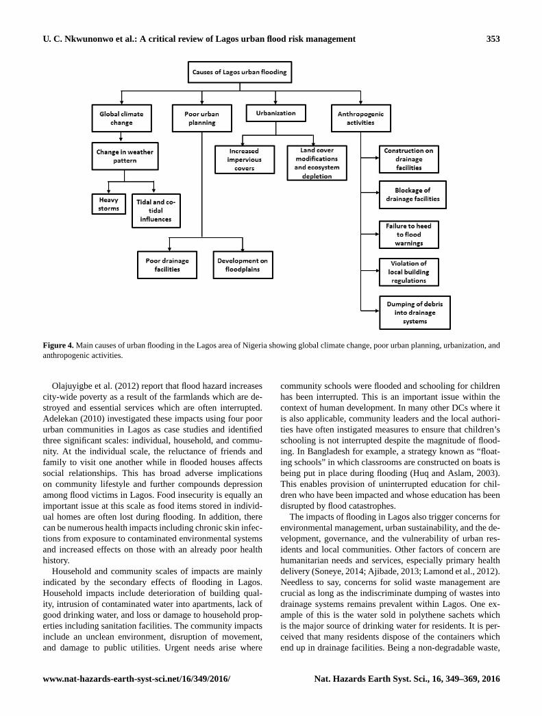
To qualitatively identify risk levels in this area, an ap-
proach used in the 2005 World Bank Hotspot project was
adopted (Dilley et al., 2005). In this approach, records of
flood events and affected areas were coupled with the pop-
ulation density of the local enumeration areas in Lagos and
mapped in a GIS. The result of this analysis as shown in
Fig. 3, indicates that Ajeromi-Ifelodun and Mushin areas are
at a higher risk of flooding than other areas. This approach,
regardless of its simplicity, offers a potentially valuable in-
sight into flooding patterns in Lagos. However, much uncer-
tainty lies within the results and this suggests the need for
more detailed research that will investigate the flood risk lev-
Nat. Hazards Earth Syst. Sci., 16, 349–369, 2016 www.nat-hazards-earth-syst-sci.net/16/349/2016/
U. C. Nkwunonwo et al.: A critical review of Lagos urban flood risk management 351
Figure 1. The Lagos metropolis of Nigeria. Inset shows the location of Lagos State in Nigeria.
els at Lagos using a more detailed quantitative or qualitative
data set.
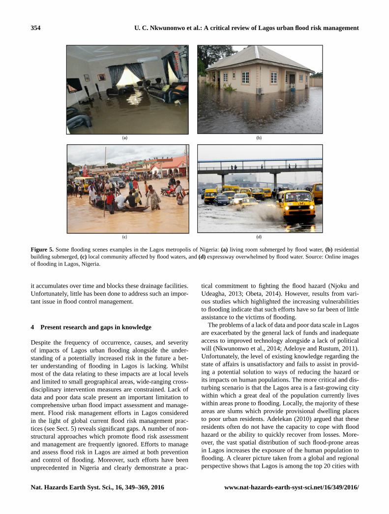
3.2 Causes of flooding
Over the past 2 decades, the causes of flooding in Lagos
have received significant attention in the literature (Ayoade
and Akintola, 1980; Action Aid, 2006; Adeloye and Rus-
tum, 2011; Adelekan, 2013; Aderogba, 2012a; Oshodi, 2013;
Ajibade et al., 2013, 2014; Soneye, 2014). Debates aris-
ing from the literature indicate that Lagos floods are mainly
the consequences of climate-change-induced short-duration-
high-intensity or long-duration-low-intensity rainfall (Hous-
ton et al., 2011). This is unsurprising considering that climate
change has arguably influenced regional precipitation pat-
terns in recent history. Odjugo (2006) concluded that there
are now more high-intensity short-duration rainfall events
and more low-intensity long-duration rainfall events than
there were 3 decades ago. Other factors have also been in-
vestigated with reference to the causes of these floods in
Lagos. These include the topography of the area, land use
(LU) and land cover (LC) modifications, and influence of
canals, lagoons, and beaches (Aderogba, 2012a; Aderogba et
al., 2012; Odunuga, 2008). Other factors considered are ur-
banization and population growth, poor urban planning, and
poor environmental management and the indiscriminate dis-
posal of solid waste (Lamond et al., 2012; Adeloye and Rus-
tum, 2011). It is also suggested that tidal and co-tidal influ-
ences and frequent incursion from the Atlantic into the low-
lands during heavy storms also play important roles (Ojin-
naka, 2013).
These factors (schematized in Fig. 4), seem to influence
the occurrence of the hazard and the exposure of elements
at risk. However, in relation to the vulnerabilities of social
systems to flooding in the area, the development of slum set-
tlements and poor perception of flooding among local com-
munities, urban residents and the general public are critical
factors (Agbola and Agunbiade, 2007; Nkwunonwo, 2013;
Ayoade and Akintola, 1980; Odunuga et al., 2012; Oloke et
al., 2013; BNRCC, 2008).
3.3 Impacts of flooding
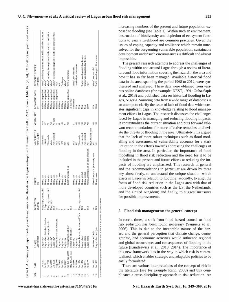
To date, flooding in Lagos is characterized by severe conse-
quences, which raise concerns about a lack of early warning
and evacuation systems. Impacts from flooding (as illustrated
in Fig. 5) are compounded by population density and the up-
ward trends of urban growth in the area (Aderogba, 2012b).
Also, flood water depth, inundation extent and duration as
well as water flow velocity play contributory roles. The gen-
eral impacts (such as displacement from homes, mortality,
physical injuries, disruption of economic activities, destruc-
tion of urban infrastructure, and submergence of buildings)
that relate to social systems directly have been extensively
considered in the literature (Ugwu and Ugwu, 2013; Adi-
gun et al., 2013; Ajibola et al., 2012; Aderogba, 2012b; Ola-
juyigbe et al., 2012). However, there are reports that Lagos
flooding causes severe additional impacts including the loss
of social values, spread of vector-borne diseases, as well as
air and water pollution (Adelekan, 2010; Olajuyigbe et al.,
2012; Bashir et al., 2012).
www.nat-hazards-earth-syst-sci.net/16/349/2016/ Nat. Hazards Earth Syst. Sci., 16, 349–369, 2016
352 U. C. Nkwunonwo et al.: A critical review of Lagos urban flood risk management
Figure 2. Spatial distribution of areas affected by extreme floods in Nigeria between 2000 and 2012. Adapted from the Federal Ministry of
Environment (2012).
Figure 3. Flood risk levels in the Lagos area qualitatively determined by coupling population density with list of flooding events and locations.
Nat. Hazards Earth Syst. Sci., 16, 349–369, 2016 www.nat-hazards-earth-syst-sci.net/16/349/2016/
U. C. Nkwunonwo et al.: A critical review of Lagos urban flood risk management 353
Figure 4. Main causes of urban flooding in the Lagos area of Nigeria showing global climate change, poor urban planning, urbanization, and
anthropogenic activities.
Olajuyigbe et al. (2012) report that flood hazard increases
city-wide poverty as a result of the farmlands which are de-
stroyed and essential services which are often interrupted.
Adelekan (2010) investigated these impacts using four poor
urban communities in Lagos as case studies and identified
three significant scales: individual, household, and commu-
nity. At the individual scale, the reluctance of friends and
family to visit one another while in flooded houses affects
social relationships. This has broad adverse implications
on community lifestyle and further compounds depression
among flood victims in Lagos. Food insecurity is equally an
important issue at this scale as food items stored in individ-
ual homes are often lost during flooding. In addition, there
can be numerous health impacts including chronic skin infec-
tions from exposure to contaminated environmental systems
and increased effects on those with an already poor health
history.
Household and community scales of impacts are mainly
indicated by the secondary effects of flooding in Lagos.
Household impacts include deterioration of building qual-
ity, intrusion of contaminated water into apartments, lack of
good drinking water, and loss or damage to household prop-
erties including sanitation facilities. The community impacts
include an unclean environment, disruption of movement,
and damage to public utilities. Urgent needs arise where
community schools were flooded and schooling for children
has been interrupted. This is an important issue within the
context of human development. In many other DCs where it
is also applicable, community leaders and the local authori-
ties have often instigated measures to ensure that children’s
schooling is not interrupted despite the magnitude of flood-
ing. In Bangladesh for example, a strategy known as “float-
ing schools” in which classrooms are constructed on boats is
being put in place during flooding (Huq and Aslam, 2003).
This enables provision of uninterrupted education for chil-
dren who have been impacted and whose education has been
disrupted by flood catastrophes.
The impacts of flooding in Lagos also trigger concerns for
environmental management, urban sustainability, and the de-
velopment, governance, and the vulnerability of urban res-
idents and local communities. Other factors of concern are
humanitarian needs and services, especially primary health
delivery (Soneye, 2014; Ajibade, 2013; Lamond et al., 2012).
Needless to say, concerns for solid waste management are
crucial as long as the indiscriminate dumping of wastes into
drainage systems remains prevalent within Lagos. One ex-
ample of this is the water sold in polythene sachets which
is the major source of drinking water for residents. It is per-
ceived that many residents dispose of the containers which
end up in drainage facilities. Being a non-degradable waste,
www.nat-hazards-earth-syst-sci.net/16/349/2016/ Nat. Hazards Earth Syst. Sci., 16, 349–369, 2016
354 U. C. Nkwunonwo et al.: A critical review of Lagos urban flood risk management
Figure 5. Some flooding scenes examples in the Lagos metropolis of Nigeria: (a) living room submerged by flood water, (b) residential
building submerged, (c) local community affected by flood waters, and (d) expressway overwhelmed by flood water. Source: Online images
of flooding in Lagos, Nigeria.
it accumulates over time and blocks these drainage facilities.
Unfortunately, little has been done to address such an impor-
tant issue in flood control management.
4 Present research and gaps in knowledge
Despite the frequency of occurrence, causes, and severity
of impacts of Lagos urban flooding alongside the under-
standing of a potentially increased risk in the future a bet-
ter understanding of flooding in Lagos is lacking. Whilst
most of the data relating to these impacts are at local levels
and limited to small geographical areas, wide-ranging cross-
disciplinary intervention measures are constrained. Lack of
data and poor data scale present an important limitation to
comprehensive urban flood impact assessment and manage-
ment. Flood risk management efforts in Lagos considered
in the light of global current flood risk management prac-
tices (see Sect. 5) reveals significant gaps. A number of non-
structural approaches which promote flood risk assessment
and management are frequently ignored. Efforts to manage
and assess flood risk in Lagos are aimed at both prevention
and control of flooding. Moreover, such efforts have been
unprecedented in Nigeria and clearly demonstrate a prac-
tical commitment to fighting the flood hazard (Njoku and
Udeagha, 2013; Obeta, 2014). However, results from vari-
ous studies which highlighted the increasing vulnerabilities
to flooding indicate that such efforts have so far been of little
assistance to the victims of flooding.
The problems of a lack of data and poor data scale in Lagos
are exacerbated by the general lack of funds and inadequate
access to improved technology alongside a lack of political
will (Nkwunonwo et al., 2014; Adeloye and Rustum, 2011).
Unfortunately, the level of existing knowledge regarding the
state of affairs is unsatisfactory and fails to assist in provid-
ing a potential solution to ways of reducing the hazard or
its impacts on human populations. The more critical and dis-
turbing scenario is that the Lagos area is a fast-growing city
within which a great deal of the population currently lives
within areas prone to flooding. Locally, the majority of these
areas are slums which provide provisional dwelling places
to poor urban residents. Adelekan (2010) argued that these
residents often do not have the capacity to cope with flood
hazard or the ability to quickly recover from losses. More-
over, the vast spatial distribution of such flood-prone areas
in Lagos increases the exposure of the human population to
flooding. A clearer picture taken from a global and regional
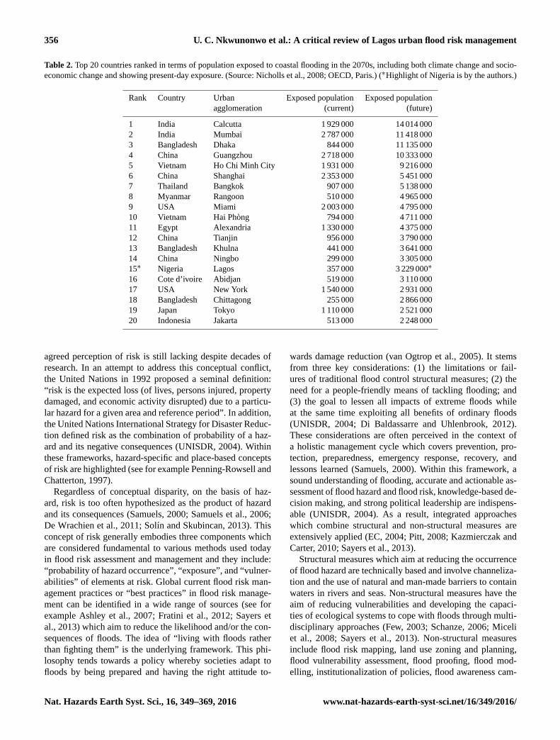
perspective shows that Lagos is among the top 20 cities with
Nat. Hazards Earth Syst. Sci., 16, 349–369, 2016 www.nat-hazards-earth-syst-sci.net/16/349/2016/
U. C. Nkwunonwo et al.: A critical review of Lagos urban flood risk management 355
Ta
ble
1.A
sum
mar
yo
fm
ajo
rfl
oo
din
gev
ents
and
asso
ciat
edth
reat
sin
the
Lag
os
met
rop
oli
so
fN
iger
iafr
om
19
68
to2
01
2.S
ou
rce:
EM
-DA
T(2
01
4),
FM
E(2
01
2)
and
pu
bli
shed
wo
rks.
S/N
o.
DA
TE
LG
A(S
)D
UR
AT
ION
CA
US
EN
OO
FP
EO
PL
EM
OR
TA
LIT
YE
CO
NO
MIC
LO
SS
AF
FE
CT
ED
HO
US
ES
/
AF
FE
CT
ED
(DA
YS
)(S
)D
ISP
LA
CE
D(N
)O
TH
ER
S
1O
ct2012
Lag
os
city
*M
any
day
s,unsp
ecifi
edH
eavy
rain
Thousa
nds
>50
Mil
lions,
unsp
ecifi
edM
any∗,in
cludin
gin
terr
upti
on
of
traf
fic
and
oth
erac
tivit
ies
2Ju
l2011
Lag
os
isla
nd,M
ainla
nd,M
ush
in2
day
sH
eavy
rain
10
000
100
Mil
lions,
unsp
ecifi
edM
any∗
3O
ct2010
Lag
os
isla
nd,A
pap
a,K
oso
fe,
Man
yday
s,unsp
ecifi
edH
eavy
rain
Thousa
nds
20
Mil
lions,
unsp
ecifi
edM
any∗
incl
udin
gin
terr
upti
on
of
traf
fic
and
oth
erac
tivit
ies
4Ju
l2009
Lag
os
city
*M
any
day
sH
eavy
rain
Man
yN
ilM
illi
ons,
unsp
ecifi
edM
any∗
5O
ct2008
Lag
os
city
*N
/AH
eavy
rain
Not
spec
ified
No
dat
aM
illi
ons,
unsp
ecifi
edM
any∗
incl
udin
gin
terr
upti
on
of
traf
fic
and
oth
erac
tivit
ies
6A
ug
2007
Ikoro
du,K
oso
fean
dA
beo
kuta
15
Hea
vy
rain
5000
17
Mil
lions,
unsp
ecifi
ed5000
7Ju
l2005
Lag
os
city
5H
eavy
storm
3000
25
Mil
lions
N/A
8Ju
n2004
Lag
os
city
2H
eavy
rain
1000
Nil
Mil
lions
Dra
inag
es
9Ju
l2002
Lag
os
city
3H
eavy
rain
200
2M
illi
ons
Man
y∗
10
Jun,Ju
l,S
ep2000
Vic
tori
aIs
land
and
Ikoyi
2B
rief
Torr
enti
alR
ain
500
Nil
Mil
lions,
unsp
ecifi
edT
ens
of
thousa
nds
11
May
,Ju
n,Ju
l1999
Mush
inan
dId
iara
ba
N/A
70
000
000
12
Jul
1990
Lag
os
city
2H
eavy
rain
3000
5T
housa
nds
Man
y∗,not
spec
ified
13
Jul
1990
Lag
os
city
2H
eavy
rain
500
Nil
N/A
Hundre
ds
of
inhab
itan
ts
14
Jun
1974
Idia
raba,
Ikoro
du,S
uru
lere
,an
dY
aba
Man
yday
s,unsp
ecifi
edH
eavy
rain
Thousa
nds
Nil
N/A
15
Jun
1972
Lag
os
Isla
nd
N/A
Hea
vy
rain
fall
Not
spec
ified
Nil
N/A
Tra
ffic
was
dis
rupte
d,fe
whouse
s
16
Jul
1971
Lag
os
Isla
nd
5H
eavy
rain
fall
Not
spec
ified
Nil
N/A
Tra
ffic
was
dis
rupte
d,fe
whouse
s
17
Jul
1970
Lag
os
Isla
nd
N/A
Win
ds,
acco
mpan
ied
by
short
-dura
tion,
Nil
Nil
5000
Few
hig
h-i
nte
nsi
tyra
in
18
Jun
1969
Suru
lere
and
Yab
a10
Short
-dura
tion,hig
h-i
nte
nsi
tyra
inN
ilN
ilN
/AM
any∗,not
spec
ified
19
Jun
1968
Lag
os
Isla
nd
and
Ijora
.N
/AH
eavy
storm
Nil
Nil
6000
Tra
ffic
was
dis
rupte
d,F
ewhouse
s
∗G
rou
ped
inst
ead
of
trea
tin
gas
sep
arat
evar
iab
les
du
eto
lack
of
dat
a.N
/A:
No
tav
aila
ble
.N
il:
No
info
rmat
ion
.
increasing numbers of the present and future population ex-
posed to flooding (see Table 1). Within such an environment,
destruction of biodiversity and depletion of ecosystem func-
tions to earn a livelihood are common practices. Given the
issues of coping capacity and resilience which remain unre-
solved for the burgeoning vulnerable population, sustainable
development under such circumstances is difficult and almost
impossible.
The present research attempts to address the challenges of
flooding within and around Lagos through a review of litera-
ture and flood information covering the hazard in the area and
how it has so far been managed. Available historical flood
data in the area, spanning the period 1968 to 2012, were syn-
thesized and analysed. These data were obtained from vari-
ous online databases (for example: NEST, 1991; Guha-Sapir
et al., 2013) and published data on historical flooding in La-
gos, Nigeria. Sourcing data from a wide range of databases is
an attempt to clarify the issue of lack of flood data which cre-
ates significant gaps in knowledge relating to flood manage-
ment efforts in Lagos. The research discusses the challenges
faced by Lagos in managing and reducing flooding impacts.
It contextualizes the current situation and puts forward rele-
vant recommendations for more effective remedies to allevi-
ate the threats of flooding in the area. Ultimately, it is argued
that the lack of more robust techniques such as flood mod-
elling and assessment of vulnerability accounts for a stark
limitation in the efforts towards addressing the challenges of
flooding in the area. In particular, the importance of flood
modelling in flood risk reduction and the need for it to be
included in the present and future efforts at reducing the im-
pacts of flooding are emphasized. This research in general
and the recommendations in particular are driven by three
key aims: firstly, to understand the unique situation which
exists in Lagos in relation to flooding; secondly, to align the
focus of flood risk reduction in the Lagos area with that of
more developed countries such as the US, the Netherlands,
and the United Kingdom; and finally, to suggest measures
for possible improvements.
5 Flood risk management: the general concept
In recent times, a shift from flood hazard control to flood
risk reduction has been found necessary (Samuels et al.,
2006). This is due to the inexorable nature of the haz-
ard and the general perception that climate change, demo-
graphic, and economic activities would influence regional
and global occurrences and consequences of flooding in the
future (Kundzewicz et al., 2010, 2014). The importance of
this new framework lies in the way in which risk is contex-
tualized, which enables strategic and adaptable policies to be
easily formulated.
There are various interpretations of the concept of risk in
the literature (see for example Renn, 2008) and this com-
plicates a cross-disciplinary approach to risk reduction. An
www.nat-hazards-earth-syst-sci.net/16/349/2016/ Nat. Hazards Earth Syst. Sci., 16, 349–369, 2016
356 U. C. Nkwunonwo et al.: A critical review of Lagos urban flood risk management
Table 2. Top 20 countries ranked in terms of population exposed to coastal flooding in the 2070s, including both climate change and socio-
economic change and showing present-day exposure. (Source: Nicholls et al., 2008; OECD, Paris.) (∗Highlight of Nigeria is by the authors.)
Rank Country Urban Exposed population Exposed population
agglomeration (current) (future)
1 India Calcutta 1 929 000 14 014 000
2 India Mumbai 2 787 000 11 418 000
3 Bangladesh Dhaka 844 000 11 135 000
4 China Guangzhou 2 718 000 10 333 000
5 Vietnam Ho Chi Minh City 1 931 000 9 216 000
6 China Shanghai 2 353 000 5 451 000
7 Thailand Bangkok 907 000 5 138 000
8 Myanmar Rangoon 510 000 4 965 000
9 USA Miami 2 003 000 4 795 000
10 Vietnam Hai Phòng 794 000 4 711 000
11 Egypt Alexandria 1 330 000 4 375 000
12 China Tianjin 956 000 3 790 000
13 Bangladesh Khulna 441 000 3 641 000
14 China Ningbo 299 000 3 305 000
15∗ Nigeria Lagos 357 000 3 229 000∗
16 Cote d’ivoire Abidjan 519 000 3 110 000
17 USA New York 1 540 000 2 931 000
18 Bangladesh Chittagong 255 000 2 866 000
19 Japan Tokyo 1 110 000 2 521 000
20 Indonesia Jakarta 513 000 2 248 000
agreed perception of risk is still lacking despite decades of
research. In an attempt to address this conceptual conflict,
the United Nations in 1992 proposed a seminal definition:
“risk is the expected loss (of lives, persons injured, property
damaged, and economic activity disrupted) due to a particu-
lar hazard for a given area and reference period”. In addition,
the United Nations International Strategy for Disaster Reduc-
tion defined risk as the combination of probability of a haz-
ard and its negative consequences (UNISDR, 2004). Within
these frameworks, hazard-specific and place-based concepts
of risk are highlighted (see for example Penning-Rowsell and
Chatterton, 1997).
Regardless of conceptual disparity, on the basis of haz-
ard, risk is too often hypothesized as the product of hazard
and its consequences (Samuels, 2000; Samuels et al., 2006;
De Wrachien et al., 2011; Solín and Skubincan, 2013). This
concept of risk generally embodies three components which
are considered fundamental to various methods used today
in flood risk assessment and management and they include:
“probability of hazard occurrence”, “exposure”, and “vulner-
abilities” of elements at risk. Global current flood risk man-
agement practices or “best practices” in flood risk manage-
ment can be identified in a wide range of sources (see for
example Ashley et al., 2007; Fratini et al., 2012; Sayers et
al., 2013) which aim to reduce the likelihood and/or the con-
sequences of floods. The idea of “living with floods rather
than fighting them” is the underlying framework. This phi-
losophy tends towards a policy whereby societies adapt to
floods by being prepared and having the right attitude to-
wards damage reduction (van Ogtrop et al., 2005). It stems
from three key considerations: (1) the limitations or fail-
ures of traditional flood control structural measures; (2) the
need for a people-friendly means of tackling flooding; and
(3) the goal to lessen all impacts of extreme floods while
at the same time exploiting all benefits of ordinary floods
(UNISDR, 2004; Di Baldassarre and Uhlenbrook, 2012).
These considerations are often perceived in the context of
a holistic management cycle which covers prevention, pro-
tection, preparedness, emergency response, recovery, and
lessons learned (Samuels, 2000). Within this framework, a
sound understanding of flooding, accurate and actionable as-
sessment of flood hazard and flood risk, knowledge-based de-
cision making, and strong political leadership are indispens-
able (UNISDR, 2004). As a result, integrated approaches
which combine structural and non-structural measures are
extensively applied (EC, 2004; Pitt, 2008; Kazmierczak and
Carter, 2010; Sayers et al., 2013).
Structural measures which aim at reducing the occurrence
of flood hazard are technically based and involve channeliza-
tion and the use of natural and man-made barriers to contain
waters in rivers and seas. Non-structural measures have the
aim of reducing vulnerabilities and developing the capaci-
ties of ecological systems to cope with floods through multi-
disciplinary approaches (Few, 2003; Schanze, 2006; Miceli
et al., 2008; Sayers et al., 2013). Non-structural measures
include flood risk mapping, land use zoning and planning,
flood vulnerability assessment, flood proofing, flood mod-
elling, institutionalization of policies, flood awareness cam-
Nat. Hazards Earth Syst. Sci., 16, 349–369, 2016 www.nat-hazards-earth-syst-sci.net/16/349/2016/
U. C. Nkwunonwo et al.: A critical review of Lagos urban flood risk management 357
paign, flood insurance, flood forecasting, relocation of prop-
erties, resettlement of human population, and green infras-
tructure planning (Merz et al., 2007; Jha et al., 2012; Smith,
2013). Fundamental to these measures is the assessment of
flood risk which is a procedure to estimate the damage or
negative impacts resulting from flooding. Flood negative im-
pacts are often classified in terms of tangible and intangible
damage. Tangible damage such as damage to properties and
infrastructure are those that can be associated with mone-
tary values. Intangible damage is difficult to express in mon-
etary terms and may include depression, anxiety, and loss of
life. Categorization of flooding impacts as direct and indi-
rect damage is also applicable. Direct damage includes those
which result from direct contact with flood water. When di-
rect flood damage is tangible, a broader classification, direct
tangible flood damage, applies. Indirect tangible flood dam-
age is a secondary consequence of direct flood impacts and
may include economic disruption, individual misfortune, and
an increase in water-borne diseases (Samuels et al., 2006;
Hammond et al., 2015).
The assessment of flood damage on the basis of damage ty-
pology is characterized by significant limitations. By means
of heterogeneous methodologies, assessment of direct tangi-
ble flood damage has received significant attention in the lit-
erature (Hammond et al., 2015; Samuels et al., 2006). Dam-
age functions, especially stage–damage curves which have
been applied in many case studies around the world, remain
potential tools for assessing direct and indirect tangible flood
damage (Smith, 1994; Merz et al., 2004). A major limita-
tion of stage–damage curves arises from the neglect of water
flow velocity which also influences flood damage. To date,
the difficulty in assessing intangible flood damage remains
unresolved. Methods are being proposed in the current lit-
erature, for example the concept of “anxiety–productivity–
income” which assumes that anxiety is a function of flood
water depth and duration (Lekuthai and Vongvisessomjai,
2001; Price and Vojinovic, 2008). The “Risk-to-life” model,
which uses flood characteristics and an estimate of the num-
ber of people exposed to flooding to assess the possible mor-
tality, was proposed by Jonkman et al. (2008). A compre-
hensive review of other current methods to assess intangible
flood losses can be found in Hammond et al. (2015).
Despite the progress made so far, uncertainties and the lack
of time series stage data and good-quality damage data are
major factors constraining the ubiquitous assessment of flood
risk. In line with predictions of worsened future risk scenar-
ios, these constraints underscore the importance of develop-
ing capacities for estimating flood hazard (in terms of wa-
ter depth, velocity, etc.), exposure, and vulnerabilities of el-
ements at risk as discrete components. The review presented
in this research considers various aspects of Lagos flood risk
assessment and management in light of the general context
of flood risk assessment. With regard to flood risk assess-
ment, procedures to estimate flood hazard are reviewed. Fun-
damental to the research is knowledge about the extent to
which current and future ecosystem exposure to flood hazard
have been influenced. Given reported trends in urbanization
and population growth (summarized in Sect. 8.1), it can be
assumed that exposure of systems to flooding in Lagos is at
a critical level.
6 The management and reduction of flood risk in
Lagos
6.1 General measures
General measures to tackle the challenges of flooding in La-
gos have been discussed by Oshodi (2013). Recent practices
have included:
1. The expansion of drainage infrastructure within the city
heartland.
2. The annual debris removal from principal drainage fa-
cilities within the city heartland.
3. Providing advice to the inhabitants of flood plains and
wetlands to relocate.
4. The demolition of homes in flood-prone areas.
5. Proposed resettlement scheme for the residents of Ogun
River catchment areas.
Oshodi (2013) claimed that these practices are being carried
out, although it could be argued that they are politically in-
fluenced. One example of this is the expansion and upgrad-
ing of the primary drainage facilities mainly being carried
out in Bariga, Surulere, and Gbagada. The annual clearing
of primary and secondary channels by Lagos State Govern-
ment through the Ministry of the Environment is carried out
principally in the metropolitan areas. Evacuation and reset-
tlement is carried out for residents who live in flood-prone
areas. A proposed resettlement scheme for residents of Aje-
gunle community near Ikorodu was undertaken between Oc-
tober 2011 and January 2012 (Oshodi, 2013). The move was
necessitated based on the belief that the current location of
the community in the Lagos urban Master Plan was origi-
nally zoned as wetland for agricultural use. The area was a
major catchment of Ogun River. It could be argued that the
lack of clear implementation policy for the plan with enor-
mous housing shortfall in the city to cope with rapid popu-
lation growth and urbanization has led to the conversion of
the area into residential use. Significant environmental im-
pacts are often associated with the use of land for purposes it
was not originally allotted for. Flooding can be the case when
such inappropriate use affects ecological equilibrium. How-
ever, a sound investigation is needed to validate this claim,
especially within the context of Lagos.
Major failures of these general measures arise from the
issues of continuity and the scope of application. These mea-
sures are often limited to the core urban areas of the city, ex-
cluding the majority of the outskirts (Oshodi, 2013). Many
www.nat-hazards-earth-syst-sci.net/16/349/2016/ Nat. Hazards Earth Syst. Sci., 16, 349–369, 2016
358 U. C. Nkwunonwo et al.: A critical review of Lagos urban flood risk management
areas within Lagos did not benefit from the expansion of
drainage facilities; moreover, the project was not completed
because of a change in administration. These projects often
suffer when new governments abandon uncompleted projects
of their predecessors. This shows the potential for urban mis-
management and the degree of limitation in urban develop-
ment given that there are many abandoned projects while new
ones are being considered. There are occasional inconsisten-
cies in the annual cleaning of the channels. Sometimes this
operation is delayed, which allows debris to accumulate in
the channels. Coupled with careless attention to the channels
after cleaning, accumulation of debris has led to early col-
lapse of the channels. This causes potholes on motorways
and retention surfaces for water during flooding.
The problems of where to relocate to and the sparcity of
support for relocation are overwhelming. Given the vast dis-
tribution of flood-prone areas and the limited financial re-
sources to facilitate resettlement, the choice of which slum
locations to resettle is complicated. Communities which can-
not be resettled often face the risk of having individual homes
demolished. Examples of this include the Agege and Ije-
shatedo demolitions in August 2011 and that of Ijora-Badia
in 2010, 2012, and 2013. The demolition of homes is under-
standably a distressing measure to those affected. It could be
argued that a particularly controversial aspect is the failure
and neglect of the state government to provide any form of
alternative housing arrangements to those whose houses have
been demolished. There have been a few exceptional cases,
for example the Ijora-Badia (World Bank assisted) drainage
channels project, which necessitated the demolition and
burning of homes. Following a community-led protest the
affected families were awarded relocation assistance costs.
On the basis of these potential government inadequacies,
Ahonshi (2002), Kamunyori (2007), and Basinsksi (2009),
cited in Lawanson (2015), argued that the achievement of
government’s urban sustainability goals (which include gen-
eral flood management measures) in Lagos are often with-
out regard to the needs of the poor residents of the area. At
the same time, demolition and eviction frequently leads to
forced social disconnection amongst families, and compen-
sation and legal process on behalf of those affected can take
a significant amount of time to complete. This is in part an
aspect of social vulnerability which needs to be investigated
within the context of Lagos urban flooding. Under the cir-
cumstances of eviction and resettlement uncertainties, most
people occupying the flood-prone areas seem to ignore gov-
ernment’s flood risk mitigation proposals and flood warnings.
This influences large-scale impacts of urban flooding in La-
gos. However, despite numerous tensions, this issue has only
received limited attention in the literature and in governance.
6.2 Institutional efforts
One critical aspect of flood response is the institutional ef-
forts which have been undertaken by local authorities and
stakeholders. Odunuga (2008) recognized several flood pre-
ventive and curative initiatives ranging from community self-
assistance actions to World Bank assisted programmes. Re-
cently, key initiatives, which include the Drain Dock and The
Emergency Flood Abatement Gang (EFAG), were launched
by the government of Lagos state to improve current ef-
forts towards addressing the challenges of flooding. The min-
istries of Environment, Works, and Health as well as the
Lagos Metropolitan Development and Governance Project
(LMDGP) have a number of initiatives aimed at control-
ling flood hazard in the area, and these include shoreline
protection, low carbon emissions, the school advocacy pro-
gramme, and the climate change club. Lagos is also the first
region in Nigeria to carry out a detailed topographic map-
ping of the area with LiDAR (Light Detection and Rang-
ing) data acquisition and GIS-based analysis aimed at ad-
dressing the challenges of flooding. In addition to these ef-
forts, the Nigerian government and international community
have been active with measures to address the challenges
of flooding at various locations within the country includ-
ing the Lagos area (Olorunfemi, 2011; NIHSA, 2013). As
well as engineering works such as dams, bridges, and sus-
tainable urban drainage systems there has also been finan-
cial assistance to victims of flooding and this appears to be
a common practice. These are undertaken by the National
Emergency Management Agency (NEMA), the Nigeria Hy-
drological Services Agency (NIHSA), the Nigerian Meteo-
rological Agency (NIMET), and the National Environmental
Standards and Regulations Enforcement Agency (NESREA)
which in 2009 superseded the Federal Environmental Protec-
tion Agency (FEPA). It is not intended to discuss the struc-
ture, specific roles, and the unique position of these agen-
cies with regard to flood management in Lagos. These as-
pects have been comprehensively discussed by Obeta (2014).
However, it is important to mention that the activities of these
institutions with regards to disaster management are gener-
ally coordinated by NEMA.
Although detailed data are not available, a key point will
be highlighted in terms of the historical perspective of dis-
aster management institutions, to give clarity to a synthetic
description of the temporal evolution of flood awareness in
Lagos. The institutional framework in Nigeria can be traced
back more than four decades in history. The federal govern-
ment of Nigeria has since the first, second, and third Na-
tional Development Plans of 1962–1968, 1970–1974, and
1975–1980 initiated plans for the management of all disas-
ters including flooding. This was organized through the fed-
eral and state ministries of works. On the basis of flood-
ing and associated hazards, the primary aim of these ini-
tiatives was to create awareness among the citizenry and
to develop sound response strategies. This development has
evolved to the present time into what is now known as in-
stitutional approaches to managing disaster. Lately, the insti-
tutional framework has incorporated operations such as flood
warning through the NISHA, improving general flood aware-
Nat. Hazards Earth Syst. Sci., 16, 349–369, 2016 www.nat-hazards-earth-syst-sci.net/16/349/2016/
U. C. Nkwunonwo et al.: A critical review of Lagos urban flood risk management 359
ness through the National Orientation Agency (NOA), and
integration of local state and federal disaster emergency man-
agement agencies.
Despite the recent initiatives, these developments have
been criticised as weak, while the roles of the institutions
are not clearly defined (Adeaga et al., 2005; Oshodi, 2013;
Soneye, 2014; Nkwunonwo et al., 2014; Adelekan, 2015).
Critically, current measures undertaken by these agencies ap-
pear aimed to control flood rather than mitigate its impacts
on ecological systems. Efforts are being made to facilitate
evacuation and provide flood victims with urgent humani-
tarian needs. Environmental sustainability and policy, social
responses, physical intervention, and environmental manage-
ment are also critical issues requiring attention (Aderogba et
al., 2012; Olajuyigbe et al., 2012; Aderogba, 2012b; Adeaga,
2008, Ilesanmi, 2010). However, despite the increasing num-
ber of people affected, the effectiveness of these efforts is
challenged. Whilst it is unreasonable to claim that the weak-
ness of these flood mitigation measures probably leads to
more frequent flooding in the area, in can be argued that such
measures have improved the experience of the general popu-
lation with regard to flooding.
6.3 Recent research efforts
From the literature, researchers have suggested several op-
tions in relation to possible flood hazard mitigation and
adaption responses. Adedeji et al. (2012) highlighted the
importance of building the capacity for flood preparedness
through spatial planning and land management. Ogunsote et
al. (2011) suggested combating environmental degradation
through sustainable landscaping. The need for sustainable
management of solid waste which was emphasized in sec-
tion 3 of this paper was recommended by Folorunsho and
Awosika (2001). Komolafe et al. (2014) argued for the adop-
tion of proactive measures to risk management and adapta-
tion whilst constant geophysical and hydrological evaluation
of rising groundwater levels was emphasized by Oyedele et
al. (2009). Adelekan (2013) reiterated the UNISDR recom-
mendation which calls for the participation of the private sec-
tor in risk management through investment decision making
in building and construction. Other factors besides flood pre-
vention are also important to reduce the potential impacts of
flood events. The humanitarian relief supply chain for vic-
tims of flooding in the Lagos area was investigated by Son-
eye (2014). This study identified the need for more empiri-
cal investigation into such crucial components of flood risk
management in Lagos. In relation to the planning framework,
sustainable housing development and functionality of plan-
ning laws and regulations as well as the role of governance
in flood management in the Lagos area and indeed in Nige-
ria have been examined by a number of authors including
Aluko (2011) and Oshodi (2013).
As well as the general discussions in the literature, there
is other research which focuses on integral components of
flood risk such as probability of flooding, and exposure and
vulnerability to flooding. But these are insufficient, and leave
significant gaps in knowledge. Insufficient knowledge of the
vulnerabilities to flooding of local communities, urban resi-
dents, and the general public constrains effective flood risk
management in Lagos. Urban flooding in particular has ar-
guably not received the attention it deserves. A general cri-
tique, which should provide a nuanced understanding of the
strengths and limitations of present efforts to address the
threats of flooding in the Lagos area, is lacking. The lack of
flood data and other ancillary data, as discussed in Sects. 3
and 5, is a major setback towards containing these threats
and has not been fully addressed. Importantly, the focus of
these studies which solely rested on general knowledge of
the causes, impacts, and remedies of flooding suggests that
the global view of the situation has been imperfect. More
scientific approaches such as the flood modelling and flood
vulnerability assessment which drives recent approaches to
flood risk management in more developed countries are gen-
erally lacking. Little action has been undertaken to raise pub-
lic awareness of flood risk or to address gendered vulnera-
bility, as highlighted by Odunuga et al. (2012), Ajibade et
al. (2013), and Adelekan (2010). As an unprecedented mea-
sure, the Lagos state government has made significant efforts
at providing high-resolution air-borne LiDAR data and topo-
graphic maps which promote research towards flood risk in
the area. However, since many of these data sets are produced
and sold commercially, the limited access of researchers to
them arguably undermines their usefulness. A possible so-
lution to such a limited access to LiDAR data is to apply
global data sets such as ASTERGDEM (Advanced Space-
borne Thermal Emission and Reflection Radiometer Global
Digital Elevation Model) and STRM (Shuttle Radar Topo-
graphic Mission). However, the resolution of spatial data is a
crucial factor in flood modelling and flood risk assessment.
Due to the geomorphology of urban features which signif-
icantly influence hydrodynamics, global data sets often do
not provide realistic results when used to model flood hazard
in urban areas (van de Sande et al., 2012). Flood modelling
research is still looking into possible ways of simulating ac-
curate flood variables on the basis of low-scale global data
sets.
7 Flood risk assessment in Lagos
There has been a great deal of research about the assess-
ment of flood risk in Lagos in general. However, it can be
argued that none of these studies explicitly assessed the level
of exposure to flooding of social and environmental sys-
tems. This aspect of flood risk assessment can be derived
from studies that consider LU and LC change analyses, and
population expansion and urbanization (see Table 3). From
the literature, it is clear that vulnerability is being assessed
under varying contexts and objectives. No study known to
www.nat-hazards-earth-syst-sci.net/16/349/2016/ Nat. Hazards Earth Syst. Sci., 16, 349–369, 2016
360 U. C. Nkwunonwo et al.: A critical review of Lagos urban flood risk management
the authors has considered flood hazard estimation, although
Odjugo (2006) and Adelekan (2010) investigated rainfall pat-
terns over spatial and temporal scales. Odjugo (2006) inves-
tigated the changing rainfall pattern in Lagos over 3 decades.
Adelekan (2010) on the basis of qualitative survey and sec-
ondary data analyses attributed increasing flood risks in La-
gos Island mainly to changes in the frequency and intensity
of rainstorms between 1971 and 2005. Other studies that es-
timate flood hazard were embodied within the general frame-
work of climate change research (see for example Aderogba,
2012a). The lack of an explicit study on flood hazard esti-
mation makes it difficult to appreciate how the probability
of flood hazard occurrence is being determined in Lagos.
Moreover, a clear understanding of the evolutionary trend of
the hazard is denied. A consensus view is that the hazard
has been increasing over the last 5 decades (Odunuga, 2008;
Adelekan, 2015). It is expected that future research should be
directed towards this crucial aspect of flood risk assessment.
7.1 Exposure
LU and LC analyses are procedures to classify land use/cover
and to identify rates and patterns of change. However, the
outcome of these analyses to Lagos has continuously sug-
gested expansion in the urban areas. LU and LC analyses
provides a basis for researchers and policy formulators to
analyse the current and future urban exposure to environmen-
tal hazards especially flooding. Flood risk is heavily influ-
enced by human and economic developments which evolve
within spatial and temporal scales (Samuels et al., 2006).
These developments are known to influence the hydrologi-
cal cycle particularly through the development of more im-
pervious surfaces which reduce soil infiltration capacity and
lead to increased surface water runoffs. The spatial and tem-
poral dimensions of flood risk can in part be directly related
to LU and LC modifications. Barredo and Engelen (2010)
and Gupta and Nair (2010) have shown that modelling LU
and LC scenarios is integral to flood risk management. Iden-
tification of the population and urban growth pattern is also
fundamental (Barredo and Demicheli, 2003). Many studies
covering this crucial aspect of flood risk assessment within
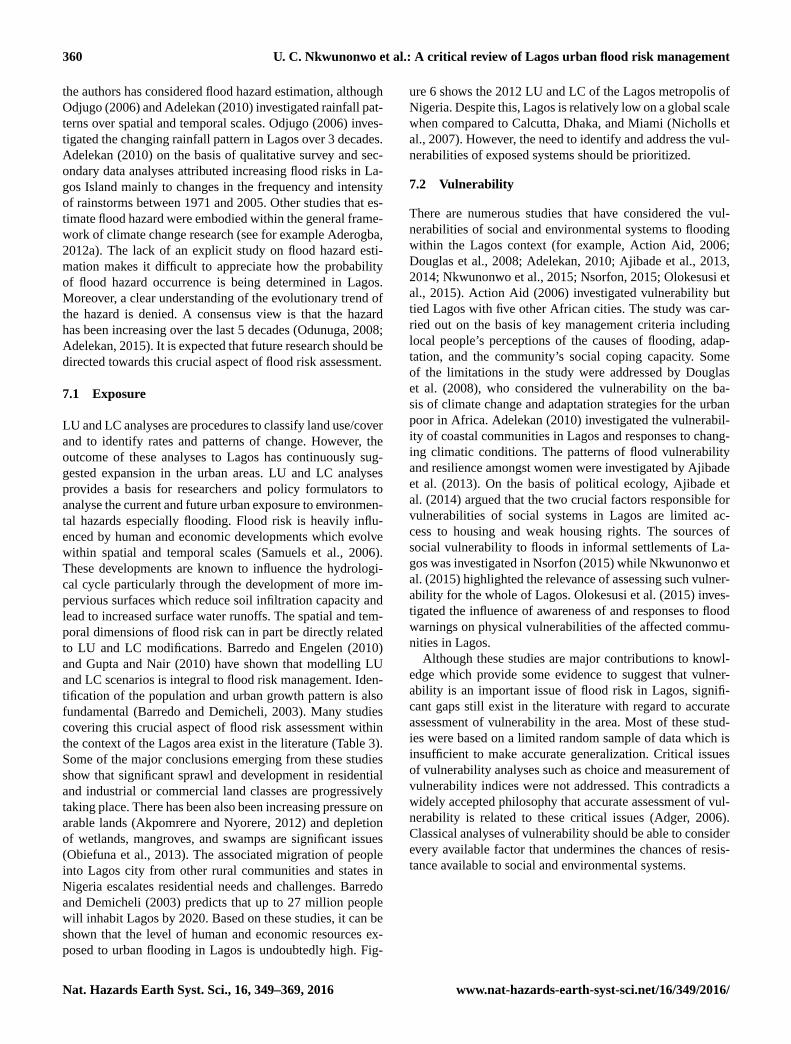
the context of the Lagos area exist in the literature (Table 3).
Some of the major conclusions emerging from these studies
show that significant sprawl and development in residential
and industrial or commercial land classes are progressively
taking place. There has been also been increasing pressure on
arable lands (Akpomrere and Nyorere, 2012) and depletion
of wetlands, mangroves, and swamps are significant issues
(Obiefuna et al., 2013). The associated migration of people
into Lagos city from other rural communities and states in
Nigeria escalates residential needs and challenges. Barredo
and Demicheli (2003) predicts that up to 27 million people
will inhabit Lagos by 2020. Based on these studies, it can be
shown that the level of human and economic resources ex-
posed to urban flooding in Lagos is undoubtedly high. Fig-
ure 6 shows the 2012 LU and LC of the Lagos metropolis of
Nigeria. Despite this, Lagos is relatively low on a global scale
when compared to Calcutta, Dhaka, and Miami (Nicholls et
al., 2007). However, the need to identify and address the vul-
nerabilities of exposed systems should be prioritized.
7.2 Vulnerability
There are numerous studies that have considered the vul-
nerabilities of social and environmental systems to flooding
within the Lagos context (for example, Action Aid, 2006;
Douglas et al., 2008; Adelekan, 2010; Ajibade et al., 2013,
2014; Nkwunonwo et al., 2015; Nsorfon, 2015; Olokesusi et
al., 2015). Action Aid (2006) investigated vulnerability but
tied Lagos with five other African cities. The study was car-
ried out on the basis of key management criteria including
local people’s perceptions of the causes of flooding, adap-
tation, and the community’s social coping capacity. Some
of the limitations in the study were addressed by Douglas
et al. (2008), who considered the vulnerability on the ba-
sis of climate change and adaptation strategies for the urban
poor in Africa. Adelekan (2010) investigated the vulnerabil-
ity of coastal communities in Lagos and responses to chang-
ing climatic conditions. The patterns of flood vulnerability
and resilience amongst women were investigated by Ajibade
et al. (2013). On the basis of political ecology, Ajibade et
al. (2014) argued that the two crucial factors responsible for
vulnerabilities of social systems in Lagos are limited ac-
cess to housing and weak housing rights. The sources of
social vulnerability to floods in informal settlements of La-
gos was investigated in Nsorfon (2015) while Nkwunonwo et
al. (2015) highlighted the relevance of assessing such vulner-
ability for the whole of Lagos. Olokesusi et al. (2015) inves-
tigated the influence of awareness of and responses to flood
warnings on physical vulnerabilities of the affected commu-
nities in Lagos.
Although these studies are major contributions to knowl-
edge which provide some evidence to suggest that vulner-
ability is an important issue of flood risk in Lagos, signifi-
cant gaps still exist in the literature with regard to accurate
assessment of vulnerability in the area. Most of these stud-
ies were based on a limited random sample of data which is
insufficient to make accurate generalization. Critical issues
of vulnerability analyses such as choice and measurement of
vulnerability indices were not addressed. This contradicts a
widely accepted philosophy that accurate assessment of vul-
nerability is related to these critical issues (Adger, 2006).
Classical analyses of vulnerability should be able to consider
every available factor that undermines the chances of resis-
tance available to social and environmental systems.
Nat. Hazards Earth Syst. Sci., 16, 349–369, 2016 www.nat-hazards-earth-syst-sci.net/16/349/2016/
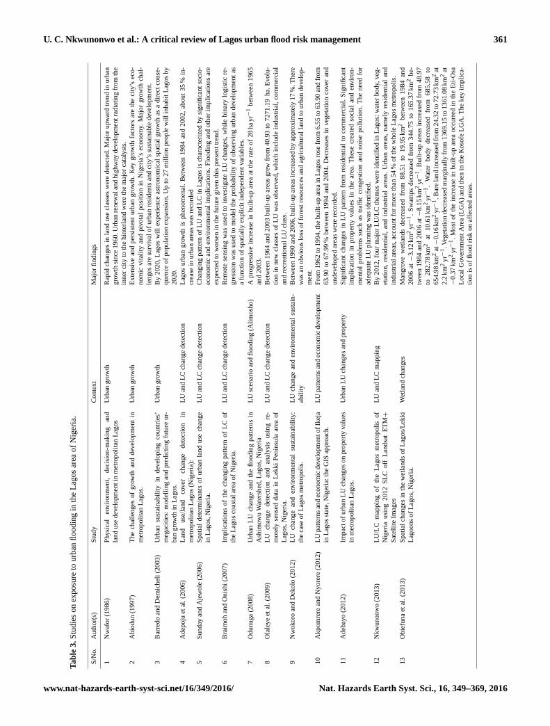
U. C. Nkwunonwo et al.: A critical review of Lagos urban flood risk management 361
Ta
ble
3.
Stu
die
so
nex
po
sure
tou
rban
flo
od
ing
inth
eL
ago
sar
eao
fN
iger
ia.
S/N
o.
Au
tho
r(s)
Stu
dy
Co
nte
xt
Maj
or
fin
din
gs
1N
waf
or
(19
86
)P
hy
sica
len
vir
on
men
t,d
ecis
ion
-mak
ing
and
lan
du
sed
evel
op
men
tin
met
rop
oli
tan
Lag
os
Urb
ang
row
thR
apid
chan
ges
inla
nd
use
clas
ses
wer
ed
etec
ted
.M
ajo
ru
pw
ard
tren
din
urb
an
gro
wth
sin
ce1
96
0.U
rban
ren
ewal
and
hig
hw
ayd
evel
op
men
tra
dia
tin
gfr
om
the
inn
erci
tyto
the
hin
terl
and
wer
eth
em
ajo
rca
taly
sts.
2A
bio
du
n(1
99
7)
Th
ech
alle
ng
eso
fg
row
than
dd
evel
op
men
tin
met
rop
oli
tan
Lag
os.
Urb
ang
row
thE
xte
nsi
ve
and
per
sist
ent
urb
ang
row
th.
Key
gro
wth
fact
ors
are
the
city
’sec
o-
no
mic
vit
alit
yan
dp
ivo
tal
po
siti
on
inN
iger
ia’s
eco
no
my.
Maj
or
gro
wth
chal
-
len
ges
are
surv
ival
of
urb
anre
sid
ents
and
city
’ssu
stai
nab
led
evel
op
men
t.
3B
arre
do
and
Dem
ich
eli
(20
03
)U
rban
sust
ain
abil
ity
ind
evel
op
ing
cou
ntr
ies’
meg
acit
ies:
mo
del
lin
gan
dp
red
icti
ng
futu
reu
r-
ban
gro
wth
inL
ago
s.
Urb
ang
row
thB
y2
02
0,
Lag
os
wil
lex
per
ien
ceas
tro
no
mic
alsp
atia
lg
row
thas
ad
irec
tco
nse
-
qu
ence
of
po
pu
lati
on
exp
ansi
on
.U
pto
27
mil
lio
np
eop
lew
ill
inh
abit
Lag
os
by
20
20
.
4A
dep
oju
etal
.(2
00
6)
Lan
du
se/l
and
cover
chan
ge
det
ecti
on
in
met
rop
oli
tan
Lag
os
(Nig
eria
):
LU
and
LC
chan
ge
det
ecti
on
Lag
os
urb
ang
row
this
ph
eno
men
al.
Bet
wee
n1
98
4an
d2
00
2,
abo
ut
35
%in
-
crea
sein
urb
anar
eas
was
reco
rded
5S
un
day
and
Aje
wo
le(2
00
6)
Sp
atia
ld
eter
min
ants
of
urb
anla
nd
use
chan
ge
inL
ago
s,N
iger
ia.
LU
and
LC
chan
ge
det
ecti
on
Ch
ang
ing
pat
tern
of
LU
and
LC
inL
ago
sis
char
acte
rize
db
ysi
gn
ifica
nt
soci
o-
eco
no
mic
and
env
iro
nm
enta
lim
pli
cati
on
s.F
loo
din
gan
do
ther
imp
lica
tio
ns
are
exp
ecte
dto
wo
rsen
inth
efu
ture
giv
enth
isp
rese
nt
tren
d.
6B
raim
oh
and
On
ish
i(2
00
7)
Imp
lica
tio
ns
of
the
chan
gin
gp
atte
rno
fL
Co
f
the
Lag
os
coas
tal
area
of
Nig
eria
.
LU
and
LC
chan
ge
det
ecti
on
Rem
ote
sen
sin
gw
asu
sed
toin
ves
tigat
eL
Uch
ang
es,
wh
ile
bin
ary
log
isti
cre
-
gre
ssio
nw
asu
sed
tom
od
elth
ep
rob
abil
ity
of
ob
serv
ing
urb
and
evel
op
men
tas
afu
nct
ion
of
spat
iall
yex
pli
cit
ind
epen
den
tvar
iab
les.
7O
du
nu
ga
(20
08
)U
rban
LU
chan
ge
and
the
flo
od
ing
pat
tern
sin
Ash
imow
uW
ater
shed
,L
ago
s,N
iger
ia
LU
scen
ario
and
flo
od
ing
(Ali
mo
sho
)A
pro
gre
ssiv
ein
crea
sein
bu
ilt-
up
area
atth
era
teo
f2
8h
ay
r−1
bet
wee
n1
96
5
and
20
03
.
8O
lale
ye
etal
.(2
00
9)
LU
chan
ge
det
ecti
on
and
anal
ysi
su
sin
gre
-
mo
tely
sen
sed
dat
ain
Lek
ki
Pen
insu
laar
eao
f
Lag
os,
Nig
eria
.
LU
and
LC
chan
ge
det
ecti
on
Bet
wee
n1
96
4an
d2
00
3bu
ilt-
up
area
sg
rew
fro
m4
0.9
3to
72
71
.19
ha.
Evo
lu-
tio
nin
new
clas
ses
of
LU
was
ob
serv
ed,
wh
ich
incl
ud
ein
du
stri
al,
com
mer
cial
and
recr
eati
on
alL
Ucl
ass.
9N
wo
ko
roan
dD
eko
lo(2
01
2)
LU
chan
ge
and
env
iro
nm
enta
lsu
stai
nab
ilit
y:
the
case
of
Lag
os
met
rop
oli
s.
LU
chan
ge
and
env
iro
nm
enta
lsu
stai
n-
abil
ity
Bet
wee
n1
99
0an
d2
00
6,bu
ilt-
up
area
sin
crea
sed
by
app
rox
imat
ely
17
%.T
her
e
was
ano
bv
iou
slo
sso
ffo
rest
reso
urc
esan
dag
ricu
ltu
ral
lan
dto
urb
and
evel
op
-
men
t.
10
Ak
po
mre
rean
dN
yo
rere
(20
12
)L
Up
atte
rns
and
eco
no
mic
dev
elo
pm
ento
fIk
eja
inL
ago
sst
ate,
Nig
eria
:th
eG
ISap
pro
ach
.
LU
pat
tern
san
dec
on
om
icd
evel
op
men
tF
rom
19
62
to1
99
4,th
ebu
ilt-
up
area
inL
ago
sro
sefr
om
6.5
5to
63
.90
and
fro
m
63
.90
to6
7.9
9%
bet
wee
n1
99
4an
d2
00
4.
Dec
reas
esin
veg
etat
ion
cover
and
un
dev
elo
ped
area
sw
ere
reco
rded
.
11
Ad
ebay
o(2
01
2)
Imp
act
of
urb
anL
Uch
ang
eso
np
rop
erty
val
ues
inm
etro
po
lita
nL
ago
s.
Urb
anL
Uch
ang
esan
dp
rop
erty
Sig
nifi
can
tch
ang
esin
LU
pat
tern
fro
mre
sid
enti
alto
com
mer
cial
.S
ign
ifica
nt
imp
lica
tio
nin
pro
per
tyval
ues
inth
ear
ea.
Th
ese
crea
ted
soci
alan
den
vir
on
-
men
tal
pro
ble
ms
such
astr
affi
cco
ng
esti
on
and
no
ise
po
llu
tio
n.
Th
en
eed
for
adeq
uat
eL
Up
lan
nin
gw
asid
enti
fied
.
12
Nk
wu
no
nw
o(2
01
3)
LU
/LC
map
pin
go
fth
eL
ago
sm
etro
po
lis
of
Nig
eria
usi
ng
20
12
SL
Co
ffL
and
sat
ET
M+
Sat
elli
teIm
ages
LU
and
LC
map
pin
gB
y2
01
2,
fou
rm
ajo
rL
U/L
Cth
emes
wer
eid
enti
fied
inL
ago
s:w
ater
bo
dy,
veg
-
etat
ion
,re
sid
enti
al,
and
ind
ust
rial
area
s.U
rban
area
s,n
amel
yre
sid
enti
alan
d
ind
ust
rial
area
s,ac
cou
nt
for
mo
reth
an5
4%
of
the
wh
ole
Lag
os
met
rop
oli
s.
13
Ob
iefu
na
etal
.(2
01
3)
Sp
atia
lch
ang
esin
the
wet
lan
ds
of
Lag
os/
Lek
ki
Lag
oo
ns
of
Lag
os,
Nig
eria
.
Wet
lan
dch
ang
esM
ang
rove
wet
lan
ds
dec
reas
edfr
om
88
.51
to1
9.9
5k
m2
bet
wee
n1
98
4an
d
20
06
at−
3.1
2k
m2
yr−
1.
Sw
amp
sd
ecre
ased
fro
m3
44
.75
to1
65
.37
km
2b
e-
twee
n1
98
4an
d2
00
6at−
8.1
5k
m2
yr−
1.
Bu
ilt-
up
area
sin
crea
sed
fro
m4
8.9
7
to2
82
.78
km
2at
10
.61
km
2y
r−1.
Wat
erb
od
yd
ecre
ased
fro
m6
85
.58
to
65
4.9
8k
m2
at−
0.1
6k
m2
yr−
1.B
are
lan
din
crea
sed
fro
m2
4.3
2to
72
.73
km
2at
2.2
km
2y
r−1.V
eget
atio
nd
ecre
ased
mar
gin
ally
fro
m1
36
9.1
5to
13
61
.08
km
2at
−0
.37
km
2y
r−1.
Mo
sto
fth
ein
crea
sein
bu
ilt-
up
area
occ
urr
edin
the
Eti
-Osa
Lo
cal
Gover
nm
ent
Are
a(L
GA
)an
dth
enin
the
Ko
sofe
LG
A.
Th
ekey
imp
lica
-
tio
nis
of
flo
od
risk
on
affe
cted
area
s.
www.nat-hazards-earth-syst-sci.net/16/349/2016/ Nat. Hazards Earth Syst. Sci., 16, 349–369, 2016
362 U. C. Nkwunonwo et al.: A critical review of Lagos urban flood risk management
Figure 6. 2012 Land use (LU) and Land Cover (LC) map of the Lagos metropolis of Nigeria. Source: Nkwunonwo (2013).
8 The case for flood modelling in Lagos
Based on the issues identified by this research with regard
to Lagos, three significant issues emerge which are: (1) lack
of data relating to flooding and its consequence, (2) lack of
accurate flood risk assessment, and (3) the “unidentifiable
method” of flood hazard estimation. To address these issues,
flood modelling which is widely being applied in hazard re-
search (see for example Samuels et al., 2006; Merz et al.,
2010) to estimate flood hazard should be considered. Atten-
tion should be given to the specific objectives that can be
achieved in Lagos. It is also important to relate these objec-
tives to specific factors which account for the reasons flood
modelling has been largely ignored in the area.
Whilst it is widely acknowledged that stage–damage func-
tions (presented in Sect. 5) are viable tools for flood risk as-
sessment (Samuels et al., 2006; Merz et al., 2010; Hammond
et al., 2015), the benefits which Lagos flood risk assessment
can derive from such a tool should be investigated. This de-
pends on the availability of various data relating to water
depth and extent of flooding events. Even the use of probabil-
ity concepts to estimate flood hazard requires data relating to
a large sample of historical flooding events. As these data are
not readily available for Lagos, a flood modelling approach
can be used to reconstruct particular historical events (such
as 1 in 50, 1 in 100, 1 in 200, 1 in 500, and 1 in 1000 flood re-
turn periods) in terms of inundation depth, extent, and water
flow velocity, and on the basis of simulated data predict fu-
ture occurrences. This will largely improve warning systems
currently in place. However, when flooding occurs, and a pre-
dicted return period is the case, field survey should be carried
out to determine properties and assets that are exposed. If the
present market values of the exposed elements are known,
damage functions on the basis of ex post flood hazard es-
timate can be used to assess the level of risk following the
flooding event.
Theoretically, flood modelling is a procedure to investigate
how rainfall or any other hydrological input into a drainage
area is transformed to a streamflow (Chow et al., 1988). Since
many of the floods in Lagos are pluvial based, accurate flood
modelling results will assist in delineating areas likely to get
increased runoff volumes and flooding. Flood modelling will
play an important role in producing Lagos flood hazard and
flood risk maps which do not currently exist. Needless to
say, a comprehensive flood risk and flood hazard map for La-
gos will increase public awareness of flood risks and inform
stakeholder decision about flood mitigation options and poli-
cies in terms of structural and/or non-structural measures.
From the point of view of cost benefit analysis (CBA), Lagos
area will derive maximum benefits in the long run if flood
modelling is the basis of any flood management operation.
Flood modelling is used to promote flood risk reduction
in the US, the Netherlands, and the United Kingdom, but in
Nigeria it is arguably too often ignored. This has continued
to raise the question of how actionable flood risk assessment
can be achieved. A number of structural measures are be-
Nat. Hazards Earth Syst. Sci., 16, 349–369, 2016 www.nat-hazards-earth-syst-sci.net/16/349/2016/
U. C. Nkwunonwo et al.: A critical review of Lagos urban flood risk management 363
ing put in place. However, an issue that has been less con-
sidered in the Nigerian context is the reliability of structural
measures in the absence of accurate flood data and scien-
tific means of acquiring such data. Flood modelling has been
largely ignored in Lagos for reasons such as data require-
ment and availability, lack of specialist technology, funding,
and the applied skills required. Academic research seems to
be the most likely option in terms of the responsibility to de-
velop flood models. The present research has been unable to
refer to specific contributions of academic research towards
flood modelling. However, the lack of bespoke or generalized
flood models and poor application in flood risk management
in the area seem to suggest that flood modelling procedures
considered by academic curricula in Lagos are mainly theo-
retical and on the periphery. As NIHSA (2013) pointed out,
such an intensive research should be funded by the govern-
ment and other interested bodies. To date, the researchers are
not aware of any such development. Moreover, the uncertain-
ties associated with flood modelling can discourage invest-
ment of resources into it. To the best of the authors’ knowl-
edge, no public agency in Lagos undertakes the procedure as
a specific role.
It can be argued that relatively few studies have high-
lighted the relevance of flood modelling and its implications
with the paucity of topographic data (Nkwunonwo et al.,
2014; van de Sande et al., 2012), although Adeaga (2008)
implemented a flood hazard mapping and risk management
in the northeastern part of Lagos. Although flood modelling
was mentioned in these studies, solutions to the problems
raised remain largely unanswered. Critically, current mea-
sures undertaken by flood management agencies appear to
control flood rather than mitigate its impacts on human pop-
ulations and urban infrastructure.
9 Flooding in Lagos – the way forward
The review of flood management covered in this research
prompts several recommendations for reducing flood risk in
Lagos. These recommendations are based on three key con-
siderations: first, is the understanding and demonstration of
the roles more scientific approaches (such as flood mod-
elling,) can play in flood risk reduction within the context
of Lagos; second, is the need to align the focus of flood
risk reduction in the Lagos area to the objectives of simi-
lar measures in more developed countries such as the US,
the UK, and the Netherlands. This should be linked to im-
proving collaboration between Lagos and indeed Nigeria and
the developed countries in terms of promoting a more effec-
tive flood risk management philosophy. In hazard research,
the need for collaboration to strengthen learning and infor-
mation exchange is increasingly being identified (Thomalla
et al., 2006). Moreover, similar to the European Union flood
risk directive, regional collaborations are being advocated for
countries in Africa (Holloway, 2003). Thirdly, there is a need
to promote awareness of flooding among local communities,
urban residents and the general public and to delineate more
suitable locations for relocation of human populations during
flooding events.
Further specific recommendations include:
1. The government of Lagos state should as a matter of ur-
gency prioritize legislation and provision of resources
towards flood hazard and flood risk mapping for the
whole of Lagos state. This is the basis of flood risk mit-
igation within the European Union framework, which
requires all constituting states to prepare flood hazard
and flood risk maps to promote the concept of living
with floods (EC, 2004).
2. Flood risk reduction under the “living with floods” idea
is multi-disciplinary, indicating that various industries
can assist in reducing the impacts of flooding. This is
the case in the UK in particular (EA, 2010). In view of
the widening of public awareness of flooding, there is
a need for improved collaboration between the Lagos
state government and federal ministries, departments,
and agencies such as NEMA, NESREA, and NIHSA.
3. Flood alert and flood early warning systems should
be improved within the Lagos area. Globally, there
is a growing concern regarding the dissemination of
and response to flood warnings (Moore et al., 2005;
Parker et al., 2009). On the basis of this, researchers in
the UK and other European countries are anxious that
flood warning systems are failing to yield the expected
scale of damage savings (Penning-Rowsell et al., 2000;
Parker et al., 2009). A review of 20 years of the progress
of hazard warning systems in the US was presented by
Sorensen (2000) although this research shows that no
warning system is perfect for any hazard.
4. A series of issues need to be addressed with regard to
the design of flood warning systems, and improved fore-
casting and response systems which correspond to the
needs of the public and are often influenced by social,
economic, and environmental variability. These issues
should underlie improvements in any flood warning sys-
tems in Lagos. The cultural, social, and religious values
of the people (which are important to many residents
of Lagos) may also need to be taken into consideration
when disseminating flood warnings. The reluctance of
many people living in flood-prone areas to heed flood
warnings should also be thoroughly investigated.
5. Flood insurance is a non-structural approach which
many property owners have benefitted from in devel-
oped countries following flood disasters. It is argued
that the benefits of flood insurance far outweigh the lim-
itations which exist (Treby et al., 2006; Crichton, 2008).
Flood insurance is still being applied in places like the
www.nat-hazards-earth-syst-sci.net/16/349/2016/ Nat. Hazards Earth Syst. Sci., 16, 349–369, 2016
364 U. C. Nkwunonwo et al.: A critical review of Lagos urban flood risk management
UK, the Netherlands, and Indonesia, although the cov-
erage is at a relatively low scale (Jha et al., 2012). The
need to enable flood victims to recover more quickly
underscores flood insurance (Lamond and Penning-
Rowsell, 2014). Purchase of insurance is highly depen-
dent on a number of factors, including its availability
and cost, the level of the provision of disaster relief, gen-
eral risk awareness, and attitudes to collective and indi-
vidual risk (Lamond et al., 2009). For the Lagos area,
poor awareness of flood insurance is a major issue. Ur-
ban residents need to know that a means of assisting
them recover from flood losses is possible. They must
be given the opportunity to try flood insurance based on
individual volition. To support the roles of flood insur-
ance in Lagos, it is recommended that the role of FEMA
in this regard should be extended to the state, whilst en-
couraging insurance companies to commence an aware-
ness campaign for property owners to take positive steps
towards purchasing insurance cover.
6. The enforcement of environmental standards and laws
is often a key factor towards containing adverse effects
of climate change including flooding (UN/ISDR, 2004).
Indiscriminate waste disposal, construction along the
flood plain, and the blockage of drainage facilities,
among other anthropogenic activities influence flood-
ing in Lagos and are often illegal. It can be argued that
NESREA should embark on enforcement measures to
address these issues.
7. The reaction to the 1953 floods in the Netherlands has
arguably made the Dutch an exemplar in terms of flood
management (Vis et al., 2003). Invariably, the success
of flood risk reduction in the Netherlands is built on a
strong commitment to avoid a repeat occurrence. The
population in general and the Dutch government are
committed to the collective efforts which underlie suc-
cess towards addressing the challenges of flooding. Col-
lective flood management costs each Dutch adult about
USD 110 annually (Kazmierczak and Carter, 2010). For
this reason, we recommend that urban residents and
the general public in Lagos need to engage more fully
in flood management and control. This would include
raising awareness of the risks and educating the wider
public about potential solutions. This would include en-
couraging adherence to environmental laws and a com-
mitment to engage with flood alerts and early warning
systems. To support this, more education is required to
make the public more aware about flooding and its con-
sequences. Qualitative research such as CBA, involving
the local community should also be encouraged.
8. Globally, it appears that research is proportional to suc-
cess towards addressing the threats of flooding. From
scoping investigations it is clear that literature relating
to flooding in Lagos appears embryonic compared to
literature in the US, the Netherlands, China, and the
UK for example. This is a strong indicator that more
research is required for Lagos. Equally, the universi-
ties and research agencies should be encouraged to in-
clude flood awareness and management in their curric-
ula and programmes. More research should be directed
towards developing bespoke hydrologic and hydraulic
flood models for simulating flood hazard and other hy-
drological parameters in the area.
9. Globally, accurate data play a key role in flood risk mit-
igation and the government of Lagos state has made an
unprecedented attempt to improve its data by the acqui-
sition of LiDAR data sets, although access to these data
sets has been limited due to funds. Given the importance
of these data sets and the need to optimize their use-
fulness for the Lagos area, the state government should
consider subsidizing these data sets for universities and
research institutions. Additionally, we also recommend
further improvement on data acquisition such as SAR
(Synthetic Aperture Radar) for flood modelling within
the Lagos area. It is argued that the key to wider ap-
plied research requires easy access to data and a collab-
orative approach between researchers and government
agencies.
10 Conclusion
Flooding is a global phenomenon, but the impacts in many
urban areas in the developing countries can be overwhelm-
ing. It is easier to understand the threats of flooding in La-
gos by the attention generated both in the media and in aca-
demic literature relating to social and environmental science.
Flood waters have impacted upon the local population, de-
stroyed critical infrastructure, and disrupted economic activ-
ities. However, based on “current practice” in flood manage-
ment and flood risk reduction in the context of “living with
floods”, the actions of the state government and other stake-
holders towards addressing the challenge of flooding in the
Lagos area have arguably been limited. Unfortunately, rel-
evant data on flood events are not readily available and the
means of building a community resilient to flood threats have
continued to elude present efforts.
This research is an attempt towards addressing the chal-
lenges of flooding in and around Lagos. Looking to the fu-
ture, this research argues that flood modelling and assess-
ment of vulnerability are necessary requisites for more ef-
fective results towards addressing the challenges of flooding
in the Lagos area and indeed in Nigeria. The wider avail-
ability of high-quality data sets (including surface modelling
and detailed demographic data) is a crucial step towards ad-
dressing this problem. It is recognized that a major limitation
of this study and many other studies is the level of infor-
mation available with regard to flooding in the Lagos area.
The majority of the research offers a generalized overview
Nat. Hazards Earth Syst. Sci., 16, 349–369, 2016 www.nat-hazards-earth-syst-sci.net/16/349/2016/
U. C. Nkwunonwo et al.: A critical review of Lagos urban flood risk management 365
of flooding rather than scaling the hazard to the local level.
If flood data had been available for LGAs, it would have
offered a better understanding of the spatial distribution of
flooding over the epoch considered. In addition, there are
places within various LGAs which may never have flooded
over the period considered. It is important to investigate these
locations with a view to finding out how they defend them-
selves from flooding. It was not intended within this study to
address flood modelling and vulnerability assessment. How-
ever, the authors recommend future research that focuses on
developing bespoke flood models for simulating flood hazard
in the Lagos area of Nigeria.
Flooding is and will continue to be a hazard for the people
of Lagos. The key to ameliorating the effects of flooding on
the population is a more integrated, informed flood manage-
ment philosophy which is linked to improved data collection
and provision. This alongside greater public engagement and
education as well as improved government coordination will
greatly reduce the potential impacts of flood events on the
population of Lagos.
Author contributions. This work was carried out in collaboration
between all authors. Nkwunonwo Ugonna designed the study, per-
formed the statistical analysis, managed literature searches, wrote
the protocol, and wrote the first draft of the paper. Malcolm Whit-
worth and Brian Baily reviewed the first draft and made academic
contributions. All authors read and approved the final paper.
Acknowledgements. This publication derives from a PhD research
which is being funded by the Tertiary Institutions Education Trust
Fund (TETFund) programme for staff of university of Nigeria. The
Surveyors Council of Nigeria (SURCON) is acknowledged for
providing some emergency grants. Data relating to flooding were
sourced mainly from the Center for Research in Epidemiology
of Disasters (CRED), Nigeria’s Ministry of the Environment and
the Nigeria Environmental Study Action/Team (NEST). Previous
works in this area are equally acknowledged and so are the
anonymous reviewers of this paper.
Edited by: P. Tarolli
Reviewed by: three anonymous referees
References
Abiodun, J. O.: The challenges of growth and development in
metropolitan Lagos. The urban challenge in Africa: growth and
management of its large cities, 192–222, 1997.
Action Aid: Climate Change, Urban Flooding and the Rights of the
Urban Poor in Africa: Key Findings From Six African Cities,
Action Aid International, London, 2006.
Adeaga, O.: Flood Hazard Mapping and Risk Management in
Parts of Lagos N. E., available at: http://www.gsdi.org/gsdiconf/
gsdi10/papers/TS13.3paper.pdf (last access: 10 March 2015),
2008.
Adeaga, O., Savic, D. A., Bertoni, J. C., Mariño, M. A., and
Savenije, H. H. G.: A sustainable flood management plan for the
Lagos environs, in: Sustainable Water Management Solutions for
Large Cities: The Proceedings of the International Symposium
on Sustainable Water Management for Large Cities (S2): Held
During the Seventh Scientific Assembly of the International As-
sociation of Hydrological Sciences (IAHS) at Foz Do Iguaçu,
Brazil, 3–9 April 2005, No. 293, International Assn of Hydro-
logical Sciences, 226–229, 2005.
Adebayo, M. A.: Impact of urban land use changes on property
values in Metropolitan Lagos, The Social Sciences, 4, 111–117,
2009.
Adedeji, O. H., Odufuwa, B. O., and Adebayo, O. H.: Building ca-
pabilities for flood disaster and hazard preparedness and risk re-
duction in Nigeria: need for spatial planning and land manage-
ment, Journal of Sustainable Development in Africa, 14, 45–58,
2012.
Adeloye, A. J. and Rustum, R.: Lagos (Nigeria) flooding and influ-
ence of urban planning, Urban Design and Planning, 164, 175–
187, 2011.
Adelekan, I.: Vulnerability of poor urban coastal communities to
flooding in Lagos, Nigeria, Environ. Urban., 22, 433–450, 2010.
Adelekan, I. O.: Flood risk management in the coastal city
of Lagos, Nigeria, Journal of Flood Risk Management,
doi:10.1111/jfr3.12179, 2015.
Adelekan, I.: Private Sector Investment Decision in Building and
Construction: Increasing, Managing and Transferring Risks:
Case Study of Lagos, Nigeria, The United Nations Office for
Disaster Risk Reduction, Global Assessment Report on Disaster
Risk Reduction, 1–9, 2013.
Adepoju, M. O., Millington, A. C., and Tansey, K. T.: Land use/land
cover change detection in metropolitan Lagos (Nigeria): 1984–
2002, ASPRS 2006 Annual Conference Reno, Nevada May, 1–5,
2006.
Aderogba, K.: Qualitative studies of recent flood and sustainable
growth and development of cities and towns in Nigeria, Interna-
tional Journal of Academic Research in Economics and Manage-
ment Science, 1, 1–25, 2012a.
Aderogba, K.: Global warming and challenges of floods in Lagos
metropolis, Nigeria, Academic Research International, 2, 448–
468, 2012b.
Aderogba, K., Martins, O. M., Oderinde, S., and Afelumo, T.: Chal-
lenges of poor drainage systems and floods in Lagos metropolis,
Nigeria, International Journal of Social Science and Education,
2, 412–427, 2012.
Adger, W. N.: Vulnerability, Global Environ. Chang., 16, 268–281,
2006.
Adigun, F., Abolade, O., and Yusuf, A. A.: Incidence of flood and its
impacts: empirical evidence from Ajeromi-Ifeledun, Lagos State,
Nigeria, International Journal of Innovative Research and Stud-
ies, 2, 239–254, 2013.
Agbola, T. and Agunbiade, E.: Urbanization, slum development
and security of tenure: the challenges of meeting millennium
development goal (MDG 7) in metropolitan Lagos, Nigeria, in:
PRIPODE Workshop, Nairobi, Kenya, 11–13 June 2007.
Ahonsi, B. A.: Popular shaping of metropolitan forms and pro-
cesses in Nigeria: glimpses and interpretations from an informed
Lagosian, in: Documenta11_Platform4, edited by: Enwezor, O.,
Basualdo, C., Bauer, U. M., Leifeld, B., Ghez, S., Maharaj, S.,
www.nat-hazards-earth-syst-sci.net/16/349/2016/ Nat. Hazards Earth Syst. Sci., 16, 349–369, 2016
366 U. C. Nkwunonwo et al.: A critical review of Lagos urban flood risk management
Nash, M., Zaya, O., Müller, M., and Nollert, A., Under Siege:
Four African Cities, , Freetown, Johannesburg, Kinshasa, Lagos
and Ostfildern-Ruit, Hatje Cantz, 129–151, 2002.
Ajibade, I., McBean, G., and Bezner-Kerr, R.: Urban flooding in
Lagos, Nigeria: patterns of vulnerability and resilience among
women, Global Environ. Change, 23, 1714–1725, 2013.
Ajibade, I., Armah, F. A., Kuuire, V. Z., Luginaah, I., McBean, G.,
and Tenkorang, E. Y.: Assessing the bio-psychosocial correlates
of flood impacts in coastal areas of Lagos, Nigeria, J. Environ.
Plann. Man., 58, 445–463, doi:10.1080/09640568.2013.861811,
2014.
Ajibola, M. O., Izunwanne, E. M., and Ogungbemi, A. O.: Assess-
ing the effects of flooding on residential property values In Lekki
Phase I, Lagos, Nigeria, International Journal of Asian Social
Science, 2, 271–282, 2012.
Akpomrere, O. R. and Nyorere, O.: Land Use Patterns and Eco-
nomic Development of Ikeja in Lagos State, Nigeria: The Ge-
ographic Information System Approach, International Journal
of Economic Development Research and Investment, 3, 39–47,
2012.
Aluko, O.: Sustainable housing development and functionality of
planning laws in Nigeria: the case of cosmopolitan Lagos, Jour-
nal of Sustainable Development, 4, 139–150, 2011.
Ashley, R., Garvin, S., Pasche, E., Vassilopoulos, A., and Zeven-
bergen, C. (Eds.): Advances in urban flood management, CRC
Press, London, UK, 2007.
Ayoade, J. O. and Akintola, F. O.: Public perception of flood hazard
in two Nigerian cities, Environ. Int., 4, 277–280, 1980.
Bashir, O., Oludare, H., Johnson, O., and Aloysius, B.: Floods of
fury in Nigerian cities, Journal of Sustainable Development, 5,
69–79, 2012.
Basinkski, S.: All Fingers Are Not Equal: A Report on Street Ven-
dors in Lagos, Nigeria. Lagos: CLEEN Foundation, avialable
at: http://www.cleen.org/allfingersarenotequalreport.pdf (last ac-
cess: 10 March 2015). 2009.
Barredo, J. I. and Demicheli, L.: Urban sustainability in develop-
ing countries’ megacities: modelling and predicting future urban
growth in Lagos, Cities, 20, 297–310, 2003.
Barredo, J. I. and Engelen, G.: Land use scenario modeling for flood
risk mitigation, Sustainability, 2, 1327–1344, 2010.
Braimoh, A. K. and Onishi, T.: Spatial determinants of urban land
use change in Lagos, Nigeria, Land Use Policy, 24, 502–515,
2007.
BNRCC (Building Nigeria’s Response to Climate Change): Vul-
nerability, Impacts and Adaptation, Climate Change in Nige-
ria, available at: [email protected] (last access: 10
March 2015), 2008.
Chow, V. T., Maidment, D. R., and Mays, L. W.: Applied Hydrol-
ogy, McGraw-Hill, Amsterdam, the Netherlands, 1988.
CII (Climate Change and Insurance): Chartered Institute for Insur-
ance, Research report of the Chartered Institute for Insurance,
London, 2001.
Crichton, D.: Role of insurance in reducing flood risk, Geneva Pap.
R. I.-Iss. P., 33, 117–132, 2008.
De Wrachien, D., Mambretti, S., and Schultz, B.: Flood manage-
ment and risk assessment in flood-prone areas: Measures and so-
lutions, Irrig. Drain., 60, 229–240, 2011.
Di Baldassarre, G. and Uhlenbrook, S.: Is the current flood of data
enough? A treatise on research needs for the improvement of
flood modelling, Hydrol. Process., 26, 153–158, 2012.
Dilley, M., Chen, R. S., Deichmann, U., Lerner-Lam, A., Arnold,
M., Agwe, J., Buys, P., Kjekstad, O., Lyon, B., and Yetman, G.:
Natural Disaster Hotspots, A Global Risk Analysis, Washington,
D.C., The World Bank, 2005.
Douglas, I., Alam, K., Maghenda, M., Mcdonnell, Y., McLean, L.,
and Campbell, J.: Unjust waters: climate change, flooding and
the urban poor in Africa, Environ. Urban., 20, 187–205, 2008.
EA (Environment Agency): Working With Natural Processes to
Manage Flood and Coastal Erosion Risk, Environment Agency,
London, 2010.
EC (European Commission): Flood Risk Management – Flood Pre-
vention, Protection and Mitigation, Communication From the
Commission to the Council, the European Parliament, the Eu-
ropean Economic and Social Committee and the Committee of
the Regions, Brussels, 2004.
EM-DAT: The International Disaster Database – Centre for Re-
search on the Epidemiology of Disasters – CRED: Flooding Data
for Nigeria, available at: www.emdat.be/ (last access: 10 March
2015), 2014.
Etuonovbe, A. K.: The devastating effect of flooding in Nigeria,
in: FIG Working Week, May 2011, available at: http://www.fig.
net/pub/fig2011/papers/ts06j/ts06j_etuonovbe_5002.pdf (last ac-
cess: March 2015), 2011.
Few, R.: Flooding, vulnerability and coping strategies: local re-
sponses to a global threat, Progress in Development Studies, 3,
43–58, 2003.
FME (Federal Ministry of Environment): Bulletin on Ecological
Disasters, FME, Abuja, Nigeria, 25, 2012.
Folorunsho, R. and Awosika, L.: Flood Mitigation in Lagos, Nige-
ria through Wise Management of Solid Waste: a case of Ikoyi
and Victoria Islands, Nigerian, UNESCO-CSI workshop, 19–23
November 2001, Maputo, 2001.
Fratini, C. F., Geldof, G. D., Kluck, J., and Mikkelsen, P. S.: Three
Points Approach (3PA) for urban flood risk management: A tool
to support climate change adaptation through transdisciplinarity
and multifunctionality, Urban Water J., 9, 317–331, 2012.
Gill, S.: Literature Review: Impacts of Climate Change on Ur-
ban Environments – Draft 30 Copy, with contributions from:
Pauleit, S., Ennos, R., Lindley, S., Handley, J., Gwilliam, J., and
Ueberjahn-Tritta, A., The Impact of Flooding on Urban and Ru-
ral Communities, Centre for Urban and Regional Ecology, Uni-
versity of Manchester, UK, 2004.
Guha-Sapir, D., Hoyois, P., and Below, R.: Annual Disaster Statis-
tical Review 2012: The Numbers and Trends, CRED, Brussels,
2013.
Gupta, A. K. and Nair, S. S.: Flood risk and context of land-uses:
Chennai city case, Journal of Geography and Regional Planning,
3, 365–372, 2010.
Hammond, M. J., Chen, A. S., Djordjevic, S., Butler, D., and Mark,
O.: Urban flood impact assessment: A state-of-the-art review, Ur-
ban Water J., 12, 14–29, 2015.
Holloway, A.: Disaster risk reduction in Southern Africa: hot
rhetoric-cold reality, African Security Studies, 12, 29–38, 2003.
Houston, D., Werritty, A., Bassett, D., Geddes, A., Hoolachan, A.,
and McMillan, M.: Pluvial (Rain-Related) Flooding in Urban Ar-
Nat. Hazards Earth Syst. Sci., 16, 349–369, 2016 www.nat-hazards-earth-syst-sci.net/16/349/2016/
U. C. Nkwunonwo et al.: A critical review of Lagos urban flood risk management 367
eas: the Invincible Hazard, Joseph Rowntree Foundation, York,
UK, 2011.
Huq, S. and Alam, M.: Flood management and vulnerability of
Dhaka City. Building Safer Cities: The Future of Disaster Risk,
Washington, D.C., 121–135, 2003.
IFRC (International Federation of Red Cross and Red Crescent):
Nigeria: Floods – July, available at: http://reliefweb.int/disaster/
fl-2012-000138-nga (last access: 10 March 2015), 2012.
Ilesanmi, A. O.: Urban sustainability in the context of Lagos mega-
city, Journal of Geography and Regional Planning, 3, 240–252,
2010.
Isong, M., Eyo, E., Eyoh, A., Nwanekezie, O., Olayinka, D. N.,
Udoudo, D. O., and Ofem, B.: GIS cellular automata using ar-
tificial neural network for land use change simulation of Lagos,
Nigeria, Journal of Geography and Geology, 4, p. 94, 2012.
Jha, A. K., Bloch, R., and Lamond, J.: Cities and flooding: a guide
to integrated urban flood risk management for the 21st century,
World Bank Publications, Washington, D.C., 2012.
Jonkman, S. N., Vrijling, J. K., and Vrouwenvelder, A.: Methods
for the estimation of loss of life due to floods: a literature review
and a proposal for a new method, Nat. Hazards, 46, 353–389,
2008.
Kamunyori, S.: A growing space for dialogue: the case of street
vending in Nairobi’s Central business district, Unpublished MCP
thesis, Massachusetts Institute of Technology, Boston, MA,
2007.
Kazmierczak, A. and Carter, J.: Adaptation to Climate Change Us-
ing Green and Blue Infrastructure, a Database of Case Stud-
ies, GRaBS project, University of Manchester, Manchester, UK,
2010.
Komolafe, A. A., Adegboyega, S. A. A., Anifowose, A. Y., Akin-
luyi, F. O., and Awoniran, D. R.: Air pollution and climate
change in Lagos, Nigeria: needs for proactive approaches to risk
management and adaptation, American Journal of Environmen-
tal Sciences, 10, 412–423, 2014.
Kundzewicz, Z. W., Hirabayashi, Y., and Kanae, S.: River floods
in the changing climate – observations and projections, Water
Resour. Manag., 24, 2633–2646, 2010.
Kundzewicz, Z. W., Kanae, S., Seneviratne, S. I., Handmer, J.,
Nicholls, N., Peduzzi, P., Mechler, R., Bouwer, L.M., Arnell, N.,
Mach, K., Muir-Wood, R., Brakenridge, G. R., Kron, W., Benito,
G., Honda, Y., Takahashi, K., and Sherstyukov, B.: Flood risk
and climate change: global and regional perspectives, Hydrolog.
Sci. J., 59, 1–28, 2014.
Lagos State Government (LSG): Abstract of Local Government
Statistics, Lagos: Lagos Bureau of Statistics, Ministry of Eco-
nomic Planning and Budget Secretariat, Alausa, Ikeja, 2012.
Lamond, J. and Penning-Rowsell, E.: The robustness of flood insur-
ance regimes given changing risk resulting from climate change,
Climate Risk Management, 2, 1–10, 2014.
Lamond, J., Bhattacharya, N., and Bloch, R.: The role of solid
waste management as a response to urban flood risk in develop-
ing countries, a case study analysis, in: Flood Recovery Innova-
tion and Response, edited by: Proverbs, D., Mambretti, S., Breb-
bia, C., and de Wrachien, D., WIT Press, Southampton, 193–205,
2012.
Lamond, J. E., Proverbs, D. G., and Hammond, F. N.: Accessibility
of flood risk insurance in the UK: confusion, competition and
complacency, J. Risk Res., 12, 825–841, 2009.
Lawanson, T.: Potentials of the urban poor in shaping a sustainable
Lagos metropolis, in: Untamed Urbanism, edited by: Allen, A.,
Lampis, A.,and Swilling, M., Routledge, New York, 108–118,
2015.
Lekuthai, A. and Vongvisessomjai, S.: Intangible flood damage
quantification, Water Resour. Manag., 15, 343–362, 2001.
McMichael, A. J., Woodru, R. E., and Hales, S.: Climate change
and human health: present and future risks, Lancet, 367, 859–
869, 2006.
Merz, B., Kreibich, H., Thieken, A., and Schmidtke, R.: Estimation
uncertainty of direct monetary flood damage to buildings. Natu-
ral Hazards and Earth System Sciences, 4,153–163, 2004.
Merz, B., Thieken, A. H., and Gocht, M.: Flood risk mapping at the
local scale: concepts and challenges, in: Flood risk management
in Europe, Springer, the Netherlands, 231–251, 2007.
Merz, B., Kreibich, H., Schwarze, R., and Thieken, A.: Review
article “Assessment of economic flood damage”, Nat. Hazards
Earth Syst. Sci., 10, 1697–1724, doi:10.5194/nhess-10-1697-
2010, 2010.
Miceli, R., Sotgiu, I., and Settanni, M.: Disaster preparedness and
perception of flood risk: A study in an alpine valley in Italy, J.
Environ. Psychol., 28, 164–173, 2008.
Moore, R. J., Bell, V. A., and Jones, D. A.: Forecasting for flood
warning, C. R. Geosci., 337, 203–217, 2005.
NEST (Nigeria Environmental Study/Action Team): Nigeria’s
Threatened Environment: a National Profile, Ibadan, Nigeria:
NEST, IRC Main, Abuja, Nigeria, 824 NG91, 9582, 1991.
Nicholls, R., Hanson, J. S., Herweijer, C., Patmore, N., Hallegatte,
S., Corfee-Morlot, J., Château, J., and Muir-Wood, R.: Ranking
of Port Cities With High Exposure and Vulnerabilities to Climate
Extremes, OECD Environment Working Papers, No. 1, OECD
Publishers, University of Southampton, UK, 2008.
NIHSA (Nigeria Hydrological Services Agency).: Flood Out-
look, available at: http://nahs.org.ng/wp-content/uploads/2014/
10/Nigeria-Flood-Outlook-for-2014.pdf (last access: 10 March
2015), 2013.
NIMET: 5 Nigerian Meteorological Agency: NIMET Weather
Data Pack-1, available at: http://nimet.gov.ng/content/
nimet-weather-data-pack-1 (last access: 10 March 2015),
2012.
Njoku, J. D. and Udeagha, M.: Assessing the flooding potentials of
Oguta Lake Watershed using remote sensing technology, Paper
presented at 5th Annual National Conference, Abuja, organized
by the Nigerian Association of Hydrological Sciences (NAHS)
at University of Nigeria, Nsukka, 21–30, 2013.
Nkwunonwo, U. C.: Land use/land cover mapping of the Lagos
metropolis of Nigeria using 2012 SLC-off Landsat ETM+ Satel-
lite Images, International Journal of Scientific and Engineering
Research, 4, 1217–1223, 2013.
Nkwunonwo, U. C., Whitworth, M., Baily, B., and Inkpen, R.: The
development of a simplified model for urban flood risk mitiga-
tion in developing countries, in: Vulnerability, Uncertainty, and
Risk Quantification, Mitigation, and Management, ASCE, USA,
1116–1127, 2014.
Nkwunonwo, U. C., Whitworth, M., and Baily, B.: Relevance of
social vulnerability assessment to flood risk reduction in the La-
gos metropolis of Nigeria, British Journal of Applied Science &
Technology, 8, 366–382, 2015.
www.nat-hazards-earth-syst-sci.net/16/349/2016/ Nat. Hazards Earth Syst. Sci., 16, 349–369, 2016
368 U. C. Nkwunonwo et al.: A critical review of Lagos urban flood risk management
Nsorfon, I. F.: Exploring Social Vulnerability to Natural Disasters
in Urban Informal Settlements-Perspectives from Flooding in the
Slums of Lagos, Nigeria, Doctoral dissertation, Universität zu
Köln, Köln, 2015.
Nwafor, J. C.: Physical environment, decision-making and land use
development in Metropolitan Lagos, GeoJournal, 12, 433–442,
1986.
Nwokoro, I. I. C. and Dekolo, S. O.: Land use change and en-
vironmental sustainability: The case of Lagos Metropolis, The
Sustainable City VII: Urban Regeneration and Sustainability, 1,
157–167. 2012.
Obeta, C. M.: Institutional approach to flood disaster management
in Nigeria: need for a preparedness plan, British Journal of Ap-
plied Science & Technology, 4, 4575–4590, 2014.
Obiefuna, J. N., Nwilo, P. C., Atagbaza, A. O., and Okolie, C.
J.: Spatial changes in the wetlands of Lagos/Lekki Lagoons of
Lagos, Nigeria, Journal of Sustainable Development, 6, p. 123,
2013.
Odjugo, P. A. O.: An analysis of rainfall pattern in Nigeria, Global
Journal of Environmental Sciences, 4, 139–145, 2006.
Odunuga, S.: Urban Land Use Change and the Flooding in
Ashimowu Watershed, Lagos, 20 Nigeria, PhD thesis, University
of Lagos, Nigeria, 2008.
Odunuga, S., Oyebande, L., and Omojola, A. S.: Social-economic
indicators and public perception on urban flooding in Lagos, Hy-
drology for Disaster Management: Special Publication of the
Nigerian Association of Hydrological Sciences, NAHS, Abuja,
82–96, 2012.
Ogunsote, O. O., Adedeji, Y. M. D., and Prucnal-Ogunsote, B.:
Combating environmental degradation through sustainable land-
scaping in emerging mega cities: a case study of Lagos, Nige-
ria, in: Proceedings of the 24th World Congress of Architecture
“UIA2011 TOKYO”, 25 September to 1 October, Tokyo, Japan,
16–21, 2011.
Ojinnaka, O.: Hydrography in Nigeria and Research Challenges,
FIG Working Week 2013, Environment for Sustainability,
TS05E – Hydrographic Education and Standards – 6439 (1-11),
Abuja, available at: http://www.fig.net/pub/fig2013/papers/ts05e/
TS05E_ojinnaka_6439.pdf (last access: 10 March 2015), 2013.
Oladunjoye, M.: Nigeria: July 10 Flooding – Lagos Gives Re-
lief Materials to Victims, Daily Champion Newspaper, available
at: http://allafrica.com/stories/201109080792.html (last access: 8
February 2015), 2011.
Olajuyigbe, A. E., Rotowa, O. O., and Durojaye, E.: An assessment
of flood hazard in Nigeria: the case of mile 12, Lagos, Mediter-
ranean Journal of Social Sciences, 3, 367–375, 2012.
Olaleye, J. B. and Abiodun, O. E.: Land Use Change Detection and
Analysis Using Remotely Sensed Data in Lekki Peninsula Area
of Lagos, Nigeria, Eliat Isreal: FIG Working Week, 1–15, 2009.
Oloke, O. C., Ijasan, K. C., Ogunde, A. O., Amusan, L. M., and
Tunji-Olayeni, P. F.: Improving urban residents’ awareness of the
impact of household activities on climate change in Lagos State,
Nigeria, Journal of Sustainable Development, 6, 56–64, 2013.
Olokesusi, F., Olorunfemi, F. B., Onwuemele, A., and Oke, M. O.:
Awareness of and responses to the 2011 flood warnings among
vulnerable communities in Lagos, Nigeria, in: Global Sustain-
ability, Springer International Publishing, Switzerland, 203–223,
2015.
Olorunfemi, F. B.: Managing flood disasters under a changing cli-
mate: lessons from Nigeria and South Africa, Paper presented at
NISER Research Seminar Series, NISER, Ibadan, 3 May 2011,
1–44, 2011.
Oshodi, L.: Flood management and governance structure in Lagos,
Nigeria, Regions Magazine, 292, 22–24, 2013.
Oyebande, L.: Drainage protection to urban lands: an environmental
challenge, Nigerian Geographical Association Conference, 16–
21 December 1974, University of Nigeria, Nsukka, Enugu, 1–7,
1974.
Oyedele, K. F., Ayolabi, E. A., Adeoti, L., and Adegbola, R. B.:
Geophysical and hydrogeological evaluation of rising ground-
water level in the coastal areas of Lagos, Nigeria, B. Eng. Geol.
Environ., 68, 137–143, 2009.
Parker, D. J., Priest, S. J., and Tapsell, S. M. Understanding and
enhancing the public’s behavioural response to flood warning in-
formation, Meteorol. Appl., 16, 103–114, 2009.
Penning-Rowsell, E. C. and Chatterton, J. B.: The Benefits of Flood
Alleviation: A Manual of Assessment Techniques, Gower Pub-
lishing Company Limited, Aldershot, UK, 1977.
Penning-Rowsell, E. C., Tunstall, S. M., Tapsell, S. M., and Parker,
D. J.: The benefits of flood warnings: real but elusive, and politi-
cally significant, Water Environ. J., 14, 7–14, 2000.
Pitt, M.: Lessons from the 2007 Floods, Pitt Review, London, 2008.
Price, R. K., and Vojinovic, Z.: Urban flood disaster management,
Urban Water J., 5, 259–276, 2008.
Raaijmakers, R., Krywkow, J., and van der Veen, A.: Flood risk
perceptions and spatial multicriteria analysis: an exploratory re-
search for hazard mitigation, Nat. Hazards, 46, 307–322, 2008.
Renn, O.: Concepts of Risk: An Interdisciplinary Review Part 1:
Disciplinary Risk Concepts, GAIA, 17, 50–66, 2008.
Samuels, P., Klijn, F., and Dijkman, J.: An analysis of the current
practice of policies on river flood risk management in different
countries, Irrig. Drain., 55, S141–S150, 2006.
Samuels, P. G.: An overview of flood estimation and flood preven-
tion. In invited paper presented at the first international sympo-
sium on flood defense, Kassel Reports of Hydraulic Engineering,
9, G1–G11, 2000.
Sayers, P., Li, Y., Galloway, G., Penning-Rowsell, E., Shen, F., Wen,
K., Chen, Y., and Le Quesne, T.: Flood Risk Management: a
Strategic Approach, UNESCO, Paris, 2013.
Sayers, P. B., Hall, J.W., and Meadowcroft, I. C.: Towards risk-
based flood hazard management 25 in the UK, Proceedings of
ICE Civil Engineering, 150, 1 May 2002, 36–42, 2002.
Schanze, J.: Flood risk management – a basic framework. In Flood
risk management: Hazards, vulnerability and mitigation mea-
sures, Springer, the Netherlands, 1–20, 2006.
Smith, K.: Environmental hazards: assessing risk and reducing dis-
aster, Routledge, London, 2013.
Smith, D. I.: Flood damage estimation – a review of urban stage-
damage curves and loss functions, Water SA, 20, 231–238, 1994.
Solín, L’. and Skubincan, P.: Flood risk assessment and manage-
ment: review of concepts, definitions and methods, Geogr. J., 65,
23–44, 2013.
Soneye, A.: An overview of humanitarian relief supply chains for
victims of perennial flood disasters in Lagos, Nigeria (2010–
2012), Journal of Humanitarian Logistics and Supply Chain
Management, 4, 179–197, 2014.
Nat. Hazards Earth Syst. Sci., 16, 349–369, 2016 www.nat-hazards-earth-syst-sci.net/16/349/2016/
U. C. Nkwunonwo et al.: A critical review of Lagos urban flood risk management 369
Sorensen, J. H.: Hazard warning systems: Review of 20 years of
progress, Natural Hazards Review, 1, 119–125, 2000.
Sunday, O. A. and Ajewole, A. I.: Implications of the chang-
ing pattern of land cover of the Lagos Coastal Area of Nige-
ria, American-Eurasian Journal of Scientific Research, 1, 31–37,
2006.
Thomalla, F., Downing, T., Spanger-Siegfried, E., Han, G., and
Rockström, J.: Reducing hazard vulnerability: towards a com-
mon approach between disaster risk reduction and climate adap-
tation, Disasters, 30, 39–48, 2006.
Treby, E. J., Clark, M. J., and Priest, S. J.: Confronting flood risk:
implications for insurance and risk transfer. J. Environ. Manage.,
81, 351–359, 2006.
Ugwu, L. I. and Ugwu, D. I.: Gender, floods and mental health: the
way forward, International Journal of Asian Social Science, 3,
1030–1042, 2013.
UN (United Nations): World Population to 2300, United Nations
Department of Economic and Social Affairs, Population Divi-
sion, New York, 2004.
UN/ISDR: United Nations International Strategy for Disaster Re-
duction: Living with Risks: a global Review of Disaster Re-
duction Initiatives, 2004 Version Volume 1, available at: http://
www.unisdr.org/files/657_lwr1.pdf (last access: 10 March 2015),
2004.
van de Sande, B., Joost, L., and Hoyng, C.: Sensitivity of coastal
flood risk assessments to digital elevation models, Water, 4, 568–
579, 2012.
van Ogtrop, F. F., Hoekstra, A. Y., and van der Meulen, F.: Flood
management in the lower Incomati River Basin, Mozambique:
two alternatives, J. Am Water Resour. As., 41, 607–619, 2005.
Vis, M., Klijn, F., De Bruijn, K. M., and Van Buuren, M.: Resilience
strategies for flood risk management in the Netherlands, Interna-
tional Journal of River Basin Management, 1, 33–39, 2003.
World Bank: World Bank Population Growth Rate 2009–2013,
available at: http://data.worldbank.org/indicator/SP.POP.GROW
(last access: 10 March 2015), 2013.
www.nat-hazards-earth-syst-sci.net/16/349/2016/ Nat. Hazards Earth Syst. Sci., 16, 349–369, 2016