Embed Size (px)
Citation preview

REVIEW AND APPROVALS
MORRIS WETLAND MANAGEMENT
DISTRICT
Morris, Minnesota
ANNUAL NARRATIVE REPORT
Fiscal Year 2007
________________________ _______ _______________________ ______ Wetland Manager Date Refuge Supervisor, Area 3 Date ______________________________ __________ Regional Chief, NWRS Date

2
INTRODUCTION
The Morris Wetland Management District (WMD), originally established in 1964 as the Benson WMD, includes 244 waterfowl production areas (WPAs) totaling 51,395 acres in fee title ownership. In addition, the Morris office administers approximately 21,735 wetland acres of waterfowl management easement lands, 1,237 acres of FmHA easements, and 4,988 acres of wildlife habitat protection easements. The Morris WMD also administers fee and easement units of the newly created Northern Tallgrass Prairie National Wildlife Refuge. We have now acquired 20 prairie easement tracts totaling 1,027 acres. All fee and easement areas are scattered throughout Big Stone, Chippewa, Lac qui Parle, Pope, Stevens, Swift, Traverse and Yellow Medicine Counties. The headquarters is located four miles east of Morris, Minnesota on the 861 acre Long Lake-Edwards WPA. The topography of west-central Minnesota is diverse, ranging from the granite outcrops of the Minnesota River bottoms to the rolling hills of Pope County. The flat agricultural land of the Red River Valley of the north blends into the transition zone between the tallgrass prairie and eastern deciduous forest. Soils of the region are generally productive which contributed to the historically high concentrations of breeding waterfowl. With the advent of modern agriculture, over 60 percent of the original wetlands were drained and nearly 100 percent of the native grasslands were converted to cropland. The primary objective of this District is to acquire, develop, and manage habitat for waterfowl production. Waterfowl species that commonly breed in this area include blue-winged teal, mallard, gadwall, wood duck, redhead, canvasback, ruddy duck, and Canada geese. The District also contains good populations of ring-necked pheasant and white-tailed deer, and an expanding wild turkey population. Another high priority objective is to provide habitat for native plants and animals. Private land habitat improvement for waterfowl and other wildlife is an important habitat restoration tool. Waterfowl production areas are open to public hunting and a variety of other wildlife oriented uses. The WPAs receive their highest public use on opening days of waterfowl, pheasant, and deer hunting seasons. The 51,614 acres of fee-title WPAs that we manage includes 18,035 acres of wetland, 7,103 acres of native prairie, 10,114 acres of re-seeded natives, 12,370 acres of other grasslands, 2,281 acres of woody cover, 966 acres of cropland, and 745 acres of other habitat (roads, rivers, and other miscellaneous habitat types).

3
INTRODUCTION
TABLE OF CONTENTS Page HIGHLIGHTS ........................................................................................................ 1 CLIMATIC CONDITIONS ............................................................................... 2 MONITORING AND STUDIES 1a. Surveys and Censuses ....................................................................................... 6 1b. Studies and Investigations................................................................................ 8 1c. General Wildlife Observations........................................................................ 13 HABITAT RESTORATION 2a. Wetland Restorations: On/Off Refuge ........................................................... 15 2b. Upland Restorations: On/Off Refuge............................................................. 16 HABITAT MANAGEMENT
3a. Water Level Management ............................................................................... 29 3b. Haying............................................................................................................. 30 3c. Grazing............................................................................................................ 31 3d. Farming ........................................................................................................... 34 3f. Fire Management ............................................................................................ 35 3g. Pest Plant Control............................................................................................ 39

4
FISH AND WILDLIFE MANAGEMENT
Page
4a. Bird Banding ................................................................................................... 44 4b. Disease Monitoring and Treatment........................................ Nothing to Report 4c. Re-Introductions.............................................................................................. 44 4d. Nest Structures ................................................................................................ 46 4e. Pest, Predator, and Exotic Animal Control ..................................................... 46 COORDINATION ACTIVITIES
5a. Interagency Coordination................................................................................ 47 5c. Private Land Activities.................................................................................... 51 RESOURCE PROTECTION 6a. Law Enforcement ............................................................................................ 54 6b. Permits and Economic Use Management ....................................................... 58 6c. Contaminant Investigations............................................................................. 58 6g. Land Acquisition Support ............................................................................... 59 PUBLIC EDUCATION AND RECREATION 7a. Provide Visitor Services.................................................................................. 69 7b. Outreach .......................................................................................................... 73 7c. Friends of Morris WMD ................................................................................. 75 PLANNING AND ADMINISTRATION 8b. General Administration................................................................................... 76

5
HIGHLIGHTS 1. An estimated 78,900 ducks were raised in the Morris district with a recruitment
rate of 0.72. This production estimate is a moderate decrease from last year and is roughly at our long-term average. (Section 1a)
2. Waterfowl nest success on Rothi WPA was over 40 percent with high nest
density on a site where we removed hostile habitat. (Section 1b) 3. Morris staff burned 34 fee and easement units covering 4,132 acres. (Section 3f) 4. We seeded 325 acres of native grassland species, mostly using local ecotype
seed. (Section 2b) 5. Volunteers collected prairie seed with a commercial value of $11,000.
(Section 2b) 6. We treated invasive woody species on 17 WPAs during the year. (Section 3g) 7. Working Lands Initiative takes off. (Section 5a) 8. Friends group receives a $40,000 private stewardship grant. (Section 7c)
Volunteers hand harvesting native seeds. 2007-1 SCV 9/27/2007

6
Climatic Conditions Morris, Minnesota
October 2006 The mean temperature was 43.2ºF, which was 3.7ºF below the normal. The high temperature was 87ºF on the 2nd and the low temperature was 20ºF on the 12th. The month’s total of precipitation was one inch of snow which was also a daily record for the 12th. November 2006 Mean temperature for November was 31.5ºF, which was 1.9ºF above the 120-year mean. The high temperature was 75oF on the 9th which was a new record for that date, while the low temperature was 1ºF on the 30th. Another daily record occurred on the 23rd with a temperature of 60ºF. November’s precipitation measured 0.35 inches, 0.64 inches below average. There was no snow this month. December 2006 The mean temperature was 24.6ºF, which was 9.2oF above normal. The month’s high temperature was 56ºF on the 10th and the low temperature was -6oF on the 7th and 8th. The month’s precipitation measured 0.99 inches. This occurred on the 31st which set a new record for that date. December’s snowfall was 2.0 inches. Snowfall from October through December was 3.0 inches; this was the second lowest since 1946. The lowest was 2.6 inches which occurred in 2004. January 2007 Mean temperature for January was 14.9ºF, 6.3ºF above the 121-year mean. The temperature high occurred on the 4th with a reading of 42ºF and the low on the 12th, 13th, and 16th was -12ºF. Precipitation totaled 0.18 inches during January, which was 0.52 inches below average. Snowfall for October through January was 5.4 inches; normally we would expect about 19.8 inches. February 2007 The mean temperature was 6.9ºF, 6.4ºF below the average mean. The high for the month was 46ºF on the 21st and 22nd and the low temperature was -22ºF on the 7th. Minimum temperatures during the first 16 days of the month were all below 0ºF with lows of -17oF to -22oF on 10 of those 16 days. Precipitation totaled 1.82 inches for the month, which is 1.16 inches above average. A daily precipitation record of 0.78 inches (melted snow) occurred on the 25th from the 9 inches that fell. Snowfall for the month was 18.1 inches, normally 6.9 inches occurs. Snowfall events for the month were 4.1 inches from the 6th through the 7th and 13.1 inches from the 24th through the 26th. Snowfall for October 2006 through February 2007 was 23.5 inches, which is 3.3 inches below normal. March 2007 March’s mean temperature was 30.5ºF, which was 3.6ºF above the average normal temperature. A high of 65ºF on the 27th was the high temperature for the month

7
and -3ºF on the 6th was the low. March’s precipitation totaled 1.38 inches, which is 0.22 inches above average. Snowfall during March measured 5.6 inches which fell on the 1st and 2nd of the month. Snowfall totaled 29.1 inches for the period of October 2006 through March 2007, which is 5.7 inches below normal. April 2007 Mean temperature for April was 50.46ºF. The recorded high temperature was 77ºF on the 29th and 30th. A reading of 8ºF on the 5th was the month’s low temperature. Precipitation totaled 3.79 inches in April. Snowfall totaled 6.0 inches which fell on the 3rd, 4th and 11th.
Spring run-off is important to fill prairie wetlands for returning waterfowl.
2007-2 SJD 4/2007 May 2007 The mean temperature was 60.5ºF, which was 4.2ºF above normal. The high temperature for May was 95ºF on the 14th and the low temperature was 34ºF on the 25th. Precipitation during the month totaled 2.35 inches, which was 0.62 inches below average.
June 2007 June mean temperature was 68.8ºF, which was 2.8ºF above average. The high temperature was 90ºF on the 11th and 26th. The low temperature was 47ºF on the 5th and 8th. Precipitation totaled 4.20 inches, 0.22 inches above the average. Most of the precipitation (3.09 inches) came on the 2nd and was a new daily record for that date.

8
Water overflowed the road at Robinhood WPA, Traverse County, after 3+ inches of rain. 2007-3 DMO 6/12/07 July 2007 The temperature mean for July was 71.9ºF, which was 1.0ºF above normal. The recorded high temperature for the month was 95ºF on the 8th, with a low of 45ºF on the 13th. During the month, four days had maximum temperatures of 90ºF or greater. Precipitation for the month was 0.94 inches, 2.73 inches below the average. On the 3rd, rain totaling 0.26 inches fell. August 2007 Mean temperature for the month was 66.8ºF, which was 1.8ºF below the recorded mean. High temperature was 91ºF on the 11th and the low was 44ºF on the 30th. Precipitation totaled 2.68 inches during the month, 0.31 inches below average. Precipitation occurred during two events, 1.35 inches on the 11th and 1.14 inches on the 18th through the 20th. The 1.35 inches on the 11th was a new daily recorded precipitation for that date, the previous record was 1.17 inches in 1974. September 2007 September’s mean temperature was 60.9ºF, which was 1.8ºF above normal. The high temperature for the month was 93ºF on the 4th and the low temperature was 29ºF on the 15th. Precipitation during September totaled 5.50 inches, which was 3.19 inches above average. On September 21st, 3.09 inches of precipitation set a new daily record and a greatest daily September precipitation record. September was the fifth wettest on record.

9
During calendar year 2007:
• The annual mean temperature was 42.9 º F, 0.8ºF above average. • This was the 10th consecutive year with above normal mean temperatures. • The year’s highest temperature was 95ºF occurring on May 14 and July 8. • The lowest temperature was -22ºF which occurred on February 7. • Days with a maximum temperature of 90ºF or greater occurred for 13 days. • We had 46 days with minimum temperature of 0ºF or lower. • Annual precipitation was 29.03 inches, 4.91 inches above average.
An approaching storm on the prairie. 2007-4 SJD 6/21/07

10
MONITORING AND STUDIES
1a. Surveys and Censuses Christmas Bird Count Two Christmas Bird Counts (CBC) took place in the Morris District this year. The Morris area CBC was held December 16. Three participants found 22 bird species in the count circle. The Lac qui Parle CBC was held on December 23, with 10 participants counting 45 species. Unusual this year at Lac qui Parle were a wood duck and a double-crested cormorant, and a high count for blue jay. Woodcock Survey Morris WMD staff participated in the annual singing-ground survey, used to assess the American woodcock (Scolopax minor) population. There are two assigned survey routes in the district, one in Pope County and one in Stevens County. Routes are 3.6 miles long, with 10 listening stations where observers record the number of woodcock heard peenting. The route in Pope County is run annually. This year it was run on April 25, with nine birds observed. We observed four woodcock on this route in 2006 and eight in 2005. The Stevens County route is run every five years unless birds are observed, in which case it would be run annually. It was done on April 26 this year, with no birds observed. The American woodcock population is still seeing a long-term decrease but the 10-year trend is steady and there was actually an increase in Minnesota and most of the rest of the Central region from 2006 to this year. Four Square Mile Waterfowl Pair Count The annual four square mile breeding waterfowl survey has taken place for 20 years. Each year, the Region 3 Habitat and Population Evaluation Team uses data from this survey to compile wetland condition, breeding waterfowl popula-tion, and waterfowl production estimates for the Morris WMD and prairie pothole region of Minnesota and Iowa. Wetland conditions in the Morris WMD were relatively unchanged from the last two years. Breeding pair estimates, strongly tied to wetland conditions, were close to long-term averages both in the prairie pothole region of Minnesota and in the district. There were 256,500 recruits produced in the region this year. The Morris WMD contributed 78,900 recruits to the fall flight. The Minnesota Prairie Pothole Region and Morris WMD recruitment rates were both above the 0.49 value that we believe is required for a stable mallard population (0.66 and 0.72, respectively).

11
Figure 1 - Number of Recruits Produced* - Morris WMD
1987-2007
21.5
34.5
72.1
61.6
77.385.5
78.9
91.9
49.4
118.1
93.4
78.176.3
98.0
108.5
89.7
63.9
37.4
116.3
82.376.1
0.0
20.0
40.0
60.0
80.0
100.0
120.0
1987 1989 1991 1993 1995 1997 1999 2001 2003 2005 2007
DATA VALUES ARE FOR THE PRAIRIE POTHOLE REGION ONLY*DATA VALUES ARE FOR 5 SPECIES (M ALLARD, GADWALL, BLUE-WINGED TEAL, SHOVELER, AND PINTAIL)
Figure 2 - Recruitment Rate* - Morris WMD - 1987-2007
0.470.43
0.69
0.54
0.72 0.71 0.720.75
0.650.630.69
0.630.68
0.71
0.820.79
0.62
0.50
0.67
0.53
0.60
0.0
0.1
0.2
0.3
0.4
0.5
0.6
0.7
0.8
0.9
1.0
1987 1989 1991 1993 1995 1997 1999 2001 2003 2005 2007
DATA VALUES ARE FOR THE PRAIRIE POTHOLE REGION ONLY*DATA VALUES ARE FOR 5 SPECIES (M ALLARD, GADWALL, BLUE-WINGED TEAL, SHOVELER, AND PINTAIL)

12
North American Amphibian Monitoring Program/Minnesota Frog and Toad Calling Survey We continued to participate in the North American Amphibian Monitoring Program this year. Briefly, routes were visited after sunset three times annually (early spring, late spring and summer). Observers identified the frog and toad species present at each stop based on breeding calls and estimated the abundance of each species using an index value. With the help of summer employees and volunteers, we partially completed surveys on all eight pre-designated routes within the Morris WMD. We plan to continue participating in this annual survey and would like to add routes in areas of special management concern or that are not well covered by the existing routes. We have not yet received a summary of all data collected in the district from the Minnesota Department of Natural Resources (DNR), but on the four routes run by our staff we observed seven species of amphibians: western chorus frog, northern leopard frog, gray treefrog, Cope’s gray treefrog, American toad, Canadian toad and Great Plains toad. As in previous years, the western chorus frog and American toad were observed on the most routes. The gray treefrog has not been reported on our routes before. This species is easy to confuse with Cope’s gray treefrog and we will need to verify this observation next year. Native Prairie Remnant Inventory We continued floristic quality assessments on remnant native prairie tracts managed by the Morris WMD. Briefly, we list all plant species observed during a field visit to a prairie remnant. Using the coefficient of conservatism that has been assigned to each plant of the northern Great Plains, we are able to calculate a floristic quality index (FQI) that can be used to compare the relative quality of remnants. In addition to the FQI, we can analyze remnants based on other calculations such as the percent of native or nonnative species present. We have created a prioritized list of prairie remnants on 40 WPAs and 47 ease-ments, essentially the largest remnants we manage in each county. After this year, we have completed 15 of the WPAs and 4 of the easements (and are partially through many others).
1b. Studies and Investigations Hostile Habitat Removal and Duck Nest Success This was the fifth year of a project to assess the effect of removing hostile habitat on waterfowl nest success at Rothi WPA. Hostile habitat can include features like scattered trees (perch sites for raptors), rock piles (den sites for mammalian predators), and shelterbelts and wood groves (roost sites for raptors and travelways for mammals). We believe that if this hostile habitat is completely removed from
13
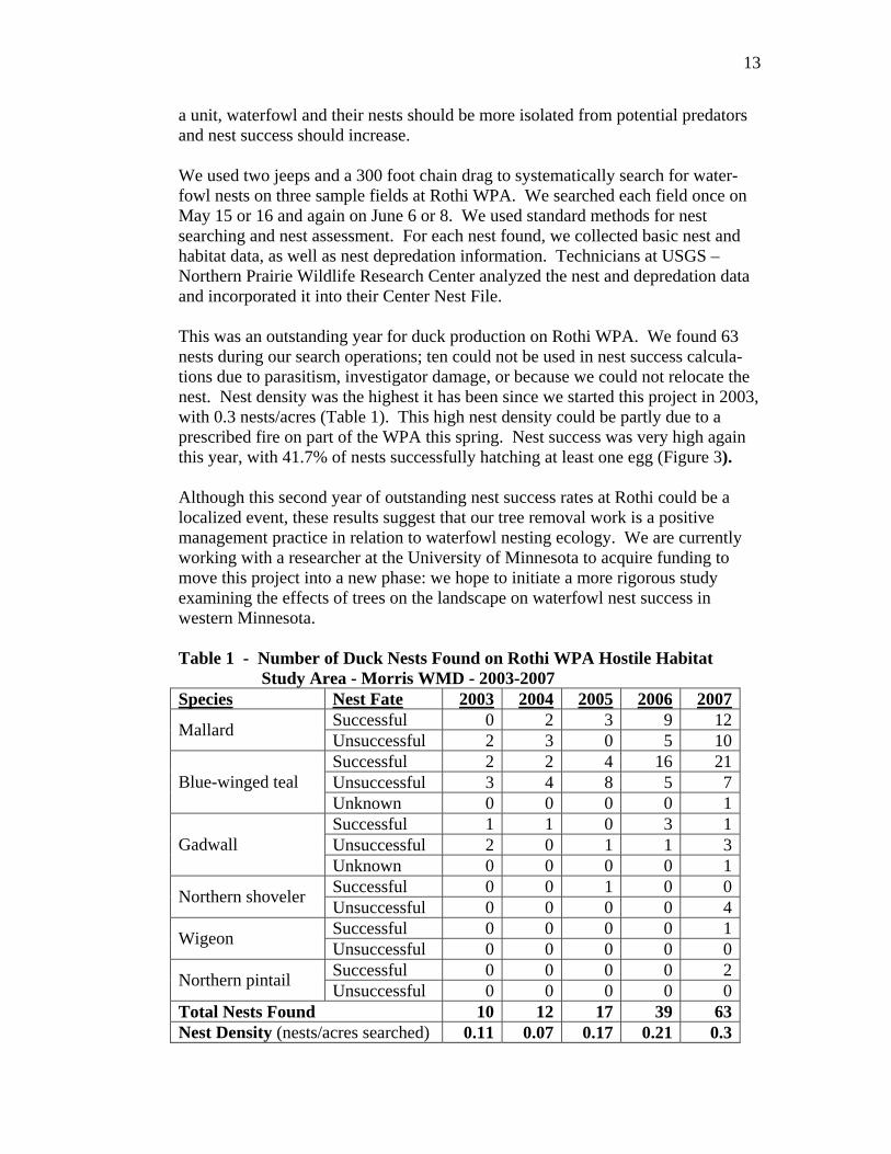
a unit, waterfowl and their nests should be more isolated from potential predators and nest success should increase. We used two jeeps and a 300 foot chain drag to systematically search for water-fowl nests on three sample fields at Rothi WPA. We searched each field once on May 15 or 16 and again on June 6 or 8. We used standard methods for nest searching and nest assessment. For each nest found, we collected basic nest and habitat data, as well as nest depredation information. Technicians at USGS – Northern Prairie Wildlife Research Center analyzed the nest and depredation data and incorporated it into their Center Nest File. This was an outstanding year for duck production on Rothi WPA. We found 63 nests during our search operations; ten could not be used in nest success calcula-tions due to parasitism, investigator damage, or because we could not relocate the nest. Nest density was the highest it has been since we started this project in 2003, with 0.3 nests/acres (Table 1). This high nest density could be partly due to a prescribed fire on part of the WPA this spring. Nest success was very high again this year, with 41.7% of nests successfully hatching at least one egg (Figure 3). Although this second year of outstanding nest success rates at Rothi could be a localized event, these results suggest that our tree removal work is a positive management practice in relation to waterfowl nesting ecology. We are currently working with a researcher at the University of Minnesota to acquire funding to move this project into a new phase: we hope to initiate a more rigorous study examining the effects of trees on the landscape on waterfowl nest success in western Minnesota. Table 1 - Number of Duck Nests Found on Rothi WPA Hostile Habitat Study Area - Morris WMD - 2003-2007 Species Nest Fate 2003 2004 2005 2006 2007
Successful 0 2 3 9 12Mallard Unsuccessful 2 3 0 5 10Successful 2 2 4 16 21Unsuccessful 3 4 8 5 7Blue-winged teal Unknown 0 0 0 0 1Successful 1 1 0 3 1Unsuccessful 2 0 1 1 3Gadwall Unknown 0 0 0 0 1Successful 0 0 1 0 0Northern shoveler Unsuccessful 0 0 0 0 4Successful 0 0 0 0 1Wigeon Unsuccessful 0 0 0 0 0Successful 0 0 0 0 2Northern pintail Unsuccessful 0 0 0 0 0
Total Nests Found 10 12 17 39 63Nest Density (nests/acres searched) 0.11 0.07 0.17 0.21 0.3

14
Figure 3 - All Duck Nest Success Data Available for Rothi WPA Morris WMD - 1983-2007
37.6
47.1
18.7
9.0
17.7
9.0 7.3
18.4
10.2
51.2
41.7
0.0
10.0
20.0
30.0
40.0
50.0
60.0
70.0
1983 1984 1985 1991 1992 2000 2003 2004 2005 2006 2007
May
field
Hat
ch R
ate
All duck nest success data available for Rothi WPA (2003-2007 are years of hostile habitat removal project). Data labels are Mayfield hatch rate and bars are 80% confidence interval.
Enhancing our Prairies – Effects of Tree Removal on Grassland Birds This was the third field season of a study to monitor the response of grassland birds before and after removing trees from large grassland habitat blocks. This study is being coordinated by the HAPET office and field work is being done at the Morris and Litchfield WMDs. Each district has treatment (trees removed) and control (trees left in place) sites with 20 point count stations in each. In the Morris WMD, treatment study fields are on Thomson and Larson Slough (both now part of Kufrin WPA), Nelson Lake, and Wente WPAs. Control areas are at Hagstrom, Stegner, and Rolling Forks WPAs. Stegner and Rolling Forks are new sites added in 2007 to allow us to cut trees on two sites that were formerly controls (Larson Slough and part of Nelson Lake). In June, grassland bird point counts were done at all 160 stations. Biological Technician Oglesby conducted point counts at Nelson Lake, Stegner, and Rolling Forks, and we hired a contractor to do counts at the remaining four sites. In July and August, we sampled vegetation at all point count stations. Vegetation monitoring consisted of assessing the plant community and structure as well as measuring the distance to the nearest trees and shrubs. Some preliminary analysis did not show increased grassland bird use at the treatment sites. Although surprising, these results are likely due to the fact that

15
nearly all the treatment sites were burned this spring, leaving little residual cover or litter. There are also still significant slash piles on some units that could be having the same effect as standing trees. This was the last year of the original grant cycle that funded the project, but all three partners are committed to continuing to monitor for several more years. Evaluation of Methods for Canada Thistle-Free Habitat Restoration This was the third field season of a study to compare the effectiveness of various seeding techniques and seed mixes for suppressing Canada thistle establishment in new restorations. The hypothesis is that by increasing competition and decreasing the disturbance inherent in seeding, we can produce more weed-resistant restora-tions. Diane Larson (USGS-Northern Prairie Wildlife Research Center) is the principle investigator for this study, which is being conducted at the Morris, Fergus Falls and Litchfield WMDs and Neal Smith NWR. Each site has two to four study fields consisting of 108 plots that were seeded by one of three seeding techniques and three seed mixes (fully crossed for a total of nine treatments). The seeding techniques include dormant broadcast, spring broadcast, and spring drill. The seed mixes are of three diversity levels: 10, 20 and 34 species. Field data were collected on all plots again this summer. Our team hired three STEP employees to complete monitoring this year. The students were very efficient and worked well together. Morris staff assisted in the field, but at a reduced level compared to previous years. The 2006 annual report shows that thistle counts were higher in dormant seeded plots and were not influenced by seed mix diversity. We suspect that the dormant plots had more thistle because they did not receive an herbicide treatment in spring 2005 like the drilled plots. Species richness and cover of planted species were generally much higher in the dormant seeded plots than in the drilled plots. There has been less influence of seed mix on species diversity and cover, though in 2006 several fields did show greater cover with the highest diversity mix. This was the final year of field work, with a final report and publications due in 2008. Because it can be several years before the effects of any seeding are clear, our group agreed to continue working together on this project in the future. We plan to do a dormant burn on the fields next year (fall 2008 or early spring 2009) and monitor again in summer 2009. Hegland WPA Buckthorn Removal Next year, a contractor will be removing the 40 acre tree grove on the recent Hegland WPA round-out. The grove is primarily buckthorn, which is an aggressive, invasive shrub. Although this site has a history of over-grazing and over-resting, we believe it has never been plowed. We would like to determine the best tool to treat the buckthorn resprouts after the site is cut, without impacting the potential native seed bank.

16
In advance of the contractor working at the site, we initiated a small monitoring project on the east side of this grove. Our staff cut all the woody vegetation from about four acres. The area was then split into four plots, each of which received a different resprout treatment: mow, spray, mow and spray, and a control. We are monitoring the site using vegetation transects, shrub stem counts, and photo points. We visited the plots before the follow-up treatments occurred; we hope to visit them again at least twice next year so that we can provide some information to help decide the best approach for the rest of the grove. Grassland Monitoring In recent years, we have had several monitoring projects to assess various grassland management tools (fire, grazing, seeding). While these efforts have given us some information to guide our management, one issue has always been our inability to collect enough data given our staff and time resources. In an effort to address this, we joined with a group of prairie managers and ecologists in Minnesota (The Nature Conservancy, MN Department of Natural Resources, Natural Resource Conservation Service, and Concordia College) to develop a standardized grassland monitoring program. This group originally came together around the idea of monitoring grazing management, but then decided we would like an approach that would consider several different grassland management practices (including grazing, fire, haying, rest, and combinations of these). The group met several times during the year in meetings and field workshops to clarify our management and monitoring objectives, develop a standardized monitoring protocol, and test the protocol in the field. We decided to use a tiered monitoring protocol, where every participant will collect the same basic data that can be pooled during data analysis, but that will include additional, more detailed data that can be collected to answer more specific questions. Our basic protocol includes monitoring vegetation composition using a belt transect and a checklist of indicator species, as well as structural information like litter depth, plant height, and visual obstruction. During the pilot season this year, Morris WMD collected data at Welsh, Welker, and Glacial Lake WPAs. Other partners collected data on additional sites throughout western Minnesota. Next year Morris WMD will host a workshop on this topic (sponsored by the FWS Biological Monitoring Team), during which we will attempt to put this question of grassland management into an adaptive management framework. We will be working with Todd Sutherland to develop a database to collect and store the data from this large effort. We will also have meetings to refine the protocol and decide how to move forward in the next field season.

17
An inter-agency group of prairie managers and biologists discuss various monitoring techniques during a grassland monitoring workshop at Hole-In- The-Mountain Preserve near Lake Benton, MN. 2007-5 JBB 7/17/2007
1c. General Wildlife Observations Fall 2006, with little snow, created a stress-free time for resident wildlife such as pheasant, turkey, partridge and grouse, giving them time to build up fat reserves rather than expend them. Spring 2007 was late. Waterfowl migration started March 10 with white-fronted geese, while most ducks did not arrive in the area until the first week of April. The first Canada goose pair was observed on March 13 and young were observed on May 7. We observed a significant drop in production this year likely due to the extremely cold temperatures in early April which froze some goose eggs. An observation of a snow goose in Traverse County on May 23, during 4-square mile monitoring, was reported. The first mallard brood was observed May 19. Broods of pheasant were first observed after June 15 and turkey July 3. The only reports of gray partridge in the district were of two birds on May 2. Fox numbers continue to be low due to increasing coyote numbers, mange, and habitat alteration. Coyote populations continue their increase throughout the district. Raccoons, after several years of decline, are back at previously observed peak levels.

18
Sandhill crane populations in the district continue to increase since 2006 when a breeding pair was confirmed at Nelson Lake WPA (Pope County). In Swift County a pair was observed near Svor WPA on June 7 and a pair at Welsh WPA on July 6. Six adults were observed at Nelson Lake/Overby WPAs on June 20. On September 13, cranes were seen at Glenwood WPA and Sedan WMA (Pope County). Other interesting wildlife observations by staff included:
• A large number of short-eared owl during January and February. • Two pairs of marbled godwits were seen in Big Stone County on May 2,
and another pair in Pope County at a 4-square mile count area on May 23. • The first upland sandpiper in Lac qui Parle County was seen on April 29.
Common goldeneye taking flight (Pepperton WPA, Stevens County).
2007-6 SJD 4/2007

19
HABITAT RESTORATION
2a. Wetland Restorations (On/Off refuge)
Four landowners cooperated with the Partners for Fish and Wildlife program during FY2007 to restore 14 wetlands. Wetland restorations were completed in four different counties for a total of 41 acres. Twelve of the 14 wetlands will be protected by Fish and Wildlife Service perpetual easements, so they can never be drained again. Due to a change in personnel and a new Blanket Purchase Agreement that was not completed until July, some of this year’s work was delayed until after the end of the fiscal year. FY07 funds will be used to restore a total of 18 wetlands with seven different landowners in five different counties. These numbers are lower than our traditional wetland restoration numbers primarily because we are seeing a change in our program. The Partners program is becoming more diverse. We cost shared projects this year to seed grass, remove invasive woody vegetation and cross fenced pastures to assist grazers with establishing a rotational grazing system. We are also seeing much of the demand for wetland restoration being completed by other agencies like NRCS. Wetland restorations averaged about $863 this year primarily because we restored six basins ourselves using our station’s dozer and staff. The average size of the basins on private land was 2.9 acres, about half an acre less than the long term average for the Morris WMD. The fourteen wetlands cost $12,085 to restore during FY07. Partner in-kind match for these wetland restorations was approximately $7,000 for engineering services, construction management and site prep of two restorations with the Stevens County Natural Resource Conservation Services. Wetlands were also restored on Waterfowl Production Areas (WPA) this year. One wetland totaling one acre was restored on O’Connell WPA in Big Stone County, and two wetlands on Robinhood WPA were restored in Traverse County. These basins total four acres restored on WPAs. FY07 funds were also used after the end of the fiscal year for restorations on WPAs to pay for eight total wetland restorations on three WPAs. One private lands wetland restoration was repaired by removing 100 feet of old tile from the 22 acre basin in Yellow Medicine County at a cost of $595.

20
Table 2 - Wetland Restorations - Morris WMD - FY 2007
Fee Private Total County Basins Acres Basins Acres Basins Acres Big Stone 1 1 6 6 7 7 Chippewa 0 0 0 0 0 0 Lac qui Parle 0 0 0 0 0 0 Pope 0 0 0 0 0 0 Stevens 0 0 2 11 2 11 Swift 0 0 4 19 4 19 Traverse 2 3 0 0 2 3 Yellow Medicine
0 0 2 5 2 5
Total 3 4 14 41 17 45
Table 3 - Wetland Restorations - Morris WMD - 1987-FY 2007
Total Restorations Total Restorations Year Basins Acres Year Basins Acres
1987 33 79 FY 1998 91 311 1988 208 673 FY 1999 51 345 1989 84 282 FY 2000 73 387 1990 82 278 FY 2001 38 120 1991 103 839 FY 2002 35 313 1992 85 228 FY 2003 75 255 1993 117 508 FY 2004 54 289 1994 78 556 FY 2005 25 78 1995 49 268 FY 2006 42 128 1996 42 177 FY 2007 17 45 1/1-9/30/97 34 423 Total 1,416 6,582
2b. Upland Restorations
Grassland habitats in the Morris WMD include native prairie, planted native grass, introduced cool-season grass seedings, and legume plantings. In this highly fragmented and altered landscape, our grasslands are threatened by many invasive plants, including common weeds like Canada thistle and leafy spurge, but also invasive cool-season grasses like smooth brome and Kentucky bluegrass, and encroaching woody vegetation. Common management practices to restore and maintain our established grasslands include prescribed fire, grazing, haying, and tree removal (see section 3g).

21
A yellow spider atop a blooming wild bergamot (Monarda fistulosa) on McIver WPA. 2007-7 JBB 7/12/07
Native Prairie
A dry remnant prairie hillside dominated by rough blazingstar (Liatris aspera) responded to a burn conducted on April 18, 2007 at Johnson WPA (P-59).
2007-8 JBB 8/20/07

22
The original upland vegetation in the Morris District was tallgrass prairie. The total native prairie acreage on WPAs within the District was approximately 7,134 in 2007. The areas vary in size from less than one acre to 513 contiguous acres on Hastad WPA. Active management consisting of prescribed burning, grazing, and haying have mostly been limited to the larger acreage remnants. Most of the small remnants have not been actively managed because of size, terrain, location, and staff time. In addition to the threats listed above, many remnant prairie tracts have likely lost some integrity due to invasion by native cultivars, resulting in hybridization with local ecotype natives.
The persistent cool-season forb hoary puccoon is diminutive, but prevalent as demonstrated by this plant found in a roadside ditch at Fults WPA (SV-21).
2007-9 JBB 5/24/07 Native Seeding Traditionally, new fee and easement acquisitions have provided the acreage for grassland seedings. In recent years a concerted effort has been made to retire and restore food plots, and convert low quality, weed infested grass stands. Usually, newly acquired land is cash rented back to the original landowner and farmed with Roundup (glyphosate) ready soybeans, which makes a good seed bed for native grasses and provides a means to control weeds. In the cases where we are converting grass stands with a historical weed problem, we cash rent to the previous landowner or a willing neighbor for several years in a soybean/corn rotation with the final year being soybeans. Weed control on young seedings is critical. A combination of herbicide applica-tions, mowing, burning, haying, and grazing are used to aid the establishment and maintenance of both native and cool-season grass seedings and legume stands.

23
Part of the Vegetation Establishment Agreement for an easement is that a property owner is required to spray Roundup (glyphosate) 10-14 days before seeding. For native grass establishment and maintenance, prescribed burning reduces compete-tion from unwanted cool-season grasses, but may also stimulate broadleaf weeds. This may necessitate subsequent application of herbicides or mechanical manipu-lations. Prescribed burning for new seedings is most often conducted in the spring of the third growing year when there is enough plant material to carry a fire; this stimulates the native grasses and forbs and gives them a competitive edge. This fiscal year, 324.6 acres were seeded to native grasses and forbs on eight WPAs, one easement, and one private parcel adjacent to Hegland WPA. The seed mixture used for the seedings varied depending on soil type, seed supplies, and the goal for the site. The majority of the sites were planted with local ecotype seed this year. Most of the seedings were broadcast with a Vicon spreader (and packed with a culti-packer in the spring if the soil wasn’t too moist and sticky). A Truax no-till grass drill was only used this year for inter-seeding into struggling restorations. The choice of drill or spreader depended on the site or the type of seed used. Four sites recently seeded to local ecotype natives were also hand seeded with porcupine grass.
Table 4 - Native Grass Seedings - Morris WMD - FY 2007
Unit Name Unit ID Unit Type Acres Date Comments
Kufrin B-12 WPA 88.0 6-21-07 Broadcast local ecotype Dismal Swamp B-21 WPA 10.0 6-08-07 Drill inter-seed cultivars to boost seeding Odden B-51 WPA 14.0 6-26-07 Broadcast cultivars into old food plot Fish Lake SV-38 WPA 12.0 6-26-07 Broadcast cultivars into old food plot Thorstad SV-8 WPA 3.0 6-07-07 Drill inter-seed to boost production plot Grove Lake P-46 WPA 155.0 7-11-07 Broadcast local ecotype Arden Hegland LqP Private 8.0 6-18-07 Broadcast local ecotype Olsen Easement Pope Easement 1.0 11-07-06 Broadcast cultivar natives Arden Hegland LqP Private 1.0 8-09-07 Handspread ~1# Porcupine seed Rothi B-2 WPA 2.6 11-22-06 Handspread ~4#’s Porcupine seed Westport P-61 WPA 15.0 8-20-07 Handspread ~6#’s Porcupine seed Kufrin B-12 WPA 15.0 8-09-07 Handspread ~24#’s Porcupine seed
324.6 Overall, spring conditions were advanced in early April and moisture was at a premium throughout the spring and summer on most of the district, except for Traverse County. First year germination appeared to be poor on most of the FY06 seedings. The 18 acre Kufrin seeding looked very nice this year. It had been supplemented in the fall of 2006 with 31 pounds of leftover seed from the Rolling Forks mix, 150 pounds of lot number MNN-B14-SPB-04, 105 pounds of lot number BS-04-Vicon, 200 pounds lot number NH01 from NAP, and 29 pounds of Canada wildrye harvested from Robinhood (lot T-10-CWR-05). The Canada wildrye was seed stock received from Nature’s Acres with a McLeod County origin.

24
In the 18 acre seeding at Kufrin WPA, field residue collected in the culti-packer during broadcasting resulting in large piles and drag areas that were devoid of seed. 2007-10 JBB 6/5/06
The piles and drag area are still visible during the second growing season of the Kufrin seeding. Otherwise, the rest of the seeding appeared to be a good catch. 2007-11 JBB 6/14/07

25
Local Ecotype Seedings Since 1973, the Morris Wetland Management District has planted roughly 11,024 acres of native grasses. As identified in the Comprehensive Conservation Plan, restorations will replicate, to the extent possible, the structure, species composi-tion, and processes of native ecological communities in the tallgrass prairie. Thus, where practical, restorations will use local ecotype seed containing eight or more grass species and 30 or more forb species. Additionally, anecdotal observations from the thistle study (see section 1b) indicate that the more diverse a seeding is, the less the competition from non-planted vegetation will be, including Canada thistle, which means reduced maintenance expense. However, the primary limiting factor to converting more fields of marginal tame grass nesting cover to local ecotype natives is seed availability. Most of the remnant prairie tracts on WPAs present challenges to bulk seed harvesting using combines, because they tend to be rough, rocky, and steeply sloped. Some tracts may also be compromised by adjacent cultivar seedings that have had seed blow in and affect the integrity of the local ecotype native stand. Harvesting by hand and using an ATV seed stripper are the only other means available for collecting from remnant prairie, but these methods are considerably less efficient. Consequently, if we are going to be serious about our goal of restoring grasslands with local ecotype native seed, we have to create our own production plots using seed harvested from remnant prairie, or provide seed to contractors under a cooperative agreement to grow it for us. We are making progress on our goal of production of local ecotype seed. In the past six years, we have seeded 598 acres of local ecotype natives on the following sites: Thorstad (3 acres), Rothi (103 acres), Prairie (8 acres), Robin Hood (95 acres), Hillman (40 acres), Westport (40 acres), Rolling Forks (40 acres), Grove Lake (155 acres), and Kufrin (106 acres) WPAs, and one private site (Arden Hegland, 8 acres). Seed has been harvested from three of these sites (Thorstad, Rothi, and Robinhood) in the past few years. We are still not past the bottleneck, but we are getting closer. In a few years we should be able to harvest 100 acres or more of seed from these sites annually. Grove Lake and Kufrin WPAs were the two significant local ecotype restorations for the year. A large portion of the Grove Lake mix (Table 5) was paid for by Pope County Pheasant Restoration (PCPR) as part of their original $20,000 cash pledge for grassland restoration projects in Pope County, and an additional pledge of $4,270 (that was also matched in a Challenge Cost Share Grant). Seed that was purchased for Kufrin (Table 6) was paid for through a grant that Pheasants Forever is administering. Seed expenditures for Grove Lake WPA were $1,698.35 to Kaste Seed Inc. for forbs and grass, $250.00 to North American Prairie’s for heart-leaf golden alexander seed, $2,203.50 to Prairie Hill Wildflowers for forbs, $1,141.00 to Prairie Moon Nursery for forbs, $1,555.74 to Prairie Restorations for grass seed,

26
$1,532.00 to Minnesota Native Landscapes for forb seed, and $2,504.50 to Feder’s Prairie Seed for grass and forb seed, for a total of $10,885.09 (155 acres @ $70.22/acre). Total expenditures covered by PCPR in the past three years are $24,266.57. Total acres restored with PCPR’s assistance to date are 264, for an average cost per acre of $91.91. In addition to Grove Lake, PCPR has spent $1,848.00 for a five species seed mix at Froland (28 acres @ $66/acre), $4,500 for local ecotype seed at Westport (41 acres @ $109.75/acre), $440 for a seed test, $572.74 for contract spraying and $6,020.74 for seed at Rolling Forks (40 acres @ $164.83/acre).
Porcupine grass seed (Stipa spartea) once harvested, intertwines into a ball that
is difficult to handle. Soaking in water for a few minutes straightens the awns, easing separation for hand spreading. STEP employees Audrey Respet, Eric Iszler, and Jordan Pieske along with volunteer Robin Freese and ROS Bright, spent a hot August day tossing seed at Kufrin WPA. 2007-12 JBB 8/9/07

27
Table 5 - Grove Lake WPA Seed Mix - Morris WMD - FY 2007 Species Origin Lot Number Vendor #’s PLS/ac
Big bluestem Morris WMD SW30B2FWMANP06 Morris 2.00 Indiangrass Morris WMD SW30B2FWMANP06 Morris 0.84 Sideoats grama Morris WMD SW30B2FWMANP06 Morris 0.72 Trace species* Morris WMD SW30B2FWMANP06 Morris 0.19 Canada wildrye McLeod Co. P61-CWR-06 Morris 0.50 Little bluestem Sherburne Co. Prairie Resto 0.71 June grass Sherburne Co. Prairie Resto 0.03 Sand dropseed Sherburne Co. Prairie Resto 0.03 Blue grama MN Native Kaste 0.13 Kalm’s brome Houston Co. Feder 0.19 Forbs Oz. PLS/ac
Bush clover MN Native Prairie Hill 0.30 Golden alexander MN Native Prairie Hill 0.80 L.F. beardstongue MN Native Prairie Hill 0.40 Leadplant MN Native Prairie Hill 0.16 Max. sunflower MN Native Prairie Hill 1.60 Prairie coneflower MN Native Prairie Hill 0.81 Prairie coreopsis MN Native Prairie Hill 0.41 Common ox-eye Kosouth Co. Feder 0.80 Hoary vervain Faribault Co. Feder 0.16 Showy goldenrod Faribault Co. Feder 0.82 Showy tick trefoil Faribault Co. Feder 1.60 Smooth aster Kosouth Co. Feder 0.19 Wild bergamot Faribault Co. Feder 0.40 N.L. purple coneflower MN Native Kaste 0.80 Purple prairie clover MN Native Kaste 2.80 White prairie clover MN Native Kaste 2.00 Yarrow MN Native Kaste 0.16 Harebell MN Native Prairie Moon 0.02 Prairie onion MN Native Prairie Moon 0.41 Prairie Sage MN Native Prairie Moon 0.05 Prairie cinquefoil Lq Parle Co. MN Native Landscape 0.10 Rough blazingstar Dakota Co. MN Native Landscape 0.25 Stiff goldenrod McLeod Co. MN Native Landscape 0.82 Heart-leaf g. alexander Ottertail Co. N. American Prairie’s 0.10
*(rough dropseed, prairie clover, little bluestem, switchgrass, bearded slender wheatgrass, prairie dropseed, liatris, sunflower sp., milkweed, sweetclover)

28
Table 6 - Kufrin WPA Seed Mix - Morris WMD - FY 2007 Species Origin Lot Number Vendor #’s PLS/ac
Big bluestem Morris WMD SW30B2FWMANP06 Morris 2.00 Indiangrass Morris WMD SW30B2FWMANP06 Morris 0.84 Sideoats grama Morris WMD SW30B2FWMANP06 Morris 0.72 Trace species* Morris WMD SW30B2FWMANP06 Morris 0.19 Canada wildrye McLeod Co. T10-CWR-05 Morris 0.68 Little bluestem Hillman WPA B14-SS-NP06 Morris 0.19 Trace species** Hillman WPA B14-SS-NP06 Morris 0.23 Little bluestem Sherburne Co. Prairie Resto 0.73 June grass Sherburne Co. Prairie Resto 0.03 Sand dropseed Sherburne Co. Prairie Resto 0.03 Blue grama MN Native Kaste 0.13 Kalm’s brome Houston Co. Feder 0.19 Forbs Oz. PLS/ac
Golden alexander MN Native Prairie Hill 0.80 L.F. beardstongue MN Native Prairie Hill 0.40 Leadplant MN Native Prairie Hill 0.16 Max. sunflower MN Native Prairie Hill 1.60 Prairie coneflower MN Native Prairie Hill 0.81 Prairie coreopsis MN Native Prairie Hill 0.41 Common ox-eye Kosouth Co. Feder 0.80 Hoary vervain Faribault Co. Feder 0.16 Showy goldenrod Faribault Co. Feder 0.82 Showy tick trefoil Faribault Co. Feder 1.60 Smooth aster Kosouth Co. Feder 0.19 Wild bergamot Faribault Co. Feder 0.40 N.L. purple coneflower MN Native Kaste 0.80 Purple prairie clover MN Native Kaste 2.80 White prairie clover MN Native Kaste 2.00 Yarrow MN Native Kaste 0.16 Harebell MN Native Prairie Moon 0.02 Prairie onion MN Native Prairie Moon 0.41 Prairie Sage MN Native Prairie Moon 0.05 Prairie cinquefoil Lq Parle Co. MN Native Landscape 0.10 Rough blazingstar Dakota Co. MN Native Landscape 0.25 Stiff goldenrod McLeod Co. MN Native Landscape 0.82 Heart-leaf g. alexander Ottertail Co. N. American Prairie’s 0.10 **(tall dropseed, sideoats grama, Indiangrass, prairie dropseed, big bluestem, leadplant, sunflower spp., switchgrass, Canada wildrye, yellow coneflower, stiff goldenrod, muhly spp., prairie clover spp., vervain, anemone, prairie cordgrass, Liatris spp., purple coneflower, numerous aster and Solidago spp.) *(rough dropseed, prairie clover, little bluestem, switchgrass, bearded slender wheatgrass, prairie dropseed, liatris, sunflower sp., milkweed, sweetclover) We also restored eight acres of Arden Hegland’s private land adjacent to Hegland WPA to local ecotypes under a private lands agreement (seed mix in Table 7). The landowner had enrolled this land in the USDA’s Wildlife Habitat Incentive Program (WHIP), and was under contract to restore it to native species. Since the field bordered native prairie on the WPA, we provided technical advice, some of

29
the seed, and performed the seeding to keep from contaminating the remnant prairie with cultivars. The private lands agreement also allows us to harvest the seed two times over five years after the WHIP contract expires in 2012. We provided the grass seed and the landowner purchased forb seed from Pheasants Forever (supplied by Feder Prairie Seed).
Table 7 - Arden Hegland Seed Mix - Morris WMD - FY 2007
Species Origin Lot Number Vendor #’s PLS/ac
Big bluestem BS NWR BSNWR-04 Morris 1.50 Indiangrass BS NWR BSNWR-04 Morris 0.16 Switchgrass BS NWR BSNWR-04 Morris 0.18 Indiangrass Morris WMD B2-L13-NP06 Morris 2.00 Trace species* Morris WMD B2-L13-NP06 Morris 1.30 Canada wildrye McLeod Co. T10-CWR-05 Morris 1.50 Prairie dropseed SE MN . Feder 0.05 Virginia wildrye IA Native Feder 0.30 Kalm’s brome Houston Co. Feder 0.30 Forbs Oz. PLS/ac
Bush clover Watonwan Co. Feder 1.00 Canada milkvetch Brown Co. Feder 3.00 Golden alexander Martin Co. Feder 4.00 L.F. beardstongue Faribault Co. Feder 0.50 Prairie coneflower Brown Co. Feder 2.00 Common ox-eye Kosouth Co. Feder 4.50 Hoary vervain Faribault Co. Feder 0.70 Showy goldenrod Faribault Co. Feder 0.30 Showy tick trefoil Faribault Co. Feder 4.60 Smooth aster Kosouth Co. Feder 1.00 Wild bergamot Faribault Co. Feder 0.80 N.L. purple coneflower Blue Earth Co. Feder 1.00 Purple prairie clover MN Native Feder 3.00 White prairie clover MN Native Feder 3.00 Prairie alumroot IA Native Feder 0.10 Prairie onion Faribault Co. Feder 0.50 Prairie rose Faribault Co. Feder 1.40 Prairie cinquefoil Blue Earth Co. Feder 0.10 Stiff goldenrod Faribault Co. Feder 0.30 Whorled milkweed Dallas Co. Feder 0.20 *(big bluestem, sunflower spp., little bluestem, tall dropseed, stiff goldenrod, rough dropseed, switchgrass, bearded slender wheatgrass, prairie cinquefoil, sideoats grama, leadplant, Liatris spp., sedge spp., prairie onion, Kalm’s brome, muhly grass spp., aster spp., sweetclover) Seed Harvest This past year we used the ATV seed stripper to harvest porcupine grass and ended up with a hundred pounds of balled-up seed. We hand spread about twenty pounds of it in August, but we’re still processing the rest by hand for spreading with equipment this coming spring. As in past years, most hand harvested species were opportunistically collected based on availability and ripeness. Dotted blazingstar
30
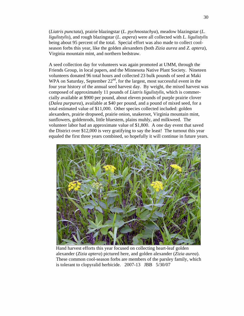
(Liatris punctata), prairie blazingstar (L. pychnostachya), meadow blazingstar (L. ligulistylis), and rough blazingstar (L. aspera) were all collected with L. ligulistylis being about 95 percent of the total. Special effort was also made to collect cool- season forbs this year, like the golden alexanders (both Zizia aurea and Z. aptera), Virginia mountain mint, and northern bedstraw. A seed collection day for volunteers was again promoted at UMM, through the Friends Group, in local papers, and the Minnesota Native Plant Society. Nineteen volunteers donated 96 total hours and collected 23 bulk pounds of seed at Maki WPA on Saturday, September 22nd, for the largest, most successful event in the four year history of the annual seed harvest day. By weight, the mixed harvest was composed of approximately 11 pounds of Liatris ligulistylis, which is commer-cially available at $900 per pound, about eleven pounds of purple prairie clover (Dalea purpurea), available at $40 per pound, and a pound of mixed seed, for a total estimated value of $11,000. Other species collected included: golden alexanders, prairie dropseed, prairie onion, snakeroot, Virginia mountain mint, sunflowers, goldenrods, little bluestem, plains muhly, and milkweed. The volunteer labor had an approximate value of $1,800. A one day event that saved the District over $12,000 is very gratifying to say the least! The turnout this year equaled the first three years combined, so hopefully it will continue in future years.
Hand harvest efforts this year focused on collecting heart-leaf golden alexander (Zizia aptera) pictured here, and golden alexander (Zizia aurea). These common cool-season forbs are members of the parsley family, which is tolerant to clopyralid herbicide. 2007-13 JBB 5/30/07

31
This year, due to equipment reliability issues with our ancient combine, we contracted with Heartland Conservation Services to harvest seed for us. We had already issued a Special Use Permit for crop sharing to them, when it became apparent the combine wasn’t up to the task this year. Under the SUP, they kept 100 percent of the cultivar seed harvested at Centennial and Odden WPAs and we retained 100 percent of the local ecotype harvest from Maki, Fahl, and Westport WPAs, and Freeman WMA. The contract harvest occurred at Rothi WPA. They billed us for 20 hours at $80 per hour, for a total of $1,600. There were 218 total pounds of pure live seed (PLS) harvested at Rothi, which comes out to a cost of $7.33 per pound, which compares favorably to what this local ecotype seed could have been purchased for from a vendor such as Prairie Restorations (~$10.00 per PLS pound). The next closest bidder for the contract was nearly four times more expensive. Before the combine broke down, 37 acres of Canada wildrye (~3,000 bulk pounds) were harvested at Robinhood, 16 acres at Rothi, and 18 acres at Artichoke Lake WPA.
These breeding monarch butterflies were captured in action on a blooming meadow blazingstar (Liatris ligulistylis) along the roadside at Pepperton WPA. 2007-14 JBB 8/15/07

32
Table 8 - Native Grass Seed Harvested - Morris WMD - Calendar Year 2007
Unit Name and ID
Harvest Method
Species
Pounds of Yield
Acres
Date(s)
Freeman WMA Flail-vac Purple prairie clover 4.9% PLS (local ecotype) Lot# PC07
157 bulk 7.7 pls
12 8/22/07
Westport (P-61) Flail-vac Canada wildrye 29.5%, sideoats grama 14.7% (local ecotype) Lot# P61-LE-07
192 bulk 85 pls
20 9/6/07
Rothi (B-2) Artichoke Lake (SW-21)
Combine Big bluestem 17.9%, Indiangrass 5.7% Lot# B2-LE-07C
685 bulk 161 pls
16 18
9/20/07 9/12 & 9/13/07
Rothi (B-2) Stripper Sideoats 13.4%, big blue 5.4%, switch 2.7%, prairie sp 6.7% Lot# B2-SO-07
78 bulk 22 pls
7.5 8/22 & 9/12/07
Rothi (B-2) Flail-vac Big bluestem 15.9%, Indiangrass 12.9% Lot# B2-LE-07
759 bulk 218 pls
22 9/26 & 9/27/07
Robinhood (T-10) Combine Canada wildrye 29.9% Lot# T10-LE07
~3000 bulk ~897 pls
37 9/5 & 9/6/07
Fahl (SW-19) study plot buffer
Flail-vac Forbs & Canada wildrye untested cultivars
156 bulk 5 10/3/07
Maki (SW-27) Flail-vac Prairie sp. 5.2% Lot# SW27-NP07
593 bulk 31 pls
~20 9/25/07
Maki (SW-27) Hand Mixed forbs, L. ligulistylis, D. purpurea untested
23 bulk ~10 9/22/07
McIver (P-2) Hand Mixed forbs, Zizia sp, little blue Untested
~1 bulk ~5 9/6, 9/9, 9/18, & 9/19/07
Helgeson (B-15) Hand L. punctata, dry forbs & grasses <1 bulk ~.5 9/27/07 Nelson Lake (P-38) Hand Dry grasses & forbs <1 bulk ~6 9/13/07 Little Chippewa (P3) Hand Zizia aurea Trace ~1 9/13/07 Fitzgerald (SV-37) Hand Wet mesic forbs <1 bulk ~2 9/5 & 9/17/07 Loen (SW-18) Hand Dry forbs, Pr. sandreed, bearded
slender wheat grass, junegrass <1 bulk ~2 9/12/07
Froland (P-22) Stripper Green-needle grass ~30 bulk 1.8 6/29 Sleeping Bison WMA (DNR)
Stripper Porcupine grass ~100 bulk 32.6 6/25 & 6/26

33
HABITAT MANAGEMENT
3a. Water Level Management
The Morris WMD manages 30 wetlands with water control structures, on 18 WPAs. We also have a few water control structures on easement properties, but do not actively manage them. Because of time and staff constraints in recent years, we had cut back significantly on water control structure management. In FY07 this changed, as we had a biological intern who could check gauges and do basic maintenance on structures. In July, we did a drawdown on the west basin on Giese WPA to facilitate repair of the eroded dike. There was an excellent shore- bird response (Table 9) and we achieved a full drawdown by late summer. We hauled rock in to repair erosion near the structure, but have not completely reinforced the dike due to late season rains. The spillway at Edwards E was replaced with a rock spillway. All the boards were pulled from Edwards H in early July to draw down that basin. However, the structure is not functioning (likely because of sedimentation filling in the dike between this basin and basin I downstream) and the attempted drawdown did not occur. In FY08, we plan to actively monitor and manage a set of wetlands with functioning water control structures (we know of several that give us little to no control over water levels). We also plan to survey all the wetlands with structures so that we have current and accurate pool bottom, flowline, and structure eleva-tions (all to mean sea level). We will also replace or repair many gauges this year. Table 9 - Waterfowl, Shorebirds, and Other Water Birds Observed On
Giese WPA, Stevens County - July 15, 2007
Mallard 60 Spotted sandpiper 3Northern shoveler 2 Semipalmated sandpiper 12Pied-billed grebe 2 Least sandpiper 38American white pelican 30 Baird's sandpiper 3Great blue heron 2 Pectoral sandpiper 2Great egret 14 Stilt sandpiper 3American coot 40 Short-billed dowitcher 3Semipalmated plover 2 Black tern 2Killdeer 151 Belted kingfisher 1Greater yellowlegs 1 Sedge wren 3Lesser yellowlegs 28 Marsh wren 15Solitary sandpiper 1
These birds were observed and reported to us by a birdwatcher. We were excited by the shorebirds, but he was most excited that he also observed a Le Conte’s sparrow at the WPA that morning.

34
In addition to allowing needed maintenance on the dike, this successful draw-down at the west basin on Giese WPA provided excellent shorebird and water-fowl habitat during the summer. The substrate consolidated and we had an excellent annual mudflat plant crop, meaning we will have good habitat conditions on this basin when it is flooded again next year. 2007- 15 SCV 10/1/07
3b. Haying
Haying has been used for upland habitat management and noxious weed control on a limited basis. Using cooperators to clip thistle problem areas and remove the litter as hay allows us to treat more acres than we can just mowing with district staff. Haying alfalfa fields is delayed until after July 15 to allow for duck nests to hatch. On units where an abundance of thistle is triggering the management action, haying may take place earlier to eliminate a serious noxious weed problem. This seemed to be a “down” year for thistle presence, but for those units that had a thistle issue, permits were issued before July 1 to give the cooperators a better opportunity at cutting prior to the thistle going to seed. Most of the units that were hayed this year after July 15 do not have a haying history. The haying was done to invigorate the grass stand. Several units that had a history of haying, based more on demand than an actual weed problem, were again rested in 2007. Prior to issuing permits for haying, field checks of units were conducted beginning in mid-June. Follow-up spraying with Transline or Curtail was conducted on many of the units in the fall. A first on the Morris WMD in FY 2007, the haying on Lundgren was conducted by the Chippewa Valley Ethanol Company for experimental use in a biomass gasification project. Another first, a special use permit was issued to the

35
University of Minnesota – Morris on September 28, 2007, for an experimental biomass gasification project on Giese, Pepperton, and Lamprecht WPAs. Cutting occurred in October and will be reported in the FY 2008 narrative.
Table 10 - Haying Summary - Morris WMD - FY 2007 Unit Name (ID) Permit Period Acres Fee
Lundgren (C-1) 9/15 – 10/31/06 44.0 $3.00 per acre Boehnke (B-8) 7/15 – 8/01 31.6 $2.00 per acre Dybdahl (B-25) 7/15 – 8/01 72.0 $2.00 per acre Anderson (B-52) 7/04 – 7/15 27.0 $3.00 per acre Centennial (B-59) 6/15 – 7/15 58.8 $2.00 per acre Freeland (L-18) 7/15 – 8/10 20.2 $3.00 per acre Kolstad Lake (P-8) 7/27 – 8/16 13.0 $2.50 per acre Walden (P-19) 7/27 – 8/17 20.0 $2.50 per acre Westport (P-61) 7/19 – 8/20 18.6 $1.00 per acre Mero (SV-40) 6/23 – 7/02 34.6 $2.50 per acre Big Stone (SV-51) 7/16 – 8/06 30.0 $2.50 per acre Giese (SV-55) 6/29 – 7/20 20.2 $1.50 per acre Loen (SW-18) 7/19 – 8/16 36.4 $1.00 per acre Monson Lake (SW-28) 7/25 – 8/16 26.9 $3.00 per acre Pedersen (T-11) 7/27 – 8/16 10.0 $5.00 per acre
Total 463.3
3c. Grazing
We also use controlled grazing as a grassland management tool. The overall objective of using grazing is to improve the nesting habitat for migratory birds. Specific objectives of grazing depend on the site, but may include: reducing litter layer buildup, relieving competition from invading cool-season grasses, promoting tillering, and stimulating native grasses. A high concentration of livestock (approximately one cow and calf pair per acre) is often used to remove a dense litter buildup and the new growth in roughly a 30-day period of time. We hope this will promote vigorous growth of desired grass species and create quality nesting habitat. Grazing traditionally has not begun until mid-April for two reasons. One, most cooperators are not finished calving until early May. Two, the combination of spring rains and high stocking rates can cause degradation of the sod. Most cooperators had cattle out on WPAs from late April through the end of May. Recently, we have had more grazers interested in late summer and fall grazing and in 2007 we implemented it on eleven units. Interest in late summer grazing was higher than previous years due to another prolonged dry spell last summer. Keeping objectives in mind, we were able to accommodate a few, but not all of the

36
requests. Objectives of grazing at this time can be reducing the litter layer, promoting tillering and increasing plant density, and targeting cool-season exotic grasses after most natives have entered dormancy. Traditionally, a lack of border fence, declining cattle operations, and uninterested neighbors, has limited our ability to utilize grazing. Lately, some grazers seem eager to utilize our grasslands for short term grazing and are more willing to do additional fencing now than in the past. We believe the future bodes well for treating more acres with grazing than has been accomplished in the past. This year, depending on when the permit was written, the grazing fees were calculated using a base rate of $15.11, or $16.01 per Animal Unit Month (AUM) with deductions for fence installation, fence repair, water hauling, etc. Because there is no report for Minnesota, the base rate was an average of USDA reported rates for South Dakota and North Dakota. In prior years the grazing rate was usually a flat rate of $2.75 per AUM with little consideration given to fencing installation or other necessary efforts on the part of the grazer. A grazer that installed two miles of temporary electric fence was charged the same rate as a grazer that didn’t install any fence. This is definitely more complicated, but it is fairer than the previous method, and most importantly has helped increase interest in grazing. Fees ranged from a low of a credit of $2,445.56 for Welsh WPA to a high of $9.68 per AUM for Heidebrink WPA. Credit is applied to the second year of the Special Use Permit.
Table 11 - Grazing Summary - Morris WMD - Calendar Year 2007 WPA Name/ID Acres AUM’s Total Fee Grazing Period Hillman (B-14) 50 50.0 $ 71.57 5/01 – 6/01 Hillman (B-14) (N/Hwy 12) 54 54.0 $332.99 5/01 – 6/30 Seidl (B-30) 89 23.3 Credit exceeded fee 7/01 – 8/16 Bolson Slough (L-06) 34 52.3 $ 58.56 4/15 – 5/15 Pearson (L-07) 80 80.5 $665.24 7/17 – 9/05 Glacial Lake (P-43) 28 32.1 $179.37 5/03 – 5/28 Heidebrink (P-17) (NW) 140 102.6 $277.67 credit 5/05 – 6/05 Heidebrink (P-17) (SW) 23 63.8 $618.21 8/20 – 10/1/07 Horse Lake (P-54) 35 41.2 $122.91 5/15 – 5/31 Lake Emily (P-4) 56 71.7 $283.67 5/09 – 6/19 Lake Johanna (P-28) 55 62.1 $222.72 6/19 – 8/31 McIver(P-2) 45 48.1 $349.85 credit 5/11 – 6/08 Ouren (P-35) 54 57.8 $250.11 credit 7/15 – 8/16 Overby (P-39) 68 73.9 $204.74 credit 4/27 – 6/04 Overby (P-39) 56.8 $ 13.55 9/24 – 10/12/07 Rolling Forks (P-10) 60 83.6 $190.30 7/14 – 8/20 Fults (SV-21) 150 145.2 $892.50 credit 5/13 – 6/07 Huebner (SV-50) 35 53.7 $ 15.38 7/28 – 9/09 Johnson (SV-22) 54 106.7 $416.51 credit 7/16 – 8/31 Nordby (SV-46) 43 72.2 $1,705.94 credit 4/15 – 5/31; 8/01 – 8/28 Pepperton (SV-45) 130 53.4 $311.26 credit 5/20 – 6/30 Big Slough (SW-8) 64 73.6 $500.65 8/15 – 10/1/07 Welsh (SW-4) 224 644.0 $2,445.56 credit 4/27 – 9/28
Totals 1,571 2,102.6
37
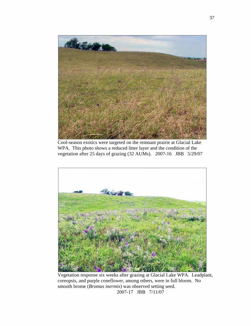
Cool-season exotics were targeted on the remnant prairie at Glacial Lake WPA. This photo shows a reduced litter layer and the condition of the vegetation after 25 days of grazing (32 AUMs). 2007-16 JBB 5/29/07
Vegetation response six weeks after grazing at Glacial Lake WPA. Leadplant, coreopsis, and purple coneflower, among others, were in full bloom. No smooth brome (Bromus inermis) was observed setting seed. 2007-17 JBB 7/11/07

38
3d. Farming In 2007, 195.7 acres were cooperatively farmed for seed bed preparations on five WPAs. Each year previously broken areas such as poor quality grasslands, old stands of alfalfa, or food plots that are no longer in use are identified to be planted back to natives. These areas are set up to be farmed for one to three years with area cooperators and then seeded with a local eco-type or cultivar native seed mix. Thorstad WPA is an example of a unit that is partially farmed while production plots of side oats grama, prairie dropseed, and little bluestem are established and expanded as seed harvest allows. However, since the production plots on Thorstad have been slow to expand, we will be seeding this area to a local ecotype mix with 43 species, rather than two or three species. There were 341 acres of cropland managed as food plots for resident wildlife. The food plots were located on waterfowl production areas identified by the Minnesota DNR as significant wintering areas for ring-necked pheasants and white-tailed deer. The majority of food plots were located near shelterbelts and/or cattail sloughs which provide escape and winter cover. Plots were located on soils not classified as highly erodible land, so as to have minimal soil loss potential. Corn, soybeans, and small grains are used in these plots. Soybeans or small grains are used in the rotation to promote nutrient cycling and reduce insect or disease cycles associated with repeated corn growth. The cooperator is responsible for all field work, seed, fertilizer, and weed control. One third of the plot is left standing in the field in alternate strips. The alternate strips help disperse snow and reduce the chances of the entire plot being buried in snow. The cooperator is allowed to harvest any leftover crops the following spring. The Morris CCP identifies some parameters for where food plots will remain on WPAs to benefit wildlife the most. Evaluation of food plots is annual and over the past few years some food plots have been taken out of production and seeded to native grasses. Food plots were chosen for elimination or reduction based on size and location in an effort to minimize grassland fragmentation and eliminate food plots that are too large for the scale of the WPA on the landscape. The Pomme de Terre chapter of the Minnesota Deer Hunters Association planted the food plots on Edwards, Schultz, and Pomme de Terre River WPAs. Since 100 percent of the crop is left for wildlife, the food plots on these units are smaller acreages than those cooperatively farmed under a one-third crop-share. This is much better for nesting waterfowl and other birds for two reasons: less fragmentation, and more grassland acres available for nesting. Pheasants Forever chapters and the Pope County Pheasant Restoration Club have also been placing feeder cribs throughout the district on both WPAs and private land.

39
Table 12 - Food Plot Summary - Morris WMD - 2007 County
No. WPAs With Food Plots
No. Food Plots
Total Acres
Big Stone 7 8 93.1 Lac qui Parle 1 1 19.6 Pope 2 2 26.1 Stevens 9 9 76.4 Swift 3 3 69.2 Traverse 3 4 36.2 Yellow Medicine 2 2 20.4
Total 27 29 341.0
3f. Fire Management
2007 was one of the best years for fire management on the Morris Wetland Management District. Prescribed fire on the district treated 4,132 acres and an additional 115 acres burned due to wildfires. The fire staff went through some changes and had several details to build experience. We also added a few new pieces of equipment to use on the district.
Three new employees joined the Morris fire program this year (section 8b). Kevin, Phil and Seth at the Jocko Lakes Fire, Montana. 2007-18 7/2007
40
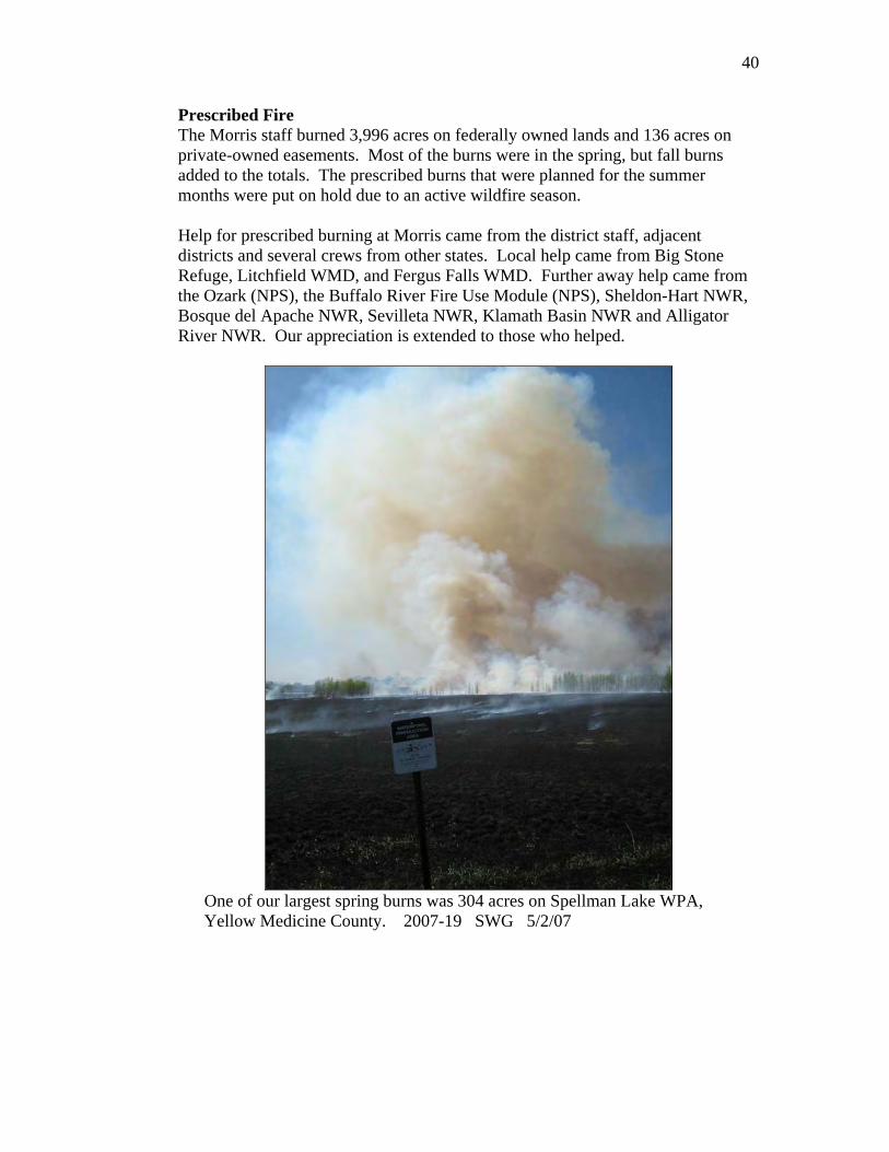
Prescribed Fire The Morris staff burned 3,996 acres on federally owned lands and 136 acres on private-owned easements. Most of the burns were in the spring, but fall burns added to the totals. The prescribed burns that were planned for the summer months were put on hold due to an active wildfire season. Help for prescribed burning at Morris came from the district staff, adjacent districts and several crews from other states. Local help came from Big Stone Refuge, Litchfield WMD, and Fergus Falls WMD. Further away help came from the Ozark (NPS), the Buffalo River Fire Use Module (NPS), Sheldon-Hart NWR, Bosque del Apache NWR, Sevilleta NWR, Klamath Basin NWR and Alligator River NWR. Our appreciation is extended to those who helped.
One of our largest spring burns was 304 acres on Spellman Lake WPA, Yellow Medicine County. 2007-19 SWG 5/2/07

41
Table 13 - Prescribed Burn Summary - Morris WMD - FY 2007 County/Burn Name Unit Type Burn Date Acres Burned Big Stone
Hillman WPA 10/01/06 12 Kufrin (east) WPA 11/08/06 37 Centennial WPA 04/18/07 457 Kufrin WPA 04/24/07 173 Rothi WPA 04/27/07 241 Helgeson WPA 04/27/07 13 Odden WPA 04/28/07 224 Barry Lake WPA 04/28/07 133 Lilly Stock Easement Habitat Esmt 04/29/07 53 Kufrin-piles WPA 06/26/07 6
Lac qui Parle Sumner WPA 04/28/07 65
Pope Bangor WPA 10/04/06 177 Froland WPA 03/27/07 50 Hagstrom WPA 04/16/07 304 Johnson WPA 04/18/07 45 Little Chippewa River WPA 04/25/07 286 Barsness WPA 04/25/07 80 McIver WPA 04/26/07 99 Nelson Lake WPA 05/09/07 270 Glacial Lake-piles WPA 06/25/07 2 Larson WPA 09/27/07 79
Stevens Wente WPA 10/05/06 140 Mud Creek WPA 04/17/07 295 Welfare WPA 04/18/07 67 Edwards-islands WPA 04/30/07 1 Wente-north WPA 09/14/07 26
Swift Artichoke Lake-piles WPA 03/12/07 10 Hoffman WPA 04/26/07 67 Maki WPA 04/26/07 138 Artichoke Lake WPA 05/25/07 113
Traverse Parnell WPA 04/28/07 26
Yellow Medicine Busack WPA 04/28/07 56 Schwendeman Easement Habitat Esmt 05/01/07 83 Spellman Lake WPA 05/02/07 304
Total = 34 Treatments 4,132
42
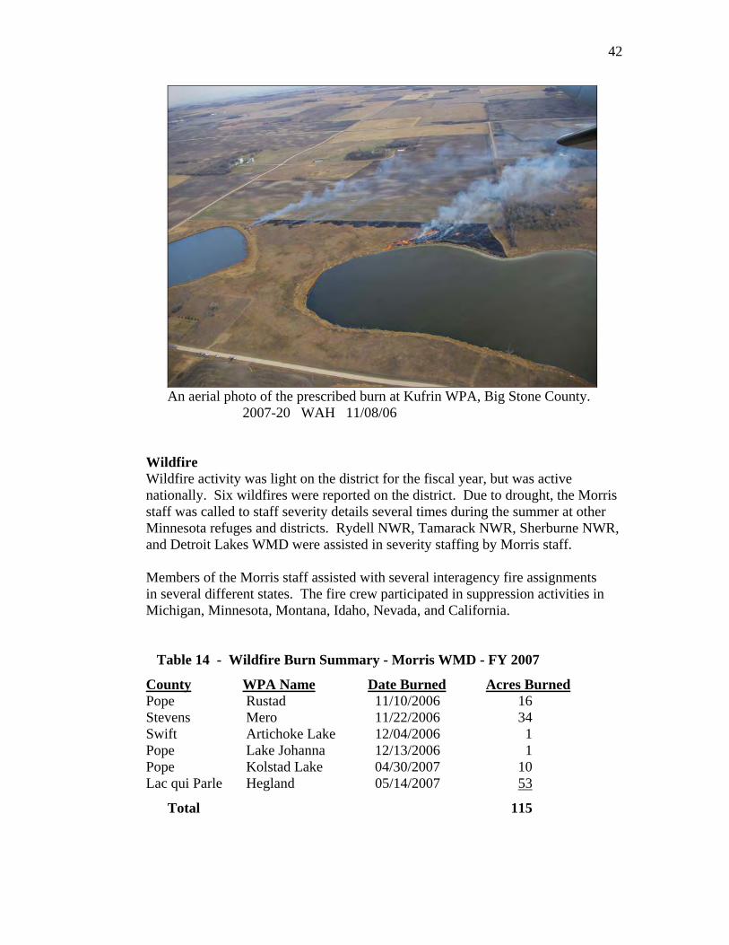
An aerial photo of the prescribed burn at Kufrin WPA, Big Stone County.
2007-20 WAH 11/08/06 Wildfire Wildfire activity was light on the district for the fiscal year, but was active nationally. Six wildfires were reported on the district. Due to drought, the Morris staff was called to staff severity details several times during the summer at other Minnesota refuges and districts. Rydell NWR, Tamarack NWR, Sherburne NWR, and Detroit Lakes WMD were assisted in severity staffing by Morris staff. Members of the Morris staff assisted with several interagency fire assignments in several different states. The fire crew participated in suppression activities in Michigan, Minnesota, Montana, Idaho, Nevada, and California. Table 14 - Wildfire Burn Summary - Morris WMD - FY 2007
County WPA Name Date Burned Acres Burned Pope Rustad 11/10/2006 16 Stevens Mero 11/22/2006 34 Swift Artichoke Lake 12/04/2006 1 Pope Lake Johanna 12/13/2006 1 Pope Kolstad Lake 04/30/2007 10 Lac qui Parle Hegland 05/14/2007 53
Total 115

43
Equipment The district acquired two new pieces of equipment to use on fires. The Polaris Ranger ATV will be a valuable tool on fires and other projects. Also, a Marsh Master amphibious tracked vehicle was acquired as a shared resource between Morris and Big Stone NWR. This is a valuable piece of equipment that will help us treat areas that weren’t accessible in the past. Both vehicles will be helpful resources to be used in fire management on the district.
Marsh master and crew watching for spot fires on the Spellman Lake prescribed burn (Yellow Medicine County). 2007-21 SWG 5/2/07 Rural Fire Assistance Grants
• The Rural Fire Assistance grant program went unfunded for FY2007.
3g. Pest Plant Control Woody Vegetation Control Besides encroachment of cool-season exotic grasses, our tracts of remnant prairie and re-established native grasses have also been invaded by trees. Siberian elm, box elder, cedar, cottonwood, and willow are the most common culprits. The past year saw a continued emphasis on tree removal, with trees cut at 18 WPAs. As in previous years, tree removal work was done through a combination of our staff time and equipment and contractors. The tree work on Heidebrink was conducted along the fence line to ease fence maintenance/repair for a grazing permittee. Dahl Logging was issued a special use permit to selectively harvest
44
cottonwood trees from Benson Lake and Blue Mounds WPAs in Pope County. In addition to work on WPAs, Tractor Operator Boutain spent four days with our Fecon mower assisting the DNR with some tree removal on Little Joe and Noordmans WMAs in Pope County. We also spent some time this year treating regrowth from previous years’ cutting. Regrowth was cut at Kufrin, Nelson Lake and Wente. Re-growth on Hegland, Rothi, McIver, and Kufrin was sprayed with Tahoe herbicide. Tree resprouts at McIver, Appleton, Hillman, and Kufrin WPAs were sprayed with Garlon 4E (Triclopyr ester) or Garlon 3A (Triclopyr amine). Table 15 - Woody Vegetation Control - Morris WMD - FY 2007
County Unit Method
Big Stone Centennial Tree shears Jacobson Fecon Kufrin Fecon
Lac qui Parle Hastad Fecon Hegland Tree shears, fecon
Pope Benson Lake Contractor, tree shears, fecon Blue Mounds Contractor, tree shears, fecon Froland Fecon, hand cut Grove Lake Hand cut Heidebrink Fecon McIver Fecon Nelson Lake Fecon, tree shears Stenerson Lake Tree shears
Stevens Edwards Hand (buckthorn) Wente Fecon (regrowth)
Swift Artichoke Lake Fecon Lynch Lake Fecon
Yellow Med. Swede Home Mow
Spotted Knapweed The spotted knapweed sites were treated for the third year in a row on Cyrus and Pomme de Terre Lake WPAs. Two new sites were treated on Pieske and Nordby WPAs. The plants were pulled at Cyrus and sprayed at the remaining sites. A few plants were also found on Westport WPA, but too late to treat.

45
Spotted knapweed on Cyrus WPA (P-56). The jury is still out on whether pulling or spraying is more effective. In any case, a multi-year commitment is necessary for control. 2007-22 JBB 7/19/07
Queen Anne’s lace growing near Hillman WPA, Big Stone County. A number of “new” invasive plants have appeared in the district in recent years including this, spotted knapweed, common tansy, and wild parsnip. 2007-23 JBB 8/16/07

46
Canada Thistle Canada thistle control receives a significant amount of effort during the field season at Morris WMD. Our general strategy is to mow problem areas in the summer and spray those areas with herbicide in the fall. The station received only four complaints regarding problem areas on WPAs, all of which were treated within one business day. Table 16 - Noxious Weed Control - Morris WMD - FY 2007
Acres Treated County Mow Spray Contracted Total
Big Stone 139.5 88.0 0.0 227.5Chippewa 0.0 0.0 0.0 0.0Lac qui Parle 37.0 0.0 0.0 37.0Pope 39.0 4.0 0.0 43.0Stevens 19.0 37.0 0.0 56.0Swift 16.0 50.0 0.0 66.0Traverse 119.0 0.0 90.0 209.0Yellow Med. 26.0 51.0 0.0 77.0
Total 2007 395.5 230.0 90.0 715.5Total 2006 883.3 867.9 104.2 1,855.4Total 2005 698.2 347.4 0.0 1,045.6Total 2004 1,026.9 722.4 0.0 1,749.3Total 2003 717.0 949.5 144.2 1,810.7
Biological Control Purple Loosestrife Loosestrife continues as a localized invasive species in wetlands across district lands but there has been good success with control through the use of purple loosestrife (Gallerucella spp.) beetles. During 2007, six galerucella spp. were collected from Kolstad Lake WPA (Pope County) on August 7 and released at Fults WPA (Stevens County). Loosestrife was discovered next to Fitzgerald WPA (Stevens County) on private land and may become a problem for this WPA in the future.

47
Purple loosestrife was found at Fults WPA on July 23 and beetles were released on August 7, 2007. 2007-24 DMO 8/7/07
Leafy Spurge The first leafy spurge bio-control agent release began in 1996 on district land with the introduction of flea beetles (Aphthona lacetosa, Aphthona czwalinea, and Aphthona flava). Beetles were harvested from established populations and released in other leafy spurge problem areas. In 2007, district staff harvested 110,000 beetles to establish new colonies. The beetles were released onto nine sites on five WPAs (one new and four existing). To date, beetles are on 195 release sites at 53 WPAs of which 414.451 acres are infested with leafy spurge. Beetles were applied to 1.424 acres in 2007. Table 17 - Flea Beetles Harvested From WPAs - Morris WMD - FY 2007
County No. WPAs Beetles Collected
Big Stone 1 107,000 Swift 1 3,000
Table 18 - Flea Beetles Released - Morris WMD - FY 2007
No. No. County WPA Sites Released
Big Stone Rothi 1 1,000 Pope Heidebrink 3 80,000 Walden 1 1,000 Swift Maki 1 3,000 Traverse Robinhood 3 25,000

48
FISH AND WILDLIFE MANAGEMENT
4a. Bird Banding The Morris WMD assisted local DNR area wildlife staff with their annual goose banding effort. Locally breeding giant Canada geese are banded in Minnesota each year in an attempt to gather movement and harvest data for the population. The groups we worked with banded about 1,000 geese this year.
4b. Disease Monitoring and Treatment Nothing to report.
4c. Re-Introductions The Morris WMD continued its involvement with an effort to re-establish a greater prairie chicken (Tympanuchus cupido pinnatus) population in west-central Minnesota. This project, in its ninth year, is supported by the Service, Minnesota Department of Natural Resources, Minnesota Prairie Chicken Society, Society of Tympanuchus Cupido Pinnatus, and The Nature Conservancy. Translocations ended in 2006 (574 birds moved since 1999) and project partners will continue to monitor birds using radio telemetry and booming ground counts. Several Morris WMD staff members assisted with spring surveys again this year. In late March we began roadside listening surveys to locate booming grounds and grounds were observed from blinds in April and May. There were 10 booming grounds in the project area this year (Figure 4). Five booming grounds are on or adjacent to WPAs (Rothi, Twin Lakes, Hillman, Hastad, Odden). We use the number of males on booming grounds as an index to our prairie chicken popula-tion; there were 83-94 males on booming grounds in 2007, slightly down from last year. Because we are no longer supplementing this population by releasing new birds, booming ground counts over the next few years will be our best indication of long-term success for this re-introduction project. Sharp-tailed grouse sightings have increased in the district in recent years. Sharptails were observed on three prairie chicken booming grounds this year. Although we did not find a dancing ground, there was a sharptail in the area of the 2006 dancing ground near Mosquito Ranch WPA. There was also a dancing ground on Big Stone NWR this year.

49
Figure 4 - Location of Prairie Chicken Booming Grounds Morris WMD - 2007

50
4d. Nest Structures
Morris WMD has two main goals in its nest structure program: to maintain approximately 300 nest structures on WPAs within the district and to distribute nest structures to cooperators with reliable instructions for placement and maintenance. The cooperators must be willing to set up and maintain the structures on private lands. The structures, including mounting post and bracket, predator guard and hardware are given away through the station’s private lands program. The mounting posts are used sign posts supplied free by the local State Department of Transportation office. This program has been very successful and well received by the public. In FY2007 we gave away 16 cylinders to participants. Since the inception of the program in 1995, we have distributed 1,441 nest cylinders. Results from the 2007 nesting season included 303 nesting structures on WPAs with 590 nesting sites available on these structures. Nests were initiated on 59 or 19.5 percent of the structures. There were 99 total nests initiated with a 69.7 percent success rate. The major cause for unsuccessful nesting attempts was abandonment (30.3 percent). No nests were found to be predated this year. Volunteers from the Friends of the Morris WMD roll mallard nest cylinders each year to be provided at no cost to landowners who restore wetlands on their property.
4e. Pest Control Goose Damage Crop damage caused by resident Canada geese continues to be an issue throughout the district. Several options are available to private landowners to lessen damage caused by the birds such as electric fencing and shooting permits. Extended hunting seasons with generous bag limits are also in place to try to reduce the number of birds statewide. The goose damage complaints in our district are handled primarily by the local DNR offices; however, we sometimes get involved if the complaint is adjacent to a WPA. Our office did not receive any damage complaints in 2007. Beaver After an active year in 2006, the number of damage complaints was down in 2007. District staff spent time cleaning out dams and setting traps on Hagstrom, Loen and Stammer WPAs. Four beaver were caught, three on Loen and one on Stammer.

51
COORDINATION ACTIVITIES 5a. Interagency Coordination
We invest a large amount of time each year in partnerships and interagency coordination. One major interagency effort this year was the Working Lands Initiative (WLI), a project designed to encourage partnerships between agricultural and conservation interests. In particular, the Working Lands Initiative seeks to provide focused conservation efforts within priority zones in agricultural land-scapes with the idea being that these agricultural zones remain working for agricultural values while meeting certain minimum conservation values such as having a large amount of grassland and wetland within the focus area. There are three active WLI teams in the Morris district, one each for Stevens, Pope, and Big Stone Counties. Each of the three teams previously prepared proposals for conservation projects and identified one or more focus areas; this was the initial year for project implementation. The Pope County proposal is very focused on grazing and grasslands. The focus area is in an area of glacial hills which still contains considerable native prairie, and several active beef producers live within the focus area. The Pope County proposal also includes an experimental conversion of some private cropland to a diverse native grass and forb stand for harvest as biomass fuel to be used in a gasification facility at a nearby ethanol plant. During the year, the Pope County WLI team organized a successful kickoff community dinner to explain the project to local residents. The team also participated in Graze Fest, a day-long forum for exchanging information about grazing and promoting sound grassland manage-ment. Most significantly, the WLI team implemented an aggressive invasive species control program on private lands within the focus area. WLI money paid for Minnesota Conservation Corps teams to remove undesirable woody vegetation from prairie owned by cooperating landowners. We removed invasive woody plants from 112 acres impacting just over 400 acres of grasslands in central Pope County. Minnesota Conservation Corp crews were hired by the Working Land Initiative and worked for nearly two and a half months removing trees. Pope WLI spent $21,000 for the labor, and the Morris Partners program paid $1,700 for the stump treatment chemicals. Two of the landowners completed or will complete prescribed burns on their property to help stimulate the grasses and control trees. This was a highly successful effort to find solutions of mutual interest to private landowners and conservation groups and agencies. We plan to continue invasive species control as well as fund conversion of 40 acres of crop ground to native plants for use as a biomass crop.

52
Forbord tree removal site before cutting began. 2007-25 SLS 4/25/07
Forbord tree removal site after cutting. Notice the landscape change.
2007-26 SLS 5/14/07

53
Stacy Salvevold spoke at Graze Fest. 2007-27 JBB 7/31/07
The Stevens County proposal includes financial incentives for enrollment into USDA conservation programs such as WRP, CREP, CRP, or other long term conservation options such as Fish and Wildlife Service easements. The Stevens County proposal also includes incentives for alternative crops (winter wheat and late harvested alfalfa), and for grazing infrastructure. The Stevens WLI alternative cropping plans have not yet materialized but, late in the year, considerable move-ment occurred with the financial incentives portion. In FY08, all of the Stevens County WLI money will likely be used on incentive payments for enrollment of marginal cropland into permanent easements, with restoration of all wetlands and grasslands on the sites. Five tracts have been enrolled protecting 330 acres of land in CREP and WRP perpetual and 45-year easements. The Big Stone County proposal includes conservation program enrollment incentives, grazing incentives, and an experimental, delayed drainage project in which a landowner is agreeing to use tile gates on two small, previously drained wetlands. The WLI project is cost sharing installation of some lateral tile in the bottom of the drained wetlands and will add the tile gates. The landowner has agreed to delay opening the tile gates until May 1 of years in which the field will be planted to soybeans (roughly five years out of ten). We are trying to see if we can add temporary wetlands to the landscape and still allow rapid enough drainage following the gate opening to allow for crop production. Late in the year, land-owner interest also increased in the enrollment incentives portion. We have not yet been successful with finding cooperative grazing projects on private land, though there is much potential for adding fence and other infrastructure to public lands to allow grazing to be another land management option. A grazing tour is

54
being planned for summer 2009 through the Big Stone County NRCS office and Big Stone County WLI. We enjoy a highly effective partnership with the Upper Minnesota River Water-shed District involving wetland restoration and environmental education. Our work with other watershed districts is more sporadic. The various watershed districts have widely different priorities, depending upon the priorities of their elected boards and paid staff. Some are essentially drainage districts, focusing largely on maintaining or improving drainage systems. Those interested in a broader water quality and quantity discussion tend to work more closely with us. Last year, Ducks Unlimited, Minnesota DNR, and the Fish and Wildlife Service cooperated on a large water control structure replacement at Spellman Lake WPA in Yellow Medicine County. The situation is atypical in that North and South Spellman Lakes are designated wildlife lakes with DNR jurisdiction over water levels but much of the surrounding land is federally owned and managed as a WPA. Thus, we manage and control the uplands while DNR manages and controls the shallow lakes within the WPA. North and South Spellman Lakes are tenuously connected through a narrow band of shallow water during high water conditions. Ducks Unlimited supervised design and construction of a water control structure to replace an old failed structure, installation of a fish barrier, and improvement of a channel connecting the two lakes so that a drawdown will remove water from both lakes. North and South Spellman Lakes were in drawdown during the year to remove fish and promote emergent vegetation. Via a cooperative agreement, Ducks Unlimited agreed to conduct surveying, engineering, and feasibility assessments for fish barriers and/or water control structures on or around Wiley, Kufrin, Barry Lake, and Twin Lakes WPAs (all in Big Stone County). Ducks Unlimited and Stevens SWCD also cooperated on engineering and planning for a replacement water control structure on Sherstad Slough WPA (Stevens County); the current structure is not functional.
Late in the fiscal year, an opportunity arose to work cooperatively with Swift County on a road project affecting Appleton WPA. A county road bisects a large shallow marsh on the WPA. We have long wanted to raise water levels in the marsh, which is perennially choked with emergent vegetation. Swift County plans to raise the road grade to improve transportation. We arranged with the county to cover the costs of raising the road an additional two feet beyond the county’s transportation needs to allow us to hold two more feet of water in the marsh. The county is also agreeing to have this extra water backed up onto the road right-of-way and, at the Service’s discretion, to allowing a water control structure to be added to the culvert under the road, allowing us to manage the large marsh in two separate pieces if we choose to do so. By doing the project cooperatively with the county, we can save substantially on the cost and we ensure that the water levels in the marsh can be managed more appropriately for waterfowl.

55
We work closely with NRCS in their implementation of conservation programs including WRP, CRP, CREP, and so on. Manager Delehanty spent time during the year involved with a tourism promotion group for Morris and surrounding area. Our Friends group is also involved with this project. Staff members participated in some on-going county conservation review group meetings and county water planning meetings. With a shrinking staff, we have scaled back our participation. Staff members worked with other agencies that included Soil and Water Conserva-tion Districts, local water boards, County Highway Departments, etc. on many issues. With the complex, scattered, and diverse land holdings of a wetland management district, there are always issues arising each year related to roads, drainage, invasive species, and other topics requiring interagency coordination.
5c. Private Lands The Morris WMD had half an FTE this year for the Partners for Fish and Wildlife program. Darrell Haugen retired in September 2006, and Stacy Salvevold did not start until March 2007. Funding for work on private land typically comes from the Fish and Wildlife Service Partners for Fish and Wildlife program, Challenge Cost Share program, North American Waterfowl Management Plan, private donations, and the Legislative and Citizens Commission on Minnesota Resources. The budget for FY2007 was $88,272, including $10,000 to be used for invasive species control. This budget covers salaries, supplies, and prairie and wetland restoration and enhancement costs as well as repairs on past projects. The budget was matched with financial and in-kind contributions from private landowners and other agencies and organizations totaling $46,503. Due to the late start of Biologist Salvevold and a blanket purchase agreement that was not completed until July, much of the budget was spent after the end of the fiscal year. Approximately $15,085 was spent before the end of the fiscal year, and the remaining $25,915 will be spent in FY08. All funds were obligated to projects by the end of the fiscal year. Grassland Projects Grassland restoration projects completed in FY07 included assisting two land-owners with native grass seeding for a total of 11 acres. We also did something new this year and assisted private landowners with controlling invasive plants on their property. Two landowners in Pope County signed 10 year agreements to control leafy spurge using biological control agents. The 10,000 beetles released should impact 10 acres or more of leafy spurge over time.

56
Grassland enhancement projects completed in FY07 include removing trees through the Pope County Working Land Initiative (WLI). Biologist Salvevold coordinated the tree removal on 112 acres impacting just over 400 acres of grasslands in central Pope County (see Section 5a). Another 357 acres of grasslands will be enhanced by tree removal using FY07 funds, but the projects will not be completed until FY08. $28,000 from a private stewardship grant will match $10,000 Partners dollars to cut red cedar from 68 acres of a Service FmHA easement near Granite Falls. Another grassland enhancement project was a cost share on an EQIP contract in Big Stone County where the landowner cross-fenced and established water in a 128 acre native pasture. We contributed $700.00 worth of fencing materials instead of constructing a stock pond. NRCS and the landowner paid $11,403 for fence, stock pond construction and improvements, and a corral. Native pastures can be managed for better cattle forage through a rotational system. Grassland birds benefit from the residual grass that tends to remain in these systems versus a traditional grazing system Private Lands Grass Drills In 1997, the Morris WMD Partners for Fish and Wildlife Program purchased two Dura Tech Haybuster grass drills. The money to purchase the drills was raised from donations from Minnesota Waterfowl Association, Ducks Unlimited, Stevens County Pheasants Forever Chapter and the Yellow Medicine County Soil and Water Conservation District. These donations were matched through the Service’s Challenge Cost Share program with the remaining balance coming from the Upper Mississippi River Headquarters/Tallgrass Prairie Ecosystem. In 2005, we used challenge cost share money and worked with the Stevens Soil and Water Conser-vation District to purchase another drill to help seed a large number of recently enrolled wetland reserve program sites in Stevens County. The SWCD purchased another drill on their own, and they run these two drills in tandem. The older Dura Tech drills are nearing the end of their useful life but are still in use along with the new Stevens SWCD drills. The Stevens Soil and Water Conservation District coordinated seeding in Stevens County using the newer drills purchased in 2005 and one Dura Tech drill in Stevens, Traverse, and parts of Pope and Big Stone counties. The Swift Soil and Water Conservation District coordinated seeding with one Dura Tech drill in parts of Big Stone, Lac qui Parle, Chippewa, Pope and all of Swift counties.

57
Table 19 - Seedings Using Private Lands Grass Drills - Morris WMD FY 1998 - FY 2007
Number of Number of Year Landowners Acres Seeded 2007 67 1,611.6 2006 114 2,265.0 2005 103 2,178.5 2004 41 1,269.6 2003 40 1,289.2 2002 60 1,440.3 2001 31 1,229.0 2000 53 2,046.0 1999 27 969.0 1998 41 1,840.0
Wetland Projects Wetland restoration was a little slower this year than it has been in the past. Fourteen wetlands were restored during FY07 on four properties in four counties. A total of 41 acres were restored. FY07 funds will be used to complete four more wetland restorations totaling seven acres on three more properties after the end of FY07. One old restoration was repaired at a cost of $600 in Yellow Medicine County, 100 feet of tile was removed from the basin bottom, and the 22 acre wetland’s outlet riser was sealed up better. (see section 2a). Education and Cooperative Projects Biologist Salvevold spent a significant amount of time working on Working Lands Initiative projects (see section 5a). The Morris WMD Partners program also provided assistance with a number of education events this year. Ortonville Public School students raise money for wetland restoration in Big Stone County, and the Service restores the wetlands and helps with a tour for the students involved in the project. Approximately 200 fourth, fifth and sixth graders got to see wetlands before and after restoration this year during a May tour. Biologist Salvevold also attended Farm Fest to staff a booth where people could learn about conservation, construct bluebird boxes, and request conservation assistance on their land.

58
These sixth graders from the Ortonville school got a tour of the restoration project on Kufrin WPA that they provided funds for. 2007-28 SLS 5/2007
6a. Law Enforcement
The station started the fiscal year with one dual function officer, Biologist Henderson. Most enforcement activities are associated with easement violations and WPA use regulations. With 244 WPAs and 825 easement contracts scattered through eight counties, there is no shortage of conflict to deal with. State Con-servation Officers carry the brunt of the responsibility for hunting and public use enforcement within the district. We maintain a good rapport with state officers working cooperatively during the fall hunting seasons and providing assistance when requested. Typical public use violations included no license in possession, no state stamp, no federal waterfowl stamp, lead shot, unplugged shotgun, vehicle trespass, minnow trapping on WPA, abandoned property and destruction of government property. Waterfowl Production Areas Most WPA management problems are detected during routine work activities, easement surveillance flights, or brought to our attention by the public. Typical and recurring issues include farming encroachment, rock dumping, vandalism, vehicle trespass, and private drainage affecting WPA wetlands. Easements Most easement violations are detected by annual surveillance flights. Typical violations are associated with activities that degrade wetland value, such as filling and draining. The authority to cite an individual is an essential element to

59
resolving easement violations. But, because the ultimate goal is restoration of the resource, citations are seldom used. The year started with 35 open cases from FY2006. Eighteen new cases were opened in FY2007. By year end a total of 25 cases had been closed, 11 of those were prior year cases. Twenty-eight cases remain open at the end of the year. Mapping requests almost exceed open cases; by year end 24 requests remain open. In October Henderson attended a Region 6 easement meeting in Jamestown, North Dakota. The focus of the meeting was the use of new technologies for easement surveillance flights. Region 6 has developed procedures and protocols for using ArcGIS, ArcPad, a small format digital camera, GPS, and laptop computers. The most costly part of easement surveillance is the flight time. Using a GPS and a customized map generated in ArcGIS for use in ArcPad, navigation is faster and more accurate than the old method of using a paper map. Fewer breaks are needed due to mental fatigue from navigation and airsickness from circling violations for photography. With the use of digital images there is no turn around time waiting for a usable photograph to be developed. Digital images can be geo referenced in ArcGIS and used with other GIS layers. Digital images allow the user to easily zoom to a particular feature, which is particularly useful when mapping pre-1976 easements.
This mounting rack was built by the Morris staff. It was used to hold the camera in the plane for easement photos. 2007-29 BL 6/2007
In the spring Henderson implemented this technology for the general easement photo documentation. The laptop, GPS, and software were already on hand. The

60
Morris staff built a mounting rack for a camera that was borrowed from the United States Geological Survey. Approximately 340 photos were taken covering one third of the district’s easements in a single flight day. Just one day using this technology resulted in a saving to the station of approximately $3,500 in film and processing. By fall the region had purchased its own small format digital camera. Big Stone National Wildlife Refuge Officer Henderson is occasionally asked to cover incidents that happen on Big Stone NWR and WMD. In November the Big Stone NWR staff received a complaint that a portion of the refuge was posted as private property. In the process of investigating the illegal posting it was discovered that an old dump was actively being used. As can be seen in the photos, both incidents required extensive investigative skills to solve.
This is one of the posted signs on the refuge. I wonder who is responsible? 2007-30 WAH 11/2006

61
Dump found on Big Stone NWR. 2007-31 WAH 11/2006
Is this a clue? 2007-32 JL 11/2006
62
Another clue? 2007-33 WAH 11/2006
6b. Permits and Economic Use Management During FY2007, we issued 55 Special Use Permits (SUP). The permits were issued for cutting hay, grazing, cash rent farming (see sections 3b, c, d), firewood cutting, fencing, tree removal, tile repair, and feeder cribs on WPAs and habitat easements.
6c. Contaminant Investigations
We continued to document water quality and the vegetation community at the Darnen WPA wetland that could be affected by stormwater drainage from the nearby Morris Industrial Park. Detailed information about water sampling and other study protocols are available in the “Water Quality Trends at Darnen WPA” work plan in the biologist’s files. We take water quality samples (nutrients, chlorides, and dissolved oxygen) once in spring and fall each year and after significant rain events. We photograph the wetland from two photopoints at several visits during the year. The main purpose of this sampling effort is to observe any long-term water quality changes at Darnen WPA, and we recognize that it may be several years before we can determine the full effect of the industrial park stormwater runoff. Next year we plan to have a soil scientist visit Darnen WPA to determine sediment levels at each site, and we will take oil and grease samples to send for analysis.

63
6g. Land Acquisition Support We have in place an efficient and effective process for acquiring wetland easements and those habitat easements that still allow continued haying or grazing. Fully restrictive habitat easements (no haying or grazing) and fee-title tracts require going though a complex and time consuming appraisal/review/offer process that regularly takes more than a year. As a result, the Morris district has pursued primarily easement acquisition over fee-title and has declined to pursue any fully restrictive habitat easements. Landowner interest in fee-title sale picked up slightly during the year and easement tracts continue to be available. With increasing land prices and stable to decreasing migratory bird fund allocations to the region, for much of 2007 we were no longer preparing new acquisition proposals for fee or easement tracts; there simply is not enough money to meet existing obligations plus new ones. If landowners approached us about fee or easement sales, we evaluated the land. If we wanted to pursue it, the landowner was informed of our interest but told that it would be some months before we would begin the acquisition process. It was an unfortunate situation and certainly not helpful to our acquisition program, but until either land values decrease or acquisition accounts increase, it is one we are likely to face more and more often. Northern Tallgrass Prairie NWR acquisition was effectively shut down through the entire year, with no funds available for use on any fee or easement acquisition except for the Lubenow tract (see Northern Tallgrass Prairie National Wildlife Refuge). Fee Title We purchased one fee tract this year under the small wetlands program, the Faith Covenant Church tract in Big Stone County. This is a 26 acre roundout to our Moulton Lake WPA. The current state of our acquisition program makes aggressively searching for quality fee-title acquisition projects nearly pointless. The process takes too long and we have insufficient resources to pursue numerous fee tracts. Moreover, the rapidly increasing real estate market and state of the farm economy cause few people to walk in our door interested in selling. Many of those interested in land use changes typically sell to a private buyer or gravitate to land conservation programs available through USDA or state agencies once they realize how long we will take to get them a purchase offer. There seems to be an insatiable appetite for land for recreational use by non-local buyers and they often snap up any land with wetlands or other hunting features. When asked, we try to direct these land buyers to sites with excellent habitat restoration potential but there is a strong preference by recreational land buyers to purchase land with existing wildlife habitat. We have several other fee-title tracts in the appraisal or review process but none were concluded by the end of the year.

64
This Faith Covenant Church tract (red) is a roundout to Moulton Lake WPA.
2007-34 WAH 2007
Work began in April, 2006, to purchase this roundout (yellow boundary) to Rustad WPA (green boundary), Pope County. By the close of the year, the landowner had not received our offer. 2007-35 WAH 4/13/06

65
Table 20 - Waterfowl Production Area Realty Acreage - Morris WMD FY 2007
County Units Realty Acres Goal Acres
Big Stone 58 11,721.48 15,600 Chippewa 2 360.10 0 Lac qui Parle 18 4,090.40 6,600 Pope 64 12,917.50 21,000 Stevens 55 9,631.60 12,850 Swift 30 7,608.90 10,800 Traverse 12 4,105.20 6,720 Yellow Medicine 5 959.60 1,260 Total 244 51,394.78 74,830
Table 21* - Waterfowl Production Area Managed Acreage - Morris WMD FY 2007
Managed Acres Managed Acres 9/30/06 9/30/07 County Units Acres Units Acres
Big Stone 58 11,738.99 58 11,764.77 Chippewa 2 360.14 2 360.14 Lac qui Parle 18 4,065.24 18 4,065.24 Pope 64 12,999.62 64 12,999.62 Stevens 55 9,676.46 55 9,676.46 Swift 30 7,653.41 30 7,653.41 Traverse 12 4,141.77 12 4,141.77 Yellow Med. 5 952.66 5 952.66
Total 244 51,588.29 244 51,614.07 *Keeping an accurate tally of the acreage of so many units is difficult. The acres recorded as purchased in real estate records are shown in Table 20 above. The actual acres we manage do not precisely match real estate records. The two most common reasons are 1) land use lines that differ from legal descriptions; and 2) managing land within the boundaries of a meandered lake. Although we do not technically own the land within the meander line, water levels are often low enough that we end up managing a fringe of land between the meander line and the water’s edge. The legislation authorizing purchase of WPAs requires that the Fish and Wildlife Service receive approval by the state involved. In Minnesota, the state makes its decision to approve or deny acquisition tract-by-tract through a decision by the Land Exchange Board. Land Exchange Board members are the Governor, Auditor, and Attorney General. Before going to the Land Exchange Board, we discuss the proposed acquisition with the board of commissioners of the county

66
involved. The county does not approve or deny the acquisition but does express its opinion to the Land Exchange Board through this process that we call certification. With county certification, Land Exchange Board approval is almost automatic; without county certification, approval at the state level is less assured. As a result, we spend time discussing each fee and easement tract with local counties who occasionally use the forum to discuss an array of issues regarding the Fish and Wildlife Service. Water, weeds, and taxes are frequent subjects. While the meetings are occasionally challenging, they do force the staff to hear and consider local concerns regarding management of federal land. Federal land acquisition is almost always controversial anywhere in the country. On wetland management districts, though, we usually acquire land each year and thus the difficult relationships that often arise from land acquisition never have a chance to completely heal before the next acquisition project. The tax loss issue remains an important issue related to land acquisition. A trust fund payment is made to the county government with each new fee purchase where revenue sharing is short. The interest from the trust fund payment, when invested at the current one-year treasury bill interest rate, should make up the difference between the revenue sharing payment and the taxes that would be paid on the land if it remained private property. The payments are only made in cases where the estimated revenue sharing payment for the land is less than the current taxes on the property. It is up to the counties to decide what to do with the money; they can spend it or invest it. Previously purchased land is not covered by the trust fund payments since they are made as part of the land purchase. The county commissioners appreciate this program but don’t consider it the full answer to the revenue sharing problem. Removing cropland from agricultural production is the other major concern that is raised more and more often by people opposed to our program. Commissioners from various counties frequently raise concerns of losing cropland acres for local farmers. Cropland loss is also used as an argument against our habitat (grassland) easements or wetland easements involving wetland restoration. Revenue sharing payments (so-called “in-lieu-of-tax payments”) are important to our acquisition program. Counties are understandably interested in the annual payment they receive and they are concerned about low payments. In 2006, counties received only 43.1 percent of the amount prescribed by the revenue sharing formula (3/4 of one percent of fair market value). However, due to rapidly increasing land values and recent reappraisals of fee tracts in certain counties, the revenue sharing check received in certain counties went up dramatically in recent years. That softened the concern over low revenue sharing payments in those counties. In other counties, it remains tough to explain why the government is not paying 100 percent of its revenue sharing commitment. Of course, we make many fewer demands on county resources than do owners of private land. Our drain on county resources for infrastructure, law enforcement, and human services is minimal or absent. Furthermore, in Minnesota, state school aid formulas tend to

67
offset any loss of local property tax and prevent any loss of income to a school district when we purchase land. Still, while our net economic effect to most counties is almost certainly positive, it is difficult to get past the fact that we pay less than 100 percent of the authorized amount. Table 22 - Revenue Sharing Payments - Morris WMD FY 2002 - FY 2006
County FY 2002 FY 2003 FY 2004 FY 2005 FY 2006
Big Stone $23,138 $20,907 *$24,317 $*28,545 $20,331Chippewa 547 526 910 1,028 486Lac qui Parle 6,818 8,695 *23,558 *26,951 8,359Pope 28,035 26,945 51,545 58,213 53,878Stevens 25,980 25,011 25,576 28,885 26,734Swift 18,657 17,932 15,861 17,913 16,579Traverse 10,736 10,318 9,127 10,307 9,540Yellow Med. 2,713 3,495 3,091 3,491 3,231
Total $116,624 $113,829 $153,985 $175,333 $139,138 *Includes payment for both WPA acres and Big Stone National Wildlife Refuge acres. These were not separated in 2004 and 2005. **Payments for 2007 have not yet been received. The long term future of fee acquisition is unknown. Our real estate capabilities, the farm economy, farm programs, revenue sharing, and many other issues combine to influence our land acquisition program. With the continued degradation of habitat on private land, fee-title acquisition remains a critical tool for habitat protection. Wetland Easements We permanently protected 162.8 wetland acres with five new wetland easements this year. Last year we purchased four wetland easements covering 106.8 acres of wetlands. Under the terms of a wetland easement, the Fish and Wildlife Service purchases the rights to drain, burn, level, or fill wetlands from a willing seller. Easements of highest priority have been those which preserve wetlands within two miles of a waterfowl production area. However, wetlands near state land or other acceptable habitat can also be protected by easement. In recent years, many wetland easements are related to our private lands program where we restore drained wetlands on private land; many of these landowners are interested in selling us an easement to leave the wetland in place permanently.

68
The curving soil line is spoil over a newly installed tile line, draining this ephemeral wetland which previously supported a breeding duck pair each spring. An easement would have prevented this drainage in Stevens County. 2007-36 SJD 4/2007
The future of our easement program is directly related to funds, staff time, and the process by which we provide landowners an easement offer. We could take many more easements if we had the staff time for making unsolicited easement contacts and enough acquisition money to pay for them. Many wetlands that need protection are still available and the program remains popular with landowners. Roughly half of all duck production in western Minnesota comes from temporary and seasonal wetlands which still have little or no protection under state and federal law. Small shallow wetlands are usually not defined as wetlands by USDA and are specifically excluded from Minnesota’s wetland protection legislation in typical agricultural situations. Our easement is the only protection available for many remaining wetlands. County commissioners must review all easement tracts for certification as with fee tracts. Easement certification is sometimes simple. However, some tracts lead to serious concerns by the county. The major objection is placing an easement on restored wetlands that were previously considered cropland. Many commissioners view that as a loss of productive agricultural land and are also concerned that the conversion to marsh will reduce tax revenue. Also, any time we restore wetlands, it leads to concerns by neighbors and thus commissioners who fear that we will cause flooding on adjoining land without permission. While we never flood a neighbor’s land without permission, it is hard to overcome a deep rooted tradition that says draining water is good and storing water is bad.

69
Table 23 - Wetland Easement Program Status - Morris WMD - FY 2007 Total Number Wetland Easement Goal County Easements Acres Acres Acres
Big Stone 199 6,736.2 25,244.00 42,640Chippewa 4 115.1 392.00 0Lac qui Parle 39 1,314.1 4,938.58 23,540Pope 259 8,945.0 34,631.17 44,180Stevens 56 1,810.8 4,956.40 6,090Swift 69 1,486.5 5,255.10 14,540Traverse 35 1,146.0 3,871.51 8,440Yellow Med. 11 181.4 659.27 7,860
Total 2007 672 21,735.1 79,948.03 147,290 Total 2006 667 21,572.3 79,460.56 147,290 Total 2005 663 21,465.5 79,148.50 147,290 Total 2004 646 21,117.4 77,877.15 147,290 Total 2003 639 20,914.9 77,054.15 147,290 Total 2002 634 20,875.0 76,854.47 147,290 Total 2001 618 20,606.0 75,303.17 147,290 Wildlife Habitat Protection Easements The Fish and Wildlife Service introduced the habitat easement in 1993. This easement is aimed at maintaining grassland habitat adjacent to wetlands. While native prairie tracts receive the highest priority, we pursue easements on other grassland habitat too as long as the block provides significant waterfowl value. Four types of easement are available. The four options allow varying opportunities for grazing and limited haying. All four easement types prohibit drainage and tillage. The landowner is required to pay taxes and control noxious weeds. A new realty process allowing quick and efficient offers for minimally restrictive easements has caused the district to shift exclusively to easements for which the landowner retains grazing and/or haying rights. We purchased six habitat easements this year, covering 531.59 acres. The Depestal (two tracts) and Ryerson easements in Yellow Medicine County protect native prairie pastures containing wetlands. The Schwarze tract in Big Stone County protects a small prairie remnant and seasonal wetland adjacent to Big Stone NWR. The Olson and VanLeuvan easements in Pope County both protect grassland and marsh complexes. Habitat easements must have commissioner review and Land Exchange Board approval in the same manner as the wetland easement.

70
Table 24 - Easements For Wildlife Habitat Protection Morris WMD - FY 2007
County Easements Acres
Big Stone 21 1,858.62 Chippewa 0 0.00 Lac qui Parle 9 608.16 Pope 12 1,063.03 Stevens 0 0.00 Swift 13 778.12 Traverse 2 296.16 Yellow Medicine 4 384.11
2007 Total 61 4,988.20 2006 Total 55 4,456.67 2005 Total 53 4,051.80 2004 Total 52 3,964.80 2003 Total 49 3,734.90 2002 Total 47 3,456.74 2001 Total 43 3,105.70
Farmers Home Administration Easements The former Farmers Home Administration (FmHA) is now part of the Farm Service Agency (FSA). For consistency, we continue to call easements related to their programs FmHA easements. We inspect each easement for compliance each year and manage the units in a manner similar to our habitat easements, using prescribed fire, haying, grazing, or no management action as appropriate. Changes in USDA rules and policies have nearly eliminated opportunities to acquire additional FmHA easements.
Table 25 - FmHA Easements - Morris WMD - FY 2007
Easement County Easements Tracts* Acres
Big Stone 1 1 4.82 Chippewa 1 1 63.20 Lac qui Parle 2 2 114.93 Pope 5 11 220.13 Stevens 1 2 73.55 Swift 10 17 418.12 Traverse 0 0 0.00 Yellow Medicine 3 9 342.48
Total 23 43 1,237.23 *Some easements contain more than one tract.

71
Northern Tallgrass Prairie National Wildlife Refuge The Fish and Wildlife Service received approval in 2000 to proceed with development of this new refuge. Funding for acquisition has come through both Land and Water Conservation Fund appropriations as well as through a state conservation corridors grant. The refuge concept is modeled after the small wetlands (WPA) program and aims to protect 77,000 acres of remaining native tallgrass prairie in scattered tracts in western Minnesota and northwest Iowa. Prairie protection is accomplished through a combination of fee-title and easement acquisition. Overall refuge coordination is provided by the manager of the Big Stone NWR. Various refuges and wetland management districts are responsible for coordinating acquisition and management of individual refuge units in designated counties. The Morris WMD is responsible for those units that fall within our eight county district. Northern Tallgrass Prairie NWR tracts in the Morris district are managed similarly to our WPAs and habitat easements though they have a primary purpose of prairie protection rather than waterfowl production. We use prescribed fire and other upland management tools as appropriate. We seed any acres of disturbed soil with seed harvested from nearby native prairie remnants.
Cup plant (Sylphium perfoliatum) is a handsome tallgrass prairie native. 2007-37 SJD 6/22/07 We acquired our first fee-title tract for the NTGP refuge this year. The Lubenow tract is tiny in size (21 acres) but contains high quality remnant prairie. A lack of NTGP acquisition funding has eliminated all other acquisition activity though landowner interest remains on existing and former pastures.
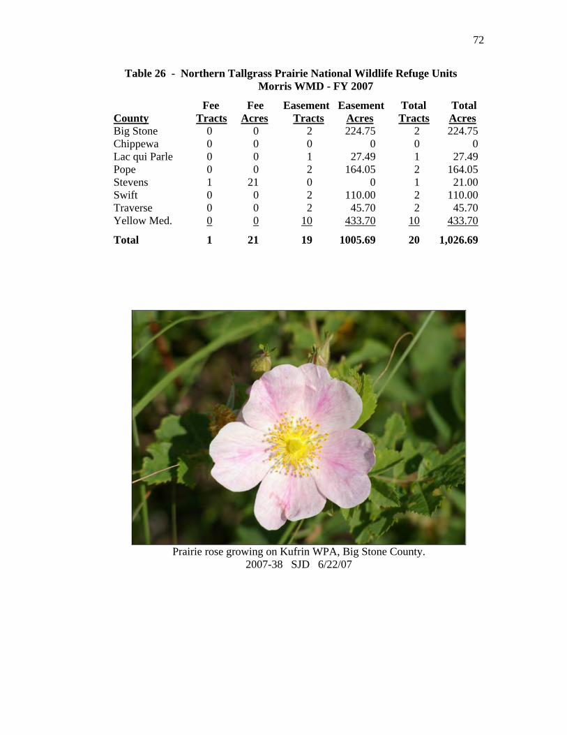
72
Table 26 - Northern Tallgrass Prairie National Wildlife Refuge Units Morris WMD - FY 2007
Fee Fee Easement Easement Total Total County Tracts Acres Tracts Acres Tracts Acres Big Stone 0 0 2 224.75 2 224.75Chippewa 0 0 0 0 0 0Lac qui Parle 0 0 1 27.49 1 27.49Pope 0 0 2 164.05 2 164.05Stevens 1 21 0 0 1 21.00Swift 0 0 2 110.00 2 110.00Traverse 0 0 2 45.70 2 45.70Yellow Med. 0 0 10 433.70 10 433.70
Total 1 21 19 1005.69 20 1,026.69
Prairie rose growing on Kufrin WPA, Big Stone County.
2007-38 SJD 6/22/07

73
PUBLIC EDUCATION AND RECREATION
7a. Provide Visitor Services The Morris district’s visitor numbers are based on results of the University of Minnesota research project: Estimating Visitor Use Levels at Waterfowl Production Areas in Minnesota (Vlaming et al, 2003, Report to U.S. Fish and Wildlife Service). At Morris WMD approximately 69,000 visitors participate in recreational activities during the year. Most district visits are associated with public recreational opportunities such as trapping, hunting, fishing, wildlife observation, interpretation and environmental education. Visitors benefit from the Service’s commitment to conserving, protecting and enhancing fish, wildlife and plants and their habitats at each unit in the district. The headquarters offers a visitor center where general information about the Morris WMD, activities, and programs are available. At the headquarters, a short paved trail loops through native prairie and is accessible to people with physical disabilities. A scenic, 2.5 mile gravel wildlife tour route is open for vehicle traffic during spring, summer, and early fall, and is always open for foot or bicycle travel. The route demonstrates wildlife manage-ment techniques as well as providing wildlife viewing opportunities. We also maintain a 1.2 mile long hiking trail that winds through native prairie, woodlands, and around a wetland. Morris WMD has another self-guided nature trail located at Froland WPA, Pope County, near Starbuck. Wildlife-oriented activities available to the public include hiking, nature observa-tion, photography, snow-shoeing, mushroom and berry picking, and cross-country skiing. Hunting, fishing and trapping in accordance with state regulations are permitted on WPAs. Open year around, WPAs provide solitary places to take a quiet stroll, places for recreation (hunting, etc.), and outdoor classrooms to observe and learn about the natural world. The economic importance of waterfowl production areas were shown in results from Impacts and Benefits of Waterfowl Production Areas by Drew Laughland, Senior Economist with Eastern Research Group, dated May 25, 2005. The local analysis for the Morris district shows that non-local visitors (people driving more than 60 miles) to WPAs in the Morris district directly spend over seven million dollars each year and are responsible for the direct creation of 75 jobs. This only includes direct spending by non-local WPA visitors. There are additional benefits created by local WPA visitors, the money rippling through the economy, WPA-produced wildlife enjoyed elsewhere, etc.

74
The largest impact provided to local communities comes from hunters who are the most frequent users of the land. WPAs were used by an estimated 32,000 water-fowl hunters, 700 other migratory bird hunters, 18,250 upland game hunters, 5,500 big game hunters, 980 small game hunters, 3,500 anglers, and 40 trappers. An estimated 8,900 visitors enjoyed wildlife observation and hiking. Staff provided support to the following at the district headquarters:
• UMM Ecology Class, October 18 • MAHS Wildlife Biology Class, September 17 and 21
The following meetings/training sessions were held at the district headquarters:
• Grazing Meeting, March 8 • Fire Refresher, April 3 • Rural Fire Meeting, April 5 • Township Annual Meeting, April 13 • DNR Meeting, August 13 • Working Lands Initiative, August 29
Second Grade Field Day Each year in May the district provides a fun day of environmental education where second grade students learn about the wonders of the natural world. On May 17, we hosted the 15th annual event where 200 students and 30 adults from five schools (Morris, Cyrus, Hancock, Minnewaska, and St. Mary’s) participated in a variety of instructional activities focusing on the Prairie Pothole Region. Most staff members participated, along with volunteers Kim Bousquet (Big Stone NWR), Randy Schmiesing (NRCS), Judy Johnston (SWCD), and Ron Rosen (Friends Group). Puddles, mascot of the National Wildlife Refuge System, was present for a short time. Prairie Pioneer Days On July 14, during Morris’ annual Prairie Pioneer Days, staff members and Friends did their part to celebrate our prairie heritage. This year, the Friends added a folk music group to our Prairie Pioneer Days activities and doubled our attendance to 200 people. Visitors not only enjoyed music, but also horse-drawn wagon rides through the prairie, prairie walks, and free bird house construction for kids.

75
A local folk band, Patty Kakac and the Pinetones, entertained at Prairie Pioneer Days. 2007-39 SJD 7/14/07
Visitors enjoying a guided prairie-themed wagon ride courtesy of the Friends. 2007-40 7/14/07 Photo by Friends of the Morris WMD

76
Hunting Hunting continues to be a major part of many people’s lives, especially in rural areas. Even if hunters don’t fill their quota, they are out enjoying the great out-doors. The diversity of WPAs in the Morris district offers many options for the hunter. The 2006 waterfowl season opened September 2 in Minnesota with approximately three and one-half months of some type of waterfowl hunting. Early goose hunting started the waterfowl season off, followed by “Take a Kid Hunting” on September 16. Duck season was open from September 30-November 28. The daily bag limit was four ducks, and could not include more than four mallards, two scaup, two wood ducks, two redheads, one pintail, and one black duck. The daily limit could include one canvasback from October 7 through November 5. The December (late) goose hunt ended the waterfowl hunting season on the 24th. There are opportunities to hunt rabbit, squirrel, ruffed grouse, gray partridge, wild turkey, crow, woodcock, rail, snipe, mourning dove, raccoon, coyote, and fox on the WPAs of the district. Pheasant harvest was one of the best in years. The 80 day season ran from October 14 to January 1 with a two cock limit. Hunting success was up from previous years due to the high pheasant population. Continued benefits from grassland conservation and restoration efforts and a string of mild winter weather resulted in an increase in pheasant numbers.
Pheasant chicks flushed while nest dragging at Rothi WPA, Big Stone County. 2007-41 SCV 6/6/07

77
Turkey hunting season occurs in the fall and spring. Zones 416, 417, 422, 425, and 433 are within our district. Hunters can take only one male. Success rates for those zones were normal. Archery season for deer opened on September 16, general firearms season was November 4-5 and November 11-14, and muzzle loader season occurred from November 25-December 10, 2006. A record number of deer were harvested.
7b. Outreach The Morris WMD web page on the Internet is: http://midwest.fws.gov/morris
Wood duck box kits were given to Stevens County Pheasants Forever for their youth event. This is one of five groups who assembled the boxes which were then put up on private land. 2007-42 8/22/2007 Manager Delehanty presented a talk about Management of Waterfowl Production Areas in Minnesota at the 10th Annual Minnesota Waterfowl Symposium on April 14 in Bloomington. From this presentation, Delehanty and other Service personnel developed an audio-visual program to be used to promote the upcoming 50th Anniversary of the Small Wetlands Acquisition Program. On April 29, Appleton Public Television aired the program Echoes of Cry of the Marsh, produced by UMM with support from FWS, CURE, Upper MN Watershed District, DU, and others. The show describes wetland losses, wetland restoration, and the plight of Bob Hartkopf. Bob created a 1970 film Cry of the Marsh
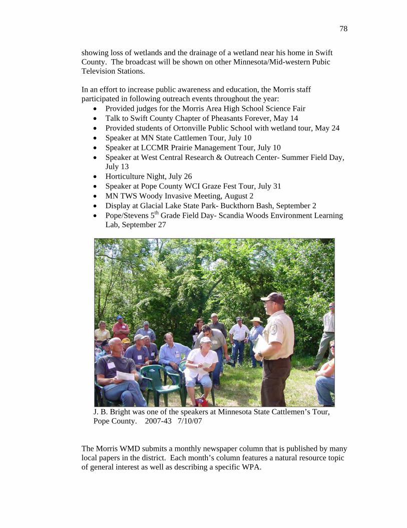
78
showing loss of wetlands and the drainage of a wetland near his home in Swift County. The broadcast will be shown on other Minnesota/Mid-western Pubic Television Stations. In an effort to increase public awareness and education, the Morris staff participated in following outreach events throughout the year:
• Provided judges for the Morris Area High School Science Fair • Talk to Swift County Chapter of Pheasants Forever, May 14 • Provided students of Ortonville Public School with wetland tour, May 24 • Speaker at MN State Cattlemen Tour, July 10 • Speaker at LCCMR Prairie Management Tour, July 10 • Speaker at West Central Research & Outreach Center- Summer Field Day,
July 13 • Horticulture Night, July 26 • Speaker at Pope County WCI Graze Fest Tour, July 31 • MN TWS Woody Invasive Meeting, August 2 • Display at Glacial Lake State Park- Buckthorn Bash, September 2 • Pope/Stevens 5th Grade Field Day- Scandia Woods Environment Learning
Lab, September 27
J. B. Bright was one of the speakers at Minnesota State Cattlemen’s Tour, Pope County. 2007-43 7/10/07
The Morris WMD submits a monthly newspaper column that is published by many local papers in the district. Each month’s column features a natural resource topic of general interest as well as describing a specific WPA.
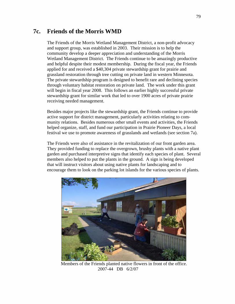
79
7c. Friends of the Morris WMD The Friends of the Morris Wetland Management District, a non-profit advocacy and support group, was established in 2003. Their mission is to help the community develop a deeper appreciation and understanding of the Morris Wetland Management District. The Friends continue to be amazingly productive and helpful despite their modest membership. During the fiscal year, the Friends applied for and received a $40,304 private stewardship grant for prairie and grassland restoration through tree cutting on private land in western Minnesota. The private stewardship program is designed to benefit rare and declining species through voluntary habitat restoration on private land. The work under this grant will begin in fiscal year 2008. This follows an earlier highly successful private stewardship grant for similar work that led to over 1900 acres of private prairie receiving needed management. Besides major projects like the stewardship grant, the Friends continue to provide active support for district management, particularly activities relating to com-munity relations. Besides numerous other small events and activities, the Friends helped organize, staff, and fund our participation in Prairie Pioneer Days, a local festival we use to promote awareness of grasslands and wetlands (see section 7a). The Friends were also of assistance in the revitalization of our front garden area. They provided funding to replace the overgrown, brushy plants with a native plant garden and purchased interpretive signs that identify each species of plant. Several members also helped to put the plants in the ground. A sign is being developed that will instruct visitors about using native plants for landscaping and to encourage them to look on the parking lot islands for the various species of plants.
Members of the Friends planted native flowers in front of the office. 2007-44 DB 6/2/07

80
PLANNING AND ADMINISTRATION
8b. General Administration Personnel
8 9 10 11 12 13 14
1 2 3 4 5 6 7
1. Karen Stettner, Administrative Officer, GS-9, PFT. 2. Stacy Salvevold, Wildlife Biologist, GS-11, PFT, EOD 3/4/07. 3. Sara Vacek, Wildlife Biologist, GS-9, PFT. 4. Donna Oglesby, Biological Technician, GS-7, PFT. 5. Wayne Henderson, Wildlife Biologist (Enforcement), GS-12, PFT. 6. Seth Grimm, Fire Management Officer, GS-9, PFT, EOD 10/29/06. 7. Rodney Ahrndt, Engineering Equipment Operator, WG-10, PFT. 8. J.B. Bright, Refuge Operations Specialist, GS-11, PFT. 9. Phil Millette, Supervisory Range Technician, GS-7, PFT, EOD 4/1/07. 10. Deb Beck, Refuge Operations Specialist, GS-12, PFT. 11. Steven Delehanty, Wetland Manager, GS-13, PFT. 12. Joel Boutain, Tractor Operator, WG-7, PFT Seasonal. 13. Victor Gades, Maintenance Mechanic, WG-9, PFT. 14. Blake Knisley, Range Technician (Fire), GS-6, PFT Seasonal.

81
There were several permanent personnel changes at Morris in FY2007. Seth Grimm began October 29 as Fire Management Officer. He came from Fergus Falls WMD and replaced Don Lantz. Range Technician Chad Runyan left on January 21, 2007 for a job at Dinosaur National Monument in Utah/Colorado. He was replaced by Phil Millette who reported to duty on April 1. Stacy Salvevold was selected as our new Private Lands Biologist. Stacy came from Fergus Falls WMD on March 4 and replaced Darrell Haugen who retired in September, 2006. Spencer Berg, who worked as a temporary Biological Technician in 2006, was accepted into the SCEP program in December as a wage grade Maintenance Worker. He will be offered a permanent position when he graduates in December. Jennifer Hagen and Kevin Thell were hired as temporary Range Technicians in our fire program. Audrey Respet was hired as a temporary Biological Aid to help Sara Vacek with her summer monitoring programs. Eric Iszler and Jordan Pieske were hired as temporary Biological Aids to work on our posting crew.
Spencer Berg Temporary Personnel Spencer Berg Maintenance Worker, SCEP 4/27/07 – 08/25/07 Jennifer Hagen Range Technician, TFT 4/01/07 – 08/25/07 Kevin Thell Range Technician, TFT 4/01/07 – 10/27/07 Audrey Respet Biological Aid, TFT 5/13/07 – 08/25/07 Eric Iszler Biological Aid, TFT 5/13/07 – 08/18/07 Jordan Pieske Biological Aid, TFT 6/03/07 – 08/18/07

82
Audrey Respet, Jordan Pieske, Eric Iszler
Table 27 - Staff Size - Morris WMD - FY 2001-FY 2007
Permanent Full Time Temporary Other Full Time Seasonal Part Time GS & WG Programs*
FY07 12 2 0 6** 0 FY06 12 2 0 4 3 FY05 13 2 0 4 0 FY04 13 2 0 3 0 FY03 14 2 0 5 0 FY02 14 1 0 4 0 FY01 14 2 0 4 1
*YCC, CETA, Work Study, Green Thumb, etc.
**Includes Spencer Berg, converted to SCEP.
Volunteers Our volunteers continue to be an asset to the Morris WMD. Most of our regular volunteers are members of our Friends group or students from the University of Minnesota – Morris. In FY2007, 42 volunteers contributed 544 hours of work. About half of these hours were in the area of visitor services and outreach through Friends activities such as the Prairie Pioneer Days event. Other areas where we received significant help were replanting gardens around the headquarters building, seed harvest, data entry, and nest structures.

83
A great group of volunteers, including members of the Minnesota Native Plant Society and students from UMM, spent a beautiful fall day helping staff hand-harvest forb seed at Maki WPA, Swift County. (see section 2b) 2007-45 SCV 9/22/07
In January, we held the second annual Friends and Volunteer Recognition Dinner. Each volunteer was presented with a certificate of appreciation and a gift (determined by their cumulative volunteer hours). In addition, we recognized Kate Livingston as the 2006 Volunteer of the Year. An active and founding member of the Friends group, Kate has volunteered many hours, often behind the scenes, to make the many Friends activities and accomplishments a reality. Safety The station had two accidents to report in FY07. Maintenance mechanic Gades injured his wrist working in the shop and Tractor Operator Boutain was hit in the mouth by a wood post while loading a truck.

84
Funding Table 28 - Morris WMD Funding Levels - FY 2001-FY 2007 (Dollars in Thousands) Fire Total FY 1260 9100/9200 3110 1230 1120 Budget
07 1,083.9 308.9 -0- -0- 88.3 1,481.106 972.2 273.2 -0- 1.0 136.6 1,383.005 949.7 267.5 -0- 30.0 118.5 1,365.704 1,027.1 213.8 -0- -0- 113.7 1,354.603 1,411.1 272.0 -0- -0- 110.0 1,793.102 1,065.1 333.8 -0- 36.0 119.3 1,554.201 869.5 82.9 -0- -0- 119.3 1,071.7
The budget amounts for 1260 and 9100/9200 are somewhat deceiving because they often include “project specific” funds. The 1260 funds include: 2001 - $61,000 of project specific funds 2002 - $130,000 for project specific funds and $119,300 for roof replacement 2003 - $446,088 for new construction and $41,700 for wind damage repair 2004 - $138,000 for a new dozer 2005 - $93,448 for equipment 2006 - $60,000 for building rehab, $15,779 for truck replacement, and $10,000 for the YCC program 2007 - $21,600 for parking lot; $20,195 for truck replacement, $27,500 for Swift County road project; $34,500 for tree removal and equipment rental The fire budgets include: 2002 - $30,109 to rural fire departments and $118,000 for new equipment 2003 - $46,484 to rural fire departments 2005 - $21,634 to rural fire departments and $13,200 for equipment 2006 - $41,394 to rural fire departments 2007 - $103,430 for a permanent change of station move The 1230 funds in 2005 went to a Cooperative Agreement with Minnesota DNR to survey shallow lakes. In 2007 we also received the following project specific money: $40,000 – 3720 – tree removal on Kufrin WPA $40,304 – 5981 – Friends Grant used for tree removal $13,633 – 7201 – Donation from Pheasants Forever for work on Kufrin WPA

85
General Maintenance Inspection of boundary posting continues to be a priority for the district. The majority of the work was done by STEP students Pieske and Iszler, but other members of the staff helped out as well. In FY2007 we focused on Stevens County. The crews were able to completely check the perimeter of 64 units replacing 594 posts and 872 signs. The hiking trail behind the office received some attention by the installation of some stairs on the west side of the trail. The area located on a steep slope had been starting to erode and the steps have provided stabilization to the area. Fence repair was completed on the east side of Little Chippewa and the north side of Welker WPA. An MCC crew was hired for two weeks and they spent the majority of the time working on removing fence from Hastad WPA. They also provided assistance to the trail project on the office walking trail. A section of split rail fence that ran along the highway in front of the office was removed due rising repair costs. Equipment Operator Ahrndt repaired failing earthen dams on Dismal Swamp and Wagner WPAs. Attention was also given to a structure that is failing on Edwards WPA. A short term fix to the spillway has been completed and we are awaiting assistance from DU to provide a long term solution. Equipment Operator Ahrndt spent two weeks and SCEP Berg spent 21 days at Mingo NWR assisting with a MAT team project to clear brush from moist soil units and helping complete a boardwalk. Ahrndt also spent two weeks at Horicon NWR removing spoil from Horicon marsh. Berg spent a week at Fergus Falls WMD assisting with repairs to the HVAC system in the learning center. Equipment New equipment received in FY2007 included a grapple attachment for the skid steer and a 50 ton, triple axle trailer from Landoll that replaced the worn out semi trailer. We also received a Dodge Magnum car which replaced a two wheel drive Dodge pickup. The car was purchased in order to provide a more fuel efficient alternative to travel to meetings and training assignments. Computers One significant change in our computer systems this year was a move to ArcGIS 9.2. All of our station’s WMD GIS data was converted into a geodatabase for use in the new RLGIS. Facilities A new parking area was constructed on Rustad WPA in response to a request from the township to provide off road parking for vehicles. Lots converted from barbed wire to post and rail included Horse Lake, McIver, and Snetting. One parking area on McIver was eliminated as well.

86
A large construction project that was completed in the fall was the remodeling of the east half of the shop building. A contract was issued to insulate, hang sheet rock, and install a heater and a 300 gallon water holding tank. The space is now used to house the fire cache and related equipment. A secondary step completed by our staff involved converting the old seed room to a parts room and the construction of a new seed room in the pole shed.
The Morris staff constructed a (hopefully) mouse-proof seed room. 2007-46 DB 8/2007 FY07 money was obligated to Morris Sealcoat who completed a chip and seal of the office and shop parking areas and to West Central Glass who installed handicap accessible doors on the entrance to the office.

87
Phlox on Hastad 6/14/07