Embed Size (px)
Citation preview
Wor World Congress/Perth Convention and Exhibition Centre (PCEC), Perth, Western Australia September 4-9, 2011 REF: IDAWC/PER11-283
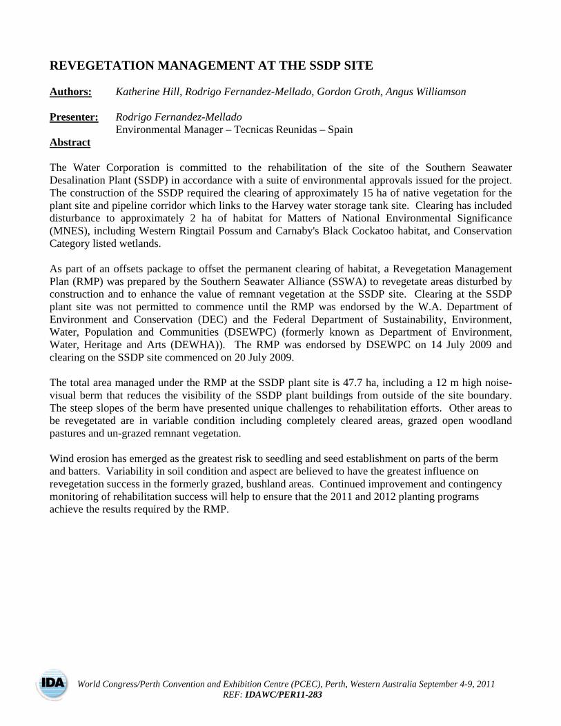
REVEGETATION MANAGEMENT AT THE SSDP SITE Authors: Katherine Hill, Rodrigo Fernandez-Mellado, Gordon Groth, Angus Williamson Presenter: Rodrigo Fernandez-Mellado Environmental Manager – Tecnicas Reunidas – Spain
Abstract The Water Corporation is committed to the rehabilitation of the site of the Southern Seawater Desalination Plant (SSDP) in accordance with a suite of environmental approvals issued for the project. The construction of the SSDP required the clearing of approximately 15 ha of native vegetation for the plant site and pipeline corridor which links to the Harvey water storage tank site. Clearing has included disturbance to approximately 2 ha of habitat for Matters of National Environmental Significance (MNES), including Western Ringtail Possum and Carnaby's Black Cockatoo habitat, and Conservation Category listed wetlands. As part of an offsets package to offset the permanent clearing of habitat, a Revegetation Management Plan (RMP) was prepared by the Southern Seawater Alliance (SSWA) to revegetate areas disturbed by construction and to enhance the value of remnant vegetation at the SSDP site. Clearing at the SSDP plant site was not permitted to commence until the RMP was endorsed by the W.A. Department of Environment and Conservation (DEC) and the Federal Department of Sustainability, Environment, Water, Population and Communities (DSEWPC) (formerly known as Department of Environment, Water, Heritage and Arts (DEWHA)). The RMP was endorsed by DSEWPC on 14 July 2009 and clearing on the SSDP site commenced on 20 July 2009. The total area managed under the RMP at the SSDP plant site is 47.7 ha, including a 12 m high noise-visual berm that reduces the visibility of the SSDP plant buildings from outside of the site boundary. The steep slopes of the berm have presented unique challenges to rehabilitation efforts. Other areas to be revegetated are in variable condition including completely cleared areas, grazed open woodland pastures and un-grazed remnant vegetation. Wind erosion has emerged as the greatest risk to seedling and seed establishment on parts of the berm and batters. Variability in soil condition and aspect are believed to have the greatest influence on revegetation success in the formerly grazed, bushland areas. Continued improvement and contingency monitoring of rehabilitation success will help to ensure that the 2011 and 2012 planting programs achieve the results required by the RMP.
IDA World Congress – Perth Convention and Exhibition Centre (PCEC), Perth, Western Australia September 4-9, 2011
REF: IDAWC/PER11-283 -2-
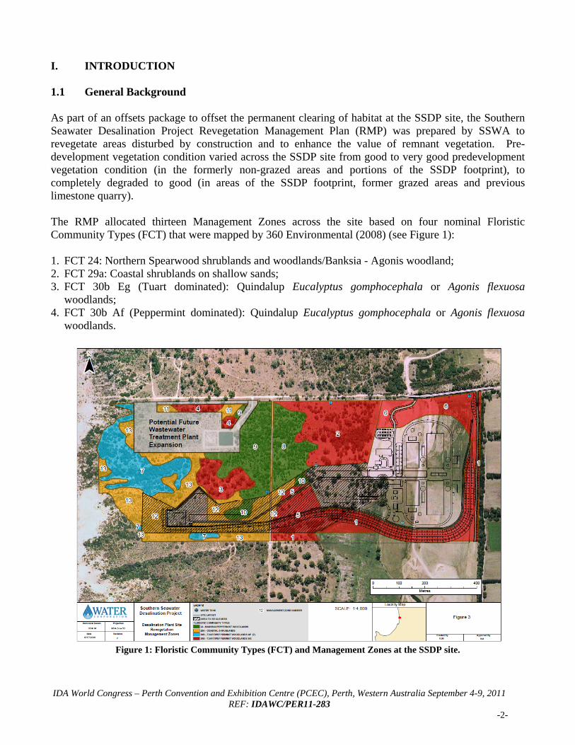
I. INTRODUCTION 1.1 General Background As part of an offsets package to offset the permanent clearing of habitat at the SSDP site, the Southern Seawater Desalination Project Revegetation Management Plan (RMP) was prepared by SSWA to revegetate areas disturbed by construction and to enhance the value of remnant vegetation. Pre-development vegetation condition varied across the SSDP site from good to very good predevelopment vegetation condition (in the formerly non-grazed areas and portions of the SSDP footprint), to completely degraded to good (in areas of the SSDP footprint, former grazed areas and previous limestone quarry). The RMP allocated thirteen Management Zones across the site based on four nominal Floristic Community Types (FCT) that were mapped by 360 Environmental (2008) (see Figure 1): 1. FCT 24: Northern Spearwood shrublands and woodlands/Banksia - Agonis woodland; 2. FCT 29a: Coastal shrublands on shallow sands; 3. FCT 30b Eg (Tuart dominated): Quindalup Eucalyptus gomphocephala or Agonis flexuosa
woodlands; 4. FCT 30b Af (Peppermint dominated): Quindalup Eucalyptus gomphocephala or Agonis flexuosa
woodlands.
Figure 1: Floristic Community Types (FCT) and Management Zones at the SSDP site.
IDA World Congress – Perth Convention and Exhibition Centre (PCEC), Perth, Western Australia September 4-9, 2011
REF: IDAWC/PER11-283 -3-
In addition to the works being performed under the RMP, SSWA have also considered revegetating the degraded Conservation Category wetland on the SSDP site (south of the berm) which was not recognised for rehabilitation under the RMP. An external Offset Strategy has also been developed by the Water Corporation and approved by the DEC in order to offset the loss of 2 ha of this wetland, funding the restoration of the Benger Swamp. 1.2 Environmental Approvals Rehabilitation at the SSDP site is managed in compliance with the following approvals: 2008/4173 Decision on Approval: issued by Department of Sustainability, Environment, Water,
Population and Communities (DSEWPC) (formerly known as Department of Environment, Water, Heritage and Arts (DEWHA)) (Federal Government) on 24 June 2009 (amended 27 January 2010).
Ministerial Statement No. 792: issued by the Environmental Protection Authority (EPA) (State Government) on 14 April 2009.
Notice of Planning Permission under District Planning Scheme No. 1: issued by Shire of Harvey (SoH) (Local Government) on 2 July 2009.
The conditions stated in these approvals are managed under the Construction Environmental Management Framework (CEMF) and the RMP. 1.3 Objectives and Key Commitments The key objectives of revegetation management at the SSDP site are to revegetate areas disturbed by construction and to enhance the value of remnant vegetation. The list of key conditions arising from environmental approvals, which have become key environmental commitments, are listed in Table 1. II. SUMMARY OF 2009-2010 REVEGETATION ACTIVITIES The RMP program at the SSDP site is scheduled to occur progressively over a five year period with preparatory works commencing 2009 and planting commencing 2010 (see Figure 1). Activities undertaken from 2009 to the end of 2010 are summarised in Table 1. To implement and monitor the RMP on the SSDP plant site, SSWA has engaged the services of a revegetation consultant, two seed collecting companies, two nurseries, two weed spraying companies, a planting and general maintenance company and a hard revegetation works company. All works are managed and coordinated by SSWA Environmental Engineers at the SSDP plant site. Preparation for the first planting program (winter 2010) included spreading topsoil stockpiled during clearing activities and performing weed knocks in October 2009, May 2010 and June 2010. Dune Onion Weed (Trachyandra divaricata) and Veldt Grass (Ehrharta longiflora) are the main weed species targeted. Different herbicide mixes were trialed on the berm and in areas where woody weeds were present. Further weed control programs are planned for 2011 and 2012.
IDA World Congress – Perth Convention and Exhibition Centre (PCEC), Perth, Western Australia September 4-9, 2011
REF: IDAWC/PER11-283 -4-
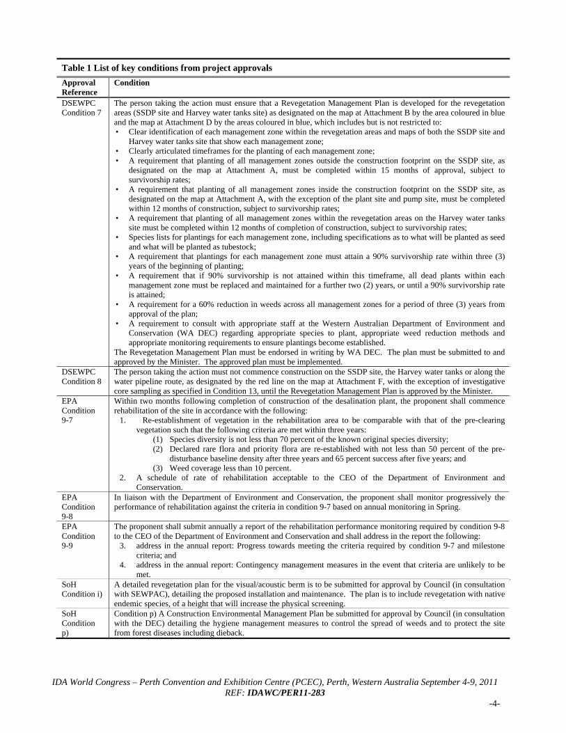
Table 1 List of key conditions from project approvals
Approval Reference
Condition
DSEWPC Condition 7
The person taking the action must ensure that a Revegetation Management Plan is developed for the revegetation areas (SSDP site and Harvey water tanks site) as designated on the map at Attachment B by the area coloured in blue and the map at Attachment D by the areas coloured in blue, which includes but is not restricted to: • Clear identification of each management zone within the revegetation areas and maps of both the SSDP site and
Harvey water tanks site that show each management zone; • Clearly articulated timeframes for the planting of each management zone; • A requirement that planting of all management zones outside the construction footprint on the SSDP site, as
designated on the map at Attachment A, must be completed within 15 months of approval, subject to survivorship rates;
• A requirement that planting of all management zones inside the construction footprint on the SSDP site, as designated on the map at Attachment A, with the exception of the plant site and pump site, must be completed within 12 months of construction, subject to survivorship rates;
• A requirement that planting of all management zones within the revegetation areas on the Harvey water tanks site must be completed within 12 months of completion of construction, subject to survivorship rates;
• Species lists for plantings for each management zone, including specifications as to what will be planted as seed and what will be planted as tubestock;
• A requirement that plantings for each management zone must attain a 90% survivorship rate within three (3) years of the beginning of planting;
• A requirement that if 90% survivorship is not attained within this timeframe, all dead plants within each management zone must be replaced and maintained for a further two (2) years, or until a 90% survivorship rate is attained;
• A requirement for a 60% reduction in weeds across all management zones for a period of three (3) years from approval of the plan;
• A requirement to consult with appropriate staff at the Western Australian Department of Environment and Conservation (WA DEC) regarding appropriate species to plant, appropriate weed reduction methods and appropriate monitoring requirements to ensure plantings become established.
The Revegetation Management Plan must be endorsed in writing by WA DEC. The plan must be submitted to and approved by the Minister. The approved plan must be implemented.
DSEWPC Condition 8
The person taking the action must not commence construction on the SSDP site, the Harvey water tanks or along the water pipeline route, as designated by the red line on the map at Attachment F, with the exception of investigative core sampling as specified in Condition 13, until the Revegetation Management Plan is approved by the Minister.
EPA Condition 9-7
Within two months following completion of construction of the desalination plant, the proponent shall commence rehabilitation of the site in accordance with the following:
1. Re-establishment of vegetation in the rehabilitation area to be comparable with that of the pre-clearing vegetation such that the following criteria are met within three years:
(1) Species diversity is not less than 70 percent of the known original species diversity; (2) Declared rare flora and priority flora are re-established with not less than 50 percent of the pre-
disturbance baseline density after three years and 65 percent success after five years; and (3) Weed coverage less than 10 percent.
2. A schedule of rate of rehabilitation acceptable to the CEO of the Department of Environment and Conservation.
EPA Condition 9-8
In liaison with the Department of Environment and Conservation, the proponent shall monitor progressively the performance of rehabilitation against the criteria in condition 9-7 based on annual monitoring in Spring.
EPA Condition 9-9
The proponent shall submit annually a report of the rehabilitation performance monitoring required by condition 9-8 to the CEO of the Department of Environment and Conservation and shall address in the report the following:
3. address in the annual report: Progress towards meeting the criteria required by condition 9-7 and milestone criteria; and
4. address in the annual report: Contingency management measures in the event that criteria are unlikely to be met.
SoH Condition i)
A detailed revegetation plan for the visual/acoustic berm is to be submitted for approval by Council (in consultation with SEWPAC), detailing the proposed installation and maintenance. The plan is to include revegetation with native endemic species, of a height that will increase the physical screening.
SoH Condition p)
Condition p) A Construction Environmental Management Plan be submitted for approval by Council (in consultation with the DEC) detailing the hygiene management measures to control the spread of weeds and to protect the site from forest diseases including dieback.
IDA World Congress – Perth Convention and Exhibition Centre (PCEC), Perth, Western Australia September 4-9, 2011
REF: IDAWC/PER11-283 -5-
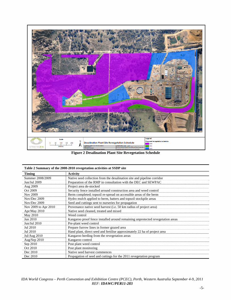
Figure 2 Desalination Plant Site Revegetation Schedule
Table 2 Summary of the 2008-2010 revegetation activities at SSDP site
Timing Activity Summer 2008/2009 Native seed collection from the desalination site and pipeline corridor Jun/Jul 2009 Preparation of the RMP in consultation with the DEC and SEWPAC Aug 2009 Project area de-stocked Oct 2009 Security fence installed around construction area and weed control Nov 2009 Berm completed; topsoil re-spread on accessible areas of the berm Nov/Dec 2009 Hydro mulch applied to berm, batters and topsoil stockpile areas Nov/Dec 2009 Seed and cuttings sent to nurseries for propagation Nov 2009 to Apr 2010 Provenance native seed harvest (i.e. 50 km radius of project area) Apr/May 2010 Native seed cleaned, treated and mixed May 2010 Weed control Jun 2010 Kangaroo proof fence installed around remaining unprotected revegetation areas Jun/Jul 2010 Pre-plant weed control Jul 2010 Prepare furrow lines in former grazed area Jul 2010 Hand plant, direct seed and fertilise approximately 22 ha of project area Jul/Aug 2010 Kangaroo herding from the revegetation areas Aug/Sep 2010 Kangaroo control Sep 2010 Post plant weed control Oct 2010 Post plant monitoring Dec 2010 Native seed harvest commences Dec 2010 Propagation of seed and cuttings for the 2011 revegetation program
IDA World Congress – Perth Convention and Exhibition Centre (PCEC), Perth, Western Australia September 4-9, 2011
REF: IDAWC/PER11-283 -6-
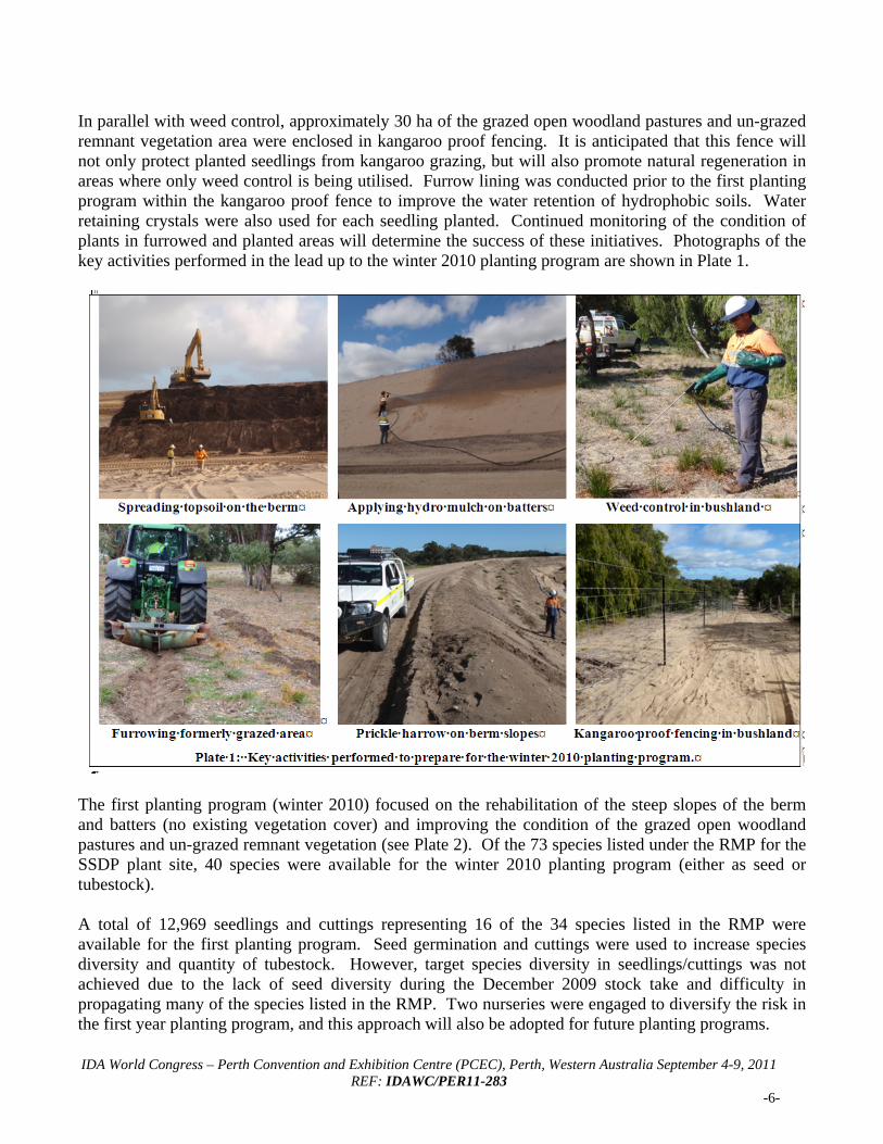
In parallel with weed control, approximately 30 ha of the grazed open woodland pastures and un-grazed remnant vegetation area were enclosed in kangaroo proof fencing. It is anticipated that this fence will not only protect planted seedlings from kangaroo grazing, but will also promote natural regeneration in areas where only weed control is being utilised. Furrow lining was conducted prior to the first planting program within the kangaroo proof fence to improve the water retention of hydrophobic soils. Water retaining crystals were also used for each seedling planted. Continued monitoring of the condition of plants in furrowed and planted areas will determine the success of these initiatives. Photographs of the key activities performed in the lead up to the winter 2010 planting program are shown in Plate 1.
The first planting program (winter 2010) focused on the rehabilitation of the steep slopes of the berm and batters (no existing vegetation cover) and improving the condition of the grazed open woodland pastures and un-grazed remnant vegetation (see Plate 2). Of the 73 species listed under the RMP for the SSDP plant site, 40 species were available for the winter 2010 planting program (either as seed or tubestock). A total of 12,969 seedlings and cuttings representing 16 of the 34 species listed in the RMP were available for the first planting program. Seed germination and cuttings were used to increase species diversity and quantity of tubestock. However, target species diversity in seedlings/cuttings was not achieved due to the lack of seed diversity during the December 2009 stock take and difficulty in propagating many of the species listed in the RMP. Two nurseries were engaged to diversify the risk in the first year planting program, and this approach will also be adopted for future planting programs.
IDA World Congress – Perth Convention and Exhibition Centre (PCEC), Perth, Western Australia September 4-9, 2011
REF: IDAWC/PER11-283 -7-
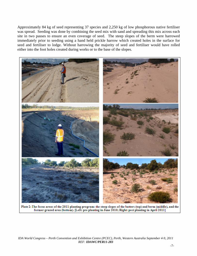
Approximately 84 kg of seed representing 37 species and 2,250 kg of low phosphorous native fertiliser was spread. Seeding was done by combining the seed mix with sand and spreading this mix across each site in two passes to ensure an even coverage of seed. The steep slopes of the berm were harrowed immediately prior to seeding using a hand held prickle harrow which created holes in the surface for seed and fertiliser to lodge. Without harrowing the majority of seed and fertiliser would have rolled either into the foot holes created during works or to the base of the slopes.
IDA World Congress – Perth Convention and Exhibition Centre (PCEC), Perth, Western Australia September 4-9, 2011
REF: IDAWC/PER11-283 -8-
III. COMPLETION CRITERIA The target completion criteria are specified in Table 3. The completion criteria for seedlings pertain to overall survival of the original number of seedlings planted in a quadrat in a particular Management Zone, irrespective of whether they are original or replacement seedlings. To meet these completion criteria, seedlings that are replaced would be maintained for a further two years to meet the overall completion criteria. Plant density, diversity and coverage criteria include both plants germinated from seed as well as planted seedlings.
Table 3 Target completion criteria for revegetation program Year after planting Basis 1 2 3 5 Survival of planted seedlings since last planting (%) Quadrat 95 90 90 75 Plant density (stems/m2) (min) Quadrat 10 10 9 8 Plant diversity (% of original number of species in FCT) (min) Quadrat 40 50 70 70 Plant diversity (% of original number of species in Project Area) (min) Overall 40 50 70 70 Plant coverage (% area visual ground cover) (min) Quadrat 5 10 25 50 Weeds (number of dominant species) (max) Overall 5 4 3 3 Weed coverage (% area visual ground cover) (max) Quadrat 10 5 2 2 Weed reduction (% reduction in ground coverage from original) (min) Overall average 60 60 60 90
IV. MONITORING METHODOLOGY Monitoring is conducted by a revegetation consultant annually in spring to determine compliance with the completion criteria (see Section III). The first formal monitoring period was performed in October 2010 to determine the success of the winter 2010 planting campaign. A total of forty two (42) 10 x 10 m (or 5 m x 20 m) monitoring quadrat sites were identified for the project area in accordance with the RMP. Of those, thirty three (33) quadrats were established in 2010 to monitor areas planted during the first planting program. The remaining quadrats will be established for subsequent planting programs. Quadrats have been located to sample representative vegetation types and landform in each management zone, and have been marked using a fence dropper and recorded using a GPS. A total of five 1 m2 plots are established within each monitoring quadrat to measure plant species diversity, recruitment numbers and weeds. Baseline assessments commenced in 2010 to allow future assessment of completion criteria. Baseline assessments for Management Zones undergoing planting in 2010 were undertaken in June 2010 prior to planting. Baseline assessments for all other Management Zones were assessed in October 2010. In addition to formal spring monitoring, informal monitoring is conducted by onsite environmental personnel on an ongoing basis to determine if any contingency measures are required (e.g. fencing repairs, erosion control, irrigation). V. MONITORING RESULTS 5.1 Survival of seedlings planted 2010 Twenty four (24) planted seedlings were recorded within the quadrats, of which 23 have survived (or 96%). The revegetation program is currently meeting the target completion criteria of 95% for one year
IDA World Congress – Perth Convention and Exhibition Centre (PCEC), Perth, Western Australia September 4-9, 2011
REF: IDAWC/PER11-283 -9-
post planting. In addition, the survivorship to date exceeds the 90% survivorship target required by SEWPAC approval 2008/4173. 5.2 Plant density In October 2010, the average native plant density in revegetated areas (MZ1, MZ2, MZ5, MZ8 and MZ12) ranged from 1.0 to 4.3 stems/m2 (Table 4). The average native plant density in other areas (MZ3, MZ4, MZ7, MZ9, MZ11 and MZ13) ranged from 6.0 to 9.3 stems/m2. Plant density across the site is unlikely to meet the target completion criteria of 10 stems/m2 for one year post planting.
Table 4 Native plant density data (October 2010)
Management zone 1 2 3 4 5 6 7 8 9 10 11 12 13
FCT type (30b Eg)
(30b Eg)
(30b Eg)
(30b Eg)
(30b Eg)
(30b Eg) (30 Af) (24) (24) (24) (29A) (29A) (29A)
Revegetation activity
Revegetated
Revegetated Infill
Weed control
only Revegetat
ed Revegetat
ed
Weed control
and infill Revegetat
ed
Weed control
only Revegeta
ted
Weed control
only Revegetat
ed
Weed control
only
Average stems/m2 (per quadrat) 3.2 4.3 6.4 6.8 1.0 N/A 6.0 1.6 9.3 N/A 6.0 3.9 9.3 Min stems/m2 (per quadrat) 0.4 2.2 4.6 6.8 1.0 N/A 5.4 1.0 9.0 N/A 6.0 1.0 5.4 Max (stems/m2 (per quadrat) 5.8 7.4 8.2 6.8 1.0 N/A 6.5 1.8 10.0 N/A 6.0 7.3 13.5
5.3 Plant diversity The RMP lists 73 dominant species for the project area; however, only 70 of those species had seeds or seedlings available for the first planting program. To date, 43 of the 73 dominant native species (or 59%) have been recorded within the quadrats or in proximity of the quadrats across the overall site. The plant diversity across the project area is likely to meet the target completion criteria of 40% for one year post planting. Six further species (not reported in the RMP) were recorded within the quadrats or in proximity of the quadrats across the project area during the October 2010 monitoring period. The species diversity for each Floristic Community Type (FCT) in October 2010 is shown in Table 3. The plant diversity for each FCT is likely to meet the target completion criteria of 40 % for one year post planting.
Table 5 Plant diversity by FCT (Spring 2010)
FCT 241 29a
2 30b Eg
3 30b-Af
4
RMP – Number of species 27 52 29 32 RMP species recorded inside quadrat 12 23 23 11 Additional RMP species recorded in proximity (i.e. outside) of the quadrats 1 5 2 2 Total 13 28 25 13 % of RMP list 48% 54% 86% 41% Additional species Additional records of species in each FCT (i.e. not recorded in the RMP) 0 4 3 0 Additional records of RMP listed species (i.e. dominant species), but were not listed in the RMP under this FCT 5 3 9 4 Revised total 18 35 37 17
1 FCT 24 - Northern Spearwood shrublands and woodlands/Banksia - Agonis woodlands
2 FCT 29a - Coastal shrublands on shallow sands
3 FCT 30b Eg (Tuart dominated) - Quindalup Eucalyptus gomphocephala or Agonis flexuosa woodlands
4 FCT 30b Af (Peppermint dominated) - Quindalup Eucalyptus gomphocephala or Agonis flexuosa woodlands
IDA World Congress – Perth Convention and Exhibition Centre (PCEC), Perth, Western Australia September 4-9, 2011
REF: IDAWC/PER11-283 -10-
Table 5 Plant diversity by FCT (Spring 2010)
FCT 241 29a
2 30b Eg
3 30b-Af
4
Revised % of RMP list 67% 67% 128% 53% Note: The species diversity records from the baseline assessment are not included as the baseline assessment was undertaken in June 2010
(before most species flowered), consequently, the species diversity is significantly lower than for the spring monitoring period.
5.5 Plant coverage The native plant coverage (% area visual ground cover) for most Management Zones is likely to meet the target completion criteria of 5% for one year post planting. Management Zones MZ 5 and MZ12 did not have topsoil re-spread in 2009 and were completely bare in June 2010 prior to planting (i.e. both had baseline values of 0% native plant coverage). The October 2010 monitoring showed a small increase in plant coverage to 1.2% (MZ5) and 2.4% (MZ12) for these Management Zones. The species coverage for each management zone is shown in Figure 3.
Note: Only baseline (June 2010) data was recorded for MZ1, MZ2, MZ5, MZ8 and MZ12. MZ6 and MZ10 were not revegetated in 2010.
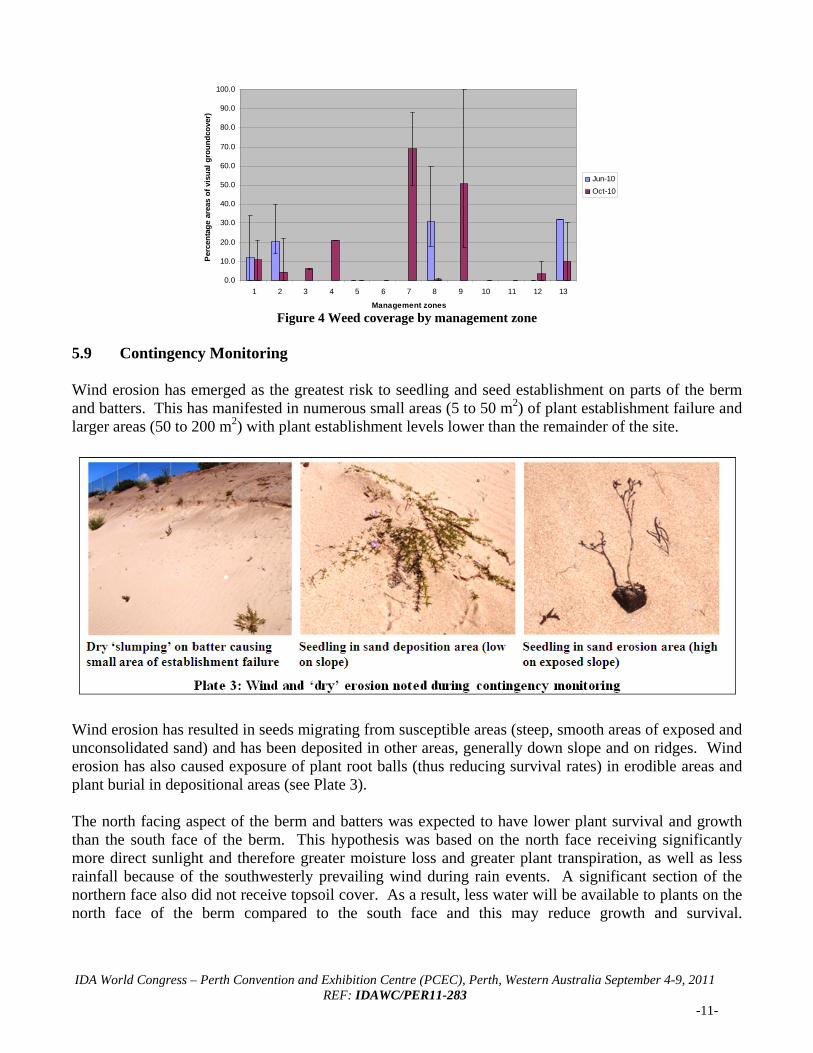
Figure 3 Native plant coverage by management zone 5.6 Weeds To date six dominant weeds have been recorded across the site. Currently the revegetation program is likely to meet the 2011 target completion criteria of five (5) dominant weeds one year post planting due to the effectiveness of the weed control program. Three declared weeds (Solanum linnaeanum (Apple of Sodom); Gomphocarpus fruiticosus (Cotton bush); Zantedeschia aethiopica (Arum lily)) are also known on the site and these were targeted during the 2009 and 2010 weed control program. The weed coverage for each Management Zone is shown in Figure 4. Weed coverage has decreased from June 2010 to October 2010 in Management Zones MZ 1, MZ2, and MZ8 (which were revegetated in 2010). Management zones MZ5 and MZ12 have shown little or no change in weed coverage due to having a low weed profile. These areas were formed by scraping and removal of topsoil from the old dunal landform. In addition these areas have had little or no topsoil re-spread over these zones. The baseline assessment (in October 2010) for Management Zones undergoing only weed control (e.g. MZ4, MZ7 and MZ9) have weed coverage greater than 20%. The weed coverage baseline assessment for MZ11 was not recorded (human error). Several of the Management Zones are unlikely to meet the target completion criteria for weed coverage of 10% by one year after planting.
0.0
10.0
20.0
30.0
40.0
50.0
60.0
70.0
80.0
90.0
100.0
1 2 3 4 5 6 7 8 9 10 11 12 13
Management Zone
Per
cen
tag
e n
ativ
e co
vera
ge
Jun-10
Oct-10
IDA World Congress – Perth Convention and Exhibition Centre (PCEC), Perth, Western Australia September 4-9, 2011
REF: IDAWC/PER11-283 -11-
Figure 4 Weed coverage by management zone
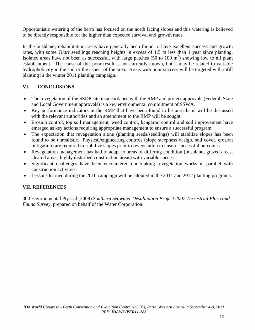
5.9 Contingency Monitoring Wind erosion has emerged as the greatest risk to seedling and seed establishment on parts of the berm and batters. This has manifested in numerous small areas (5 to 50 m2) of plant establishment failure and larger areas (50 to 200 m2) with plant establishment levels lower than the remainder of the site.
Wind erosion has resulted in seeds migrating from susceptible areas (steep, smooth areas of exposed and unconsolidated sand) and has been deposited in other areas, generally down slope and on ridges. Wind erosion has also caused exposure of plant root balls (thus reducing survival rates) in erodible areas and plant burial in depositional areas (see Plate 3). The north facing aspect of the berm and batters was expected to have lower plant survival and growth than the south face of the berm. This hypothesis was based on the north face receiving significantly more direct sunlight and therefore greater moisture loss and greater plant transpiration, as well as less rainfall because of the southwesterly prevailing wind during rain events. A significant section of the northern face also did not receive topsoil cover. As a result, less water will be available to plants on the north face of the berm compared to the south face and this may reduce growth and survival.
0.0
10.0
20.0
30.0
40.0
50.0
60.0
70.0
80.0
90.0
100.0
1 2 3 4 5 6 7 8 9 10 11 12 13
Management zones
Per
cen
tag
e ar
eas
of
visu
al g
rou
nd
cove
r)
Jun-10
Oct-10
IDA World Congress – Perth Convention and Exhibition Centre (PCEC), Perth, Western Australia September 4-9, 2011
REF: IDAWC/PER11-283 -12-
Opportunistic watering of the berm has focused on the north facing slopes and this watering is believed to be directly responsible for the higher than expected survival and growth rates. In the bushland, rehabilitation areas have generally been found to have excellent success and growth rates, with some Tuart seedlings reaching heights in excess of 1.5 m less than 1 year since planting. Isolated areas have not been as successful, with large patches (50 to 100 m2) showing low to nil plant establishment. The cause of this poor result is not currently known, but it may be related to variable hydrophobicity in the soil or the aspect of the area. Areas with poor success will be targeted with infill planting in the winter 2011 planting campaign. VI. CONCLUSIONS The revegetation of the SSDP site in accordance with the RMP and project approvals (Federal, State
and Local Government approvals) is a key environmental commitment of SSWA. Key performance indicators in the RMP that have been found to be unrealistic will be discussed
with the relevant authorities and an amendment to the RMP will be sought. Erosion control, top soil management, weed control, kangaroo control and soil improvement have
emerged as key actions requiring appropriate management to ensure a successful program. The expectation that revegetation alone (planting seeds/seedlings) will stabilize slopes has been
found to be unrealistic. Physical/engineering controls (slope steepness design, soil cover, erosion mitigation) are required to stabilize slopes prior to revegetation to ensure successful outcomes.
Revegetation management has had to adapt to areas of differing condition (bushland, grazed areas, cleared areas, highly disturbed construction areas) with variable success.
Significant challenges have been encountered undertaking revegetation works in parallel with construction activities.
Lessons learned during the 2010 campaign will be adopted in the 2011 and 2012 planting programs. VII. REFERENCES 360 Environmental Pty Ltd (2008) Southern Seawater Desalination Project 2007 Terrestrial Flora and Fauna Survey, prepared on behalf of the Water Corporation.


![[MS-SSDP]: SSDP: Networked Home Entertainment …...The SSDP: Networked Home Entertainment Devices (NHED) Extensions are a set of extensions to the Simple Service Discovery Protocol](https://img.pdfslide.us/doc/110x75/5ed994301b54311e7967d370/ms-ssdp-ssdp-networked-home-entertainment-the-ssdp-networked-home-entertainment.jpg)