Embed Size (px)
Citation preview
������������������������� ���
���������
������������� ��������������������
������������
������������������� �������������������������
����������������������������� ����

Table Of Contents iii
����������������
ACKNOWLEDGMENTS ..........................................................................................................vii
INTRODUCTION......................................................................................................................... 1
What Are “Native” Species? .................................................................................................................................... 1Objective and Scope of this Guide........................................................................................................................... 3Before You Begin .................................................................................................................................................... 4How To Use This Guide........................................................................................................................................... 5Plant Names ............................................................................................................................................................. 6
PLANT BASICS............................................................................................................................ 7
Life Cycles ............................................................................................................................................................... 8Growth Forms .......................................................................................................................................................... 8Reproductive Strategies............................................................................................................................................ 9Seasonal Growth ...................................................................................................................................................... 9
NATURAL COMMUNITIES .................................................................................................... 11
FLORISTIC REGIONS OF COLORADO .............................................................................. 13
PART I: UPLAND COMMUNITIES ..................................................................................... 15
EASTERN PLAINS AND FOOTHILLS REGION................................................................. 15
GRASSLANDS...............................................................................................................................................17Short-grass Prairie.................................................................................................................................................. 18Mid-grass Prairie.................................................................................................................................................... 20Tall-grass Prairie .................................................................................................................................................... 21Foothills Grassland................................................................................................................................................. 22
SHRUBLANDS...............................................................................................................................................23Saline Bottomland Shrublands ............................................................................................................................... 24Sand Sagebrush Prairie........................................................................................................................................... 25Mixed Foothills Shrubland..................................................................................................................................... 27
WOODLANDS...............................................................................................................................................28Piñon Pine-Juniper Woodlands .............................................................................................................................. 29Ponderosa Pine woodland and Savanna ................................................................................................................. 31
ROCKY MOUNTAIN REGION............................................................................................... 33
GRASSLANDS...............................................................................................................................................35Montane and Subalpine Grasslands ....................................................................................................................... 36
SHRUBLANDS...............................................................................................................................................38Sagebrush Shrublands ............................................................................................................................................ 39
WOODLANDS...............................................................................................................................................42FORESTS......................................................................................................................................................44
Douglas-fir Forests................................................................................................................................................. 45Lodgepole Pine Forests .......................................................................................................................................... 47Aspen Forests......................................................................................................................................................... 48Engelmann Spruce - Subalpine Fir Forests ............................................................................................................ 49
ALPINE TUNDRA..........................................................................................................................................50Alpine Meadows .................................................................................................................................................... 51
Table Of Contents iv
WESTERN PLATEAU AND CANYON REGION ................................................................. 53
GRASSLANDS...............................................................................................................................................55SHRUBLANDS...............................................................................................................................................57
Mat Saltbush Shrublands........................................................................................................................................ 58Saline Bottomland Shrublands ............................................................................................................................... 58Sagebrush Shrublands ............................................................................................................................................ 60Mixed Mountain Shrubland ................................................................................................................................... 62
WOODLANDS...............................................................................................................................................63Piñon Pine-Juniper Woodland................................................................................................................................ 64Pine Woodlands ..................................................................................................................................................... 65
REVEGETATION TECHNIQUES........................................................................................... 67
STEP 1: PLANNING YOUR PROJECT.............................................................................................................67STEP 2: SOIL CHARACTERIZATION.............................................................................................................69
Soil Texture............................................................................................................................................................ 69Soil Chemistry........................................................................................................................................................ 72Soil Structure.......................................................................................................................................................... 73
STEP 3: SITE PREPARATION........................................................................................................................75Topsoil Salvage...................................................................................................................................................... 75Development of Substitute Soil.............................................................................................................................. 76Seedbed Preparation............................................................................................................................................... 77Soil Amendments ................................................................................................................................................... 78
STEP 4: SEEDING AND PLANTING ...............................................................................................................81SEEDING..................................................................................................................................................81
Collecting Seed.................................................................................................................................................. 82Purchasing Seed ................................................................................................................................................ 83Testing Seed ...................................................................................................................................................... 87Seeding Techniques........................................................................................................................................... 89Post Seeding Techniques................................................................................................................................... 91
PLANTING ................................................................................................................................................95Plant Materials................................................................................................................................................... 95Planting Techniques ........................................................................................................................................ 100
STEP 5: MONITORING & STEWARDSHIP...................................................................................................103MONITORING.............................................................................................................................................103
Potential Problems ............................................................................................................................................... 103Techniques and Frequency................................................................................................................................... 104Assessment of Problems and Stewardship Activities........................................................................................... 104
STEWARDSHIP............................................................................................................................................105Developing a Stewardship Plan............................................................................................................................ 105Techniques ........................................................................................................................................................... 105
WEED MANAGEMENT ......................................................................................................... 107
INTEGRATED WEED MANAGEMENT..........................................................................................................107PREVENTION..............................................................................................................................................108ERADICATION ............................................................................................................................................109CONTROL...................................................................................................................................................109
Biological Control................................................................................................................................................ 109Chemical Control ................................................................................................................................................. 110Cultural Control ................................................................................................................................................... 110Mechanical Control .............................................................................................................................................. 110
PART II: WETLAND & RIPARIAN HABITATS................................................................ 111
INTRODUCTION..................................................................................................................... 111
HOW TO USE THIS SECTION......................................................................................................................111WETLAND AND RIPARIAN DEFINED..........................................................................................................113
Table Of Contents v
Wetland ................................................................................................................................................................ 113Riparian................................................................................................................................................................ 113
FUNCTIONS OF WETLANDS AND RIPARIAN COMMUNITIES.......................................................................114IMPORTANT POLICIES AND REGULATIONS................................................................................................115
Federal.................................................................................................................................................................. 115State...................................................................................................................................................................... 115County & Local.................................................................................................................................................... 116
WETLAND DELINEATION...........................................................................................................................116Diagnostic Characteristics of Wetlands ............................................................................................................... 117Technical Approach: Delineation of Wetlands .................................................................................................... 118
WETLAND AND RIPARIAN COMMUNITIES IN COLORADO..................................... 119
EASTERN PLAINS AND FOOTHILLS REGION............................................................... 121
WETLANDS................................................................................................................................................121Marshes ................................................................................................................................................................ 121Playas ................................................................................................................................................................... 122Meadows .............................................................................................................................................................. 123
RIPARIAN COMMUNITIES...........................................................................................................................126Cottonwood/Willow Shrublands and Forests....................................................................................................... 126
ROCKY MOUNTAIN REGION............................................................................................. 130
WETLANDS................................................................................................................................................130Marshes ................................................................................................................................................................ 131Playas ................................................................................................................................................................... 131Meadows .............................................................................................................................................................. 133Fens ...................................................................................................................................................................... 135
RIPARIAN COMMUNITIES...........................................................................................................................139Willow Carrs ........................................................................................................................................................ 140Riparian Forests ................................................................................................................................................... 142Alpine Riparian Communities.............................................................................................................................. 144
WESTERN PLATEAU AND CANYON REGION ............................................................... 145
WETLANDS................................................................................................................................................145Marshes ................................................................................................................................................................ 145Meadows .............................................................................................................................................................. 147
RIPARIAN COMMUNITIES...........................................................................................................................150Cottonwood/Willow Forests ................................................................................................................................ 150
WETLAND REVEGETATION TECHNIQUES................................................................... 153
STEP 1: PLANNING YOUR PROJECT..........................................................................................................154STEP 2: SITE SELECTION...........................................................................................................................155
Site Assessment Considerations........................................................................................................................... 155STEP 3: DEVELOPING A SITE SPECIFIC PLAN ...........................................................................................159
Setting Your Goals: Creation, Restoration or Enhancement ................................................................................ 159The Conceptual Wetland Plan.............................................................................................................................. 160Final Wetland Construction Plans........................................................................................................................ 162
STEP 4: SEEDING AND PLANTING .............................................................................................................173Wetland and Riparian Seeding............................................................................................................................. 173General Considerations for Planting .................................................................................................................... 174Plant Materials and Techniques ........................................................................................................................... 174Acceptability of Plant Materials........................................................................................................................... 183Comparison of Plant Materials............................................................................................................................. 183Field Collection of Plant Materials ...................................................................................................................... 184Fertilizer and Other Soil Amendments................................................................................................................. 187
STEP 5: MONITORING AND STEWARDSHIP................................................................................................187
REFERENCES AND SUGGESTED READING................................................................... 189

Table Of Contents vi
APPENDIX I: UPLAND PLANT CHARACTERISTICS .................................................... 197
GRAMINOIDS .............................................................................................................................................197FORBS........................................................................................................................................................205TREES AND SHRUBS...................................................................................................................................213
APPENDIX II: CHARACTERISTICS OF WETLAND & RIPARIAN SPECIES........... 223
APPENDIX III: WEED LISTS................................................................................................ 227
COLORADO PROHIBITED NOXIOUS WEED SEEDS......................................................................................227COLORADO RESTRICTED NOXIOUS WEED SEEDS.....................................................................................228PLANTS TO AVOID .....................................................................................................................................229
APPENDIX IV: MANAGING COMMON AND AGGRESSIVE WEEDS ........................ 235
FORBS........................................................................................................................................................235GRASSES....................................................................................................................................................239TREES/SHRUBS..........................................................................................................................................239
APPENDIX V: REGIONAL VENDORS OF PLANT MATERIALS ................................. 241
APPENDIX VI: EROSION CONTROL PRODUCTS AND SUPPLIERS ......................... 253
APPENDIX VII: FEDERAL AGENCY CONTACTS .......................................................... 255
APPENDIX VIII: INDEX OF PLANT LISTS AND TABLES............................................ 257
UPLAND PLANT FINDERS...........................................................................................................................257WETLAND & RIPARIAN PLANT FINDERS...................................................................................................257OTHER TABLES..........................................................................................................................................258
Acknowledgments vii
����� ���!����This guide is the result of several years work by a large number of dedicated natural resourceprofessionals. These people and the agencies that have supported them in the development of this guiderepresent a variety of approaches to the protection of natural values in Colorado and beyond. TheColorado Natural Areas Program extends its appreciation to all who have contributed to the guide; weappreciate your help.
The Colorado Natural Areas Program would like to specifically acknowledge the following contributors,and to apologize in advance if any have been inadvertently omitted.
Rex A. Seiple and Dina Clark laid the groundwork for this document by soliciting input and staffingworkshops. They assembled the preliminary drafts of the guide. Rex Seiple deserves special credit forpulling together many, many comments and writing the first drafts. Subsequent work was provided bystaff of the Colorado Natural Areas Program: Kathy Carsey, Janet Coles, Karin Decker, and MarkGershman.
The document has undergone rigorous review, however some errors may have gone undetected. TheColorado Natural Areas Program assumes responsibility for these (but please let us know so that we cancorrect future editions).
Base funding for the development of this guide was provided by:
Funding for publication and distribution was provided by:
The National Fish and Wildlife FoundationThe United States Bureau of Land Management
Truax Company, Inc., Minneapolis, MinnesotaColorado State Forest Service, Fort Collins, ColoradoSharp Brothers Seed Company, Inc., Greeley, ColoradoJames Trammell, Littleton, ColoradoDr. Ruth L. Willey, Gunnison, Colorado
This guide is dedicated to Jim Von Loh. Jim conceived of this guide while he was the Director ofthe Colorado Natural Areas Program. We wish to recognize and thank Jim for:
• his vision about the importance and usefulness of this guide• his technical knowledge firmly based in experience throughout the state,• his competence which provided leadership for the project's many cooperators, and• his willingness to place an emphasis on the use of native plants in revegetation projects.
The views and conclusions contained in this document are those of the authors and should not be interpretedas representing the opinions or policies of the U.S. Government. Mention of trade names or commercial
products does not constitute their endorsement by the U.S. Government or the State of Colorado.
The Colorado NaturalAreas Program

Acknowledgments viii
We would like to thank the following contributing writers who invested many hours of their valuable timepreparing sections of the guide.
David Buckner ESCO Associates, Inc.1077 South Cherryvale Rd.Boulder, CO 80303
Claire DeLeo Boulder County Parks and Open SpaceP.O. Box 471Boulder, CO 80306
Grant Gurneé Aquatic and Wetland Company1830 17th Street, Suite 100Boulder, CO 80302
Cathy Halm Colorado Department of Transportation4201 E. Arkansas Ave.Denver, CO 80222
Don Hijar Pawnee Buttes Seed Inc.P.O. Box 1604605 25th StreetGreeley, CO 80632
Eric Lane Colorado State Dept. of AgricultureDivision of Plant Industry700 Kipling St., Suite 4000Lakewood, CO 80215-5894
Denise Larson ERO Resources1846 ClarksonDenver, CO 80218
Randy Mandel Rocky Mountain Native Plants Co.3780 Silt Mesa RoadRifle, CO 81650970-625-3276 [email protected]
Cindy Owsley Boulder County Weed DistrictP.O. Box 471Boulder, CO 80306
Ed Spence
Jim Von Loh
Acknowledgments ix
Thanks also to all those who contributed by attending meetings, participating in working groups,reviewing and editing draft editions of this document, or providing any of the other types of informationand support we have received. Your input was greatly appreciated, thank you.
Gay Austin USDA Forest Service216 N. IowaGunnison, CO 81230
Roy Bell City of Boulder Open Space66 South Cherryvale Rd.Boulder, CO 80303
Richard Brune Botanical Consultant2060 GarlandLakewood, CO 80215-1630
Bob Carlson Colorado State Parks361-32 RoadClifton, CO 81520
Anita Culp US Army Corps of EngineersSouthern Colorado Project Office720 N. Main St., Rm. 205Pueblo, CO 81003-3046
Carol Dawson Denver Botanic Gardens909 York St.Denver, CO 80206
Lois Dworshak Upper Colorado Environmental Plant CenterP.O. Box 448Meeker, CO 81641
Jill Easley Colorado Department of Transportation4201 E. ArkansasDenver, CO 80222
Barbara Fahey CSU Cooperative ExtensionJefferson County Extension Office15200 West 6th AvenueGolden, CO 80401-5018
Deborah B. Keammerer Keammerer Ecological Consultants, Inc.5858 Woodbourne Hollow Rd.Boulder, CO 80301
Andy Kratz USDA-FS-Region 2P.O. Box 25127Lakewood, CO 80225
Jim Lance Colorado Department of Transportation222 S. 6th St., Room 317Grand Junction, CO 81502
Ivo Lindauer University of Northern ColoradoBiology DepartmentGreeley, CO 80639

Acknowledgments x
Jan McKee USDI-FWSP.O. Box 25486 - Denver Federal CenterDenver, CO 80225-0207
Randy Moench Colorado State Forest ServiceCSU - Foothills CampusBuilding 1060Fort Collins, CO 80523
Tamara Naumann Dinosaur National Monument4545 Highway 40Dinosaur, CO 81610
John Oram Colorado Forestry Association5130 Meade St.Denver, CO 80221-1036
Terry Ruiter Gannett Fleming, Inc.999 18th Street, Suite 2520Denver, CO 80202
Susan Spackman Colorado Natural Heritage Program254 General Services BuildingFort Collins, CO 80523
Carol Spurrier USDI-BLM2850 Youngfield St.Lakewood, CO 80215
Susan Trumble Roxborough State Park4751 N. Roxborough Dr.Littleton, CO 80125
Dave Weber CDOW - North Region6060 BroadwayDenver, CO 80216
Finally, the Colorado Natural Areas Program would like to acknowledge the following individuals fortheir special contributions to this guide:
Ben Berlinger Mary PowellJim Borland Neil SperandeoCasey Davenhill Harvey SprockGary Finstad Lisa TaskerAlice Guthrie Jeff WoodsCharlie Holcomb
Introduction 1
����� �����
Every day portions of Colorado's landscape are disturbed as roads and trails are constructed,trenches for utility lines are excavated, and fields are plowed or graded in anticipation of a newcrop or new building. Natural disturbances occur too, including flood, fire, wind erosion,avalanches and landslides. Eventually most of these disturbances will be revegetated. But withwhat and when? Without special effort, it may be decades before plants become established. Inother areas soil loss may occur before any plants can successfully colonize the disturbance,further lowering the chance for revegetation—even in the long term. In more moderate climates,and on sites with better soils, plants may begin to grow as soon as the disturbance ends—butthese may not be native species. Some will be noxious weeds, which will use the disturbed zoneas a staging area to spread into adjacent healthy landscapes where they will be difficult tocontrol. Others may be well-adapted to grow in barren landscapes, but will not persist.
For decades, land management agencies have been developing reclamation plans for reseedingand replanting disturbances. The historic focus was on providing vegetation to stabilize erodingareas and to heal unsightly scars on the landscape. Many of the plants used historically werereadily available, inexpensive, fast growing, and aggressive agronomic species—just the strategyfor quick and effective revegetation. However most were not native species. In recent yearsmore agencies and landowners have become interested in propagating attractive and diverseplant communities by using native species for revegetation projects. This guide is intended toassist them in successfully planning and implementing such projects.
"������#������$��������%
When settlers first made their way to Colorado in the early 1800’s, they brought with them seedsof plants from all over the world. Some were seeds planted in the Old World for food crops,windbreaks, landscaping, erosion control, and livestock forage. Many other seeds arrivedaccidentally, mixed with crop seeds, animal feed, or even in the ballast of ships. These camewestward with shipments of agricultural goods, or they were dispersed along irrigation ditches,railroad tracks, wagon roads, and cattle trails. Today, either by accident or design, theintroduction of nonnative plants to Colorado continues. Because of past and present humanactivities, Colorado’s landscape is replete with “nonnative” species.
But what is a native plant? The contributors and reviewers of this guide spent a great deal oftime wrestling with this question. In the end, it was easiest to start by defining which plants werenonnative. Although there are other perspectives, the group decided to use the definition fromColorado's Weed Management Act. The act defines a nonnative plant species as:
“. . . a plant species which is not indigenous to the state of Colorado, nor to the native plantcommunity in which it is found.” Title 35, Colorado Revised Statutes: Colorado WeedManagement Act.
This latter definition will be used in this guide. Conversely, a native species is defined as: “Aplant species which is indigenous to the state of Colorado, or to the natural plant community inwhich it is found.”

Introduction 2
"&��"� �� ����������������� ���"�������������������������������������%
Many, but not all, nonnative plants spread rapidly and outcompete native species for water, lightand soil nutrients. Native plant species have evolved with local herbivores and diseases thatregulate population numbers. In contrast, nonnative species frequently have no local predatorsacting to keep population sizes in check. Many nonnative agronomic species were bred in theOld World for rapid growth, prolific reproduction, and ability to tolerate both disease and a widerange of soil, moisture, and light conditions. Nonnative weeds have often had several thousandyears evolution in the presence of human disturbances, resulting in enhanced growth,reproduction, and environmental tolerance, similar to what was purposedly bred into agronomicspecies of the Old World. While these characteristics are valuable for agricultural crops, theyenable nonnative species to become aggressive invaders of native ecosystems. If leftuncontrolled, these species often form extensive single-species stands where once there werediverse and productive native communities.
Nonnative species cover bare ground with dense greenery and sometimes with showy flowers,but may provide little in the way of habitat values or plant community diversity and structure.For example, a marsh full of purple loosestrife in bloom makes a beautiful impression from adistance. However, closer observation will reveal a lack of other plant species and a dearth ofanimal life. The same observation can be made about areas where knapweeds, thistles, leafyspurge and other nonnative plants have become established.
Plants such as knapweed and leafy spurge release toxins into the soil which inhibit thegermination of native species. In addition, many nonnative species are not palatable to mostNorth American animals. Such characteristics enable nonnative plant species to establish largemonotypic stands that deplete the soil moisture and shade the ground, eliminating chances thatnative plants will germinate and grow.
"� ����������������������������&%
The impacts from infestations of aggressive nonnative plants are widespread and far reaching:
� Land infested by nonnative plants has low value for hunting, photography, or wildlifewatching (Cook, 1991).
� Waterfowl habitat across North America has badly deteriorated due to purple loosestrifeinfestation. The dense stands reduce biotic diversity in wetlands by replacing native plantspecies, thereby eliminating the natural foods and cover essential to wetland wildlife(Malecki et al. 1993).
� Although planting Russian-olive as wildlife habitat has been encouraged for many years bypublic land managers, its presence actually degrades wildlife habitat. Studies reveal that this
The terms alien, nonnative, exotic, and adventive are all expressions used to describeplants that have been introduced to Colorado. To keep things simple, this guide uses“nonnative” throughout.

Introduction 3
species displaces native cottonwoods. The displacement of native trees has caused more thana 30 percent decline in nesting bird species (USFWS 1989). Furthermore, the small limbsand hard wood of Russian-olive are not appealing to cavity-nesters, and the trees do notsupport the insects that many birds require for food (Cook 1991).
��������!�����������!���������������������������
Approximately 3.7 million acres (1.5 million hectares) of range and pasture land in the westernUnited States are infested with knapweeds and leafy spurge infests over 2.5 million acres (1million hectares) in North America (Steele 1991). Most domestic or wild animals cannot eatthese species and knapweed is actually toxic to horses. In Montana and Wyoming, some areasare so completely covered with knapweed that the land has been abandoned and taken off taxrolls (Steele 1991). In North Dakota, mortgage companies will not lend on agricultural propertyinfested with leafy spurge (Cook 1991).
In Colorado, leafy spurge has become thoroughly established in Larimer, Weld and Douglascounties, and is moving southward. Weed scientists predict that leafy spurge will soon be adominant upland and lowland plant throughout the northern foothills and plains. The damagecaused by nonnative plants includes degraded wildlife habitat, devalued crop and rangeland,injured or dead livestock, decreased water quality, lost tax revenue, diminished recreationalexperiences and the loss of irreplaceable native ecosystems.
The State of Colorado has recognized that nonnative species pose threats to natural landscapesand the economy. Title 35, Colorado Weed Management Act contends that it is the “duty of allpersons to . . . manage undesirable plants . . .” and mandates that counties and municipalitiesadopt “undesirable plant management plans”. This act further declares that the managementplans apply to both state and privately owned lands.
�������!����������������'
One way to combat the problem of invasive nonnative species is to use native plants forlandscaping, revegetation, and reclamation. Using native plants for these projects decreases theintroduction of nonnative plants into Colorado and maintains the integrity of native communities.Because they are adapted to the region, native plants often require less labor and expense tomaintain once established. Native plants also provide many other benefits, including wildlifehabitat, opportunities for environmental education, and a greater variety of scenery. TheColorado Native Plant Society Education Committee (1991) encourages the use of native species“both because of their adaptability and because we like the idea of Colorado looking likeColorado with a unique regional horticulture which sets us apart from other parts of the country”.Colorado has a profusion of beautiful native grasses, wildflowers, shrubs, and trees which can beused for all planting purposes.
��(���������������������"���� ���
This guide provides information on how to select, plant and maintain Colorado native plantspecies for a wide range of landscaping, revegetation and reclamation needs. It includesinformation on important ecological considerations for the variety of Colorado landscape typesand natural communities in both upland and wetland habitats. Instructions for the design,planning, execution, and maintenance of revegetation projects are also presented. In addition tothe information provided in the text, additional resources are provided in the appendices. Other

Introduction 4
useful references and resources, including federal and state agencies, are dispersed throughoutthe document.
This guide does not contain suggestions for every possible revegetation situation or suggest a usefor every plant species native to Colorado (there are more than 2500!). The emphasis instead ison providing a basic understanding of the range of natural communities in Colorado and theprocesses involved in establishing native species in those communities. Knowledge of thissubject will continue to increase over time through implementation of these strategies andcontinued experimentation. It is our hope that this guide serves as a good place to begin and thatupdated editions result from the perfection of these or other techniques.
�&!���� ��������"���� ���
� Used to identify important components of a definition, technique, or other topic.
➲ Warning! This symbol indicates common pitfalls or disadvantages of a restorationtechnique.
������&� ������
This guide is intended to serve as a resource for choosing native tree, shrub, forb and grassspecies for reclamation, revegetation and landscape projects. However, your best referenceguide is the local landscape. The landscape can tell you which native species occur, how theyare distributed, what soils they prefer, and what conditions they can tolerate. The local landscapealso provides an important potential source of seed for revegetation projects.
There are several ways local resources can be used for revegetation projects. One is to salvage thevegetation that was on the site before the onset of the disturbance. If you know in advance that aproject is going to disturb the landscape and will require revegetation after its completion, trypreserving some of the existing plants and seeds so they can be used in the revegetation process.For instance, while a pipeline trench is being excavated, blocks of the existing native sod can beremoved and set aside to be replanted after the work is complete. If the native sod cannot bepreserved for later use, it may be helpful to spread the topsoil that contains root systems and seedson the area.
Another way to use existing local resources for revegetation projects is to use seed from nativeplants that occur near the reclamation site. (See collecting guidelines on page 82). Seeds can becollected by hand from plants near the area to be revegetated. This method requires someplanning in terms of allowing time for seed collection, but it offers many benefits, including:
� Germination success and plant hardiness may be increased because the seed source is local,and therefore, well-adapted to local environmental conditions.
� This type of project promotes community service and “hands-on” involvement of the publicin resource conservation issues.
� This method of seed acquisition is relatively inexpensive, requiring only the time needed forvolunteer organization, seed collecting, and soil preparation.
� This method preserves local native gene pools and ecotypes.
Introduction 5
�����)*
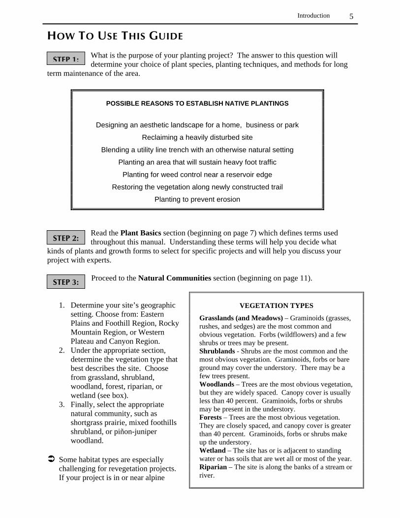
"� ���� ����"���� ���
What is the purpose of your planting project? The answer to this question willdetermine your choice of plant species, planting techniques, and methods for long
term maintenance of the area.
Read the Plant Basics section (beginning on page 7) which defines terms usedthroughout this manual. Understanding these terms will help you decide what
kinds of plants and growth forms to select for specific projects and will help you discuss yourproject with experts.
Proceed to the Natural Communities section (beginning on page 11).
1. Determine your site’s geographicsetting. Choose from: EasternPlains and Foothill Region, RockyMountain Region, or WesternPlateau and Canyon Region.
2. Under the appropriate section,determine the vegetation type thatbest describes the site. Choosefrom grassland, shrubland,woodland, forest, riparian, orwetland (see box).
3. Finally, select the appropriatenatural community, such asshortgrass prairie, mixed foothillsshrubland, or piñon-juniperwoodland.
� Some habitat types are especiallychallenging for revegetation projects.If your project is in or near alpine
POSSIBLE REASONS TO ESTABLISH NATIVE PLANTINGS
Designing an aesthetic landscape for a home, business or park
Reclaiming a heavily disturbed site
Blending a utility line trench with an otherwise natural setting
Planting an area that will sustain heavy foot traffic
Planting for weed control near a reservoir edge
Restoring the vegetation along newly constructed trail
Planting to prevent erosion
VEGETATION TYPES
Grasslands (and Meadows) – Graminoids (grasses,rushes, and sedges) are the most common andobvious vegetation. Forbs (wildflowers) and a fewshrubs or trees may be present.Shrublands - Shrubs are the most common and themost obvious vegetation. Graminoids, forbs or bareground may cover the understory. There may be afew trees present.Woodlands – Trees are the most obvious vegetation,but they are widely spaced. Canopy cover is usuallyless than 40 percent. Graminoids, forbs or shrubsmay be present in the understory.Forests – Trees are the most obvious vegetation.They are closely spaced, and canopy cover is greaterthan 40 percent. Graminoids, forbs or shrubs makeup the understory.Wetland – The site has or is adjacent to standingwater or has soils that are wet all or most of the year.Riparian – The site is along the banks of a stream orriver.
���� �*
�����+*
Introduction 6
tundra or fens read the cautionary notes on pages 50 and 135.� If you are carrying out a project in or near what you believe is a wetland or riparian habitat,
be sure to read the Wetland and Riparian Habitats sections (beginning on page 111).
Choose plant species from the Plant Finder lists located in the NaturalCommunities section (beginning on page 11). Common species are listed for each
natural community under the categories of graminoids, forbs and trees/shrubs, with the mostcommon species in bold print. The Upland Plant Characteristics Tables in Appendix I (page197) will help you determine which species are appropriate for your circumstances. They listcharacteristics for each species such as height, growth form, wildlife value, flower color, andmaturity rate. In addition to using Appendix I, it is always important to look at naturalcommunities of the type you are trying to establish to get an idea of the relative abundanceand arrangement of different species. Some of the plants listed in the Plant Finder may not becommercially available, however, such species can still be used by collecting native seed /plantmaterial or by contracting with a nursery to grow certain plants.
Read the Revegetation Techniques section (beginning on page 81). This sectioncontains detailed information on planning and executing a revegetation project,
including sources of plant material, seeding and planting methods and other advice. Not all ofthis information will be needed for every project. If your project is small (of the “backyard”variety) you will not need to read the entire section in detail. Instead, use the subjectheadings to locate topics of interest and information appropriate to the scale of your project.
�������!��
Common names are generally used in the text to make it easier for the reader, however, for thesake of accuracy, we have included scientific names in tables and lists. Appendix I (page 197)lists common names of major species from the Upland Plant Finder lists.
Some plants have more than one scientific name. This document uses Kartesz (1994) and theKartez-based USDA-NRCS database (1997) as the primary source of scientific nomenclature,and Weber (1996a, 1996b) as the secondary source. Tables in the appendices list both names.
�����,*
�����-*
Plant Basics 7
�����������The Plant Kingdom is extremely diverse. There are well over 200,000 different species of plantsliving today. Taxonomists divide these species into a variety of groups and sub-groups on the basisof shared characteristics. Plants discussed in this guide all belong to the large category of plantswhich reproduce by means of seeds. Plants which do NOT reproduce by seeds include ferns,mosses, and lichens; these plants are not included in this manual.
Two broadly defined groups of seed plants mentioned in this manual are gymnosperms andangiosperms.
Both gymnosperms and angiosperms may be either deciduous or evergreen
Gymnosperms and angiosperms can be further categorized by life cycle, growth form ,reproductive strategy, maturity rate, and other descriptive terms.
Gymnosperms
� Woody plants with needle-like or scale-like (imbricate, overlapping) leaves.� Do not produce flowers.� Have fruits which are cones or berry-like cones. (The blue “berries” on junipers
are really modified cones!)� Includes pines, firs, Douglas-fir, spruces, junipers, and some that do not
resemble the other taxa, e.g., Mormon-tea (Ephedra sp.).
Angiosperms
� Plants that produce flowers.� Include species with obvious flowers such as wild rose and columbine, as
well as those that are not so obvious, like grasses, bulrushes, and sedges.
Deciduous
� Bears leaves only through the growing season, dropping them in the fall.Deciduous plants are bare during the winter.
� Quaking aspen, Rocky Mountain maple, and mountain mahogany are examplesof deciduous plants.
Evergreen
� Bears green leaves throughout the winter.� Pines, junipers, Oregon grape, and kinnikinnick are examples of evergreen
plants.
Plant Basics 8
�����&���
This manual uses only the general life cycle terms annual, biennial and perennial; more detailed andcomplicated descriptions of life cycles may be used by specialists.
Annual plants live for only one growing season. For annual species, the emphasis of growth isplaced on production of seeds. Aboveground growth is rapid because the plant must flower andproduce seed before it dies at the end of the season. As a consequence, annual species can berecognized by their relatively small root systems. Often annual plants are seeded at locations thatneed to be vegetated quickly, such as highly erosive slopes. While annuals grow quickly andprovide cover, they do not provide a long-term solution to the challenge of revegetation.Furthermore, the seed that they produce may be stored in the soil. These plants will continue toappear, competing for nutrients, water and sunlight, long after the area has been planted with speciesthat are more permanent and desirable. Many weeds and crop plants are annuals.
Biennial plants live for two years. During the first year they typically produce rosettes of basalleaves and store energy. They send up flowering stalks the second year, produce seeds and die.Native biennials are relatively uncommon, however, many invasive weeds are biennials, includingmusk thistle, scotch thistle, and some knapweed species.
Perennial plants live for many years. Normally they do not flower or reproduce until they areseveral years old. Perennials can afford to direct more energy to long-term establishment andtypically have more extensive root systems. These species are usually the most desirable fornative plantings.
�� �"���!�
Woody plants do not die back to ground level each winter as forbs, grasses, and grass-like plantsdo. On woody plants, buds are borne above ground level, giving these plants a “head start” to largerstature each spring. Trees and shrubs are woody plants.
Trees are woody perennial plants with a single main stem or trunk and radiating branches on theupper portion of the plant. They usually stand over 13 feet (4 m) tall at maturity.
Shrubs are woody perennials lacking a main stem, instead having several to many branches arisingat ground level. They are usually less than 10 to 13 feet (3 to 4 m) tall.
Graminoids include grasses and grass-like plants such as sedges and rushes. Sedges resemblegrasses but have solid stems which are often triangular. Rushes resemble grasses but haveround, pliant, hollow, or pithy stems lacking joints.
Grasses have jointed, hollow stems and clusters of small membranous flowers arranged inspikelets
Forbs are broad-leaved herbaceous plants that die back to the ground each year and are generallyknown as wildflowers.
Plant Basics 9
���� ���������������
Seed reproduction is found in all groups of gymnosperms and angiosperms. Seeds may bespread by wind, water, animals, or humans. Some seeds may require special treatment orconditions such as fire, freezing temperatures, or passage through the gut of animals in order togerminate.
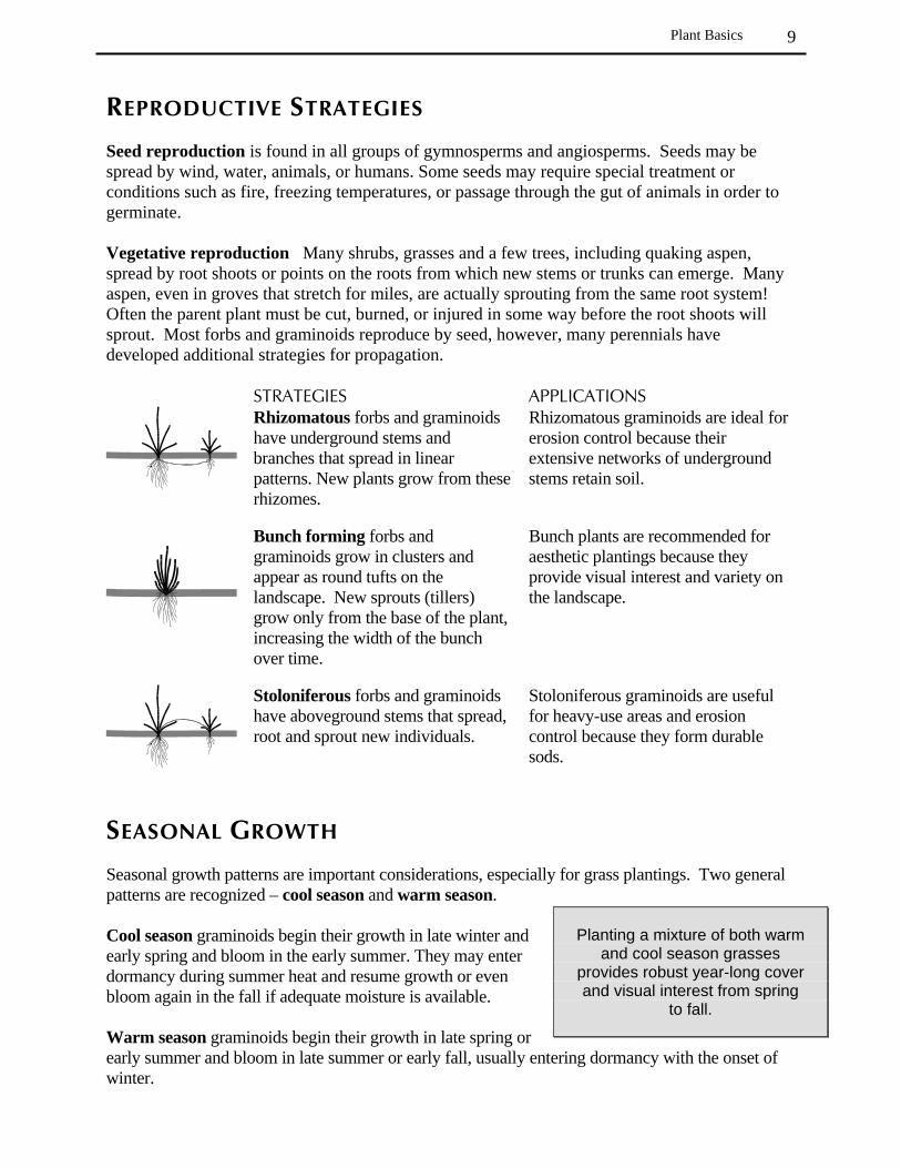
Vegetative reproduction Many shrubs, grasses and a few trees, including quaking aspen,spread by root shoots or points on the roots from which new stems or trunks can emerge. Manyaspen, even in groves that stretch for miles, are actually sprouting from the same root system!Often the parent plant must be cut, burned, or injured in some way before the root shoots willsprout. Most forbs and graminoids reproduce by seed, however, many perennials havedeveloped additional strategies for propagation.
���������� ������������Rhizomatous forbs and graminoidshave underground stems andbranches that spread in linearpatterns. New plants grow from theserhizomes.
Rhizomatous graminoids are ideal forerosion control because theirextensive networks of undergroundstems retain soil.
Bunch forming forbs andgraminoids grow in clusters andappear as round tufts on thelandscape. New sprouts (tillers)grow only from the base of the plant,increasing the width of the bunchover time.
Bunch plants are recommended foraesthetic plantings because theyprovide visual interest and variety onthe landscape.
Stoloniferous forbs and graminoidshave aboveground stems that spread,root and sprout new individuals.
Stoloniferous graminoids are usefulfor heavy-use areas and erosioncontrol because they form durablesods.
���������� �"
Seasonal growth patterns are important considerations, especially for grass plantings. Two generalpatterns are recognized – cool season and warm season.
Cool season graminoids begin their growth in late winter andearly spring and bloom in the early summer. They may enterdormancy during summer heat and resume growth or evenbloom again in the fall if adequate moisture is available.
Warm season graminoids begin their growth in late spring orearly summer and bloom in late summer or early fall, usually entering dormancy with the onset ofwinter.
Planting a mixture of both warmand cool season grasses
provides robust year-long coverand visual interest from spring
to fall.

Plant Basics 10
Natural Communities 11
��� ����!! ������In the broadest sense, a community can be defined as all the plants and animals living in aparticular area. Plant communities are usually named for their most prominent and/or abundantmembers. Community classifications can range from general descriptions such as “grassland” or“forest” to more detailed designations which include species names. The term “naturalcommunities” as used in this manual, refers to those plant species and communities whichoccurred in Colorado before European settlement and which retain the capability of maintainingthemselves without human interference.
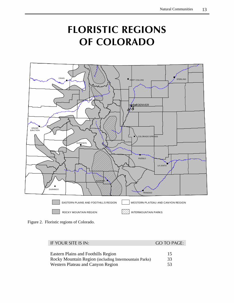
For the purposes of this guide, the state is divided into three floristic regions based on geography,elevation and climate (see Figure 2 on page 13). The Eastern Plains and Foothills Regionoccurs on the eastern side of the state below 8,000 feet (2438 m). The Rocky Mountain Regionoccurs in the center of the state on either side of the Continental Divide and includes theintermontane valleys (North Park, Middle Park, South Park and the San Luis Valley). TheWestern Plateau and Canyon Region occurs on the western side of the state below 8,000 feet(2438 m). Each region is divided into dominant vegetation types (grasslands, shrublands,woodlands and forests). Within each vegetation type, several natural plant communities arelisted (for example, short-grass prairie or sagebrush shrubland). Vegetation types and naturalcommunities have been generalized for this guide in order to emphasize the characteristic specieswhich will help determine the environmental setting of your site. On the landscape, these typesvary considerably in species composition and are too numerous to include in this document. Thenative landscape that surrounds your project site will be the best source of information fordetermining how to fine tune your revegetation project.
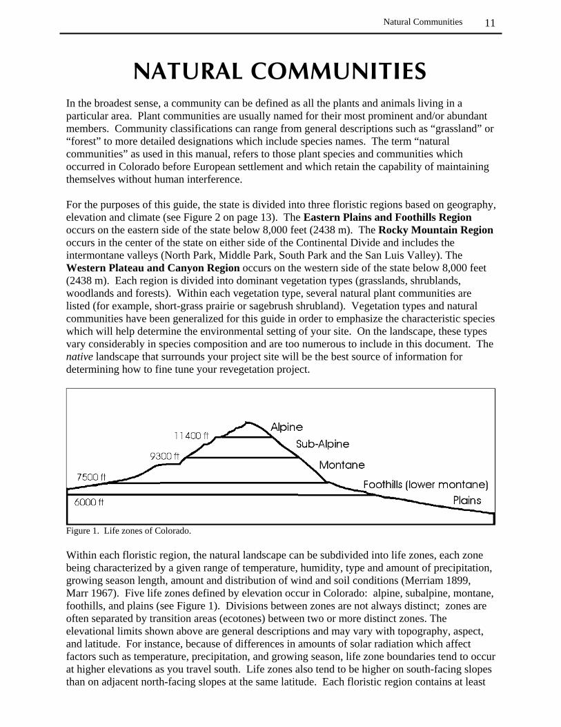
Figure 1. Life zones of Colorado.
Within each floristic region, the natural landscape can be subdivided into life zones, each zonebeing characterized by a given range of temperature, humidity, type and amount of precipitation,growing season length, amount and distribution of wind and soil conditions (Merriam 1899,Marr 1967). Five life zones defined by elevation occur in Colorado: alpine, subalpine, montane,foothills, and plains (see Figure 1). Divisions between zones are not always distinct; zones areoften separated by transition areas (ecotones) between two or more distinct zones. Theelevational limits shown above are general descriptions and may vary with topography, aspect,and latitude. For instance, because of differences in amounts of solar radiation which affectfactors such as temperature, precipitation, and growing season, life zone boundaries tend to occurat higher elevations as you travel south. Life zones also tend to be higher on south-facing slopesthan on adjacent north-facing slopes at the same latitude. Each floristic region contains at least

Natural Communities 12
one life zone, and each life zone generally includes several natural communities. A few naturalcommunities (wetland and riparian communities in particular) may cross life zones.
Natural communities tend to occur in predictable patterns on the landscape. The distribution offlora and fauna is for the most part determined by local resources and conditions. Importantfactors include water and nutrient availability, temperature, light, disturbance, and the presenceof other organisms. Descriptive terms for habitats are frequently based on one or more of thesefactors. For instance, according to water availability, habitats may be characterized as “xeric”(dry) or “mesic” (moist). Or, depending on type and frequency of disturbance, communities maybe classified as “successional or seral” (gradually changing in species composition) or “persistentor climax” (maintaining the same species composition over time in the absence of disturbance).Most other community characterizations are self-explanatory. Individual populations of aparticular species may, over many generations, become genetically adapted to extremelylocalized conditions within a habitat type; these differentiated populations are known as“ecotypes”. The ecotype concept is important when discussing revegetation, because it pointsout that not all populations of a species are identical. For example, seeds of ponderosa pineadapted to the volcanic soils and high, dry conditions of Arizona's Colorado Plateau may notgerminate or thrive when planted on coarse granitic soils of the Front Range, and adult trees maynot possess the cold and wind tolerance needed on the east slope of the Front Range.
Natural community revegetation information in this manual is arranged as follows: Part I coversupland habitats, i.e. those communities occurring on ground which is not subject to regularflooding or saturation. Part II covers wetland and riparian communities, considered as a separatetype within the surrounding upland community type. Each section also discusses appropriatemethods and techniques for revegetation projects in specific communities. Plant communitydescriptions are taken largely from Marr 1967, Mutel and Emerick 1984, Galatowitsch 1988, andBenedict 1991.
Natural Communities 13
�����������������������
EASTERN PLAINS AND FOOTHILLS REGION
ROCKY MOUNTAIN REGION INTERMOUNTAIN PARKS
WESTERN PLATEAU AND CANYON REGION
�
�
�
�
�
�
�
�
�
�
�
DENVER��
CRAIG
PUEBLO
ALAMOSA
DURANGO
TRINIDAD
LA JUNTA
STERLING
GUNNISON
FORT COLLINS
GRANDJUNCTION
COLORADO SPRINGS
Figure 2. Floristic regions of Colorado.
��� �!������������" ����������"
Eastern Plains and Foothills Region 15Rocky Mountain Region (including Intermountain Parks) 33Western Plateau and Canyon Region 53

Natural Communities 14

�����*�� �������!! ������

Part I: Upland CommunitiesEastern Plains and Foothills Region
15
���������������������"�������
DESCRIPTION - The eastern plains form much of Colorado's landscape east of the ContinentalDivide, extending the length of Colorado from Wyoming to New Mexico and east to Nebraskaand Kansas. Elevations on the plains rarely exceed 6,000 feet (1829 m) (Benedict 1991).Foothills, which occur at the eastern edge of the Rocky Mountains, form a transition zonebetween the plains and the mountains, extending from 6,000 (1829 m) to about 8,000 feet (2438m) in elevation.
CLIMATE / SOIL - Annual precipitation on the plains ranges from 12 to 18 inches (30 to 46cm) per year with much of the moisture occurring in the winter and early spring or late in thesummer (Galatowitsch 1988; Mutel and Emerick 1984). The area is prone to long periods ofdrought. Many plains soils are alkaline and fine-textured; foothills soils are variable but tend tobe coarser and have neutral chemistry.
TOPOGRAPHIC FEATURES - The eastern plains consist of relatively flat terrain with gentlehills, bluffs, and in some places, steep-sided mesas. Although glaciers never made it as far as theplains during the Pleistocene, their presence was felt east of the mountains. The Arkansas andSouth Platte Rivers were swollen with melted ice and ground-up rock and spread a blanket ofsand and silt far beyond the current floodplains. Today, smaller, meandering drainages,wetlands, moist swales, playas, bottomlands, and depressions created by wind and water erosionare scattered throughout the plains. The foothills area is characterized by mesas, hogbacks, lowridges, and streams and creeks. Canyons and elevated plateaus (Mesa de Maya and the PalmerDivide) extend the foothills floristic region far out onto the plains.
Part I: Upland CommunitiesEastern Plains and Foothills Region
16
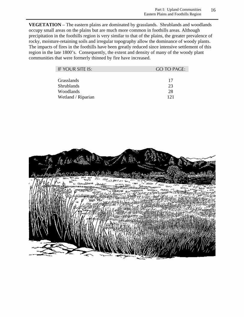
VEGETATION – The eastern plains are dominated by grasslands. Shrublands and woodlandsoccupy small areas on the plains but are much more common in foothills areas. Althoughprecipitation in the foothills region is very similar to that of the plains, the greater prevalence ofrocky, moisture-retaining soils and irregular topography allow the dominance of woody plants.The impacts of fires in the foothills have been greatly reduced since intensive settlement of thisregion in the late 1800’s. Consequently, the extent and density of many of the woody plantcommunities that were formerly thinned by fire have increased.
��� �!���������" ����������"
Grasslands 17Shrublands 23Woodlands 28Wetland / Riparian 121
Part I: Upland CommunitiesEastern Plains and Foothills Region - Grasslands
17
��������Grasslands (or prairies) are the most common vegetation type on the eastern plains of Colorado.The Great Plains region that once covered central North America between the Rocky Mountainsand central Iowa had three main components arranged in irregular north-south trending bandsfrom southern Canada to central Texas (Sims et al. 1978). As precipitation decreases from eastto west, height and species composition of the dominant prairie grasses changes. Tall-grassprairie covered the eastern band from 95º-100º west longitude; mid-grass prairie dominated themiddle section between 100º and 105º west longitude, and short-grass prairie typified the aridwestern region between 105º and 110º west longitude. The plains of Colorado are in the short-grass zone, but fingers of mid-grass prairie extend into the short-grass prairie, and patches of tallgrasses occur in riparian areas where conditions are sufficiently moist year-round.
Notes on grassland projects
True restoration of the prairie that once covered hundreds of thousands of square milesand sustained the complex interactions of hundreds of species is probably impossible onthe small parcels that are available today. However, where native grasslands do occur,they can be maintained and their condition improved. Small created prairies canpreserve native prairie plants and give visitors a feel for the former native prairie.
Depending on the degree of past disturbance, rehabilitation may be accomplished byremoving grazing, introducing fire, interplanting native grasses and forbs, and/orremoving aggressive nonnative plants.
Planting a prairie from scratch is a long-term project. It may take 3 to 5 years for theprairie to look like the vision you have of it.
Transplanting from the wild is difficult because many prairie plants have developed long,deep roots to promote survival during drought. Try salvaging plants from sites that arescheduled for development rather than trying to move plants from intact native prairies.
Mow prairie plantings the first year after planting to prevent weeds from going to seed.
If possible, burn occasionally to reduce litter accumulations and prevent invasion byshrubs and trees. Burning only a part of the prairie in any year will leave the remainderas a refuge for creatures living there.
For more information on prairie planting or restoration, see Brune 1991, Roundy et al.1993, and Schramp 1978.

Part I: Upland CommunitiesEastern Plains and Foothills Region - Grasslands
18
�"��.����������
Short-grass prairie covers much of the eastern plains, occurring on drought-prone, mildlyalkaline, medium and fine-textured soils. The character of the short-grass prairie is shaped byaridity; average annual precipitation is between 10 and 16 inches (25-40 cm). Mid-grasses areable to survive during periods of moderate conditions, but are replaced by blue grama andbuffalograss during and following events of stress such as drought or overgrazing. In theabsence of such stress, mid-grasses such as needleandthread, sideoats grama, junegrass, andSandberg bluegrass are common and even dominant, and the many associated forbs can turn theprairie into a colorful wildflower garden in wet summers. Western wheatgrass may formmonotypic stands in swales and depressions on clay-rich soils. Few shrubs grow consistently inshort-grass prairie because the soils are too dry and compacted to support them; yucca, cacti,fourwing saltbush and rabbitbrush are the most common woody plants on the prairie.
��/0���102����*���3���.4�/55���/1�1�62��10/0��57��1�5�10����2��87�9
GRAMINOIDSBouteloua gracilis blue gramaBouteloua hirsuta hairy gramaBuchloe dactyloides buffalograssCarex filifolia threadleaf sedgeHilaria jamesii galleta (southern plains)
Koeleria macrantha junegrassMuhlenbergia torreyi ring muhlyPascopyrum smithii western wheatgrassPoa secunda Sandberg bluegrassSporobolus cryptandrus sand dropseedStipa comata needleandthread
FORBSArgemone polyanthemos crested pricklypoppyArtemisia carruthii Carruth’s sagewortArtemisia frigida fringed sagewortAstragalus missouriensis Missouri milkvetchHeterotheca canescens hoary false goldenasterCryptantha thyrsiflora calcareous catseyeDalea candida white prairiecloverDalea purpurea purple prairiecloverDelphinium carolinium ssp. virescens Carolina larkspurEriogonum effusum spreading buckwheatErysimum asperum plains wallflowerGaillardia pinnatifida red dome blanketflowerGaura coccinea scarlet beeblossomIpomoea leptophylla bush morning gloryLiatris punctata dotted gayfeatherLinum lewisii Lewis’ flaxMirabilis linearis narrowleaf four o’clockOenothera caespitosa clumped evening primrose

Part I: Upland CommunitiesEastern Plains and Foothills Region - Grasslands
19
��/0���102����*���3���.4�/55���/1�1�62��10/0��57��1�5�10����2��87�9
FORBS (continued)Psoralidium tenuiflorum slimflower scurfpeaRatibida columnifera upright prairie coneflowerSolidago mollis velvety goldenrodSophora sericea silky sophoraSphaeralcea angustifolia copper globemallowSphaeralcea coccinea scarlet globemallowTetraneuris acaulis stemless hymenoxysZinnia grandiflora Rocky Mountain zinnia (southern plains)
TREES AND SHRUBS (INCLUDING SUCCULENTS)
Atriplex canescens fourwing saltbushChrysothamnus parryi Parry’s rabbitbrushCoryphantha vivipara scarlet hedgehog cactusEchinocereus triglochidiatus kingcup cactusEchinocereus viridiflorus nylon hedgehog cactusKrascheninnikovia lanata winterfatOpuntia fragilis brittle pricklypearOpuntia macrorhiza twistspine pricklypearOpuntia phaeacantha Mojave pricklypearOpuntia polyacantha hairspine pricklypearYucca glauca small soapweed
Yucca glauca
Part I: Upland CommunitiesEastern Plains and Foothills Region - Grasslands
20
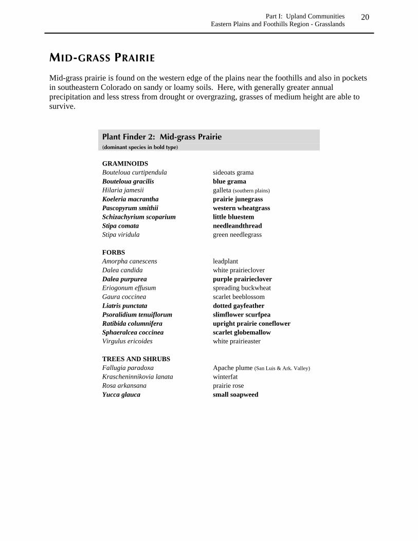
!��.����������
Mid-grass prairie is found on the western edge of the plains near the foothills and also in pocketsin southeastern Colorado on sandy or loamy soils. Here, with generally greater annualprecipitation and less stress from drought or overgrazing, grasses of medium height are able tosurvive.
��/0���102���+*��!12.4�/55���/1�1�62��10/0��57��1�5�10����2��87�9
GRAMINOIDSBouteloua curtipendula sideoats gramaBouteloua gracilis blue gramaHilaria jamesii galleta (southern plains)
Koeleria macrantha prairie junegrassPascopyrum smithii western wheatgrassSchizachyrium scoparium little bluestemStipa comata needleandthreadStipa viridula green needlegrass
FORBSAmorpha canescens leadplantDalea candida white prairiecloverDalea purpurea purple prairiecloverEriogonum effusum spreading buckwheatGaura coccinea scarlet beeblossomLiatris punctata dotted gayfeatherPsoralidium tenuiflorum slimflower scurfpeaRatibida columnifera upright prairie coneflowerSphaeralcea coccinea scarlet globemallowVirgulus ericoides white prairieaster
TREES AND SHRUBSFallugia paradoxa Apache plume (San Luis & Ark. Valley)
Krascheninnikovia lanata winterfatRosa arkansana prairie roseYucca glauca small soapweed

Part I: Upland CommunitiesEastern Plains and Foothills Region - Grasslands
21
��.����������
Tall-grass prairie is extremely uncommon in Colorado, occurring only in very small pocketsalong the Front Range where natural and artificial subirrigation supplements soil moisture. Itrequires well-drained soils that stay moist; this is a difficult combination in the arid climate ofeastern Colorado. Individual tall grass species can be found where localized environmentalfactors support their growth. If your project will include tall-grass prairie, you may want tocontact a conservation professional before proceeding.
��/0���102���)*���/��.4�/55���/1�1�62��10/0��57��1�5�10����2��87�9
GRAMINOIDSAndropogon gerardii big bluestemBouteloua curtipendula sideoats gramaBouteloua gracilis blue gramaPanicum virgatum switchgrassPascopyrum smithii western wheatgrassSchizachyrium scoparium little bluestemSorghastrum nutans yellow IndiangrassSpartina pectinata prairie cordgrassSporobolus asper dropseedSporobolus heterolepis prairie dropseed
FORBSArtemisia frigida fringed sagewortAsclepias speciosa showy milkweedCirsium flodmanii Floodman’s thistleDalea candida Floodman’s thistleDalea purpurea purple prairiecloverLiatris punctata dotted gayfeatherPsoralidium tenuiflorum slimflower scurfpeaRatibida columnifera upright prairie coneflowerSolidago speciosa var. pallida showy goldenrodThelesperma megapotamicum Hopi tea greenthreadVirgulus ericoides white prairieaster

Part I: Upland CommunitiesEastern Plains and Foothills Region - Grasslands
22
����"����������
Localized environmental conditions at the base of the foothills support grasslands at higherelevations than is typical of the eastern plains. Pockets of mid and tall-grass prairie speciesoccur with foothills species on sites in the foothills where soils have a very high content ofcoarse rock fragments. The stones in and on the soil act as a mulch to concentrate soil moistureto levels needed by these species typical of wetter environments. Most commonly, foothillsgrasslands are composed of mid-grass species, and include occasional shrubs.
��/0���102���,*������31��5���/55�/0262��10/0��57��1�5�10����2��87�9
GRAMINOIDSAndropogon gerardii big bluestemBouteloua curtipendula sideoats gramaBouteloua gracilis blue gramaHilaria jamesii galleta (southern foothills)
Koeleria macrantha prairie junegrassMuhlenbergia montana mountain muhlyPanicum virgatum switchgrassPascopyrum smithii western wheatgrassSchizachyrium scoparium little bluestemSorghastrum nutans yellow IndiangrassStipa comata needleandthreadStipa neomexicana New Mexico needlegrass
FORBSAmorpha canescens leadplantAster porteri Porter asterDalea candida white prairiecloverDalea purpurea purple prairiecloverEriogonum effusum spreading buckwheatGaura coccinea scarlet beeblossomLiatris punctata dotted gayfeatherPsoralidium tenuiflorum slimflower scurfpeaRatibida columnifera upright prairie coneflowerSolidago nana baby goldenrodSphaeralcea coccinea scarlet globemallowThelesperma megapotamicum Hopi tea greenthread
TREES AND SHRUBSCercocarpus montanus true mountain mahoganyKrascheninnikovia lanata winterfatRhus glabra smooth sumacRhus trilobata skunkbush sumacRibes cereum wax currantRosa arkansana prairie roseYucca glauca small soapweed
Part I: Upland CommunitiesEastern Plains and Foothills Region - Shrublands
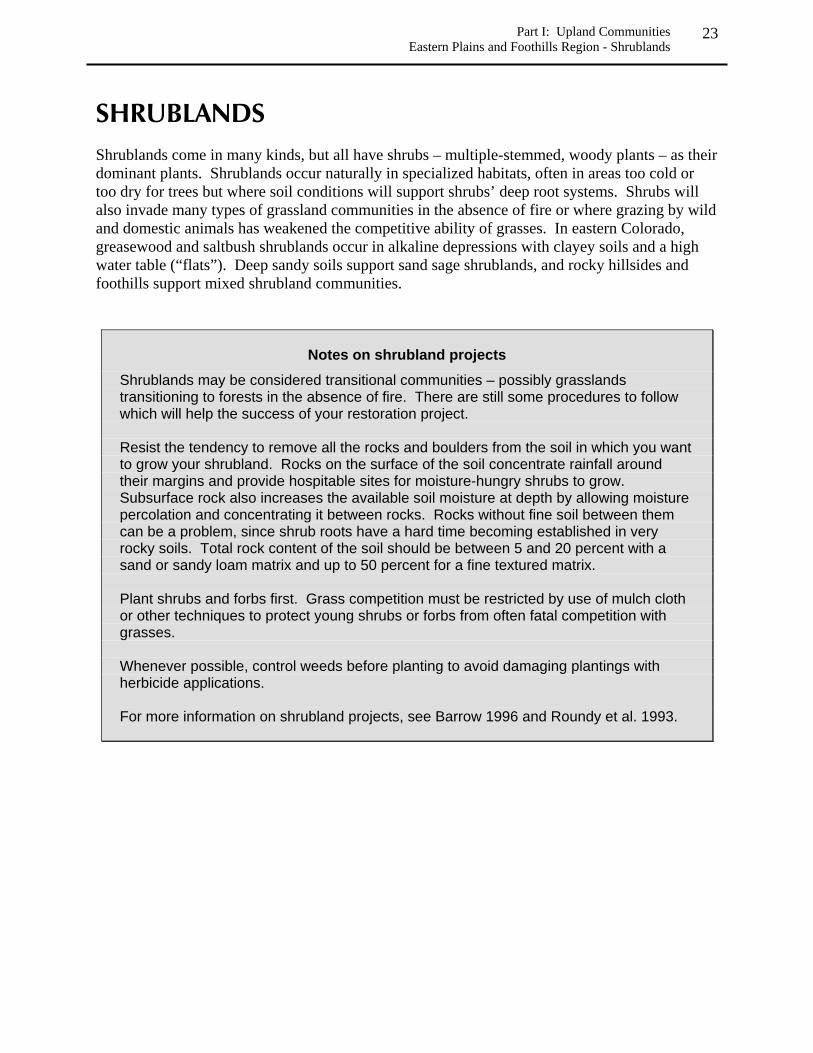
23
�" �����Shrublands come in many kinds, but all have shrubs – multiple-stemmed, woody plants – as theirdominant plants. Shrublands occur naturally in specialized habitats, often in areas too cold ortoo dry for trees but where soil conditions will support shrubs’ deep root systems. Shrubs willalso invade many types of grassland communities in the absence of fire or where grazing by wildand domestic animals has weakened the competitive ability of grasses. In eastern Colorado,greasewood and saltbush shrublands occur in alkaline depressions with clayey soils and a highwater table (“flats”). Deep sandy soils support sand sage shrublands, and rocky hillsides andfoothills support mixed shrubland communities.
Notes on shrubland projects
Shrublands may be considered transitional communities – possibly grasslandstransitioning to forests in the absence of fire. There are still some procedures to followwhich will help the success of your restoration project.
Resist the tendency to remove all the rocks and boulders from the soil in which you wantto grow your shrubland. Rocks on the surface of the soil concentrate rainfall aroundtheir margins and provide hospitable sites for moisture-hungry shrubs to grow.Subsurface rock also increases the available soil moisture at depth by allowing moisturepercolation and concentrating it between rocks. Rocks without fine soil between themcan be a problem, since shrub roots have a hard time becoming established in veryrocky soils. Total rock content of the soil should be between 5 and 20 percent with asand or sandy loam matrix and up to 50 percent for a fine textured matrix.
Plant shrubs and forbs first. Grass competition must be restricted by use of mulch clothor other techniques to protect young shrubs or forbs from often fatal competition withgrasses.
Whenever possible, control weeds before planting to avoid damaging plantings withherbicide applications.
For more information on shrubland projects, see Barrow 1996 and Roundy et al. 1993.

Part I: Upland CommunitiesEastern Plains and Foothills Region - Shrublands
24
�����������!�����" �����
These communities occur on alkaline flats and slight depressions where periodic saturation hascaused salts to accumulate as a white crust on the soil surface. Only a few specially adaptedspecies of plants can tolerate these extremely alkaline soils.
��/0���102���-*�����/5�:��2���/�5�6�/5���0���/105962��10/0��57��1�5�10����2��87�9
GRAMINOIDSBouteloua gracilis blue gramaBuchloe dactyloides buffalograssDistichlis spicata inland saltgrassHordeum jubatum foxtail barleyMuhlenbergia asperifolia alkali muhlyPuccinelia nuttaliana Nuttal alkaligrassSpartina gracilis alkali cordgrassSporobolus airoides alkali sacaton
TREES AND SHRUBSAtriplex canescens Fourwing saltbushChrysothamnus nauseosus rubber rabbitbrushSarcobatus vermiculatus greasewood
��/0���102���;*���3/25�/���/02��/����53���/�5�6�/5���0���/105962��10/0��57��1�5�10����2��87�9
GRAMINOIDSBouteloua gracilis blue gramaBuchloe dactyloides buffalograssPascopyrum smithii western wheatgrassSporobolus airoides alkali sacatonSporobolus cryptandrus sand dropseed
FORBSAmbrosia psilostachya western ragweedSphaeralcea coccinea scarlet globemallow
TREES AND SHRUBSAtriplex canescens fourwing saltbushAtriplex confertifolia shadscale saltbush

Part I: Upland CommunitiesEastern Plains and Foothills Region - Shrublands
25
���������� �"������
Sand sagebrush prairie occupies sandy soils of the plains, primarily in the northeastern andsoutheastern corners of the state but also in other isolated areas where sandy soils occur. Theporous nature of sand allows deeper water infiltration, giving deep-rooted shrubs the opportunityto grow more abundantly here. Unlike most prairies which are named for the dominant grasses,this prairie type is named for the most obvious species, sand sagebrush (Artemisia filifolia).Taller bunch grasses are common in this community, although they tend to drop out in heavilygrazed areas. Wind erosion is common, often resulting in localized depressions or “blowouts”.These blowouts are usually sparsely vegetated due to constantly shifting sands. Wherevegetation occurs, it is composed of grass species with roots and rhizomes long enough tostabilize the sand.
��/0���102���<*���/02��/4����53���/1�1�62��10/0��57��1�5�10����2��87�9
GRAMINOIDSAndropogon hallii sand bluestemBouteloua curtipendula sideoats gramaBouteloua gracilis blue gramaBouteloua hirsuta hairy gramaCalamovilfa longifolia prairie sandreedMuhlenbergia pungens sandhill muhlyOryzopsis hymenoides Indian ricegrassRedfieldia flexuosa blowout grassSchizachyrium scoparium little bluestemSporobolus cryptandrus sand dropseedStipa comata needleandthread
FORBSHeterotheca villosa hairy goldenasterCorydalis aurea scrambledeggsCymopterus acaulis plains springparsleyDalea villosa silky prairiecloverEriogonum annuum annual buckwheatGilia longiflora flaxflowered giliaHelianthus petiolaris prairie sunflowerIpomoea leptophylla bush morning gloryMentzelia nuda bractless blazingstarMirabilis glaber four-o'clockPsoralidium lanceolatum lemon scurfpeaRumex venosus veiny dockTradescantia occidentalis prairie spiderwort
TREES AND SHRUBSArtemisia filifolia sand sagebrushOpuntia phaeacantha Mojave pricklypearYucca glauca small soapweed
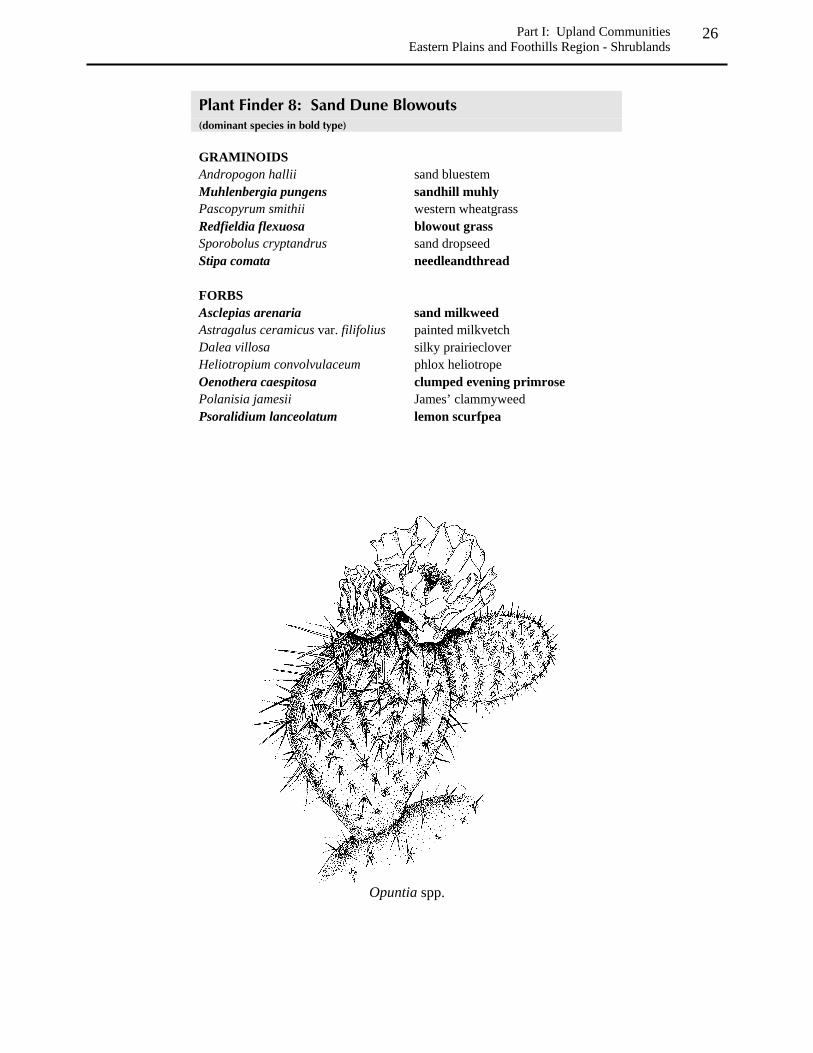
Part I: Upland CommunitiesEastern Plains and Foothills Region - Shrublands
26
��/0���102����*���/02���0�����:���562��10/0��57��1�5�10����2��87�9
GRAMINOIDSAndropogon hallii sand bluestemMuhlenbergia pungens sandhill muhlyPascopyrum smithii western wheatgrassRedfieldia flexuosa blowout grassSporobolus cryptandrus sand dropseedStipa comata needleandthread
FORBSAsclepias arenaria sand milkweedAstragalus ceramicus var. filifolius painted milkvetchDalea villosa silky prairiecloverHeliotropium convolvulaceum phlox heliotropeOenothera caespitosa clumped evening primrosePolanisia jamesii James’ clammyweedPsoralidium lanceolatum lemon scurfpea
Opuntia spp.
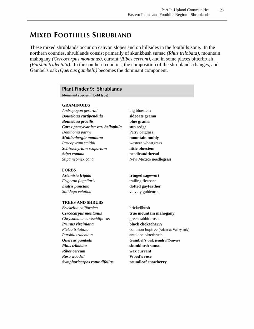
Part I: Upland CommunitiesEastern Plains and Foothills Region - Shrublands
27
!�=�������"����" ����
These mixed shrublands occur on canyon slopes and on hillsides in the foothills zone. In thenorthern counties, shrublands consist primarily of skunkbush sumac (Rhus trilobata), mountainmahogany (Cercocarpus montanus), currant (Ribes cereum), and in some places bitterbrush(Purshia tridentata). In the southern counties, the composition of the shrublands changes, andGambel's oak (Quercus gambelii) becomes the dominant component.
��/0���102����*���3����/02562��10/0��57��1�5�10����2��87�9
GRAMINOIDSAndropogon gerardii big bluestemBouteloua curtipendula sideoats gramaBouteloua gracilis blue gramaCarex pensylvanica var. heliophila sun sedgeDanthonia parryi Parry oatgrassMuhlenbergia montana mountain muhlyPascopyrum smithii western wheatgrassSchizachyrium scoparium little bluestemStipa comata needleandthreadStipa neomexicana New Mexico needlegrass
FORBSArtemisia frigida fringed sagewortErigeron flagellaris trailing fleabaneLiatris punctata dotted gayfeatherSolidago velutina velvety goldenrod
TREES AND SHRUBSBrickellia californica brickellbushCercocarpus montanus true mountain mahoganyChrysothamnus viscidiflorus green rabbitbrushPrunus virginiana black chokecherryPtelea trifoliata common hoptree (Arkansas Valley only)
Purshia tridentata antelope bitterbrushQuercus gambelii Gambel’s oak (south of Denver)
Rhus trilobata skunkbush sumacRibes cereum wax currantRosa woodsii Wood’s roseSymphoricarpos rotundifolius roundleaf snowberry

Part I: Upland CommunitiesEastern Plains and Foothills Region - Woodlands
28
�������Woodlands occur in the foothills zone and where canyons on the plains create foothills-likeconditions. They are characterized by having one or more species of small trees – oneseedjuniper, Rocky Mountain juniper, piñon pine, or limber pine – dominant in the topmost layer ofvegetation. Because these trees require more moisture and deeper soils than shrubs or grasses,woodland communities are restricted to rocky, mesic sites in draws and north-facing escarpmentsbelow 6000 feet (1829 m), and dry slopes among ponderosa pine and Douglas-fir communitiesabove 6000 feet. Fire converts woodland communities to grasslands or shrublands; very oldwoodland communities are rare except in rocky areas which are protected from fire.
Notes on woodland projects
Woodland sites alternate over time between woodland, shrubland, and grasslandvegetation, depending on the climate and the frequency and intensity of the fire regime.After intense fire, grasses replace all or some of the trees. Over time, shrubs replacegrasses. Eventually, trees again become the dominant vegetation.
In natural settings, unless the soil has been seriously disturbed or weeds are abundant,woodlands will regenerate without intervention. Erosion control and weed managementmay be sufficient to restore woodlands after disturbance. Planting in woodland sites canbe very difficult due to rocky soils. Short-term reestablishment of visually dominantamounts of woody cover is likely to require nursery stock planting and mulching, caging,and irrigation of those plants.
For more information on woodlands, see Shaw et al. 1994, Covington 1996, and Howell1986.

Part I: Upland CommunitiesEastern Plains and Foothills Region - Woodlands
29
��>�������.( ����� �������
Piñon pine-juniper woodlands occur in draws, on escarpments and mesas, and on rocky hillsides.These woodlands are best developed between 5,000 and 7,000 feet (1524-2134 m), but localizedenvironmental conditions may allow them to occur at lower elevations on the plains and up to9,000 feet (2743 m) in the montane zone. Sites occupied by piñon-juniper woodlands aretypically warm, dry and windy. Annual precipitation ranges from 12 to 18 inches (30-46 cm).Trees tend to be short and widely spaced. Either piñon or juniper may dominate; generallyjuniper is more abundant at the lower end of the elevational range. Piñon pine, being betteradapted to cold conditions is typically more abundant at higher elevations. In southern counties,the community includes one-seeded juniper and piñon in the overstory and wavyleaf orGambel’s oak, apache plume, and candelabra cactus in the understory. North of ColoradoSprings, Rocky Mountain juniper may replace one-seeded juniper and piñon pine becomes lesscommon; understory species include skunkbush, rabbitbrush, bitterbrush, and mountainmahogany. Throughout the range of this community type, grass and forb cover is inverselyproportional to the density of the piñon and juniper.
��/0���102����?*���1@�0��10�.(�017��� ��2�/0262��10/0��57��1�5�10����2��87�9
GRAMINOIDSBouteloua curtipendula sideoats gramaBouteloua gracilis blue gramaElymus elymoides bottlebrush squirreltailLycurus phleoides common wolfstailOryzopsis hymenoides Indian ricegrassOryzopsis micrantha littleseed ricegrassPoa fendleriana muttongrassSchizachyrium scoparium little bluestemStipa comata needleandthreadStipa neomexicana New Mexico needlegrass
FORBSArenaria hookeri Hooker’s sandwortCastilleja linariifolia Wyoming Indian paintbrushHeterotheca villosa hairy goldenasterHymenopappus filifolius fineleaf hymenopappusMirabilis multiflora Colorado four o’clock (south of Denver)
Solidago velutina velvety goldenrodTetraneuris acaulis stemless hymenoxys
TREES AND SHRUBSAmelanchier alnifolia Saskatoon serviceberryArtemisia tridentata big sagebrushCercocarpus montanus true mountain mahoganyChrysothamnus nauseosus rubber rabbitbrushHolodiscus dumosus rock spireaJuniperus monosperma oneseed juniper

Part I: Upland CommunitiesEastern Plains and Foothills Region - Woodlands
30
��/0���102����?*���1@�0��10�.(�017��� ��2�/0262��10/0��57��1�5�10����2��87�9
TREES AND SHRUBS (continued)Juniperus scopulorum Rocky Mountain juniperPinus edulis piñon pine (south of Denver)Pinus flexilis limber pine (northeast Colorado)
Purshia tridentata antelope bitterbrushQuercus gambelii Gambel’s oak (south of Denver)
Rhus trilobata skunkbush sumacRibes cereum wax currantSymphoricarpos rotundifolius roundleaf snowberry
Juniperus scopulorum

Part I: Upland CommunitiesEastern Plains and Foothills Region - Woodlands
31
�������������� ������������������
Ponderosa pine savannas occur primarily on dry, fire-prone south-facing slopes and have grassyunderstories with few shrubs. Woodlands typically occur on rockier sites less prone to fire andhave dense shrub understories. In the eastern part of the state, these communities are found atthe base of the foothills and on mesa tops on the plains.
��/0���102�����*����02���5/��10�� ��2�/025�/02��/A/00/62��10/0��57��1�5�10����2��87�9
GRAMINOIDSBlepharoneuron tricholepis pine dropseedBouteloua curtipendula sideoats gramaBouteloua gracilis blue gramaCarex pensylvanica var. heliophila sun sedgeDanthonia spicata poverty oatgrassFestuca arizonica Arizona fescueKoeleria macrantha prairie junegrassLeucopoa kingii spike fescueLeymus ambiguus Colorado wildryeMuhlenbergia montana mountain muhlyPoa fendleriana mutton bluegrassPoa secunda Sandberg bluegrassSchizachyrium scoparium little bluestemStipa pinetorum pine needlegrassStipa scribneri Scribner’s needlegrass
FORBSAntennaria rosea rosy pussytoesArnica fulgens foothill arnicaArtemisia frigida fringed sagewortArtemisia ludoviciana white sagebrushCampanula rotundifolia bluebell bellflowerEremogone fendleri desert sandwortHeterotheca villosa hairy goldenasterGalium boreale northern bedstrawGeranium caespitosum pineywoods geraniumPenstemon virens green beardtonguePotentilla fissa bigflower cinquefoilSedum lanceolatum spearleaf stonecrop
TREES AND SHRUBSArctostaphylos uva-ursi kinnikinnickBerberis fendleri Colorado barberry (south of Denver)
Ceanothus fendleri Fendler’s ceanothusCercocarpus montanus true mountain mahoganyJamesia americana cliffbushJuniperus communis common juniperJuniperus scopulorum Rocky Mountain juniper

Part I: Upland CommunitiesEastern Plains and Foothills Region - Woodlands
32
��/0���102�����*����02���5/��10�� ��2�/025�/02��/A/00/62��10/0��57��1�5�10����2��87�9
TREES AND SHRUBS (continued)Mahonia repens Oregon grapePhysocarpus monogynus mountain ninebarkPinus ponderosa ponderosa pinePseudotsuga menziesii Douglas firPurshia tridentata antelope bitterbrushQuercus gambelii Gambel’s oak (south of Denver)
Rhus trilobata skunkbush sumac
Pinus ponderosa
Quercus gambelii

Part I: Upland CommunitiesRocky Mountain Region
33
���&�!� �����������
DESCRIPTION – This region lies between the plains and foothills to the east and the plateaus,canyons and lowlands to the west. The southern Rocky Mountains of Colorado are a complexgroup of well-defined ranges which have been carved by glaciers and eroded by streams to formsteep, rugged canyons and ridges. This section also describes the vegetation of the greatintermountain basins or “parks” (North Park, Middle Park, South Park) and the San Luis Valley,which are geographically part of the mountain region, but which may also share climatic andfloristic characteristics with the eastern and western regions of Colorado.
CLIMATE / SOIL – Annual precipitation in the Colorado Rocky Mountains ranges from 18 toover 40 inches (45 to 100 cm) per year, with the high elevations of the Park Range and San JuanMountains receiving the most moisture. At least 40 percent of the annual precipitation originateswith Pacific air masses and falls in the form of snow. Soils are variable, depending on geologicsubstrate, precipitation, aspect and slope, and contribute to the diversity of plant communitiesfound in the region. In general, soils developed from granitic and metamorphic rocks are coarserthan soils developed from the less extensive sedimentary rocks in the region. The steeper slopesand higher precipitation in this region result in higher rates of erosion, keeping soils generallyyounger and shallower than is the case east or west of the region.
TOPOGRAPHIC FEATURES – Vertical relief characterizes the Rocky Mountain region ofColorado. Colorado’s average elevation is 6,800 feet (2073 m); the state contains 54 peakshigher than 14,000 feet (4267 m) and more than 1000 peaks over 10,000 feet (3048 m) high,three elevated plateaus and more than 20 named mountain ranges. Most of the mountain rangeswere glaciated during the Pleistocene, which put the finishing touches on peaks and valleysalready millions of years in the making. Four of North America's great rivers (the Colorado, thePlatte, the Rio Grande and the Arkansas) originate within these mountains.
Steep slopes are the rule in the Rocky Mountain region, with three exceptions. Glaciersbroadened the bottoms of many mountain valleys a thick layer of river deposits leveled them.The four great parks within the region (North, Middle, and South Park and the San Luis Valley)also have relatively flat floors. Surprisingly, a good deal of gentle terrain is also found at upper

Part I: Upland CommunitiesRocky Mountain Region
34
elevations and even at the tops of the mountains, a reminder that at various times since thecurrent Rocky Mountains were uplifted, erosional planing created surfaces later elevated,dissected by streams, broken by faults, and carved by glaciers. Broad summits at variouselevations in the Front and Rampart ranges are examples of these ancient surfaces.
VEGETATION – The topographic diversity which defines the Rocky Mountain region givesrise to a parallel diversity of vegetation. Mountain environments are characterized primarily byconiferous forests: Ponderosa pine forests, Douglas-fir, and Engelmann spruce and subalpine firforests. Aspen forests cover large areas where conifers have been removed by wind, landslide,avalanche or fire. Pockets of grassland often persist on deep soils and shrublands are foundwhere warm, shallow soils are inhospitable to tree establishment. At the highest elevations,treeless alpine tundra and bare rock form the landscape. The Rocky Mountain region is alsowhere most of the naturally-occurring wetlands of Colorado are found.
��� �!���������" ����������"
Grasslands 35Shrublands 38Woodlands 42Forests 44Alpine Tundras 50Wetland / Riparian 130

Part I: Upland CommunitiesRocky Mountain Region - Grasslands
35
��������Grasslands are a minor but important part of the Rocky Mountain region's vegetation. Theyoccupy specialized habitats where the climate is too cold or dry and/or the soils are too shallowto support the growth of trees and shrubs. In general, grasslands are small, providing openingswithin the forested zone, but the entire floor of South Park is a montane grassland. Two majortypes of grasslands have been distinguished on the basis of elevation. Montane grasslands occurbetween approximately 8,000 and 10,000 feet (2438-3048 m) and subalpine grasslands occupyfavorable habitats between approximately 10,000 feet and treeline.
Notes on grassland projects
Many mountain grasslands in Colorado have been altered by over a century of use andfire suppression. Restoration can increase the diversity of plants, animals andcommunity types in a given area.
Depending on the degree of past disturbance, restoration may be as simple asremoving grazing and introducing fire. In more disturbed situations, interplanting missingnative grasses and forbs, and/or removing aggressive nonnative plants may also benecessary.
Transplanting from the wild is difficult because mountain envirmonments are stressful onplants weakened by relocation. Grassland plants have developed long, deep roots topromote survival during drought. Try salvaging plants from sites that are scheduled fordevelopment rather than trying to move plants from intact native grasslands.
Where possible, burn occasionally to reduce litter accumulations and prevent invasionby shrubs and trees. Burning only a part of the grassland in any year will leave theremainder as a refuge for creatures living there.
For more information on grassland planting or restoration, see Brune 1991, and Roundyet al. 1993.

Part I: Upland CommunitiesRocky Mountain Region - Grasslands
36
!������������ ���������������
Small mountain grasslands and meadows are interspersed between the various forestcommunities and occur primarily on flat or gently sloping terrain with shallow to deep fine-grained soils. Large expanses of grassland or meadow communities are concentrated in parts ofNorth, Middle, and South parks, the Wet Mountain Valley, the perimeter of the San Luis Valleyand parts of the upper Rio Grande Basin (Benedict 1991). These grasslands range from moist todry depending on exposure, their proximity to the water table and soil characteristics. Meadowswith seasonally or permanently saturated soils or standing water are discussed in the wetlandsection (beginning on page 111). Mountain grasslands are usually dominated by bunch grassessuch as fescues, oatgrass, Junegrass and mountain muhly, but wildflowers are abundant anddiverse, making Colorado's grasslands the state's most photogenic plant community. Becausemountain grasslands occur under conditions (including cold sinks or shallow soils) which do notfavor the growth of woody plants, trees and shrubs are not recommended for revegetationprojects.
��/0���102����+*��!�0�/0����/55�/02562��10/0��57��1�5�10����2��87�9
GRAMINOIDSBouteloua gracilis blue gramaCarex geyeri elk sedgeDanthonia parryi Parry’s oatgrassFestuca arizonica Arizona fescueFestuca idahoensis Idaho fescueKoeleria macrantha prairie junegrassMuhlenbergia montana mountain muhlyPoa fendleriana muttongrassStipa lettermanii Letterman’s needlegrass
FORBSAchillea lanulosa western yarrowAntennaria umbrinella umber pussytoesArnica parryi Parry's arnicaArtemisia frigida fringed sagewortErigeron flagellaris trailing fleabaneGeranium richardsonii Richardson's geraniumHeterotheca villosa hairy goldenasterHymenoxys richardsonii pingue hymenoxysIpomopsis aggregata skyrocket giliaLinum lewisii Lewis’ flaxOxytropis lambertii Lambert's locoweedPenstemon strictus Rocky Mountain penstemonPotentilla pulcherrima beautiful cinquefoilSenecio neomexicanus New Mexico groundsel

Part I: Upland CommunitiesRocky Mountain Region - Grasslands
37
��/0���102����)*�����/�710����/55�/02562��10/0��57��1�5�10����2��87�9
GRAMINOIDSCarex geyeri elk sedgeCeratochloa carinata California bromeDanthonia intermedia timber oatgrassDeschampsia cespitosa tufted hairgrassElymus elymoides bottlebrush squirreltailElymus trachycaulus slender wheatgrassFestuca idahoensis Idaho fescueFestuca rubra red fescueFestuca saximontana Rocky Mountain fescueFestuca thurberi Thurber’s fescuePhleum alpinum alpine timothyPoa alpina alpine bluegrassPoa secunda Sandberg bluegrassStipa viridula green needlegrassTrisetum spicatum spike trisetum
FORBSAchillea lanulosa western yarrowAgoseris aurantiaca orange agoserisAquilegia coerulea Colorado blue columbineArnica parryi Parry's arnicaCampanula rotundifolia bluebell bellflowerCastilleja rhexifolia Indian paintbrushErigeron peregrinus subalpine fleabaneHelianthella quinquenervis fivenerve sunflowerLathyrus lanszwertii var. leucanthus aspen peavineLupinus argenteus silvery lupineMertensia lanceolata prairie bluebellsOxytropis lambertii Lambert’s locoweedPenstemon whippleanus Whipple’s penstemonSenecio dimorphophyllus groundselThalictrum fendleri Fendler meadow-rueThermopsis montana golden bannerVicia americana American vetch
Part I: Upland CommunitiesRocky Mountain Region - Shrublands
38
�" �����Shrublands come in many kinds, but all have shrubs – multiple-stemmed, woody plants – as theirdominant plants. Shrublands occur naturally in specialized habitats, often in areas too cold ortoo dry for trees but where soil conditions will support shrubs’ deep root systems. Shrubs willalso invade many types of grassland communities in the absence of fire or where grazing by wildand domestic animals has weakened the competitive advantage of grasses. In the RockyMountain region, greasewood and saltbush shrublands occur in level areas where clay soils and ahigh water table create saline or alkaline conditions. Sagebrush shrublands can occur on avariety of well-drained soils with more nearly neutral soil pH and can be found over a widerange of elevations.
Notes on shrubland projects
Shrublands may be considered transitional communities – possibly grasslandstransitioning to forests in the absence of fire. There are several procedures to followwhich will help the success of your restoration project.
Resist the tendency to remove all the rocks and boulders from the soil in which you wantto grow your shrubland. Rocks on the surface of the soil concentrate rainfall aroundtheir margins and provide hospitable sites for moisture-hungry shrubs to grow.Subsurface rock also increases the available soil moisture at depth by allowing moisturepercolation and concentrating it between rocks. Rocks without fine soil between themcan be a problem since shrub roots have a hard time becoming established in very rockysoils. Total rock content of the soil should be between 5 and 20 percent with a sand orsandy loam matrix and up to 50 percent for a fine textured matrix.
Plant shrubs and forbs first. Grass competition must be restricted by use of mulch clothor other techniques to protect young shrubs or forbs from often fatal competition withgrasses.
Whenever possible, control weeds before planting to avoid damaging plantings withherbicide applications.
For more information on shrubland projects, see Barrow 1996 and Roundy et al. 1993.
Part I: Upland CommunitiesRocky Mountain Region - Shrublands
39
����� �"��" �����
Sagebrush shrublands are most extensive in western Colorado, but also cover certain areas of theRocky Mountain region. Two major types may be distinguished on the basis of elevation andsoils.
��������������� �"
Basin big sagebrush shrublands occur at lower elevations on deep soils of floodplains andarroyos; they occur throughout western and southern Colorado. This type is dominated bybasin big sagebrush (Artemisia tridentata ssp. tridentata), a tall shrub up to seven feet (2 m)in height. Understory vegetation tends to be sparse but other shrub species are commonassociates.
��/0���102����,*���/510��14��/4����5362��10/0��57��1�5�10����2��87�9
GRAMINOIDSBouteloua curtipendula sideoats gramaHilaria jamesii galleta (southern Colorado)
Leymus cinereus Great basin wildryeOryzopsis hymenoides Indian ricegrassPascopyrum smithii western wheatgrassPoa fendleriana muttongrassPoa secunda Sandberg bluegrassSporobolus cryptandrus sand dropseed
FORBSArenaria hookeri Hooker’s sandwortBalsamorhiza sagittata arrowleaf balsamrootHeterotheca villosa hairy goldenasterGaillardia aristata common gaillardiaSphaeralcea coccinea scarlet globemallowWyethia amplexicaulis mulesears wyethia
TREES AND SHRUBSArtemisia tridentata ssp. tridentata basin big sagebrushArtemisia tridentata ssp. wyomingensis Wyoming big sagebrushAtriplex canescens fourwing saltbushChrysothamnus nauseosus rubber rabbitbrushChrysothamnus viscidiflorus green rabbitbrushSarcobatus vermiculatus greasewood
Part I: Upland CommunitiesRocky Mountain Region - Shrublands
40
!� ��������������� �"
Mountain big sagebrush communities occur at higher elevations on convex sites and onshallower soils than basin big sagebrush communities. Mountain big sagebrush is thedominant plant species of this type, but it may be replaced by black sagebrush at lowerelevations on rocky soils and it intermixes with basin big sagebrush growing in similar sizeon many sites. Mountain big sagebrush communities may include a variety of shrubs and anabundance of wild flowers. It occurs at upper elevations adjacent to aspen, oak-serviceberry,and coniferous forest. Examples of this plant community are found in North Park, MiddlePark, the western slope of the Park Range, the upper Gunnison Basin, the Vail Valley, andthe Beaver Meadows area on the eastern side of Rocky Mountain National Park. In theseareas, the similar Wyoming big sagebrush (Artemisia tridentata ssp. wyomingensis) may bedominant or co-dominant locally.
��/0���102����-*��!��0�/10��14��/4����5362��10/0��57��1�5�10����2��87�9
GRAMINOIDSAgropyron spicatum bluebunch wheatgrassBouteloua curtipendula sideoats gramaFestuca saximontana Rocky Mountain fescueHilaria jamesii galleta (southern Colorado)
Koeleria macrantha prairie junegrassMelica sp. onion grassOryzopsis hymenoides Indian ricegrassPascopyrum smithii western wheatgrassPoa fendleriana muttongrassPoa secunda Sandberg bluegrassStipa lettermanii Letterman’s needlegrassStipa nelsonii Nelson’s needlegrass
FORBSAgastache urticifolia nettleleaf giant hyssopArenaria hookeri Hooker’s sandwortAstragalus miser timber milkvetchBalsamorhiza sagittata arrowleaf balsamrootErigeron speciosus showy daisyHelianthella uniflora oneflower helianthellaHeterotheca villosa hairy goldenasterDelphinium nuttallianum Nuttall’s larkspurGaillardia aristata common gaillardiaLupinus argenteus silvery lupineLupinus caudatus tailcup lupinePenstemon caespitosus mat penstemonWyethia amplexicaulis mulesears wyethia
TREES AND SHRUBSAmelanchier utahensis Utah serviceberryArtemisia arbuscula ssp. longiloba alkali sagebrushArtemisia nova black sagebrushArtemisia tridentata ssp. tridentata basin big sagebrush

Part I: Upland CommunitiesRocky Mountain Region - Shrublands
41
��/0���102����-*��!��0�/10��14��/4����5362��10/0��57��1�5�10����2��87�9
TREES AND SHRUBS (continued)Artemisia tridentata ssp. vaseyana mountain big sagebrushArtemisia tridentata ssp. wyomingensis Wyoming big sagebrushAtriplex confertifolia shadscale saltbushChrysothamnus parryi Parry rabbitbrushPurshia tridentata antelope bitterbrushSymphoricarpos rotundifolius roundleaf snowberryTetradymia canescens spineless horsebrush
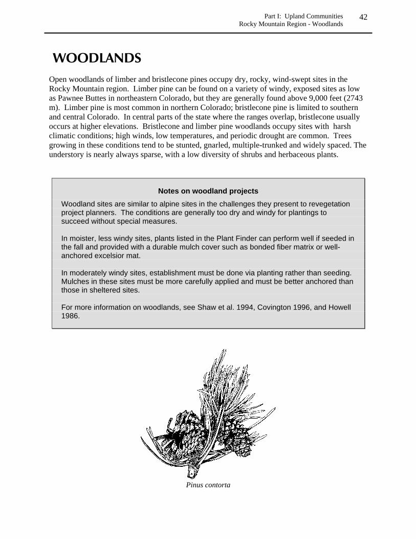
Part I: Upland CommunitiesRocky Mountain Region - Woodlands
42
� �������Open woodlands of limber and bristlecone pines occupy dry, rocky, wind-swept sites in theRocky Mountain region. Limber pine can be found on a variety of windy, exposed sites as lowas Pawnee Buttes in northeastern Colorado, but they are generally found above 9,000 feet (2743m). Limber pine is most common in northern Colorado; bristlecone pine is limited to southernand central Colorado. In central parts of the state where the ranges overlap, bristlecone usuallyoccurs at higher elevations. Bristlecone and limber pine woodlands occupy sites with harshclimatic conditions; high winds, low temperatures, and periodic drought are common. Treesgrowing in these conditions tend to be stunted, gnarled, multiple-trunked and widely spaced. Theunderstory is nearly always sparse, with a low diversity of shrubs and herbaceous plants.
Pinus contorta
Notes on woodland projects
Woodland sites are similar to alpine sites in the challenges they present to revegetationproject planners. The conditions are generally too dry and windy for plantings tosucceed without special measures.
In moister, less windy sites, plants listed in the Plant Finder can perform well if seeded inthe fall and provided with a durable mulch cover such as bonded fiber matrix or well-anchored excelsior mat.
In moderately windy sites, establishment must be done via planting rather than seeding.Mulches in these sites must be more carefully applied and must be better anchored thanthose in sheltered sites.
For more information on woodlands, see Shaw et al. 1994, Covington 1996, and Howell1986.

Part I: Upland CommunitiesRocky Mountain Region - Woodlands
43
��/0���102����;*��1�����/02���15�����0���10�� ��2�/02562��10/0��57��1�5�10����2��87�9
GRAMINOIDSDanthonia intermedia timber oatgrassFestuca arizonica Arizona fescueFestuca thurberi Thurber’s fescuePoa alpina alpine bluegrassTrisetum spicatum spike trisetum
FORBSCilaria austromontana matted saxifrageErysimum capitatum sanddune wallflowerHeuchera parvifolia littleleaf alumrootSedum lanceolatum spearleaf stonecropTrifolium attenuatum Rocky Mountain cloverTrifolium dasyphyllum alpine clover
TREES AND SHRUBSArctostaphylos uva-ursi kinnikinnickJuniperus communis common juniperPinus aristata bristlecone pinePinus flexilis limber pineRibes montigenum gooseberry currant
Sedum lanceolatum
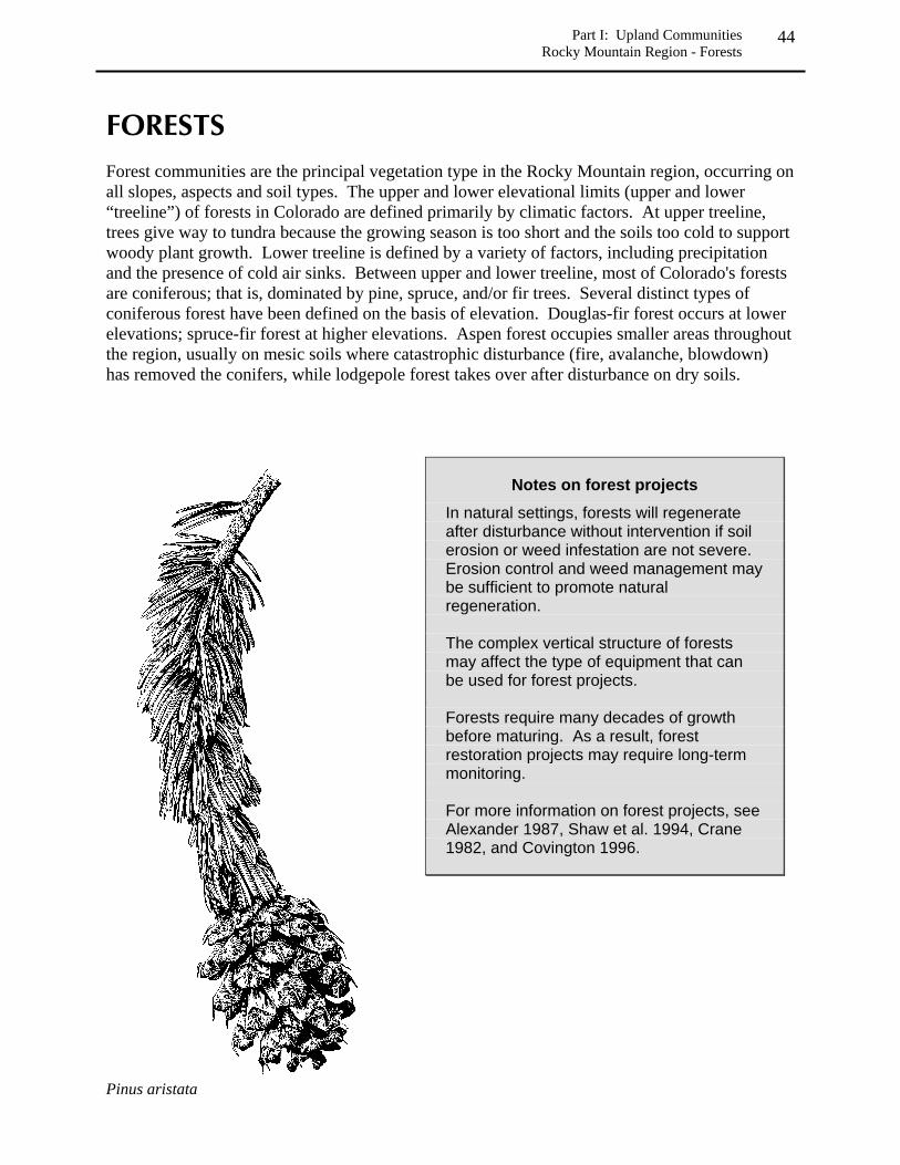
Part I: Upland CommunitiesRocky Mountain Region - Forests
44
������Forest communities are the principal vegetation type in the Rocky Mountain region, occurring onall slopes, aspects and soil types. The upper and lower elevational limits (upper and lower“treeline”) of forests in Colorado are defined primarily by climatic factors. At upper treeline,trees give way to tundra because the growing season is too short and the soils too cold to supportwoody plant growth. Lower treeline is defined by a variety of factors, including precipitationand the presence of cold air sinks. Between upper and lower treeline, most of Colorado's forestsare coniferous; that is, dominated by pine, spruce, and/or fir trees. Several distinct types ofconiferous forest have been defined on the basis of elevation. Douglas-fir forest occurs at lowerelevations; spruce-fir forest at higher elevations. Aspen forest occupies smaller areas throughoutthe region, usually on mesic soils where catastrophic disturbance (fire, avalanche, blowdown)has removed the conifers, while lodgepole forest takes over after disturbance on dry soils.
Pinus aristata
Notes on forest projects
In natural settings, forests will regenerateafter disturbance without intervention if soilerosion or weed infestation are not severe.Erosion control and weed management maybe sufficient to promote naturalregeneration.
The complex vertical structure of forestsmay affect the type of equipment that canbe used for forest projects.
Forests require many decades of growthbefore maturing. As a result, forestrestoration projects may require long-termmonitoring.
For more information on forest projects, seeAlexander 1987, Shaw et al. 1994, Crane1982, and Covington 1996.
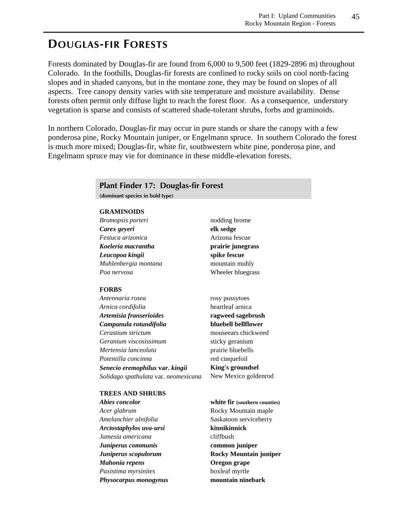
Part I: Upland CommunitiesRocky Mountain Region - Forests
45
�� ���.���������
Forests dominated by Douglas-fir are found from 6,000 to 9,500 feet (1829-2896 m) throughoutColorado. In the foothills, Douglas-fir forests are confined to rocky soils on cool north-facingslopes and in shaded canyons, but in the montane zone, they may be found on slopes of allaspects. Tree canopy density varies with site temperature and moisture availability. Denseforests often permit only diffuse light to reach the forest floor. As a consequence, understoryvegetation is sparse and consists of scattered shade-tolerant shrubs, forbs and graminoids.
In northern Colorado, Douglas-fir may occur in pure stands or share the canopy with a fewponderosa pine, Rocky Mountain juniper, or Engelmann spruce. In southern Colorado the forestis much more mixed; Douglas-fir, white fir, southwestern white pine, ponderosa pine, andEngelmann spruce may vie for dominance in these middle-elevation forests.
��/0���102����<*�����4�/5.B1������5�62��10/0��57��1�5�10����2��87�9
GRAMINOIDSBromopsis porteri nodding bromeCarex geyeri elk sedgeFestuca arizonica Arizona fescueKoeleria macrantha prairie junegrassLeucopoa kingii spike fescueMuhlenbergia montana mountain muhlyPoa nervosa Wheeler bluegrass
FORBSAntennaria rosea rosy pussytoesArnica cordifolia heartleaf arnicaArtemisia franserioides ragweed sagebrushCampanula rotundifolia bluebell bellflowerCerastium strictum mouseears chickweedGeranium viscosissimum sticky geraniumMertensia lanceolata prairie bluebellsPotentilla concinna red cinquefoilSenecio eremophilus var. kingii King's groundselSolidago spathulata var. neomexicana New Mexico goldenrod
TREES AND SHRUBSAbies concolor white fir (southern counties)
Acer glabrum Rocky Mountain mapleAmelanchier alnifolia Saskatoon serviceberryArctostaphylos uva-ursi kinnikinnickJamesia americana cliffbushJuniperus communis common juniperJuniperus scopulorum Rocky Mountain juniperMahonia repens Oregon grapePaxistima myrsinites boxleaf myrtlePhysocarpus monogynus mountain ninebark
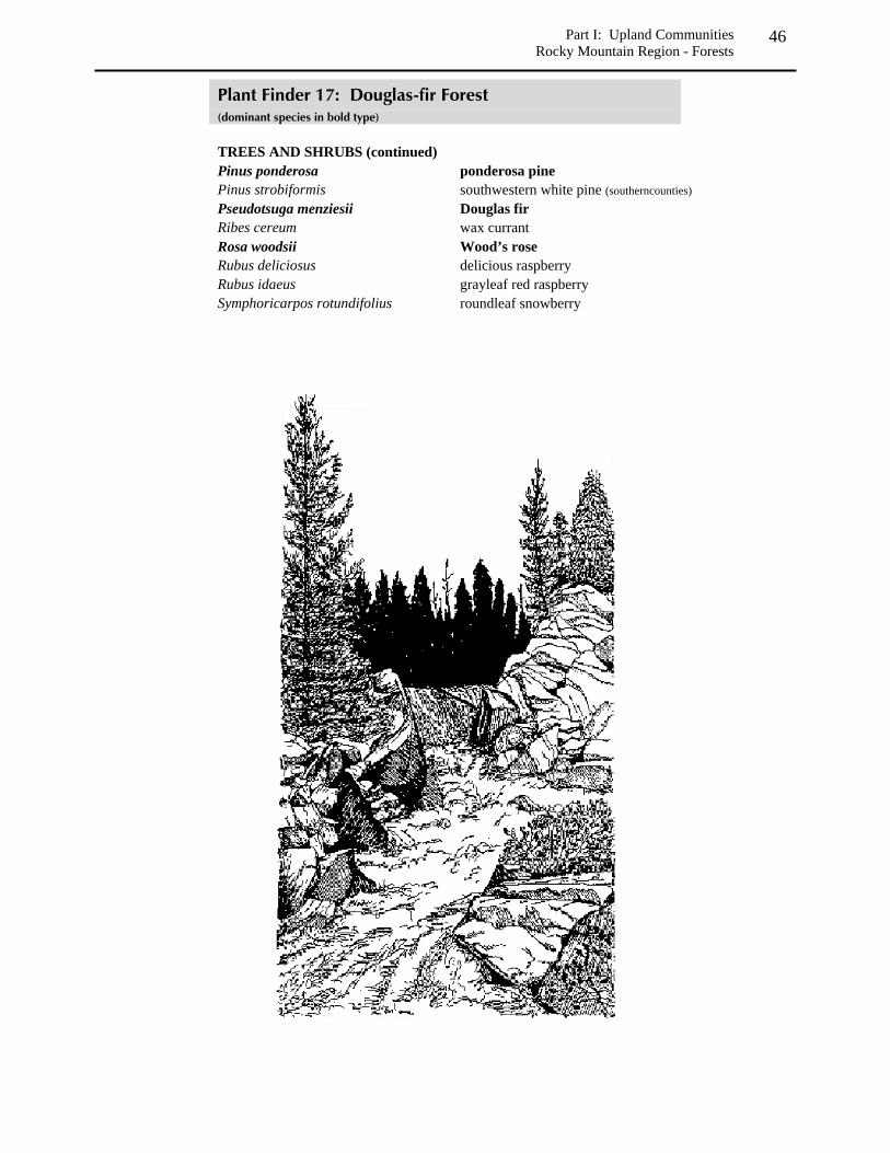
Part I: Upland CommunitiesRocky Mountain Region - Forests
46
��/0���102����<*�����4�/5.B1������5�62��10/0��57��1�5�10����2��87�9
TREES AND SHRUBS (continued)Pinus ponderosa ponderosa pinePinus strobiformis southwestern white pine (southerncounties)
Pseudotsuga menziesii Douglas firRibes cereum wax currantRosa woodsii Wood’s roseRubus deliciosus delicious raspberryRubus idaeus grayleaf red raspberrySymphoricarpos rotundifolius roundleaf snowberry
Part I: Upland CommunitiesRocky Mountain Region - Forests
47
�������������������
In Colorado, lodgepole pine is an upper montane and subalpine species whose range overlapsthat of Engelmann spruce and subalpine fir, except that lodgepole pine does not occur naturallywest of the Sangre de Cristo Mountains and south of the Gunnison River (Crane 1982). Ingeneral lodgepole pine replaces Engelmann spruce and subalpine fir after catastrophic fires ondry sites, where it forms dense stands. Few herbaceous plants and shrubs are able to tolerate thedeep shade of these “doghair thickets”. Because lodgepole pine does not reproduce in the shadeof existing forest, it usually gives way over time to spruce and fir. Lodgepole pine can persistindefinitely, however, on cold sites with thin, extremely dry soils.
��/0���102�����*���24�7�����10������5�62��10/0��57��1�5�10����2��87�9
GRAMINOIDSCarex geyeri elk sedgeKoeleria macrantha prairie junegrassPoa lettermanii Letterman’s bluegrassTrisetum spicatum spike trisetum
FORBSArnica cordifolia heartleaf arnicaCampanula rotundifolia bluebell bellflowerEpilobium angustifolium fireweedLupinus argenteus silvery lupinePotentilla diversifolia varileaf cinquefoil
TREES AND SHRUBSAbies lasiocarpa subalpine firArctostaphylos uva-ursi kinnikinnickJuniperus communis common juniperMahonia repens Oregon grapePicea engelmannii Engelmann sprucePinus contorta lodgepole pinePseudotsuga menziesii Douglas firRosa woodsii Wood’s roseSalix scouleriana Scouler’s willowShepherdia canadensis russet buffaloberryVaccinium myrtillus whortleberryVaccinium scoparium grouse whortleberry
Part I: Upland CommunitiesRocky Mountain Region - Forests
48
������������
Aspen forests are distributed on moist deep soils and scattered shallow soils in all mountainzones except the alpine. At lower elevations, aspen forests reach into the upper foothills zonealong ravines where conditions are cool and moist; in the montane and subalpine, aspen mayform large groves on slopes and narrow borders on valley bottoms. Aspen are typically seralspecies that become established on sites disturbed by fires, floods, avalanches, landslides orhuman activity. Persistent aspen stands are found in northern Colorado, in South Park, and westof the continental divide. Moist aspen groves typically have a rich diversity and a dense cover ofherbaceous and shrub species in the understory. Drier sites have a grassy understory of Thurberfescue, slender wheatgrass, and blue wild rye.
��/0���102�����*���57�0�����5�62��10/0��57��1�5�10����2��87�9
GRAMINOIDSBromopsis porteri nodding bromeBromopsis pumpelliana pumpelly bromeCarex geyeri elk sedgeElymus glaucus blue wildryeElymus trachycaulus slender wheatgrassFestuca thurberi Thurber’s fescue
FORBSAchillea lanulosa western yarrowAgastache urticifolia nettleleaf giant hyssopArnica cordifolia heartleaf arnicaAster engelmannii Engelmann’s asterDelphinium barbeyi tall larkspurGalium boreale northern bedstrawGeranium richardsonii Richardson’s geraniumHeracleum sphondylium cow parsnipLathyrus lanszwertii var. leucanthus aspen peavineLigusticum porteri Porter’s licoricerootOsmorhiza chilensis sweet cicelySenecio serra tall ragwortThalictrum fendleri Fendler’s meadowrueThermopsis montana golden bannerVicia americana American vetch
TREES AND SHRUBSAmelanchier alnifolia Saskatoon serviceberryJuniperus communis common juniperMahonia repens OregongrapePopulus tremuloides quaking aspenPrunus virginianus black chokecherryRubacer parviflorus thimbleberrySymphoricarpos rotundifolius roundleaf snowberry

Part I: Upland CommunitiesRocky Mountain Region - Forests
49
����!������ ���.�� ����������������
Forests of Engelmann spruce and subalpine fir form extensive stands in the subalpine zone(9300-11,400 feet/2835-3475 m) of the Rocky Mountain region and extend down into themontane zone in cool ravines. These fairly homogeneous expanses of forest are occasionallyinterrupted by stands of lodgepole pine (in northern Colorado) or aspen, grasslands, meadows orwetlands. The understory in spruce-fir forests is often dense but with moderate to low diversityof vascular plants and relatively high diversity of non-vascular plants—mosses and lichens aswell as various fungi involved with the decay of fallen wood. In the southern mountains,corkbark fir may occur with or replace subalpine fir.
��/0���102���+?*���04���/00��7�����.����/�710���1������5�62��10/0��57��1�5�10����2��87�9
GRAMINOIDSBromopsis pumpelliana pumpelly bromeCarex geyeri elk sedgePoa nervosa Wheeler bluegrassPoa reflexa nodding bluegrass
FORBSAchillea lanulosa western yarrowAntennaria rosea rosy pussytoesArnica cordifolia heartleaf arnicaCampanula rotundifolia bluebell bellflowerEpilobium angustifolium fireweedGalium boreale northern bedstrawGeranium richardsonii Richardson's geraniumPedicularis spp. lousewortPolemonium pulcherrimum ssp. delicatum Jacob's ladderPyrola spp. wintergreenSolidago parryi Parry’s goldenrod
TREES AND SHRUBSAbies arizonica corkbark fir (southern Colorado)Abies lasiocarpa subalpine fir (northern Colorado)Lonicera involucrata twinberry honeysucklePaxistima myrsinites boxleaf myrtlePicea engelmannii Engelmann sprucePinus flexilis limber pineRibes coloradense Colorado currantRibes lacustre prickly currantRibes montigenum gooseberry currantRibes wolfii Wolf’s currantRubacer parviflorus thimbleberryShepherdia canadensis russet buffaloberryVaccinium myrtillus whortleberryVaccinium scoparium grouse whortleberry
Part I: Upland CommunitiesRocky Mountain Region – Alpine Tundra
50
������� ���Alpine tundra extends from treeline (approximately 11,400 feet/3475 m) to the mountain tops.The cold, extremely windy climate produces harsh growing conditions. As a result, plants aremostly small, low, perennial and adapted to a short growing season. Geomorphic processes(frost action, glaciation, mass wasting), snow retention, wind dessication and permafrost haveproduced soil and topographic conditions that vary considerably over short distances andstrongly influence vegetation patterns. Plant communities, reflecting the underlying variations inenvironmental conditions, are arranged in a complex mosaic of closely interspersed types.
� In consideration of the difficulty of alpine revegetation, readers are strongly advised to avoiddisturbing alpine areas whenever possible. For instance, if your project involves a trail,consider the possibility of using cairns rather than removing vegetation to build the trail.You should consult an experienced restoration specialist for alpine projects.
Tips for alpine projects
Due to the high elevation, harsh environmental conditions, and difficult access, planting in the alpinezone presents special complications.
� Short growing seasons and cold temperatures limit plant growth rates, slowing establishmentand visible progress of revegetation.
� Few high altitude native plant materials are available from commercial suppliers.� Very little information regarding the germination requirements of native high-altitude species is
available. High altitude species are even less likely than lower altitude native species to conformto the desired “garden model” of rapid germination and vigorous establishment.
The severe environmental conditions of high elevations can devastate carefully acquired/propagatedplant materials. Among the most harmful factors are wildlife browsing (including pocket gophers),summer freezes, snowmold and frost-heaving especially during spring when young seedlingstrapped in a frozen surface soil layer are often ripped out of the ground by ice crystals growing frombelow.
� Below treeline and in the moister, less windy alpine communities, plants listed in the PlantFinders can perform well if seeded in the fall and provided with a durable mulch cover such asbonded fiber matrix or well-anchored excelsior or other organic mats.
� In moderately windy sites, establishment must be done via planting rather than seeding.Appropriate species for such sites are not ordinarily available (e.g., Bellardi kobresia (Kobresiamyosuroides), or blackroot sedge (Carex elynoides)) and must be propagated by special order.Mulches in these sites must be more carefully applied than those in sheltered sites.
� In the most exposed alpine sites (fellfields), prospects of successful revegetation within a decadeare small. Success is likely to result from custom propagation of fellfield native species, carefulpositioning relative to microtopography, and subtle use of microtopographic objects such asrocks to produce a moderate, but not overly protected microsite for the plantings.
For more information, see Proceedings of the High Altitude Revegetation Workshops, Willard 1972.

Part I: Upland CommunitiesRocky Mountain Region – Alpine Tundra
51
������!���� �
Alpine meadows are common on level to gently rolling sites with fairly deep, well-drained, fine-textured soils. Dry meadows (turfs) occur in areas where snow does not accumulate in thewinter or melts early, typically on windward slopes and ridges. Meadows in more mesic areasare found on gentle slopes or in shallow basins.
��/0���102���+�*��!�51����710��!�/2�:562��10/0��57��1�5�10����2��87�9
GRAMINOIDSCarex norvegica Norway sedgeDanthonia intermedia timber oatgrassDeschampsia cespitosa tufted hairgrassElymus trachycaulus subsp. andinus slender wheatgrass (alpine race)
Festuca brachyphylla alpine fescueLuzula spicata spiked woodrushPoa alpina alpine bluegrassPoa glauca timberline bluegrassTrisetum spicatum spike trisetum
FORBS/SHRUBSAchillea lanulosa western yarrowAgoseris glauca wild dandelionAquilegia caerulea Colorado blue columbineAquilegia saximontana Rocky Mountain columbineArtemisia arctica arctic wormwoodArtemisia scopulorum alpine sagewortAster foliaceous alpine leafybract asterErigeron melanocephalus blackhead fleabaneErigeron simplex onestem fleabaneGeum rossii var. turbinatum alpine avensPolygonum bistortoides American bistortPolygonum viviparum alpine bistortHymenoxys grandiflora graylocks hymenoxysPenstemon whippleanus Whipple’s penstemonPolemonium viscosum sticky Jacob's ladderSalix brachycarpa barrenground willowSalix arctica arctic willowSalix reticulata ssp. nivalis snow willowSibbaldia procumbens creeping sibbaldiaSolidago spathulata alpine goldenrodTrifolium dasyphyllum alpine clover
Part I: Upland CommunitiesRocky Mountain Region – Alpine Tundra
52
��/0���102���++*����8���710��!�/2�:562��10/0��57��1�5�10����2��87�9
GRAMINOIDSCarex elynoides blackroot sedgeCarex rupestris Drummond sedgeDanthonia intermedia timber oatgrassElymus scribneri spreading wheatgrassFestuca brachyphylla Colorado fescueKobresia myosuroides Bellardi kobresiaPhleum commutatum alpine timothyPoa alpina alpine bluegrassPoa glauca timberline bluegrass
FORBSCampanula uniflora arctic bellflowerCastilleja occidentalis western Indian paintbrushClaytonia megarhiza alpine springbeautyDryas octopetala mountain dryadErigeron pinnatisectus featherleaf fleabaneEritrichum aretioides alpine forget-me-notHymenoxys grandiflora old man of the mountainMertensia lanceolata prairie bluebellsOreoxis alpina alpine oreoxisPrimula angustifolia alpine primroseSilene acaulis moss campionThalictrum alpinum alpine meadowrue

Part I: Upland CommunitiesWestern Plateau and Canyon Region
53
����������� ��������&�������
DESCRIPTION – This region lies west of the Continental Divide and below 8,000 feet (2438m). Like the Rocky Mountain region, it is geographically and vegetationally complex. Theunifying theme in this region is the relatively flat-lying layers of sedimentary rocks formingextensive highlands. The Colorado River and its major tributaries (the San Juan, Dolores, White,Yampa and Gunnison rivers) have cut deep canyons into the layers of rock. The region sharesfloristic affinities with the Colorado Plateau, the San Juan Basin and the Uintah Basin regions ofArizona, Utah and New Mexico.
CLIMATE / SOIL – This region does not have a dominant precipitation season. Sixty percentof the annual precipitation occurs from October to April in the form of snow. The westernplateau and canyon region receives very little summer precipitation, although some areas insouthern Colorado are influenced by summer monsoon moisture from the southwest. Annualprecipitation ranges from 6 to 18 inches (15-45 cm). Shallow and impermeable soils in manyareas limit the effectiveness of the snow and rain that does fall.
TOPOGRAPHIC FEATURES – This region is distinguished from the Rocky Mountain andEastern Plains and Foothills Regions by plateaus with more or less flat tops and very steep sides.Broad river valleys and deep, spectacular canyons frequently interrupt the generally level terrain.High escarpments such as the Vermilion Bluffs, the Book Cliffs and the Mesa Verde alsoprovide topographic relief.
Part I: Upland CommunitiesWestern Plateau and Canyon Region
54
VEGETATION – The combination of dry climate and shallow, impermeable soils on slopesthat are often steep imposes severe limitations on plant growth. The perennial vegetation of theregion is generally very sparse, though weedy annuals can form a dense understory. Majorcommunities include bunchgrass grasslands, saline bottomland shrublands, sagebrushshrublands, mixed mountain shrublands, and piñon-juniper and pine woodlands.
��� �!���������" ����������"
Grasslands 55Shrublands 56Forests and Woodlands 63Wetland / Riparian 145
Part I: Upland CommunitiesWestern Plateau and Canyon Region - Grasslands
55
��������Grasslands and meadows occur primarily on fine-grained or deep soils on moderate to low slopesor on steeply sloping sites, and may be small patches interspersed among shrubland, woodland orforest communities. These areas range from mesic to dry depending on soil characteristics andthe availability of ground water.
Grasslands on rocky, windswept mesa sides above 6,500 feet (1981 m) are dominated bybunchgrasses, especially bluebunch wheatgrass, Indian ricegrass, and Junegrass. Shrub cover isgenerally minimal. Other grasslands typically occur on flat sandstone benches below 6,500 feet(1981 m). Galleta, Indian ricegrass, needleandthread grass, Indian ricegrass and blue grama arethe most common species.
Notes on grassland projects
Depending on the degree of past disturbance, rehabilitation may be accomplished byremoving grazing, introducing fire, interplanting native grasses and forbs, and/orremoving aggressive nonnative plants.
Transplanting from the wild is difficult because many grassland plants have developedlong, deep roots to promote survival during drought. Try salvaging plants from sites thatare scheduled for development rather than trying to move plants from intact nativegrasslands.
Mow grasslands the first year after planting to prevent weeds from going to seed.
Western slope grasslands evolved without frequent fire or intense grazing. Burn thesegrasslands only often enough to prevent invasion by shrubs and trees.
For more information on grassland projects, see Brune 1991, Roundy et al. 1993, andSchramp 1978.
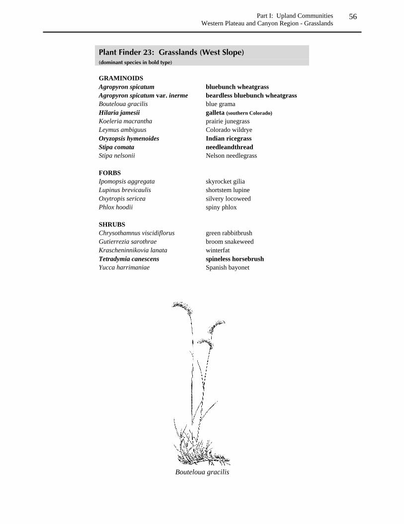
Part I: Upland CommunitiesWestern Plateau and Canyon Region - Grasslands
56
��/0���102���+)*����/55�/025�6 �5�����7�962��10/0��57��1�5�10����2��87�9
GRAMINOIDSAgropyron spicatum bluebunch wheatgrassAgropyron spicatum var. inerme beardless bluebunch wheatgrassBouteloua gracilis blue gramaHilaria jamesii galleta (southern Colorado)
Koeleria macrantha prairie junegrassLeymus ambiguus Colorado wildryeOryzopsis hymenoides Indian ricegrassStipa comata needleandthreadStipa nelsonii Nelson needlegrass
FORBSIpomopsis aggregata skyrocket giliaLupinus brevicaulis shortstem lupineOxytropis sericea silvery locoweedPhlox hoodii spiny phlox
SHRUBSChrysothamnus viscidiflorus green rabbitbrushGutierrezia sarothrae broom snakeweedKrascheninnikovia lanata winterfatTetradymia canescens spineless horsebrushYucca harrimaniae Spanish bayonet
Bouteloua gracilis
Part I: Upland CommunitiesWestern Plateau and Canyon Region - Shrublands
57
�" �����Shrublands come in many kinds, but all have shrubs – multiple-stemmed, woody plants – as theirdominant plants. Shrublands occur naturally in specialized habitats, often in areas too cold ortoo dry for trees but where soil conditions will support shrubs’deep root systems. Shrubs willalso invade many types of grassland communities in the absence of fire or where grazing by wildand domestic animals has weakened the competitive ability of grasses. In western Colorado,shrubland communities separate out by elevation and soil type. The “adobe badlands” socommon at the lowest elevations near Grand Junction and in the northwestern and southwesterncorners of the state support mat saltbush shrublands. Greasewood and fourwing saltbushshrublands occur in alkaline depressions with clayey soils and a high water table (“flats”) in thesame areas. Deeper, coarser soils at middle elevations support sagebrush shrublands, andhillsides near lower treeline support mixed mountain shrubland communities.
Notes on shrubland projects
Shrublands may be considered transitional communities – possibly grasslandstransitioning to forests in the absence of fire. There are several procedures to followwhich will help the success of your restoration project.
Resist the tendency to remove all the rocks and boulders from the soil in which you wantto grow your shrubland. Rocks on the surface of the soil concentrate rainfall aroundtheir margins and provide hospitable sites for moisture-hungry shrubs to grow.Subsurface rock also increases the available soil moisture at depth by allowing moisturepercolation and concentrating it between rocks. Rocks without fine soil between themcan be a problem since shrub roots have a hard time becoming established in very rockysoils. Total rock content of the soil should be between 5 and 20 percent with a sand orsandy loam matrix and up to 50 percent for a fine textured matrix.
Plant shrubs and forbs first. Grass competition must be restricted by use of mulch clothor other techniques to protect young shrubs or forbs from often fatal competition withgrasses.
Whenever possible, control weeds before planting to avoid damaging plantings withherbicide applications.
For more information on shrubland projects, see Barrow 1996 and Roundy et al. 1993.
Part I: Upland CommunitiesWestern Plateau and Canyon Region - Shrublands
58
!������� �"��" �����
Mat saltbush shrubland usually occurs on the driest sites below 6,000 feet (1829 m), usually onsoils derived from shales of the Mancos and Green River formations. It is sometimes hard torecognize this community because the total vegetation cover often does not exceed 10 percent.The soils are heavy clays rich in calcium sulfate, selenium and sodium, and create conditionsoutside the tolerance limits of most plants. Gardner’s and mat saltbush seem best adapted tothese harsh growing conditions.
��/0���102���+,*��!/���/����53��3����/02562��10/0��57��1�5�10����2��87�9
GRAMINOIDSHilaria jamesii galleta (southern Colorado)
Leymus salinus saline wildryeOryzopsis hymenoides Indian ricegrassSporobolus airoides alkali sacaton
FORBSGilia ophthalmoides eyed giliaPhacelia splendens patch scorpionweedSphaeralcea coccinea scarlet globemallowStanleya pinnata pinnate princesplume
TREES AND SHRUBSAtriplex corrugata mat saltbushAtriplex gardneri Gardner’s saltbushFrankenia jamesii James’ seaheath (southern Colorado)
Krascheninnikovia lanata winterfat
�����������!�����" �����
Saline bottomland shrubland usually occurs below 7,500 feet (2286 m); it is common on broadvalley floors from Wyoming to the New Mexico border and west into Utah. On moist alkalinesoils developed from stream deposits, greasewood forms pure stands. As alkalinity and depth ofalluvium decrease, greasewood is found with shadscale and other saltbush species (Benedict1991; Mutel and Emerick 1984). Shadscale saltbush is found primarily on elevated moderatelycoarse, moderately alkaline alluvium. Other species of saltbush, primarily Gardner’s and mat,occur on more alkaline soils, often developed from shales.
��/0���102���+-*�����/5�:��2���/�5��6 �5�����7�962��10/0��57��1�5�10����2��87�9
GRAMINOIDSBouteloua gracilis blue gramaDistichlis spicata inland saltgrass
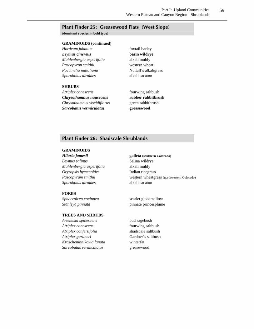
Part I: Upland CommunitiesWestern Plateau and Canyon Region - Shrublands
59
��/0���102���+-*�����/5�:��2���/�5��6 �5�����7�962��10/0��57��1�5�10����2��87�9
GRAMINOIDS (continued)Hordeum jubatum foxtail barleyLeymus cinereus basin wildryeMuhlenbergia asperifolia alkali muhlyPascopyron smithii western wheatPuccinelia nuttaliana Nuttall’s alkaligrassSporobolus airoides alkali sacaton
SHRUBSAtriplex canescens fourwing saltbushChrysothamnus nauseosus rubber rabbitbrushChrysothamnus viscidiflorus green rabbitbrushSarcobatus vermiculatus greasewood
��/0���102���+;*���3/25�/����3����/025
GRAMINOIDSHilaria jamesii galleta (southern Colorado)
Leymus salinus Salina wildryeMuhlenbergia asperifolia alkali muhlyOryzopsis hymenoides Indian ricegrassPascopyrum smithii western wheatgrass (northwestern Colorado)
Sporobolus airoides alkali sacaton
FORBSSphaeralcea cocinnea scarlet globemallowStanleya pinnata pinnate princesplume
TREES AND SHRUBSArtemisia spinescens bud sagebushAtriplex canescens fourwing saltbushAtriplex confertifolia shadscale saltbushAtriplex gardneri Gardner’s saltbushKrascheninnikovia lanata winterfatSarcobatus vermiculatus greasewood
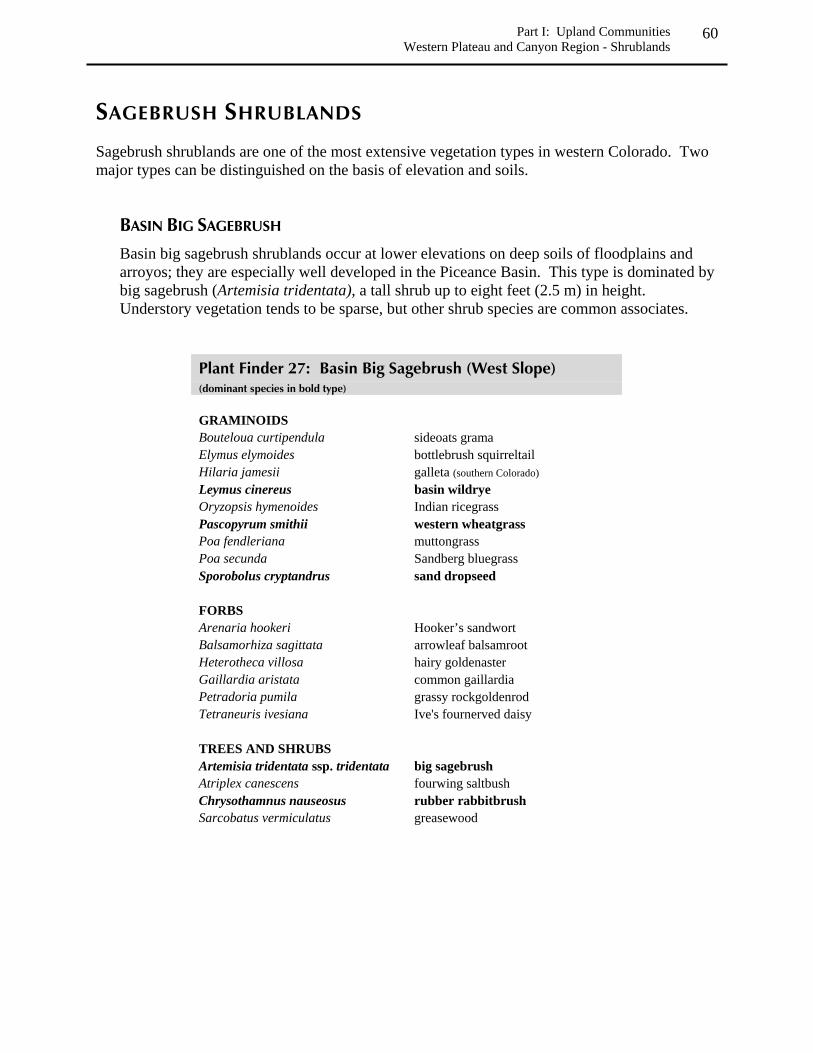
Part I: Upland CommunitiesWestern Plateau and Canyon Region - Shrublands
60
����� �"��" �����
Sagebrush shrublands are one of the most extensive vegetation types in western Colorado. Twomajor types can be distinguished on the basis of elevation and soils.
��������������� �"
Basin big sagebrush shrublands occur at lower elevations on deep soils of floodplains andarroyos; they are especially well developed in the Piceance Basin. This type is dominated bybig sagebrush (Artemisia tridentata), a tall shrub up to eight feet (2.5 m) in height.Understory vegetation tends to be sparse, but other shrub species are common associates.
��/0���102���+<*���/510��14��/4����53�6 �5�����7�962��10/0��57��1�5�10����2��87�9
GRAMINOIDSBouteloua curtipendula sideoats gramaElymus elymoides bottlebrush squirreltailHilaria jamesii galleta (southern Colorado)
Leymus cinereus basin wildryeOryzopsis hymenoides Indian ricegrassPascopyrum smithii western wheatgrassPoa fendleriana muttongrassPoa secunda Sandberg bluegrassSporobolus cryptandrus sand dropseed
FORBSArenaria hookeri Hooker’s sandwortBalsamorhiza sagittata arrowleaf balsamrootHeterotheca villosa hairy goldenasterGaillardia aristata common gaillardiaPetradoria pumila grassy rockgoldenrodTetraneuris ivesiana Ive's fournerved daisy
TREES AND SHRUBSArtemisia tridentata ssp. tridentata big sagebrushAtriplex canescens fourwing saltbushChrysothamnus nauseosus rubber rabbitbrushSarcobatus vermiculatus greasewood
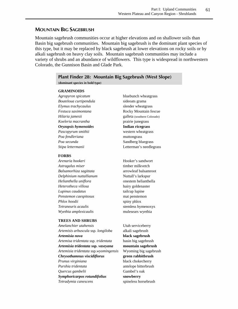
Part I: Upland CommunitiesWestern Plateau and Canyon Region - Shrublands
61
!� ��������������� �"
Mountain sagebrush communities occur at higher elevations and on shallower soils thanBasin big sagebrush communities. Mountain big sagebrush is the dominant plant species ofthis type, but it may be replaced by black sagebrush at lower elevations on rocky soils or byalkali sagebrush on heavy clay soils. Mountain sagebrush communities may include avariety of shrubs and an abundance of wildflowers. This type is widespread in northwesternColorado, the Gunnison Basin and Glade Park.
��/0���102���+�*��!��0�/10��14��/4����53�6 �5�����7�962��10/0��57��1�5�10����2��87�9
GRAMINOIDSAgropyron spicatum bluebunch wheatgrassBouteloua curtipendula sideoats gramaElymus trachycaulus slender wheatgrassFestuca saximontana Rocky Mountain fescueHilaria jamesii galleta (southern Colorado)
Koeleria macrantha prairie junegrassOryzopsis hymenoides Indian ricegrassPascopyrum smithii western wheatgrassPoa fendleriana muttongrassPoa secunda Sandberg bluegrassStipa lettermanii Letterman’s needlegrass
FORBSArenaria hookeri Hooker’s sandwortAstragalus miser timber milkvetchBalsamorhiza sagittata arrowleaf balsamrootDelphinium nuttallianum Nuttall’s larkspurHelianthella uniflora onestem helianthellaHeterotheca villosa hairy goldenasterLupinus caudatus tailcup lupinePenstemon caespitosus mat penstemonPhlox hoodii spiny phloxTetraneuris acaulis stemless hymenoxysWyethia amplexicaulis mulesears wyethia
TREES AND SHRUBSAmelanchier utahensis Utah serviceberryArtemisis arbuscula ssp. longiloba alkali sagebrushArtemisia nova black sagebrushArtemisa tridentata ssp. tridentata basin big sagebrushArtemisia tridentata ssp. vaseyana mountain sagebrushArtemisia tridentata ssp.wyomingensis Wyoming big sagebrushChrysothamnus viscidiflorus green rabbitbrushPrunus virginiana black chokecherryPurshia tridentata antelope bitterbrushQuercus gambelii Gambel’s oakSymphoricarpos rotundifolius snowberryTetradymia canescens spineless horsebrush

Part I: Upland CommunitiesWestern Plateau and Canyon Region - Shrublands
62
!�=���!� �������" ����
Mixed mountain shrublands occur at elevations between the piñon pine-juniper woodland andupper montane coniferous forest communities. The shrubland consists of Gambel’s oak growingeither in pure stands or with mountain mahogany, serviceberry and/or snowberry. The shrubsform a dense canopy restricting the understory to relatively few shade tolerant graminoids andforbs.
��/0���102���+�*��!1C�2�!��0�/10��3����/025�6 �5�����7�962��10/0��57��1�5�10����2��87�9
GRAMINOIDSCarex geyeri elk sedgeCarex pensylvanica var. heliophila sun sedgeStipa nelsonii Nelson’s needlegrass
FORBSLathyrus lanszwertii var. leucanthus aspen peavineMertensia fusiformis spindleroot bluebellsPetradoria pumila grassy rockgoldenrodSolidago missouriensis Missouri goldenrodStenotus acaulis stemless mock goldenweed
TREES AND SHRUBSAmelanchier alnifolia Saskatoon serviceberryAmelanchier utahensis Utah serviceberryArctostaphylos patula greenleaf manzanita (northwestern Colorado)Arctostaphylos uva-ursi kinnikinnickCeanothus martinii Martin’s ceanothus (northwestern Colorado)Cercocarpus montanus true mountain mahoganyFendlera rupicola cliff fendlerbushPeraphyllum ramosissimum squaw apple (southern counties)
Quercus gambelii Gambel’s oak (southern counties)
Rhus trilobata skunkbush sumacSymphoricarpos rotundifolius roundleaf snowberry

Part I: Upland CommunitiesWestern Plateau and Canyon Region - Woodlands
63
�������Woodlands occur on rocky hillsides at middle elevations and often define lower treeline. Theyare characterized by having one or more species of small trees – Utah juniper, Rocky Mountainjuniper or piñon pine – dominant in the topmost layer of vegetation. Because these trees requiremore moisture and deeper soils than shrubs or grasses do, woodland communities are restrictedto rocky, mesic sites in draws and north-facing escarpments below 6,000 feet (1829 m), and dryslopes among ponderosa pine and Douglas-fir communities above 6,000 feet. Fire convertswoodland communities to grasslands or shrublands; very old woodland communities are rareexcept in rocky areas which are protected from fire. Conversely, fire suppression over the past150 years of settlement has resulted in the spread of piñon-juniper woodlands over vast areas ofthe West formerly occupied by grasslands and shrublands.
Notes on woodland projects
Woodland sites are similar to alpine sites in the challenges they present to revegetationproject planners. The conditions are generally too dry and windy for plantings tosucceed without special measures.
In moister, less windy sites, plants listed in the Plant Finder can perform well if seeded inthe fall and provided with a durable mulch cover such as bonded fiber matrix or well-anchored excelsior mat.
In moderately windy sites, establishment must be done via planting rather than seeding.Mulches in these sites must be more carefully applied and must be better anchored thanthose in sheltered sites.
For more information on woodlands, see Shaw et al. 1994, Covington 1996, and Howell1986.

Part I: Upland CommunitiesWestern Plateau and Canyon Region - Woodlands
64
��>�������.( ����� ������
Piñon pine-juniper woodland communities occur on shallow, rocky soils in warm, dry sites.They often occur on hillsides and mesa tops, and this community will invade sagebrushshrublands and Great Basin grasslands in the absence of fire. Gravelly substrates with highlevels of calcium and alkaline salts provide the optimum growth medium (Mutel and Emerick1984). Juniper tolerates drought and soil saturation better than piñon pine, so it is more abundantat lower elevations. Piñon pine is more cold tolerant and is more prevalent at higher elevations(Mutel and Emerick 1984). Understory species are less abundant where the woody overstory isdense, but the graminoid and forb flora is typically rich.
��/0���102���)?*���1@�0��10�.(�017��� ��2�/02�6 �5�����7�962��10/0��57��1�5�10����2��87�9
GRAMINOIDSAgropyron spicatum bluebunch wheatgrassBouteloua curtipendula sideoats gramaBouteloua gracilis blue gramaElymus elymoides bottlebrush squirreltailHilaria jamesii galleta (southern Colorado)
Leymus salinus salina wildryeOryzopsis hymenoides Indian ricegrassPoa fendleriana muttongrassPoa secunda Sandberg bluegrassStipa comata needleandthread
FORBSHymenopappus filifolius thinleaf hymenopappusLeucelene ericoides sand asterPetradoria pumila grassy rockgoldenrodPhlox longifolia longleaf phloxSolidago nemoralis gray goldenrodStenotus armerioides thrift mock goldenweedTetraneuris ivesiana Ive’s fournerved daisy
TREES AND SHRUBSAmelanchier utahensis Utah serviceberryArtemisia tridentata ssp. vaseyana mountain sagebrushBrickellia californica brickellbushCercocarpus intricatus littleleaf mountain mahoganyCercocarpus ledifolius curlleaf mountain mahoganyCercocarpus montanus true mountain mahoganyChrysothamnus viscidiflorus green rabbitbrushJuniperus osteosperma Utah juniperLycium pallidum pale wolfberryPinus edulis Piñon pinePurshia tridentata antelope bitterbrushRibes cereum wax currantSymphoricarpos rotundifolius roundleaf snowberryYucca baccata banana yucca (southern counties)

Part I: Upland CommunitiesWestern Plateau and Canyon Region - Woodlands
65
����� �������
Pine woodlands are composed predominately of ponderosa pine. They typically consist of openstands on dry south-facing slopes with a shrub and herbaceous understory. These woodlandsform the ecotone between the Rocky Mountain region and the Western Plateau and Canyonregion, except in northwestern Colorado, where they are absent and replaced by pure stands ofDouglas-fir and aspen. These communities are similar to the pine woodlands in the foothills eastof the Rocky Mountain region.
��/0���102���)�*���10�� ��2�/02562��10/0��57��1�5�10����2��87�9
GRAMINOIDSBlepharoneuron tricholepis pine dropseedBouteloua gracilis blue gramaCarex geyeri elk sedgeFestuca arizonica Arizona fescueFestuca saximontana Rocky Mountain fescueMuhlenbergia montana mountain muhlyPoa fendleriana muttongrassPoa secunda Sandberg bluegrassStipa nelsonii Nelson’s needlegrassStipa pinetorum pine needlegrass
FORBSAntennaria rosea rosy pussytoesArtemisia ludoviciana white sagebrushAstragalus lonchocarpus Hamilton’s milkvetchBrickellia grandiflora tasselflower brickelbushCampanula rotundifolia bluebell bellflowerGaillardia aristata common gaillardiaGeranium caespitosum pineywoods geraniumIpomopsis aggregata skyrocket giliaLotus wrightii Wright’s deervetch (southern counties)
Penstemon caespitosus mat penstemonPetradoria pumila grassy rockgoldenrod
TREES AND SHRUBSArctostaphylos uva-ursi kinnikinnickBerberis fendleri Colorado barberryCeanothus fendleri Fendler’s ceanothusJuniperus communis common juniperJuniperus osteosperma Utah juniperMahonia repens Oregon grapePaxistima myrsinites boxleaf myrtlePhysocarpus monogynus mountain ninebarkPinus flexilis limber pinePinus ponderosa ponderosa pinePseudotsuga menziesii Douglas-firPurshia tridentata antelope bitterbrushQuercus gambelii Gambel’s oakRibes inerme whitestem gooseberry

Part I: Upland CommunitiesWestern Plateau and Canyon Region - Woodlands
66

Part I: Upland CommunitiesRevegetation Techniques – Planning Your Project
67
���������������"��D ��
This section is divided into five steps:
����" ����"
1. Planning Your Project 672. Soil Characterizaton and Identification 693. Site Preparation 754. Seeding and/or Planting 815. Monitoring and Stewardship 103
������*���������&� ���(���The flow-chart on the following page presents the steps which are required for successfulcompletion of a revegetation project. The sequence will depend on the purpose of the projectand the current condition of the site to be revegetated. The following sections provide moredetailed information on each step.
WHEN TO CONSULT A PROFESSIONAL
The following sections will provide general guidelines for carrying out yourproject, however, this guide cannot include detailed information for everyscenario. For large projects, or for those in particularly challengingenvironments, we advise working with experts. You may choose to work with alocal resource agency or a private consultant. In either case, you should be asinformed as possible about the techniques and plant species which will be usedin your project.
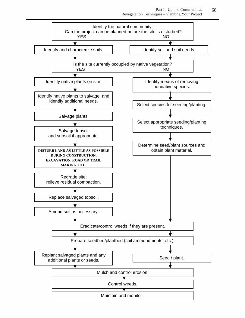
Part I: Upland CommunitiesRevegetation Techniques – Planning Your Project
68
Regrade site;relieve residual compaction.
Identify the natural community. Can the project can be planned before the site is disturbed?
YES NO
Identify means of removingnonnative species.
Identify native plants on site.
Identify and characterize soils.
Identify native plants to salvage, andidentify additional needs.
Identify soil and soil needs.
Salvage plants.
Salvage topsoiland subsoil if appropriate.
Select species for seeding/planting.
Select appropriate seeding/plantingtechniques.
Determine seed/plant sources andobtain plant material.
Eradicate/control weeds if they are present.
Replace salvaged topsoil.
Amend soil as necessary.
Prepare seedbed/plantbed (soil ammendments, etc.).
Control weeds.
Maintain and monitor .
Replant salvaged plants and anyadditional plants or seeds. Seed / plant.
Is the site currently occupied by native vegetation?YES NO
Mulch and control erosion.
DISTURB LAND AS LITTLE AS POSSIBLEDURING CONSTRUCTION,
EXCAVATION, ROAD OR TRAILMAKING, ETC.

Part I: Upland CommunitiesRevegetation Techniques – Soils
69
�����+*�������"������E�����Soil is the medium for plant growth and is made up of minerals, dead organic matter, and livingorganisms such as soil microbes, mycorrhizae (the symbiotic association between specific fungiand the roots of some plants), worms, insects, and roots. Soils are often overlooked. However,an understanding of soil texture, chemistry, and structure is extremely important for successfulreclamation.� For small landscape projects, it is important to know the basic texture of the soil (clay, sand,
loam, or a mixture), but it is rarely important to have laboratory tests made of soils on thesite.
������=� �
Texture is determined by the size of the particlesthat make up the soil. Particles are divided intothe three size categories: sand, silt, and clay.Sand is the largest particle, clay is the smallest.Soil types are based on the percentage of the soilcomposed of these particle sizes (Figure 3). Forexample, a soil that is 20 percent sand , 60 percentsilt, and 20 percent clay is called a silty loam.Soil texture can be determined by using the flowchart in Figure 4.
��!��������!�*
Parent material is the rock from which soils are formed.
Subsoil is weathered parent material found beneath the soil layers. It isbasically eroded rock and lacks the other elements, such as organic matter, thatwould make it suitable for plant growth.
Soil is made up of minerals (generally derived from the parent material), deadorganic matter, and living organisms.
Topsoil refers to the uppermost layers of soil that include the most activebiological components, nutrients and organic matter. If topsoil is missing, a sitewill be difficult to revegetate. In this case, amendments may be necessary tofacilitate plant growth.
Amendments include organic matter and fertilizer or anything added to the soilor parent material to which will make it more suitable for plant growth (fertilizer isseldom used with native plants).
Plants native to your site have evolvedto survive in the local soils - even soilsthat might be considered “poor”. Whilesome amendments may be required toaid in plant establishment, deep darkrich soil is not always the goal.

Part I: Upland CommunitiesRevegetation Techniques – Soils
70
Texture influences how quickly water, nutrients and oxygen move into and through the soil aswell as the quantity of water and nutrients a soil can hold (Table 1). In general, soils high in claydo not drain well. They retain nutrients but have a tendency to become waterlogged. Sandysoils drain well, but have low nutrient holding capacity. Loamy soils represent a balancebetween sand and clay and are preferred for agricultural use because they retain nutrients andalso drain well. Adding organic matter to sandy soil can improve the nutrient and water holdingcapacity. The addition of organic matter to a clayey soil can improve water infiltration andpercolation. Ultimately, the best solution is to choose plants adapted to the soil type.
�/�����*���1�����7���1�5���7�02�0�� 7�0��/��1�����1F�
Particle Type Size (mm) Water Retention Nutrient RetentionSand 0.05-2.0 Low water retention Little to no nutrient
retentionSilt 0.0002-0.05 Moderate water
retentionModerate nutrientretention
Clay <0.002 High water retention High nutrient retention(Bradshaw and Chadwick 1980)
�14����)*���1����C�������1/04��

Part I: Upland CommunitiesRevegetation Techniques – Soils
71
�14����,*����:��3/�������������10104���1����C�����6/B�����3�10���<�9

Part I: Upland CommunitiesRevegetation Techniques – Soils
72
�����"�!���&
Four chemical properties of soil should be considered before a revegetation project isimplemented. These are pH, electrical conductivity, sodium adsorption ratio and percentorganic matter. These chemical properties are important because they greatly influence thesuitability of the soil for plant survival and growth. The easiest way to determine the chemicalproperties of a soil is to have it tested.
Soil tests are reasonably priced and worth the investment. A soil test will not only aid in theselection of species best suited for your site, but will also identify potential toxicity problems andsuggest soil amendments. A basic soil test will provide information on the four soil propertieslisted above as well as give a more precise soil texture reading compared to what can be done inthe field. A test can also give details on the macronutrients (nitrogen, phosphorus, andpotassium) and micronutrients (copper, iron, magnesium, and zinc) present in the soil. In somecases, other tests may be necessary for measuring the quantities of salts and heavy metals, aswell as other physical properties.
Some laboratories offer assistance in interpreting test results. Recommendations given for soilamendments are usually based on agricultural standards, however, and may not always beapplicable to native plant growth. The use of fertilizer will be discussed later in the manual, butin general, fertilizer should be used sparingly as native plants, unlike horticultural or agriculturalplants, rarely require fertilizer. Table 2 on page 73 offers some guidelines for determining thequality of the topsoil based on the results of your soil test.
Any soil testing facility can provide specific directions on how to collect a soilsample for analysis at their lab, but we have included a general description ofhow it is done. Most labs will recommend a composite soil sample.
1. Collect several samples (5 to 20) from an area using a consistent samplingmethod, and mix them together to form a composite.
2. Take a sample from this composite.3. Lable the sample with the date and location of collection and keep it on ice in
a cooler or frozen until submitted to the laboratory.4. Send the soil samples to the laboratory as soon as possible after collection to
ensure accurate results.
You may make several composite samples representing different soil depths, butat least one composite sample should be taken from the soil surface, at a depthof 0 to 6 inches (0 to 15 cm). For small areas, testing one composite soil samplewill be sufficient. For larger areas, several composite soil samples may benecessary. Samples may be removed with a soil corer or a shovel, as long as thesampling method is consistent and the tool is not contaminated with soil fromanother site. Although perhaps obvious, composited soils should be as similaras possible. If obvious soil differences are ignored, analysis of a compositesample will characterize an average or intermediate soil that does not exist.

Part I: Upland CommunitiesRevegetation Techniques – Soils
73
�/����+*���1���1/�����5�/��153���1�/�1�1�8��B���75�1�
SOIL PROPERTYSUITABLE MARGINAL
TO POORUNSUITABLE✝
GOOD FAIR*
pH 6.0-8.45.5-6.0
and8.4-8.8
5.0-5.5and
8.8-9.0
<5.0and>9.0
EC(electrical conductivitymmhos/cm soluble salts)
0-4 4-88-16
(EC >8 may provedifficult torevegetate)
>16
Texture
sandy loamloamsilty loamsandy clayloam
clay loamsilty clay loamsandy clayloamy sand
claysilty claysiltsand
SAR(sodium adsorption ratio) <6 6-10 10-15 >15
% Organic matter >2 0.5-2 <0.5
(Hansen et al. 1991)
∗ Native species adapted to highly acidic (pH <6.0) or highly alkaline (pH >8.4) soil conditionsshould be used when possible instead of attempting to amend the soil. Using additives tochange the pH can have complicating side effects and can be expensive. Some ecosystems inColorado are naturally acidic (very few) or alkaline, and additives should not be used in therestoration of these areas.
✝ Specific methods to treat or revegetate problem soils that fall under the category of“unsuitable” in Table 2 are beyond the scope of this document, but have been discussed inother references. If a site is particularly challenging, consider consulting an expert.
������ �� �
Soils are not usually just collections of loose soil particles; they are composed of clods, clumpsand chunks of sand, silt and clay particles mixed with organic material, together with air spacesor pores. Soil structure refers to the relative quantities of air and solid matter in the soil as wellas the size, shape and arrangement of these aggregations. Soil scientists use categories ofstructure to describe these aggregates. Quantitative measure of structure is roughly reflected inbulk density data.

Part I: Upland CommunitiesRevegetation Techniques – Soils
74
Low bulk density High bulk density
Soil compaction is the compression of soil particles. As soil compacts, particles move closertogether and the soil volume has fewer air spaces. This is often the result of too many passes ofheavy machinery or excessive foot traffic. Neither water nor roots can move readily into andthrough severely compacted soils. Seeds will sit on top of the soil and be vulnerable to wind,water, the sun’s heat and hungry birds or ants.
Soil structure develops over time as the soil itself develops. A loss of soil structure reduces theability of water to percolate and of air to move in and out of soils between the plant roots and theair spaces within the soil. The greatest danger to soil structure during a restoration project is soilcompaction. This usually occurs when heavy equipment is driven over the soil too many timesduring the course of a project. With each pass, soil particles are compressed and air spaces arereduced. Compaction can also occur in small projects if many people repeatedly walk over thesame area. Soil structure may also be damaged by improper seedbed preparation or poor topsoilsalvage methods. Use the methods described in the Site Preparation section beginning on thenext page to avoid destroying soil structure.
Bulk density is the amount of solid material per unit volume (g/cm3) in the soil.A soil with ideal growing conditions contains about 50 percent solid volume and50 percent pore volume, with a bulk density of approximately 1.33 g/cm3. A highbulk density translates to a greater degree of soil compaction and less developedstructure.

Part I: Upland CommunitiesRevegetation Techniques – Site Preparation
75
�����)*����������������There are two paths one can take to prepare the soil for a restoration project. The path youchoose depends on when the planning for the restoration project begins. If you can plan yourrestoration project before the disturbance and the site is currently occupied by native vegetation,then topsoil salvage is the best option. If land use activities have destroyed native vegetation andtopsoils are damaged or absent, then the only option is the development of substitute soils (siteconversion).
�������������
Remember, soil is essentially alive. Topsoil contains microbes, invertebrate animals such asworms and insects, fungi and bits of living plant material. Microbes, worms and insects aid incycling soil nutrients, aerating the soil and maintaining the soil structure. These creatures areimportant. Many native plant species are strongly dependent on an association with certainfungi. If these fungi are lacking, the plants may be weakened and less able to compete withweeds. Living plant propagules within the soil, such as roots, tubers, and seeds, are a source oflocally adapted native plants that are not available commercially.
����"����������
For the purposes of salvage, topsoil is generally defined as the upper 6 to 12 inches (15 to 30cm). Below this depth biological activity is usually limited. In some cases deeper subsoilsare salvaged to increase the amount of material available for covering a larger area. In thesecases, separating the topsoil from the subsoil is recommended. Lower soil materialsshould be stored separately and marked to distinguish them from the true topsoil. Thesesubsoils should be respread first before the topsoil is placed as the uppermost layer. Subsoilsshould be treated carefully, but the importance of maintaining structure is not as critical aswith topsoil.
"������������
Topsoil should be salvaged when moist, but not wet. Salvage of wet soils, particularly thosewith fine texture, often severely damages or completely destroys soil structure. The result isa giant “mud pie” that may dry as a massive brick. Salvage of completely dry topsoil mayalso damage soil structure, though not as severely, and will result in nearly complete loss ofliving plant material.
�����������������������������������
In general, it is best to avoid storing or stockpiling topsoil. If topsoil must be stored, do so asbriefly and shallowly as possible. Follow these general guidelines:
The goal of a topsoil salvage operation is to keep the soil alive, weed-free, andprotected from damage until it can be returned to the restoration site for plantingor seeding.
Part I: Upland CommunitiesRevegetation Techniques – Site Preparation
76
� Topsoil should be stored less than oneyear and in a weed-free location.
� Make storage piles shallow (less than 2feet is best) to leave more of the soilexposed to air. Remember, soil isalive!
� Soil stored for longer than a few weeksshould be sown with a protective sterilecover crop.
� Deep piles are harmful to salvagedtopsoil because the buried soil receiveslittle oxygen and desirable soilorganisms die soon after storage.
�� �������������"����������������
The manner in which the soil is returned to the site is just as important as the way it issalvaged and stored.
� Topsoil should be replaced with a minimum number of machine passes. “Sloppy work”mimics natural systems which have variable topsoil depths. Project supervisors shouldaccept variability of topsoil depth in lieu of seeking very uniform topsoil thicknessthrough extended machine work.
� Topsoil should be placed only when there is an assurance that the area will be seededwithin a few days. Each day that the topsoil remains bare gives weedy species a chanceto invade the site and allows erosion from wind and rain. This makes establishment ofperennial native species much more difficult.
� If topsoil is imported from another location, the source should be carefully andthoroughly inspected for noxious weeds and undesirable plants and rejected if weeds arefound.
������!�������� ����� ������
The following guidelines should be used when native vegetation has been absent for the past fewyears or the soil has been covered by undesirable species. Undesirable species may includeexotic invasive weeds or plants purposely introduced, such as forage grasses, nonnative
landscaping plants, or agricultural crops.
� Controlling these undesirable plants isthe single most important action you cantake to increase survival of native species.
Examples of sterile cover crops areRegreen (sterile wheat X wheatgrasscross) or milo.
� Barley (Hordeum vulgare), wheat(Triticum aestivum), or rye (Secalecereale) should not be used astemporary cover crops unless theycan be mown prior to seed maturitybecause they can reseed themselvesand inhibit the germination of nativeperennials. Despite claims to thecontrary, in some areas Regreen hasreseeded itself. “Sterile” hybridsusually produce a small number offertile plants.
Because weed control is such an importantaspect of revegetation, this manualincludes a separate section on the topicbeginning on page 107. We alsorecommend that a weed specialist beconsulted whenever possible.

Part I: Upland CommunitiesRevegetation Techniques – Site Preparation
77
There are three general approaches to dealing with a weedy situation:
1. If topsoil is present, eradicate or control undesirable plants, then prepare existing surface soilfor seeding or planting.
2. If topsoil is absent, eradicate or control undesirable plants, then import topsoil from anotherlocation or commercial source or amend the existing soil material.
3. For sites severely infested with perennial weeds, disposal of the topmost soil could bedesirable if elimination of weedy species is not feasible. This alternative could be veryexpensive and should only be considered if subsoils are of at least moderate quality.Remember, when a weedy plant spreads by rhizomes, the rhizomes often penetrate many feetinto the soil and will persist if only a foot or two of soil is removed.
�����������������
A well-prepared seedbed is a critical step in a successful restoration project. Seedbedpreparation refers to the physical operations necessary to prepare the soil for seeding. There aretwo extremes to contend with when preparing the seedbed: soil that is too firm (compacted) andsoil that is too loose (which can lead to erosion or improper depth of seeding when using a seeddrill). An ideal seedbed is midway between these two conditions. Your seedbed should be
� Firm enough so the seed will be in contactwith the soil, and the soil will not be easilywashed or blown away.
� Loose enough for the seed sprout topenetrate the soil.
To alleviate soil compaction the following methods may be used.
������������
Scarification is a form of ripping or chiseling, and consists of breaking up the topsoilaggregates by means of raking the soil surface with a set of sharp teeth. Implements withripper shanks can be pulled with almost any kind of motorized vehicle, but farm tractors,road graders and tracked bulldozers are recommended because they have sufficienthorsepower to accomplish this task. The soil surface can be ripped down to 12 inches (30cm), but subsoil sweeps should be used with caution as these devices can add to compactionproblems in the soil zone immediately below the blade. For large projects in which topsoilhas been removed, chiseling or ripping of subsoils to a depth of 6 to 12 inches (15 to 30 cm)prior to replacing the topsoil is recommended
� While soil ripping may be beneficial for preparing the seedbed, each episode of suchtreatment reduces soil moisture (Cotts et al. 1991); however, greater water infiltrationfrom subsequent rains can also be expected.
All site preparation methods should bedone on the contour (across the slope) toprevent soil erosion from surface waterrunoff.
Part I: Upland CommunitiesRevegetation Techniques – Site Preparation
78
�����
At its most basic, tillage is any process which involves cutting through and turning over thesoil. Tillage may be used to relieve both soil compaction and to control undesired plants.Plants can be plowed under so that their roots are exposed to the sun to die.
� This method should not be used on undesirable rhizomatous plants because tilling canspread rhizomes. Tillage should also not be used on sites that have high soil erosionpotential, such as on slopes or fine textured soils.
� Disc plows are often very harmful to soil structure and should not be used as a means ofrelieving compaction. However, in cases where the soil surface is dominated by coarseclods (as may occur if it is worked while wet), discing can be effective in reducing clods.
"�� �����������
Harrowing or raking is a secondary tillage operation which uses a spiked or toothedcultivating implement to roughen the soil surface uniformly. This method is generallyemployed to break up crusts or to lightly cover seeds. Harrowing/raking should almostalways be used immediately prior to and immediately following broadcast seeding.
�����!���!����
Soil amendments are materials added to the soil to alter or enhance its physical or chemicalproperties.
�������������E��
Nitrogen fertilizer should be used sparingly or not at all; excess applications can bedetrimental to a restoration project. It should only be used where a soil test has revealed agross deficiency of nitrogen. Test results can be compared with those from a similar intactcommunity as a baseline indicator of natural nutrient levels. One strategy for determining ifapplication of nitrogen fertilizer is appropriate is to wait until the next growing season andlook for evidence of severe nitrogen deficiency. Signs of nitrogen deficiency include stuntedgrowth and yellowish color. Fertilizer can then be applied in limited amounts to deficientareas only. Projects lacking topsoil will be the most deficient in soil nutrients and mayrequire some type of fertilizer input.
� Indiscriminate use of nitrogen fertilizer can “burn” young native plant seedlings. Mostnative plants in Colorado have evolved to thrive in low nutrient soils and will not benefitfrom high doses of nitrogen nearly as much as will competing nonnative weeds.
� Nitrogen fertilizer can also encourage heavy weed growth. Most introduced weeds andagricultural species are very opportunistic users of nitrogen. Excess amounts of fertilizercan result in a flush of rapidly growing invasive weeds that overwhelm slower growingnative species. Some weeds, such as Russian-thistle or kochia, will flourish under theslightest application of nitrogen. In time, as nitrogen is used up or leached out of the soil,these weeds will decrease in abundance; however, in some cases this process may takemany years.

Part I: Upland CommunitiesRevegetation Techniques – Site Preparation
79
Where fertilizer use is appropriate, a low level or slow release fertilizer is suggested for thegrowth of native plants. Organic fertilizers are good since they provide macronutrients(nitrogen, phosphorus, and potassium), micronutrients (copper, iron, manganese, zinc) andorganic matter to the soil or substrate.
Examples of organic fertilizers include:
� Compost� Biosolids (sewage sludge)� Mushroom compost� Animal waste (i.e. manure)� Biosol, a byproduct of penicillin production
which can be purchased in granular form likechemical fertilizers
�"���"� �
Colorado soils typically have low phosphorus levels and native plant requirements forphosphorus are small. For soils low in this nutrient, amending soils with phosphorus can bebeneficial for seed germination and plant growth. Phosphorus applications must be mixedinto the soil. A one-time application is sufficient since phosphorus is not easily leached outof the soil like nitrogen. Triple superphosphate (P2O5 with an N-P-K of 0-46-0) is the formof phosphorus most commonly used. A soil test can determine if phosphorus is needed inyour soil, but be aware that there are currently no accepted guidelines for the phosphorusrequirements of native species.
��"�������!���!����
Other amendments may include wood chips, sawdust, or microorganisms. Each of theseamendments has its advantages and drawbacks.
��2��3175��02��/:2�5�
Wood chips and sawdust are carbon rich mulches that can aid in erosion control, soilmoisture conservation and temperature regulation; however, these mulches can also inhibitseed germination and plant growth. Such growth inhibition is due to the decomposing actionof soil microorganisms that use the nitrogen which otherwise would be available to theplants. Over time the soil nitrogen is depleted. Because wood chips and sawdust have thiseffect on the soil, they are often used as landscape area mulches and are effective incontrolling weed growth. Nonnative weedy plant species need available nitrogen in the soilto persist. If the amount of available nitrogen is suppressed, weed growth will be reduced.This method of weed control can be very successful in an area where established nativeplants are growing under a cover of nonnative species.
!1�����4/015�5
Soil microorganisms are important for nutrient cycling; they process mulch and dead plantmaterial into a form that is available for plant uptake. If these belowground organisms arenot re-established, the aboveground plant communities will not become established.
Biosol ManufacturerBio Resource ManagementPO Box 320Gypsum, Colorado 81637970-524-9897FAX: 970-524-1363
Note: This information does notconstitute endorsement of this product bythe State of Colorado.

Part I: Upland CommunitiesRevegetation Techniques – Site Preparation
80
One type of soil microorganism that is especially crucial for the establishment of nativeplants in our semiarid ecosystems is mycorrhizal fungus. A mycorrhiza is the symbiotic(mutually beneficial) association between a plant root and a specific type of fungus. Thefungus aids the plant in the uptake of soil nutrients and water, and receives carbohydratesfrom the plant in return. Many native Colorado plants that thrive in dry environments andlow nutrient soils have mycorrhizae.
The most abundant mycorrhiza, vesicular-arbuscular (VA) mycorrhiza, increases droughttolerance and plant growth where water and nutrients are lacking. Unlike ectomycorrhizalfungi, which are used to inoculate trees for reforestation, there are no wide scale methods forthe inoculation of VA mycorrhizal fungi.
There are three ways of adding these beneficial microorganisms into your restoration site.
1. The preferred method is salvaging the topsoil and following the advice given earlier forkeeping it alive.
2. If topsoil is not available, adding organic matter can increase soil microorganisms andmycorrhizal development in the restoration site (Fresquez et al. 1982). One way toaccomplish this may be to collect the top litter layer (decomposing dead plants) from anearby, weed-free native plant community and work it into the topsoil of the project site.
3. Another strategy is to plant shrubs or clumps of other large plants that will capture topsoiland mycorrhizal spores transported by the wind.
Certain native plants are known to fix nitrogen in association with a bacterium. These aremostly legumes such as lupine (Lupinus spp.) or sweetvetch (Hedysarum boreale). They canbe planted to enhance soil nitrogen levels.

Part I: Upland CommunitiesRevegetation Techniques – Seeding and Planting
81
�����,*���������������������Native plantings may be established by natural revegetation of a site, by seeding, or by plantingsod, cuttings, or bare root, containerized, or salvaged stock. Natural revegetation may be the bestoption when native plants are established near the site and when weeds do not seriously threatento outcompete the native plants. Seeding is often less expensive and more practical than plantingnursery stock on large areas. Planting may be more expensive, but it may be the best option incertain situations and may result in more rapid establishment. For many revegetation projects, acombination of planting and seeding will be the most practical approach and will produce thebest results.
With either method, care should be taken in planning the arrangement of plant materials on thesite. In the natural landscape, plants are rarely arranged in regular rows or monocultural (singlespecies) stands like agricultural crops or in dense patches like horticultural plantings. Instead,plants may be distributed across the landscape in irregular patterns, with many species mixedtogether and occasional bare areas between plants. For revegetation projects, a more dense,regular cover may be desirable, but the natural landscape can still provide a good guide toplanning.
�������Seeding is one of the most commonly used techniques for establishing native plants because it isusually the most cost-effective. However, the establishment of seeded plant stands can bedifficult. Patience and experience are normally required for success. Expect to wait three to fiveyears before seeing significant results of a seeding project. Whenever possible, seeding shouldbe used with planting, described later in this section.
The variability of the soil and site conditions means that it is not possible to provide only one setof guidelines. Variation in soil, elevation, site exposure and climate may make establishmentdifficult. Plant establishment is more likely to be successful if locally adapted species are
Before planning a seeding operation, answer the following questions:
� Is seeding necessary?� Do undesirable plants dominate the site?� Is weed control practical?� Is the desired amount and type of seed available and affordable?� Does the site require additional preparation before the planting can be undertaken?
The answers to these questions will help you in determining the feasibility, timing, cost, andprobability of success of your project. In some cases, enough sources of native seed will bepresent on the site and seeding may actually introduce undesired plant species or geneticvariations. Proper management of the land can stimulate the native plants to reproduce and outcompete undesired plants. In some areas, the law may require seeding of a disturbed sitewithin a certain period to prevent erosion. Be sure to check with local agricultural and healthagencies.

Part I: Upland CommunitiesRevegetation Techniques – Seeding and Planting
82
properly seeded at the correct time (Horton 1989; R. Mandel, personal communication). Nativeseeds may be obtained by field collection or purchase.
�������������
Field collection of local seed has several advantages over purchasing seed: it can be veryeconomical, it ensures that plantings are adapted to local environmental conditions, and it allowsfor use of species that may not be commercially available. Collecting seed is often mostpractical for small projects, but can be expanded for larger projects by collecting for severalyears or by collecting seeds and having them grown in a nursery. The following guidelines refermainly to collection of seeds from plants with dry fruits that open at maturity. Collection ofseeds from fleshy fruits or from fruits that do not open naturally may require different handling.See Young and Young (1986) for more information on seed collection, handling, and storage.
�������� ������������������������
� Locate collection sites as near to the planting area as possible.� Identify several collection sites with different elevations, aspects, and geographic
locations. Try to find sites separated by at least ¼ mile.� Obtain permission from the owner to collect seed.� Do not collect near sensitive plant sites, other environmentally sensitive areas, or weed
infested areas. Avoid collecting weed seed.� Select seeds from at least 30 to 50 healthy, vigorous parent plants at each site. To allow
for natural reproduction in the community, leave at least 2/3 of the available seeds.� Collect when seeds are mature, but before fruits shatter. Correct timing is important and
may require observation of parent plants over several weeks. Seeds are usually mature ifthey feel hard and cannot easily be punctured by a thumbnail.
� Be aware that many native plants will not produce a good crop of strong, viable seedseach year even if flowering seems vigorous. It is possible that efforts invested in seedcollection will be repaid at a low level.
"����������������������
There are many techniques for hand harvesting. Some useful ones include the following:
� Cutting: Cut stems as close as possible below the seed head. A grass sickle is a goodtool to use.
� Stripping: Wearing gloves, pull along seed heads to dislodge seed into a container.� Shaking: Gently shake branches to dislodge seeds onto a tarp.
Separate collected seed or seedheads by species, place in paper bags, and label. If seed isgoing to be used for direct reseeding, a mix of species can be used.
Dry bags of collected seedheads in the sun for about a week with bags placed about two feet(0.5 m) apart, stirring every few days; or dry in a protected area indoors or outside, byspreading plant material in a thin layer on tarps, screens, wood or cardboard. Dry in a sunnyarea if the temperature is not over 90° F (32° C). Bring the seed under cover on moist or coolnights and cover with screens if needed to protect from losses by wind or birds.
Part I: Upland CommunitiesRevegetation Techniques – Seeding and Planting
83
Clean seed by rubbing seedheads over a piece of 1/8 inch hardware cloth mounted in a woodframe. Dry again for another week in trays lined with newspaper. Cleaned seed can bestored for more than one year. For most species, freezing provides the best long termstorage, but storage in a cool, dry environment may be adequate.
� �"����������
Native seed should be free of weeds, recentlytested for the ability to germinate, and have ahigh germination rate. Some native speciesgerminate best when seeds are several yearsold. Consider the following factors to obtainthe best possible seed:
� Plan seed orders early, at least 120 days prior to the planting time. This will allow sufficienttime to design a seed mix that will perform properly and to check for availability and price.
� Buy seed approximately 90 days prior to planned use. This will allow enough time toexamine the seed tags and the seed.
� Check the seed tags and bag labels to verify you are receiving what you ordered. Seed qualitycan be improved dramatically by requesting certified seed. How do you know that you arereceiving the variety that you ordered? The only way to tell for certain is to receive yourdesired variety in the original bag with the Certified Seed Blue Tag.
� &������!�=������ ��!�=����&� �� �
Buy seed by individual species, unmixed, whenever possible. Buying mixed seed may bemore convenient for the buyer, but the buyer should be aware of the hidden risks.
� If Blue Tagged Certified Seed is specified in the mix, there is no way to assure thatcertified seed will be used. The buyer should ask for the blue tags removed from the bagsof certified seed used in the mix.
� The expensive component in the mix may actually be reduced while the cheapercomponent may be increased.
� Lower quality, weedy lots can be blended into the mix.
If you do purchase mixes, send a good sample in for purity and germination testing toan AOSCA (National Association of Seed Certification Analysts) approved seed lab.
� Use caution when buying wildflowerseed mixes. Make sure all speciesare listed and all are native toColorado.
To ensure receipt of Certified Seed, specify the following language on seed orders:
“Certified Seed with blue tags attached to the seed bag shall be supplied where a named varietyis specified. The vendor shall indicate on the bid whether Certified or common seed is beingoffered, as well as the origin of the seed. The blue tags which are removed to mix the seedshall be given to the revegetation engineer. In addition, mix tags showing the weightedaverages of the ingredients shall be attached to each bag.” (Dunne and Dunne1996)
Part I: Upland CommunitiesRevegetation Techniques – Seeding and Planting
84
�����������������
The two types of certified seed that a buyer is most likely to purchase are Blue TaggedCertified Seed and Yellow Tagged Source Identified Seed.
1. Certified Seed (Blue Tag): In the seed industry, Seed Certification is the means ofmaintaining the pedigree of a specific variety of seed, such as the named variety“Vaughn” which is a variety of sideoats grama. Each variety is released for propagationbecause it is deemed superior in one or more characteristics, such as seedling vigor, lowdormancy, broad range of adaptability, seed production, forage production, form andcolor, or palatability. Each state has a seed certifying agency or crop improvementassociation that writes the rules for seed certification. Some seed growers voluntarily usecertification to assure their customers of correctly identified, genetically pure seed. BlueTagged Certified Seed must meet high purity and germination standards and have a lowweed content, usually less than 0.25 percent. There are no standards for noncertifiedseed other than state limits on weed, which can be as high as two percent!
2. Source Identified Seed (Yellow Tag): There is a strong market for native plantmaterials, but there may not be certified ecotypes available due to a lack of breeding, lowsupply, or high cost. In many cases a buyer will accept native material if the materialwas harvested within a prescribed distance from its intended area of use. While the buyermay request the state and county of origin, state seed law only requires that the actualstate of origin be on the label. To receive seed from the area you designate, it isadvisable to request “Source Identified Seed” in order to ensure that a certificationagency has verified the exact location from which the seed was harvested. SourceIdentified certification is in place in Colorado, New Mexico, Utah, Wyoming andMontana. The inspector travels to the collection site to verify the species, location(county, state, and elevation), the extent of noxious weeds present, and an estimate of thepounds collected on site. Yellow tags do not guarantee that the seed is free of noxiousweeds. Buyers should refer to the vendor’s label for analysis and weed content, or betteryet, test the seed themselves. If the seed is to be mixed by the vendor, the buyer shouldrequest that the vendor provide the yellow tags.
Take note of several questionable practices sometimes employed by disreputable seeddealers.
� An accepted practice in the seed industry is to label seed as “Variety Not Stated (VNS)”when the source is not known or where there is an oversupply of a particular variety.Some suppliers, however, have informed their customers that VNS seed is an elite type,but can not be labeled as such because of marketing restrictions. The supplier may sellthis seed for a higher price than “Common Class” but less than the actual certifiedvariety. Seed sold in this manner should be purchased as common since there is no proofas to its origin.
� Seed is not certified unless there is a tag attached to the seed bag that clearly states:Certified Seed (Blue Tag) or Source Identified Seed (Yellow Tag). Do not be misled bysuppliers who state that the “seed came from a certified field,” or “we don’t have the tagsyet,” or “it’s just as good as certified.” Plain and simple, bags of certified seed havecertified seed tags.
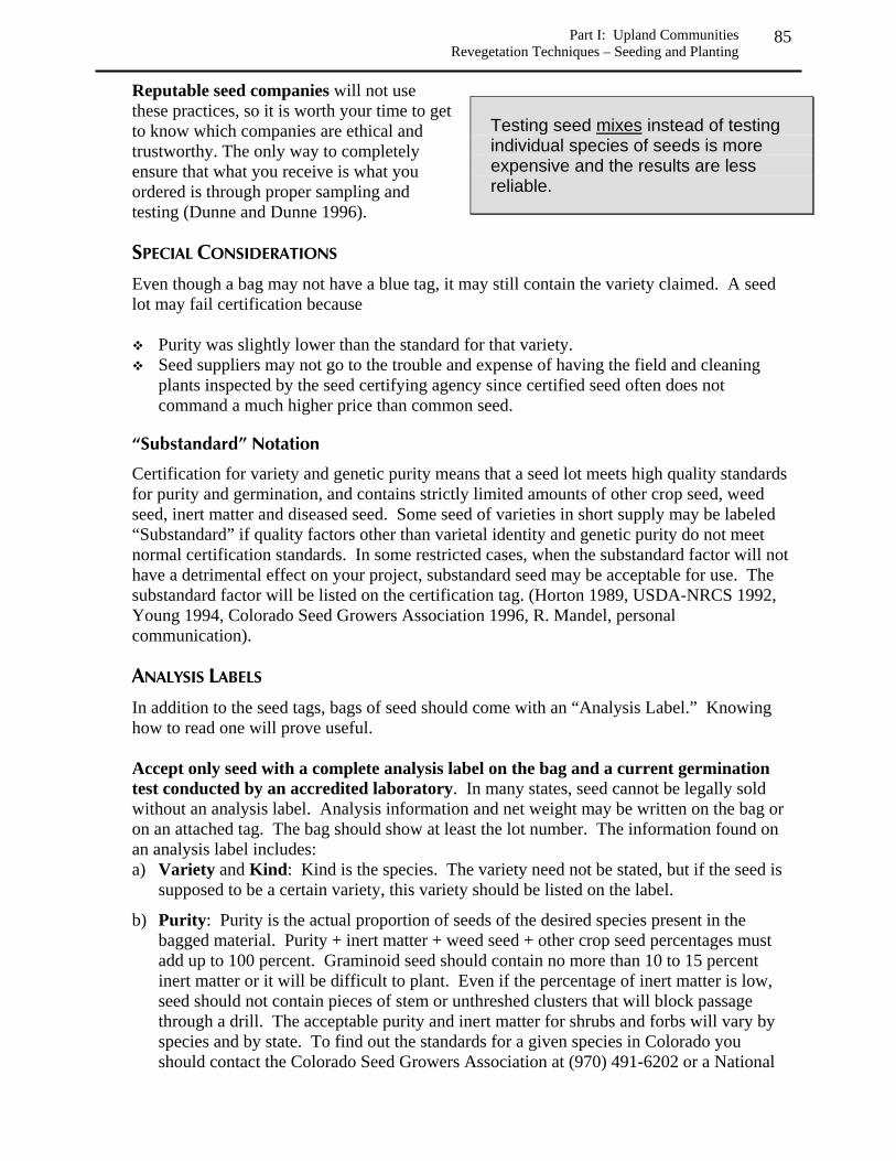
Part I: Upland CommunitiesRevegetation Techniques – Seeding and Planting
85
Reputable seed companies will not usethese practices, so it is worth your time to getto know which companies are ethical andtrustworthy. The only way to completelyensure that what you receive is what youordered is through proper sampling andtesting (Dunne and Dunne 1996).
��������������������
Even though a bag may not have a blue tag, it may still contain the variety claimed. A seedlot may fail certification because
� Purity was slightly lower than the standard for that variety.� Seed suppliers may not go to the trouble and expense of having the field and cleaning
plants inspected by the seed certifying agency since certified seed often does notcommand a much higher price than common seed.
#���5�/02/�2$����/�1�0
Certification for variety and genetic purity means that a seed lot meets high quality standardsfor purity and germination, and contains strictly limited amounts of other crop seed, weedseed, inert matter and diseased seed. Some seed of varieties in short supply may be labeled“Substandard” if quality factors other than varietal identity and genetic purity do not meetnormal certification standards. In some restricted cases, when the substandard factor will nothave a detrimental effect on your project, substandard seed may be acceptable for use. Thesubstandard factor will be listed on the certification tag. (Horton 1989, USDA-NRCS 1992,Young 1994, Colorado Seed Growers Association 1996, R. Mandel, personalcommunication).
���&��������
In addition to the seed tags, bags of seed should come with an “Analysis Label.” Knowinghow to read one will prove useful.
Accept only seed with a complete analysis label on the bag and a current germinationtest conducted by an accredited laboratory. In many states, seed cannot be legally soldwithout an analysis label. Analysis information and net weight may be written on the bag oron an attached tag. The bag should show at least the lot number. The information found onan analysis label includes:a) Variety and Kind : Kind is the species. The variety need not be stated, but if the seed is
supposed to be a certain variety, this variety should be listed on the label.
b) Purity : Purity is the actual proportion of seeds of the desired species present in thebagged material. Purity + inert matter + weed seed + other crop seed percentages mustadd up to 100 percent. Graminoid seed should contain no more than 10 to 15 percentinert matter or it will be difficult to plant. Even if the percentage of inert matter is low,seed should not contain pieces of stem or unthreshed clusters that will block passagethrough a drill. The acceptable purity and inert matter for shrubs and forbs will vary byspecies and by state. To find out the standards for a given species in Colorado youshould contact the Colorado Seed Growers Association at (970) 491-6202 or a National
Testing seed mixes instead of testingindividual species of seeds is moreexpensive and the results are lessreliable.

Part I: Upland CommunitiesRevegetation Techniques – Seeding and Planting
86
Association of Official Seed Certification Analysts (AOSCA) approved seed testinglaboratory.
c) Weed Seed: The analysis should indicate that no noxious weed seeds are present (seeAppendix III, page 227). The name and number of seeds per pound of any restrictedweeds must be listed on the label. In Colorado the number of restricted weed seedsallowed varies by certification class and species. The general grass seed standards forColorado are the following:
�/����)*���0��/����/55����2���/02/�25����������/2�Factor Maximum Permitted for Certified Seed
Prohibited noxious weeds None
Restricted noxious weeds 6 per lb
Total other crop seed 1.00%
Other varieties 1.00%
Other inseparable spp. 0.25%
In graminoid for forage use 0.50%
NOTE: “Other varieties” and “Other inseparable spp.” may include aggressive nonnativesthat, even in allowed small amounts may pose a long term problem in the reestablishment ofnative vegetation.
NOTE: Each state has different lists of prohibited noxious weeds and restricted noxiousweeds. If you are buying seed from out of state or if the origin of your seed is from out ofstate, request that the seed be tested with an “All-States Noxious Weed Exam.” Coloradostate law only requires that Colorado seed testing labs report weeds considered noxious inColorado. Reputable seed companies will test their own lots of seed regardless of origin andwill list for which states they tested noxious weeds. Unscrupulous seed companies may listseed as originating from out-of-state to circumvent Colorado seed laws. Again, the only wayto be sure you are not getting a noxious weed in your seed is to test the seed yourself.Although certified seed is worth buying, it does not guarantee that the seed is weed free.
For specific information you should contact the Colorado Seed Growers Association at (970)491-6202 or an AOSCA (National Association of Official Seed Certification Analysts)approved testing laboratory.
d) Germination: Total germination may include the sum of all seeds germinated plus hardseed and dormant seed. Dormant seed is viable but requires time or a physiologicalstimulus to induce germination. Hard seed is alive but has a thick seed coat that must bescarified, either mechanically, thermally or biologically, before it will germinate. Thehigher the total germination, the better the seed quality. In general, the germination of agiven graminoid species should not be lower than 60 percent, while the germinationpercentages for various shrub and forb types vary widely by species.
Total germination may be given as a percent followed by “TZ”, which means that astaining technique with tetrazolium chloride was used to evaluate seed viability. Whilethis technique can be an acceptable substitute for a germination test, it provides noinformation about the percentage of hard or dormant seed present. In addition, a TZ test

Part I: Upland CommunitiesRevegetation Techniques – Seeding and Planting
87
is only as good as the experience of the analyst who administers the test. There are manyvariables that can give a positive or negative TZ viability indication.
Under Colorado state law, if the seed has been grown in and sold in Colorado, it musthave had a germination test within the last year of its date of sale. If the seed has beengrown outside of Colorado and is to be brought into the state or if the seed has beengrown within Colorado and is to be shipped outside of the state, it must be germinationtested within 5 months of its date of sale.
e) Pure Live Seed (PLS): Most species are sold on a PLS basis, with the price adjustedaccordingly. PLS equals the percent purity times percent germination. When given achoice between buying on a PLS or bulk basis, PLS is always preferable.
������������
Testing seed is the only way to insure the quality of the seed (purity and viability), that youreceived what you ordered and that no undesirable species are present.
Purity tests will show the percentages of crop, weed and inert matter (material other than seedsuch as stems or chaff), and tell you if the percentage of each species in the mix meets thestandards you ordered.
The terms germination and viability are sometimes used interchangeably, but do not have thesame meaning. A germination test will determine how seeds perform under favorableconditions (which are seldom encountered in the field); however, some seeds are dormant and donot germinate even though they are still alive. Dormant seeds have the potential to germinate ifdormancy is broken, usually through time and/or physiological stimulus. A viability test will tellyou the sum of the percent germinated and percent dormant seeds in a seed lot, providinginformation on the potential germination of the lot.
Proper seed sampling is very important. The test results received can be no better than thesample sent in. Samples should be sent to a seed lab that tests according to the standardsestablished by AOSCA.
How To Use PLS
If your plan calls for a specific weight of PLS seed per acre, how much bulk seedis needed? To calculate, divide the PLS percentage into the number of poundsrecommended. For example, you want to plant 5 pounds PLS of bluebunchwheatgrass per acre. The analysis label indicates 85 percent pure seed and 79percent total germination; 0.85 x 0.79 = 0.67 PLS. Divide 0.67 into 5 pounds peracre and you find that 7.5 pounds of bulk bluebunch wheatgrass seed is requiredto plant 5 pounds PLS per acre.

Part I: Upland CommunitiesRevegetation Techniques – Seeding and Planting
88
����������� �������� ��������!�������������
To secure a representative seed sample, equal portions should be taken from evenlydistributed parts of the quantity of seed to be sampled.� For free-flowing seed in bags or bulk, a probe or tier should be used.� For non-free-flowing seed, such as certain graminoid seed, uncleaned seed, screenings, or
other seed difficult to sample with a probe or tier, sampling should be done by thrustingone’s hand into the bulk and withdrawing representative portions. If the seed has beenchemically treated, be sure to wear protective equipment. When a sample is taken withthe hand the following procedure should be used:1. Insert the hand flat and with the fingers together.2. Keep the fingers together as the hand is closed and withdrawn.3. Hand samples should be taken from various locations in bags or in bulk.
� Composite samples should be obtained in order to determine the overall quality of a seedlot, including factors such as percentage of pure seed, other crop seed, weed seed, inertmatter, noxious weed seed, germination, varietal purity, freedom from disease, andeffectiveness of seed treatment.
� Individual bag samples may be obtained to determine whether or not the seed is ofuniform quality.
��E������ �!��������!��
For a composite sample to test for quality (purity, germination, and noxious weedexamination), the sample should contain a minimum of 2500 seeds. Samples can becompiled by carefully weighing a smaller number of seeds and multiplying to obtain the totalweight of seed required. Sample weights may vary from a few ounces for very small seeds toseveral pounds for large seeds. Always contact the testing lab for specific requirementsbefore submitting a sample. To test for uniformity, the size of any individual-bag samplesshould be no smaller than the amounts specified for composite samples.
����������������������
The following Colorado laboratories are approved by AOSCA to test certified seed.
Colorado Seed LaboratoryE-10 Plant Science Bldg.Colorado State UniversityFt. Collins, CO 80523(970) 491-6406
STA Laboratories, Agricultural Testing Services630 S. Sunset St.Longmont, CO 80501(970) 651-64171-800-426-9124
Some seed companies have their own seed testing laboratories that are allowed to test andlabel uncertified seed only.

Part I: Upland CommunitiesRevegetation Techniques – Seeding and Planting
89
�����������"��D ��
��!������������
When seed is planted in nonirrigated conditions, the planting season must be chosen to takeadvantage of natural moisture. Seeding success is greatly influenced by temperature andprecipitation; the best germination occurrs when temperatures are above freezing andprecipitation is high. In Colorado, seasons that reflect these conditions for cool seasonspecies are usually the early spring and late fall; seeding should not be done when the groundis frozen. For warm season species, seeding in late spring or early summer is more likely toaccompany temperatures warm enough to support germination. For most sites, properseeding time is dependent on
� A period of adequate moisture for seed germination.� A period of adequate moisture for early seedling growth and establishment.� Adequate soil temperatures for seed growth (Ostler and Allred 1987).
It is important to seed a site as soon as final grading and topsoil placement have occurred tominimize erosion and weed establishment on the project. During periods of time whenseeding cannot be accomplished, soils should not remain unprotected. See the SitePreparation section (beginning on page 75) for suggestions on how to accomplish this.
��������!��"���
There are three primary seeding methods: drilling, broadcasting and hydroseeding. The bestmethod to use will depend on
� Site accessibility and terrain� Seedbed characteristics� Time of seeding
��1������2104
� Proven high revegetation rates.� Most successful on slopes 3:1 or flatter.� Preferred because seed depths and seeding rates can be more closely controlled.� Seed-soil contact is high, which maximizes germination results.� Drill seeding cannot be accomplished where soils are extremely rocky or slopes are steep.� Unless specially modified drills are used, all seeds, regardless of size, will be planted at
the same depth; the smallest seeds are likely to be planted too deep.� Seeds drilled in rows may suffer from high interseedling competition.� Drill seeding leaves “rows” which often persist for many years (or even decades on dry
sites); this may be a visual or aesthetic liability.
The following components are required in a drill suitable for general use in native seeding:
� Multiple seed boxes for different types of seed (agitators and picker wheels in at least onebox for fluffy seed).
Percent slope, aspect, soil type and microclimateswill influence the moisture and temperature of asite and should be considered when determiningthe seeding window for the project.

Part I: Upland CommunitiesRevegetation Techniques – Seeding and Planting
90
� Double disc furrow openers� Intact depth bands with functioning scrapers on all disc openers to ensure consistent,
uniform seed depth placement� Seed tubes, which drop between disc openers, large enough to handle fluffy seed� Packer wheels with adjustable tension, to provide proper soil compaction over and
adjacent to the seed� Coulter wheels to allow penetration of furrow openers where seeding into heavy mulch or
cover crop.
���/2�/5�����2104
Careful attention to seedbed preparation is critical, especially harrowing/raking both beforeand after seeding.
� Can be used on slopes that are steep, extremely rocky, remote or inaccessible.� The variable planting depths that result from broadcast seeding allows better
establishment of smaller seeds than with drill seeding.� Resulting vegetation not in “rows”, which is more aesthetically acceptable on many sites.� If broadcasting is not performed correctly, germination and seedling establishment tends
to be slower with this method.� Broadcast seeding requires double or triple the seeding rate of drill seeding, and
calibration of seeding rates is less precise than with drill seeding
Tips For Drill Seeding
In general, seeding to a depth of 0.25 to 0.5 inches (0.6 to 1.3 centimeters) should beadequate. Seeding should be conducted along the contour to avoid erosion from water flowingdown drill furrows.
Greater success can often be achieved with smaller grass seed and forbs by placing them in aseparate seed box and alternating the seeding depth between rows or dropping them directlyon the ground to be covered by the action of heavy, trailing chains.
Tips For Broadcast Seeding
Soils “accept” broadcast seed much better if they have been very recently raked or harrowedto eliminate crusting. After broadcasting the seed, cover the seed by harrowing, chaining,raking or using a similar technique. Raking or harrowing immediately before and afterbroadcast is highly recommended.
Care should be taken when seeding to provide uniform coverage (even seed application rates)over the site. Seeding should not be attempted on windy days.
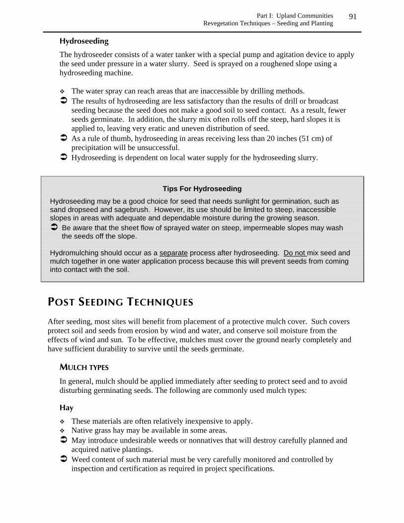
Part I: Upland CommunitiesRevegetation Techniques – Seeding and Planting
91
"82��5��2104
The hydroseeder consists of a water tanker with a special pump and agitation device to applythe seed under pressure in a water slurry. Seed is sprayed on a roughened slope using ahydroseeding machine.
� The water spray can reach areas that are inaccessible by drilling methods.� The results of hydroseeding are less satisfactory than the results of drill or broadcast
seeding because the seed does not make a good soil to seed contact. As a result, fewerseeds germinate. In addition, the slurry mix often rolls off the steep, hard slopes it isapplied to, leaving very eratic and uneven distribution of seed.
� As a rule of thumb, hydroseeding in areas receiving less than 20 inches (51 cm) ofprecipitation will be unsuccessful.
� Hydroseeding is dependent on local water supply for the hydroseeding slurry.
����������������"��D ��
After seeding, most sites will benefit from placement of a protective mulch cover. Such coversprotect soil and seeds from erosion by wind and water, and conserve soil moisture from theeffects of wind and sun. To be effective, mulches must cover the ground nearly completely andhave sufficient durability to survive until the seeds germinate.
! �"��&���
In general, mulch should be applied immediately after seeding to protect seed and to avoiddisturbing germinating seeds. The following are commonly used mulch types:
"/8
� These materials are often relatively inexpensive to apply.� Native grass hay may be available in some areas.� May introduce undesirable weeds or nonnatives that will destroy carefully planned and
acquired native plantings.� Weed content of such material must be very carefully monitored and controlled by
inspection and certification as required in project specifications.
Tips For Hydroseeding
Hydroseeding may be a good choice for seed that needs sunlight for germination, such assand dropseed and sagebrush. However, its use should be limited to steep, inaccessibleslopes in areas with adequate and dependable moisture during the growing season.� Be aware that the sheet flow of sprayed water on steep, impermeable slopes may wash
the seeds off the slope.
Hydromulching should occur as a separate process after hydroseeding. Do not mix seed andmulch together in one water application process because this will prevent seeds from cominginto contact with the soil.

Part I: Upland CommunitiesRevegetation Techniques – Seeding and Planting
92
� Straw is often used for this purpose, but the almost inevitable inclusion of grain seed instraw materials makes the use of straw highly inadvisable because of the competition thatresults from germinating grain plants.
� Do not use hay of nonnative species such as smooth brome that may germinate andcompete with seeded natives.
For hay mulch, a list of certified weed-free hay producers is available from the ColoradoDepartment of Agriculture. The list can be faxed or mailed to interested parties.
Colorado Department of AgricultureDivision of Plant Industry
700 Kipling Street, Suite 4000Lakewood, Colorado 80215
303-239-4149
��/0��2���������!���3����75
Annual grasses, such as sterile forage sorghums, sudan, or forage millets, are planted thegrowing season prior to permanent seeding. After crop maturation, native seeds are sowninto the residual standing dead material. This method differs distinctly from use of a “nursecrop” in which the annual grain and the perennial mix are planted simultaneously. The“nurse” usually ends up out competing the slow-growing perennials. In a relatively fewlocations, where moisture can be anticipated to be sufficient to support both the nurse cropand the native seedlings, the method may be beneficial.
� Very cost effective method of providing mulch cover.� Potential for rill erosion.� Not recommended for steep slopes.
Tips For Using Hay Mulch
In general, hay mulches are more durable the longer the average unbroken stem length.Loose hay is usually highly susceptible to being blown off the surface in most Coloradosites. To counteract this shortcoming, hay is often “crimped” into the soil surface byusing a modified disc plow to jam the hay stems into the soil. This does little directly toenhance or stabilize the important cover function of mulch but it can mimic the effects ofreducing surface wind speeds and soil desiccation that stubble mulch provides.
Durability of the applied mulch cover is also enhanced by addition of organic tackifierproducts that “glue” (at least temporarily) the hay to itself and to the ground.When used, hay is typically applied at the rate of 3,000 to 4,000 pounds per acre (3360-4480 kg/ha).

Part I: Upland CommunitiesRevegetation Techniques – Seeding and Planting
93
"82������3
Wood fibers are mixed into a water slurry and sprayed onto the ground surface to apply amulch coating of varying thickness. Hydromulch should be applied separately followingseed application. The hydromulch mix is often colored green to assist operators in applyingan even cover during spraying. The green color usually fades to tan or gray within a fewweeks.
� Overspraying may result in erosion.� Substantially more expensive than other mulch types.
��02�2��1����!/��1C
Bonded fiber matrix is a relatively new product. It is essentially a spray-on mat consisting ofa continuous layer of elongated fiber strands held together by a water-resistant bonding agentwhich creates a very durable and ground-fitting cover.
� Bonded fiber matrix is especially useful where steep and very rocky surface conditionswould make the use of mats ineffective.
Tips For Planted Stubble Mulch Crops
Wheat, rye, and barley should not be used unless they will be mowed before seedmaturity, since they produce seed that will compete with the seeded native species.
The annual forage graminoids must be mown prior to seed maturation to preventreseeding and allow easier drilling of the permanent seed. Planting into such coverrequires a grass or no-till seed drill equipped to handle low tillage and high “trash”conditions.
Stubble mulch is most appropriate on low-slope sites because water erosion controlcapabilities of such covers are limited. Steep slopes such as highway embankmentsrequire very intensive efforts and careful species selection to control erosion.
Tips For Using Hydromulch
An organic tackifier is typically added to the slurry to enhance the durability of theapplied mulch cover.
Although typically applied at a rate of approximately 1,500 pounds per acre (1680kg/ha), it is more effective at a rate of 3,000 pounds per acre (3360 kg/ha) with a guargum tackifier.

Part I: Upland CommunitiesRevegetation Techniques – Seeding and Planting
94
� Great care must be exercised by trainedtechnicians to apply the correct ammount ofmaterial. A continuous cover is needed tocreate the integrated shell, but if thematerial is applied too thickly it can preventpenetration of seedling shoots.
���51�0���0�����!/�5������/0G��5
There are a large variety of mats which can perform the function of mulch. Mats composedof aspen shavings attached to or sandwiched between one or two plastic nets have long beenused with good success. There are also many mats comprised of different combinations ofcoconut fiber, straw and other materials that double as both mulch and erosion control.
� Erosion control mats are generally expensive (although the least expensive are similar tobonded fiber matrix).
� Installation on rough ground is less efficient because the mulch to ground contact is poorcompared to other mulches. Where the surface is very rocky, material ends up suspendedabove most of the surface stretched between protruding rock “peaks.”
� Some mats have unsightly plastic netting that does not biodegrade and can be stripped offin large pieces by wind or wildlife.
� Plastic netting has been reported to trap snakes, whose scales become snagged on themonofilament netting.
� Paper mats are not recommended in Colorado. They have a tendency to form a paper-mâché-like crust which makes it difficult for plants to sprout.
Appendix VI (on page 253) lists erosion control products and suppliers.
Tip For Using Bonded Fiber Matrix
The key is to find a certified contractorwho knows how to apply the materialappropriately.
Tips For using Erosion Control Mats
Biodegradable netting (not to be confused with “photodegradable” plastic netting) isavailable from some manufacturers at a slightly higher cost.
Mats are most cost-effective when used on areas where erosion potential is high and thesite surface is relatively smooth.

Part I: Upland CommunitiesRevegetation Techniques – Seeding and Planting
95
�������Planting can compliment seeding efforts and increase the overall success of a restoration projectand should not be overlooked because of the initial higher cost. Planting will be most desirableand cost effective when
� The desired species are difficult to establish from seed, unavailable, or the only seed sourcesavailable have low germination rates.
� The revegetation site is highly erodible or quick results are needed for aesthetic reasons.� The revegetation site has abnormally stressful environmental conditions, such as extremely
low nutrients, alkalinity, salinity, erosion potential or a short growing season.� The existing plant community will present severe competition during seedling establishment.� A need for more rapid plant establishment exists than can be met through seeding.
If planting is limited by budget constraints, fewer plants may be used by creating islands of moremature plants, with the following results:
� A more diverse and natural looking landscape.� A central, established stand of native plants
which can reproduce and spread.� Creation of habitat for wildlife.
� Be aware that nursery stock is costly, and that a successful project will require additionaleffort and investment to protect planted stock from both wildlife predation and competitionfrom other vegetation (see Protection of Plantings on page 98).
There are two basic options for obtaining native plant materials: 1) purchasing stock from anursery, or 2) collecting or salvaging plants in the wild, either from the site itself before it isdisturbed or from near-by areas.
�����!������
��������������������E��
Bareroot and containerized plants are common types of transplant stock usually purchasedfrom a nursery. If you are purchasing plant materials from a commercial supplier, thedecision to use bareroot or containerized stock should be based on the informationsummarized in Table 4 below.
With containerized stock, the choice of container size and shape should be based on
� Species.� Seedling size and growth tendencies.� Characteristics of the site to be planted.� Economics.
In general, site establishment fromplants is far more rapid than from seed.(Ostler and Allred 1987, R. Mandel,personal communication).
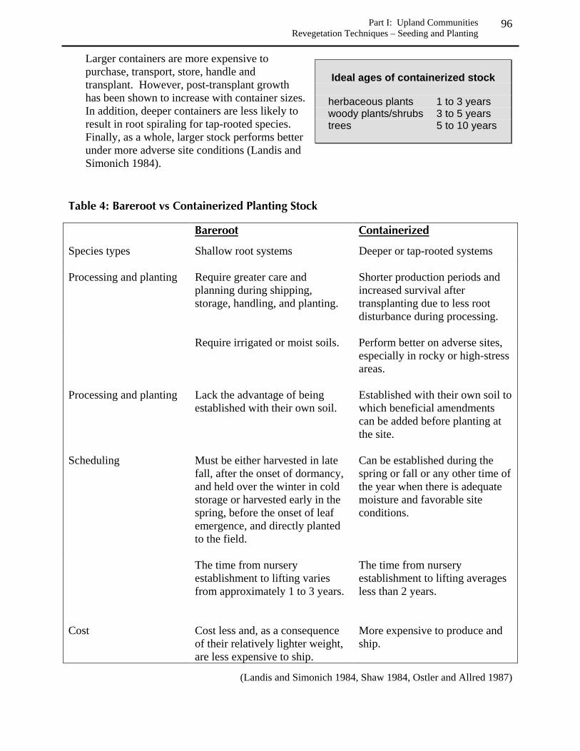
Part I: Upland CommunitiesRevegetation Techniques – Seeding and Planting
96
Larger containers are more expensive topurchase, transport, store, handle andtransplant. However, post-transplant growthhas been shown to increase with container sizes.In addition, deeper containers are less likely toresult in root spiraling for tap-rooted species.Finally, as a whole, larger stock performs betterunder more adverse site conditions (Landis andSimonich 1984).
�/����,*��/�������A5���0�/10��1F�2���/0�104�����G
�/������ ��0�/10��1F�2
Species types Shallow root systems Deeper or tap-rooted systems
Processing and planting Require greater care andplanning during shipping,storage, handling, and planting.
Shorter production periods andincreased survival aftertransplanting due to less rootdisturbance during processing.
Require irrigated or moist soils. Perform better on adverse sites,especially in rocky or high-stressareas.
Processing and planting Lack the advantage of beingestablished with their own soil.
Established with their own soil towhich beneficial amendmentscan be added before planting atthe site.
Scheduling Must be either harvested in latefall, after the onset of dormancy,and held over the winter in coldstorage or harvested early in thespring, before the onset of leafemergence, and directly plantedto the field.
Can be established during thespring or fall or any other time ofthe year when there is adequatemoisture and favorable siteconditions.
The time from nurseryestablishment to lifting variesfrom approximately 1 to 3 years.
The time from nurseryestablishment to lifting averagesless than 2 years.
Cost Cost less and, as a consequenceof their relatively lighter weight,are less expensive to ship.
More expensive to produce andship.
(Landis and Simonich 1984, Shaw 1984, Ostler and Allred 1987)
Ideal ages of containerized stock
herbaceous plants 1 to 3 yearswoody plants/shrubs 3 to 5 yearstrees 5 to 10 years

Part I: Upland CommunitiesRevegetation Techniques – Seeding and Planting
97
��2��104��02����1A��8
Order bareroot or containerized seedlings from 1 to 4 years in advance of the planting date.In general, containerized seedlings should be ordered from between 1 to 2 years prior toplanting; bareroot seedlings should be ordered from 2 to 4 years prior to planting (Townsendet al. 1993, Shaw 1984). Advanced planning and ordering will ensure the availability ofdesired species and proper hardening of the stock. In addition to their standard stock, somenurseries offer custom growing and may be able to propagate materials that are collectedfrom the project site. However, custom grown materials have a higher initial purchase costand may require additional production time as well as an initial contract and down payment(Townsend et al. 1993).
Upon receipt, all containerized stock should be examined to ensure
� It has a root system adequate to hold the ball together but is not root bound.� It is adequately hardened.
The handling and transportation of bareroot materials must be more carefully planned thanthat for containerized materials due to their exposed root mass (Shaw 1984, Ostler and Allred1987). Most nurseries package their seedlings prior to delivery in order to protect theirmaterials during shipping and handling. Seedlings are usually shipped either via expresstransportation services or in enclosed, refrigerated vehicles. Shipment should not be made inopen vehicles or trailers to prevent desiccation and wind damage (Townsend et al. 1993).
The physiological state of the plants should be examined upon delivery. Potential dormancyproblems can be indicated by:
� Elongated buds.� Leaf emergence.� Root growth and/or elongation of white root buds.� Root molds (not to be confused with mycorrhizae).
The seedlings should also be examined for their moisture level, which can be determined byobserving the root condition, the twig, needle or root flexibility, and the overall appearance(Townsend et al. 1993).
Hardening is the process of plant adjustment to cold temperatures. During hardening, aseedling’s growth is reduced, stored carbohydrates accumulate, and the plant becomesmore able to withstand adverse conditions. Hardening is a gradual process,accomplished by reducing the supply of moisture, altering the nutrient balance, reducingthe temperature, and increasing the seedling’s exposure to direct sunlight as well as toother environmental conditions typical of the planting site. If conditions at the plantingsite are much different from those at the nursery, site hardening may also be beneficial.The hardening process can not be rushed or accomplished at the last minute. Seedlingswhich are stressed just prior to establishment have reduced survival rates (Ostler andAllred 1987).
Part I: Upland CommunitiesRevegetation Techniques – Seeding and Planting
98
� Any damage or deficiencies in the stock should be immediately reported to the nurseryand/or contractor from whom it was received. If deficiencies occur in the number ofplants shipped or the packaging or transportation procedures, the nursery should be ableto correct the problem. If serious problems are noted for the received materials, theyshould not be planted and should be classified as cull stock. Again, in such case, contactyour nursery and/or contractor to correct the problem before payment is made (Townsendet al. 1993).
�������1�0��B���/0�1045
� Nursery plantings, especially shrubs, trees and weaker forbs/grasses, will suffer fromcompetition from other vegetation unless they are properly protected. Use a square orcircle of landscape cloth or similar material up to 9 ft2 (1m2) and cover with mulch tomoderate soil temperature rise and extend the life of the cloth.
� At many sites, protective tubes or cages should be installed on trees and shrubs to protectthem from wildlife predation until they are well established.
������
An alternative to purchasing plants is to collect them in the wild (refered to herein as“salvage”). Salvaging native plants is ideal because 1) locally-adapted plants are “recycled,”2) success of transplant survival can be high when the native soil accompanies the salvagedplant, and 3) salvaged plants can be more cost effective than purchased plants, especially forprojects with limited budgets but plenty of labor (paid or volunteer). Salvaged plants caneither be directly transplanted onto another site or potted and tended until the next plantingseason.
� Salvaging from areas that have noxious weeds or undesirable plants should be avoided.
��H�1�104��/�A/4�2���/0�5
There are several ways to obtain salvaged plant material.
� Native plants or sod on sites slated for development can be salvaged. This methodrequires some advanced knowledge of construction areas and planning for the destinationof salvaged plants.
� Small numbers of plants may be transplanted from sites ecologically similar to therevegetation site. Do not remove too many individual plants when collecting from suchsites. This method is suitable for small restoration projects only.
� If you are planning your revegetation project in advance of the site being disturbed,plants can be salvaged from the site itself.
3/������/�A/4�
Some experimentation may be necessary to determine which native plants are best forsalvage; here are some general guidelines.
� Plants that reproduce through vegetative sprouting (root shoots) should be ideal forsalvaging.
� Native plants that grow in disturbed areas have been found to be particularly suited fortransplanting (Goeldner 1995).
Part I: Upland CommunitiesRevegetation Techniques – Seeding and Planting
99
� Plants with taproots and extensive root systems are least likely to tolerate transplanting.� Diseased or weak plants should be avoided.
Native salvaged seedlings should be provided with as much of a competitive edge aspossible.
� Direct transplants should be watered at the time of transplanting, and will benefit greatlyfrom supplemental waterings. Generally, direct transplants will require at least one yearof regular waterings. A soaking once every three weeks should be sufficient in coolweather, with increased waterings during warm periods.
� Dormant plants that are potted need to be watered periodically through the dormantseason. A soaking once every three weeks should be sufficient in cool weather. Increasewaterings during warm spells.
� All salvaged plants should be weeded to prevent contamination from the donor site.� For wetland plants, water is more critical than soil in plant salvage since wetland plants
do not rely on soil microbes and mycorrhizae for survival. Bareroot plants from wetlandscan be salvaged and even stored for short periods of time if the plants are kept cool and ina shallow bucket or pool of water. Wetland plants can also be salvaged and transplantedin the summer months as long as the salvaged plants are transplanted directly into wet ormoist soils.
3�0�����/�A/4�
The ideal time to salvage plants is from October to April. Plants can be salvaged at othertimes of the year if one-third to two-thirds of the plant is cut back and a good rootball issaved and kept moist. A typical salvage day might consist of digging up plants in themorning and transplanting on another site or potting the plants in the afternoon.
Any plants held over the dormant season or held in a temporary salvage nursery should betransplanted as soon as possible to increase the survival of the salvaged plants. If plants aredug up when dormant, they can also be “heeled in” in a pile of mulch or soil, and kept moistuntil they are transplanted. Dormant plants that are potted will need to be wateredperiodically through the dormant season.
Salvage when the soil is moist. If salvagingby hand, transport plants or chunks of sod inplastic grocery bags or moist burlap bags toconserve water. Heavy machinery can beused to move large areas of sod or clumps ofshrubs.
� ������
Some native planting stock is more easily and cheaply produced from cuttings. Cuttings canalso be used to maintain the genetic identity and desirable traits of parent material. Plantscan be propagated from cuttings as poles, wattles (fascines) or whips. Poles, wattles/fascinesand whips are techniques used primarily with cottonwood, poplar and willow propagation forriparian stabilization and restoration (Mandel 1990, R. Mandel, personal communication).
While cuttings, sodding, and plantsalvage are all valid means of siteestablishment, they are lesscommonly used for upland speciesreintroduction than are containerizedor bareroot stock.

Part I: Upland CommunitiesRevegetation Techniques – Seeding and Planting
100
When roots form, the cuttings should be transplanted to containers. After several months ofgreenhouse acclimation, the transplanted cuttings should be gradually hardened off and usedas containerized stock for transplant establishment (Mandel 1990).
���
The use of sod is confined to rhizomatous and stoloniferous graminoids. It is not well-suitedfor use with bunchgrass. Sodding with native species is an effective means of providingrapid plant establishment on critical slopes, grassed waterways, reconstructed drainages, andother priority areas. Sodding can also be used when a desired species produces little viableseed (e.g., inland saltgrass) (Shaw 1984).
Native sod (usually buffalograss) can be purchased from a commercial vendor or can besalvaged (see below). Watering will most likely be required for sod to be successfullyestablished.
�����������"��D ��
All stock, whether purchased or salvaged,should be handled as little as possiblebefore transplanting. Even a few minutesof root exposure or extended shootexposure to warm temperatures and/or highwinds can result in plant damage andreduced survival. Only the minimumnumber of seedlings necessary to completea designated section of the planting shouldbe removed from theircontainers/packaging at any one time(Townsend et al. 1993).
������
Ideally the planting site will be fully prepared and all personnel ready to begin planting whenseedlings are delivered. Short-term (under two weeks) storage at the planting site can befacilitated by “heeling in” bareroot materials or by constructing a temporary storage facilityfor containerized stock.
� Heeling-in must be done in such a manner as to ensure good soil coverage and protectionfrom moisture loss. Roots should be adequately covered with soil to the root stem,tamped-in, and immediately watered (Townsend et al. 1993).
� All materials should be stored in a fenced area which minimizes the chances for damagefrom humans, birds or animals and should be adequately watered and protected fromexcess sun, wind and cold.
� Transplanting stock should be checked daily for moisture, cold-tolerance, insect oranimal damage, and disease.
� With proper timing, most deciduous species can be safely stored for more than 90 days.� Plants which are stored for extended periods should have adequate root ventilation to
minimize heat build-up from respiration (Townsend et al. 1993, Shaw 1984, Ostler andAllred 1987, Landis and Simonich 1984).
“Heeling in” consists of digging a trenchwith a sloped side, laying the plants at a 45degree angle, and placing soil over the rootball to provide winter protection. Thissystem provides more even soil moisturewithin the ball and prevents the root systemfrom freezing during low temperatureperiods. Water thoroughly, especially if thesoil is dry.

Part I: Upland CommunitiesRevegetation Techniques – Seeding and Planting
101
� Fall-lifted bareroot transplants can be over-wintered in an appropriate cold storagefacility. Proper cold storage involves over-wintering dormant transplants between 34°and 40° Fahrenheit (1°- 4° C) and at approximately 86 percent relative humidity.
� Some species, especially those with persistent leaves, can not be stored for more than oneweek without risking damage and/or mold infestation.
������
All temperate western plantings require supplemental moisture at the time of planting, unlessthey are being transplanted into a wetland or riparian habitat. Whenever possible, soilmoisture reserves should be built up prior to plant establishment. This can be accomplishedthrough the use of irrigation and/or snow-fencing on the windward side of the planting area(Townsend et al. 1993). As a general rule, properly hardened transplants should be plantedin early spring, as soon as the ground has thawed and while moisture is available.
In general, larger sized or bareroot and salvaged materials will require more moisture thansmaller sized and commercially obtained containerized seedlings. At least two quarts (1.9 l)of water per bareroot tubeling and at least one gallon (3.8 l) of water per containerized plantwill be needed.
�������
Planting holes may be made with motor-drivenaugers, planting bars, hoedads, picks, shovelsor other means. To avoid drying out the soil,do not excavate holes too far in advance ofplant establishment. Holes must be deepenough to allow roots to penetrate into the soiland wide enough so that the roots will drop inat approximately their natural form. However,to minimize labor costs, excavation time, andmoisture loss, hole size should not be anylarger than necessary.
Place transplants quickly but carefully into theholes to minimize drying the roots. Insert plants into the hole as close to vertical as possible.Plant roots should not be bent, kinked or tangled, or bunched up at the bottom of the hole.Once the seedling is placed in the hole, pack the soil firmly around the root in order to avoidair pockets. Be careful not to mash the roots between the tamped soil and the surroundingsubstrate. The soil line should be maintained 0.5 to 1 inch (1.3 to 2.5 cm) above the rootplug.
To assure good soil to root contact and minimize air pockets, all transplants should beirrigated at the time of establishment. At least two quarts (1.9 l) of water should be used pertubeling and at least one gallon (3.8 l) of water should be used per containerized plant(Townsend et al. 1993, Ostler and Allred 1987).
In addition to providing moistureand reducing transplant stress, thesupplemental water will assist inpacking soil around thetransplanted root systems andeliminating any remaining airpockets, ensuring good soil to rootcontact (Ostler and Allred 1987,Townsend et al. 1993, R. Mandel,personal communication).

Part I: Upland CommunitiesRevegetation Techniques – Seeding and Planting
102
��/0�104��0�����7����7�5
Working on steep slopes requires that planters begin at the top of the slope and traverse,eventually working downslope. Do not work below another planter; they may dislodge soilwhich will bury the plants below. The positioning of transplants on steep slopes is critical.Form precipitation catchment basins approximately 12 inches (30 cm) in diameter aroundeach transplant to trap additional water and prevent soil erosion around the plant. Scrape thearea directly up-slope from the planting hole with a hoedad or shovel to remove excess soilwhich might slough off and bury the seedling. Position the hole near the outer lip of thebasin to prevent the plant from being covered by soil eroding from above or exposure of theroots by erosion. Align the crown of the transplanted plug with the plane of the undisturbedslope. Again, to assure good soil to root contact and to minimize air pockets, all transplantsshould be irrigated at the time of establishment (Ostler and Allred 1987).
�����������������1�1F��
Test the soil from the planting site before adding any amendments. Once you havedetermined the actual site nutrient conditions, compare these conditions with thoseconsidered optimum, if that information exists for the species involved. The availableliterature differs on its opinions concerning fertilizer use at the time of transplanting. Ostlerand Allred (1987) state that Osmocote tablets, a commercial slow-release fertilizer, should beincluded at the bottom of the transplanting hole to assist with establishment. Wallace (1987)and Mandel (personal communication) report that many native species, especially those withincreased drought tolerance, react adversely to fertilizer use at the time of establishment.With such species, even mild fertilization can cause root-dieback and shoot burning. It isalso an excellent idea to consult with a nursery, a plant ecologist, or the Natural ResourceConservation Service (NRCS) in order to determine the specific requirements (Wallace 1987,R. Mandel, personal communication).
Part I: Upland CommunitiesRevegetation Techniques - Monitoring and Stewardship
103
�����-*��!���������I���� ���"��The objective of monitoring is to identify problems that could prevent or interfere with asuccessful outcome of the project. The goal of stewardship is to ensure that site managementalleviates these problems and maintains desired site conditions. The fact that restoration projectsare resource intensive in the early stages makes it easy to overlook the potential ongoing costs ofmonitoring and stewardship. Landowners and managers often commit most of their financialresources to planning a project, procuring the equipment and plant materials, and planting thearea. Frequently, little thought is given to the wide variety of problems that can arise after thelast seed is sown or shrub is planted, and this oversight can lead to project failure. Monitoringand stewardship are indispensable and cost-effective components of revegetation projects,without which a potentially successful project can deteriorate into a patch of noxious weeds or aneroded gully. For more specific information on evaluating project success, see Chambers andWade (1990).
!��������If a restored site is never monitored once the initial work has been completed, there is noassurance that the final landscape will match the landowner’s vision for the area, and no chanceto learn from the results. Successful monitoring should include
� Awareness of potential problems.� Use of monitoring techniques and frequencies appropriate to the site.� Detailed summary of information gathered through monitoring, as an aid to the preparation
of stewardship plans.� Means to confirm the effectiveness of management/stewardship actions.
�������������!�
Factors which can interfere with the desired outcome of a revegetation project after initialrevegetation work is complete include the following:
� The establishment or re-establishment of nonnative invasive species from remnant roots orfrom an existing seedbank.
� Preferential foraging by wildlife which may overwhelm the vegetation’s ability to recover orselectively alter species composition.
� Erosion caused by sudden or steady influxes of water or wind that can damage plantmaterials and the soil base.
� Acts of nature such as flooding, windstorm, hail, etc. which severely damage restored areas.� Failure or lack of vigor in introduced plantings.� Unexpected successional changes that shift species composition or abundance.� Unfavorable amounts of moisture (too little, too much, or wrong time of year).� Damage resulting from human trespass.
Frequent monitoring can detect potential problems in time to rectify or mitigate them.

Part I: Upland CommunitiesRevegetation Techniques - Monitoring and Stewardship
104
���"��D ���������D ���&
Monitoring techniques can range from a quick visual inspection to an in-depth study of speciescomposition, distribution, and density based on quantitative data from random plots, samplingtransects, and/or statistical analysis. In any case, monitoring techniques must be designed togather the information necessary to identify and evaluate problems that could jeopardize thesuccess of the project. The frequency with which a site is monitored will always depend on siteconditions. For example, a site prone to low moisture, high erosion, and invasions of weedsshould be checked frequently to ensure the health of introduced plantings. Conversely, dormantperiods such as the winter necessitate far less frequent visits as do stable and well-advancedsuccessional stages. If problems are detected, monitoring frequency may need to be increased.The ideal monitoring regime will detect both expected and unexpected problems as soon as theyarise.
������!�����������!��������� ���"�������������
Monitoring will help detect problems that arise as a result of changing site conditions. Once aproblem is identified, corrective actions can be taken. A comprehensive stewardship plan formanaging the site after restoration is a vital part of every project. Information gathered bymonitoring should be incorporated into such plans whenever possible. Monitoring informationsummaries should include
� A clear description of problems which have been identified at the site.� Actions required to correct the problems and provisions to monitor the success of these
actions.
Preventing Potential Problems
There are a number of steps taken during site preparation and revegetation that canminimize the potential for problems to arise once initial restoration efforts are completed
� Removal of biennial and perennial weeds and the use of certified weed-free plantmaterials for mulch can limit the extent to which native plantings must later competewith invasive nonnative species.
� Careful landscaping and the use of mulch can reduce the threat of damage causedby water-runoff and erosion.
� Prudent selection and placement of native species as well as protective fencing canmitigate the threat of selective grazing by local wildlife.
Most preventive steps can only mitigate or reduce the threat of such problems arisinglater. For example, given the root system of perennial invasive species, one shouldn’tassume that weeds were eradicated during site preparation; deep rhizomes willresprout. An established seedbank will assure that new plants germinate and findsuitable sites to colonize among areas with disturbed soils and favorable conditions.

Part I: Upland CommunitiesRevegetation Techniques - Monitoring and Stewardship
105
� Information on any additional considerations affecting the success of the project, includinglocal and/or regional land management laws, particularly when elements such as grazing,controlled burns, herbicide/insecticide application, etc., are being considered.
��� ���"��Stewardship, as it relates to native plant establishment and restoration projects, can be defined ascaring for a site so as to foster natural processes or management activities that emulate naturalprocesses. The simplest form of stewardship occurs on naturally functioning landscapes, wherenatural processes are in place and negative effects by human presence are absent. Under theseconditions, the land steward merely monitors and records observations that relate to trends inclimate, wildlife populations, plant succession, etc. Effective site stewardship defines the goalsof a project and identifies the steps needed to achieve these goals.
��������������� ���"������
Begin developing a stewardship plan for your restoration project at the earliest possible moment,preferably even before work has begun on a site. Your plan will be enhanced if you� Draw upon available expertise.� Establish clear, site-specific project goals.� Consider the relationship of the site to the surrounding land and its proposed land use.� Establish measures for erosion control, buffers, fencing, other protective measures, and
prescriptions for management tools, including mowing, grazing, fire, pesticides, etc.� To the extent possible, design the project to be a self-sustaining and persistent landscape
feature.� Obtain support for the management plan by including current and potential users in the
planning process.In some instances, plans should be reviewed by local law enforcement, transportation and fireprotection agencies so that the proper protocols are followed during stewardship activities.Finally, it is always advisable to develop stewardship plans with the involvement of neighboringlandowners/managers.
���"��D ��
Stewardship techniques are normally designed to correct problems which are in conflict withestablished goals and/or provide site protection. Some common techniques include� Fencing for site protection (temporary during construction and permanent afterwards -
although fencing may limit many of the natural processes that might otherwise occur).� Establishment and maintenance of buffer areas around the project site.� Avoidance of sensitive habitats when possible.� Control of nonnative plant and animal species.� Management by burning, mowing, and/or grazing.� Control of erosion caused by runoff and wind.� Creation of passive or active recreation activities, if appropriate.� Creation of educational programs to promote stewardship goals.

Part I: Upland CommunitiesRevegetation Techniques - Monitoring and Stewardship
106
� Signage to recognize contributions and to educate visitors and neighbors.� Recruitment of volunteers to assist with stewardship activities.
Stewardship planning won’t prevent damage from catastrophic events such as flooding, extremehailstorm, tornado, or winter drought and windstorm, but it will help maintain a site in thedesired condition under normal conditions. Should the site be damaged by unforseencircumstances, a good stewardship plan will prove to be a valuable resource in the repair process.

Part I: Upland CommunitiesRevegetation Techniques – Weed Management
107
����!�����!���Many potentially successful restoration projects have failed due to a lack of proper weed control.A weed management plan for reclamation and restoration projects is as critical as choosing thenative species to plant. Appendices III and IV (beginning on page 227) list prohibited andrestricted noxious weed seeds, plants to avoid in native plant establishment projects andmanagement techniques for controlling specific noxious weeds commonly found in Colorado.
Weed management must be included in the planning process of every project and should beimplemented before the project begins. If a site is seriously infested with weeds, the first year ofa project may be dedicated entirely to the control of weeds. Weeds are initially controlledthrough prevention and eradication; however, because soil disturbances often stimulate dormantweed seeds, monitoring, control, and containment must continue after a site has been planted.
���������� ����!�����!���Integrated weed management (IWM) is the selection and application of a variety of managementtechniques that, in combination, shape the composition and structure of the plant community topromote ecosystem health and function. The goal of IWM is not specifically the elimination ofundesirable species as much as the development and maintenance of a healthy, desirablecommunity of native species; the eradication and/or reduction of invasive plant populations ismerely one beneficial result of effective IWM. The use of a combination of techniques makes itpossible to alter site availability for weeds and disturbances, control colonization events, andmanipulate species performance in order to transform the existing plant community into ahealthy native one.
Most successful weed management efforts include a combination of two or more controlmethods. To develop an effective IWM plan, each site must be individually evaluated to identifytechniques that are feasible and the most appropriate for the site. Every technique has positiveand negative aspects that determine its appropriateness for specific situations. Site managersshould select and utilize as many appropriate techniques as possible. Reliance on any oneparticular method frequently results in failure.
� Remember that most control techniques (mowing, herbicides, hand-pulling, etc.) are effectiveonly during certain periods of the target species’ life cycle. Every effort should be made toutilize techniques that suppress targeted weed populations throughout the season whilepromoting desirable species.
Note: Most revegetation sites will be dominated by “pioneer” or “weedy” species for thefirst few years following the disturbance. If these plants are not aggressive andtenacious perennial weeds, they will normally be replaced by desirable vegetation overtime. Monitoring is especially important in order to insure a timely and appropriateresponse to the appearance of aggressive noxious weed species.
Part I: Upland CommunitiesRevegetation Techniques – Weed Management
108
Contact your county weed manager or local Colorado State University Cooperative Extensionoffice for more specific information about control methods or for assistance in developing aneffective IWM plan for your site.
���������Preventing weeds from invading a site is the most effective and least costly method forcontrolling weeds. It requires constant vigilance from the very beginning of the project and aknowledge of weeds that are found on surrounding lands.
A healthy cover of native vegetation may prevent weed invasions. It is important to understand,however, that most invasive weeds threatening restoration projects in Colorado easily invadeestablished native plant communities, especially in semi-arid environments. The goal is tominimize the amount of time the ground is not covered by a stand of native plants. As discussedin the Planting Techniques section, if the area will not be revegetated immediately, plant atemporary and sterile “cover crop” such as “Regreen” (sterile wheat X wheatgrass cross) or milo.
� Barley (Hordeum vulgare), wheat (Triticum aestivum) or rye (Secale cereale) should not beused as temporary cover crops unless they are mown before seed maturity, because they canreseed themselves and inhibit the germination of native seeded perennials.
Removal of weeds from nearby areas will preventtheir seeds from invading the revegetation site.Some weeds (see inset) are not of great concernuntil the soil is disturbed. The seeds of thesecommon weeds germinate once the ground isturned over or if excessive amounts of fertilizer areapplied. However, if the site has been properlyrevegetated, and if the site is not disturbed furtherand fertilizer is not continuously applied, these weeds will be at a competitive disadvantage andmay eventually disappear.
Many well-planned projects have been compromised by weeds introduced during thereclamation process via weed-contaminated products or equipment. Use only certified weed-freeforage for mulch, noxious weed-free seeds in seed mixes and weed-free compost. A directory ofcertified weed-free forage (hay and mulch) can be obtained from the Colorado Department ofAgriculture. Colorado certified weed-free forage bales are differentiated from other forage balesby one strand of orange and blue baling twine or galvanized wire. Other western statesfrequently use specific tags to mark certified bales (every bale sold into Colorado from anotherstate should be tagged) but are beginning to adopt Colorado's twine marking system forregionally certified hay.
Inquire about the source and composition of the hay as well. A native big bluestem hay importedfrom Kansas that is not certified weed-free may be preferable to smooth brome hay fromColorado that is certified weed-free. The use of straw from barley (Hordeum vulgare), wheat(Triticum aestivum), or rye (Secale cereale) should be avoided because seed remaining in thestraw will germinate and compete with the native perennial seedlings. Annual straw crops,especially rye, can prevent the germination and establishment of native seedlings. Forinformation on how to buy weed-free or certified seeds, refer to the Seeding section.
Russian-thistle (Salsola species),Goosefoot (Chenopodium species),Pigweed (Amaranthus species), andKochia (Kochia species), if present,often increase in numbers followingdisturbance.

Part I: Upland CommunitiesRevegetation Techniques – Weed Management
109
All heavy equipment to be used on a project should be cleaned before it is moved to the site. Ifimported topsoil is required, it is worth the extra effort to inspect the topsoil mining sitebeforehand to inventory potential weed contaminants. Since all topsoil contains a “seed bank” ofnormally dormant “weedy” seeds, only extremely poor sites should be candidates for topsoilimportation. In most circumstances, it is preferable to amend the soils that are already on site.
����������Eradication is the complete removal of weeds from an area. Most weed species are extremelydifficult to eradicate due to the hardiness of the targeted species and the longevity of their seed.Eradication is most effective on weed patches smaller than 100 ft2 (9 m2) and areas where weedsare newly established. No method (or integration of methods) will achieve eradication forlarge-scale weed infestations. Eradication requires long-term land management that encouragesdesirable native vegetation while continuing to remove aggressive weed species from the site.Weed infestations of minimum size should be removed using hand pulling or digging (forbiennials and simple perennials) and spot herbicide treatments (for biennials, simple perennials,and especially deep-rooted, creeping perennials).
Management techniques should be directed at disabling the target weeds’ biological processesand promoting the vigor of desirable vegetation. Each weed species may react differently to aparticular control method, depending on its biological characteristics. For example, tilling anarea will not eliminate Canada thistle, but will actually spread the problem since broken rootpieces will sprout new growth. Pulling leafy spurge will usually result in stimulated shootgrowth from root buds. If eradication efforts create bare ground, revegetation is required toprevent reinfestation of nonnative or weedy species.
�����Control emphasizes the reduction of a weed population to a manageable level but not thecomplete elimination or eradication of the problem. With this distinctly different goal, a numberof additional weed management tools and techniques instantly become useful. Control methodsare used not only to eliminate individual plants but also to suppress the growth and reproductionof (or otherwise stress) targeted weed populations, especially deep-rooted, creeping perennialswhich cannot easily be reduced or thinned. Such suppression of weed populations helps torelieve desirable natives species of the competitive pressures exerted by the weeds and promotethe development of a healthy native plant community resistant to further invasions. There arefour main control methods.
��������������
Biological control uses predators of a particular weed to reduce or thin populations. In the nativehabitat of the target alien plants, there are numerous predators, parasites, or pathogens thatregulate populations. Some of these agents, frequently insects, are collected and screened fortheir utility and low risk in North American habitats. Complete biological control requires thefull complement of organisms. Not all of these organisms are suitable for North Americanintroduction; thus the few organisms that are cleared for release will not completely control analien plant species. It is important to note that while some agents have been dramatically

Part I: Upland CommunitiesRevegetation Techniques – Weed Management
110
successful (e.g., St. Johnswort Chrysolina beetles), effective biocontrol agents may never beavailable in North America for even the most common noxious weeds such as Canada thistle(Cirsium arvense).
Biological control may also include the use of large herbivores such as sheep, goats and cattle.These herbivores can be used at a variety of stocking rates and periods to stress targeted weedspecies and release desirable species from weed competition.
Biological agents are recommended for large infestations when combined with other methodsthat contain the existing infestations. After an initial release, it may take three to five years tosee the effects of an established biocontrol population at the point of release. Biocontrol agentswill not provide noticeable short-term results but they show promise for long-term management.Biological control agents are not recommended for any weed infestation that is of apotentially eradicable size.
�"�!���������
Chemical control uses herbicides to disrupt weed growth. As with all management tools,herbicides must be used with caution and should be integrated with other techniques. Herbicidesvary in their target plant species, modes of action, toxicity and degradation time. Naturalresource managers must familiarize themselves with all these factors in order to choose the mostappropriate herbicide. Contact the National Pesticide Telecommunications Network(1-800-858-7378) for the most scientifically proven toxicological and environmental fate data(sponsored by the Environmental Protection Agency and Oregon State University).
� Always follow all label recommendations, precautions and restrictions when using anyherbicide.
� Herbicides should be applied only by responsible, licensed applicators. Commercialherbicide applicators can be contracted to manage this facet of a weed management program,particularly if restricted use herbicides are advisable.
� Commercial applicators should demonstrate the ability to distinguish the undesirable speciesfrom similar desirable species.
� � �������
Cultural control promotes the growth of desirable, native plant species by means of planting,appropriate irrigation, nitrogen management, proper grazing management and other techniques.A healthy community of desirable native species provides competition that can help to suppressundesirable alien species and resist future invasions by exotic species.
!��"�����������
Mechanical control disrupts weed growth by physical means. Techniques include tilling, hoeing,hand-pulling, mowing, burning, and mulching. Disking an area can provide temporary (oneyear) control of annuals and biennials. As described above in the Eradication section, each weedspecies may react differently to a particular control method, depending on its biologicalcharacteristics. Mechanical control techniques should be timed for maximum effect upon thetarget species based upon the life history characteristics of the weed.
������* ������I��������"�������

Part II: Wetland and Riparian CommunitiesIntroduction
111
����� �����
This Wetland and Riparian section is designed to be used in conjunction with the Upland section.Wetlands do not exist in isolation from the surrounding upland communities. Most projects witha wetland focus also have impacts on upland areas as well. Be sure to read the Introduction ,Plant Basics and Natural Communities sections at the beginning of this manual. Much of theinformation in the Upland Habitats section is also applicable to wetland and riparian restorationprojects.
"� ���� ����"����������
Read the introductory sections.
� Wetland and Riparian Defined (page 113)� Functions of Wetland and Riparian Communities (page 114)� Important Policies and Regulations (page 115).
These sections contain information important to understanding wetland and riparian habitats andthe issues surrounding them. You will also find it helpful to read the Plant Basics sectionbeginning on page 7.
Read the Wetland Delineation section, beginning on page 116.
This section will help you identify the boundaries of your wetland and to understand some of thereasons the wetland exists where it does.
Wetland and riparian habitats are different from the upland plant communitiesdescribed in Part I. Effective restoration requires an understanding of hydrology,or how water moves through or is present in the system. Furthermore, there arenumerous government regulations concerning activities that affect wetlands. Ifyour site includes wetlands, you may want to consult a wetlands expert beforeinitiating any projects of significant complexity or size. The following sectionsprovide the reader with enough information to carry out simple wetlandimprovements or to create small wetlands in situations without complex hydrology.
������*
�����+*

Part II: Wetland and Riparian CommunitiesIntroduction
112
Proceed to the Wetland Communities section, beginning on page 121.
Read the introductory material and determine your site’s geographic setting, choosing one of thethree sections: Eastern Plains and Foothills, Rocky Mountain Region or Western Plateau andCanyon Region. Decide if your site is a wetland or riparian area. Finally, select the appropriatewetland type. If necessary, refer to the Communities Descriptions for upland habitats sectionbeginning on page 15 for additional details in determining your location.
Refer to the Wetland Revegetation Techniques section, beginning on page 153.
This section contains detailed information on planning, implementing and monitoring yourwetland project.
Note: The Plant Finder tables provide a beginning list of species for each type,with some of the the more common species listed in bold type. Not all speciesfound in each community type are listed. Many of the species listed in the PlantFinder tables may not be available commercially. In some cases, it may benecessary to contract with a nursery to have plants grown or to collect nativeseeds or plants. (See guidelines in text). Appendix II, beginning on page 197provides details on characteristics for a few species which are most likely to becommercially available.
�����,*
�����)*

Part II: Wetland and Riparian CommunitiesIntroduction
113
������������������������
�����
Wetlands are regulated under a number of laws and ordinances. The most widely accepteddefinition of wetlands is that used in the federal Clean Water Act. This manual defines wetlandsaccording to the language of that Act.
“Those areas that are inundated or saturated by surface or ground water at a frequencyand duration sufficient to support, and that under normal circumstances do support, aprevalence of vegetation typically adapted for life in saturated soil conditions. Wetlandsgenerally include swamps, marshes, bogs, and similar areas” (Environmental Laboratory1987).
������
There are a variety of definitions of “riparian” used by different entities. The word “riparian” isderived the from the Latin ripare, meaning “to flow”. In this manual the term “riparian” is usedprimarily as a geographic term, meaning “along the banks of rivers or streams.” In many places“riparian areas” and “wetlands” overlap (Cooper and Jones 1993).
THE US BUREAU OF LAND MANAGEMENT identifies riparian areas as a form of wetland transitionbetween permanently saturated wetlands and upland areas. These areas exhibit vegetation orphysical characteristics reflective of permanent surface or subsurface water influence. Landsalong, adjacent to, or contiguous with perennially or intermittently flowing rivers and streams,glacial potholes, and the shores of lakes and reservoirs with stable water levels are consideredriparian areas by the BLM. Excluded are such sites as ephemeral streams or washes that do notexhibit the presence of vegetation dependent upon free water in the soil.
THE COLORADO RIPARIAN ASSOCIATION identifies riparian areas as being characterized by highwater tables, distinctive plant communities dependent on water and often distinctive soils andlandforms as well. Riparian areas are often associated with streams, lakes, reservoirs and otherbodies of water.
THE ENVIRONMENTAL PROTECTION AGENCY defines riparian habitats or zones (that do not fit thewetland definition) simply as areas adjacent to streams, rivers, lakes and freshwater estuaries.

Part II: Wetland and Riparian CommunitiesIntroduction
114
� ����������� �������������������!! ������Wetlands and riparian areas are some of the most biologically productive natural ecosystems inthe world. These communities are a valuable part of our environment and perform a variety ofimportant functions.
Improve water quality by
� Removing suspended sediments.� Removing or using nutrients, such as nitrogen and phosphorus.� Retaining heavy metals and other pollutants. Decrease erosion damage by
� Stabilizing shorelines.� Stabilizing streambanks.
Moderate flood flows by
� Detaining and storing run-off.� Recharging ground water.� Providing groundwater discharge areas.
Provide habitat for plants and animals by
� Adding structure to the landscape.� Enhancing ecosystem productivity through water and nutrient availability.� Moderating water temperature of aquatic ecosystems.
Increase opportunity for recreation and education such as
� Wildlife photography and observation.� Fishing and hunting.� Boating.� Hiking.� Bird watching.� Nature study.� Educational and research opportunities.

Part II: Wetland and Riparian CommunitiesIntroduction
115
�!��������������������� ������Within the past decade, federal, state and local policies directed at protection and revegetationefforts for wetlands have expanded. This is due in large part to increased interest incompensating for lost wetlands by creating new wetlands or restoring degraded wetlands (Kuslerand Kentula 1990). A large body of information exists concerning wetland and riparian habitatpolicy and regulation. Below is a brief summary, broken down by federal, state, and local levels.
�����
Congress has passed legislation that either directly or indirectly provides wetland and riparianhabitat protection. The most important items in this body of law include the following:
� Rivers and Harbors Act � Emergency Wetlands Resources Act� Clean Water Act � Fish and Wildlife Coordination Act� Endangered Species Act � Federal Land Policy and Management Act� Migratory Bird Treaty Act � Multiple Use/Sustained Yield Act� Migratory Species Act � National Historic Preservation Act� North American Wetlands Conservation
Act� Executive Order 11988 (Floodplain
Management)� Food Security Act� Wetlands Reserve Program� National Environmental Policy Act� Wild and Scenic Rivers Act� Conservation and Trade Act
� Executive Order 11990 (Mitigation ofEnvironmental Impacts to Privately OwnedWetlands: Protection of Wetlands)
Wetland researchers and applicants for construction permits are usually most familiar withSection 404 of the Clean Water Act. This law and the associated regulations include processesfor wetland identification, delineation, impact assessment, permitting of impacts, andcompensation for impacts to wetlands. Another federal process that is often used is the NationalEnvironmental Policy Act, or NEPA, which provides guidance for assessing and minimizingadverse environmental effects including impacts to wetlands.
�����
The Colorado legislature enacted Senate Bill 40 (CRS 33-5-101), which states that, “the fishingwaters within the state are to be protected and preserved from the actions of any state agency.”This bill protects wetland and riparian habitats by requiring coordination between state agenciesand the Colorado Division of Wildlife (CDOW). For example the CDOW and ColoradoDepartment of Transportation (CDOT) have agreed on a process to coordinate and evaluate roadconstruction and maintenance activities which affect wetland and riparian habitats.
In addition, the CDOW has undertaken a broad scale Colorado Wetlands Program to conservewetlands through a variety of strategies including public education, restoration and purchase ofcritical wetlands.
Part II: Wetland and Riparian CommunitiesIntroduction
116
Other state programs involving wetlands include the following:
� The Water Quality Control Division of the Colorado Department of Public Health andEnvironment reviews federal 404 permit applications to ensure that activities do not violateColorado water quality standards or effluent limitations.
� CDOT has created an erosion control manual to protect all habitats and water quality duringconstruction projects.
� The Colorado Geological Survey has undertaken several projects to help evaluate thewetlands of Colorado in accordance with a new nationwide system referred to asHydrogeomorphic Classification System.
� Wetlands and riparian areas may also be recognized under provisions of the ColoradoNatural Areas Act. Designated Natural Areas may then be protected and managementprovisions formalized in a voluntary agreement between the landowner and the ColoradoNatural Areas Program (CNAP). As part of the Colorado Division of Parks and OutdoorRecreation, CNAP has prepared a best management practices guide for wetland and riparianhabitats in state parks (Peale 1996).
�� ��&�I����
Boulder, Eagle, Larimer and Pitkin counties have introduced processes into land use planningwhich provide varying degrees of wetland regulation and protection. One element of theseefforts is the preparation of accurate maps of existing wetland and riparian habitats.
The cities of Broomfield, Boulder, Denver, Fort Collins, Greenwood Village and Westminsterhave also conducted advanced wetland inventories and may have incorporated ordinancesdesigned to protect wetlands into their land use codes and regulations.
����������������All wetlands share certain common factors or environmental characteristics which distinguishthem from other habitat types. Some areas, like cattail marshes, are obviously wetlands;however, in other circumstances the distinction is less clear cut. Because wetlands are protectedand regulated by the federal Clean Water Act (CWA), it is also necessary to define the preciselimits (i.e., delineate the boundaries) of a wetland so that citizens have clarity about where theregulations apply.
The current federal wetland delineation methodology used to define wetland habitat under theCWA was produced by the Army Corps of Engineers (COE) and is explained in detail in the1987 “Corps of Engineers Wetlands Delineation Manual” (Environmental Laboratory 1987).The following diagnostic environmental characteristics and technical approach summarize theguidelines for the identification and delineation of wetlands in the 1987 COE Manual.

Part II: Wetland and Riparian CommunitiesIntroduction
117
������������"��������������� ������
According to the COE definition, wetlands havethe following three general diagnosticcharacteristics:
1. Hydrophytic vegetation.2. Sustaining hydrology.3. Hydric soils.
A wetland habitat is identified and delineatedbased upon the presence of these threeparameters.
����������
Plants usually need air in the soil to allow the roots to breath. However, hydrophytic(wetland adapted) plants have specialized structures which allow them to tolerate soils thatare periodically anoxic (lacking oxygen). For example, such structures include internal airspaces that allow air to travel from the aerial portions of the plant into the roots. Someplants are also able to change their metabolic chemistry under anaerobic conditions toprevent the buildup of toxic materials. Wetland plants include the following types:
� Free-floating plants float at the surface of ponds and slow-moving streams. Theseplants, such as duckweed (Lemna), have specialized free-floating root systems or leavesthat can exchange gases and obtain nutrients from the water.
� Submerged plants are rooted in soil and depend on the buoyancy of water to supporttheir stems and leaves. Some examples of submerged plants are watercress (Nasturtium)and mare’s tail (Hippuris).
� Floating-leaved plants have well-developed leaves that float on the surface. Gasexchange occurs where the upper surface of the leaves is exposed to the air. Water lilies(Nuphar spp.),are an example of rooted floating-leaved plants found in Colorado.
� Emergent plants grow above the saturated soils or water. This group include cattails(Typha spp.), bulrushes (Scirpus spp.), rushes (Juncus spp.) and sedges (Carex spp.).These plants typically have long, linear leaves which increase the amount of surfaceavailable for photosynthesizing in order to compensate for the lack of oxygen in the soil.Many also have hollow tissues that conduct air to the roots.
� Woody species can also be hydrophytic. Examples include shrubby willows (Salix spp.)and alder (Alnus spp.) and trees such as peach-leaf willow (Salix amygdaloides) andcottonwood (Populus spp.). They are similar to upland species, although they usuallypossess shallow root systems, adventitious roots and other structures that increase gasexchange between roots and air spaces. Although these woody species can tolerateinundation for short periods, they generally cannot survive continuous saturation of theroot zone.
"&����&
The hydrology of an area is the most critical factor determining the presence of a wetland;without water saturating the soil, no wetlands will occur regardless of what is planted. On
Wetland delineation is complicated.The information provided here isintended to introduce the fundamentalconcepts of delineation—not to traindelineators. Contact the Corps ofEngineers to determine if you need awetland delineation for your project.If you do, the Corps can provide a listof qualified wetland consultants.

Part II: Wetland and Riparian CommunitiesIntroduction
118
the other hand, wetlands will develop in areas with saturated soils whether or not they areplanned as wetlands.
The water level in wetlands can range from constantly inundated shallow ponds to soilswhich are only saturated during spring runoff. At the wet end of the spectrum, the wetlandsseldom occur in water that is greater than 10 feet (3 meters) deep. At the drier end of thespectrum, the soils must be saturated at least long enough for hydric soils to develop andsupport wetland vegetation. It can be difficult to determine if an area has “wetlandhydrology,” especially during dry periods.
���
Wetland soils are classified as hydric . When the ground is saturated for a long period, air isdepleted from the soil. Hydric soils develop specific characteristics due to this lack of air.These soils can be divided generally into two categories.
� Organic hydric soils (peat soils or histosols) are formed from accumulations of deadcattails, sedges, and other plants mixed with small amounts of silt and sand. In theabsence of oxygen, this material decomposes much more slowly than organic material ofupland soils. Organic soils are often foul smelling from bacterial production of hydrogensulfide and methane.
� Mineral hydric soils lack a significant amount of organic material. These soils have awide range of textures (from sandy to clayey) and have characteristics indicative of ananerobic environment. Some indicators of mineral hydric soils include bluish or greenishgray (gleyed) color, rotten egg odors from sulfur compounds (found only in permanentlywaterlogged soils), and soils with clumps of brighter colored material from the oxidationof iron and other minerals.
���"�����������"*��������������� ������
Except in certain exceptions defined by the Corps of Engineers, you need to have at least onepositive indicator from soils, vegetation and hydrology in order to make a positive wetlanddetermination.
� The identification and delineation of wetland habitat is a specialized area of expertisetypically performed by biologists, botanists, soil scientists or other related environmentalscientists. If you believe you may have wetland habitat on your property or in an area ofconcern, contact the nearest office of the Army Corps of Engineers, the Natural ResourceConservation Service or a professional wetland scientist/consultant.
Part II: Wetland and Riparian CommunitiesIntroduction
119
������������������!! ����������������
Wetland and riparian communities occur on a very small percentage of Colorado's total landarea, possibly as low as two percent (Cooper and Jones 1993). These habitats are as varied as thelandscape. Over the past 150 years, many have been lost, introduced, or changed by humanactivity. Cooper and Jones (1993) estimated that as much as 50 percent of wetland and riparianhabitats have been lost or changed during settlement, and that an unknown amount of wetlandand riparian habitats have also been created through irrigated agriculture and water transport andstorage systems. The purchase and transfer of water rights to rapidly developing areas of thestate may affect the permanence of such recently created wetland habitats.
Wetland communities in Colorado are a direct result of the interaction of water with thetopography of the state. Headwater streams arising near the continental divide join other streamsas they flow toward the plains thousands of feet below. There are several basic types of wetlandsfound in Colorado, each associated with a particular combination of water and the landscape.
� Riverine Wetlands associated with flowing water� Depressional Wetlands in low spots on the landscape� Lacustrine Fringe Wetlands along the edges of lakes or other deepwater habitats� Slope Wetlands supported by groundwater discharge on a slope� Artificial Wetlands supported by human activities such as irrigation
Within each of these types there may be several classes of wetlands, each with its characteristicsuite of vegetation. As with upland communities, species associations vary with changes inelevation. Wetland species, however, tend to be more cosmopolitan than upland species, andtherefore, geographic differences are less common with wetland than upland species. For thatreason, wetlands on the eastern plains may look very much like the same type of wetland at thesame elevation the western slope.
Although wetland and riparian habitats make up a relatively small area of the total land mass,their contribution to biodiversity is tremendous. For example, in the United States wetlandsprovide habitat for approximately one-third of the plant and animal species federally listed asthreatened or endangered, as well as essential nesting, migratory, and wintering areas for morethan 50 percent of the nation's migratory bird species (USFWS 1990). Redelf (1983) estimatedthat 90 percent of the 800 species of fish and wildlife in Colorado depend on ripariancommunities for various habitat needs. The Colorado Natural Heritage Program (CNHP) lists 29species of wetland-dependent birds and 11 species of amphibians as “rare and imperiled” inColorado (CNHP 1996).
��� �!������������" ����������"
Eastern Plains and Foothills Region 121Rocky Mountain Region (including Intermountain Parks) 130Western Plateau and Canyon Region 145

Part II: Wetland and Riparian CommunitiesIntroduction
120

Part II: Wetland and Riparian CommunitiesEastern Plains and Foothills Region - Wetlands
121
���������������������"�������
������On the predominantly dry plains of Colorado, wetlands occur along drainages and in shallowdepressions with at least periodically wet soils.
!��"��
Marshes are dynamic wetlands that typically receive flows of water in the spring, sometimesresulting in flooding and relatively deep water, followed by dropping water levels later in theseason (Cooper and Jones 1993). Marshes are found around ponds, lakes and reservoirs andsometimes in the backwater areas or oxbows of riparian zones. Marsh vegetation consistsmainly of large rhizomatous species such as cattails and bulrushes that form monotypic standsaround the edges of ponds. Sedges and rushes, such as Nebraska sedge and arctic rush, coverareas that have permanently high water tables and standing water in the spring and early summer.In addition, small ponds and large reservoirs with permanent standing water usually also havefloating and submergent vegetation, including yellow pond lily, water smartweed, water millfoil,pondweeds, bladderwort and other plants floating beneath the surface of one to three feet (0.3 to0.9 m) deep water. Many freshwater plants cannot survive the alkaline conditions that prevail in
Notes on wetland projects
For wetland creation or restoration, hydrology is all important. Some questions toconsider are� What is the source of water for the wetland and how reliable is it?� How much water is available and for how long during the year?� Will wetland plants establish naturally or are manipulation of the hydrology and
seeding and planting necessary?
Study the arrangement of the plants in wetlands. Different plants grow in differentamounts of water or in soils with different saturation levels. As a result, rings of differentplant species often form around ponds or playas. For that reason, shallowly gradedslopes around ponds will provide more wetland habitat than steep slopes.
There are many references on wetland restoration and creation. A few which are listedin the reference section include Haskisaki 1996, Kusler and Kentula 1990, Mutz et al.1988, Peale 1996, and Schneller-McDonald 1990.

Part II: Wetland and Riparian CommunitiesEastern Plains and Foothills Region - Wetlands
122
areas where periodic saturation causes salts to accumulate in the soil. In these situations, marshvegetation is dominated by alkaline tolerant plants.
��&��
Ephemeral ponds, or playas, occur in wide, shallow depressions throughout the plains. Duringspring, water collects in these depressions forming small, shallow ponds. Later in the summer,the ponds usually dry, leaving a grassy swale of sedges, rushes and grasses. Patches of cattailsand bulrushes form in wetter areas where the soils are saturated for most of the year. The soilsare often very rich in clay. Cottonwoods and willows sometimes surround these temporaryponds.
���/02�J�17/�1/0���/0���102����* ���/02�.����53:/����!/�53�5�/02���/8/5
62��10/0��57��1�5�10����2��87�9
GRAMINOIDSBeckmannia syzigachne American sloughgrassCarex aquatilis water sedgeCarex utriculata Northwest territory sedgeEleocharis palustris common spike-rushGlyceria striata fowl mannagrassJuncus arcticus arctic rushJuncus longistylis longstyle rushJuncus nodosus jointed rushJuncus torreyi Torrey’s rushPersicaria coccinea scarlet smartweedScirpus acutus hardstem bulrushScirpus maritimus saltmarsh bulrushScirpus microcarpus panicled bulrushSparganium eurycarpium Bur-reedTypha latifolia broadleaf cattail
FORBSAlisma triviale northern water plantainLycopus americanus American water horehoundLycopus asper rough bugleweedSagittaria cuneata arumleaf arrowheadSagittaria latifolia broadleaf arrowhead

Part II: Wetland and Riparian CommunitiesEastern Plains and Foothills Region - Wetlands
123
���/02�J�17/�1/0���/0���102���+* ���/02�.���G/�10��!/�53�5�/02���/8/5
62��10/0��57��1�5�10����2��87�9
GRAMINOIDSCarex nebrascensis Nebraska sedgeEleocharis palustris common spike-rushJuncus arcticus arctic rushJuncus compressus roundfruit rushJuncus torreyi Torrey’s rushPuccinellia airoides alkali grassScirpus acutus hardstem bulrushScirpus nevadensis alkali bulrushScirpus maritimus saltmarsh bulrushTriglochin concinna low arrow-grassTriglochin maritima maritime arrow-grassTypha angustifolia narrow-leaved cattail
FORBSGlaux maritima sea milkwortHalerpestes cymbalaria alkali crowfootPersicaria coccinea scarlet smartweedPotamogeton pectinatus sago pondweedRumex maritimus golden dock
!���� �
Wet meadows occur on the eastern plains where the water table is high enough to saturate thesoil for some portion of the growing season. This can occur along reservoirs and playas wheresprings emerge, or in irrigated pastures. At the wet end of the scale, communities of Nebraskasedge, baltic rush, and other species grow in areas where the water table is near the surface formost of the year. In slightly drier areas where the water table fluctuates, wet meadows of three-square bulrush, baltic rush, spikerush, switchgrass and other grasses occur. Rings of foxtailbarley, western wheatgrass or other grasses can surround the wet meadows. In areas of highsurface salinity, species tolerant of saline and alkaline conditions dominate saturated soils.
���/02�J�17/�1/0���/0���102���)* ���/02�K�!/�53�!/�4105�/02� ���!�/2�:5
62��10/0��57��1�5�10����2��87�9
GRAMINOIDSAlopecuris aequalis shortawn foxtailCarex emoryi Emory’s sedgeCarex lanuginosa woolly sedgeCarex nebrascensis Nebraska sedgeEleocharis palustris common spike-rush

Part II: Wetland and Riparian CommunitiesEastern Plains and Foothills Region - Wetlands
124
���/02�J�17/�1/0���/0���102���)* ���/02�K�!/�53�!/�4105�/02� ���!�/2�:5
62��10/0��57��1�5�10����2��87�9
GRAMINOIDS (continued)Hordeum jubatum foxtail barleyJuncus arcticus arctic rushJuncus confusus Colorado rushPanicum virgatum switchgrassPascopyrum smithii western wheatgrassStipa viridula green needlegrass
FORBSAsclepias incarnata swamp milkweedApocynum cannabinum Indian hempAsclepias incarnata marsh milkweedAsclepias speciosa showy milkweedCicuta douglasii western water hemlockCyclachaena xanthifolia marsh-elderEpilobium ciliatum willow-herbEuthamia occidentalis western goldentopGaura parviflora velvetweedGlycyrrhiza lepidota wild licoriceHelianthus nuttallii Nuttall’s sunflowerIris missouriensis wild irisMentha arvensis wild mintMimulus glabratus monkey-flowerMonolepis nuttalliana Nuttall’s povertyweedOenothera elata Hooker’s evening-primrosePolygonum pensylvanica smartweedRorippa palustris yellowcressRorippa sinuata spreading yellowcressRorippa teres southern marsh yellowcressRumex hymenosepalus canaigre dockScrophularia lanceolata lanceleaf figwortSenecio hydrophilus water groundselStachys palustris marsh hedge-nettleSolidago canadensis Canada goldenrodUrtica gracilis stinging nettleVerbena hastata blue vervainVeronica americana American speedwell
TREES AND SHRUBSRosa woodsii Wood’s roseSalix exigua sandbar willow

Part II: Wetland and Riparian CommunitiesEastern Plains and Foothills Region - Wetlands
125
���/02�J�17/�1/0���/0���102���,* ���/02�K���G/�10��!/�53�!/�4105�/02��/���!�/2�:5
62��10/0��57��1�5�10����2��87�9
GRAMINOIDSAlopecurus aequalis shortawn foxtailCarex nebrascensis Nebraska sedgeDistichlis spicata inland saltgrassEleocharis palustris common spike-rushHordeum jubatum foxtail barleyJuncus arcticus arctic rushJuncus nodosus jointed rushJuncus saximontanus Rocky Mountain rushJuncus torreyi Torrey’s rushMuhlenbergia asperifolia alkali muhlyPanicum virgatum switchgrassPascopyrum smithii western wheatgrassPuccinellia airoides Nuttall’s alkali grassSporobolus airoides alkali sacatonStipa viridula green needlegrassTriglochin concinna arrow-grass
FORBSAsclepias speciosa showy milkweedBrachyactis ciliata alkali rayless asterBrachyactis frondosa leafy rayless asterGaura parviflora velvetweedGlaux maritima sea milkwortGlycyrrhiza lepidota wild licoriceHelianthus nuttallii Nutall’s sunflowerIva axillaris povertyweedOenothera elata Hooker’s evening-primroseOenothera villosa hairy evening-primroseSolidago canadensis Canada glodenrodSuaeda calceoliformis Pursh seepweedSuaeda moquini Mojave seabliteSuaeda nigra black seablite
TREES AND SHRUBSAtriplex argentea silverscale saltbushRosa woodsii Wood’s roseSarcobatus vermiculatus greasewood
Part II: Wetland and Riparian CommunitiesEastern Plains and Foothills Region - Riparian
126
���������!! ������Typically, riparian forests and shrubland communities of the plains occur along streams thatmeander and braid through wide, flat main channels. Patches of cottonwoods typically form thecanopy layer, with sandbar willow along the stream edge and grasses, such as switchgrass andprairie cordgrass, between cottonwood clumps. In the foothills or in canyons on the plains,streams tend to be narrower with swifter flowing water. Water levels in these streams mayfluctuate widely during the year, from several feet above the stream bottom during spring andafter thunderstorms to a small trickle or even no water in the fall. Foothills riparian areas oftenhave dense shrub layers composed of willows, currants, plums, chokecherries and hawthorn.Riparian areas often include a mosaic of vegetation types, with wetlands at stream edges, inbackwater areas, or old oxbows, and upland and transitional vegetation communities interspersedwith wetland and riparian vegetation.
������ ���J �� ��" ����������������
On the plains, woody vegetation, mostly plains cottonwood and sandbar willow, germinates onthe bare sandbars formed by meandering streams. A variety of grasses and forbs growunderneath and in open areas around these trees and shrubs. Along streambanks, switchgrassand prairie cordgrass form wide stands of dense, tall grasses. Nebraska sedge, baltic rush, three-square and other grass-like plants form patches along the edge of permanent streams and at thebottom of intermittent drainages.
Along foothills streams, lanceleaf and narrowleaf cottonwoods replace the plains cottonwoods.Thinleaf alder, river birch and blue spruce (mostly in southern Colorado) mix with thecottonwoods in the valleys along streams. Shrubs such as sandbar and other willows, red-osierdogwood and twinberry grow along the cool, moist creekbanks.
Notes on riparian projects
Hydrology and stream dynamics are critical factors for the success of riparian projects.The work needed to restore proper functioning will depend on the current condition ofthe stream and the riparian vegetation. Questions to consider include� Would changes in land use (i.e., changes in grazing season or stocking numbers,
closing or moving trails, etc.) be sufficient to improve stream functioning and riparianvegetation?
� Is stream hydrology suitable to support the planned changes?
For some of the many available references on riparian projects, see American FisheriesSociety 1982, Briggs 1995 and 1996, Clary 1996, Crumpacker 1985, Hughes 1996, andSchultze 1984.

Part II: Wetland and Riparian CommunitiesEastern Plains and Foothills Region - Riparian
127
���/02�J�17/�1/0���/0���102���-*17/�1/0�K���/105
62��10/0��57��1�5�10����2��87�9
GRAMINOIDSDistichlis spicata inland saltgrassGlyceria striata manna grassHordeum jubatum foxtail barleyJuncus arcticus arctic rushPanicum virgatum switchgrassPascopyron smithii western wheatgrassSpartina pectinata prairie cordgrassSporobolus airoides alkali sacaton
FORBSApocynum cannabinum Indian hempAsclepias incarnata swamp milkweedClematis ligusticifolia western white clematisCyclachaena xanthifolia marsh-elderGlycyrrhiza lepidota wild licoriceHydrophyllum fendleri Fendler’s waterleafIris missouriensis Rocky Mountain irisMaianthemum stellatum starry false Solomon’s sealMentha arvensis wild mintMonarda fistulosa wildbergamot beebalmParthenocissus inserta Virginia creeperPotentilla rivalis brook cinquefoilSolidago canadensis Canada goldenrod
TREES AND SHRUBSAcer negundo box-elderAmorpha fruiticosa desert indigobushArtemisia tridentata ssp. tridentata big sagebrushBaccharis salicina Great Plains false-willowCeltis reticulata netleaf hackberryChrysothamnus nauseosus rubber rabbitbrushChrysothamnus viscidiflorus green rabbitbrushForestiera pubescens stretchberryJuniperus monosperma oneseed juniperJuniperus scopulorum Rocky Mountain juniperPrunus virginiana black chokecherryPopulus angustifolia narrowleaf cottonwoodPopulus deltoides plains cottonwoodPopulus tremuloides quaking aspenRhus trilobata skunkbush sumacRibes aureum golden currantRosa woodsii Woods’ roseSalix amygdaloides peachleaf willowSalix bebbiana Bebb willowSalix exigua sandbar willowSalix lucida shining willow

Part II: Wetland and Riparian CommunitiesEastern Plains and Foothills Region - Riparian
128
���/02�J�17/�1/0���/0���102���;*17/�1/0�K�����31��5�/02��/08�05
62��10/0��57��1�5�10����2��87�9
GRAMINOIDSGlyceria grandis American mannagrassGlyceria striata fowl mannagrassHordeum jubatum foxtail barleyJuncus arcticus arctic rushJuncus confusus Colorado rushPascopyron smithii western wheatgrassPoa palustris fowl bluegrassStipa viridula green needlegrass
FORBSApocynum cannabinum Indian hempClematis ligusticifolia western white clematisCyclachaena xanthifolia marsh-elderEpilobium angustifolium fireweedEquisetum arvense field horsetailGlycyrrhiza lepidota wild licoriceHeracleum sphondylium cow-parsnipHydrophyllum fendleri Fendler’s waterleafHypericum formosum St. JohnswortIris missouriensis Rocky Mountain irisJuncus arcticus arctic rushMaianthemum stellatum starry false Solomon’s sealMentha arvensis wild mintMertensia ciliata mountain bluebellsMonarda fistulosa wildbergamot beebalmPotentilla rivalis brook cinquefoilSolidago canadensis Canada goldenrodVicia americana American vetch
TREES AND SHRUBSAcer glabrum Rocky Mountain mapleAcer negundo box-elderAlnus incana thinleaf alderBetula occidentalis water birchCrataegus rivularis river hawthornPicea pungens Colorado blue sprucePopulus angustifolia narrowleaf cottonwoodPopulus deltoides plains cottonwoodPopulus tremuloides quaking aspenPrunus americana American plumPrunus virginiana black chokecherryPseudotsuga menziesii Douglas-firRibes aureum golden currantRibes cereum wax currantRosa woodsii Woods’ rose
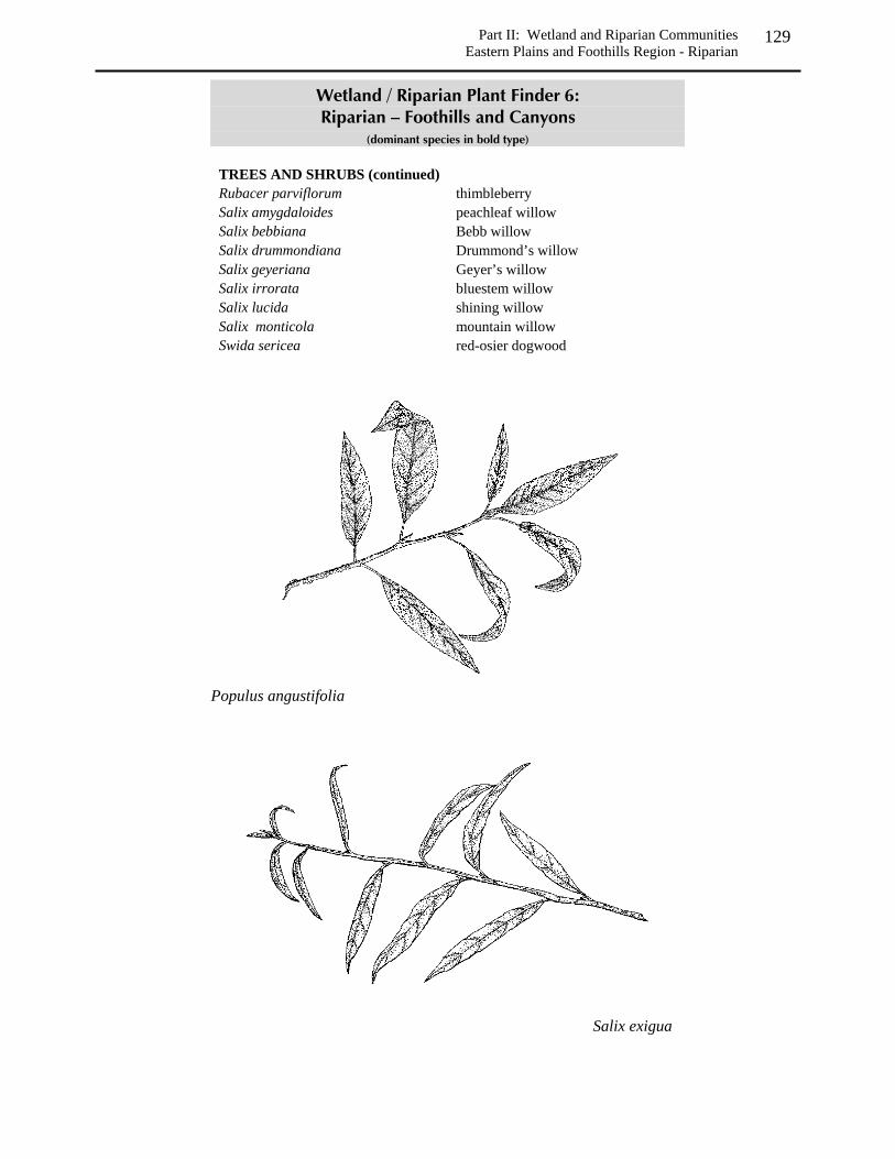
Part II: Wetland and Riparian CommunitiesEastern Plains and Foothills Region - Riparian
129
���/02�J�17/�1/0���/0���102���;*17/�1/0�K�����31��5�/02��/08�05
62��10/0��57��1�5�10����2��87�9
TREES AND SHRUBS (continued)Rubacer parviflorum thimbleberrySalix amygdaloides peachleaf willowSalix bebbiana Bebb willowSalix drummondiana Drummond’s willowSalix geyeriana Geyer’s willowSalix irrorata bluestem willowSalix lucida shining willowSalix monticola mountain willowSwida sericea red-osier dogwood
Populus angustifolia
Salix exigua

Part II: Wetland and Riparian CommunitiesRocky Mountain Region - Wetlands
130
���&�!� �����������
Most of the naturally-occurring wetlands in Colorado are found in the montane and subalpinezones. There are a number of reasons for this. First, it rains and snows more at higherelevations. Second, air temperatures are cooler at higher elevations, so there is less evaporationthan on the plains. Third, most of the montane and subalpine zone was glaciated during the lastice age, and glaciers tend to turn narrow, V-shaped mountain valleys into broad, flat, U-shapedvalleys more suitable for wetland development. Glaciers also create a large number ofspecialized landforms where wetlands can develop, including cirque basins and kettle lakes.
Wetland and riparian habitats within the montane and subalpine zones are similar in location,structure and the functions attributable to them. Moisture from snow melting from high peakssupports a wide variety of wetlands in ponds, shallow depressions and along streams.They range from aquatic systems to herbaceous wet meadows and fens, to willow carrs andforested habitats. At lower elevations they intergrade into wetland and riparian communities ofthe foothills and piñon pine-juniper woodlands, and at higher elevations they intergrade into thealpine wetland communities. Depending on site hydrology and topography, a mosaic of wetlandtypes may occur at a single location.
������
Notes on wetland projects
For wetland creation or restoration, hydrology is all important. Some questions toconsider are� What is the source of water for the wetland and how reliable is it?� How much water is available and for how long during the year?� Will wetland plants establish naturally or are manipulation of the hydrology and
seeding and planting necessary?
Study the arrangement of the plants in wetlands. Different plants grow in differentamounts of water or in soils with different saturation levels. As a result, rings of differentplant species often form around ponds or playas. For that reason, shallowly gradedslopes around ponds will provide more wetland habitat than steep slopes.
There are many references on wetland restoration and creation. A few which are listedin the reference section include Haskisaki 1996, Kusler and Kentula 1990, Mutz et al.1988, Peale 1996, and Schneller-McDonald 1990.
Part II: Wetland and Riparian CommunitiesRocky Mountain Region - Wetlands
131
!��"��
Marshes occur in a variety of situations in the Rocky Mountain region of the state. Natural lakesdot the higher portions of the mountains where snowmelt from the high peaks collects in basins.In the San Luis Valley, the perenially high water table creates numerous shallow ponds withideal conditions for marsh development. In lower elevation areas, dams by humans and beaverscreate small and large bodies of water.
On the shallow shores of the lakes and ponds, plants rooted in the muddy bottom emerge fromthe surface of the water. Large patches of cattails, sedges, spikerush and other emergentvegetation may form rings around the lake shores. As the water gets deeper, rooted plants withfloating leaves such as water lilies and burreed spread across the water. Submergent plants, suchas pondweeds and water crowfoot, occur in deeper water. Where periodic saturation causessalts to accumulate in the soil, marsh vegetation is dominated by alkaline tolerant plants.
��&��
Shallow playas, also called internal drainage basins or ephemeral ponds, are most extensive inthe San Luis Valley. During spring, water collects in these depressions forming small, shallowponds. Later in the summer, the ponds usually dry, leaving a grassy swale of sedges, rushes, andgrasses. Patches of cattails and bulrushes form in wetter areas where the soils are saturated formost of the year. The soils are often very rich in clay. Cottonwoods and willows sometimessurround playas. Often greasewood shrubs are present within the playas where they grow on lowsand dunes on the playa bottom or in a band along the upper playa margin.
���/02�J�17/�1/0���/0���102���<* ���/02�.����53:/����!/�53�5�/02���/8/5
62��10/0��57��1�5�10����2��87�9
GRAMINOIDSBeckmannia syzigachne American sloughgrassCarex aquatilis water sedgeCarex utriculata Northwest territory sedgeEleocharis palustris common spike-rushGlyceria grandis American mannagrassGlyceria striata fowl mannagrassJuncus arcticus arctic rushJuncus longistylis longstyle rushJuncus nodosus jointed rushJuncus torreyi Torrey’s rushScirpus acutus hardstem bulrushScirpus maritimus saltmarsh bulrushScirpus microcarpus panicled bulrushScirpus pungens three-square bulrushTypha latifolia broadleaf cattail
Part II: Wetland and Riparian CommunitiesRocky Mountain Region - Wetlands
132
���/02�J�17/�1/0���/0���102���<* ���/02�.����53:/����!/�53�5�/02���/8/5
62��10/0��57��1�5�10����2��87�9
FORBSAlisma triviale northern water plantainLycopus americanus American water horehoundLycopus asper rough bugleweedPersicaria coccinea scarlet smartweedSagittaria cuneata arumleaf arrowheadSagittaria latifolia broadleaf arrowhead
���/02�J�17/�1/0���/0���102����* ���/02�.���G/�10��!/�53�5�/02���/8/5
62��10/0��57��1�5�10����2��87�9
GRAMINOIDSCarex nebrascensis Nebraska sedgeEleocharis palustris common spike-rushJuncus arcticus arctic rushJuncus torreyi Torrey’s rushJuncus compressus roundfruit rushPuccinellia airoides Nuttall’s alkali grassScirpus acutus hardstem bulrushScirpus nevadensis alkali bulrushScirpus maritimus saltmarsh bulrushTriglochin concinna low arrow-grassTriglochin maritima maritime arrow-grassTypha angustifolia narrowleaf cattail
FORBSGlaux maritima sea milkwortHalerpestes cymbalaria alkali crowfootPersicaria coccinea scarlet smartweedPotamogeton pectinatus sago pondweedRumex maritimus golden dock

Part II: Wetland and Riparian CommunitiesRocky Mountain Region - Wetlands
133
!���� �
A wide variety of wetlands occur in stream valleys, in small depressions, and in other areaswhere the ground is saturated for a substantial portion of the growing season but pools of waterrarely form. The type of wetland depends on the soil characteristics, the duration of soilsaturation, and the vegetation.
���!���� �
Wet meadows of sedge, arctic rush, tufted hairgrass and other grasses occur along streamsand around ponds in the broad mountain valleys. Wild iris may dot the meadows especiallyin heavily grazed areas. These meadows form where the soils are saturated in the spring andearly summer, but usually dry out later in the summer.
���/02�J�17/�1/0���/0���102����* ���/02�K�!�0�/0��/02����/�710�� ���!�/2�:5
62��10/0��57��1�5�10����2��87�9
GRAMINOIDSAlopecuris aequalis shortawn foxtailCarex emoryi Emory’s sedgeCarex lanuginosa woolly sedgeCarex nebrascensis Nebraska sedgeCarex praegracilis clustered field sedgeDeschampsia cespitosa tufted hairgrassEleocharis palustris common spike-rushHordeum jubatum foxtail barleyJuncus arcticus arctic rushJuncus bufonius toad rushJuncus compressus roundfruit rushJuncus nodosus jointed rushJuncus saximontanus Rocky Mountain rushJuncus torreyi Torrey’s rushStipa viridula green needlegrass
FORBSAntennaria corymbosa flattop pussytoesAntennaria rosea rosy pussytoesApocynum cannabinum Indian hempAsclepias speciosa showy milkweedCicuta douglasii western water hemlockConioselinum scopulorum Rocky Mountain hemlock-parsleyCyclachaena xanthifolia marsh-elderEpilobium ciliatum willow-herbIris missouriensis Rocky Mountain irisLimosella aquatica water mudwortMentha arvensis wild mintMimulus glabratus monkey-flowerMonolepis nuttalliana Nuttall’s povertyweedOenothera elata Hooker’s evening-primrose
Part II: Wetland and Riparian CommunitiesRocky Mountain Region - Wetlands
134
���/02�J�17/�1/0���/0���102����* ���/02�K�!�0�/0��/02����/�710�� ���!�/2�:5
62��10/0��57��1�5�10����2��87�9
FORBS (continued)Oenothera villosa hairy evening primroseRanunculus gmelinii Pursh’s buttercupRorippa palustris Fernald’s yellowcressRorippa sinuata spreading yellowcressRorippa teres southern marsh yellowcressRumex hymenosepalus canaigre dockScrophularia lanceolata lanceleaf figwortSenecio hydrophilus water groundselSidalcea neomexicana New Mexico checkermallowStachys palustris marsh hedge-nettleSolidago canadensis Canada goldenrodUrtica gracilis stinging nettleVeronica americana American speedwell
TREES AND SHRUBSPentaphylloides floribunda shrubby cinquefoil
����!���� �
Salt meadows occur in areas of high surface salinity where the water table is close to thesurface and where evaporation exceeds precipitation. Salt meadows are common in lowerand middle elevations in Colorado and are most extensive in South Park and in the playas ofthe San Luis Valley. Greasewood shrubs are present within the playas where they grow onlow sand dunes on the playa bottom or in a band along the upper playa margins.
���/02�J�17/�1/0���/0���102����?* ���/02.�!�0�/0��/02����/�710���/���!�/2�:5
62��10/0��57��1�5�10����2��87�9
GRAMINOIDSAlopecurus aequalis shortawn foxtailCarex nebrascensis Nebraska sedgeCarex douglasii Douglas’ sedgeDistichlis spicata inland saltgrassEleocharis palustris common spike-rushHordeum jubatum foxtail barleyJuncus arcticus arctic rushJuncus nodosus jointed rushJuncus saximontanus Rocky Mountain rushJuncus torreyi Torrey’s rushMuhlenbergia asperifolia alkali muhlyPascopyrum smithii western wheatgrassPuccinellia airoides Nuttall’s alkali grass
Part II: Wetland and Riparian CommunitiesRocky Mountain Region - Wetlands
135
���/02�J�17/�1/0���/0���102����?* ���/02.�!�0�/0��/02����/�710���/���!�/2�:5
62��10/0��57��1�5�10����2��87�9
GRAMINOIDS (continued)Stipa viridula green needlegrassSporobolus airoides alkali sacatonTriglochin concinna low arrow-grassTriglochin maritima maritime arrow-grass
FORBSAsclepias speciosa showy milkweedBrachyactis ciliata alkali rayless asterBrachyactis frondosa leafy rayless asterIva axillaris povertyweedOenothera elata Hooker’s evening-primroseOenothera villosa hairy evening-primroseSolidago canadensis Canada goldenrodSuaeda calceoliformis Pursh seepweedSuaeda moquini Mojave seabliteSuaeda nigra black seablite
TREES AND SHRUBSAtriplex argentea silverscale saltbushChrysothamnus nauseosus rubber rabbitbrushSarcobatus vermiculatus greasewood
����
Fens occur on organic soils nourished by both surface runoff and groundwater sources. They canbe found in relatively flat, constantly wet mountain valleys. Peat accumulation in fens occursslowly, at a rate of about eight inches every 1,000 years (Cooper and Jones 1993). Rich fens,fens on soils rich in calcium carbonate and other salts, are extremely rare in Colorado, but aremost common in South Park. Sedges, spike rush, tufted hairgrass and Canadian reedgrassdominate these wetlands. Colorful patches of marsh marigold, elephantella, queen’s crown,king’s crown and other wildflowers occur in many fens. In some of the wetter areas, only one ortwo species of sedge may dominate the entire site.
� The U. S. Fish and Wildlife Service is in the process of listing fens as ResourceCategories 1 or 2 of the FWS Mitigation Policy (Federal Register, Volume 46,Number 15, 1981). Since these wetlands are essentially irreplaceable (they takehundreds or thousands of years to develop), the FWS mitigation goal is no net lossof existing habitat value or no net loss of in-kind habitat value, depending on therichness of the wetland being evaluated (USFWS 1997).

Part II: Wetland and Riparian CommunitiesRocky Mountain Region - Wetlands
136
������ ������
Alpine habitats are those that occur above treeline, where vegetation patterns are controlled bysnow retention, wind desiccation and permafrost (Galatowitsch 1988). Alpine wetlands occurwhere permanent snow fields provide a steady source of water through the growing season.They are highly variable, ranging from late-lying snowbed communities to communitiessurrounding permanent pools. Alpine wetland and riparian communities occur at the highestelevations in the Rocky Mountains, near or above treeline and are similar on both the east andwest slopes.
Tips for alpine projects
Due to the high elevation, harsh environmental conditions, and difficult access, planting in the alpinezone presents special complications.
� Short growing seasons and cold temperatures limit plant growth rates, slowing establishmentand visible progress of revegetation.
� Few high altitude native plant materials are available from commercial suppliers.� Very little information regarding the germination requirements of native high-altitude species is
available. High altitude species are even less likely than lower altitude native species to conformto the desired “garden model” of rapid germination and vigorous establishment.
The severe environmental conditions of high elevations can devastate carefully acquired/propagatedplant materials. Among the most harmful factors are wildlife browsing (including pocket gophers),summer freezes, snowmold and frost-heaving especially during spring when young seedlingstrapped in a frozen surface soil layer are often ripped out of the ground by ice crystals growing frombelow.
� Below treeline and in the moister, less windy alpine communities, plants listed in the PlantFinders can perform well if seeded in the fall and provided with a durable mulch cover such asbonded fiber matrix or well-anchored excelsior or other organic mats.
� In moderately windy sites, establishment must be done via planting rather than seeding.Appropriate species for such sites are not ordinarily available (e.g., Bellardi kobresia (Kobresiamyosuroides), or blackroot sedge (Carex elynoides)) and must be propagated by special order.Mulches in these sites must be more carefully applied than those in sheltered sites.
� In the most exposed alpine sites (fellfields), prospects of successful revegetation within a decadeare small. Success is likely to result from custom propagation of fellfield native species, carefulpositioning relative to microtopography, and subtle use of microtopographic objects such asrocks to produce a moderate, but not overly protected microsite for the plantings.
For more information, see Proceedings of the High Altitude Revegetation Workshops, Willard 1972.

Part II: Wetland and Riparian CommunitiesRocky Mountain Region - Wetlands
137
��������� ������
Alpine snow glades occur in areas with late-season snow retention, where snow coverprotects plants from winter frost, shortens the growing season and provides moisture duringthe growing season (Galatowitsch 1988). Characteristic species of snow glades includetufted hairgrass, phippsia, black sedge, avens, alpine sagewort and daisy fleabane.
���/02�J�17/�1/0���/0���102�����* ���/02.���710���0�:���/2�5
62��10/0��57��1�5�10����2��87�9
GRAMINOIDSCarex crandallii Pyrenean sedgeCarex nigracans black sedgeDeschampsia cespitosa tufted hairgrassJuncus drummondii Drummond’s sedgePhippsia algida phippsiaPhleum communtatum alpine timothy
FORBSArtemisia scopulorum alpine sagewortErigeon melanocephalus black-headed daisyErigeron simplex onestem fleabaneGeum rossii var. turbinatum alpine avensRanunculus adoneus snow buttercupSibbaldia procumbens sibbaldia
SHRUBSSalix arctica arctic willow
������ ���!���� �
Alpine wet meadows occur below persistent snow drifts, behind solifluction terraces, overpermafrost and around cirque or tarn lakes and ponds (Galatowitsch 1988, Peale 1996).Solifluction depressions (nivation depressions) and pools also accumulate water fromsummer thunderstorms, greatly augmenting available soil moisture (Willard 1979).Characteristic alpine wet meadow species include tufted hairgrass, Nelson’s sedge, mountainsedge , Drummond rush , marsh marigold, alpine bistort, elephantella, and Parry’s primrose.
���/02�J�17/�1/0���/0���102����+* ���/02.���710�� ���!�/2�:5
62��10/0��57��1�5�10����2��87�9
GRAMINOIDSCarex crandallii Pyrenean sedgeCarex nelsoni Nelson’s sedgeCarex scopulorum mountain sedgeDeschampsia cespitosa tufted hairgrass

Part II: Wetland and Riparian CommunitiesRocky Mountain Region - Wetlands
138
���/02�J�17/�1/0���/0���102����+* ���/02.���710�� ���!�/2�:5
62��10/0��57��1�5�10����2��87�9
GRAMINOIDS (continued)Juncus castaneus chestnut rushJuncus drummondii Drummond’s rush
FORBSPolygonum bistortoides American bistortPolygonum viviparum alpine bistortCaltha leptosepala marsh marigoldClementsia rhodantha queen’s crownEpilobium anagadallidifolium alpine willowherbPedicularis groenlandica elephantellaPrimula parryi Parry’s primrose
SHRUBSSalix planifolia planeleaf willow
Deschampsia cespitosa
Part II: Wetland and Riparian CommunitiesRocky Mountain Region - Riparian
139
���������!! ������Along mountain streams, discontinuous patches of forest intermix with shrub communities andherbaceous wetlands. Forests of narrowleaf cottonwood, river birch, mountain alder, and clumpsof aspen occur along the banks of the Colorado streams. Along permanent streams in coolercanyons, blue spruce, Douglas-fir, and white fir (southern Colorado) anchor the banks. At higherelevations, Englemann spruce becomes the dominant tree. Dense thickets of shrub willows, red-osier dogwood and gooseberries occur under the forest canopy. Wildflowers such as cowparsnip, chimingbells, monkshood and bittercress form a dense, showy understory along manymountain streams.
In open, unforested areas, dense patches of willow shrubs, bog birch and shrubby cinquefoil mayform. Sedges, rushes, and grasses such as tufted hairgrass grow in grassy strips on the banks ofmany streams, especially where grazing occurs. In the subalpine, communities of chimingbells,monkeyflower, bittercress and other wildflowers cover the banks of small streams.
Notes on riparian projects
Hydrology and stream dynamics are critical factors for the success of riparian projects.The work needed to restore proper functioning will depend on the current condition ofthe stream and the riparian vegetation. Questions to consider include� Would changes in land use (i.e., changes in grazing season or stocking numbers,
closing or moving trails, etc.) be sufficient to improve stream functioning and riparianvegetation?
� Is stream hydrology suitable to support the planned changes?
For some of the many available references on riparian projects, see American FisheriesSociety 1982, Briggs 1995 and 1996, Clary 1996, Crumpacker 1985, Hughes 1996, andSchultze 1984.

Part II: Wetland and Riparian CommunitiesRocky Mountain Region - Riparian
140
�� ����
Willow carrs occur on organic soils along montane and subalpine streams, on broad floodplainsinundated by beaver dams, around the edges of sedge-dominated fens, and around glacial lakesand on solifluction terraces in the alpine zone.
!����������
In the montane zone, willow carrs occur adjacent to meandering streams on broad floodplainsoften inundated by beaver dams. Tall willows, in various combinations, often dominate thesecommunities. Typical tall willow species include Drummond’s willow, Geyer’s willow,planeleaf willow, shining willow and mountain willow. Barrenground willow, Wolf’swillow and bog birch may be present, but more commonly occur at higher elevations. Watersedge, beaked sedge and bluejoint reedgrass are common in the understory along with avariety of forbs.
� ����������
In the subalpine, planeleaf willow is usually the dominate species of willow carrs; bog birch,Wolf’s willow and barrenground willow may also be important. These species may formshort, but nearly impenetrable thickets around small glacial lakes or on poorly-drained soilsalong streams. Shrubby cinquefoil may form a ring around the edge of the willow carrs,especially in heavily grazed areas. Understory vegetation may be sparse where willows aredense or may be extremely dense and diverse. Elephantella, marsh marigold, globe flower,water and beaked sedges are common understory species. Many other species, not listedhere, may be found in native willow communities.
���/02�J�17/�1/0���/0���102����)*17/�1/0�K� 1���:��/��562��10/0��57��1�5�10����2��87�9
GRAMINOIDSAlopecuris alpinus shortawn foxtailCalamagrostis canadensis bluejoint reedgrassCarex aquatilis water sedgeCarex lanuginosa woolly sedgeCarex nebrascencis Nebraska sedgeCarex scopulorum mountain sedgeCarex utriculata beaked sedgeDeschampsia cespitosa tufted hairgrassEleocharis palustris common spike-rushEleocharis quinqueflora fewflower spike-rushJuncus arcticus arctic rushJuncus castaneus chestnut rushJuncus confusus Colorado rushJuncus longistylis longstyle rushJuncus mertensianus Merten’s rushJuncus parryi Parry’s rushJuncus saximontanus Rocky Mountain rushLuzula parviflora smallflowered woodrushMuhlenbergia filiformis pullup muhly

Part II: Wetland and Riparian CommunitiesRocky Mountain Region - Riparian
141
���/02�J�17/�1/0���/0���102����)*17/�1/0�K� 1���:��/��562��10/0��57��1�5�10����2��87�9
GRAMINOIDS (continued)Phleum commutatum alpine timothyPoa leptocoma bog bluegrassPoa palustris fowl bluegrassPoa reflexa nodding bluegrass
FORBSAllium geyeri Geyer’s onionAllium schoenoprasum wild chivesAndrosace filiformis filiform rock-jasmineAntennaria corymbosa flattop pussytoesAntennaria rosea rosy pussytoesAnticlea elegans mountain death camasAstragalus alpinus alpine milkvetchPolygonum bistortoides American bistortPolygonum vivipara alpine bistortCaltha leptosepala marsh marigoldCardamine cordifolia heartleaf bittercressClementsia rhodantha queen’s crownDelphinium barbeyi tall larkspurEpilobium saximontanum Rocky Mountain willow-herbErigeron peregrinus subalpine fleabaneGeum macrophyllum largeleaf avensHeracleum sphondylium cow-parsnipIris missouriensis Rocky Mountain irisPedicularis groenlandica elephantellaPolemonium foliosissimum towering Jacob’s ladderPotentilla pensylvanica Pennsylvania cinquefoilRhodiola integrifolia king’s crownSenecio integerrimus lambstongue groundselSwertia perennis star gentianThermopsis montana mountain thermopsisTrollius laxas American globe-flowerValeriana edulis edible valerianValeriana occidentalis western valerianVeronicastrum serpyllifolium thyme-leaved speedwell
TREES AND SHRUBSBetula glandulosa bog birchKalmia microphylla alpine laurelPentaphylloides floribunda shrubby cinquefoilRibes lacustre prickly currantSalix brachycarpa barrenground willowSalix drummondiana Drummond’s willowSalix geyeriana Geyer’s willowSalix monticola mountain willowSalix planifolia planeleaf willowSalix wolfii Wolf’s willowVaccinium cespitosum dwarf blueberry
Part II: Wetland and Riparian CommunitiesRocky Mountain Region - Riparian
142
�������������
Riparian plant communities consist largely of deciduous forests on lower montane streams andrivers and evergreen forests of higher elevations. Characteristic tree species of the montanezone include narrowleaf cottonwood, Douglas-fir or aspen. Commonly associated understoryspecies include river birch, alder, red-osier dogwood, bush honeysuckle, and sandbar, mountain,Drummond’s, Geyer’s, and shining willow. Higher elevations are characterized by quakingaspen, Engelmann spruce and subalpine fir; Colorado blue spruce and white fir are common inboth zones in southern Colorado. The shrub and herbaceous layers in subalpine riparian foreststend to be extremely lush and diverse. Since they vary considerably from one site to another,only a few of the herbaceous species in the Plant Finder are listed in bold. Many of theunderstories species from the montane are also found in subalpine riparian forests.
���/02�J�17/�1/0���/0���102����,*17/�1/0�K�!�0�/0��/02����/�710������5�5
62��10/0��57��1�5�10����2��87�9
GRAMINOIDSAlopecuris alpinus shortawn foxtailCalamagrostis canadensis bluejoint reedgrassCalamagrostis stricta slimstem reedgrassCarex aquatilis water sedgeCarex utriculata beaked sedgeDeschampsia cespitosa tufted hairgrassEleocharis palustris common spike-rushJuncus arcticus arctic rushJuncus confusus Colorado rushJuncus longistylis longstyle rushJuncus mertensianus Merten’s rushJuncus saximontanus Rocky Mountain rushLuzula parviflora smallflowered wood-rushPhleum commutatum alpine timothyPoa leptocoma bog bluegrassPoa palustris fowl bluegrassPoa reflexa nodding bluegrass
FORBSAllium geyeri Geyer’s onionAllium schoenoprasum wild chivesCardamine cordifolia heartleaf bittercressClementsia rhodantha queen’s crownDelphinium barbeyi tall larkspurErigeron peregrinus subalpine fleabaneFrasera speciosa monument-plantGalium septentrionale northern bedstrawGalium trifidum threepetal bedstrawGeranium viscosissimum sticky purple geraniumHeracleum sphondylium cow-parsnip

Part II: Wetland and Riparian CommunitiesRocky Mountain Region - Riparian
143
���/02�J�17/�1/0���/0���102����,*17/�1/0�K�!�0�/0��/02����/�710������5�5
62��10/0��57��1�5�10����2��87�9
FORBS (continued)Iris missouriensis Rocky Mountain irisLigusticum porteri Porter’s licoricerootMicranthes odontoloma brook saxifragePedicularis groenlandica elephantellaPedicularis procera giant lousewortPotentilla pensylvanica Pennsylvania cinquefoilRudbeckia hirta black-eyed susanSenecio serra tall ragwortSenecio triangularis arrowleaf groudselThermopsis montana mountain thermopsisValeriana edulis edible valerianValeriana occidentalis western valerianVeronicastrum serpyllifolium thyme-leaved speedwellVicia americana American vetch
TREES AND SHRUBSAbies concolor white firAbies lasiocarpa subalpine firAcer glabrum Rocky Mountain mapleAcer negundo box elderAlnus incana thinleaf alderBetula occidentalis water birchCrataegus rivularis river hawthornLonicera involucrata twinberry honeysucklePentaphylloides floribunda shrubby cinquefoilPicea engelmannii Engelmann sprucePicea pungens blue sprucePopulus angustifolia narrowleaf cottonwoodPopulus tremuloides quaking aspenPrunus virginiana black chokecherryRibes lacustre prickly currantRibes montigenum gooseberry currantSalix brachycarpa barrenground willowSalix drummondiana Drummond’s willowSalix geyeriana Geyer’s willowSalix lucida shining willowSalix monticola mountain willowSalix planifolia planeleaf willowSalix wolfii Wolf’s willowSeriphidium canum silver sagebrush
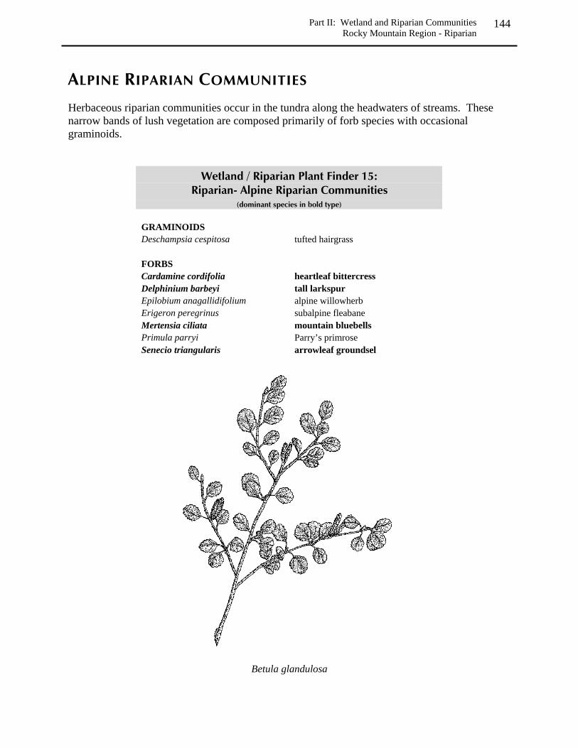
Part II: Wetland and Riparian CommunitiesRocky Mountain Region - Riparian
144
���������������!! ������
Herbaceous riparian communities occur in the tundra along the headwaters of streams. Thesenarrow bands of lush vegetation are composed primarily of forb species with occasionalgraminoids.
���/02�J�17/�1/0���/0���102����-*17/�1/0.���710��17/�1/0������01�1�5
62��10/0��57��1�5�10����2��87�9
GRAMINOIDSDeschampsia cespitosa tufted hairgrass
FORBSCardamine cordifolia heartleaf bittercressDelphinium barbeyi tall larkspurEpilobium anagallidifolium alpine willowherbErigeron peregrinus subalpine fleabaneMertensia ciliata mountain bluebellsPrimula parryi Parry’s primroseSenecio triangularis arrowleaf groundsel
Betula glandulosa

Part II: Wetland and Riparian CommunitiesWestern Plateau and Canyon Region - Wetlands
145
����������� ��������&�������
The landforms of western Colorado are an interesting mosaic of mountains (Uinta, Park, Gore,Elk, Sawatch and San Juan Ranges), mesas (Battlement and Grand), plateaus (White River, Roanand Uncompahgre), and basins (Wyoming, Piceance and San Juan). Major river systemsdraining the region and sometimes forming large canyons and valleys, include the Yampa,White, Colorado, Gunnison, Dolores and Animas. Wetland and riparian communities are asvaried as the terrain; many are extremely saline or alkaline and are described more fully below.
������
!��"��
Freshwater marshes occur in water less than 1.5 feet (0.5 m) deep and on adjacent saturated soils.Typical associated plant species include softstem bulrush, broad-leaved cattail, spike-rush, Arcticrush and arrowhead. Alkaline and saline marshes are characterized by hardstem and three-squarebulrush, narrow-leaved cattail and arctic rush, growing on periodically saturated soils.Submergent and floating aquatic plants occur where water is deeper than 1.5 feet (0.5 m), and arecharacterized by pondweeds, bladderwort, water milfoil and water crowfoot.
Notes on wetland projects
For wetland creation or restoration, hydrology is all important. Some questions toconsider are� What is the source of water for the wetland and how reliable is it?� How much water is available and for how long during the year?� Will wetland plants establish naturally or are manipulation of the hydrology and
seeding and planting necessary?
Study the arrangement of the plants in wetlands. Different plants grow in differentamounts of water or in soils with different saturation levels. As a result, rings of differentplant species often form around ponds or playas. For that reason, shallowly gradedslopes around ponds will provide more wetland habitat than steep slopes.
There are many references on wetland restoration and creation. A few which are listedin the reference section include Haskisaki 1996, Kusler and Kentula 1990, Mutz et al.1988, Peale 1996, and Schneller-McDonald 1990.

Part II: Wetland and Riparian CommunitiesWestern Plateau and Canyon Region - Wetlands
146
���/02�J�17/�1/0���/0���102����;* ���/02�.����53:/����!/�53�5
62��10/0��57��1�5�10����2��87�9
GRAMINOIDSBeckmannia syzigachne American sloughgrassCarex aquatilis water sedgeCarex utriculata Northwest territory sedgeEleocharis palustris common spike-rushGlyceria grandis American mannagrassJuncus arcticus mountain rushJuncus longistylis longstyle rushJuncus nodosus jointed rushJuncus torreyi Torrey’s rushPersicaria coccinea scarlet smartweedScirpus acutus hardstem bulrushScirpus pungens three-square bulrushScirpus maritimus saltmarsh bulrushScirpus microcarpus panicled bulrushTypha latifolia broadleaf cattail
FORBSAlisma triviale northern water plantainLycopus americanus American water horehoundLycopus asper rough bugleweedSagittaria cuneata arumleaf arrowheadSagittaria latifolia broadleaf arrowhead
���/02�J�17/�1/0���/0���102����<* ���/02�.���G/�10��!/�53�5
62��10/0��57��1�5�10����2��87�9
GRAMINOIDSCarex nebrascensis Nebraska sedgeEleocharis palustris common spike-rushJuncus arcticus arctic rushJuncus compressus roundfruit rushJuncus torreyi Torrey’s rushPuccinellia airoides alkali grassScirpus acutus hardstem bulrushScirpus nevadensis alkali bulrushScirpus maritimus saltmarsh bulrushTriglochin concinna low arrow-grassTriglochin maritima maritime arrow-grassTypha angustifolia narrow-leaved cattail
FORBSGlaux maritima sea milkwortHalerpestes cymbalaria alkali crowfootPersicaria coccinea scarlet smartweedPotamogeton pectinatus sago pondweedRumex maritimus golden dock

Part II: Wetland and Riparian CommunitiesWestern Plateau and Canyon Region - Wetlands
147
!���� �
���!���� �
Wet meadows often surround marshes, occupying saturated to moist soils. Plant speciespresent reflect the degree of alkalinity or salinity; when the pH is near-neutral to slightlyalkaline, Nebraska sedge, arctic rush, common spike-rush and Torrey’s rush are commonspecies.
���/02�J�17/�1/0���/0���102�����* ���/02�K�!/�53�!/�4105�/02� ���!�/2�:5
62��10/0��57��1�5�10����2��87�9
GRAMINOIDSAlopecuris aequalis shortawn foxtailCarex emoryi Emory’s sedgeCarex lanuginosa woolly sedge
Carex nebrascensis Nebraska sedgeEleocharis palustris common spike-rushHordeum jubatum foxtail barleyJuncus arcticus arctic rushJuncus confusus Colorado rushJuncus longistylis longstyle rushJuncus nodosus jointed rushJuncus saximontanus Rocky Mountain rushJuncus torreyi Torrey’s rushPanicum virgatum switchgrassPascopyrum smithii western wheatgrassStipa viridula green needlegrass
FORBSApocynum cannabinum Indian hempAsclepias speciosa showy milkweedCicuta douglasii western water hemlockCyclachaena xanthifolia marsh-elderEpilobium ciliatum willow-herbGaura parviflora velvetweedGlycyrrhiza lepidota wild licoriceHelianthus nuttallii Nuttall’s sunflowerMentha arvensis wild mintMimulus glabratus monkey-flowerMonolepis nuttalliana Nuttall’s povertyweedOenothera elata Hooker’s evening-primroseRorippa palustris yellowcressRorippa sinuata spreading yellowcressRorippa teres southern marsh yellowcressRumex hymenosepalus canaigre dockScrophularia lanceolata lanceleaf figwort

Part II: Wetland and Riparian CommunitiesWestern Plateau and Canyon Region - Wetlands
148
���/02�J�17/�1/0���/0���102�����* ���/02�K�!/�53�!/�4105�/02� ���!�/2�:5
62��10/0��57��1�5�10����2��87�9
FORBS (continued)Senecio hydrophilus water groundselSolidago canadensis Canada goldenrodStachys palustris marsh hedge-nettleVeronica americana American speedwell
TREES AND SHRUBSPentaphylloides floribunda shrubby cinquefoilRosa woodsii Wood’s roseSalix exigua sandbar willow
����!���� �
Where the sites are moderately to highly alkaline or saline, saltgrass, alkali sacaton, alkali-grass, alkali cordgrass, meadow foxtail, foxtail barley, three-square bulrush, sea-blite andarrowgrass are typically present. Moist to wet swales and seeps also support thecharacteristic plant species identified in the above discussion.
���/02�J�17/�1/0���/0���102�����* ���/02�K���G/�10��!/�53�!/�4105�/02��/���!�/2�:5
62��10/0��57��1�5�10����2��87�9
GRAMINOIDSAlopecurus aequalis shortawn foxtailCarex nebrascensis Nebraska sedgeDistichlis spicata inland saltgrassEleocharis palustris common spike-rushHordeum jubatum foxtail barleyJuncus arcticus arctic rushJuncus nodosus jointed rushJuncus saximontanus Rocky Mountain rushJuncus torreyi Torrey’s rushMuhlenbergia asperifolia alkali muhlyPanicum virgatum switchgrassPascopyrum smithii western wheatgrassPuccinellia airoides Nuttall’s alkali grassSporobolus airoides alkali sacatonStipa viridula green needlegrassTriglochin concinna low arrow-grass
FORBSAsclepias speciosa showy milkweedBrachyactis ciliata alkali rayless asterBrachyactis frondosa leafy rayless asterGaura parviflora velvetweedGlaux maritima sea milkwort
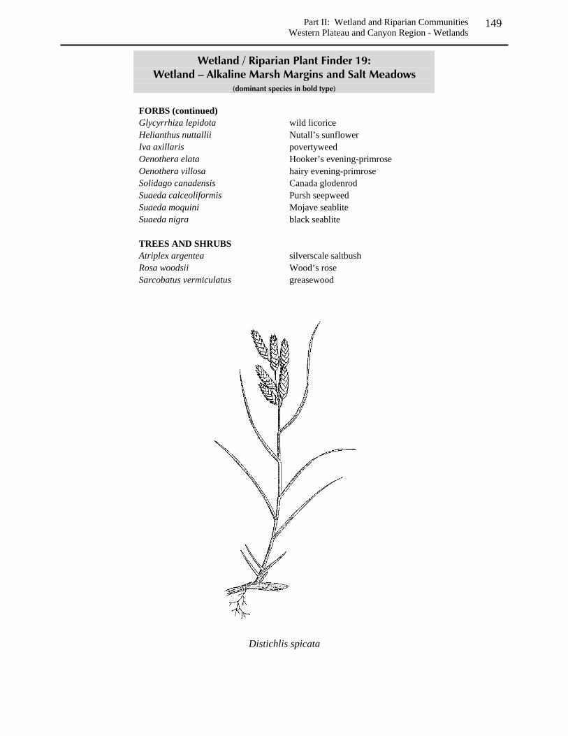
Part II: Wetland and Riparian CommunitiesWestern Plateau and Canyon Region - Wetlands
149
���/02�J�17/�1/0���/0���102�����* ���/02�K���G/�10��!/�53�!/�4105�/02��/���!�/2�:5
62��10/0��57��1�5�10����2��87�9
FORBS (continued)Glycyrrhiza lepidota wild licoriceHelianthus nuttallii Nutall’s sunflowerIva axillaris povertyweedOenothera elata Hooker’s evening-primroseOenothera villosa hairy evening-primroseSolidago canadensis Canada glodenrodSuaeda calceoliformis Pursh seepweedSuaeda moquini Mojave seabliteSuaeda nigra black seablite
TREES AND SHRUBSAtriplex argentea silverscale saltbushRosa woodsii Wood’s roseSarcobatus vermiculatus greasewood
Distichlis spicata
Part II: Wetland and Riparian CommunitiesWestern Plateau and Canyon Region - Riparian
150
���������!! ������Typically, riparian forests and shrubland communities of lower elevations of the Western Plateauand Canyon region occur on low terraces and floodplains. In the foothills, streams tend to benarrower with swifter flowing water. Water levels on these streams may fluctuate widely duringthe year, from several feet above the stream bottom during spring and after thunderstorms to dryor a small trickle in the fall. Riparian areas often include a mosaic of vegetation types, withwetlands at stream edges, in backwater areas, or old oxbows, and upland vegetation interspersedwith riparian species.
������ ���J �� �������
Riparian plant communities consist largely of deciduous forests on lower river terraces andfloodplains, dominated by Fremont cottonwood in the lower elevations and narrowleafcottonwood along moderate-gradient streams above about 6,000 feet (1829 meters) elevation.Commonly associated shrubs at lower elevations include skunkbush sumac, rabbitbrush,sandbar willow, and groundsel-tree; at higher elevations, box-elder and Douglas-fir trees, andsandbar willow, Woods' rose, river birch, alder, and red-osier dogwood are typical species inriparian communities. Many of these communities have been invaded by nonnative salt-cedar, Russian-olive and Siberian elm.
���/02�J�17/�1/0���/0���102���+?*17/�1/0�K�����27�/105�/02�����/��5
62��10/0��57��1�5�10����2��87�9
GRAMINOIDSDistichlis spicata inland saltgrassHordeum jubatum foxtail barleyJuncus arcticus arctic rushPanicum virgatum switchgrassPascopyron smithii western wheatgrassSpartina pectinata prairie cordgrass
Notes on riparian projects
Hydrology and stream dynamics are critical factors for the success of riparian projects.The work needed to restore proper functioning will depend on the current condition ofthe stream and the riparian vegetation. Questions to consider include� Would changes in land use (i.e., changes in grazing season or stocking numbers,
closing or moving trails, etc.) be sufficient to improve stream functioning and riparianvegetation?
� Is stream hydrology suitable to support the planned changes?
For some of the many available references on riparian projects, see American FisheriesSociety 1982, Briggs 1995 and 1996, Clary 1996, Crumpacker 1985, Hughes 1996, andSchultze 1984.

Part II: Wetland and Riparian CommunitiesWestern Plateau and Canyon Region - Riparian
151
���/02�J�17/�1/0���/0���102���+?*17/�1/0�K�����27�/105�/02�����/��5
62��10/0��57��1�5�10����2��87�9
FORBSApocynum cannabinum Indian hempClematis ligusticifolia western white clematisCyclachaena xanthifolia marsh-elderGlycyrrhiza lepidota wild licoriceHydrophyllum fendleri Fendler’s waterleafIris missouriensis Rocky Mountain irisMaianthemum stellatum starry false Solomon’s sealMentha arvensis wild mintMonarda fistulosa wildbergamot beebalmPotentilla rivalis brook cinquefoilSolidago canadensis Canada goldenrod
TREES AND SHRUBSAcer negundo box-elderAmorpha fruiticosa desert indigobushArtemisia tridentata ssp. tridentata big sagebrushBaccharis salicina Great Plains false-willowCeltis reticulata netleaf hackberryChrysothamnus nauseosus rubber rabbitbrushChrysothamnus viscidiflorus green rabbitbrushForestiera pubescens stretchberryJuniperus scopulorum Rocky Mountain juniperPrunus virginiana black chokecherryPopulus angustifolia narrowleaf cottonwoodPopulus deltoides ssp.wizlizenii Fremont cottonwoodPopulus tremuloides quaking aspenRhus trilobata skunkbush sumacRibes aureum golden currantRosa woodsii Woods’ roseSalix amygdaloides peachleaf willowSalix bebbiana Bebb willowSalix exigua sandbar willowSalix lucida shining willow
���/02�J�17/�1/0���/0���102���+�*17/�1/0�K�����31��5�/02��/08�05
62��10/0��57��1�5�10����2��87�9
GRAMINOIDSGlyceria grandis American mannagrassGlyceria striata fowl mannagrassHordeum jubatum foxtail barleyJuncus arcticus arctic rushPascopyron smithii western wheatgrass

Part II: Wetland and Riparian CommunitiesWestern Plateau and Canyon Region - Riparian
152
���/02�J�17/�1/0���/0���102���+�*17/�1/0�K�����31��5�/02��/08�05
62��10/0��57��1�5�10����2��87�9
GRAMINOIDS (continued)Poa palustris fowl bluegrassStipa viridula green needlegrass
FORBSApocynum cannabinum Indian hempClematis ligusticifolia western white clematisCyclachaena xanthifolia marsh-elderEpilobium angustifolium fireweedEquisetum arvense field horsetailGlycyrrhiza lepidota wild licoriceHeracleum sphondylium cow-parsnipHydrophyllum fendleri Fendler’s waterleafIris missouriensis Rocky Mountain irisMaianthemum stellatum starry false Solomon’s sealMentha arvensis wild mintMertensia ciliata mountain bluebellsMonarda fistulosa wildbergamot beebalmPotentilla rivalis brook cinquefoilSolidago canadensis Canada goldenrodVeratrum tenuipetalum Colorado false helleboreVicia americana American vetch
TREES AND SHRUBSAcer glabrum Rocky Mountain mapleAcer negundo box-elderAlnus incana thinleaf alderBetula occidentalis water birchCrataegus rivularis river hawthornLonicera involucrata twinberry honeysucklePicea pungens Colorado blue sprucePopulus angustifolia narrowleaf cottonwoodPopulus deltoides plains cottonwoodPopulus tremuloides quaking aspenPrunus virginiana black chokecherryPseudotsuga menziesii Douglas-firRibes aureum golden currantRibes cereum wax currantRosa woodsii Woods’ roseRubacer parviflorum thimbleberrySalix amygdaloides peachleaf willowSalix bebbiana Bebb willowSalix exigua sandbar willowSalix lucida shining willowSalix monticola mountain willow
Part II: Wetland and Riparian CommunitiesRevegetation Techniques
153
��������������������"��D ��
This section is divided into five steps:
����" ����"
1. Planning Your Project 1542. Site Selection 1553. Developing a Site Specific Plan 1594. Seeding & Planting 1735. Monitoring and Stewardship 187
The following flow-chart presents the steps which are required for successful completion of awetlands creation/restoration/enhancement project. The path you take will depend upon yourgoals for the project. The sequence of procedures will depend on the current condition of theproject site. The following sections provide more detailed information on each step.
WETLAND PROJECTS:REGULATORY COMPLIANCE & COMPENSATORY MITIGATION
Regulatory agencies such as the Corps of Engineers and the EnvironmentalProtection Agency may require an applicant for a wetlands permit to construct,restore, or enhance wetlands to compensate for impacts to other wetlands. Thisguide provides information that can help you carry out such a project. However itis not meant as specific guidance for regulatory compliance. Always make surethat you have contacted the appropriate regulatory agency to understand theirrequirements for planning, implementing and monitoring the construction of acompensatory wetland project. A list of agency contacts is included in AppendixVII on page 255.
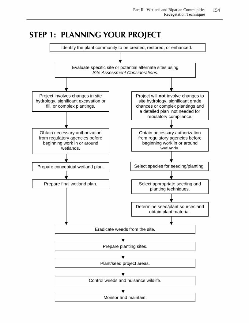
Part II: Wetland and Riparian CommunitiesRevegetation Techniques
154
������*����������&� ���(���Identify the plant community to be created, restored, or enhanced.
Obtain necessary authorizationfrom regulatory agencies before
beginning work in or aroundwetlands.
Project involves changes in sitehydrology, significant excavation or
fill, or complex plantings.
Prepare conceptual wetland plan.
Project will not involve changes tosite hydrology, significant grade
chances or complex plantings anda detailed plan not needed for
regulatory compliance.
Prepare final wetland plan.
Obtain necessary authorizationfrom regulatory agencies before
beginning work in or aroundwetlands.
Select species for seeding/planting.
Select appropriate seeding andplanting techniques.
Determine seed/plant sources andobtain plant material.
Eradicate weeds from the site.
Prepare planting sites.
Control weeds and nuisance wildlife.
Monitor and maintain.
Plant/seed project areas.
Evaluate specific site or potential alternate sites usingSite Assessment Considerations.

Part II: Wetland and Riparian CommunitiesRevegetation Techniques – Site Selection
155
�����+*���������������The success of a project depends on selecting a suitable site which will meet the goals andobjectives of your wetland plan. In many cases, especially for simple revegetation projects, youmay only be considering a single potential site for your project. For compensatory wetlandprojects, on-site mitigation of wetlands with similar functions (in-kind) is preferred. On-sitereplacement is not always possible, however, and you must find a suitable site for your project.
You should collect sufficient information for each project to
� identify possible sites� compare the features of these sites� estimate construction costs
The extent of site evaluation will depend on the type and size of the proposed project.Coordinate with other resource or regulatory agencies involved in the project.
Resource agencies may at times prefer off-site, out-of-kind mitigation if it creates a wetland typewith higher value. If on-site, in-kind areas cannot be found, the preference is for replacementsites in the same watershed to avoid red-tape. For instance, consumptive water loss due toevapo-transpiration from created wetlands in another watershed may mandate the acquisition ofadjudicated water rights.
�����������!�����������������
Site selection and evaluation involves collecting and analyzing information on such items ashydrology, soils, topography, biology, land ownership and use, and construction feasibility.
"&����&
Evaluating the hydrology of the site involves understanding surface and groundwaterlocations, quantity and quality of water, surface and subsurface flow patterns and seasonalfluctuations (Hammer 1992).
���B/���:/���
The amount and type of surface water available will influence the type and size of thewetland project. Items to consider when looking at a surface water wetland site include
� Maintaining water levels will be difficult or impossible if surface run-off is inadequateand alternative water sources are not available.
� The amount of sediment entering the project area.� The likelihood of flooding and the severity of subsequent erosion (Hammer 1992).
If there are lakes or streams near the project site, monitor water elevation, flow rate andseasonal fluctuations in order to quantify water levels. Flow volumes in streams and lakesare often monitored by the US Geological Survey, state governments, irrigation districts and

Part II: Wetland and Riparian CommunitiesRevegetation Techniques – Site Selection
156
other agencies. Where previously recorded data are unavailable, collecting informationyourself will be necessary (Cooper 1993).
The water surface elevation in relation to a site is important and can be determined byinstalling and monitoring staff gauges. These gauges are essentially sturdy rulers anchored ina non-turbulent portion of the stream. At a minimum, data should be collected bi-weeklyduring the growing season and monthly in late summer and fall. Winter monitoring isnormally not necessary. Data should be collected for at least one year (Cooper 1993).
����02� /���
On wetland sites which will be supported by ground water, the review process must includeon-site monitoring wells to measure ground water levels. Wells should be installed bysomeone who is experienced and qualified, and should be placed in a grid pattern across thepotential site(s). The number of wells will depend on the size and complexity of the site.
During analysis and interpretation of data collected from wells, look for
� Seasonal fluctuations of water. A site which has a large fluctuation in water elevationsmay not be a suitable project location.
� Depth to ground water. The deeper the hole, the less feasible a site will be due to costsassociated with excavation and the potential that the site is not large enough to containthe excavation.
� Precipitation records for the watershed to determine if data were collected during a wet ordry year (Cooper 1993).
� How the water table is distributed across the site, whether water is isolated or perchedand how it flows.
� Whether ground water adjacent to a stream is flowing into (“gaining”) or out of(“losing”) the stream. In a “losing” stream situation, ground water decreases rapidlyaway from the stream and constructing a site will become a source of frustration.Wetland projects next to a “gaining” stream will typically be successful.
While reviewing the site, determine whether permanent structures or water diversions duringconstruction will be needed to make the wetland successful. Project sites that require little orno future maintenance are preferred over those that use high-maintenance and man-madestructures.
����
Soils should be evaluated for permeability, erodability, texture, nutrients, pH and possiblecontaminants. Water holding capacity is influenced by soil texture, which will determinehow long a soil will remain inundated. Coarse textured soils are more permeable than finetextured soils. Where soils are too porous, a clay liner, soil amendments or addition oftopsoil may be needed to retain water. Such amendments will increase the cost of theproject. Local soil surveys and soil testing labs (see page 72) can provide detailed analysis ofsoil samples. In many cases comparing the soils on your project site with the soil underlyingan adjacent wetland can provide a good indication of the soil’s ability to support a wetland.

Part II: Wetland and Riparian CommunitiesRevegetation Techniques – Site Selection
157
�������"&
The site must be surveyed prior to designing the wetland. The survey should be completedusing one foot contour intervals, and include elevations of any groundwater wells, streamstaff gauges, locations of existing vegetation, fences, and utilities. Relief should be lowcompared to the water table or surface water in order to minimize the cost of grading andexcavation.
�����&
The current ecological function and social value of a site (see page 114) must be consideredduring site evaluation. The project should not destroy any existing wetlands or detrimentallyaffect any threatened or endangered species, or aesthetic values. Construction should betimed to avoid disrupting nesting birds or wildlife. The plants and animals which currentlyoccupy the site are a good indicator of site quality because they reflect the present conditionsof soil, water, climate and land use.
If surveys for threatened and endangered species are required, this may delay the project untila time when planting is undesirable, migratory birds are present, wildlife is breeding orrearing young, fish are spawning, etc.
If a selected site is adjacent to an existing wetland, construction should not alter the waterconditions of the wetland or cause sediment to run into the wetland. An existing, highquality wetland could provide a plant and seed source for the proposed site, but it may alsoserve as a seed source of invasive plants. Avoid building adjacent to weedy wetlands.
����� ���"������� ��
Information on land ownership, use (historical and present) and availability, costs, zoning,local ordinances and water rights is crucial to the site selection process. Adjacent land use isimportant; it could negatively affect the project’s goals or the project may create conflicts forsurrounding land uses. For example, selecting a site next to a highway where run-off isheavily laden with roadway salts and sediments could shorten the life of the wetland.Wildlife attracted to a roadside wetland could become a hazard to travelers on the road.
����� ����������!����������
Construction feasibility is an important component of site selection. Is the site accessible?Will temporary roads or stream crossings have to be built? Will a temporary or permanentright-of-way agreement be required? Will material being excavated from the site have to behauled away or can it be used on-site?
If maintenance will be required on the proposed wetland, consider the cost of maintaining thewetlands, availability of personnel and equipment to maintain the site and site access formaintenance (gates, roads, fencing, etc.).
��"���������������
Additional factors which should be considered in the site selection process include
� Proximity to potential disturbances or impacts.� Utility conflicts and relocation requirements.

Part II: Wetland and Riparian CommunitiesRevegetation Techniques – Site Selection
158
� Need to fence and protect the site from wildlife, livestock, or people.� Regulatory considerations, agency concerns and permit requirements.� Presence of archeological or historical sites.� Anticipated costs.� Existence of benchmarks.� Educational components for land managers.� The public.

Part II: Wetland and Riparian CommunitiesRevegetation Techniques – Developing a Site Specific Plan
159
�����)*�������������������������������
��������&� �����*�������L���������������"����!���
������������� �����
Creation is defined as human modification of the environment in areas which would nototherwise support wetland or riparian habitats. Wetland creation can be very complicated,and successful projects require the following practices.
� Collect baseline data on ground andsurface water throughout the growingseason for at least one year.
� Compare the data collection year withlong-term records to determine if it wasaverage, wet, or dry.
� Design for a self sustaining wetland.� Understand the water and shade tolerance of the species that you wish to introduce.� Grade the site for average water levels.� Create topographic relief to account for hydrologic variability.� Create a spectrum of habitats from shallow water (up to 3 feet (0.9 m) deep), to moist
soils, to soils with subsurface hydrology up to 2 to 5 feet (0.6 to 1.5 m) below the surface.� Seal the bottoms of dammed ponds or lakes if you wish to avoid an increase in water
levels below the dam over time.
More detail is provided later in this section.
��������������� �����
Restoration is generally defined as the process of returning a site from a disturbed or totallyaltered condition to a previously existing or natural condition. As for creation projects, thereare practices that help assure success in restoration.
� Collect baseline data on ground and surface water throughout the growing season for atleast one year.
� Remember that fertilizers are rarely necessary or helpful.� Be aware that some species may be adapted to particular soil types.� Use only plants well adpated for the elevation of the project.� Consider the site in the context of the current watershed condition (degraded versus
healthy).� For restoration in and along stream channels, consider these areas in the context of
watershed, upstream impacts, flow volume, flow fluctuation, seasonality of flow, totalsediment load, sediment particle size, channel bank vegetation and valley gradient.
In the creation, restoration, and/orenhancement of wetland and riparianhabitats, the most basic and importantneed is to understand the hydrology(Zedler and Weller 1989).

Part II: Wetland and Riparian CommunitiesRevegetation Techniques – Developing a Site Specific Plan
160
� Consider the dynamic nature of streams and rivers prior to restoration/rehabilitationactivities.
��"����!��������� �����
Enhancement is defined as the increase in ecological function or societal values of anexisting wetland as a result of human activity. Enhancement project needs are similar tothose described above for the habitat restoration projects.
�"��������� �� ���������
Once you have selected whether you plan to create, restore or enhance a wetland, you must beginto make sense out of the ecological and legal complexities of your project. Wetland specialistsoften use a Conceptual Wetland Replacement Plan to prepare for projects. This plan is generallydeveloped for the benefit of project sponsors and/or regulatory agencies, and is meant to confirmthat the project design meets the desired goals and objectives. The conceptual plan describes thewetland replacement plan through diagrams and notes or text.
The conceptual plan may be developed for one or more of the following reasons:
� To verify that a wetland can be developed/restored/enhanced at the selected replacement siteand that it meets the desired goals and objectives.
� To confirm for internal review the feasibility, desirability and cost factors prior tocommitting to the wetland replacement design or collecting additional information and dataneeded to develop final plans and specifications.
� To allow affected parties (including regulatory agencies) to review and comment early in theprocess.
� To allow the project sponsor or regulatory agencies to announce the plan in Public Noticesrequesting comments on the proposed action.
� To verify and/or identify the types of additional information required.
��!���������������
There is no specific format for a Conceptual Wetland Replacement Plan. The text maycontain sections covering summary information, hydrology, general construction andgrading, and vegetation. Diagrams should be at a scale of 1 inch = 100 feet (2.5 cm= 30 m)or greater (e.g., 1 inch = 50 feet), depending on the size of the site and the amount of detailthat is necessary. Important sections or details may be drawn to scale; however, conceptualdiagrams do not need to be drawn to scale.
You will notice in the sections which follow that there is an emphasis on thedevelopment of detailed plans. This guidance is provided because of the legal andecological complexities associated with creating and restoring wetlands. But what ifyour project is not complex? You may want to skip this section, and go directly to theSeeding and Planting section beginning on page 173. There you will find a variety oftechniques and general guidance that can be used for smaller scale projects where thehydrology is understood, no major grade changes are proposed, and planting isproposed for a single moisture regime.

Part II: Wetland and Riparian CommunitiesRevegetation Techniques – Developing a Site Specific Plan
161
����/�8��0B���/�1�0
� A statement of the goals and objectives of the plan, how they were determined, and howthe proposed design (as shown on the plan sheets) will achieve these goals andobjectives. A report of the functions and values of the wetland to be lost and thereplacement wetland would also be discussed here.
� The acreage and type of the project wetland and that of the wetland to be lost (if any),including any transition zone, buffer area, and upland island(s).
� A discussion and summary of estimated costs (construction, maintenance, monitoring)associated with the project.
� Other possible considerations relating to the proposed wetland, including provisions forownership and maintenance once the wetland project has been completed, and a summaryindicating that permit stipulations (if any) have been satisfied for regulatory review.
� The proposed monitoring protocol and schedule. (Note: This may also be required forregulatory review.)
"82����48
� A demonstration, with appropriatecalculations, that the necessaryhydrology will be available to sustainthe project. If not yet documented,then the diagrams or notes shoulddetail what studies and/or monitoringwill be done to ensure that the finaldesign incorporates the necessaryhydrology and hydraulic design.
� Water depths (seasonal, temporary,or permanent) for the specifiedvegetation species and communitiesshould be shown on the diagrams.Although additional hydrologic information may be necessary in order to produce thefinal plans, the conceptual plan should show intended water levels.
��0��/����05�����1�0�/02���/2104
� A discussion of information, other than hydrological, that must be acquired beforedeveloping the final plan.
� Existing and final grades, if known, should be included on the plans. If these areunknown, a note should indicate that this information will be acquired. Any otherphysical features of the project area should be described (e.g., stream location, unusualsubstrates, etc.).
� Construction techniques, to the extent known, should be described in the text or on thediagrams where necessary.
� Typical and clarifying cross-sections of the wetland should appear on the diagrams.� Any existing site constraints for construction and subsequent maintenance should be
identified in the plan (e.g., site access).
REGULATORY COMPLIANCE NOTEThe level of information provided at thisstage of project development varies withregulatory requirements and the type ofproject. Some regulatory agencies orpermit programs have establishedprocedures for a Section 404 Permitapplication to be coordinated with thepreparation of environmental assessmentsor environmental impact statements.

Part II: Wetland and Riparian CommunitiesRevegetation Techniques – Developing a Site Specific Plan
162
��4��/�1�0
� Plant communities and their extent (in acres) should be listed in the notes or text andidentified on the diagrams. Open water, mudflats, channels, upland, transition and bufferzone, etc. should also be identified and mapped.
����� ����������� ����������
The most important documents produced for a wetland project are the Final WetlandConstruction Plans. They should be developed in consultation with wetland professionals withan established record of successful projects. Furthermore, to ensure project success, the projectdesigner must anticipate the timetable for acquiring all the information necessary for the finalplans and specifications. Most of the necessary design information should be collected duringthe site selection process. Final Wetland Construction Plans contain more detailed data than theConceptual Plan and will be used on site by construction crews.
��� ��&���������&
Because Final Wetland Construction Plans are the most important documents produced for awetlands project, they must contain clearly presented and accurate information. The successof the project is critically dependent on the accuracy and clarity of the Final WetlandConstruction Plans. If it has not been verified during the conceptual planning phase, theseplans should document that the goals and objectives of the project will be realized.
The monitoring protocol formulated for the wetland replacement project will be based on thepremise of correct plans and specifications. Consequently, every effort should be taken toensure that these plans contain
� Accurate site hydrology information.� Planting plans appropriate for the various hydrologic regimes.� Correct construction specifications.
The construction plans and specifications must be sufficiently detailed and complete so thatthey can be used for
� Bidding purposes.� Engineering, hydrologic, and ecological/biological review.� Project implementation.� Verification of the “as built” conditions.
If the plans contain any engineered items such as water control, diversion, conveyance,detention structures or other items that require engineering, they must be signed and sealedby a licensed professional engineer.
The Final Wetland Construction Plans should demonstrate a complete understanding of thetechnicalities of wetland replacement. The two most important factors that relate to thesuccess of replacement projects, and which have been stressed throughout the design process,must be reflected in the plans.

Part II: Wetland and Riparian CommunitiesRevegetation Techniques – Developing a Site Specific Plan
163
1. The hydrology that will be associatedwith the wetland replacement project mustbe clearly understood and known to bereliable so that vegetation communitiescan be assigned with confidence to thecorrect site elevations.
2. The construction plans andspecifications must be site specific,sufficiently detailed, and accurate so that the wetland replacement project, if constructedaccording to the plans and specifications, will succeed.
To ensure that the document is clear, understandable and contains all the necessaryinformation, it should be reviewed by wetland professionals prior to construction. Thisreview may reveal whether design modifications or additional studies are required tominimize or eliminate costly mistakes and time-consuming corrective actions onceconstruction begins.
The construction plans and specifications will be the permanent record of the project and willserve as the project’s baseline for post-construction monitoring and follow-up evaluations.Therefore, any discrepancies between the “as-built” project and the plans and specificationsmust be clearly noted on the plans with explanations.
The project wetland should require minimal maintenance; therefore, self-sustainingparameters (such as the source of sustaining hydrology) are preferred to engineeredparameters. Reality dictates that after several years, or as determined by the wetland permitconditions (if any), the planned maintenance will stop and the wetland must persist.
��!���������������
For most public agencies, a project will need to be described in the format appropriate forbidding packages. Typically, the information listed in the following categories is required.
� Summary information.� Hydrology report.� Biology report.� General construction and grading.� Vegetation (Planting Plans).� Sediment stabilization and erosion control.
This information, much of which is also recommended for the conceptual plan, issummarized on the next page as a checklist. The individual items are discussed in detail inthe following sections.
���������������� ������������
����������������������������������
�����������������������������������
�������������������������������
�����������������������������
����������� ����������������������������

Part II: Wetland and Riparian CommunitiesRevegetation Techniques – Developing a Site Specific Plan
164
SECTION INFORMATION TO INCLUDE(All of the information listed does not necessarily apply to all projects)
Summary Information ❏ Results of functional evaluations
❏ Goals and objectives
❏ Wetland types and acreage involved
❏ Costs
❏ Earthwork calculations and topsoil requirements
❏ Provisions for ownership
❏ Monitoring protocol and schedule
Hydrology Report ❏ Hydrology summary (illustrated on plans and described in writing)
❏ Assumptions or modeling data
❏ Hydrologic verification
Biology Report ❏ Biological benchmarks
❏ Soil seed bank studies
General Construction And Grading ❏ Notes
❏ Plans
❏ Materials
❏ Construction timetable
❏ Benchmark locations
❏ Important site features
❏ Limits of disturbance
❏ Areas to be graded and back-filled
❏ Typical and atypical condition sections
❏ Stream/channel dimensions and configurations
❏ Details for construction of all structures
❏ Slope stabilization techniques
❏ Special considerations
❏ Specifications for de-consolidation of substrate
❏ Maintenance procedures
Vegetation ❏ Lists of species for planting/seeding
❏ Lists of acceptable substitutes
❏ Commercial sources of plant materials
❏ Field collection instructions
❏ Special conditioning requirements
❏ Planting timetable
❏ Areas to be vegetated, identified by method
❏ Details for slope stabilization with vegetation
❏ Identification of party responsible for marking planting zones
❏ Criteria for acceptable plant material
❏ Plant handling instructions
❏ Special planting techniques
❏ Wetland topsoiling instructions
❏ Planting and fertilizing techniques
❏ Seeding instructions
❏ Soil amendment details
❏ Wildlife control structures
❏ Guarantee requirements
❏ Vegetation maintenance requirements
Sediment Stabilization And ErosionControl
❏ Plans for the entire area must be prepared according to state and/or localrequirements

Part II: Wetland and Riparian CommunitiesRevegetation Techniques – Developing a Site Specific Plan
165
����/�8��0B���/�1�0
If a conceptual plan was developed and summary information included, it may be redundantto provide this information in the Final Wetland Construction Plan. Such information isimportant for internal consideration, for regulatory agency consideration, for the publicrecord, and to track the history of the wetland replacement project. Suggested summaryinformation includes:
���������������������������
The results of any functional evaluations of the affected wetland and of the replacementwetland (if required).
������������������
The goals and objectives of the wetland project should be stated and, if such goals andobjectives arose from an evaluation of the affected wetland, then an evaluation of the newwetland should be provided—showing how the project objectives were met.
����������������� �������!������
This can include a summary statement explaining the following (as applicable):
� The acreage and type of wetland to be lost due to the project and what will bereplaced. The wetland areas that are proposed for restoration or enhancement.
� Any buffer, transition, and upland habitat areas and/or which areas are being givenreplacement (mitigation) credit.
���
These include estimated pre-construction, construction, maintenance, monitoring andreporting costs for wetland replacement.
�������"������������������������#����$���
A summary of the volumes of cut, fill, and topsoiling with conventional soils and/orwetland soils required for wetland replacement.
%������������&�������
Provisions for ownership that have been made after construction has been completed andall permit conditions (if any) have been satisfied.
'�������%����������������
State the success criteria (i.e., goals), the monitoring parameters (i.e., methods), themonitoring schedule and date(s) (e.g., annually at the end of the growing season), andreporting schedule (e.g., report to be submitted to the Corps of Engineers by November 1of each year).
"82����48��7���
If the hydrologic studies and analyses produce voluminous data and results, it may be helpfulto develop a hydrology report as part of the Final Wetland Construction Plan. However,summary statements regarding the designed hydrology must also be provided in the notes.Where applicable, the following elements should be included, at least in summary in thenotes and in detail in the hydrology report:

Part II: Wetland and Riparian CommunitiesRevegetation Techniques – Developing a Site Specific Plan
166
(���������$$���
The conclusions from all hydrologic evaluations must be summarized in the notes on thediagrams so that any person reviewing them will clearly understand the source ofsustaining hydrology associated with the wetland project site.
���$�������'�������)��
All assumptions made in the analysis must be clearly stated. If such assumptions relate tothe transfer of data from one watershed to another where the wetland project is located,then data must be presented that validates, at least in part, the assumptions made.Similarly, if hydrological modeling was employed, information in the form of field data(collected at the wetland replacement site) should be presented that validates the modeland assumption.
(��������*���������
Any time a wetland project site is connected to an existing wetland, a hydrologic analysisshould be conducted to verify that the hydrology is sufficient to sustain both the existingwetland and the project. Such an analysis should be conducted during the site selectionprocess and possibly during information gathering.
�1���48��7���
The biology report should provide detailed information which will facilitate replication of thedesired type of natural ecosystem. The following elements are recommended:
+��������+����$��"�
A reference wetland provides valuableinformation during the wetland designprocess in the form of “biologicalbenchmarks.” Biological benchmarksare the physical parameters of anexisting, natural habitat which can bemeasured, quantified and documented.Examples include plant densities, plantcomposition and zones, and groundsurface distance from the sustaining hydrology. These documented parameters may thenbe utilized as a model for the restoration of a similar natural habitat.
Generally, the reference wetland will be located close to the wetland project site. Areference wetland is not usually necessary if the purpose of the wetland project is toreplace the affected wetland “in-kind” (i.e., same wetland type with same speciescomposition) and the design team was able to assess the affected wetland prior to projectinitiation. In this instance the species composition and habitat type(s) are known. Areference wetland may still provide valuable data regarding proper grades in relation tothe source of sustaining hydrology. A reference wetland is always useful when theproject goal is “in-kind,” and the affected wetland could not be assessed; and when theproject goal is “out-of-kind” (i.e., different wetland type and/or different speciescomposition from the affected wetland).
Using biological benchmarks as thebasis for a wetland replacement planminimizes the potential for human errorin interpreting and replicating a naturalecosystem and maximizes theprobability of success of the project.

Part II: Wetland and Riparian CommunitiesRevegetation Techniques – Developing a Site Specific Plan
167
After the desired wetland type has beenestablished, the design team shouldidentify a local wetland (preferablyadjacent to the replacement site) which issimilar in characteristics to the plannedwetland. This wetland should then beassessed for its applicable biologicalbenchmarks.
��0��/����05�����1�0�/02���/2104
The general construction and grading plansand specifications must be sufficientlycomplete and specific so that the generalcontractor does not need to make decisionsthat may affect the success of the project. Itis recommended that the generalconstruction and grading sections of theplans and specifications include, but notnecessarily be limited to, the followingitems:
,��
Notes on the plans should contain� A summary statement regarding the designed hydrology at the site.� A statement directing the reviewer to the plan sheets to see the elevation(s) of the
designed water level(s).� The project elevation and all water elevations tied to it.� Acceptable tolerance(s) in the final grades.� A restatement of any element in the construction timetable that is critical for success.� A restatement of any element in the special considerations and conditions for
construction that is critical for success.� A restatement of any item in the special conditions of the wetland permit that relates
to construction.
%����
All plans should be scaled at 1 inch = 100 feet (2.5 cm = 30 m) or larger (e.g., 1inch = 50feet) and show one-foot contours or better (e.g., 0.5-foot contours) throughout the finalgrades of all wetland areas. Spot elevations at all critical locations should be given.
'�������
Details, requirements, quantities, and specifications for all listed materials (e.g., stone,added topsoil, wetland topsoil, geo-textiles, etc.) must be placed in the specifications.Summary tables should also be included on the plans.
Soil Seed Bank StudiesIf a donor seed bank (i.e., from the topsoil ofthe affected wetland) is proposed for use in thewetland, then a soil seed bank study may bedesirable. This study may yield valuableinformation on the species composition of theseed bank, and the abundance and distributionof the species (Welling et al. 1988). With thisinformation, predictions can be made aboutthe vegetation which may become establishedfrom the donor seed bank. The process can betime consuming and expensive. It is typicallyused in areas where the presence of anyweedy species would compromise the projector the overall management principles of theagency. Plan seed bank studies at least oneyear in advance of finalizing your wetlandproject. For further information on seed banks,see Baskin and Baskin 1998, Leck et al. 1989,Gross 1990, Iverson and Wali 1982, andRoberts 1972 and 1981.

Part II: Wetland and Riparian CommunitiesRevegetation Techniques – Developing a Site Specific Plan
168
�����������$�����
The construction timetable should be clearly placed on the plans. Poor constructiontiming may often be linked to problems with, or failures of, wetland replacement projects.It is important to develop a thoughtful construction timetable that does not lead to inflatedconstruction costs and yet ensures that a minimum of problems will arise due toconstruction delays.
+����$��"� �����
The location(s) of all physical benchmark(s) must be shown on the plans withcorresponding elevations clearly identified.
!$����������������
Features such as access points, power lines, rights of way, and property lines should beshown on the plans.
�$�����)���������
The limits of all disturbance due to construction of the wetland replacement should beshown on the plans. Acceptable construction staging areas should also be identified onthe plans.
��������������������+��"������
Areas to be graded below the final grade and then backfilled with conventional topsoil orwetland soils to the final grade must be clearly shown on the plans and sections, as wellas discussed in the specifications. When a specific soil type is required for theestablishment of vegetation, this should be clearly stated. Backfilling with acceptablesoils may be necessary after sealing a site with a clay liner or when existing soils are notsuitable for the establishment of specified vegetation.
������������ ��������������������
Sections (such as a cross section for a typical segment of the wetland) in the plans mustbe shown for all typical and atypical conditions.
����$-��������)�$����������������������
If stream/channel dimensions and configurations have been modeled to ensureconfiguration (erosional/depositional) stability, this should be stated in the plans andspecifications so that extreme care will be taken to construct the stream/channelaccording to plan.
)�������������������� �����������
Final Wetland Construction Plans must include detailed information regarding theconstruction of any water control/conveyance/diversion structures, as well as details forother structures such as stone aprons, concrete headwalls, etc. As indicated previously,the plans and specifications containing the design of such structures may have to besigned and sealed by a licensed engineer.
Part II: Wetland and Riparian CommunitiesRevegetation Techniques – Developing a Site Specific Plan
169
�����������.����������#���
The final diagrams should indicate slopes that may be unstable even when vegetated.The plans should detail stabilization techniques, including stone armoring, combiningappropriate geo-textile materials plus seeding/planting, or combining appropriate geo-textile materials plus stone armoring. Slope stabilization on vegetated slopes will varydepending on site conditions. For example, soil types and conditions, water flow rates inconstructed streams and ditches, currents and waves generated by winds, etc.
�������������������
Special considerations and conditions for construction should be placed in thespecifications and restated in the notes when the item is critical to project success.
����������������)�/�������������������
The substrate (soil) associated with all areas that are to be vegetated need to be de-consolidated (loosened) following construction. Specifications for substrate de-consolidation in these areas by disking, ripping, plowing or roto-tilling need to beprovided.
'����������%��������
Maintenance procedures as they relate to structures and other non-vegetation relateditems should be detailed in the notes. Maintenance of vegetation should be placed in thevegetation section. If the necessary maintenance is to be performed under a separatecontract, then it should not be a part of these plans.
��4��/�1�0
Vegetation (i.e., landscaping tables, lists, notes and specifications) and the relationship ofvegetation to the site hydrology are an important part of the Final Wetland ConstructionPlans. Items that need to be addressed (at a minimum) in the plans and specifications areprovided below.
�����������������%����������������
Lists should provide� Scientific and common names of plant species.� Types of plant materials (e.g., dormant bare root, growing bare root, unrooted cutting,
balled & burlapped, container, fiber pot, etc.)� Container size, caliper and heights of trees and shrubs.� On-center spacings of plant materials and whether within areas or within clusters.� Quantities of plant materials.� Fertilizer formulations, rates, and quantities (if necessary, but they are not usually
recommended for wetlands).� Soil amendments required (e.g., compost, sand, etc.).� Seed(s) and seeding rate(s).
������ �����������������
Lists and tables identifying “Acceptable Substitutes” should be included because of thepotential that some plant species and types of plant materials may be unavailable.
Part II: Wetland and Riparian CommunitiesRevegetation Techniques – Developing a Site Specific Plan
170
�$$����������������%����'�������
The names, addresses, phone and FAX numbers of all acceptable sources of plantmaterial should be identified.
��������������!��������
Reuse of salvaged on-site materials is preferred over purchasing commercial materials. Ifplant materials are to be obtained through field collection, the following informationshould be included in the plan:
� Identify the permitting agency or agencies (if any).� Detail which species may be collected.� Recommend method(s) of collections.� Identify optimum time for collection.� Establish maintenance requirements following collection.� Identify specific locations of acceptable donor sites that meet the approval of any
necessary agency or agencies.
��������������������#����$���
Any special conditioning and time requirements for preparing plants to site conditionsshould be explained in the specifications.
%���������$�����
Recommended times for planting should be stated. If planting can be done duringdifferent seasons of the year, identify the acceptable types of plant materials by date. Incertain instances the site’s hydrology may not be expected to stabilize (or to achieve thedesigned pool level) rapidly. In such cases, planting of the wetland species may have tobe delayed for up to one year or more following the construction of the wetland. Suchinstances must be clearly stated in the plans and specifications so the landscapecontractors bidding the job understand the uncertainties associated with obtaining thenecessary plant materials and with scheduling the work.
���������*������0�!������������'���
All planting and seeding zones for specified species should be labeled clearly on theplans. Open zones specified for natural colonization, areas requiring topsoiling withwetland soils, and experimental work zones should also be labeled. Associatedelevations for all of these areas should be clear on the plans.
)��������������������.����&���*������
If slope stabilization will be achieved with vegetation, details for seeding or planting inthese areas should be included. There should be an explanation of how geo-textilematerials will be combined with vegetation where this method is necessary.
!�������������%������������������'��"����%�������1���
The individual responsible for staking or flagging the zones prior to planting/seedingshould be listed (e.g., the project designer, landscape architect, the landscape contractor,or the general contractor).
Part II: Wetland and Riparian CommunitiesRevegetation Techniques – Developing a Site Specific Plan
171
����������� ���������%����'������
Criteria for ensuring the quality of plant materials at time of delivery or pick up at thenursery should be stated in the planting specifications. It should be clear what isconsidered acceptable and not acceptable for the types of plant materials specified.
%����(��������!��������
Instructions for the handling, storage, and maintenance of plant materials once they aredelivered to the job site should be given.
��������%�������������#���
If planting “in the dry,” directions for removal of water from the site prior to planting andreturning water to the site following planting must be given. If planting “in the wet” (i.e.,under water), directions and techniques must be described for proper installation of plantmaterials so that these items do not float out of the planting holes following planting.
����������������!��������
If wetland soils are used for topsoiling (“mucking”), then provide specifications forobtaining, storing and stockpiling, maintaining and spreading the soils.
�������0�%�����������������.����!��������
Specifications should describe seeding, planting and fertilizing (note that fertilizers areusually not used or recommended in wetlands), including details regarding the size of theplanting hole, the underground depth of planting, what to do with excess soils afterplanting, where to place the fertilizer, etc.
� Beware of specifying the use of commercially available “wetland seed mixes”. Theyoften contain undesirable invasive species and noxious weeds that have little wildlifevalue.
���� $���$���)�����
If soil amendments are to be used, details about the proportions to use, how to mix them,and what equipment, if any, might be used should be stated.
����������������������
If wildlife grazing or browsing is expected to be a problem, specifications should includethe construction of and timing for installing wildlife enclosures and/or other managementcontrols. If trapping and relocation of wildlife is proposed, requirements of this activity,together with information about any necessary permits should be stated. Statementsrelating to the continuance of wildlife management should also be placed in thespecifications for maintenance, since this will most likely be an ongoing activity.
�����������#����$���
Details about guarantee requirements of the landscape contractor should be specified, andshould include
� Guarantee period.� Survival percentages required for both herbaceous and woody plant materials

Part II: Wetland and Riparian CommunitiesRevegetation Techniques – Developing a Site Specific Plan
172
� Guarantee required of seeding (if any).� Under what conditions the guarantee requirements will be relaxed and the landscape
contractor not held responsible (e.g. if plants are in the ground and dead thecontractor must replace them; if plants are pulled out or missing – the contractor isnot responsible).
*���������#����$����'���������
If maintenance is considered part of the contract, then describe any maintenance itemsrequired for vegetation. Otherwise, maintenance specifications should be included in aseparate maintenance contract.
��1����/�1�1F/�1�0�/02����51�0���0����
Separate soil stabilization and erosion control plans for the entire area throughout the limitsof disturbance need to be prepared. Standard requirements and specifications for thepreparation of these plans are generally available from the USDA, CDOT, UDFCD, statenatural resources agencies or other equivalent departments.

Part II: Wetland and Riparian CommunitiesRevegetation Techniques – Wetland and Riparian Planting
173
�����,*���������������������The wetland and riparian plant materials and planting techniques listed below are not acomprehensive list of all possible options. Rather, they list the materials and techniques whichhave been found to be most effective in Colorado’s wetland and riparian areas. Some of thematerials and techniques presented are specifically applicable to wetlands only and are indicatedas such. Because riparian habitats are composed of a mosaic of wetland, upland and transitionalvegetation communities, it is important to apply the proper planting materials and techniques toeach specific micro-habitat or vegetation community within a riparian area. The information inthis chapter should be used in combination with the information presented in the RevegetaionTechniques section of the Upland Habitats portion of this manual, beginning on page 67, toformulate planting plans for riparian areas. There are also many other references on wetland andriparian revegetation techniques. For more information, see the reference section.
������������������������
Seeding is normally the least expensive approach to establishing vegetation. Consequently, thereis great interest in its application in wetland and riparian replacement projects. Unfortunately,there is little information available in the literature, from wetland scientists or from wetlandrestoration practitioners about which wetland plant species can be successfully seeded. Manywetland plants reproduce exclusively or primarily by vegetative means (shoots, suckers,rhizomes and stolons). For those species which can be successfully seeded, information aboutthe technique(s), limitations and special requirements for successful seeding must be understoodand incorporated into the plans and specifications. For these reasons, it is strongly suggested thatwetland plant seed be used only in combination with other planting techniques and never used asthe sole planting technique.
���������������!��"���
� Hydroseeding is an inappropriate technique for wetland and riparian replacement. Shouldwater levels at the replacement site rise above the seeded area prior to seed germinationand seedling establishment, the mulch, binder and seed/seedlings will float and washaway.
The preferred method for dry seeding wetland and riparian areas is drill seeding (see page89). More often than not, however, wetland and riparian replacement sites are inaccessible tolarge equipment; in these cases broadcast seeding (see page 90) is preferable.
�����������!�=��
� A few nurseries and seed suppliers provide wetland seed mixes. However, the seeds insuch mixes often include undesirable species or species having limited habitat value andlimited tolerance to varied hydrologic regimes. We strongly recommended that these“boxed” seed mixes never be considered for use in wetland and riparianreplacement projects.

Part II: Wetland and Riparian CommunitiesRevegetation Techniques – Wetland and Riparian Planting
174
������������������������������
Planting wetland and riparian plants (herbaceous and woody) is not significantly different fromplanting other types of plants. Although some sample planting specifications are provided here,planting specifications in general reflect those standards of the landscaping industry.
Using wetland/riparian replacement projects to experiment with new techniques that mightimprove the process and make it less costly should be encouraged, but not at the expense ofoverall success of the project. Consequently, experimental work should be confined to a smallpercentage (e.g., ≤ 5 percent of the overall project) so that this work, if unsuccessful, does notjeopardize the success of the entire project.
�������&��������
Planting with most of the water drained from the site (“dry” planting) is desirable. Thismethod should only be used if supplemental water will be available to prevent the plantsfrom drying out. If dry planting is used, the planting will most likely be accomplishedproperly, and planting costs will be reduced by as much as a factor of ten. Even in six inchesof water, planting costs may be double that for planting in the dry. The greatest difficulty inplanting under water is to get the planting crew to take their time and ensure that the plantsare firmly installed within the sediments so they do not float out. If planting under water isrequired, include in the specifications of the plan that the landscape contractor will berequired to re-install any plants that float or are washed away.
�����������������
Planting densities will greatly influence planting costs and should not be casually specified orarbitrarily copied from the specifications of another wetland/riparian replacement project. Asdiscussed below, planting densities should be arrived at objectively. There should be goodreasons, other than cost, for low density plantings.
Substrate compaction will greatly affect herbaceous and woody plant survival as well asdevelopment and the rate of spreading of herbaceous and sometimes woody (spread bysuckers) plants. It is important that substrate compaction not be a determining factor ofplanting density. The de-consolidation by physical means of substrates to be planted shouldbe specified as part of the wetland/riparian replacement site construction plans andspecifications. Substrates to be planted with herbaceous plants need to be de-consolidated todepths of four to six inches; substrates to be planted with trees and shrubs that are taller thanone year old seedlings may require de-consolidation to depths of twelve to eighteen inches.
�����!��������������"��D ��
Although an increasing number of nurseries are offering wetland and riparian plant species, thenumber of such nurseries is low. Even fewer nurseries carry a significant inventory of nativeplant species. Consequently, the required plant material for wetland and riparian projects areoften not available from commercial sources.
When plant materials are unavailable commercially, the only sources are the natural habitats.Extracting large quantities (thousands to tens of thousands) of plugs or other planting units from
Part II: Wetland and Riparian CommunitiesRevegetation Techniques – Wetland and Riparian Planting
175
natural wetlands and riparian areas can have significant negative effects even when undertakenby knowledgeable persons. From a practical standpoint the wetland/riparian replacement processis unproductive if it leads to significant adverse impacts to natural donor habitats.
On occasion, there is sufficient time available (i.e., more than one calendar year) to obtain therequired plant materials. We strongly recommend that plant material needs for wetland andriparian replacement projects be identified well in advance, especially when the requiredquantities are in the hundreds of stems for woody materials and in the thousands for herbaceousmaterials. Such planning should involve contract growing arrangements with native plantnurseries. These arrangements ensure the production of the required plant materials and allowthe nursery ample time to produce high quality materials. This manual provides a current list ofnative nursery and seed suppliers (see Appendix V on page 253).
Plant materials and their corresponding planting techniques below are divided into twocategories: herbaceous and woody:
Herbaceous Plant Material Woody Plant Material
Containerized Containerized trees and shrubsPlugs Transplanted trees and shrubsBareroot Poles (Trees)Wetland seed Live stakes (Shrubs)Salvaged wetland topsoil Wattles (Shrubs)
"������ �������!��������������"��D ��
The following text provides a brief description of the collecting and planting techniques,intended application and design considerations for herbaceous plant material.
��0�/10��1F�2
Containerized herbaceous material is typically grown from seed (either commerciallysupplied or collected on site) at a native plant nursery until it reaches a specified containersize (e.g., 2.5 inch container, 10 cubic inch cone, 5 gallon pot, etc.). Bareroot material,rhizomes, tubers or bulbs of specific wetland and riparian species may also be selectivelycollected and contract grown within containers to a specified size at a native plant nursery.Containerized material is often the preferred form for herbaceous species because it providesa well developed soil/root mass which is hardy and has a relatively high survival rate.� Containerized plant material may be planted in spring, summer or fall. Spring planting is
preferred because it allows the plant a full growing season to become established.� Containerized material allows flexibility in a project because it can be stored (under
proper conditions) for a moderate period prior to installation.
���45
Wetland plugs contain stems, roots, underground perennial parts and associated substrate ofwetland plant material. Plugs are best transplanted into wetland sites where significantcompetition from other plants will not be a factor.� Collect plugs from adjacent or nearby wetlands with similar hydraulic regimes.� Take only a few plugs from each area of the wetland to disperse the impact of the harvest.

Part II: Wetland and Riparian CommunitiesRevegetation Techniques – Wetland and Riparian Planting
176
� Remove plugs including rootmats with a pipe, post hole digger, tile spade or similar tool.The plug should be a minimum of 4 inches (10 centimeters) in diameter and 6 to 8 inches(15 to 20 cm) thick.
� Transplant directly into the project site, in areas which meet the hydraulic requirementsfor each plant species.
� Place in prepared hole, making sure that the soil surface of plug and new site are at thesame grade. Do not compress the existing root mass.
� For plugs of herbaceous fibrous root or rhizomatous material, soil may be removed andthe plugs planted bareroot with good success. These plugs may also be divided intomany more plants.
� Make sure that plugs do not contain rhizomes of noxious species such as Canada thistle,quackgrass, smooth brome, etc.
�/������
Bareroot herbaceous material may be supplied as whole plants (i.e., upper plant parts androot systems) or as underground plant parts (i.e., propagules) such as rhizome cuttings, tubersand bulbs. This material is typically field collected or propagated at a native plant nurseryand supplied without a container or soil.� Bareroot material is often purchased, potted, and grown into a larger size prior to
planting.� Bareroot material has a somewhat lower survival rate than other herbaceous plant forms,
and it must be planted (or potted) immediately upon delivery from the nursery.� Spring is the preferred season for planting bareroot material so that it is allowed a full
growing season to mature. Fall planting is feasible; however, the survival rate decreases.� Bareroot material is typically planted by hand or with the use of an automated planter
(e.g., Holland tree planter).� Bareroot plant material is not as hardy as containerized material, but it is less expensive.
���2104
Seeds, whether collected from existing wetlands or purchased, may be used to re-establishportions of a wetland site. Seeding can aid in erosion control, improve wildlife habitat andimprove aesthetics.� Seed in saturated or moist soils. Seeding underwater is difficult to control and once the
seeds have germinated, the seedlings may float to the surface.� Seed in fall or early spring.� Prepare soil by tilling to a depth of 4 to 6 inches (10 to 15 cm). Do not add fertilizer to
the site.� Drill seed if the site is not too moist. For saturated areas or sites too small for a drill,
broadcast seed by hand and rake to cover the seed. Mulch with certified weed-free hay,crimped into the topsoil.
� Seed left on the surface is good for birds and rodents but not for growing plants!
�/�A/4�2� ���/02���75�1�
When impacts to existing wetlands cannot be avoided, the use of the existing wetland topsoilshould be considered. Wetland topsoil contains valuable seeds and root stock, which will re-establish quickly in the proposed project site.� Wetland topsoil can be stockpiled or placed directly into the new site. The less time the
topsoil is stockpiled the better, as seeds will begin to lose their viability.

Part II: Wetland and Riparian CommunitiesRevegetation Techniques – Wetland and Riparian Planting
177
� Topsoil may be stripped to a depth of up to 18 inches (46 cm). Place topsoil at aminimum of 4 to 6 inches (10 to 15 cm) deep.
� Seeding, placing plugs, perennial pots and rhizomes may not be necessary when wetlandtopsoil is available. Woody plant material may be used if it meets the goals and objectiveof the wetland plan.
� Avoid topsoil which contains any weeds or nuisance plants. The presence of thesespecies may destroy your planting project.
����������������������"������ ��!�����
��051�8
The density at which herbaceous species are planted will affect the rate at which the plantscover the area. Rapid vegetation coverage may be critical in the following instances:� The replacement site is surrounded by an abundance of one or more invasive plant
species. The longer open ground is available, the greater the likelihood that these specieswill invade the replacement site and become a significant management problem.
� There may be an abundance of wildlife in the area that will be particularly damaging tovegetation that remains clumped and isolated, as opposed to uniformly covering the site.
� Site grades or surface flow conditions may be such that rapid sediment stabilization forerosion control is important.
� A design function of the replacement site may be such that rapid vegetation coverage isnecessary (e.g., water quality improvement or cover for wildlife).
In other instances, rapid vegetation coverage may not be as important. Open areasthroughout the replacement site may be desirable for certain lengths of time to recruit otherdesirable species known to be in adjacent habitats.
Table 5 provides recommended planting densities for achieving uniform aerial coverage forslow spreading herbaceous plants and uniform ground coverage for moderately and rapidlyspreading herbaceous plants in one, two and three growing seasons. Use this table toestimate the planting density required for the time period (either desired or mandated) inwhich the site must achieve uniform vegetation coverage.
�/����-*�������02�2���/0�104���051�1�5�B�����31�A104� 01B������A��/4�
Rate of Spread Uniform Aerial Coverage Uniform Ground Coverage
1 Year 2 Year 3 Year 1 Year 2 Year 3 YearRapid (>1.0 ft./year) - - - 2 ft OC 4 ft OC 6 ft OCModerate (0.5-1.0 ft./year) - - - 1 ft OC 2 ft OC 3 ft OCSlow (< 0.2 ft./year) 0.5 ft OC 1 ft OC 1.5 ft OC - - -
OC = On Center Plant Spacing
Use Table 6 or the equation below to calculate the required number of plants for the projectbased upon the planting density.
Number of Plants = (area in sq. ft.) (on center distance in ft.)2

Part II: Wetland and Riparian CommunitiesRevegetation Techniques – Wetland and Riparian Planting
178
�/����;*��/����/�1�0��B��3���H�1��2���������B���/0�5������31�A����51��2���051�8
If on center distance = Then number of plants =0.5 ft1 ft1.5 ft2 ft3 ft4 ft5 ft6 ft
(area in sq. ft) (4)(area in sq. ft)(area in sq. ft) (0.444)(area in sq. ft) (0.25)(area in sq. ft) (0.11)(area in sq. ft) (0.625)(area in sq. ft) (0.04)(area in sq. ft) (0.028)
Careful consideration should be given to proper planting densities. If in doubt, consult anursery or density data from a reference wetland.
��/0�104�10�����F104���1�/��5
If emergent herbaceous plants are to be planted at the end of the growing season in frigidsites where the water may rise above the ground surface during freezing temperatures,specify that the tops of the plant materials be cut within two inches of the ground surface sothat rising ice will not pull the plants out of the ground. If planting is completed at thebeginning of or during the growing season, cutting the plants back at the end of the growingseason generally will not be necessary; the plants should be well rooted by then.
���&������!��������������"��D ��
Trees and shrubs provide wildlife habitat, aesthetics and erosion control to a site. Thefollowing provides a brief description of collecting and planting techniques, intendedapplication and design considerations for woody plant material.
��0�/10��1F�2�����5�/02��3���5
� Use native plant material that is adapted to the local hydrologic conditions.� Plant after all grading is completed and once the water levels at the site have stabilized.� Areas for tree and shrub planting should be staked by a wetland botanist and/or landscape
architect so that the plants are placed in areas which meet their moisture and aspectrequirements.
� Dig hole two times wider than the ball or container.� Place each plant 1 to 2 inches (2.5 to 5 cm) higher than surrounding ground and backfill
with soil from the hole. Aspen humus may be used to amend the soil.� When planting in riparian areas or drier sites, water the plants for a minimum of one
growing season.
��/057�/0��2�����5
� Transplant trees that would otherwise be removed or damaged during construction.� Transplant healthy trees.� Plant to areas which will not be disturbed by construction activity.� When transplanting to a constructed wetland site, wait until grading and water levels have
been established.
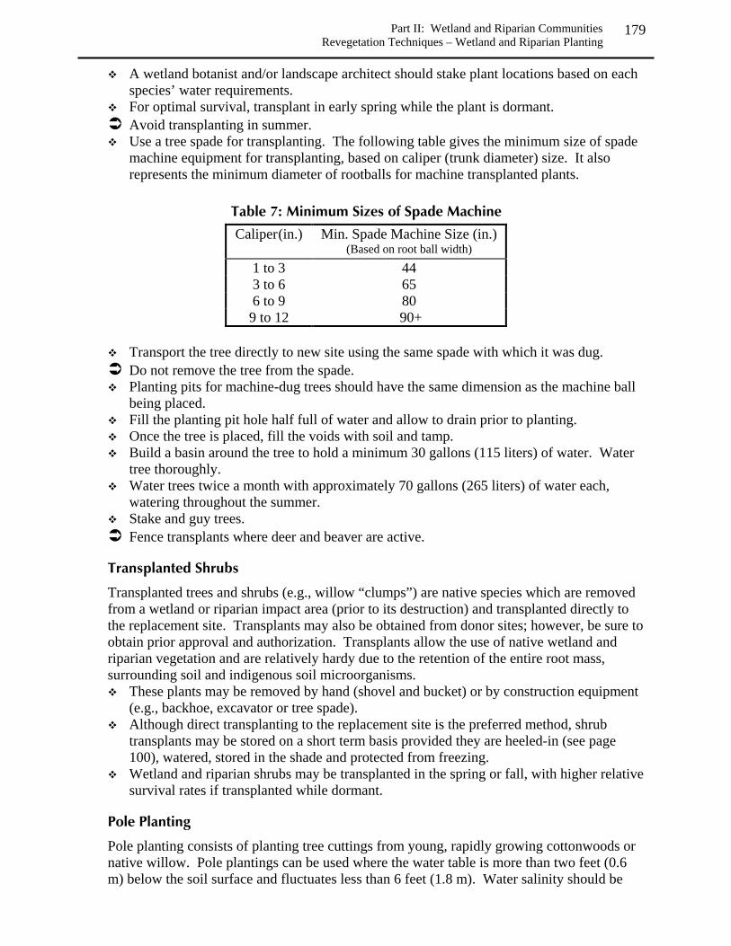
Part II: Wetland and Riparian CommunitiesRevegetation Techniques – Wetland and Riparian Planting
179
� A wetland botanist and/or landscape architect should stake plant locations based on eachspecies’ water requirements.
� For optimal survival, transplant in early spring while the plant is dormant.� Avoid transplanting in summer.� Use a tree spade for transplanting. The following table gives the minimum size of spade
machine equipment for transplanting, based on caliper (trunk diameter) size. It alsorepresents the minimum diameter of rootballs for machine transplanted plants.
�/����<*�!101�����1F�5��B��7/2��!/�310�
Caliper(in.) Min. Spade Machine Size (in.)(Based on root ball width)
1 to 3 443 to 6 656 to 9 809 to 12 90+
� Transport the tree directly to new site using the same spade with which it was dug.� Do not remove the tree from the spade.� Planting pits for machine-dug trees should have the same dimension as the machine ball
being placed.� Fill the planting pit hole half full of water and allow to drain prior to planting.� Once the tree is placed, fill the voids with soil and tamp.� Build a basin around the tree to hold a minimum 30 gallons (115 liters) of water. Water
tree thoroughly.� Water trees twice a month with approximately 70 gallons (265 liters) of water each,
watering throughout the summer.� Stake and guy trees.� Fence transplants where deer and beaver are active.
��/057�/0��2��3���5
Transplanted trees and shrubs (e.g., willow “clumps”) are native species which are removedfrom a wetland or riparian impact area (prior to its destruction) and transplanted directly tothe replacement site. Transplants may also be obtained from donor sites; however, be sure toobtain prior approval and authorization. Transplants allow the use of native wetland andriparian vegetation and are relatively hardy due to the retention of the entire root mass,surrounding soil and indigenous soil microorganisms.� These plants may be removed by hand (shovel and bucket) or by construction equipment
(e.g., backhoe, excavator or tree spade).� Although direct transplanting to the replacement site is the preferred method, shrub
transplants may be stored on a short term basis provided they are heeled-in (see page100), watered, stored in the shade and protected from freezing.
� Wetland and riparian shrubs may be transplanted in the spring or fall, with higher relativesurvival rates if transplanted while dormant.
�������/0�104
Pole planting consists of planting tree cuttings from young, rapidly growing cottonwoods ornative willow. Pole plantings can be used where the water table is more than two feet (0.6m) below the soil surface and fluctuates less than 6 feet (1.8 m). Water salinity should be

Part II: Wetland and Riparian CommunitiesRevegetation Techniques – Wetland and Riparian Planting
180
less than 3,000 parts per million. Plantings are used for bank stabilization, shading andwildlife habitat.� Obtain poles from stands of open grown, young, rapidly growing trees, using wood that is
four years old or less.� Collect while the plant is dormant, preferably as early in spring as the ground can be
augured, usually from February to April.� Cut poles up to 20 feet (6 m) in length, three inches (7.6 cm) or greater in diameter.� Store cutting with butt end in water at all times.� Plant in a 15 inch (38 cm) diameter hole augured to the water table, making sure that four
to six feet (1.2 to 1.8 m) remain above the soil surface. Backfill completely with soil,tamp firmly.
� Stake the pole to prevent wind damage.� Fence to protect against deer and beaver where necessary.
1A����/G�5
Live stakes are cuttings which are harvested from wetland and riparian shrub species. Thespecies which are suitable for harvesting live stakes are those which have adventitious budsalong their stems from which new leaves, stems or roots can grow (e.g., willows, red-osierdogwood). Live stakes must be collected while the donor shrub is dormant (i.e., beforeleaf-out). No more than one-third of the donor shrub should be harvested. The minimumdiameter of the cuttings should be 0.5 inch (1.2 cm); larger live stakes contain a greateramount of the stored energy required to form leaves, stems and roots. After they areharvested, the live stakes should be submerged (at least the lower one-third) in water andstored in a cool, dark place for a period of 24 to 48 hours. Immediately after soaking andstorage, the live stakes should be planted.
The term “live stake” refers to a single cutting which is planted vertically in the ground;however, live stakes may also be planted vertically in a group of two or more (a bundle) orhorizontally below the ground surface (see “wattles” below). Live stakes are commonly usedfor erosion control (e.g., stream bank stabilization); however, they have a wide variety ofapplications in wetland and riparian replacement projects. If an adjacent donor site is notavailable, cuttings should be harvested from a site that is within 100 miles (160 kilometers)and approximately 2,000 feet (600 meters) elevation of the project site. The allowableelevation difference will vary depending upon the particular species; therefore, it is best tocollect similar species from similar elevations.
� Insert the cutting vertically (i.e., oriented in the same direction which it grew on theshrub) into the substrate so that approximately two-thirds of the total length is below thesurface.
� The length of the cutting should be a minimum of 24 inches (61 cm).� In many saturated wetland substrates the cutting can be pushed into the ground, however,
a planting bar may be required to form the planting hole (a piece of re-bar can be used).� The cutting must be inserted deep enough to ensure that it reaches the water table
throughout the entire growing season. Therefore, the appropriate length of the live stakeswill vary, based upon the relationship of the ground surface to the sustained water table.
� After the live stake is inserted, the planting hole must be backfilled with native soil andlightly tamped to prevent air pockets.

Part II: Wetland and Riparian CommunitiesRevegetation Techniques – Wetland and Riparian Planting
181
� The use of rooting hormones generally does not increase survival for these plant species,however, soaking the cuttings in water for a period of 24 to 36 hours does increasesurvival rates (Windell 1992).
/����5
Wattles are bundles of live, dormant willow cuttings, placed into the ground for revegetation.Wattles are best used in areas where sheet erosion is occurring and on stream banks or fillareas for stabilization.
� Select live, dormant willows� A mix of older and younger wood (including wood less than one year old) should be
used; most of the material should be one to four years old.� Select cuttings 3/8 inches to 1 ½ inches (0.95 to 3.8 cm) in diameter and a minimum of
six feet (1.8 m) long, with the bottom end cut off at an angle.� Tie bundles 8 to 12 inches (20 to 30 cm) in diameter, and a minimum of six feet (1.8
meters) in length, tapering at each end.� The growing tips and ends of cuttings should orient in alternating directions, with tips
being staggered and evenly distributed throughout the length of the bundle.� Compress the bundles and tie tightly with biodegradable rope, spaced 12 to 15 inches (30
to 40 cm) apart.� Excavate a trench parallel with the contour of the ground, approximately half the
diameter of the wattle.� Place the wattle in the trench. Using stakes 1 x 1 x 18 inch or larger, secure wattles
firmly in place with one row of stakes on the downhill side of the bundle, not more thanthree feet (1 m) apart. Place a second row of stakes through the wattle, near the ties,using a minimum of two stakes per bundle.
� Overlap the tapered ends of adjacent wattles so that the overall thickness is uniform. Usetwo stakes at each bundle overlap, driving a stake between the last two ties of eachwattle.
� Backfill the wattle with soil, work into spaces and compact the soil behind and below thebundle by foot tamping.
� Puddle with water and allow soil to settle, then add more soil as needed. The top of thebundle should be slightly visible when the installation is complete.
� Water daily for 30 days.� If necessary, wattles can be stored totally submersed for up to two weeks.
���������������������� ���&�!�����
��051�8
In planting forest or shrub wetland/riparian replacement sites, density considerations aredifferent from those for planting herbaceous sites. The density of tree and shrub planting willnot affect the rate of recruitment of invasive plant species, the incursion by problem animals,soil stabilization, or the short-term functioning of the project site as directly as willherbaceous plant density.
Target tree and shrub densities should not come from a single “reference” wetland or riparianarea. Rather, relative densities of these species should be obtained from a number of regional“reference” wetlands or riparian areas of the same type as is being targeted by the project.
Part II: Wetland and Riparian CommunitiesRevegetation Techniques – Wetland and Riparian Planting
182
When determining planting densities, consider potential losses due to wildlife browse,drought and natural thinning, as well as gains arising from possible natural regeneration.
#�/����5$
Wetland and/or riparian replacement plans sometimes specify that saucers must be developedaround the planting holes of trees and shrubs with the leftover soils from the plant pit.Mulching throughout the saucers also is frequently specified. In some instances thesesaucers facilitate manual watering by creating a basin which can be filled with water.
� Be aware that in many cases such soil mounding will actually withhold water from theplant. This is particularly true in riparian and wetland areas which derive some (or all) oftheir sustaining hydrology from water which flows over the soil surface. Also, in morepermanently flooded wetlands and riparian areas, sustaining hydrology is derived from anelevated ground water table and saucers will serve no function. Therefore, werecommend that surplus soils from planting woody species be raked or spread about theplants so as not to restrict water flow or to significantly alter ground surface elevations.In situations where manual watering/irrigation is to be used, saucers may still not providethe proposed benefit. If plants have to be watered by hand during periods of drought, theabsence of saucers would require watering at slower flow rates than with saucers, and thisslower flow rate may help ensure that each plant actually receives an adequate amount ofwater.
��/�1�1F104� ��28���4��/�1�0
Staking trees and shrubs more than four feet in height (using standard landscapespecifications) is strongly recommended under the following conditions:
� The wetland or riparian replacement site will have saturated soils year-round.� In frigid areas where the depths of ponded water during periods of freezing will be less
than several inches.
Staking does provide a factor of safety for all replacement projects since most wetland (andsome riparian) trees and shrubs root at shallow depths. Until the surface roots become welldeveloped, such plants are subject to being blown over.
��/0�104�10�����F104���1�/��5
If trees and/or shrubs are to be planted in frigid sites that are expected to have more thanseveral inches of standing water during freezing weather, they should be wired to metalanchors, regardless of size. Standard landscape specifications should be used, except thatanchors should be specified to be sufficiently deep so as not to be pulled out if the plants arelifted by ice. Also, under these types of conditions, planting should take place in thebeginning of the growing season in order to provide maximum time for rooting andstabilization before freezing. Fertilizer, if used at all, should be a zero or low nitrogen-basedslow release fertilizer to promote root development.
"�����3/7�
Plant roots do not develop through pockets of air; roots stop developing when they reach theair and become “air pruned.” Make sure that plants from flat bottomed containers are not

Part II: Wetland and Riparian CommunitiesRevegetation Techniques – Wetland and Riparian Planting
183
planted in V-shaped (spade dug) holes. The air pockets at the bottom of the holes may causeplant mortality.
Trees should be planted erect and that any trees showing a lean of greater than ten degreesfrom perpendicular must be straightened or replanted. Leaning trees often die or sprout anew leader from close to ground level.
���0104
Pruning trees and shrubs prior to or following planting is not recommended, unless site-specific conditions and/or timing require the plant to devote more energy to rootdevelopment. Native wetland and riparian replacement projects are not ornamental gardensand dead branches do not threaten the success of the project.
�����������&���������!������
Acceptable parameters for plant materials should be specified in sufficient detail that aninexperienced inspector can make a rapid determination of acceptability. At a minimum, includegeneral appearance and health (i.e. no sign of disease), as well as plant size and form.
���!����
The height of plant materials is often specified as a criteria for acceptability; however, heightalone is not an acceptable parameter. The standard parameters which are applicable to allplant material types include
� Container size (e.g., 2.5 inch container, 10 cubic inch cone, 5 gallon pot, etc.)� Plant form (e.g., bareroot, seed, containerized, ball and burlap, etc.).� Diameter (or caliper), height and age are secondary parameters utilized in specifying
woody plant material; however, none of these parameters should be used as the solespecification.
For herbaceous species, specify plant height sufficient to ensure that the plants are tallenough to emerge above the intended water level (pool level) of the wetland and/or riparianzone. Specifying diameter (caliper) or age for herbaceous plant materials is inappropriate.
��!���������������!������
The table below summarizes the preferred planting times and relative success of each of the plantmaterial types. This table provides a qualitative comparison of the various planting techniquesand is intended to guide the user in selecting the most appropriate technique for the time of yearin which the project is being implemented.
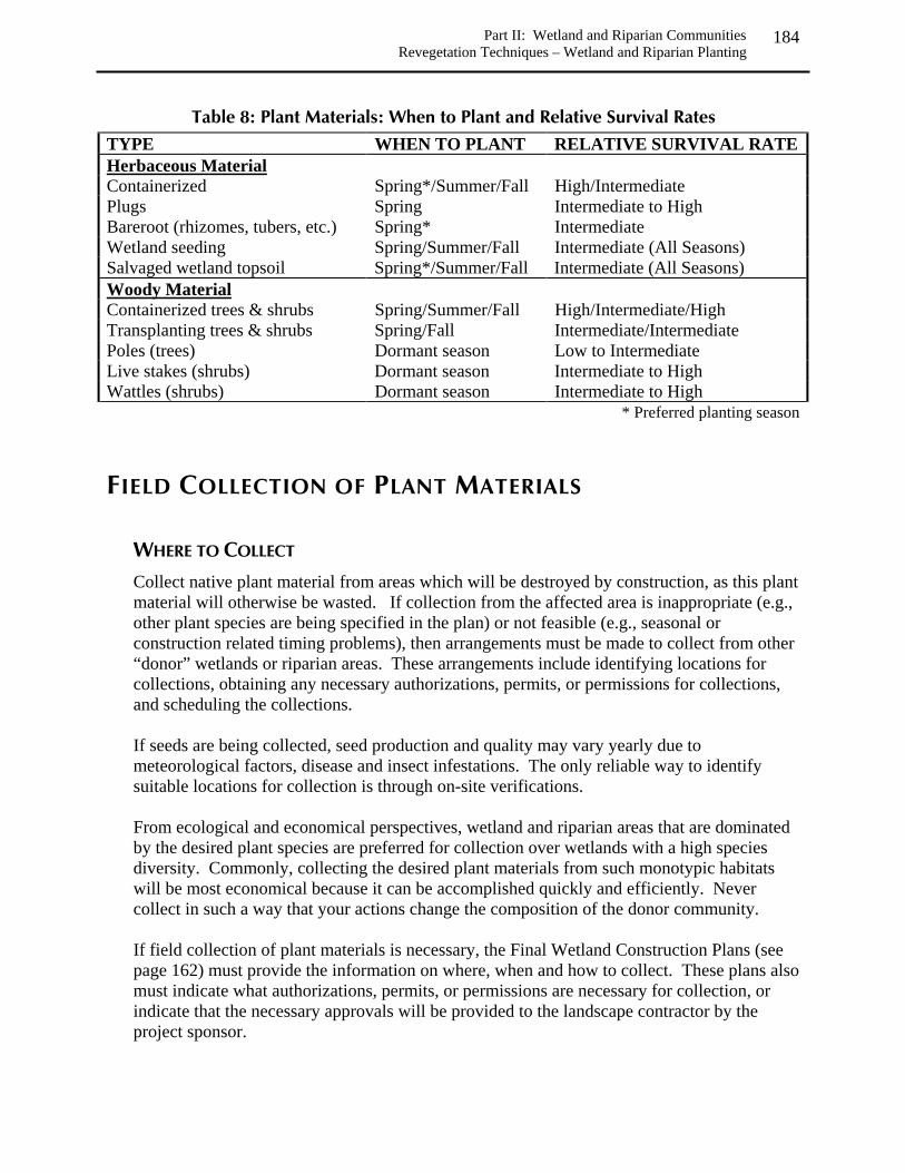
Part II: Wetland and Riparian CommunitiesRevegetation Techniques – Wetland and Riparian Planting
184
�/�����*���/0��!/���1/�5*� 3�0������/0��/02���/�1A�����A1A/��/��5
TYPE WHEN TO PLANT RELATIVE SURVIVAL RATEHerbaceous MaterialContainerized Spring*/Summer/Fall High/IntermediatePlugs Spring Intermediate to HighBareroot (rhizomes, tubers, etc.) Spring* IntermediateWetland seeding Spring/Summer/Fall Intermediate (All Seasons)Salvaged wetland topsoil Spring*/Summer/Fall Intermediate (All Seasons)Woody MaterialContainerized trees & shrubs Spring/Summer/Fall High/Intermediate/HighTransplanting trees & shrubs Spring/Fall Intermediate/IntermediatePoles (trees) Dormant season Low to IntermediateLive stakes (shrubs) Dormant season Intermediate to HighWattles (shrubs) Dormant season Intermediate to High
* Preferred planting season
����������������������!������
"�����������
Collect native plant material from areas which will be destroyed by construction, as this plantmaterial will otherwise be wasted. If collection from the affected area is inappropriate (e.g.,other plant species are being specified in the plan) or not feasible (e.g., seasonal orconstruction related timing problems), then arrangements must be made to collect from other“donor” wetlands or riparian areas. These arrangements include identifying locations forcollections, obtaining any necessary authorizations, permits, or permissions for collections,and scheduling the collections.
If seeds are being collected, seed production and quality may vary yearly due tometeorological factors, disease and insect infestations. The only reliable way to identifysuitable locations for collection is through on-site verifications.
From ecological and economical perspectives, wetland and riparian areas that are dominatedby the desired plant species are preferred for collection over wetlands with a high speciesdiversity. Commonly, collecting the desired plant materials from such monotypic habitatswill be most economical because it can be accomplished quickly and efficiently. Nevercollect in such a way that your actions change the composition of the donor community.
If field collection of plant materials is necessary, the Final Wetland Construction Plans (seepage 162) must provide the information on where, when and how to collect. These plans alsomust indicate what authorizations, permits, or permissions are necessary for collection, orindicate that the necessary approvals will be provided to the landscape contractor by theproject sponsor.
Part II: Wetland and Riparian CommunitiesRevegetation Techniques – Wetland and Riparian Planting
185
"�����������
Timing depends on the types of plant materials that are specified and when they must beplanted to the wetland replacement site.
���2
Timing for seed collection is critical because if the seed collection “window” is missed, anentire year is lost. There are three types of plants from which it is difficult to collect seed.
� Plants that produce seeds that fall to the ground soon after ripening. Many species in thegrass and aster families fall into this category. For this plant type, one storm or windyday soon after seed ripening can cause the loss of seed.
� Plants that flower and produce seeds during much of the growing season so that there isno optimum time for seed collection.
� Plants that produce seeds of high value to wildlife so that one must compete with localfauna to collect the seed.
The optimum time for seed collection of any species will vary depending on location withinthe state or region, therefore, this information is best obtained through consultation with localwetland scientists and botanists.
"���/����5���/0��!/���1/�
Examples of herbaceous plant material include bareroot plants and plugs. The optimum timeto collect the specified plant materials is just before they are to be transplanted to thereplacement site; this practice eliminates any storage and maintenance requirements.Consequently, collection and planting processes should be coordinated. Although barerootmaterial may be collected in advance, stored and prepared at a native plant nursery, plugsshould only be used when direct transplanting is possible.
��28���/0��!/���1/�
Although some tree and shrub species transplant well, transplanted trees and shrubs mayhave slower growth rates and lower overall survival than containerized material. Thisdifference is due to the potential reduction in root biomass which results from being dug up,and because of the loss of optimum growing conditions provided in the original site. Treesand shrubs should be collected while dormant.
"� ���������
���2
Mechanical devices have been developed for the field collection of prairie plant seeds andthese may be applicable for seed collection under certain wetland and riparian conditions.Seed collection by hand using hedge cutters, shears, sickle or other cutting tools willprobably work best under most wetland conditions. Seed collection is also an excellentopportunity to encourage volunteer participation.
Part II: Wetland and Riparian CommunitiesRevegetation Techniques – Wetland and Riparian Planting
186
"���/����5���/0��!/���1/�
Collection of herbaceous plant materials (e.g., bareroot and plugs) from the wetland orriparian area(s) that will be affected might be assisted (depending upon ground conditions)by the use of a backhoe, excavator or other mechanical means. However, collection by handor shovel (sharpshooter) is preferable; the use of excavators and other mechanical devices forcollecting in natural habitats is generally too destructive. The use of a pressurized watersprayer might assist in cleaning some of the sediments off growing bareroot plants, makingthem easier to ship and plant. Plugs do not need to be washed; in fact, it is better totransplant the native soil and microbes that are bound to the root/rhizome mass.
When collecting material from a donor wetland, under no circumstances should a gap becreated that will not be filled in by surrounding vegetation in a year. The preferred method isto collect plant materials in a “checkerboard” pattern (i.e., a “checkerboard” grid of aboutfive ft2). These requirements should be included in the Final Wetland Construction Plans.
When collections are made from peat wetlands, the holes created by taking plugs or theremoval of other plant materials will often fill in with water rather than with sediments.Plants will not return to these “collection holes” unless they are filled with sediment. If thedonor wetland conditions result in “collection holes” it is important to specify in the FinalWetland Construction Plans that holes be filled with mineral sediments following thecollection process. If this is not done, these “collection holes” will persist and negativelyaffect the wetland, particularly for projects where large amounts of plant materials arecollected.
If “collection holes” are filled by sediment, either naturally or artificially, vegetation willusually fill in these bare areas within several years. For this process to succeed, the“checkerboard” grid size for collection must not too great, and the surrounding vegetationmust be of the type that propagates by rhizomes, stolons or tubers. If the perennial parts ofthe surrounding vegetation are bulbs or corms, the surrounding vegetation will only fill inthrough seeding or other species will colonize the bare areas. The spreading rates of plantspecies that are given in Appendix II beginning on page 197 will provide some indication ofthe time it will take for surrounding vegetation to fill in the bare areas depending on the sizeof the collection grid.
��28���/0��!/���1/�
Depending on ground conditions, the use of a backhoe, excavator, or tree spade will greatlyfacilitate the lifting of the larger plants for transplanting. Plugs of small (12 to 24 inch)seedlings, with soil intact, can often be extracted using a shovel.
"��������� ��"��"����������!������
���2
Unlike other collected plant materials, collected seed should not be used for seeding awetland replacement area immediately after collection. Before seeding, the seed purity andgermination percentage must be determined, and seeding specifications should indicateseeding rates using pure live seed (PLS). The collected seed must be cleaned, processed,analyzed for purity, stored, and germination tested before being used (see seeding section
Part II: Wetland and Riparian CommunitiesRevegetation Techniques – Wetland and Riparian Planting
187
beginning on page 81 for details). Consult a local wetland scientist about when to collectseed in order to compile the proper specifications for processing and storing seed.
"���/����5�/02� ��28���/0��!/���1/�
Herbaceous and woody plant material should generally be collected just before planting. It isimportant that these plant materials be delivered in accordance with the Final WetlandConstruction Plans.
�����E��������"�������!���!����
Fertilization requirements vary greatly depending upon the specific nutrients available in the soilof the project site and the particular species being planted.
In order to determine specific fertilization requirements, soil tests must be performed on theplanting site. Once the on site nutrient conditions have been determined, they may be comparedwith those that are considered optimum for the species involved. You should also consult thesupplying nursery to determine the specific requirements for the varieties and/or ecotypes to beplanted at the site (R. Mandel, personal communication). Keep in mind that the release ofnitrates and other fertilizers into water can be extremely toxic to fish and may also cause largealgal blooms.
Opinions vary regarding the use of polymers and other moisture-retaining soil additives. Thesoil moisture in most wetland planting sites (during the growing season) should be adequate tomaintain native wetland species; however, it is still advisable to water wetland plantsimmediately after planting to reduce shock and assist in soil compaction in the planting pit.Available soil moisture in riparian areas will vary greatly depending upon the relation(topographic elevation) of the planting site to the river or creek, the moisture retention propertiesof the soil, and the species being planted. Directions for upland plant watering requirements aregenerally applicable to most riparian plantings and are provided in the Upland RevegetationTechniques section of this manual. Available soil moisture should be determined prior to thetime of planting to calculate site-specific soil additive and watering requirements. These data aretypically gathered during the site design process, particularly data regarding the sustaininghydrology of the system.
�����-*�!���������������� ���"��The step of monitoring and stewardship is no less important than that of the planting techniquesor species selection. The processes and techniques used for the monitoring and stewardship ofwetland or riparian communities are essentially the same as for upland plant communities (seeMonitoring and Stewardship, beginning on page 103).
� In general, fertilizers are not needed or recommended for wetlandrevegetation projects.

Part II: Wetland and Riparian CommunitiesRevegetation Techniques – Wetland and Riparian Planting
188

References and Suggested Reading189
�������������� �������������
Adams County Weed Program Office. Integrated Management Options of Control: LeafySpurge. CSU Cooperative Extension. Brighton, Colorado.
Allen, E. B. 1989. The restoration of disturbed arid landscapes with special reference tomycorrhizal fungi. Journal of Arid Environments 17:279-286.
Allen, M.F. 1988. Belowground structure: a key to reconstructing a productive arid ecosystem.In: E.B. Allen, ed. The Reconstruction of Disturbed Arid Lands. Westview Press, Inc.,Boulder, Colorado.
Alexander, R.R. 1987. Ecology, silviculture, and management of the Engelmann sprucesubalpine type in the central and southern Rocky Mountains. USDA Agric. Handbook659. USDA Forest Service, Washington D. C.
American Fisheries Society, Western Division. 1982. The Best Management Practices for theManagement and Protection of Western Riparian Stream Ecosystems. AmericanFisheries Society - Western Division, Orem, Utah.
Aquatic and Wetland Company. 1997. Miscellaneous wetland mitigation plans (unpublished).Aquatic and Wetland Company, Boulder, Colorado.
Barrow, J.R. 1996. Proceedings: Shrubland ecosystem dynamics in a changing environment.INT-GTR-338. USDA Forest Service, Intermountian Research Station, Ogden, Utah.
Baskin C.C. and J.M. Baskin. 1988. Studies on the germination ecophysiology of herbaceousplant species in a temperate region. Amer. J. Bot. 75:286-305.
Beck, K.G. 1991. Canada thistle: biology and management in pastures and rangeland. Servicein Action 3.108. Colorado State Cooperative Extension, Fort Collins, Colorado.
Beck, K.G. 1994. Leafy spurge: biology and management in pastures and rangeland. Service inAction 3.107. Colorado State Cooperative Extension, Fort Collins, Colorado.
Beck, K.G. 1994. Diffuse and spotted knapweed: biology and management in pastures andrangeland. Service in Action 3.110. Colorado State Cooperative Extension, Fort Collins,Colorado.
Beck, K.G. 1994. Russian knapweed: biology and management in pastures and rangeland.Service in Action 3.111. Colorado State Cooperative Extension, Fort Collins, Colorado.
Benedict, A.D. 1991. A Sierra Club Naturalist’s Guide of the Southern Rockies. Sierra ClubBooks. San Francisco.
Billings, W.D. 1994. Ecological impacts of cheatgrass and resultant fire on ecosystems in thewestern Great Basin. In S.B. Monsen and S.G. Kitchen, eds. Proceedings-Ecology and

References and Suggested Reading190
Management of Annual Rangelands. INT-GTR-313. USDA Forest Service,Intermountain Research Station, Ogden, Utah.
Bradshaw, A.D. and M.J. Chadwick. 1980. The Restoration of Land: the Ecology andReclamation of Derelict and Degraded Land. Blackwell Publishers, Oxford, England.
Briggs, M. 1995. Evaluating degraded riparian ecosystems to determine the potentialeffectiveness of revegetation. In B.A. Roundy et al., eds. Proceedings: Wildland shrubsand arid land restoration symposium, pp. 63-67. INT-GTR-315. USDA Forest Service,Intermountain Research Station, Ogden, Utah.
Briggs, M. K. 1996. Riparian Ecosystem Recovery in Arid Lands. University of Arizona Press.Tucson, Arizona.
Brune, R. 1991. The Prairie Garden: A step by step guide to creating a shortgrass prairiegarden. Colorado Native Plant Society.
Carter, J. L. 1988. Trees and Shrubs of Colorado. Johnson Books. Boulder, Co.
Chambers, J.C. and G.L. Wade, eds. 1990. Evaluating Reclamation Success: The EcologicalConsideration - Proceedings of a Symposium. GTR NE-164. USDA Forest Service,Northeastern Forest Experiment Station, Radnor, Pennsylvania.
Clary, W. P. 1996. Response of a depleted sagebrush steppe riparian system to grazing controland woody plantings. INT-492. USDA Forest Service, Intermountain Research Station,Ogden, Utah.
Clay, D. H. 1984. High mountain meadow restoration. In R. E. Warner and K. M. Hendrix,eds. California Riparian Systems: Ecology, Conservation and Productive Managementpp. 477-479. University of California Press, Berkeley, California.
Colorado Native Plant Society Education Committee. 1991. Grow Native: Why do NativesBelong in Your Landscape? (Pamphlet). Colorado Native Plant Society, Fort Collins,Colorado.
Colorado Natural Heritage Program. 1996. Colorado's Natural Heritage: Rare and ImperiledAnimals, Plants, and Natural Communities. Volume 2, No. 1. Colorado NaturalHeritage Program, Fort Collins, Colorado.
Colorado Seed Growers Association. 1996. Colorado Seed Certification Standards. ColoradoCrop Improvement Association, Colorado State University, Fort Collins, Colorado.
Colorado Weed Management Association. 1993. Colorado’s 30 Troublesome Weeds - PlantsThat Threaten Our Natural Resources. Colorado Weed Management Association.
Cook, K. J. 1991. Wildlife and Weeds. Colorado Outdoors. May-June: 10-14.
Cooper, D. 1988. Advanced Identification of Wetlands in the City of Boulder ComprehensivePlanning Area. Prepared for United States Environmental Protection agency, RegionVIII and the City of Boulder, Colorado.
Cooper, D. and K. Jones. 1993. Wetlands of Colorado. Colorado Department of NaturalResources, Denver, Colorado.

References and Suggested Reading191
Cotts, N.R., E.F. Redente, and R. Schiller. 1991. Restoration methods for abandoned roads atlower elevations in Grand Teton National Park, Wyoming. Arid Soil Research andRehabilitation 5:235-249.
Covington, W.W. 1996. Conference on Adaptive Ecosystem Restoration and Management:Restoration of Cordilleran Conifer Landscapes of North America. RM-GTR-278. USDAForest Service, Rocky Mountain Forest and Range Experiment Station. Ft. Collins,Colorado.
Crane, M.F. 1982. Fire ecology of Rocky Mountain Region forest habitat types. USDA ForestService Region Two, Golden, Colorado.
Crumpacker, D.W. 1985. The Boulder Creek corridor projects: riparian ecosystem managementin an urban setting. In R.R. Johnson et al., eds. Riparian Ecosystems and TheirManagement: Reconciling Conflicting Uses pp. 389-392. RM-120. USDA ForestService, Rocky Mountain Forest and Range Experiment Station. Ft. Collins, Colorado.
Currans, S.P. 1996. Seed Buying, How to Get What You Really Need. Clearwater SeedCompany, Lewiston, ID.
Diamond, J. 1985. How and why eroded ecosystems should be restored. Nature 313:629-630.
Dorn, R. D. 1997. Rocky Mountain Region Willow Identification Field Guide. Department ofAgriculture, Forest Service, Rocky Mountain region, Denver, Colorado.
Dunne, R. and C.G. Dunne. 1996. Seed ordering methods. In F. K. Ferris et al., eds. Handbookof Western Reclamation Techniques. Office of Surface Mining Reclamation andEnforcement, Denver, Colorado.
Elmore, F. H. 1976. Shrubs and Trees of the Southwest Uplands. Southwest Parks andMonument Association, Tuscon, Arizona.
Environmental Laboratory. 1987. “Corps of Engineers Wetlands Delineation Manual”Technical Report Y-98-1, US Army Engineer Waterways Experiment Station, Vicksburg,Miss.
Environmental Laboratory. 1987. “Corps of Engineers Wetlands Delineation Manual,”Technical Report Y-87-1, US Army Engineer Waterways Experiment Station, Vicksburg,Miss.
ERO Resources Corporation. 1993. Draft - Natural Areas Design Guidelines and MitigationManual. City of Fort Collins, Colorado.
ERO Resources Corporation. 1997. Stapleton Revegetation Guidelines. Stapleton DevelopmentCorporation. Denver, Colorado.
ERO Resources Corporation. 1997. City of Boulder Wetlands Protection Program RevegetationGuidelines. City of Boulder, Colorado.
Evans, R.A. and J.A. Young. 1987. Seedbed microenvironment, seedling recruitment, and plantestablishment on rangelands. In G.W. Frasier and R.A. Evans, eds. Proceedings of theSymposium of Seed and Seedbed Ecology of Rangeland Plants pp.212-220. USDA-ARS,Washington, D.C.

References and Suggested Reading192
Fresquez, P.R. and W.C. Lindemann. 1982. Soil and rhizoshpere microorganisms in amendedmine spoils. Soil Science Society of America Journal. 46:751-755.
Galatowitsch, S. 1988. Colorado's Natural Vegetation. Unpublished manuscript availablethrough Colorado State Parks Natural Areas Program, Denver, Colorado.
Garbisch, E. 1992. Wetland Mitigation course notes. Environmental Concern, Inc., St.Michael’s, Maryland.
Goeldner, J. 1995. A Seattle-area volunteer based plant-rescue program. Restoration &Management Notes 13:16-19.
Gross, K.L. 1990. A comparison of methods for estimating seed numbers in the soil. J.Ecology. 78:1079-1093.
Gurneé, G.E. 1997. Personal experience as a Professional Wetland Scientist. Unpublished datafrom various wetland mitigation plans. Aquatic and Wetland Company, Boulder,Colorado.
Hammer, D.A. 1992. Creating freshwater wetlands. Lewis Publishers, Boca Raton, Florida.
Hansen, D., C.M. McKell, S.L. Clark, and L. Hobbs. 1991. Native Plant EstablishmentTechniques for Successful Roadside Revegetation. Utah Department of Transportation.Salt Lake City, Utah.
Harrington, H. D. 1954. Manual of the Plants of Colorado. Sage Books, Chicago, Illinois.
Harris, J.A., P.B. Birch, and J.P. Palmer. 1996. Land Restoration and Reclamation: Principlesand Practice. Longman. Essex, England.
Haskisaki, S. 1996. Functional wetland restoration: an ecosystem approach. Northwest Science70:348-351.
High Altitude Revegetation Workshop. 1976-1997. Proceedings. Colorado State University, Ft.Collins, Colorado: Colorado Water Resources Research Institute, Information Series.
Howell, E. A. 1986. Woodland restoration: an overview. Restoration and Management Notes4:13-17.
Hughes, D. 1996. Restoring native riparian vegetation. In Shaw et al., eds. Desired FutureConditions for Southwestern Riparian Ecosystems: Bringing Interests and ConcernsTogether pp. 262-264. RM-272. USDA Forest Service, Rocky Mountain Forest andRange Experiment Station. Ft. Collins, Colorado.
Horton, H., ed. 1989. Interagency Forage and Conservation Planting Guide for Utah.Extension Circular EC433. Utah State University, Agricultural Experiment Station,Logan, and the Cooperative Extension Service, Utah State University, Logan.
Iverson, L.R. and M.K. Wali. 1982. Buried, viable seeds and their relationship to revegetationafter surface mining. J. Range Management. 35:648-652.

References and Suggested Reading193
Johnston, B. C. 1987. Plant Associations of Region Two: Potential Plant Communities ofColorado, Wyoming, South Dakota, Nebraska and Kansas. R2-ECOL-87-2. USDAForest Service, Rocky Mountain Region, Lakewood, Colorado.
Kartesz, J.T. 1994. A synonymized checklist of the vascular flora of the United States, Canada,and Greenland. Timber Press. Portland, Oregon.
Kelly, G. W. 1970. A Guide to Woody Plants of Colorado. Pruett Publishing Company,Boulder, Colorado.
Kirkpatrick, Z. M. 1992. Wildflowers of the Western Plains. University of Texas Press,Austin, Texas.
Kusler, J.A. and M. E. Kentula. 1990. Wetland Creation and Restoration. Island Press,Washington D.C.
Landis, T.D. and E.J. Simonich. 1984. Producing native plants as container seedlings. In P.M.Murhpy, ed. The Challenge of Producing Native Plants for the Intermountain Area.(Proc. Intermountain Nurseryman’s Conf.) pp. 6-15. INT-168. USDA Forest Service,Intermountain Research Station, Ogden, Utah.
Leck, M.A., V.T. Parker, and R.L. Simpson. 1989. Ecology of Soil Seed Banks. AcademicPress, San Diego.
Malecki, R.A., B. Blossey, and S.D. Hight. 1993. Biological Control of Purple Loosestrife.Bioscience 43: 680-686.
Mandel, R. 1990. The development of a low-cost methodology for the vegetative production ofEastern red cedar - Juniperus virginiana. Unpublished data, USDA-NRCS Cape MayPlant Materials Center, Cape May Court House, New Jersey.
Marr, J.W. 1967. Ecosystems of the East Slope of the Front Range in Colorado. ColoradoAssociated University Press, Boulder.
McLendon, T. and E.F. Redente. 1991. Nitrogen and phosphorus effects on secondarysuccession dynamics on a semiarid sagebrush site. Ecology 72:2016-2024.
McLendon, T. and E.F. Redente. 1992. Effects of nitrogen limitation on species replacementdynamics during early secondary succession on a semiarid sagebrush site. Oecologia91:312-317.
Merriam, C.H. 1894. Laws of temperature control of the geographic distribution of terrestrialanimals and plants. National Geographic Magazine 6:229-238. See also Merriam, C.H.1899. Life zones and Crop zones. USDA Bull. No. 10. USDA, Washington D.C.
Miller, R.W., and R.L. Donahue. 1995. Soils in Our Environment, 7th Edition. Prentice-HallInc. Upper Saddle River, New Jersey.
Munshower, F.F. 1994. Practical handbook of disturbed land revegetation. Lewis Publishers,Boca Raton, Florida.
Mutel, C. F. and J. C. Emerick. 1984. From Grassland to Glacier: The Natural History ofColorado. Johnson Books, Boulder, Colorado.

References and Suggested Reading194
Mutz, K.M., D.J. Cooper, M.L. Scott, and L.K. Miller, eds. 1988. Restoration, Creation, andManagement of Wetland and Riparian Ecosystems in the American West. Symposium.Rocky Mountain Chapter of the Society of Wetland Scientists. Denver, Colorado.
Naschberger, S. 1988. Alpine ski slopes, the causes of the problems, and possible ways ofrehabilitation with the help of specialty fertilizers. In W.R. Keammerer and L.F. Brown,eds. Proceedings: High Altitude Revegetation Workshop No. 8. Water ResourcesResearch Institute, Colorado State University, Fort Collins, Colorado.
Ostler, W.K. and K.L. Allred. 1987. Accelerated Recovery of Native Vegetation on RoadwaySlopes Following Construction. US Federal Highway Administration Report No.FHWA/DF-87003, Final Report, pp. 44-48. US Dept. of Transportation.
Peale, M. 1996. Best Management Practices for Wetlands within Colorado State Parks.Colorado Natural Areas Program, Colorado State Parks, Colorado Department of NaturalResources. Denver, Colorado.
Redelf, A.E. 1983. Wetlands values and losses in the United States (unpublished MastersThesis). Oklahoma State University. Stillwater.
Redente, E.F., T.B. Doerr, C.E. Grygiel, and M.E. Biodini. 1984. Vegetation establishment andsuccession on disturbed soils in Northwest Colorado. Reclamation and RevegetationResearch 3:153-165.
Reeder, J.D. and B. Sabey. 1987. Nitrogen. In: R.D. Williams and G.E. Schuman, eds.Reclaiming Mine Soils and Overburden in the Western U.S. Soil Conservation Society ofAmerica. Ankeny, Iowa.
Roberts, E. H. 1972. Viability of Seeds. Syracuse University Press, New York.
Roberts, E. H. 1981. Seed banks in soil. Adv. Appl. Biol. 6:1-55.
Roundy, B.A. et al., eds. 1993. Proceedings: Wildland shrub and arid land restorationsymposium. INT-GTR-315. USDA Forest Service, Intermountain Research Station,Ogden, Utah.
Schneller-McDonald, K., L.S. Ischinger, and G.T. Auble. 1990. Wetland Creation andManagement: Description and Summary of the Literature. USDI USFWS BiologicalReport 90(3).
Schramm, P. 1978. The Dos and Don’ts of Prairie Restoration. In D.C. Glenn-Lewin and R.Q.Landers, eds. Fifth Midwest Prairie Conference Proceedings pp.139-150. Iowa StateUniversity, Ames.
Schultze, R.F. 1984. Riparian system restoration by private landowners: an example ofcoordinated interagency assistance. In R.E. Warner and K.M. Hendrix, eds. Californiariparian systems: ecology, conservation, and productive management. California WaterResour. Rep. No. 55, pp. 965-967. University of California Press, Berkeley.
Shaw, D.W., E.F. Aldon, and C. LoShapiro. 1994. Desired Future Conditions for Piñon-juniperEcosystems. RM-GTR-258. USDA Forest Service, Rocky Mountain Forest and RangeExperiment Station. Ft. Collins, Colorado.

References and Suggested Reading195
Shaw, N. 1984. Producing bareroot seedlings of native shrubs. in: The Challenge of ProducingNative Plants for the Intermountain Area (Proc.Intermountain Nurseryman’s Conf.),pp.6-15. INT-168. USDA Forest Service, Intermountain Research Station, Ogden, Utah.
Sims, P.L., J.S. Singh and W.K. Lauenroth. 1978. The structure and function of ten westernNorth American grasslands. J. of Ecology 66:251-285.
Soil and Water Conservation Society. 1990. Sources of Native Seeds and Plants. Unpublished.SWCS, Ankeny, IA.
Steele, Ruth A. 1991. Weeds. Colorado Forestry Association Newsletter 9:13-15.
Thien, S. J. 1979. A flow diagram for teaching texture by feel analysis. Journal of AgronomicEducation 8:54-5.
Townsend, L., D. Schen, P. Murphy, M. Hanson, D. Grierson, D. Greytak, and D. Somerville.1993. Tree and Shrub Planting Handbook: A Guide for Conservation Plantings in Utahand Nevada, Sect. V-VI. Utah Division of State Lands and Forestry, Salt Lake City,Utah.
US Department of Agriculture, Natural Resources Conservation Service. 1992. Release of PlantMaterials. National Plant Materials Manual, Section 540.19. USDA-NRCS.Washington, D.C.
US Department of Agriculture, Natural Resources Conservation Service. 1997. The PLANTSdatabase. (http://plants.usda.gov). National Plant Data Center, Baton Rouge, LA 70874-4490 USA.
United States Fish and Wildlife Service. 1989. Russian-olive Threatens Integrity of WesternRiparian Ecosystems. Research Information Bulletin No. 32. US Department of theInterior, Fish and Wildlife Service.
United States Fish and Wildlife Service. 1990. Wetlands Action Plan. US Fish and WildlifeService, Washington, D.C.
United States Fish and Wildlife Service. 1997. Peatland Mitigation Policy Considerations. USFish and Wildlife Service, Region 6, Lakewood, Colorado.
Wallace, A. 1987. Comparative growth of four shrub species in a native desert soil and anamended non-calcareous soil and some unsolved problems in mineral nutrition of desertshrubs. In A.Wallace, E.D. McArthur, M.R. Haferkamp, eds. Proceedings - Symposiumon Shrub Ecophysiology and Biotechnology VI: General Principles pp.169-172. USDAForest Service, Intermountain Research Station, Ogden, Utah
Wasser, C. 1982. Ecology and Culture of Selected Species Useful in Revegetating DisturbedLands in the West. US Department of the Interior, Fish and Wildlife Service,Washington D.C.
Weber, W. A. 1996a. Colorado Flora: Eastern Slope, Revised Edition. University Press ofColorado, Niwot, Colorado.
Weber, W. A. 1996b. Colorado Flora: Western Slope, Revised Edition. University Press ofColorado, Niwot. Colorado.

References and Suggested Reading196
Welling C.H., R.L. Pederson, and A.G. van der Valk. 1988. Recruitment for the seed bank andthe development of zonation of emergent vegetation during drawdown in a prairiewetland. J. of Ecology 76:483-496.
Whitson, T. et. al. 1992. Weeds of the West. Western Society of Weed Science, The WesternUnited States Land Grant University Cooperative Extension Service, and the Universityof Wyoming.
Willard, B.E. 1979. Plant sociology of alpine tundra, Trail Ridge, Rocky Mountain NationalPark in Colorado. Colorado School of Mines Quarterly 74:1-119.
Windell, J., B. Willard, D. Cooper, et. al. 1986. An Ecological Characterization of RockyMountain Montane and Subalpine Wetlands. Performed for National Ecology Center,Division of Wildlife and Contaminant Research. US Department of the Interior, Fish andWildlife Service, Washington, D.C.
Windell, J.T. 1992. Stream, Riparian and Wetland Ecology. Produced by TRIUS Corp. for theColorado Division of Wildlife.
Wingate, J.L. 1994. Illustrated Keys to the Grasses of Colorado. Wingate Consulting. Denver,Colorado.
Young, J. A. and C. Young. 1986. Collecting, processing, and germinating seeds of wildlandplants. Timberland Press, Portland, Oregon.
Young, J.A., R.A. Evans, and G.J. Cluff. 1987. Seeding on or near the surface of seedbeds insemiarid environments. In G.W. Frasier and R.A. Evans, eds. Proceedings of theSymposium of Seed and Seedbed Ecology of Rangeland Plants pp. 57-61. USDA-ARS,Washington, D.C.
Young, S. 1994. New AOSCA Release Methods. Unpublished. Utah Crop ImprovementAssociation, Utah State University, Logan.
Zedler J.B., and M.W. Weller. 1989. Overview and future directions. In: J.A. Kusler and M.E.Kentula, eds. Wetland creation and restoration: The status of the science, Volume l. USEPA/7600/389/038, pp. 465-73. US Environmental Protection Agency Corvallis,Oregon.
Zimdahl, R. 1983. Weeds of Colorado. Bulletin 521A. Cooperative Extension of ColoradoState University. Fort Collins, Colorado.
Zwinger, A.H. and B.E. Willard. 1972. Land Above the Trees: A Guide to American AlpineTundra. Harper and Row, New York.

Appendix I: Upland Plant Characteristics 197
����������������������� ���� ������� �Species described in this appendix include those marked as dominant in the upland habitats plant finders. Some additionalspecies are included; however, not all species in the plant finders are shown here. Many of these species are not yetcommerically available and little is known about their use in revegetation projects. The Forbs (Table A2) begin on page205, and the Shrubs and Trees (Table A3) begins on page 213.
����������
���������������������� �������� !� �!�"����# �$ �!
����������
���
������ �
����������
���
������
����
���
����������� ������
���
������ ��������
���
���������
�����
������
���������
���� �
�� �����������
�����
���������
����������
���� ����� � !"# ���$ �%&'�()&*�+,�)%-*�.)-�$)(,-.()&*%%�)+%��)'�,�)(�//%*0
*%1*�$��%()1*'/-*'�.)2.)(%%$(
���������
���� ��3-*4
�����
�� �����������
������3-*4
�����
���������)���������
����������
���� ����� � !"# ���$ �()-2�3%
����� � �
���� �
����� � �
���� �
��5���)��6���� ���� ��'7�/%( !" �"# �-'* ���$)(�'�)2'�$%*0)(�2-�1'�%)/%-$�+()-�$)&*-3%��.
(,*%-/('$%(
����������
������
����������
������
���)������� �-*/ ��'7�/%( 8" 9"# �:�%��%�, �%*.)-,,*-�,'3%)&*-((0)-,,*-�,'3%)(�//%*)-�$)�-,%)(%-(��
����*
����������
����
����������
����
����)������� �-*/ ��'7�/%( 8" 9"# �:�%��%�, �,,*-�,'3%)�-,%)(%-(��)����*0)(-�$)$��%()��),�%)�-(,%*�
5�-'�(
���������� ���
��������
���������� ���
��������
5���)���5���� ���� ����� !" ;<# ���$ �,,*-�,'3%)(�//%*)&*-((0)&��$)(�'�)2'�$%*0)*��=.
/%-$�+(>)&*-3%��.)(�'�()'�)�1%�)(1*��%)�*)1'�%)?�*%(,(
�� ���� �
������ ��
�� ���� �
������ ��
��������)���� �-*/ ��'7�/%( ;" �"# ���$ ��$)?�*/%*0)&*-3%��.)(�'�(0)1�-'�()-�$)?��,�'��()��),�%
�-(,)���1%0)(-&%2*�(�)-�$)1'@�� A��'1%*)��),�%)�%(,
���1%
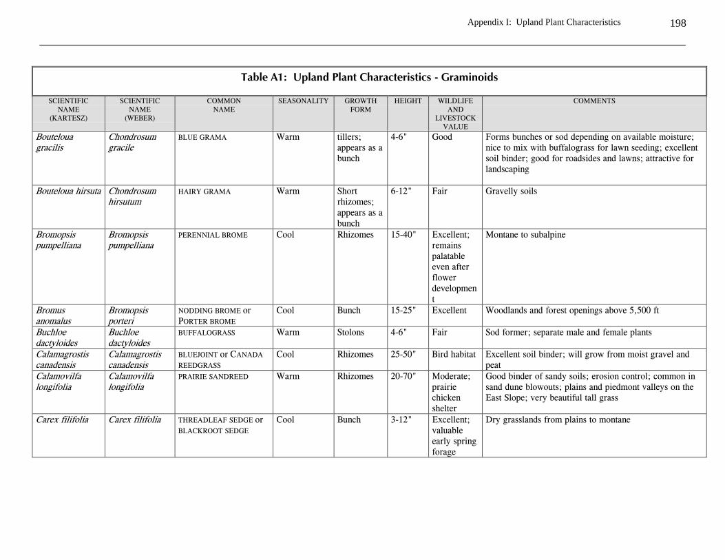
Appendix I: Upland Plant Characteristics 198
���������������������� �������� !� �!�"����# �$ �!
����������
���
������ �
����������
���
������
����
���
����������� ������
���
������ ��������
���
���������
�����
������
�� ���� �
�����
�������� �
�����
����)���� �-*/ ,'��%*(0
-11%-*()-()-
2����
8 <# ���$ ��*/()2����%()�*)(�$)$%1%�$'�&)��)-3-'�-2�%)/�'(,�*%0
�'�%),�)/':)+',�)2�??-��&*-(()?�*)�-+�)(%%$'�&0)%:�%��%�,
(�'�)2'�$%*0)&��$)?�*)*�-$('$%()-�$)�-+�(0)-,,*-�,'3%)?�*
�-�$(�-1'�&
�� ���� ����� �� �������� �
��� � �
�����)���� �-*/ ���*,
*�'7�/%(0
-11%-*()-()-
2����
< !;# �-'* �*-3%��.)(�'�(
��������
� ��������
��������
� ��������
5��������)���� ���� ��'7�/%( !B 8"# �:�%��%�,0
*%/-'�(
1-�-,-2�%
%3%�)-?,%*
?��+%*
$%3%��1/%�
,
��,-�%),�)(�2-�1'�%
���� �
������ �
��������
������
�������)����)�*
5�����)����
���� ����� !B ;B# �:�%��%�, ���$�-�$()-�$)?�*%(,)�1%�'�&()-2�3%)B>B"")?,
� ����
���������
� ����
���������
������������ �-*/ �,����( 8 <# �-'* ��$)?�*/%*0)(%1-*-,%)/-�%)-�$)?%/-�%)1�-�,(
������������
��������
������������
��������
����C����)�*)������
���������
���� ��'7�/%( ;B B"# �'*$)�-2',-, �:�%��%�,)(�'�)2'�$%*0)+'��)&*�+)?*�/)/�'(,)&*-3%�)-�$
1%-,
����������
��������
����������
��������
5������)�������� �-*/ ��'7�/%( ;" D"# �$%*-,%0
1*-'*'%
��'�=%�
(�%�,%*
���$)2'�$%*)�?)(-�$.)(�'�(0)%*�('��)���,*��0)��//��)'�
(-�$)$��%)2��+��,(0)1�-'�()-�$)1'%$/��,)3-��%.()��),�%
�-(,)���1%0)3%*.)2%-�,'?��),-��)&*-((
������������ ������������ ����������)�����)�*
���������)�����
���� ����� � !;# �:�%��%�,0
3-��-2�%
%-*�.)(1*'�&
?�*-&%
�*.)&*-((�-�$()?*�/)1�-'�(),�)/��,-�%

Appendix I: Upland Plant Characteristics 199
���������������������� �������� !� �!�"����# �$ �!
����������
���
������ �
����������
���
������
����
���
����������� ������
���
������ ��������
���
���������
�����
������
����������� ����������� ���)�����)�*)�����
�����)�*)5���)�����
���� �,����( 8 !B# ���$)?�*
%�=)-�$
�-,,�%0)?-'*
?�*)(�%%1
-�$)$%%*0
3-��-2�%
%-*�.)(1*'�&
?�*-&%
�1%�)(1*��% ?'*>)���&�-( ?'*)-�$)�-= (%*3'�%2%**.
(�*�2�-�$)��$%*(,�*.
�����������((1�
��������
�����
����������
((1����������
���)����� ���� ���*,
*�'7�/%(
� !;# ���$)%-*�.
(1*'�&
?�*-&%
�*.)?�*%(,%$)-*%-(0),�%)%-*�'%(,)?��+%*'�&)(%$&%)'�),�%
?��,�'��(0)-�(�)?���$)'�)1*-'*'%)(',%(
������(114 ������(114 ����� �-*'��( �-*'��( �-*'��(�
(�-��.
��$%*
;"#
�(�-��.
&��$),�
%:�%��%�,
��������
��������
��������
��������
�����)��������)�*
�����)���������
���� ����� 8 ;;# �:�%��%�,0
3-��-2�%
(1*'�&
?�*-&%
�,,*-�,'3%)+',�)1�*1�%)��%$)'�?��*%(�%��%(0)(�2-�1'�%)-�$
-�1'�%)&*-((�-�$(>)/%-$�+(>)-�$)?�*%(,)?���*(
�������������� �������������� 5����E�)���������)�*
5����)��������
���� ����� !; ;8# �-'*0
(%�$�/
-2��$-�,
%���&�
�,,*-�,'3%)(�//%*)&*-((0)$*.)&*-3%��.)�'��('$%()'�)�11%*
/��,-�%
���������
�������
���������
�������
������)���������)�*
���� ��� 5�55��
�����
���� ����� 9 �"# �-'*)+'�$�'?%
?�*-&%0
&��$),�
%:�%��%�,)?�*
�'3%(,��=
�%�-�'��(>)-,,*-�,'3%)1�-�,0)+'��)&*�+)?*�/)/�'(,)&*-3%�
-�$)1%-,
������������ ������������ ������)��������� �-*/ ��'7�/%( B !B# 5��* ���$)(�$)?�*/%*0)*�2�(,0)(,-.()&*%%�),�*��&�)?-��0
-�=-�'�%)-�$)(-�'�%)(�'�(
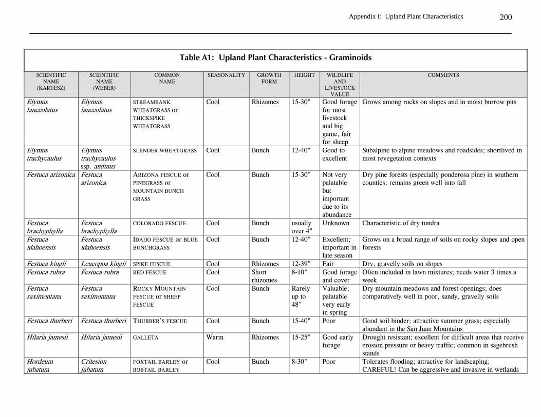
Appendix I: Upland Plant Characteristics 200
���������������������� �������� !� �!�"����# �$ �!
����������
���
������ �
����������
���
������
����
���
����������� ������
���
������ ��������
���
���������
�����
������
���� �
�������� �
���� �
�������� �
���������
����������)�*
������5���
����������
���� ��'7�/%( !B �"# ���$)?�*-&%
?�*)/�(,
�'3%(,��=
-�$)2'&
&-/%>)?-'*
?�*)(�%%1
�*�+()-/��&)*��=()��)(��1%()-�$)'�)/�'(,)2�**�+)1',(
���� �
������ � �
���� �
������ � �
((1������ �
�������)���������� ���� ����� !; 8"# ���$),�
%:�%��%�,
��2-�1'�%),�)-�1'�%)/%-$�+()-�$)*�-$('$%(0)(��*,�'3%$)'�
/�(,)*%3%&%,-,'��)���,%:,(
���� �������� ���� �
������
��� ���)������)�*
5��������)�*
�������)�����
�����
���� ����� !B �"# ��,)3%*.
1-�-,-2�%
2�,
'/1�*,-�,
$�%),�)',(
-2��$-��%
�*.)1'�%)?�*%(,()%(1%�'-��.)1��$%*�(-)1'�%�)'�)(��,�%*�
����,'%(0)*%/-'�()&*%%�)+%��)'�,�)?-��
���� �
�����������
���� �
�����������
��������)������ ���� ����� �(�-��.
�3%*)8#
��=��+� ��-*-�,%*'(,'�)�?)$*.),��$*-
���� �
��������
���� �
��������
�����)������)�*)����
����������
���� ����� !; 8"# �:�%��%�,0
'/1�*,-�,)'�
�-,%)(%-(��
�*�+()��)-)2*�-$)*-�&%)�?)(�'�()��)*��=.)(��1%()-�$)�1%�
?�*%(,(
���� �� �� !� ����� �� �5���)������ ���� ��'7�/%( !; �F# �-'* �*.>)&*-3%��.)(�'�()��)(��1%(
���� ��� ��� ���� ��� ��� ���)������ ���� ���*,
*�'7�/%(
9 !"# ���$)?�*-&%
-�$)��3%*
�?,%�)'����$%$)'�)�-+�)/':,�*%(0)�%%$()+-,%*)�),'/%()-
+%%=
���� �
����������
���� �
����������
�����)�������
������)�*)����5
������
���� ����� �-*%�.
�1),�
89#
�-��-2�%0
1-�-,-2�%
3%*.)%-*�.
'�)(1*'�&
�*.)/���,-'�)/%-$�+()-�$)?�*%(,)�1%�'�&(0)$�%(
��/1-*-,'3%�.)+%��)'�)1��*>)(-�$.>)&*-3%��.)(�'�(
���� ���� ���� ���� ���� ���� �������E�)������ ���� ����� !B 8"# 5��* ���$)(�'�)2'�$%*0)-,,*-�,'3%)(�//%*)&*-((0)%(1%�'-��.
-2��$-�,)'�),�%)�-�)C�-�)���,-'�(
"�����#���� "�����#���� ������� �-*/ ��'7�/%( !B ;B# ���$)%-*�.
?�*-&%
�*��&�,)*%('(,-�,0)%:�%��%�,)?�*)$'??'���,)-*%-(),�-,)*%�%'3%
%*�('��)1*%((�*%)�*)�%-3.),*-??'�0)��//��)'�)(-&%2*�(�
(,-�$(
"���� �
# ��� �
�������
# ��� �
��6����)������)�*
�������)������
���� ����� 9 �"# 5��* ���%*-,%()?���$'�&0)-,,*-�,'3%)?�*)�-�$(�-1'�&0
�������G)�-�)2%)-&&*%(('3%)-�$)'�3-('3%)'�)+%,�-�$(
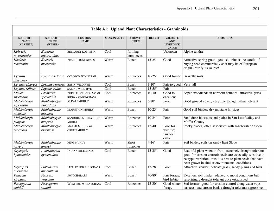
Appendix I: Upland Plant Characteristics 201
���������������������� �������� !� �!�"����# �$ �!
����������
���
������ �
����������
���
������
����
���
����������� ������
���
������ ��������
���
���������
�����
������
$������
���� �����
$������
���� �����
��������)�������� ���� ?�*/'�&
��//��=(
��=��+� ��1'�%),��$*-
$������
��������
$������
��������
5������)C�������� �-*/ ����� !B ;B# ���$ �,,*-�,'3%)(1*'�&)&*-((0)&��$)(�'�)2'�$%*0)2%)�-*%?��)'?
2�.'�&)(%%$)��//%*�'-��.)-()',)/-.)2%)�?)��*�1%-�
�*'&'�) )3%*'?.)',()(��*�%G
!� � �
��������
!� � ������� � ����)��������� �-*/ ��'7�/%( !" ;B# ���$)?�*-&% �*-3%��.)(�'�(
!��� ������ � !��� ������ � �����)����)��� ���� ����� � !"E �-'*),�)&��$ �%*.),-��
!��� ������ � !��� ������� ������)����)��� ���� ����� !B BB# �-'*
%���
��������
�������
��������
5��5��)����������)�*
�����)����������
���� ��'7�/%( !" �"# ���$),�
%:�%��%�,
�(1%�)+��$�-�$()'�)��*,�%*�)����,'%(0)-,,*-�,'3%)&*-((
% ���������
���������
% ���������
���������
������)���� �-*/ ��'7�/%( B ;"# 5��* ���$)&*���$)��3%*0)3%*.)?'�%)?��'-&%0)(-�'�%),��%*-�,
% ���������
�������
% ���������
�������
�������)���� �-*/ ����� !" ;B# �-'* ���$)(�'�)2'�$%*0)$*.)/��,-�%)�'��('$%(
% ���������
� �����
% ���������
� �����
��������)����0)����
����
�-*/ ��'7�/%( !" ;8# 5��* �-�$)$��%)2��+��,()-�$)1�-'�()'�)�-�)��'()�-��%.)-�$
�??-,)����,.
% ���������
�������
% ���������
�������
����)����)�*
�����)����
�-*/ ��'7�/%( !; 8"# 5��*)?�*
+'�$�'?%0
?-'*)?�*
�-,,�%
���=.)1�-�%(0)�?,%�)-((��'-,%$)+',�)(-&%2*�(�)�*)-(1%�
% ���������
������
% ���������
������
����)���� �-*/ ���*,
*�'7�/%(
8 !<# �-'* ��'�)2'�$%*0)(�'�()��)(-�$.)�-(,)���1%
&�������
���������
�������� �
���������
������)��������� ���� ����� !B ;B# ���$ �%-�,'?��)1�-�,)+�%�)'�)?*�',0)%:,*%/%�.)$*��&�,),��%*-�,0
&��$)?�*)%*�('��)���,*��0)(%%$()-*%)%(1%�'-��.)(%�(','3%),�
%��,.1'�)3-*'-,'��>),��()',)'()2%(,),�)1�-�,)(%%$(),�-,)�-3%
2%%�)&*�+�)'�)('/'�-*)%�3'*��/%�,-�)���$','��(
&�������
�������
�������� �
������ �
����������)��������� ���� ����� !; ;9# 5��* �,,*-�,'3%)(�%�$%*>)$%�'�-,%)&*-((0)(-�$.)1�-'�()-�$)�'��(
��� �
����� �
��� �
����� �
����������� �-*/ ����� 8" 9"# �-'*)?�*-&%0
2'*$)�-2',-,
�:�%��%�,)(�'�)2'�$%*0)-$-1,%$),�)/�'(,)���$','��()2�,
(�*1*'('�&�.)$*��&�,),��%*-�,)���%)%(,-2�'(�%$
������� �
����
������� �
����
�������)���������� ���� ��'7�/%( !B �"# ���$)+'�,%*
?�*-&%
��$)?�*/%*0)&��$)?�*)%*�('��)���,*��)-���&)+-,%*+-.(>
,%**-�%(>)-�$)(,*%-/)2-�=(0)$*��&�,),��%*-�,0)-&&*%(('3%

Appendix I: Upland Plant Characteristics 202
���������������������� �������� !� �!�"����# �$ �!
����������
���
������ �
����������
���
������
����
���
����������� ������
���
������ ��������
���
���������
�����
������
���� ������ � ���� �
��� ��� �
��5���)������ ���� ���*,
*�'7�/%(
9 !<# ���$ ���$)(�'�)2'�$%*0)(�2-�1'�%)/%-$�+(
��������� ��������� ��5���)��������� ���� ����� 8 9# 5��*),�)?-'* �,,*-�,'3%)(�//%*)1�-�,0)&��$)&*���$)��3%*0),��$*-)-�$
&*-3%��.)�11%*)(�2-�1'�%
�������������� ��������������
((1�������� ��
���������� ���� ����� !" ;;# ���$ �*-3%��.)(�'�(0)&��$)(�'�)2'�$%*0)1'@�� A��'1%*),�
,'/2%*�'�%
����������� ����������� �������)��������� ���� ��'7�/%( �-'* ��//��)'�)?�*%(,()-�$)/%-$�+(0)/��,-�%)-�$)(�2-�1'�%
������ ��� ������ ���
'�� ������
��������(���
�����)
��������)��������� ���� ����� !B ;B# �-'* ���$)(�'� 2'�$%*0)$*��&�,),��%*-�,0)%*�('��)���,*��0)(-�$
(,-2'�'7-,'��0)$*.)&*-((�-�$)-�$)$%(%*, (,%11%
�� �����������
�����
�� �����������
�����
���������
����������
���� ����� !" !<# ���$)+'�,%*
?�*-&%
���$)(�'�)2'�$%*)��)(��1%(
*�������
���� ���
*�������
���� ���
�������)����� �-*/ ��'7�/%( ;B 8"# �-'* �:�%��%�,)(�'�)2'�$%*0)(-�$.)(�'�(0)(-�$�'��()-�$)$��%()��
�-(,%*�)5�-'�(
+������ �
����� �
+������ �
����� �
������)������� �-*/ ��'7�/%( ;" <"# �-'* �%-�,'?��)*%$)?��'-&%)'�),�%)?-��)�-(,'�&),�*��&�)+'�,%*
+�������� �
� ����
+�������� �
������ �
������)����������� �-*/ ��'7�/%( 89 <"# �-'* �,,*-�,'3%)�-,%)(�//%*)&*-((0)/�'(,),-�� &*-(()1*-'*'%
*%/�-�,()��)�-(,)���1%
+������� �
������
+������� �
������
������)������� �-*/ ����� ;" 8"# 5��* �,,*-�,'3%)?�*)�-�$(�-1'�&0)2�'�$()-)&��$)(%%$)2-�= (%%$(
*%/-'�)3'-2�%)?�*).%-*(0)-�=-�'�%)?�-,(
+������� �
������ �
+������� �
�����
����
���5�����-*/ ����� ;" 8"# 5��*)?�*
+'�$�'?%0
?-'*)?�*
�'3%(,��=
+������� �
�������� �
+������� �
�������� �
����)���5���� �-*/ ����� !B 8"# 5��* �*�('��)���,*��0)(-�$)(,-2'�'7-,'��0)%:�%��%�,)(%%$
1*�$��%*0)*�-$('$%()-�$)$*.)&*-((�-�$(
+������� �
������ �
+������� �
������ �
�����)���5���� �-*/ ����� 8" 9"# 5��* (��,�%-(,%*�)����*-$�)��)(-�$)$��%(
+������� �
����������
+������� �
����������
5������
���5�����-*/ ����� !; ;9# ��=��+� �-(,%*�)1*-'*'%)(1%�'%(0)3%*.)?'�%)�%-3%(
+��������� "����������
�����
������ ��� ������ ���� ����� !B ;B# 5��* �%*.)-,,*-�,'3%)&*-((0)&��$)(%%$)1*�$��%*

Appendix I: Upland Plant Characteristics 203
���������������������� �������� !� �!�"����# �$ �!
����������
���
������ �
����������
���
������
����
���
����������� ������
���
������ ��������
���
���������
�����
������
+������������� �������� �
���������
��������E�
�����������
���� ����� !" ;8# �-'*)��,'�
(�-*1)�-���(
$%3%��1(
�-,%)'�
(�//%*
5�'�,%$)�-���()/-.)�-�(%)�'3%(,��=)��((0)$*.)/��,-�%
?�*%(,(
+���������� �������� �
������
������E�
�����������)�*
�������
�����������)�*
�����5���
�����������
���� ����� !; 8"# �-'*)��,'�
(�-*1)�-���(
$%3%��1(
�-,%)'�
(�//%*
5�'�,%$)�-���()/-.)�-�(%)�'3%(,��=)��((0)$*.)1�-'�(>
/%-$�+(>)-�$)+��$�-�$()'�)?��,�'��()-�$)/���,-'�(
+���
���������
"����������
���������
���)�6���
������������
���� ����� !< �!# 5��* �%-�,'?��)1�-�,0)*��=.)(�'�()'�)&*-((�-�$()�%-*),�%)?*��,
*-�&%)-�$)(��,�%-(,%*�)����,'%()���.0)&��$)(%%$
1*�$��%*0)&��$)(�'�)2'�$%*
+����������� "����������
�������
5����5���)����� ���� ����� ;" 8D# ��=��+� �%*.)���&)-+�(0)(,*'='�&)-11%-*-��%
,���� �
���� �
,���� �
���� �
�5���)������� ���� ����� < ;"# ���$
,�*��&���,
&*�+'�&
(%-(��)-�$
'�,�)?-��
�,,*-�,'3%)&*-((0)�11%*)(�2-�1'�%)-�$)-�1'�%

Appendix I: Upland Plant Characteristics 204

Appendix I: Upland Plant Characteristics 205
%��&�
�������'�������������� �������� !� �!�"�%$��!
����������)���
������ �
����������)���
������
����)��� ������)����� ������ ������
���
������
���������� ���� ���������� ���� ������)������ ��',%)2����%()�?
/'��,%)?��+%*(
��+),�),-��0)9 8"# 5%*%��'-�0)*�'7�/%( �*�+()'�)$'(,�*2%$)-*%-(0)/%-$�+(
-�$)�1%�)(',%(0)9>""" !;>""")?%%,
��������� ������(
����� �
��������� ������(
������ �
�����
���������
��*�,)�*-�&%
�%���+
%$'�/)�%'&�, 5%*%��'-� �%(%/2�%(),�%)����-,'3%)$-�$%�'��
2�,)+',�)�-*&%*)?��+%*(
������������������ �������
����������
�������
�������
�����(1'����(>
&*%%�'(�
!; �"# 5%*%��'-� �*.)1*-'*'%(>)2-**%�(4)��%(()�'��(
����������(114 ����������(114 5�������� �����(1'����(
+�',%),�)1'�=
5*�(,*-,%0)H)!I 5%*%��'-� �1*%-$(>)?�*/'�&)�-*&%)/-,(
����������� �� ������������� �� ������
��������
��',%),�).%���+ 5*�(,*-,% 5%*%��'-� �-�$.>)*��=.)(',%(0)$%(%*, (,%11%0
��-.)2-**%�(
��������
������������
��������
������������
5������)5�55�)�*
�������
5������)5�55�
��',%)+',�).%���+
�%�,%*(
�-��0)! �I �'%��'-�)�*)(��*, �'3%$
1%*%��'-�
�-�$.)(�'�(0)1*'�=�.)(,%/)-�$)?��'-&%
������������ ������������ ���������
������
�%���+ %$'�/),�),-�� 5%*%��'-�0)*�'7�/%( �,,*-�,'3%0)$*.)?�*%(,(>)?��,�'��(>)-�$
(�2-�1'�%
���������� ���������� �����)������ �%���+ %$'�/),�),-�� 5%*%��'-� ��2-�1'�%)(1*��% ?'*)?�*%(,(
����������� �� ����������� �� �������E�
��������
�����(1'����( ��+ 5%*%��'-�0)(��*,
*�'7�/%()-11%-*'�&),�
&*�+()'�)1-,��%(
�*�/-,'�)?��'-&%0)(��,�%-(,%*�
����,'%()���.
�������
�����������
�������
�����������
RAGWEED
SAGEBRUSH�����(1'����( 5%*%��'-� ��/%+�-,)+%%$.
������������� ������������� �������)���� �����(1'����( �-��>)!; ;9# ���$.)1%*%��'-� ��%�,%$)?��'-&%
��������� ������ ��������� ������ �������� �����(1'����( %$'�/ 5%*%��'-� �*�/-,'�)('�3%*)?��'-&%
����������� ��� � ����������� ��� � ALPINE
SAGEBRUSH�����(1'����( 5%*%��'-� ��1'�%),�)(�2-�1'�%
��������������� ��������������� ����)������� �*%%�'(� +�',% �-��0)9 ;"# 5%*%��'-� �-�$�'��(
��������������� ��������������� ���������
�������
�*%%�'(� +�',% �-��0);I 5%*%��'-�0)*�'7�/%( �*=-�(-()�'3%*)$*-'�-&%0)(��*, &*-((
1*-'*'%)-�$)$'(,�*2%$)-*%-()��)��-.>
(-�$>)-�$)*��=.)(�'�(
Appendix I: Upland Plant Characteristics 206
�������'�������������� �������� !� �!�"�%$��!
����������)���
������ �
����������)���
������
����)��� ������)����� ������ ������
���
������
�������� ��(114 �������� ��(114 �������� �-*'��( 5*�(,*-,%),�),-�� �(,�.)1%*%��'-� -�.)(1%�'%()�?)-(,*-&-��()-*%)?���$
-�*�(()-)+'$%)%�%3-,'��-�)*-�&%)-�$
/-�.)�-2',-,),.1%(4)�$%�,'?.).��*
���-�)(1%�'%(0)�-�)2%)1�'(����(),�
$�/%(,'�)�'3%(,��=4
������������
��������
������������
��������
���������
����� ����
�%���+)(%%
��//%�,(�
�-�� 5%*%��'-� ��%(�E,)?��+%*)��,'�)8,�)�*)B,�).%-*>
2�,)/-.)�'3%)-()���&)-()B"J).%-*(
����������������� ����������������� ���������
������)�*)�����
����
�%���+)*-.()+',�
*%$$'(�)2*�+�
�%�,%*
��+)(1*-+�'�& 5%*%��'-� ������-,%)(�%�,%$0)(��,�%*�
����,'%(0)$*.)1�-'�(>)�'��(>)/%(-(>
*��=.)(�'�(
�������� ��(114 �������� ��(114 ������5� �%���+ ,�)9# 5%*%��'-� ���*, �'3%$)?��+%*(
������ ��
��� ������
������ ��
��� ������
��������
����������
���'(� 1�*1�% < ;9# 5%*%��'-� �,,*-�,'3%)2��%)3-*'%,'%(0)/%('�>
&*-3%��.>)(-�$.>)��-/.)(�'�(
�������#���������� �������#���������� ������)������
5���������
�%$ %$'�/),�),-�� 5%*%��'-� -�.)����*)3-*'-�,(
�������#���������� �������#���������� �������)������
5���������
5-�%).%���+ ,�)9# 5%*%��'-� ��//��),��$*-)(1%�'%(
������ ��������� ������ ��������� ���� ���
���������
��',% �-*'��( ����-�)-�$)1%*%��'-�0
*�'7�/%(
���$)&*���$)��3%*0)/-,*':)1�-�,
��������������� ��������������� �������� 5'�= �-�� 5%*%��'-� �*�+()'�)$'(,�*2%$)-*%-()%(1%�'-��.
-?,%*)-)?'*%
����������������� "���������
�������
������)����� �%���+ ��*/()���/1( 5%*%��'-� �'�3%*.)?��'-&%0)/'$ ),�)�-,%)(�//%*
2���/%*
���������������� "���������������� ������)����� �%���+ ��+)(1*-+�'�&0)9
;8#
5%*%��'-� �'�3%*.)?��'-&%0)/'$ ),�)�-,%)(�//%*
2���/%*
����������������� ����������������� ��5���
�5����������
��',%),�)1'�= ��+ 5%*%��'-� �:,*%/%�.)*��=.)-�1'�%),��$*-)(',%(
���������� ���
((1����������
��������� ����- � �������)�*
������)����
�%���+)(1�**%$
?��+%*
��+0)8 !<# 5%*%��'-� �-*�.)(1*'�&)2���/%*0)&*-3%��.>
(-�$.)��-/
����������������
3-*��#����
&�������
� ��� ����
C���E)���)��� �/-��)+�',%
?��+%*()+',�
.%���+)�%�,%*(
8 !;# 5%*%��'-� �*-.)(,%/()-�$)�'*(�,%)?��'-&%0
�(�-��.)��)(-�$.)(�'�
��������������������� &������������������ �������)���)��� �/-��)+�',%
?��+%*(
�-�� 5%*%��'-� �*'(,�.0)��//��)��)1�-'�(

Appendix I: Upland Plant Characteristics 207
�������'�������������� �������� !� �!�"�%$��!
����������)���
������ �
����������)���
������
����)��� ������)����� ������ ������
���
������
�������� ���� �� �������� ���� �� 5�����
�5����
5������)�*
�������)�5����
5������
��',% 5*�(,*-,% 5%*%��'-� �-*�.)(1*'�&0)(-�$.)(�'�(0)1�-'�()-�$
/%(-(
����������� ����������� �����
5������������
��',%),�)1'�=
1�*1�%
!; �"#0)$%��/2-�, 5%*%��'-� �.�'�$*'�-�)�%-$(0)/%('�),�)$*.)(�'�
������� �� ��� ������� �� ��� 5��5��
5������������
5�*1�% %$'�/0),�);4BI 5%*%��'-� ����/()/'$(�//%*0)/-�.)(�'�),.1%(
������������ ������������ �����
5������������
5'�=),�)1�*1�%>
*-*%�.)+�',%
9 !8# 5%*%��'-� �-�$�'��()��),�%)%-(,%*�)1�-'�(
������ �������� ������ �������� �����5��)�*
������
�����5��
�-*=)1�*1�% �-�� 5%*%��'-� %('�)(',%(
������ �
����� ��� ����
�������
������ �
����� ��� ����
�������
�����5��)�*
5������
�����5��
�?? +�',%),�
&*%%�'(� +�',%),�
+�','(� 2��%
�-��0)! 8I 5%*%��'-� �*�-,%)?��+%*(0))1�-'�()-�$)(-�$�'��(
������ �
� ������� �
������ �
� ������� �
�������E�))��
������E��
�����5��
���%)1�*1�% 8 �<# 5%*%��'-� %-$�+(>)(-&%2*�(�>)�1%�)+��$(
�������� �
��� �)3-*4
��� �
������������������ ��55��)������ 5'�= ��+ 5%*%��'-� �1'�.
������� �
������� �
������� �
������� �
��������
������
�%���+'(� &*%%� ��+ 5%*%��'-� ��//��
������������������ ������������������ ��������)����� �%���+)�%�,%*)+',�
+�',%)-�$)1'�=
*-.()�*)2��%)*-.(
��+ 5%*%��'-�0)(,����( �1*%-$()*-1'$�.)?�*/'�&)/-,(
��������������� � ��������������� � �����5���
��������
�-3%�$%* �4B ;;# 5%*%��'-� �1%�)*��=.)(��1%()-�$)(�2-�1'�%
/%-$�+(
������ ����� � ������ ����� � ������
���������
��',%0)*�(, *%$)'�
,�%)?-��
�-��0)!; 8"# ����-�)-�$)2'%��'-� '$ ),�)�-,%)(�//%*)2���/%*)��
(-�$.)(�'�(
������ ����� � ������ ����� � �������
���������
�/-��)1'�='(�
+�',%
��+0)< !<# 5%*%��'-� '$(�//%*0)��,%*)?��,�'��(>
'�,%*/���,-'�)1-*=(
������ ����� � � ������ ����� � � ����)���������
�*)�����
���������
�%*.)(/-��)+�',%
,�*�'�&)*%$)'�)?-��
��+)(�*�2 �'=% 5%*%��'-� �*��/ �'=%)'�)-11%-*-��%0)1�-'�(
-�$)�*=-�(-()�'3%*)�-��%.

Appendix I: Upland Plant Characteristics 208
�������'�������������� �������� !� �!�"�%$��!
����������)���
������ �
����������)���
������
����)��� ������)����� ������ ������
���
������
����� ������� � ����� ������� � ����������)�*
�������
����������
�%���+),�)�*-�&% %$'�/0)9 ;8# �'%��'-�)�*)1%*%��'-� �-,%)(1*'�&),�)%-*�.)(�//%*)2���/%*
+',�)�-*&%)-,,*-�,'3%)?*�',(
.��������������� .��������������� ����
�������������
�%���+)+',�
*%$$'(� 1�*1�%)-,
,�%)2-(%
%$'�/)�%'&�, 5%*%��'-�0)*�'7�/%( '$(�//%*)2���/%*0)3%*'?.)(��*�%
�?)��//%*�'-�)3-*'%,'%(>)/-�.)-*%
�.2*'$(0)+%�� $*-'�%$)(�'�(
.���������������� .���������������� ���)���
�������������
�*)������
�������������
���*,).%���+)*-.(0
*%$$'(�)�%�,%*
%$'�/0)9 ;8# 5%*%��'-� ���,�%*�)����,'%()���.
.�� ��(114 .�� ��(114 �������� ��',% ��+),�)/%$'�/
�%'&�,
5%*%��'-� �1*%-$()%-('�.
.� ������� .� ������� �����)�*
�������)�����
5'�='(� +�',% ��$%*)8"# 5%*%��'-�0)*�'7�/%( �-*'%,.)�?)(�'�(0)$*.)(',%()��)1*-'*'%(
.���� ���������� .���� �
��������
�������)�*
����������E�
�������
��',%),�)1�*1�% %$'�/)�%'&�,0
;" 8"#
5%*%��'-� �,,*-�,'3%)?*�',(>)?��+%*(>)-�$
?��'-&%0)�1%�'�&()'�)���'?%*)?�*%(,(
.���� �
������� �
.���� �
������� �
5���������
�������
��',%),�)1'�=
1�*1�%
< ;9# 5%*%��'-�
.� �������3-*4
� ����� �
��������������
������ ������
����E)����� �%���+ ��+0)! D# 5%*%��'-� ��//��)��)*��=.),��$*-
.������������ /����������������� �����)�*)����
��������)�����
��',%),�)2��% %$'�/)�%'&�,0),�
;8#
����-� �-�$.)(�'�(
"����������
- �- ������
"����������
- �- ������
����������
������������
�%���+ �-�� 5%*%��'-� �(1%�)��$%*(,�*.
"������ ���������� "������ ���������� 5������
���������
�%���+)*-.()+',�
2*�+�)�%�,%*
�-��0),�)<I ����-� �,,*-�,()2'*$(0)1�-'�(>)�'��(>
*�-$('$%(0)2%(,)��)(-�$.)(�'�(
"��������� ������� "��������� ������� �����
���������
�%���+ �-�� 5%*%��'-� '$ ),�)�-,%)(�//%*)2���/%*
"������� �
������ ��� �
� ����
������ ����
5���6
��������5�
��',% ��+0)8 !<# ����-� �'�3%*)?��'-&%0)�?,%�)��)(-�$�'��(0
(-�$.)(�'�(
"���������������� "���������������� �����
�����������
�%���+ �-�� 5%*%��'-� �%*.)��//��),�*��&���,)����*-$�
"��������� �
����� �
"��������� �
����� �
����������
�����5�55���%���+ �-�� �'%��'-�)�*)1%*%��'-� �-�$.)(�'�(
"��������
��������
�������
��������
PINGUE
HYMENOXYS�%���+ � !<# 5%*%��'-� �*-3%��.)?�-,(>)'�,%*/���,-'�)1-*=(

Appendix I: Upland Plant Characteristics 209
�������'�������������� �������� !� �!�"�%$��!
����������)���
������ �
����������)���
������
����)��� ������)����� ������ ������
���
������
/������������������ /����������������� BUSH MORNING
GLORY5'�=),�)*%$$'(�
1�*1�%
�-��0)! BI0)���,(
*��)!B ;BI)$%%1
5%*%��'-� 5�-'�(0)�>B"" <>B"")?%%,0)*��,
$'-/%,%*)�?)-)?%��%)1�(,0)-,,*-�,'3%
/����������������� /����������������� ���������)����� �%$),�)1'�= %$'�/ 5%*%��'-�0))1�(('2�.
2'%��'-�
�-*�.)(���%(('��-�)�11�*,��'(,
!����� ��(114 !����� ��(114 5��)���� �-*'��(K)+�',%),�
1'�=
�-*'��( �-*'��( �(1%�>)�-=L(%*3'�%2%**.>)(-&%2*�(�
��$%*(,�*.
!� ������������ !� ������������ ����)�����)�*
�����)�����
��',%)+',�).%���+
�%�,%*(
��*/()���/1( 5%*%��'-� �*'$)(',%(0)(-�$.)-�$)*��=.)(',%(>
8>""" 9>""")?%%,
!������ ����� !������ ����� ������
����������
5'�= %$'�/),�),-��0)!
;4BI
5%*%��'-� �1'=.),-��)?��+%*(0)�-,%)(�//%*
2���/%*0)-$-1,(),�)/-�.)(�'�),.1%(
!� �� �������� !� �� �������� 5�����E�
������������
�����(1'����( �-�� 5%*%��'-� ��*%(,%$)*-3'�%()-�$)-(1%�)&*�3%(
!� ����0� ������� ����0� ����)����)���6
�*)�����)���6
�'&�,)2��% �-��0),�);4B# 5%*%��'-� �*-&'�%)?��+%*(>)�-*$.)1�-�,(0)+%��
$*-'�%$)(�'�(
!�� ��0���� !�� ��0���� ������E�)����
�����
�%���+ ��+ 5%*%��'-� ���,�%*�)����,'%()�?)�%(,)���1%0
,%�$*'�(
! �� ��� ��� � ! �� ��� ��� � ��5��� ���%),�)1�*1�% �*%�,0)8 9# ����-� �-�$.)(�'�(0)(%%$()&-,�%*%$)2.)-�,(
-�$)�(%$),�)��3%*),�%'*)�'��(
! �� ��(114 ! �� ��(114 ��5��� ���%),�)+�',% �(�-��.),-��)-�$
%*%�,
5%*%��'-�)-�$)-���-�
%������� �
�� ���� �
%������� �
�� ���� �
���������
�����
��',%)*-.()+',�
.%���+)�%�,%*
��+)2�(�.)�%*20
< ;"#
5%*%��'-� �*=-�(-()�'3%*)$*-'�-&%0)+%��
$*-'�%$)(�'�(
%��������� �� 1 �������� �� ��� ������� ��',%),�)�*%-/ �-��0),�)�I �'%��'-�)�*)1%*%��'-� �-�$.)(�'�(0)?��+%*()�1%�)'�)%-*�.
%3%�'�&
%����������������� %����������������� ������)����� ���%),�)1'�= %$'�/),�),-��0)8
!9#
5%*%��'-� �%*.)-,,*-�,'3%)1�-�,)+',�)-)3-*'%,.
�?)(�-$%()�?)2��%)-�$)1'�=)?��+%*(
��),�%)(-/%)'�$'3'$�-�)1�-�,(
%��������(114 %��������(114 ������)�����)�*
���������
�-*'��()(�-$%()�?
2��%),�)1�*1�%
%$'�/),�),-�� 5%*%��'-� �%*.)-,,*-�,'3%)1�-�,)+',�)-)3-*'%,.
�?)(�-$%()�?)2��%)-�$)1'�=)?��+%*(
��),�%)(-/%)'�$'3'$�-�)1�-�,(
%���� ��� ��� � � %���� ��� ��� � � ������)���6 ��11%* .%���+ ��+ 5%*%��'-� ���,�%*�)����,'%()�?)�-(,)���1%
%������������ &������ �������� ���� �E����� ���+%*(
���$%(�*'1,0
1'�='(�)2*-�,(
�-�� 5%*%��'-� �-�$�'��(
%������������ &������ �������� ����������
���� �E�����
5'�='(� +�',% �-��0)9 8"# 5%*%��'-� ��//��)��)1�-'�(

Appendix I: Upland Plant Characteristics 210
�������'�������������� �������� !� �!�"�%$��!
����������)���
������ �
����������)���
������
����)��� ������)����� ������ ������
���
������
&���������(114 &���������(114 �������
5������
�(�-��.)+�',% �-*'��( 5%*%��'-� ���*, �'3%$)?��+%*(0)2���/)'�),�%
%-*�.)%3%�'�&0)�'&�,)1���'�-,%$
&��������������� &��������������� ������E�
��� �����
5'�=)1�*1�% %$'�/),�),-�� 5%*%��'-� �*-((�-�$(
������������������ ������������������ ������ 5'�= ��+),�)/%$'�/)'�
�%'&�,0)� ;;#
����-� �-�$.)(�'�(
����������(114 ����������(114 ����������� �-*'��(K)1'�=>
+�',%)1�*1�%>
�-3%�$%*>)*%$>)2��%
�-*'��(>)�(�-��.
%*%�,
5%*%��'-� -�.)(1%�'%()+',�),*%/%�$��(
*%3%&%,-,'��)�,'�',.
����������� ��� ����������� ��� ����
���������
�%���+ %$'�/ 5%*%��'-� �%(,)���1%)1'@�� A��'1%*)-�$)�-=
���������� ���������� �5���)5���6 �-*'��(>)+�',%>
1'�=),�)2��%
��+ 5%*%��'-�
��������#���� ��������#���� C���E
��������
��',%),�).%���+ %$'�/ ����-� �,,*-�,'3%)'�)?��+%*)-�$)?*�',
������� ��(114 ������� ��(114 C����E�)������ �'&�,),�)$-*=)2��% ��+ 5%*%��'-� �=��=.)�$�*
�������������� �������������� ���M������ �%���+ ��+ 5%*%��'-�0)1*�(,*-,%
����������(114 ����������(114 ���M������ �%���+ �-*'��( �-*'��(
��� ��������� �
������ �
��� ��������� �
������ �
��5���)�����
�5����5������
�%���+ %$'�/),�),-�� 5%*%��'-� �*-&*-�,)?��'-&%
��������
���������
������� �
�������� �
����)�����5�� ��',%)�*)�*%-/),�
2��'(�
��(�.0)8 ;B# 5%*%��'-�0)*�'7�/%( �-�$.)(�'�(
��������
��� �����
������� �
��� ���� �
���������
�����5��
5�*1�%),�)2��% �-��)2�(�.0)4B 8I 5%*%��'-� ��//��)��)1�-'�(
*�������� ������ *�������� ������ 5������
����������
�%���+)*-.( "4B 8I 5%*%��'-� �.�'�$*'�-�)�%-$(0)�%�3%*),�
(��,�%-(,%*�)����,'%(
*������������� *������������� 5������
����������
-*���)*-.( ���*,0)< !<# 5%*%��'-�0)*�'7�/%( �.�'�$*'�-�)�%-$(
* ��������� � * ��������� � ���� ������� 5'�='(�)2*-�,(0
�*-�&% *%$)?*�',(
��+0),�);I 5%*%��'-�0)*�'7�/%( �-�$.),�)&*-3%��.)(�'�(
+�� ���������� � �������� �
�������� �
��������5 �%���+ ��+ 5%*%��'-� ������%�,)�%-3%(
+����������� !� ����������� ����E�)������� �%���+ �-�� 5%*%��'-� ��,-�%),�)(�2-�1'�%
+�����(114 !� �����(114 ������� �%���+ %$'�/),�),-�� 5%*%��'-� �'&�)*%3%&%,-'��)1�,%�,'-�
+�����(114 �� ����(114 ��������� �%���+ %$'�/),�),-�� ����-�),�)1%*%��'-� �'&�)*%3%&%,-'��)1�,%�,'-�>
%(1%�'-��.)+������� �
Appendix I: Upland Plant Characteristics 211
�������'�������������� �������� !� �!�"�%$��!
����������)���
������ �
����������)���
������
����)��� ������)����� ������ ������
���
������
+������� �� +������� �� ���)��5��� 5'�= ��+ 5%*%��'-� ��*/()$%�(%)/-,(0)$*.),��$*-
+�������(114 +�������(114 ��������� �%���+ %$'�/),�),-��0),�
<I),-��
5%*%��'-�0)*�'7�/%( �-,%)(�//%*),�)%-*�.)?-��)2���/%*
+������������ 2������ �������� �����)���� ��',% ��+0),�);I 5%*%��'-�0)*�'7�/%( �-*�.)(1*'�&)-�$)1�(('2�.)�-,%
(�//%*)'?)-$%N�-,%)/�'(,�*%)'(
1*%(%�,
+���������
��� ������
+���������
��� ������
����������
�����)�����
�*-�&% �-��0),�)BI 5%*%��'-� �*=-�(-()�'3%*)$*-'�-&%
+�������������� +�������������� �������)�����
�����
��*�,)�*-�&% ��+ 5%*%��'-�0)*�'7�/%( �,,*-�,'3%0)3%*.)$*��&�,),��%*-�,
+�������������� +�������������� 5�����E�)5��� �%���+ �-��0),�)B4BI 5%*%��'-� ��$'�-,�*)�?)(%�%�'�/)*'��)(�'�(
+����� ���� �� +����� ���� �� ���������� �%���+ %$'�/),�),-�� 5%*%��'-� �%(,)���1%
+����� ����������� +����� ����������� ���������� �%���+ ; <# 5%*%��'-� �'$%)$'(,*'2�,'��
,������ ����� �� ,������ ����� �� �������
�����6��
�%���+ ��+ 5%*%��'-� �1*%-$'�&>)-,,*-�,'3%)('�=.)?��'-&%
,������ ��������� ,������ ��������� ���E�)����
������)�����
�%���+ ��+ 5%*%��'-� �1*'�&)?��+%*'�&
,������ ��������� ,������ ��������� ����
�����6��
�%���+ ��+ 5%*%��'-� �1*'�&)?��+%*'�&
,� � ������� � ,� � ������� � �������
��������
��',%)+',�)1�*1�%
(,*%-=(
5%*%��'-� ��*/()2����%(0)�*=-�(-()�'3%*
$*-'�-&%
,����� ������ � ,����� ������ � ��5���
��������
���$%(�*'1, �-�� 5%*%��'-� �,,*-�,'3%)?��'-&%0)*%(%/2�%()?��'-&%
�?)����/2'�%
,����� ��������� ,����� ��������� �������
��������
���$%(�*'1, �-�� 5%*%��'-� �,,*-�,'3%)?��'-&%0)*%(%/2�%()?��'-&%
�?)����/2'�%
,����� ��(114 ,����� ��(114 �������� ���$%(�*'1,
&*%%�'(�)?��+%*(
5%*%��'-� �,,*-�,'3%)?��'-&%0)*%(%/2�%()?��'-&%
�?)����/2'�%
,����������
��������� �
,����������
��������� �
����������� �%���+ �-��0),�)�I 5%*%��'-�0)*�'7�/%( ���+%*()���=)�'=%)2�,,��(
,���������������� ,���������������� ������)������ �%���+ %$'�/),�),-��0
!; ;8#
5%*%��'-�0)*�'7�/%( �,'??>)%*%�,)?*�',(
,���������(114 ,���������(114 ������)������ �%���+ �-�� 5%*%��'-�0)*�'7�/%( ��*%% �%-3%$)?��'-&%
,���������
��������
,���������
��������
�������
�5��������
���%),�)1�*1�% %$'�/)�%'&�,0
"4B !4BI
5%*%��'-� �*-3%��.>)(-�$.)(�'�
,���� �
��������� �
,���� �
��������� �
��5���)������ 5�*1�% ��+ 5%*%��'-� ��*/()/-,()��)$*.),��$*-

Appendix I: Upland Plant Characteristics 212
�������'�������������� �������� !� �!�"�%$��!
����������)���
������ �
����������)���
������
����)��� ������)����� ������ ������
���
������
2��������� 2��������� �������)����� 5�*1�%>)1'�=>)�*
2��%
�-��)(�%�$%* 5%*%��'-� �%�$*'�(0)3'�% �'=%
3�������������� 3�������������� �����
�������
�����
�%���+)*-.()+',�
*%$)�*)�*-�&%
�%�,%*(
��+)2�(� �'=%0),�
!I
5%*%��'-�0)(1*%-$(
*-1'$�.)?�*/'�&
�����'%(
5-1%*.)?��+%*(>)�*=-�(-()�'3%*
$*-'�-&%

Appendix I: Upland Plant Characteristics 213
�������������&�
�������(�������������� �������� !� �!�"�����!��������)�!
����������)���
������ �
����������)���
������
����)��� ������
�����
������
���)���
������
��������
�����
�����������
�����
?%%,�
������
����������� ����������� WHITE FIR orBALSAM FIR
��,)-11�'�-2�% �3%*&*%%�),*%%0)9" !""I �%%$()%-,%�)2.)&*��(%>
*�$%�,(>)-�$)$%%*
D>B"" !">""" �'��('$%()+',�
1��$%*�(-)1'�%)-�$
���&�-( ?'*)-�$)'�
�-�.��()+',�)2��%
(1*��%>)(��,�%*�)��
������������� ���������� SUBALPINE FIR ��,)-11�'�-2�% �3%*&*%%�),*%%0)8" <"I �%%$()%-,%�)2.)2'*$(
-�$)(/-��)/-//-�(0
(�%%1)-�$)$%%*)2*�+(%
,+'&()-�$)?��'-&%
9>B"" !;>""" ����)/�'(,)(',%(
��������� � ��������� � ROCKYMOUNTAIN
MAPLE
�����(1'����(
3%*.)(/-��
�/-��>)$%�'$���(>
/��,' (,%//%$),*%%0);"
�"I
��$%�,()%-,)(%%$(0
2'*$()%-,)(%%$(>)2�$(>
-�$)?��+%*(0)/��(%>
%�=>)-�$)$%%*)2*�+(%
?��'-&%
)B>""" !">B"" �'(,)(',%(>)(,*%-/(>
-�$)�-�.��(0)-,,*-�,'3%
*%$)(,%/(
���������
�������
���������
�������
SASKATOON
SERVICEBERRY���+.)+�',%
?��+%*(
�/-��>)$%�'$���(),*%%
�*)(�*�20)�1),�);"I
�-*=)%-,%�)2.)/-*/�,(
-�$)2%-3%*0)?��'-&%)-�$
?*�',()-*%)%-,%�)2.
*�$%�,(>)$%%*>)/��(%>
2%-*(>)-�$)2'*$(
)B>""" !">""" �*.>)*��=.)(��1%(),�
/�'(,>)?%*,'�%)(�'�(
���������
�������
���������
�������
UTAH
SERVICEBERRY���+.)+�',% �/-��>)$%�'$���(),*%%
�*)(�*�20)< !BI
�*�',()-�$)?��'-&%
%-,%�)2.)�3%*)<"
(1%�'%()�?)+'�$�'?%0
1*�3'$%()&��$)��3%*
?�*)(/-��)2'*$()-�$
/-//-�(
8>""" !">""" �-&%2*�(�)-�$)1'���
A��'1%*>)+%(,%*�)(��1%
�������
�������
�������
�������
LEADPLANT �'&�,)2��%),�
1�*1�% *%$)'�)-
�*�+$%$)*-�%/%
�/-��)$%�'$���(>)(�*�20
*�'7�/%(0)�%((),�-�)�I
,-��
�:�%��%�,)?�*)�'3%(,��=
-�$)+'�$�'?%
�'&�)1�-'�(0
%-(,%*�)/�(,
����*-$�
����,'%(>),-��
&*-(()1*-'*'%
*%/�-�,(
�?,%�)���,'3-,%$)?�*
�*�-/%�,-�)�(%(0)$*.>
1�-'�(>)�'��(>)-�$
1*-'*'%(0)�',*�&%�)?':%*

Appendix I: Upland Plant Characteristics 214
�������(�������������� �������� !� �!�"�����!��������)�!
����������)���
������ �
����������)���
������
����)��� ������
�����
������
���)���
������
��������
�����
�����������
�����
?%%,�
������
���������� ���� ���������� ���� LEADPLANT 5�*1�%)'�)-
�*�+$%$)*-�%/%
�%�'$���()(�*�2),�)<I ���,�'��( ����&)(,*%-/(
�������������
��4 ��
�������������
��4 ��
KINNIKINNICK orBEARBERRY
�/-��)+�',%),�
1'�='(�0)-,,*-�,'3%
*%$)?*�',(
��+>),*-'�'�&>
%3%*&*%%�)(�*�20)�1),�
!;#
�%-*()-�$)&*��(%)%-,
?*�',(0)2*�+(%$)2.)-
+'$%)3-*'%,.)�?)+'�$�'?%
8>B"" 9>""" �%/' $*.)-*%-(0
-,,*-�,'3%>)+-:.)�%-3%(
-�$)*%$)2%**'%(0)�%%$
-�'$'�>)+%�� $*-'�%$
(�'�
�������������� &������� �
������
SAND
SAGEBRUSH orTHEAD-LEAVED
SAGEBRUSH orWIZENED SAGE
�����(1'����( �%�'$���()(�*�20)!;
BF#
�-�(%()(-&%)('�=�%((
'�)��*(%(0)?�*-&%)?�*
$%%*)-�$)-�,%��1%
<>""" !">""" �-�$.)(�'�(
�������
��������
�������� �
�������� �
BUD SAGEBRUSHor BUDSAGE orSPINY SAGE
�����(1'����(
.%���+�
��*�20); ;"# �%('(,-�,),�)2*�+('�&0
3-��-2�%),�)(�%%1
8>B"" 9>""" �%(%*,)/%(-()-�$
1�-'�(0)-�=-�'�%)(�'�0
-((��'-,%$)+',�
(�-$(�-�%0)?*-&*-�,
�������
����������((14
���������
+������ �
�������� �
BASIN BIGSAGEBRUSH
�����(1'����( ��*�20); !"I �%('(,-�,),�)2*�+('�& �,*��&),%*1%�%)�$%*
�������
����������((1�
��������
+����� �
������� �
MOUNTAIN BIG
SAGEBRUSH�����(1'����( ��*�20),�)8I �-,%�)2.)(-&%)&*��(%
-�$)(/-��)&-/%)-�$
2*�+(%$)2.)2'&)&-/%4
<>""" !">""" �'$%�.)$'(,*'2�,%$0
/�*%)?*�',.)�$%*),�-�
((14)���������
�������
����������
�������
����������
SHADSCALE
SALTBUSH orSPINY SALTBUSH
�����(1'����( �%�'$���()(�*�209 8"# �/1�*,-�,)2*�+(%)?�*
�-,,�%>)(�%%1>)-�$)&�-,(
8>B"" D>B"" ��=-�'�%)(�'�(
����������� ���� ����������� ���� MAT SALTBUSH �����(1'����( ��+)(1*%-$'�&)(�*�2 �-��-2�%)2*�+(%)1�-�, 8>B"" D>B"" �%�?)*%&%�%*-,'��)�'&�
��������������� ��������������� GARDNER’SSALTBUSH orSALADILLO
�����(1'����( ��+)(�*�20)9 ;"# �/1�*,-�,)2*�+(%)?�*
�'3%(,��=
;>B"" <>""" ��=-�'�%)(�-�%)(�'�(
��������������� ��������������� GARRETT’SSALTBUSH orFOUR WING
SALTBUSH orCHAMISO
�����(1'����( ��*�20)9 !""# �-��-2�%)%-*�.)(1*'�&
?�*-&%)?�*)�'3%(,��=0
(%%$()%-,%�)2.)2'*$(
8>""" 9>""" ��=-�')?�-,(>)&*-((.
�1�-�$(>)(-�$.)(�'�(
��������������� ��������������� COLORADO
BARBERRY�%���+)$*��1'�&
���(,%*(
��+>)$%�'$���()(�*�20
; �I
�%**'%()��1-�-,-2�%>
�(%$)���.)2.)2'&)&-/%
B>8"" 9>B"" �1'�.0)�?,%�)-((��'-,%$
+',�)1��$%*�(-)1'�%
Appendix I: Upland Plant Characteristics 215
�������(�������������� �������� !� �!�"�����!��������)�!
����������)���
������ �
����������)���
������
����)��� ������
�����
������
���)���
������
��������
�����
�����������
�����
?%%,�
������
�� ����
�������
�� ����
�������
CALIFORNIA
BRICKELLBUSHor PACHABA
�%���+'(� +�',%),�
�*%-/. &*%%�)-�$
,'�&%$)+',�)1�*1�%
�%�'$���()(�*�20)�1),�
�I
�%%$()-*%)?-3�*',%)�?
�-/2%�E()N�-'�
�>""" D>B"" �*.)(��1%(>)*��=.
/%(-(0)+%(,%*�)-�$
(��,�%*�)����*-$�0
-*�/-,'�
�� ����
����������
�� ����
����������
TASSELFLOWER
BRICKELLIBUSHor SHEATH
FLOWER
�%���+'(�)+�',% �%�'$���()(�*�20)�1),�
�I
�%+)3-��%(0)(�/%
2'*$()%-,)(%%$(
B>""" !">""" �-�.��(>)*��=.)(��1%(
������� ��������� ������� ��������� FENDLER’SCEANOTHUS orBUCKBRUSH
���(,%*()�?)(/-��
+�',%)?��+%*(
�%�'$���()(�*�20)!;
�"#
�-3�*',%)2*�+(%)�?
$%%*)-�$)1�*��1'�%
B>B""),�)F>""" �1'�.
������� ������� ������� ������� MARTIN’SCEANOTHUS
�/-��)+�',%
?��+%*(
�%�'$���()(�*�20)�1),�
�I
�-'*)2*�+(% 8>B"" 9>B"" �((��'-,%$)+',�)�-=
(�*�2
������� �
����� �
������� �
/����� �
WESTERN
MOUNTAIN
MAHOGANY
�/-��).%���+
?��+%*
��+>)%3%*&*%%�)(�*�20
�1),�)BI
�%%*)-�$)%�=)2*�+(%0
1*�3'$%()��3%*)?�*
/-�.)(/-��)2'*$()-�$
/-//-�(
8>B"" 9>B"" �-*)+%(,%*�)1-*,)�?
����*-$�0)�-*$+��$
������� �
������ �
������� �
������ �
LITTLELEAF
MOUNTAIN
MAHOGANY orCURL-LEAF
MOUNTAIN
MAHOGANY
�/-��).%���+
?��+%*
�-*&%>)%3%*&*%%�)(�*�20
�1),�);<I
�%%*)-�$)%�=)2*�+(%0
1*�3'$%()��3%*)?�*
/-�.)(/-��)2'*$()-�$
/-//-�(
<>B"" F>""" ��*,�+%(,%*�)N�-*,%*
�?)����*-$�0)-*�/-,'�0
�-*$+��$
������� �
������ �
������� �
������ �
TRUE MOUNTAIN
MAHOGANY�/-��).%���+
?��+%*
��*�20)(�/%,'/%(
%3%*&*%%�0)� ;"I
�:,*%/%�.)3-��-2�%
+'�,%*)2*�+(%
8>""" 9>B"" �1%�)*��=.)+��$()-�$
(,��.)(�'�(
����������� �
�� ���� �
����������� �
�� ���� �
RUBBER
RABBITBRUSH�%���+ ��+),�),-��)$%�'$���(
(�*�2(
�-'*)+'�,%*)?�*-&%)?�*
$%%*0)/-.)2%),�:'�),�
�'3%(,��=
�-*'��( -�.)�-,'3%)(1%�'%()�?
����������� �)-*%
?���$)-�*�(()-)+'$%
%�%3-,'��-�)*-�&%)-�$
'�)/-�.)�-2',-,),.1%(4
�$%�,'?.).��*)���-�
(1%�'%(4
����������� �
�����
����������� �
�����
PARRY’SRABBITBRUSH
�%���+ ��+),�)/�$%*-,%)(�*�2 B>""" !">""" ���&)?��+%*)�%-$(
����������� �
������� �
����������� �
������� �
DOUGLASRABBITBRUSH
�%���+ ��+)(�*�20)8 �"# B>""" )F>B"" ��//��)'�)�11%*
%�%3-,'��)(-&%)7��%

Appendix I: Upland Plant Characteristics 216
�������(�������������� �������� !� �!�"�����!��������)�!
����������)���
������ �
����������)���
������
����)��� ������
�����
������
���)���
������
��������
�����
�����������
�����
?%%,�
������
���� ������������ +0�������� RED-OSIER
DOGWOOD�'�.)+�',%
���(,%*(
�%�'$���()(�*�20)� <I 5-�-,-2�%)-��)(%-(��(
?�*)+'$%)3-*'%,.)�?
+'�$�'?%
8>B"" !">""" �,,*-�,'3%)&��((.
�%-3%()-�$)*%$)2-*=0
-���&)(,*%-/()-�$
�-�.��)2�,,�/(
� ����
������ ����
� ����
������ ����
STANSBURY
CLIFFROSE orQUININE-BUSH
�*%-/ ����*%$0
*�(% (�-1%$
��*�20)(,-.()&*%%�
/���)�?),�%).%-*)(%/'
%3%*&*%%��0)�1),�)!!I
�',,%*>)���.)%-,%�)2.
$%%*)-�$)�'3%(,��=
+�%�)�,�%*)2*�+(%)'(
��,)-3-'�-2�%
8>B"" D>B"" ���,�+%(,%*�
����*-$�0)-,,*-�,'3%
(/-��)(�*�2
������� �
� �����
������� �
����������3-*4
��������
FLESHY
HAWTHORN�/-��)+�',%
?��+%*(
�/-��>)$%�'$���(),*%%
�*)�-*&%)(�*�20�1),�);BI
�*�',()%-,%�)2.),�*=%.(
-�$)�1�-�$)&-/%)2'*$(
8>B"" D>B"" �1'�.0)/%('�)(',%(
$�������� ���
������
$�������� ���
������
WINTERFAT �����(1'����(
���(,%*()2%��/%
?��??.)*%(%/2�'�&
�-/2(E),-'�(
��*�20)! �I �-��-2�%)?�*-&%)1�-�, ;>B"" 9>""" ��77.)+�',%)?��'-&%0
3%*.)-,,*-�,'3%
�*�-/%�,-�0)(-�$.
-�=-�'�%)(�'�(
���� ����������� ���� ����������� APACHEPLUME ���+.)+�',%
?��+%*()-�$)(��+.
?*�',(
��*�20); BI �*�+(%$)+�%�)�,�%*
?�*-&%)'()(�-*�%
�>B"" 9>""" ���=.)(��1%()-�$
+-(�%(
���������� ���� ���������� ���� CLIFF
FENDLERBUSH orFALSE
MOCKORANGE
���+.)+�',%),�
1'�=
��*�20)!" B"I �*�+(%$)+�%�)�,�%*
?�*-&%)'()(�-*�%
8>""" 9>""" ���,�+%(,%*�
����*-$�0)�*%3'�%()'�
�-�.��)+-��()-�$
�%$&%(
5������������� 5������������� CLIFFBUSH orWAXFLOWER
�-:.)+�',% �%�'$���()(�*�20)� <I �*�+(%$)�'&�,�.)2.
$%%*)-�$)2'&��*�)(�%%1
B>B"" !">""" �*�/-,'�0)��'??()-�$
��'??)2-(%(
5 ���� �
��� ���3-*4
�������
5 ���� �
��� ���((1�
�����
COMMON
JUNIPER��,)-11�'�-2�% ��+>)1*�(,*-,%>
%3%*&*%%�)(�*�2)�%((
,�-�)�I
�*�+(%$)2.)$%%*0
?*�',()-*%)%-,%�)2.
2'*$()-�$)(/-��
/-//-�(
B>""" D>B"" �,,*-�,'3%>)%3%*&*%%�
(�*�2
5 ���� �
����������
+����
����������
ONESEED
JUNIPER��,)-11�'�-2�% �-*&%>)%3%*&*%%�)(�*�2
,�)(/-��),*%%0);"I
�*�',()%-,%�)2.)-
3-*'%,.)�?)+'�$�'?%
(1%�'%(
�>B"" 9>""" �*.)�'��()-�$)/%(-(0
(��,�%-(,%*�)����,'%(0
-�=-�'�%)(�'�(
5 ���� �
��� ��� �
+�������� ��� � ROCKY
MOUNTAIN
JUNIPER
��,)-11�'�-2�% �3%*&*%%�)�-*&%)(�*�2
,�)(/-��),*%%0)�1),�)8"I
�/1�*,-�,)?�*)-�,%��1%>
/��%)$%%*>)-�$)2'&��*�
(�%%10)2'*$()%-,),�%
?*�',(
B>""" F>""" �*.>)*��=.)�'��('$%(0
-�(�)-���&)(,*%-/(
Appendix I: Upland Plant Characteristics 217
�������(�������������� �������� !� �!�"�����!��������)�!
����������)���
������ �
����������)���
������
����)��� ������
�����
������
���)���
������
��������
�����
�����������
�����
?%%,�
������
5 ���� �
�����������
'5�� �������)
+����
�����������
UTAH JUNIPER ��,)-11�'�-2�% �/-��>)%3%*&*%%�)(�*�2
�1),�)!BI
�*�',()-*%)%-,%�)2.
2'*$()-�$)(/-��)*�$%�,(
�>""" 9>""" �*.>)*��=.)1�-�%(
!�����
���� ����
������
���� ����
TWINBERRY
HONEYSUCKLE���+.)*%$$'(�
1�*1�%)�%-? �'=%
2*-�,()+',�).%���+
,+'�)?��+%*(
�%�'$���()(�*�20); DI �*�',()%-,%�)2.)2'*$(>
2%-*(>)-�$)(/-��
/-//-�(0
��//'�&2'*$(
-,,*-�,%$),�),�%),�2��-*
?��+%*(
D>B"" !!>B"" �'(,)(�'�(0)?�*%(,(>
(,*%-/('$%(
%������������ %������������ OREGONGRAPE �/-��).%���+)'�
?*-&*-�,)���(,%*(0
2%**'%()2��%),�
1�*1�%
�%((),�-�)!4BI)3%*.
��+>)1*�(,*-,%>
%3%*&*%%�)(�*�20
*�'7�/%(
�'&�)?�*-&%)3-��%)?�*
2'&)&-/%0)2'*$()%-,),�%
?*�',(
<>""" !">""" ����. �'=%)�%-3%(0
-,,*-�,'3%)&*���$)��3%*
&� ����(114 &� ����(114 5������ 5��� �%���+),�)1'�=0
2%��/%()�*-�&%)-(
',)?-$%(
��+ �-*'��( �1'�.>)%$'2�%)?*�',()��
/-�.
�������
��������
�������
��������
BOXLEAF
MYRTLE orMOUNTAIN
LOVER
�����(1'����( ��+>)(1*%-$'�&>
%3%*&*%%�)(�*�20)�1),�
;I0)*�'7�/%(
���-('��-��.)2*�+(%$ <>""" !">""" ��*%(,()-,)/'$$�%
-�,',�$%(0)(�-$.)/�'(,
(',%(0)-,,*-�,'3%
��������������
����� ���
��������������
����� ���
SHRUBBY
CINQUEFOIL�%���+ �%�'$���()(�*�20)! �I �*�+(%$)2.)$%%*)-�$
$�/%(,'�)(�%%1)-�$
&�-,(
D>B"" !!>B"" �?,%�)���,'3-,%$)-()-�
�*�-/%�,-�0)-,,*-�,'3%0
3-*'%,.)�?)�-2',-,(
��������� �
�������� �
��������� �
�������� �
SQUAWAPPLE 5-�%)1'�= �-��>)$%�'$���()(�*�20
�1),�)<4BI
���-('��-��.)2*�+(%$ B>B"" 9>""" �,,*-�,'3%>)(,�*$.
(�*�20)-�'$)(�'�(
��������� �
�������� �
��������� �
�������� �
LITTLELEAF
MOCKORANGE��',%>)(��+.>
?*-&*-�,
�%�'$���()(�*�20)�1),�
<I
5��* 8>""" 9>""" ��'()'(),�%)���.)�-,'3%
(1%�'%()�?),�'(),.1%>
$��E,)���?�(%)',)+',�
,�%)/-�.)���,'3-,%$
(1%�'%()?���$)'�),�%
-*%-)-�$)-3-'�-2�%)-,
��//%*�'-�)��*(%*'%(

Appendix I: Upland Plant Characteristics 218
�������(�������������� �������� !� �!�"�����!��������)�!
����������)���
������ �
����������)���
������
����)��� ������
�����
������
���)���
������
��������
�����
�����������
�����
?%%,�
������
�������� �
������� �
�������� �
������� �
MOUNTAIN
NINEBARK��',%),�)*�(%
����*%$>)(��+.
�%�'$���()(�*�20);"
89#0)?�*/()�����'%(
�'�,%*)?�*-&%0)2'*$(
%-,)(%%$(
B>B"" !">""" �%*.)-,,*-�,'3%>)(��+.
?��+%*(0)*��=.
�-�.��('$%()-�$),-��(
(��1%()'�)(��,�)%-(,%*�
����*-$�)-�$)����*-$�
5�-,%-�
������������� ������������� ENGELMANN
SPRUCE��,)-11�'�-2�% �-��>)%3%*&*%%�),*%%0)�1
,�)!�"I),-��
5��*)?�*-&%0)1*�3'$%(
(�%�,%*)-�$)�%(,'�&)?�*
2'*$(0)&��$)(%%$)�*�1
%3%*.); B).%-*(
9>B"" !;>""" ��2-�1'�%)7��%
,�*��&���,),�%)(,-,%0
(�-���+)*��,%$
����� ����� ����� ����� COLORADO BLUE
SPRUCE��,)-11�'�-2�% �-��>)%3%*&*%%�),*%%0),�
!""I),-��
5��*)?�*-&%0)1*�3'$%(
(�%�,%*)-�$)�%(,'�&)?�*
2'*$(0)2'*$()-�$)(/-��
/-//-�()%-,)(%%$(
D>""" F>B"" �%-*)(,*%-/('$%()-�$
�-�.��()-�$)'�),�%
+%,�-�$()�?)���,�)5-*=
�� ��������� �� ��������� BRISTLECONE
PINE��,)-11�'�-2�% �-��>)%3%*&*%%�),*%% B>""" F>""" ���,�)-�$)�%(,
�� ��������� �� ����������((1�
�������
LODGEPOLE
PINE��,)-11�'�-2�% �-��>)%3%*&*%%�),*%%0),�
!""I),-��
5��*)?�*-&%0)1*�3'$%(
(�%�,%*)-�$)�%(,'�&)?�*
2'*$(0)2'*$()-�$)(/-��
/-//-�()%-,)(%%$(
�2�3%)9>""" ����%(('��-�)'�
����*-$�
�� ���� �� �� ���� �� TWONEEDLE
PIÑON��,)-11�'�-2�% �3%*&*%%�),*%%0)�%((
,�-�)B"I
5*�3'$%()(�%�,%*)-�$
?��$)'�),�%)?�*/)�?
1'@��)��,(),�)2'*$()-�$
(/-��)/-//-�(
8>""" F>""" C-.()(1*%-$)(%%$(0
&��$)(%%$)�*�1)%3%*.)8
,�)D).%-*(
�� �������� �� �������� LIMBER PINE ��,)-11�'�-2�% %$'�/)�%'&�,>
%3%*&*%%�),*%%0),�)B"I
,-��
��$%�,()-�$)2'*$()%-,
(%%$(0)2'&)&-/%
2*�+(%)?��'-&%
B>""" F>""" �%%$()(1*%-$)2.
��-*=E()��,�*-�=%*0
-$-1,%$),�)3%*.)*��=.>
+'�$.)(',%(
�� ����������� �� �����������
((1����� ��� �
PONDEROSA PINE ��,)-11�'�-2�% �-��>)%3%*&*%%�),*%%0),�
!B"I),-��
��$%�,()-�$)2'*$()%-,
(%%$(0)2'&)&-/%
2*�+(%)?��'-&%
B>""" F>""" �$-1,(),�)-)+'$%)*-�&%
�?)(�'�(>)(��1%(>
-(1%�,(>)-�$)-�,',�$%(0
/-,�*%),*%%()*%('(,-�,
,�)�'&�,)?'*%(

Appendix I: Upland Plant Characteristics 219
�������(�������������� �������� !� �!�"�����!��������)�!
����������)���
������ �
����������)���
������
����)��� ������
�����
������
���)���
������
��������
�����
�����������
�����
?%%,�
������
��� � ����������
((1����������
��� � ����������
((1����������
PLAINS
COTTONWOOD��,)-11�'�-2�% �-��>)$%�'$���(),*%%0),�
!""I),-��
�*�-$)*-�&%)�?)+'�$�'?%
�(%)',)?�*)?�*-&%>
2*�+(%>)-�$)%-,),�%
(%%$(
;>B"" D>""" �'(,)(�'�()'�)*'1-*'-�
7��%()-�$)3-��%.
?���*(4
��� � �
���� �����
��� � �
���� �����
QUAKING ASPEN ��,)-11�'�-2�% �%�'$���(),*%%0)�1),�
!""I
�*�-$)*-�&%)�?)+'�$�'?%
�(%)',)?�*)?�*-&%>
2*�+(%>)-�$)%-,),�%
(%%$(
<>""" !">""" �%1*�$��%()2.)*��,
(��=%*(>)*-*%�.)2.)(%%$
�� � ���������
3-*������������
��� ���������
���������������
BLACK
CHOKECHERRY�*-&*-�,>)+�',% �/-��>)$%�'$���(),*%%
�*)�-*&%)(�*�20)!" ;"I0
?�*/()�����'%(
��3%$)2.)2%-*(0
?-3�*',%)2�'�$'�&
/-,%*'-�)?�*)2%-3%*(0
'/1�*,-�,)2*�+(%)?�*)-
3-*'%,'%()�?)+'�$�'?%
8>B"" F>""" �'��('$%(>)�-�.��(>)-�$
(,*%-/('$%(
��� ���� ��
������
��� ���� ��
������
DOUGLAS-FIR ��,)-11�'�-2�% �3%*&*%%�),*%%0)�1),�
!�"I
�*�-$)*-�&%)�?)+'�$�'?%
�(%)',)?�*)?�*-&%>
2*�+(%>)-�$)%-,),�%
(%%$(
8>""" !!>""" ��)��*,� ?-�'�&)(��1%(
-,)��+%*)%�%3-,'��(0
/�'(,)(�'�(
��������������� ��������������� COMMON
HOPTREE�*%%�'(� +�',%>
(/-��
%$'�/),�)�-*&%>
$%�'$���()(�*�2)�*
(/-��),*%%0),�);"I),-��
���-('��-��.)2*�+(%$ B>""" F>""" �,,*-�,'3%)?*�',0
&����%()'�)�*=-�(-(
�'3%*)�*-'�-&%
� �������������� � �������������� ANTELOPE
BITTERBRUSH�'&�,).%���+ �%�'$���()(�*�20),�)!"I �/1�*,-�,)(��*�%)�?
2*�+(%0)(%%$()?�*
(/-��)/-//-�()-�$
2'*$(
8>B"" 9>""" ���,� ?-�'�&)(��1%(0
-,,*-�,'3%>)$*.)+%��
$*-'�%$)(�'�(
6 �� �������� 6 �� �������� GAMBEL’S OAK �����(1'����( �%�'$���()(�*�2),�
(/-��),*%%0),�);"I
�/1�*,-�,)(�%�,%*)-�$
2*�+(%)?�*)$%%*0
-��*�()'/1�*,-�,)?��$
?�*)(/-��)/-//-�()-�$
2'*$(
8>""" 9>B"" ��*/()$%�(%),�'�=%,(0
$*.)�'��('$%()-�$)(��1%(
6 �� �� �� ���� 6 �� �� �� ���� DESERT OAK orWAVYLEAF OAK
�����(1'����( ��+>)$%�'$���()(�*�20
��+%*),�-�)�,�%*)�-=(0
�1),�)!I0)?�*/()�����'%(
��%�,%*)?�*)A-�=*-22',(
-�$)(/-��)*�$%�,(0
-��*�()'/1�*,-�,)?��$
?�*)(/-��)/-//-�()-�$
2'*$(
8>""" <>B"" �*.)1�-�%(0)(��,�%*�
����,'%(

Appendix I: Upland Plant Characteristics 220
�������(�������������� �������� !� �!�"�����!��������)�!
����������)���
������ �
����������)���
������
����)��� ������
�����
������
���)���
������
��������
�����
�����������
�����
?%%,�
������
*� ���������� *� ���������
((1����������
SKUNKBUSH
SUMAC orSQUAWBUSH
�%���+)'�),'�.
���(,%*(
�%�'$���()(�*�20); <I �'�$�'?%)%-,(),�%)*%$
.%���+)?*�',(0)*-22',(
%-,)2-*=
8>""" F>""" �*.)�'��('$%()�-�.��(>
3-��%.(>)-�$)1�-'�(
*������� � *������� � WAX CURRANT 5'�=),�)+�','(� �%�'$���()(�*�20);"
DF#
�'�$�'?%)%-,(),�%)?*�',( 8>""" !">""" �*.)*��=.>)�1%�
(��1%(0)�'��()-�$
*'$&%(0)��,)(1'�.
*�������������� *�������������� COLORADO
CURRANT�*%%�'(�),�)1�*1�% ��+>)$%�'$���()(�*�20
1*�(,*-,%)(,%/(
�'�$�'?%)%-,(),�%)?*�',( 9>""" !!>B"" ��,)(1'�.
*��������� *��������� WHITESTEM
GOOSEBERRY�*%%�'(�),�)1�*1�%
(��+.)2*-�,(
�%�'$���()(�*�20)�1),�
8"#0)?�*/()�����'%(
�'�$�'?%)%-,(),�%)?*�',(0
&��$)$%%*)?�*-&%
B>""" !!>""" �'��>)/�'(,)(�'�)-���&
(,*%-/(0)+',�)�*
+',���,)(1'�%(
*������ ���� *������ ���� PRICKLY
CURRANT�*%%�'(� +�',% �%�'$���()(�*�20)�1),�
8"#
�'�$�'?%)%-,(),�%)?*�',( 9>""" !">"""4 �1'�.
*������������ � *������������ � TRUMPET
GOOSEBERRY�*%%�'(� +�',% �%�'$���()(�*�20);"
DF#
�'�$�'?%)%-,(),�%)?*�',( B>B"" !;>""" �*.>)(���.)1�-�%(0
(1'�.
*����������� � *����������� � ALPINE PRICKLY
CURRANT orGOOSEBERRY
CURRANT
5'�='(�),�)1'�='(�
1�*1�%
�%�'$���()(�*�20)!;
;8#
�'�$�'?%)%-,(),�%)?*�',( D>B"" !!>B"" �1'�.0)��//��)'�
(�2-�1'�%)?�*%(,(
*����0��� *����0��� WESTERN
CURRANT�*%%�'(� +�',%),�
*%$$'(�
�%�'$���()(�*�20)� BI �'�$�'?%)%-,(),�%)?*�',( <>B"" !!>B"" ��,)(1'�.
*������ ������ *������ ������ PRAIRIE ROSE 5'�=)+',�).%���+
�%�,%*0)(��+.
�%�'$���()(�*�20)�1),�
;"#0)*�'7�/%(
���$)2*�+(%0)(/-��
/-//-�()-�$)2'*$(
?%%$)��)�'1(
�>B"" F>""" ���=.)(��1%(0)$*.
/%(-(0)1*'�=�.
*����0���� *����0���� WOOD’S ROSE 5'�=)(��+.
?��+%*(
�/-��>)$%�'$���()(�*�20
� !"I0)*�'7�/%(
���$)2*�+(%0)(/-��
/-//-�()-�$)2'*$(
?%%$)��)�'1(
�>B"" !">""" ���*�.
* ����
�������� �
* ����
�������� �
THIMBLEBERRY ���+.)+�',%
?��+%*(
�%�'$���()(�*�20)�
<4BI
�'�$�'?%)%-,(),�%)?*�',( D>""" !">""" �'(,>)(�-$%$)?�*%(,(
* � ������� � &������ �
����� �
DELICIOUS
RASPBERRY orBOULDER
RASPBERRY
���+.)+�',%
?��+%*(
�1*%-$'�&>)$%�'$���(
(�*�20)�1),�)BI
�'�$�'?%)%-,(),�%)?*�',( 8>B"" F>""" �%*.)-,,*-�,'3%0)�(�-��.
?���$)��)*��=.)&*���$
* � ����� ��((1�
������ �
* � ����� ��((1�
��������� �
GRAYLEAF RED
RASPBERRY�/-��)+�',%
?��+%*(
�%�'$���()(�*�20
�(�-��.)-2��,)BI0
*�'7�/%(
�'�$�'?%)%-,(),�%)?*�',(0
%(1%�'-��.)��3%$)2.
2%-*(
D>""" !!>B"" ���*�.0)?��,�'��(),�
(�2-�1'�%

Appendix I: Upland Plant Characteristics 221
�������(�������������� �������� !� �!�"�����!��������)�!
����������)���
������ �
����������)���
������
����)��� ������
�����
������
���)���
������
��������
�����
�����������
�����
?%%,�
������
+�������� +�������� ARCTIC WILLOW '�)�-,='�( 5*�(,*-,%)$%�'$���(
(�*�2
!!>""" !�>""" 5*�1-&-,'��)2.
��,,'�&(
+������� �����((1
�����
+������� �����((1
�����
SNOW WILLOW '�)�-,='�( 5*�(,*-,%)$%�'$���(
(�*�2
!">B"" !;>B"" 5*�1-&-,'��)2.
��,,'�&(
+������ �
���� ��� �
+������ �
���� ��� �
GREASEWOOD �����(1'����( �%�'$���()(�*�20)! DI 5�,%�,'-��.)1�'(����(
,�)$�/%(,'�)(�%%1)'?)',
'(),�%)(��%)?�*-&%),�%.
���(�/%0)'/1�*,-�,
?�*)1�*��1'�%(>
A-�=*-22',(>)-�$
*�$%�,(
;>""" 9>B"" ��=-�'�%)(�'�(0)(1'�.
+��������
��������
+��������
��������
RUSSET
BUFFALOBERRY�����(1'����( �%�'$���()(�*�20),�)!"I
,-��
�'�$�'?%)%-,(),�%)?*�',(0
%(1%�'-��.)2'*$(
D>B"" !!>""" �,,*-�,'3%)('�3%*.
?��'-&%
+������
��� �����
+������
��� �����
CREEPING
SIBBALDIA�����(1'����( ��+)$%�'$���()(�*�20
?�*/'�&)/-,(
F>""" !;>"""
+�����������
��� �
+�����������
��� �
COMMON
SNOWBERRY�/-��)+�',%),�
1'�='(�)?��+%*(
�%�'$���()(�*�20)�%((
,�-�)8"#0)*�'7�/%(
�/1�*,-�,)?��$)-�$
��3%*)?�*)&-/%)2'*$(0
���-('��-��.)2*�+(%$
2.)$%%*
B>B"" D>B"" �,,*-�,'3%)*%$)(,%/(0
?�*%(,)?��,�'��)�-�.��(
+�����������
��� ����� �
+�����������
��� ����� �
ROUNDLEAF
SNOWBERRY�/-��)1'�='(�
?��+%*(
�%�'$���()(�*�20)�1),�
BI0)*�'7�/%(
�/1�*,-�,)?��$)-�$
��3%*)?�*)&-/%)2'*$(0
���-('��-��.)2*�+(%$
2.)$%%*
B>""" F>""" �/1�*,-�,)(1%�'%()'�
�11%*)%�%3-,'��)(-&%
7��%
,��������
�������
,��������
�������
SPINELESS
HORSEBRUSH��+)(�*�20),�)�B# -.)2%)1�'(����(),�
�'3%(,��=
8>B"" F>""" �*.)*'$&%()-�$)1�-'�(
�?)+%(,%*�)����*-$�
2�� �
������ �
2�� �
������ ��((1�
������� �
WHORTLEBERRY 5'�=)-�$)+�',% ��+>)(1*%-$'�&>
$%�'$���()(�*�20)< !;#
�%**'%()%-,%�)2.
&*��(%>)2%-*()-�$)-
+'$%)3-*'%,.)�?)+'�$�'?%
9>""" !;>""" ��)�'&�%*)/���,-'�()',
�-�)?�*/)(��'$)�-*1%,(4
2�� �
����� �
2�� �
����� �
GROUSE
WHORTLEBERRYor BROOM
HUCKLEBERRY
5'�=)-�$)+�',% ��+>)(1*%-$'�&>
$%�'$���()(�*�20)< !;#
�%**'%()%-,%�)2.
&*��(%>)2%-*()-�$)-
+'$%)3-*'%,.)�?)+'�$�'?%
�'&�%*),�-�)�4
/.*,'���(>�?,%�
-2�3%),*%%�'�%0
9>B"" !;>"""
��*,�+%(,%*�)N�-*,%*
�?)����*-$�
7 ������� 7 ������� BANANA YUCCA 5'�=)-�$)+�',% �3%*&*%%�)(�*�20)�%-3%(
!B �"#)���&
�'*$()%-,),�%)?*�',( 8>B"" 9>""" �'$%)*-�&'�&

Appendix I: Upland Plant Characteristics 222
�������(�������������� �������� !� �!�"�����!��������)�!
����������)���
������ �
����������)���
������
����)��� ������
�����
������
���)���
������
��������
�����
�����������
�����
?%%,�
������
7 ����� � 7 ����� � SMALL
SOAPWEED��','(�)&*%%�0)��
(,-�=)�1),�)!"")�/
,-��
�3%*&*%%�)(�*�2)+',�
2*�-$>)(,'??)�%-3%(0)�1
,�);4BI
5���'�-,%$)2.)�'&�,
?�.'�&)1*���2-)/�,�
8>""" 9>B"" ��-*1)?��'-&%
7 ����������� 7 �
����������
SPANISHBAYONET
��',%),�)&*%%�'(�
+�',%
�)(/-��).���-0);I �'*$()%-,),�%)?*�',( �%��+)<>B"" ��)����*-$�

Appendix II: Wetland and Riparian Plant Characteristics 223
������������� ���� ������� ���%� ������*�������+������������� ���
Key for Wetland/Riparian Plant Characteristics Tables A4 and A5 below:Salinity/Acidity Tolerance Wetland Indicator Status Wildlife Value
L = Low (mild) FACU = facultative upland BGC = Big Game Cover BGF = Big Game FoodM = Medium FAC = facultative WFC = Waterfowl Cover WFF = Waterfowl FoodH = High+ FACW = facultative wetland SMC = Small Mammal Cover SMF = Small Mammal Food
OBL = obligate UBC = Upland Bird Cover UBF = Upland Bird FoodU = Unknown
�������,��*������-� ��� ��������� �������� !� �!.� $##$������ �!�"��������$)!
Scientific Name COMMON NAME NationwideWetlandIndicator
ElevationalRange
(ft.)
HydrologicRegime
SalinityTolerance
AcidityTolerance
Height Rate ofSpread
Wildlife Value Comments
Asclepiasincarnata
MARSH MILKWEED FACW+/ OBL 3000-6000 seas. sat. M - up to 4' slow UBF, SMF, UBC tolerates drought, partial shade
Beckmanniasyzigachne
SLOUGHGRASS OBL 4500-11500 seas. flood. - - 36" rapid WFF, SMF palatable forage grass
Calamagrostiscanadensis
BLUE-JOINT REED
GRASS
FAC/ OBL 4500->11500 seas. sat. L M 24-36" medium SMF, UBF excellent soil stabilizer
Calamagrostisstricta
NORTHERN REED
GRASS
FACW/FACW+
4500->11500 seas. sat. L M 12-14" medium SMF, UBF commonly found in subalpinewillow bogs (C. inexpansia)
Carex aquatilis WATER SEDGE OBL 4500->11500 up to 3 L M 6-24" medium WFC, WFF good streambank/pond edgeCarex bebbii BEBB'S SEDGE OBL 3000-11500 seas. sat. L - 10-20" medium WFCCarex lanuginosaWOOLLY SEDGE OBL 3000-11500 seas. flood. L L 12-30" medium WFC will tolerate drought, streambank
stabilizerCarex microptera SMALL WINGED
SEDGE
FAC/ FACW 4500->11500 moist sat. - - 8-16" medium WFC, SMC
Carexnebrascensis
NEBRASKA SEDGE OBL 3000-11500 seas. sat. M L 10-24" medium WFF, WFC, SMC tolerates heat if providedadequate moisture
Carex scopulorumROCKY MOUNTAIN
SEDGE
FACW 9000->11500 seas. flood - - 8-16" medium U limited to high altitude habitats
Carex utriculata BEAKED SEDGE OBL 4500->11500 seas. sat. L M 10-40" rapid WFF, WFC, SMC (C. rostrata)

Appendix II: Wetland and Riparian Plant Characteristics 224
�������,��*������-� ��� ��������� �������� !� �!.� $##$������ �!�"��������$)!
Scientific Name COMMON NAME NationwideWetlandIndicator
ElevationalRange
(ft.)
HydrologicRegime
SalinityTolerance
AcidityTolerance
Height Rate ofSpread
Wildlife Value Comments
Deschampsiacespitosa
TUFTED HAIRGRASSFACW 4500->11500 up to 3 L M 18-30" medium SMC good for mine reclamation
Distichlis spicata INLAND SALTGRASS FAC+/FACW+ 3000-7500 seas. sat. H - 4-12" UEleocharisacicularis
SPIKERUSH OBL 3000-11500 up to 3 L L 6-18" rapid WFF stabilize pond margins
Eleocharispalustris
CREEPING
SPIKERUSH
OBL up to 11500 up to 6 M L 6-30" rapid WFF excellent sediment stabilizer
Glyceria striata MANNAGRASS OBL up to 11500 seas. flood. L - 24-36" rapid WFF, BGF rapid growing, streambankstabilizer
Helianthusnuttallii
MARSH SUNFLOWERFAC/ FACW 3000-6000 seas. flood. M - up to 6' medium UBF
Iris missouriensis WILD IRIS FACW-/ OBL 4500->11500 temp. flood. M L 18-24" slow U poisonous to livestockJuncus balticus BALTIC RUSH FACW/ OBL 3000-11500 moist to sat. M M 6-30" medium SMC tolerates wide range of
hydrologic conditionsJuncus confusus COLORADO RUSH FAC+ 3000-11500 moist to sat. L - 6-12" medium WFF, WFCJuncus hallii HALL 'S RUSH FAC 9000->11500 moist to sat. - M 8-16" medium U limited to high altitude habitatsJuncus longistylisLONGSTYLE RUSH FACW/
FACW+4500->11500 moist to sat. - - 8-24" medium U
Juncusmertensianus
MERTEN'S RUSH OBL 9000->11500 saturated - - 4-16" medium U streambank and shorelinestabilizer
Juncus nodosus KNOTTED RUSH OBL 3000-6000 seas. sat. M - 8-24" rapid U creeps rapidly with tuberousroots
Juncussaximontanus
ROCKY MTN. RUSH FACW+ 4500->11500 seas. sat. - L 6-18" slow U
Juncus tenuis POVERTY RUSH FAC-/ FACW 4500-9000 moist to sat. - - 6-12" medium UJuncus torreyi TORRY'S RUSH FACW/
FACW+up to 9000 saturated - - 6-18" rapid U can tolerate drought conditions
Juncus triglumis THREE-FLOWER
RUSH
FACW+ >11500 seas. sat. - L 6-12" rapid U limited to high altitude habitats
Poa palustris FOWL BLUEGRASS FACU/ FACW+1000->11500 saturated - - 12-18" medium SMC, SMF, UBF,WFF
seeds eaten by a variety ofwildlife
Polygonumpersicaria
LADY 'S THUMB
SMARTWEED
FAC/ OBL 1000-9000 up to 6 M - up to 3' rapid WFF, WFC, UBF requires light (Persicariamaculata)
Polygonumpensylvanicum
SMARTWEED FACW/ OBL 1000-9000 up to 6 M - up to 4' rapid WFF, UBF, WFC tolerates poor soils, requireslight (Persicariapennsylvanicum)
Puccinellianuttalliana
ALKALI GRASS FAC-OBL 3000-6000 temp. flood. H L 6-12" medium SMC reservoir shoreline stabilizer
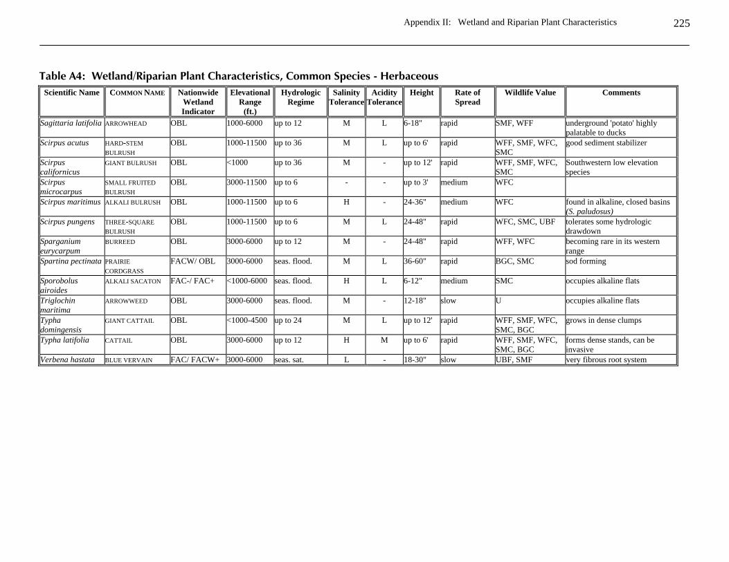
Appendix II: Wetland and Riparian Plant Characteristics 225
�������,��*������-� ��� ��������� �������� !� �!.� $##$������ �!�"��������$)!
Scientific Name COMMON NAME NationwideWetlandIndicator
ElevationalRange
(ft.)
HydrologicRegime
SalinityTolerance
AcidityTolerance
Height Rate ofSpread
Wildlife Value Comments
Sagittaria latifolia ARROWHEAD OBL 1000-6000 up to 12 M L 6-18" rapid SMF, WFF underground 'potato' highlypalatable to ducks
Scirpus acutus HARD-STEM
BULRUSH
OBL 1000-11500 up to 36 M L up to 6' rapid WFF, SMF, WFC,SMC
good sediment stabilizer
Scirpuscalifornicus
GIANT BULRUSH OBL <1000 up to 36 M - up to 12' rapid WFF, SMF, WFC,SMC
Southwestern low elevationspecies
Scirpusmicrocarpus
SMALL FRUITED
BULRUSH
OBL 3000-11500 up to 6 - - up to 3' medium WFC
Scirpus maritimusALKALI BULRUSH OBL 1000-11500 up to 6 H - 24-36" medium WFC found in alkaline, closed basins(S. paludosus)
Scirpus pungens THREE-SQUARE
BULRUSH
OBL 1000-11500 up to 6 M L 24-48" rapid WFC, SMC, UBF tolerates some hydrologicdrawdown
Sparganiumeurycarpum
BURREED OBL 3000-6000 up to 12 M - 24-48" rapid WFF, WFC becoming rare in its westernrange
Spartina pectinataPRAIRIE
CORDGRASS
FACW/ OBL 3000-6000 seas. flood. M L 36-60" rapid BGC, SMC sod forming
Sporobolusairoides
ALKALI SACATON FAC-/ FAC+ <1000-6000 seas. flood. H L 6-12" medium SMC occupies alkaline flats
Triglochinmaritima
ARROWWEED OBL 3000-6000 seas. flood. M - 12-18" slow U occupies alkaline flats
Typhadomingensis
GIANT CATTAIL OBL <1000-4500 up to 24 M L up to 12' rapid WFF, SMF, WFC,SMC, BGC
grows in dense clumps
Typha latifolia CATTAIL OBL 3000-6000 up to 12 H M up to 6' rapid WFF, SMF, WFC,SMC, BGC
forms dense stands, can beinvasive
Verbena hastata BLUE VERVAIN FAC/ FACW+ 3000-6000 seas. sat. L - 18-30" slow UBF, SMF very fibrous root system
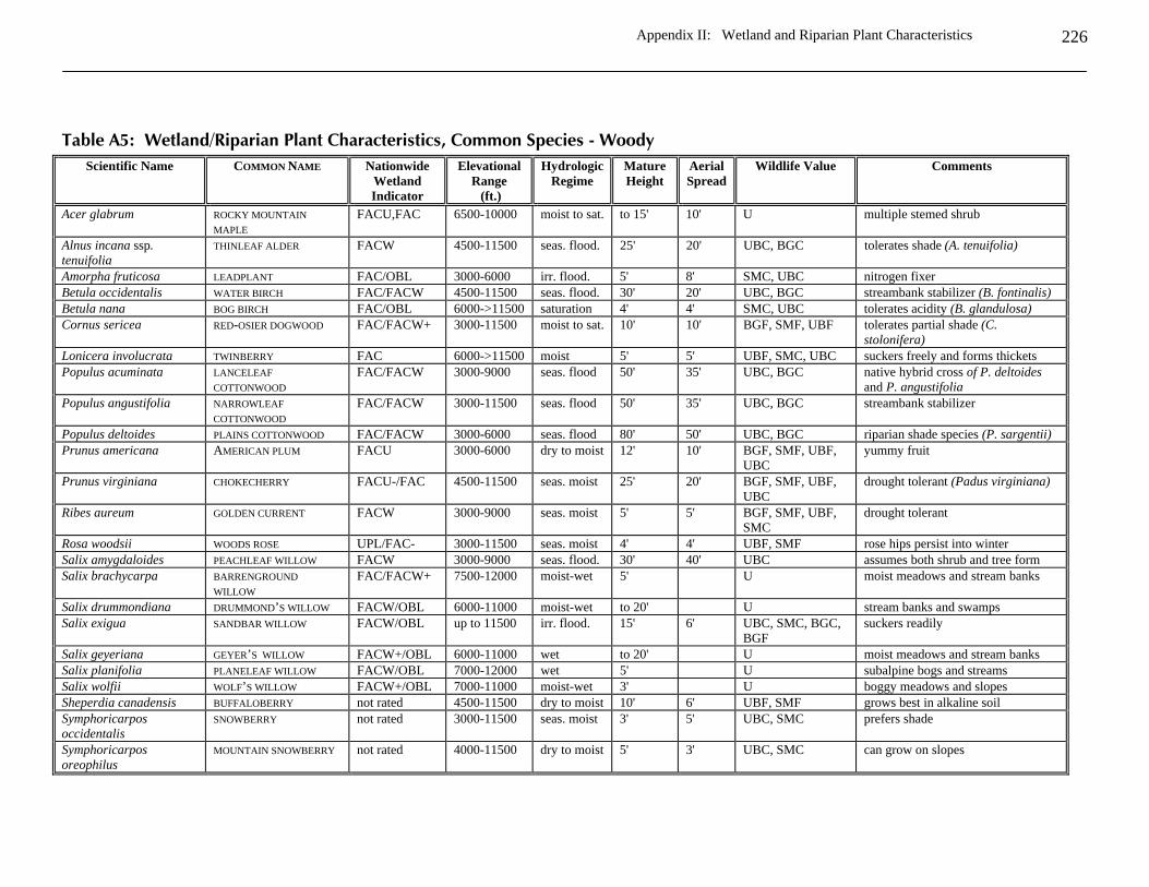
Appendix II: Wetland and Riparian Plant Characteristics 226
�������/��*������-� ��� ��������� �������� !� �!.� $##$������ �!�"�*$$�0
Scientific Name COMMON NAME NationwideWetlandIndicator
ElevationalRange (ft.)
HydrologicRegime
MatureHeight
AerialSpread
Wildlife Value Comments
Acer glabrum ROCKY MOUNTAIN
MAPLE
FACU,FAC 6500-10000 moist to sat. to 15' 10' U multiple stemed shrub
Alnus incana ssp.tenuifolia
THINLEAF ALDER FACW 4500-11500 seas. flood. 25' 20' UBC, BGC tolerates shade (A. tenuifolia)
Amorpha fruticosa LEADPLANT FAC/OBL 3000-6000 irr. flood. 5' 8' SMC, UBC nitrogen fixerBetula occidentalis WATER BIRCH FAC/FACW 4500-11500 seas. flood. 30' 20' UBC, BGC streambank stabilizer (B. fontinalis)Betula nana BOG BIRCH FAC/OBL 6000->11500 saturation 4' 4' SMC, UBC tolerates acidity (B. glandulosa)Cornus sericea RED-OSIER DOGWOOD FAC/FACW+ 3000-11500 moist to sat. 10' 10' BGF, SMF, UBF tolerates partial shade (C.
stolonifera)Lonicera involucrata TWINBERRY FAC 6000->11500 moist 5' 5' UBF, SMC, UBC suckers freely and forms thicketsPopulus acuminata LANCELEAF
COTTONWOOD
FAC/FACW 3000-9000 seas. flood 50' 35' UBC, BGC native hybrid cross of P. deltoidesand P. angustifolia
Populus angustifolia NARROWLEAF
COTTONWOOD
FAC/FACW 3000-11500 seas. flood 50' 35' UBC, BGC streambank stabilizer
Populus deltoides PLAINS COTTONWOOD FAC/FACW 3000-6000 seas. flood 80' 50' UBC, BGC riparian shade species (P. sargentii)Prunus americana AMERICAN PLUM FACU 3000-6000 dry to moist 12' 10' BGF, SMF, UBF,
UBCyummy fruit
Prunus virginiana CHOKECHERRY FACU-/FAC 4500-11500 seas. moist 25' 20' BGF, SMF, UBF,UBC
drought tolerant (Padus virginiana)
Ribes aureum GOLDEN CURRENT FACW 3000-9000 seas. moist 5' 5' BGF, SMF, UBF,SMC
drought tolerant
Rosa woodsii WOODS ROSE UPL/FAC- 3000-11500 seas. moist 4' 4' UBF, SMF rose hips persist into winterSalix amygdaloides PEACHLEAF WILLOW FACW 3000-9000 seas. flood. 30' 40' UBC assumes both shrub and tree formSalix brachycarpa BARRENGROUND
WILLOW
FAC/FACW+ 7500-12000 moist-wet 5' U moist meadows and stream banks
Salix drummondiana DRUMMOND’S WILLOW FACW/OBL 6000-11000 moist-wet to 20' U stream banks and swampsSalix exigua SANDBAR WILLOW FACW/OBL up to 11500 irr. flood. 15' 6' UBC, SMC, BGC,
BGFsuckers readily
Salix geyeriana GEYER’S WILLOW FACW+/OBL 6000-11000 wet to 20' U moist meadows and stream banksSalix planifolia PLANELEAF WILLOW FACW/OBL 7000-12000 wet 5' U subalpine bogs and streamsSalix wolfii WOLF’S WILLOW FACW+/OBL 7000-11000 moist-wet 3' U boggy meadows and slopesSheperdia canadensis BUFFALOBERRY not rated 4500-11500 dry to moist 10' 6' UBF, SMF grows best in alkaline soilSymphoricarposoccidentalis
SNOWBERRY not rated 3000-11500 seas. moist 3' 5' UBC, SMC prefers shade
Symphoricarposoreophilus
MOUNTAIN SNOWBERRY not rated 4000-11500 dry to moist 5' 3' UBC, SMC can grow on slopes

Appendix III: Weed Lists 227
�������������������� �
���������������� ��������������������
��������������������������������������
(none allowed for certified seed)
COMMON NAME SCIENTIFIC NAME* ANODA, SPURRED Anoda cristata
BINDWEED, FIELD Convolvulus arvensis* BOUNCINGBET Saponaria officinalis* CAMELTHORN Alhagi pseudalhagi* CHAMOMILE, SCENTLESS Anthemis arvensis* CINQUEFOIL, SULFER Potentilla recta* CLAMATIS, CHINESE Clematis orientalis* DAISY, OXYEYE Chrysanthemum leucanthum
GOATGRASS, JOINTED Aegilops cylindricaHALOGETON Halogeton glomeratusHORSENETTLE, CAROLINA Solanum carolinenseHORSENETTLE, WHITE Solanum elaeagnifolium
* HOUNDSTONGUE Cynoglossum officinaleJOHNSONGRASS Sorghum halepense
* KNAPWEED, BLACK Centaurea nigraKNAPWEED, DIFFUSE Centaurea diffusaKNAPWEED, RUSSIAN Acroptilon (Centaurea) repensKNAPWEED, SPOTTED Centaurea maculosa
* KNAPWEED, SQUAROSE Centaurea virgataLOOSESTRIFE, PURPLE Lythrum salicaria and Lythrum virgatum
* MALLOW , VENICE Hibiscus trionum* MEDUSAHEAD Taeniatherum caput-medusae* MILLET , WILD PROSO Panicum miliaceum ssp. ruderale* NUTSEDGE, YELLOW Cyperus esculentus
PEPPERWEED, PERENNIAL see Whitetop, tallPOVERTYWEED, SILVERLEAF Ambrosia tomentosa (Franseria discolor)POVERTYWEED, WOOLLYLEAF Ambrosia grayi (Franseria tomentosa)
+ ROCKET, DAME’S Hesperis matronalis* RUE, AFRICAN Peganum harmala* SAGE, MEDITERRANEAN Salvia aethiopis* SALTCEDAR Tamarix parviflora and Tamarix ramosissima* SKELETONWEED, RUSH Chondrilla juncea
SORGHUM, ALMUM Sorghum almumSOWTHISTLE, PERENNIAL Sonchus arvensis
* SPURGE, CYPRESS Euphorbia cyparissiasSPURGE, LEAFY Euphorbia esula
* SPURGE, MYRTLE Euphorbia myrsinitesST. JOHNS WORT, COMMON Hypericum perforatum
Appendix III: Weed Lists 228
��������������������������������������
(none allowed for certified seed)
COMMON NAME SCIENTIFIC NAMESTARTHISTLE, YELLOW Centaurea solstitialis
* TARWEED, COAST Madia sativaTHISTLE, CANADA Cirsium arvenseTHISTLE, MUSK Carduus nutansTHISTLE, PLUMELESS Carduus acanthoidesTHISTLE, SCOTCH Onopordum acanthium and Onopordum tauricumTOADFLAX, DALMATIAN Linaria dalmaticaTOADFLAX, YELLOW Linaria vulgarisWHITETOP Cardaria drabaWHITETOP, HAIRY Cardaria pubescensWHITETOP, TALL Lepidium latifoliumWOAD, DYER'S Isatis tinctoria
* These weeds are added to the prohibited noxious weed list effective January 1, 1999.+ Dame’s rocket shall not be considered a prohibited noxious weed until January 1, 2001.
������������ ��� ��������������������
������ �����������������!������"��#�����������
(Up to 6 per lb allowed for Certified Seed)
����������� �����������
BLUEWEED Helianthus ciliaris* BURDOCK, COMMON Arcticum minus
BUTTERPRINT OR VELVET LEAF Abutilon theophrastiDOCK, CURLY Rumex crispusDODDER Cuscuta spp.FOXTAIL, GIANT Setaria faberiGROUNDCHERRY, PURPLE Quincula lobata (Physalis lobata)
* HEMLOCK, POISON Conium maculatum* HENBANE, BLACK Hyoscyamus niger
LETTUCE, BLUE Lactuca tatarica ssp. pulchella (Lactuca pulchella)MUSTARD, BLACK Brassica nigraMUSTARD, INDIA Brassica junceaMUSTARD, WILD Sinapsis arvensisOAT, WILD Avena fatuaPLANTAIN, BUCKHORN Plantago lanceolataPOVERTYWEED, MOUSE-EAR Iva axillarisPUNCTUREVINE Tribulus terrestrisQUACKGRASS Elytrigia repens (Agropyron repens)
* SANDBUR, LONGSPINE Cenchrus longispinus* THISTLE, BULL Cirsium vulgare
* These weeds are added to the prohibited noxious weed list effective January 1, 1999.

Appendix III: Weed Lists 229
���� �� ���$���
Plants to Avoid (modified from Plant Species Not To Use in Gardening, Reclamation, andRestoration by the Colorado Native Plant Society, Boulder Chapter. November, 1995.) This isnot a complete list. New species are continually identified that have escaped cultivation tobecome weed problems.
FORBS
Bellflower, Creeping (Campanula rapunculoides) - Stoloniferous plant that displaces nativevegetation. Found in the foothills and plains in shady places.
Bindweed, Field (Convovulus arvensis) - Perennial with extensive root system and stems thatclimb or form dense tangled mats. Difficult to control. Common on disturbed sites.
Bouncing Bet or Soapwort (Saponaria officinalis) - Escapes from gardens and displaces nativevegetation. Occurs on roadsides, trails, and homestead sites on mesas and in the foothills.
Burdock (Arctium minus) - Biennial that competes with native vegetation. Often disperses bysticking to the hair of livestock and wildlife. Found on roadsides, trails, ditches, andstreambanks.
Butter -and-Eggs (Linaria vulgaris) - Escaped ornamental with yellow, snapdragon like flowers.Highly invasive in natural areas and very difficult to control.
Carrot , Wild or Queen Anne’s Lace (Daucus carota) - Escapes from gardens, spreading byseeds. Found along roadsides in the plains and foothills.
Chamomile, Scentless (Matricaria perforata = Anthemis arvensis) - Adventive plant thatcompetes with native vegetation. Found along roadsides, pastures, and townsites in themountains.
Chicory (Cichorium intybus) - Adventive weed that competes with native vegetation. Occurs onroadsides, trails, and open areas.
Cinquefoil, Sulfur (Potentilla recta) - Adventive perennial. Found in disturbed areas, alongroadsides and in pastures.
Clematis, Oriental (Clematis orientalis) - Adventive plant that competes with native vegetation.Found in the foothills and montane areas especially along Clear Creek.
Crambe (Crambe cordifolia) - Escapes from gardens. Produces abundant seeds. Found ondisturbed sites.
Daisy, Ox-eye (Leucanthemum vulgare = Chrysanthemum leucanthum) - Escapes from gardensand spreads easily by seeds. Displaces native plants. In wildflower seed mixes and used inroadside reclamation. Establishes in natural areas. Found from the plains to the alpine.
Dame’s Rocket or Sweet Rocket (Hesperis matronalis) - Escaped from gardens displacingnative vegetation. Occurs in riparian areas and wet meadows.

Appendix III: Weed Lists 230
Dyer’s Woad (Isatis tinctoria) - Escapes from cultivation. Occurs on disturbed sites. Invadesnatural areas.
Field bindweed (Convolvulus arvensis) - Competitive perennial weed. Widespread in cultivatedareas, pastures, lawns, gardens, roadsides, and waste areas.
Hoary Cress (see Whitetop)
Hemlock, Poison (Conium maculatum) - All plant parts are poisonous, including the large, whitetaproot. Biennial that tolerates poorly drained soils. Frequently found on streambanks.
Horehound (Marrubium vulgare) - Escapes from cultivation. Found on disturbed sites.
Hound’s Tongue (Cynoglossum officinale) - Escapes from cultivation. The prickly seeds travelon fur and clothing. Found on disturbed areas, trails, and logging sites.
Knotweed, Japanese or Buckwheat (Reynoutria japonica) - Escapes cultivation. Spreads bylong rhizomes. Found in populated areas at the base of the foothills.
Knapweed, Diffuse* (Centaurea diffusa) - Highly competitive annual that is found alongroadsides, waste areas, and dry rangelands.
Knapweed, Russian* (Centaurea repens) - Perennial that spreads by black, deep growing rootsalong roadsides, pastures, orchards, and cultivated fields.
Knapweed, Spotted* (Centaurea maculosa) - Short-lived perennial. Found along roadsides,waste areas, and rangelands.
Kochia (Kochia scoparia) - Annual introduced weed that reproduces by seeds. Grows incultivated fields and waste places.
Loosestrife, Purple (Lythrum salicaria) - Attractive, perennial garden plant that is extremelyinvasive and threatens cattail marshes and other wetlands. Spreads by seeds in mud and waterand by pieces of stems.
Mustard , Jim Hill or Tumble (Sisymbrium altissimum) - Adventive plant that breaks at the soillevel and tumbles with the wind spreading its seed over a wide area. Common in fields,rangeland, waste areas and along roads.
Pepperweed, Perennial* (Lepidium latifolium) - Perennial with deep rootstocks that make theplant difficult to control. Found in wetland and riparian areas.
St. John’s Wort (Hypericum perforatum) - Competes with and displaces native vegetation.Poisonous to animals. Found in open areas on mesas in the foothills.
Sage, Mediterranean (Salvia aethiopis) - Escapes from cultivation forming pure stands that outcompete natives. Winter tumbleweed. Found in grasslands, pastures, meadows and rangelands.
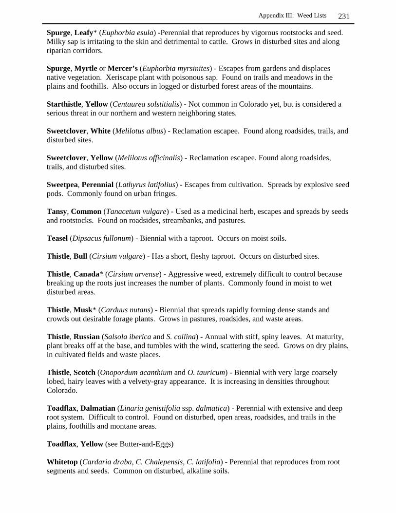
Appendix III: Weed Lists 231
Spurge, Leafy* (Euphorbia esula) -Perennial that reproduces by vigorous rootstocks and seed.Milky sap is irritating to the skin and detrimental to cattle. Grows in disturbed sites and alongriparian corridors.
Spurge, Myrtle or Mercer’s (Euphorbia myrsinites) - Escapes from gardens and displacesnative vegetation. Xeriscape plant with poisonous sap. Found on trails and meadows in theplains and foothills. Also occurs in logged or disturbed forest areas of the mountains.
Starthistle, Yellow (Centaurea solstitialis) - Not common in Colorado yet, but is considered aserious threat in our northern and western neighboring states.
Sweetclover, White (Melilotus albus) - Reclamation escapee. Found along roadsides, trails, anddisturbed sites.
Sweetclover, Yellow (Melilotus officinalis) - Reclamation escapee. Found along roadsides,trails, and disturbed sites.
Sweetpea, Perennial (Lathyrus latifolius) - Escapes from cultivation. Spreads by explosive seedpods. Commonly found on urban fringes.
Tansy, Common (Tanacetum vulgare) - Used as a medicinal herb, escapes and spreads by seedsand rootstocks. Found on roadsides, streambanks, and pastures.
Teasel (Dipsacus fullonum) - Biennial with a taproot. Occurs on moist soils.
Thistle, Bull (Cirsium vulgare) - Has a short, fleshy taproot. Occurs on disturbed sites.
Thistle, Canada* (Cirsium arvense) - Aggressive weed, extremely difficult to control becausebreaking up the roots just increases the number of plants. Commonly found in moist to wetdisturbed areas.
Thistle, Musk* (Carduus nutans) - Biennial that spreads rapidly forming dense stands andcrowds out desirable forage plants. Grows in pastures, roadsides, and waste areas.
Thistle, Russian (Salsola iberica and S. collina) - Annual with stiff, spiny leaves. At maturity,plant breaks off at the base, and tumbles with the wind, scattering the seed. Grows on dry plains,in cultivated fields and waste places.
Thistle, Scotch (Onopordum acanthium and O. tauricum) - Biennial with very large coarselylobed, hairy leaves with a velvety-gray appearance. It is increasing in densities throughoutColorado.
Toadflax, Dalmatian (Linaria genistifolia ssp. dalmatica) - Perennial with extensive and deeproot system. Difficult to control. Found on disturbed, open areas, roadsides, and trails in theplains, foothills and montane areas.
Toadflax, Yellow (see Butter-and-Eggs)
Whitetop (Cardaria draba, C. Chalepensis, C. latifolia) - Perennial that reproduces from rootsegments and seeds. Common on disturbed, alkaline soils.

Appendix III: Weed Lists 232
GRASSES
Some of the grasses listed here, including crested wheatgrass (Agropyron cristatum), smoothbrome (Bromus inermis), orchardgrass (Dactylis glomerata), and timothy (Phleum pratense),are planted for hay or pasture grass, or are used for erosion control or reclamation projects wherethe use of native species is not a priority. These species are listed in the weed section becausethey can be detrimental to the establishment of native species.
Barnyard Grass (Echinochloa crusgalli) - An annual grass that spreads by seeds. Found incroplands and disturbed areas.
Brome, Smooth (Bromus inermis) - Competes with native vegetation via extensive undergroundroots. Found in planted grasslands and roadsides, especially on moister sites. It has escapedfrom planted areas and invaded disturbed native ecosystems.
Cheatgrass* (Bromus tectorum) - An aggressive winter annual that out competes native plantsand is a fire hazard. Widespread along roadsides, in waste areas, and in disturbed pastures andrangelands.
Johnsongrass (Sorghum halepense) - Vigorous perennial that reproduces from seed or creeping,robust rhizomes. Grows in cultivated fields and neglected areas.
Orchardgrass (Dactylis glomerata) - Widely used in pastures. It has escaped and invadedroadsides and disturbed habitats.
Reedgrass, Canary (Phalaris arundinacea) - Stout perennial which regenerates from largerootstocks. Found along streams, ditches, and in marshes. It has escaped from intentionalplantings to establish on disturbed riparian and wetland habitats.
Rye, cereal (Secale cereale) - Annual. Escapes cultivation and can become established onroadsides, waste places, and even open rangeland.
Timothy (Phleum pratense) - Escapes from pasturelands and competes with native vegetation.A habitat generalist, it is found in dry to wet soils.
Wheatgrass, Crested (Agropyron cristatum) - Persistent reclamation grass that out competesnative grasses, and can cause soil erosion between individual plants. Found along roadsides,trails, and disturbed areas.
SHRUBS
Buckthorn (Frangula alnus) - Escapes from gardens and competes with native vegetation.Found in riparian areas in the plains, especially in urban areas.
Tamarisk or Salt Cedar* (Tamarix ramosissima and T. parviflora) - Very aggressive shrub orsmall tree. Has displaced the native willows along riparian corridors especially on the WesternSlope and lower Arkansas River valley.

Appendix III: Weed Lists 233
TREES
Elm, Siberian (Ulmus pumila) - Widely planted, hardy tree that escapes cultivation. Foundalong roadsides and floodplains.
Russian Olive* (Elaeagnus angustifolia) - Extremely invasive tree that displaces native willowsand cottonwoods throughout the plains and Western Slope. Seed commonly dispersed by birds.Found along riparian corridors.
Willow , Crack (Salix fragilis) - Originally cultivated along streams. Displaces nativecottonwoods and willows. Found in riparian corridors along the plains and lower foothills.
Willow , White (Salix alba var. vitellina) - Displaces native willows and cottonwoods. Found inriparian corridors.
* Discussed in more detail in Appendix IV: Managing The Most Common And AggressiveWeeds Of Colorado.

Appendix III: Weed Lists 234
Appendix IV: Managing Common and Aggressive Weeds235
����������$�%���&��&� ��%�� ���%%��������&&�����$�
������'���������
'����
Diffuse knapweed (Centaurea diffusa)Description: This usually biennial weed has finely divided leaves and numerous solitary flowerheads. It is distinguished from other knapweeds by the comb-like, spiny bracts under the flowerheads. This introduced weed invades disturbed and undisturbed ground with dry, light soils. Itspreads rapidly as it breaks off at the ground level and blows into new areas. The dry seed headscan also easily attach to animals’ fur, tire tread and hiking boots. It typically has white flowers.
Management Methods: The key to controlling this weed is to prevent seed production.
Cultural Control: The most effective way to prevent invasion of this noxious weed is torevegetate disturbed areas as soon as possible.
Chemical Control: Transline (clopyralid) is an effective chemical control for diffuse knapweedwhen applied at the rosette to early bolting growth stage. This herbicide is only effective on fourplant families. Other herbicides such as Banvel (dicamba), Tordon (picloram), or tank mixes ofBanvel plus 2,4-D, Banvel plus Tordon, and others are also effective against diffuse knapweed.
Biological Control: The root-boring beetle (Sphenoptera jugoslavica) has the best potential forsuccess against diffuse knapweed, although further research needs to be done. Two seedheadflies (Urophora spp.), and several species of seedhead weevil have been released against diffuseknapweed with marginal control success. Grazing with sheep, goats and cattle will also reduceknapweed seed set and release grasses from competition. Spring grazing can be effective forreducing seed formation especially when a large number of animals have been grazed in a smallarea for a short time.
Russian knapweed (Acroptilon repens = Centaurea repens)Description: This purple-flowered perennial spreads by seeds and creeping roots. The extensiveroots can grow to 23 feet (7 meters) deep within two years of establishment. Russian knapweeddiffers from other knapweeds by having broad, round bracts with papery margins under theflower head. In Colorado, an estimated 50,000 acres (20,235 hectares) has been infested by thisnoxious weed. Abandoned farmlands are the most frequently invaded habitats.

Appendix IV: Managing Common and Aggressive Weeds236
Control Measures: The most effective weed control plan combines cultural control methods withmechanical and/or chemical control methods. Mowing or applying herbicide alone is usually notsufficient.
Cultural Control: Planting an area with grasses helps prevent the establishment and spread ofRussian knapweed.
Mechanical Control: Mowing the area two to three times per season for two or more seasonshelps prevent seed production and stresses the plant. Mow after the plant has bolted, but beforethe seeds have matured (usually six to eight week intervals). More than one season of mowing isrecommended because mowing for only a year may actually increase Russian knapweed density.
Chemical Control: Herbicides alone will rarely manage this weed effectively. Curtail, Tordon22K or Transline can be sprayed at the bud to flower growth stage. Then a month to six weeksbefore seeding, disk the area. Plant grass seed, especially cool season grasses.
Spotted knapweed (Centaurea maculosa)Description: Very similar to diffuse knapweed, this short-lived perennial reproduces from seed.It typically has purple flowers. The distinguishing physical character of spotted knapweed is asmall, dark spot at the end of the bracts underneath the flower head. This noxious weed invadesdisturbed ground with light, well drained, often calcareous soils. It survives in slightly moremoist soils than diffuse knapweed.
Management Measures: Spotted knapweed can be managed in the same manner as diffuseknapweed.
Leafy spurge (Euphorbia esula)Description: This Eurasian native forms dense patches in riparian corridors. It can invade dry aswell as moist sites. This plant has leafy stems supporting bright yellow-green flowers. Thisperennial grows from seeds and root stock. The extensive root system may grow 15 feet (4.5meters) deep or more. It is extremely difficult to control, much less eradicate this weed, once ithas become established. Leafy spurge grows rapidly, taking moisture and nutrients from nativeplants before they have had a chance to grow. It also produces a white milky sap that is irritatingto skin and detrimental to grazing wildlife, horses and cattle.
Management Measures: Attempts to kill this plant with herbicides will be more effective if theplants are stressed before herbicides are applied.
Prevention: The most effective management technique is to prevent this weed’s establishment.All other methods are difficult and require great persistence.
Cultural Control: Having a good cover of grasses, especially early in the growing season, helpsprevent an infestation of leafy spurge from spreading.
Mechanical Control: It is difficult to control leafy spurge with mowing alone. However,mowings at 14 to 21 day intervals throughout the summer can be combined with herbicidecontrol to decrease the amount of herbicide needed. Caution: leafy spurge’s milky sap may gumup the mower.

Appendix IV: Managing Common and Aggressive Weeds237
Chemical Control: Timing herbicide application is critical, and all treatments may need to berepeated for several years. Roundup (Glyphosate) needs to be applied at one month intervals (1quart per acre) beginning in June, and works best when combined with fall grass seedings. Otherherbicides such as Banvel (dicamba) and Tordon 22K (picloram) require fewer applications.Neither Tordon or Banvel should be used under woody vegetation or where ground water ismore than six feet (1.8 meters) below.
Biological Control: Sheep and goats can graze on leafy spurge to help stress control (but noteradicate) the plant. Other livestock avoid the plant. The Colorado Department of Agriculturehas four varieties of flea beetle available to feed on and help control leafy spurge. Theappropriate type of beetle depends on the soil type, moisture regime, and cover of the area.
Canada thistle (Cirsium arvense)Description: This aggressive weed forms large dense patches of prickly plants along the bottomsof intermittent drainages and other areas with moist soil. This thistle, however, does not do aswell in continually saturated or inundated soils (although, it does grow in seasonally saturated orinundated sites). It is extremely difficult to eradicate because it has an extensive root system andnew plants can grow from even a small piece of root. One plant can colonize an area up to sixfeet (1.8 meters) in diameter in one or two years. Canada thistle grows to three to five feet (1-1.5meters) tall, has spine-tipped leaves, smooth stems, and small lavender flowering heads.
Management Measures: In addition to prevention, the critical management measure is to stressthe plant by forcing it to use stored root nutrients. The most effective way to prevent this speciesis to revegetate moist bare soil.
Cultural Control: After establishment, competition with other plants is helpful, but notcompletely effective in controlling this weed. Reseeding is often necessary after the thistle hasbeen removed from an area.
Mechanical Control: Mowing can be effective when combined with herbicide treatments,especially in areas with competition from established grasses. Mow throughout the growingseason and then treat with herbicides in the fall. Mowing alone, without herbicides, can beeffective if done at one-month intervals over several years. Late spring burning will also stressthe plant if sufficient dead plant material is available to carry a fire hot enough to kill springrosettes. Burning will have to be repeated annually for several years or at three year intervals.
Chemical Control: Herbicides can be effective, especially when combined with mowing, tilling,and competition from other plants. Mow two or three times in the summer at monthly intervals(beginning at bolt to early bud-growth stage) and follow with a fall application.
Biological Control: The larvae of the weevil Ceutorhyncus litura bores into Canada thistle,weakening the plant. This weevil alone will not effectively control thistle but it can be combinedwith other methods. Urophora cardui is another insect that helps to control this weed. Grazingcan be used in the spring and early summer to help control Canada thistle in riparian areas aswell.
Appendix IV: Managing Common and Aggressive Weeds238
Musk thistle (Carduus nutans)Description: This biennial weed is a prolific seed producer and reproduces rapidly. Itestablishes in moist, bare ground. Reaching up to 6 feet (1.8 meters) tall, musk thistle has spinymarginated leaves and rose pink clusters of flowers growing at the top of the stem.
Management Measures: In addition to prevention, the key to controlling this weed is to preventseed production.
Cultural Control: Because seeds need open moist ground to germinate, the most effectivecontrol method is to keep an area vegetated. Do not allow a grassland to degrade into open areasof bare soil.
Mechanical Control: Tilling can effectively remove musk thistle. Cut the weed below the soilline before the bud stage. Mowing when the terminal flower head is in the late-flowering stagecan be effective. However, musk thistle (like many biennials) will often continue to live until itis afforded the opportunity to flower and produce seed. Mowed debris should be gathered andburned to destroy any seeds.� Be aware that tilling may promote the germination of other weeds in the seed bank.
Chemical Control: Several different herbicides (e.g. Banvel, Tordon, Curtail, Transline, 2,4-D)can be applied to the musk thistle rosettes in the spring or fall before the flowering stems areproduced (bolting). Apply Escort in early spring when the thistle is in the bolting to early-flowergrowth stages.
Biological Control: The most successful and widespread biological control insect for weedmanagement has been the musk thistle seed head weevil, Rhinocyllus conicus. It infestsdeveloping terminal flowers on most areas of the state. However, this seed head weevil has beenfound to attack native thistles as well. Another musk thistle weevil is Trichosirocalus horridus.Instead of reducing seed production, this insect feeds on the developing thistle rosette.
Perennial Pepperweed (Lepidium latifolium)Description: Creeping perennial mustard that reproduces from seed and roots. It is highlycompetitive in wetland and riparian areas often forming pure stands.
Management Measures: Prevention is the best method. Soon after disturbance, sow perennialgrasses that grow early in the season.
Cultural Control: When battling an existing infestation, combine grass seeding with the othermethods described below.
Mechanical Control: Mowing may reduce seed set but will not control established stands.
Chemical Control: Telar or Escort are very effective and should be applied in late spring, bud toflower growth stage. Landmaster/Campaign can also be applied at the flower growth stage.Desirable seed can be sown into the residues of these herbicides in the fall following late springapplication. When restoring an infested site, disk lightly. Landmaster/Campaign may need to besprayed for two consecutive seasons; the area should be seeded in the fall following the secondapplication.
Appendix IV: Managing Common and Aggressive Weeds239
&������
Cheatgrass or Downy Brome (Bromus tectorum)
Description: This winter annual grass grows from seed to a height of 4 to 30 inches (10 to 76centimeters). Growing in early spring and summer, this weed effectively competes with moredesirable native grasses for moisture and nutrients. As the plant dries in summer, it becomes afire hazard.
Cultural Control: Several native grasses, including bottlebrush squirreltail and westernwheatgrass have been shown to compete well with cheatgrass.
Mechanical Control: Grazing, mowing and controlled burning may be used to control cheatgrass.If the weed has been in the area for many years, the soil probably has a large bank of cheatgrassseeds. The plant will continue to sprout and control will require several years of effort. Themost effective intensity and timing of efforts for grazing, mowing and burning have not beenwell established and may vary with geographic setting and habitat type. The guiding principle isto limit the cheatgrass infestation without damaging native warm season grasses. The mostcommonly used prescribed burn approach is to burn in early spring when the cheatgrass is 1-1.5"tall. Burning later in the summer after cheatgrass seedset but before seedset of warm seasongrasses has also been effective in some areas (T. Nauman, personal communication).
Chemical Control: Several different herbicides can kill cheatgrass. However, they may also killthe desired native plants. Pronamide applied in late fall will control cheatgrass selectively instands of slender wheatgrass, western wheatgrass, and other grasses (although, this does notmean it is harmless to all grasses). The label for Pronamide prohibits grazing of treated grass.Pronamide also will control seedlings shortly after they germinate. Glyphosate is anotherherbicide that when applied in the early spring or late winter (mid-to late February along theFront Range) does not reduce the cover of western wheatgrass, blue grama and needlegrasses.This treatment can be pushed a little later in the season (early March along the Front Range) andstill not harm the desirable grasses especially warm season grasses. Glyphosate affects only theliving plant and does not affect the seeds that may be in the ground.
����(������
Russian-olive (Elaeagnus angustifolia)
Description: This fast-growing tree has silvery green leaves and long thorns. The fruit isolive-shaped. A European native, Russian-olive has been widely sold in Colorado as anornamental shade tree. Along some streams, Russian olive has completely replaced native woodyvegetation such as cottonwoods, thus reducing the amount and quality of wildlife habitat.
Appendix IV: Managing Common and Aggressive Weeds240
Management Methods: Russian olive trees can be controlled by either cutting the trees down andtreating the stumps with herbicide, or pulling the tree out of the ground when it is young. Thecutting method should be used on trees larger than two inches (5 centimeters) in diameter. Cutthe Russian olive trees within four inches (10 centimeters) of the ground. Within five minutes ofcutting, treat the stumps with an herbicide. Appropriate herbicides to use would include Garlon,the premixed product Pathfinder and Rodeo. Garlon decomposes rapidly after application, in aday or less in sunlit water and approximately two weeks to two months in soil. Rodeo(glyphosate) is specified for use in riparian or wetland habitats. Monitor and implementfollow-up treatment as needed. Follow-up treatments are best completed the following Junebefore any possible resprouts have time to grow. Retreated areas should be monitored every 6months until complete mortality is ensured. Care should be taken not to introduce any herbicideinto adjoining waters.
Trees less than about two inches (5 centimeters) in diameter can be wrenched out of the soil bymeans of a weed winch. Removal of small Russian olive trees will be easier when the soil ismoist so that the majority of roots can be extracted.
Tamarisk or Salt Cedar (Tamarix ramosissima and T. parviflora)Description: This shrub grows from 5 to 20 feet (1.5 to 6 meters) tall. Tiny scale-like leavesgrow on slender reddish-brown stems. Originally introduced for erosion control purposes,tamarisk has become naturalized along many of the streams and canals of the West. It formsdense stands that replace native vegetation and degrade wildlife habitat.
Management Methods: The recommended management method is the same as described forRussian Olive.

Appendix V: Regional Vendors of Plant Materials 241
���������$���&������$�������'����� �%� ������
������)��������������*��%��������$�*����
Anderson Seed 2410 10th St., Greeley, CO 80631 (970) 353-0188Applewood Seed Co. 5380 Vivian St., Arvada, CO 80002 (303) 431-6283Applewood Seed Co. P.O. Box 270, Rocky Ford, CO 81067 (719) 254-7460Aquatic and Wetland Nurseries 1655 Walnut St., Suite 205, Boulder,
CO 80302(303) 442-5770
Arbor Valley Nursery P.O. Box 932, Brighton, CO 80601 (303) 654-1682Arkansas Valley Seeds, Inc. 4333 Hwy. 66, Longmont, CO 80504 (303) 535-4481Bookcliff Gardens 755 26 Rd., Grand Junction, CO 81506 (970) 242-7766Camelot Gardens 16612 S. Hwy 550, Montrose, CO
81401(970) 249-6109
Carhart Feed and Seed Dove Creek, CO 81324 (970) 677-2233Colo-Hydro Inc. 5555 Ute Highway, Longmont, CO
80501Colorado State Forest Service CSU-Foothills Campus, Ft. Collins,
CO 80523(970) 491-8429
Colorado Alpines, Inc. P.O. Box 2708, Avon, CO 81620 (970) 949-6464Country Lane Wholesale Nursery 2979 North Hwy 83, Franktown, CO
80116(303) 688-2442
Earth, Wind, and Rock 5899 Co. Rd. 24, Ridgeway, CO 80143Farmers Marketing Assoc. 4545 Madison St., Denver, CO 80216Farmers Pride Seed Co. 916 19 1/2 Rd., Fruita, CO 81521Ft. Collins Nursery 2224 N. Shields, Ft. Collins, CO 80524 (970) 484-1289Green Acres Nursery 4990 McIntyre St., Golden, CO 80403 (303) 279-8204Hydro-Garden, Inc. P.O. Box 9707, Colorado Springs, CO
80932Iliff Gardens 4750 East Iliff, Denver, CO 80222 (970) 858-9134Kroh Nursery Loveland, CO 80537Little Valley Nursery 13022 E. 136 Ave., Brighton, CO
80524(800) 221-3241 or(303) 659-6708
Longmont Seed Co. P.O. Box 2298, Longmont, CO (970) 776-1560Mile High Seed Co. Box 1988, Grand Junction, CO 81501 (970) 242-3122Neco, Inc. Box 1178, Cahone, CO 81320Northrup-King and Company 1621 West Twelfth Ave., Denver, CO
80204Northrup-King and Company Box 998, Longmont, CO 80501Pawnee Buttes Seed Inc.(formerly Southwest Seed)
P.O. Box 1604 605 25TH Street
Greeley, CO 80632(970) 356-7002(800) 782-5947
Rocky Mountain Native Plants,Co.
2730 Snowmass Creek Road,Snowmass, CO [email protected]@aspeninfo.com
(970) 927-0925

Appendix V: Regional Vendors of Plant Materials 242
������)��������������*��%��������$�*����
Rocky Mountain Rare Plants P.O. Box 200483, Denver, CO 80220San Juan Native Nursery Box 302, Pagosa Springs, CO 89117Sharp Brothers Seed 101 East 4th St., Greeley, CO 80631 (970) 356-4710Steamboat Landscaping, Inc. Box 1521, Steamboat Springs, CO
80477Sunchaser Natives 14290 W. 54th Ave., Arvada, CO
80002Dean Swift Box 24, Jarosa, CO 81138Timberline Tree Seed Rye Star Route, Box 145, Pueblo, CO
81104Treehouse Nursery 7450 Velmont Road, Boulder, CO
8030Upper CO Environ. Plant Center P.O. Box 448, 5538 Rio Blanco
County Rd. 4, Meeker, CO 81641(970) 878-5003
Western Evergreen, Inc. 14201 West Forty-fourth Ave., Golden,CO 80401
Western Native Seed P.O. Box 1463, Salida, CO 81201Yellow Pine Nurseries Box 192, Kiowa, CO 80117 (719) 539-1071
������+�����������*��%��������$�*����
All Seasons Landscape Nursery 3376 E. Overland Rd., Meridian, ID83642
(208) 888-6268
Allied Seed, Inc. 1917 E. Fargo Ave., Nampa, ID 83651 (208) 466-9218Aloha Landscape and Nursery 4291 S. Cloverdale Rd., Boise, ID
83704(208) 362-2062
Asgrow Seed Co. 1811 E. Florida Ave., Nampa, ID83651
(208) 466-3351
Bakker Bros. of Idaho Eastland Dr. South, Twin Falls, ID83301
(208) 459-1900
W.R. Baxter Wholesale Nursery 2615 Pioneer Ave., Emmett, ID 83617 (208) 365-6011Baxter Wholesale Nursery P.O. Box 621Meridian, ID 83642Boise Valley Seed, Inc. R.R.10, Darrow Land, Caldwell, ID
83651(208) 459-7211
Brown King Nursery 1407 Arthur Street, Caldwell, ID 83605Clayton Wholesale Nursery Co. 6622 Joplin Road, Nampa, ID 83651 (208) 286-7801Clifty View Nursery Route 1, Box 509, Bonners Ferry, ID
83805Cloverdale Nursery 2528 N. Cloverdale Rd., Boise, ID
83704Coeur d'Alene Landscaping Box 1556, Coeur d'Alene, ID 83814Crookham Company 301 Warehouse Avenue, Caldwell, ID
83651D&G Turf Farm and Nursery 1267 N. Cloverdale Rd., Boise, ID
83704Dahlin's Landscape Nursery Route 1, Box 304, Priest River, ID
83856Donnelly Nursery 11911 Franklin Rd., Boise, ID 83709 (208) 375-2000

Appendix V: Regional Vendors of Plant Materials 243
������+�����������*��%��������$�*����
Double D Feed and Seed, Inc. 215 Broadway Ave., Melba, ID 83641Down to Earth Garden Shop 1615 N. Woodruff, Idaho Falls, ID
83401Du-Rite Nursery and Landscaping 5321 W. Cherry Lane, Meridian, ID
83642Eagle Landscaping and Nursery P.O. Box 8, 988 East State Street,
Eagle, ID 83616(208) 939-8723
Erico Nursery P.O. Box 209, Plummer, ID 83851Fantasy Farms Nursery Route 2, Lenore, ID 83541Ferry Morse Seed Co. 3015 E. Comstock, Nampa, ID 83651Forest Tree Nursery c/o College Forestry, Wildlife and
Range Science, University of Idaho,Moscow, ID 83843
Fruitland Nursery P.O. Box 332, Fruitland, ID 83619Garden and Landscape Nursery 2900 N. 32nd, Boise, ID 83703 (208) 343-0755Garden Center West, Inc. 11500 Fairview Ave., Boise, ID 83704 (208) 376-3322Garden Square Lewiston, ID 83501Globe Seed and Feed Company 224 4th Ave., Twin Falls, ID 83301 (208) 733-1373Gooding Seed Company Box 57, Gooding, ID 83330Graft Nursery and Landscaping 1602 East 16th, Burley, ID 83318Grassland West Company Box A, Culdesac, ID 83524 (208) 843-5121Greenhurst Nurs. and GardenCntr.
3209 S. Happy Valley Rd., Nampa, ID83651
Green Things Nursery P.O. Box 1900, 2230 Michigan,Orofino, ID 83544
Green Thumb, Inc. 2113 Idaho Avenue, Caldwell, ID83605
(208) 459-3349
Grimm Alfalfa Growers Assn. Box 269, Blackfoot, ID 83221 (208) 785-0830Harker Bros. Southside Blvd., Nampa, ID 83651 (208) 495-2308
or(208) 466-5783Hash Company Nurs. and Lndsc. Troy Highway, Moscow, ID 83843Hash Tree Co. Box 72A, Princeton, ID 83857 (208) 875-1030High Altitude Gardens P.O. Box 1048, Hailey, ID 83340 (208) 788-4363Hillcrest Farms, Inc. Route 1, Grangeville, ID 83530Hillside Nursery 2350 Hill Road, Boise, ID 83702Hoffmans Greenhouse and Nurs. 3332 Caldwell Blvd., Nampa, ID
83651(208) 466-1977
Howards Nursery and Greenh. 7106 Ustick Rd., Boise, ID 83704 (208) 322-6000Inland Gardens 2124 Longmont Ave., Boise, ID 83705 (208) 342-6953Intermountain Landscape Co. P.O. Box 1087, Hailey, ID 83333Jacklin Seed Company 17300 Jacklin Ave., Post Falls, ID
83854(208) 773-7581
Jayker Tree Farms, Inc. 801 E. Beacon Light Rd., Eagle, ID83616
(208) 939-0014
John's Gourmet Gardens 9010 Burnett Dr., Boise, ID 83709 (208) 362-4439Johnson's Quality Evergreens HCR 68, Box 293, Cocolalla, ID 83813Kellog Mills 223 Roedel Ave., Caldwell, ID 83605 (208) 459-0777

Appendix V: Regional Vendors of Plant Materials 244
������+�����������*��%��������$�*����
Ketchum Garden Center P.O. Box 229, Sun Valley, ID 83353Kimberly Nurseries Route 3, Twin Falls, ID 83301Leland Plato Star Route 1, Bonners Ferry, ID 83805Levig Nursery Star Route 1, Kings Row, Bonners
Ferry, ID 83805McDonald's Garden Store Route 2, Public Avenue, Moscow, ID
83843Mountain Seed Nursery Route 1, Box 271, Moscow, ID 83843Mountain View Nursery Route 3, Box 170, Sandpoint, ID 83864Musser Seed Co., Inc. 301 Fourth Ave. South, Caldwell, ID
83605(208) 459-8243
Native Seed Foundation Star Route, Moyie Springs, ID (208) 267-7938Nishek Nursery Route 1, Box 516, Bonners Ferry, ID
83805Nishitani Greenhouse P.O. Box 325, Caldwell, ID 83606North American Plant Breeders 2323 11th Ave., North Ext., Nampa, ID
83651(208) 467-2191
Northern Natives Nursery 903 E. Lincoln, Emmett, ID 83617Northplan Seed Producers P.O. Box 9107, Moscow, ID 83843Northrup-King and Company Box 124, Twin Falls, ID 83605Northrup-King and Company 223 Roedel Ave., Caldwell, ID 83605 (208) 459-0844Northwest Nursery P.O. Box 455, Sandpoint, ID 83864Northwest Turf and Garden 843 Lilac, Meridian, ID 83642 (208) 888-4467NRCS Plant Materials Cntr P.O. Box 296, 1691 A South 2700
West Aberdeen, ID 83210(208) 397-4133
Pickle Butte Farms Route 4, Box 344, Caldwell, ID 83605Ponderosa Garden Cntr. and Nurs. 6305 North Black Cat Rd., Meridian,
ID 83642Providence Nursery Route 1, Box 588, Sandpoint, ID 83864Puffer-Ridge Farms Baldy Road, P.O. Box 132, Sandpoint,
ID 83864Purple Sage Farms, Inc. 11741 Bullock Lane, Middleton, ID
83644(208) 585-6140
Reggear & Sons Route 3, box 102-A, Orofino, ID 83544Rick's College Landscape and Horticulture Dept. 500
South Center, Rexburg, ID 83440Riteway Industries Route 1, Box 31-B, Potlatch, ID 83855Steve Rogan Co. 32121 Ave., Caldwell, ID 83605 (208) 632-3001Rogers Bros. Seed Co. Madison Ave., Nampa, ID 83651 (208) 467-1159Sand Hollow Nursery R.R.7, Caldwell, ID 83605 (208) 459-7389Seeds BLUM (208) 342-0858Sherwood Forest Nursery 244 N. 2nd East, P.O. Box 781,
Rexburg, ID 83440Shields of Nampa, Inc. 1618 Avenue South, Nampa, ID 83651 (208) 466-3584Silver Springs Nursery HCR 62, Box 86, Moyie Springs, ID
83845(208) 267-5753
Simplot Soilbuilders Box 342, Meridian, ID 83642

Appendix V: Regional Vendors of Plant Materials 245
������+�����������*��%��������$�*����
Smith Garden Square, Inc. 415 North 22nd Street, Lewiston, ID83501
Smith Tree Plantation Route 1, Box 131-A, Idaho Falls, ID83401
Spencer Mountain P.O. Box 3, Cocalalla, ID 83813Stonetree Landscaping 3226 Garrity Blvd., Nampa, ID 83651Storey Feed and Seed Co. 503 E. 1st., Meridian, ID 83642 (208) 888-4436Sunseeds, Inc. 1832 Garrity Blvd., Nampa, ID 83651 (208) 466-4679The Green Ranch P.O. Box 2597, Boise, ID 83701 (208) 336-3312The Hothouse 563 North 3rd Street, Montpellier, ID
83254The Rudy-Patrick Company Box 1130, Nampa, ID 83651The Silva Star Co. R.R. 1, Box 64-A, Potlatch, ID 83855Twin Butte Evergreens 416 N. Blaine Street, Moscow, ID
83843Union Farm and Garden, Inc. 250 No. Orchard Ave., Boise, ID
83704(208) 466-3568
Western Premium Seed, Inc. 4696 Overland Rd., Boise, ID 83705 (208) 343-0871Franz Witte, Lndsc. Contr./Nurs. 9770 W. State St., Boise, ID 83703Young's Nursery and Landsc. Orchard and Ramsey Rds., P.O. Box
570, Hayden Lake, ID
������,-��.�*�������*��%��������$�*����
Buskirk Horticultural Service 1621 East Kansas Ave., McPherson,KS 67460
Beachner Seed Co. Box 128, St. Paul, KS 66771 449-2286Creek Side Farm Rt. 1, Box 19, Fowler, KS 67844Delange Seed House, Inc. P.O. Box 7, Gerard, KS 66743 (316) 724-6223Gamagrass Seed Co. Rt. 1, Box 45, Hiawatha, KS 66434 (913) 742-3699Mott Ranch, Inc. 579 Parkway, Pratt, KS 67124 (316) 672-2341NRCS Plant Materials Cntr. 3800 S. 20th St., Manhattan, KS 66502 (913) 539-8761Sharp Bros. Seed Co. Healy, KS 67850 (316) 398-2231J.H. Skinner Co. Nursery P.O. Box 8068, Topeka, KS 66608Glen Snell 300 N. Adams, Medicine Lodge, KS
67104(316) 886-5075 or(800) 279-5841
Sommer Bros. Seed Co. Box 19021, Topeka, KS 66619Star Seed Inc. 128 South First, Osborne, KS 67473 (913) 346-5447Star Seed Inc. Highway 14, Beloit, KS 67420 (913) 738-2422Valley Feed and Seed, Inc. 1903 S. Meridian, Wichita, KS 67213Willis Nursery Co., Inc. P.O. Box 530, Ottawa, KS 66067
������,,��%�*��*�����*��%��������$�*����
Adsit Farm and Ranch Service Decker, MT 59025 (406) 757-2223Agribasics 100 S. Broadway, Belgrade, MT 59714 (406) 388-4232Agribasics 900 16th North, Great Falls, MT 59403 (406) 453-4321Agrineeds Box 622, Livingston, MT 59047 (406) 222-0332

Appendix V: Regional Vendors of Plant Materials 246
������,,��%�*��*�����*��%��������$�*����
A.L. Bruce Seed Company Townsend, MT 59664 (406) 266-3835Alpine Nursery 1763 Highway 2 East, Kalispell, MT
59901Amsterdam Store 6680 Amsterdam Rd., Manhattan, MT
59741(406) 282-7223
Badland Nursery P.O. Box 1615, Havre, MT 59501Barber Seed Service, Inc. HC 76, Box 62, Denton, MT 59430 (406) 567-2211Beartooth Grain and Feed Box 1088, Red Lodge, MT 59068 (406) 446-1418Beebe Grain 712 E. Front, Butte, MT 59701Big Sky Wholesale Seeds P.O. Box 852, Shelby, MT 59474 (406) 434-5011Billings Nursery 7900 Frontage Rd., Billings, MT 59101BitterRoot Nursery 521 East Side Hwy., Hamilton, MT
59828(406) 961-3806
BitterRoot Nursery 445 Quast Lane, Corvallis, MT 59828 (406) 961-4991Blake Nursery Otter Creek Rd., Big Timber, MT
59011(406) 826-3405
Bridger Tree Farm 8860 Bridger Canyon Rd., Bozeman,MT 59715
Buffalo Bill Nursery Route 2, Box 66, Plains, MTBud Burta Rd. 2, #2241, Lewistown, MT 59457 (406) 538-8397Canyon Creek Nursery Billings, MT 59101Del Carey Box 1, Volborg, MT 59351 (406) 421-5562Cashman Nursery P.O. Box 242, Bozeman, MT 59715 (406) 587-3406Cenex Seed Co. P.O. Box 1748, Billings, MT 59103Cenex/Farmers Union Oil Box 339, Chinook, MT 59523Cenex Seed Plant Box 956, Miles City, MT 59301 (406) 232-4760Cenex/Farmers Union Oil 1820 St. Charles, Fort Benton, MT
59422(800) 497-8295
Cenex/Farmers Union Oil 105 2nd Ave. North, Froid, MT 59226 (406) 766-2339Cenex/Farmers Union Oil Box 2483, Great Falls, MT 59403Cenex/Farmers Union Oil 1545 Northern Ave., Worden, MT
59058(406) 967-3100
Cenex/Power Farmers Elev. Co. Box 215, Power, MT 59468 (406) 463-2281Cenex Supply and Marketing 4570 N. Reserve, Missoula, MT 59802 (406) 543-8383Cenex Supply and Marketing 1408 Hwy 93 So., Ronan, MT 59864 (406) 676-2201Central Feed Co. 220 East Main, Lewistown, MT 59457 (406) 538-5451Chadwick Landscape Nursery 2101 East Custer Ave., Helena, MT
59601Circle S Seeds Box 130, Three Forks, MT 59752 (406) 285-3269Co-op Supply, Inc. 700 North Montana St., Dillion, MT
59725(406) 683-2308
Co-op Supply Inc. Box 36, Valier, MT 59486 (406) 279-3277Cramer Irrigation and Seed Box 432, Hysham, MT 59038 (406) 342-5281CX Ranch, Inc. 341 Rd. 422, Circle, MT 59215Dept. of State Lands, For. Div. 2705 Spurgin Rd., Missoula, MT
59801Chip Dye HC 50, Box 4, Alzada, MT 59311 (406) 828-4487

Appendix V: Regional Vendors of Plant Materials 247
������,,��%�*��*�����*��%��������$�*����
Earth and Wood Craftsman, Inc. 3204 Highway 93 South, Stevensville,MT 59870
Eastern Montana Seeds HC Box 3050, Forsyth, MT 59327 (406) 356-2374Eisenman Seed Co. P.O. Box 129, Fairfield, MT 59436 (406) 467-2521Farmers Exchange 115 Main St., Stevensville, MT 59870 (800) 240-5441Forestry Seeds Lewistown, MT 59457Forsyth Seed Co. Box 185 Forsyth, MT 59327 (406) 356-7627Four Winds Nursery 5853 E. Shore Rd., Polson, MT 59860Gallatin Farmers Co. 114 Northern Pacific, Belgrade, MT
59714(406) 388-6242
Garden City Seeds 1324 Red Crow Rd., Victor, MT 59875Grain Growers Oil Co. Box 847, Scobey, MT 59263 (406) 487-2741R.M. Gregor Landscaping 1310 Greene St., Helena, MT 69501Harding Land and Cattle Co. Box 3022, Miles City, MT 59301 (406) 232-2754Hardy Trees P.O. Box 9346, Kalispell, MT 59904Loyd A. Harris 3921 Springhill Rd., Bozeman, MT
59715(406) 587-5696
Harvest States Co-op Box 66, Valier, MT 59486 (406) 279-3615Hi-Mountain Farm Route 1, Box 29, Seligman, MTHeartland, Inc. Belgrade, MT 59714 (406) 388-4232Heisel Nursery 4463 Springhill Rd., Bozeman, MT
59715K and K Seed Co. Route 3, Conrad, MT 59425K-W Feed and Grain, Inc. Box 1389, Big Timber, MT 59011 (406) 932-5132Lake Milling, Inc. Box 288, Hamilton, MT 59840 (406) 363-2334Lawsons Greenhouse 1405 Hillside Dr., Bozeman, MT
59715Lawyer's Nursery 950 Hwy. 200 West, Plains, MT 59859 (406) 826-3229Laurel Co-op Assn. Box 7, Edgar, Mt 59026 (406) 962-3792Lone Pine Ranch HC 31, Box 3125, Wolf Point, MT
59201(406) 525-3390
Mannakee Seed Co. Box 68, Cascade, MT 59421Marchie's Nursery 1845 South Third West, Missoula, MT
59801Mecklenberg Gardens 4141 Sringhill Rd., Bozeman, MT
59715Mo's Greenhouse 185 Swan River Rd., Bigfork, MT
59911Montana Bitterroot Gardens 1990 Lower Valley Rd., Kalispell, MT
59901Montana Merchandising Co. Box E, Great Falls, MT 59405 (800) 332-1812Montana Seeds, Inc. Route 3, Conrad, MT 59425 (406) 278-5547Mountain Brooks Nursery P.O. Box 1114, Eureka, MT 59917Mountain Home Nursery Deborgia, MT 59830Hugo Muggli, Inc. Tongue River Stage, Miles City, MT
59330(406) 232-5578
Northern Ag Service HC65, Box 5500, Hwy 2 East (406) 654-2022

Appendix V: Regional Vendors of Plant Materials 248
������,,��%�*��*�����*��%��������$�*����
Northland Seed Co. 418 Albert St., Billings, MT 59101 (406) 252-0568Northrup-King and Co. Box 398, Billings, MT 59103 (406) 252-0508NRCS Plant Materials Cntr. Route 1, Box 1189, Bridger, MT
59014-9718(406) 662-3579
Patrick Seed Farms, Inc. HC 72, Box 7300, Malta, MT 59538 (406) 654-1958Ed Peterson Rt. 1, Box 2908, Troy, MT 59935Pioneer Hi-Bred Int'l Box 400, Wibaux, MT 59353 (406) 654-1958Powder River Seed Co. Box 673, Broadus, MT 59317Quality Seed Co. P.O. Box 31, Lewistown, MT 59457 (406) 538-8738Renn's Blue Spruce Nursery 6305 Highway 2 East, Columbia Falls,
MT 59912Reynolds Feed and Seed Box 201, Winnett, MT 59087 (406) 429-7821Shades of Green Nursery 3403 Cooney Dr., Helena, MT 59601Bill Skorupa Rt. 1, Box 1211, Bridger, MT 59014 (406) 662-3358Snow Line Tree Co., Inc. Highway 93 South, Kalispell, MT
59901Spanish One Conrad, MT 59425 (406) 627-2329State Nursery Company Helena, MT 59601Townsend Seeds, Inc. P.O. Box 1338, Townsend, MT 59644 (406) 266-4444Treasure State Seed, Inc. Box 698, Farifield, MT 59436 (406) 467-2557Tri-Valley Feed Rt. 62, Box 3252, Livingston, MT
59047(406) 222-1132
Two Dog Seed Co. 800 Steel Bridge Rd., Kalispell, MT59901
(406) 752-3656
Valley Feed Rt. 62, Box 3252, Livingston, MT59047
Valley Nursery Box 4845, Helena, MT 59601Wanner Nursery Corvallis, MT 59828West Butte Ranch Box 32, Sweetgrass, MT 59484 (406) 937-2281West Feeds/Agribasics 1420 Minnesota Ave., Billings, MT
59101(406) 252-5196
Western Seed and Supply, Inc. P.O. Box 57, Charlo, MT 59824Western Seed and Supply, Inc. Box 67 Ronan, MT 59864 (406) 676-3900Westland Seed, Inc. Box 57, Charlo, MT 59824 (406) 644-2202Westland Seeds, Inc. 1308 Round Butte Road W., Ronan,
MT 59864(800) 547-3335
Wild Flower Seeds 16000 Hwy 10A West, Anaconda, MT59711
Wildwood Landscaping P.O. Box 322, Big Sky, MT 59716
������,/��������0�����*��%��������$�*����
Arrow Seed Co., Inc. Box 722, Broken Arrow, NE 68822Kendall Atkins HC89, Box 52, Dix, NE 69133Bluebird Nursery P.O. Box 460, Clarkson, NE 68629 (402) 892-3457Cenex Seed Co. Box 279, Gering, NE 69341Clarke-McNary Univ. of NE. Campus, Lincoln, NE (402) 472-6640
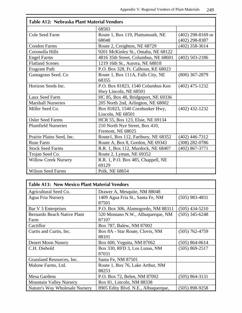
Appendix V: Regional Vendors of Plant Materials 249
������,/��������0�����*��%��������$�*����
68583Cole Seed Farm Route 1, Box 119, Plattsmouth, NE
68048(402) 298-8169 or(402) 298-8387
Condon Farms Route 2, Creighton, NE 68729 (402) 358-3614Coronolla Hills 9201 McKinley St., Omaha, NE 68122Engel Farms 4816 35th Street, Columbus, NE 68601 (402) 503-2186Flatland Scenes 1219 16th St., Aurora, NE 68818Fragrant Path P.O. Box 328, Ft. Calhoun, KE 68023Gamagrass Seed. Co Route 1, Box 111A, Falls City, NE
68355(800) 367-2879
Horizon Seeds Inc. P.O. Box 81823, 1540 Columbus KenHwy Lincoln, NE 68501
(402) 475-1232
Laux Seed Farm HC 85, Box 48, Bridgeport, NE 69336Marshall Nurseries 205 North 2nd, Arlington, NE 68002Miller Seed Co. Box 81823, 1540 Cornhusker Hwy,
Lincoln, NE 68501(402) 432-1232
Osler Seed Farms HCR 55, Box 123, Elsie, NE 69134Plumfield Nurseries 210 North Nye Street, Box 410,
Fremont, NE 68025Prairie Plains Seed, Inc. Route1, Box 112, Faribury, NE 68352 (402) 446-7312Ruse Farm Route A, Box 8, Gordon, NE 69343 (308) 282-0786Stock Seed Farms R.R. 1, Box 112, Murdock, NE 68407 (402) 867-3771Trojan Seed Co. Route 2, Lyman, NE 69352Willow Creek Nursery R.R. 1, P.O. Box 485, Chappell, NE
69129Wilson Seed Farms Polk, NE 68654
������,1����2�%�"�!�����*��%��������$�*����
Agricultural Seed Co. Drawer A, Mesquite, NM 88048Agua Fria Nursery 1409 Agua Fria St., Santa Fe, NM
87501(505) 983-4831
Bar V 3 Enterprises P.O. Box 306, Alamogordo, NM 88311 (505) 434-5210Bernardo Beach Native PlantFarm
520 Montano N.W., Albuquerque, NM87107
(505) 345-6248
Cactiflor Box 787, Balew, NM 87002Curtis and Curtis, Inc. Box 8A - Star Route, Clovis, NM
88101(505) 762-4759
Desert Moon Nusery Box 600, Veguita, NM 87062 (505) 864-0614C.H. Diebold Box 330, RFD 3, Los Lunas, NM
87031(505) 869-2517
Grassland Resources, Inc. Santa Fe, NM 87501Malone Farms, Ltd. Route 1, Box 76, Lake Arthur, NM
88253Mesa Gardens P.O. Box 72, Belen, NM 87002 (505) 864-3131Mountain Valley Nursery Box 81, Lincoln, NM 88338Nature's Way Wholesale Nursery 8905 Edity Blvd. N.E., Albuquerque, (505) 898-9258
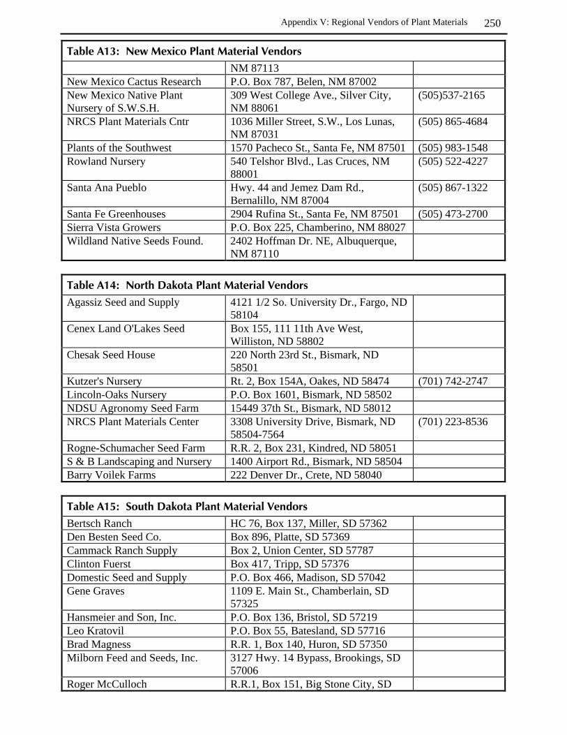
Appendix V: Regional Vendors of Plant Materials 250
������,1����2�%�"�!�����*��%��������$�*����
NM 87113New Mexico Cactus Research P.O. Box 787, Belen, NM 87002New Mexico Native PlantNursery of S.W.S.H.
309 West College Ave., Silver City,NM 88061
(505)537-2165
NRCS Plant Materials Cntr 1036 Miller Street, S.W., Los Lunas,NM 87031
(505) 865-4684
Plants of the Southwest 1570 Pacheco St., Santa Fe, NM 87501 (505) 983-1548Rowland Nursery 540 Telshor Blvd., Las Cruces, NM
88001(505) 522-4227
Santa Ana Pueblo Hwy. 44 and Jemez Dam Rd.,Bernalillo, NM 87004
(505) 867-1322
Santa Fe Greenhouses 2904 Rufina St., Santa Fe, NM 87501 (505) 473-2700Sierra Vista Growers P.O. Box 225, Chamberino, NM 88027Wildland Native Seeds Found. 2402 Hoffman Dr. NE, Albuquerque,
NM 87110
������,3����������0�������*��%��������$�*����
Agassiz Seed and Supply 4121 1/2 So. University Dr., Fargo, ND58104
Cenex Land O'Lakes Seed Box 155, 111 11th Ave West,Williston, ND 58802
Chesak Seed House 220 North 23rd St., Bismark, ND58501
Kutzer's Nursery Rt. 2, Box 154A, Oakes, ND 58474 (701) 742-2747Lincoln-Oaks Nursery P.O. Box 1601, Bismark, ND 58502NDSU Agronomy Seed Farm 15449 37th St., Bismark, ND 58012NRCS Plant Materials Center 3308 University Drive, Bismark, ND
58504-7564(701) 223-8536
Rogne-Schumacher Seed Farm R.R. 2, Box 231, Kindred, ND 58051S & B Landscaping and Nursery 1400 Airport Rd., Bismark, ND 58504Barry Voilek Farms 222 Denver Dr., Crete, ND 58040
������,4����#�����0�������*��%��������$�*����
Bertsch Ranch HC 76, Box 137, Miller, SD 57362Den Besten Seed Co. Box 896, Platte, SD 57369Cammack Ranch Supply Box 2, Union Center, SD 57787Clinton Fuerst Box 417, Tripp, SD 57376Domestic Seed and Supply P.O. Box 466, Madison, SD 57042Gene Graves 1109 E. Main St., Chamberlain, SD
57325Hansmeier and Son, Inc. P.O. Box 136, Bristol, SD 57219Leo Kratovil P.O. Box 55, Batesland, SD 57716Brad Magness R.R. 1, Box 140, Huron, SD 57350Milborn Feed and Seeds, Inc. 3127 Hwy. 14 Bypass, Brookings, SD
57006Roger McCulloch R.R.1, Box 151, Big Stone City, SD

Appendix V: Regional Vendors of Plant Materials 251
������,4����#�����0�������*��%��������$�*����
57216Pearl View Seeds R.R. 1, Box 151, Cavour, SD 57324Wm. Scott Phillips Box 17, New Underwood, SD 57761Eugene Raap R.R. 1, Box 72, Pierpont, SD 57408Rethke Nurseries 47030 149th St., Twin Brooks, SD
57324SD Crop Improv. Found. Box 2207-A, Brookings, SD 57007Sexauer Co. Box 58, Brookings, SD 57007Robert Weiss 41963 275th St., Parkston, SD 57366Wilbers Feed and Seed Co. P.O. Box 41, Miller, SD 57362
������,�����������*��%��������$�*����
C & S Intermtn. Seed Enter. Box 74 or Box 62, Ephraim, UT 84627 (801) 283-4383Coble Seed Co. P.O. Box 175, Gunnison, UT 84634 (801) 528-3234Granite Seed 1697 West 2100 North, Lehi, UT
84043(801) 768-4422
Hillview Water Gardens 1044 East Hillview Dr., Salt Lake City,UT 84124
(801) 261-4912
Charles Inouye Box 396, Gunnison, UT 84634Lone Peak State Nursery Utah Dept. of Natural Resources,
14650 South Prison Rd., Draper, UT84020
(801) 571-0900
Maple Leaf Industries Box 496, Ephraim, UT 84627Mountain Wildland Seed Co. Box 3201, Logan, UT 84321 (801) 283-4701Progressive Plants 9180 S. Wasatch Blvd., Sandy, UT
84093(801) 942-7333
Steve Regan Co. 451 South 400 West, Salt Lake City,UT 84101
Stevens Bros Wldlnd Sds & Nurs Box 496, Ephraim, UT 84627William Roger Steward and Sons Box 124, Ephraim, UT 84627Porter Walton Co. Box 1919, 522 South Third West, Salt
Lake City, UT 84110
������, ��5�6�*7����*��%��������$�*����
Dean Anderson 2527 Hwy. 215, Pine Bluffs, WY82082
Carroll Riggs Seed Co. Shoshoni, WY 82649 (307) 856-3004Clouds Seed Co. P.O. Box 937, Sheridan, WY 82801Etheridge Seed Farms 2028 Lane 11, Powell, WY 82435Faxon Farms 598 Rd. 11, Powell, WY 82435Parko Farms Star Route, Box 162A, Powell, WY
82435(307) 754-3080
Riggs Seed Co., Inc. Shoshoni, WY 82649 (307) 856-2278Spiering Farms 1170 Road 19, Powell, WY 82435 (307) 754-4349Wind River Seed Co. Rt. 1, Box 97, Manderson, WY 82432 (307) 568-3361Yoder Grain and Lumber Co. Torrington, WY 82240

Appendix V: Regional Vendors of Plant Materials 252

Appendix VI: Erosion Control Products and Suppliers253
���������$������������ ���������� �
�������������Listing of these vendors and products does not constitute endorsement by the State of Colorado, the authors of thismanual, or sponsoring agencies.
American Excelsior Company6475 North Franklin StreetDenver, Colorado 80229303-287-3261
Curlex blankets, erosion control netting, Enkamat, AmTak tackifier
Bowman Construction Supply, Inc.2310 So. Syracuse WayDenver, Colorado 80231303-696-8960
PPS Excelsior blankets, Greenfix straw and coconutblankets, mat fiber and Thermoguard Co. hydromulches.R-Tack tackifier. Soil Guard bonded fiber matrix, SoilMaster soil binder, Koirmat, and Jute Netting.
Buckley Powder Company42 Inverness Drive EastEnglewood, Colorado 80112303-766-2000
Xcel Excelsior blankets (biodegradable nettingavailable), Aspen Turbo & Conwed hydraulic mulches,Plantago and Marloc tackifiers, Conwed erosion controlnetting
Nilex Corporation6810 South Jordan RoadEnglewood, Colorado 80111303-766-2000
North American Green straw blankets, coconut blankets,straw/coconut blankets, synthetic blankets
REVEX (Revegetation Exchange, Inc.)8941 Woodland RoadLongmont, Colorado 80503303-772-43351-800-666-4050
PPS Excelsior blankets, Greenfix straw and coconutblankets, mat fiber and Thermoguard Co. hydromulches.R-Tack tackifier. Soil Guard bonded fiber matrix, SoilMaster soil binder, Koirmat, and Jute Netting.
Vance Bros. Inc.3313 Moline StreetAurora, Colorado 80040303-341-260
straw blankets, Excelsior blankets, EcoAegis bondedfiber matrix, Ecofiber hydromulch
Western Excelsior901 West Grand AvenueMancos, Colorado970-533-7412
Xcel Excelsior erosion control blankets
The distributors above sell and ship directly to consumers. All have specialists who can help in selectingthe right material for your project. Many also sell to local garden centers, hardware, building supply, andother stores that sell graminoid seed.

Appendix VI: Erosion Control Products and Suppliers254

Appendix VII: Federal Agency Contacts 255
���������$��'��������&���8���� �� �
������%8��������'���&������
Omaha District (Platte River drainage)Tri-Lakes Project Office9307 State Hyw 121Littleton, Colorado 80218-6901303-976-4120
Albuquerque District (Arkansas and Rio Grande River drainages)Southern Colorado Regulatory Office710 N. Main Street, Ste. 205Pueblo, Colorado 81003-3046719-543-9459
Sacramento District (Colorado river drainage)Western Colorado Regulatory Office402 Rood Avenue, Rm 142Grand Junction, Colorado 81501-2563970-243-1199
��$����%�� ������ �� �����&���8
Environmental Protection AgencyRegion VIII999 18th Street, #500Denver, Colorado 80202-24661-800-227-89171-303-312-6312

Appendix VII: Federal Agency Contacts 256
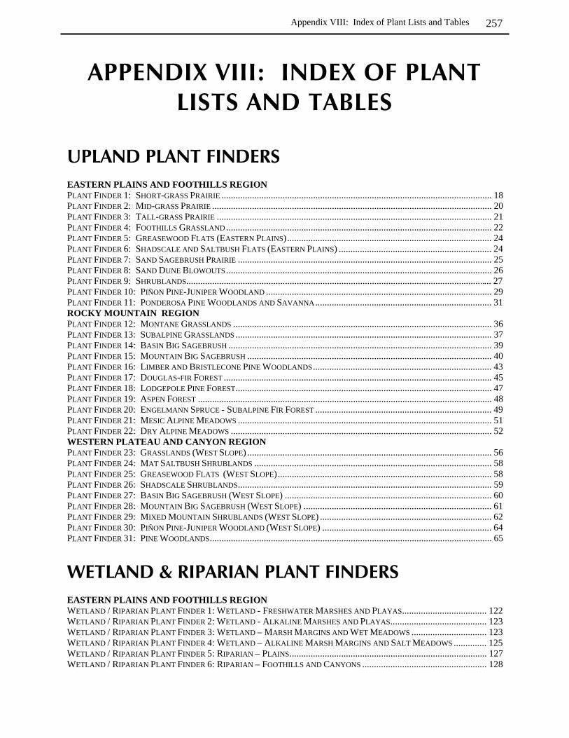
Appendix VIII: Index of Plant Lists and Tables 257
���������$������������'����� ��� ������ �����
����������� �'������
EASTERN PLAINS AND FOOTHILLS REGIONPLANT FINDER 1: SHORT-GRASS PRAIRIE ................................................................................................................... 18PLANT FINDER 2: MID-GRASS PRAIRIE ....................................................................................................................... 20PLANT FINDER 3: TALL -GRASS PRAIRIE ..................................................................................................................... 21PLANT FINDER 4: FOOTHILLS GRASSLAND................................................................................................................. 22PLANT FINDER 5: GREASEWOOD FLATS (EASTERN PLAINS)....................................................................................... 24PLANT FINDER 6: SHADSCALE AND SALTBUSH FLATS (EASTERN PLAINS) ................................................................. 24PLANT FINDER 7: SAND SAGEBRUSH PRAIRIE ............................................................................................................ 25PLANT FINDER 8: SAND DUNE BLOWOUTS................................................................................................................. 26PLANT FINDER 9: SHRUBLANDS.................................................................................................................................. 27PLANT FINDER 10: PIÑON PINE-JUNIPER WOODLAND ................................................................................................ 29PLANT FINDER 11: PONDEROSA PINE WOODLANDS AND SAVANNA ........................................................................... 31ROCKY MOUNTAIN REGIONPLANT FINDER 12: MONTANE GRASSLANDS.............................................................................................................. 36PLANT FINDER 13: SUBALPINE GRASSLANDS............................................................................................................. 37PLANT FINDER 14: BASIN BIG SAGEBRUSH................................................................................................................ 39PLANT FINDER 15: MOUNTAIN BIG SAGEBRUSH........................................................................................................ 40PLANT FINDER 16: LIMBER AND BRISTLECONE PINE WOODLANDS............................................................................ 43PLANT FINDER 17: DOUGLAS-FIR FOREST.................................................................................................................. 45PLANT FINDER 18: LODGEPOLE PINE FOREST............................................................................................................. 47PLANT FINDER 19: ASPEN FOREST............................................................................................................................. 48PLANT FINDER 20: ENGELMANN SPRUCE - SUBALPINE FIR FOREST........................................................................... 49PLANT FINDER 21: MESIC ALPINE MEADOWS............................................................................................................ 51PLANT FINDER 22: DRY ALPINE MEADOWS............................................................................................................... 52WESTERN PLATEAU AND CANYON REGIONPLANT FINDER 23: GRASSLANDS (WEST SLOPE) ........................................................................................................ 56PLANT FINDER 24: MAT SALTBUSH SHRUBLANDS ..................................................................................................... 58PLANT FINDER 25: GREASEWOOD FLATS (WEST SLOPE)........................................................................................... 58PLANT FINDER 26: SHADSCALE SHRUBLANDS............................................................................................................ 59PLANT FINDER 27: BASIN BIG SAGEBRUSH (WEST SLOPE) ........................................................................................ 60PLANT FINDER 28: MOUNTAIN BIG SAGEBRUSH (WEST SLOPE) ................................................................................ 61PLANT FINDER 29: MIXED MOUNTAIN SHRUBLANDS (WEST SLOPE) ......................................................................... 62PLANT FINDER 30: PIÑON PINE-JUNIPER WOODLAND (WEST SLOPE) ........................................................................ 64PLANT FINDER 31: PINE WOODLANDS........................................................................................................................ 65
� �����9�������������� �'������
EASTERN PLAINS AND FOOTHILLS REGIONWETLAND / RIPARIAN PLANT FINDER 1: WETLAND - FRESHWATER MARSHES AND PLAYAS.................................... 122WETLAND / RIPARIAN PLANT FINDER 2: WETLAND - ALKALINE MARSHES AND PLAYAS......................................... 123WETLAND / RIPARIAN PLANT FINDER 3: WETLAND – MARSH MARGINS AND WET MEADOWS................................ 123WETLAND / RIPARIAN PLANT FINDER 4: WETLAND – ALKALINE MARSH MARGINS AND SALT MEADOWS.............. 125WETLAND / RIPARIAN PLANT FINDER 5: RIPARIAN – PLAINS.................................................................................... 127WETLAND / RIPARIAN PLANT FINDER 6: RIPARIAN – FOOTHILLS AND CANYONS..................................................... 128

Appendix VIII: Index of Plant Lists and Tables 258
ROCKY MOUNTAIN REGIONWETLAND / RIPARIAN PLANT FINDER 7: WETLAND - FRESHWATER MARSHES AND PLAYAS.................................... 131WETLAND / RIPARIAN PLANT FINDER 8: WETLAND - ALKALINE MARSHES AND PLAYAS......................................... 132WETLAND / RIPARIAN PLANT FINDER 9: WETLAND – MONTANE AND SUBALPINE WET MEADOWS......................... 133WETLAND / RIPARIAN PLANT FINDER 10: WETLAND- MONTANE AND SUBALPINE SALT MEADOWS........................ 134WETLAND / RIPARIAN PLANT FINDER 11: WETLAND- ALPINE SNOW GLADES ......................................................... 137WETLAND / RIPARIAN PLANT FINDER 12: WETLAND- ALPINE WET MEADOWS........................................................ 137WETLAND / RIPARIAN PLANT FINDER 13: RIPARIAN – WILLOW CARRS................................................................... 140WETLAND / RIPARIAN PLANT FINDER 14: RIPARIAN – MONTANE AND SUBALPINE FORESTS................................... 142WETLAND / RIPARIAN PLANT FINDER 15: RIPARIAN- ALPINE RIPARIAN COMMUNITIES........................................... 144WESTERN PLATEAU AND CANYON REGIONWETLAND / RIPARIAN PLANT FINDER 16: WETLAND - FRESHWATER MARSHES....................................................... 146WETLAND / RIPARIAN PLANT FINDER 17: WETLAND - ALKALINE MARSHES............................................................ 146WETLAND / RIPARIAN PLANT FINDER 18: WETLAND – MARSH MARGINS AND WET MEADOWS.............................. 147WETLAND / RIPARIAN PLANT FINDER 19: WETLAND – ALKALINE MARSH MARGINS AND SALT MEADOWS............ 148WETLAND / RIPARIAN PLANT FINDER 20: RIPARIAN – FLOODPLAINS AND TERRACES.............................................. 150WETLAND / RIPARIAN PLANT FINDER 21: RIPARIAN – FOOTHILLS AND CANYONS................................................... 151
� ���� �����
TABLE 1: SOIL PROPERTIES DEPENDENT UPON PARTICLE SIZE................................................................................... 70TABLE 2: CRITERIA TO ESTABLISH SUITABILITY OF TOPSOIL..................................................................................... 73TABLE 3: GENERAL GRASS SEED STANDARDS FOR COLORADO.................................................................................. 86TABLE 4: BAREROOT VS CONTAINERIZED PLANTING STOCK....................................................................................... 96TABLE 5: RECOMMENDED PLANTING DENSITIES FOR ACHIEVING UNIFORM COVERAGE.......................................... 177TABLE 6: CALCULATION OF THE REQUIRED NUMBER OF PLANTS TO ACHIEVE DESIRED DENSITY ........................... 178TABLE 7: MINIMUM SIZES OF SPADE MACHINE......................................................................................................... 179TABLE 8: PLANT MATERIALS: WHEN TO PLANT AND RELATIVE SURVIVAL RATES .................................................. 184
TABLE A1: UPLAND PLANT CHARACTERISTICS - GRAMINOIDS................................................................................ 197TABLE A2: UPLAND PLANT CHARACTERISTICS - FORBS.......................................................................................... 205TABLE A3: UPLAND PLANT CHARACTERISTICS - TREES AND SHRUBS..................................................................... 213TABLE A4: WETLAND/RIPARIAN PLANT CHARACTERISTICS, COMMON SPECIES - HERBACEOUS............................. 223TABLE A5: WETLAND/RIPARIAN PLANT CHARACTERISTICS, COMMON SPECIES - WOODY ..................................... 226TABLE A6: COLORADO PROHIBITED WEED SEEDS................................................................................................... 227TABLE A7: COLORADO RESTRICTED NOXIOUS WEED SEEDS................................................................................... 228TABLE A8: COLORADO PLANT MATERIAL VENDORS............................................................................................... 241TABLE A9: IDAHO PLANT MATERIAL VENDORS....................................................................................................... 242TABLE A10: KANSAS PLANT MATERIAL VENDORS.................................................................................................. 245TABLE A11: MONTANA PLANT MATERIAL VENDORS.............................................................................................. 245TABLE A12: NEBRASKA PLANT MATERIAL VENDORS.............................................................................................. 248TABLE A13: NEW MEXICO PLANT MATERIAL VENDORS......................................................................................... 249TABLE A14: NORTH DAKOTA PLANT MATERIAL VENDORS..................................................................................... 250TABLE A15: SOUTH DAKOTA PLANT MATERIAL VENDORS..................................................................................... 250TABLE A16: UTAH PLANT MATERIAL VENDORS...................................................................................................... 251TABLE A17: WYOMING PLANT MATERIAL VENDORS.............................................................................................. 251