Embed Size (px)
DESCRIPTION
In dense cities, it is very important for people to stay connected with the immediate environment as it provides opportunities to develop a connection between the social infrastructure and natural resources. This project uses water as a medium to rejuvenate this neighborhood by uncovering the process of collection and dispersion of water to create awareness about major water problems. It alleviates insufficient water supply for individual citizen by harvesting and cleaning rain water and also recharging the aquifer on a bigger scale.
Citation preview
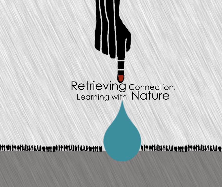
Retrieving Connection:Learning with Nature

Copyright @ Jinal Sampat 2012
Rhode Island School Of Design

Approved by Masters Examination Committee:
Scheri Fultineer, Interim Department Head, Landscape Architecture
Michael Blier, Adjunct Professor of Landscape Architecture, Primary Thesis Advisor
Nadine Gerdts, Adjunct Professor of Landscape Architecture, Secondary Thesis Advisor
James Heroux, Visiting Critic, Secondary Thesis Advisor
Retrieving Connection:
Learning with Nature
A thesis presented in partial fulfillment of the degree Master of Landscape Architecture in the Department of Landscape Architecture of the
Rhode Island School of Design, Providence, RI
ByJinal Sampat
2012

Acknowledgments
I would never have been able to finish my dissertation without the guidance of my professors, help from friends, and support from my family.
I would like to express the deepest appreciation to some of my professors that guided me throughout this Thesis. Michael Blier, who always believed in my ideas and motivated me to trust my gut throughout the design process, he continually and convincingly conveyed a spirit of excitement in regards to teaching. Professor Nadine Gerdts, who has a very cheerful and straightforward attitude for our projects. James Heroux for his excellent guidance, caring and patient attitude.
One of my favorite professors, Scheri Fultineer who has been such a wonderful teacher throughout my experience at RISD. I never said this but I can never forget all the feedback I used to get from Scheri and I promise to take all the lessons I learned from her into the professional career.
Last but not the least Colgate Searle who has always been such an amazing person to have worked with. Genius in terms of teaching us the concepts of Landscape Architecture. He really cared for us throughout our time here which made the entire experience very special.
I would also like to thank my friend Prerna Thackar who helped me collect all the site analysis data as it would have been very difficult to get information and picture of Mumbai while being here in Providence.
Finally I would like to thank my husband, Kunal Sampat. He encouraged me to get my Masters Degree and was always there cheering me up and stood by me through good times and bad.

Contents 12
3
4
5
6
789
10
11
Why this ThesisTestsPrecedents-HighWaterLine - Kroon Hall, Yale University
-Jodhpur, water collection system- Srigaverapura, Ganga, Flood -Over flow cleaning system- Ladakh water Reservoirs
Glossary of Terms 1
2 - 3
3 - 4
6 - 13
14 - 39
40 - 41
42 - 43
43 - 44
46 -69
70- 71
72 - 73
Abstract
Statement
Introduction
Site
Historic Precedents
Program
Process Drawings
Proposal
Conclusion
Resources
Selection criteriaAnalysis- History- History : Water in Mumbai- History Chembur- Chembur Gaothan- Existing street typologies- Major Gathering spaces- Existing Building Typologies- Existing Wells- Site sections
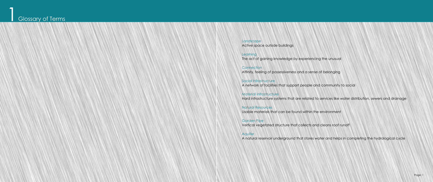
Glossary of Terms1LandscapeActive space outside buildings
LearningThe act of gaining knowledge by experiencing the unusual
Connection Affinity, feeling of possessiveness and a sense of belonging
Social InfrastructureA network of facilities that support people and community to social
Material infrastructureHard infrastructure systems that are related to services like water distribution, sewers and drainage
Natural ResourcesUsable materials that can be found within the environment
Garden PipeVertical vegetated structure that collects and cleans roof runoff
AquiferA natural reservoir underground that stores water and helps in completing the hydrological cycle
Page: 1

Statement2In densely populated cities, it is important for people to couple with their immediate environment as it provides opportunities to develop a connection between culture and nature. Uncovering the value of natural processes will foster awareness about major problems and re-integrate people with the environment around them in a sustainable way.
Page: 2 Page: 3

Abstract3There is a general cry about the lack of intimate experiences with nature in the urban lifestyle. It is also believed that in childhood we have attachments to the place we grew up in and carry the lessons we learned from it for the remainder of our lives. This thesis activates the medium of Landscape to develop a connection between the social and natural infrastructure. The goal is also to make the communities aware about the major problems such scarcity of water.
Nature experiences are needed for their therapeutic values and as a key stone in building ecological literacy. A recent national study indicates being engaged in the immediate natural environment enhances people attitude and performance. The result of this thesis uses water as a medium to demonstrate how important it is to reveal and connect the existing social, cultural and natural flows to create awareness about the importance of nature.
Page: 4 Page: 5
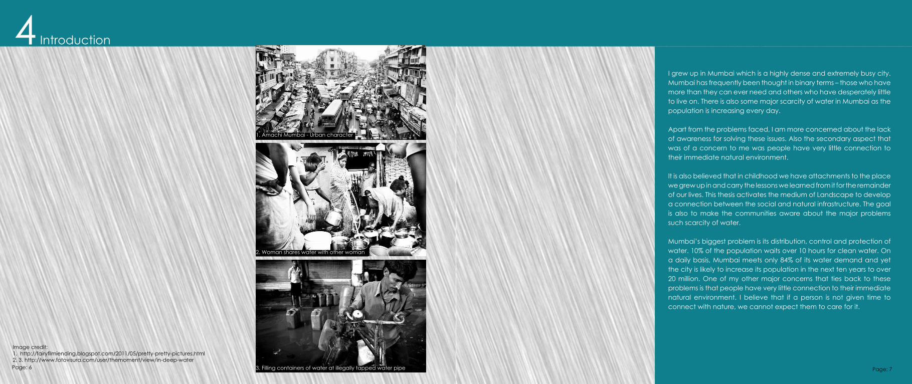
Image credit:1. http://fairyfilmiending.blogspot.com/2011/05/pretty-pretty-pictures.html2, 3. http://www.fotovisura.com/user/themoment/view/in-deep-water
1. Amachi Mumbai - Urban character
2. Woman shares water with other woman
3. Filling containers of water at illegally tapped water pipe
Introduction4I grew up in Mumbai which is a highly dense and extremely busy city. Mumbai has frequently been thought in binary terms – those who have more than they can ever need and others who have desperately little to live on. There is also some major scarcity of water in Mumbai as the population is increasing every day. Apart from the problems faced, I am more concerned about the lack of awareness for solving these issues. Also the secondary aspect that was of a concern to me was people have very little connection to their immediate natural environment.
It is also believed that in childhood we have attachments to the place we grew up in and carry the lessons we learned from it for the remainder of our lives. This thesis activates the medium of Landscape to develop a connection between the social and natural infrastructure. The goal is also to make the communities aware about the major problems such scarcity of water.
Mumbai’s biggest problem is its distribution, control and protection of water. 10% of the population waits over 10 hours for clean water. On a daily basis, Mumbai meets only 84% of its water demand and yet the city is likely to increase its population in the next ten years to over 20 million. One of my other major concerns that ties back to these problems is that people have very little connection to their immediate natural environment. I believe that if a person is not given time to connect with nature, we cannot expect them to care for it.
Page: 6 Page: 7
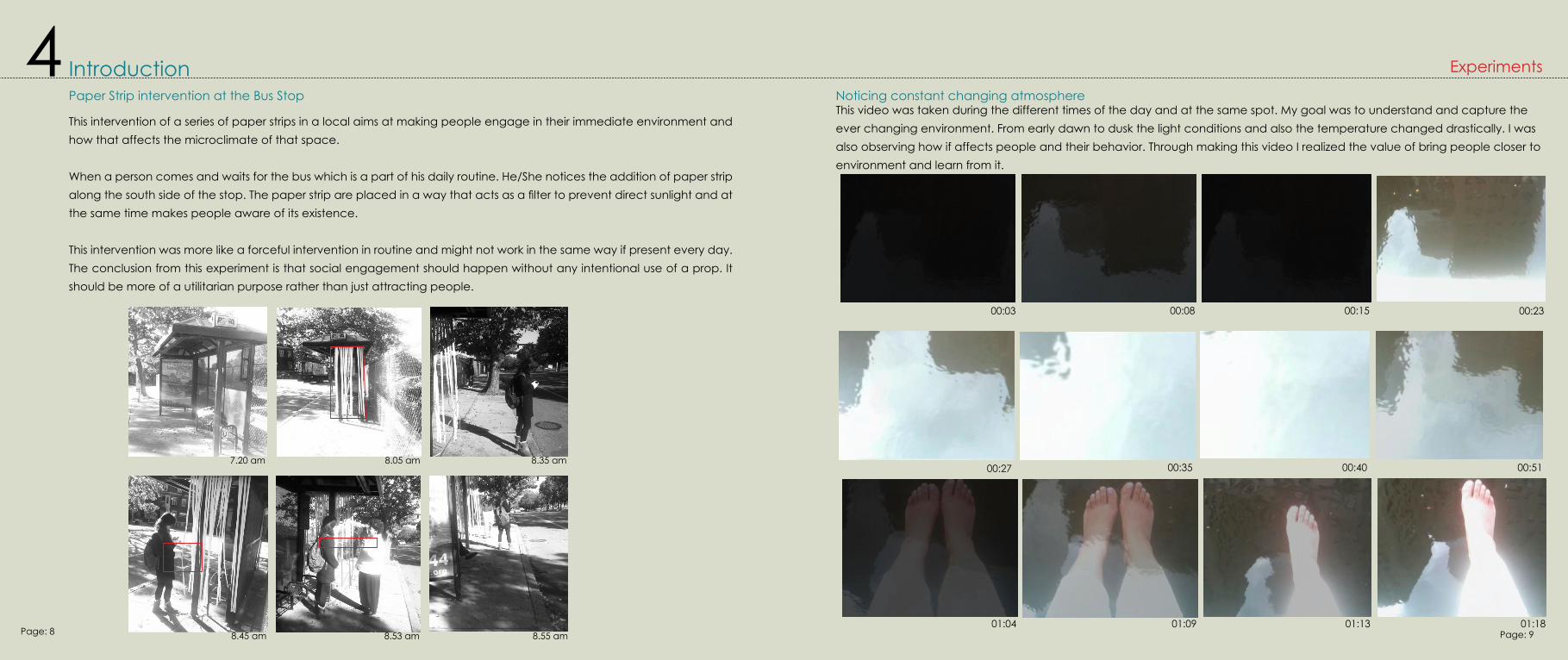
Paper Strip intervention at the Bus Stop
This intervention of a series of paper strips in a local aims at making people engage in their immediate environment and how that affects the microclimate of that space.
When a person comes and waits for the bus which is a part of his daily routine. He/She notices the addition of paper strip along the south side of the stop. The paper strip are placed in a way that acts as a filter to prevent direct sunlight and at the same time makes people aware of its existence.
This intervention was more like a forceful intervention in routine and might not work in the same way if present every day.The conclusion from this experiment is that social engagement should happen without any intentional use of a prop. It should be more of a utilitarian purpose rather than just attracting people.
7.20 am 8.05 am 8.35 am
8.45 am 8.53 am 8.55 am
Introduction 4This video was taken during the different times of the day and at the same spot. My goal was to understand and capture the ever changing environment. From early dawn to dusk the light conditions and also the temperature changed drastically. I was also observing how if affects people and their behavior. Through making this video I realized the value of bring people closer to environment and learn from it.
Noticing constant changing atmosphere
Experiments
00:03 00:08 00:15 00:23
00:27 00:35 00:40 00:51
01:04 01:09 01:13 01:18Page: 8 Page: 9
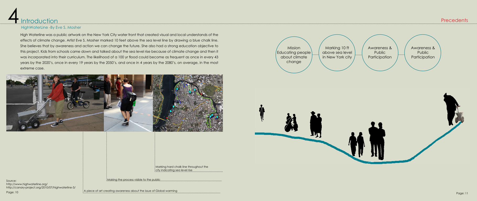
Introduction 4HighWaterLine -By Eve S. Mosher
High Waterline was a public artwork on the New York City water front that created visual and local understands of the effects of climate change. Artist Eve S. Mosher marked 10 feet above the sea level line by drawing a blue chalk line. She believes that by awareness and action we can change the future. She also had a strong education objective to this project. Kids from schools came down and talked about the sea level rise because of climate change and then it was incorporated into their curriculum. The likelihood of a 100 yr flood could become as frequent as once in every 43 years by the 2020’s, once in every 19 years by the 2050’s, and once in 4 years by the 2080’s, on average, in the most extreme case.
Source:http://www.highwaterline.org/http://canary-project.org/2010/07/highwaterline-3/
Marking hard chalk line throughout the city indicating sea level rise
Making the process visible to the public
A piece of art creating awareness about the issue of Global warming
Precedents
MissionEducating people
about climate change
Marking 10 ft above sea levelin New York city
Awareness & Public
Participation
Awareness & Public
Participation
Page: 10 Page: 11
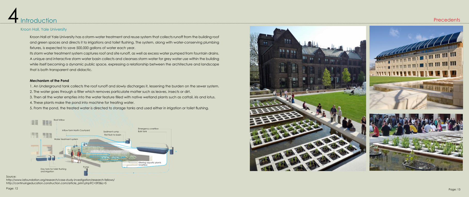
Kroon Hall, Yale University
Source:http://www.lafoundation.org/research/case-study-investigation/research-fellows/http://continuingeducation.construction.com/article_print.php?C=593&L=5
Introduction 4
Roof Inflow
Inflow form North Courtyard
Water treatment system
Day tank for toilet flushing and irrigation
PumpOverflowFiltering aquatic plants
Emergency overflowSediment sumpFirst flush to basin
Bulk tank
Kroon Hall at Yale University has a storm-water treatment and reuse system that collects runoff from the building roof and green spaces and directs it to irrigations and toilet flushing. The system, along with water-conserving plumbing fixtures, is expected to save 500,000 gallons of water each year.Its storm water treatment system captures roof and site runoff, as well as excess water pumped from fountain drains. A unique and interactive storm water basin collects and cleanses storm water for grey water use within the building while itself becoming a dynamic public space, expressing a relationship between the architecture and landscape that is both transparent and didactic.
Mechanism of the Pond1. An Underground tank collects the roof runoff and slowly discharges it, lessening the burden on the sewer system.2. The water goes through a filter which removes particulate matter such as leaves, insects or dirt.3. Then all the water empties into the water feature filled with native wetland plants such as cattail, iris and lotus.4. These plants make the pond into machine for treating water.5. From the pond, the treated water is directed to storage tanks and used either in irrigation or toilet flushing.
Precedents
Page: 12 Page: 13
Site5India
India is a country in south east of Asia and is the seventh largest country. Indus valley civilization was started in India and is home to a region of historic trade routes and vast empires. It was identified with its commercial and cultural wealth for its long history.
The nation is largely subject to four seasons: winter (January and February), summer (March to May), a monsoon (rainy) season (June to September), and a post-monsoon period (October to December).
Culture:The culture of India refers to the religions, beliefs, customs, traditions, languages, ceremonies, arts, values and the way of life in India and its people. India’s languages, religions, dance, music, architecture, food, and customs differ from place to place within the country. Its culture often labeled as an amalgamation of these diverse sub-cultures is spread all over the Indian subcontinent and traditions that are several millennia old.
Mumbai
Mumbai, formerly known as Bombay is the capital of the Indian State of Maharashtra. It is the most populous city in India. Mumbai lies on the west coast of India and has a deep natural harbor. It is built on what was once an archipelago of seven islands: Bombay Island, Parel, Mazagaon, Mahim, Colaba, Worli, and Old Woman’s Island (also known as Little Colaba). The islands were under the control of successive indigenous empires before being ceded to the Portuguese and subsequently to the British East India Company.
Mumbai has a tropical climate, specifically a tropical wet and dry climate. The cooler season from December to February is followed by the summer season from March to June. The period from June to about the end of September constitutes the south-west monsoon season, and October and November form the post-monsoon season.
Source:http://en.wikipedia.org/wiki/Culture_of_Indiahttp://en.wikipedia.org/wiki/India
Chembur
Chembur Gaothan
Legend
River
Chembur boundary
Highways
Mumbai geographic boundary
SitePage: 14 Page: 15
Page: 16 Page: 17
Site 5
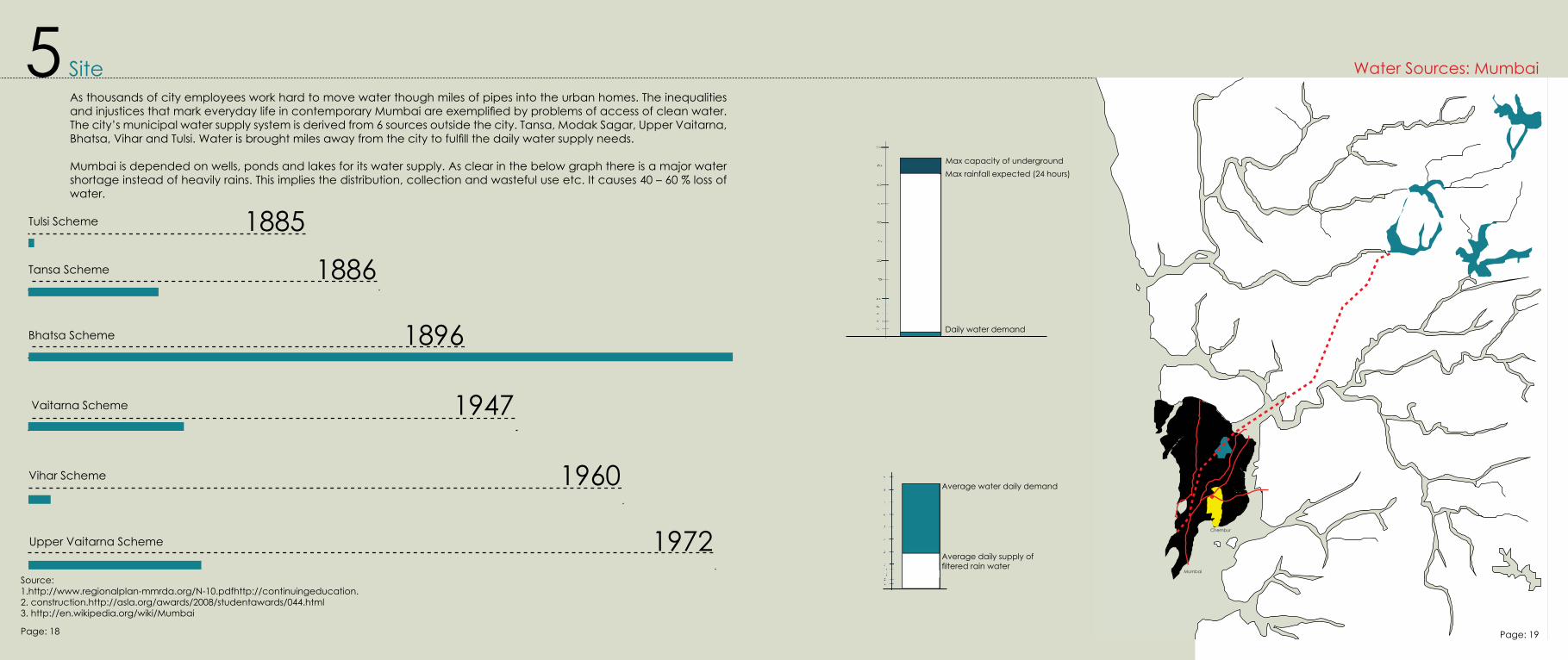
1885Tulsi Scheme
1886Tansa Scheme
1896Bhatsa Scheme
1947Vaitarna Scheme
1960Vihar Scheme
1972Upper Vaitarna Scheme
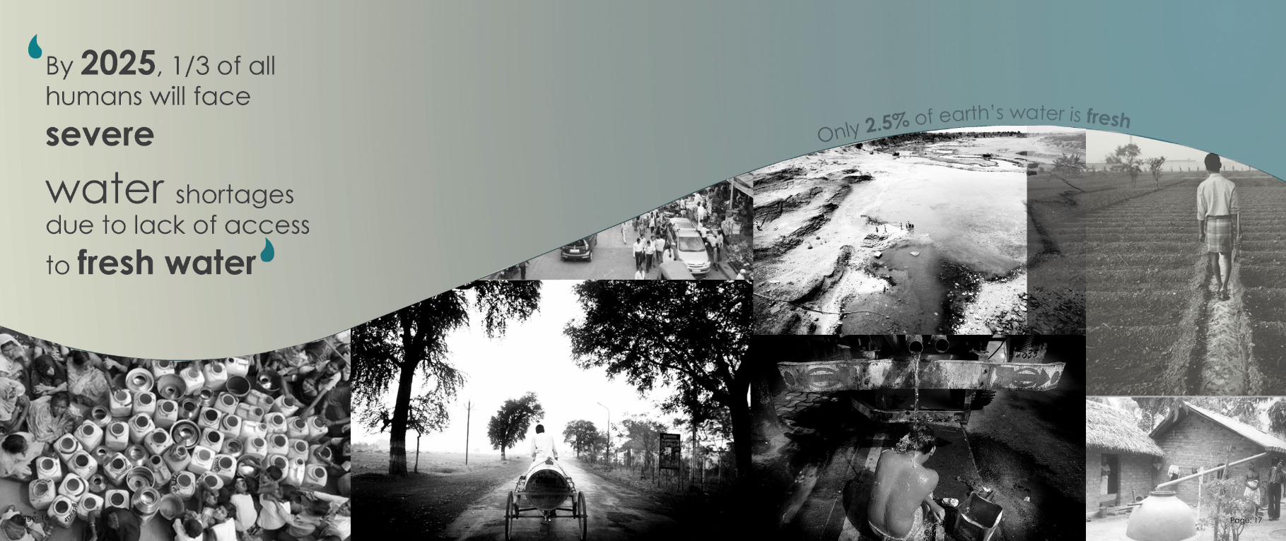
As thousands of city employees work hard to move water though miles of pipes into the urban homes. The inequalities and injustices that mark everyday life in contemporary Mumbai are exemplified by problems of access of clean water. The city’s municipal water supply system is derived from 6 sources outside the city. Tansa, Modak Sagar, Upper Vaitarna, Bhatsa, Vihar and Tulsi. Water is brought miles away from the city to fulfill the daily water supply needs.
Mumbai is depended on wells, ponds and lakes for its water supply. As clear in the below graph there is a major water shortage instead of heavily rains. This implies the distribution, collection and wasteful use etc. It causes 40 – 60 % loss of water.
Water Sources: Mumbai
Mumbai
Chembur
Max capacity of underground Max rainfall expected (24 hours)
Daily water demand
Average water daily demand
Average daily supply of filtered rain water
Source:1.http://www.regionalplan-mmrda.org/N-10.pdfhttp://continuingeducation.2. construction.http://asla.org/awards/2008/studentawards/044.html3. http://en.wikipedia.org/wiki/Mumbai
Page: 18 Page: 19
Credit:Prerna Thakkar: Thesis B.arch, 2011Reinventing the Contemporary Gaothan - Redefining RedevelopmentAcademy of Architecture, Rachna Sansad, Mumbai
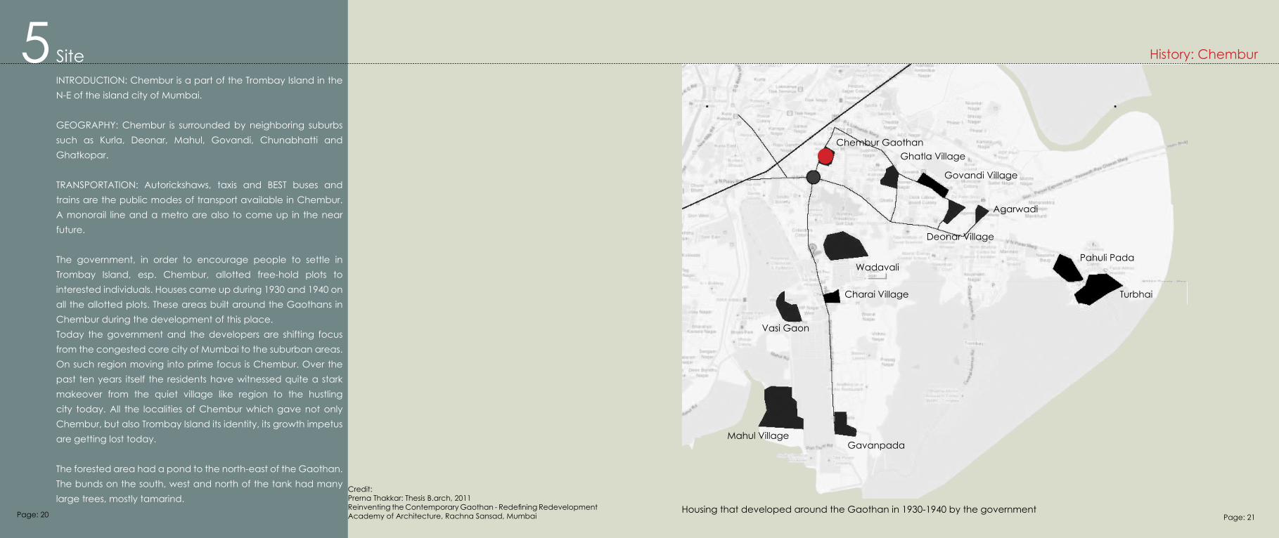
INTRODUCTION: Chembur is a part of the Trombay Island in the N-E of the island city of Mumbai.
GEOGRAPHY: Chembur is surrounded by neighboring suburbs such as Kurla, Deonar, Mahul, Govandi, Chunabhatti and Ghatkopar.
TRANSPORTATION: Autorickshaws, taxis and BEST buses and trains are the public modes of transport available in Chembur. A monorail line and a metro are also to come up in the near future.
The government, in order to encourage people to settle in Trombay Island, esp. Chembur, allotted free-hold plots to interested individuals. Houses came up during 1930 and 1940 on all the allotted plots. These areas built around the Gaothans in Chembur during the development of this place.Today the government and the developers are shifting focus from the congested core city of Mumbai to the suburban areas. On such region moving into prime focus is Chembur. Over the past ten years itself the residents have witnessed quite a stark makeover from the quiet village like region to the hustling city today. All the localities of Chembur which gave not only Chembur, but also Trombay Island its identity, its growth impetus are getting lost today.
The forested area had a pond to the north-east of the Gaothan. The bunds on the south, west and north of the tank had many large trees, mostly tamarind.
History: Chembur
Chembur GaothanGhatla Village
Govandi Village
Agarwadi
Deonar Village
Pahuli Pada
Turbhai
Wadavali
Charai Village
Vasi Gaon
Mahul VillageGavanpada
Housing that developed around the Gaothan in 1930-1940 by the government
Site 5
Page: 20 Page: 21
Credit:Prerna Thakkar: Thesis B.arch, 2011Reinventing the Contemporary Gaothan - Redefining RedevelopmentAcademy of Architecture, Rachna Sansad, Mumbai
http://www.mid-day.com/news/2010/oct/281010-BMC-lifeguards-swimming-pools-Chembur-water-shortage.htm
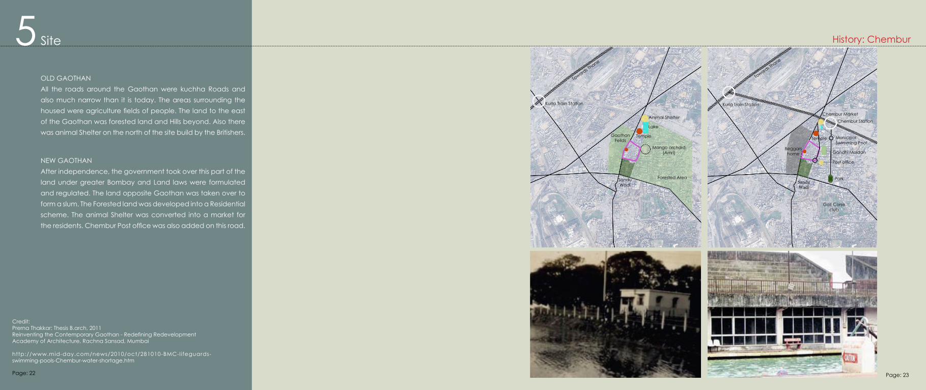
OLD GAOTHANAll the roads around the Gaothan were kuchha Roads and also much narrow than it is today. The areas surrounding the housed were agriculture fields of people. The land to the east of the Gaothan was forested land and Hills beyond. Also there was animal Shelter on the north of the site build by the Britishers.
NEW GAOTHANAfter independence, the government took over this part of the land under greater Bombay and Land laws were formulated and regulated. The land opposite Gaothan was taken over to form a slum. The Forested land was developed into a Residential scheme. The animal Shelter was converted into a market for the residents. Chembur Post office was also added on this road.
Site 5Towards Th
ane
Kurla Train Station
Animal Shelter
Forested Area
Mango orchard (Amri)
Temple
Lake
Gaothan Feilds
Sandu Wadi
Towards Thane
Kurla Train Station
Chembur Station
Municipal Swimming Pool
Chembur Market
Temple
Gandhi MaidanBeggars home
Sandu Wadi
Post office
Park
Golf Corse club
History: Chembur
Page: 22 Page: 23
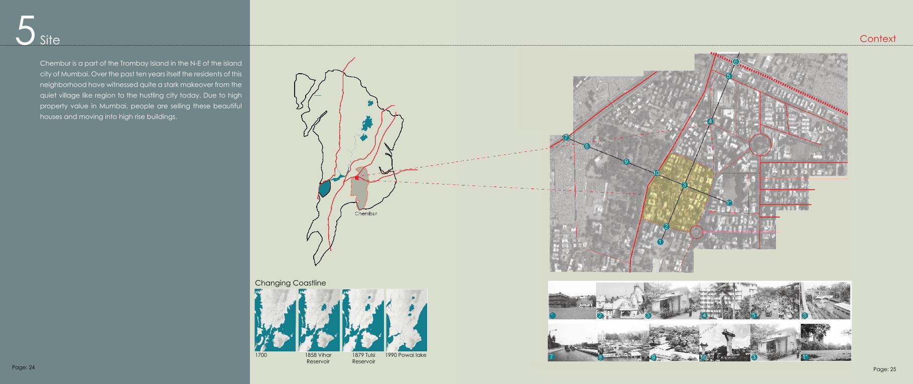
Site 5Chembur is a part of the Trombay Island in the N-E of the island city of Mumbai. Over the past ten years itself the residents of this neighborhood have witnessed quite a stark makeover from the quiet village like region to the hustling city today. Due to high property value in Mumbai, people are selling these beautiful houses and moving into high rise buildings.
Context
Changing Coastline
1700 1858 Vihar Reservoir
1879 Tulsi Reservoir
1990 Powai lake
Page: 24 Page: 25

Chembur Gaothan is one of the original villages established over three hundred years ago. The oldest in the three sub precincts glimpses of old Chembur village are still found in the Gaothan area. Mumbai is urbanized and a very fast city but Gaothan is a very quiet and peaceful place in Chembur. In Gaothan area, there are beautiful and small houses as an ancestral property.
Chembur Gaothan lies to the southeast of Chembur station, about 5 minutes away. The center portion of the Gaothan is the wadis and the portion further east is the upper Gaothan and the portion to the west the lower Gaothan.
The Gaothan lies between the Ghatkopar-Mahul link road (where the metro is coming up) and the D.K Sanghvi marg. The Ghatkopar Mahul link road (R.C marg) was very important for the residents of Chembur right from the start. It was one of the only two accessible roads Chembur (then forest land) in the 19th century, 8 to 9 feet wide with creek land (khadi) on both sides.
5 Site Analysis: Chembur Gaothan
Gaothan Boundry
Ground floor structures
Gaothan Boundry
Under construction
1 Floor + Pitched roof
2 Flooors + Pitched Roof
2 Floors Flat roof
2- 5 Floors
6- 1 2 Floors
Credit:Prerna Thakkar: Thesis B.arch, 2011Reinventing the Contemporary Gaothan - Redefining RedevelopmentAcademy of Architecture, Rachna Sansad, Mumbai
Page: 26 Page: 27
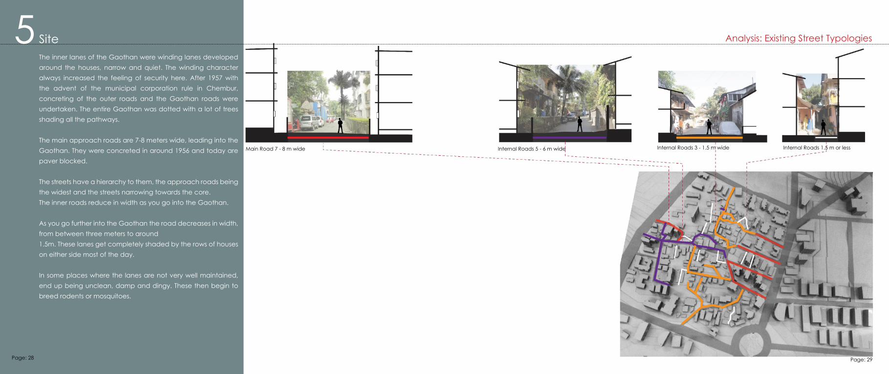
5 Site The inner lanes of the Gaothan were winding lanes developed around the houses, narrow and quiet. The winding character always increased the feeling of security here. After 1957 with the advent of the municipal corporation rule in Chembur, concreting of the outer roads and the Gaothan roads were undertaken. The entire Gaothan was dotted with a lot of trees shading all the pathways.
The main approach roads are 7-8 meters wide, leading into the Gaothan. They were concreted in around 1956 and today are paver blocked.
The streets have a hierarchy to them, the approach roads being the widest and the streets narrowing towards the core.The inner roads reduce in width as you go into the Gaothan.
As you go further into the Gaothan the road decreases in width, from between three meters to around1.5m. These lanes get completely shaded by the rows of houses on either side most of the day.
In some places where the lanes are not very well maintained, end up being unclean, damp and dingy. These then begin to breed rodents or mosquitoes.
Analysis: Existing Street Typologies
Main Road 7 - 8 m wide Internal Roads 5 - 6 m wide Internal Roads 3 - 1.5 m wide Internal Roads 1.5 m or less
Page: 28 Page: 29
5 Site Analysis: Major Gathering Spaces
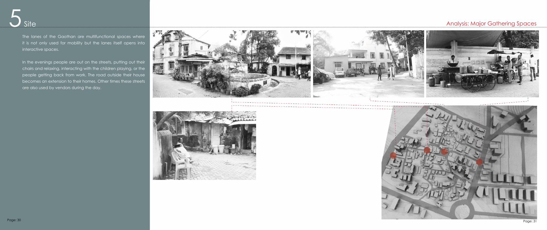
The lanes of the Gaothan are multifunctional spaces where it is not only used for mobility but the lanes itself opens into interactive spaces.
In the evenings people are out on the streets, putting out their chairs and relaxing, interacting with the children playing, or the people getting back from work. The road outside their house becomes an extension to their homes. Other times these streets are also used by vendors during the day.
Page: 30 Page: 31
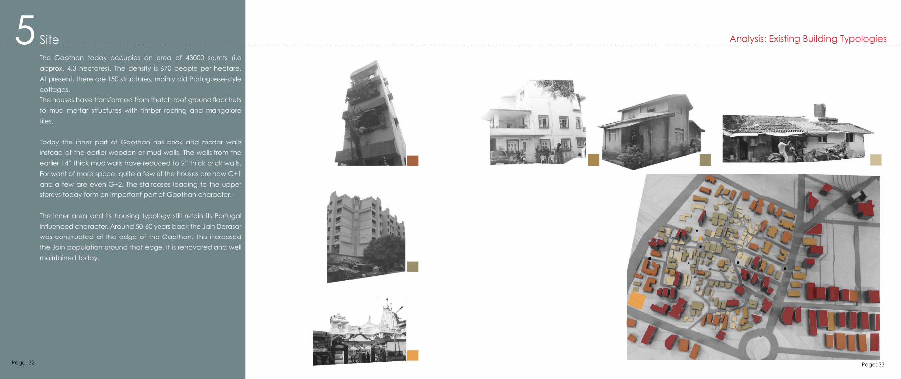
5 Site The Gaothan today occupies an area of 43000 sq.mts (i.e approx. 4.3 hectares). The density is 670 people per hectare. At present, there are 150 structures, mainly old Portuguese-style cottages. The houses have transformed from thatch roof ground floor huts to mud mortar structures with timber roofing and mangalore tiles.
Today the inner part of Gaothan has brick and mortar walls instead of the earlier wooden or mud walls. The walls from the earlier 14” thick mud walls have reduced to 9” thick brick walls. For want of more space, quite a few of the houses are now G+1 and a few are even G+2. The staircases leading to the upper storeys today form an important part of Gaothan character.
The inner area and its housing typology still retain its Portugal influenced character. Around 50-60 years back the Jain Derasar was constructed at the edge of the Gaothan. This increased the Jain population around that edge. It is renovated and well maintained today.
Analysis: Existing Building Typologies
Page: 32 Page: 33
5 Site
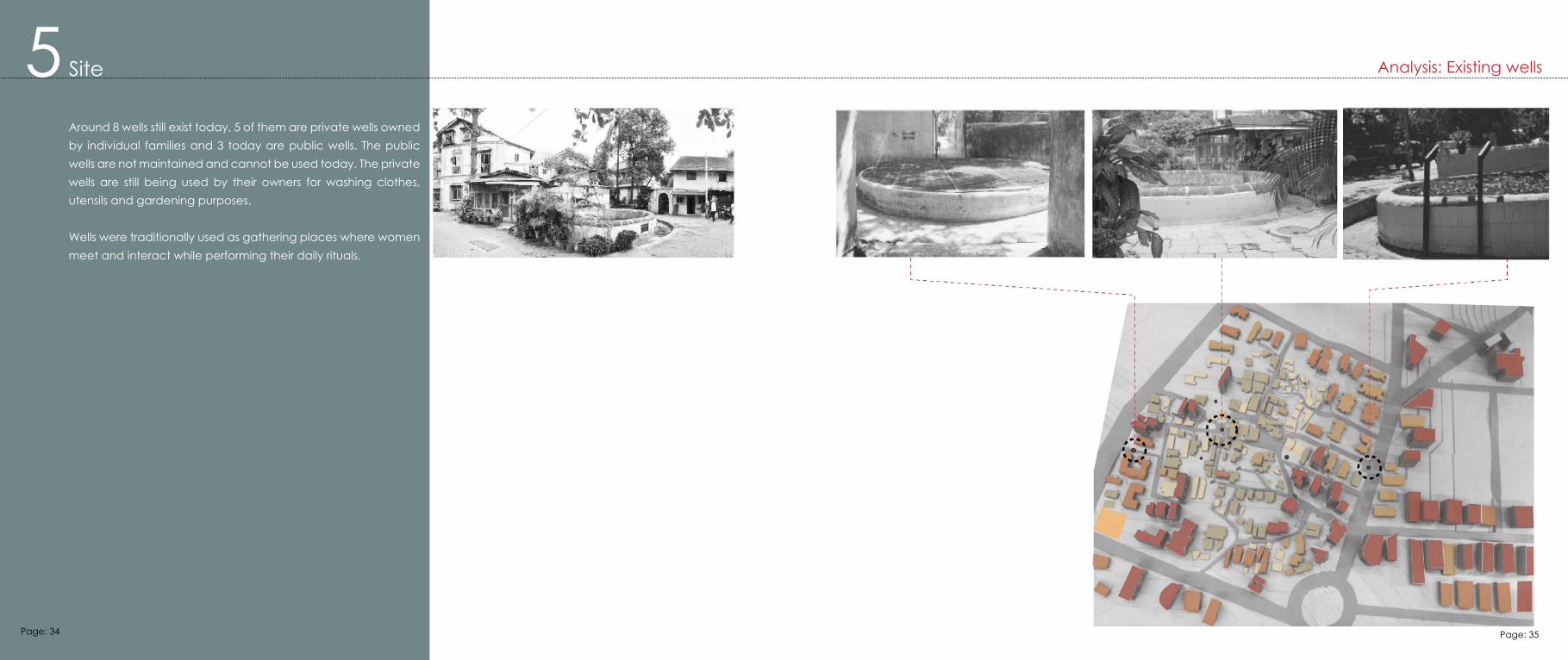
Around 8 wells still exist today, 5 of them are private wells owned by individual families and 3 today are public wells. The public wells are not maintained and cannot be used today. The private wells are still being used by their owners for washing clothes, utensils and gardening purposes.
Wells were traditionally used as gathering places where women meet and interact while performing their daily rituals.
Analysis: Existing wells
Page: 34 Page: 35
1. http://en.wikipedia.org/wiki/Holi2. http://en.wikipedia.org/wiki/Krishna_Janmashtami3. http://en.wikipedia.org/wiki/Ganesh_Chaturthi4. http://en.wikipedia.org/wiki/Navratri5. http://en.wikipedia.org/wiki/Diwali
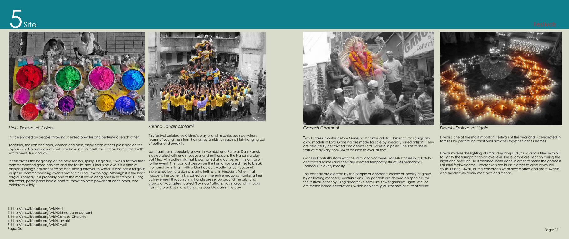
Holi - Festival of Colors
It is celebrated by people throwing scented powder and perfume at each other.
Together, the rich and poor, women and men, enjoy each other’s presence on this joyous day. No one expects polite behavior; as a result, the atmosphere is filled with excitement, fun and joy.
It celebrates the beginning of the new season, spring. Originally, it was a festival that commemorated good harvests and the fertile land. Hindus believe it is a time of enjoying spring’s abundant colors and saying farewell to winter. It also has a religious purpose, commemorating events present in Hindu mythology. Although it is the least religious holiday, it is probably one of the most exhilarating ones in existence. During this event, participants hold a bonfire, throw colored powder at each other, and celebrate wildly.
Krishna Janamashtami
This festival celebrates Krishna’s playful and mischievous side, where teams of young men form human pyramids to reach a high-hanging pot of butter and break it.
Janmaashtami, popularly known in Mumbai and Pune as Dahi Handi, is celebrated with enormous zeal and enthusiasm. The Handi is a clay pot filled with buttermilk that is positioned at a convenient height prior to the event. The topmost person on the human pyramid tries to break the handi by hitting it with a blunt object. Mostly nariyal (coconut) is preferred being a sign of purity, truth etc. in Hinduism. When that happens the buttermilk is spilled over the entire group, symbolizing their achievement through unity. Handis are set up around the city, and groups of youngsters, called Govinda Pathaks, travel around in trucks trying to break as many handis as possible during the day.
Site5 Festivals
Ganesh Chathurti
Two to three months before Ganesh Chaturthi, artistic plaster of Paris (originally clay) models of Lord Ganesha are made for sale by specially skilled artisans. They are beautifully decorated and depict Lord Ganesh in poses. The size of these statues may vary from 3/4 of an inch to over 70 feet.
Ganesh Chaturthi starts with the installation of these Ganesh statues in colorfully decorated homes and specially erected temporary structures mandapas (pandals) in every locality.
The pandals are erected by the people or a specific society or locality or group by collecting monetary contributions. The pandals are decorated specially for the festival, either by using decorative items like flower garlands, lights, etc. or are theme based decorations, which depict religious themes or current events.
DIwali - Fesitval of Lights
Diwali is one of the most important festivals of the year and is celebrated in families by performing traditional activities together in their homes.
Diwali involves the lighting of small clay lamps (diyas or dīpas) filled with oil to signify the triumph of good over evil. These lamps are kept on during the night and one’s house is cleaned, both done in order to make the goddess Lakshmi feel welcome. Firecrackers are burst in order to drive away evil spirits. During Diwali, all the celebrants wear new clothes and share sweets and snacks with family members and friends.
Page: 36 Page: 37
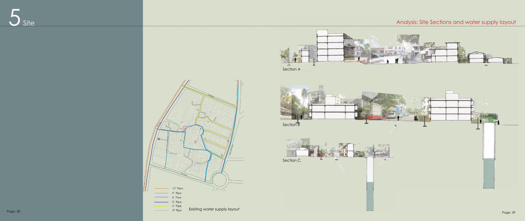
5 Site
Existing water supply layout
Analysis: Site Sections and water supply layout
Section A
Section B
Section C
A
B
C
Page: 38 Page: 39
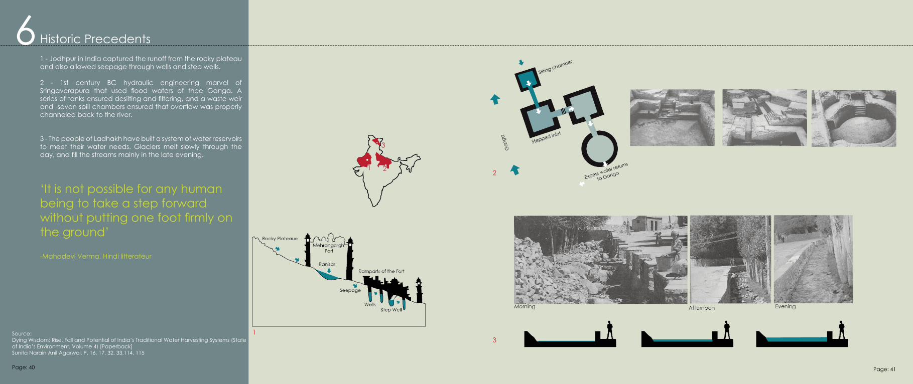
6 Historic Precedents
‘It is not possible for any human being to take a step forward without putting one foot firmly on the ground’
-Mahadevi Verma, Hindi litterateur
1 - Jodhpur in India captured the runoff from the rocky plateau and also allowed seepage through wells and step wells.
2 - 1st century BC hydraulic engineering marvel of Sringaverapura that used flood waters of thee Ganga. A series of tanks ensured desilting and filtering, and a waste weir and seven spill chambers ensured that overflow was properly channeled back to the river.
3 - The people of Ladhakh have built a system of water reservoirs to meet their water needs. Glaciers melt slowly through the day, and fill the streams mainly in the late evening.
13
2
Source:Dying Wisdom: Rise, Fall and Potential of India’s Traditional Water Harvesting Systems (State of India’s Environment, Volume 4) [Paperback]Sunita Narain Anil Agarwal. P. 16, 17, 32, 33,114, 115
Page: 40 Page: 41
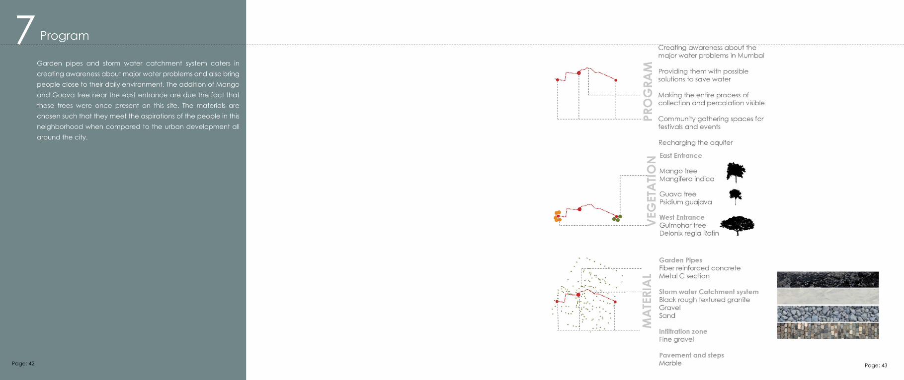
7 Program
Garden pipes and storm water catchment system caters in creating awareness about major water problems and also bring people close to their daily environment. The addition of Mango and Guava tree near the east entrance are due the fact that these trees were once present on this site. The materials are chosen such that they meet the aspirations of the people in this neighborhood when compared to the urban development all around the city.
Page: 42 Page: 43
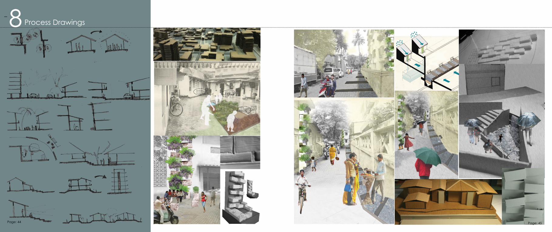
8 Process Drawings
Page: 44 Page: 45
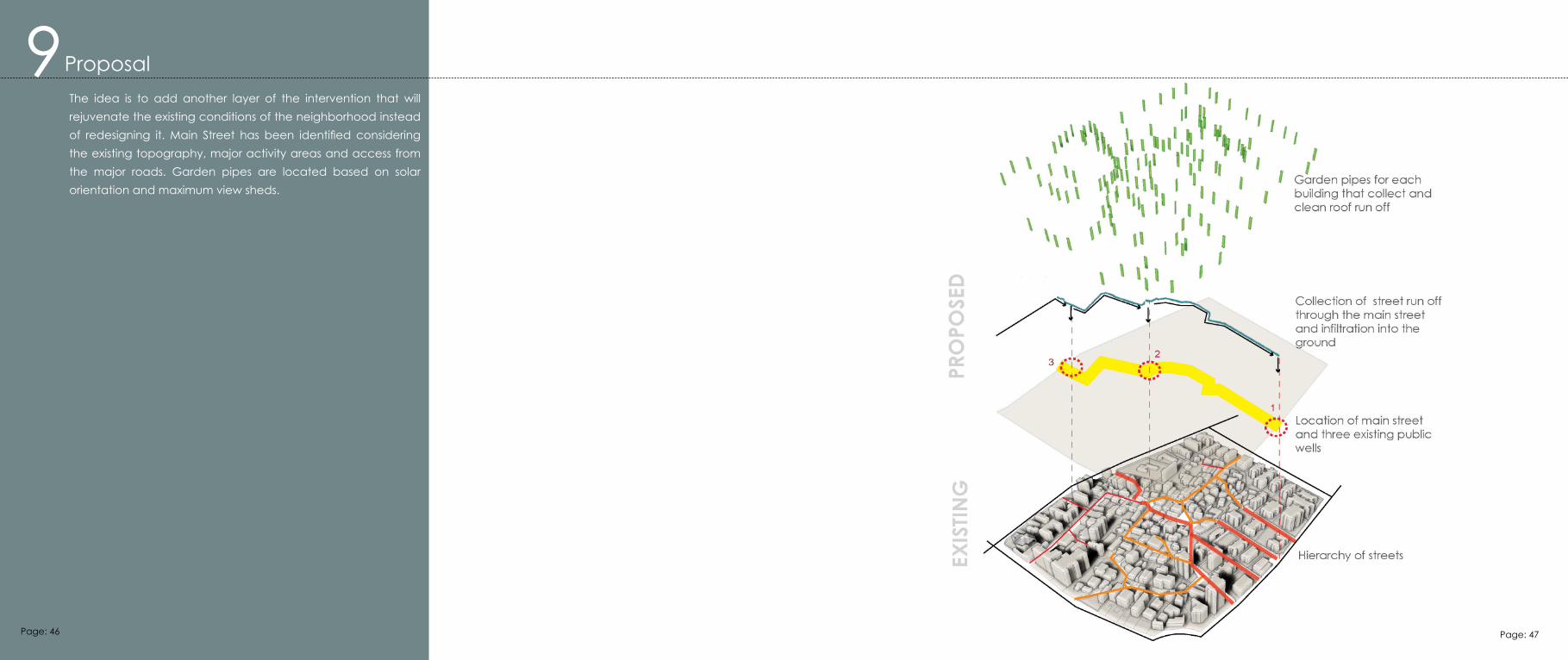
The idea is to add another layer of the intervention that will rejuvenate the existing conditions of the neighborhood instead of redesigning it. Main Street has been identified considering the existing topography, major activity areas and access from the major roads. Garden pipes are located based on solar orientation and maximum view sheds.
9Proposal
Page: 46 Page: 47
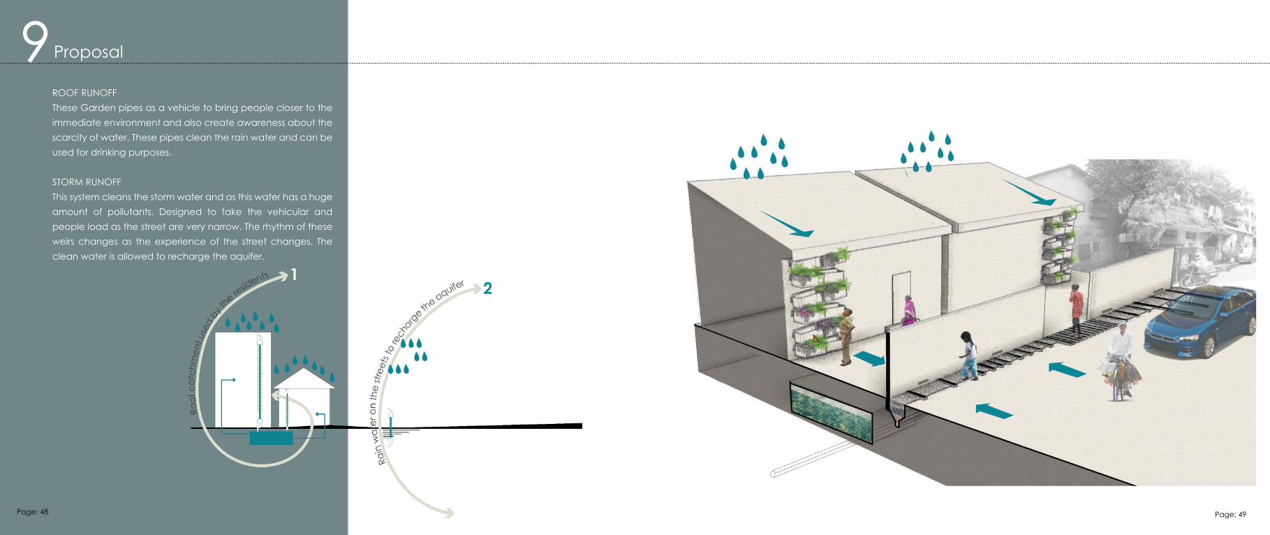
9ROOF RUNOFFThese Garden pipes as a vehicle to bring people closer to the immediate environment and also create awareness about the scarcity of water. These pipes clean the rain water and can be used for drinking purposes.
STORM RUNOFFThis system cleans the storm water and as this water has a huge amount of pollutants. Designed to take the vehicular and people load as the street are very narrow. The rhythm of these weirs changes as the experience of the street changes. The clean water is allowed to recharge the aquifer.
Proposal
Page: 48 Page: 49
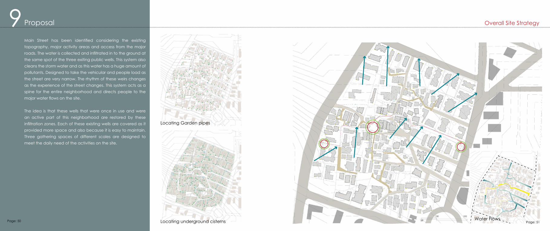
Main Street has been identified considering the existing topography, major activity areas and access from the major roads. The water is collected and infiltrated in to the ground at the same spot of the three exiting public wells. This system also cleans the storm water and as this water has a huge amount of pollutants. Designed to take the vehicular and people load as the street are very narrow. The rhythm of these weirs changes as the experience of the street changes. This system acts as a spine for the entire neighborhood and directs people to the major water flows on the site.
The idea is that these wells that were once in use and were an active part of this neighborhood are restored by these infiltration zones. Each of these existing wells are covered as it provided more space and also because it is easy to maintain. Three gathering spaces of different scales are designed to meet the daily need of the activities on the site.
Water Flows
Locating Garden pipes
Locating underground cisterns
Overall Site Strategy9 Proposal
Page: 50 Page: 51
9 Proposal
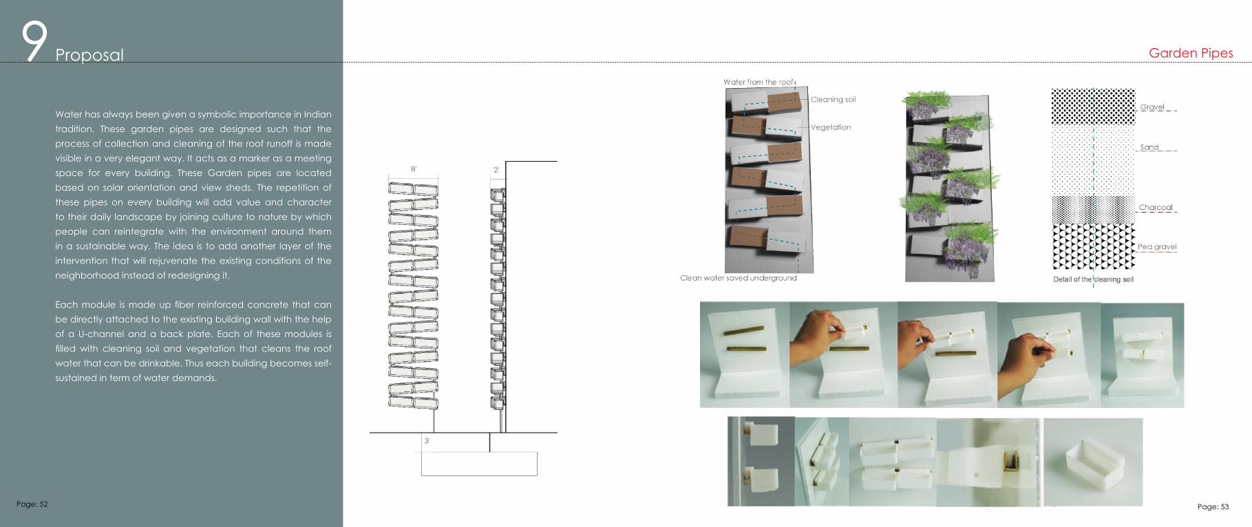
Water has always been given a symbolic importance in Indian tradition. These garden pipes are designed such that the process of collection and cleaning of the roof runoff is made visible in a very elegant way. It acts as a marker as a meeting space for every building. These Garden pipes are located based on solar orientation and view sheds. The repetition of these pipes on every building will add value and character to their daily landscape by joining culture to nature by which people can reintegrate with the environment around them in a sustainable way. The idea is to add another layer of the intervention that will rejuvenate the existing conditions of the neighborhood instead of redesigning it.
Each module is made up fiber reinforced concrete that can be directly attached to the existing building wall with the help of a U-channel and a back plate. Each of these modules is filled with cleaning soil and vegetation that cleans the roof water that can be drinkable. Thus each building becomes self-sustained in term of water demands.
Garden Pipes
Page: 52 Page: 53
9 Proposal
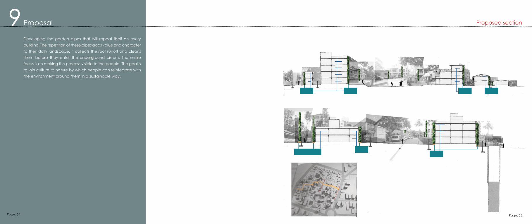
Developing the garden pipes that will repeat itself on every building. The repetition of these pipes adds value and character to their daily landscape. It collects the roof runoff and cleans them before they enter the underground cistern. The entire focus is on making this process visible to the people. The goal is to join culture to nature by which people can reintegrate with the environment around them in a sustainable way.
Proposed section
Page: 54 Page: 55
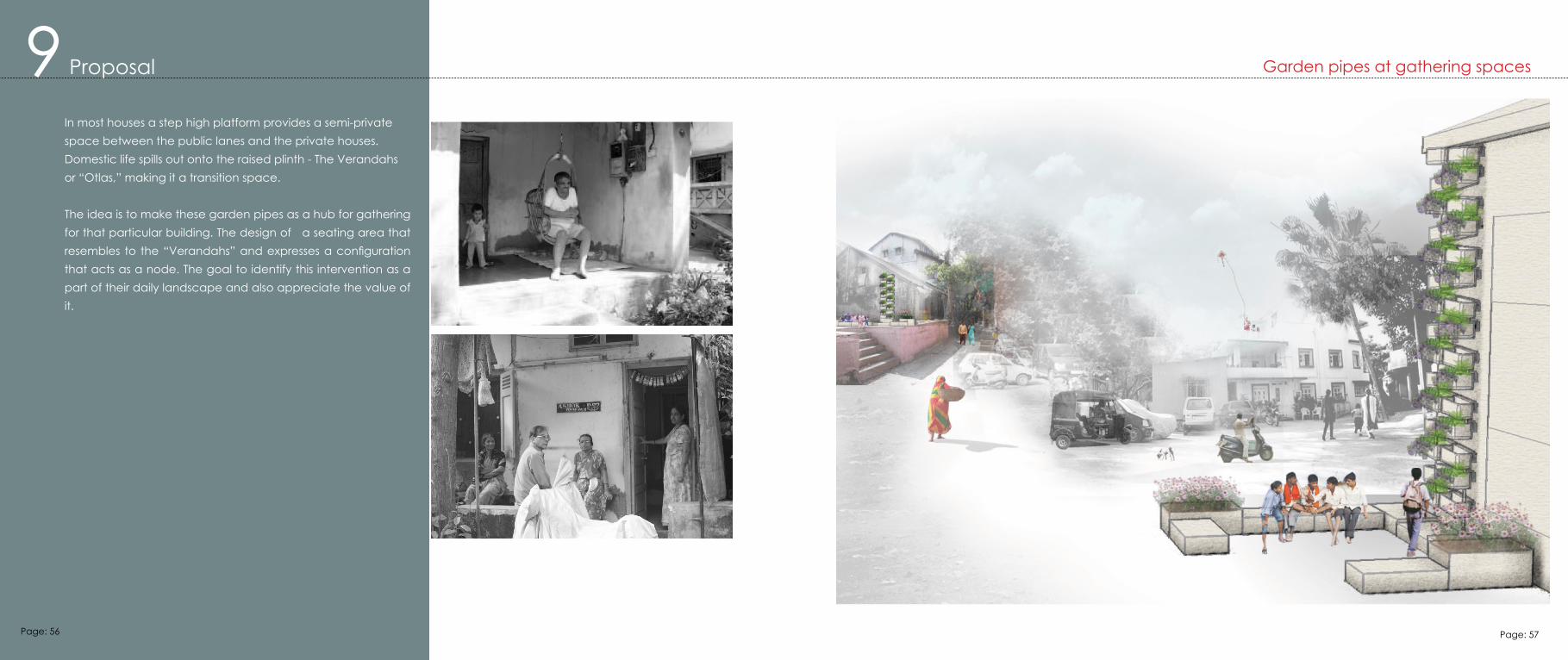
In most houses a step high platform provides a semi-private space between the public lanes and the private houses. Domestic life spills out onto the raised plinth - The Verandahs or “Otlas,” making it a transition space.
The idea is to make these garden pipes as a hub for gathering for that particular building. The design of a seating area that resembles to the “Verandahs” and expresses a configuration that acts as a node. The goal to identify this intervention as a part of their daily landscape and also appreciate the value of it.
9 Proposal Garden pipes at gathering spaces
Page: 56 Page: 57
1
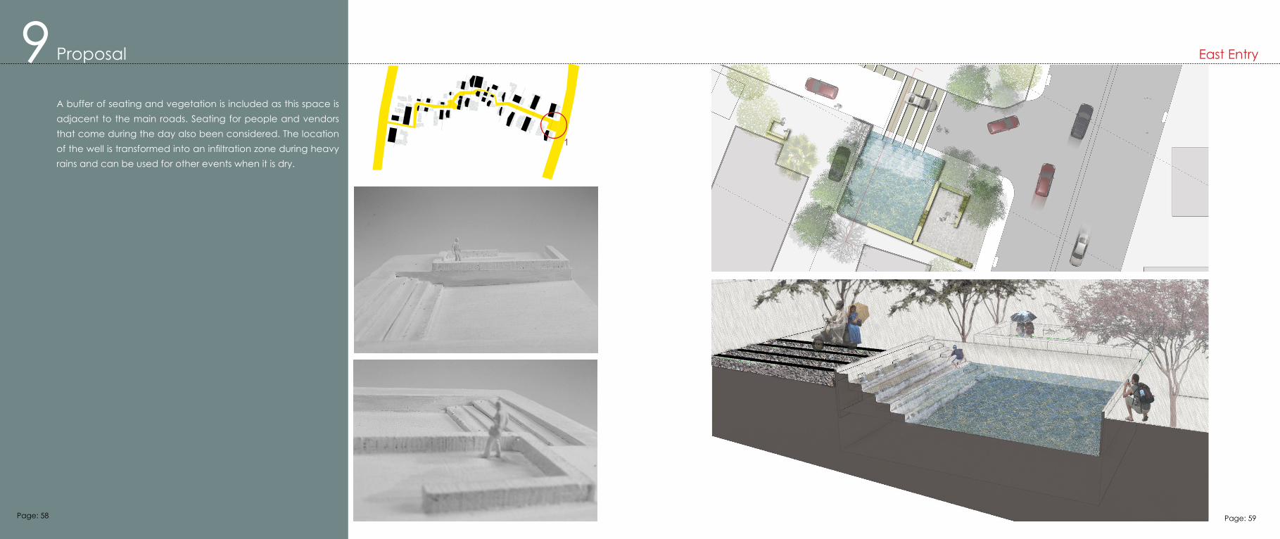
A buffer of seating and vegetation is included as this space is adjacent to the main roads. Seating for people and vendors that come during the day also been considered. The location of the well is transformed into an infiltration zone during heavy rains and can be used for other events when it is dry.
9 Proposal East Entry
Page: 58 Page: 59
2
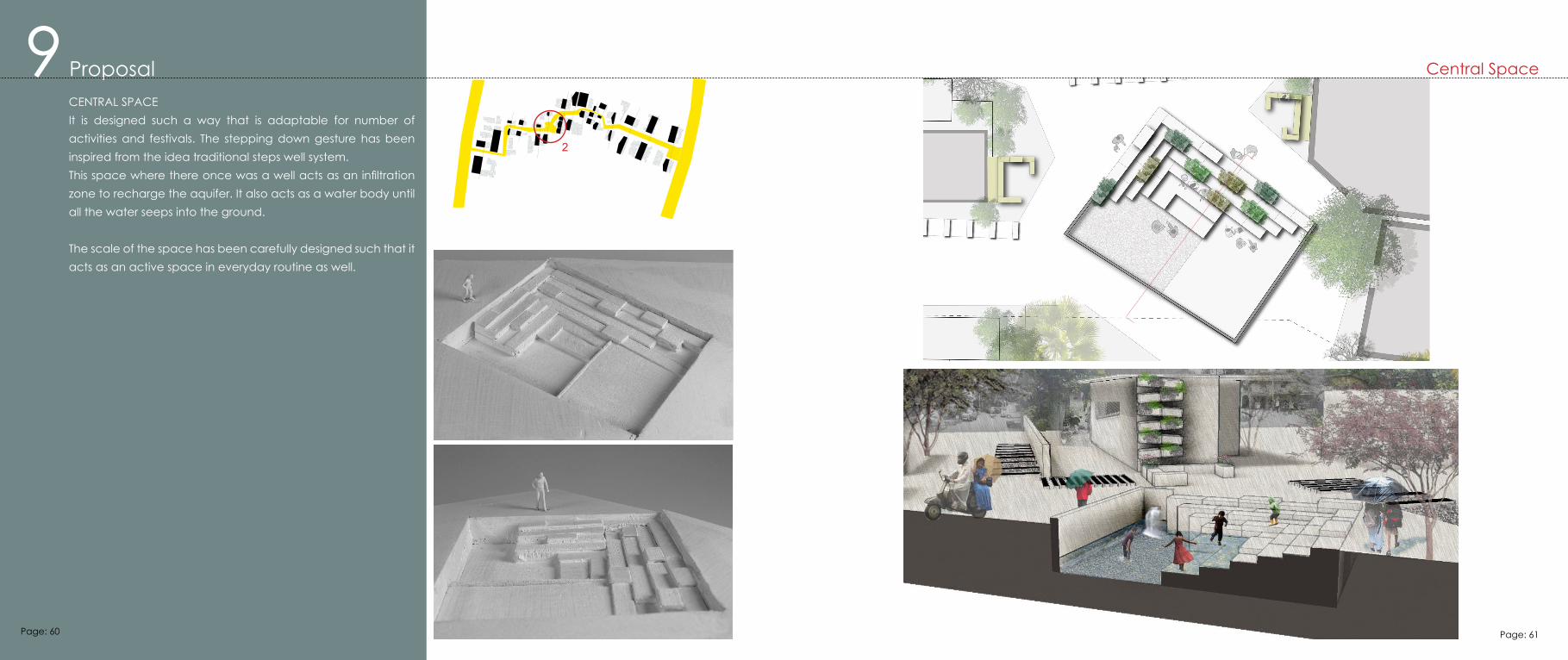
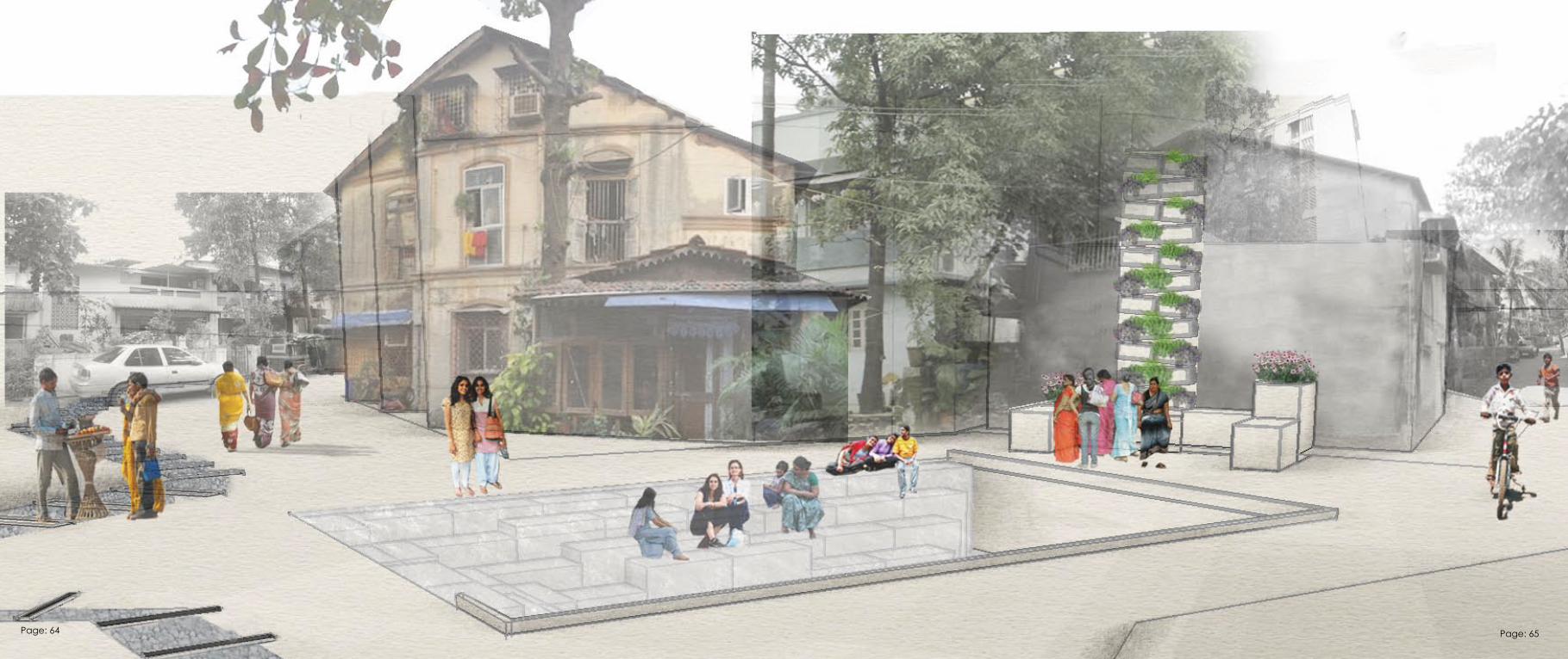
CENTRAL SPACEIt is designed such a way that is adaptable for number of activities and festivals. The stepping down gesture has been inspired from the idea traditional steps well system.This space where there once was a well acts as an infiltration zone to recharge the aquifer. It also acts as a water body until all the water seeps into the ground.
The scale of the space has been carefully designed such that it acts as an active space in everyday routine as well.
9 Proposal Central Space
Page: 60 Page: 61
3
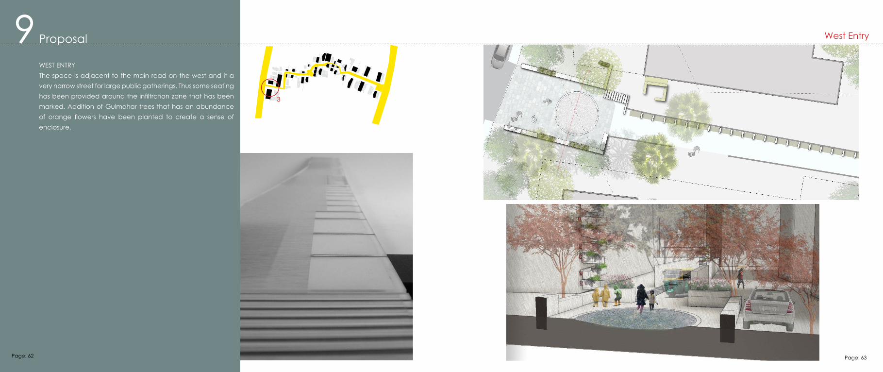
WEST ENTRYThe space is adjacent to the main road on the west and it a very narrow street for large public gatherings. Thus some seating has been provided around the infiltration zone that has been marked. Addition of Gulmohar trees that has an abundance of orange flowers have been planted to create a sense of enclosure.
9 Proposal West Entry
Page: 62 Page: 63
Page: 64 Page: 65
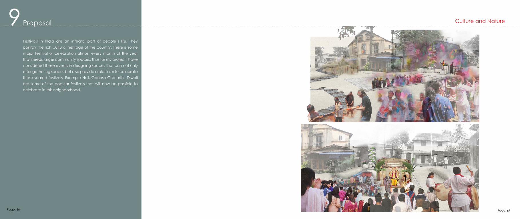
Festivals in India are an integral part of people’s life. They portray the rich cultural heritage of the country. There is some major festival or celebration almost every month of the year that needs larger community spaces. Thus for my project I have considered these events in designing spaces that can not only offer gathering spaces but also provide a platform to celebrate these scared festivals. Example Holi, Ganesh Chaturthi, Diwali are some of the popular festivals that will now be possible to celebrate in this neighborhood.
9 Proposal Culture and Nature
Page: 66 Page: 67
10 Conclusion
During this thesis investigation, I learned lessons that could not have been articulated without its due process. Being a familiar context I was able to understand the challenges, aspirations and desire of the people living in this neighborhood.
However, thinking about the design of this project. There are many layers that this can take on what was really important that this project tries to find a cultural connection but the daily routine and immediate environment.
Through this thesis I learned that minor interventions can help rejuvenate any neighborhood if the design is articulated carefully in such a way that contributes to the existing grain of the neighborhood.
At first I was skeptical about choosing this site as this would mean retaining the most part of the residential area. But as I worked through the essential needs and the goal of my proposal. These points all connected to the larger system that could be an integral part the city. It alleviates insufficient water supply for individual citizen by harvesting and cleaning rain water and also recharging the aquifer on a bigger scale.
My professor Michael raised a very critical question during the final review which is still a question in my mind that who owns the water after all? Part of my work has been about to propose a system that several neighborhood little by little can aggregate and recharge the aquifer. I don’t know how much of a difference this little neighborhood will make. But the question still remains that who owns the water the city or neighborhood?
The second part of this thesis was to educate people and make them more aware about the major environmental challenges not only faced by Mumbai but also the entire world. I imagine this project can be seen as a field trip opportunity for the nearby schools and colleges.
To sum up, this thesis uses water as a medium to rejuvenate this neighborhood by uncovering the process of collection and dispersion of water to create awareness about major water problems.
Page: 68 Page: 69
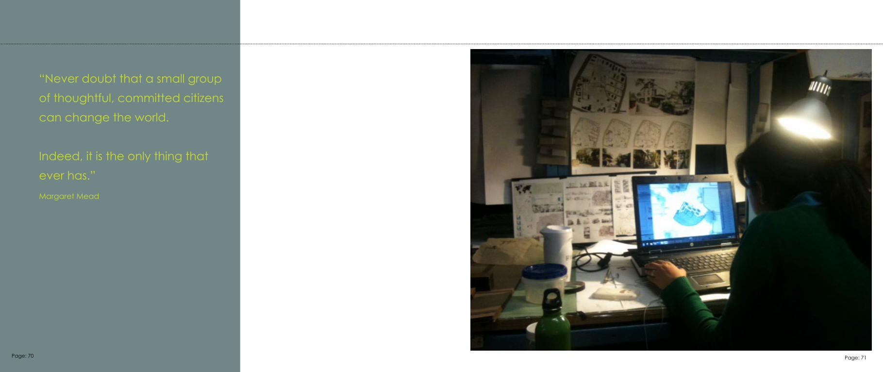
“Never doubt that a small group of thoughtful, committed citizens can change the world.
Indeed, it is the only thing thatever has.”Margaret Mead
Page: 70 Page: 71
11 ResourcesSobel, David “Place Based education: Connecting classrooms and community (2004)
Louv, Richard “Last Child in the wood – saving our Children from Nature deficient disorder” (2005)
Walker, Gabriel and king, Sir David “The Hot Topic” (2008)
Mckibben Bill “eaarth – making a Life on a Tough New Planet” (2010)
Macauly, David “The way things work” (1998)
“Landscape Architecture Foundation–Case Study investigation” http://www.lafoundation.org/research/case-study investigation/research-fellows/Mosha, Eve “High Water Line Project” http://www.highwaterline.org/
Narain, Sunita and Agarwal, Anil “Dying Wisdom: Rise, Fall and Potential of India’s Traditional Water Harvesting Stystem” (State of India’s environment, Volume 4. P 16, 17, 32, 33, 114, 115.
Mumbai facts, History “http://www.mumbaifacts.com/history-of-mumbai, http://en.wikipedia.org/wiki/Mumbai
Water need data” http://asla.org/awards/2008/studentawards/044.html.”
Thakkar, Prerna ,”Reinventing the Contemporary Gaothan - Redefining Redevelopment” Academy of Architecture, Rachna Sansad, Mumbai (Thesis B.arch, 2011)
IMAGE ILLUSTRATIONS
http://www.fotovisura.com/user/themoment/view/in-deep-water
http://news.inchembur.com/2011/01/03/beggars-home-chembur-state-move-irks-corporators/
http://en.wikipedia.org/wiki/File:Chembur_Market.jpg
http://www.waterencyclopedia.com/Ge-Hy/Groundwater.html#b
Page: 72 Page: 73