Embed Size (px)
Citation preview

Department of Architecture
Faculty of Engineering
Alexandria University
Ahmed M. SOLIMANSecond Arab Land Conference- 22-24 February 2020 in Cairo, Egypt
Rethinking Urban Sustainability Transitions on land readjustment
in Egypt

Department of Architecture
Faculty of Engineering
Alexandria University
Ahmed M. SOLIMANSecond Arab Land Conference- 22-24 February 2020 in Cairo, Egypt
The main objective is
The research aims to open an academic discussion
on theory and practice of sustainability transitions
and its correlations in land Readjustment (LR) for
urban expansion in Egypt.
It concludes that :
• The configuration, interrelation, and integration
of LR within sustainability transitions perspective
would enhance the continuous sociotechnical and
political transitions in the Middle East region.
The research assumes that:
• Linking between a socio-technical transitions
process and LR, would result on a proper
sustainable land development.
1- Introduction

Department of Architecture
Faculty of Engineering
Alexandria University
Ahmed M. SOLIMANSecond Arab Land Conference- 22-24 February 2020 in Cairo, Egypt
❑ Egypt is suffering from spontaneous, rapid informal urbanization, and the
conversion of agricultural land into urban uses which became the fertile arena
for the urban informality.
❑ Between 1982 and 2004, an estimated around 0.5 million hectare of
agricultural land has been destroyed for urban use.
❑As of 2007, there were an estimated 8.5 million informal housing units
with at least 21.2 million Egyptians live in urban areas.
❑ In 2016, more than 50% of urban and rural agglomerations in Egypt are
informal.
❑ If the current trend of population growth continued, with a population
growth rate of 1.8% Egypt's population will reach more than 173.8 million by
the year 2050.
❑ This would lead the need for at least between a half to two thirds of
the current urban and rural agglomerations to be added to the Egyptian
territory till 2050, or to construct around 30 new cities with a population
of 2.5 million each, to absorb the future population growth.
2- The rapid urbanization and Urban Expansion in Egypt

Department of Architecture
Faculty of Engineering
Alexandria University
Ahmed M. SOLIMANSecond Arab Land Conference- 22-24 February 2020 in Cairo, Egypt
Peri-urban land Semi-informal areas Formal areas
lan
d is
cen
tral
to
ec
on
om
ic d
evel
op
me
nt
Var
iou
s d
evic
es f
or
lan
d d
eliv
ery
syst
em
th
rou
gh in
stit
uti
on
al, e
con
om
ic a
nd
so
cial
po
licie
s .
Go
vern
me
nt
& P
rofe
ssio
nal
s In
stit
uti
on
sC
om
mu
nit
y In
stit
uti
on
s
Co
sts
of
the
lega
l sys
tem
as
the
pri
mar
y fa
cto
rs p
ush
ing
peo
ple
into
ext
rale
gal
exis
ten
ce
The
po
or
relie
d m
ain
ly o
n t
he
ir o
wn
p
ote
nti
al a
ctio
n a
nd
th
eir
so
cial
net
wo
rks
Per
i-u
rban
are
as a
s in
tegr
al c
om
po
nen
t an
d a
gen
erat
or
of
eco
no
mic
gro
wth
, po
litic
al c
han
ge, i
nfo
rmat
ion
te
chn
olo
gy,
and
so
cial
tra
nsf
orm
atio
n
“Per
i-u
rban
" la
nd
has
bec
om
e a
fair
ly s
ecu
re,
con
ven
ien
t,
and
inex
pen
sive
op
tio
n f
or
ob
tain
ing
ho
usi
ng
plo
ts
Enh
ance
me
nt
of
inst
itu
tio
nal
, eco
no
mic
an
d s
oci
al p
olic
ies
as a
dri
vin
g se
at f
or
imp
rovi
ng
lan
d t
en
ure
sys
tem
an
d
acce
lera
tin
g la
nd
de
liver
y sy
ste
m
Wh
at is
ne
ed
ed
?
Urban informality
Virgin land
Process of land development Organized Areas

Department of Architecture
Faculty of Engineering
Alexandria University
Ahmed M. SOLIMANSecond Arab Land Conference- 22-24 February 2020 in Cairo, Egypt
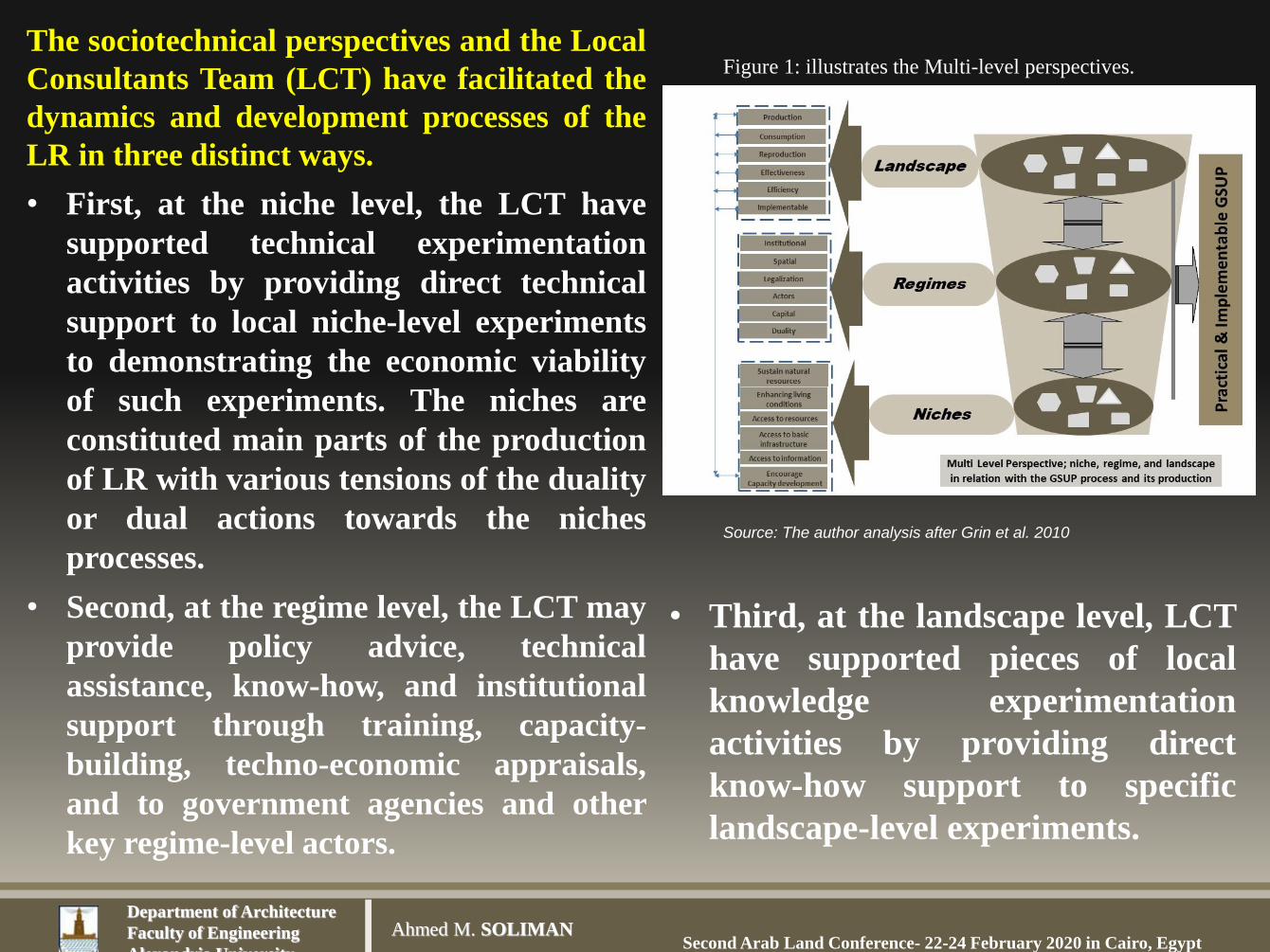
4- Sustainability transitions and urban expansion
❑ In recent years, planning innovations have taken
place aiming at sustainability transitions for the
future of urban agglomerations development on the
planet (Grin, 2010).
❑ Transitions is a shift from one condition to
another whereby the human species goes about
organizing equally the consumption, production, and
distribution of human, natural, and other resources
among a society.
❑As Illustrated in Figure (1) Grin defines the three
levels in transition dynamics: (1) relational power at
the level of niches, (2) dispositional power at the level
of regimes, and (3) structural power at the level of
landscapes (Grin, J., et al. 2010)
Figure 1: The MLP process and its levels.
Source: (Geels and Schot 2007) The multi-level
perspective of sustainability transitions
Department of Architecture
Faculty of Engineering
Alexandria University
Ahmed M. SOLIMANSecond Arab Land Conference- 22-24 February 2020 in Cairo, Egypt
Figure 1: illustrates the Multi-level perspectives.
Source: The author analysis after Grin et al. 2010
The sociotechnical perspectives and the Local
Consultants Team (LCT) have facilitated the
dynamics and development processes of the
LR in three distinct ways.
• First, at the niche level, the LCT have
supported technical experimentation
activities by providing direct technical
support to local niche-level experiments
to demonstrating the economic viability
of such experiments. The niches are
constituted main parts of the production
of LR with various tensions of the duality
or dual actions towards the niches
processes.
• Second, at the regime level, the LCT may
provide policy advice, technical
assistance, know-how, and institutional
support through training, capacity-
building, techno-economic appraisals,
and to government agencies and other
key regime-level actors.
• Third, at the landscape level, LCT
have supported pieces of local
knowledge experimentation
activities by providing direct
know-how support to specific
landscape-level experiments.

Department of Architecture
Faculty of Engineering
Alexandria University
Ahmed M. SOLIMANSecond Arab Land Conference- 22-24 February 2020 in Cairo, Egypt
4-2 The niches processesThe niches processes followed the planning principles that would lead into steps to the
following stages. These implicitly entail that interventions are constructed to proceed in a
nonlinear fashion, involving a step-by-step series of activities from experimentation to arrive
into concrete and measurable outcomes.
Experimentation refers to collective search and exploration processes in which a broad suite
of stakeholders and actors from government and civil society are navigating, negotiating (and
ideally) reducing uncertainty about new sociotechnical innovations. The real-world
experiments are gaining knowledge and experience along the way in an iterative learning-by-
doing and Doing-by-learning iterative process (Ansell, C. K., & Bartenberger, M. 2016).
Three main operational principles/criteria were introduced by the LCT: Do No Harm, Do
Good and Act legally. By providing a space to negotiate problem definitions and
understandings, claims to resources, authority or dominant ideologies, experiments restructure
the local institutions and through that have the potential to contribute to deep-structural
change, i.e. sustainability transitions (Hodson, M., Geels, F. W., & McMeekin, A. 2017).
Three outcomes were reached at niches levels: spaces for future housing plots, spaces for
economic activities and social amenities, and finally, spaces for infrastructure to cope with the
current and future needs. Intensive negotiations processes between various stakeholders and
the LCT were relied on three strategies of niches: Establishing, Translation, and Scaling

Department of Architecture
Faculty of Engineering
Alexandria University
Ahmed M. SOLIMANSecond Arab Land Conference- 22-24 February 2020 in Cairo, Egypt
3- A Brief Background of LR
❑ LR is return back in 1791 by George Washington.❑The origins of LR established in Germany that are often attributed to
the 1902. German legislation was translated into Japanese and
adapted in “the 1919 City Planning Act (Archer 1989; Soliman 2014;
Turk 2008)
❑ . In the Middle East countries, the British administration applied it in
Palestine in the 1921 Town Planning Ordinance LR provisions (called
‘parcellation’).
❑After the end of the civil war in Lebanon (1991), the city center of
Beirut (Solidere) was extremely fragmentation of property rights. LR
was introduced to redevelopment the city center.
❑LR has shown its value for the servicing and subdivision of urban-
fringe landholdings.
❑This mechanism also reallocated lands with project costs and benefits
that are equitably shared between and among landowners.
The concept of LRP, participatory inclusive process, PILaR, is win-win process.

Department of Architecture
Faculty of Engineering
Alexandria University
Ahmed M. SOLIMANSecond Arab Land Conference- 22-24 February 2020 in Cairo, Egypt
Ch
all
e
ng
e
sLand readjustment Detailed Plan
Sp
ati
al
▪ It determines road network, housing blocks, land plots,
and various services in the plan.
▪ Lack of cadastral maps of the status quo of urban
expansion areas.
▪ The status of the new added urban expansion areas is
completely differed than what the scheme has been
adopted for the GSUP.
▪ All the processing of land transaction is taking into
consideration.
▪ Landlords are prepared to handle land documentation
to declare their own properties.
▪ It gives the flexibility for urban planner to innovate a
good planning scheme.
▪ It could be applied in areas with scattered buildings
▪ It determines road network and housing blocks and does
not allocate land plots.
▪ Does not take into consideration the actual situation on the
ground.
▪ The mismatch between the property lines, the current
territory boundary and registered/ or nonregistered land
documentations.
▪ Fragmentation of agricultural property by which is
creating many obstacles to trace a land transaction, and the
implementation of the project on the ground.
▪ The difficulty of inferred the real landowners and various
official documentation of land tenure
▪ It is a rigid process as it limits the planner with agricultural
land subdivision
▪ It is difficult to apply in areas with scattered buildings
Inst
itu
tion
al
▪ It must be within the official approved Hayez of the city
▪ It is a finished product by which each landlord could
apply for a building license.
▪ It is Win-Win process by which it takes into
consideration the smallest land plot
▪ The land sharing could be applied
▪ It must be within the official approved Hayez of the city
▪ It is an unfinished product in which land subdivision
project should be applied to the property registration
department.
▪ It is a Winer-loser process
▪ Difficult to apply land sharing
Leg
ali
zati
on
▪ According to PBL119, the responsible consultant has to
obtain the consent of the landlords of the project.
▪ It is facilitated the Planning and Urban Development
departments in the governorates to proceed with the
final accreditation procedures.
▪ It is fulfilling the interpretation of the PBL119 for the
definition of land subdivision and how to deal with.
▪ The ability to agree with the landlords to allocate land
for the needed services according to PBL119.
▪ It is not necessary to obtain the approval of all the
landlords.
▪ The inability of the Planning and Urban Development
departments in the governorates to proceed with the final
accreditation procedures.
▪ Inability in the decision-making in the adoption of detailed
plans measures as stated in the PBL119.
▪ Inability to make decisions on the needed services that
could be inside/or perimeter-scale of the DPUEA
4- Differences between LR and Detailed Plan

Department of Architecture
Faculty of Engineering
Alexandria University
Ahmed M. SOLIMANSecond Arab Land Conference- 22-24 February 2020 in Cairo, Egypt
3-3 Detailed Plan for Urban Expansion Areas (DPUEA)

Department of Architecture
Faculty of Engineering
Alexandria University
Ahmed M. SOLIMANSecond Arab Land Conference- 22-24 February 2020 in Cairo, Egypt
5- A possible paradigm on urban sustainable transitions on land readjustment.
❑ This research focuses on two areas. El Khargha area is in
Sammanoud city, as a small city. The other is El Rezqa area
in Banha city, as intermediate city, which is located 45
kilometers north of Cairo, the capital of Egypt. The former
implemented in 2008, the latter in 2016. ❑ Both projects have relied on Urban Sustainability Transitions in which
relied on a sociotechnical approach using the Multi-level (ML) perspective
and hidden potential actions of local communities who are living in the two
areas, as a cooperation/participation process among the urban poor and
official institutions (Soliman, A., 2020).
❑ Both projects introduced Participatory and Inclusive Land Readjustment
(PILaR) as a tool that enables cities to significantly increase the supply of
serviced land at the urban fringe.
❑ Both projects have implemented as an innovation tool to control the
arbitrary development of peri-urban areas on the periphery of the two
cities (Soliman, A., 2010; 2012; 2017 ).

Department of Architecture
Faculty of Engineering
Alexandria University
Ahmed M. SOLIMANSecond Arab Land Conference- 22-24 February 2020 in Cairo, Egypt
5-1 PLANNING PRINCIPLES
A set of basic principles has prioritized the following five values; transparency;
equity; trust; credibility; and efficiency
This had led into four tasks intersected at the niche and regime levels with various
pathways: What is needed? Who will do the Task, Who will be responsible for the
end product? How will overcome the current urban challenges?
❑ It was through these values that the Local Consultant Team (LCT) was able to
establish a sort of social network, and building bridge of trust between landlords
that would enhance participation to reach a sort of compromise among them.
Accordingly, a communal principles among all landlords was emerged as follows:
• All landlords would give up the same percentage of their land for roads and
services according to the BPL 119.
• In reassigning a plot of land to a landlord, the LCT would do its best to make sure
it would be at the closest physical proximity as that of the landlord’s original site.
• The TT would also respect any specific advantages that a parcel had and make
sure the “new parcel” provided for those advantages.
• The minimum street's width will be 10 meter.
• The minimum land parcel's size will be 120 square meter.
• In the case that land parcel's size is less than 120 square meter, the landlord will
reimburse his exact land size in another land plot to be shared with other.

Department of Architecture
Faculty of Engineering
Alexandria University
Ahmed M. SOLIMANSecond Arab Land Conference- 22-24 February 2020 in Cairo, Egypt
Tasks What is needed? Who will do the
Task
Who will be
responsible for the
end product?
How to overcome the current urban
challenges?
(Pathways) (Niches) (Niches)/(Regimes) (Landscape)
Field Survey &
identifying site
characteristics
Collecting
necessary data &
documentation
LCT and stakeholders LCT and
stakeholders
Accurate information, cadastral maps,
and GIS maps
Site formalization Tracing land
transaction and
conversion
Stakeholders, Local
municipality, and
government agencies
The GOPP and
local municipality
Change land uses from agriculture into
residential use
Building basic
principles/criteria
Do No Harm, Do
Good and Act legally.
LCT and stakeholders LCT, the GOPP,
and local
municipality
Building a bridge of trust based on
Transparency, accountability,
responsibility
Setting up various
scenarios
Borrowed the
residents’ initiative
providing a space to
negotiate between LCT
and stakeholders
LCT and
stakeholders
Are there any technical issues or
obstacles to be solved before starting the
project?
Designing the
layout pattern
Residents’
participation
A committee from
the LCT and
stakeholders
A committee
from LCT local
municipality and
stakeholders
Build a sort of partnership between
stakeholders and local municipality
Cost recovery Fees to be paid by
the residents and
local municipality
Beneficiaries/ local
municipality
Local
municipality and
stakeholders
Avoiding the project deficit and
ensuring that the urban poor are
included in the site
Tenure security Simplifying land
registration
Local municipality and
government agencies
Local
municipality
Secure land tenure, and simplifying
procedures for land registration
Providing land
plots and housing
units
Land subdivision
according to the
agreed layout pattern
People who own land
and residential buildings
Local residents
and local
municipality
Increase housing production and
facilitate land delivery system
Monitoring the
progress of the
project (Learning by
doing and doing by
learning)
Providing day-by
day data
Nominee from
stakeholders and the
consultants
Technical team
and local
municipality
Major effects on poverty reduction

Department of Architecture
Faculty of Engineering
Alexandria University
Ahmed M. SOLIMANSecond Arab Land Conference- 22-24 February 2020 in Cairo, Egypt
331000.000000
331000.000000
331500.000000
331500.000000
332000.000000
332000.000000
332500.000000
332500.000000
34
26
00
0
.00
000
0
34
26
00
0.0
00
00
0
34
26
50
0
.00
000
0
34
26
50
0.0
00
00
0
34
27
00
0
.00
000
0
34
27
00
0.0
00
00
0
34
27
50
0
.00
000
0
34
27
50
0.0
00
00
0
331000.000000
331000.000000
331500.000000
331500.000000
332000.000000
332000.000000
332500.000000
332500.000000
34
26
00
0
.00
000
0
34
26
00
0.0
00
00
0
34
26
50
0
.00
000
0
34
26
50
0.0
00
00
0
34
27
00
0
.00
000
0
34
27
00
0.0
00
00
0
34
27
50
0
.00
000
0
34
27
50
0.0
00
00
0
5-2 El Khargha Area
The total size is 16.44 Faddan. In 2008, it accommodated 1,530 persons
مدينة سمنود–مشروع منطقة الخارجة
❑ It offered 357 land plots with total
1,377 housing units to accommodate
4284 persons till 2027.
❑ The estimated cost was around 96.39
million EL to be covered by the
residents. While the infrastructure cost
around 1,522 million EL to be covered
by the governorate.

Department of Architecture
Faculty of Engineering
Alexandria University
Ahmed M. SOLIMANSecond Arab Land Conference- 22-24 February 2020 in Cairo, Egypt
330700.000000
330700.000000
330800.000000
330800.000000
330900.000000
330900.000000
331000.000000
331000.0000003
42
69
00
.00
000
0
34
26
90
0.0
00
00
0
34
27
00
0
.00
000
0
34
27
00
0.0
00
00
0
34
27
10
0
.00
000
0
34
27
10
0.0
00
00
0
34
27
20
0
.00
000
0
34
27
20
0.0
00
00
0
330700.000000
330700.000000
330800.000000
330800.000000
330900.000000
330900.000000
331000.000000
331000.0000003
42
69
00
.00
000
0
34
26
90
0.0
00
00
0
34
27
00
0
.00
000
0
34
27
00
0.0
00
00
0
34
27
10
0
.00
000
0
34
27
10
0.0
00
00
0
34
27
20
0
.00
000
0
34
27
20
0.0
00
00
0
330700.000000
330700.000000
330800.000000
330800.000000
330900.000000
330900.000000
331000.000000
331000.0000003
42
69
00
.00
000
0
34
26
90
0.0
00
00
0
34
27
00
0
.00
000
0
34
27
00
0.0
00
00
0
34
27
10
0
.00
000
0
34
27
10
0.0
00
00
0
34
27
20
0
.00
000
0
34
27
20
0.0
00
00
0
330700.000000
330700.000000
330800.000000
330800.000000
330900.000000
330900.000000
331000.000000
331000.0000003
42
69
00
.00
000
0
34
26
90
0.0
00
00
0
34
27
00
0
.00
000
0
34
27
00
0.0
00
00
0
34
27
10
0
.00
000
0
34
27
10
0.0
00
00
0
34
27
20
0
.00
000
0
34
27
20
0.0
00
00
0
330700.000000
330700.000000
330800.000000
330800.000000
330900.000000
330900.000000
331000.000000
331000.0000003
42
69
00
.00
000
0
34
26
90
0.0
00
00
0
34
27
00
0
.00
000
0
34
27
00
0.0
00
00
0
34
27
10
0
.00
000
0
34
27
10
0.0
00
00
0
34
27
20
0
.00
000
0
34
27
20
0.0
00
00
0
Implementation of El Khargha
Area

Department of Architecture
Faculty of Engineering
Alexandria University
Ahmed M. SOLIMANSecond Arab Land Conference- 22-24 February 2020 in Cairo, Egypt
0 10 20 30 405
Meters
Landlords' Initiative Plan
Official Land Subdivision area
Landlords' Proposed Road Network
Huts
Residential Buildings
Total study Area
Non Residential Buildings
Gas Station
Surroundings Areas
Vacant Land
´
Hoaad El Shaael No 5
Riv
er N
ile
Dam
ietta
Bra
nch
Hoaad El Rezqa No 8
Hoaad El Ramel No 9
Villa Subdivision
Hoaad El Roada No 6
Ring Road Cairo- Alexandria
Kaf
r Saa
d R
oad
Road No 8
El F
atah
Road
Official Land Subdivision area
Gas Station
`
To Cairo
` To Alexandria
`
To C
ity c
ente
r
Public Buildings
The study Area
325300.000000
325300.000000
325400.000000
325400.000000
325500.000000
325500.000000
325600.000000
325600.000000
325700.000000
325700.000000
33
73
30
0
.00
00
00
33
73
30
0.0
00
00
0
33
73
40
0
.00
00
00
33
73
40
0.0
00
00
0
33
73
50
0
.00
00
00
33
73
50
0.0
00
00
0
33
73
60
0
.00
00
00
33
73
60
0.0
00
00
0
0 10 20 30 405
Meters
Landlords' Initiative Plan
Official Land Subdivision area
Landlords' Proposed Road Network
Huts
Residential Buildings
Total study Area
Non Residential Buildings
Gas Station
Surroundings Areas
Vacant Land
´
5-3 Banha Case
The LCT had three tools presenting different
information:
• The total size of the southern part is around 4.9
Faddan
• Land parcel mapping out of physical land
survey effort
• Land parcel histories as per information at the
Real Estate Publicity Authority (REPA).
• Informal land parcel map from the Land
Survey Authority (LSA).
• All data transferred into GIS format.

Department of Architecture
Faculty of Engineering
Alexandria University
Ahmed M. SOLIMANSecond Arab Land Conference- 22-24 February 2020 in Cairo, Egypt
5-4 PROCESS OF DECISION, PARTICIPATION AND ANALYSIS
❑ The LCT had to set up several meetings
with the stakeholders to reach a common
vision that would satisfy the wishes of all
stakeholders involved in the LR according
to the GSUP and its regulations,
❑ Analyzed the situation of the LR, and
consulted the stakeholders through
workshops and meetings to obtain a clear
view of the potentialities and constraints
of the LR.
❑ Data analysis was conceptually divided
into two categories; traditional, and object
oriented. A wide range of applications
were based on each category.
❑ The LR was analyzed from the following
perspectives, the number of land plots,
types of land tenure, land ownership, land
parcels size, land allocation, streets width
and road network.
Privately initiated
land subdivision
Land to land
readjustment
Total area devoted to residential buildings
(sq.m.)14742 21367
Total area devoted to road network 4858 6462
Percentage of total land area devoted to
road network (in total sq.m.)32.9 % 30.24%
Number of residential housing units
created (floor area in sq. m.)14742/130*7
floors= 794 units
21367/130*5
floors= 822 units
Percentage of total land area devoted to
green areas and open space (in total
sq.m.)
zero zero
Percentage of public facilities devoted to
total land area (in total sq.m.)zero 372.5/21367*100=
1.74%
Total percentage of land devoted to roads,
green spaces, public facilities32.9% 31.98%
The preparation of the LR took around one year, and it has approved by the governor of the Qaloubia
governorate in 15/10/2014 (see the front slide). The technical work was finished within a period of six
months, while the evaluation, negotiation, and reviewing processes took around another six months

Department of Architecture
Faculty of Engineering
Alexandria University
Ahmed M. SOLIMANSecond Arab Land Conference- 22-24 February 2020 in Cairo, Egypt
5-5 Comprehensive land to land readjustment scenario;
❑ The street that served as an entry way
for the entire site and specifically for
this group on landlords’ plot was owned
by a one figure who’s solution was to
offer his land to serviced swap land. Yet,
the landlords could not asking for extra
money to be paid.
❑ The plan did include the whole site
between the public premises till the gas
station,
❑ The proposed road network depended
on loop pattern that could allow for
vehicle movements.
❑ The proposed entrance area is 10 meter,
and this is matching with the BPL119.
❑ The plan does meet the requirements of
the BPL119, as the road network and
social amenities is within a range of
33%,.
❑ The minimum land size, 120 square
meters, is within the specification of the
BPL119
0 10 20 30 405Meters
Landlords' Initiative Plan
Official Land Subdivision area
Landlords' Proposed Road Network
Huts
Residential Buildings
Total study Area
Non Residential Buildings
Gas Station
Surroundings Areas
Vacant Land
´
Landlords' Area
Hoaad El Shaael No 5
Riv
er N
ile
Dom
mya
t B
ranch
Hoaad El Rezqa No 8
Hoaad El Ramel No 9
Villa Subdivision
Hoaad El Roada No 6
Ring Road Cairo- Alexandria
Kaf
r Saa
d R
oad
Road No 8
El F
atah
Road
Official Land Subdivision area
Gas Station
325400.000000
325400.000000
325500.000000
325500.000000
325600.000000
325600.000000
325700.000000
325700.000000
33
73
20
0
.0000
00
33
73
20
0.0
000
00
33
73
30
0
.0000
00
33
73
30
0.0
000
00
33
73
40
0
.0000
00
33
73
40
0.0
000
00
33
73
50
0
.0000
00
33
73
50
0.0
000
00
33
73
60
0
.0000
00
33
73
60
0.0
000
00
0 10 20 30 405Meters
Landlords' Initiative Plan
Official Land Subdivision area
Landlords' Proposed Road Network
Huts
Residential Buildings
Total study Area
Non Residential Buildings
Gas Station
Surroundings Areas
Vacant Land
´
Landlords' Area
0 10 20 30 405Meters
Landlords' Initiative Plan
Official Land Subdivision area
Landlords' Proposed Road Network
Huts
Residential Buildings
Total study Area
Non Residential Buildings
Gas Station
Surroundings Areas
Vacant Land
´
Landlords' Area
Hoaad El Shaael No 5
Riv
er N
ile
Dom
mya
t B
ranch
Hoaad El Rezqa No 8
Hoaad El Ramel No 9
Villa Subdivision
Hoaad El Roada No 6
Ring Road Cairo- Alexandria
Kaf
r Saa
d R
oad
Road No 8
El F
atah
Road
Official Land Subdivision area
Gas Station
325400.000000
325400.000000
325500.000000
325500.000000
325600.000000
325600.000000
325700.000000
325700.000000
33
73
20
0
.00
00
00
33
73
20
0.0
00
00
0
33
73
30
0
.00
00
00
33
73
30
0.0
00
00
0
33
73
40
0
.00
00
00
33
73
40
0.0
00
00
0
33
73
50
0
.00
00
00
33
73
50
0.0
00
00
0
33
73
60
0
.00
00
00
33
73
60
0.0
00
00
0
0 10 20 30 405Meters
Landlords' Initiative Plan
Official Land Subdivision area
Landlords' Proposed Road Network
Huts
Residential Buildings
Total study Area
Non Residential Buildings
Gas Station
Surroundings Areas
Vacant Land
´
Landlords' Area
0 10 20 30 405Meters
Landlords' Initiative Plan
Official Land Subdivision area
Landlords' Proposed Road Network
Huts
Residential Buildings
Total study Area
Non Residential Buildings
Gas Station
Surroundings Areas
Vacant Land
´
Landlords' Area
Hoaad El Shaael No 5
Riv
er N
ile
Dom
mya
t B
ranch
Hoaad El Rezqa No 8
Hoaad El Ramel No 9
Villa Subdivision
Hoaad El Roada No 6
Ring Road Cairo- AlexandriaK
afr Saa
d R
oad
Road No 8
El F
atah
Road
Official Land Subdivision area
Gas Station
325400.000000
325400.000000
325500.000000
325500.000000
325600.000000
325600.000000
325700.000000
325700.000000
33
73
20
0
.0000
00
33
73
20
0.0
000
00
33
73
30
0
.0000
00
33
73
30
0.0
000
00
33
73
40
0
.0000
00
33
73
40
0.0
000
00
33
73
50
0
.0000
00
33
73
50
0.0
000
00
33
73
60
0
.0000
00
33
73
60
0.0
000
00
0 10 20 30 405Meters
Landlords' Initiative Plan
Official Land Subdivision area
Landlords' Proposed Road Network
Huts
Residential Buildings
Total study Area
Non Residential Buildings
Gas Station
Surroundings Areas
Vacant Land
´
Landlords' Area
0 10 20 30 405Meters
Landlords' Initiative Plan
Official Land Subdivision area
Landlords' Proposed Road Network
Huts
Residential Buildings
Total study Area
Non Residential Buildings
Gas Station
Surroundings Areas
Vacant Land
´
Landlords' Area
Green Area
Hoaad El Shaael No 5
Riv
er N
ile
Dom
mya
t B
ranch
Hoaad El Rezqa No 8
Hoaad El Ramel No 9
Villa Subdivision
Hoaad El Roada No 6
Ring Road Cairo- Alexandria
Kaf
r Saa
d R
oad
Road No 8
El F
atah
Road
Official Land Subdivision area
Gas Station
325400.000000
325400.000000
325500.000000
325500.000000
325600.000000
325600.000000
325700.000000
325700.000000
33
73
20
0
.0000
00
33
73
20
0.0
000
00
33
73
30
0
.0000
00
33
73
30
0.0
000
00
33
73
40
0
.0000
00
33
73
40
0.0
000
00
33
73
50
0
.0000
00
33
73
50
0.0
000
00
33
73
60
0
.0000
00
33
73
60
0.0
000
00
0 10 20 30 405Meters
Landlords' Initiative Plan
Official Land Subdivision area
Landlords' Proposed Road Network
Huts
Residential Buildings
Total study Area
Non Residential Buildings
Gas Station
Surroundings Areas
Vacant Land
´
Landlords' Area
Green Area
0 10 20 30 405Meters
Landlords' Initiative Plan
Official Land Subdivision area
Landlords' Proposed Road Network
Huts
Residential Buildings
Total study Area
Non Residential Buildings
Gas Station
Surroundings Areas
Vacant Land
´
Landlords' Area
Green Area
Hoaad El Shaael No 5
Riv
er N
ile
Dom
mya
t B
ranch
Hoaad El Rezqa No 8
Hoaad El Ramel No 9
Villa Subdivision
Hoaad El Roada No 6
Ring Road Cairo- Alexandria
Kaf
r Saa
d R
oad
Road No 8
El F
atah
Road
Official Land Subdivision area
Gas Station
325400.000000
325400.000000
325500.000000
325500.000000
325600.000000
325600.000000
325700.000000
325700.000000
33
73
20
0
.0000
00
33
73
20
0.0
000
00
33
73
30
0
.0000
00
33
73
30
0.0
000
00
33
73
40
0
.0000
00
33
73
40
0.0
000
00
33
73
50
0
.0000
00
33
73
50
0.0
000
00
33
73
60
0
.0000
00
33
73
60
0.0
000
00
0 10 20 30 405Meters
Landlords' Initiative Plan
Official Land Subdivision area
Landlords' Proposed Road Network
Huts
Residential Buildings
Total study Area
Non Residential Buildings
Gas Station
Surroundings Areas
Vacant Land
´
Landlords' Area
Green Area
Within those main guidelines; and intensive negotiations
with landlords, various proposals were reached to fulfill
the requirements of all landlords and to match the BPL
119

Department of Architecture
Faculty of Engineering
Alexandria University
Ahmed M. SOLIMANSecond Arab Land Conference- 22-24 February 2020 in Cairo, Egypt
5-6 THE ROLE OF STAKEHOLDERS
❑ First, social network was formulated on the ground
through positive participation and negotiations among
the landlords themselves as well as, with the LCT.
❑ Second, the stakeholders were convinced to identify a
range of options that would give landlords the flexibility
to choose their setting or the size of the land plots,
❑ Third, stakeholders introduced arrangements among
themselves that accelerated illegal/semi legal land
subdivision.
❑ Fourth, the stakeholders’ participation present an
important entry point to the political decision-making
needed for exploring differing viewpoints.
❑ Fifth, the stakeholders have relied on a great autonomy in
their environment through positive participation in
understanding the land readjustment process
❑ Sixth, the stakeholders have relied on their culture and
their talent and symbolic aspects of their lifestyle by
which land readjustment , and settlement form was
formulated within the site.
Achieving Interaction between Niche and Regime

Department of Architecture
Faculty of Engineering
Alexandria University
Ahmed M. SOLIMANSecond Arab Land Conference- 22-24 February 2020 in Cairo, Egypt
❑ Following Grin concept, two
niches are operating in two
opposite directions: land markets
and a system of governance.
❑ Both are influencing the final
output of the landscape being
produced and both are met to
formulate the built environment.
❑ In between niches and landscape,
two regimes have existed; the first
constitutes the three driven
process, and the second
represents the three main pillars.
❑ The duality of the regimes has
been reflected in the final output
of the market in which the
formal/informal market have
grown
Fig. 5 Illustrates the relationship between the land market and the three driven process.
5-7 Two niches, Two regimes, One landscape

Department of Architecture
Faculty of Engineering
Alexandria University
Ahmed M. SOLIMANSecond Arab Land Conference- 22-24 February 2020 in Cairo, Egypt
A model draws socio-
technical transitions and
the MLP through the
interaction and
correlation among the
three levels of niche-
innovations, regime, and
landscape (three pillars )
while the MP draws
four phases of
transition:
predevelopment, takeoff,
acceleration, and
stabilization..
6- Conclusion
A new mode of Transitions Land Management and security has emerged.
Direct these Transitions into a sustainable way to be socially, physically, and
economically feasible for future urban growth to benefit the whole society

Department of Architecture
Faculty of Engineering
Alexandria University
Ahmed M. SOLIMANSecond Arab Land Conference- 22-24 February 2020 in Cairo, Egypt
This model has the advantages that:
▪ First, it comes with the dynamic of the duality of economic and social
exclusion in Egypt.
▪ Second, it is a flexible process that meets changes beyond the
formal/informal and regulatory framework caused by the rapid
transitive urbanization.
▪ Third, it is an adaptable model to cope with outer and inner forces
(economic, social, and political) that might affect the emergence of
societies.
▪ Fourth, it is elastic works with a diversity of actors, and it is flexible
with various transitions and allows us to locked-in/out the privileging
circumstances.
6- Conclusion

Department of Architecture
Faculty of Engineering
Alexandria University
Ahmed M. SOLIMANSecond Arab Land Conference- 22-24 February 2020 in Cairo, Egypt
7- Final Remarks
Diagram of the management of sustainability
transitions on urban informality’s taxonomic in Egypt
▪ In the systematic change of urban informality,
trends echoes pressures of the urban
informality formulation that constitutes
sociotechnical. It constitutes the interaction
between niche, regime, and landscape which
are formulating the process of urban
informality transitions.
▪ Urban informality transitions, as a
sociotechnical landscape, can occur through
complex interactions of the housing-system
economy of the production, reproduction,
consumption, and distribution of goods and
services, interrelated with political economy,
circular economy, state, and society.
▪ The enhancement of a networked society, as an
active urban niche, stimulated by increased
digitalization, informatization, through the
great acceleration in resource use, through
rescaling, but also by changing the power of
state and grassroots, and by transforming the
drivers of change at various socioeconomic-
spatial levels.
Source: Soliman, A. , 2021, Urban informality Experiences and Urban
Sustainability transitions in Middle East Cities. Germany: Springer International
Publishing AG, Springer Nature

Department of Architecture
Faculty of Engineering
Alexandria University
Ahmed M. SOLIMANSecond Arab Land Conference- 22-24 February 2020 in Cairo, Egypt
M
LP
MPEmergenc
e
Diffusion Reconfiguratio
n
State power
Land rightSocial exclusion
& Marginality
Informal
economy
Grassroots
Hidden
Potential
Urbanization, demographic changes, Urban informality etc.
New urbanity, New way of life, a site of transition etc.
The fluctuation of the power of the state, the evolution of the informal economy,
the contribution of the grassroots is determined the level of the land delivery
system, the acceleration of the hidden potential of the low-income groups, and
the determination of the marginality. Thus, urban informality served as “a site
of transitions” over time, and the question is how to create consistency and
equilibrium among these magnitudes?
7- Final Remarks

Department of Architecture
Faculty of Engineering
Alexandria University
Ahmed M. SOLIMANSecond Arab Land Conference- 22-24 February 2020 in Cairo, Egypt
Thank you for your attention