Embed Size (px)
Citation preview

Rethinking the Planning System for the 21st CenturyJack Airey and Chris DoughtyForeword by Professor Edward Glaeser

Rethinking the Planning System for the 21st Century
Jack Airey and Chris DoughtyForeword by Professor Edward Glaeser
Policy Exchange is the UK’s leading think tank. We are an independent, non-partisan educational charity whose mission is to develop and promote new policy ideas that will deliver better public services, a stronger society and a more dynamic economy.
Policy Exchange is committed to an evidence-based approach to policy development and retains copyright and full editorial control over all its written research. We work in partnership with academics and other experts and commission major studies involving thorough empirical research of alternative policy outcomes. We believe that the policy experience of other countries offers important lessons for government in the UK. We also believe that government has much to learn from business and the voluntary sector.
Registered charity no: 1096300.
TrusteesDiana Berry, Alexander Downer, Pamela Dow, Andrew Feldman, Candida Gertler, Patricia Hodgson, Greta Jones, Edward Lee, Charlotte Metcalf, Roger Orf, Andrew Roberts, George Robinson, Robert Rosenkranz, Peter Wall, Nigel Wright.
2 | policyexchange.org.uk
Rethinking the Planning System for the 21st Century
About the Authors
Jack Airey leads Policy Exchange’s work on housing. His research has included work on building more beautiful homes and places, improving the planning system; and, new town development on the edge of London. In particular his work on raising housebuilding standards has attracted cross-party support and led to the Government creating the Building Better, Building Beautiful Commission. An article in The Economist welcomed Policy Exchange’s work on this subject as pioneering “the biggest idea in housing policy since the sale of council houses under Margaret Thatcher.” Before joining Policy Exchange, Jack was Head of Research at the think tank Localis where he wrote extensively on the role of place in politics and policy, while managing and supporting the development of their research output.
Chris Doughty is a Research Fellow in Housing Policy. He joined in 2018 as an intern contributing to research on a range of policy areas, and has since joined the Housing Unit. He holds a B.A. in History and Political Science (Trinity College Dublin, first-class) and an MSc. In International Political Economy (LSE, Distinction).

policyexchange.org.uk | 3
Acknowledgements
Acknowledgements
The authors would like to thank members of the Advisory Panel who generously gave up their time to attend roundtable discussions and peer review the report.
They are also very grateful to Charlie Dugdale from Knight Frank for his advisory support on typical value gain for residential land during the planning and development processes.
© Policy Exchange 2020Published byPolicy Exchange, 8 – 10 Great George Street, Westminster, London SW1P 3AE
www.policyexchange.org.uk
ISBN: 978-1-913459-09-3
4 | policyexchange.org.uk
Rethinking the Planning System for the 21st Century
Contents
About the Authors 2Acknowledgements 3Advisory Panel 5Foreword 6Executive Summary 8
Bringing the planning system into the 21st century 8Recommended reforms 10What will reforms achieve? 13
Introduction 15The growth of the planning system 15Root and branch reform of the planning system is required 20
Deficiencies of the planning system 22Land use: central planning or markets? 22Nationalised development rights 31An imbalance of power 33Regional policy through urban containment 38Mitigating and compensating for development externalities 43A complex operation 49
The costs of the planning system 56Direct costs on developing land 56The cost of housing 59The cost of doing business 61Urban and rural economies are stifled 62Infrastructure delivery and climate change mitigation are made more difficult 63Measuring the value of planning 65
The impact of the planning system on the urban environment 66Stunted urban growth 67Beautiful design is squeezed 68A design vision rarely survives the planning process 69
A Planning System for the 21st Century 71Proposed reforms 72Implementing reforms 76
Appendix One: History of the Planning System 78Pre-1914: the seeds of planning 781918-39: urban growth and rural reaction 801940-1947: a national planning system 84Post-1947: increased planning control and restriction 872020: the planning system today 93
Appendix Two: Value gain for an average plot of land in the UK, Knight Frank analysis 95

policyexchange.org.uk | 5
Advisory Panel
Advisory Panel
This research project has been supported by an Advisory Panel of experts from fields including residential development, commercial development, retail, economics, public policy, planning, local government, law, politics, architecture, energy and environment. Advisory Panel members attended two editorial roundtables and provided comments on report drafts. They may not necessarily agree with every analysis and recommendation made in the project’s reports.
Member of the Advisory Panel include:
• Professor Robert Adam, Director of ADAM Architecture• Paul Brickell, Executive Director of Regeneration and Community
Partnerships for the London Legacy Development Corporation• Dr Sue Chadwick, Strategic Planning Adviser at Pinsent Masons• Richard Ehrman, developer and former ministerial Special Adviser• Warwick Lightfoot, Head of Economics and Social Policy at Policy
Exchange• Benedict McAleenan, Senior Adviser at Policy Exchange on
Environment and Energy• Jamie Ratcliff, Executive Director at Network Homes and formerly
Assistant Director responsible for the GLA’s work on housing• Bridget Rosewell, economist and author of the government-
commissioned Independent review of planning appeal inquiries• Tom Stanley, Partner at Knight Frank• Sir Robin Wales, Senior Adviser at Policy Exchange on Local
Government, Skills and Housing and former Mayor of Newham• Lord [Simon] Wolfson, Chief Executive of Next• Reuben Young, Director of PricedOut
6 | policyexchange.org.uk
Rethinking the Planning System for the 21st Century
Foreword
Edward GlaeserFred and Eleanor Glimp Professor of Economics at Harvard University
The words “town and country planning” conjure up garden cities and the arcana of allotment gardens and mock Tudor semi-detached houses. Yet land use planning moulds our modern economies. What limits the growth of our most productive cities? Land use planning. What determines the possibilities of home ownership for the young? Land use planning. What shapes the environmental footprint of our communities? Land use planning. What keeps poor children out of middle-income neighborhoods? Land use planning.
Despite the importance of land use controls, as this superb report by Policy Exchange makes clear, the English planning system has evolved in a largely haphazard fashion with little attention to any broader consequences. After 1947, the government first assumed total control over land use within England and then devolved the power to deny new construction to tiny boroughs and townships. Large national policies, like the Green Belts, made vast tracts of land off limits to any serious development. Local opposition to change meant that local communities ferociously fought rear guard actions to thwart any nationwide push to encourage more building.
In the United Kingdom, as in the United States, the young increasingly see little hope in the promises of capitalism. In American polls, a routine majority of younger Americans have a positive view of socialism. A healthy majority of 18 to 29 year-old voters chose Jeremy Corbyn’s Labour Party in the 2019 U.K. election, while less than one fourth voted Conservative.1 The young see limited upside in our current form of capitalism. Unlike their parents and grandparents, they certainly don’t expect to be able to buy a home any time soon.
Capitalism seems to be failing the young, both in the U.S. and the U.K., because the system has increasingly come to favour insiders over outsiders. Tenure contracts protect even the worst performing teachers, and younger students suffer. Occupational licensing prevents young people from experimenting with different jobs. Land use restrictions keep property values high for people who bought their homes in 1980, and stop young people from finding affordable housing in the places that they want to live.
The post-Brexit world is filled with uncertainty. Will London boom or will there be a burst of creativity in Leeds or Liverpool? Land use controls freeze cities in place and reduce England’s flexibility to respond to future economic shifts.
In the U.S., Silicon Valley has emerged as a great centre of the 1. YouGov (2019) - How Britain voted in the 2019 gen-
eral election

policyexchange.org.uk | 7
Advisory Panel
information age. During previous local booms, rich and poor alike flooded into successful areas to take advantage of enhanced local productivity. But greater San Francisco has used the power of land use controls to stop growth. Consequently, the region plays a far smaller role in the American economy than it should and only the wealthy can afford its housing. Limiting the growth of high productivity regions means that the U.S. and the U.K. are far less economically productive than they should be, and that the benefits of that productivity flow disproportionately to the wealthy who can afford housing in the most productive places.
Jack Airey and Chris Doughty have written an excellent primer on land use planning in England that both teaches its history and points out its flaws. In England, unlike the U.S., the national government at least has the power to control local land use decisions. Even when the national government tries to induce localities to permit enough to provide for local housing needs, Airey and Doughty detail how localities manage to game the system to understate local housing needs and limit new construction.
There are always tradeoffs in local land use. The U.K. has much that is historic and worth preserving. Green spaces are also precious. But the country must build if it is going to provide the young with access to robust labour markets and affordable homes. Airey and Doughty provide a coherent road map to reform that must start with a recognition that the current system is not working.
Perhaps the most revolutionary idea in this report is that land should be divided in two primary classes, not hundreds of finely tuned zoning areas. One class of land is protected against growth, either for historical or environmental reasons. The other class of land largely permits growth. By eliminating uncertainty about the permitting process, development can become faster and cheaper. If the rules of the game are clear from the beginning, then builders will be able to deliver the housing England needs.
Airey and Doughty’s report is a bold entry into the global conversation about land use reform. For too long, the enemies of growth have stopped new building without any attention to costs and benefits. My hope is that this report can further a national conversation that can move England towards inclusiveness and economic dynamism by improving its system of land use controls.
8 | policyexchange.org.uk
Rethinking the Planning System for the 21st Century
Executive Summary
Bringing the planning system into the 21st centuryPlanning and building regulations are necessary to a functioning economy and society. They set a framework for the interaction of capital markets and land markets. The state has a legitimate role in influencing development and urban growth, for example setting standards and mitigating any negative impact on local communities.2
The planning system in the UK, however, has little relevance to the country’s 21st century liberalised economy and society facing continuous change. Although the planning system has regularly been tinkered with in the past few decades, its fundamental principles are the same as when it was established in 1947 as part of a government program to establish a command-and-control economy. Development rights remain nationalised and land use is still systematically controlled by local authorities. The state has substituted itself for the price mechanism in land markets. Uncertainty and complexity have been the result.
These principles are wholly out of sync with the needs and desires of people, businesses and wider society. They have resulted in unnecessary costs and administration, leading to higher costs of housing, living and doing business. In short, the costs of the planning system far outweigh its benefits. Its main deficiencies include:
• Land use is rationed depending on what planners think is ‘needed’ and thus on aspirations rather than reality. Local planning authorities allocate specific uses for all individual land plots in their area over 15 to 20 year periods based on projections of ‘need’. Yet rapid changes in the economy, society and technology, as well as the unpredictability of human and commercial activity, mean that the ‘needs’ of households and businesses cannot be accurately projected, certainly not over 15 or 20 years.3 In areas of high demand for developable land, the strong tendency has been to excessively ration the supply of developable land. Permissioned land is therefore highly prized and highly priced – excessive rationing has artificially inflated the value of land use allocations, often to extreme levels. This system puts pressure on developers to save on costs at later stages in the development process, for instance on the design and quality of construction. There are also excessive constraints on the recycling of existing buildings whose designated use has become redundant into new uses.
2. To be clear, our critique focuses on land use plan-ning controls which determine what can be built and where, not building regulations. Requiring buildings to be constructed in a way that meets standards on issues like fire safety, insulation and foundations is essential. Detailed long-term land use planning is distinct from building control.
3. For example, like most of us, planners entirely failed to foresee the impact of internet shopping on the high street, or of digital technology on the need for office space. The longevity of plans also means that ‘need’ projections soon become out-of-date.
policyexchange.org.uk | 9
Executive Summary
• Stunted, ugly and unsustainable urban growth is the result. The sheer level of control in the land use planning system means that the process by which places naturally change has been wholly disrupted, causing entirely new urban patterns to emerge – many of which involve the creation of places that use land less efficiently and that are far less popular than those built previously. Plans attempt to impose a ‘rational’ order on a place, remote from custom and tradition with the assumption that humans behave in a programmable way.
• Uncertainty. Unlike most other planning systems in the world, there are no fixed rules that determine what must be done to gain the right to build. Instead, the right to build is conferred on a case-by-case basis according to sets of complex and often contradictory policies and case law.
• Dynamic places are constrained. Supply of housing and employment space has not been able to adjust to increased demand from people and firms locating in high performing urban economies surrounded by restrictive Green Belts. Real estate prices have increased significantly in these areas, often to extreme levels, causing significant costs for people, firms and the public sector. This discourages people from moving to take a new job. It also discourages the starting or expansion of businesses.
• Excessive planning restrictions have caused a redistribution of wealth and income from renters to homeowners. Tight rationing of housing land has caused significant increases in housing costs and housing equity in productive places with restrictive planning controls, benefiting homeowners that can enjoy greater housing wealth and disadvantaging prospective homebuyers and renters who have had to pay higher rents as housing wealth has grown.4 This has amplified regional inequalities. A ‘One Nation’ government should address this issue head-on.
• Excessive planning restrictions have increased the cost of commercial real estate. The supply of office and retail space is particularly impacted. The effect of planning restrictions has been to reduce local competition which reduces the incentives for productivity improvements and diffusion of best practice.
• The planning system has been captured by the ‘noisy minority’. Low turnouts in local elections and the demographic of voters – typically older people and homeowners – means there is an incentive for parties and candidates in local elections run on anti-development policy platforms. Unless they have the time and patience to attend local planning committees, ordinary citizens are detached from the planning process.
• The complexity and risk of the planning system has diminished the country’s base of small and medium sized developers. Generally only the volume housebuilders and large land companies have the resources to work with the system, for instance through
4. Centre for Cities (2019) – Capital Cities
10 | policyexchange.org.uk
Rethinking the Planning System for the 21st Century
having extensive land banks. SME developers have much less financial leeway with which to manage the cost, risk and delay of navigating the planning process. This limits new entrant competition in the housebuilding sector.
• Planners are tasked with achieving too many policy objectives. They are pulled in all directions, some of which are contradictory, as more and more policy objectives have been required of the planning system, not least attempts to direct economic activity and increase the provision of sub-market housing without using government funding. Balancing these objectives alongside private and political interests when producing local plans and deciding planning applications has become a near impossible task. The result is a time and resource-intensive process that is slow and fraught with risk for anyone seeking to earn the right to develop their land or change its use.
• Legal challenge. The complexity and discretionary nature of the planning system means that decisions are regularly challenged in the courts. This further increases the cost, risk and delay when navigating the planning process.
To remain a competitive economy and to address the country’s housing shortage, the planning system is in urgent need of wholesale reform. Just as the 1947 planning system represented the zeitgeist and circumstances of the time, the Government should be ambitious in establishing a new system that can meet the challenges the country faces in 2020.
Recommended reformsThe Government should announce a clean break with the land use planning system introduced in 1947 that largely continues in the same form today. This reform programme should focus on the following issues:
• Ending detailed land use allocations. The planning system should not try to systematically control what specific activity can take place on individual land plots based on fallacious projections of housing and commercial ‘need’. Local planning authorities have proved ineffective and inefficient at micro-managing land markets. In this regard, the supply of new homes, offices and other types of land use should no longer be capped by local planning authorities in local plans or by site allocations.
• Introducing a binary zonal land use planning system. Land should be zoned either as development land, where there is a presumption in favour of new development, or non-development land, where there is not a presumption and minor development is only possible in more restricted circumstances. Land zoned as development land will include existing urban areas and new urban extensions made possible by infrastructure improvements. In this new system:

policyexchange.org.uk | 11
Executive Summary
• Zones should, in general, have no reference to what specific land uses are allowed on individual private land plots. Market conditions should instead determine how urban space is used in the development zone. Land and buildings in the urban area would then be able to change use without requiring the permission of the state (as long as rules on separating certain harmful uses are not broken, as detailed below).
• Zonal designations should be separate from any concept or calculation of ‘need’. Instead, they should be dependent on metrics that determine whether land has good access potential, whether new development would cause environmental disturbance; and the potential for an existing built development to expand. Zones should be updated an ongoing basis and would need to be periodically reviewed by the Planning Inspectorate.
• These proposals do not negate the need to separate certain harmful uses that have a negative impact on neighbours, for instance a quarry next to a children’s play park. Nor do the proposed reforms negate the need to protect certain uses, for instance for their natural or heritage value. These incompatible and protected uses should be clearly defined in the local plan.
• Redefining what a local plan should be. As well as ending systematic land use control of individual plots, the Government should radically reform the structure and objectives of local plans (the documents produced by local planning authorities which applications are decided in accordance with) :• Local plans should set a limited and simple set of development
control rules detailing what development is not acceptable in development zones and a similar set of rules detailing what development is acceptable in non-development zones – a framework for administering planning applications that allows developers to respond to market conditions and innovate in the places where new development is suitable. These should be rules rather than policies. Development rules should be clear and non-negotiable, relating to development form and layout. Issues like using safe construction materials would continue to be enforced by building regulations. This would turn the current system on its head and significantly lessen its riskiness and complexity. Planning regulations would also work with rather than against the process of urban growth.
• Similarly to how communities can shape the development and growth of their local area in the current planning system by writing Neighbourhood Plans, communities in development zones should have the power to set development rules for new development in their area. These rules should not determine the fact of development, but they should consider the form of new development and how it retains and adds to an area’s
12 | policyexchange.org.uk
Rethinking the Planning System for the 21st Century
sense of place.• The strategic focus of local plans should be for real estate to be
affordable and for travel within a place to be fast and cheap. To these ends, the planning of infrastructure provision should be a more central feature of local plans. Better infrastructure increases the supply of land and mobility. Local plans should set out what new infrastructure is required, how it can be financed through a coordination of public and private investment; and, the effect of new infrastructure on land prices and rents.
• As a matter of course, environmental and heritage planning protections should be transposed into a new system. This should include National Parks, Areas of Natural Beauty, building listings and conservation areas. Green Belt protections should be reviewed to clarify what purpose they are supposed to be serving and whether it is still justified. In general, land uses which are of a low or even negative commercial value but high social value should be protected, for instance areas of high natural capital and valuable urban green space (e.g. playing fields).
• Rather than stretching to many hundreds of pages (as local plans currently do), local plans should be short, including a zonal map and several pages of development control rules. Central government consolidated 200 documents and 7,000 pages of national planning policy into the 59 page 2012 National Planning Policy Framework. Local planning authorities can do the same.
• Rules-based development control. As long as a proposed development does not break the development control rules set out in the local plan, meets building regulations and is not in a protected area, it should be permitted. This would allow by-right development and increase legal certainty. Administrators of applications for new development should only check that the proposals conform to the local plan’s rules, rather than conferring any judgment on the proposal itself. Over time, a number of popular housing types would emerge that do not break local planning rules. These designs would effectively be pre-approved in development zones and allow custom-builders and smaller developers to build new homes quickly.
• Streamlining the role of local politicians. The rules in local plans for new development should be controlled by local authorities. They are necessarily political and should be voted on by local councillors. The Planning Inspectorate should be required to monitor whether local and community rules conform to national planning policy and intervene where necessary. This should be the only stage in the planning system when local politicians have a say. They should have no say over deciding applications for new

policyexchange.org.uk | 13
Executive Summary
developments – this should be a purely administrative exercise checking the proposal conforms to local rules.
Our proposals do not cover every part of the planning system. Instead, they are focused on the systemic issues which we believe are in most urgent need of reform as part of a break with the 1947-style planning system. Implementing these proposals requires planning legislation to be updated. A new Planning Act would be necessary that enables a new system to emerge and form reforms to development control to take place. The National Planning Policy Framework (NPPF) would also need to be rewritten, determining what a local plan should and should not do, as well as relevant policy guidance. Local and regional plans would then need to be rewritten in line with new requirements. To spread innovation and best practice in the new planning system, an innovation unit should also be established.
What will reforms achieve?Taking forward reforms of the kind proposed will provoke opposition from certain lobbyist groups, for instance those who say they speak for the countryside. The Government should, nonetheless, be resolute in a bold programme of planning reform. Such a programme will drastically improve social welfare, especially for poorer households, at the same time as improving the beauty and sustainability of the environment and boosting innovation in the economy. Both the private and public sectors would gain. Planning reform is a major structural reform with significant potential benefits:
• Broader access to property wealth. A reformed planning system will allow a housing market that is more responsive to price signals. It will no longer allocate land for certain uses and increase access to land. It will also reduce the risk and cost of the planning process, thereby reducing the costs of developing land – making more brownfield and infill development viable – and lowering the barriers to building new homes for smaller builders. Each of these factors will make it easier to build new homes in areas of high demand and reduce house prices and rents over the long term. More people will then be able to get onto the housing ladder. Rather than seeing large proportions of their income going to landlords each month, they will be able to access property wealth and share in the prosperity of this country.
• Increasing economic competitiveness. A reformed planning system will reduce the costs of doing business by increasing the affordability of commercial space through more responsive supply and lower rents. This will benefit start-up companies most and increase incentives for productivity improvements and diffusion of best practice. The public sector will benefit as well with it easier to build or renovate buildings such as schools and care homes. A
14 | policyexchange.org.uk
Rethinking the Planning System for the 21st Century
reformed system would also allow buildings to change use with much greater flexibility. This would support town centre and high street vitality.
• A more beautiful built environment. A reformed planning system will allow places to grow organically. It will make acquiring development land much less risky and costly, encouraging developers to compete on the quality and beauty of what they build as well as the infrastructure they provide.
• Climate leadership. A reformed planning system will allow the building of infrastructure more easily, not least the infrastructure necessary to achieve the UK target to reach net zero greenhouse gas emissions by 2050 (e.g. more wind farms and better public transport).
A tepid and watered-down reform programme will not address the fundamental issues hampering the planning and development processes. It will only to lead to more of the same. The greatest risk is not in the scare stories that will inevitably emerge from opponents of planning reform. The greatest risk is doing nothing.
policyexchange.org.uk | 15
Introduction
Introduction
Reforming the planning system is reported to be of primary importance to the Government.5 This is welcome. The planning system in its current form increases the cost of living and the cost of doing business in this country, unnecessarily and often by obscene amounts. Without reform, the Government’s efforts to increase access to property wealth, improve economic competitiveness, build beautiful homes at a rate that meets housing demand; and, reach net zero emissions will be frustrated.
The Prime Minister has recognised the scale of reform required. In a speech in July 2019, he said “we will review everything – including planning regulations.”6 The Secretary of State for Housing Communities and Local Government has also lamented the “exceptionally complex and convoluted planning system, which is the product of the last 75 years of our national life, which does need radical reform.”7 In its 2019 manifesto, the Conservative Party made a commitment to “make the planning system simpler for the public and small builders”8 and a Planning White Paper is due to be published soon. To deliver on these pledges, this report puts forwards a blueprint for reforming the planning system.
The purpose of this report is not to suggest that we can do without development management. There are many trade offs to development, not least those related to environmental, social and economic factors that need a framework to balance. We make policy proposals accordingly. Instead, the purpose of this report is to show that the costs of our current system of planning far outweigh the benefits – and that many of these costs are simply not taken into account in mainstream political and policy debate.
The planning system is not the only structural barrier to economic and housing growth. This paper does not make that argument. Reforming the planning system will, nonetheless, unleash growth in the economy, housing supply and innovation more than any other supply-side structural reform.
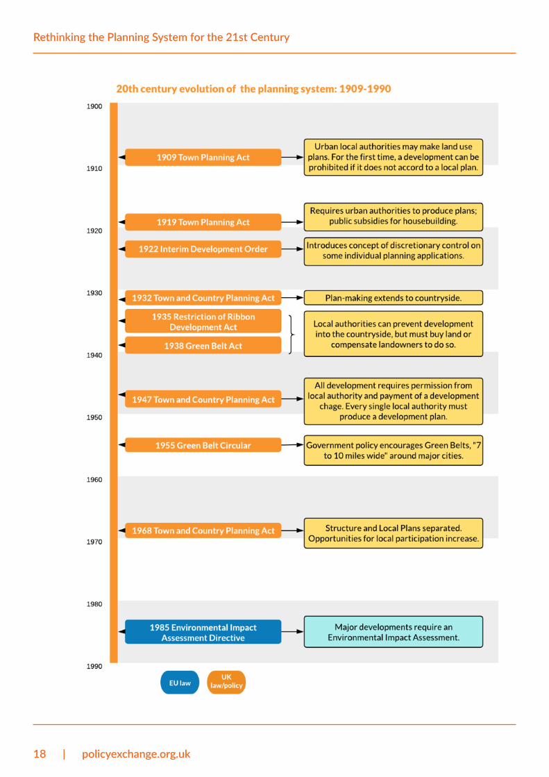
The growth of the planning systemThe UK has a long tradition of planning and regulating new building. Over several centuries, this tradition has grown remarkably in power, intention and extent, from a form of limited development control, to a system in which land use is restricted much more tightly and new development must meet an ever growing number of policy objectives. This happened in five stages, detailed in the report appendix and summarised below:
5. The Sun (2019) - Boris Johnson to turbocharge home building with series of planning reforms in the new year
6. PM speech at Manchester Science and Industry Mu-seum, 27 July 2019
7. Robert Jenrick speech at Policy Exchange, 23 Octo-ber 2019
8. The Conservative and Unionist Party Manifesto 2019
16 | policyexchange.org.uk
Rethinking the Planning System for the 21st Century
• Prior to 1914, development control emerged in the form of essential building regulations, to ensure fire prevention, day light and urban sanitation. There were also a number of planned communities in the form of model villages, Garden Suburbs, and Garden Cities. In 1909, legislation encouraged local authorities to make land use plans for their area, anticipating the rise of a UK-wide planning system.
• In the interwar period, a combination of limited planning control and government- subsidised housebuilding enabled rapid suburban expansion. It sparked a negative reaction from a number of campaigners who were concerned about ’ribbon development’ and the loss of countryside. Planning evolved from ‘Town Planning’, focused on improving urban conditions, to ‘Town and Country Planning’, focused on restricting the extent of urban growth at the same time as dealing with conflicts between heavy industry and housing. Planning control remained limited but a movement to strengthen it gathered momentum.
• From 1940-47, a radical reorganisation of planning policy occurred, culminating in the Town and Country Planning Act 1947. The Uthwatt Committee of 1941 had recommended that all land in the country be nationalised, but the government opted for what was seen as the less radical approach of nationalising land development rights. This became the legal basis that meant that any development now required planning permission, at the discretion of the local authority. It also meant that the value generated by development was a state asset to be collected via Betterment Tax. The main bones of the Act still form the skeleton of the current regulatory planning system today.
• After 1947, alongside a radical restructuring of local government in 1972, a number of policy objectives were added to the planning system, increasing levels of complexity and restriction: Green Belts expanded dramatically beyond what was originally proposed; new regional plans were written alongside local plans; attempts to capture land value uplift changed frequently; EU directives were added to the planning system; and attempts to encourage public participation were made at every stage of the planning process.
• The modern system is therefore defined by a patchwork of legislation and policy: primary legislation, secondary legislation, EU directives, policy guidance, separate regimes in the different nations of the UK, an individual framework in London and other regional cities; and, a separate consent regime for Nationally Significant Infrastructure Projects. The main pieces of legislation are Planning Acts from 1990, 2004, 2008, and 2011,9 while Government policy was consolidated into the National Planning Policy Framework in 2012 which was updated in 2018 and 2019.
9. Namely, the Town and Country Planning Act 1990, the Planning and Compulsory Purchase Act 2004, the Planning Act 2008, and the Localism Act 2011.

policyexchange.org.uk | 17
Introduction
The planning system as we know it today is thus a relatively modern invention, brought into being by a post-War government in very different economic and political circumstances to those we live in today. The level of state control in the British planning system is also relatively unusual compared to other Western countries.
18 | policyexchange.org.uk
Rethinking the Planning System for the 21st Century
Introduction

policyexchange.org.uk | 19
Introduction
Introduction
20 | policyexchange.org.uk
Rethinking the Planning System for the 21st Century
Root and branch reform of the planning system is required
Despite government attempts to make the planning system less complex, less costly and less risky, the fundamental principles of the 1947 planning system remain in place:
• The state has quasi-ownership of all land. Development rights are nationalised. To make a material change to the form or use of their property, owners of private property are required to win this right from the state. Granting the right to build is generally at the discretion of members and officers of local planning authorities.
• Uncertainty. We have a discretionary system so unlike most other planning systems in the world, there are no fixed rules that determine what must be done to gain the right to build. Instead, the right to build is conferred on a case-by-case basis according to sets of complex and often contradictory policies and case law.
• ‘License raj’.10 Owners of land and property are not allowed to develop their land unless given a specific license by the state. Building is the sole major industry in which you can only do something if you have specific, detailed permission from the state. In all other industries and activities you can do broadly anything, as long as it is not specifically prohibited. The planning system turns that on its head.
• A deterministic approach. Local plans are immensely detailed presume that they will be implemented in full. They are also predicated on flawed projections of future need for employment and housing space.
• Natural and efficient urban change is stifled. Towns and cities are most efficient when they are allowed to ‘self-organise’ – this is something that happens through many mechanisms, not least community action, but the main one is the market. The planning system stifles this self-organising aspect of development.
• Anti-agglomeration and anti-growth. The planning system has frozen in time the pattern of settlements as it was in 1941. Planning restrictions prevent dynamic places from growing naturally. The supply of residential and commercial space is rationed which causes real estate prices to increase. The agglomeration economies of scale that make places more productive, innovative and more prosperous are undermined.
These principles were established in a time period that was very different to 2020. The planning system is in urgent need of wholesale reform to bring it into the 21st century. This type of reform programme is possible and necessary, but bold thinking is required. In this report, we have some ideas, supported by sound reasons.
To be clear, our critique throughout the paper focuses on land use
10. License raj is a term used to describe the regulation of the private sector in India between 1947 and 1991. Licenses were required to establish new com-panies and new products. Businesses needed state approval to lose workers and shut down. There were also high import tariffs and extensive nationalisation of industry.

policyexchange.org.uk | 21
Introduction
planning controls which determine what can be built and where, not building regulations. Requiring buildings to be constructed in a way that meets standards on issues like fire safety, insulation and foundations is essential. Detailed long-term land use planning is distinct from building control.
The first chapter details the basis of the planning system and the case for reform. The second chapter considers the costs of our planning system on the economy and society. The third chapter looks at the impact of the planning system on urban form and pattern. The final chapter proposes a reform programme that allows a clean break with the land use planning system introduced in 1947. The appendix includes a detailed history of the planning system.
22 | policyexchange.org.uk
Rethinking the Planning System for the 21st Century
Deficiencies of the planning system
The planning system is an accretion of more than seven decades of regulation and case law. As the system has evolved, it has been required to achieve more and more policy objectives, not least attempts to ration residential and commercial land, direct economic activity and increase the provision of sub-market housing without using government funding. On the whole, the planning system has a significant influence on our economy, society and environment.
In this chapter we consider the fundamental principles and functions of the planning system and the reasons why we do not believe it is fit for the 21st century. These are considered theme by theme over the pages that follow.
Land use: central planning or markets?How should land use be allocated? As land is a scarce resource, the answer to this question is essential to economic productivity, labour market functionality and public welfare.
One means of allocation is through markets and the price mechanism. Price signals show a changing demand for land and land supply adjusts accordingly. As places evolve, for instance through economic transformation or population change, land is recycled. Through rising and falling prices, markets create new types of land use and make others obsolete.11 This process tends to enable an efficient use of resources and quick adjustment to economic and technological transformation. But it also creates a number of market failures because it is unable to respond quickly to externalities like pollution and congestion and through the undersupply of public goods like roads and open spaces. Moreover, there are feedback effects and lock-in impacts which undermine a market allocative process.
Another means of allocation is the central planning mechanism. Land is rationed for exact uses by the state. It is allocated on the basis of ‘need’, as judged by administrators, and almost wholly independently of price signals. The efficiency with which land is recycled is dependent on the administrator’s judgment of what is permissible. Land markets are micromanaged by the state and this makes policy failure, instead of market failure, a feature of land allocation by central planning.
Similarly to other economic functions, land use planning systems across the world sit somewhere on a spectrum between the price signal and central planning mechanisms. As the UK planning system grew more
11. Order without Design: How Markets Shape Cities, Alain Bertaud, Cambridge, MA, MIT Press, [2018]
policyexchange.org.uk | 23
Deficiencies of the planning system
powerful over the 20th century, it now sits very firmly on the central planning side of this spectrum. This is despite almost all other constituent parts of the economy – like use of labour and use of capital – being relatively liberalised from state control. As the government-commissioned Barker Review of Housing Supply found in 2004, “One of the striking features of the local planning process is the lack of any reference to price signals. In spite of numerous modifications, the planning system retains many of the mechanisms originally set out in the 1947 Town & Country Planning Act.”12
In the UK, land use is allocated by local authorities over defined time periods, normally every 15 to 20 years.13 Based on a set of ‘use classes’ as have been defined by legislation (detailed in the table below), planning officers classify the sanctioned use of each square metre of land and building within their boundaries. Their proposals (the local development plan) are then adopted by local authority members after being subject to public examination and approval by a central government Planning Inspector before they become legally binding.
Land use allocations are based on local authority projections of housing and economic ‘need’ in the local area over the plan’s time period. People may seek approval of the local authority to change the specified use of a land plot or building. The decision on the land use change application, with a few exceptions,14 is dependent on the judgment of the local authority and made in accordance with the local development plan, which has primacy in the law. This governs changes to existing buildings as well as those being built anew.
Town and Country Planning Act (Use Classes) Order
1987 (as amended)15
Use/description of development
A1 (Shops) Shops, retail warehouses, hairdressers, undertakers, travel and ticket agencies, post offices, pet shops, sandwich bars, showrooms, domestic hire shops, dry cleaners, funeral directors and internet cafes
A2 (Professional and Financial Services)
Financial services such as banks and building societies, professional services (other than health and medical services) and including estate and employment agencies. It does not include betting offices or pay day loan shops
A3 (Restaurants and Cafes) For the sale of food and drink for consumption on the premises - restaurants, snack bars and cafes.
A4 (Drinking Establishments) Public houses, wine bars or other drinking establishments (but not night clubs)
A5 (Hot Food Takeaways) For the sale of hot food for consumption off the premises.
B1 (Business) B1(a): Offices (other than those that fall within A2).
B1(b): Research and development of products and processes.
B1(c): Light industry appropriate in a residential area.
12. Kate Barker (2004) - Review of Housing Supply Final Report
13. The National Planning Policy Framework requires strategic policies in local plans to “look ahead over a minimum 15 year period from adoption.”
14. The General Permitted Development Order allows a number of ‘permitted developments’ where the approval of the local authority is not required. For some permitted developments, a number of prior approval tests must be met, for example changing from office to residential use.
15. Knight Frank (2019) - Use Class Order
24 | policyexchange.org.uk
Rethinking the Planning System for the 21st Century
B2 (General Industrial) Use for industrial process other than one falling within class B1 (excluding incineration purposes, chemical treatment or landfill or hazardous waste).
B8 (Storage and Distribution) This class includes open air storage
C1 (Hotels) Hotels, boarding and guest houses (where no significant element of care is provided)
C2 (Residential Institutions) Residential accommodation and care to people in need of care, residential schools, colleges or training centres, hospitals, nursing homes
C3 (Dwellinghouses) C3(a) Use by a single person or a family (a couple whether married or not, a person related to one another with members of the family of one of the couple to be treated as members of the family of the other), an employer and certain domestic employees (such as an au pair, nanny, nurse, governess, servant, chauffeur, gardener, secretary and personal assistant), a carer and the person receiving the care and a foster parent and foster child.
C3(b): Up to six people living together as a single household and receiving care e.g. supported housing schemes such as those for people with learning disabilities or mental health problems.
C3(c) groups of people (up to six) living together as a single household. This allows for those groupings that do not fall within the C4 HMO definition, but which fell within the previous C3 use class, to be provided for i.e. a small religious community may fall into this section as could a homeowner who is living with a lodger.
C4 (Small Houses in Multiple Occupation)
Small shared houses occupied by between three and six unrelated individuals, as their only or main residence, who share basic amenities such as a kitchen or bathroom.
D1 (Non-residential Institutions) Clinics, health centres, crèches, day nurseries, day centres, schools, art galleries (other than for sale or hire), museums, libraries, halls, places of worship, church halls, law court. Non-residential education and training centres.
D2 (Assembly and Leisure) Cinemas, music and concert halls, bingo and dance halls (but not night clubs), swimming baths, skating rinks, gymnasiums or area for indoor or outdoor sports and recreations (except for motor sports, or where firearms are used).
Sui Generis Uses that do not fall within any use class, including: theatres, houses in multiple occupation, hostels providing no significant element of care, childcare on domestic premises, scrap yards, petrol filling stations, shops selling and/or displaying motor vehicles, retail warehouse clubs, nightclubs, launderettes, taxi businesses, amusement centres and casinos.
The UK’s system of land use planning provides local authorities significant levels of control. The rationale for this, at least in the eyes of its supporters, is that it allows the local authority to “hold developers to account, ensuring they build the right homes in the right places.”16 The permission system also means that even after land has been allocated for a certain use, the 16. A comment by Councillor Darren Rodwell, the Local
Government Association’s housing spokesman: ITV (2019) - Next government ‘must tackle dangerous shortage of accessible homes’
policyexchange.org.uk | 25
Deficiencies of the planning system
landowner must apply for planning permission to carry out the type of development they wish to undertake. To have a chance of securing the local authority’s permission, the proposed development must meet the local authority’s requirements for development.
It is certainly the case that instances of market failure in land markets mean that the state should require and prohibit certain types of land use in certain areas. However, asking local authorities to micromanage something as complex as the natural process of urban growth has proved to be a misguided exercise since they were first required to in 1947.
A healthier balance is required between market forces and state regulation. This is for a number of reasons.
Housing and economic ‘need’ cannot be accurately projected and should not determine land useCalculations of housing and economic ‘need’ are published by local authorities based upon a methodology provided by Government and each document often stretches to hundreds of pages. The exercise is mostly outsourced to consultancies and is an industry in itself – a local authority spends on average £2.5 million producing a local plan, £1 million of which is spent on average on the evidence base.17 Calculations of ‘need’ are used as evidence bases for planning policies, land use allocations and planning decisions.
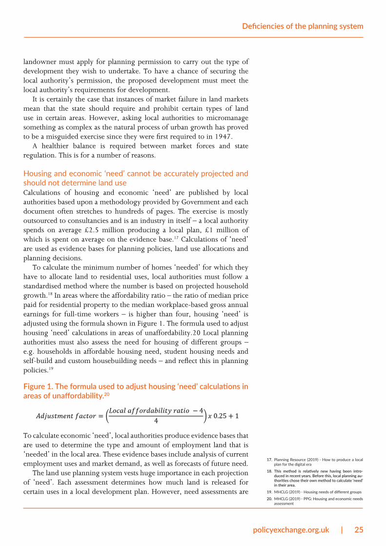
To calculate the minimum number of homes ‘needed’ for which they have to allocate land to residential uses, local authorities must follow a standardised method where the number is based on projected household growth.18 In areas where the affordability ratio – the ratio of median price paid for residential property to the median workplace-based gross annual earnings for full-time workers – is higher than four, housing ‘need’ is adjusted using the formula shown in Figure 1. The formula used to adjust housing ‘need’ calculations in areas of unaffordability.20 Local planning authorities must also assess the need for housing of different groups – e.g. households in affordable housing need, student housing needs and self-build and custom housebuilding needs – and reflect this in planning policies.19
Figure 1. The formula used to adjust housing ‘need’ calculations in areas of unaffordability.20
To calculate economic ‘need’, local authorities produce evidence bases that are used to determine the type and amount of employment land that is ‘needed’ in the local area. These evidence bases include analysis of current employment uses and market demand, as well as forecasts of future need.
The land use planning system vests huge importance in each projection of ‘need’. Each assessment determines how much land is released for certain uses in a local development plan. However, need assessments are
17. Planning Resource (2019) - How to produce a local plan for the digital era
18. This method is relatively new having been intro-duced in recent years. Before this, local planning au-thorities chose their own method to calculate ‘need’ in their area.
19. MHCLG (2019) - Housing needs of different groups
20. MHCLG (2019) - PPG: Housing and economic needs assessment
26 | policyexchange.org.uk
Rethinking the Planning System for the 21st Century
trying to calculate the impossible. The rate and direction of urban growth over a 15 year or more period is largely unpredictable and the result of exogenous and endogenous circumstances. It cannot be projected with any accuracy and nor can the needs of households or businesses. For example, like most of us, planners entirely failed to foresee the impact of internet shopping on the high street, or of digital technology on the need for office space. The longevity of plans also means that ‘need’ projections soon become out-of-date.
As Alain Bertaud, former Principal Urban Planner for the World Bank, has argued, “Planners… lack the information about the economy of individual firms and households that would be necessary to make informed decisions about the advantages and disadvantages of locating in a small, medium or large city.” 21 Instead, households and firms should be as free as possible to choose where they locate and how much floor space they consume. It is they, after all, who have most invested in the success of their move and it is they who have enough information to make trade-offs between location and floor space consumption.
All this means that the land use allocation system is based on a fallacy: that the needs of households and businesses can be accurately projected. Land is rationed depending on what planners think is ‘needed’ and therefore on aspirations rather than reality. The land market becomes dislocated from labour and product markets. This point is fundamental to why our land use planning system does not work and is in urgent need of reform.
In practice, ‘need’ calculations are also often manipulated. Local authority members do not tend to want the extra burden on public services and infrastructure that new homes bring. Many are also elected on the promise that new homes won’t be built in their ward. This means there is a lot of pressure to reduce the number of new homes a local authority plans for. In contrast, local councillors are usually keen on having more jobs. This can lead to the over-allocation of employment land which can then be unused for years while housing land remains scarce.
The result is regular policy failure with land misallocated in relation to demand. Land use planners simply do not and will never have enough information to account for household or business ‘need’. They also cannot plan for, or respond quickly enough to, changes in the economy and technology. Rather than designing a place’s land use on norms and perceived ‘needs’, we should trust the wisdom of the crowd: the collective intelligence of households and firms over the individual wisdom of the land use planner. Projections should not become regulations and planners should not seek to micromanage land markets. Instead, “Planners should… constantly monitor demand through the evolution of land prices and rent, and adjust their projections accordingly.”22
21. Order without Design: How Markets Shape Cities, Alain Bertaud, Cambridge, MA, MIT Press, [2018]
22. Order without Design: How Markets Shape Cities, Alain Bertaud, Cambridge, MA, MIT Press, [2018]
policyexchange.org.uk | 27
Deficiencies of the planning system
Supply of housing and employment space is decoupled from local demandWhen land is allocated for a certain use, it is assumed that the identified ‘need’ that justified the allocation will be met as a result of the allocation. For instance, if land is allocated to residential use, it is assumed that it will lead to the allocated number of homes being built and the ‘need’ for housing will have been met. The system is therefore designed to allocate only enough land to meet the identified ‘need’.
In practice, allocations do not translate to ‘need’ being met. This is for two reasons. Firstly, markets, land ownership and landowner aspirations are all liable to change. Housing developers, for example, build homes at the rate at which they can be absorbed by the local housing market while retaining profit levels. Not every home allocated will be built right away, while landowners may decide they want to use the land differently and may not apply for permission to develop their land as was allocated in the timeframe planners envisioned. Analysis of government data suggests that 30 to 40 per cent of residential planning permissions expire.23
Secondly, as a complex process involving many different agents, developments often encounter problems and delays. Many residential planning permissions, around 55 per cent,24 are won by organisations who don’t build homes (though often sold onto housebuilders). The ‘conversion rate’ of planning approvals to housing completions in London is around 50 per cent. As noted in an extended Policy Exchange essay, “By planning for only “just enough” land to deliver the homes that are needed, the planning system implicitly assumes that nothing will go wrong, that no site will have unexpected problems, or at least that any that do will be counterbalanced by new sites or increased densities on existing ones. The system is thus set up to fail.”25
Supply is decoupled from local demand – and this gap between supply and demand is made wider by the fact that land sites are regularly allocated not just on the number of homes that can be provided or the amount of floor space, but also on the condition that certain types of homes will be delivered. For example, a site allocation by one local authority states that “Redevelopment proposals should… Provide primarily family housing… [and] a range of house sizes from two to five bedroom at least.”26 Another site allocation from a different local authority requires “A mix of houses to be provided including a majority of 2 and 3 bedroom properties.”27
Prescribing how development should happen is not a problem in itself. Indeed many conditions that form part of site allocations are clearly worthy, for instance environmental and heritage protections. However, as described on the previous page, local authorities do not have enough information to know what types of homes are demanded in the local area. When local authorities prescribe housing mixes in this way – not all local authorities go this far – it further decouples land supply from land demand.
23. The analysis finds that 10 to 20 per cent of permis-sions are never started while 15 to 20 per cent are recycled into fresh applications. Chamberlain Walker Economics (2017) - The Role of Land Pipelines in the UK Housebuilding Process
24. Ibid.
25. Policy Exchange (2016) - The Homes London Needs
26. Slough BC (2010) - Slough Local Development Framework Site Allocations
27. Hertsmere DC (2016) - Site Allocations and Devel-opment Management Policies Plan
28 | policyexchange.org.uk
Rethinking the Planning System for the 21st Century
Limiting land supply in the ways that have been described implies that without these checks there would be “too much” of certain uses, for example too many homes or too many office buildings. By calculating ‘need’ and allocating land to meet this need, it is also implied that there should not be a surplus of certain uses. While fixed location products like homes and buildings cannot clear the market – i.e. where supply equalises with demand – like normal products, this does not warrant local authorities rationing supply so tightly in areas with high levels of demand for certain uses.
Excessive rationing means that land use allocations are overly valuableThe divorcing of land use allocation from price signals means that there is no mechanism for automatically making available more land of a certain use when demand for land of that use (evident by its price) increases in that location. Instead, land use allocation policies are up to the local authority based on what they determine is ‘needed’.
This is not much of a problem in areas of low demand for developable land. Indeed in many low demand areas, as several members of the Advisory Panel put it, “you can get planning permission for anything reasonable”. However, in areas of high demand for developable land, the strong tendency has been to excessively ration developable land.
Excessive rationing means that the value of developable land is artificially extremely high (detailed later in the report). For instance, agricultural land with residential planning permission (its Benchmark Land Value) is typically around 10 times its value without planning permission (its Existing Use Value). This value uplift is partly a function of the cost and risk of the planning process and partly because developable land is so tightly rationed. It follows that if we can reduce the cost and risk of the planning process and increase the supply of developable land, the cost to builders of permissioned land will decrease.
It is telling that a whole industry, land promotion, has been born out of navigating the complex but potentially lucrative process of securing land use allocations. A similarly significant industry of assessing the viability of a development has also emerged, in order partly to ensure that high land costs are reflected in the amount of residual value. One of the consequences of low residual value is a reduced amount of money for providing public infrastructure through planning obligation agreements (detailed later in the report). In effect no-one benefits from these inflated land values except the party selling the land.
Planners attempt to design places in their totalityLand use plans and development frameworks in the UK are highly deterministic. Local planning departments create end-state visions that they expect to be implemented over the timeframe of the plan (normally around 15 to 20 years). Every square metre of land, whether it is developed or undeveloped, is allocated a use and the local authority decides policies
policyexchange.org.uk | 29
Deficiencies of the planning system
on everything from energy meter cupboards to the colour and illumination of commercial advertisements. Each policy is made on projections of what the local authority expects households and business will ‘need’ over the 15 to 20 year time horizon.
The UK has a ‘plan-led’ system which means that, as required by the Planning and Compulsory Purchase Act 2004, planning applications must be determined “in accordance with the plan unless material considerations indicate otherwise.”28 This means that a local authority’s land use allocations in its local plan have primacy in the law, though they can be changed on a case-by-case basis through the permission process. This provision allows a degree of flexibility in land use, but the lengthy and risky administrative process of securing planning permission means that land use does not change quickly, if at all, in response to demand and remains highly deterministic. Instead, land uses are often protected even when there is relatively little or no demand or social value for that use.
The deterministic nature of planning policy goes against the natural process of urban growth. Human settlements are hugely complex in structure and urban growth is both chaotic and incremental. Land use plans and development frameworks create visions which planners expect people and companies to follow. They replace the natural evolution of cities, towns and villages with artificially created proxies.
As the urban designers David Rudlin and Shruti Hemani have argued, “Planning professions across the world are yet to understand this truth and persist in creating end-state visons of how a city will be in 20 years time. Economists struggle to predict the state of the economy three years hence, let alone 20. Yet the fundamental assumption of the planning system is that it can envision a better future and somehow will it into existence.”29
This didn’t work after World War Two when the state undertook a large proportion of development. And it certainly doesn’t work today when the vast majority of development is done by private firms and individuals. “The problem,” it has been argued, “lies with the very idea that the city can be entirely planned on paper under the blue utopian skies of a planner’s imagination.”30
Much greater flexibility is therefore required in planning policy. Local plans should be looser, working with rather than against the process of urban growth; and, leaving places to their own devices rather than trying to design them in totality. Above all, planners must accept that they “can influence the way a city develops without being able to determine the outcome.”31
‘Rational order’ is imposed on places and peopleBy virtue of its determinism, planning in its post Second World War form is inherently ideological. Land is designated specific uses and any material changes to the built environment must first receive the permission of the local authority planning department. A ‘rational’ order is imposed on people and communities, remote of customs and tradition. Writing a local plan, it has been written, “Implies an environmental determinism in
28. Planning and Compulsory Purchase Act 2004, Sec-tion 38
29. Climax City: Masterplanning and the Complexity of Urban Growth, David Rudlin and Shruti Hemani, London, RIBA Publishing, [2019]
30. Ibid.
31. Climax City: Masterplanning and the Complexity of Urban Growth, David Rudlin and Shruti Hemani, London, RIBA Publishing, [2019]
30 | policyexchange.org.uk
Rethinking the Planning System for the 21st Century
assuming that people will behave in a predictable, even programmable, way.” 32
This may sound grandiose, but it is essential to understanding the reasons why the post-War planning system came into being. It was born from the utopian idea that a just and efficient society can be created through the work of planners. This is evident from literature of the time which showed a belief that scientific design could replace markets in land use allocation. Thomas Sharp, author of a book on Town Planning that sold 250,000 copies during the Second World War, wrote that “town planning is an attempt to formulate the principles that should guide us in creating a civilised background for human life.”33 Donald Gibson, the chief architect of Coventry City Council who produced the city’s rebuilding plan, once said that his plans represented “the first time that a central area [had been] analysed in terms of its main uses and a plan drawn up which retained only those necessary to its correct functioning.”34
The notion that science should replace markets in land use allocation was common across the world. In India, the Modernist Architecture Research Group (MARG) said that “planning is like dreaming – dreaming of a new world.”35 They talked of “the possibilities of a planned society… against the long ages in which men were more or less subject to ‘fate’.”36 In China between the 1950s and 1980s, land was allocated on ‘scientific’ rules and formulas rather than market mechanisms. “Substituting scientific rationalism for the messy and unpredictable outcome of markets,” it has been argued, “provide[d central planners] a powerful legitimacy.”37 Introducing uniform norms that applied across the entire country also gave “the impression of equality under the law.”38
Plans tend to be made on geographies that are out of step with local labour marketsIn England, urban planning functions are mostly exercised by lower-tier authorities (i.e. borough, district and unitary councils). They are duty-bound to produce a local development plan and to determine the outcome of planning applications. A small number of planning matters are decided by upper-tier authorities in two-tier areas.39 Some areas, mainly large cities like London and Greater Manchester, also carry out statutory strategic planning functions, including producing a statutory spatial plan for the whole area.
The empowerment of lower-tier authorities with planning functions means that urban planning is often done over geographies that do not align with Travel to Work Areas – which the ONS define as a self-contained area in which most people both live and work (i.e. an approximate labour market area).
While the Duty to Cooperate means that neighbouring local planning authorities must consult with each other on strategic matters when writing local plans – the Duty to Cooperate is a legal obligation introduced by the Localism Act 2011 which is in practice very weak and largely ineffectual – local plan policies have no legal weight beyond their boundaries. This
32. Ibid.
33. Thomas Sharp, Town Planning, 1940.
34. Jaqueline Tyrwhitt, Jose Luis Sert, and Ernesto N. Rogers, CIAM 8: The Heart of the City: Towards the Humanisation of Urban Life, CIAM, Lund Hemphries, 1952.
35. Mulk Raj Anand, “Planning and Dreaming,” MARG 1, no. 1,1946.
36. Ibid.
37. Order without Design: How Markets Shape Cities, Alain Bertaud, Cambridge, MA, MIT Press, [2018]
38. Ibid.
39. In two-tier areas where there is a district council and a county council (most of non-metropolitan Eng-land), transport and minerals and waste planning are the functions of the county council.
policyexchange.org.uk | 31
Deficiencies of the planning system
means that local plans are, by nature, parochial.In places where the local planning authority boundary roughly aligns
with the Travel to Work Area, there is not much of an issue in this regard. Land use planning is done over the same sort of spatial area as the operation of local labour and product markets (this does not, of course, mean plans should be deterministic). Yet in places where the local planning authority boundary has little relation to the Travel to Work Area, this means land use planning is done with little relevance to the realities of workers and businesses. Although some local planning authorities have produced joint planning documents as a means of addressing this issue, local planning documents in most of the country are out of sync with local economic geographies.
In summary, while some places plan land use over boundaries that roughly relate to local labour and product markets, most land use planning is done over geographies that are too small.
Nationalised development rights“The fundamental ability of government to interfere with the rights of landowners to do what they will with their land,” David Rudlin and Shruti Hemani have argued, “has shaped their system of planning.”40 In 1947, the UK Government decided it had the ultimate ability to interfere with landowner rights. The land use planning system, as introduced by the 1947 Town and Country Planning Act, generally removed the right of property owners to develop their property or change its use without the discretion of the local authority.
Before this, local authorities (those who had used their power to produce a local development plan) had the power to prohibit development on the condition that landowner was appropriately recompensed. Land law had developed based on the feudal system of land ownership – based on the idea that all land is owned by the crown with the right to use land passed on through the leasehold system – and urban development was mainly controlled through restrictive covenants – rules agreed in a deed that restrict use of land in some way that benefits another’s land.
The planning system gives the state quasi-ownership of all propertyThe new 1947 system marked a significant break from the past. It placed a statutory duty on local authorities to produce a local development plan, made planning permission a necessity; and, gave local authorities the power to prohibit development without giving compensation to the landowner. Nationalising development rights effectively gave the state quasi-ownership of all land and property – indeed, the Attlee Government had been elected on a manifesto that said it “believes in land nationalisation and will work towards it”.41 There was also an expectation that the large majority of new development would be done by the public rather than the private sector.
Although there are now some changes of use that are ‘permitted development’ (with permission automatically conferred by the Secretary
40. Climax City: Masterplanning and the Complexity of Urban Growth, David Rudlin and Shruti Hemani, London, RIBA Publishing, [2019]
41. 1945 Labour Party Manifesto
32 | policyexchange.org.uk
Rethinking the Planning System for the 21st Century
of State) the principle that significant changes to private property must be approved by the local planning authority (whose decisions are guided by their local development plan) remains the cornerstone of the British land use planning system. The private sector, however, now does the vast majority of new development.
British exceptionalismIn France, the planning system – which is broadly a zonal permit system where development is authorised if it conforms to a set of rules – has evolved out of a system of land ownership that was liberalised after the 1789 Revolution. Landowners are provided the ‘power of dominium’. This gives them the absolute right to land and thus “the absolute control of material possession, which implied an absence of personal obligation to others.”42 That power is overridden, however, by the ‘power of imperium’, which gives the state power to control land use for the common good, for example for public works projects.43 The result is a land use planning system where building is authorised according to a set of rules and land is regularly acquired by the state – quite different to a British planning system where approval is at the state’s discretion and negotiated on a case-by-case basis.
Rules-based approaches to planning are consistent across Europe. As has been written by Create Streets, “Unlike every other prosperous planning system, the British system nationally is not rules-based but instead takes a case-by-case approach… in every other European country studied (other than Ireland and Portugal) the main permit required is conceived of and indeed called a building permit.”44
In countries with rules-based planning systems, the state still, in a sense, owns development rights. What is different in these countries in comparison to the UK is that there are fixed rules that determine what must be done to gain the right to build. In the UK, the right to construct is conferred case-by-case according to sets of complex and often contradictory policies and case law.
The UK also has very tight restrictions on what can be built where through detailed local plans that rigidly designate specific uses for all land plots (an issue explore in the previous part of this chapter) and extensive constraints on urban growth (e.g. Green Belts). These restrictions tend to be much tighter and more detailed than in other Western countries which tend to have more general zonal systems and fewer constraints on urban growth.45 This further constrains development and property rights in the UK relative to other countries.
Reversing the extent of post-War reformsGiven the principles and structure of a country’s system of land use planning are so dependent on the country’s conception of, and legislation for, property rights – which are in turn dependent on its history – there can be no universally ‘correct’ level of interference in private property rights by the state. Indeed, as a tool for balancing private and public
42. Spatial Planning Systems of Britain and France: A Comparative Analysis, Booth et al., London, Rout-ledge, [2007]
43. Ibid.
44. Create Streets and Legatum Institute (2019) - More Good Homes
45. Sarah Monk, Christine Whitehead, Gemma Burgess and Connie Tang (2013), International Review of Land Supply and Planning Systems
policyexchange.org.uk | 33
Deficiencies of the planning system
interests, some form of constraint on individual freedom is necessary because development creates externalities that should be managed for long-term public benefit.
Nonetheless, governments of recent decades have made a profound mistake in failing to reverse the extent of reforms made by the post-War Government that nationalised development rights in the UK. Even if the reforms matched the public mood of the time and might have worked more effectively if the state had, as expected, undertaken almost all new development, they certainly do not suit today’s economy or society. They overly curtail the rights of landowners at the same time as failing to serve the interests of the wider public.
An imbalance of powerThe nationalisation of development rights means that the balance of power in the planning system very firmly lies with the state rather than with private property rights and individual initiative. This power to determine planning policy and planning decisions is exercised by politicians and administrators at a number of different government levels, sometimes mediated by the courts. A complex and at times contradictory set of planning rules has been created for planning applicants and interested parties to navigate, be they individuals, private organisations, public organisations, communities or interest groups.
Advocates of this system say that it puts power in the hands of the people. As Hugh Ellis, Head of Policy at the Town and Country Planning Association, has written: “By nationalising development rights, landowners lost the right to develop their land… creating the biggest shift in power between landowning interest and ordinary citizen in British history. Coupled with comprehensive land tax, the 1947 system was elegant in structure and poetic in outcome.”46
Yet the system has failed in these terms. Power is in the hands of some people, not the population as a whole. Unless they have the time and patience to attend local planning committees, ordinary citizens are detached from the planning process. Instead, the regulation of development and land use is often exercised randomly, slowly and without enough reference to what people actually want. Meanwhile, planning law is such a “statutory thicket”, as one judge described a part of the system,47 that any description of the wider system as elegant or poetic is risible.
A 21st century planning system requires a much healthier balance of power. This is for a number of reasons.
The role of politiciansPolitical choice is a significant feature of the planning system. Local planning authorities have to vote to formally adopt their local plan, usually by a vote in full Council, while some planning applications, normally those that are controversial and/or complex, are decided by the local planning committee which is made up of local councillors.
In some respects, the significance of political choice in the planning 46. The Rise and Fall of the 1947 Planning System, Hugh
Ellis, Town and Country Planning Association, 2017
47. Kebbell Developments Ltd, R (on the application of) v Leeds City Council & Anor [2016] EWHC 2664 (Admin)
34 | policyexchange.org.uk
Rethinking the Planning System for the 21st Century
process is necessary. As it has been argued, “There is no scientific way to set up urban development objectives.”48 The best way of deciding the priority of these objectives is through democratic means.
Yet in other ways, there is too much political choice in the planning system. Local politicians not only set planning rules in their area, but they often adjudicate whether these rules are met as well. This is like asking politicians to determine the tax bills of each person and company, in addition to them setting policies on general taxation.
In both rule setting and decision making, the complexity of the planning process (detailed later in the report) means that local politicians are required to deal with a sizeable amount of documentation: when applications are brought fully documented before committees, such is the complexity of these documents and the possible legal outcomes that the documentation is rarely scrutinised and the reporting officer, in effect, controls the gateway to the application. Similarly, the research and documentation process in the preparation of local plans is so voluminous that local politicians who may wish to question the outcomes would have to challenge the research outcomes in detail. This requires putting in large personal resources.
The many junctures at which politicians have a say over planning means that new developments are often at the mercy of political cycles and the most vocal and time-rich members of the local community. Land for a proposed housing scheme might, for instance, be allocated for development by one administration only for the next administration to oppose and delay the scheme. The political risk incurred through this process makes planning ahead difficult for the developer – managing labour, materials and financing for the scheme. It also deters investment in the first place.
Representing some but not othersWhen introducing the new planning system to the House of Commons in 1947, the Minister of Town and Country Planning said it would give a voice to people whose voices had previously been drowned by “the objections of a noisy minority.”48 The Minister also said how, “In the past, plans have been too much the plans of officials and not the plans of individuals, but I hope we are going to stop that.”49
These were worthy ideals. But unfortunately the planning system has failed to live up to them. The noisy minority continue to drown out the silent majority, while local plans remain the plans of officials – based on their judgment of what is ‘needed’ (as detailed earlier in the report) – rather than individuals, as the Minister hoped.
Two public groups are represented in the local planning process: those who vote in local elections; and, those who have the time and patience to take part in public consultations on planning policies and planning application decisions.
48. Order without Design: How Markets Shape Cities, Alain Bertaud, Cambridge, MA, MIT Press, [2018]
49. Ibid.
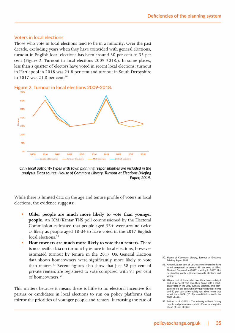
policyexchange.org.uk | 35
Deficiencies of the planning system
Voters in local electionsThose who vote in local elections tend to be in a minority. Over the past decade, excluding years when they have coincided with general elections, turnout in English local elections has been around 30 per cent to 35 per cent (Figure 2. Turnout in local elections 2009-2018.). In some places, less than a quarter of electors have voted in recent local elections: turnout in Hartlepool in 2018 was 24.8 per cent and turnout in South Derbyshire in 2017 was 21.8 per cent.50
Figure 2. Turnout in local elections 2009-2018.
0%
10%
20%
30%
40%
50%
60%
70%
2009 2010 2011 2012 2013 2014 2015 2016 2017 2018
Turn
out
London Boroughs Unitary Councils Metropolitan District Councils
Only local authority types with town planning responsibilities are included in the analysis. Data source: House of Commons Library, Turnout at Elections Briefing
Paper, 2019.
While there is limited data on the age and tenure profile of voters in local elections, the evidence suggests:
• Older people are much more likely to vote than younger people. An ICM/Kantar TNS poll commissioned by the Electoral Commission estimated that people aged 55+ were around twice as likely as people aged 18-34 to have voted in the 2017 English local elections.51
• Homeowners are much more likely to vote than renters. There is no specific data on turnout by tenure in local elections, however estimated turnout by tenure in the 2017 UK General Election data shows homeowners were significantly more likely to vote than renters.52 Recent figures also show that just 58 per cent of private renters are registered to vote compared with 91 per cent of homeowners.53
This matters because it means there is little to no electoral incentive for parties or candidates in local elections to run on policy platforms that mirror the priorities of younger people and renters. Increasing the rate of
50. House of Commons Library, Turnout at Elections Briefing Paper, 2019
51. Around 25 per cent of 18-34s are estimated to have voted compared to around 49 per cent of 55+s. Electoral Commission (2017) - Voting in 2017: Un-derstanding public attitudes towards elections and voting
52. 70 per cent of those who own their home outright and 68 per cent who own their home with a mort-gage voted in the 2017 General Election. This com-pares to 53 per cent who privately rent their home and 52 per cent who socially rent their home that voted. Ipsos MORI (2017) - How Britain voted in the 2017 election
53. Politics.co.uk (2019) - The missing millions: Young people and private renters left off electoral register ahead of snap election
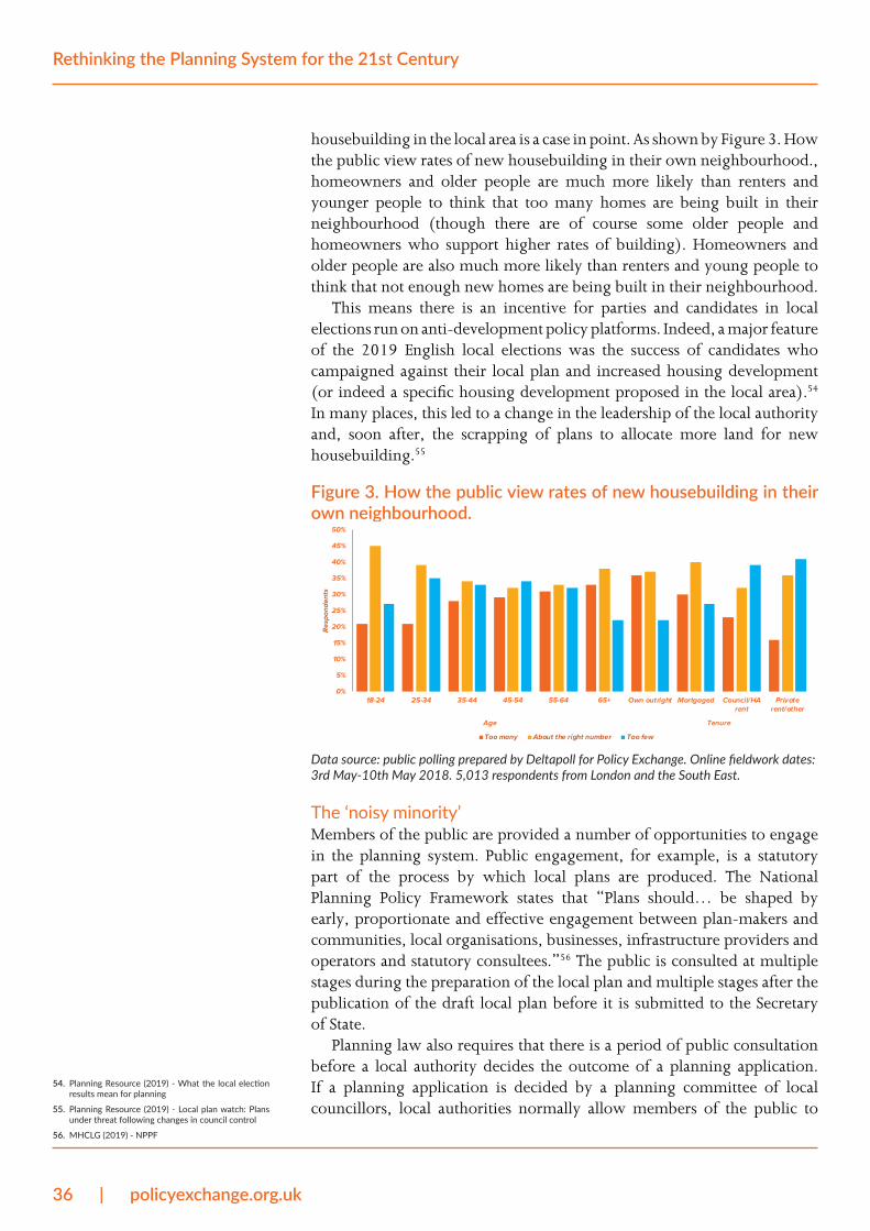
36 | policyexchange.org.uk
Rethinking the Planning System for the 21st Century
housebuilding in the local area is a case in point. As shown by Figure 3. How the public view rates of new housebuilding in their own neighbourhood., homeowners and older people are much more likely than renters and younger people to think that too many homes are being built in their neighbourhood (though there are of course some older people and homeowners who support higher rates of building). Homeowners and older people are also much more likely than renters and young people to think that not enough new homes are being built in their neighbourhood.
This means there is an incentive for parties and candidates in local elections run on anti-development policy platforms. Indeed, a major feature of the 2019 English local elections was the success of candidates who campaigned against their local plan and increased housing development (or indeed a specific housing development proposed in the local area).54 In many places, this led to a change in the leadership of the local authority and, soon after, the scrapping of plans to allocate more land for new housebuilding.55
Figure 3. How the public view rates of new housebuilding in their own neighbourhood.
0%
5%
10%
15%
20%
25%
30%
35%
40%
45%
50%
18-24 25-34 35-44 45-54 55-64 65+ Own outright Mortgaged Council/HArent
Privaterent/other
Age Tenure
Resp
onde
nts
Too many About the right number Too few
Data source: public polling prepared by Deltapoll for Policy Exchange. Online fieldwork dates: 3rd May-10th May 2018. 5,013 respondents from London and the South East.
The ‘noisy minority’Members of the public are provided a number of opportunities to engage in the planning system. Public engagement, for example, is a statutory part of the process by which local plans are produced. The National Planning Policy Framework states that “Plans should… be shaped by early, proportionate and effective engagement between plan-makers and communities, local organisations, businesses, infrastructure providers and operators and statutory consultees.”56 The public is consulted at multiple stages during the preparation of the local plan and multiple stages after the publication of the draft local plan before it is submitted to the Secretary of State.
Planning law also requires that there is a period of public consultation before a local authority decides the outcome of a planning application. If a planning application is decided by a planning committee of local councillors, local authorities normally allow members of the public to
54. Planning Resource (2019) - What the local election results mean for planning
55. Planning Resource (2019) - Local plan watch: Plans under threat following changes in council control
56. MHCLG (2019) - NPPF
policyexchange.org.uk | 37
Deficiencies of the planning system
speak and make representations at committee meetings as a matter of good practice. Members of the public also have the right to seek judicial review of the way a planning application decision was made.
Despite there being numerous opportunities for the public to participate in the planning system, rates of public participation are very low. Response rates to local plans are said in some areas to be less than 1 per cent of the local population while “typical” response rates to pre-planning consultations around 3 per cent of those directly made aware of it.57 The majority of people who engage in the planning system are also said to be over the age of 55.58
Judicial review is a relatively infrequent but significant part of the planning system. It allows people or organisations with a sufficient interest in the matter to challenge the lawfulness of planning decisions made by local planning authorities or the Secretary of State. The judicial review process is an important element of the rule of law, but is often abused in relation to planning cases. Often cases are brought forward without legal merit and used to frustrate development by objector groups and/or rival developers and landowners whose sites have not been allocated for development. This delay increases costs for developers and investors – and also for local authorities who must spend time and resource preparing and then defending the lawfulness of the planning decision they have made.
All this means that the views of people who cannot afford to spend time in local planning committees, attend local plan examination hearings or bring forward a claim for judicial review – the vast majority of people – go unheard. The complexity of the planning system and the attritional nature of planning procedures mean there are significant barriers to entry for public participation. It should therefore be no surprise that local planning policies are so often weighted in favour of the noisy minority’s interests.
The noisy minority might include individuals with an overwhelming interest in specific issue. For example, one member of the advisory panel described one person with “a particular type of tree species, and any appeal [across the country] that he could see was affecting this particular type of tree species he would write in an objection to.” It might also include anti-development groups opposing a particular development in their area.
Requiring the state to arbitrate individual planning applications since 1947, coupled with subsequent attempts in the late 1960s to increase public participation in planning, has had the effect of putting control in the hands of objectors rather than ‘the people’.
Potential occupants are not representedThe inevitable consequence of having a planning system with such an extensive level of local political control is that, if they come from outside the local authority boundaries, the prospective occupants of new developments – be they homes, offices, or something else – have little representation in the local planning process. Central government has tried to overcome this by imposing housing supply targets and delivery tests on local planning authorities. However, history shows that local 57. RTPI (2017) - Planning and public engagement: the
truth and the challenge
58. Ibid.
38 | policyexchange.org.uk
Rethinking the Planning System for the 21st Century
politicians and objectors find ways to frustrate or bypass these policies. Local councillors have little electoral incentive to do anything different.
Similarly, potential occupants of new developments are unlikely to turn up to planning committee meetings to speak in support of a development. This is not just because they might not live in an area, but also because developments take long times to build. Potential occupants are unlikely to know they will be moving home in one year’s time, let alone the time it takes to achieve planning consent and then build new homes.
Regional policy through urban containmentIn the aftermath of the Second World War, a significant feature of the government’s economic programme was its regional policy. The focus was shifting economic activity away from “congested areas” like London and Birmingham and towards “development areas” in the north and west. A number of policies were enacted to limit population and economic growth in certain places, including the 1945 Distribution of Industry Act which forbade private industries from opening or expanding in an area without permission of the government.
Two decades later, the Control of Office Employment Act 1965 introduced a need to obtain an office development permit before building new offices over 2,500 sq. ft. in specific areas (applied initially in Greater London and the outer Metropolitan region then later in Birmingham). Douglas Jay, the then President of the Board of Trade, spoke positively of “imposing a virtual standstill on office building in the most congested parts of the South-East.”59
Planning policy was a tool used to amplify these economic policies. The West Midlands Plan, for example, was commissioned by the Minister for Town and Country Planning and sought to reduce Birmingham’s population by 10 per cent. Similarly, the 1944 Greater London Plan aimed to rehouse 1,033,000 people outside of the capital, 383,250 of which would be housed in new towns, 261,000 of which would be housed in existing towns and 125,000 in inner London’s ‘quasi-satellite’ towns.60 The remainder were to be moved to places far from London.
Policy makers today do not quite so explicitly attempt to limit or reduce population and business growth in certain areas. However, by rationing land for housing and business growth in land use plans and requiring new developments to receive planning permission, the supply of new homes and employment space is capped by local planning authorities in other ways: land use plans are, as we detail earlier in the report, dislocated from local demand for homes and employment space, while it is in the electoral interest of local councillors to limit the allocation of land for new development and to oppose applications for new developments.
Across the country, the result has been the creation of significant planning constraints on the supply of homes and employment space in the dynamic areas where people and firms want to locate. Unlike before 1947, when local authorities had to recompense landowners if they prohibited development on their land, nowadays there is no direct cost 59. HC Deb 01 February 1965 vol 705 cc733-822
60. Larkham and Adams, The post-war reconstruction planning of London: a wider perspective, 2011
policyexchange.org.uk | 39
Deficiencies of the planning system
to the local authority of doing so. There is also no direct cost to the local electorate. They do not, for example, have to pay higher taxes to fund the compensation of landowners whose development rights have been taken away.
The growth of Green BeltsThe most well-known and most significant land use regulation that constrains productive places is the Green Belt policy. This policy allows local planning authorities to establish Green Belts around settlements to, as described in national planning policy, “prevent urban sprawl by keeping land permanently open.”61 Except for a limited number of exceptions, proposed developments on land designated as Green Belt is prohibited unless the applicant can prove “very special circumstances”.62 Local planning authorities also use ‘Open Countryside’ planning designations to restrict development.
Green Belts are not a post-War invention. The idea was proposed by Victorian thinkers like Ebenezer Howard and the policy was taken forward by the London County Council (LCC) who worked with local authorities outside of London to purchase land and then permanently safeguard it from development. Their aim was “to provide a reserve supply of public open spaces and of recreational areas and to establish a Green Belt or girdle of open space lands.”63 The objective was a continuous belt 1 to 5 miles wide around London but, by 1943, the total area was 72,000 acres which amounted to “nothing like a continuous belt, only a scattering of green patches on the map”.64
In 1955, a government circular allowed for the creation of Green Belts across the country without compensation of landowners. It recommended planning authorities “consider establishing a [formal] Green Belt wherever this is desirable in order.”65 Rather than to provide public open space and recreational area as was the aim two decades before, the circular directed planning authorities to establish Green Belts to check the further growth of built-up areas and prevent neighbouring towns from merging into each other.66
Local planning authorities have extensively used their power to designate land as Green Belt without compensation. The total area of Green Belt in England more than doubled from 721,500 hectares in 1979 to 1,555,700 hectares in 1993.67 The most recent figures show that 1,621,150 hectares of land is now designated Green Belt in England, with 15 Green Belts in total.68 A key moment seems to have been in 1984 when a draft government circular advocating the relaxation of Green Belt boundaries provoked opposition.69 Figure 4. Green Belt size by place, 2018/19. shows the size of Green Belts around cities across the country.
In London, the policy has gone well beyond the scope originally envisioned. The city’s pre-War objective was to establish a continuous belt one to five miles wide.70 Duncan Sandys, the Minister of Housing and Local Government who allowed Green Belts across the country in 1955, promoted a Green Belt around London seven to 10 miles wide.71 Yet the
61. MHCLG (2019) - NPPF
62. Ibid.
63. Alan Jackson (1991) - Semi-Detached London: Sub-urban Development, Life and Transport, 1900-39
64. Ibid.
65. Ministry of Housing and Local Government, Circular 42/55, 1955
66. Ibid.
67. MHCLG, Local Planning Authority Green Belt: Eng-land 2017/18; HC Deb 28 July 1997 vol 299 c47W
68. MHCLG, Local Planning Authority Green Belt: Eng-land 2018/19
69. H.W.E. Davies, The Evolution of the British planning System, 1998
70. Alan Jackson (1991) - Semi-Detached London: Sub-urban Development, Life and Transport, 1900-39
71. Ministry of Housing and Local Government, Circular 42/55, 1955
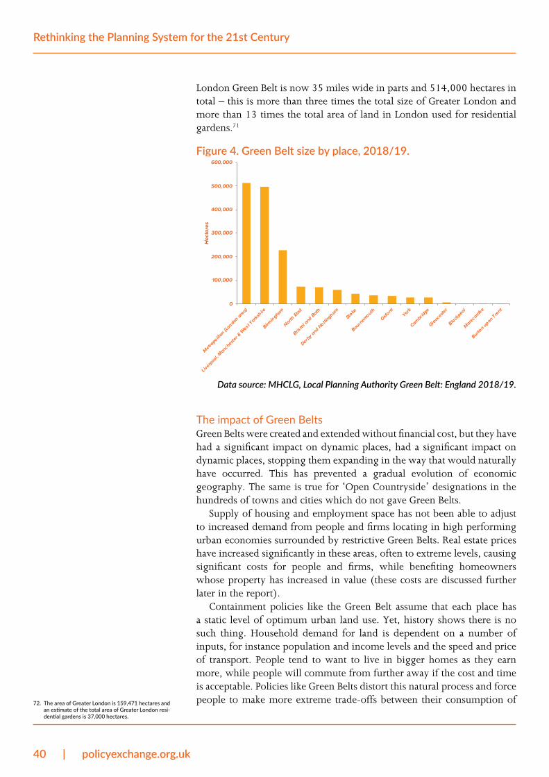
40 | policyexchange.org.uk
Rethinking the Planning System for the 21st Century
London Green Belt is now 35 miles wide in parts and 514,000 hectares in total – this is more than three times the total size of Greater London and more than 13 times the total area of land in London used for residential gardens.71
Figure 4. Green Belt size by place, 2018/19.
0
100,000
200,000
300,000
400,000
500,000
600,000
Metropolita
n (London area)
Liverpool, Mancheste
r & W
est Yorksh
ire
Birmingham
North East
Bristol a
nd Bath
Derby and Nottin
ghamSto
ke
Bournemouth
Oxford
York
Cambridge
Gloucester
Blackpool
Morecombe
Burton upon Trent
Hec
tare
s
Data source: MHCLG, Local Planning Authority Green Belt: England 2018/19.
The impact of Green BeltsGreen Belts were created and extended without financial cost, but they have had a significant impact on dynamic places, had a significant impact on dynamic places, stopping them expanding in the way that would naturally have occurred. This has prevented a gradual evolution of economic geography. The same is true for ‘Open Countryside’ designations in the hundreds of towns and cities which do not gave Green Belts.
Supply of housing and employment space has not been able to adjust to increased demand from people and firms locating in high performing urban economies surrounded by restrictive Green Belts. Real estate prices have increased significantly in these areas, often to extreme levels, causing significant costs for people and firms, while benefiting homeowners whose property has increased in value (these costs are discussed further later in the report).
Containment policies like the Green Belt assume that each place has a static level of optimum urban land use. Yet, history shows there is no such thing. Household demand for land is dependent on a number of inputs, for instance population and income levels and the speed and price of transport. People tend to want to live in bigger homes as they earn more, while people will commute from further away if the cost and time is acceptable. Policies like Green Belts distort this natural process and force people to make more extreme trade-offs between their consumption of 72. The area of Greater London is 159,471 hectares and
an estimate of the total area of Greater London resi-dential gardens is 37,000 hectares.
policyexchange.org.uk | 41
Deficiencies of the planning system
housing space and commuting time and cost. This has a significant impact on people’s quality of life. Green Belts are an example of the eminent geographer Sir Peter Hall’s 1972 description of the planning system as “a framework that virtually guaranteed that town would be set up against country, and that gave very considerable weight to the rural status quo”.73
Advocates of containment policies like Green Belts say that they are necessary to stop places from ‘sprawling’. Indeed, Government policy says that Green Belts should “prevent urban sprawl” or large built-up areas.74 Sprawl is an emotive term that suggests urban growth leads to a wasteful and inefficient use of land. Cities tend to be surrounded by agricultural land, so the term is also linked in peoples’ minds to the loss of food production. Both points merit challenge for several reasons.
Firstly, as argued already, there is no optimum level of land consumption by households or companies. Densities vary across cities and consumption of land on the edge of cities should not be compared in these terms to more central parts. Indeed, the standard monocentric urban model – where the price of and demand for land decreases the further from a city’s central business district with the result concentric land use rings (inner rings are commercial use and outer rings residential use) – shows it is perfectly normal for urban land on a city’s periphery to be used at lower densities.
Secondly, as Policy Exchange argued in its report Farming Tomorrow, there is little to worry about in the loss of agricultural land.75 Food production is more dependent on productivity than land consumption.
Thirdly, by preventing cities from growing naturally, the household growth of cities with dynamic labour markets will be displaced to areas beyond protected areas where new development isn’t so rigidly restricted. This has negative implications for the environment.76 It would mean more transport infrastructure would need to be built than otherwise would – ironically, pushing growth beyond the Green Belt has often meant that the Green Belts themselves, rather than remaining pristine, are developed for roads and railways rather than houses. It might also lead to a loss of land that is genuinely environmentally valuable as opposed to low-grade farmland on the edge of cities.
Contrary to dramatic stories about Green Belt and countryside loss, the country has extensively protected agricultural land at the expense of land for housing and commercial needs. MHCLG data, illustrated in Figure 5 shows that just 1.1 per cent of land in England is used for housing (4.8 per cent is used residential gardens) and 0.4 per cent is used for industry and commerce. In comparison, 63.1 per cent is used for agriculture and 20.9 per cent for forestry, open land and water.
73. Hall, 1974: 396
74. MHCLG (2019) - NPPF
75. Policy Exchange (2018) - Farming Tomorrow
76. Adam Smith Institute – The Green Noose
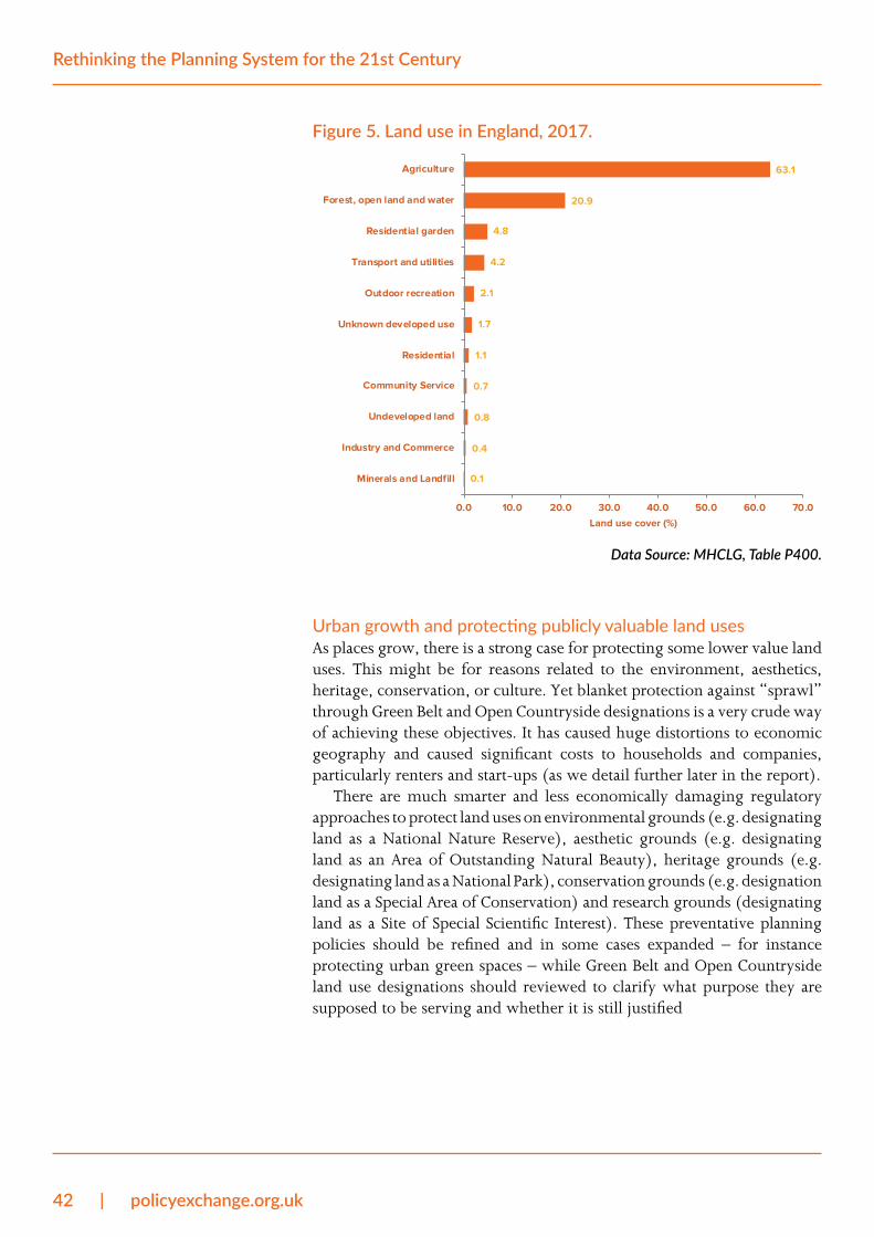
42 | policyexchange.org.uk
Rethinking the Planning System for the 21st Century
Figure 5. Land use in England, 2017.
0.1
0.4
0.8
0.7
1.1
1.7
2.1
4.2
4.8
20.9
63.1
Minerals and Landfill
Industry and Commerce
Undeveloped land
Community Service
Residential
Unknown developed use
Outdoor recreation
Transport and utilities
Residential garden
Forest, open land and water
Agriculture
0.0 10.0 20.0 30.0 40.0 50.0 60.0 70.0
Land use cover (%)
Data Source: MHCLG, Table P400.
Urban growth and protecting publicly valuable land usesAs places grow, there is a strong case for protecting some lower value land uses. This might be for reasons related to the environment, aesthetics, heritage, conservation, or culture. Yet blanket protection against “sprawl” through Green Belt and Open Countryside designations is a very crude way of achieving these objectives. It has caused huge distortions to economic geography and caused significant costs to households and companies, particularly renters and start-ups (as we detail further later in the report).
There are much smarter and less economically damaging regulatory approaches to protect land uses on environmental grounds (e.g. designating land as a National Nature Reserve), aesthetic grounds (e.g. designating land as an Area of Outstanding Natural Beauty), heritage grounds (e.g. designating land as a National Park), conservation grounds (e.g. designation land as a Special Area of Conservation) and research grounds (designating land as a Site of Special Scientific Interest). These preventative planning policies should be refined and in some cases expanded – for instance protecting urban green spaces – while Green Belt and Open Countryside land use designations should reviewed to clarify what purpose they are supposed to be serving and whether it is still justified
policyexchange.org.uk | 43
Deficiencies of the planning system
Mitigating and compensating for development externalities
One of the most significant features of the planning system is the requirement for developers to mitigate or compensate for the impact of new development. As a condition of achieving planning consent, developers will normally be obliged to contribute to the cost of local infrastructure when the proposed development has a significant impact on a local area. Residential developers may also be required to provide a proportion of homes at below-market rates for eligible households to either rent or buy.
Developer contributions are made to address the externalities caused by growth. Externalities are numerous, not least the effect of new development on:
• The value of adjacent properties. This effect could be positive and cause private gain, for instance if the adjacent land or property was previously derelict. Or the effect could be negative and cause private loss, for instance if a view of open space is compromised by a new development. Either way, the impact of new development on nearby land and property tends to be highly localised.77
• Housing amenity. People or organisations located next to a new development being built may also suffer private loss that is not directly financial. Construction, for instance, can have a significant impact on peoples’ day-to-day lives and organisations’ operations, for instance increasing levels of road congestion, noise pollution and air pollution over the build period. It also has implications for road safety.
• Local public services. New development increases human activity in an area. This increases demand for local public services, not least transport, education, healthcare and recreation, which requires higher expenditure by the relevant public authority.
The scope and scale of developer contributions is determined by what is negotiated with the local planning authority in the Section 106 agreement as ‘necessary’ and ‘reasonable’ to make a development “acceptable” under the terms of the 1990 Town and Country Planning Act and Regulation 122 of the Community Infrastructure Regulations 2010. Some local planning authorities also operate a Community Infrastructure Levy, as allowed by the 2008 Planning Act, which some developments must also pay either instead of or in addition to the Section 106 agreement. While Section 106 contributions are site-specific, Community Infrastructure Levy payments are made according to the local planning authority tariff and used to help fund local infrastructure that supports development.
It is right that, where necessary, developers are required to mitigate and compensate for losses to local people, communities and public authorities that are caused by new development. Developers benefit from
77. For example, research from the Netherlands has found that proximity to local open space has a pos-itive effect on house prices – ceteris paribus a view of open space increases property prices by four to eight per cent – however this effect is negligible after 50 metres. Valuation of Open Space, Hedonic house price analyses in the Dutch Randstad region, J Dekkers & E Koomen, 2008
44 | policyexchange.org.uk
Rethinking the Planning System for the 21st Century
previous private and public investment that has been made in the place they are building – e.g. transport infrastructure, local parks, heritage – so it is only fair that they contribute towards its upkeep. Indeed, the value of whatever they build will be dependent on its location remaining an attractive environment in which to live, work and do business, so there is a commercial case for contributing to local infrastructure as well as one of fairness.
There are, however, a number of challenges related to developer contributions, not least their scale, how they are spent; and, the process by which they are agreed, as is detailed below.
Developer contributions are a balancing financial actHow much extra infrastructure is needed in a place to support a new development?
Most new developments will become a part of existing settlements, in which case they will be connecting to an existing infrastructure network. Some new developments will be entirely new settlements, in which case the infrastructure requirement will be vast. The infrastructure requirement will also differ, of course, by the development size.
Who pays for infrastructure necessary for new development is a complex mix of public and private sources. Public sources include central government departments like the Ministry of Housing, Communities and Local Government, the Department for Transport and the Department for Education); non-departmental public bodies like NHS England and the Environment Agency; and, local authorities. Private sources include privatised utilities like companies who provide water, gas, electricity and broadband; as well as developers.
The extent to which developers contribute to this mix will depend on what is agreed with local planning authorities in Section 106 agreements, the rate at which the Community Infrastructure Levy is applied (if at all); and, what other infrastructure the developer decides to provide above and beyond what is legally agreed as part of the planning process (for instance, because it makes the development more attractive and increases its value).
It is important to note that the incidence of these developer contributions generally falls on the landowner from whom the developer has acquired land to build. Land has a residual value – calculated by subtracting from the projected total value of a development the projected costs associated with development and developer profit – so if the level of required contribution is known before permission is applied for; the liability is priced in to the developer’s land bid. If the level of required contribution is unknown, the developer bids for land on an assumption of these liabilities. In areas where there is intense competition for residential land – caused by high demand and low supply – developers will attempt to outbid each other and this will drive prices up. House prices are generally pegged to the resales market (where the large majority of housing transactions occur). For the prospective development to remain profitable, the winning land bidder is likely to have assumed the lowest compensatory contributions
policyexchange.org.uk | 45
Deficiencies of the planning system
and/or that costs can be recovered later in the development process, for instance during construction. In other words, the more that is spent acquiring land, the less there is available for developer contributions and the actual construction of the development.
If developer contributions are minimised, infrastructure might either go unprovided or the state will likely end up paying a higher proportion of costs. Given the cost pressures faced by central and local government, there is understandably a strong lobby to maximise developer infrastructure contributions. However, any push to increase developer contributions needs to be judged against the costs they impose on development and the effect on its overall financial viability. Building new roads and schools is an expensive exercise, while a requirement to sell or rent homes at a discounted rate makes a big difference to the development’s gross value. Even a relatively small development can require significant infrastructure costs.78
The impact of these costs on the cost of developing land is considered in detail later in the report. If local planning authorities set contributions too high, a development might quickly become financially unviable. The developer would then pull out their investment, building no extra homes or offices and making no contribution whatsoever to the local area. A balance is therefore required.
Developer contributions also have wider implications on the planning and development process. To generate high amounts of income from Community Infrastructure Levy payments – which are based on the area of new build floor space – planners are incentivised to require developments to be built at higher densities. Although this generates bigger Community Infrastructure Levy payments, it also skews the design of development schemes which may not be the ambition of the developer or in the interests of the people who eventually use the development.
Contributions do not effectively address development externalities“Planning obligations,” it is stated in the Government’s guidance on how local planning authorities should seek them, “are legal obligations entered into to mitigate the impacts of a development proposal.”79 While the purpose of the Community Infrastructure Levy is to fund infrastructure projects across the local planning authority, Section 106 agreements are specific to the proposed development site as is described in the Government’s guidance. They are private agreements between local authorities and developers to make acceptable development which would otherwise be unacceptable.
Using developer contributions to mitigate site-specific externalities is rational. As already detailed, the effects of development are felt most by people living closest. Their private loss should, where reasonable, be mitigated and compensated for. Higher demand for public services as a result of new development should also be addressed, though it should be noted that occupants of new property will pay council tax or business rates to the local authority. Local authorities also receive a New Homes
78. Infrastructure tends to be lumpier than develop-ment and needed up front. This creates financing difficulties. For example, a new electricity sub-sta-tion can end up being required for quite small devel-opments but would provide for a much larger num-ber in due course. However, providing the electricity sub-station would then make the smaller develop-ment unviable.
79. MHCLG (2019) - Planning obligations
46 | policyexchange.org.uk
Rethinking the Planning System for the 21st Century
Bonus payment from central government for the number of new homes built in their area each year – though the impact of these payments on new home creation is difficult to measure and the Government has recently announced the whole scheme will be reviewed.80
Whether the contents of Section 106 agreements effectively address the local externalities caused by new development is, however, open to question. Their content varies from scheme to scheme depending on the nature of the development and what the local authority says is needed in the area, though will normally include provisions related to public open space, education, highways, public realm and Affordable Housing.81
The last of these is often the most significant cost to a developer and also the one which least directly addresses development externalities faced by local people. Affordable Housing stock delivered via Section 106 agreements tends to be sold at a below market rate (normally around £170 per square foot compared to £300 per square foot full market price)82 to housing associations that then provide affordable homes for rent and sale. Lower cost rental homes are allocated to households on the social housing waiting list of local authorities and housing associations – allocation criteria varies by local authority though normally includes priority to those in most acute housing need with some local connection tests. Affordable homes for sale (e.g. shared ownership properties) are available to households who meet qualifying criteria and in a position to buy a home.
Delivering new Affordable Housing through Section 106 agreements with private developers has recently become the main source of new affordable homes. MHCLG figures show that in 2018/19, 49 per cent of the 57,485 new affordable homes built were delivered this way, compared to around 30 per cent directly built by housing associations and 10 per cent by local authorities.83 In 2000/01, around 4 per cent of the 33,159 affordable homes delivered were built via Section 106 agreements.84
People living in close proximity to a new proposed development might qualify for a new affordable rental or sale home, but the beneficiaries of this policy are mostly people who are not directly impacted by the development’s externalities. The MHCLG figures show how the contents of Section 106 agreements have shifted from their original purpose of mitigating negative externalities caused by new development. Instead, they are now also used to achieve other public policy objectives as well as making up for lower levels of central grant funding for new Affordable Housing and lower levels of funding in general for public services delivered by local authorities.
The effect of this is to localise the negative externalities of new development and to dissipate the positive externalities. This effect is also found in Community Infrastructure Levy payments which are used to help fund specific projects that have been identified by the local planning authority. If these projects are not useful to households and organisations located near the new development, the benefit of developer obligation payments is spread further from the people most affected.
80. NAO (2013) - The New Homes Bonus
81. Section 106 agreements can also be used to pre-scribe the nature of a development, by restricting and guaranteeing certain land/building uses as well as certain activities/operations. Affordable Hous-ing obligations will commonly specify the type and timing of the homes that must be delivered. Af-fordable Housing obligations can also be provided as payments in-lieu, if agreed by the local planning authority.
82. Knight Frank analysis detailed in Appendix
83. Affordable homes built by housing associations and local authorities are funded via a mix of government grant, reserves and loans. MHCLG - Affordable housing supply statistics (AHS) 2018-19.
84. MHCLG - Affordable housing supply statistics (AHS) 2018-19
policyexchange.org.uk | 47
Deficiencies of the planning system
Securing Affordable Housing through Section 106 agreements to households in housing need and using Community Infrastructure Levy payments to help fund urgently needed infrastructure projects are worthy and perfectly legitimate policies. We do not suggest otherwise. However, localising the most negative aspects of development and dissipating the most positive has an effect on people’s support or objection to new building in their area – so called ‘Nimbyism’. Addressing this issue would help to mitigate this Nimbyism.
Agreeing developer contributions is a complicated and contested exercise Mitigating and compensating for the impact of new development involves a number of trade-offs for local planning authorities to manage. They must require developers to make contributions to the local area without demanding contributions with such a high cost that the proposed development is made unviable. Local planning authorities must also require developer contributions that help to mitigate and compensate for the externalities of development at the same time as meeting their other statutory duties – e.g. duties to work to prevent and relieve homelessness, duties to provide essential public services – using budgets that have reduced significantly reduced in recent years. Managing these trade-offs is a complicated and contested exercise that has implications for the feasibility and ease of development.
The process of negotiating Section 106 agreements has been criticised for a number of reasons:
• It is protracted and overly complex.85 A Government consultation established to address these issues found that the contentious nature of developers and local authorities agreeing what is fair, reasonable and necessary to mitigate the impact of development, as well as limited legal capacity in local authorities and a lack of incentives to resolve negotiations quickly caused significant delays to the planning process.86 Delay is especially common for larger sites and failing to agree Section 106 obligations is an important reason for extending the timeframe over which planning application is decided. Developments can be delayed for up to a year, if not longer, due to lengthy Section 106 agreement negotiations.87
• It is uncertain. The discretionary nature of the planning permission process means that it is often unclear what level of contribution developers must provide to gain the right to build. This impacts their capacity to manage development finances.
• It has a particular impact on SME developers. Although smaller developments tend to not be liable for certain obligations (e.g. residential developments of 10 units or fewer or less than 1,000 square metres of floor space are exempt from Affordable Housing obligations), the cost of negotiating obligations on developments they are liable for can be extensive. For instance, developers will
85. DCLG (2015) - Section 106 Planning obligations: speeding up negotiations
86. Ibid.
87. Local Government Lawyer (2013) - How relevant to-day are section 106 agreements?
48 | policyexchange.org.uk
Rethinking the Planning System for the 21st Century
often produce viability assessments to demonstrate their ability (or inability) to pay certain obligations. These are difficult to calculate for small developments and can amount to significant sunk costs. The cost of delay in the planning process also weighs particularly significantly on SME developers as they do not have the resource or financial leeway to deal with building delay.
• It is not open to scrutiny. While the heads of terms for a Section 106 agreement are a material consideration to be taken into account in the grant of a permission, and the completed document is a matter of public record, the drafting process in between is generally confidential, along with the content of the draft documents. The opacity and secrecy of this system has been criticised.
• Obligations can be revised. The system has also been criticised for the power of developers to appeal against obligations they find unreasonable and ask for them to be revised. This provision was introduced to prevent developments becoming stalled as a result of a market downturn,88 though critics argue that it allows developers to water down obligations.89
Concerns over the effectiveness of the Section 106 process led to the Community Infrastructure Levy being introduced by the 2008 Planning Act. The Levy was intended to provide funding to address the cumulative impact of development on an area, with Section 106 scaled back to address only site-specific issues that would make a development acceptable. It was also supposed to address the shortcomings of the Section 106 system, with liability set by a fixed charging schedule.
The reality, however, has been mixed. A Community Infrastructure Levy review group established in 2015 by the Government found that the Levy “is not fulfilling the original intention of providing a faster, fairer, simpler, more certain and more transparent way of ensuring that all development contributes something towards cumulative infrastructure need.”90 The review group and a subsequent government consultation on reforming developer contributions have raised a number of issues related to the Community Infrastructure Levy:
• It has proved difficult to implement. Just 164 out of 343 English local authorities had adopted CIL charging schedules by July 2019.91 A major reason given for this is the time and resource it takes to design and adopt a Community Infrastructure charging schedule, which includes two rounds of statutory public consultation and consideration by an Independent Examiner. According to the Government’s review group, both local authorities and developers agreed “that the overall complexity has led to a system which is difficult to understand, expensive to operate and uncertain in its implementation.”92 Other reasons for not introducing the Levy include the prioritisation of Affordable Housing delivery over
88. National planning policy framework 2012
89. The Guardian (2014) - The truth about property de-velopers: how they are exploiting planning authori-ties and ruining our cities
90. MHCLG (2017) - Community Infrastructure Levy re-view: report to government
91. Local Government Lawyer (2019) - CIL Pools and the latest changes (in England)
92. MHCLG (2017) - Community Infrastructure Levy re-view: report to government

policyexchange.org.uk | 49
Deficiencies of the planning system
infrastructure and the actual or perceived lack of viability in the local area – indeed local authorities with operational Levies tend to be located in parts of the country where market and land values are higher.93
• It is costly to local authorities and developers. The complexity of the system both in terms of rate-setting and compliance has created a need for specialist and legal advice. This has impacted charging authorities and developers.
• It has not delivered the infrastructure expected or needed. The Levy has raised much less funding than was anticipated, with many types of development exempted. In particular, the Levy has not worked well for large sites which are complex and require site specific mitigations. The burden and risk of providing infrastructure has shifted from developers to local authorities who are not in a good position to do so in a timely way that supports the early stages of a development.
As a contested exercise that creates winners and losers, no mechanism for mitigating and compensating for development externalities will be perfect. There is, nonetheless, a need for a more effective system that has greater certainty and which directs an appropriate rate of developer contributions where they are most needed.
A complex operationAs policymakers have required the planning system to try to achieve more and more objectives, it has been made progressively more complex and more difficult (arguably impossible) for local planning authorities to achieve a balance of interests when agreeing local plans and deciding planning applications.94 The complexity of the planning process means that it is a long and resource-intensive operation. This is true of both the production of local plans and the deciding of planning applications.
Agreeing local plansThere are five stages to the production of local plans, outlined in the diagram across the page.95 The total time it takes to produce a local plan varies by local authority, though might typically take seven years or so. It depends on how long it takes to complete each of the stages, some of which are the responsibility of the local authority and some of which depend on the Planning Inspectorate.
93. MHCLG (2017) - Community Infrastructure Levy re-view: report to government
94. In fact, it is unappealing electorally for local politi-cians to allow a genuine balance of interests to be found. This is because the interests of some groups – those who vote in local elections (namely old-er people, homeowners) and objectors – are well represented in the planning process, while others – those who do not vote in local elections (namely younger people, renters) and potential occupants of new developments – are not.
95. This diagram reproduces content from the DCLG’s 2015 Plain English guide to the Planning System
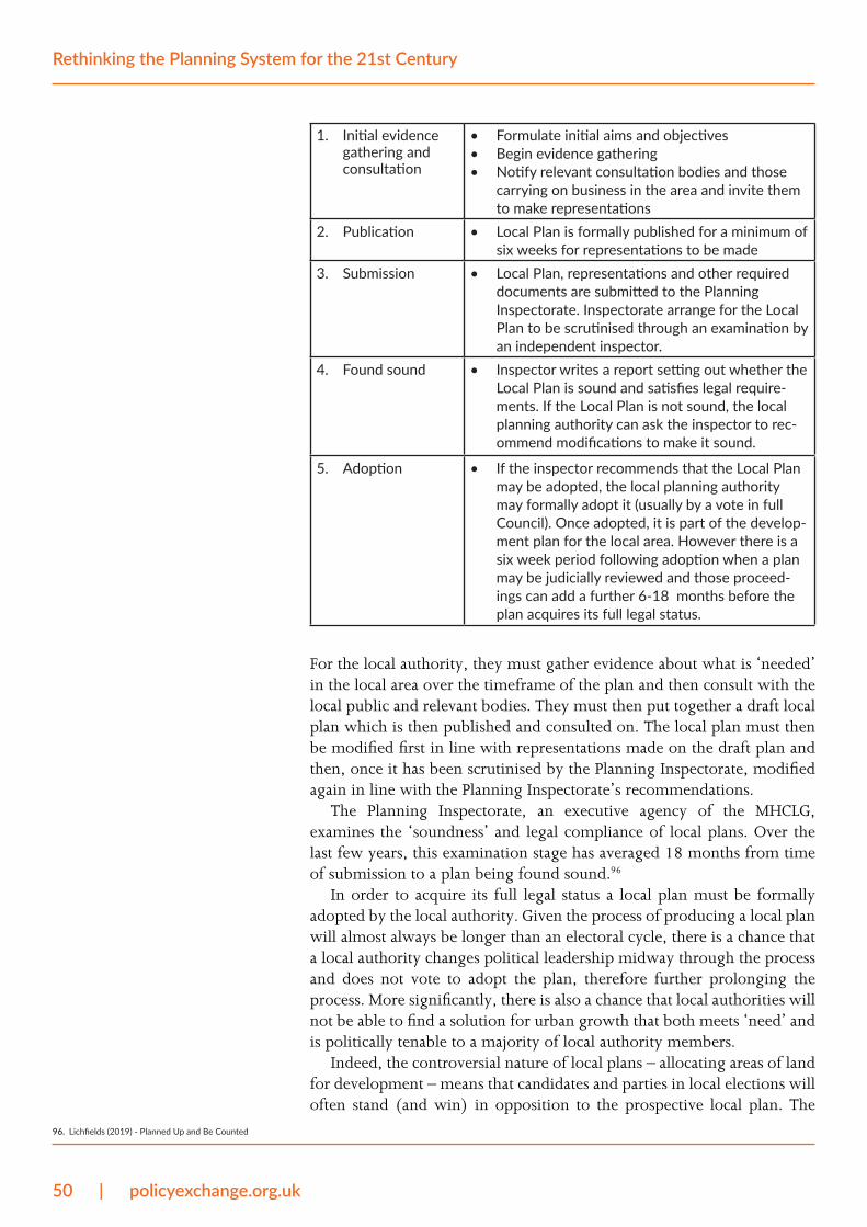
50 | policyexchange.org.uk
Rethinking the Planning System for the 21st Century
1. Initial evidence gathering and consultation
• Formulate initial aims and objectives• Begin evidence gathering• Notify relevant consultation bodies and those
carrying on business in the area and invite them to make representations
2. Publication • Local Plan is formally published for a minimum of six weeks for representations to be made
3. Submission • Local Plan, representations and other required documents are submitted to the Planning Inspectorate. Inspectorate arrange for the Local Plan to be scrutinised through an examination by an independent inspector.
4. Found sound • Inspector writes a report setting out whether the Local Plan is sound and satisfies legal require-ments. If the Local Plan is not sound, the local planning authority can ask the inspector to rec-ommend modifications to make it sound.
5. Adoption • If the inspector recommends that the Local Plan may be adopted, the local planning authority may formally adopt it (usually by a vote in full Council). Once adopted, it is part of the develop-ment plan for the local area. However there is a six week period following adoption when a plan may be judicially reviewed and those proceed-ings can add a further 6-18 months before the plan acquires its full legal status.
For the local authority, they must gather evidence about what is ‘needed’ in the local area over the timeframe of the plan and then consult with the local public and relevant bodies. They must then put together a draft local plan which is then published and consulted on. The local plan must then be modified first in line with representations made on the draft plan and then, once it has been scrutinised by the Planning Inspectorate, modified again in line with the Planning Inspectorate’s recommendations.
The Planning Inspectorate, an executive agency of the MHCLG, examines the ‘soundness’ and legal compliance of local plans. Over the last few years, this examination stage has averaged 18 months from time of submission to a plan being found sound.96
In order to acquire its full legal status a local plan must be formally adopted by the local authority. Given the process of producing a local plan will almost always be longer than an electoral cycle, there is a chance that a local authority changes political leadership midway through the process and does not vote to adopt the plan, therefore further prolonging the process. More significantly, there is also a chance that local authorities will not be able to find a solution for urban growth that both meets ‘need’ and is politically tenable to a majority of local authority members.
Indeed, the controversial nature of local plans – allocating areas of land for development – means that candidates and parties in local elections will often stand (and win) in opposition to the prospective local plan. The
96. Lichfields (2019) - Planned Up and Be Counted
policyexchange.org.uk | 51
Deficiencies of the planning system
2019 Local Elections, for instance, saw large numbers of local authorities change political control, with planning issues a major factor and local plans subsequently stalled.97 One local authority under new control has since passed a motion of ‘no confidence’ in its local plan, even though the local plan had been democratically adopted in 2018.98
Section 288 of the Town and Country Planning Act 1990 means that local plans can also be challenged in the High Court for their legality. This can cause further uncertainty and great expense to the local authority that must defend their actions. Local plans are challenged for a variety of reasons – recent examples are listed in the box below. Challenges to local plans in 2019 February: Jopling v London Borough of Richmond-upon-Thames & Secretary of State. Jopling case successfully challenged the Richmond Local Plan because of the lack of consultation on the de-designation of the Udney Park Playing Field (UPPF) as Local Green Space.
September: Dylon 2 Ltd v London Borough of Bromley. Unsuccessful challenge to the adoption of the Bromley Local Plan. The plan was ruled to be generally in conformity with the London Plan and the Inspector’s conclusion on housing land supply were assessed as reasonable and his decision on soundness was sufficient.
November: CPRE Surrey v Waverley Borough Council. Unsuccessful appeal against High Court ruling. Court of Appeal ruled that a planning Inspector acted reasonably when he assessed unmet housing need for a local plan based partly on the deficit in a neighbouring authority’s area.
December: Compton Parish Council v Guildford Borough Council. An unsuccessful attempt to challenge the Guildford Local Plan (adopted in April 2019) on the basis that sites should not have been released from the Green Belt, and in particular that the Inspector should not also have permitted a buffer of 4,000 dwellings above the Objectively Assessed Need.
The length of time it takes to produce and agree a local plan reflects the complexity of the job that local planners are tasked with completing. They must write plans based on calculations of what households and businesses will ‘need’ – which, as we argue earlier in the report, is a fallacy because such a thing cannot be estimated with any accuracy at one point in time, let alone over the 15 years or more timescale that local plans are operational. They must then attempt to design places in their totality, designating every plot of land a specified use in a way that balances all the objectives (housing, ecology, commerce, schools, transport, etc.) required by central government and, if relevant, regional government, all while being compliant with European Union environmental directives. And they must do this while representing the views of local people and the many relevant bodies that local planners are duty bound to consult, all in a way that is acceptable enough for a majority of local authority members to vote to adopt the plan.
Given the complexity of producing a local plan, it is unsurprising that local plan documents are extremely long and accompanied by a large number of supporting documents, for instance sustainability appraisals, technical studies and consultation documents. It is also no surprise that, despite there being a statutory duty for local authorities to have adopted
97. Planning Resource (2019) - What the local election results mean for planning
98. Planning Resource (2019) - Arun Council demands moratorium on large-scale housing schemes over climate concerns
52 | policyexchange.org.uk
Rethinking the Planning System for the 21st Century
local plans, a significant proportion of local planning authorities has not completed the local plan process.99 Recent analysis has found that just 55 per cent of local planning authorities have adopted local plans that are legally compliant with national planning policy.100 23 per cent of local planning authorities had published or submitted a local plan and 22 per cent of local planning authorities have not published a local plan since national planning policy was reformed in 2012.101 There are some local authorities who have not had adopted local plans for many decades, for instance St Albans’s most recent adopted plan is from 1994, while the City of York has not had an adopted plan since 1954.
The power vested in local plans makes their land use allocations very important for organisations who want to develop land in the local authority area. A proposed development is much more likely to receive planning consent if it is plan-compliant. For instance, a proposal for new homes is much more likely to be consented on a site allocated for residential use than on a site allocated for agricultural use. When local authorities produce local plans, developers and landowners will therefore ‘promote’ their site(s) to be allocated to their preferred use (e.g. agricultural to residential). However, the complex nature of local plan production makes this process:
• High cost. Developers and landowners promoting their site have to expend a lot of resource and time submitting evidence to the local authority demonstrating why their site should be allocated in relation to national planning policy, why it is suitable for development (which requires specialist evidence on issues such as impact on the local housing market, economy, ecology, ground conditions and traffic); as well as responding to questions that arise as the local plan is put together.
• High risk. A number of factors make land promotion highly risky. Firstly, the timescale over which local plans are produced is uncertain. Plans might be changed in their final stages and the allocations process might have to be done again, causing high political risk. Secondly, local plans strictly ration land uses. This means that land promoters will often compete against each other for allocations, demonstrating why their site is more suitable than their competitor(s). It is up to the local planning authority which site they choose to allocate. Thirdly, local authorities allocate sites for development when they replace their local plan. This tends to be every 15 years or so, which gives developers and landowners a limited number of opportunities to promote their site(s).
• High reward. If a site is allocated to a land use in high demand but low supply, its value will increase significantly, especially if its previous use meant the site had a low value (e.g. agricultural land). This makes land promotion highly lucrative and explains why, despite the high cost and risk associated with land promotion, a whole industry of land promoters exists to navigate the local plan process and sell on allocated land to builders at a high price.
99. The Government has introduced a number of meas-ures to encourage more local authorities to get adopted local plans in place. These are largely based around the threat of taking their planning powers away, for instance because not enough land is com-ing forward for development or because housing targets aren’t being met.
100. Lichfields - Planned up and be counted (2019)
101. Ibid.
policyexchange.org.uk | 53
Deficiencies of the planning system
Three decades ago this system was already being described as an “English sweepstake.”102 It is a function of the way local plans are agreed and the way they strictly ration land uses. The high price of land allocated for residential use is a significant barrier to smaller builders.
Despite (or, rather, because of) their immense detail, uncertainty is the defining feature of local planning systems. Local plans provide hundreds of page of policies outlining what is expected to achieve permission, but there is no legal certainty that meeting those policies will result in the achievement of planning permission. As Robert Megarry, a judge and barrister, once wrote, a local plan is only an “informed prophecy” that is not legally binding.103 This was a significant break with the pre-1947 planning system:
The old town planning scheme laid down the local law. It actually gave permission to build houses in the areas that were zoned residential. The [post-1947] development plan, on the other hand, gives permission for nothing. It does not operate as a sort of local law. What it does do is to provide an informed prophecy of what kind of development is likely to be permitted and what is likely to be prohibited.
Deciding planning applicationsPlanning applications must be decided in line with local plans unless material considerations indicate otherwise. Where local plans are not in place or up to date, planning decisions are made with a presumption in favour of sustainable development and in line with national planning policy. Sustainable development has no strict legal definition and the way in which it is defined and applied by the National Planning Policy Framework has been and continues to be a source of extensive legal argument.
Planning applicants must prepare applications that show how their development meets these policy objectives. This requires extensive work, time and documentation, not least on due diligence and the design of the proposed development. Some types of planning application also require Environmental Impact Assessments to be undertaken and submitted. Applicants will often pay for ‘pre-application’ advice from the local planning authority on what they must do to have a better chance of achieving consent – this is common practice and can take upwards of six months to arrange and be completed, though its output sometimes isn’t even communicated to planning committees. The result is that planning application preparation takes many months and sometimes years – one report estimates that preparation for a typical residential site of ‘raw land’ will take 1.3 years, while preparation for typical residential sites over 150 homes will take 2.1 years.104
As well as taking a long time to prepare, planning applications can also take a long time to process and decide. The timeframe depends on a number of variables, for instance whether planning officers use delegated powers or determine the application or whether it goes to the local planning committee, the complexity and controversy of the planning
102. Centre for Policy Studies (1990) - Nimbyism: Disease and the cure
103. Robert Megarry (1962) - Town and Country Plan-ning in England: A Bird’s Eye View
104. Chamberlain Walker Economics (2017) - The Role of Land Pipelines in the UK Housebuilding Process
54 | policyexchange.org.uk
Rethinking the Planning System for the 21st Century
application, the proposed scale of the development, the timing of local planning committee meetings, the length of time it takes to negotiate planning obligations, the capability of the local planning authority; and, whether the planning application is ‘called in’.105 Although the statutory determination period for planning applications once validated is eight weeks, 13 weeks for major developments and 16 weeks if the application must include an Environmental Impact Assessment, one report estimates that it takes 6 to ten months to process a planning application for a typical residential site.106 The timescales for major planning applications are more-often-than-not extended by mutual agreement between the applicant and the local planning authority.107
Frequent delays in the planning application decision process mean that, for those that can afford to do so, planning applicants can often pay for ‘planning performance agreements’ with local planning authorities. These non-binding agreements mean that the local planning authority will dedicate more resource and expertise to processing the relevant planning application to an agreed timescale. They are available to all types of developer, whether they are small-scale (e.g. individual households) or large-scale (e.g. major regeneration projects) and can cost hundreds, thousands or tens of thousands depending on the size of the proposed development and the local planning authority.108
If a planning application is turned down or is approved with conditions that are thought to be unacceptable, the applicant has a statutory right of appeal. This means the local planning authority’s decision is reviewed by the Planning Inspectorate or, occasionally, the Secretary of State. The appeal can be determined by the consideration of written representations (93 per cent are determined this way), dealt with through hearings (5 per cent) or be subject to an inquiry (2 per cent).109110 Parts of the appeal process are thought to be slow, risky and costly. According to the National Audit Office, the average time it took to determine an appeal through an informal hearing or inquiry increased from 30 weeks in 2013/14 to 38 weeks in 2017/18.111
The government-commissioned Independent Review of Planning Appeal Inquiries chaired by Bridget Rosewell recommended ways to avoid what it called “unnecessary delays” and their impact on developers.112 The Review found that between 2013 and 2018, from receipt of a valid appeal it took on average 42 weeks for an inquiry decision to be made by an inspector.113 The Review concluded this figure could be halved and its recommendations are in the process of being implemented.114
Interested third parties can also, within six weeks of a decision being made, challenge planning decisions in the High Court by judicial review. The challenge cannot be made on the planning merits of the decision but on its lawfulness. This, however, often extends to whether particular representations or material considerations were properly accounted for. The judicial review process also delays developments, with claims thought to be regularly made without legal merit and with the intention of slowing construction.115
105. The Secretary of State and some city-region mayors can ‘call in’ planning applications. This allows them to be the local planning authority and to make the final decision on whether the application should be approved or rejected.
106. Chamberlain Walker Economics (2017) - The Role of Land Pipelines in the UK Housebuilding Process
107. According to the National Audit Office, two-thirds of major residential planning applications were ex-tended in 2017/18. National Audit Office (2019) - Planning for new homes
108. In Westminster, a planning performance agreement for an alteration or extension of a single house costs £12,000. A planning performance agreement for a proposal to build 10 or more homes costs £37,200. In Cornwall, the equivalent costs are £370 and £7,344.
109. MHCLG (2018) - Independent Review of Planning Appeal Inquiries
110. Although just 2 per cent of appeals are inquires, ac-cording to the NAO this “route is how the largest number of new homes are granted by appeal”. Na-tional Audit Office (2019) - Planning for new homes
111. National Audit Office (2019) - Planning for new homes
112. Independent Review of Planning Appeal Inquiries (2018) - Call for Evidence
113. This does not include decisions made by the Secre-tary of State which take longer but for which there are not comprehensive figures.
114. Recent reporting by Planning Inspectorate on imple-mentation of Rosewell reforms
115. BPF (2013) - Judicial Review: Proposals for Reform
policyexchange.org.uk | 55
Deficiencies of the planning system
Even when a planning application is consented and not subject to judicial review, this is by no means the end of the planning process. It has been estimated that it takes on average 1.7 years for construction to begin on a typical residential site after detailed planning consent has been granted.116 A key cause of this delay is that developers have to ‘discharge’ conditions placed on them as part of the planning consent before works can start or before the use of land changes. Many of these are entirely appropriate, but there is also concern at the rising number of conditions inappropriately attached to planning permissions.117
The effect of complexityWe have described the complex nature of producing local plans and deciding planning applications. The complexity of the planning system has a number of effects. Planners are tasked with the impossible job of balancing private, societal and political interests when producing local plans and deciding planning applications. Their decisions create winners and losers, the latter of which have the power to challenge what is decided.
The result is a time and resource-intensive process that is slow and fraught with risk for any individual or organisation seeking to earn the right to develop their land or change its use. Developers, whether they are a homeowner looking to extend their house or a housebuilder building hundreds of homes, have to second guess the system at every stage and prepare accordingly. Any delay makes it difficult to organise labour and construction inputs for a development. Some developers say that it can often take more time to get planning permission for a development than to construct it.
Some local planning authorities are more ‘pro-growth’ than others and this tends to be a function of political leadership. One large housebuilder we spoke to said there are around 100 local planning authorities, many in high demand locations like the South East, where they will avoid building homes because local councillors make the process too difficult and too risky.
Across the country, planners are asked to tick too many boxes and please too many people at once. They are pulled in all directions, some of which are contradictory, as more and more policy objectives are required of the planning system. Balancing these objectives alongside private and political interests has increased planning risk and delay, with little to show for it in terms of meeting those objectives.
These effects weigh most significantly on SME developers who do not have the resource or financial leeway to bear the cost or risk of the planning process. Smaller sites that are suited to SME developers are less likely to be brought forward in the local plan process, while local planning authorities understandably dedicate more resource to the biggest and most complex applications. The planning system is therefore a significant barrier to SME developers building more homes, offices and other types of development.
116. Chamberlain Walker Economics (2017) - The Role of Land Pipelines in the UK Housebuilding Process
117. Ibid.
56 | policyexchange.org.uk
Rethinking the Planning System for the 21st Century
The costs of the planning system
The planning process attempts to balance the long-term economic, environmental and social impact of development and land use. This, as we have argued, is a complex operation. It requires decision makers to manage a number of trade offs which bring about benefits and costs.
What are those costs and who are they borne by?
Direct costs on developing landThe costs of developing land and constructing buildings are extensive. They vary by the type of development, but typically include land acquisition costs, land promotion costs (incurred when planning permission is required), infrastructure costs (e.g. site preparation, connections to transport and utility networks, developer contributions), physical construction costs (e.g. labour and materials), financial costs (e.g. loan interest) and costs associated with administration, management and design. The planning system directly impacts a number of these costs, making developed land more expensive and constraining what can be built on that land.
The cost of land varies significantly, depending on its location (i.e. demand for space), the value of any existing development on the land (i.e. construction costs); and, the value of the right to build on that land. By nationalising development rights, the UK planning system has a significant direct impact on the last of these variables, both through local plans and through the permission process. Local plans tightly ration urban land uses – principally residential uses as opposed to other urban uses like commercial118 – which rations the supply of land that can be built upon in certain uses. The permission process gives landowners a chance to be granted the right to build on their land or change its use on the condition that the development meets planning policies and, in some cases, is seen to be permissible by the planning committee made up of local politicians.
Tight rationing of permissioned land artificially inflates its value – significantly so in areas of high demand for residential or commercial space. This value is further increased by the costs incurred during the planning process, for example capital investment in planning applications and supporting documentation. Because of these costs and the scarcity of land with planning permission, builders will pay significant sums of money for permissioned land and landowners can receive significant premiums from obtaining planning permission. A whole industry (land promotion) exists to provide this service of securing sites with planning permission.
The cost of financing a development is also impacted by the planning
118. In a general sense, the shortage of commercial space or land is much smaller than the shortage of residen-tial space or land (though there are exceptions, for instance warehouses). In part this is because coun-cillors are usually predisposed to vote for new jobs while not being nearly so keen on new residents (as detailed earlier in the report).. This does not negate the other problems in the planning process faced by developers of commercial property.
policyexchange.org.uk | 57
The costs of the planning system
system. The longer it takes to deliver the development, the longer it takes for the developer to receive capital receipts and begin repaying loans. Delays in the planning process therefore increase a developer’s borrowing costs. SME developers are particularly impacted by this as they are typically provided loans with higher interest rates than more established developers.
While they will vary by a site’s condition, size and location, infrastructure costs tend to be the most significant cost of developing land. Sites need to be prepared so that construction can begin. They must also be connected to transport and utility networks, for instance by building more roads. As part of the terms of their planning consent, most developments will also be expected to contribute towards local infrastructure costs through Section 106 agreements and/or the Community Infrastructure Levy. Most residential developments will also be required to provide Affordable Housing through Section 106 agreements. Section 106 agreements are negotiated on a case-by-case basis while local planning authorities who operate a Community Infrastructure Levy have different tariffs. Contributions therefore vary by development and by local planning authority.
Meeting these regulatory standards impact the economics of a development. Infrastructure costs and developer contributions also tend to be paid upfront before the value of serviced land can be realised. The developer must bear the costs of financing these payments.
Each of these variables means that the costs of developing land are extensive and uncertain, often prohibitively so for smaller developers who cannot afford the risk or possible expense in relation to local real estate values and their need to make a profit. While many of these regulatory standards that impose costs on developers are fair, other parts of the planning process are not. Most significantly, if the right to develop land wasn’t rationed so tightly and the planning process was less risky and costly, the cost of land with planning permission would be lower and so would the costs of financing development.
Land value capture?A number of organisations have called for the state to ‘capture’ more of the uplift in land value that happens when a landowner obtains residential planning permission. The Housing, Communities and Local Government Select Committee,119 for example, has pointed to Valuation Office Agency figures showing the stark difference between the average value of agricultural land (£21,000 per hectare) and the value of residential land (£1.95 million per hectare).120 Think tanks, MPs and local councillors have signed a letter saying that “When agricultural land is granted planning permission for housing to be built, the land typically becomes at least 100 times more valuable… more of this huge uplift in value should be captured to provide benefits to the community.”121
The problem with this argument is that is based on a fallacy. Residential land value, as calculated by the Valuation Office Agency, is not the same as the value of land after obtaining residential planning permission (typically
119. Housing, Communities and Local Government Select Committee (2018) - Land Value Capture
120. The Valuation Office Agency figures are for England (excluding London) DCLG (20150 - Land value esti-mates for policy appraisal
121. Onward (2019) - Sharing land value with communi-ties: An open letter
58 | policyexchange.org.uk
Rethinking the Planning System for the 21st Century
£280,000 per hectare).122 The Valuation Office Agency’s figure of £1.95 million per hectare refers to the value of serviced residential land – where infrastructure and developer contributions (the Community Infrastructure Levy and Affordable Housing) have been provided and paid for.
The granting of residential planning permission therefore does not typically increase the value of land by 100 times.123 The planning value gain for a typical plot of agricultural land will instead be the difference between the value of land with residential planning permission (typically £280,000 per hectare) and the combined cost of the agricultural land value (typically £21,000 per hectare) plus the cost of planning (typically £100,000 per hectare).124 Landowners will therefore typically realise a profit of £159,000 per hectare if they obtain residential planning permission. These figures are representative of a typical land plot – the landowner premium will be significantly higher in places where demand for development land is highest, for instance London and the South East.
This typical development model is demonstrated by Figure 6. Value gain per hectare for typical residential land plot. which shows how the value of land typically increases as it is developed. As can be seen, the large majority (86 per cent) of residential land value is the costs of infrastructure and contribution paid by the developer as part of obtaining the right to develop land. These costs will vary by local planning authority, but the total percentage figure is consistent across the country.125 In some parts of the country, the costs of developing land exceed the land’s development value. This means there is no profit potential and prospective development schemes in these areas are unviable.
While the landowner premium figure is arguably too high, it is a function of the risk associated with the planning process – it is the figure at which landowners will be incentivised to release their land for development, where the financial benefits outweigh the risks and costs associated with a complex and difficult regulatory process of achieving an allocation in the local plan and then planning permission. The landowner premium is the ‘earned increment’ for risking their capital.
This balance can be seen through considering a planning application for a residential development on an agricultural field: if the application is unsuccessful, the owner of the agricultural field will lose more than the value of their asset. The value of the field is not in itself enough security to finance the cost of the planning application. For this reason, landowners have to fund the planning process through bridging loans which are a relatively high cost source of finance. This further increases the riskiness of the prospective development and is why landowners often decide to enter promotion agreements (when they work with a land agent to obtain planning permission and then sell the land to a housebuilder) or option agreements (when they give a housebuilder the right to seek planning approval for their land and exercise the option to buy the land if successful).
122. See appendix for full analysis by Knight Frank.
123. Mea culpa: the author made the same mistake of be-lieving this to be the case several years ago.
124. This model analysis is based on an average plot of land across the country. In evidence produced for the Building Better, Building Beautiful Commission, Knight Frank has also produced a real-life case study detailing the land value uplift and cost profile of the Welborne garden village development in Fareham, Hampshire.
125. Knight Frank analysis
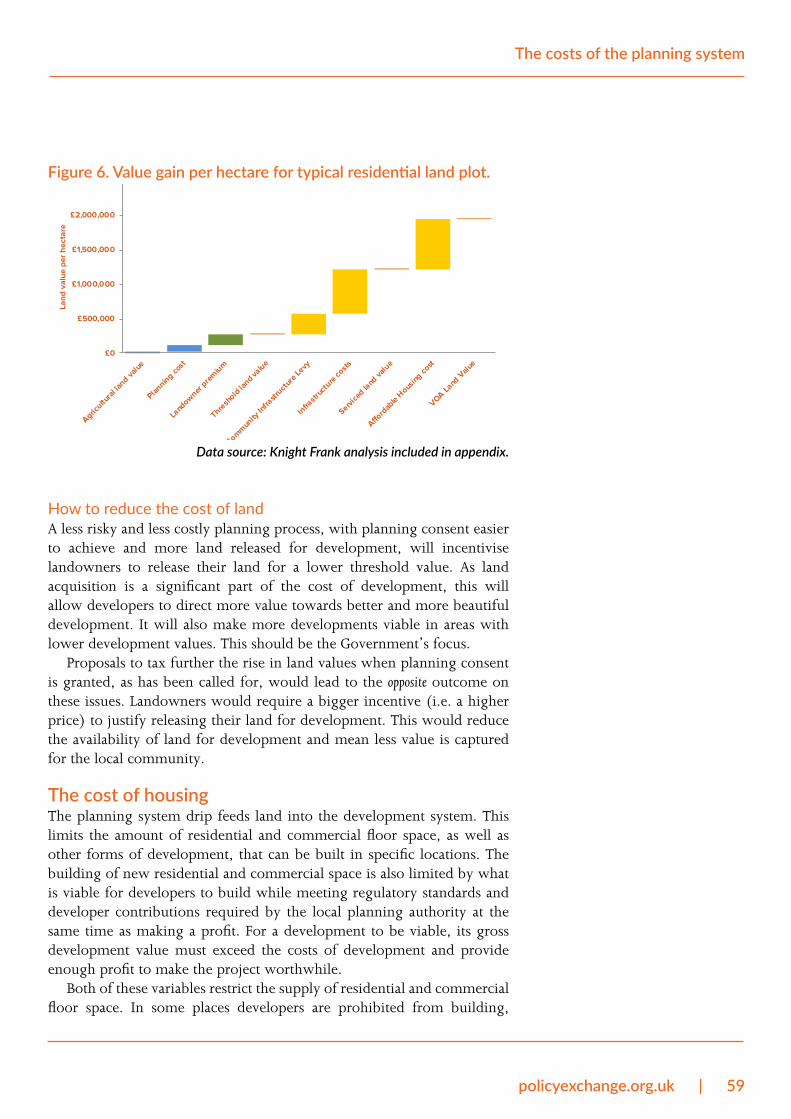
policyexchange.org.uk | 59
The costs of the planning system
Figure 6. Value gain per hectare for typical residential land plot.
£0
£500,000
£1,000,000
£1,500,000
£2,000,000
£2,500,000
Agricultu
ral la
nd value
Planning co
st
Land
owner pre
mium
Thresh
old lan
d value
Commun
ity In
frastr
uctur
e Levy
Infra
struc
ture
costs
Service
d land
valu
e
Afford
able H
ousing
cost
VOA Land
Valu
e
Land
val
ue p
er h
ecta
re
Data source: Knight Frank analysis included in appendix.
How to reduce the cost of landA less risky and less costly planning process, with planning consent easier to achieve and more land released for development, will incentivise landowners to release their land for a lower threshold value. As land acquisition is a significant part of the cost of development, this will allow developers to direct more value towards better and more beautiful development. It will also make more developments viable in areas with lower development values. This should be the Government’s focus.
Proposals to tax further the rise in land values when planning consent is granted, as has been called for, would lead to the opposite outcome on these issues. Landowners would require a bigger incentive (i.e. a higher price) to justify releasing their land for development. This would reduce the availability of land for development and mean less value is captured for the local community.
The cost of housingThe planning system drip feeds land into the development system. This limits the amount of residential and commercial floor space, as well as other forms of development, that can be built in specific locations. The building of new residential and commercial space is also limited by what is viable for developers to build while meeting regulatory standards and developer contributions required by the local planning authority at the same time as making a profit. For a development to be viable, its gross development value must exceed the costs of development and provide enough profit to make the project worthwhile.
Both of these variables restrict the supply of residential and commercial floor space. In some places developers are prohibited from building,
60 | policyexchange.org.uk
Rethinking the Planning System for the 21st Century
while in others profit margins are either too tight or non-existent (i.e. the development would run at a loss). The result is that the supply of real estate has been decoupled from demand for real estate in places where restrictions are too great. In these places there has been a sustained undersupply of residential and commercial space over many decades. This has had a significant impact on real estate prices, especially in the most productive areas where demand for homes and commercial space is highest.126 Developers have been unable to respond to price signals of high real estate prices by building more space. Instead, these prices have risen over a sustained period of time often to exorbitant levels. This has had a significant impact on the economy and prosperity.
Housing costs and equity have increased in restricted placesIn the housing market, high demand for housing in England’s productive places where economies provide high-paid work has not been matched by relative increases in the supply of homes.127 Instead, housing supply has been rationed by the planning system. This has caused significant increases in housing costs and housing equity in productive places with restrictive planning controls, benefiting homeowners that can enjoy greater housing wealth and disadvantaging prospective homebuyers and renters who have had to pay higher rents as housing wealth has grown.128 As the Centre for Cities has argued, “Even though housing wealth is driven primarily by a local economy’s ability to provide high-paid work, the economic benefits of cities with high wages are not being fully retained by renting households in work. Rather, they are flowing to homeowners, many of whom are retired and outside the labour market.”129
One government-commissioned academic study estimates that house prices increase by around 30 per cent when moving from an area of minimal housing restrictiveness to average housing restrictiveness130 – this is seen to be a “considerable underestimate” of the actual costs of planning restrictiveness because the study does not account for the impact of restrictions on prices before 1980.131
The redistribution of wealth and income from renters to homeowners as a result of planning restrictions is common across the world’s most dynamic cities. In their book The Captured Economy, Brink Lindsey and Steven M. Teles have detailed the regressive nature of planning restrictions in high-growth cities in the United States, like San Francisco, Los Angeles, New York, and Boston.132 They argue that preventing supply from responding to rising demand in these places has artificially boosted housing prices and created a “windfall” for existing homeowners – a process which they describe as a form of “regressive rent-seeking.”133
When politicians talk about ‘making work pay’, perhaps the most effective way of doing this would be would be for more of the benefits of working in productive places to go to renting workers rather than to homeowners. This would be the most significant benefit of a less restrictive planning system. Politicians should therefore be much more confident in talking about the link between the country’s planning system and its
126. Planning restrictions are, of course, not the only fac-tor that impacts the supply of residential and com-mercial floor space. The price of labour, construction materials and credit are also significant, albeit at varying rates in comparison to planning restrictions depending on the location and its local authority’s planning policies. The price of local real estate is also impacted by demand side factors, for instance the price of consumer credit.
127. Centre for Cities (2019) – Capital Cities
128. Ibid.
129. Ibid.
130. Hilber and Vermeulen (2010) - The Impact of re-stricting housing supply on house prices and afforda-bility: report for NHPAU. London, Department of Communities and Local Government.
131. Chesire et al. (2012) - Links Between Planning and Economic Performance: Evidence Note For LSE Growth Commission
132. The Captured Economy, Brink Lindsey and Steven M. Teles
133. The Captured Economy, Brink Lindsey and Steven M. Teles

policyexchange.org.uk | 61
The costs of the planning system
wealth inequalities. They should then put more pressure on local planning authorities in productive places to release more land for development. As Alain Bertaud has argued, “Urban planners should be held responsible for unaffordable high price/income ratios in the same way that public health officials are held responsible for infectious disease epidemics, or police are held responsible for high crime.”134
The impact: increased inequality, reduced labour mobility and a worsening of urban lifeIncreases in housing costs and housing wealth in productive places where supply has not adjusted to demand has had a number of other economic and societal effects. It has meant widening wealth inequalities between regions as the housing wealth of homeowners in productive areas has grown much more than other homeowners.135 It has also reduced geographic labour mobility and national economic efficiency, putting off people from moving to parts of the country where they have greater opportunity to earn a higher income. The Resolution Foundation recently found that the propensity of young private renters to move home and job fell by two-thirds between 1997 and 2018, largely because the earnings boost of living in a more productive place is now much lower as a result of rental costs taking up much more of higher wages.136 The research also found that high house prices “lock out” homeowners from moving to productive places.137
Unaffordable housing costs caused by planning restrictions in productive cities have also had a significant impact on housing consumption. Households have had to adjust to higher costs of housing by making more extreme trade-offs between spending more of their income on housing, living in smaller homes, sharing their home with other people (e.g. flatmates or living at the family home) and spending time and money commuting. Each of these factors worsens urban life. And as central government subsidises the rent of low income households through Housing Benefit payments, higher housing costs as a result of planning restrictions also have an effect on the public purse.
The cost of doing businessWhile most research and policy discussion on the planning system focuses on its impact on housing supply and the cost of living, planning restrictions also have a significant impact on the costs of doing business in a place. Places with tighter planning restrictions have been found to have more expensive commercial rents.138
Businesses have different space and location requirements so are impacted differently by this effect. To illustrate the point, manufacturing firms tend to require lots of space per worker without needing to be in a city centre, high-skill service industries tend to require less space per worker but in a city centre, while retailers need to be in places of high footfall and start-ups need low-cost rents. Research suggests planning restrictions impose varying costs by sector.
134. Order without Design: How Markets Shape Cities, Alain Bertaud, Cambridge, MA, MIT Press, [2018]
135. Centre for Cities (2019) – Capital Cities
136. Resolution Foundation (2019) - Moving matters
137. Ibid.
138. Henneberry, J, McGough, T, Mouzakis, F (2005) The impact of planning on local business rents. Urban Studies 42: 471–502.
62 | policyexchange.org.uk
Rethinking the Planning System for the 21st Century
• Office space: The academics Paul Cheshire and Christian Hilber have found that planning restrictions impose a ‘regulatory tax’ on office developments.139 They have calculated the cost of this tax as a percentage of office development costs in various cities – their calculation is an aggregate measure of the gross cost of regulatory constraints limiting the height and floor area of buildings and the supply of office land use. In 2008, the regulatory tax in central London was calculated to be 400-800 per cent of development costs. In Birmingham, it was calculated to be 250 per cent. For comparison, they calculate the tax to have been 300 per cent in central Paris, 200 per cent in Amsterdam and 0-50 per cent in New York. CBRE research has also found that the cost of UK office space is relatively high: seven of the top 20 most expensive European cities for office space are in the UK.140
• Retail space: Retailers are impacted by land use restrictions forcing them onto less productive sites in less restrictive locations. Academics found that this effect reduces productivity by 32 per cent in a representative store of a large supermarket chain.141 It is also thought that planning restrictions that force retailers to locate in town centre locations has impacted small and independent shops – larger retailers have developed smaller formats and located on high streets, thereby causing higher rents.142
The cost and availability of commercial space therefore has an effect on the type of businesses that can develop in a place – and its long-term productivity. The effect of planning restrictions can be to reduce local competition which reduces the incentives for productivity improvements and diffusion of best practice, contributing to the current recognised decline of the high street and hindering its recovery.
There are also tight restrictions on how property used commercially can be recycled into another use when the commercial use has become redundant. Some of these restrictions have been lifted through the extension of Permitted Development rights – for instance the right to convert offices (B1 use class) to residential (C3 use class) without the permission of the local planning authority – though many restrictions remain.
Urban and rural economies are stifledPlanning restrictions have a significant impact on urban economies. By constraining a productive place’s natural growth, the agglomeration economies of scale that make places more productive, innovative and more prosperous are undermined.143 This effect, as well as the increased costs of living and doing business in a place with high real estate costs, means that excessive planning restrictions impact local economic competitiveness. Excessively restrictive planning policies might indirectly route people and investment to another part of the country or world.
The nature of excessive planning restrictions – limiting natural urban growth and creating market distortions – also makes cities less responsive
139. Cheshire and Hilber (2008) - Office space supply re-strictions in Britain: the political economy of market revenge
140. CBRE (2019) - Global Prime Office Occupancy Costs
141. Cheshire, Hilber and Kaplanis (2015) - Land use regulation and productivity—land matters: evidence from a UK supermarket chain
142. Chesire et al. (2012) - Links Between Planning and Economic Performance: Evidence Note For LSE Growth Commission
143. Glaeser (2011) – Triumph of the City
policyexchange.org.uk | 63
The costs of the planning system
to economic and technological change. There is a risk that places that haven’t adapted to this type of change are less resilient to external shocks.
Excessive planning restrictions also have an impact on local rural economies. Rural landowners are often constrained from using their land more productively, for instance using farmland for activities like storage, renewable energy, food and drink processing and event hosting. This slows or prevents the diversification of the rural economy.
Infrastructure delivery and climate change mitigation are made more difficult
The quality and breadth of the UK’s infrastructure has risen up the political agenda in recent years. A consensus has formed across the political divide that an “infrastructure revolution” is needed to support economic growth, improve quality of life and achieve the country’s commitment to being ‘net-zero’ by 2050.
As well as higher rates of government capital spending and changes to the way infrastructure is planned for (e.g. being less reliant on conventional economic forecasting and narrow technocratic cost-benefit analysis),144 delivering this “revolution” will require reforms to the planning system. Currently the system hampers the delivery of infrastructure that is essential to achieving a number of the Government’s key policy objectives.
Renewable energyWind farms are the UK’s largest source of renewable energy. Building more of them will be an important of delivering on the target of Net Zero greenhouse gas emissions by 2050.145 Yet while there is no shortage of investment in wind farms, the expansion of wind technology is running into the difficulties of a restrictive planning system. This is particularly so for onshore wind farms. Since 2015, applications for new onshore windfarms with a capacity over 50 megawatts are no longer treated as Nationally Significant Infrastructure Projects (NSIPs).146
This means that rather than having applications examined and decided centrally by the Planning Inspectorate via the NSIP planning regime, permission must be achieved from the local planning authority. Coupled with a reduction in public subsidy for onshore wind, it is unsurprising that the Global Wind Energy Council has reported a decline in onshore wind activity in the UK in its 2018 Annual Report after this change in planning policy.147 According to the House of Commons Library, applications for new onshore windfarms have been rejected for a number of reasons:148
• A proposal for two wind turbines close to a racecourse in Somerset was partly blocked due to the adverse effect on the horses.
• A proposal for a 127m wind turbine at a sewage treatment works in Staffordshire was turned down following findings that it would diminish Lichfield Cathedral’s visual dominance in views from the south-west.
• A proposal for 12 wind turbines 145 metres high and a permanent
144. Bridget Rosewell, Policy Exchange, Planning Curses: How to deliver long-term investment in infrastructure, 2010
145. Policy Exchange (2015) - Powering Up: The future of onshore wind in the UK
146. First in a ministerial statement of 2015, and then through the Energy Act 2016
147. GWEC (2019) - Global Wind Report 2018
148. House of Commons Library (2016) - Planning for onshore wind
64 | policyexchange.org.uk
Rethinking the Planning System for the 21st Century
meteorological mast in the Trent Valley was rejected, although the site lay within one kilometre of eight power stations and was crossed by pylon lines. The inspector held that the turbines would still have a significant effect on the surroundings.
• A 75-metre high wind turbine in Southern Scotland was rejected because of its harm to the setting of a historic hill fort 500 metres away.
The NSIP regime itself is not free of delay and political involvement. Offshore windfarms, which are still NSIPs and thus made by direct application to the Planning Inspectorate, can face similar uncertainty. An application to construct a windfarm off the coast of Thanet, for example, was originally made in June 2018. After many months of consultation and examination, the decision was put on hold by Ministers in late November 2019 until after the General election.149 Many successful wind farm applications are also taken to judicial review which causes further delay, uncertainty and cost.
Full-fibre broadband rolloutThe UK has also failed to move at an adequate pace on technological infrastructure. Only 7 per cent of homes have full-fibre broadband, compared with 99 per cent in South Korea and 89 per cent in Portugal.150 All parties recognise the need to upgrade this quickly. The 2018 National Infrastructure Assessment (NIA) set a target of 100 per cent coverage in the UK by 2033 (which Government policy has brought forward to 2025).151 To achieve full coverage, the NIA says the planning system needs to be reform. It highlights the complexity of wayleaves (legal agreements between the broadband provider and landowners allowing the former to carry out works under the land) and the lack of a single point of contact in local authorities for digital infrastructure.
Similarly, rolling out 5G requires a more efficient planning framework. The Government has recognised this and in August 2019 launched a consultation into allowing automatic planning permission (through a permitted development right) for higher 5G masts and associated infrastructure.152 Without these reforms, the rollout of 5G technology is likely to be slowed by the problems normally associated with the planning system: inconsistent approaches from different local authorities, unexpected delays and opposition to development on what are often spurious grounds.153
Upgrading transport infrastructureThe difficulties of catering for large projects in the planning system have hampered public and private investment in transport infrastructure upgrades. Designs for Heathrow Terminal 5, for example, began in 1989. It was not opened until 2008. This delay was in large part due to the improvised application process; BAA made a formal planning application to the London Borough of Hillingdon in 1993, but the then Transport Secretary understandably insisted that a project of regional economic
149. Planning Resource (2019) - Leadsom delays decision on Thanet offshore wind farm expansion
150. House of Commons Library (2019), Full Fibre Broad-band.
151. https://www.nic.org.uk/wp-content/uploads/CCS001_CCS0618917350-001_NIC-NIA_Accessi-ble.pdf
152. https://www.gov.uk/government/consultations/proposed-reforms-to-permitted-development-rights-to-support-the-deployment-of-5g-and-ex-tend-mobile-coverage
153. Conspiracy theories about the health risks of 5G masts have managed to stop necessary infrastruc-ture being delivered in a number of counties. A Gov-ernment Minister has had to send a letter to coun-cil leaders urging them not to take heed of these sorts of claims when 5G making planning decisions. https://www.thetimes.co.uk/article/dont-block-5g-ministers-tell-councils-lx3zvrw32
policyexchange.org.uk | 65
The costs of the planning system
significance should be decided by the Department. The longest ever planning inquiry in the UK was then launched, beginning in 1995 and lasting for four years. Yet, the final decision was only made in November 2001 – eight years and two elections after the original application.
Similarly, after proposals for Crossrail re-emerged in the 2000s, the lack of an adequate mechanism for deciding on its planning status meant that an Act of Parliament (Crossrail Act 2008) was required. The High Speed Rail (London-West Midlands) Act 2017 was also needed to enact HS2. As PwC concluded in their study into the escalating cost of HS2, the “historical stop-start approach to infrastructure investment and lack of a long-term plan” undermines market confidence and the ability to attract investment.154
A number of projects also spend years in planning but are eventually scrapped. For instance, the Mayor of London attempted to deliver the West London Tram. Despite the environmental and congestion-related benefits, and the evidence that a slender majority of affected residents were supportive of the investment, the opposition to the tram was vocal enough for the project to be scrapped in 2007.
In short, the planning issues that impact residential planning applications – perennial uncertainty about whether a project can go ahead, complexity that requires large sums spent on consultancy fees and protracted delay – also impact infrastructure planning applications.
Measuring the value of planningMost public policy objectives can be measured for their progress. Politicians can be judged against their record in office while civil servants can internally review whether policies are working or not. For example, a transport policy would be seen to be working if people can get from A to B more quickly. Likewise, an economic policy would be seen to be working if it increased the number of well-paid jobs in an area. This is essential to good policymaking. The benefits of policies need to be judged against their costs.
Evaluating planning policies, however, tends to be very difficult. This is because policies are often justified in imprecise and qualitative terms like “liveable”, “sustainable” and “resilient”. This obscures the objectives of planning documents and means there is little way of measuring their success or failure. It means that the benefits of specific planning policies are not properly judged against the costs that have been outlined in this chapter.
A better way forward would be more directly linking planning policies to quantitative issues that are fundamental to a place’s success, for instance the cost of living (e.g. housing affordability in relation to incomes), the costs of business (e.g. real estate rents and prices) and mobility (e.g. commuting patterns and cost). As it has been argued, the role of planners should be to monitor these data sets in real time and identify when policy needs to be adjusted so that places can adapt to changing circumstances.155
154. PwC, High Speed Rail International Benchmarking Study, p42
155. Order without Design: How Markets Shape Cities, Alain Bertaud, Cambridge, MA, MIT Press, [2018]
66 | policyexchange.org.uk
Rethinking the Planning System for the 21st Century
The impact of the planning system on the urban environment
“The process of incremental urban growth didn’t stop with the invention of planning. What the planning system did was to alter the condition of the system and, as complexity theory shows, it sometimes takes only a small change to alter the entire emergent pattern.”
David Rudlin and Shruti Hemani, 2019156
By attempting to control complex urban systems through policies and processes, the planning system has a significant effect on urban form and pattern. Planning regulations change what has been described as a city’s ‘climax state’ – the condition a settlement reaches as people self-organise and create a place that accommodates the stochasticity of urban life as new technologies emerge.157
Societies have always attempted to influence the shape of their settlements. Entirely spontaneous environments often involve poor living conditions, so attempts to control urban growth are understandable and in many cases necessary. Yet planning regulations, while admirable in intention (e.g. sustainability), have unintended consequences and do not always produce the best of results.
The sheer level of control in the modern planning system means that the process by which places naturally change has been wholly disrupted, causing entirely new urban patterns to emerge – many of which involve the creation of places that use land less efficiently and that are far less popular than those built previously. For example, the most common urban pattern to emerge in the late twentieth century has been the suburb estate. This pattern has been described as “a confusion of dendritic cul-de-sacs” built around private car use and built as if it was the last that would ever be built.158 The modern British suburb is the “unthinking result of rules that generated an optimised urban form that no one really foresaw or wanted.”159
Any reform of the planning system should consider what type of regulations would create a better, sustainable and more beautiful environment in which people want to live. Planning regulations are, of course, not the only factor that influences the urban structure. The strength of the labour market determines demand to live in a place, while the price of transport (both in terms of time consumed and money spent)
156. Climax City: Masterplanning and the Complexity of Urban Growth, David Rudlin and Shruti Hemani, London, RIBA Publishing, [2019]
157. Ibid.
158. Ibid.
159. Ibid.
policyexchange.org.uk | 67
The impact of the planning system on the urban environment
also shapes urban form and size and is impacted by a number of factors, not least technological change, fuel subsidies and the cost of using roads.
Nonetheless, planning regulations have a significant effect and often work against, rather than with, the grain of urban complexity. This happens at a number of stages in the planning process and materialises in a number of different ways, not least the allocation process, cost of permissioned land; and, the application process.
Stunted urban growthThroughout this report, we have described the adversarial process
by which land is allocated for development. Local planning authorities ration certain land uses which means that landowners compete with each other for their land to be approved.160 Tight rationing and the ‘winner takes all’ aspect of this process ramps up the value of allocated land and, with significant windfalls on offer, huge sums are spent by landowners promoting the suitability of their site for development and the unsuitability of competing sites.
The contestability of this process is increased by the fact that any decision on which sites are allocated must be signed off by local councillors (whose decisions can be challenged in the courts). This heightens the adversity of the allocation process because, as detailed earlier in the report, local politicians are often elected on anti-development platforms so are incentivised to reject any policy that allows new development near their voters. The need to demonstrate a five year housing land supply as well as the introduction of the Housing Delivery Test – which strips local authorities of their planning powers if they miss their New Homes Target by a wide margin– means that local authorities are also incentivised to allocate sites based on the number of new homes delivered rather than what the new place will be like.
Each of the variables described decouples the process of urban growth from what might have happened organically. The prominence of political choice and the inherent ‘risk-and-reward’ nature of the process also results in the allocation of land for development that may not be the most suitable option in economic, environmental and/or social terms.
Instead, places grow in a stunted fashion. New developments are often balkanised with little connection to the existing urban fabric – take, for instance, new residential developments that are located next to motorways rather than the natural growth of a place. This effect is amplified by the lack of alignment between infrastructure provision and local planning authority land use allocations. As the National Audit Office has recognised, infrastructure is paid for by a range of public and private organisations – there is no requirement and often no incentive for their infrastructure strategies to cohere with the local authority’s land use plans.161
160. Often landowners will have option agreements with developers. In this arrangement, the developer seeks planning approval on behalf of the landowner and can exercise their option to buy the land if suc-cessful. It is therefore not just landowners who are involved in this process.
161. National Audit Office (2019) - Planning for new homes
68 | policyexchange.org.uk
Rethinking the Planning System for the 21st Century
Beautiful design is squeezedThe adversarial nature of the planning process means that developers spend significant amounts of time and money securing permissioned land on which to build their product – either by securing planning permission on land they own or, as is more frequent in residential development, by purchasing land with planning permission. This changes the economics of development schemes. The more a developer spends securing permissioned land and the higher the cost of meeting obligations that are part of a planning consent (e.g. Community Infrastructure Levy payments and Affordable Housing provision), the more pressure there is to save on costs at later stages in the development process for the scheme to remain viable and worthwhile to the developer.
One result of this is that rather than spending capital on the design and build of beautiful and environmentally sustainable buildings and places that makes their product more desirable to consumers, capital is consumed on services (e.g. planning consultants) that increases the likelihood of a site being allocated for development.162 Beautiful and sustainable design does not necessarily have to cost more money, but a scheme may need to be chopped and changed as it progresses in response to cost pressures. This might mean the loss of certain design features or the use of lower quality materials as developers look to recoup higher than expected costs from earlier in the project.
Another result is that developers face significant commercial pressure to squeeze as much value as possible from their plot of land. For housebuilders, this means building the smallest homes they can as tightly together as possible. More generally, it also means less provision of land uses which are of a low or even negative commercial value but high social value which add considerable value to the overall scheme and place, like green spaces and schools.
Two features of the development industry show how this aspect of the planning process is typical of new building. First, the winning bidder for land with planning permission tends to be the developer who has bid the most by presuming the lowest possible spend on things related to the standard of the development like build materials and infrastructure. The bid will have been made in knowledge of prices in the local housing market. The speculative nature of the land market, where permissioned land is highly prized and therefore highly priced, would not be so extreme if permissioned land was not rationed so tightly.
Second, most homes are built by publicly limited companies who report to their shareholders each quarter. Larger house builders’ financing and business models – which have come to dominate the housebuilding market since the Financial Crash163 – demand profit to be realised as quickly as possible from a development. This means that for some larger house builders, beyond immediate consumer pressure, there is often no commercial imperative to build places that are of a high standard for the long term, not least as their interest in a project tends to end with the last house sold. They tend to be producers (of housing) rather investors (in
162. These might not be direct costs to the developer if they are purchasing permissioned land, but they are indirectly borne in the price that is paid for permis-sioned land.
163. MHCLG (2017) - Housing white paper
policyexchange.org.uk | 69
The impact of the planning system on the urban environment
places). As was the case decades ago, a much higher proportion of homes would be built by smaller firms with different business models if the risk and cost of securing permissioned land wasn’t so high.
A design vision rarely survives the planning processAlthough high design standards are a significant ambition of planning policy,164 the planning application process is, unfortunately, not particularly conducive to fulfilling them. Instead, through imprecise policy and control overreach, it can often work against high-quality design. As Professor Robert Adam has written, “[the planning] process has become so burdensome that it not only acts as a severe brake on the delivery of housing but is so arbitrary and fragmented that the chances of a design vision surviving become very slim indeed.”165 This is evident at several stages as development schemes progress through the application process.
When a planning application for a new development is made, it is scrutinised for, amongst other things, its design. Decisions are based on whether the proposal is ‘in accordance with’ the policies in the local development plan before the decision maker goes on to consider other material considerations including national planning policy and the views of interested parties. New developments must also, of course, meet Building Regulations which set the minimum standards for the design and construction of new buildings relating to issues such as fire safety.
Planning officers and councillors decide what constitutes good designLocal planning policies pertaining to design that planning applications are judged against are typically vague. Plans will often require new developments to “meet the highest standards of design” or to “improve… local identity by enhancing and complementing the positive visual characteristics” of the local area.166 These are fine aspirations but they have no practical meaning. Planning officers, committee members and applicants could interpret them in many different ways and each policyhas little reference to what the local public likes.
This is a problem because it puts a lot of power in the hands of individual planning officers and/or committee members to personally decide what constitutes good design – which might be at odds with the designer’s vision, the developer’s understanding of the local real estate market; or what local people think. Time and cost pressures to achieve planning consent mean that the applicant is incentivised to fall in line with what the planning officer demands, rather than challenge their personal judgment.
Some planner requirements will of course be reasonable and necessary – others will not. Depending on their significance, some requirements may also impact the financial viability of a development project, especially if the developer has not been able to plan for them at an earlier stage of the development process, for instance when purchasing land which is done with certain assumptions about what will be required at the planning stage. It would be better to set more precise design standards at an earlier stage in the planning process.
164. The National Planning Policy Framework states that “The creation of high quality buildings and places is fundamental to what the planning and development process should achieve.”
165. Policy Exchange (2019) - Building Beautiful
166. These two examples are from Winchester and Southampton.
70 | policyexchange.org.uk
Rethinking the Planning System for the 21st Century
Single interest regulationsAnother issue that impacts the design of new developments as they progress through the planning process is scrutiny by interested bodies inside and outside the local authority. This might include government bodies and agencies like Network Rail and the Environment Agency. It will also include bodies representing ‘single interest’ issues such as trees, archaeology, hydrology, leisure, education and highways. The applicant will usually address each issue in a report accompanying the application. Reports will then be assessed by planning application decision makers who may then require the proposed scheme to be changed in accordance with the requirements of each interest.
While each single interest body has worthy aims, the outcomes of some often result in the original design vision being diluted or corrupted whether it meets local planning policy or not. Meeting highways regulations are thought to have an especially significant effect. New developments have had to follow a set of government-issued guidelines (called Design Bulletin 32) on roads and footpaths so that, amongst other things, vehicles can navigate the area in a coherent and safe way.
“More than any other document,” the Design Bulletin 32 regulations are said to have “shaped the British suburb.”167 The regulations create a particular form of development based around the needs of vehicles rather than people – very different to traditional settlement types that tend to be more walkable.168 The Design Bulletin 32 regulations have since been replaced but are still widely used by local highway authorities and “continue to exert a pernicious influence on the quality of development.”169
Each of these issues means that rather than incentivising developments that are beautiful, sustainable and high-quality from the very start, planning practice relies on negotiating the features that developers must provide to make it bureaucratically acceptable. The question of what a development is like for the people who will live there is often relegated in importance beneath an issue such as whether wide vehicles like bin lorries can easily navigate the development. Designers’ and developers’ visions are, however brilliant, shredded by the planning process and the result is more often that not a worse standard of development. This stifles innovation and discourages smaller developers who struggle to take on the significant upfront cost necessary to navigate the application process. As it has been argued, “the way to bring about radical change [in the poor quality of development in the UK] is to change the system” to enable “a new golden urban age” of urbanism.170
167. Climax City: Masterplanning and the Complexity of Urban Growth, David Rudlin and Shruti Hemani, London, RIBA Publishing, [2019]
168. This also determines what sorts of facilities in a place are viable – e.g. shops and public transport services – and has an impact on crime levels.
169. Climax City: Masterplanning and the Complexity of Urban Growth, David Rudlin and Shruti Hemani, London, RIBA Publishing, [2019]
170. Ibid.
policyexchange.org.uk | 71
A Planning System for the 21st Century
A Planning System for the 21st Century
In this report, we have set out the many ways in which the planning system is failing and its costs. The case for wholesale planning reform is, we believe, clear. Like the 1947 planning system represented the zeitgeist and circumstances of the time, the Government should be ambitious in establishing a new system that can address the challenges the country faces in 2020.
In this new planning system, two changes are key (detailed further on the pages that follow).
Firstly, local planning authorities should no longer systematically control what specific activity can take place on individual land plots, nor should they attempt to calculate how much space is ‘needed’ by local households and firms and set policy accordingly. A looser binary zonal system should be introduced instead. This would allow obsolete land uses to be recycled much more quickly and local planning authorities would no longer micro-manage land markets.
Secondly, rather than produce extensive local planning documents, local planning authorities should produce a definitive and limited set of rules detailing what type and form of development is not acceptable in their urban area. Developments would then be permitted as long as they are not forbidden. This would turn the current system on its head and significantly lessen its riskiness and complexity.
This should be a reform programme that cuts across government departments, not least HM Treasury, the Ministry for Housing, Communities & Local Government and the Department for Transport. Planning reform would, after all, be a major structural reform of the economy. Such a programme must be done with four intentions in particular:
1. Broader access to property wealth. A reformed planning system will allow a housing market that is more responsive to price signals. It will no longer allocate land for certain uses. It will also reduce the risk and cost of the planning process, thereby reducing the costs of developing land and lowering the barriers to building new homes for smaller builders. Each of these factors will make it easier to build new homes in areas of high demand and reduce house prices and rents over the long term. More people will then be able to get onto the housing ladder. Rather than seeing large proportions of their income going to landlords each month, they
72 | policyexchange.org.uk
Rethinking the Planning System for the 21st Century
will be able to access property wealth and share in the prosperity of this country.
2. Increasing economic competitiveness. A reformed planning system will reduce the costs of doing business by making it easier to provide more affordable commercial space as well as allowing business to use properties more flexibly. This will benefit start-up companies most and increase incentives for productivity improvements and diffusion of best practice. A reformed system would also allow buildings to change use with much greater flexibility. This would support town centre and high street vitality.
3. A more beautiful built environment. A reformed planning system will allow places to grow organically. It will make acquiring development land much less risky and costly, encouraging developers to compete on the quality and beauty of what they build as well as the infrastructure they provide.
4. Climate leadership. A reformed planning system will allow the building of infrastructure more easily, not least the infrastructure necessary to achieve the UK target to reach net zero greenhouse gas emissions by 2050 (e.g. more wind farms and better public transport).
Proposed reformsTo deliver on these intentions, the Government should announce a clean break with the land use planning system introduced in 1947 that largely continues in the same form today. This reform programme should focus on the issues that follow.
Ending detailed land use allocations and introducing a binary zonal systemThe planning system should not try to systematically control what specific activity can take place on individual land plots. Local authorities have proved ineffective and inefficient at micro-managing land markets. To this end:
• Local planning authorities should no longer set a use for every building or land plot in their area.
• Calculations of economic and housing ‘need’ should no longer be used (or required) to allocate land uses in a local area.
• The supply of new homes, offices and other types of use should no longer be capped by local planning authorities in local plans or by site allocations.
• Densities of new developments on individual plots should no longer be prescribed by local planning authorities in land use allocations.171
171. This would not stop local planning authorities from setting general rules on matters like height in local plans.
policyexchange.org.uk | 73
A Planning System for the 21st Century
Instead, a binary zonal land use planning system should be introduced. In this system:
• Land should be zoned either as development land, where there is a presumption in favour of new development, or non-development land, where there is not a presumption and minor development is only possible in more restricted circumstances. Land zoned as development land will include existing urban areas and urban extensions made possible by improved infrastructure.
• Zones should, in general, have no reference to specific land uses. Market conditions should instead determine how urban space is used in the development zone. Land and buildings in the urban area would thus be able to change use without requiring the permission of the state (as long as rules on separating certain harmful uses are not broken, as detailed in the paragraph below).
• Zonal designations should be separate from any concept of ‘need’. Instead, they should be dependent on metrics that determine whether land has good access potential, whether new development would cause environmental disturbance and the potential for an existing built development to expand. Zones should be updated an ongoing basis and would need to be periodically reviewed by the Planning Inspectorate.
These proposed reforms do not negate the need to separate certain harmful uses that have a negative impact on neighbours, for instance a quarry next to a children’s play park. Nor do the proposed reforms negate the need to protect certain uses, for instance for their natural or heritage value. These incompatible and protected uses should be clearly defined in national planning policy and the local plan.
In practice, these reforms would means that buildings and land could change use with much greater flexibility than under the current planning system. The local plan would be a development framework rather than an end-state vision.
Precise and definitive local plansLocal plans should set a limited and simple set of development control rules detailing what development is not acceptable in development zones and a similar set of rules detailing what development is acceptable in non-development zones – a framework for administering planning applications that allows developers to respond to market conditions and innovate in the places where new development is suitable. These should be rules rather than policies. Rules should be clear and non-negotiable, relating to development form and layout. Development control rules should reflect the ambitions of the local public – this can be achieved by local politicians standing for election on policy platforms relating to these issues that they believe to be the most popular. They should also be, where possible, empirically-based. The extent to which development control rules refer
74 | policyexchange.org.uk
Rethinking the Planning System for the 21st Century
to land use should be limited to separating harmful uses and protecting certain uses for their natural or heritage values, as set out above.
To be clear, rules in development zones should not determine the fact of development, but they should consider the form of new development and how it retains and adds to an area’s sense of place. A limited set of rules will create certainty for developers; incentivise more innovation in design and construction; and, lower barriers for self-builders and SME builders.
The focus of local plans should be on strategic issues rather than minutiae. Their primary focus should be for real estate to be affordable and for travel within a place to be fast and cheap. To these ends, the planning of infrastructure provision should be a more central feature of local plans. It can increase the supply of land and mobility. Local plans should set out what new infrastructure is required, how it can be financed through a coordination of public and private investment; and, the effect of new infrastructure on land prices and rents. There should be an ability to make changes to plans on an ongoing basis as new data emerges rather than the monolithic shift from one plan to another over a 15-20 year period.
These proposals shift the allocation of land use towards market forces; however it is vital that local plans continue to ensure the provision of public goods. They should establish a street framework and ensure that public open space is adequately provided, thereby marking out the lines separating public goods from private goods. As long as new developments do not break the rules set out in the local plan, markets should then be the main factor shaping land use of private plots in development zones. Limiting state design to binary zonal designations, street layout and public space would allow places to grow organically, the same way that places such as Washington DC, Paris and Barcelona grew. 173
To enable these reforms to be as effective as possible, local planning departments should increase their use of metrics and spatial modelling, enhanced through the increasing use of autonomous data collection and assessment, to better understand their influence over land prices, rents and commuting times and patterns. These factors should also be monitored by household income and firm type. The role of planners should be to monitor these data sets in real time and identify when policy needs to be adjusted so that places can adapt to changing circumstances.
Rather than stretching to many hundreds of pages (as local plans currently do), local plans should be short, including a zonal map and several pages of development control rules. Central government consolidated 200 documents and 7,000 pages of national planning policy into the 59 page 2012 National Planning Policy Framework. Local planning authorities can do the same.
Finally, similarly to how communities can shape the development and growth of their local area in the current planning system by writing Neighbourhood Plans, communities in development zones should have the power to set development control rules for new development in their area.
172. Order without Design: How Markets Shape Cities, Alain Bertaud, Cambridge, MA, MIT Press, [2018]

policyexchange.org.uk | 75
A Planning System for the 21st Century
Development controlAs long as a proposed development does not break the development control rules set out in the local or community plan, meets building regulations and is not in a protected area, it should be permitted. Administrators of applications for new development should only check that the proposals conform to the local plan’s rules, rather than conferring any judgment on the proposal itself. The starting point of each application in development zones should be that it will be approved unless certain rules are broken rather than if those rules are met (and vice-versa in non-development zones).
There is potential for low-value and resource-intensive parts of this development management process to be automated.173 Where the assessment criteria are empirical this assessment could be machine-based subject to human review.
Applicants should have a right of appeal to the Planning Inspectorate (or a similar body) but only on the basis that rules have been wrongly interpreted. As a public decision made by an administrative body, application decisions would still be within the purview of the judicial review process.
Environmental and heritage protectionsAs a matter of course, environmental and heritage planning protections should be transposed into a new binary zonal system. This should include National Parks, Areas of Natural Beauty, building listings and conservation areas. Green Belt and Open Countryside land use designations should be reviewed to clarify what purpose they are supposed to be serving and whether it is still justified.
Other land uses which are of a low or even negative commercial value but high social value should be protected, for instance areas of high natural capital and valuable urban green space (e.g. playing fields).
Compensation A more effective development compensation scheme is needed that delivers greater certainty and directs an appropriate rate of developer contributions to the places most impacted by new development.
To these ends, the Government’s Community Infrastructure Levy review group’s proposals are a sensible way forward. The review group’s proposals are for a twin track developer contribution system mandatory across the country. This would comprise a low level Local Infrastructure Tariff based on a national formula and the continued negotiation of a Section 106 (or similar) agreement on larger sites.174 The latter would slow the planning process for larger development; however it is necessary for mitigating their local impact.
Proposals from Reuben Young and Jamie Ratcliff, members of this project’s Advisory Panel, that are made in an essay that accompanies this report also provide a more certain way of securing developer contributions.175 Rather than securing Affordable Housing contributions
173. Euan Mills, Building a 21st Century planning system, Planning Resource, 2019
174. MHCLG (2017) - Community Infrastructure Levy re-view: report to government
175. Planning Affordable Housing, Reuben Young and Jamie Ratcliff, Policy Exchange, 2020 (forthcoming)
76 | policyexchange.org.uk
Rethinking the Planning System for the 21st Century
through Section 106 agreements, they propose that developers are liable for a flat tax on a prediction of the Gross Development Value they submit when applying for planning consent. The tax would be paid on completion of the scheme and local planning authority would then spend this money on buying homes in the development (or another development) for use as Affordable Housing. Young and Ratcliff argue this would make the system transparent, less gameable, and would deliver more Affordable Housing.
The role of local politiciansThe rules in local plans for new development should be controlled by local authorities. They are necessarily political and should be voted on by local councillors. Similarly to the current planning system, the Planning Inspectorate on behalf of the Secretary of State should be required to monitor whether local and community rules and protected area designations conform to national planning policy and intervene where necessary.
This should be the only stage in the planning system when local politicians have a say. They should have no say over deciding applications for new developments – this should be a purely administrative process, capable of being made, at least partially, by a machine.
Our proposals reduce the importance of political decisions because local politicians have an electoral incentive to oppose new development. It is highly unlikely that turnout in local elections will increase by any significant level, so their control should be reduced. They should not be both judge and jury.
Implementing reformsThe reforms we propose do not cover every part of the planning system. Instead, they are focused on the systemic issues which we believe are in most urgent need of reform as part of a break with the 1947-style planning system. Implementing these proposals require a number of further considerations.
Legislative and policy reformOur proposed reforms require planning legislation to be updated. A new Planning Act would be necessary that enables a new system to emerge and form reforms to development control to take place. The National Planning Policy Framework (NPPF) would also need to be rewritten, determining what a local plan should and should not do, as well as relevant policy guidance. It could also include a template plan and/or specific template clauses. Local and regional plans would then need to be rewritten in line with new requirements and should not be considered legally sound unless they are.
To spread innovation and best practice in the new planning system, an innovation unit should also be established by the Government. As John Myers, Co-founder of the pro-development pressure group London YIMBY, writes in the essay collection that accompanies this report, “The

policyexchange.org.uk | 77
A Planning System for the 21st Century
planning ministry has never done a single randomised controlled trial in planning. We need a new Innovation Unit for housing and planning to run hundreds of experiments to see what works to get high-quality new homes with local support.”176
Gradualist reformReforming the planning system and removing some planning constraints will have a deflationary impact on land prices.177 This is very much the point of the exercise.
Nonetheless, given that banks often use land as collateral for loans, reforms that decrease the capital value of assets that are important to the economy should be made in a gradualist fashion. Even when the long-term benefit for the economy is huge, any short-term loss should be managed carefully. It could, for instance, be recognised as a material planning consideration in itself, to be quantified and taken into account as reforms are implemented.
Remaining resoluteTaking forward reforms of this kind will provoke opposition from certain lobbyist groups, for instance those who say they speak for the countryside. The Government should, nonetheless, be resolute in a bold programme of planning reform. Such a programme will drastically improve social welfare, especially for poorer households, at the same time as improving the beauty of the environment and boosting innovation in the economy. A tepid and watered-down reform programme will not address the fundamental issues hampering the planning and development processes – as Professor Robert Adam writes, “more tinkering is only likely to lead to more of the same.”178
The greatest risk is not in the scare stories that will inevitably emerge from opponents of planning reform. The greatest risk is doing nothing.
176. Better Planning May Partly Involve Less Planning, John Myers, Policy Exchange, 2020 (forthcoming)
177. Order without Design: How Markets Shape Cities, Alain Bertaud, Cambridge, MA, MIT Press, [2018]
178. Root and Branch Reform of the Planning System, Professor Robert Adam, Policy Exchange, 2020 (forthcoming)
78 | policyexchange.org.uk
Rethinking the Planning System for the 21st Century
Appendix One: History of the Planning System
Pre-1914: the seeds of planningFrom Queen Elizabeth I’s proposals for a Green Belt to attempts to ban the use of thatch as early as 1189, the regulation of development is a principle that goes back many centuries. But it was in the Victorian era that public health legislation, combined with the democratisation of aesthetics and a national rollout of building regulations, began to bring about development and land use control in a form comparable to the planning system today. These initiatives were motivated by one idea in particular: that cramped, industrial slum-dwelling should be replaced by spacious, healthier communities.
Building controlBuilding control originated as an attempt to prevent unsafe structures from being built. Following the Great Fire of London in 1666, an Act of Parliament was passed that banned houses made from thatch or wood. The Act stated that “No man whatsoever shall presume to erect any house or building, whether great or small, but of brick or stone”.179 Building regulation for fire safety continued with the Fires Prevention (Metropolis) Act 1774, designed “for the more effectually preventing Mischiefs by fire within the Cities of London and Westminster”.180 Acts were also passed to regulate building in Bristol (1788) and Liverpool (1825).
By the mid-19th century, building regulation was extended to address issues such as health and wellbeing. This responded to concern for the welfare of the working classes from across the political spectrum, from Disraeli to Engels. Parliament passed the Metropolitan Buildings Act 1844 and the Public Health Act 1848. Regulation had moved beyond basic fire safety: it aimed to encourage free ventilation of air through properties by banning dead end streets, and back-to-back houses. Houses without individual drains were banned to avoid human waste flowing directly into cess pools.
Sanitation standards were given greater effect by the Public Health Act 1875.181 This legislation attempted to extend basic standards across the whole country, not just where local authorities chose to enforce them. Section 25 of the Act ruled that “It shall not be lawful in any urban district newly to erect any house” without proper drainage. Section 157 of the Act also encouraged local authorities to set standards for new housing
179. BBC (2016) – Five ways the Great Fire Changed London
180. Fires Prevention (Metropolis) Act 1774
181. Public Health Act 1875
policyexchange.org.uk | 79
Appendix One: History of the Planning System
developments, giving every urban authority the power to make by-laws to regulate new building. By-laws could be used to regulate the width of new streets, require sewerage provision and set rules for the structure of walls and foundations as well as the amount of space around buildings. Urban authorities were also empowered to remove buildings that contradicted by-laws.
A model template for by-laws in 1877 was published alongside the 1875 Act. These were widely adopted and have left a lasting mark on the UK’s urban environment. From Moss Side in Manchester, to the streets around Anfield in Liverpool, the by-laws shaped much of the Victorian terraced housing up and down the country. The by-law system differed from today’s discretionary system in that it set clear rules which developers had to follow when building, rather than a decision encompassing exercise of discretion, which is the normal approach today.
It is important to note that these regulations were what would now be called building control. They did not include land use planning which became a function of government later.
Planned communitiesThe late Victorian period also saw the emergence of the concept of actively planning the shape of settlements. New, planned communities were built away from congested cities, taking advantage of new rail and canal links. The earliest initiatives were led by the private sector, as a number of philanthropic industrialists built model villages for their workers, with green spaces, large houses, and amenities. In 1851, for instance, Sir Titus Salt moved his textile factory from Bradford to Saltaire. This was thought to be “a locality where ample space, pure air, and an abundance of water” would enable “the moral and physical improvement of the people.”182
Although small in size and number, model villages like Saltaire stimulated the concept of town planning. Bournville, built by the Cadburys near Birmingham, was invoked in parliament during the passage of the first planning legislation in 1909. William Lever, who developed the village of Port Sunlight in Merseyside, helped to establish the first university department dedicated to town planning, by a donation to the University of Liverpool in 1908.183
In the same period, the expansion of rail networks out of cities allowed the planning and building of more spacious Garden Suburbs around transport stops, such as Bedford Park and Brentham Garden Suburb in Ealing. Ebenezer Howard also led the Garden City movement which proposed self-sustaining settlements built in the countryside, where land was cheaper to acquire. He hoped that the “old, crowded, chaotic slum-towns of the past” could be replaced with “new towns, bright and fair, wholesome and beautiful”.184 In the garden cities of Letchworth and Welwyn, his ideas were put in to practice.
182. Reverend Robert Balgarnie (1876), Balgarnie’s Salt, p.74
183. University of Liverpool (2009), Liverpool University opens exhibition celebrating 100 years of town plan-ning education
184. Ebenezer Howard (1902), Garden Cities of To-morrow
80 | policyexchange.org.uk
Rethinking the Planning System for the 21st Century
1909: the first planning actThe 1909 Housing and Town Planning Act was the first piece of legislation to encourage local authorities to create land use plans. It was introduced by John Burns, then President of the Local Government Board, who like Howard and Salt before was concerned with the “cribbed, crabbed, confined” conditions of working-class life. The Act extended building regulations. Back-to-back housing, for instance, was banned. It also allowed local authorities to make “plans”, which could provide surveys of the area, stating where houses or factories would be permitted, or banned.
The significance of the 1909 Act was neatly captured by the judge and barrister, Robert Megarry:
Before the year 1909 there was no general statutory provision for town or country planning in England and Wales. There were simply the rules of equity and the common law. Anyone could build what he liked on his own land provided he did not commit a nuisance or infringe any restrictive covenants. In general, the statute book was innocent of any provisions for controlling the use and development of land. But in 1909 there came the first timid beginnings of the statutory control of land use in England and Wales.185
The initial impact of the Act was limited. If landowners were prevented from developing their land, they were able to receive compensation from the local authority. This limited both the number of plans and their extent. The process of producing local plans was also thought to be slow and arduous, with plans requiring approval by the Local Government Board. By 1914, only 13 plans had been approved, while 172 Local Authorities had attempted to produce them.186 Nonetheless, the 1909 Act introduced a foundation of the modern planning system. Whereas previous legislation simply outlawed building on health or safety grounds, building could now be sanctioned on the grounds that it didn’t conform to the local authority’s development plan:187 more wide-ranging in its impact and an altogether more subjective conceit.
1918-39: urban growth and rural reactionThe interwar period was notable for an expansion of housebuilding and industry. The restrictions that characterise the post-1947 planning system were not yet in place, while the 1919 “Addison” Act allowed for significant public subsidies to housebuilding. Thus, both private builders and the state were positioned to contribute to significant rates of housing supply. The expansion of towns and cities, however, prompted reactions from existing populations who tried to stop further development into the countryside. Planning evolved from “Town Planning”, concerned with improving urban conditions, to “Town and Country” Planning, which sought to limit urban growth. As a result, development control expanded further beyond its health and safety origins.
185. R.E. Megarry (1962), Town and Country Planning in Britain: A Bird’s Eye View, 619-620
186. Philip Booth (1999), From Regulation to Discretion: the evolution of development control in the British planning system 1909-1947, 279
187. Ibid
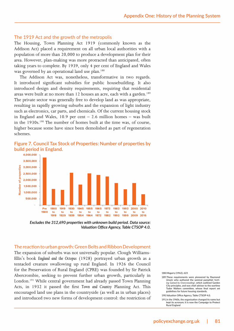
policyexchange.org.uk | 81
Appendix One: History of the Planning System
The 1919 Act and the growth of the metropolisThe Housing, Town Planning Act 1919 (commonly known as the Addison Act) placed a requirement on all urban local authorities with a population of more than 20,000 to produce a development plan for their area. However, plan-making was more protracted than anticipated, often taking years to complete. By 1939, only 4 per cent of England and Wales was governed by an operational land use plan.188
The Addison Act was, nonetheless, transformative in two regards. It introduced significant subsidies for public housebuilding. It also introduced design and density requirements, requiring that residential areas were built at no more than 12 houses an acre, each with a garden.189 The private sector was generally free to develop land as was appropriate, resulting in rapidly growing suburbs and the expansion of light industry such as electronics, car parts, and chemicals. Of the current housing stock in England and Wales, 10.9 per cent – 2.6 million homes – was built in the 1930s.190 The number of homes built at the time was, of course, higher because some have since been demolished as part of regeneration schemes.
Figure 7. Council Tax Stock of Properties: Number of properties by build period in England.
-
500,000
1,000,000
1,500,000
2,000,000
2,500,000
3,000,000
3,500,000
4,000,000
Pre1900
1900to
1918
1919to
1929
1930to
1939
1945to
1954
1955to
1964
1965to
1972
1973to
1982
1983to
1992
1993to
1999
2000to
2009
2010to
2016
Num
ber
of p
rope
rtie
s
Excludes the 312,690 properties with unknown build period. Data source: Valuation Office Agency, Table CTSOP 4.0.
The reaction to urban growth: Green Belts and Ribbon DevelopmentThe expansion of suburbs was not universally popular. Clough Williams-Ellis’s book England and the Octopus (1928) portrayed urban growth as a tentacled creature swallowing up rural England. In 1926 the Council for the Preservation of Rural England (CPRE) was founded by Sir Patrick Abercrombie, seeking to prevent further urban growth, particularly in London.191 While central government had already passed Town Planning Acts, in 1932 it passed the first Town and Country Planning Act. This encouraged land use plans in the countryside (as well as in urban places) and introduced two new forms of development control: the restriction of
188. Megarry (1962), 623
189. These requirements were pioneered by Raymond Unwin who authored the seminal pamphlet Noth-ing Gained by Overcrowding!, which outlined Garden City principles, and was chief adviser to the wartime Tudor Walters committee, whose final report set guidelines for future housing standards.
190. Valuation Office Agency, Table CTSOP 4.0.
191. In the 1960s, the organisation changed its name but kept its acronym; it is now the Campaign to Protect Rural England
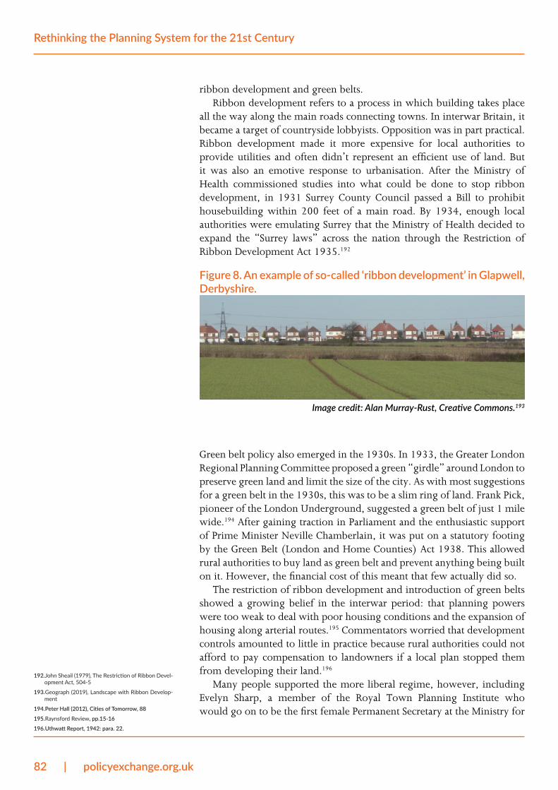
82 | policyexchange.org.uk
Rethinking the Planning System for the 21st Century
ribbon development and green belts.Ribbon development refers to a process in which building takes place
all the way along the main roads connecting towns. In interwar Britain, it became a target of countryside lobbyists. Opposition was in part practical. Ribbon development made it more expensive for local authorities to provide utilities and often didn’t represent an efficient use of land. But it was also an emotive response to urbanisation. After the Ministry of Health commissioned studies into what could be done to stop ribbon development, in 1931 Surrey County Council passed a Bill to prohibit housebuilding within 200 feet of a main road. By 1934, enough local authorities were emulating Surrey that the Ministry of Health decided to expand the “Surrey laws” across the nation through the Restriction of Ribbon Development Act 1935.192
Figure 8. An example of so-called ‘ribbon development’ in Glapwell, Derbyshire.
Image credit: Alan Murray-Rust, Creative Commons.193
Green belt policy also emerged in the 1930s. In 1933, the Greater London Regional Planning Committee proposed a green “girdle” around London to preserve green land and limit the size of the city. As with most suggestions for a green belt in the 1930s, this was to be a slim ring of land. Frank Pick, pioneer of the London Underground, suggested a green belt of just 1 mile wide.194 After gaining traction in Parliament and the enthusiastic support of Prime Minister Neville Chamberlain, it was put on a statutory footing by the Green Belt (London and Home Counties) Act 1938. This allowed rural authorities to buy land as green belt and prevent anything being built on it. However, the financial cost of this meant that few actually did so.
The restriction of ribbon development and introduction of green belts showed a growing belief in the interwar period: that planning powers were too weak to deal with poor housing conditions and the expansion of housing along arterial routes.195 Commentators worried that development controls amounted to little in practice because rural authorities could not afford to pay compensation to landowners if a local plan stopped them from developing their land.196
Many people supported the more liberal regime, however, including Evelyn Sharp, a member of the Royal Town Planning Institute who would go on to be the first female Permanent Secretary at the Ministry for
192. John Sheail (1979), The Restriction of Ribbon Devel-opment Act, 504-5
193. Geograph (2019), Landscape with Ribbon Develop-ment
194. Peter Hall (2012), Cities of Tomorrow, 88
195. Raynsford Review, pp.15-16
196. Uthwatt Report, 1942: para. 22.
policyexchange.org.uk | 83
Appendix One: History of the Planning System
Housing. As she argued,
Remember that the countryside is not the preserve of the wealthy and leisured classes. The country rightly prides itself on the fact that since the War there has been unparalleled building development, a development which every Government has done its utmost to stimulate, and whose effect has been to create new and better social conditions for a very large number of persons.197
Interim development and embedded discretionAnother important principle introduced during the interwar period was the transition from a zonal or “regulatory” planning system to a discretionary one. Under zonal plans, common in continental Europe, a land-use plan designates zones for different uses (residential, green space, industry, etc.), and developers are permitted to build so long as they follow the rules set out in the plan. The UK’s system is peculiar in that land-use plans designate specific land uses for individual private plots of land as opposed to more general uses in zonal areas. There are also no fixed rules to follow to securing permission to build - granting development rights is at the discretion of the local planning authority who judge whether proposals are in accordance with planning policies (which are often imprecise and subjective).198 Discretionary systems increase flexibility, but they mean that there is little certainty or transparency about what is likely to gain planning permission. Philip Booth has detailed how, between the wars, “the emergence of local government and the traditions of British case law led to the development of a discretionary system when the model for the plan-making system had been the regulatory plans of continental Europe.”199
This happened by an almost accidental sequence of events. There had been a flaw in the 1909 Act: while Councils were preparing plans, developers would hold back from building homes or investing in factories, in case the incoming plan outlawed the new building. So a system was needed to manage development in the meantime. The 1919 Act (section 45) therefore introduced the concept of “Interim Development” – while the local authority was preparing the plan, the council would decide on any new proposal on a case-by case basis. This was given effect by the 1922 Interim Development Order, which stated that building operation shall comply with such requirements as the local authority may reasonably impose”.200 There was no definition in statute of what was “reasonable”, so it was left to the discretion of local authorities.
One result of this was that different types of planning control existed across the country. A small minority (4 per cent in 1939) had zonal plans in operation.201 Most (70 per cent) had Interim Development control in place, while the remaining 26 per cent had no planning system.The majority of the country operated discretionary decision making, ensuring that it dominated case law and planning culture. An Act of 1943 stipulated that the remaining 26 per cent of the country with no planning system must operate Interim Development control.202 When the system was
197. Quoted in Hall, 2012: 87
198. The planning system is not meant to be discretion-ary. In theory, at least, if the plan says something is allowed it gets permission. The trouble is that plans have become so complicated that even if one provi-sion says a proposal is acceptable, there is all to like-ly to be something else that can be used to stymie it.
199. Booth, 1999: 277
200. Quoted in Booth, 1999: 279
201. Megarry, 1962: 623
202. The Town and Country Planning (Interim Develop-ment) Act 1943
84 | policyexchange.org.uk
Rethinking the Planning System for the 21st Century
redesigned after the war, the discretionary element was made universal.
1940-1947: a national planning systemThe period of and just after the Second World War brought about radical transformation in the UK planning system. Three wartime reports and one White Paper were highly influential – the Barlow Report (1940) on the Distribution of Industrial Population, the Uthwatt Report (1942) on Compensation and Betterment, the Scott Report (1942) on Land Utilisation in Rural Areas; and a government White Paper (1944) on The Control of Land Use. These publications inspired the watershed legislation of the 1947 Town and Country Planning Act, whose features continue to characterise the UK planning system to this day.203
The features of the 1947 Act
1. All local planning authorities have a legal duty to produce a development plan
Previous Planning Acts gave local authorities the option to create plans, but the 1947 Act gave them a duty to do so. All local authorities were required to make plans to define the sites of roads, public buildings, green spaces, residential, industrial and other forms of land. As with previous planning Acts, this was much more protracted than originally had been expected. The Act stated that these plans were to be produced within three years; this deadline was largely missed, and it was not until 1961 that the final plan was approved.204
2. Any development requires permission from the local planning authority
Section 12 of the Act stated that “permission shall be required under this Part of this Act in respect of any development of land”. The definition of “any development” was broad, including any new building, engineering, mining, and the conversion of one dwellinghouse to more than one. This was a revolution in property rights: the individual retained private property, but their right to develop it now required approval from the state. A crucial consequence of this was that the planning system was, following the traditions of Interim Development, discretionary. Even if a plan designated land for a particular type of development, permission was still required to allow it.
3. The decision-making process incorporates an element of discretionSection 14 of the Act required the grant of permission to be determined by the local authority. The Act also embedded the established discretionary element of that decision making by requiring the local authority to make its decision in accordance with the development plan and “any other material considerations” without determining either what those considerations were or what weight should be placed on them.
203. With the exception of the financial provisions (points five and six in the section below), which were dropped in the 1950s and have changed since, the features of the 1947 system are still recognisable today.
204. HWE Davies (1998): 141

policyexchange.org.uk | 85
Appendix One: History of the Planning System
4. Developers may appeal to the Minister if they aren’t satisfied with the decision of a local planning authority
This was already a feature of the 1909 Act (there had been the option to appeal to the Local Government Board). However, because the 1947 system required an application for almost all development, a large number of appeals would now go to the Ministry in Whitehall.
5. Developments which happen without the consent of the local planning authority will be removed
This was also a feature of previous planning legislation, so the impact of the 1947 Act was merely to greatly increase the scope of planning control.
6. “Betterment taxation” of 100 per centWhen a local planning authority grants permission to build on land, the value of that land tends to increase sharply (“betterment”). The 1942 Uthwatt Report suggested that most of this increase (75 per cent) should go to the state via taxation,205 on the grounds that the extra value was created by the work of the community, rather than the landowner. The 1947 Act was even more radical than this, stipulating that 100 per cent of the increased value would go to the state. The mechanism for achieving this was the Development Charge. When someone applied for planning permission to construct a new building, or to extend a building, they were liable to pay this charge if successful. An authority would assess the differential between the existing use value and the value of land when built on, and claim 100 per cent of this.
7. Compulsory purchase based on the existing use valueBecause the development charge prevented landowners from profiting through building, there was a risk that they would not develop at a time when reconstruction was drastically needed. Therefore, local authorities were provided new powers of compulsory purchase. If they wanted to purchase, for instance, agricultural land, they could do so at the existing use value of the agricultural land.
What changed with the 1947 Act?Pre-1947 1947 Act
Were plans optional or mandatory?
Local planning authorities had the option to make local plans under Acts of 1909, 1919, 1932
Local planning authorities required to make local plans
What was the nature of local plans?
Plans were zonal. They marked out residential zones, industrial zones, and agricultural zones. A developer automatically had permission to build houses in a residential zone, or factories in an industrial zone.
Plans were discretionary. They still marked out zones, but this was just a guide to what development was likely to receive permission. Local planning authorities still had the discretion to reject or approve individual applications.
205. Uthwatt Report, p319
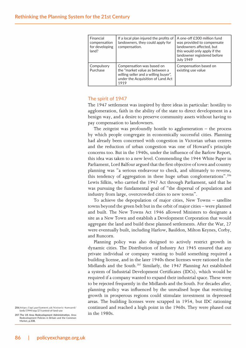
86 | policyexchange.org.uk
Rethinking the Planning System for the 21st Century
Financial compensation for developing land?
If a local plan injured the profits of landowners, they could apply for compensation.
A one-off £300 million fund was provided to compensate landowners affected, but this would only apply if the landowner registered before July 1949
Compulsory Purchase
Compensation was based on the “market value as between a willing seller and a willing buyer”, under the Acquisition of Land Act 1919
Compensation based on existing use value
The spirit of 1947The 1947 settlement was inspired by three ideas in particular: hostility to agglomeration, faith in the ability of the state to direct development in a benign way, and a desire to preserve community assets without having to pay compensation to landowners.
The zeitgeist was profoundly hostile to agglomeration – the process by which people congregate in economically successful cities. Planning had already been concerned with congestion in Victorian urban centres and the reduction of urban congestion was one of Howard’s principle concerns too. But in the 1940s, under the influence of the Barlow Report, this idea was taken to a new level. Commending the 1944 White Paper in Parliament, Lord Balfour argued that the first objective of town and country planning was “a serious endeavour to check, and ultimately to reverse, this tendency of aggregation in these huge urban conglomerations”.206 Lewis Silkin, who carried the 1947 Act through Parliament, said that he was pursuing the fundamental goal of “the dispersal of population and industry from large, overcrowded cities to new towns”.
To achieve the depopulation of major cities, New Towns – satellite towns beyond the green belt but in the orbit of major cities – were planned and built. The New Towns Act 1946 allowed Ministers to designate a site as a New Town and establish a Development Corporation that would aggregate the land and build these planned settlements. After the War, 27 were eventually built, including Harlow, Basildon, Milton Keynes, Corby, and Runcorn.
Planning policy was also designed to actively restrict growth in dynamic cities. The Distribution of Industry Act 1945 ensured that any private individual or company wanting to build something required a building license, and in the later 1940s these licenses were rationed in the Midlands and the South.207 Similarly, the 1947 Planning Act established a system of Industrial Development Certificates (IDCs), which would be required if a company wanted to expand their industrial space. These were to be rejected frequently in the Midlands and the South. For decades after, planning policy was influenced by the unrealised hope that restricting growth in prosperous regions could stimulate investment in depressed areas. The building licenses were scrapped in 1954, but IDC rationing continued and reached a high point in the 1960s. They were phased out in the 1980s.
206. https://api .par l iament.uk/historic-hansard/lords/1944/sep/27/control-of-land-use
207. The US Area Redevelopment Administration, Area Redevelopment Policies in Britain and the Common Market, p.338.
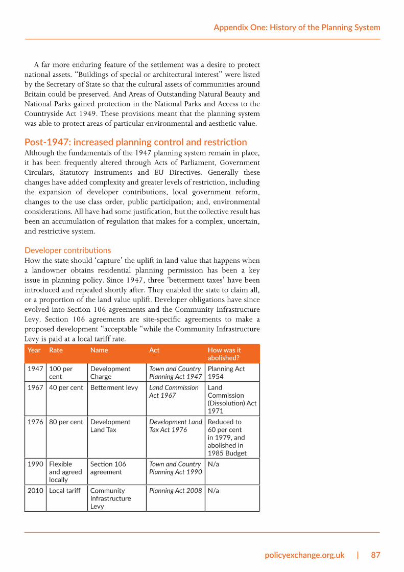
policyexchange.org.uk | 87
Appendix One: History of the Planning System
A far more enduring feature of the settlement was a desire to protect national assets. “Buildings of special or architectural interest” were listed by the Secretary of State so that the cultural assets of communities around Britain could be preserved. And Areas of Outstanding Natural Beauty and National Parks gained protection in the National Parks and Access to the Countryside Act 1949. These provisions meant that the planning system was able to protect areas of particular environmental and aesthetic value.
Post-1947: increased planning control and restrictionAlthough the fundamentals of the 1947 planning system remain in place, it has been frequently altered through Acts of Parliament, Government Circulars, Statutory Instruments and EU Directives. Generally these changes have added complexity and greater levels of restriction, including the expansion of developer contributions, local government reform, changes to the use class order, public participation; and, environmental considerations. All have had some justification, but the collective result has been an accumulation of regulation that makes for a complex, uncertain, and restrictive system.
Developer contributionsHow the state should ‘capture’ the uplift in land value that happens when a landowner obtains residential planning permission has been a key issue in planning policy. Since 1947, three ‘betterment taxes’ have been introduced and repealed shortly after. They enabled the state to claim all, or a proportion of the land value uplift. Developer obligations have since evolved into Section 106 agreements and the Community Infrastructure Levy. Section 106 agreements are site-specific agreements to make a proposed development “acceptable “while the Community Infrastructure Levy is paid at a local tariff rate. Year Rate Name Act How was it
abolished?1947 100 per
centDevelopment Charge
Town and Country Planning Act 1947
Planning Act 1954
1967 40 per cent Betterment levy Land Commission Act 1967
Land Commission (Dissolution) Act 1971
1976 80 per cent Development Land Tax
Development Land Tax Act 1976
Reduced to 60 per cent in 1979, and abolished in 1985 Budget
1990 Flexible and agreed locally
Section 106 agreement
Town and Country Planning Act 1990
N/a
2010 Local tariff Community Infrastructure Levy
Planning Act 2008 N/a
88 | policyexchange.org.uk
Rethinking the Planning System for the 21st Century
As well as changes in the level of contribution required, developer contributions have also evolved in what they include. One of the most significant changes has been the increase and formalisation of Affordable Housing requirements. These were first negotiated by local authorities in the 1970s and later endorsed by the government for rural developments in 1979.209 Affordable housing requirements were features of planning agreements from that point onwards and could be secured through Section 106 agreements. They became dominant in government policy after a circular from the Department of the Environment, Transport and the Regions in 1998 lowered the thresholds so that smaller sites could require affordable housing.209 Government planning policy guidance in 2000 also made clear that refusal to contribute to affordable housing requirements would be an appropriate reason to refuse planning permission.210
Regional planning and local government reformThe geographic scope of planning has also changed significantly since 1947. As part of attempts to shift economic activity away from dynamic areas (like London and Birmingham) and towards less dynamic areas (in the north and west), regional Economic Planning Councils and Boards comprised of local authorities, industrialists, trade unions, academics and civil servants were established. They produced regional studies and plans and had a strong influence over physical planning.211 At the same time, an ill-fated five-year “National Plan” was attempted in 1965 though abandoned two years later. Edmund Dell, the former Department of Economic Affairs minister who had defended the Plan in Parliament, later described it as “a political gesture, supported equally by naïve politicians, naïve businessmen and naïve civil servants in the DEA.”212 Regional policies also included the need to obtain an office development permit before building new offices over 2,500 sq. ft. in specific areas (applied initially in Greater London and the outer Metropolitan region then later in Birmingham).
Regional planning was revived in 1994 when eight newly-created English regions were tasked with producing Regional Planning Guidance. Regional Development Agencies, tasked with producing Regional Economic Strategies, were later established as were Regional Bodies whose voluntary members would produce Regional Spatial Strategies.213 These were criticised for their cost and bureaucracy and abolished in 2010 as part of initiatives to encourage localism. Instead, local planning authorities were placed under a “duty to co-operate” when preparing local plans. Neighbourhood Plans were also legislated for, allowing communities to shape the development and growth of their local area. In 2018, 542 Neighbourhood Plans were in place.214
208. Joseph Rowntree Foundation, 2002: 1
209. Government Circular 6/98, Planning and Affordable Housing
210. Joseph Rowntree Foundation, 2002
211. Hall, Urban and Regional Planning
212. Dell, The Chancellors, 331
213. Sandford 2013; Cullingwoth and Nadin 2006: 56-59
214. Lichfields, Local Choices? May 2018
policyexchange.org.uk | 89
Appendix One: History of the Planning System
Use Classes and Permitted DevelopmentThe 1947 Act required local authorities to make comprehensive land use plans and to adjudicate on any change in land use. This required them to categorise land and buildings in their area by their use. A series of statutory instruments followed to instruct authorities how to carry this out by creating a Use Class Order. The first, in 1948, was too detailed and led to an overwhelming number of applications about minor changes. It was replaced by a new Order in 1950, which “amalgamates certain of the Use Classes… and thus permits a wider range of changes of use to take place without involving development”.215 The Order clarified a number of actions that would not require permission. These included minor extensions, minor operations such as installing gates and fences, changing from a shop to a different type of shop, etc. Recognising the excessive bureaucracy that could be caused, this Order was the first attempt to reduce state control over the planning system.
In the decades after the 1947 Act, statutory instruments such as the Use Class Order and General Permitted Development Orders have similarly been used to tighten or liberalise the planning system without new primary legislation. It is central to the planning system – not least because planning is not predominantly about new building. The current Use Class Order is still that drafted in 1987 although it has been modified since. Permitted Development rights have also been extended to modify and, generally, extend the range of development that has deemed consent although in some cases that consent is restricted by the ‘prior approval’ requirements.
Public participation The 1947 planning system was seen to be highly technocratic. The decision by the London County Council in the early 1960s to demolish Euston Arch despite fierce public opposition, for instance, reinforced a perception that planners treated places like blank cavasses without public involvement or support. The pushback against technocratic planning led to the writing of the Skeffington Report (People and Planning) in 1969. Skeffington’s Committee were appointed “to consider and report on the best methods, including publicity, of securing the participation of the public at the formative stage in the making of development plans for their area”.216
The rise of public participation was soon linked to the issue of ‘NIMBYism’. A 1974 study found that rural dwellers had been “quick to seize on the opportunities of increased public participation in planning” to restrict growth around their area, in order to preserve the status quo.217 The NIMBY phrase was popularised by Nicholas Ridley, former Secretary of State for the Environment, who criticised people who support the need for new transport and housing, so long as it’s “Not In My Back Yard”. (He was later reported to oppose development in his own section of the Cotswolds).218 215. The Town and Country Planning (Use Classes) Order,
1950, No, 1131
216. People and Planning, 1969
217. Hall, 1973: 406
218. Ehrman, 1990. Nimbyism: the disease and the cure. Centre for Policy Studies
90 | policyexchange.org.uk
Rethinking the Planning System for the 21st Century
Variations across the UKPlanning is a devolved matter. England, Scotland, Wales, and Northern Ireland have developed differing approaches to planning, particularly since devolution in 1998. Scotland, for example, has four Strategic Development Plans for the city and surrounding region of Glasgow, Edinburgh, Aberdeen, and Dundee.
Nonetheless the planning systems across the constituent nations of the UK are broadly similar. Each is a plan-led system, where local authorities produce local plans that allocate land for development. In all nations, local planning authorities can impose conditions on planning applications on a discretionary basis. All have the use classes system and permitted development rights (with slightly different regulations). And applicants can appeal against planning decisions to a central body in each of the four nations.
Environmental Assessments and EU lawA number of global and European initiatives to tackle climate change and environmental degradation have translated into changes to the UK planning system. The first EU legislation in this area was the 1979 Birds Directive, which simply addressed the killing/capture of birds. This was continuously modified and updated in 2009. It puts a Duty on member states to safeguard the habitats of migratory birds through Special Protection Area designations. In the UK, there are 275 Special Protection Areas covering 3,760,717 hectares.219
EU environmental legislation became more extensive from the 1980s onwards. The 1985 Environmental Impact Assessment Directive stipulated that an Environmental Impact Assessment must be carried out for a number of projects including railway lines, motorways, and airports. It has been amended three times to increase the number of projects requiring Environmental Impact Assessments. Then in 2001, the Strategic Environmental Assessment Directive required any land use plan to include a Strategic Environmental Assessment.220 As a result, EU legislation has added requirements to both plan-making (through Strategic Environmental Assessments) and development control (through Environmental Impact Assessments).
In 1992, the European Council’s Habitats Directive added other obligations to plan-making.221 It stipulated that certain sites be designated as protected and that “an appropriate assessment must be made of any plan or programme likely to have a significant effect on the conservation objectives of a site which has been designated or is designated in future”. As of 2019, there are 658 designated Special Areas of Conservation in the UK.222 In these areas, the local planning authority must undertake an “Appropriate Assessment” into the impacts of development on their plans. Furthermore, anyone proposing development which might impact on these areas must similarly undertake these developments.
The UK has also transposed international standards into the planning system. The Ramsar Convention, for example, was ratified by the UK
219. JNCC (2019) - Special Protection Areas – overview
220. EU Directive 2001/42/EC. Transposed into UK law via s19 of the Planning and Compulsory Purchase Act 2004
221. European Council Directive 92/43/EEC
222. JNCC
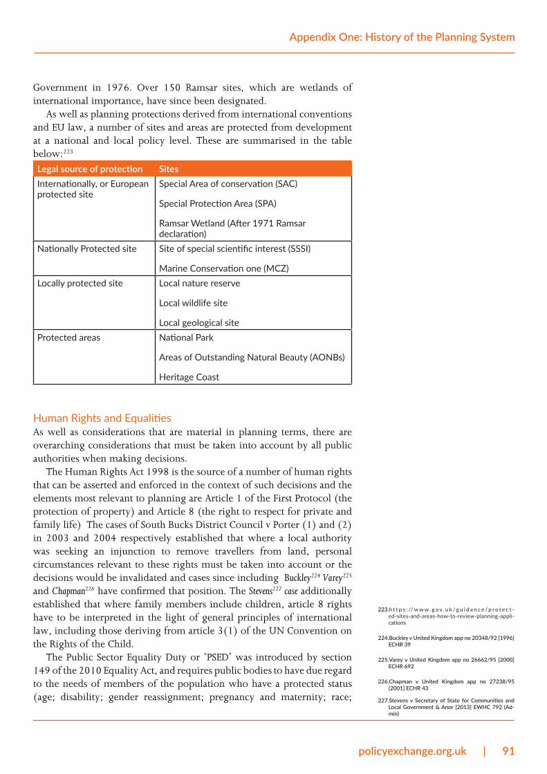
policyexchange.org.uk | 91
Appendix One: History of the Planning System
Government in 1976. Over 150 Ramsar sites, which are wetlands of international importance, have since been designated.
As well as planning protections derived from international conventions and EU law, a number of sites and areas are protected from development at a national and local policy level. These are summarised in the table below:223
Legal source of protection SitesInternationally, or European protected site
Special Area of conservation (SAC)
Special Protection Area (SPA)
Ramsar Wetland (After 1971 Ramsar declaration)
Nationally Protected site Site of special scientific interest (SSSI)
Marine Conservation one (MCZ)Locally protected site Local nature reserve
Local wildlife site
Local geological siteProtected areas National Park
Areas of Outstanding Natural Beauty (AONBs)
Heritage Coast
Human Rights and EqualitiesAs well as considerations that are material in planning terms, there are overarching considerations that must be taken into account by all public authorities when making decisions.
The Human Rights Act 1998 is the source of a number of human rights that can be asserted and enforced in the context of such decisions and the elements most relevant to planning are Article 1 of the First Protocol (the protection of property) and Article 8 (the right to respect for private and family life) The cases of South Bucks District Council v Porter (1) and (2) in 2003 and 2004 respectively established that where a local authority was seeking an injunction to remove travellers from land, personal circumstances relevant to these rights must be taken into account or the decisions would be invalidated and cases since including Buckley224 Varey225 and Chapman226 have confirmed that position. The Stevens227 case additionally established that where family members include children, article 8 rights have to be interpreted in the light of general principles of international law, including those deriving from article 3(1) of the UN Convention on the Rights of the Child.
The Public Sector Equality Duty or ‘PSED’ was introduced by section 149 of the 2010 Equality Act, and requires public bodies to have due regard to the needs of members of the population who have a protected status (age; disability; gender reassignment; pregnancy and maternity; race;
223. h t t p s : // w w w . g o v . u k /g u i d a n c e / p r o t e c t -ed-sites-and-areas-how-to-review-planning-appli-cations
224. Buckley v United Kingdom app no 20348/92 [1996] ECHR 39
225. Varey v United Kingdom app no 26662/95 [2000] ECHR 692
226. Chapman v United Kingdom app no 27238/95 [2001] ECHR 43
227. Stevens v Secretary of State for Communities and Local Government & Anor [2013] EWHC 792 (Ad-min)
92 | policyexchange.org.uk
Rethinking the Planning System for the 21st Century
religion or belief; sex.) when exercising any public function. Its relevance to planning case was established in Harris228 and explored and confirmed in Coleman229. It was recently asserted with success in Buckley v North East Somerset Council where permission for a residential redevelopment scheme was quashed where the judge ruled that the local authority “did not in fact have due regard to the impact on the elderly and disabled persons of granting an application which might lead to the demolition of their existing homes”.
Major infrastructure planningThe 2008 Planning Act introduced a separate planning process for large infrastructure projects, putting them under the control of ministers rather than local planning authorities. This was done with the intention of providing a streamlined application process for so-called Nationally Significant Infrastructure Projects (NSIPs), of which 176 are currently under consideration by the Planning Inspectorate.230 NSIPs include energy, transport, water and waste projects which require “development consent” rather than several consents that would otherwise be necessary (e.g. planning permission and compulsory purchase orders). As the House of Commons Library has written, “The idea of [the Development Consent Order] regime is that it is a quicker process for large scale development projects to get the necessary planning permission and other related consents that they would require, rather than having to apply separately for each consent.”231
The planning process for NSIPs involves six stages:
1. Pre-application and application. Developers have a statutory duty to carry out consultation on their proposals. The length and extent of this will vary with the size of the project.
2. Acceptance. The Planning Inspectorate decides whether to accept that the application is meets the standards required to be examined. They have 28 days to decide.
3. Pre-examination. At this stage, members of the public can register to become an Interested Party by writing a summary of their position. There will be a Preliminary Meeting where all interested parties are invited to attend. This takes approximately three months on average.
4. Examination. The Planning Inspectorate has six months to examine the proposal.
5. Recommendation and Decision. The Planning Inspectorate prepares a report to the Secretary of State, including a recommendation, within three months of the close of the examination. The Secretary has a further three months to make the decision. The decision is made in accordance with legislation and national policy statements for major infrastructure.
6. Post decision. There is a six-week period in which the decision may be challenged in the High Court.
228. Harris, R (on the application of) v The London Bor-ough of Haringey [2010] EWCA Civ 703
229. Coleman, R (on the application of) v The London Borough of Barnet Council & Ors [2012] EWHC 3725
230. National Infrastructure Planning
231. House of Commons Library (2017) - Planning for Na-tionally Significant Infrastructure Projects

policyexchange.org.uk | 93
Appendix One: History of the Planning System
2020: the planning system todayOver the last decade, central government has attempted to reduce some of the complexity associated with the system. In 2012, the 59 page National Planning Policy Framework (NPPF) was published. This consolidated national planning policy which, at the time ran to 200 documents and 7,000 pages. The NPPF has since been updated in 2018 and 2019.
A new route to planning permission has also been introduced for small housing developments where permission ‘in principle’ can quickly be granted based on the location, type and quantum of development. Technical details are then given consent at a later stage – subject to negotiations over developer obligations and, in some instances, Environmental Impact Assessments.
The route by which land use planning and planning decisions are made in England are summarised below.
The formulation of land use planning in EnglandNational Planning Policy Framework (NPPF)
The NPPF formulates policy priorities for spatial development. These priorities are material considerations that must be taken into account by local planning authorities when making local plans and planning decisions.
Regional strategic plans Although Regional Spatial Strategies have been abolished by the 2011 Localism Act, documents such as the London Plan and the emerging Greater Manchester Spatial Strategy add an extra layer of policy and additional requirements for policy compliance at the regional/strategic level.
Local plans Local plans set out a vision and framework for future development. They include detailed land use plans, which allocate certain uses in line with what is projected to be ‘needed’ locally, and policy guidelines on issues like developer obligations and design. Local plans must be in conformity with the NPPF and, where relevant, regional plans.
Neighbourhood plans Self-organising communities are able to shape the development and growth of their local area by preparing neighbourhood plans. These cannot restrict development in areas already allocated for development in local plans, but they can allocate additional land for development if it conforms to the NPPF.

94 | policyexchange.org.uk
Rethinking the Planning System for the 21st Century
Planning decision-making in EnglandLocal planning authorities
Planning applications are determined by local planning authorities in accordance with the local plan unless material considerations indicate otherwise. Material considerations include a number of issues, for instance national/region policies, highways/wildlife/noise issues and loss of sunlight/daylight/outlook/privacy. The scope for deciding what is a material consideration and the weight to be given to it is a matter for the judgment of the local authority but the Supreme Court has recently ruled that it must relate to the use or development of land. 232.
Call-in powers Planning applications can be ‘called-in’ by the Secretary of State and, in London, by the Mayor of London. This provides them power to make decisions on a planning application instead of the local planning authority.
Statutory right of appeal
If a planning application is turned down or is approved with conditions that are thought to be unacceptable, the applicant has a statutory right of appeal. This means the decision is reviewed by the Planning Inspectorate or, occasionally, the Secretary of State.
Judicial review People or organisations with a sufficient interest in the matter are allowed to challenge the lawfulness of planning decisions made by local planning authorities or the Secretary of State via either a specific statutory appeal or general judicial review.
232. Wright, R (on the application of Wright) v Resilient Energy Severndale Ltd & Anor - [2019] WLR(D) 649, [2019] UKSC 53, [2019] 1 WLR 6562

policyexchange.org.uk | 95
Appendix Two: Value gain for an average plot of land in the UK, Knight Frank analysis
Appendix Two: Value gain for an average plot of land in the UK, Knight Frank analysis
Land value Uplift % of VOA Land Value Note Per ha Per acre Per ha Per acre
Agricultural land value 1 £21,000 £8,000 £21,000 £8,000 Planning cost 2 £100,000 £40,000 5%
Landowner premium 3 £157,750 £64,000 8%
Threshold land value 4 £278,750 £113,000 £0 £0 CIL 5 £299,000 £121,000 15%
s106 & infrastructure costs 6 £642,000 £260,000 33%
Serviced land value 7 £1,221,000 £494,000 £0 £0 Affordable housing cost 8 £727,000 £294,000 37%
VOA Land Value 9 £1,950,000 £789,000 £0 £0 Construction & development costs 10 £4,866,000 £1,969,000
Housebuilder profit and finance 11 £2,035,000 £824,000
Built value (70% private) 12 £8,849,456 £3,581,181 0
Built value (100% private) 12 £10,171,789 £4,116,300 £535,119
1. Agricultural value taken as £21,000 per ha from the VOA estimate 2015. Arithmetic average of 2017 data is £22,355 per ha. £21,000 matches figures for Dorset, Cambridgeshire, New Anglia, Wiltshire and West of England.
96 | policyexchange.org.uk
Rethinking the Planning System for the 21st Century
2. Planning cost is difficult to judge and varies dramatically between projects. £100,000 per ha is a judgement of an average project from professional experience.
3. The profit to a landowner or promoter for achieving planning permission. Calculated as the TLV less the planning cost and agricultural value.
4. Threshold land value at £278,750 per ha for greenfield land taken from Local Authorities in Leicestershire (Blaby, Charnwood, Harborough, Hinckley, Melton, NW Leics and Rutland) being indicative of typical TLV. Rule of thumb is 10x multiplier so 13.2x is generous and might suggest a slightly generous Landowner Premium.
5. Average CIL rate for the country is £95 per sq m, or £8.82 per sq ft (DCLG, February 2017, The value, impact and delivery of the Community Infrastructure Levy), multiplied by 13,721 sq ft on a net acre (matching VOA’s assumption).
6. Infrastructure costs vary considerably from high costs at large greenfield sites (c.£690,000 per acre - see Policy Exchange Duty to Build Beautiful essay) to lower costs at sites that benefit from existing infrastructure / capacity. The figure of £260,000 per acre is considered an average cost for an average situation.
7. Serviced land value is the value of a typical parcel of land sold to housebuilders for development.
8. Affordable cost calculated as 55% of lost GDV, itself £130 per sq ft (£300 per sq ft private value less £170 per sq ft affordable value) lower across 30% affordable of 13,721 sq ft in an acre.
9. VOA assessment of average (excluding London) hypothetical hectare of land with planning permission, serviced and with no affordable housing is £1.95m per ha.
10. Average ‘All-in’ construction cost assessed of £143.5 per sq ft across an acre comprising 13,721 sq ft.
11. Average profit and finance equivalent of 23% of GDV.12. Built value calculated at £300 per sq ft private (70%) and £170 per
sq ft affordable (30%) values across 13,721 sq ft per acre.

policyexchange.org.uk | 97
Contents

Our planning system was designed for the 1940s. Tinkering with it will not alleviate the UK’s housing crisis - radical reform is desperately needed. Unlocking the planning system presents law makers with a huge opportunity. It will give people the homes they deserve, improve productivity and boost economic growth.
Lord [Simon] Wolfson of Apsley Guise, Chief Executive of Next Plc and founder of the Wolfson Prize
The planning system is based on the misconception that the state both can and should know how many houses and jobs will be needed and where they should go. ‘The Plan’ is seen as the epitome of rationality, enabling us to control and to manage our world. But humans are messy and want different things at different times in their lives, while economies and technologies change, sometimes abruptly. The planning system is a straitjacket on housing and economic growth and needs to be wholly overhauled.
Bridget Rosewell, Commissioner for the independent National Infrastructure Commission, chaired the Independent Review into Planning Appeal Inquiries
The Byzantine complexity and arbitrary decision-making of English planning turn places into little more than an expression of negotiations between big-business development and harassed bureaucracies. The supply of housing is held back and small local builders give up. Vision, creativity and a more direct response to the persistent local plea for beauty can only happen with a root-and-branch reform of the planning system.
Professor Robert Adam, Director of ADAM Architecture
Our current planning system has it completely backwards. We need to be pulling out all the stops to build the homes we need where we need them, so that more people can live where they want to live and housing becomes cheaper for everyone. That means a total overhaul of the whole process, as Policy Exchange makes the case for in this report.
Reuben Young, Director of Priced Out
£10.00 ISBN: 978-1-913459-09-3
Policy Exchange8 – 10 Great George StreetWestminsterLondon SW1P 3AE
www.policyexchange.org.uk