Embed Size (px)
Citation preview

DEPARTMENT OF THE INTERIOR
UNITED STATES GEOLOGICAL SURVEYGEORGE OTIS SMITH, DIRECTOR
BULLETIN 487
RESULTS OF SPIRIT LEVELING IN IDAHO
1896 TO 1909, INCLUSIVE
R. B. MARSHALL, CHIEF GEOGRAPHER
WASHINGTONGOVERNMENT PRINTING OFFICE
1911


CONTENTS.
Pago.Introduction.............................................................. 5
Scope of the work.................................................... 5Personnel............................................................. 5Classification.......................................................... 5Bench marks......................................................... (5Datum............................................................... 6Topographic maps................................ v .................. 7
Precise leveling........................................................... 7Birch Creek and Weiser quadrangles (Canyon and AVashington counties)... 7
Primary leveling........................................................... 8Cambridge, Meadows, Squaw Creek, and Weiser quadrangles (Boise and
Washington counties)............................................... 8St. Anthony and Victor quadrangles (Bingham and Fremont counties)... 15 Montpelier, Pocatello, Soda Springs, and Wayan quadrangles (Bannock and
Bear Lake counties)................................................. 1CHailey, Picabo, Sawtooth, and Soldier quadrangles (Blaine County)...... 20Chatcolet Station, Kendrick, and Pullman quadrangles (Kootenai and
Latah counties) ...................................................... 22Cataldo and Rathdrum 30' quadrangles and Cceur d'Alene special
quadrangle (Kootenai and Shoshone counties)......................... 23Bonners Ferry, Calispell, Pend Oreille, and Sandpoiut quadrangles (Bonner
and Kootenai counties).............................................. 37 Priest Lake quadrangle (Kootenai County).............................. 40
Index.....................................:.............................. 45
ILLUSTRATION.
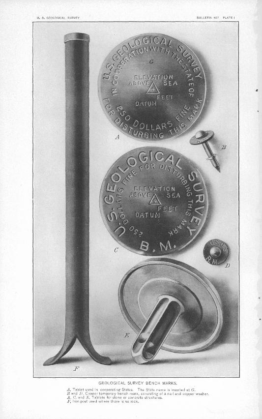
* Page. PLATE 1. Geological Survey bench marks ...... J........................... 5

U. S. GEOLOGICAL SURVEY BULLETIN 4E7 PLATE I
GEOLOGICAL SURVEY BENCH MARKS.
j-1. Tablet used in cooperating States. The State name is inserted at G.]i and !>, Copoer temporary bench mark, consisting of a nail and copper washer.A, C, and E, Tablets for stone or concrete structures.Jf\ Iron post used where there is no rock.

RESULTS OF SPIRIT LEVELING IN IDAHO, 1896 TO 1909, INCLUSIVE.
R. B. MARSHALL, Chief Geographer.
INTRODUCTION.
Scope of the work Ml results of spirit leveling in Idaho previouslypublished by the United States Geological Survey and all results of later work in the State are included in this report, rearranged by quadrangles. Most of the elevations are based on the precise-level line of the United States Coast and Geodetic Survey from Seattle, Wash., via Pocatello, Idaho, to Evanston, Wyo., from the preliminary adjustment by that bureau in 1911.
Personnel. The field work previous to 1903 was done under the general direction of R. U. Goode, geographer; that for 1903 to 1906, inclusive, under E. M. Douglas, geographer; that for 1907 under R,. B. Marshall, geographer; "and the later work under T. G. Gerdine, geographer, under the general direction of R. B. Marshall, chief geog rapher. Credit is given to the different levelmen in the introduction to each list. The office work of computation, adjustment, and prepa ration of lists was done mainly by S. S. Gannett, geographer, and D. H. Baldwin, topographer, and since 1907 under the general direc tion of E. M. Douglas, geographer.
Classification. The, elevations are classified as precise or primary, according to the methods employed in their determination. For pre cise lines instruments and rods of the highest grade are used, each line is run in both forward and backward directions, and every precaution is taken to guard against error. The allowable divergence between the forward and the backward lines in feet is represented by the for mula 0.017-/D, m which D is the distance in miles between bench marks. For primary lines standard Y levels are used; lines are run in circuits or are closed on precise lines, with an allowable closing error in feet represented by the formula 0.05-/D, in which D is the length of the circuit in miles, sufficient care being given the work to maintain this standard. For levels of both classes careful office adjustments are made, the small outstanding errors being distributed over thelines.
5

6 SPIRIT LEVELING IN IDAHO, 1896 TO 1909.
Bench marks. The standard bench marks are of two forms. The first form is a circular bronze or aluminum tablet (0 and E, PI. I), 3£ inches in diameter and one-fourth inch thick, having a 3-inch stem, which is cemented in a drill hole in solid rock, in the wall of some public building, in a bridge abutment, or in other substantial masonry struc ture. The second form (F, PL I), employed where masonry or rock is not accessible, consists of a hollow wrought-iron post 3| inches in outer diameter and 4 feet in length after being split at the bottom and expanded to 10 inches in order to give a firm bearing on the earth. A bronze or aluminum-bronze cap is riveted over the top of the post, which is set about. 3 feet in the ground. A third style of bench mark with abbreviated lettering (B and D, PI. I) is used for unimportant points. This consists of a special copper nail 1£ inches in length driven through a copper washer seven-eighths of an inch in diameter.
The tablets, as well as the caps on the iron posts, are appropriately lettered, and for cooperating States the fact of such cooperation is indicated by the addition of the State name (G, PL I). The numbers stamped on the bench marks described in the following pages represent the elevations to the nearest foot as determined by the levelman. These numbers are stamped with -n--inch steel dies on the tablets or post caps, to the left of the word "feet." The. office adjustment of the notes and the reduction to mean sea-level datum may so change some of the figures that the original markings are 1 or 2 feet in error. It is assumed that engineers and others who have occasion to use the bench-mark elevations will apply to the Director, of the United States Geological Survey, at Washington, D. C., for the adjusted values, and will use the markings as identification numbers only.
Datum. All United States Geological Survey elevations are referred to mean sea level, which is the level that the sea would assume if the influence of winds and tides were eliminated. This level is not the elevation determined from the mean of the highest and the lowest tides, nor is it the half sum of the mean of all the high tides and of the mean of all the low tides, which is called half-tide level. Mean sea level is the average height of the water, all stages of the tide leing considered. It is determined from observations made by means of tidal gages placed at stations where local conditions, such as long,-narrow bays, rivers, and like features, will not affect the height of the water. To obtain even approximately correct results these observations must extend over at least one lunar month, and if great accuracy is desired they must extend over several years. At ocean stations half-tide level and mean sea level usuaUy differ but little. It is assumed that there is no difference between the mean sea level as determined from obser vations in the Atlantic Ocean, the Gulf of Mexico, or the Pacific Ocean.

PRECISE LEVELING. . 7
The connection with tidal stations for bench marks in. certain areas that lie at some distance from the sea coast is still uncertain, and this fact is indicated by the addition of a letter or a word to the right of the word "Datum" on 0tablets or posts. For such areas corrections of published results will be made from time to time as the precise- level lines of the United States Geological Survey or other Government organizations are extended.
Topographic maps. Maps of the following quadrangles wholly or partly in Idaho have been published by the United States Geological Survey up to August 1,1911. They may be obtained, except as noted, for 5 cents each or $3 a hundred, on application to the Director of the Survey at Washington, D. C.
Bear Valley. Bisuka.Boise.Camas Prairie.Occur d'Alene special (Idaho-Montana)
(10 cents). Garden Valley. Hailey.Hamilton (Montana-Idaho). Idaho Basin. Meadows. Mitchell Butte (Oregon-Idaho).
Mountain Home. Nampa (Idaho-Oregon). Oakesdale (Washington-Idaho).Pullman (Idaho-Washington).Rathdrum.Rocky Bar.Sandpoint.Sawtooth.Silver City.Spokane (Washington-Idaho).Squaw Creek.Weiser (Idaho-Oregon).
PRECISE LEVELING.
Birch Creek and Weiser quadrangles.
CANYON AND WASHINGTON COUNTIES.
The elevations in the following list are results of a line of precise leveling begun at Huntington, Oreg., and run southeast 'along the Oregon Short Line Railroad in Idaho to Ontario, Oreg. This line was redetermined by the Coast and Geodetic Survey, being part of its transcontinental line of precise leveling, and was corrected to accord with the heights obtained by the preliminary 1911 adjustment.
The double simultaneous method of leveling was employed, using a Van Orel eh. type of precise level and special rods.
The leveling was done in 1903 by C. H. Semper.For results along this line in Oregon see Bulletin 462.
BIRCH CREEK QUADRANGLE.
Point near Huntington, Oreg., south along Oregon Short Line Railroad to Eaton, Idaho.
Huntington, 5.2 miles east of, on north side of railroad, at first telegraph Feet.pole west of milepost 536, 8 feet from fence; iron post stamped "2069'H". 2,076.919
Huntington, 8.1 miles east of, between track and milepost 533, 18 feet eastof track; iron post stamped "2070-H"................................ 2, 077. 363
Old's Ferry, 2.2 miles east of, on north side of railroad, 70 feet west of seventh telegraph pole east of milepost 530, 10 feet north of track; iron
post stamped "2086 H"............................................. 2,093.395
8 SPIRIT LEVELING IN IDAHO, 1896 TO 1909.
Old's Ferry, 5.2 miles east of, on north side of railroad, 15 feet east of fifth .telegraph pole east of milepost 527, 10 feet north of track;, iron post Feet.stamped "2087 H"................................................... 2,094.325
Eaton, at road crossing; top of rail....................................... 2,104.0Eaton, 0.3 mile southeast of, at mile post 524, on west side of track, at fence
line; iron post stamped "2097 H.".................................... 2, 104.291
WEISER QUADRANGLE.
Eaton along Oregon Short Line Railroad to point 2.2 miles south of Payette.
Eaton, 3.2 miles southeast of, first telegraph pole west of milepost 521,, at fence line; iron post stamped "2122 H"............................... 2,129. 792
Weiser, 13.6 feet west of new station, 41.3 feet north of track, just inside of park, 011 fence line; iron post stamped "2107 H"...................... 2,115.833
Weiser, in front of station; top of rail..................................... 2,113. 8Weiser, 3.3 miles south of, 4 feet north of milepost 515, west of track; iron
post stamped "2113 H"............................................. 2,120.494Weiser, 6.3 miles south of, first telegraph pole south of milepost 512, at fence
line, west of track; iron post stamped "2112 H "...................... 2,119. 775Crystal, in front of station sign; top of rail............................... 2,122. 9Crystal, 2.6 miles south of, west of track, first telegraph pole north of mile
post 509, at fence line; iron post stamped "2123 H ".................... 2, 130. 752Payette, 0.9 mile north of, west of track, at fence line, 27 feet south of mile
post 506; iron post stamped "2139 H ".............."....,............ 2,146. 328Payette, in front of station; top of rail................................... 2,147. 2Payette, 2.2 miles south of, 285 feet south of milepost 503, 10 feet east of
track; iron post stamped "2139 H". ................................. 2,147.104
PRIMARY LEVELING.
Cambridge, Meadows, Squaw Creek, and Weiser quadrangles.
BOISE AND WASHINGTON COUNTIES.
The elevations in the following list are based on the preliminary 1911 adjusted elevation of Bench Mark G0 of the Coast and Geodetic Survey at Weiser, Idaho, on the transcontinental line of precise levels..
The leveling in the Squaw Creek quadrangle was done by D. A. Maxwell in 1907, and that in the other quadrangles by Maxwell and J. G. Hefty in the same year. A check line was run in the Weiser quadrangle in 1908 by W. B. Jones.
WEISER QUADRANGLE.
Weiser along Pacific & Idaho Northern Railway east 11.7 miles (checked line), thence north to Midvale (mean of direct and reverse lines).
Weiser, in west wall of brick building occupied by the Masonic Lodge, 9.84 feet (3 meters) north of the southwest corner and 3.94 feet (1.2 meters) " above ground; copper bolt leaded in wall, stamped "TJ. S. B. M." (Coast and Geodetic Survey B. M. G6). The Coast and Geodetic Survey descrip- Feet, tion gave this location incorrectly as the northwest corner.............. 2,121. 516
Weiser, in west wall of brick courthouse at Oldtown, about 1 mile east of railroad station; red metal disk lettered "Coast and Geodetic Survey B. M. HG," set flush with surface....................................' 2,118. 520
1 The corner of building is cracked from settling, just above the bench mark. The Coast and Geodetic Survey elevation of 2,118.234 feet was therefore not accepted.
^PRIMARY LEVELING. 9
Weiser, 2 miles east of, 10 feet south of track, in foot of milepost 2; spike Feet. head flush with ground.............. 1 ...... ......................... 2,117. 79
Weiser, 3.8 miles east of, 50 feet north of track, at edge of right of way, oppo site milepost 4; iron post stamped "2136 W"........................... 2,136.487
Weiser, 5 miles east of, south side of track, in-foot of milepost 5; spike.... 2,148. 81Weiser, 5.8 miles east of, south side-of track, in foot of milepost 6; spike.... 2,159.09'Weiser, 6.8 miles east of, 50 feet north of track, at edge of right of way,
opposite milepost 7, 30 feet east of wagon road crossing railroad at right angles, about 300 feet north of large yellow house; iron post stamped " 2167 W":..........................,............................... 2,167. 278
Weiser, 9.8 miles east of, 50 feet north of track, opposite milepost 10, at mouth of Weiser River Canyon, 1,000 feet southeast of unused smelter, in outcropping bowlder; aluminum tablet stamped "2210 W "......... 2, 210. 517
Weiser, 10.8 miles east of, 10 feet south of track, in foot of milepost 11; spike............................................................... 2, 215.92
Weiser, 12.9 miles northeast of, 9 feet west of track, 165 feet north of mile- post 13, at foot of low retaining wall along upper side of grade, 100 feet from river, in top of large flat basalt bowlder on east side of rocky bluff, 1,800 feet south of mouth of large stream from east; aluminum tablet stamped "2249 W"................................................. 2, 250. 256
Weiser, 15.9 miles northeast of, opposite milepost 16, 40 feet south of track, near mound of rocks, in large basaltic bowlder; aluminum tablet stamped "2275 W"...........................:.................:............. 2, 275.217
Weiser, 19 miles northeast of, 600 feet north of milepost 19, north side of dry gulch, 50 feet west of track, on point of knoll, in volcanic bowlder along side mound of rocks; aluminum tablet stamped "233S W"............ 2, 338.450
Midvale, 9.5 miles soutl; of, 270 feet north of milepost 22, near mouth of Thousand Spring Creek, 10 feet west of track, in large volcanic bowlder; aluminum tablet stamped "2373 W".................................. 2, 373.131
Midvale, 8.5 miles south of, east side of track, in foot of milepost 23; spike.. 2, 388. 26Midvale, 6.5 miles south of, at sharp curve in track, 18 feet northeast of
milepost 25, 24 feet east of track, between track and river, near mound of rocks, in top of large bowlder; aluminum tablet stamped "2454 W".. 2,454. 751-
Midvale, 4.5 miles south of, east side of track, in base of milepost 27; spike. 2, 501. 66Diamond Springs, in front of section house; top of rail.................... 2, 506. 9Midvale, 3.5 miles south of, .85 feet north of milepost 28, 14 feet east of
track, beside a cairn of rock, top of volcanic bowlder; aluminum tablet stamped '"2514 W"................................................. 2, 514. 811
Midvale, 1. 5 miles south of, 45 feet west of track, in base of telegraph pole (rnilepost 30); spike.................................................. 2, 528. 32
Midvale, 0.5 mile south of, 45 feet west of track, in foot of telegraph pole (milepost 31); spike................................................. 2, 533.11
Midvale, cement block building occupied by Bank of Washington County, at outer entrance, on south side and inner face of entrance, about 4.5 feet above floor; aluminum tablet stamped '' 2544 W "...........,.......... 2, 544. 643
Midvale east along road to J. R. McMahan's ranch.
Midvale, 3.5 miles east of, on Midvale-Indian Valley road, 1,000 feet east of Richard Gaber's ranch house, 80 feet south of road and 40 feet south of wire fence in field, in volcanic bowlder, near mound of rock; aluminum tablet stamped "2724 W"............................................ 2, 726.181
Midvale, 7 miles east of, on Indian Valley-Midvale road, 10 feet south of road, iri base of feucepost; 30-penny nail, aluminum tag............... 3, 210. 91
10 SPIRIT. LEVELING IN IDAHO, 1896 TO 1909.
T. 13 N., R. 2 W., sec. 21,10.7 miles west of Indian Valley-Midvale crossroads 1,000 feet east of ranch, 40 feet south of road, mound of rocks in top Eeet. of volcanic bowlder; aluminum tablet stamped "3292 "W" ........... 3, 293, 930
T. 13 N., R. 2 W., sees. 23 and 24, 7.2 miles west of Indian Valley-Midvale crossroads, 40 feet south of county road, at J. R. McMahan's ranch, 200 feet north of house, in volcanic bowlder; aluminum tablet stamped "3245 W"...................................!...................... 3, 246. 789
CAMBRIDGE QUADRANGLE.
Midvale northeast along Pacific & Idaho Northern Railway to milepost 56.
Midvale, 3.2 miles north of, 9 feet north of telegraph milepost 35, 40 feet west of tract, 10 feet above and 40 feet north of small creek; iron post stamped " 2587 W "........................-........................... 2, 587. 267
Midvale, 4.2 miles north of, 25 feet southwest of milepost 36, 75 feet west of tract; point on large bowlder....................................... 2, 590. 46
Trestle 30, northeast corner; bolt head marked with chiseled cross (+)..... 2, 596. 82Midvale, 6.2 miles north of, 80 feet north of milepost 38, west side of track,
in face of large volcanic bowlder; aluminum tablet stamped "2620 W".. 2, 620. 783Midvale, 7.2 miles north of, 140 feet west of trestle 32, 450 feet south of mile
post 39, on slope of rock; chisel mark on rock.......................... 2, 623. 35Cambridge, 70 feet north of station, at edge of right of way, corner of lot on
south side of central boulevard, at edge of sidewalk; iron post stamped ''2651 W"........................................................... -2, 651. 347
Cambridge, 3.8 miles north of, 1,800 feet north of milepost 44, at short rock cut near end of long low spur from main ridge to west, 20 feet west of track, top of bank 8 feet above level of track, in outcropping rock; aluminum tablet stamped ''2700 W"....................... 1..................... 2, 699. 919
Cambridge, 6.5 miles north of, 600 feet north of trestle 42 across small creek, at point of hill, 10 feet west of track, in cap of box culvert; drift bolt marked with chiseled cross........................................... 2, 718. 35
Cambridge, 7.5 miles north of, 1.5 miles south of Goodrich Creek, 120 feet east of telegraph pole marked "48 miles," 40 feet west of track, on vol canic bowlder 2.5 by 2.5 by 1 foot, near mound of rocks; aluminum tablet stamped "2736 W"................ ̂ .................................. 2,735.997
Cambridge, 8.5 miles north of, 150 feet south of milepost 49, 70 feet east of track in root of lone leaning cottonwood tree in field; nail............. 2, 736. 31
Council, 8.5 miles south of, 100 feet south of railroad bridge 47 across Weiser River, 20 feet west of track, in cement at surface of ground; aluminum tablet stamped '' 2782 W"............................................ 2, 782. 399
Council, 5.5 miles south of, 300 feet south of road crossing, 100 feet west of track; point on large bowlder........................................ 2,819. 25
Council, 5 miles south of, 20 feet west of milepost 55, 8 feet south of track, 100 feet west of trestle 49, in face of solid rock wall 20 feet high, 5 feet above ground, in cement wall flush with surface; aluminum tablet stamped "2860 W"................................................... 2,859.926
Bench marks established along Indian Valley-Van Wyck road, near Van Wyck.
T. 14 N., R. 2 E., in sec. 25, on Indian Valley road, Lookout Mountain, in volcanic bowlder; aluminum tablet stamped ''7811 W"................ 7,812. 485
Van Wyck, 7.8 miles west of, in saddle 10 feet south of Van Wyck and In dian Valley road, in pine tree; 30-penny nail........................... 7, 379. 369
Van Wyck, 8.9 miles west of, on Van Wyck-Indian Valley road, 30 feet south of, in pine tree; 30-penny nail with aluminum tag................ 7,020.118
Van Wyck, 10.2 miles west of, on Van Wyck-Indian Valley road, 50 feet east of, in pine tree; nail............................................. 6, 565. 49
PEIMAKY LEVELING. 11
Van Wyck, 10.8 miles west of, near center of sec. 34, T. 14 N., R. 2 E., 30 feet north of Van Wyck-Indian Vall(5y road, 150 feet south of Sheep Creek, Feet. in top of volcanic bowlder; aluminum tablet stamped "6210 W"....... 6, 211. 754
MEADOWS QUADRANGLE.
Milepost 56 north along Pacific & Idaho Northern Railway to trlangulatlon station 2 miles north of Council.
Council, 4 miles south of, 10 feet east of track, in base of milepost 56; spike. 2, 916. 29Council, 2.5 miles south of, sec. 27, T. 16 N., R. 1 W., county road cross
ing, just north of Cottonwood Creek, 25 feet east of track, east of crossing signpost; iron post stamped "2939 W"................................ 2, 940. 200
Council, 300 feet southeast of station, at foot of and at north side of main street of town, in angle of sidewalk and cross walk; iron post stamped "2910 W"........................................................... 2,911.164
Council, in front of station; top of rail.................................. 2, 913. 9^
Triangulation station 2 miles north of Council east along road to crossroads in T. 17 N.,R. 3 £., thence northwest along road to Meadows, thence southwest to point near Council.
Council, 2.8 miles north of, on line between sees. 34 and 35, T. 17 N., R. 1 W., intersection of Council-Meadows and Mill Creek roads, 300 feet north east of ranch house, west edge of road near fence; iron post stamped "3015 W"......................................................-......... 3,015. 880
Council, G.2 miles northeast of, 1,000 feet east of line between sees. 31 and 32, T. 17 N.,'R. 1 E., at August Baurer's sawmill, between house and sawmill, south side of road, 100 feet north of Mill Creek, in top of large bowlder; aluminum tablet stamped "4023 W"........................ 4,024.064
Council, 7.8 miles east of, in fir tree 15 feet north of road; 20-penny spike.... 4, 855. 77Council, 9.6 miles northeast of, near southwest corner of sec. 22, T. 17 N.,
R. 1 E., intersection of roads in saddle, 50 feet east of forks, 10 feet north of road, in volcanic bowlder; aluminum tablet stamped "5612 W"...... 5, 613. 351
Council, 10.1 miles northeast of, in base of pine tree 5 feet south of road; spike................................................"............... 5, 941.18
Council, 10.3 miles northeast of, in base of fir tree 6 feet south of road; spike. 6, 036.48Council, 10.6 miles northeast of, NW. i sec. 26, T. 17 N., R. 1 E., 50 feet
east of road, on Miller Summit, at mound of rocks, in volcanic rock; aluminum tablet stamped '' 6208 W ".................................. 6, 208. 824
Mill Creek Summit, 0.6 mile east of, in base of fir tree 3 feet south of road; spike............................................................... 6, 281.45
Mill Creek Summit, 1.2 miles east of, in base of balsam tree 3 feet west of road; nail..:........................................................ 6,335.57
Mill Creek Summit, 1.8 miles east of, in fir tree 10 feet west of road; spike.. 6, 306.59Mill Creek Summit, 3 miles northeast of, in balsam fir 10 feet south of road;
20-penny spike...................................................... 6,306.69Mill Creek Summit, 3.6 miles east of, near quarter corner between sees. 6
and 31, Tps. 16 and 17 N., R. 2 E., 100 feet southeast of road, 100 feet west of east fork of Weiser River, in top of granite bowlder; aluminum tablet stamped "6245 W"................................................. 6, 246.098
Mill Creek Summit, 4.5 miles east of, in tamarack tree 15 feet west of road; nail................................................................. 6, 265.44
Mill Creek Summit, 5.4 miles northeast of, in pine tree 20 feet north of road; nail................................................................. 6, 399.06
Mill Creek Summit, 6.6 miles east of, in base of fir tree 5 feet northeast of road- nail........................................................... G, 527. 29
12 SPIRIT LEVELING IN IDAHO, 1896 TO 1909.
T. 17 N., R. 2 E., NW. t sec. 27, 120 feet east of road, mound of rocks, Feet, in saddle, in volcanic rock; aluminum tablet stamped "6521 W"....... 6, 522. 635
Long Valley Summit, 0.9 mile east of, in fir tree 10 feet west of road; nail.. 5, 976. 98Long Valley Summit, 1.4 miles east of, in fir tree 10 feet east of road; nail.. 5, 534. 749Long Valley Summit, 2.4 miles east of, in fir tree 10 feet north of road; nail.. 5, 006. 399Long Valley Summit, 3.9 miles east of, SW. J sec. 19, T. 17 N., R. 3 E.,
junction of Long Valley and Mill Creek roads, northeast corner of James Hartsel's fence, 1,700 feet east of house, 175 feet west of Payette River, 1,320 feet northeast of section corner; iron post stamped "4837 W"..... 4, 838. 393
Long Valley Summit, 5.3 miles east of, corner of sees. 18, 19, 29, and 30, T. 17 N., R. 3 E., in base of southeast corner fence post, at crossroads; nail with aluminum tag.... i........................................ 4, 889. 32
Long Valley Summit, 8.3 miles east of, sec. 22, T. 17 N., R. 3 E., 500 feet south of log house, 5 feet north of road, at southeast corner of fence; iron post stamped "4897 W"............................................. 4, 898. 520
Long Valley Summit, 12.2 miles northeast of, in sec. 33, T. 18 N., R. 3 E., 50 feet southeast of road, in Sam Shaw's field, about 1,200 feet north of Tom Yount's house, 1,600 feet east of Gabriel Maenpad's house, in top of granite bowlder; aluminum tablet stamped "5029 W".................. 5,030. 273
Long Valley Summit, 14.2 miles northeast of, in base of pine tree 10 feet west of road; nail................................................... 5,093.13
Long Valley Summit, 14.9 miles northeast of, in pine tree 10 feet west of road; nail .......................................................... 5, 073. 85
Old Lardo, sec. 9, T. 18 N., R. 3 E., 16.4.miles northeast of Long Valley Summit, south end of Payette Lake, 500 feet south of McCall Hotel, .200 feet north of sawmill, 20 feet south of road, in top of volcanic bowlder, near mound of rocks; aluminum tablet stamped "5030 W"............ 5,030. 771
Old Lardo, in front of McCall Hotel; high-water mark.................... 4, 990Old Lardo; surface of water, Payette Lake, July 30,1907................. 4; 985.5Lardo, 400 feet east of post office, in sec. 8, T. 18 N., R. 3 E., 17.5 miles
northeast of Long Valley Summit, 100 feet south of Payette Lake, 50 feet south of Lardo-Roseberry road, in granite bowlder; aluminum tablet stamped "5001 W"................................................. 5, 002.114
Lardo, 1 mile west of, on Lardo-Meadows stage road, in yellow pine tree 25 feet south of road; nail. ............................................. 5 050.41
Lardo, 2 miles west of, on Lardo-Meadows stage road, in pine tree 20 feetwest of road; nail. .................................................. 5,180.76
Lardo, 2.5 miles west of, sec. 1, T. 18 N., R. 2 E., on Lardo-Meadows stage road, on Payette River and Salmon Creek divide, about 80 feet north of road, 20 feet above road, in top of granite bowlder; aluminum ta.blet stamped "5352 W" ................................................. 5, 352. 766
Lardo, 3.7 miles west of, on Lardo-Meadows stage road, in black pine tree south of road; nail.................................................. 5,104.89
Lardo, 4.8 miles west of, on Lardo-Meadows stage road, in pine tree east of road; nail........................................................... 5,052.15
Lardo, 5.8 miles west of, near center of sec. 34, T. 19 N., R. 2 E., on Lardo- Meadows stage road, on Meadows Summit, in saddle 70 feet north of road,' in top of granite bowlder; aluminum tablet stamped "5093 W"........ 5, 093. 695
Lardo, 6.4 miles west of,- on Lardo-Meadows stage road, in fir tree east of road; nail........................................................... 4, 730.80
Lardo, 7 miles west of, on Lardo-Meadows stage road, in pine tree north of road; nail........................................................... 4, 354.61
Meadows, south side of main street of town, north edge of sidewalk, north east corner of porch at Meadows Hotel; iron post stamped "3975 W".... 3, 976.185
PRIMARY LEVELING. 13
Meadows, 3.3 miles west of, on line between sees. 14 and 23, T. 19 N., R. 1 E., on Council-Meadows stage road, 0.4 mile west of Little Salmon River, 100 feet north of road, 800 feet northeast of sawmill, in rock beside Feet, mound of rocks; aluminum tablet stamped "3964 W"................... 3, 965.1,36
Meadows, 4.4 miles west of, in pine tree 10 feet south of Council-Meadows road; nail......................................................:... 4,030.. 62
Meadows, 5.4 miles west of, in pine tree north of Council-Meadows road; nail................................................................. 4,020.16
Meadows, 6.9 miles west of, sec. 17, T. 19 N., R. 1 E., on Council-Meadows stage road, at north end of Price Valley, on summit between Little Sal mon and Weiser rivers, 100 feet east of road, in top of volcanic rock near mound of rocks; aluminum tablet'stamped " 4186 W".................. 4,187.179
Meadows, 7.7 miles southwest of, in pine tree 15 feet west of Council-Mead ows stage road; nail................................................. 4,143. 94
Meadows, 9.9 miles southwest of, in pine tree 50 feet west of Council-Mead ows stage road; nail................................................. 4,108. 33
Meadows, 10.5 miles southwest of, in sec. 31, T. 19 N., R. 1 E., on Council- Meadows stage road, 1 mile south of Price Valley, 60 feet west of road, 50feet north of small creek, at old sawmill site, in volcanic rock; aluminumtablet stamped "4089 W"............................................ 4,089. 827
Meadows, 12.5 miles southwest of, in pine tree 60 feet west of Council- Meadowa stage road; nail............................................ 3,945. 95
Meadows, 13.8 miles southwest of, 100 feet east of railroad grade, 200 feet east of Weiser River, in fir tree; nail.................................. 3, 972. 05
Evergreen, at terminal of-Pacific & Idaho Northern Railway, in north part of sec. 30, T. 18 N., R. 1 E., 150 east of track, 200 feet directly east of Record Commercial Co. store, in top of volcanic bowlder; aluminum .tablet stamped " 3704 W"............................................ 3, 704. 697
Evergreen, 4.8 miles southwest of, sec. 2, T. 18 N., R. 1 W., 600 feet north of old sawmill, 300 feet north of track, at brow of hill, 200 feet northwest of log house, in volcanic bowlder near mound of rocks; aluminum tablet stamped "3302 W"................................................... 3,302.880
Starkey (Hot Springs), in front of station; top of rail.................... 3,165. 8Starkey (Hot Springs), sec. 34, T. 18 N., R. 1 W., 100 feet southeast of station,
80 feet south of track, in top of volcanic bowlder; aluminum tablet stamped "3172 W".................................................. 3,172. 610
Starkey (Hot Springs), 3.3 miles south of, sec. 15, T. 17 N., R. 1 W., 200 feet west of milepost 66, 400-feet south of house, 100 feet west of railway cut, in top of volcanic bowlder near mound of rocks; aluminum tablet stamped "3065 W"............................................................ 3,066.071
Crossroads in T. 17 N., R. 3 E., south along road via Roseberry to Van Wyck, thencewest 11.7 miles.
T. 17 N., R. 3 E., on line between sees. 23 and 26, 2.6 miles southeast of Lake Fork bridge, on Roseberry-Lardo stage road, 50 feet southeast of bridge across irrigation ditch 40 feet south of road; iron post stamped "4905 W"............................................................ 4, 905. 924
Roseberry, near corner of sees. 11, 12, 13, and 14, T. 16 N., R. 3 E., in schoolhouse yard opposite post office; iron post stamped "4871 W"..... 4, 872. 034
Tps. 15 and 16 N., R. 3 E., corner of sees. 1, 2, 35, and 36, on Roseberry- Van AVyck stage road, northwest corner of schoolhouse yard, 300 feet southeast of Mr. Moore's house, 360 feet west of log house, in granite bowlder; aluminum tablet stamped "4874 W"........................ 4,875. 462

14 SPIRIT LEVELING IN IDAHO, 1896 TO 1909.
Roseberry, 7.8 miles south of, near southwest corner of sec. 14, T. 15 N., R. 3 E., on Roseberry-Van Wyck stage road, 300 feet southwest of Joe Downing's house, 150 feet north of Dry Branch, 50 feet east of road, in Feet. volcanic bowlder; aluminum tablet stamped "4822 W"................ 4, 823. 066
Roseberry, 11.4 miles south of, on line between sees. 2 and 3, T. 14 N., R. 3 E., on Roseberry-Van Wyck stage road, 0.5 mile south of Newton Marler house, 60 feet southeast of road, at corner of fence, in granite bowlder; aluminum tablet stamped " 4802 W "................ ...... 4, 802. 900
Van Wyck, on Main Street, at northeast corner of C. B. Fisher's general store; iron post stamped "4777 W "................................>,... 4, 778.103
Van Wyck, 3.7 miles northwest of, near center of sec. 20, T. 14 N., R. 3 E., at road forks 100 feet west of sawmill road, 150 feet south of Van Wyck- Indian Valley road, near mound of rocks, in volcanic bowlder; alu minum tablet stamped "4910 W".................................... 4, 910. 875
Van Wyck, 4.7 miles west of, in pine tree 10 feet north of Van Wyck- Indian Valley road; nail................................................ 5, 724. 41
Van Wyck, 5.8 miles west of, in pine tree 10 feet north of Van Wyck-Indian Valley road; nail...................................................... 6,156. 89
Van Wyck, 6.8 miles west of, 20 feet north of Van Wyck-Indian Valley road, in fir tree; nail................................................. 6, 801. 76
Van Wyck east 3.7 miles to Norrls ranch.
Crawford, 1.8 miles east of Van Wyck, northeast corner of W. D. Patter- son's yard, opposite post office, 100 feet from main street of town, in top of granite bowlder; aluminum tablet stamped "4759 W".................. 4, 760. 244
Crawford, 1.9 miles east of, on section line at northwest corner of NE. J sec. 29, T. 14 N., R. 4 E., at Anna J. Norris's ranch, 50 feet south of road, 30 feet southeast of house, in granite bowlder; aluminum tablet stamped "4811 W"............................................................. 4,812.608
North along Indian Valley, Midvale, and Council roads to point near Indian Valley.
T. 14 N., R. 1 W., on line between sees. 26 and 35, on Van Wyck, Midvale, and Indian Valley road, at Hillsdale crossroads, 150 feet east of white schoolhouse, at northwest corner of fence, 30 feet east of road, in volcanic bowlder near mound of rocks; aluminum tablet stamped "3164 W".... 3,165.559
Van Wyck, 34.4 miles northwest of, on Van Wyck, Midvale, and Indian Valley road, 100 feet north of Little Weiser River; nail in knuckle of cot- tonwood 20 feet west of road.. .................................... ̂ ... 3,029.16
Indian Valley, near corner of sees. 10, 11, 14, and 15, T. 14 N., R. 1 W., southwest corner of blacksmith shop, east side of Main Street, in volcanic bowlder; aluminum tablet stamped '' 2999 W "........................ 3,000. 889
Indian Valley, 3.7 miles north of, near center of sec. 27, T. 15 N., R. 1 W., on Indian Valley-Council road, at foot of Thorn Creek Hill, 150 feet north of Thorn Creek, 100 feet west of road, 500 feet east of Sam Wood's house, near mound of rocks, in bowlder; aluminum tablet stamped "2931 W"........................................................... 2, 932. 948
Indian Valley, 6.2 miles north of, NW. i sec. 15, T. 15 N., R. 1 W., on Indian Valley-Council road, on middle fork of Weiser River Summit, 30 feet east of road, near mound of rocks, in granite bowlder; aluminum tablet stamped "3309 W"............................................ 3, 310. 911
Indian Valley, 7.3 miles north of, on Indian Valley-Council road, 50 feet south of creek, 3 feet east of bridge crossing Middle Fork Creek, in cotton- wood; nail ......................................................... 2, .903.95

PRIMARY LEVELING. 15
SQUAW CREEK QUADRANGLE.
Bench mark in T. 13 N., R. 1 W.
Van Wyck, 29.6 miles west of, T. 13 N., R. 1 W., 500 feet northeast of cross roads, 100 feet east of Van Wyck-Indian Valley road, in top of volcanic . Feet. bowlder beside mound of rocks; aluminum tablet stamped "3395 W".. 3,396. 379
Point 11.7 miles west of Van Wyck southwest to Canyon Hill, sec. 27, T. 13 N., R. 1 E., thence northwest along Indian Valley road to junction of Mldvale road.
Van Wyck, 12.8 miles west of, 30 feet east of Van Wyck-Indian Valley road, in tree; nail........................................................:. 5,906. 80
Van Wyck, 12.8 miles west of, 20 feet east of Van Wyck-Indian Valley road, in tree; 30-penny nail................................................ 5, 637. 20
Van Wyck, 13.6 miles west of, 30 feet east of Van Wyck-Indian Valley road, in pine tree; 30-penny nail................:.......................... 5, 948. 81
Van Wyck, 15.3 miles west of, 50 feet south of Van Wyck-Indian Valley road, on Four-bit Summit, near mound of rock, in volcanic rock; alumi num tablet stamped "61.54 W"........................................ 6,155.170
Van Wyck, 16.6'miles west'of, 10 feet west of Van Wyck-Indian Valley road, in pine tree; 30-penny nail........................................... 5,372.11
Van Wyck, 17.9 miles west of, 70 feet north of Van Wyck-Indian Valley, road, in pine tree; 30-penny nail..................................... 4,743. 51
Van Wyck, 19.1 miles west of, 10 feet north of Van Wyck-Indian Valley road, in pine tree; 30-penny nail,.................................... 4,494.42
Van Wyck, 19.2 miles west of, 0.5 mile west of Courtright's house, 60 feet south of Van Wyck-Indian Valley road, in top of volcanic bowlder, near mound of rocks; aluminum tablet stamped ''4464 W "................... 4,464. 983
Van Wyck, 20.4 miles west of, in pine tree, '40 feet north of Van Wyck- Indian Valley road; 30-penny nail........'..........................'. 4,136. 58
Van Wyck, 21.6 miles west of, 150 feet south of Van Wyck-Iudian Valley road, on Canyon Hill Summit, in volcanic bowlder, near mound of rocks; aluminum tablet stamped "4375 W "......'............................ 4,376. 422
Van Wyck, 23 miles west of, on Van Wyck-Indian Valley road; chisel mark on top of bowlder, 2 by 2 by 3 feet..................................:. 3, 833. 51
Van Wyck, 26 miles west of, 0.4 mile southeast of junction of Indian Valley and Mid vale roads, in-rim of rock, in top of volcanic rock; aluminum tablet stamped "3409 W "............................ .'.. ............. 3,410. 541
Little Weiser River west along Mldvale road to McMahan ranch.
Indian Valley-Midvale crossroads, 4.2 miles west of, at J. W. Stippich's ranch, 100 feet northeast of house, in corner of yard, in volcanic bowlder; aluminum tablet stamped "3230 W".................................. 3, 231.166
St. Anthony and Victor quadrangles.
BINGHAM AND FREMONT COUNTIKS.
The elevations in the following list are the results of leveling by Goyne Drummond in 1899 from St. Anthony, Idaho, to the Grand Teton and Mount Leidy quadrangles, Wyo., and were originally published in the Twenty-first Annual Report. In 1906 connection was made with the transcontinental line of the Coast and Geodetic Survey leveling by a line brought north from Green River and Rock
16 SPIRIT LEVELING IN IDAHO, 1896 TO 1909.
Springs, Wyo., to Twogwotee Pass and to a point 12 miles northeast of Kroner ranch, and readjustment was made between these points.
VICTOR QUADRANGLE.
Idaho-Wyoming State line at Trail Creek via Victor to Rigby's house.
Idaho-Wyoming State line, at Trail Creek, 8 feet north of road; bronze Feet.tablet stamped "B. M. 6681B'......................................... 6, 683.580
Spencer's house, 30-feet west of, 20 feet east of road, 250 feet north of MosesCreek; bronze tablet................................................ 6,477. 700
Victor, northeast corner of Porter's store; iron post...................... 6, 207. 582Chapin's ranch, 60 feet east of house; iron post........................... 6,14.5.989Chapin's ranch, 2 miles northwest of, 100 feet north of channel of Darby
Creek, 20 feet east of road; iron post........................... ̂ ...... 6,124.608Drigg's house, 40 feet east of; iron post.................................. 6,099.209Rigby's house, 1,000 feet northwest of, at milepost 192, Wyoming-Idaho
State line;iron post................................................ 6,404.151
Drigg's ranch via Kimball's and Swanner's ranches to Teton Bridge.
Kiniball's house, 1,150 feet southwest of; iron post...................... 6,107.743Swanner's yard, northeast corner of; iron post-.......................... 5, 976.158
Drigg's ranch to point 5.4 miles northwest of Teton Bridge.
Drigg's ranch, 3.5 miles north of, 80 feet east of new house; iron post.... 6,158.321 Lathron's house, 50 feet east of, 300 feet south of ford, T. 6 N., E. 45 E.,
east of southwest corner of sec. 28, north side of road; iron post...... 6,064.717Teton Bridge, 400 feet east of, 6 feet from northwest corner of Alex West's
house;iron post.....................................................1 5,932.255Teton Bridge, 3.4 miles northwest of, top of divide between Tetori River
and Mill Creek; iron post............................................. 6,194. 980Teton Bridge, 5.4 milea northwest of, 20 feet west of Milk Creek, 600 feet
south of road fork; iron post......................................... 6,071.942
ST. ANTHONY QUADRANGLE.
Point 5.4 miles northwest of Teton Bridge to Sti Anthony.
Teton Bridge, 7.9 miles northwest of, top of divide between Milk Creek and Canyon Creek, 300 feet southwest of trail from Milk Creek; bronze tablet............................................................... 6,024.386
Harris ranch, 3'miles northeast of, 30 feet north of road; iron post........ 5, 908.169Harris ranch, 10 feet northeast of house; iron post....................... 5, 641.554St. Anthony, 120 feet to left of station 1956+50, Oregon Short Line Rail
road elevation corrected to sea level, 5,010.49 feet; U. S. G. S. elevation .. 4,958.665
Montpelier, Pocatello, Soda Springs, and Wayan quadrangles.
BANNOCK AND BEAR LAKE COUNTIES.
The elevations in the following list are results of part of the leveling done in 1909 in Idaho, Utah, and Wyoming, and are based on a bench mark of the Coast and Geodetic Survey near Onyx, Bannock County, Idaho, the first given in the following list. The elevation of this bench mark is accepted as 4,619.392 feet above mean sea level. From Onyx the line was run over the Oregon Short Line Railroad to a point 3.5 miles south of Montpelier, thence south by road via Lake-
PEIMAEY LEVELING. 17
town and Randolph, Utah, to Evanston, Wyo., closing on the Coast and Geodetic Survey bench mark at that point.
The.leveling was done by L. F. Biggs. The closure errors of this line and circuits are excessive.
Additional elevations in the Montpelier quadrangle will be found in the Wyoming lists.
POCATELLO QUADRANGLE.
Point near Onyx along Oregon Short Line Railroad to Pebble.
Onyx, 1 mile north of, near signboard "1 mile to Onyx," west of third tele phone pole south of milepost 197, 24 feet west of right of way fence on west side of track, red stone post 6 feet long and 6 inches square; bottom of square "hole cut in top marked "U. S. D B. M." (Coast and Geodetic Feet. Survey bench mark and 1911 preliminary adjustment value).......... 4, 619. 392
McCauimon, opposite station; top of east rail............................ 4, 749. 5McCammon, opposite point on the tracks 150 feet north of station, 20 feet
southeast of third telephone pole north of schoolhouse, 225 feet west of track,4 feet from fence on west side of main highway, in red stone post 6 feet long and 6 inches square; square cut hole marked "U. S. D B. M." (Coast and Geodetic Survey bench mark)............................. 4,753. 742
McCammon, southeast corner of McCammon Investment Co. building, 3 feet above ground in comer stone; aluminum tablet stamped "4767 B 1909 A "............................................................. 4, 767. 081
McCammon, 2.6 miles southeast of, west side of track at turn east, in con crete foundation of semaphore 1888; aluminum tablet stamped "4834 B 1909 B "............................................................ 4, 834. 003
McCammon, 6.1 miles east of, 1 mile west of Topaz station, south side of track, 250 feet east of road crossing, in concrete culvert; aluminum tablet stamped "4925 B 1909 C" .................................... 4, 925. 589
Topaz, 2.8 miles east of, 0.8 mile west of Renfro, concrete foundation of distant block signal 1818, 12 feet south of center of track; aluminum r tablet.............................................................. 5,017.180
Lava, in front of station; top of rail...................................... 5,147. 0Lava, 0.2 mile north of, east side of track, in concrete foundation of sema
phore 1772; aluminum'tablet stamped "5155 B 1909 E "..... , ......... 5,155. 072Lava, 3.7 miles north of, east side of track, cemented in concrete founda
tion of semaphore 1734; copper nail and washer stamped "5225 B.M.F"........................................................... 5,225.373
SODA SPRINGS QUADRANGLE.
Pebble along Oregon Short Line Railroad to Rose. s
Pebble, 1.5 miles north of, edge of track, in concrete foundation of sema phore 1682; aluminum tablet stamped "53181909 B.G."................. 5,318.428
Bancroft, 3.4 miles west of, south side of track, in concrete foundation of semaphore 1652; aluminum tablet stamped "5380 B 1909 H ".......... 5, 380. 640
Bancroft, in northeast corner of brick schoolhouse, 4 feet above ground; aluminum tablet stamped "5417 1909 BI"............................ 5,418. 323
Bancroft, in front of station;'top of rail................................. 5, 421. 9Bancroft, 4 miles east of, north side of track, in 'concrete foundation of
semaphore 1581; aluminum tablet stamped "5502 B 1909 J "........... 5, 503. 484Way, in front of station; top of rail...................................... 5, 585. 2
97937° Bull. 487 11 2

18 SPIRIT LEVELING IN IDAHO, 1896 TO 1909.
Alexander, 1.9 miles west of, south side of track, in concrete foundation Feet, of semaphore 1540; aluminum tablet stamped "5668 B 1909 K"......... 5, 669. 024
Alexander, in front of station; top of rail................................ 5, 731. 8Soda Springs, 4 miles west of, west edge of track, in concrete foundation
of semaphore 1496; aluminum tablet stamped "5730 B 1909 L"........ 5, 730. 963Soda Springs, in front of station; top of south rail.......................... 5, 777. 6Soda Springs, southwest corner of schoolhouse, 4 feet above ground;
aluminum tablet stamped "5777 B 1909 M"............................ 5,777.860Soda Springs, 4 miles southeast of, south side of track, in concrete founda
tion of semaphore 1422; aluminum tablet stamped "5808 B 1909 N". 5,808.296
WAYAN QUADRANGLE.
Rose along Oregon Short Line Railroad to Novene.
Rose, 1.5 miles southeast of, southwest corner of bridge over Bear River in concrete abutment; aluminum tablet stamped "5807 B 1909 0 "........ 5,808.198
Manson, 2.3 miles southeast of, south side of track, in concrete foundation of' semaphore 1336; aluminum tablet stamped '' 5853 B 1909 IP".......... 5, 853. 320
Novene, 0.6 mile northwest of, southeast corner of bridge over Bear River, in abutment; aluminum tablet stamped " 5881 B 1909 Q ".............. 5, 882.163
MONTPELIER QUADRANGLE.'
Novene along Oregon Short Line Railroad to point 3.5 miles south of Montpeller, thence south along road on east side of Bear Lake to Idaho-Utah State line.
Novene, in front of station; top of rail.................................. 5,889. 0Woley's spur, 1 mile northwest of, southwest corner of bridge 137 over Bear
River, in stone abutment; aluminum tablet stamped '"'5904 B 1909 R".. 5, 903. 439 Pescadero, 1 mile northwest of, south side of track, in concrete foundation
of semaphore 1218; aluminum tablet stamped "5923 B 1909 S ".......'. 5, 923. 794Pescadero, in front of station; top of rail................................. 5, 921.5Montpelier, 4.6 miles northwest of, southeast corner of bridge over Bear
River, in concrete foundation; aluminum tablet stamped "5914 B1909 T"............................................................. 5,914.969
Montpelier, in front of station; top of west rail.......................... 5, 940. 8Montpelier, southeast corner of First National Bank building, on step at
entrance to bank; aluminum tablet stamped "5944 B 1909 U ".......... 5,945. 815Montpelier, 3.4 miles southeast of, east edge of right of way, at road crossing,
in fence corner; iron post stamped '' 5951 B 1909 V".................. 5,952. 301Dingle, north end of town, at bend of road, opposite Bridge's ranch house,
southwest corner of house yard; iron post stamped '' 5954 B 1909 W ".... 5, 955. 630Meckley Lake; surface of water, June 1, 1909........................... 5, 926. 0Dingle, 2.9 miles south of, 1,000 feet south of Meckley Lake, 50 feet south of
sheep pens, 150 feet west of road; iron post stamped '' 5939 B 1909 X "..".. 5, 940. 562 Mud Lake, surface of water in; June 1, 1909......................... 5,924. 2Hot Springs, 1.6 miles north of, west edge of road, opposite Mini tunnel,
on bowlder painted "5928 B. M. 72 "; chisel point. .................... 5, 929. 90Hot Springs, 500 feet west of north-south road, 100 feet south of Turnpike
post office, west end of large gate to yard; iron post stamped "5947 B 1909 Y"....................... ..................................... 5,948.178
Bear Lake, east shore; surface of water, May 31, 1909, light west wind pre vailing. ............................................................. 5, 924.3
Hot Springs, 1 mile south of, north end of row of poplar trees, 300 feet north of house , in base of 20-inch poplar tree; spike with aluminum tag stamped "5980 B.M. 73"..................................................... 5,981.75
1 Additional elevations in this quadrangle will be found in Wyoming list.

PRIMARY LEVELING. 19
Hot Springs, 3.5 miles south of, opposite northeast corner of alfalfa field, at Feet.lane to barn; iron post stamped '' 5958 B 1909 7i"...................... 5. 960. 008
Hot Springs, 5.7 miles south of, 250 feet west of road, on east shore, of lake,1,000 feet south of clump of small bushes at rocky point on shore, onbowlder painted "5925 B. M. 76"; chisel point....................... 5, 927. 01.
North Eden, 1.2 miles north of, 25 feet west of road, 150 feet east of smallclump of trees, 100 feet east of lake; iron post stamped '' 5942 B 1909 A 1". 5, 943. 985
North Eden, 0.7 mile south of, at fence corner, 1,000 feet south of sheepsheds, west edge of road; iron post stamped "5958 B 1909 B 1"......... 5, 959. 763
Dingle along Oregon Short Line Railroad to Border.
Dingle, 1.6 mile south of, in southeast corner of concrete abutment of bridge 117 over creek; aluminum tablet stamped "5983 B 1909 32".... 5, 984, 322
Harer, in front of station; top of rail.................................... 6, 001. 2Pegram, 4.8 miles north of, 2,000 feet south of Harer station, opposite south
end of siding, 100 feet west of right of way, on west side of wagon road; iron post stamped "5998 B 1909 33"............................ .'. .... 5,999. 543
Pegram, 200 feet east of station, east edge of right of way, northwest cornerof field, at road crossing; iron post stamped "6030 B 1909 34".......... G, 031. 733
Pegram, 0.9 mile northeast of, northeast corner of steel bridge over Bear River, in cap; copper nail, with aluminum tag stamped "6042 B. M. 177"........................'..................................,.... 6,043. 30
Pegram, 2.6 miles northeast of, east edge of right of way, opposite milepost95; iron post stamped "6048 B 1909 35".............................. 6,048, 849
Border, opposite section house, south side of track, 3 feet east of Idaho- Wyoming State line post; iron post stamped "6072 B 1909 30 ".......... 6,073. 342
Montpelier by road via Geneva and Raymond to Border.
Montpelier, east side of steps of town hall, on first tier of concrete guard rail; aluminum tablet stamped '' 5962 B 1909 21 "......... ................. 5,963. 350
Montpelier, 4.4 miles east of, north end of dam, at city water works, in top; aluminum tablet stamped "62111909 B 22 "...._...................... 6, 212.100
Montpelier, 8.4 miles east of, 600 feet southeast of junction of Star Valley and Geneva roads, 200 feet south of creek, on point of hill, 20 feet east of road iron post stamped "6444 B 1909 23 ".................................. 6,444. 837
Montpelier, 9.5 miles east of, 0.7 mile east of junction of Star Valley and Geneva roads, 3 miles west of summit, south side of road, on bowlder painted "6608 B. M. 148"; chisel point............................... 6, 609. 86
Montpelier, 11.2 miles east of, 20 feet east of road, 3 miles east of junction of Star Valley and Geneva roads, on summit of.ridge between Montpelier and Geneva; iron post stamped ''7000 B 1909 24 "..................... 7, 001.153
Summit between Montpelier and Geneva, 2 miles east of, 15 feet south of road, on bowlder painted " 6310 B. M. 151"; chisel point .............' 6, 311 02
Summit between Montpelier and Geneva, 2.8 miles east of, 2 miles west of Geneva, 800 feet east of log house, at intersection of road to north, south west corner of field; iron post stamped "6230 B 1909 25".............. 6, 230. 086
Geneva, near post office, 150 feet east of northwest corner of field, at inter section of north-south road; iron post stamped '' 6171 B 1909 26"........ 6,171. 811
Geneva, 3.6 miles south of, 3.2 miles northeast of Raymond, south side of east-west road, 20 feet west of canal; iron post stamped "6205 B 1909 27 " 6,206. 057
Raymond, 1,500 feet south of schoolhouse, at section corner, junction of east-west; road; iron post stamped '' 6133 B 1909 28 ""..........,......... 6,134.138
Raymond, 3 miles south of, on section line, 0.25 mile east of Idaho-Wyom ing State line, northwest corner of alfalfa field belonging to J. Francis, 15 feet south of gate to lane; iron post stamped "6107 B 1909 29 "...... 6,108. 221
20 SPIBIT LEVELING IN IDAHO, 1896 TO 1909.
Montpelier via Ovid, Paris, and St. Charles to Turnpike (Hot Springs).
Montpelier, 1.7 miles west of, northeast corner of steel bridge over Bear Feet. River, in concrete abutment; bolt head painted "5925 "............... 5, 925. 97
Montpelier, 3 miles west of, 350 feet west of bridge over slough, southeast corner of field at junction of roads; iron post stamped "5922 B 1909 36 ". 5, 923. 880
Ovid, southwest corner of school yard, at road junction; iron post stamped "5932 B 1909 37 "................................................... 5, 933. 430
Paris, southwest corner of county courthouse, 5 feet above ground; alumi num tablet stamped "5966 B 1909 38"....................... 1........ 5, 967. 084
St.Charles, 3 miles north of, northeast corner of field, at junction of road to west, 60 feet south of log barn at Joe Patterson's ranch, 300 feet north of creek; iron post stamped "5962 B 1909 39 ".......... .^................ 5, 963. 890
St. Charles, northeast end of town, west edge of road, opposite intersection of Paris and turnpike roads, 35 feet east of frame house, on fence line; iron post stamped "B 1909 5953 40".................................. 5, 954. 928
St. Charles, 3 miles east of, 4 miles west of Hot Springs, 50 feet west of out let of Bear Lake, on turnpike road; iron post stamped "5927 B 1909 41". 5, 928. 410
Bear Lake, surface of water, July 19, 1909; (light south winds and light waves, poor level)................................................... 5, 924.1
Mud Lake; surface of water, July 19, 1909............................... 5, 924.1
Hailey, Picabo, Sawtooth, and Soldier quadrangles.
HLAINB COUNTY.
The elevations in the following list are approximate and are based on the height of the top of rail in front of the station at Hailey, determined by the Oregon Short Line Railroad.
The leveling was done in 1896 by A. B. Searle.HAILEY QUADRANGLE.
Bench mark established at Hailey Hot Springs.
Hailey Hot Springs, at southwest corner of porch of hotel; iron post stamped Feet. "5418 "............................................................. 5,418.534
Bench marks along Warm Springs Creek.
Upper Hot Springs, at northwest corner of old cabin, on northeast side of road, about 20 yards from creek crossing; iron post stamped "6286".... 6,286.317
Punch Bowl Lakes, about 1.2 miles above, on southeast side of road; iron post stamped "6010 "................................................. 6, 010. 747
Ketchum, bridge across Wood River, east end of, in top of large rock abut ment; bronze tablet stamped "5819 "......................:............. 5, 819. 686
Ketchum south along Oregon Short Line Railroad to Hailey.
Cold Springs mill, about 0.2 mile south of, at Poiut of Rocks; iron post stamped "5690 "..................................................... 5, 689.836
Gimlet, discontinued post office, in front yard of east building; iron post stamped "5544"..................................................... 5,543.733
Becker's ranch, at fence corner west of railroad track, about 20 yards south of road crossing; iron post stamped "5465''............................ 5,4.65.166
Ketchum north along Sawtooth road.
Ketchum, 2.5 miles north of, first bridge over Wood River, not on main road, about 40 feet northeast of east end, west of road; iron post stamped " 5949 "............................................................ 5,948. 921
PKIMABY LEVELING. 21
Ketchum, 8.5 miles north of, about 90 feet north of third bridge over Wood Feet.River, 30 feet east of wagon road; iron post stamped '' 6236 ".............. 6,235.937
Ketchum, 10 miles northwest of, south of wagon road, beyond crossing of drywash, in center of large flat; cross on small basalt rock................. 6, 315.4 *
PIC ABO QUADRANGLE.
Hailey along Camas Prairie road to Donlphan.
Oilman, side of house where post office was formerly located, near forks of road; iron post stamped "5547 "......................'................. 5, 547.023
Kelly Creek crossing, 50 feet west of; iron post stamped "5857 ".......... 5, 856.922Divide between Croy and Camp creeks, south side of road; iron post stamped
"6114".............................;............................... 6,114.866Doniphan, south side of post office building, used also as assay office of
Camas No. 2 mine; iron post stamped "5788 "......................... 5, 788.444
SOLDIER QUADRANGLE.
Bench marks established along Willow Creek.
Willow Creek road and short cut to Soldier, forks of, about 50 feet west of a lone tree at edge of small drain; iron post stamped ' '5094 "............... 5,093. 974
Willow Creek and Soldier roads, about 4 miles north of intersection of, house of A. B. Arnold, at west side of county road, near rail fence at end of bars; iron post stamped ' '5298 ".................................... 5, 297. 747
Willow Creek and Buttercup mine roads, junction of, southeast corner of log house; iron post stamped "5530 ".................................. 5,530. 596
Smoky District to head of Soldier Creek.
Trail Creek and branch of Soldier Creek, divide between; iron post stamped1 '7082 "............................................................. 7, 081. 932
T. 14 E., R. 1N, south line of sec. 9, near Soldier Creek, at southeast corner of John Wordrupp's corral, about 20 feet west of forks of Soldier and Trail Creek roads; iron post stamped "5366 ".......................... 5,365. 63
Soldier Creek, near, 30 yards northwest of little log cabin, west side of wagon road where road makes right-angle turn after crossing creek near clump of quaking asps; iron post stamped ' '5755 "............................... 5, 755. 02
Soldier Creek, near, 2 miles west of mill, near cluster of big rocks, about 20 yards from large fir tree and 30 yards south of trail; iron post stamped "6558"............................................................. 6, 558. 089
SAWTOOTH QUADRANGLE.
Divide between Willow Creek and Smoky Creek to Castle Crag.
Willow Creek and Smoky Creek divide, highest point of, about 200 feet east of road; iron post stamped "6857 ".................................... 6,857. 009
Soldier road, junction with, opposite Soldier road crossing of Little Smoky Creek, in top of bowlder; bronze tablet stamped ' '6365 "................ 6, 364. 689
Carrie Leonard road, junction with, west side of road, about 0.5 mile north of junction of Carrie Leonard and Little Smoky creeks; iron post stamped ' '6123"............................................................. 6,123.185
Carrie Leonard Creek and Warm Springs Creek, divide between; iron post stamped ' '8719 "..................................................... 8, 718. 57S
Summit.where Warm Springs Creek crosses road, about 3.5 miles east of, on south side of road and near a group of large stumps; iron post stamped ' '7281"............................................................. 7, 281. 377
Castle Crag, 50 feet east of base of, at west side of road, midway between two creek crossings; in top of rock; bronze tablet stamped "6640"........... 6, 640.174

22 SPTEIT LEVELING IN IDAHO, 1896 TO 1909.
Smoky District along south Boise trail toward Atlanta.
Worswick's, 1.5 miles from, about 100 yards east of trail; iron post stamped Feet. ' '7148 "............................................................. 7,148. 267
Little and Big Smoky creeks, junction of, about 200 yards south of forks of South Boise and Big Smoky trails, in east face of rock, about 50 feet above general elevation of valley; copper bolt stamped ' '5539 "............... 5, 539. 014
Big Smoky Creek, about 3.5 miles from junction with Little Smoky Creek, on rocky point about 100 feet above creek and about 20 yards southwest from lone fir tree; iron post stamped ' '5822".......................... 5,.821. 759
South Boise Creek, 3.8 miles above placer claim, near lone fir tree at south side of trail on flat, and 50 yards east of creek; iron post stamped ' '5773 ".. 5, 772. 815
South Boise Creek, about 9.5 miles above placer claim, at south side of trail and at base of large accumulation of slide rock, at point where the canyon begins to narrow, and where trail goes down to creek; iron post stamped ''6169 "..^................................. ............... 6,169. 593
Point 13.5 miles northwest of Ketchum up Wood River to divide between Wood andSalmon rivers.
Ketchum, about 13.5 miles northwest of, about 40 feet north of abandoned stable on top of small knoll at south end of road and west of road crossing of Bowlder Creek; iron post stamped ' '6596 ".......................... 6, 595. 866
Ketchum, 17.5 miles northwest of, 300 feet west of seventh bridge over Wood River, at top of wagon grade on north side of road; iron post stamped ' '7020 "............................................................. 7, 019. 766
Galena, near southeast corner of second building west of road; iron post ' stamped "7294" .................................................... 7, 294.195
Galena, 1.2 miles west of, about 70 feet before road crosses stream; cross mark on large rock west of road........................................ "7,426. 2
Wood River and Salmon River, divide between, 50 feet northwest of road; iron post stamped "8795"............................................ 8, 795. 582
Chatcolet Station, Kendrick, and Pullman quadrangles.
KOOTENAI AND LATAH COUNTIES.
The elevations in the' following list were determined by primaryleveling extended from an aluminum tablet in the top of latitude pier in the grounds of the county courthouse at Spokane, the elevation of .which is now accepted as 1,891.954 feet above mean sea level, as obtained by readjustment of a double-rodded line run in 1898 along the Northern Pacific Railway by H. S. Crowe.
The leveling was done in 1903 by E. M. Fry.
PULLMAN QUADRANGLE.
Bench mark at Moscow.
Moscow, 20 feet north of Northern Pacific Railway station, 5 feet west of platform, near coal house, 15 feet west of track; iron post stamped "2564 Feet. S"................................................................. 2, 564.873
KENDRICK QUADRANGLE.
Genesee via county road to Moscow.
Genesee, northeast corner of Main and Third streets, in brick wall at front entrance to First National Bank, 1 foot above sidewalk; bronze tablet
.stamped "2676 S".................................................... 2,676.945

PRIMARY LEVELING. 23
Line along Thorn Creek road to Moscow.
Bangs, 2 feet from southeast corner of schoolhouse, in brick foundation, 3 Feet, feet north of steps; bronze tablet stamped '' 2745 S "................... 2, 746. 207
Snow's ranch, 1,000 feet southwest of house, 150 feet west of road at section corner, southeast corner of field, in rock ledge 3 feet above ground; bronze tablet stamped "2586 S "............................................. 2, 587. 552
CHATCOLET STATION QUADRANGLE.
Bench mark at Lovell.
Lovell, 150 feet west of section house, 100 feet east of railroad tool house, 10 feet west of milepost 407, 20 feet south of track; iron post stamped "2586 S"................................................................. 2, 587.882
Cataldo and Rathdrum 30' quadrangles and Cceur d'Alene special quadrangle.
KOOTENAl AND SHOSHONE COUNTIES.
The elevations in the following list are based on primary leveling.The leveling in the Cataldo and Coeur d'Alene quadrangles was
done in 1900 by F. E. Washburn, in 1901 by S. M. Hatch, and in 1905 by A. P. Anderson; that in the Rathdrum quadrangle was done in 1899 by M. P. Page.
RATHDRUM QUADRANGLE.
Bench marks established near Spirit Lake and Fish Lake.
Sullivan's ranch, south end of, 4 feet south of road, in root of 40-inch yellow- Feet.pine tree; tack................a ..................................... 2, 298.7
Spirit Lake, 200 feet east of landing, 15 feet south of road; iron post stamped"2490 S"........:.........:......................................... 2,490.593
Spirit Lake, surface of water. ........................................... 2,442. 6Fish Lake, 1.5 miles north of, 4 feet west and south of forks of road, in top of
bowlder 20 by 12 inches, 6 inches above ground; cross mark, " + "...... 2,429. 4Fish Lake, 600 feet east of, northeast of forks of roads, in top of bowlder 10
inches by 6 feet; cross mark, " + " .................................... 2,391.7Fish Lake, surface of water............................................. 2, 313. 6Fish Lake, 0.2 mile east of south end of, 80 feet south of fork of roads; iron
post stamped "2366 S"..........J................................... 2,366. 308
From point near Hauser Junction along Northern Pacific Railway to milepost "W.204, H. 42."
Itauser Junction, 1.4 miles east of, 30 feet north of public road and 120 feetnorth of railroad, in south end of bowlder 40 by 30, inches above ground;bronze tablet stamped "2118 T"..................................... 2,119.193
Rathdrum, in front of station, top of rail................................ 2, 207. 0Rathdrum, in brick building (Russell's store), eighth tier of bricks above
sidewalk; bronze tablet stamped "2216 T "........................... 2, 216. 310Milepost "W. 190, H. 56," 0.2 mile east of, 10 feet south of wagon road, 300
feet northeast of signboard "Sheridan" in notch of fir tree 18 inches indiameter; copper nail................................................ 2, 271. 85
Ramsey, 50 feet north of center of track, 3 feet east of telegraph pole, 20 feeteast of wagon road; iron post stamped "2330 T"...................... 2,330. 828
Milepost "W. 196, H. 50," 215 feet northeast of, 100 feet north of railroad,in pine tree; copper nail............................................. 2, 368. 80
North Pole spur, 0.5 mile east of, 40 feet north of railroad track, 3 feet east oftelegraph pole; iron post stamped "2396 T"............................ 2, 396. 227

24 SPIRIT LEVELING IN IDAHO, 1896 TO 1909.
Milepost "W. 201, H. 45," 390 feet northeast of, 40 feet north of track, in Feet.north side of fir stump 24 inches in diameter; railroad spike............ 2, 376. 90
Athol, in front of railroad section house; center of track.................. 2, 392.1Athol, 200 feet northeast of milepost "W. 202, H. 44," in notch of fir tree 24
inches in diameter; copper nail...................................... 2, 393. 40Milepost "W. 204, H. 42," 13 feet west of, 20 feet west of center of track;
iron post stamped "2350 T" .......................................... 2, 350. 544
Hauser Junction via Northern Pacific Railway to Cceur d'Alene.
Post Falls, 150 feet south of woolen mill, 200 feet east of bridge over Spo- kane River, 100 feet west of railroad spur, in large bowlder 20 feet south of road; aluminum bolt stamped "2147 S"............................. 2, 147. 903
Post Falls, 6 miles east of, 500 feet south of track, 8 feet southwest of tele graph pole; iron post stamped "2148 S ".............................. 2, 148.196
Cceur d'Alene, corner of Sherman and Fourth streets, in southeast corner of Merriam building, 2 feet above sidewalk and 1 foot from door; alu minum tablet stamped "2157 S.............................i........ 2,157. 909
Coeur d'Alene Lake, at Johnson's boat landing, in cottonwood tree at sur- face of water May 20, 1899; spike.................................... 2,131.1
Coeur d'Alene Lake; surface of water May 23, 1899 ....................... 2,130. 5Coeur d'Alene Lake; surface of water, August 23, 1899 .................... 2,122. 0Post Falls, at dam; surface of Spokane River, August 23, 1899............ 2,120.1
Cceur d'Alene via King's ranch to Ramsey.
Coeur d'Alene, 1 mile north of, 20 feet west of road, 200 feet southwest of house, in pine stump; spike.......................................... 2, 234. G9
Coeur d'Alene, 2 miles north of, 30 feet east of road, 200 feet northeast of road forks, in pine tree; spike..................°...................... 2, 235. 36
Coeur d'Alene, 3.5 miles north of, 40 feet north of forks of road, in gate post; spike.......................................................... 2, 254. 27
Coeur d'Alene, 4.3 miles north of, 40 feet northeast of road crossing, 80 feet southwest of schoolhouse, near corner of sees. 13, 14, 23, and 24, T. 51 N., R. 4 W., in pine tree; spike.......... i..................... 2, 280. 60
Cceur d'Alene, 6.2 miles north of, 30 feet south of crossroads, at corner ofsees. 1, 2,11, and 12, T. 51 N., R. 4 W., in top of pine stump; spike.... 2,314.13
Coeur d'Alene, 7.2 miles north of, in pine bearing tree to sees. 1, 2, 35, and 36, Tps. 51 and 52 N., R. 4 W.; spike............................ 2,329.73
Cceur d'Alene, 8.2 miles north of, 30 feet west of road at edge of timber, in pine tree; spike.................................................. 2, 316. 31
Cceur d'Alene, 9.5 miles north of, 3 feet west of road, in root of pine stump 36 inches in diameter; spike.......... ~. .............................. 2, 285. 43
Coeur d'Alene to Fernan Lake.
Fernan Lake, 15 feet north of, 200 feet east of Fernan's house, on stone 20 by 30 by 20 inches; cross............................................ 2,133. 66
Fernan Lake; surface of water, August-18, 1899.......................... 2,129. 53
Rathdrum along telephone road to point on Cceur d'Alene branch of Northern Pacific Railway 2.5 miles east of Post Falls.
Rathdrum, 2.8 miles south of, corner common to sees. 12, 7, 13, and IS, T. 51 N., Rs. 4 and 5 W., on stone at foot of telephone pole; cross...... 2, 256. 07
Rathdrum, 3.8 miles south of, 20 feet northwest of crossroads, 300 feet northeast of Thornton's barn, corner common to sees. 13, 18, 24, and 19, T. 51 N., Rs. 4 and 5 W.; iron post stamped "2241 S"................. 2,241.833

PRIMARY. LEVELING. 25
Hauser Junction via county road to Hayden Lake.
Hauser Junction, 4 miles east of, in post southeast of corner of sees. 22, Feet.23, 26, and 27, T. 51 N., R. 5 W.; spike............................... 2, 206. 45
Hauser Junction, 5 miles east of, on stone set for corner of sees. 23, 24, 25,and 26,1\ 51 N., R. 5 W.; cross....................................... 2,231.93
T. 51 N., R. 4 W., corner of sees. 15, 16, 21, and 22, 30 feet southeast of;iron post stamped "2293 S "......................................... 2, 293. 264
Hayden Lake, 40 feet west of, 200 feet east of gate to King's ranch, in pinetree; nail.. .......................................................... 2, 262. 00
Hayden Lake; surface of water, August 29, 1899......................... 2,243. 2
Corner of Tps. 51 and 52 N., Us. 3 and 4 W., along township line north to Hayden Lake.
Corner of Tps. 51 and 52 N., Rs. 3 and 4 W.; iron post stamped "2424 S ".. 2,424. 05 T. 52 N., R. 3 W., 30 feet east of quarter corner of S. £ sec. 33; in root of
fir tree; spike,....................................................... 2,465. 46Hayden Lake, 100 feet west of, 3 feet east of trail, on stone; cross........ 2,330.0
Corner of sees. 4,5,31, and 32, Tps. 51 and 52 N., R. 3 W., to Hudlow's ranch, On HaydenLake.
Rim Rock, 300 feet northwest of schoolhouse, 60 feet north of road, in tamarack stump; spike.......'........................................ 2,519.19
Hudlow's ranch, 25 feet northeast of house, 600 feet north of Hayden Lake; iron post stamped '' 2267 S "........................................... 2,267. 846
Coeur d'Alene via French Gulch to Kelley's ranch.
Coeur d'Alene, 2 miles northeast of, 30 feet north of road and 50 feet west of bridge, in root of tamarack stump; nail............................. 2,296. 39
French Gulch, summit of hill east of, 10 feet north of road, 50 feet south east of house, in root of pine stump; nail............................... 2,521. 92
West end of Spirit Lake along trail to Brickel's cabin.
Spirit Lake, 1 mile west of, 30 feet west of log cabin, 60 feet east of creek, 5 feet north of trail, in root of fir tree 24 inches in diameter; nail...... 2,456. 07
Spirit Lake, 2 miles west of, 20 feet southeast of southeast corner of Brickel's cabin, 150 feet north of creek, in root of fir tree 10 inches in diameter; nail................................................................. 2,476.07
Schoolhouse at east end of Eightmile Prairie, 2 miles south of Ramsey, east along county road to Pend Oreille Lake.
Schoolhouse at east end of Eightmile Prairie, 100 feet west of, 250 feet east of Northern Pacific Railway; iron post stamped ''2385 S ".............. 2, 385. 500
Schoolhouse at east end of Eightmile Prairie, 2 miles east of, 10 feet north of road at top of hill, in root of pine tree; nail......................... 2,432. 67
Schoolhouse at east end of Eightmile Prairie 4.8 miles east of, 15 feet north of road, in root of pine tree; nail...................................... 2,398. 79
Schoolhouse at east end of Eightmile Prairie, 4 miles east of, 250 feet north west of sawmill, 140 feet northwest of house; iron post stamped "2465 S ". 2,465. 608
Pend Oreille Lake, 8 feet east of road, 9 feet south of corner of fence, in root of cottonwood tree 10 inches in diameter; nail .................... 2,071. 09
Pend Oreille Lake; surface of water, September 22, 1897.................. 2,055. 5
Collin's ranch along road and Leiberg trail to Chllto Mountain.
Collin's ranch, 2.5 miles east of, 20 feet south of forks of roads, in root of fir tree ]2 inches in diameter; nail.................................... 2, 643. 23
Collin's ranch, 3.5 miles east of, 4 feet north of trail at its,beginning, 100 . feet south of creek: iron post stamped ''2684 S "........................ 2, 684. 491

26 SPIRIT LEVELING IN IDAHO, 1896 TO 1909.
Leiberg Creek and Iron Gulch, top of divide between, 1 mile southwest of Feet. Chilco triangulation station; iron post stamped "4944 S"............ 4,944.500
Ramsey via Seneaguoteen and Rathdrum road to Sheep Springs.
Ramsey, 1 mile north of, 30 feet west of road, in root of pine tree; nail.... 2, 353.30 Ramsey, 2.8 miles north of, 10 feet west of road, 100 feet west of fork of
roads; iron post stamped "2424 S"................................... 2,424. 629Ramsey, 4.3 miles north of, 30 feet west of fork of roads, 5 feet west of road,
in root of pine tree; nail.............................................. 2,440. 22Ramsey, 5 miles north of, 40 feet north of road, 60 feet northeast of fork of
roads, in root-of pine tree; nail........................................ 2,437.49Ramsey, 5.8 miles north of, 25 feet northeast of crossroads; iron post stamped
." 2491 S "....................../...................................... 2, 491.449Ramsey, 7.5 miles north of, 30 feet west of road, in root of tree; nail........ 2, 521. 38Sheep Springs, 200 yards southwest of, 15 feet north of road, in root of fir
tree; nail............................................................ 2,486.24
C03UT d'Alene via Wolf Lodge to Fourth of July Canyon.
Coeur d'Alene, 2.8 miles southeast of, 60 feet southwest of fork of roads,on stone 30 by 20 by 12 inches; cross................................. 2, 504.445
Cffiur d'Alene, 3 miles southeast of, 45 feet south of road at summit of hill;iron post stamped "2691 S"........................................... 2, 691. 893
Coeur d'Alene, 4.5 miles southeast of, 60 feet east of creek, 10 feet north ofroad,in fir tree; nail................................................. 2, 545.83
Coeur d'Alene, 6.7 miles southeast of, 5 feet north of road, 50 feet east offork of roads, in fir tree; nail.. ......................................... 2,162. 86
Wolf Lodge, 60 feet west of Johnson's house in yard, 200 feet east of WolfLodge Creek ford; iron post stamped "2155 S"........................ 2,155.092
Wolf Lodge, 1.2 miles east of, 5 feet north of road, 300 feet north of drain,in root of fir tree; nail................................................ 2, 339.00
Fourth of July Canyon and Cedar Creek, top of divide between, 4.0 feetnorth of road; iron post stamped "3136 S "............................ 3,137.062
Harrison along track of Oregon-Washington Railroad & Navigation Co. to Lane.
Harrison, base of fence around residence of M. Ribstene, in sixth tier ofstone wall; aluminum tablet stamped '' 2207 S ".............'........... 2, 206. 970
Lane, 600 feet southeast of post office and station, 40 feet north of house, in granite bowlder 24 by 36 by 40 inches; aluminum bolt stamped "2153 S "............................................................ 2,153.438
Len Landing via Bellgrove to State line.
Len Landing, 1 mile southwest of, 10 feet north of road, in root of fir tree; nail................................................. .............. 2, 530. 36
Len Landing, 2.1 miles southwest of, 6 feet south of trail on summit of mountain, in root of pine tree; nail.................................... 2, 070. 37
Len Landing, 3.2 miles southwest of, 6 feet south by 100 feet west of cross roads, in root of fir tree; nail......................................... 2, 502.81
Bellgrove, 1 mile south of, 20 feet east of an old deserted cabin, 100 feet north of fork of roads; iron post stamped "2411 S "..................... 2,411. 994
Bellgrove, 2 miles southwest of, 5 feet west of road, 20 feet south of fork of roads, in root of fir tree; nail......................................... 2,464. 55
Three Pine Springs, 1.1 miles west of, 20 feet south of road, at summit of hill, in root of fir tree; nail........................................... 2, 753. 54

PRTMABY LEVELING. 27
Bellgrove via. Mica Bay to Post Falls.
Bellgrove, 0.9 mile north of, 15 feet east of road at summit of divide, 600 Feet.feet north of B. F. Williams's house; iron post stamped "2585 S"........ 2, 585. 372
Bellgrove, 2.1 miles north of, 24 feet north of creek, 500 feet southeast ofbarn, 20 feet east of fence, in root of fir tree; nail...................... 2,331.21
Bellgrove, 2.8 miles north of, 60 feet west of creek, in root of white pinetree; nail............................................................ 2, 290.32
Bellgrove, 5.8 miles north of, 100 feet south of house, on rock 20 by 10 by 7inches; cross........................................................ 2,149. 91
Mica Bay, 0.8 mile north of, 20 feet northwest of fork of roads, on stone36 by 24 by 18 inches; cross.......................................... 2,471. 57
Mica Bay, 1.2 miles north of, 10 feet west of forks of roads on summit ofhill, in root of pine tree; nail.......................................... 2, 571.32
T. 49 N., R. 4 W., 30 feet east of quarter corner between sees. 4 and 5; ironpost stamped "2578 S ".............................................. 2, 578.170
Cougar Creek, 2 miles northwest of, 12 feet south of road, on summit ofdivide between Spokane River Mid Cougar Creek, 800 feet north ofcabin; iron post stamped "28iO S".................................... 2,810.936
Spokane River, 0.5 milo couth of, 25 feet southeast of fork of roads, in root'of pine tree; nail.................................................... 2,139.44
Post Falls, 1.5 miles southeast of, 15 feet south of ferry over Spokane River,in root of pine tree; nail............................................. 2, .1.21.59
Various hlgn summits determined by vertical angles.
Coeur d'Alene, 7.5 miles southeast of, 4.5 miles east of Echo Bay, on summit of highest round top point, in stone 20 by 20 inches; aluminum bolt stamped "4440 S".................................................... 4,440.5
Ccour d'Alene, 10 miles southwest of, Skalan triangulation station, on summit of high roundtop bald peak, in rock 2 feet by 1 foot; copper bolt stamped "5250 S".................................................... 5,250.5
Coeur d'Alene, 10 miles northeast of, summit of high roundtop burnt point at head of Wolf Lodge Creek, in large bowlder; aluminum bolt stamped "4851 S"..-,......................................................... 4,85].5
Rathdrum, 3 miles north of, on high roundtop burnt peak known as " Rath- drum Bald," in bowlder; aluminum bolt stamped "4970 S"............. 4,970.5
Hayden Lake, 5.5 miles east of high roundtop burnt point, in rock; alumi num bolt stamped "5026 S".-........................................ 5, 026. 5
Leiberg Creek and Iron Gulch, 1 mile northeast of divide between, at Chilco triangulation station; copper bolt stamped "5625 ".............. 5/ 625. 5
CATALDO 30' QUADRANGLE AND C<EUR D'ALENE SPECIAL QUADRANGLE
Cataldo along road to mouth of Fourth o'f July Canyon.
Cataldo, 4 feet west of section house; iron post stamped "2143 S "........ 2,142. 886Cataldo, 1 mile northwest of, in base of telephone pole 1034; spike. ....... 2, 135. 450Cataldo, 3 miles northwest of, 3.75 feet northwest of schoolhouse, in root of
pine stump; nail..................................................... 2,136. 87Cataldo, 3.7 miles northwest of, north of road at forks, in root of fir tree; nail. 2,152. 09 Cataldo, 4.6 miles northwest of, 6 feet west of telephone pole 900, in root of
stump; spike........................................................ 2, 205. 57Cataldo, 5.7 miles northwest of, south of road, 60 feet southwest of telephone
pole 857, in root of fir stump; spike.................................... 2, 257. 54Fourth of July Canyon, mouth of, 200 feet west of old barn, south of road
opposite old cellar; iron post stamped "2160 S "....................... 2,160. 446

28 SPIRIT LEVELING IN IDAHO, 1896 TO 1909.
Kingston along trail via Little North Fork to Cascade Creek, thence northeast via Leiberg mine, Bear Creek, and Weber mine to Lake View.
Little North Fork of Coeur d'Alene River, 150 feet north of mouth of, 30 Feet, feet west of, on top of large cliff; iron post...........;................ 2,204. 880
Little North Fork of Coeur d'Alene River, 100 feet northwest of mouth of, 6 feet above water, on narrow projecting rock; cross................... 2,193. 450
Kingston, 1 mile northeast of, 90 feet northeast of Oregon-Washington Rail road & Navigation Co. bridge, in root of cottonwood tree branching in two; nail............................................................ 2,160. 90
Delta, Murray, and Little North Fork roads, 210 feet east of intersection of, 40 feet-south of creek at bend in road, in root of 12-inch pine tree; nail.. 2, 532. 48
Delta, Murray, and Little North Fork roads, 0.45 mile from intersection of, 20 feet north of creek, in root of fir tree; spike; marked "2436"........ 2,437.06
Delta, Murray, and Little North Fork roads, 1.2 miles from intersection of, 20 feet south of road, in root of pine tree; nail.......................... 2. 260. 99
Delta, Murray, and Little North Fork roads, 1.98 miles north of intersection of, 1,700 feet northwest of Jacobson's house, 30 feet west of road, in root of large cedar stump; nail marked "2195"................................ 2,195. 06
Ben Vener's house, 50 feet northwest of, in root of 24-inch fir tree; nail.... 2,199. 25Ben Vener's house, 1 mile northwest of, edge of trail between North Fork
of Cceur d'Alene and Little North Fork rivers, in root of 20-inch pine tree; nail marked '' 2462 "............................................. 2,462. 44
North Fork and Little North Fork rivers, summit of trail between, 25 feet north of trail, in root of 26-inch fir tree; nail marked "2641".......... 2, 641. 58
North Fork Cceur d'Alene River, 1.25 mile from, 10 feet north of trail, 20 feet north of small rill, in root of 16-inch fir tree; nail marked "2515".. 2, 514. 82
Little North Fork River, 500 feet northwest of, at edge of trail, in root of fir tree; nail marked "2380"......................................... 2,382. 27
Canning's house, 880 feet north of, 150 feet northwest of Little North Fork River, 40 feet south of trail, in root of 36-inch cottonwood tree; nail marked "2205 "..................................................... 2, 206.10
Canning's house, 0.5 mile north of, 80 feet west of Little North Fork River, 30 feet east of trail, in root of 34-inch cedar tree; nail marked "2212 "... 2, 212. 52
Glenwood, 40 feet west of log house, 300 feet northwest of Little North ForkRiver, in root of 12-inch fir tree; nail marked "2218"................. 2,218.42
Bumble Bee, east of river, in top of rock 12 feet above water; aluminum tablet stamped '' 2239 S ".............................................. 2,239.444
Bumble Bee, 0.25 mile southwest of, 30 feet southeast of river, at edge of trail, in root of 36-inch cottonwood tree; nail marked "2241".......... 2,241. 25
Bumble Bee, 0.8 mile northwest of, 10 feet west of river, at edge of trail at ford, in root of 30-inch cottonwood tree; nail marked "2245".......... 2, 245. 09
Bumble Bee, 1.5 miles northwest of, opposite high cliff at bend in river, on bank of river, in root of 24-inch cottonwood tree; nail marked "2250.".. 2, 250. 43
Bumble Bee, 2.8 miles northwest of, 1,600 feet south of cabin, 30 feet south west of river, in root of 36-inch cedar tree; nail marked "2273 "........ 2, 273. 39
Old Mission trail, intersection with Little North Fork of Cceur d'Alene River crossing, 20 feet south of river, in root of 36-inch fir tree; nail marked '' 2300 "...................................................... 2, 300. 06
Old Mission trail, 0.1 mile from, intersection with Little North Fork of Coeur d'Alene, 10 feet from north bank of river, in root of pine tree 30 inches in diameter; nail.. ..^......................................... 2, 306. 29
Cox's logging camp, 70 feet east of, 50 feet west of Copper Creek, 30 feet west of Old Mission trail: iron post stamped "2335 S ".................. 2, 335. 780
Cox's logging camp, 0.25 mile north of, 200 feet from Copper Creek, 10 feet. east of trail, in root of 16-inch white pine tree; nail marked "2336".... 2,336.85

PEIMAEY LEVELING. 29
Cox's logging camp, 1 mile north oE, 20 feet southeast of Little North ForkRiver, at edge of trail where it makes first steep climb above Cox's camp, Feet.in root of 30-inch hemlock tree; nail marked "2357 "................... 2, 357,25
Little North Fork River, west side of stream, at base of cliff 300 feet high,10 feet from three large cotton wood trees, in root of fir tree; nail marked''2388 "............................................................ 2,388.35
Old Mission trail, 20 feet north of, south bank of river, in root of 48-inchcedar tree; nail marked "2401"....................................... 2,401.88
Cox's lower logging camp, 3 miles northwest of, 50 feet south of river, 10feet south of Old Mission trail; iron post stamped "2406 S"............ 2,406.773
Little North Fork River, south bank of stream at bend, at base of cliff 75feet high, on shelving rock, in root of 18-inch hemlock tree; nail marked"2444" ............................................................ 2,444.97
Old Mission trail, 20 feet north of, 40 feet south of river, in root of 24-inchhemlock tree; nail marked "2467".................................... 2,468. 70
Little North Fork River, near bend at base of cliff 100 feet high projectingover river, in root of 36-inch cottonwood tree; nail marked "2481"..... 2,481.23
Little North Fork River, south bank of, clump of four trees, one partly cutby beavers, in root of cottonwood tree; nail marked "2502 ".........--- 2,503.20
Leiberg and Old Mission trails, 200 feet west of intersection of, west bankof river, on large rock; cross marked "2540"........................... 2,540.40
Leiberg and Old Mission trails, intersection of, 40 feet north of, 6 feet eastof trail, in root of 20-inch hemlock tree; nail marked "2541"........... 2, 541.78
Leiberg and Old Mission trails, 12 feet west of intersection of, 0.75 milenorthwest of Handspike mine, 200 feet west of mouth of Leiberg Creek;iron post stamped " 2541 S "........................................... 2, 541.860
S. W. Cope's cabin, 250 feet northeast of, 10 feet north of-river, 70 feetbelow crossing of Old Mission trail, in root of 30-inch cottonwood tree;nail marked '' 2558 "........................................:......... 2, 559.04
Prospector's cabin, 0.5 mile northwest of, south bank of river, at base ofsteep wooded slope, in root of 18-inch cedar tree; nail marked "2630".. 2, 631.36
Old Mission trail, 100 feet south of, on south bank of river, 400. feet abovelarge riffle, in root of 30-inch cottonwood tree; nail marked "2673"..... 2, 672. 52
Old Mission trail, 170 feet south of, 50 feet east of large talus slope, southbank of river, in root of 24-inch cottonwood tree; nail marked "2692".. 2, 692.56
Old Mission trail ford, 200 feet north of, north bank of river at bend, inroot of 12-inch black pine tree; nail marked "2717 ".................... 2, 718.04
Skookum Creek, mouth of, on bank, in root of dogwood tree; nail .marked"2732 ".........................................................-.... 2, 732.54
Old Mission and Coeur d'Alene trails, 10 feet east at intersection, 115 feetnorth of mouth of Deception Creek; iron post stamped "2740 S"....... 2, 740. 627
Old Mission and Coeur d'Alene trails, 0.5 mile north of intersection, 200feet northeast of ford of Old Mission trail, north bank of river, in root of20-inch white pine tree; nail marked "2754".......................... 2.754.79
Old Mission and Coeur d'Alene trails, 1.5 miles north of intersection of,20 feet east of river, 6 feet west of Old Mission trail, in root of white pinetree; nail marked "2792 "............................................. 2, 792.89 .'
Cascade Canyon, mouth of, 240 feet south of mouth of Cascade Creek, 30feet east of river, edge of trail at ford, in root of large pine stump; nail
' marked "2834".................................................... 2, 834.62Cascade Creek, 230 feet south of mouth, 80 feet east of river, 10 feet east of
forks of trail; iron post stamped "2837 S "............................ 2, 837. 547Cascade Canyon, 0.8 mile northeast of mouth of, 400 feet northeast of cabin,
edge of trail, in root of 30-inch white pine tree; nail marked "2912 ".... 2, 912. 58

30 SPIRIT LEVELING IN IDAHO, 1896 TO 1909.
Cascade Canyon, 1.2 miles northeast of mouth of, 20 feet south of trail, in Feet.root of 38-inch white pine tree; nail marked '' 2980 "................... 2, 980. 76
Moore's cabin, 0.8 mile southwest of, between trail and creek, in root ofwhite pine tree 36 inches in diameter; nail marked "3155 "............. 3,156.26
Moore's cabin, 0.5 mile southwest of, 10 feet north of trail, 30 feet south ofcabin, in root of 24-inch hemlock tree; nail marked "3293"......'....... 3, 293.82
Moore's cabin, 340 feet south of, 30 feet east of small creek, 6 feet north oftrail, in root of 32-inch hemlock tree; nail marked "3346 ".............. 3,347.10
Moore's cabin, 1,700 feet northeast of, 5 feet south of trail, in root of 24-inchhemlock tree; nail marked "3437 ".................................. 3,438. 35
Moore's cabin, 0.6 mile northeast of, edge of trail, in root of hemlock tree;nail marked "3642 "......-. ̂ ........................................ 3, 643. 33
Moore's cabin, 1.5 miles northeast of, north edge of trail, in root of 12-inchfir tree; nail marked "3900"........................................ 3,900. 36
Moore's cabin, 1.8 miles northeast of, edge of trail, in root of 10-inch whitepine tree; nail marked "4144"...................................... 4,148.50
Moore's cabin, 1.9 miles northeast of, edge of trail, in root of 20-inch whitepine tree; nail marked "4300"..................... 4 ...:......:..... 4, 301. 09
Moore's cabin, 2 miles northeast of, at forks of trail and beginning of secondswitchback, in root of 20-inch fir tree; nail marked"4473 "............. 4,473. 79
Moore's cabin, 2.25 miles northeast of, 60 feet above last switchback, edge oftrail, in.root of 18-inch black pine tree; nail marked "4661"............ 4, 662. 00
Moore's cabin, 2.25 miles northeast of, 800 feet south of Leiberg mine, edgeof trail, in root of 24-inch white pine tree; nail marked "4665 "......... 4, 666. 59
Leiberg mine, 0.5 mile south of, edge of trail, in root of black pine tree 10inches in diameter; nail marked "4809 "............ ; ................ 4,809. 65
Leiberg mine, 0.8 mile south of, 300 feet west.of summit of trail, 6 feetnorth of trail, in root of 10-inch black pine tree; nail marked "5100".... 5,100. 64
Leiberg mine, 0.8 mile south of, top of summit in large rock, 20 feet southof trail; aluminum tablet stamped "5127 S ".......................... 5,127. 864
Leiberg mine, 0.9 mile southeast of, 6 feet south of trail, at base of rockyknoll, in root of white pine tree; nail marked "5094".................. 5,094. 68
Summit of trail, 1,600 feet northeast of, 18 feet north of trail, on steep smoothslope, in root of black pine tree; nail marked "4919 "................... 4,920. 495
Leiberg mine, 1 mile southeast of, 0.5 mile east of summit of trail, 3 feetnorth of trail, in root of 12-inch black pine tree; nail marked "4926".... 4,926.796
Leiberg'mine, 1.25 miles southeast of, south edge of trail, in root of fir tree;nail marked "4822 "................................................ 4, 822. 846
Leiberg mine, 1.8 miles east of, in low sag on ridge, 3 feet south of trail, inroot of 12-inch white pine tree; nail marked "4457 ".....;............. 4,458. 21
Leiberg mine, 3 miles southeast of, top of last summit between Cascade andTrail creeks, on top of large white quartz bowlder 30 feet south of trail;cross marked "4581"................................................ 4,582. 56
Leiberg mine, 3.1 miles southeast of, 400 feet southeast of last summit ontrail ̂ between Cascade and Trail creeks, in root of 10-inch hemlock tree;nail marked "4522 "...........'..................................... 4,523. 25
Leiberg mine, 3.25 miles southeast of, edge of trail, in root of 16-inch whitepine tree; nail marked "4439"....................................... 4,440. 20
Leiberg mine, 4 miles southeast of, 1 mile southeast of last summit on trail, .edge of trail, in root of 10-inch white pine tree; nail marked "4169 "...... 4,170.14
Leiberg mine, 4.5 miles southeast of, 0.5 mile west of Trail Creek, 3 feetsouth of trail, in root of 12-inch hemlock tree; nail marked "4001"...... 4,002.13
Leiberg mine, 4.8 miles southeast of, 500 feet east of Teany's cabin, 1,200feet west of Trail Creek, 3 feet south of trail, in-root of. white pine tree;nail marked "3802"................................................ 3,803. 57
PllIMAKY LEVELING. 31
Webb's cabin, 0.25 mile south of, 800 feet west of Trail Creek, on sharp ridge Feet.sloping down to creek, 3 feet west of trail, in root of 24-inch red fir tree;nail marked "3571"................................................ 3,572.66
Webb's cabin, 120 feet southeast of, 100 feet west of Trail Creek, SW. J sec.29, T. 52, R. 1 E., 3 feet west of trail, in root of 12-inch white pine tree,nail marked "3332"..........................................!..... 3,333.61
Webb's cabin, 0.2 mile east of, 100 feet east of Trail Creek, 8 feet east offorks of trail; iron post stamped "3273 S ".............................. 3,274. 068
Trail Creek, 50 feet east of, 2,000 feet north of McDarman's cabin, in root of10-inch white fir tree; nail marked "3213"............................ 3,214. 27
Big M'eadows, 6 miles southwest of, 20 feet east of Trail Creek, 3 feet southof trail, at lower end of large open meadow, in root of 30-inch spruce tree;nail marked "3195"................................................ 3,195.95
Big Meadows, 5 miles southwest of, 110 feet southeast of Trail Creek, 2 feeteast of trail, in root of 16-inch white fir tree; nail marked "3147 "........ 3,147. 77
Big Meadows, 4.8 miles southwest of, 12 feet west of Trail Creek, 4 feet eastof trail, in root of 36-inch spruce tree; nail marked "3137 ".............. 3,138. 61
Heiner's cabin, 30 feet south of, 2.5 miles southwest of Big Meadows, 20 feetnorth of Trail Creek, in root of 30-inch spruce tree; nail marked''3082 "... 3,083.28
Big Meadows, 1.8 miles southwest of, 3 feet south of trail, in root of 16-inch hemlock tree; nail marked "3054"................................... 3,055.42
Big Meadows, 1.25 miles southwest of, 3 feet north of trail, 70 feet north of Trail Creek, in root of spruce tree 24 inches in diameter; nail marked ''3025 ".......:.......................1............................. 3,026. 79
Big Meadows, 0.8 mile southwest of, 100 feet southeast of fork of Lake View and Coeur d'Alene trails, 3 feet north of trail, 300 feet northwest of mouth of Bear Creek, in root of 10-inch balsam fir tree; nail marked " 3021"............................................................. 3,022. 00
Mouth of Cascade Canyon to point 2.5 miles northwest of Wright's ranch (spur line).
Wright's ranch, 400 feet west of, 10 feet north of river, in root of 24-inch white pine tree; nail marked "2856"................................. 2,855.94
Burnt Cabin Creek, 55 feet northeast of mouth, 0.8 mile west of Wright's ranch, on large protruding rock 3 feet above water; cross marked " 2874 ". 2,874. 99
Wright's ranch ,1.25 miles northwest of, 1,600 feet northwest of mouth of Burnt Cabin Creek, 10 feet south of river, in root of white fir tree; nail marked "2882"...................................................... 2,883.55
Wright's ranch, 2 miles northwest of/12 feet east of river, 15 feet west of trail, in root of 36-inch spruce tree; nail marked "2902".............. 2,903. 05
Wright's ranch, 2.5 miles northwest of, 200 feet west of trail, below dense willow swamp, south bank of river at sharp bend, in root of 20-inch spruce tree; nail marked "2916"........................................... 2,916.99
Mouth of Bear Creek along trail via Magees to mouth of East Fork of Coeur d'Alene River, thence down river to mouth of Little North Fork.
Big Meadows, 0.2 mile west of, 300 feet west of mouth of Teepee Creek, on steep hillside, 25 feet south of trail, in root of red fir tree 18 inches in diameter; nail marked "3138":...................................... 3,139. 06
Magee's ranch, 0.25 mile west of, 260 feet north of mouth of Teepee Creek, 3 feet south of trail, in root of 22-inch spruce .tree; nail marked "2997".. 2,998.19
C. Magee's cabin, 120 feet south of, 300 feet north of Trail Creek, 60 feet north of trail, on gravel knoll in open meadow; iron post stamped "2984 S".. 2,985. 289
C. Magee's cabin, 1 mile northeast of; 50 feet northwest of Trail Creek, 6 feet southeast of trail, in root of 8-inch white fir tree; nail marked "2957".. 2,958.61
32 SPIRIT LEVELING IN IDAHO, 1896 TO 1909.
C. Magee's ranch, 2 miles northeast of, 70 feet south of trail, bank of Trail Feet. Creek, on projecting rock 3 feet above water; cross marked "2926".... 2,926. 96
Scott's cabin, 150 feet northeast of, 50 feet west of Trail Creek, 20 feet west of trail, in small meadow, in root of balsam fir tree in clump of three; nail marked "2919".....................................:................ 2,920.12
T. S. Vickere's cabin, 220 feet northwest of, 20 feet southwest of Trail Creek, 8 feet east of trail, in root of spruce tree forking in two; nail marked " 2903 ^......................I...............................'...... 2,904. 70
Independence Creek, 200 feet north of mouth, 35 feet east of creek, 7 feet north of trail, 5 feet south of 36-inch cottonwood tree, on small gravel knoll; iron post stamped "2894"..................................... 2,895.168
Independence Creek, 1 mile northeast of mouth, 30 feet southwest of river, 15 feet southeast of an old cabin, in root of 20-inch white pine tree; nail marked "2874"....................................................... 2,874.93
independence Creek, 2.25 miles northeast of mouth. 30 feet north of river, in root of 35-inch white pine tree; liafl marked " 2847 "................ 2,848. 41
East Fork of Coaur d'Alene River, 1 mile northwest of mouth, 0.5 mile southeast of Peterson's cabin, north bank of river, in root of 3.2-inch cot tonwood tree; nail marked "2813"................................... 2,813. 68
East Fork of Cceur d'Alene River, 240 feet southeast of mouth, 30 feet south of north fork of river, 40 feet west of Miss Otterson's cabin; iron post stamped "2796 S"................................................... 2,797. 072
East Fork of Coeur d'Alene River, 1.25 mileo southeast of mouth of, on north bank of river opposite limestone cliff, in root of 18-inch cottonwood tree; nail marked "2768". .......................................... 2,769.56
East Fork of Coeur d'Alene River, 2.25 miles southeast of mouth of, on east bank of river, on large square rock sloping into river and 3, feet above surface of water; cross marked "2748"............................... 2,749. 32
East Fork of Cceur d'Alene River, 3.25 miles southeast of mouth, on east bank of river, opposite large riffle, in root of 18-inch cottonwood tree; nail marked " 2731"..................................................... 2, 731. 70
East Fork of Coeur d'Alene River, 4.25 miles southeast of mouth, 30 feet south of river, 90 feet northeast of cabin, in root of 10-inch willow tree; nail marked " 2714 ".................................................. 2, 715.14
East Fork of Coeur d'Alene River, 5 miles southeast of mouth, on south bankof river, 4 feet above water, on shelving rock protruding from a high cliff.600 feet west of L. Sherman's cabin; cross marked "2701". ........... 2, 702. 32
Big Henk's meadow, 0.5 mile southeast of, at sharp bend in river, 6 feetabove water, on large projecting rock; cross marked "2674"........... 2, 675. 07
Big Henk's meadow, 1.25 miles southeast of, 350 feet south of mouth ofcreek, at base of cliff 200 feet high, 3 feet north of white pine tree 24 inchesin diameter, on top of rock; cross marked " 2661"..................... 2, 661. 94
Big Henk's meadow, 2.5 miles southeast of, upper end of Long Pool, atbase of cliff, 25 feet above water, on shelving rock; cross marked " 2640".. 2, 641. 21
Big Pool, 60 feet north of, 220 feet southeast of an old cabin, 7 feet northeastof hemlock tree 30 inches in diameter; iron post stamped " 2636 S"...... 2, 636. 840
Big Pool, 1.25 miles southeast of, 300 feet east of mouth of creek, oppositeold cabin, 3 feet above water, on highest point of large rock projectingabove water; cross marked "2607".................................. 2, 607. 77
Big Pool, 2.5 miles southeast of, on east bank of river, 60 feet west of foot ofhigh cliff, 3 feet above water, on highest point of large rock; cross marked"2587"............................................................. 2,587. 59
Big Pool, 3 miles southeast of, on west bank of river, at base of cliff, 6 feetabove water, on top of large rock; cross marked "2579"................ 2, 580. 27
PRIMARY LEVELING. 33
Big Pool, 4 miles southeast of, west bank of river, opposite high cliff, in Feet.root of 30-inch cottonwood tree; nail marked " 2564".................. 2, 564. 77
Kit Price's prairie, southeast end of, 40 feet west of river, in root of 48-inchtwin cottonwood tree; nail marked "2535"............................ 2, 536.11
Kit Price's prairie, 1 mile southeast of, near middle of river, 3 feet abovewater, on large rock; cross marked "2519"............................ 2, 519. 87
Kit Price's prairie, 2 miles southeast of, on west bank of river, in root of30-inch cottonwood tree; nail marked " 2506"........................ 2. 506. 28
Kit Price's prairie, 3 miles southeast of, 0.5 mile north of mouth of BigCreek, on east .bank of river, in root of 24-inch cottonwood tree; nailmarked "2492"...................................................... 2,492.99
Big Creek, 1 mile southeast of mouth, on north bank ot river, in root ofcottonwood tree forking in three; nail marked " 2474"................ 2, 475. 06
Big Creek, 1.25 miles southeast 01 mouth, on south bank of river, oppositejagged cliff, on very large rectangular rock sloping down to water, 1 footabove high water mark; aluminum tablet stamped "2472 S"; sunk intorock............................................................... 2,472. 314
Copper Bell mine, 200 feet east of mouth of tunnel, 50 feet east of locationtunnel, on south bank of river, 7 feet above water, on projecting point ofcliff; cross marked "2455". ......................................... 2,456.11
Copper Bell mine, 1.25 miles south of, 2.8 miles northeast of mouth of Prichard Creek, 5 feet above water, south bank of river, on top of large rock; cross marked "2438".....,..................................... 2,438. 32
Prichard Creek, 2 miles northeast of -mouth, 1,600 feet west of Whipple's cabin, on south bank of river, in root of 18-inch cottonwood tree; nail marked ".2425". ................................................... 2, 425. 88
Prichard Creek, 0.8 mile northeast of mouth, on south bank of river, oppo site rocky point, in root of 24-inch twin cottonwood tree; nail marked " 2409 "... .........................................:.............. 2,409. 74
Prichard Creek, 0.9 mile southwest of mouth, on east bank of river, 400 feet northwest of old cabin, opposite burned steep rocky slope, in root of 12-inch cottonwood tree; nail marked " 2387 "........................ 2, 387. 56
North Fork of Coeur d'Alene River, east side of, 200 feet north of Delta road, at foot of cliff, 7 feet above water; aluminum tablet stamped "2370 S".......................................................... 2, 372. 469
North Fork of Coaur d' Alene River, 30 feet east of, 160 feet north of Delta road, on narrow rock projecting from' cliff, 11 feet above water; aluminum tablet stamped "2376 S"............................................. 2, 376. 238
Beaver Creek, 3.3 miles west of, on south side of river, 800 feet north of cliff, in root of 30-inch cedar tree; nail marked "2325"...................... 2, 327. 24
Big Jam, 1.6 miles southwest of, on south bank of river, opposite high craggy cliff, at edge of burn, in root of 10-inch cedar tree; nail marked "2280"............................................................. 2,280.08
Castle Rock, 50 feet east of west end, flat rock sloping toward cliff; highest part; marked ''2256"............................................... 2, 257. 61
Steamboat Rock, 200 feet east of, 60 feet from west end of cliff, east side ofSteamboat Creek at mouth; aluminum tablet stamped " 2248 S "........ 2, 249. 44
Mouth of Bear Creek via Lake View to Fend Orellle Lake. 1
Bear Creek, 0.8 mile north of mouth, 40 feet east of Bear Creek, 10 feet west of trail, in root of 20-inch spruce tree; nail marked " 3098 ".......... 3,099. 46
Bear Creek, 1.25 miles north of mouth, 2 feet west of track, in root of black stump; nail marked "3151"......'.................................... ,3,152. 78
i The closure error in tliis circuit is excessive.
97937° Bull. 487 11 3

34 SPIKIT LEVELING IN IDAHO, 1896 TO 1909.
Bear Creek, 2 miles north of mouth, 30 feet east of Bear Creek, 4 feet east of Feet. trail, in root of lone white pine tree 36 inches in diameter; nail marked ' "3280"............................................................. 3, 281. 52
Bear Creek, 2.3 miles north of mouth, on steep'open incline, 20 feet north east of trail, in root of 10-inch black pine tree; nail marked "3575"'.... 3, 576. 55
Bear Creek, 2.5 miles north of mouth, on steep open incline, sloping toward the south, 6 feet west of trail, in root of 24-inch line white pine tree; nail marked "3974".. .............. f.................................... 3, 975. 44
Bear Creek, 2.8 miles north of mouth, on steep open incline, sloping toward south, 25 feet east of trail, in root of 20-inch red fir tree; nail marked "4440" ............................................................ 4,441. 53
Bear Creek, 2.9 miles north of mouth, on steep open incline, sloping toward the south, 20 feet east of trail, in root of 9-inch fir tree; nail marked '' 4684 " 4, 685. 03
Bear Creek, 3 miles north of mouth, on top of first summit on trail between mouth of Bear Creek and Lake View, 3 feet north of trail, in root of 24- inch red fir tree; nail marked "4734 "................................ 4, 735. 53
Bear Creek, 3 miles north of mouth, on top of first summit between mouth of Bear Creek and Lake View, 3 feet below apex of rocky point, in flat black shale rock; aluminum tablet stamped "4858 S "................. 4, 859. 519
Bear Creek, 3.25 miles northwest of mouth, on top of ridge, where trail makes first big drop toward Independence Creek, 5 feet west of trail, in root of 9-inch balsam fir tree; nail marked "4838 ".................... 4, 839. 75
Bear Creek, 3.5 miles northwest of mouth, 1.8 miles south of Independence Creek, 3 feet east of trail, in root of 24-inch tamarack tree; nail marked "4522 "............................................................ 4,523. 21
Bear Creek, 3.6 miles northwest of mouth, 1.7 miles south of Independence Creek, atfoot of steep slope, in root of 30-inch fir tree; nail marked "4364". 4, 365. 71
Bear Creek, 4 miles northwest of mouth, 1.5 miles south of Independence Creek, 30 feet west of trail, on west slope of small grassy knoll, in root of balsam fir tree forking in two; nail marked "4320 ".................... 4, 321. 39
Bear Creek, 4.25 miles northwest of mouth, 1.25 miles south of Independ ence Creek, on high bushy knoll, in root of 12-inch white fir tree; nail marked "4515 "..................................................... 4,516. 27
Bear Creek, 4.4 miles northwest of mouth, 1 mile south of Independence Creek, on steep brushy incline, sloping toward west, 30 feet southwest oftrail, in root of 10-inch hemlock tree; naitorked "4200".............. 4,201.41
Independence Creek, 0.25 mile south of, on steep wooded incline, sloping down to creek, 6 feet north of trail, in root of 30-inch white pine tree; nail marked '' 3691"............-..................................... 3, 692. 46
Independence Creek, 0.2 mile south of, on steep wooded point sloping down to creek, 20 feet north of trail, in root of 20-inch hemlock tree; nail marked "3576 "..................................................... 3,577. 04
Mrs. Lovell's cabin, 6 feet southwest of, 120 feet south of Independence Creek, 5 feet north of trail, 11 miles southeast of Lake View; iron post stamped "3275 S".................................................. B, 276. 557
Mrs. Lovell's cabin, 0.25 mile west of, 400 feet north of Independence Creek, 6 feet north of trail, on steep open point sloping south, in root of 10-inch fir tree; nail marked "3429 "................................. 3, 430.10
Mrs. Lovell's cabin, 0.4 mile west of, 500 feet north of Independence Creek, at beginning of second switchback on trail, in root of 9-inch fir tree; nail marked "3645"..................................................... 3,646. 61
Independence and Bear Creek trails, 120 feet west of intersection of, on high burned divide, 12 feet north of Lake View trail, in root of 12-inch tamarack tree: nail.marked "4280".................................. 4, 281. 22

PEIMAEY LEVELING. 35
Weber mine, 1.6 miles southeast of, 150 feet south of summit of divide, Feet. 0.5 mile north of Independence Creek, 12 feet south of trail, in root of 30- inch tamarack tree; nail marked "4908".............................. 4, 909. 55
Weber mine, 1.5 miles southeast of, on top of divide, burned ridge, 3 feet north of trail, in root of 24-inch tamarack tree; nail marked "4983 ".... 4, 984. 75
Lake View, 6 miles southeast of, 1 mile southeast of Weber mine, at head of graded road, on lowest part of divide; iron post stamped "4602 S "...... 4, 604. 542
Weber mine, 120 feet southwest of entrance, 30 feet northwest of road, in root of large black stump; nail marked "3606 "....................... 3, 607. 97
Conjecture mill, 4 miles southeast of Lake View, in top of stringer in south west corner of mill; nail marked "3164"............................ 3,165. 49
Lake View, 3.5 miles southeast of, 10 feet west of road, at foot of long hill, in root of black tree; nail marked "2764"............................... 2, 764. 96
Lake View, 1.8 miles southeast of, on top of hill, 7 feet east of county road, iu root of 9-inch jack pine tree; nail marked "2695 ".................. 2, 697.12
Lake View, corner of South Street and Rus Avenue, 1 foot north of south west corner lot 8, block 6, 75 feet southeast of post-office; iron post stamped "2269 S"......'..........................-. ............... 2,269.824
Pend Oreille Lake, 100 feet south of, 1,500 feet north of Lake View, 50 feet east of North Gold Creek, in root of 36-inch twin cottonwoocl tree; nail marked "2064"..................................................... 2,065. 60
Pend Oreille Lake, 60 feet east of mouth of North Gold Creek, at water sur face; bridge spike................................................. 2,051. 45
Peiid Oreille Lake, 60 feet east of mouth of North Gold Creek; surface of water, Sept. 9 and Sept. 12, 1905..................................... 2,051. 4
Kingston via Oregon-Washington Railroad & Navigation Co. tracks to Wallace.
Kellogg, 200 feet southeast of station, 5 fe'et west of northwest corner of Hotel McKinniss; iron post stamped "2305 S ".!........................ 2, 305. 720
Osburn, 300 feet northwest of hotel, 3 feet north of north corner of grocery store, on west side of Mullan Avenue; iron post stamped "2521 S"..:... 2, 521. 874
Wallace, 1 foot north of schoolhouse, 1 foot east of wall, 7 feet south of north east corner; iron post stamped ''2728 S".............................. 2, 728. 506
Osburn via Beaver and Delta to Murray.
Beaver, 6 feet north of northeast corner of station house, 3 feet east of fence,5 feet north of porch; iron post stamped "2785 S "................... 2, 785. 385
Murray and Delta, summit of mountain between, 25 feet north of road; ironpost stamped "3321 S".............................................. 3,321. 819
Murray, at intersection of Main and Second streets, 6 feet west of southwestcorner of printing office; iron post stampecl "2772 S ".................. 2, 772. 435
Hurray via Eagle and east fork of Eagle Creek to point 4 miles east of Eagle (singlespur line).
Murray, 1.7 miles northwest of, 15 feet south of old flume, 5 feet south of road,in poplar tree; spike............................................ 2,654. 028
Murray, 2.7 miles northwest of, in tree 15 feet east of road; spike......... 2, 601. 518Eagle, 20 feet north of cabin, 30 feet east of road; iron post stamped'' 2546 S ". 2, 547. 088 Eagle, 120 feet north or road, 350 feet west of white house, in fir tree; spike. 2, 549. 896 Eagle, 1 mile east of, 450 feet southeast of house, south of road, in spruce
tree; spike..................................:....................... 2, 619. 773Eagle, 1.2 miles east of, 50 feet east of forks of road, in spruce tree; spike.. 2, 626. 716 Eagle, 4 miles east of, 400 feet northeast of branches of creek, north of road,
at base of cliff, in quartz rock; copper bolt stamped "2892 S"........... 2.892. 674

36 . SPIRIT LEVELING IN IDAHO, 1896 TO 1909.
Delta, Murray, and Little North Fork roads, intersection of, 210 .feet east Feeti of, 40 feet south of creek at bend in road, in root of pine tree 12 inches in diameter; nail....................................................... 2, 532. 768
Halzandorf 's ranch, 780 feet north of, forks of roads, east side of road, in root of cedar tree; nail.................................................... 2, 230. 457
Wallace east along Northern Pacific Railway to Idaho-Montana boundary line.
Mullan, 15 feet west of station, at corner of sidewalk, at base of Northern Pacific Railway station steps; iron post stamped "3244 S ".............. 3, 244. 855
Lookout, summit of Bitterroot Mountain, Mont., 250 feet south of Mon- tana-Idaha State line, 30 feet west of station; iron post stamped "4727 S". 4, 727. 268
Wallace east via Gem and Burke to Glidden Pass.
Granite, opposite Granite mill, 10 feet north of Canyon Creek, in root of pine stump; spike................................................... 3,168. 202
Gem, 725 feet east of-Granite mill, 6 feet west of.house, on fence line, 45 feet north of Northern Pacific Railway, 20 feet north of wagon road; alumi num bolt in granite bowlder 5 by 5 by 4 feet, stamped "3197 S "....... 3,197. 045
Burke, 15 feet north of Northern Pacific Railway track, 15feet east of house, 17 feet northeast of telegraph pole, 60 feet west of road crossing, 10 feet north of wagon road, 180 feet west of station, in rock at base of cliff; aluminum tablet stamped '' 3736 S "................................... 3, 736. 657
Burke, in front of station; top of rail.................................... 3, 740. 9Burke, 1.6 miles northeast of, south of Tiger-Poorman electric station, 18
feet north of wagon road, in spruce tree; spike.......................... 4,100. 33Burke, 3 miles east of, 100 feet north of flume, 1 foot south of road, in root of
fir tree 4 inches in diameter; spike................................... 4, 783. 67Glidden Pass, 15 feet east of road, summit of Bitterroot Mountains, in white
limestone pillar 5 by 5 inches at top, 2.3 feet high, projecting 4 inches above ground; aluminum tablet stamped '' 5768 "....................... 5, 768. 296
Murray east via Raven, to ;Thompson Pass, Idaho-Montana State line.
Murray, 1 mile east of, 2 feet west of road, in root of pine stump; spike...... 2, 911. 337Raven, 100 feet south of old sawmill, at north end of Burke trail, at mouth of
Granite Creek, in bowlder 6 inches above ground at base of stump; alumi num tablet stamped "3060 S"....................................... ^ 060. 761
Raven, 1.1 miles east of, 20 feet SOUth of road, in root of pine tree 8 inches indiameter; spike.................................................... 3, 258. 155
Sullivan, 1 mile east of, 2 feet north of road, 35 feet northeast of blazed tree on south side of road, in sandstone; cross............................... 3, 908.110
Summit of Bitterroot Mountain, 25 feet northeast of road, 25 feet southeast of flume; iron post stamped "4862 S ".. f............................... 4, 862. 292
Burke along trail to Raven.
Burke, 1 mile north of, 2 feet south of trail at switchback, in root of spruce tree 5 inches in diameter; spike..................................... 4, 632. 70
Summit, 6 feet east of trail; iron post stamped "5839 S "................, 5, 839. 468
Beaver via Dobson Pass to Wallace.
Beaver, 2 miles southeast of, 12 feet east of road, in pine tree 1 foot in diam eter; spike........................................................... 3, 502. 23
Beaver, 3 miles southeast of, 6 feet east of road, in spruce tree 2 feet in diam eter; spike.......................................................... 3, 948. 90
Dobson Pass, 12 feet south of road; iron post stamped "4179 S "............ 4,179. 934Dobson Pass, 1.1 miles southeast of, 10 feet west of road, in root of tamarack
tree 1 foot 6 inches in diameter: spike ............................... 3, 802.13

PRIMARY LEVELING. 37
Kellogg via county road to Wardner.
Kellogg, 0.7 mile south of, 20 feet southeast of telephone pole, west of road, Feet.in cedar stump; nail...................................;............ 2, 521. 353
Wardner, in foundation of Empire State-Idaho Mining & Developing Co.compressor under cylinder head of high pressure air cylinder; aluminumtablet stamped "2880 S"............................................. 2, 880.142
Wardner, Bunker Hill & Sullivan machine shop, 300 feet north of, on rockwest of road; cross................................................... 2, 960. 301
Delta along wagon road and trail down North Fork of Coeur d'Alene River to Kingston.
Delta, 1 mile northwest of, 150 feet southeast of house, on west side of bendin road, in root of poplar tree; nail.................................... 2, 471. 035
Delta, 2 miles northeast of, east side of road, in root of dead fir tree; nail.... 2,433.166North Fork of Coeur d'Alene River, at intersection of road with river, in a
twin cedar; nail. ................................................... 2, 369. 643North Fork of Cceur d'Alene River, east side of, 200 feet north of Delta road,
at foot of cliff, 7 feet above river; aluminum tablet stamped "2370 S ".... 2,371. 772Morrison's mine, on rock at entrance; cross............................... 2, 332. 901Big Jam, 450 feet east of, sunk into a flat rock sloping into river, 3 feet above
surface, on south side; aluminum tablet stamped "2297 S ".............. 2,298.950Big Jam, 1 mile west of, 1,000 feet southwest of junction of old and northwest
channel of river, on south side; cross on rock 3 feet above surface of water. 2, 287.046
Bonners Ferry, Calispell, Pend Oreille, and Sandpoint quadrangles.
BONNER AND KOOTENAI COUNTIES.
The elevations in the following list were, determined by a double primary level line from Tacoma and by other primary lines. The list includes descriptions taken from the appendix to the Twentieth Annual Keport of the Geological Survey, pages 471 to 474 and pages 521 and 522, inclusive, with readjusted elevations.
The leveling was done in the Sandpoint quadrangle in 1897 by Charles Harlow, jr., in 1898 by W. R. Pro well and H. S. Crowe; in the Pend Oreille quadrangle in 1898 by H. S. Crowe, and in 1903 by G. H. Kendall; in the Calispell quadrangle in 1898 by Pro well; and in the Bonners Ferry quadrangle in 1904 by M. S. Bright, J. G. Hefty, and G. H. Kendall.
SANDPOINT QUADRANGLE.
Granite along Northern Pacific Railway to Sandpoint.Feet.
Granite, in front of station; top of rail.................................... 2, 260. 7Granite, 45 feet west of west edge of station platform, 20 feet south of center
of track, near telegraph pole; iron post stamped "2262 T "............. 2, 262. 666Milepost "W.213, H.33," 19 feet west of, 28 feet west of center of track;
iron post stamped "2251 T"......................................... 2, 251. 252Cocolalla, in front of section house; base of rail........................... 2, 220. 3Milepost "W.218, H.28," 250 feet northeast of, 18 feet north of railroad,
southeast of whistling post; iron post stamped "2226 T "............... 2, 226. 419Algoma siding; top of east head block................................... 2,177. 4Milepost "W. 224, H.22," 390 feet southeast of, 25 feet south of railroad track,
at west end of cut; iron-post stamped'1 " 2167 T "....................... 2,167. 277Sandpoint, in front of station; top of rail................................ 2, 086. 4
38 SPIRIT LEVELING IN IDAHO, 1896 TO 1909.
Sandpoint, 83 feet southwest of Northern Pacific station, 6 feet north of Butler & Culver warehouse, west side of street, at edge of sidewalk, 62 feet west of main track; iron post stamped "2087 T," restamped"2085" Feet, when reset............................................................ 2, 085.107
Sandpoint, T. 57 N., R. 2 W., 32 feet northeast of Spokane International Railway section house; iron post stamped "2117 T "................... 2,117. 498
Sandpoint, in front of telegraph office of Northern Pacific Railway station; top of rail........................................................... 2,119. 4
Albane Falls east and north along Great Northern Hallway to 3 miles northeast ofColburn.
Priest River, in front of station; top of rail............................... 2, 080. 4Priest River, 75 feet south by 167 feet east of water tank, 75 feet south of
south rail; iron post stamped "2077 P. R."........................... 2, 082. 394Markham, in southeast corner of sec. 20, T. 56 N., R. 3 W., 60 feet from
front door of post office, inside yard; iron post stamped "2088 P. R."... 2, 093. 580 T. 57 N., R. 3 W., SW. i sec. 26, in center of C. Carr's front yard, 100 feet
from house; iron post stamped "2087 P. R.".......:................... 2,091.959Colburn, 1.2 miles north of section house, northwest corner of T. 58 N., R. 1
W., 1,700 feet northwest of railway track; iron post stamped "2127 P. R." 2,133.432
Elmira siding to corner of Tps. 59 and 60 N., Rs. 1 and 2 W.
Elmira, 3.2 miles west of, northwest corner of T. 59 N., R. 1 W.; alumi num tablet stamped "4031 P. R."..................................... 4,037.680
Gary Ferry south and west to Medler Lake.
T. 55 N., R. 4 W., sec. 33, 100 feet from Vogler's house, at north gatepost;iron post stamped "2222 P. R.."............... ......................... 2,227.625
T. 54 N., Rs. 4 and 5 W., quarter corner between sees. 24 and 19, 900 feetsouth of road; iron post stamped "2286 P. R."......................... 2, 291. 060
Priest River northwest along road up West Branch.
Terrells Falls, near east side of Bee. 16, T. 57 N., R. 5 W., at east end of bridge across West Branch of Priest River, just below falls, about 600 feet east of Terrell's house; iron post stamped "2289 P. R."............ 2,294. 785
T. 58 N., R. 5 W., SW. 1 sec. 27, at lower end of S. H. Moor's ranch, at west side and north end of bridge across small stream, about 400 feet from section corner; iron post stamped "2411 P. R.".................. 2,416.192
Priest River north along road to Priest Lake.
Tps. 56 and 57 N., R. 4 W., on line between, .5 yards west of road; ironpost stamped '' 2371"............,.................................... 2, 376. 053
Tps. 57 and 58 N., R. 4 W., on line between, 5 yards west of road; ironpost stamped ''2405 "................................................. 2, 410. 730
Tps. 58 and 59 N., R. 4 W., on line between, 4 yards west of road; ironpost stamped "2543 "................................................. 2, 548. 002
Coolin, northwest of northwest corner of fence, 15 yards from edge of lake;iron post stamped "2442 "............................................ 2, 447.102
Priest Lake; surface of water, September, 1898...... 1................... 2, 439. 4Coolin, Aug. 29, 1905.................................................. 2, 438. 9Coolin, 200 yards south of, triangulation station; iron post................ 2, 445. 235
Coolin to corner of Tps. 59 and 60 N., Rs. 4 and 5 W.
Coolin, 2.5 miles northwest of, northwest corner of T. 59 N., R. 4 W., in rock; aluminum tablet stamped "2760"............................ 2,765.854
PRIMARY LEVELING. 39
Coolin to corner of Tps. 59 and 60 N., Rs. 3 and 4 W.
Coolin, 3.8 miles northeast of, northwest corner of T. 59 N., R. 3 W., in Feet, rock; aluminum tablet stamped "3852 P. R.".......................... 3,857.716
Priest Lake road east to southwest corner of T. 58 N., R. 3 W.
T. 58 N., R. 3 W., southwest corner of, in rock; aluminum tablet stamped ''3491 P. R."........................................................ 3,496. 581
Spur line from Northern Pacific Railway to northwest corner of T. 66 N., R. 1 W.
T. 56 N., R. 1 W., northwest corner of, 5.5 miles from Sandpoint .and 1.8 miles east of Northern Pacific Railway track; iron post stamped ''3376 "............................................................. 3, 381. 801
Spur line from Northern Pacific Railway to northwest corner of T. 64 N., R. 2 W.
T. 54 N., R. 2 W., northwest corner of, 0.6 mile east of Northern Pacific Railway track; iron post stamped "2289 ".............................. 2, 294. 004
PEND OREILLE QUADRANGLE.
Sandpoint along Northern Pacific Railway to Idaho-Montana boundary line.
Kootenai, 60 feet north of post office door; iron post stamped "2117 T "... 2,116. 840 Oden siding; top of east head block..................................... 2, 075. 2Milepost "W. 240, H. 6," 300 feet east of, on knoll, 30 feet south of center
of track; iron post stamped "2079 T" ................................. 2,078.951Hope, in front of telegraph office; top of rail............................ 2, 078. 2Hope, 70 feet west of station, in lot between hotel and station, 20 feet
north of center of track; iron post stamped ''2080 T ".................. 2,079. 692Thornton, 225 feet southeast of station, east end of siding, 45 feet south
of track at east end of cut; iron post stamped '' 2103 T "................. 2,102. 546Clark Fork, 90 feet east of milepost "H. 10, HLNA 288," at east corner
of fence of railroad section house; iron post stamped "2081 T "......... 2, 081.141Clark Fork, second crossing; surface of water............................. 2, 062. 5Milepost "H. 15, HLNA 283," 0.2 mile east of, 15 feet north of track,
opposite spur for loading logs; iron post stamped "2101 T "...;......... 2,100.403Cabinet, in front of section house; top of rail............................ 2,186. 4Idaho-Montana boundary line, at signboard 15 feet north of track; iron
post stamped "2212 T".............................................. 2, 212.182
Point near Elmira north via Great Northern Railway.
Elmira, 1 mile north of, 50 feet east of track, 30 feet southeast of road crossing; iron post.................................................... 2,148.539
BONNERS FERRY QUADRANGLE.
Point near McCarthy siding north along Great Northern Railway to Bonners Ferry.
Milepost 1383,135 feet south of, 40 feet southeast of track, in slope; iron post. 2,104.270 Naples, 1,000 feet-south of station, opposite milepost 1380, 65 feet east of
track, 700 feet south of water tank; iron post.......................... 2, 018.337Naples, in northeast corner of northeast foundation stone under water
tank; cross ......................................................... 2,028.212Bridge, 211, 1,000 feet north of, 300 feet northwest of cut, 120 feet west of
track, at first telegraph pole south of milepoot 1377; iron post............ 1, 955.481Milepost 1374, opposite, 300 feet northeast of tunnel 10, 150 feet west of .
track on old roadbed, lOOfeetoouthwectof road at Dunn's ranch; iron poet. 1, 834.911 Moravia, in front of ctation sign; top of west rail.......................... 1, 849.1Mirror Lake; surface of water, July 13,1904.............:....,.......... 1, 763..D

40 SPIRIT LEVELING IN IDAHO, 1896 TO 1909.
Bonnera Ferry, 2.5 miles southwest of, opposite milepost 1371, 60 feet west Feet.of track, on east shore of Mirror Lake; iron post......................... 1, 766. 663
Bonners Ferry, in front of Great Northern Railway station; top of rail...... 1, 778. 8
Bonners Ferry via Kootenai Valley Railway to international boundary line.
Bonners Ferry, 0.5 mile east of, 30 feet northeast of railroad track where it entero a cut, south corner of town lot 18, block 1, near residence of Benj. Morrow; iron post................................................... 1,786.594
Bonners Ferry, near Kootenai River, under bridge; surface of water, Mar. 28, 1904..........................................................:... 1, 748
Bonners Ferry, 2.4 miles north of, at edge of right of way, 30 feet east of track, at north edge of small cleared flat at mouth of draw on sharp curve of track; iron post.................................................... 1,792.204
Bonners Ferry, 6 miles north of, 30 feet east of track, 150 feet north of Wrider's cabin, at fence; iron post..................................... 1,789. 242
Bonnera Ferry, 9 miles north of Empy's house, at road crossing, 30 feet east ' of track, at edge of wagon road and at foot of rocky bank; iron poet....... 1, 788.097
Copeland, 5 mileo south of, McRay's ranch, in front of house, 20 feet east of track, 50 feet north of small creek; iron post............................ 1,789.484
Copeland, 2.4 miles south of, 150 feet south of milepost 14, 30 feet east of track; iron post..................................................... 1, 799.751
Copeland, 450 feet north of Cole's store, 40 feet east of track; iron poat...... 1, 788.474Port Hill, 2.8 miles south of, on bank 30 feet east of track, 170 feet north
of trestle 10; iron post................................................. 1, 783. 838Port Hill, in front of station; top of rail................................... 1, 781. 7Port Hill, international boundary line, 4 feet went of original stone monu
ment marking boundary, 60 feet eaot of railroad, east of Kootenai River; iron post.............................................................. 1,797.277
CALISPELL QUADRANGLE.
Newport south to Medler Lake.
Newport, Washington-Idaho State line, corner of sees. 24 and 25, T. 56 N., R. 6 W.; iron poot stamped "2128 P. RJ' ............................. 2,133. 281
T. 54 N., R. 5 W., northwest corner of; iron poet stamped "2326 P. R.';-' .... 2, 331. 843
Priest Lake quadrangle.
KOOTENAI COUNTY.
The following elevations are based on that of an iron post stamped "2442" near the edge of Priest Lake at Coolin, the accepted elevation of which is 2,447.102 feet. Water leveling was used in determining .elevations at other points on the lake, and from these only single spur primary level lines were run and the elevations are therefore un checked. The Coolin elevation is determined in part through primary circuits and in part by a single spur line in the Sandpoint quadrangle from the double line from Tacoma, as published on page 521 of the appendix to the Twentieth Annual Report of the Geological Survey.
The leveling was done in 1905 by A. L. Glover.

PRIMARY LEVELING. 41
PRIEST LAKE QUADRANGLE.
Bench marks near Reeder Creek and Bear Creek.Feet.
Priest Lake; surface of water, August 31, 1905......................... 2,438. 8Reeder Creek, about 1,000 feet north of mouth, 90 feet west of end of old
Reeder Creek trail, 130 feet west of water's edge on top of first terrace, 7 feet north of trail, 6 feet northwest of stump 10 inches in diameter and 50 feet high, 300 feet north of only live fir and cedar trees in the vicinity; iron post stamped "2468".......................................... 2,467. 999
Bear Creek Bay, south side of, opposite mouth of Granite Creek, about halfway to end of point from mouth of Bear Creek, on east side of lake, at old camp, 50 feet south of water's edge, about middle of small sandy stretch of beach rocky at both ends, 10 feet north of blazed and marked 24-inch pine tree; iron post stamped "2447 "......................... 2,446. 990
Thoroughfare (watercourse between Lower and Upper Priest lakes) north along Con tinental mine trail to Continental mine.
Thoroughfare, on east bank, at south end, 200 feet from water opposite en trance, between two large blazed tamarack trees about 18 inches in di ameter, one of which has top broken off the only large trees on the end of bar 10 feet from each tree; iron post stamped "2447 ".............. 2,447.107
Thoroughfare, 0.7 mile from south end of, on east bank, 15 feet from water, in root of 18-inch blazed tamarack tree; spike marked "2447 "... 2,447. 08
Thoroughfare, 1.3 miles from south end of, north side of Caribou Creek, on end of point between entrance of Caribou Creek into Thoroughfare, 30 feet east of Thoroughfare, 15 feet north of water's edge in Caribou Creek, in root of 10-inch pine tree; spike marked "2450"....................... 2,450. 01
Thoroughfare, 2 miles from south end of, 40 feet west of water's edge, at foot of 30-inch cedar tree, in small stump 3 inches high and 4 inches in diameter, near tree blazed and marked "2455"; spike................. 2,455. 41
Thoroughfare, north end of, at south end of upper lake, 8 feet east of blazed and marked spruce tree 18 inches in diameter, 50- feet north of 24-inch blazed pine tree, 75 feet east of water's edge, 20 feet east of edge of sand beach, 150 feet northeast of end of sand point; iron post stamped "2447 ". 2,447. 004
Upper Priest Lake; surface of water September 2, 1905.................. 2,438. 95Upper Priest Lake, at north end on east side, where the Continental mine
trail reaches .the shore of the lake, 50 feet east of water, 5 feet west of trail, 15 feet east of 10-inch cotton wood tree blazed and marked "2447 "; iron post stamped '' 2447 "................. J........................ 2,447. 025
Continental mine, 10.3 miles south of, 1 foot east of trail, near dead 48-inch cedar tree, in stump; nail marked "2454 "............................ 2,453. 68
Continental mine, 9.9 miles south of, 1 foot west of trail, in root of 24-inch cedar tree; spike marked "2489 ".................................... 2,488. 78
Continental mine, 9.4 miles south of, 10 feet west of trail, in root of 18-inch cedar tree; nail marked "2512"...................................... 2, 511. 81
Continental mine, 8.9 miles south of, 12 feet east of trail, in root of 24-inch 'hemlock tree; nail marked "2487 ".............,..................... 2,487. 22
Continental mine, 8.2 miles south of, 20 feet east of trail, in root of dead 12-inch stump 30 feet high; nail marked "2594 "...................... 2, 594. 30
Continental mine, 7.8 miles south of, 4 feet west of trail, in root of 24-inch cedar tree; nail marked "2620"...................................... 2, 620. 36

42 SPIRIT LEVELING IN IDAHO, 1896 TO 1909.
Continental mine, 7.4 miles south of, 3 feet east of trail, in root of 30-inch Feet. hemlock tree; nail marked "2638"...............................;.. 2, 638. 27
Continental mine, 6.8 miles south of, 15 feet east of trail, in root of 30-inch cedar tree; nail marked "2664"...................................... 2,664. 31
Continental mine, 6.5 miles south of, 4 feet west of trail, in root of 12-inch hemlock tree; hail marked "2676". ................................. 2, 676. 34
Continental mine, 5.8 miles south of, 4 feet east of trail, in root of 36-inch cedar tree; nail marked "2705"...................................... 2, 704. 82
Continental mine, 5.1 miles south of, short distance east of mouth of Cedar Creek, 1 foot above and 2 feet east of trail to Continental mine, 10 feet northwest of blazed and marked 18-inch cedar tree 4 feet west of trail, on top of small hill over the end of which the trail passes, in 3 foot granite rock; aluminum tablet stamped "2736 "...........................'.... 2, 735. 990
Continental mine, 4.8 miles south of, west edge of trail, in root of 18-inch hemlock tree; nail marked "2873 ".................................... 2, 872. 84
Continental mine, 4.4 miles south of, 6 feet east of trail, in root of 30-inch cedar tree; nail marked "2913 "...................................... 2, 913.15
Continental mine, 4.1 miles south of, 15 feet east of trail, in root of 30-inch hemlock tree; nail marked "2950"................................... 2, 950. 44
Continental mine, 3.7 miles south of, 15 feet southeast of trail, about 200 yards south of first cabin on Cedar Creek where trail crosses, in root of 42- inch hemlock tree; nail marked "3079 "............................... 3,079. 23
Continental mine, 3.4 miles south of; surface of water in Cedar Creek at trail crossing, September 17, 1905; elevation marked on 24-inch cedar log across stream 4 feet above water, 30 feet northeast of trail crossing and 75 feet south of cabin. ................................................. B, 089. 7
Continental mine, 3.4 miles south of, 100 feet north of creek, 15 feet west of northwest corner of cabin at trail crossing Cedar Creek, 1 foot east of trail, in root of 48-inch cedar tree; nail marked "3115 "..................... 3,114. 77
Continental mine, 3 miles south of, 2 feet south of second cabin on trail, 7 feet east of southeast corner of house, side of house marked "3381"; marked point on rock................................................ 3, 381. 22
Continental mine, 2.6 miles south of, south edge of trail, on top of first high point crossed by trail, above second cabin on trail, in root of 4-inch birch tree; nail marked '' 3705 "-.....-.-.................................... 3,705. 44
Continental mine, 2.2 miles south of, 10 feet north of trail, 50 feet northwest of small creek just before reaching Cedar Creek, where trail crosses at lowest place trail strikes, in root of 30-inch cedar tree; nail marked "3693 "................. ................................ : ......... 3, 692. 87
Continental mine, 1.8 miles south of, 200 feet north of Cedar Creek, 20 feet south of trail,- 2 feet'southeast of-stream 1 foot wide, 100 feet :south of large stream, both crossed by trail which then runs parallel to Cedar Creek, in root of 48-inch hemlock tree; nail marked "3920 "..................... 3, 919. 59
Continental mine, 1.77 miles south of, on trail, 1,000 feet south third cabin up trail, near 12-inch hemlock treejS feet north of trail, in a 5-foot granite rock 2 feet above ground; aluminum tablet stamped "3932"........... 3, 932. 065
Continental mine, 1.6 miles south of, east edge of trail, near 24-inch dead burnt fir tree marked "4058," 400 feet south of cabin; marked point on rock............................................................... 4, 058. 07
Continental mine, 1.5 miles south of, at southeast corner of cabin, in log, nail; marked on cabin "4176.......................................... 4,175. 66
Continental mine, 1.1 miles south of, 2 feet east of trail, near point where trail crosses gulch below Dark Horse mine; point on rock marked "4773". 4, 773.12
PRIMARY LEVELING. 43
Continental mine, 0.8 mile south of, 5 feet east of trail, 6 feet north and 50 feet south of point where trail crosses second draw below Dark Horse Feet. mine; point on rock marked "4989 "................................... 4, 989.18
Continental mine, 0.7 mile south of, 12 feet east of trail; point on rock marked "5167"...................................................... 5,166.92
Continental mine, 400 feet south of shaft house, on outcropping rock above rock pile above slide; marked point on rock.......................... 5, 774. 26
Continental mine, 400 feet east of shaft house, near top of mound in center . of upper saddle in ridge between Cedar Creek and Blue Joe Creek, stump 12 inches in diameter blazed and marked on all four sides; nail marked "5850"............................................................. 5,850
Continental mine, 6 feet north of trail from Continental boarding house to Continental shaft house, at top of ridge between Cedar Creek and Blue Joe Creek, in solid rock outcrop; aluminum tablet stamped "5890"..... 5, 890. 001

INDEX.
A.
Alexander..............Algoma.................Andersen, A. P., work of. Athol...................
B.
Baldwin, D. H., work of..................... 5Bancroft................................... 17Bangs....................................... 23Bannock County............................ 16Bear Lake County.......................... 16Beaver...................................... 35,30Bellgrove................................... 2C-27Bench marks................................ G
plate showing.......................... 5Biggs, L. F., work of.................."....... 17Big Jam...........................;........ 33,37Big Meadows............................... 31Big Pool.................................... 32-33Bingham County........................... 15Birch Creek quadrangle..................... 7-8Blaine County.............................. 20Boise County............................... 8Bonner County.........................:... 37Bonners Ferry.............................. 40Bonners Ferry quadrangle.................. 39-40Border...................................... 19Bright, M. S., work of........................ 37Bumble Bee................................ 28Burke................................:...... 30
C.Cabinet..................................... 39Calispell quadrangle......................... 40Cambridge.................................. 10Cambridge quadrangle...................... 10-11Canyon Cotraty............................. 7Cataldo..................................... 27Cataldo quadrangle......................... 27-37Chatcolet Station quadrangle................ 23Clark Fork.................................. 39Cocolalla.................................... 37Cceur d'Alene......................... 24,25,26,27Cceur d'Alene spscial quadrangle.......... 27-37Colburn..................................... 38Cold Springs Mill.......:.................:. 20Coolin....................................... 38-39Copeland.................................... 40Council..............'....................... 10,11Crawford..................................... 14Crowe, H. S., work of....................... 22,37Crystal...................................... 8
D.Page.
Delta........................................ 37Diamond Springs........................... . 9Dingle...................................... 18,19Dobson Pass................................ 36Doniphan................................... 21Douglas, E. M., work of..................... 5Prumxnond, Goyne, work of................. 15
E.Eagle.............................:.......... 35Eaton....................................... 8Elmira...................................... 38,39Evergreen................................... 13
F.Fremont County... Fry, E. M., work of.
G.Galena................Gannett, S. S., work of. Gem...................Genesee. ..............Geneva.................Gerdine, T. G., work o/. Oilman..................Gimlet................G lenwood...............Glidden Pass........:...
............... 22.............. 5............... .36............... 22............'... 19.............. 5.............. 21............... 20.............. 28.............. 36
Glover, A. L., work of....................... 40-43Goode, R. U., work of....................... 5Granite, Bonner County...................... 37Granite, Shoshone County................... 36-Great Northern Ry...................... 38,39-40
H.Hailey Hot Springs.......................... 20Hailey quadrangle. ........................... 20-21Harer....................................... 19Harlow, Charles, jr., work of................. 37Harrison.................................... 26Hatch, S. M., work of............. J......... 23Hauser Junction............................. 23,26Hefty, J. G., work of........................ 8,37Hope........................................ 39Hot Springs, Bear Lake County............. 18-19Hot Springs, Washington County........... 13Huntington, Oreg........................... 7
I.Indian Valley. 14
Jones, W. B., work of.
45

46 INDEX.
K. Page. Kellogg....!.....................-........... 35,37Kendall, G. H. , work of ..................:.. 37Kendrick quadrangle. ...................... .a 22-23Ketchum.. ............................... 20-21,22Kingston. ................................... 28'Kootenai. ........................ 1 ........... 39Kootenai County. ..................... 22, 23, 37, 40
L.Lake View. .................................. 35Lane. ....................................... 26Lardo ........................................ 12Latah County ............................... 22Lava. . . ... J. ................... f. .......... 17Len Landing ................................ 26Lookout. .................................... 36Lovell. ...................................... 23
M.McCammon .............Maason .................Markham.... . ...........Marshall, R. B., work of. Maxwell, D. A., work of .
.............. 17
.............. 18:............. 38.............. 5.............. 8
Meadows. ................................... 12-13Meadows quadrangle. ....................... 11-14Mica Bay. ................................... 27Midvale. .................................... 9, 10Montpelier.. .............................. 18,19.20Montpelier quadrangle. ...................... 18-20Moravia. .................................... 39Moscow. ..................................... 22Mullan. .................................. i .. 36Murray. ..................................... 35, 36
N.
Naples. '..................................... 39Newport. ................................... 40North Eden................................. . 19Northern Pacific Ry. ............ 23-24, 36, 37, 38. 39North Pole spur. ............................ 23Novene. ..................................... 18
0.
Oden... ..................................... 39Old's Ferry. .................................. 7-8Old Lardo.. . ................................ 12Onyx:....................................... 17Oregon Short Lme R. R. ............. 7-8, 17-19, 20Oregon-Washington R. R. & Navigation Co. 26,35 Osburn. ...................:................. 35Ovid. ....................................... 20
P.
Pacific & Idaho Northern Ry. ........... 8-9, 10, 11Page, M. P.. work of.. ....................... 23Paris. ...;................................... 20Payette. ................Pebble..................Pegram. .................Pend Oreille quadrangle. Pescadero . . .............
Picabo quadrangle........................... 21Pocatello quadrangle........................ 17Port Hill.................................... 40Post Falls................................... 24,27Priest Lake quadrangle...................... 40-43Priest River. ................................. 38Prowell, W. R., work of..................... 37Pullman quadrangle......................... 22
R.Ramsey..................................... 23,26Rathdrum................................ 23,24,27Rathdrum quadrangle....................... 23-27Raven....................................... 36Raymond................................... 19Run Rock................................... 25Rose........................................ 18Roseberry................................... 13-14
S.
St. Anthony................................. 16St. Anthony quadrangle..................... 16St. Charles.................................. 20Sandpoint................................... 37-38Sandpoint quadrangle....................... 37-39Sawtooth quadrangle........................ 21-22Searle, A. B., work of....................... 20Semper, C. H., work of ....................... 7Sheep Springs............................... 26Shoshone County........................... 23Smoky district.............................. 21-22Soda Springs................................ 18Soda Springs quadrangle.................... 17-18Soldier quadrangle.......................... 21Starkey........:............................ 13Sullivan.................................... 36
T.
Terrells Falls.......Teton Bridge......Thorn ton..........Three Pine Springs. Topaz..............
Topographic maps.,Turnpike..........
3816392617
718
V.
Van Wyck............................ 10-11,14,15Victor....................................... 16Victor quadrangle........................... 16
- W.Wallace..................................... 35Wardner........... J........................ 37Washburn, F. E., work of................... 23Washington County.......................... 7,8Way....................................... 17Wayan quadrangle.......................... 18Weiser...................................... 8-9Weiser quadrangle.......................... 8-10Woley's..................................... 18Wolf Lodge................................. 26
o