Embed Size (px)
Citation preview
l l l l l l l l l l l l e i i i i i i
42C13SW{*e2 2 .M649 W ABIKOBA LAKE 010
RESULTS OF 1992 EXPLORATION WORK ELECTROMAGNETIC (VLF-EM1G) AND MAGNETIC SURVEYS
SUMMERS LAKE PROPERTYWABIKOBA LAKE AREA, NORTHWESTERN ONTARIO
N.T.S. 42 C 13 f SW
Written by: Pierre 3-309, Thunder P7E 1K7 Phone: (807)
(807)
Simoneau Catherine st. Bay, Ontario
June 1992
623-7496 623-1692 (messages 1)
/err
JUL O 8 1992
MINING
l l l l l l l l l l l l l l ll l l l
SUMMERS LAKE PROPERTY
ABSTRACT
The property consists of 8 unpatented mining claims which include a base metal occurence.
The property is located l'l km north-north-east of the famous Hemlo gold mines site on l ho Trans-Canada Highway 17. Access to the property is by the Highway 614 which extends north- south through the western half of the property, 12.5 km north of the corner of highways 17 (Trans-Canada) and 614 {to Mani touwadge).
The Summers Lake claim-group lies on the southern limb of tlie Dead Otter Lake anticline, in a package of volcanosedimentary rocks similar to the Manitouwadge-Geco area which hosts several significant base metal deposits.
VLF and magnetometer surveys were completed along cut and topofill chained pace with stations flagged at 25 metre intervals during the beginning of april 1992.
The survey should provide good assistance in locating potential base-metal and gold targets. Two (2) significant VLF conductors (B and H) coincide with magnetic anomalies and are consistent with the results of prior AEM surveys. They are probably stratigraphic conductors within mafic to intermediate volcanics. The anomaly H also coincide with a prior IP anomaly. The main copper-zinc occurence west of Season Lake didn't show on the survey. It is maybe not conductive enough to cause appreciable EM effect. Prospection with a Beep Mat should provide more accurate information.
l l l l l l l l l l l l l l l l l l l
42C!3SWeeea 2 .14649 WABIKOBA LAKE
Table of contents
Abstract. . .... .. . . . .... . .. . . . . . . . . . . . . . . . . . . . . . . . . lTable of contents... . . . . . . . . . . . . . . . . . . , . . . . . . . . . . . 2
1. Introduction................. . . . . . . . . . . . . . . . . . . . . . 32. Location and Access........ . ... . , , . . . . . . . . . . . . . . . . 43. Claims......................... . . . . , , . . . . . . . . . , . , , 74. Vegetation and topography........ . . . . . . . . . . . . . . . . . 95. Regional geology.................................lO6. Previous work....................................127. 1991 work program................................15
7.1 Li necutting.................................157.2 Geophysical surveys..... .. .... . . . .. . . . . , . . . . 15
7.2.1 Survey methods........................157.2.2 Interpretation............ . . . . . . . . . . . . l 6
Magnetic survey...... . . . . . . . . . . . . . . . . . l 6Electroniagnetic survey. ...............17
8. Property geology.................................208.1 Volcano-sedimentary rocks. . . ............. . ..208.2 Intrusive rocks. . . . . . , . . . . . . . . . . . ........ . ..208.3 Structure............................... . . ..208.4 Alteration..................................208.5 Mineralization.............................,22
8. Conclusion. . . . . ...... . . . ... ......................239. Recommendations..... .... . . . . ... . . . , . . ....... . . ...23
Selected References........,......,..............24Certificate of Qua]i fications.............. . . . . . . 26
LIST OF FIGURES
Figure 1. Genera.! location map. . . . . . . . . . . . . . , . . . . 5Figure 2. Detailed location map.............. . ...6Figure 3. Claim map. . . . . . . . . . . . . . . . .. . . . . . . . . . . . . 8Figure 4. General geology map of Hemlo area.....11Figure 5. Compilation map of mag-vlf anomalies..19Figure 6. Property Geology......................21
LIST OF MAPS (in pocket)
Plan Plan Plan Plan Plan Plan Plan Plan Plan Plan Plan
l .2.3.4.5.6.7.8.9.1011 ,
Magnetometer Magnetometer MagnetometeiMAG MAG VLF VLF VLF VLF VLF VLF
survey, survey, survey, survey, survey, survey, survey, survey,
survey, profiles S postings survey, total field contours survey, vertical gradient contours
colored total field contours colored vertical gradient contours profiles S postings, Cutler station profiles S interpretation, Cutler st. colored Fraser Filter contours, Cutler profiles S postings, Jim Creek st. profiles fc interpretation, Jim Creek colored Frazer Filter contours, Jim Cr
O1OC
2,5002,5002,5002,5002,5002,5002,5002,5002,5002,5002,500
i i i i i l i l i i i i i i i i i i i
l. INTRODUCTION
There has been continued prospecting interest in the Manitouwadge area since the discovery of Geco orebody in 1953. The claims were .slaked to cover a copper-zinc showing, and much interest has recent]y been shown in copper, copper- zinc and copper-nickel prospects in the surrounding area.
The following report gives the results of a limited ground VLF-EM and magnetometer surveys carried out between April 9th to 12th, 1992 over the Summers Lake Property. The author of this report supervised and performed the survey work .
I l l l l l l l l l l l l l l f l l l
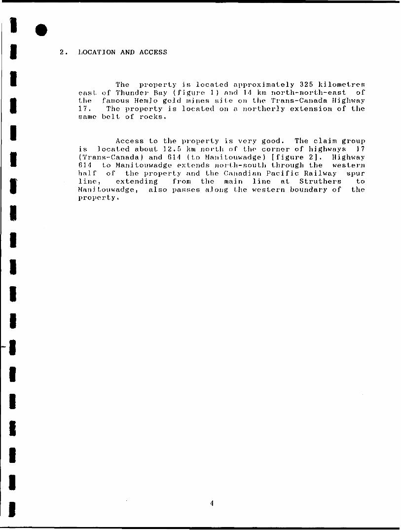
2. LOCATION AND ACCESS
The property is located approximately 325 kilometres east of Thunder Bay (figure 1) and 14 km riorth-riorth-east of the famous Hemlo gold mines site on the Trans-Canada Highway 17. The property is located on a northerly extension of the same belt of rocks.
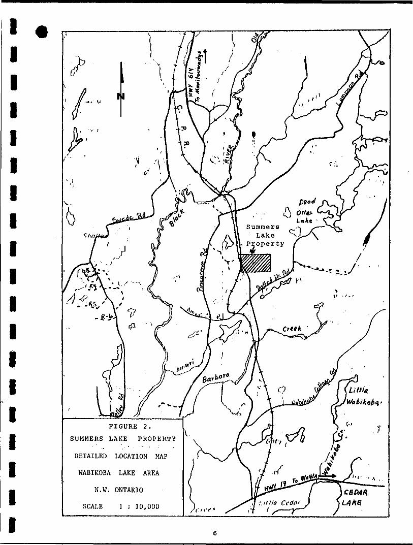
Access to the property is very good, The claim group is located about 12.5 km north of the corner of highways 17 (Trans-Canada) and G14 (to ManiLouwadge) [figure 2]. Highway 614 to Manitouwadge extends north-south through the western half of the property arid the Canadian Pacific Railway spur line, extending from the main line at Struthers to Manitouwadge, also passes along the western boundary of the property.

l l l l l
HUDSON BAY
•KitMond lake
LAROE
SUMMERS LAKE PROPERTY
LOCATION MAP
WABIKOBA LAKE AREA
SCHREIBER-HEMLO DISTRICT
N.W. ONTARIO
N.T.S. 42 C 13 l SW
FIGURE 1.
l i l l l l l l l l l ll l l l l l l
Property
FIGURE 2.
SUMMERS LAKE PROPERTY
DETAILED LOCATION MAP
WABIKOBA LAKE AREA
N.W. ONTARIO
SCALE l : 10,000

l l l l l l l l l l l l l l l l l l l
3. CLAIMS
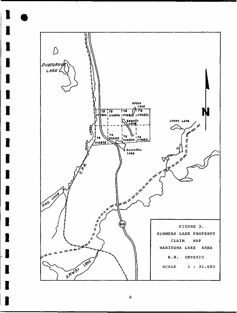
The property consists of 8 unpatented mining claims which were all covered by a limited geophysical survey (figure 3).
List of Claim Numbers and Due Dates
1. TB 1142831................,,............August 3, 1992
2. TB 1142832..............................August 3, 1992
3. TB 1142833.....,........................August 3, 1992
4. TB 1142834........ . . . . . . . ... .. . . ........August 3, 1992
f). TB 1142835. . . . . . . . . . . . . . . . . . . . . . . . . . . . . .August 3, 1992
G. TB 1142836..............................August 3, 1992
7. TB 1142837..............................August 3, 1992
8. TB 1142838. . . . . . . . . . . . . . . .. .. . . . ........August 3, 1992
The claim holder of the mining property covered by the survey is:
M. Dave Saunders 309, Catherine st. Thunder Bay, Ontario P7E 1K7
l l l l l l l l l l l l l l l l l l l
TB ;ra l"111*4283) l H Vt83l
FIGURE 3.
SUMMERS LAKE PROPERTY
CLAIM MAP
WABIKOBA LAKE AREA
N.W.
SCALE
ONTARIO
l : 31,680
l l l l l l l l l l l l l l l l l l l
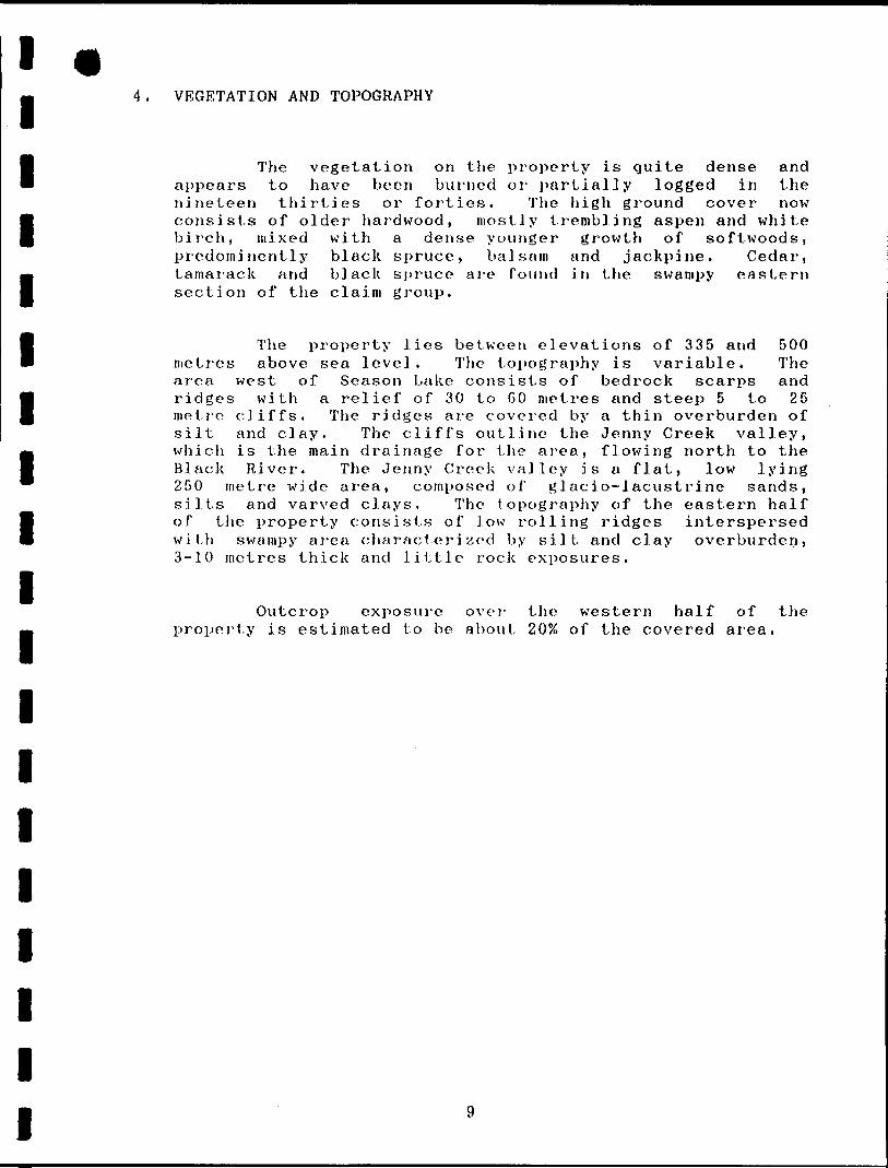
4. VEGETATION AND TOPOGRAPHY
The vegetation on the property is quite dense and appears to have been burned or partially logged in the nineteen thirties or forties. The high ground cover now consists of older hardwood, mostly trembling aspen and white birch, mixed with a dense younger growth of softwoods, predominently black spruce, balsam and jackpine. Cedar, tamarack and black spruce are found in the swampy eastern section of the claim group.
The property lies between elevations of 335 and 500 metres above sea level. The topography is variable. The area west of Season Lake consists of bedrock scarps and ridges with a relief of 30 to GO metres and steep 5 to 25 metre cliffs. The ridges are covered by a thin overburden of silt and clay. The cliffs outline the Jenny Creek valley, which is the main drainage for the area, flowing north to the Black River. The Jenny Creek valley is a flat, low lying 250 metre wide area, composed of glacio-lacustrine sands, silts and varved clays. The topography of the eastern half of tlie property consists of low rolling ridges interspersed with swampy area characterized by silt and clay overburden, 3-10 metres thick and little rock exposures.
Outcrop exposure over the western half of the property is estimated to be about 20?o of the covered area.

l l l l l l l l l l l l l l l l l l l
5. REGIONAL GEOLOGY
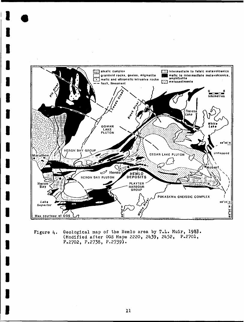
The Black River area, as described by V.G. Milne (1968) is underlain by an assemblage of Archean greenstones, intruded by granitic plutonic rocks (figure 4), The mafic inetavolcanics formation, which includes pillowed units, has been interpreted as the oldest and lowermost horizon of a gradational sequence. The mafic inetavolcanics grade upwards into intermediate inetavolcanics, felsic metavolcanics, pyroclastic rocks (agglomerates) and sediments.
The Summers Lake property lies on the southern limb of the Dead Otter Lake anticline, an east-west trending anticlinorium developped within the Archean aged Heron Bay Greenstone Belt. The anticline is flanked to the west by the Gowan Lake and to the south by the Musher Lake Plutons.
Rocks within the anticline have locally attained an upper amphibolite grade of metamorphism. The core of the anticline has locally been intruded by several late Archean felsic complexes, some batholitic size, composed of hornblende-biotite, biotite granodiorite, arid quartz monzonite. Finally, several ages of post-Archean diabase dykes intrude the entire sequence.
The Hemlo Mining Camp, situated in the Wawa- Shebandowan subprovince, specifically occurs in a highly deformed zone flanked by intermediate to mafic volcanic rocks in the footwall and volcaniclastic rocks in the hanging wall. It lias been suggested that the mineralization is at the contact of the crystal tuffs and sediments, where the tuffaceous rocks wedge out against the sedimentary rocks. The mineralization is zoned both across dip and along strike.
10
l l l l l l l l l l l l l l l l l l l
ITJ71 alkalic complexgranitoid rocks, gneiss, migmatite mafic and ultramafic Intrusive rocks
7] Intermediate lo felsic metavolcanlcsmafic lo Intermediate metavolcanlcs, amphibolitemetasediment— — fault, lineament
GOWANLAKE
PLUTON
\
CEDAR LAKE PLUTON
OHERON BAY PLUTON
PLAYTERHARBOUR
GROUP
PUKASKWA GNEISSIC COMPLEX
Ltkt Super/or
Map courtesy of OGS
Figure U* Geological map of the Hemlo area by T.L. Muir, 1993. (Modified after OGS Maps 2220, 2^39, 2Jf52, P.2701, P.2702, P.2738, P.2739).
11
l l l l l l l l l l l l l l l l l l l
6. PREVIOUS WORK
Little is known about history of the property prior to 1961 except that, since discovery of the orebodies in the Manitouwadge area in 1953, the whole district generally has been regarded with interest.
1961-1962 Including the eastern half of the Summers Lake property, 134 claims were staked by Cecil Von Klein and his associates and the property was optioned to Mcintyre Porcupine Mines Ltd. who has done some ground geophysical work and investigated the copper-nickel showing by diamond drilling in 1962.
1964 - Car-ravel le Mines Ltd. acquired control of the Mcintyre property and called it the Pulfa prospect. The Pulfa prospect consists of 253 contiguous claims including the whole Summers Lake property. Associate companies have carried out evaluation work over the area of the claims in summer 1964. The work consisted of photogeological and aeromagnetic interpretation, reinterpretation of previous information and ground geological reconnaissance. The results were compiled into reports by V. Wierzbicki (1964, 1964b).
1964-1965 Geologists of the Geological Branch, Ontario Department of Mines carried out field mapping of Black River area during the summers seasons (Milnes 1968) .
1965 - A combined airborne geophysical survey was flown between June 11 tli and 13th, 1965 for Carravelle Mines Ltd. by Selco Exploration Company Ltd. with a Mark IV INPUT and 200 metres spacing and variable line directions. A number of weak anomalies were detected whose characteristics are difficult to interpret (Domzalski, 1965).
1966 - Arrangements for further developments on the mining property were taken with Falconbridge Nickel Mines, dated January 31st, 1966. A ground magnetometer and AFMAG-Longwire surveys were carried out over the claims by Central Geophysics Limited of Winnipeg (Kilburn, 1967, 1967b). The claims over Summers Lake area were soon dropped.
12
l l l l l l l l l l l l l l l l l l l
1982 - As a result of the gold discoveries during the summer of 1982 in the Henilo area, claims covering the Summers Lake property were staked by two seperate companies: llarlin Resources Limited covered the eastern half and Key Lake Exploration Limited covered the western half called the Dillman C]aim Group. An airborne magnetometer and electro magnetic survey was done over the area by Aerodata Surveys Limited. Work has been conducted on the surrounding claim groups exploring for copper- nickel and copper-1 ond-y. i ne mineralization. The survey yielded significant information as to probable bedrock conductors and the extent and conductivity of probable conductive overburden, as well as generalized magnetic features. The potential for gold bearing rocks on the Key Lake property appears to be likely in the southeast corner of the property (central part of the Summers Lake Property).
1983 - Dillman Claims (Key Lake Expl. Ltd.)Three grids were cut on the property.
Detailed mapping of the property carried out by Chris Richardson (1983) has largely confirmed the geology of Milnes (1908) while providing greater details as to volcanics subunits. Both intermediate and mafic units are observed considerably more intermingled than the OGS map would suggest. Several occurences of pyrite and/or pyrrhotite in the volcanics were noted, 47 rock samples were collected. Soil Geochemical sampling at 30 metre intervals on the grid has been done over the volcanics rocks. Work was done by S.J. Bortnick and Associate. A VLF and magnetometer surveys were carried out over the property and J. Roth (1984) recommended IP and subsequently test by drill ing.
Harlin Resources LimitedMagnetometric and Electromagnetic (VLF)
surveys were performed in winter 1983 (Giroux, 1983). Two major magnetic zones were observed. The VLF survey has outline 10 anomalies. Three of which crosses in the Summers Lake Property.
Montgomery Consultants Limited of Vancouver B.C. undertook to conduct a detailed multi-element geochemical soil survey for Harlin Resources Ltd. which was done during the period June 9th to July 15th, 1983 (Montgomery, 1983). A total of 2500 soil samples were taken. A total of 25 areas which contain anomalous metal values were further examined and sampled.
13

l l l l l l l l l l l l l l l l l l l
1983 - Harlin Resources Limited (continuation)
A Geological mapping was done in conjunction with geochemical surveys (Montgomery, 1983b). Laminated pyrjte-chalcopyrite-sphalerite mineralization occurs in interbedded chert- argil l ite. A chip sample from this outcrop assayed fl.14% zinc. Disseminated pyrite also occurs in felsic volcanics. A sample of this material assayed Q.20% nine. Roth of these occurences are in the southwest corner- of the map-area and indicate some potential for a volcanogenic massive sulfide deposit.
During the period of July Gth to August 8th 1983, Phoenix Geophysics Limited have completed a reconnaissance induced polarization and resistivity survey on the grid (Hallof, 1983) covering a portion of Summers Lake Property. The background IP effects in the general Hemlo area are low in magnetude: this must be due to the low level of metallic minerals (pyrite, magnetite, etc.) in the country rocks. The survey lias detected anomalies of definite interest.
A total of 1707 feet were drilled in five holes during the period October 11 to October 28, 1983 by N. Morissette Diamond Drilling Limited of Haileybury, Out. (Montgomery, 1985). Five holes were drilled to test combined geological, geochemical and geophysical targets. Only minor zinc values were encountered and the claims in the vicinity of Summers Lake soon came open.
1985 - Key Lake Exploration Limited acquired 5 new mining claims contiguous to their original 33 claim group. These 5 claims are north of Summers Lake, staked on the previous Marl in's property. During June and July 1985, the new claims were geophysically surveyed by VLF-EM and magnetometer survey equipment (Baker, 1986). Following the geophysical survey, the claims were then prospected and mapped geologically (Baker, 198Gb). As well, a total of 245 geochemical soil samples were collected at various intervals over the 5 claims and some 38 rock samples were taken from the outcrop exposures.
14

l l l l l l l l l l l l l l l l l l l
7. 1992 WORK PROGRAM
7.l Linecutting
During the beginning of april 1992, a grid (cut and flagged lines) was established over the claim-area with a line-spacing of 100 metres and a station interval of 25 metres. Two kilometres of l i neciitti ng was undertaken on the western half of the Baseline and the eastern half of the tieline 6 + 50 S. All the other lines were flagged (17 km) for a total of 19 line-kilometres.
7.2 Geophysical surveys
7.2.1 Survey methods
A geophysical program was initiated on the Summers Lake property to evaluate the economic potential of the claim block.
A grid of north - south lines spaced 100 metres apart was established as reference stations for the geophysical surveys. A total of 1.9 km of lines including the base line and tie line was completed. The ground geophysical surveys including a magnetometer and an electromagnetic VLF-EM 16 survey were carried out by the author of this report.
The geophysical survey was conducted with a Scintrex OMNI-PLUS. The OMNI-PLUS Magnetometer/VLF System is a ruggedized compact, portable instrument designed specifically for field operation. It allows for quick surveying capability without sacrificing accurancy arid quality data. It contains several microprocessors and associated circuitry for monitoring, processing and storing data. The OMNI-PLUS has two memories: the tie-line points and field measurements of the survey.
The magnetometer system measures the value of the total magnetic field with a precision of 0.1 gamma with a statistical error alarm flashing over 0.2 gamma. If the error is larger than 2.0 gammas, another reading must be taken. The OMNI-PLUR contains high technology circuits which allow for automatic, fine tracking (tuning) over the entire field strength from 18,000 to 110,000 gammas, under cumputer control. The readings were taken systematically every 12.5 metres along the cut - flagged and chained lines. The base station is located east of the highway 614, on the shore of Summers Lake, near line 2+00 W. The magnetic readings have been automatically corrected for diurnal variations when the data was dumped.
15

l l l l l l l l l l l l l l l l l l l
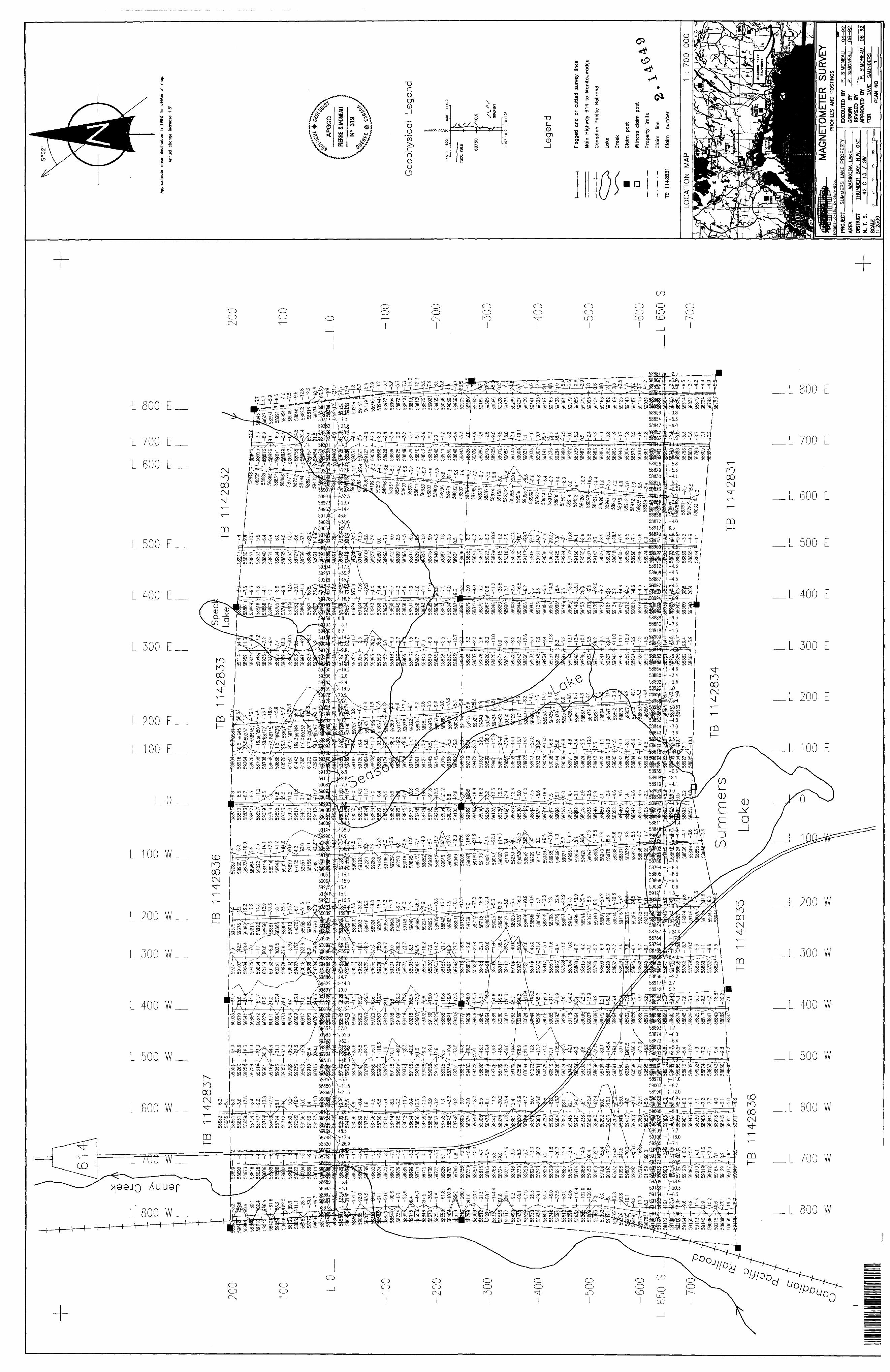
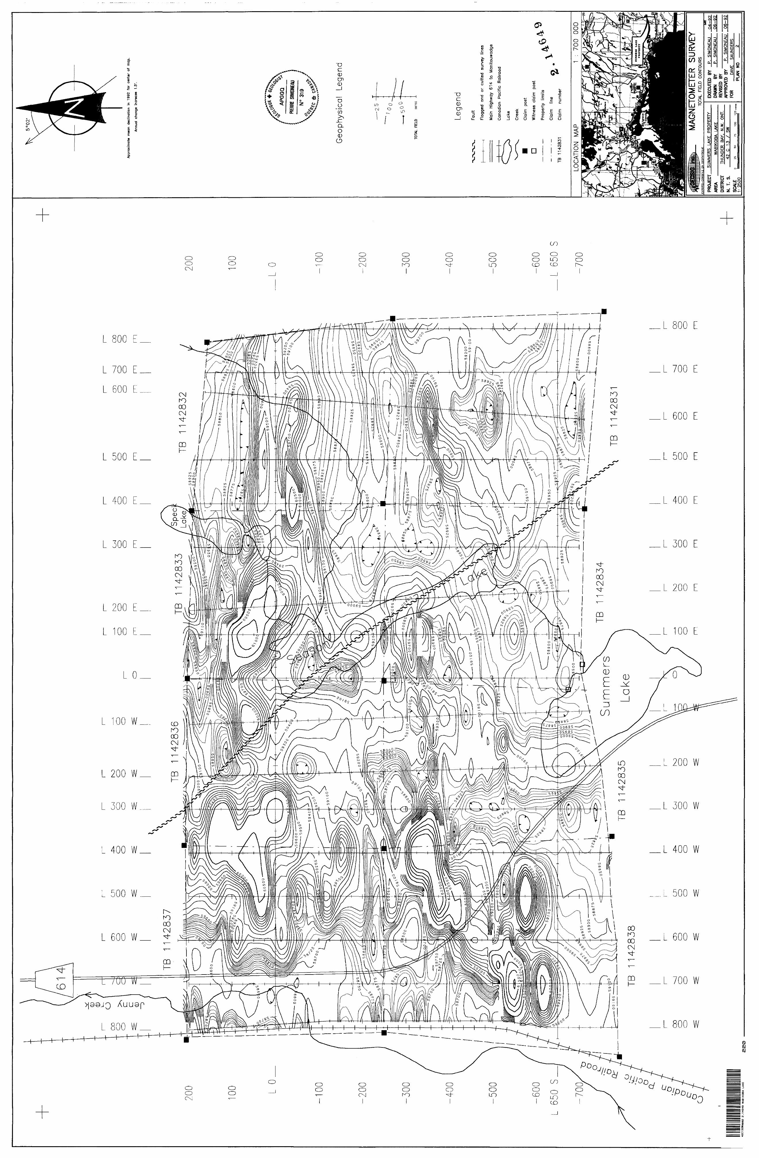
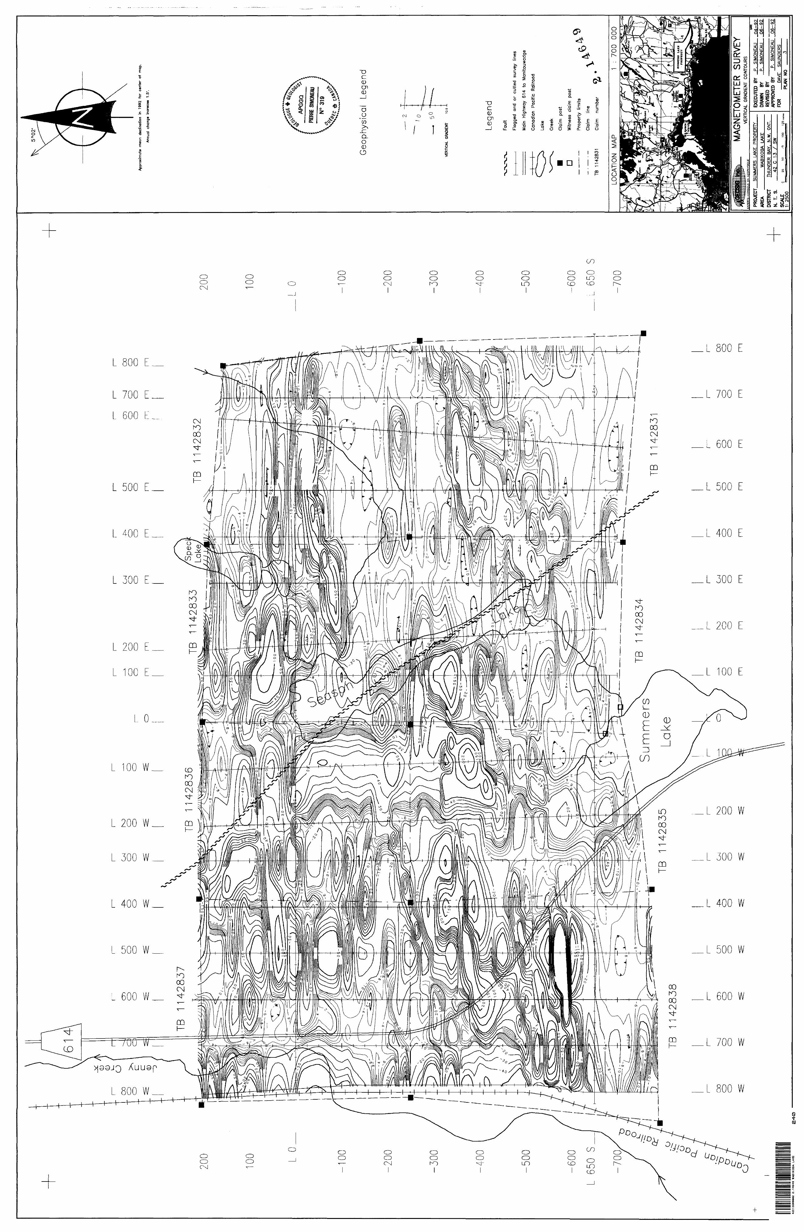
The magnetic results are presented on a profile map (Plan 1) and two contour maps {Plans 2 and 3) at the metric scale of 1=2,500 in pocket. Extra couloured contour maps (Plan 4 and 5) were added to the report at the metric scale of 1=2,500.
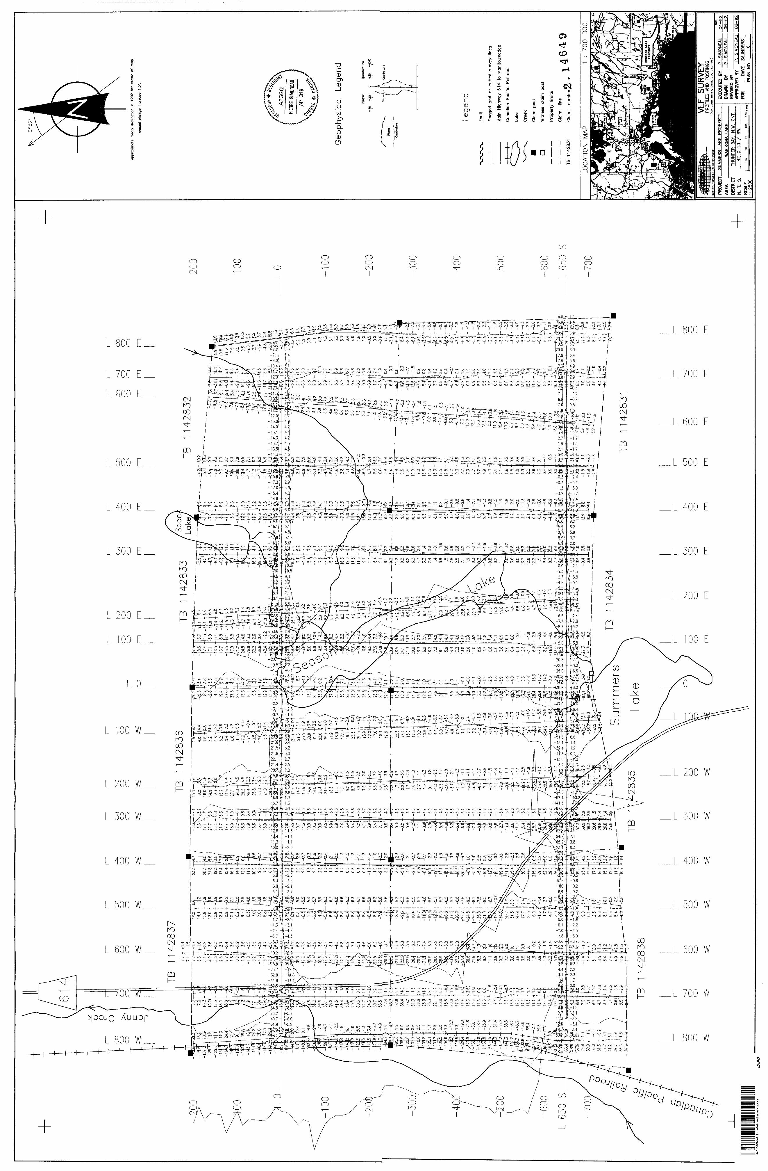
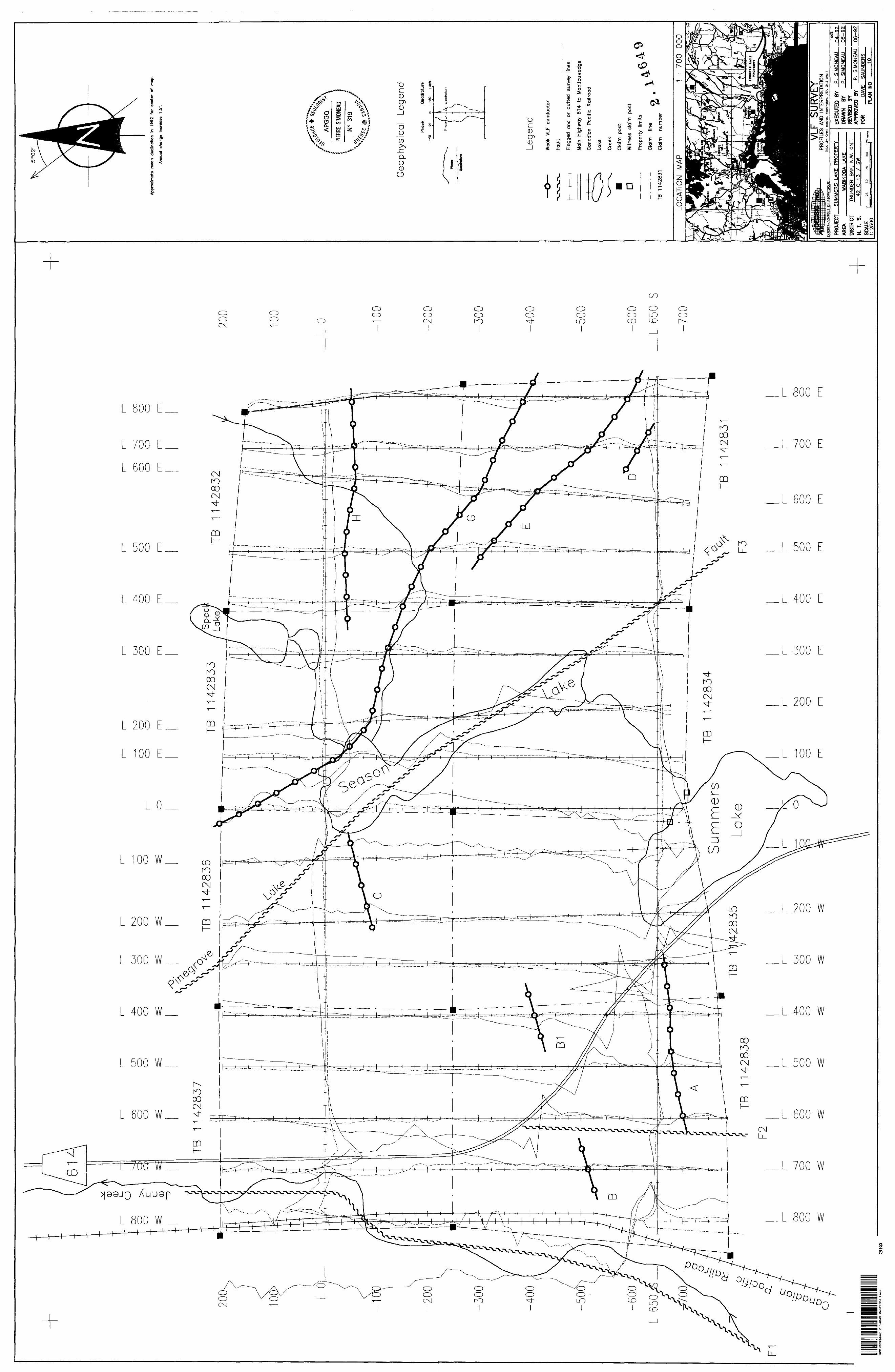
The electromagnetic VLF-EM 16 survey was carried out with the OMNI-PLUS using Cutler, Maine station (frequency 24.0 kHz) and Jim Creek, Washington station (frequency 24.8 kHz). The vertical components (in phase and quadrature) of the secondary field are measured with a precision of -f or Q.2%. The OMNI-PLUS has been designed whereby, if a weak station is selected, the instrument will automatically increase the measurement period to produce higher quality results. The readings were taken systematically every 12.5 metres along the grid lines.
The results of the electromagnetic survey are plotted for the Cutler station on Plan 6 and the interpretation on Plan 7 with an extra coloured contour map 8 representing the Fraser filter. The Jim Creek station results are on Plan 9 and the interpretation on Plan 10 with an extra coloured contour map 11 representing the Frazer filter. All the maps are at the metric scale of 1=2,500 in pocket. Profiles at the scale of l cm = 2096 have been drawn for the in phase and quadrature readings. The possible conductors have been interpreted and marked by a bolder line.
7.2.2 Interpretation
Magnetic Survey
The contoured magnetic data reveal 3 general magnetic domains:
1) Broad, relatively featureless areas consistent with narrow bands of felsic volcanics and/or volcaniclatic sediments interbanded between stronger sub-linear anomali es.
2) Strong, linear magnetic high, reflection of diabase dykes like the one trending northwest and intruding the fault zone c rossing through Season Lake. A number of outcrops northwest of Season Lake allow confirmation of that anomaly.
16
l l l l l l l l l l l l l l l l l l l
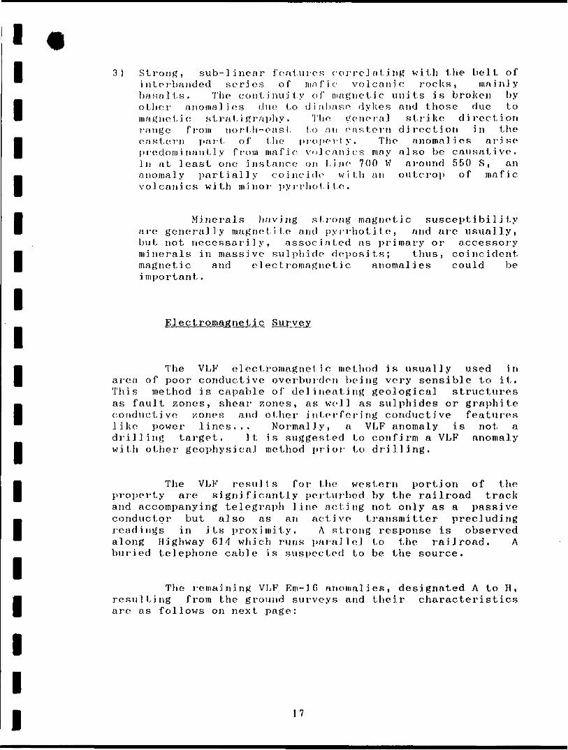
3) Strong, sub-linear features correlating with the belt of interbanded series of mafic volcanic rocks, mainly basalts. The continuity of magnetic units is broken by other anomalies due to diabase dykes and those due to magnetic stratigraphy. The genera] strike direction range from north-east to an eastern direction in the eastern part of the property. The anomalies arise predominantly from mafic volcanics may also be causative. In at least one instance on l,j ne 700 W around 550 S, an anomaly partially coincide with an outcrop of mafic volcanics with minor pyrrhotite.
Minerals having strong magnetic susceptibility are generally magnetite and pyrrhotite, and are usually, but not necessarily, associated as primary or accessory minerals in massive sulphide deposits; thus, coincident magnetic and electromagnetic anomalies could be i mportant.
Electromagnetic Survey
The VLF electromagnetic method is usually used in area of poor conductive overburden being very sensible to it. This method is capable of delineating geological structures as fault zones, shear zones, as well as sulphides or graphite conductive zones and other interfering conductive features like power lines... Normally, a VLF anomaly is not a drilling target. It is suggested to confirm a VLF anomaly wit}) other geophysical method prior to drilling.
The VLF results for the western portion of the property are significantly perturbed by the railroad track and accompanying telegraph line acting not only as a passive conductor but also as an active transmitter precluding readings in its proximity. A strong response is observed along Highway 614 which runs parallel to the railroad. A buried telephone cable is suspected to be the source.
The remaining VLF Em-16 anomalies, designated A to H, resulting from the ground surveys and their characteristics are as follows on next page:
17
1111111111111111111
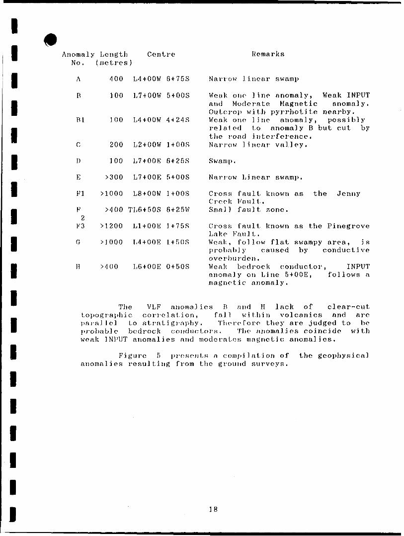
Anomaly Length CentreNo . ( metres )
A 400 L4+OOW
R 100 L7+OOW
Bl ]00 L4+OOW
C 200 L2+OOW
D 100 L7+OOE
E ^00 L7 + OOE
FI MOOO L8 + OOW
F MOO TL6 + 50S2
F3 M 200 Ll + OOE
G MOOO L4 + OOE
H MOO L6+OOE
The VLFtopographic corr
6 + 75S
5 + OOS
4 + 24S
1+OOS
6 + 25S
5 + OOS
1+OOS
6 + 25W
1 + 75S
l+GOS
0 + 50S
anomel at i o
parallel to strati grap probable bedrock condweak INPUT anomal
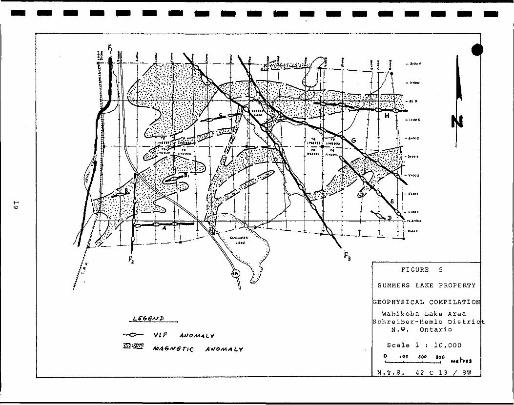
Figure 5anomalies result!
ies ani
pi'eS'ng froi
Remarks
Narrow linear swamp
Weak one line anomaly, Weak INPUT and Moderate Magnetic anomaly. Outcrop with pyrrhotite nearby. Weak one line anomaly, possibly related to anomaly B but cut by the road interference. Narrow linear valley.
Swamp.
Narrow Linear swamp.
Cross fault known as the Jenny Creek Fault. Smal l fault 7,one .
Cross fault known as the PinegroveLake Fault.Weak, follow flat swampy area, isprobably caused by conductiveoverburden.Weak bedrock conductor, INPUTanomaly on Line 5+OOE, follows amagnet i c anomaly.
l ies B and H lack of clear-cut i fall within volcanics and are f. Therefore they are judged to be ;torK. The anomalies coincide with moderates magnetic anomalies.
sents a compilation of the geophysical
18
l li -~- . -__ ' ft. *
VI f
FIGURE 5
SUMMERS LAKE PROPERTY
GEOPHYSICAL COMPILATION
Wabikoba Lake Area Schreiber-Hemlo Distric
N.W. Ontario
Scale l : 10,000
O 100 i 00 300
N.T.S. 42 C 13 X SW
l l l l l l l l l l l l l l l l l l l
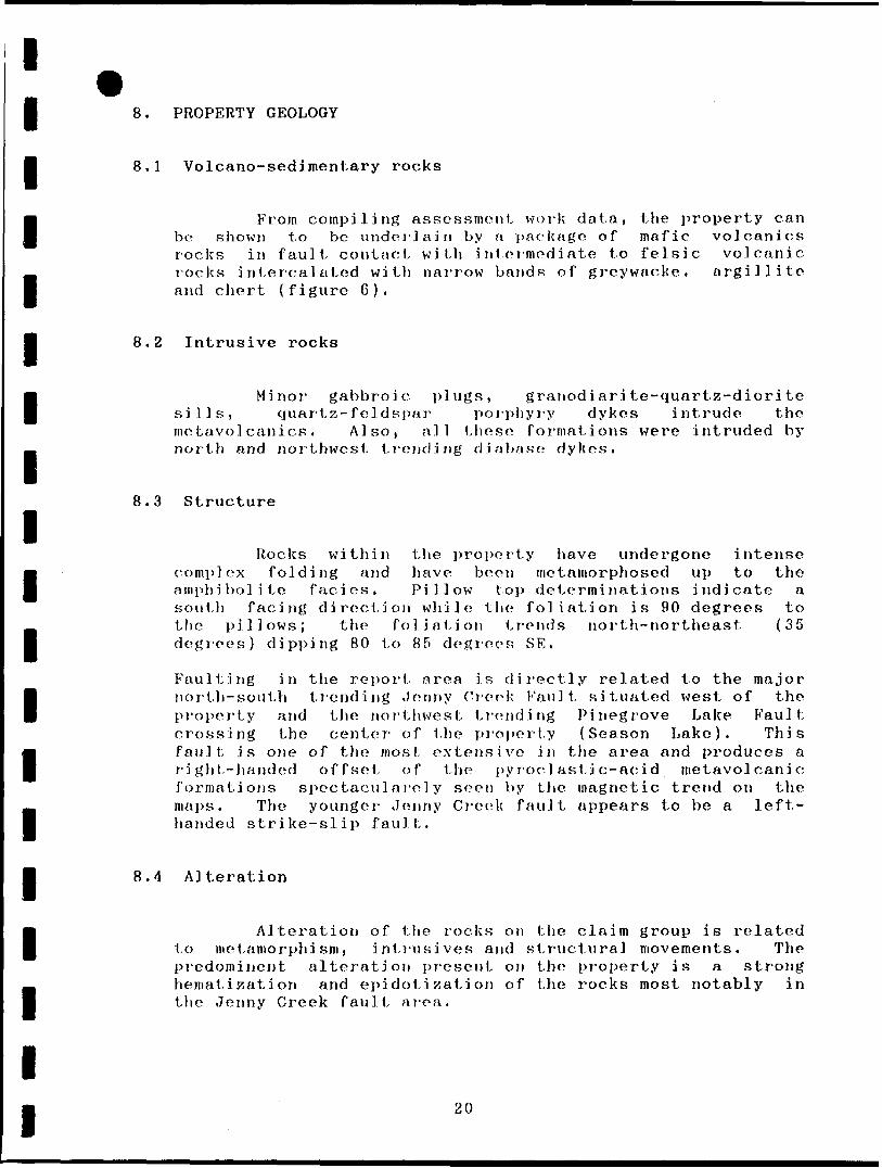
8. PROPERTY GEOLOGY
8.1 Volcano-sedimentary rocks
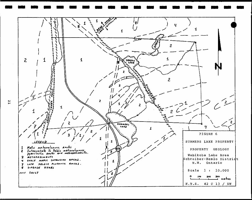
Fi'om compiling assessment work data, the property can be shown to be underlain by a package of mafic volcanics rocks in fault contact with intermediate to felsic volcanic rocks intercalated with narrow bands of greywacke. argillite and chert (figure 6).
8.2 Intrusive rocks
Minor gabbroic plugs, granodiarite-quartz-diorite sills, quartz-feldspar porphyry dykes intrude the metavolcani.es. Also, all these formations were intruded by north and northwest trending diabase dykes.
8.3 Structure
Rocks within the property have undergone intense complex folding and have been metamorphosed up to the amphibolite facies. Pillow top determinations indicate a south facing direction while the foliation is 90 degrees to the pillows; the foliation trends north-northeast {35 degrees) dipping 80 to 85 degrees SE.
Faulting in the report area is directly related to the major north-south trending .Jenny Creek Fault situated west of the property and the northwest trending Pinegrove Lake Fault crossing the center of the property (Season Lake). This fault is one of the most extensive in the area and produces a right-handed offset of the pyrodastic-acid metavolcanic formations spectaculare]y seen by the magnetic trend on the maps. The younger Jenny Creek fault appears to be a left- handed strike-slip fault.
8.4 Alteration
Alteration of the rocks on the claim group is related to metamorphism, intrusives and structural movements. The predominent alteration present on the property is a strong hematination and epidotization of the rocks most notably in the Jenny Creek fault area.
20
K)
FIGURE 6
SUMMERS LAKE PROPERTY
Wabikoba Lake AreaSchreiber-Hemlo Distric

l l l l l l l l l l l l l l l l l l l
8.5 Mineralization
Minor mineralization of pyrite, pyrrhotite and magnetite were present, mainly in the Jenny Creek Fault area. Laminaled pyri te-cha] copy r i lo-sphaleri le mineral ization occurs in interbedded chert-argil l j le.
Feldspar porphyry and diabase dykes are strongly magnetic and the diabase dykes contain up to 596 pyrite and pyrrhotite.
The metasedi menlary rocks of the property are somewhat similar to those in the Hem]o Gold Camp and have a good potential for gold and base metal mineralization.
22
l l l l l l l l l l l l l l l l l l l
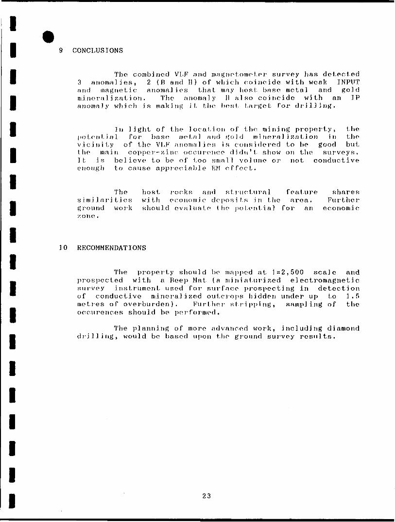
9 CONCLUSIONS
The combined VI.,F nnci magnetometer survey has detected 3 anomalies, 2 (B and H) of which coincide with weak INPUT and magnetic anomalies that may host base metal and gold mineralization. The anomaly 11 also coincide with an IP anomaly which is making it the best target for drilling.
In light of the location of the mining property, the potential Tor base metal and gold mineralization in the vicinity of the VI,F anomalies is considered to be good but the main copper-zinc occurence didn't show on the surveys. It is believe to be of too small volume or not conductive enough to cause appreciable EM effect.
The host rocks and structural feature shares; similarities with economic deposits in the area. Further ground work should evaluate the potential for an economic zone .
10 RECOMMENDATIONS
The property should be mapped at 1=2,500 scale and prospected with a Beep Mat (a miniaturized electromagnetic survey instrument used for surface prospecting in detection of conductive mineral i seed outcrops hidden under up to 1.5 metres of overburden). Further stripping, sampling of the occurences should be performed.
The planning of more advanced work, including diamond drilling, would be based upon the ground survey results.
23

l l l l l l l l l l l l l l l l l l l
SELECTED REFERENCES
Baker, N.W.,
Baker, N.W.,
Domzal ski , W.
Giroux, M.
Hallof, P.G.
Kilburn, L.C.
Kilburn, L.C.
Milne, V.G.
1986. Report on Geological Mapping and Geochemical Survey, Hemlo Area Property, Ontario. Company report for Key Lake Kxplornti on Limited and Brandy Brook Mines Ltd. l report 4 l map. MNDM assessment File No. 2.9213, Thunder Bay.
1986b. Report on VLF and Magnetometer Surveys, Hemlo Area Property, Ontario. Company report for Key Lake Exploration Limited and Brandy Brook Mines Limited. l report -f 3 maps. MNDM assessment File No. 2,9213, Thunder Bay.
1965. Report on Combined Airborne Geophysical Survey Over Pulfa Group of Claims. Company report for Carravelle Mines Limited. l report -f l map. MNDM assessment File No. G3.1G98, Thunder Bay.
1983. Magnetometric and Electromagnetic (VLF) Surveys, Company report for Marl in Resources Ltd. l report * 2 maps, MNDM assessment File No. 2.6030
1983. Report on the Reconnaissance Induced Polarization and Resistivity Survey on a Portion of a Claim Group, Hemlo Area, District of Thunder Bay, Ontario. Company report for Harlin Resources Ltd. l rep. * l map MNDM assessment File No 2.6030
1966. Report of Geophysical Assessment Work, Dead Otter Lake Claims, Thunder Bay Mining District, Ontario. Company report for Falconbridge Nickel Mines Limited, l report -f 1 map, MNDM assessment File No. 63.2003, Thunder Bay.
1966b. Report of Geophysical Assessment Work, Phil Lake - Wabikoba Lake Area, Thunder Bay Mining District, Ontario. Company report for Falconbridge Nickel Mines Limited, l report * l map, MNDM assessment File No. 63.2105, Thunder Bay.
1968. Geology of the Black River Area, ODM GR 72 68 p. 5 maps (2143-2144-2145-2146-2147).
Montgomery, J.H. 1983. Geological Report on Claims Nos. TB660401-405 incl., Claims Nos. TB660502-520 incl. Claims Nos. TB644129-144 incl., Thunder Bay Mining Division, Province of Ontario, Company report for Harlin Resources Limited, l report t 2 maps, MNDM assessment File No. 2.6030, Thunder Bay.
24

l l l l l l l l l l l l l l l l l l l
Montgomery, J.H. 1983b. Geochemical Report on Claims Nos. TB660401-405 incl., Claims Nos. TB660502-520 incl. Claims Nos. TB644129-144 incl., Thunder Bay Mining Division, Province of Ontario. Company report for Harlin Resources Limited, l report 4- 16 maps, MNDM assessment File No. 2.0030, Thunder Bay.
Montgomery, J.H. 1985. Report on Diamond Drilling Program (1983) Hemlo North (Pine Grove Lake) Project, Thunder Bay Mining Division, Province of Ontario. Company report for Hnrlin Resources Limited, l rep, * logs and sketches, MNDM assessment File No 63.4388.
Mn i r T. L .
Richardson, C.
Roth, J.
Wierzbicki
1983. Geology of the Hemlo - Heron Bay Area: pp. 230-239, in The Geology of Gold in Ontario; edited by A. Colvine, Ontario Geological Survey, Miscellaneous Paper 110, 278p.
1983. Geology of the Dillman Claim Group. Company report for Key Lake Exploration Limited, l report * 3 maps, MNDM assessment File No. 2.7408
1984. Report on VLF and Magnetometer Surveys, Hemlo, Ontario. Company report for Key Lake Expl . Ltd. and Brandy Brook Mines Ltd. l report f 6 maps MNDM assessment File No. 2.7409, Thunder Bay.
Wierzbicki', V. 1964. Report on Pulfa Arthur Mining Division, Canada. Company report MNDM Assessment File No.
Group of Claims, Port Province of Ontario,
for Carravelle Mines Ltd. 03 E.6, Thunder Bay.
V., Domzalski , W. 19(i4b. Report on Preliminary Evaluation of Pulfa Prospect. Photogeological report + G maps. Company report for Carravelle Mines Limited, MNDM assessment File No. 63 E.6.
25

l l l l l l l l l l l l l l l l l l l
CERTIFICATE OF QUALIFICATIONS
THIS IS TO CERTIFY THAT:
l am a resident of Thunder Bay, province of Ontario, Canada {2-309 Catherine si, Thunder Bay, Out. P7K 1K7).
T have been engaged in base and precious metal exploration as a geologist since 1987 and as a geophysicist since 1991.
I am a graduate of University of Quebec at Chicoutimi, Chicoutimi, Quebec {M.Se. Earth Sciences, 1987) and University of Montreal, Montreal, Quebec (B.Se. Geology, 1982).
t am a member of the Professional Association of Geologist and Geophysicist of Quebec (APGGQ).
APGGQ
P1ERRE SIMONEAU
\ N* 319
Signed in Thunder Bay, June 30 1992
Pierre Simoneau Geologist, M.Se.
2G
ntario 42CI3SWeee2 2 .M649 WABIKOBA LAKE 900
Ministry of Ministere duNorthern Development Developpement du Nordand Mines et des Mines
Mining Lands Branch Geoscience Approvals Section 933 Ramsey Lake Road 6th Floor Sudbury, Ontario P3E 6B5
Telephone: Fax;
(705) 670-5853 (705) 670-5863
September 28, 1992 Our File: 2.14649Transaction #W9240.0129
Mining RecorderMinistry of Northern Developmentand Mines435 James Street SouthThunder Bay, OntarioP7C 5G6
Dear Si r/Madam:
Subject: APPROVAL OF ASSESSMENT WORK CREDITS ON MINING CLAIMS TB1142831 ET AL. IN THE WABIKOBA LAKE AREA
The assessment work credits for the Geophysical Survey and Other Authorized Work filed under sections 14 and 18 of the Mining Act Regulations have been approved as originally filed.
The approval date is September 24, 1992.
Please indicate this approval on your claim record sheets.
Yours sincerely,
Ron C. GashinskiSenior Manager, Mining Lands BranchMines and Minerals Division
JLJ/jl Enclosures:
cc: Resident Geologist Thunder Bay, Ontario
Assessment Files Office Toronto, Ontario
tylnlstry ofNorthern Developmentand Mines
Ontario
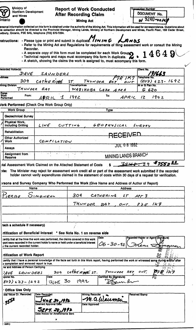
Report of Work Conducted After Recording Claim
Mining Act
DOCUMENT No.M/ 9240-06/4 f
'ersonal Information collected on this form Is obtained under the authority of the Mining Act. This Information will be used for correspondence. Questions about ill collection should be directed to the Provincial Manager, Mining Lands, Ministry of Northern Development and Mines, Fourth Floor, 159 Cedar Street, Sudbury, Ontario, P3E 6A5, telephone (705) 670-7264. .
instructions: - Please type or print and submit in duplicated fiN t*t G /**JQ*tbS- Refer to the Mining Act and Regulations for requirements of filing assessment work or consult the Mining
Recorder.- A separate copy of this form must be completed for each Work Groupf) 1 4 O 4- Technical reports and maps must accompany this form in duplicate. J& * A ** ^ - A sketch, showing the claims the work is assigned to, must accompany this form.
(•corded Holders) Client No.
S9/U3leNo.\ddress
sr fareephone (f*?)
fining Division Township/Area M or Q Plan No.
G 6Zoates
Work Performed
From:Af/ZlL 1 To: tz
/ork Performed (Check One Work Group Only)Work Group
X
/
Geotechnical Survey
Physical Work, Including Drilling
Rehabilitation
Other Authorized Work
Assays
Assignment from Reserve
Type
LlfG" C.oTr/^6 f 6&0 rn'rJ IC4L s^/zvty
RFCEIV^nIiC.wU.1 v CO/w/V LATtO^
JUL 0 8 1992
' ; ' "i ; "' MINING LANDS BRANCH
)tal Assessment Work Claimed on the Attached Statement of Costs S?te: The Minister may reject for assessment work credit all or part of the assessment work submitted if the recorded
holder cannot verify expenditures claimed in the statement of costs within 30 days of a request for verification.
jrsons and Survey Company Who Performed the Work (Give Name and Address of Author of Report)Name Address
12 30*? sr
, O"r. Pit? Ik?
tach a schedule If necessary)
rtlficatlon of Beneficial Interest * See Note No. 1 on reverse sidecertify that at the time the work was performed, the claims covered In this work (port were recorded In the current holder's name or held under a beneficial Interest y the current recorded holder.
Date
rtlficatlon of Work Report -* C. . O ?- r, i
certify that l have a personal knowledge of the facts set forth In this Work report, having performed the work or witnessed samedurln{parjd7orcafter i completion and annexed report is true.___________________________________________J^ ^ -.y ~ne and Addres* of Person Certifying ,-M r,
ST.ipone No.
C2-J-
Date Certified By rSpnature)
Office Use OnlyotaTvalue Cr. Recorded
ts Sent
Mining Recorder
Oat* Approved
Received Stamp
\
!
Hft
!** OQ
i li
2
4
W
i
0
Xr*o••QV/O
~~
xf^
**oU)si
""•^
X^VA)S-N
"~^
-
f^
^\
Uj
^
"•J*
iro^ooUJr.
"•^
XfO'^v
OJvg
^^^
J^^oowIM
•^^*
2CviV\y
O4
•— t
ffi*M.~.offi sifli!*\
z|8a|
f'1i
t:-c0c^
?
'**
-*—4t/xKi-
O
V
JUS^^rf/^
OG
g\
S
yso\us.
O\^
I(A)•"-^
^ft
•^
Os
J
i
OJ^
t/J-r
oQ\
^
j\f\•c
oo
E^
x* wyCA•C
O 0
5
Jl/l-c
'i
to j* S? ** b 9*
o|||3 **
Ills8 8.
0
J .rr2*
Ksdb" \
•-J5'
^Xfc
Sgo
K
U-
\m
es^y^-' * •••-
\}\ 0
jLAT
ix./c
819?
OS t
n2
****
0
^-C
C/VmXSi
0
xwJ- —^1
V^)^\
^
^.-C
a-— -1c/N^i
a
^JI4L.(/\
<
^
^^•C
*--*.(/^•C
^k
r^j
^^^.U)•^- n l
{/^
-C*s5*
0r
^rC
vy.
\^
klr i
O
^u
-cfe.K
ofcjf a
B
sirf*|KjB Bc5
^ ^ ^ ^ ^ — ^ —
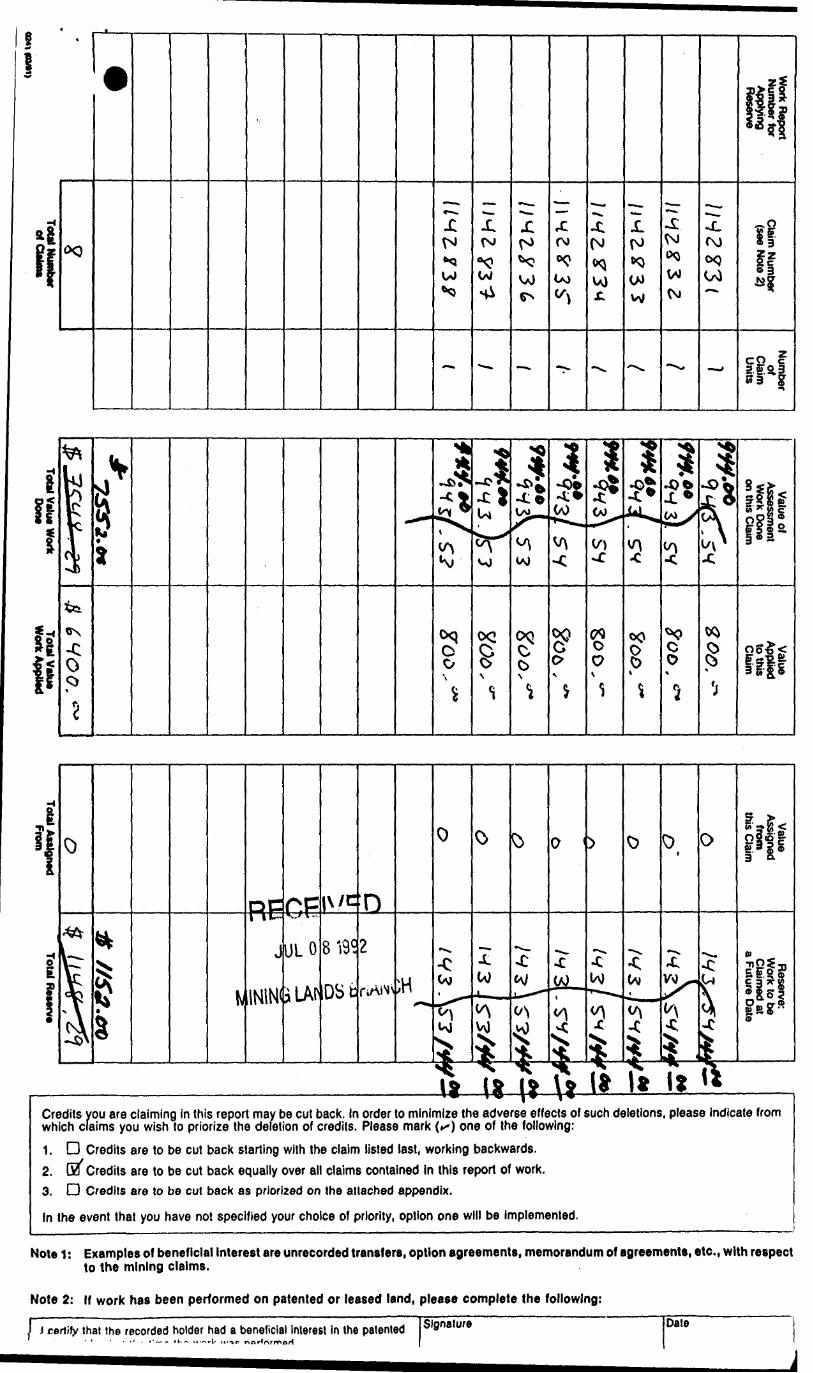
Credits you are claiming in this report may be cut back. In order to minimize the adverse effects of such deletions, please indicate from which claims you wish to priorize the deletion of credits. Please mark (^) one of the following:1. D Credits are to be cut back starting with the claim listed last, working backwards.2. Ga Credits are to be cut back equally over all claims contained in this report of work.3. D Credits are to be cut back as priorized on the attached appendix.
In the event that you have not specified your choice of priority, option one will be Implemented.
Note 1: Examples of beneficial interest are unrecorded transfers, option agreements, memorandum of agreements, etc., with respect to the mining claims.
Note 2 : If work has been performed on patented or leased land, please complete the following:
] i certify that the recorded holder had a beneficial Interest In the patented Signature Dale

Ontario
ofNorthern Development and Mines
Mi.Developpement du Nordet des mines
Statement of Costs for Assessment CreditEtat des coOts aux fins du credit devaluation
Mining Act/Lol sur les mines
Transaction No./N 8 de transaction
Personal Information collected on this form is obtained under the authority of the Mining Act. This information will be used to maintain a record and ongoing status of the mining claim(s). Questions about this collection should be directed to the Provincial Manager, Minings Lands, Ministry of Northern Development and Mines, 4th Floor, 159 Cedar Street, Sudbury, Ontario P3E 6A5, telephone (705) 670-7264.
Les renseignements personnels contenus dans la presente formule sont recueillis en vertu de la Lol sur Its mines et sen/iron! a tenlr a jour un registre des concessions minleres. Adresser toute question sur la collece de ces renseignements au chef provincial des terrains mlnlers, minlstere du Developpement du Nord et des Mines, 159, rue Cedar, 4* etage. Sudbury (Ontario) P3E 6A5, telephone (705) 670-7264.
1. Direct Costs/CoOts directs
Type
Wages Satalres
Contractor's and Consultant's Fees Drolts de ('entrepreneur •1 de I'expert- consell
Supplies Used Fournltures utilities
Equipment Rental Location de materiel
Description
Labour Main-d'oeuvreField Supervision Supervision sur le terrain
Type
U^f c^r i i-s t
Type Pi ut j f no TOO f let
*WP /urAZ*0^iTu*v
Type O/MV, PL v J e**, / fc
f Sw/fVWi
Amount Montan!
3200
3200
3V. *W
M S, 1,0,
loVt.?!
Total Direct Costs Total des coOts directs
Totals Total global
3^oo, *
5j2c***
/
^<?7. ttt
iof^?iiww.is
l/
2. indirect Costs/CoOts Indirects* * Note: When claiming Rehabilitation work Indirect costs are not
allowable as assessment work. Pour le remboursement des travaux de rehabilitation, les coOts Indirects ne sont pas admissibles en tant que travaux d'evaluation.
Type
Transportation Transport
MlFood and Lodging Nourrlture et hebergementMobilization and Demobilization Mobilisation et demobilisation
DescriptionTyp*
'VxV r/cv.'/r
it^v^C.1 v rzt *
JUL 0 8 1992
^ING LANDS BRAfPI/VO w k*. neic*r f /tfJr#.^~rj
Amount Montan!
H mo,-"
;CH
t 3 Si. H
Sub Total of Indirect Costs Total partlel des coots Indlrects
Amount Allowable (not greater thin 20H of Direct Costs) Montsnt admissible (n'excedant pas 20 tt des coOts directs)Total Value of Assessment Credit Vileur totals du credit (Total of Direct and Allowable d'evaluation Indirect eoilit ftolil du coflli dlrieti
Totals Total global
^20 ^.
^ 3W.IV
ISi.N
7?yjiy?sw.w
*t Mlrtclt •dmliilbl*!
Note: The recorded holder will be required to verify expenditures claimed In this statement of costs within 30 days of a request for verification. If verification is not made, the Minister may reject for assessment work all or part of the assessment work submitted.
Note : Le tltulalre enreglstre sera tenu de verifier les depenses demandees dans le present etat des coCils dans les 30 jours sulvant une demande a cet effet. Si la verification n'est pas effectuee, le minlstre pout rejeter tout ou une partie des travaux devaluation preserves.
Filing Discounts
1 . Work filed within two years of completion is claimed at ^ 00% of the above Total Value of Assessment Credit.
Remises pour depot
1. Les travaux deposes dans les deux ans suivant leur achevement sont rembourses a 100 Vo de la valeur totale susmentionnee du credit devaluation.
2. Work filed three, four or five years after completion is claimed at 500A of the above Total Value of Assessment Credit. See calculations below:
Total Value of Assessment Credit Total Assessment Claimed
x 0.50
2 . Les travaux deposes trois, quatre ou cinq ans apres leur achevement sont rembourses a SO "/b de la valeur totale du credit devaluation susmentionne. Volr les calculs cl-dessous.
Valeur totale du credit d'evaluationx 0,50 -
Evaluation totale demandee
Certification Verifying Statement of Costs
l hereby certify:that the amounts shown are as accurate as possible and these costs were incurred while conducting assessment work on the lands shown on the accompanying Report of Work form.
that as J&(Rscordsd Holder, Agsnt, Petition In Compiny)
to make this certification
Attestation de l'6tat des coOts
J'atteste par la presente :que les montants indiques sont le plus exact possible et quo ces depenses ont 6td engagees pour effectuer les travaux devaluation sur les terrains Indiques dans la formule de rapport de travail ci-joint.
J M* l dee. \ am authorized Et qu'a titre de je suis autoris6(titulilri enngiiM, npriitnlinl, poiti occupi dim li compignli)
a faire cotte attestation.
Slgnstur* Date
Noia : Dans cetle rormule, lorsqu'il deslgne des personnes, le masculin esl utilise au sens neuue. A

W.R.O. - MINING RIGHTS ONI.Vf..H.O. -SURFACE RIGHTS ONLYW.+ 5. ^ MIMING AND SURFACE RIGHTS
Dwcripuon Order ho. Due Qiipoaition
SEC 36/BO W 28/63 20/10/83 S-B.O
SEC 36/60 W22/84 I4/OJ/B4 SB O
SCC 36/80 WIO/85 2/10/85 S R f;
SEC 36/^0 Wil/85 I8/I2/85 S BM B
Fik
BLACK RIVER G-580P-3268-^
-Mfc4 8*5 Z 1 10 48 0 E2'30'
OJI14406I i 1194443119
l ft TB 1 ti[*4444lll94441
a K I I57M
NT*B04 flfrfrTB H-VOTE -H**-*4 ^t .....ITB -Lfa-_ J—l™...
II77S70 ST M 7? ,|7I l M7787I lr—-4- - --
.ISWTi iU5M7*_ l . J-IZ.-- J U6G523 l 116652-!!
7V8GI . 1177862 l n 4 o29Ete
ID l1064506 J 10P4S07 1064506 l I 064605
— .. J- - -... -L - -, - 4 - - - 4-
181146 i II8II44 J ,. -|---^ J , M7T8?4....^.. . .f-- , , —l '
1148 i 1193135 i I IM1W , 77Z6M ' 77Z*M [ ?T2702
- - ~ -- - - -f
- r — -—
^.---r.-.-^--*----^l u." "
' ""'WABIKOBA
117371* h l73736 l 11737331147761 142*45
880!©
IU779I 1147792 l
---'-^,. -j-. ^-LJL..,....^^.^ J.L-ti T d f n l TQ .' . Td TD t
[tf^Uff/A'G
r---H-- --H——"1 TB T B I TB
l
-,^ _l_ _ _ —-L,^l _ ™ _ t— _ _
ITB i TB
- -*- - -T"- -/.-i~^J"** * * ~ TTfi^ :: TIB
10805^9 ',050324
— — — ~ J— — - -t- - —' —4ra j Th Tnl TB ! T fi
l 'OCOS65
~~"T~"~ — K~ — — — 1~ ~ — ~".~ — ~ — TB ' TB
— ^ .,. —— l- — — —.ITB ITB
—l- — — ^L — — —T— __ -TB l TB
1060319 J*
ITS l TB ITB
65858 l I IWM ,
,^.-lr -- T ——-1----T ITB
F14 !i BID.; 15 TB T" T M l TB TC i UTTB T" T M l TB T
•'CLM * 285
C 1130 l 6 I-, ? t^4 —— . —— - ————— *———
ve* .
l T——— ____ 4 ^ - -. ^""" S 5ftr49 i ftJAJJUt'M 6M PKOJEC^D^^.j
LEGEND
.HIGHWAY AND PO'.n; Nr
OIHtH R OADS
TRAILS
SUHV[ YtD UNLSTOWNSHIPS BASE L INl^ tTC LOTS, M INING CLAIM''-. VARCE .S
UN^URVEYID HUES LO 1 L INES PARCEL BOUNDARYM'MNG CLAtMI- t If
PA'i ^/.^ AN'.'. Mi,,HI O* *A/' i
UTILITY L IV S
NON-PE FfCNMAi. S " ^fcAM
FLOODING CH f LOODING PIGHTG SUBDIVISION OR cur,' pos"f PLAN"r st h", /. ' iOKS
OHIO.. A L SH:.:-FLIr,'
VA^SH OR Mi'SKf - .
M IN t i, TRAVf'lSl M ' - "' •- 1
4,...,-...-
?^ OF CROWN LANDS
XDCU M E NT SYMBOL
PATFNT, SURF A*":r h MnJNG H 1GHTS
,SURf ACE e
"!jy *^i s"j'?7jT?4T~ - - l ^ ^'615
BOMBY TWP. G-3173 PROTHERS TWP. G-3172
, MINJN:., RIGHTS ONIYLEASE'. SURF ACf ft VI'. I NG r'tG
" .SURfACt R IGHTS ONLY......
" .MINING r.lGHlSONLY. ..,.
L ICE NCfc Of OCCUPATION ...... .
ORDEP 1N-COUNCIL .....RES: F VATION .... .... ... .. . .CANCELED . ........ . .....
. GC
(J-
SAND&GRAvf !. . ... ... ,. ... .. ....LAND USE PERMIT;. r *,# COMMEhCtAI TOUWSM.OOTPC-^1 S
MlN'NCi ftlGMlS if, y i C CFLS PA^f NTtC 1 PMIO* 1O M*,V 6 1913 vLSTf!. 'K O^^'^AL PATi^^tf iV -* H t K J* i. K LANDb ACT *, C , 7 8:0, CH^P S*C S IC &J. *'..'*..M C "
f*OTE:
SCALE: 1 INCH -- 40 CHAINS
6OOC
O .00 '/t. T Hi i.
SOLGNG LAKE SUBJECT TO F LOOfJiNfe " O E.tVA^ GSC 3 23.75 M ETRE S
Lards o ijrrouoded by Thl* Mor'-'''T or* Su^*Qf to — 5*c. 189 Easement *S4-IO.
Sea Bomby Landrail.
Lands Surrounded by TKts MwMftg ar* Subject to Qnd o1h*r right*, 01 j*r S*e.. i89 E
. S** Whitv l.aVa N. Part
MOT F: The f.^ove Eofeemerts Ru,- Wilfi T*ypi '..^R-S And Will Attest ' Bfnes A fii'
THE INFORMATION THAT APPEARS ON THIS MAP HAS B EEN C OMPILED FROM VARIOUS SOURCES, AND ACCURACY IS NOT GUARANTEED. THOSE WISHING TO STAKE MIN ING CLAIMS SHOULD CON SUIT WITH THE MINING RECORDER, MINISTRY OF NORTHERN DEVELOP WENT AND MINES. FOR AD DITIONAL INFORMATION ON THE STATUS OF THE LANDS SHOWN HEHEON
A P E A
M.N.R. ADMINISTRATIVE DISTRICT
TERRACE BAYMlMNGDIVIStOll
THUNDER BA\RECE'wcLAND TITUS/ R EGISTRY Q UHV 8*1992
THUNDER BAY
MinistryofNatural
ResourcesOntario
Dell AUGL'iT 1964
e.i4649 WABIKOBA LAKE
200
TB
1142
837
TB
1142
836
TB
1142
833
58682
. 58685
5866
T1
5865
1 58659; \
58754
X/
TB
1142
832
60023
60319
5964
5988
^60572
60239
60171
6009
^60378
60454
5935
4 59
267
5925
^
59379
5937
85908^
5908
358
930
58873'
58964
59022
589
1
5883
3! l
-8.6
59
114
T
5895
958
834f
5904
8^58
936
58
8-
5881
959
0B9
5891
659264
5892
658
79^
5870
^5366^
59868
60570
61083
61443
6136
561272
60961
5883
3!)
58342
,58857[ -
59089
5930
659805
60033
59993
l59
5l7*
f59401
59303
59112'
58880,
5885
71 58
853
i-H
58840
58831
!-H58834
5883
5
-6.4
5894
5(-1
6488
501
-30.
^877
21
5925
^5931 *
5960
4591
5906
5905
5909,fe
59425
y59
854
H:60114
60162^-
6025
159
878 -\
-5950^-
5949
A.+
6001
8
5901 H
5899
358
935
)58
889
l58
865)
5883
158
8Q6
58771.'
58752'
5874?
5889
159
432
5^04
3 9
027
5899
3 58
991
58954
58906
58774^
58499C-
5879
459342-
59669;
5909
5^59136
\59
166
-698
73-.
-319
2658705
5671
4 58
7 to
5875
^
5894
35905
59873
6016
560
357
6015
659
981
7^829
9.58
797/
5862
.9 58
714.
^.35
9849
1(
16.06
0332
1H
7.560
5890
59
0 l
5907
0}58
95^
59101
5880
6^
5869
/1
5882
^
5872
7)f
5873
^58
8231
58
816)
60917
60B70
60793
S963
& 59
910
60913
j
1.7
j-v
9.0
(J
'-1
4.9
A)
-11.
2 ^
5951 \
5938
9 i
5937^
5955
5 i
5923
9 5904k-
5930
4 59
023-
-)-
5924
45919
159119
5900
6
5899
0 5890-1-23.8
59089i
59102'
x 59220
59285
59m'
5916
8J59239^
59250
61924
601 W+ -
47.6
593 ii
59006
5886
958
775
5875
658736
5871
5
59667
59628
5928
3^59320
5926
2C59
429
-59338
5910
959
44fk
60218
59187
5912
659064
- 59
14d[
--
590101
58977V-
-7.9
58980
x 0.0
58898i
58874
58899
8899
5877
5896
658918
5892
^58
97^
59058J
5906
0|59056
59149
5904
0/58999^
5922
4-59096
5924
3- -
.O59
995
59553
5915
258918
5907
658968
58928
58889
5887
558
849
58829
58810
58812
58815
58946
58911
5886
558848
58343
58652
5867
4*58
673
5867
158679
58689
5869
958
711
58715
5873
B
5905
7 58
996
'
58961
5891
9 58
897
58876
i 5884?
5883
3 58803
'58
809
5893
658
978
5883
258
807
5894
4k1
-9.2
-3
.759
088
589J
5458
8)8
5892
758
904
58872
5884
058813
588121
58875
5890
258935
5903
659
080
5896
659009
5888
058
965'
5916
259
365
5956
659
338
5917
359290
5920
759
130
5914
159093
5916
759
166
59135
5906
159
039
59056
59072
59098
5910
459166
5926
259
169
5912
559
140
5918
759116
5903
9
5892
760
136
5966
45937SJ
591 65
59219
5906
8^59
058^
59105-
5892
5
5891
21 [-6.0
5889
9 r
-2.5
58
866
j -4
.5
5S83
7J--
-8.5
58829^
3.8
5881
5 j
-6.0
58840-r--4.3
5888
7 '1
-0.8
58
912
- -0
.3
5893
4 0.
5 58
906
j-i-0.7
5885
5 ("
-8T~
58841
i- -6,7
58
857'
5926
9,59
127,'
59
03V
5902
2 i
589 8
1 58
982
8975
5885
258828[-H
5884
5.)
58791'
58758
5871^
58754
59219J-M
58954
590321
5910
5901 6
58895*
58905
i58890
58902
58943
5887
958
835
58838
5883
0 ;
58642(
58634
58806
592
5915
4^59
361
5942
759
445
5941
559
315
5S83
8 58
8 53
5885
858
993^
59042
58929)
58842
60019
5902^
5904
5
58848
5886
759
025
5886
^59008i 4-
5918
^ 59497 4
5879
3'
5871
di i
58
581J
58
52^
5848
E
5882
658783
5876
558883
J 5885V
5873(1
5881
59481
5932
2
5908
591
5926
159
329
5934
059
368
5943
494
5093
50
5900
591 7^
59029
5881
(3
i~ r
t ri n f
~55805\
58674
5854
5850
5847
5844
5837
5909
7]
59185
5917
3 59
061
58885
58887
58876
58820
5882
5\
58877
5882
1 58
8251
58842!
5886
6 58
933
5894
5 58934
5895
7(
9035
5876
9 58
7 IS'
5922
959
472
5938
^59
52f9
599
596^1
5 5883
S58
944
58927}
58943.
5933
359044\
5903
859144
59036
58991
58958
58924
58878'
58913
5892
058
979
59080
58987
5887
658
884
v58
905-
58929
58730]
5B754\
5881
8'58
816-
58768
5872
458
731
5B745
58730
\58
729
58879
58886
58913
5893
5(59
012
59082
5913
359
0044
5903
159
033
59007^
59141
59236
59294
58989
58826
58887
58974
59158
5923
(X60055
5953
6
5895
9 59
354
5912
k59
5^4
62B89
63280
63807
62763
3 606^
4
5881
58726
5878
5877
591T1
62538
6306
461273,
58879^
5891
5 58
916
f 58832!
5940
0 591 IK"
5981
8 59731
589 1
7 59412
601
5993^
5916,6;
59027( i
5899
0 'i
5900
8 y
-58
944d
5900
6V59094'
59123 rf
59086
5911
859
239
5905*
59862
59209
59117
593
584-
1^58
458918J-N
588^
458
874
588
585'
R" -
97.5
5872J
58826
58927
589 U
58913
5890
0 s
5889
U
5891
4 58
892
-; 58720,1' -
70.7
5869
^-1^
16.5
,, r'4.4
59096
5899
1 ;
5894
258
918
58912
58912
-34.7
5960
8 \
-3.4
5900(\
59227^
5939
5 59
504
59852
59945
59647
59238
5892
2 5901^
5905
^ 59
1 93
588
586
587
585
586
) 5B&I9
586
582
5891?
5886
158823
5878BI -I
f58784I
5880
0 \4
f58
815
58786
5879
858
809
5882
058832
58829
60329
60819
5982
- 59
374
5879
S;
5877
^ 58853
59127
5872
3'
5862
1159
0^6
5912
5 4
58
58
5886
9^59
021
58996^
5926
659
425
5904^
5889
958
970
5897
5
59098*
591461-^
5906
9,59 140
J-594531
5931
5917
5868
558
757^
,58974
589
5894
8158
986
5903
259
259
241
5930
759
048,
5899
5'58
959^
5895
4 '58
928
5891
5
5911
* 59
364
5903
6^
5902
71
5903
9 \
9072
58906
5889
158883
58879
5888
158
B64
58847
58862
5887
958
907,
58939
58987
5898
658983
5898
358982
58966
58946
5890
458872
58870
5886
1
58^7
8 58
936
58^4
0-5
0059
017
59040
5890V
5892
9
5915
358
9559
1060
0ft
63532
6109
859
80^
5922
(259
7^3
5912
5918
159
1359
105921
5900
258
9758
97
5873
587^
459361
eooi
o,69387
eose
r60
0^)2
59
59
5885
2 Hi -
5sk4
C
5928
659
275
59220
-600
en
en
enCD
DO
Co
co
DO
enLJ
l O
l-f5
- en
L 650
S59
0459
36C
593
5922
4 V
I 6
5,88
93 j
58
858
4-58869
58855
5884
4
5879
658
800
5878
658
809
5896
158
943
5893
058
9D5l
5889
458
9184
5891
558
911
5884
5 58
B29
58825
5881
7/-H
5892
758
885
588H
I58
832
5880
558
794
5879
815
79
59164/
5913
5 59
113!S
5914
5 -
5908
6^
5921
5 -
58989-^
5903
CJ -
fl
iirf
^^TT^^^
59122/
59067
5907
0 5901 9
5883
658
846
5885
558
9321
5887
458
853
58835
\ 58868
58732i
58825
5884
7 58
84^
-HTB
11
4283
459164
5912
959077
964
Sum
mer
sTB
11
4283
1TB
11
4283
5TB
11
4283
8
200
-200 30
0
4
-500
-600
L 65
0 S
App
roxi
mat
o m
oan
decl
inat
ion
in
1992
for
cen
ter
of m
ap.
Annu
al c
hang
e in
crea
se
1.5*
.
Geo
phys
ical
Le
gend
E i o
Ift
-1 G
OO
-800
10
+8
00
+160
0
-10+
-10
O +1
Q +
104
Lege
nd
D
TB
1142
831
Flag
ged
and
or c
utte
d su
rvey
lin
es
Mai
n H
ighw
ay
614
to
Man
itouw
adge
Can
adia
n P
acifi
c R
ailro
ad
Lake
Cre
ek
Cla
im
post
Witn
ess
clai
m
post
Pro
perty
lim
its
Cla
im
line
O
*
Cla
im
num
ber
LOCA
TIO
N M
AP1
: 70
0 00
0
gXPE
RTS^
CONS
EUS
EN G
EO P
HYSI
QUE
MAG
NETO
MET
ER
SUR
VEY
PRO
FILE
S AN
D PO
STIN
GS
PROJ
ECT.
AR
EA
. DI
STRI
CT
N. T
. S.
SCAL
E1=
2500
SUM
MER
S LA
KE
PRO
PERT
YW
ABIK
OBA
LAK
E TH
UNDE
R BA
Y.
N.W
. O
NT.
42.
C ]3
/
SW25
5075
100
125
OSE
04
-9?
0
6-9
2EX
ECLT
TED
BY
P. S
1MON
EAU
DRAW
N BY
P.
S1
MON
EAU
——^
REVI
SED
BY
—^
——
^—
—^
——
—
APPR
OVED
BY
P-
SIM
ONEA
U .0
6-92
FOR
DAVE
SA
UNDE
RSPLAN NO
1
614 TB
1142837
TB 11
4283
642833
TB 11
4283
2
142834
TB 11
4283
1TB 11
4283
5TB 1142838
mm
200 00 200
-300
-400 500
-600
L 650
S
-700
42C
13S
W0e
02
2.1
46
49
W
AB
IKO
BA
LA
KE
22
0
App
roxi
mat
e m
ean
decl
inat
ion
in
1992
for
cen
ter
of
map
.
Annu
al c
hang
e in
crea
se
1.5*
.
APGG
Q
j PIE
RRE
SIMON
EAU
\ N
0 31
9
Geo
phys
ical
Le
gend
25 -
TOTA
L HE
LD
5S75
0 -L
Lege
nd
D
TB
114-
2831
Faul
t
Flog
ged
and
or c
utte
d su
rvey
lin
es
Mai
n H
ighw
ay
614
to
Man
itouw
adge
Can
adia
n P
acifi
c R
ailro
ad
Lake
Cre
ek
Cla
im
post
Witn
ess
clai
m
post
Pro
perty
lim
its
Cla
im
line
Cla
im
num
ber
LOCA
TIO
N M
AP1
: 70
0 00
0
MAG
NETO
MET
ER
SUR
VEY
EXPE
RTS
-CO
NSE
IUSL
TOTA
L FI
ELD
CONT
OURS
PROJ
ECT
SUM
MER
S LA
KE
PRO
PERT
Y AR
EA
_
WAB
IKO
BA L
AKE
DIST
RICT
N.
T.
S.SC
ALE
1: 25
00
THUN
DER
BAY.
N.
W.
ONT
. 42
C
13
X SW^-^
O 25
50
75H
X2
12
5
ME
EXEC
UTED
BY
P.
SI
MQ
NEAU
04
-97
DRAW
N BY
P.
SI
MON
EAU
06
-92
REVI
SED
BY
__
__
__
__
__
——
——
AP
PRO
VED
BY
P.
SIM
ONE
AU
06-9
2
FOR
DAVE
SA
UNDE
RS
PLAN
NO
2
200
TB
1142
837
TB
1142
836
TB
1142
833
TB
1142
832
TB
1142
834
TB
1142
831
TB
1142
835
TB
1142
838
200
100
-100
-200 30
0 00
-500
-600
. 65
0 S
-700
24
0
App
roxi
mat
e m
ean
decl
inat
ion
in
1992
for
cen
ter
of
map
.
Annu
al c
hang
e in
crea
se
1.5*
.
' ^
f PIE
RflE
SIMON
EAU
l
\ N
0 31
9
Geo
phys
ical
Le
gend
o .
50
VERT
ICAL
GRA
DIEN
T 10
.6 -L
Lege
nd
D
TB
1142
831
Faul
t
Flag
ged
and
or c
utte
d su
rvey
lin
es
Mai
n H
ighw
ay
614
to
Man
itouw
adge
Can
adia
n Pa
cific
Rai
lroad
Lake
Cre
ek
Cla
im
post
Witn
ess
clai
m
post
Pro
perty
lim
its
Cla
im
line
Cla
im
num
ber
\LO
CATI
ON
MAP
1 :
700
000
EX
PE
RTS
-CO
NS
OLS
EN
G
EOPH
YSIQ
UE
MAG
NETO
MET
ER
SUR
VEY
VERT
ICAL
GRA
DIEN
T CO
NTO
URS
PROJ
ECT.
AR
EA
DIST
RICT
N.
T.
S.SC
ALE
1=25
00
SUM
MER
S L^
KE
PR
OPE
RTY
WAB
IKO
BA L
AKE
THUN
DER
BAY.
N.
W.
ONT
. 42
C
13
X SW
__
0 25
50
75
10
012
5
EXEC
UTED
BY
DRAW
N BY
RE
VISE
D BY
AP
PROV
ED B
Y
P.
SIM
ON
EAU
DOE
04-9
2P.
SI
MO
NEA
U
06
-92
P.
SIM
ONE
AU
06
-92
DAVE
SA
UNDE
RS
PLAN
NO
3
42C
13S
We*
02
2.1
4643
WA
BIK
OB
A
LAK
E
614 TB
11
4283
742
83TB
1 42832
0.4---0.2
0.6
-0.3
0.0 l
-0.9
42834
TB 1142831
2835
TB 1142838
200 2
-300
-4 -500 650
S
App
roxi
mat
e m
ean
decl
inat
ion
In
1992
for
cen
ter
of m
ap.
Annu
al
chan
ge
incr
ease
1.
5',
t t l
APG
GQ
PIERR
E SI
MONE
AU
N0
319
Geo
phys
ical
Le
gend
Phas
e Qu
adra
ture
-40
-20
O
+20
+40X
Lege
nd
D
TB
1142
831
Faul
t
Flag
ged
and
or c
utte
d su
rvey
lin
es
Mai
n H
ighw
ay
614
to
Man
itouw
adge
Can
adia
n P
acifi
c R
ailro
ad
Lake
Cre
ek
Cla
im
post
Witn
ess
clai
m
post
Pro
perty
lim
its
Cla
im
line
Clai
m
num
ber'2
-14
64
9
LOCA
TIO
N M
AP1
: 70
0 00
0
•E&
ER
TS
-CO
ME
ILS
EN
G
EQPH
YSIQ
UE
VLF
SURV
EYPR
OFI
LES
AND
POST
ING
S(N
AA
C
utl*
r st
atio
n.
Main
*,
USA
, 2
4.0
kH
z.)
PRO
JECT
SU
MM
ERS
LAKE
PR
OPE
RTY
AREA
__
____
WA
BIK
OB
A
LAKE
DI
STRI
CT
N.
T.
S.TH
UNDE
R BA
Y,
N.W
. O
NT.
42
C 13
X
SW_____
SCAL
E 1:
2500
2550
75
100
125
m**.
EXEC
UTED
BY
P. S
IMQN
EAU
DRAW
N BY
P.
SI
MON
EAU
REVI
SED
BY
——
——
——
AP
PRO
VED
BY ^
^^^
FOR
DAVE
SA
UNDE
RS
ME
Q4-
Q7
06-9
2
P.
SIM
ONE
AU
06
-92
PLAN
NO
26
042C
13S
*eee2
2.1
46
49
W
AB
IKO
BA
L
AK
E

2
42837
TB 11
4283
6TB
1142833
TB 11
4283
2
-600
650
S
-700
42834
TB
1 42
831
TB 1142838
2 2 4 500
L 65
0 S
m
Appr
oxim
ate
mea
n de
clin
atio
n In
19
92 f
or c
ente
r of
map
.
Annu
al c
hang
e in
crea
se
1.5'
.
f A
PGG
Qt
'——
—~—
——
——
——
——
—
j PIE
RRE
SIMO
NEAU
\.N
0 31
9
Geo
phys
ical
Le
gend
Phas
e Qu
adra
ture
-40
-20
o +2
0 +4
0X
Lege
nd
D
TB
1U2B
31
Faul
t
Flag
ged
and
or c
utte
d su
rvey
lin
es
Mai
n H
ighw
ay
614
to
Man
itouw
adge
Can
adia
n P
acifi
c R
ailro
ad
Lake
Cre
ek
Cla
im
post
Witn
ess
clai
m
post
Pro
perty
lim
its
Cla
im
line
9 *
Cla
im
num
ber
f*
LOCA
TIO
N M
AP1
: 70
0 00
0
EX
PE
RTS
-CO
NS
E1L
S
EN
GEO
PHYS
lQU
E
VLF
SURV
EYPR
OFI
LES
AND
POST
ING
S(N
ik J
im
Cr*
*k s
tatio
n,
Was
hing
ton,
U
SA,
24.B
kH
z.)
PROJ
ECT.
AR
EA
. DI
STRI
CT
N. T
. S.
SCAL
E1:
2500
SUM
MER
S LA
KE
PRO
PER
TY
WAB
IKO
BA
LAKE
THUN
DER
BAY.
N.
W.
ONT
.42
C
13
X S
W^—
——
2550
75TO
O12
5
EXEC
UTED
BY
P. 5
IMQ
NEAU
DR
AWN
BY
P. S
IMON
EAU
REVI
SED
BY
——
——^
—™
AP
PROV
ED B
Y FO
R
ME
04
-97
0
6-9
2
P.
SIM
ONE
AU
06
-92
DAVE
SA
UNDE
RS
PLAN
NO
9
27
042
C13
5*68
02
2.1
46
49
W
AB
IKO
BA
LA
KE

614 TB
1142837
TB
1428
36TB 11
4283
3TB
1142832
650^
2834
42838
2 100 00
-200
-300
-400 500
-600
. 65
0 S
-700
42C
I3S
We0
82 2.1
4649
WA
BIK
OB
A
LA
KE
300
Appr
oxim
ate
mea
n de
clin
atio
n in
19
92 f
or c
ente
r of
map
.
Annu
al c
hang
e in
crea
se
1.5*
.
APG
GQ
J P1
ERRE
SIM
ONEA
U
V
N0
319
*L
.A
Geo
phys
ical
Le
gend
Phas
e Q
uadr
atur
e
-40
-20
O +2
0 +4
0K
Pha*
*
Quad
ratur
e
Lege
nd
D
TB
1142
831
Wea
k VL
F co
nduc
tor
Faul
t
Flag
ged
and
or c
utte
d su
rvey
lin
es
Mai
n H
ighw
ay
614
to
Man
itouw
adge
Can
adia
n P
acifi
c R
ailro
ad
Lake
Cre
ek
Cla
im
post
Witn
ess
clai
m
post
Pro
perty
lim
its
A
Cla
im
line
A
At
Cla
im
num
ber^
*
LOCA
TIO
N M
AP1
: 70
0 00
0
EX
PE
RTS
-CO
NS
EJL
S
EN
S.EQ
PHYS
IQU
E
VLF
SUR
VEY
PRO
FILE
S AN
D IN
TERP
RETA
TIO
N(N
AA C
utle
r st
atio
n,
Main
*. US
A,
Z4.0
kH
z.)
PRO
JECT
. AR
EA
DIST
RICT
N.
T.
S.SC
ALE
1i 25
00
SUM
MER
S LA
KE P
ROPE
RTY
WAB
IKO
BA
LAKE
TH
UNDE
R BA
Y,
N.W
. O
NT.
42
C 13
X
SW
^—^
25
50
75
l DO
1 25
m*t
res
EXEC
UTED
BY
P. S
IMQN
EAU
DRAW
N BY
P.
SI
MON
EAU
REVI
SED
BY
——
——
——
—
APPR
OVE
D BY
FO
R
ME
Q4-
9?
06-9
2
P.
SIM
ONEA
U 06-9
2DA
VE
SAUN
DERS
PL
AN
NO
7
20
614
4283
7TB
11
4283
6TB
11
4283
3TB
11
4283
2
4283
4
TB
1142
838
oo CD
O
200
100
L -100 20
0
-300 00
-500
-600
L 65
0
-700
S
App
roxi
mot
e m
ean
decl
inat
ion
In
1992
for
cen
ter
of
map
.
Annu
al c
hang
e In
crea
se
1,5'
,
Geo
phys
ical
Le
gend
Phas
e Q
uadr
atur
e-4
0
-20
O
+20
+40X
Phaw
Quad
ratu
re
\Ph
aseJ
-2.*
, 3\
Qua
drat
ure
l l
Lege
nd
D
TB
114-
2831
Wea
k VL
F co
nduc
tor
Faul
t
Flag
ged
and
or c
utte
d su
rvey
lin
es
Mai
n H
ighw
ay
614
to
Man
itouw
adge
Can
adia
n P
acifi
c R
ailro
ad
Lake
Cre
ek
Cla
im
post
Witn
ess
clai
m
post
Pro
perty
lim
its
Cla
im
line
Cla
im
num
ber
LOCA
TIO
N M
AP1
: 70
0 00
0
EXPE
RTS
-CO
NS
OLS
E
NG
EQ
PH
YS
IQU
E
VLF
SUR
VEY
PRO
FILE
S AN
D IN
TERP
RETA
TIO
N(N
LK J
im
Cr*
*k
stat
ion,
W
ashi
ngto
n,
USA
, 24.8
kH
z.)
PRO
JECT
. AR
EA
^ DI
STRI
CT
N.
T. S
.SC
ALE
1: 25
00
SUM
MER
S LA
KE P
ROPE
RTY
WAB
IKO
BA
U\K
E TH
UNDE
R BA
Y.
N.W
, ON
T.
42
C 13
X
SW-—
——
—25
50
75
10
012
5™
Mie
04—
97
06-9
2EX
ECUT
ED
BY
P.
SIM
ONE
AU
DRAW
N BY
P.
SI
MQ
NEAU
—
——
—
REVI
SED
BY
-—
——
——
——
——
——
AP
PRO
VED
BY
P.
SIM
ONE
AU
06
-92
FOR
DAVE
SA
UNDE
RSPL
AN
NO10
4S
C1
3S
W0
0*2
2
.14
64
9
WA
BIK
OB
A
LAK
E310
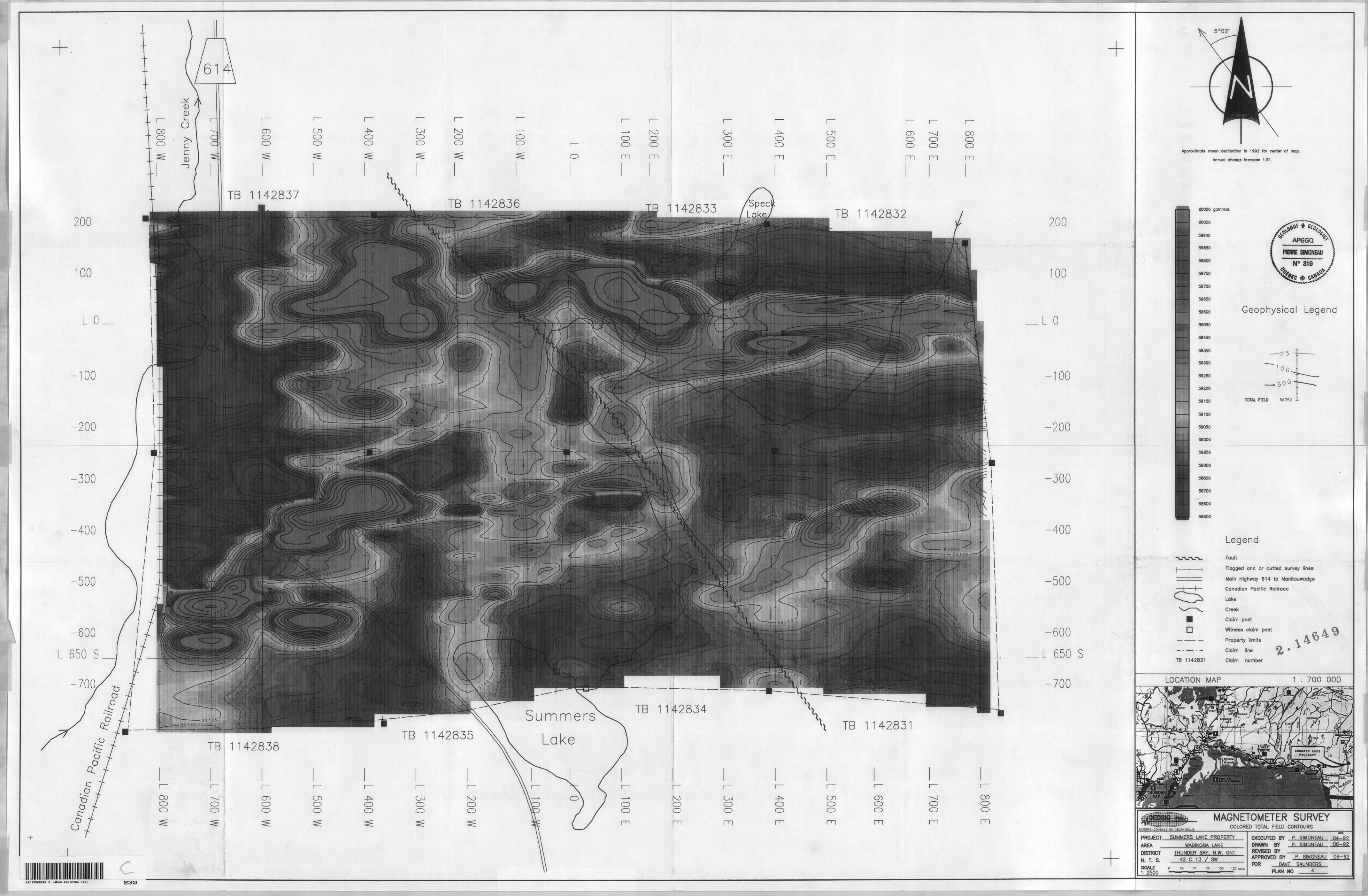
614
42837TB 1 142836 42833 TB 1142832
650 S
TB 1142834SummersTB 1142831
TB 1142835 LakeTB,1142838
200
100
L O
-100
-200
300
-400
-500
-600 . 650 S
-700
Approximate mean declination in 1992 for center of map.
Annual change increase 1.5'.
65000 gammas
60000
59900
59850
59300
59750
59700
59650
59600
59550
59450
59350
59300
59250
59200
59150
59100
59050
59000
59950
59000
58800
58700
58600
58500
Geophysical Legend
TOTAL FIELD 58750 -L
Legend
a
TB 1H2831
Fault
Flagged and or c u tie d survey linea
Main Highway 514 to Manitouwadge
Canadian Pacific Railroad
Lake
Creek
Claim post
Witness daim past
Property limits
Claim line
Claim number
LOCATION MAP 1 : 700 000
EXPERTS-CQHSEIUS EN GEOPHYSIQUE
MAGNETOMETER SURVEYCOLORED TOTAL FIELD CONTOURS
PROJECT S UMMERS LAKE PROPERTY AREA ______WABIKOBA LAKE DISTRICT N. T. S.GCALE1: 2500
THUNDER BAY. N .W. ONT. 42 C 13 X SW^—^
9 25 50 75 100 1^5
EXECUTED BY P. SIMONEAU n4-g? DRAWN BY P. SIMONEAU 06-92 REVISED BY ———————-— ^^—. APPROVED BY P. SIMONEAU 06-92FOR DAVE SAUNDERS
PLAN NO 4-
S3042C13SW00B2 2.14649 WABIKOBA LAKE