Embed Size (px)
Citation preview

Strasbourg, 5 June 2015 AP/CAT (2014) 11 rev
BIL
EUROPEAN AND MEDITERRANEAN MAJOR HAZARDS AGREEMENT (EUR-OPA)
NETWORK OF SPECIALISED EURO-MEDITERRANEAN CENTRES
RESULTS OBTAINED IN 2014 WITHIN THE COORDINATED PROJECTS FOR 2014-15
Draft
www.coe.int/europarisks

2
Contents
1.A. Assessment of events and population alert .............................................................................................. 3
GEOPHYSICAL MONITORING OF LANDSLIDES AND MAN-MADE STRUCTURES - SEARCH OF FORERUNNERS 4 METHODOLOGY FOR CREATION OF THE COMPLEX EMERGENCY ALERTING SYSTEM ................................... 9 CONTRIBUTION TO THE CARE OF A POTENTIAL RISK: HEAT WAVES ........................................................... 14
2.A. Knowledge diffusion ................................................................................................................................ 17
RISK-EUR-OPA WEB RESOURCE CENTRE .................................................................................................... 18 FIRE MANAGEMENT IN NATURAL AND CULTURAL HERITAGE SITES AND OTHER PROTECTED AREAS ........ 19 CONTRIBUTION TO FUNDAMENTAL STUDIES IN SEISMIC, SEISMO-TECTONIC AND SEISMO-VOLCANIC PROCESSES 22 KNOWLEDGE DIFFUSION ON NUCLEAR SAFETY BASED ON BOOKLET “BASIC KNOWLEDGE OF NUCLEAR HAZARDS: LESSONS FROM CHERNOBYL AND FUKUSHIMA” ....................................................................................... 24
2.B. Risk identification and vulnerability ........................................................................................................ 27
VULNERABILITY ASSESSMENT OF HISTORICAL CENTERS OR TOWNS AND SAFE EVACUATION IN CASE OF AN EARTHQUAKE ............................................................................................................................................ 28 METHODOLOGY FOR DISTANCE AUTOMATIC ON-LINE MONITORING OF BUILDINGS AND ENGINEERING CONSTRUCTION FRAMES ........................................................................................................................... 31
2.C. Impact of climate change and environment ............................................................................................. 34
EUROPEAN LANDSLIDE HAZARD MAPPING: INTEGRATION OF TRIGGERING FACTORS ............................... 35 ASSESSING DROUGHT RECURRENCE USING NONLINEAR APPROACH ......................................................... 49 GLOBAL CHANGE, CULTURAL HERITAGE AND SMART CITIES ..................................................................... 57 COUPLING TERRESTRIAL AND MARINE DATASETS FOR COASTAL HAZARD ASSESSMENT & RISK REDUCTION IN CHANGING ENVIRONMENTS ..................................................................................................................... 59
3.A. Policy studies ........................................................................................................................................... 67
NATIONAL STRATEGIES FOR ALERTING AUTHORITIES AND POPULATION CONCERNING NATURAL AND TECHNOLOGICAL RISKS IN BALKAN COUNTRIES ......................................................................................... 68 ELABORATE THE SYSTEM OF MEASURES TO SOLVE THE PROBLEMS OF TRANS-BOUNDARY COUNTRIES IN ORDER TO PREVENT HEAVY POLLUTION OF KUR RIVER......................................................................................... 70
3.B. Awareness initiatives ............................................................................................................................... 73
BE SAFE NET. PROTECT YOURSELF FROM HAZARD .................................................................................... 74 IDENTIFICATION AND RISK AWARENESS BY PUPILS IN CASE OF FLOOD PROBLEMS: PREVENTION, PREPARATION AND CONDUCT DURING AND AFTER FLOOD .............................................................................................. 76 PUBLIC AWARENESS AND EDUCATION TOOLS FOR DISASTER RISK REDUCTION AND PREPAREDNESS IN EARTHQUAKE SITUATION .......................................................................................................................... 79 INFORM AND INVOLVE THE POPULATION IN THE PREVENTION OF SEISMIC AND TSUNAMI RISKS: MINIMIZE DAMAGE AND INCREASE THE RESILIENCE OF CITIES .................................................................................. 81 GREATER INVOLVEMENT OF CITIZENS IN THE DECISION-MAKING PROCESS TO PROTECT AGAINST MAN-MADE DISASTERS ................................................................................................................................................. 85
3.C. Ethics and social values ............................................................................................................................ 90
DEVELOPMENT OF INFORMATIVE MATERIAL CONCERNING EARTHQUAKE PROTECTION MEASURES, FOR PEOPLE WITH DISABILITIES .................................................................................................................................... 91 INVOLVING PEOPLE WITH DISABILITIES IN DISASTER PLANNING AND PREPAREDNESS, AS AN INTEGRAL PART OF DISASTER PREPAREDNESS AND RESPONSE ................................................................................................ 92 SOFT SKILLS IN DISASTER PREPAREDNESS AND RELIEF .............................................................................. 95
3
1.A. Assessment of events and population alert

4
GEOPHYSICAL MONITORING OF LANDSLIDES AND MAN-MADE STRUCTURES - SEARCH OF FORERUNNERS
DURATION : 2014 – 2015 TARGET COUNTRIES : France and Georgia (case study) but European applicability PARTNERS INVOLVED : COORDINATING CENTRE : CERG Strasbourg, France OTHER CENTRES: GHHD Tbilisi, Georgia OTHER PARTNERS : University of Strasbourg (UdS, J.-P. Malet, C. Doubre, P. Ulrich), Delft University of Technology (TUD, T.A. Bogaard), University of Brest, IUEM (C. Delacourt), University of Grenoble (ISTerre, D. Jongmans)
2014 WORK PACKAGES CERG, STRASBOURG Work package 1 Description: Workshop to initiate the work (CERG) Associated deliverables: Conclusions of the workshop Work package 2 Description: Collection and organization of the in-situ monitoring datasets at the test site in France Associated deliverables: Organization of a dedicated field campaign in France (1 week) for testing the monitoring of strain with Fiber Optic on the La Valette landslide (CERG) Work package 3 Description: Interpretation of the data collected in Georgia and France (CERG) Associated deliverables: Report on the analysis of the data in the form of an easy to read leaflet for end users Work package 4 Description: Set up of an automated processing chain for the analysis of series of optical photographs for estimating the displacement and the strains and comparison with external sensor information (CERG) Associated deliverables: Development of a routine for automated processing and test of its performance against other data. Report on the analysis of the data in the form of an easy to read leaflet for end users Work package 5 Description: Workshop to define the logic tree procedure and identify the components of the decision support system (DSS) (CERG) Associated deliverables: Draft design of the DSS system
GHHD, Georgia Work package 1 Description: Collection and organization of the in-situ monitoring datasets at the test site in Georgia for testing the monitoring of strain with Fiber Optic and Acoustic Sensors Associated deliverables: i. Assembling and testing in Laboratory and Field of Acoustic Telemetric System for monitoring landslide activity ii. Field campaign on Gombori active landslide in Georgia using Fiber Optic and Acoustic Telemetric System for monitoring landslide activity Work package 2 Description: Contribution of the interpretation of the data collected in Georgia and France (GHHD) Associated deliverables: Interpretation of results of the Field campaign on Gombori active landslide in Georgia using Fiber Optic and Acoustic Telemetric System for monitoring landslide activity and elaborating recommendations for creation of corresponding early warning system
2014 RESULTS

5
CERG, STRASBOURG Surface reconstruction and displacement monitoring with Pléiades satellite images Context: Recent advances in image-matching techniques and VHR satellite imaging at submeter resolution theoretically offer the possibility to measure Earth surface displacements with decimetric precision. However, this possibility has yet not been explored and requirements of ground control and external topographic datasets are considered as important bottlenecks that hinder a more common application of optical image correlation for displacement measurements. Objectives: This work describes an approach combining spaceborne stereo-photogrammetry, orthorectification and sub-pixel image correlation to measure the horizontal surface displacement of landslides from Pléiades satellite images. The influence of the number of ground-control points on the accuracy of the image orientation, the extracted surface models and the estimated displacement rates is quantified through comparisons with airborne laser scan and in situ global navigation satellite measurements at permanent stations. The comparison shows a maximum error of 0.13 m which is one order of magnitude more accurate than what has been previously reported with spaceborne optical images from other sensors. The obtained results indicate that the approach can be applied without significant loss in accuracy when no ground control points are available. It could, therefore, greatly facilitate displacement measurements for a broad range of landlside monitoring systems (Stumpf et al., 2014). Landslide monitoring with satellite SAR imagery: A D-InSAR interpretation method Context: The objective of this work is to evaluate a geomorphologically-guided method for the interpretation of L-band ALOS/PALSAR interferograms created by Differential Interferometric Synthetic Aperture Radar (D-InSAR). The interferograms are used to estimate the deformation pattern of two large landslides (Poche, La Valette; South East France; Schlögel et al., 2015). Objectives: The wrapped and unwrapped phase values are interpreted for different movement types (rotational, translational, and complex sliding) and two ranges of surface displacement rates. Kinematic sub-units are detected for both landslides, and zones affected by enlargement or retrogression are identified. The InSARderived displacement rates are consistent with ground-based measurements. The results demonstrate the potential of L-band ALOS/PALSAR imagery for the monitoring of active landslides with important changes in the soil surface state and covered by vegetation. A network of corner reflectors for ground deformation monitoring with the Sentinel-1 SAR sensor Context: The Sentinels is the new fleet of ESA satellites which is poised to deliver imagery data of the Earth at a 6 days interval. By offering very high frequency observations for a broad range of applications, this global monitoring programme makes a step change in the way we manage our environment, understand and tackle the effects of climate change, and safeguard everyday lives. The first in the series, Sentinel-1, carries an advanced radar instrument to provide an all-weather, day-and-night supply of imagery of Earth’s surface. The design of Sentinel-1 with its focus on reliability, operational stability, global coverage and quick data delivery is expected to enable the development of new applications and meet the evolving needs of the Copernicus programme. Objectives: The objective of this work is to design and implement a network of trihedral corner reflectors co-located with permanent GNSS for exact positioning and registration of the SAR images in ground coordinates, and for reference measurements of elevation changes. A network of 16 corner reflectors has been implemented along a S-N track of the Sentinel-1a satellite located over eastern France and Switzerland. Several sites have been equipped for the monitoring of landslides (La Valette, Super-Sauze, Pont-Bourquin), glacier (Argentière), tectonic deformation (J9) and anthropogenic hazards related to geothermal exploration (Soultz, Rittershoffen). Multi-view photogrammetry of optical images for landslide monitoring Context: Recent advances in multi-view photogrammetry (MVS) have resulted in a new class of algorithms and software tools for more automated surface reconstruction. These new techniques have a great potential to provide topographic information for geoscience applications at significantly lower costs Objectives: Based on open-source libraries for multi-view stereophotogrammetry and Structure-from-Motion, we investigated the accuracy that can be obtained from several processing pipelines for the 3D surface reconstruction of landslides and the detection of changes over time. Two different algorithms for point-cloud comparison are tested and the accuracy of the resulting models is assessed against terrestrial

6
and airborne LiDAR point clouds. Change detection over a period of more than two years allows a detailed assessment of the seasonal dynamics of the landslide; the possibility to estimate sediment volumes and 3D displacement are possible. Algorithm parameters and the image acquisition protocols are found to have important impacts on the quality of the results (Stumpf et al., 2014). Ground-based observing systems At Super-Sauze landslide, the general pattern detected by MVS is consistent with previous studies of the landslide dynamics. However, due to the flow-like behavior of the landslide, the largest component of the 3D displacement is typically parallel to the slope and hence an important component of the displacement is not comprised in the distances measured normal to the surfaces. To illustrate the possibility to quantify the 3D displacement, vectors are calculated for two sub-areas (Fig. 6) being located 1) downslope of the secondary scarp, and 2) at the landslide toe where a comparison with a permanent GPS station installed on the landslide is possible. The 3D displacement measurements for the central part of the landslide were obtained through a piecewise alignment (translation and rotation) of rigid blocks that could be identified in at least two of the three point clouds. The ICP algorithm was used for fine registration, whereas if the distances were larger than 1 m an initial guess for the translational component was provided manually. The measurements for the period 29-Aug-2012 to 10-Oct-2012 suggest a maximum displacement of 5.79 m with at most 4.53 m in the Z-component and 4.01 m in the horizontal (E–W and N–S) component. The spatial pattern of displacement is consistent with satellite-based measurements covering nearly the same time period (Stumpf et al., 2014). GEO Candidate sites identification Two candidate sites were inspected for joint field work with participants from CERG planned by the project: Tsiv-Gombori ridge (Kakhety region) and Mukhatgveri area (near Tbilisi). The field team consisted from geophysicists (M. Nodia Institute of Geophysics and GHHD) and geologists (Ministry of Environment Protection of Georgia). Some Georadar survey was conducted on the objects. The joint expedition is postponed for the year 2015. The Tsiv-Gombori ridge morphostructure with its landslides and mudflows is one of the most stressed regions on the territory of Georgia in regard to geological hazards. Due to the high intensity of these processes all the segment here are either already damaged or in the risk zone. The area of landslide-gravitational and erosional-mudflow hazard risks covers nearly 80-90% of the territory. Landslides and gravitational phenomena take place at all kinds of engineering-geologic formations on the Tsiv-Gombori territory. They directly cause losses for the population and engineering objects and very often play principal role in the transformation of mudflows widely spread in the region. The landslide-gravitational phenomena differ from one another by generation, formation conditions, depth and areal distribution, dynamics and movement mechanisms. The landslides range from very simple, deformation of which do not transgress the aeration zone, to deep landslides of dozens of meters thickness and several thrust planes. According to their formation two main kinds of landslides dominate here:
1. Consistent (climatogenic), formation of which is fully connected with intense water intrusion to the slopes infiltrated by atmospheric precipitations and influenced by underground waters as well as “humidity effect”, during which the physical properties of the deformed rocks fall to the critical displacement level. Landslides of this kind are mostly formed within the aeration zone and are mainly connected with slope sediments;
2. Tectoseismogravitational landslides are directly linked with tectonical destructions and active fault zones where the first impulse for the slopes to leave their homeostatic state is earthquakes’ strikes. The majority of such landslides are connected with basic rocks and all of them are characterized with deep deformations, vast areas and volume.
Activation of such kinds of landslides is directly connected with seismic phenomena. During the recent five centuries in the Kakheti region the earthquakes with intensities VI-IX occurred at least 22 times, among them in the Zemo Alazani zone – in 1530, 1742, 1756, 1811, 1902, 1928, 1932, 1951, in the Zakatala-Lagodekhi zone – in 1890, 1907, 1924, 1936, 1948, 1991, 2006, 2008, in the Alaverdi zone – 1275, 1510, 1530, 1668, 1742. If we take into account that in a region, extremely sensitive to geo-tectonical processes,
7
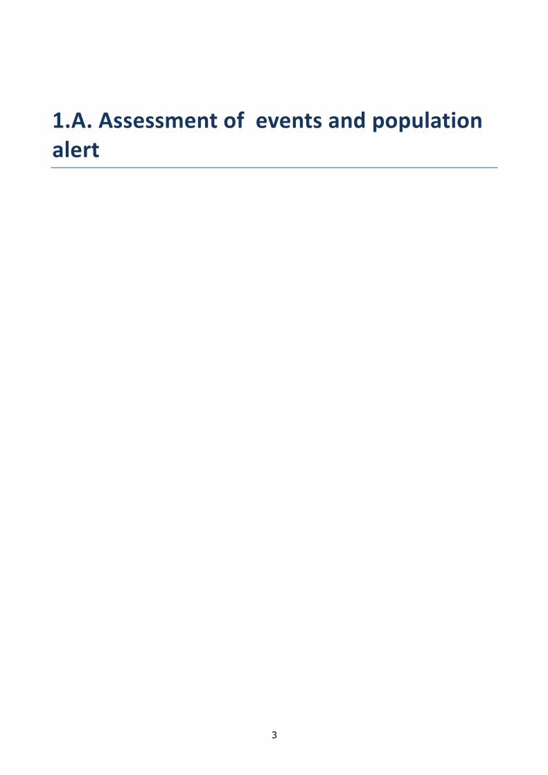
such as the Tsiv-Gombori morphostructure, activations of landslides and gravitational phenomena are significantly influenced by the strikes caused by earthquakes, then the rate of the process activation became quite obvious. It is noteworthy that the highest point of the activation of the Gombori landslides was observed as a result of the impact of the 1991 Racha-Imereti earthquakes and in the recent years after the 2006-2008 Lagodekhi seismic events. In 2006 on the territory of the river Kobidzeebi a new landslide focus was formed. It became hazardous for the 40 m segment of the highway. The landslide activity zone covers approximately one third of the highway. On the north-western slope there is a landslide of approximately 120 m length and 60 m width and probable thickness – 6-8 m. One more landslide was formed in 2004 at the 12th kilometer of the Telavi-Gombori highway. The landslide damaged 60 m part of the highway. The landslide has developed on the western slope inclined by 25-30°. The parameters of the landslide are: length – 70-120 m, thickness – around 15 m. The height of the landslide terraces range between 4-30 m. The landslide has developed in tectonically extremely destructed, lithified Tertiary clay and in its slope covers. The difference between the torn terrace of the landslide and the tongue discharge zone is 240 m. The landslide mass volume is approximately 1000 000 m3. Nowadays the landslide body is in stabile state. Due to its morphogeological nature, in case of activation of its landslide processes any significant activity against it is quite excluded. It is noteworthy that in the Tsiv-Gombori ridge area the landslides similar to the Gobori landslide have developed at numerous places and not only in flysch sediments but in every river basin built with molasse stratum. In this point of view there is even more geodynamic hazard in the part of the ridge, which is built of molasse sediments of the upper Pliocene as while on the either slopes of the Gombori pass there are only vast landslides, on the slopes built of molasse sediments (especially, on its southern slope) landslide-gravitational and erosional-mudflow process are developing simultaneously. Laboratory testing of Acoustic landslide monitoring and early warning systems Laboratory model was assembled in order to test the acoustic sensor system for telemetric monitoring/early warning at debris flow/landslide areas. Large plastic barrel is filled with a soil from the landslide, in the center of which is placed a cylinder filled with small stones (gravel). In the center of gravel parcel thick-wall stainless steel tube is placed, through which acoustic pulses arisen in the gravel by deformation are transmitted to the acoustic sensor. Acoustic emissions carry information about location, intensity, and deformation mechanisms occurring in a material. Detecting AE generated by a developing shear surface within a slope is not an easy task. The goal of our study is registration and monitoring of landslide slow motion (creep) by recording the acoustic emission. For this goal we developed the special equipment (Fig.1a). Plastic barrel is filled with a soil from the landslide, the in the center of which is a cylinder filled with small stones. The cylinder diameter is approximately 15 cm and a mean diameter of stones about 7 mm. In the center of gravel parcel thick-wall stainless steel tube is placed, through which acoustic pulses arisen in the gravel are transmitted to the acoustic sensor. The deformation of the experimental set up is done with the help of a mechanical jack. Continuous recording waveform and DC voltage was done using USB oscilloscope. One of the record fragments is shown on Fig.1b.
a b c Fig1.7. a) Landslide creep modeling and b) accompanying AE registration, records of acoustic signal level

8
and waveform using USB oscilloscope; x-axis is time in sec, y-axis is the acoustic signal intensity in volts, c) barrel and pendulum The goal of our experiment the increase in sensitivity of the acoustic sensor by changing its mechanical parts. For this goal plastic small volume was filled with gravel (Fig.2a). At its center was placed aluminum stem with small cross-section, on which was fixed electronic block of the acoustic sensor. In one experiment on an aluminum rod was fixed aluminum radiator (Fig.2b), which increases the useful area of the sensor and therefore, in our opinion, its sensitivity. In a second experiment, nothing was fixed to the aluminum rod. a. b.
Fig.1.8. a) experimental equipment, b)acoustic sensor with fixed aluminum rod and radiator for increasing sensitivity Our guess is that in this direction, it is possible to develop monitoring and early warning acoustic system for revealing landslide incipient slipping.

9
METHODOLOGY FOR CREATION OF THE COMPLEX EMERGENCY ALERTING SYSTEM
DURATION : 2014 – 2015 TARGET COUNTRIES : all member states PARTNERS INVOLVED : COORDINATING CENTRE: ECNTRM Moscow, Russian Federation OTHER CENTRES: OTHER PARTNERS : EMERCOM of Russia
2014 WORK PACKAGES ECNTRM, Russian Federation Work package 1 Description: Gathering and analysing the information about existing practicing alerting systems of the municipal level in Russia and Ukraine (probably Georgia, Armenia, and Azerbaijan). Development of proposals (further on methodology) for creating the complex emergency alerting system based on best practices.
2014 RESULTS We developed a questionnaire which allowed gathering the information about existing practicing alerting systems of the municipal level. It was distributed within Russia, Ukraine, Georgia, Armenia and Azerbaijan. Probably because of the fact that this year the financing of the project to other than Russian participants was not provided we got responses only from Russia, Ukraine and Azerbaijan. The analyses of the answers showed that alerting systems in these countries are more or less the same based on the former Soviet systems with the same problems and faults that need modernization and upgrading. The proposals were developed for creating the complex emergency alerting system based on the results obtained. Consider it interesting and important to continue gathering best practices now in the West and South Europe, to make a comprehensive study, analyses with further recommendations and methodology. 1. ANALYSIS OF THE CURRENT PUBLIC ALERT AND NOTIFICATION SYSTEMS 1.1. Current Alert Systems Analysis The public is alerted by the emergency response services by way of various systems and equipment established by the state executive authorities, regional executive authorities, local municipalities and organizations. The regional public alert systems Regional alert systems are primarily designed for delivering the information and alert signals to:
Civil defense management in the region;
Bodies responsible for protecting the public and territory from emergencies and/or civil defense forces in the municipalities;
Public safety answering points (PSAP) in municipalities;
Specially trained forces allocated (called) for emergency prevention and response and also civil defense forces in the region;
Operations control desks (OCD) at the organizations managing potentially dangerous facilities;
Population living in the respective region. Municipal (local) public alert systems The municipal (local) public alert systems are designed for delivering the information and alert signals to:
Civil defense management in the municipality;
Specially trained forces allocated (called) for emergency prevention and response and also civil defense forces in the municipality;
Operations control desks (OCD) of the organizations managing potentially dangerous facilities;

10
Population living in the respective municipality. Facility alert systems The facility alert systems are designed for delivering the information and alert signals to:
Civil defense management of the organizations operating potentially dangerous facilities;
Facility rescue units, including specialized ones;
The employees of the organization operating a dangerous production facility;
Management and operations control desks of the organizations located in the facility alert system coverage area;
Population living in the facility alert system coverage area. The systems mentioned are to be established and maintained by the agencies and organizations responsible for the potentially dangerous facilities. 1.2 . Current Public Notification Systems Analysis The public notification is done to inform the population on the forecasted or actual natural and technogenic emergencies, measures taken to protect the population and the territory, protective methods and means, and also for raising public awareness of civil defense and protection of the population and territory from emergencies. Unlike public alert, public notification does not require immediate public protection action and is to be performed by all the state authorities, regional executive authorities, municipal authorities and organizations. Mobile telephone networks The mobile telephone networks have shown the most dynamic development in the past few years. The amount of devices connected to the mobile telephone networks is much more than the number of fixed-line telephone service subscribers. The 2G technology is the major one in the mobile telephone networks, while the 3G technology is demonstrating the most dynamic growth. Major population and territory coverage makes the mobile telephone networks an attractive instrument to notify the population about the threats coming from natural and technogenic emergencies. The following actions are currently being taken to improve the use of mobile telephone networks:
regulatory action for operators’ performance in an emergency and ensuring hardware and software integration between their equipment and the automated information platform of the emergency response services;
introduction of mechanisms for standard mobile telephone networks technology application like Cell Broadcast/Interactive Cell Broadcast into the comprehensive public notification and alert system.
Telephone and Radio Broadcasting Networks Telephone and radio broadcasting are the most spread information systems covering almost all population, which makes them a major public notification and alert channel. The on-the-ground segment of the state television and radio broadcasting network is comprised by the regional, republican, territorial and provincial radio and television broadcasting centers, which are part of the single state television and radio broadcasting operator responsible for on-the-ground broadcasting of all mandatory public television and radio channels throughout all the country’s territory and also for deployment of digital on-the-ground networks for broadcasting mandatory television and radio channels. Television and radio broadcasting networks are optimized for public alert needs the following way:
Reliable digital television and radio broadcasting networks are built for guaranteed and targeted alert and also public notification;
VHF radio broadcasting networks are developed in the rural areas;
Current wire broadcasting networks are preserved and maintained for public alert system application;
The private (municipal) television and radio broadcasting companies are used for the public alert and notification, for instance, through cooperation agreements in case of emergency threat or occurrence.
Fixed line telephone communication networks Despite the rapid development of the mobile communication networks in the past years, the fixed line telephone communication networks are still well-spread, but are in limited use for notification and alert, that is largely for autoinformer-based alert of the response forces management. The potential of this

11
communication type will be significantly increased when new software-based switching systems (like soft-switch) are introduced there. The Internet The Internet is clearly a promising channel for public urgent notification and alert, but is currently in extremely limited use. Thus, the analysis performed shows that:
The capacity of the modern digital information and communication technologies, development of multi-service communication networks, establishment of digital television and radio broadcasting networks require the organizational and technical solutions previously used to create the current alert and notification systems at all managerial levels should be revised.
Comprehensive approach is needed to perform the emergency public alert and notification tasks by using all available equipment, including the communication and broadcasting means, which are supposed to complement each other.
2. PROPOSALS FOR THE COMPREHENSIVE PUBLIC EMERGENCY ALERT SYSTEM (CPEAS) 2.1. Goals The CPEAS is to be designed for timely and guaranteed public alert in the emergency alert areas with the use of up-to-date information and communication technology, software and hardware suites (equipment and end devices), which type and kind are determined depending on the emergency alert area features (certificate), dangerous natural and technogenic processes the area is prone to, and also the population groups that can be in the area. 2.2. Tasks The CPEAS is to perform the following tasks:
To guarantee timely delivery of the information on an emergency threat or occurrence, rules of behavior and protection ways in conditions like that to every person in the area under the emergency threat, or in the emergency area; rules of behavior and protection measures in such situations;
To alert the disabled people and persons with reduced mobility differentiated by the types of their disability;
To transfer the required information and alert signals (audio, video, characters and figures, and other) on an automatic and automated basis for adequate perception by the public in case of emergency threat or occurrence;
To have integration capacity for the equipment receiving, processing and transmitting the audio and /or audiovisual, as well as other messages on an emergency threat or occurrence, rules of behavior and protection ways in situations like that;
To have an automatic and/or automated integration capacity with software and hardware suites for decision-making used by the emergency response services;
To have an automatic and/or automated integration capacity between the public alert systems and the systems for monitoring potentially dangerous facilities, natural and technogenic emergencies;
To apply up-to-date information technology, electronic and printed mass media for the timely and guaranteed public alert on an emergency threat or occurrence, rules of behavior and protection ways in situations like that;
To timely transfer information to the emergency response services of respective level to take necessary action for public protection;
To control the end alert and notification means from the respective emergency response service desks;
To transfer information in preset modes (personal, selective, circular and by groups according to preset programs);
To protect information from unauthorized access and provide information integrity in case of system failures.
3. COMPREHENSIVE PUBLIC EMERGENCY ALERT SYSTEM REQUIREMENTS 3.1. Requirements to defining public emergency alert areas When the public emergency alert areas are defined the risks present on a given territory of the country and the possible scale of their development are to be taken into consideration. The natural threats include:
geophysical dangerous phenomena;

12
volcanic eruptions;
geological dangerous phenomena;
weather and agrometeorological dangerous phenomena;
sea hydrologic dangerous phenomena;
hydrologic dangerous phenomena;
natural (landscape) fires: forest fires, steppe and grain area fires, peat fires; The technogenic threats include:
Chemically hazardous facility accidents;
Radiation hazardous facility accidents;
Fire and explosion hazardous facility accidents;
Hydrodynamically hazardous facility accidents;
Transportation accidents (railway, motorcar, aerial, water, metro);
Utility and power grid accidents. 3.2. Control levels
Federal (on the territory of the country);
Regional (in the constituent entities);
Local (in municipalities);
Facility/on-site (on the territory of potentially dangerous facilities). 3.3. Operating requirements The CPEAS is to be round-the-clock operational and ready for use. The CPEAS is to provide timely, guaranteed and accurate alert signals and emergency information delivery to the public in the emergency alert areas. The time required for the alert signals and emergency information delivery to the public from the moment the reliable data on a natural or technogenic emergency threat or occurrence is received, should be enough to ensure the necessary action for public protection (engineer, radiation, chemical and biological protection, evacuation, and other action). The CPEAS is to have 100% population coverage for those on the territory of an emergency threat or occurrence. 3.4. Technical requirements The CPEAS is to support the following alert signals and information transfer modes:
circular;
circular by preset programs;
selective within one CPEAS level;
selective (over one or two levels) by preset programs; The CPEAS systems of all management levels are to be integrated in terms of software and hardware. The CPEAS is to have a throughout centralized and decentralized operation capability. The CPEAS is to support information exchange between the automatic, automated, manual and dialogue levels. The CPEAS is to support transfer and reception of confirmations on the transferred alert signals and emergency information at all levels. The CPEAS is to provide: - Automatic display and registration of the transferred alert information, data and acknowledge receipt; - Registration of actions taken by the on-duty officer managing the alert system; - Possibility to ‘intercept’ the alert network by a higher level management in the country operating on a daily basis; - Remote control for public and authorities alert means; - Information input into the alert system from an industrial computer; - Transmission of pre-recorded voice messages or microphone messages; - Transmission of voice and video information from broadcasting studios of the broadcasting operators. 3.5. Integration requirements for monitoring software and hardware suites, forecasting, surveillance and laboratory control systems. The CPEAS is to support input and processing of the emergency information coming from the monitoring, forecasting, surveillance and laboratory control systems which receive and process the formalized messages on the emergency threat or occurrence (further to be referred to as control systems). The CPEAS is to be software and hardware integrated with the automated information gathering, processing, and presentation suites of the control systems at all levels.

13
The alarm systems are to be automatically launched when the sensors of the monitoring systems for dangerous natural and technogenic processes are actuated. The CPEAS control systems’ information output is to be done through standard data communications protocols processed by the integration modules and command generation for actuating different levels of the CPEAS. The CPEAS integration with the control systems is to provide both an automatic (no operator participation) and an automated operation mode. 3.6. General requirements to communication networks The public is to be alarmed of an emergency threat or occurrence by the fixed-line telephone, mobile telephone (cellular) networks, television and radio broadcasting networks, the Internet, the electrical and electronic acoustic horn networks, street public address systems, mobile alert means and other means. Mobile telephone (cellular) communication The Cell Broadcast technology and short messages delivery are to be used for the mobile telephone (cellular) communication alert. When the short messages are sent to the public for the mobile telephone (cellular) communication alert, the following capabilities of the federal and regional mobile operators are to be taken into consideration: - The number of mobile operators servicing a given region and the number of their subscribers; - Operator coverage areas in a given region with the indication of installed satellite communication basic stations addresses; - The technical capacity of the regional communication operator representative offices to circulate short messages. The message text is to be not more than 140 symbols (the message size is subject to change based on technical capabilities and approval) to be delivered by the mobile radio and telephone communication network and within 15 minutes. The cell network public alert via the Cell Broadcast technology is to be performed using pre-prepared and pre-approved texts. The communication operators are banned from introducing changes to the message texts. TV and radio broadcasting TV and radio broadcasting based public alert is to be performed under applicable law. Public alarms The electrical and electronic acoustic horn networks, street public address systems are to be used up on the basis of the fixed-line telephone communication network, the dedicated digital IP VPN communication network of the executive authorities of the regions and municipal authorities, as well as the communication networks of the potentially hazardous facilities. The Internet public alarm is to be performed by placing emergency information on the official specialized websites, as well as the major news and search sites. 3.7. Requirements for CPEAS sustainability - CPEAS hardware suites are to be located in the facilities which are protected from the emergency hazards; - Several geographically distributed communication systems (channels, lines) are to be jointly used for one alert direction; - CPEAS hardware suites and communication lines are to be backed up; - The mobile alert means are to be kept and used in store; - Power supply is to be guaranteed; - An industrial computer is to be used as part of the alert systems. - If the devices, blocks, cabinets, etc. are opened, a signal is to be transferred to a control desk for a corresponding level of the alert system; - Component parts are to be checked for proper functioning and a signal is to be transferred to a control desk of the corresponding level of the alert system; - The equipment is to be protected from unauthorized launch, as well as mistaken actions of the on-duty officer and maintenance staff; - The alert equipment suites used for the CPEAS are to be software and hardware integrated. 3.8. Public The CPEAS is to alert and notify all public groups, including the disabled people and other people with limited health capabilities considering the different limitations and by using various communication, broadcasting and alert equipment.
14
CONTRIBUTION TO THE CARE OF A POTENTIAL RISK: HEAT WAVES
2014 WORK PACKAGES
CRSTRA, ALGERIA Work package 1 Description: Collecte de données climatiques concernant l’Algérie Livrables associés: Collecte des données des températures concernant l’Algérie au cours des 50 dernières années en milieu aride. Constitution d’une base de données et traitement des données historiques pour les milieux arides. Sur le long terme, développement d’un système d’alerte aux canicules et de prise de mesures et de prise en charge. Work package 2 Description: Organisation d’une base de données concernant les pays participants Livrables associés: Le plus grand effort d’échantillonnage concerne les données algériennes et qui couvrent les 50 dernières années.
2014 RESULTS Atelier Méthodologique Gestion du Risque Canicule ( 04 et 05 Novembre 2014) La journée du 04 Novembre qui s’est déroulée en deux sessions, une la matinée où trois communications ont été présentées et une l’après-midi avec trois présentations également suivies de débats fructueux. Dans son allocution d’ouverture, Mme la Directrice a mis l’accent sur l’importance accordée par le Centre aux différents risques liés au climat dont les canicules peu étudiées jusque-là et qui pose de plus en plus de difficultés en régions arides surtout en saison estivale. Elle indique également la mise en place d’une stratégie de recherche en niveau du Centre afin d’appuyer le développement durable de ces régions. À cet effet, les programmes de recherche du Centre émanent des réalités du terrain et s’appuient sur un réseau d’observation et de transfert en régions steppiques et sahariennes identifiés selon un découpage agro-écologique. Après l’ouverture solennelle par Mme la directrice, nous avons entamé les sessions de présentations et de débats. Présentation 1 : CONTRIBUTION A L’ETUDE DES CANICULES EN ALGERIE (CAS D’ORAN ET DE BECHAR) La communication présentée par deux chercheurs de la division écosystèmes en régions arides et gestion des risques climatiques, en l’occurrence Mme BOUDJEMLINE et Mr FACI est d’un intérêt particulier. Il s’agit d’une démonstration sur la base de l’analyse des données relatives aux températures de l’existence d’une tendance vers la hausse de la température dans les deux stations étudiées. L’étude des épisodes caniculaires de deux régions pilotes (Bechar et Oran) avec une série de 60 années de données climatiques, montre un accroissement des épisodes caniculaires en amplitude et en fréquence durant les trente dernières années aussi bien en région côtière qu’en région saharienne. Présentation 2 : CANICULE 2012, ASPECT CLIMATIQUE Le communicant, Mr BENSALAH de l’ONM Biskra, a relaté dans son intervention les épisodes de canicule qui ont marqué la région de Biskra d’une durée de 11 jours en Juillet, 8 jours en Août et 4 jours en Juin. Il a souligné l’importance de la compréhension des phénomènes en distinguant entre pic de chaleur et canicule. Il a insisté sur la complexité du phénomène et sur l’approche statistique. Présentation 3 : PROTECTION DES CEDRAIES EN ALGERIE. IMPORTANCE DE LA PROCESSIONNAIRE D’ETE DANS LE MASSIF DES AURES : TECHNIQUES D’AVERTISSEMENT ET DE LUTTE Le problème apparu pour la première fois en Algérie sur la cédraie de Bellazma en 1981. Mr. KHEMICI de l’INRF montre qu’outre le réchauffement climatique, les épisodes caniculaires qui favorisent la pullulation de la processionnaire d’été favorise le dépérissement de la cédraie en Algérie. L’orateur a aussi indiqué que les Lépidoptères en général peuvent être des indicateurs de ces phénomènes extrêmes. Après les présentations il a eu un débat fructueux qui nous a permis de dresser, par consensus, les points sur lesquels s’oriente notre débat. Nous avons retenus les questions suivantes :
15
-Qu’est-ce que une canicule ? -Quelles sont les causes ? -Quelles sont les conséquences sur l’agriculture, eau, sol, ressources naturelles,… -Les moyens de préventions et d’intervention, système d’alerte, coordination,… Présentation 4: RESEAU DE VEILLE PHENOLOGIQUE EN MILIEU OASIEN EN RAPPORT AVEC LE CLIMAT Le travail s’insère dans la nouvelle vision orientée vers une recherche active basée sur la collaboration Recherche – paysannerie. On la désigne généralement par la Recherche Action Participative (RAP) qui est une méthode de recherche pour identifier les logiques paysannes d’adaptation aux changements climatiques et pour analyser et mesurer les changements subi par le cycle du palmier dattier par cultivar sous l’effet des changements climatiques. Mr Romani a souligné que la finalité du projet issu de l’atelier organisé à Touggourt en Novembre 2011 est l’élaboration d’outil d’aide à la décision en vue de stratégies d’adaptation. Présentations 5: PRESENTATION DE MR KHABER, DG DE L’AGENCE NATIONALE DES CHANGEMENTS CLIMATIQUES ANCC Il a souligné que la mission principale de l’Agence est l’intégration de la problématique des changements climatiques dans tous les plans de développement. Présentations 6: POLLUTION ATMOSPHERIQUE/ BLACK CARBON Mr MERABET a présenté les premières données sur les mesures du Black Carbon réalisées dans la nouvelle station de mesure de Bouzareah. Les premiers résultats montrent que même si la station est située dans une zone qui peut être considérée comme propre « forêt périurbaine », la concentration des polluants est élevée et leur concentration est corrélée à la vitesse du vent « phénomène de dispersion », reste à la corréler avec les piques de chaleur. DEBATS Les présentations sont suivies de débats qu’on estime fructueux et bénéfiques avec une participation active et massive de l’assistance. On a enregistré pas moins de 55 interventions entre question/réponse/commentaire et/ou complément d’information pour toutes les interventions (présentations). Les questions sont traduites en recommandations que nous relatons dans ce qui suit : a. Définition de la canicule Les intervenants ont fait référence à la définition appartenant au vocabulaire météorologique international en précisant que la question des seuils de calcul de ce phénomène reste à caractère régionale. En Algérie Mr BENSALAH (ONM) précise que l’Algérie est divisée en 3 régions : • Le nord ou le seuil est de 40 °C • L’intérieur où le seuil est de 44 °C • Le Sud est de 48 °C Les intervenants on insisté sur la nécessité d’affiner ce paramètre en tenant compte des spécificités locales à l’intérieur de chaque région comme c’est le cas par exemple de Chlef, Guelma, Biskra….. L’autre point soulevé fait référence à l’amplitude thermique surtout en agriculture ou ce paramètre joue un rôle important dans les cycles phénologiques. b. Les causes des canicules Sur ce point, les participants sont unanimes à suivre les recommandations des experts en climatologie et de l’ONM à savoir : La cause des canicules est des anomalies dues aux circulations générales avec l’installation d’une dépression thermique qui fait tourner les « masses d’air chaud ». Ce phénomène peut avoir un caractère régional ou local avec des facteurs aggravants d’origine anthropique. Tout en insistant pour ne pas confondre entre canicule et réchauffement climatique. Même si ce dernier a pour conséquence l’augmentation de la fréquence des événements caniculaires. c. Les conséquences des canicules Les intervenants ont dès le départ noté que l’écosystème oasien a été bien conçu pour résister aux conditions exigeantes du milieu. Ce système de résilience a permis d’assurer la pérennité de la palmeraie à ce jour. Les impacts des canicules sont exposés par les intervenants en insistant sur des faits avérés tels que :
Impact sur l’agriculture qui pour faire face à ces phénomènes fait appel de plus en plus aux ressources,
surtout hydriques, sol, … ;
Un décalage dans la floraison ;

16
Impact sur la qualité et la quantité de la production phoenicicole
o Assèchement des dattes avant la fin de leur maturation ;
o Pour les variétés délicates un raccourcissement de la période de reproduction ;
Concernant la biodiversité qu’elle soit animale ou végétale celle-ci est négativement affectée par les canicules qui font subir des épisodes de stress fragilisant encore la végétation et les animaux déjà affaiblis par les phénomènes climatiques tel que la sécheresse. Concernant la pollution même si cette dernière est déjà à l’origine de l’augmentation des températures à l’échelle mondiale, les épisodes caniculaires favorisent la formation de polluants et participent ainsi plus au réchauffement climatique Concernant la santé, les intervenant rappellent que si ce phénomène n’à été pris en considération de façon plus concrète par les pouvoirs publiques et la communauté scientifique en région méditerranéenne qu’après l’épisode caniculaire de 2003 qui a touché l’Europe ; jadis épargnée ; et qui a engendré des milliers de mort. A cet effet, la corrélation entre les épisodes caniculaires et l’augmentation de la mortalité dans les catégories les plus fragiles (personnes âgés, enfants en bas âge, malades chroniques) ne fait plus aucune controverse. En fin, Les intervenants attirent l’attention sur le facteur anthropique, qui accentue le phénomène et ceci par : • Les incendies qui causent localement des augmentations de la température • L’urbanisation inadaptée qui crée des ilots de chaleurs • Le type de construction qui ne prend pas toujours en considération les normes thermiques • Réseaux National du Risque canicule Concernant le débat et la réflexion sur la mise en place d’un réseau Méditerranéen sur le Risque Canicule, Les participants ont suggéré d’abord la mise en place d’un réseau national de recherche sur ce risque. Le réseau en question a pour but de mettre à la disposition des décideurs les outils nécessaires dans la gestion et l’atténuation des effets du risque canicule. Ce réseau doit s’appuyer sur la mutualisation des moyens existants dans les différents secteurs, Centre, Institut et Laboratoire de recherche. A cet effet, comme première étape, tous les partenaires doivent faire un état des lieux des moyens à mettre à la disposition du réseau pour l’accomplissement de ces objectifs. Pour la donnée météorologique, il est recommandé aux différents secteurs concernés (MESRS, Agriculture, Energie,….) d’établir des conventions avec l’ONM pour faciliter l’accès à la donnée météorologique pour les chercheurs et partenaires. Les participants recommandent la tenue d’un deuxième atelier consacré exclusivement à la mise en place du réseau, pour mieux discuter son organisation, son fonctionnement ainsi que la contribution de chaque partenaire. La matinée du 05 Novembre 2014 a été consacrée à la synthèse des travaux, la remise des attestations pour les intervenants et la clôture officielle de l’atelier après lecture des recommandations.

17
2.A. Knowledge diffusion

18
RISK-EUR-OPA WEB RESOURCE CENTRE
DURATION: 2014 – 2015 TARGET COUNTRIES: All members PARTNERS INVOLVED: COORDINATING CENTRE: to be decided OTHER CENTRES: to be decided OTHER PARTNERS : Federal Public Service Home Affairs, DG Crisis Centre, other European countries who can present good practices (NO, UK, SE, FI, …)
2014 WORK PACKAGES
Activity postponed to 2015/ Activité reportée en 2015
2014 RESULTS No results are available as the project was postponed to 2015.

19
FIRE MANAGEMENT IN NATURAL AND CULTURAL HERITAGE SITES AND OTHER PROTECTED AREAS
DURATION : 2014 – 2015 TARGET COUNTRIES : CoE Member States and Global, Greece PARTNERS INVOLVED : COORDINATING CENTRE : GFMC Freiburg, Germany OTHER CENTRES: OTHER PARTNERS : Democritus University of Thrace, Department of Forestry and Natural Resources Management, Orestiada, Greece.
2014 WORK PACKAGE GFMC, Germany Work package 1 Description: Survey of the members states heritage sites threatened by forest fires and their fire management Associated deliverables: Study "Fire Management in Protected Areas and Cultural and Natural Heritage Sites" Work package 2 Description: Pilot project in Greece Associated deliverables: Landscape-level fire risk assessment methodology demonstrated in Mt. Athos Cultural Heritage Site
2014 RESULTS 1. Work package 1: Survey of Natural and Cultural Heritage Sites of the EUR-OPA Participating Countries A total of 433 World Heritage Sites (WHS) of the EUR-OPA Member States were extensively surveyed. The sites are divided into Cultural, Natural and Mixed sites. In the beginning, the sites were classifying according to their fire regime into four classes: (a) Fire-dependent or fire-adapted: WHS with ecosystems where the present species have evolved in presence of fire; excluding fire from them may cause alterations in the system. Fire-independent: WHS that naturally lack of fuel or ignition sources. (b) Fire-sensitive: Sites with ecosystems adapted to fire where an inappropriate introduction of fire may cause negative impacts. (c) Threatened: WHS which have not evolved with fire and negative impacts are expected if burned. After the classification, a thorough and detailed search was made for each WHS looking for fire events that have affected or/and threatened them by scanning the media collections on GFMC website, search engines and for the case of natural WHS the assessment made by the First World Heritage Outlook1. Overall, 55 Natural, Cultural and Mixed WHS have been affected by fire on the EUR-OPA countries. The survey analysis is still on progress. Two workshops were carried out during the first year of the project: 1.1 International Workshop "Fire Management in Protected Areas and Cultural and Natural Heritage Sites". Meeting of members, partners and observers of the Council of Europe / EUROPA Project “Fire Management in UNESCO World Natural and Cultural Heritage Sites and other Protected Areas” (27 June 2014, Freiburg, Germany) The project and its initial achievements were presented. The presentation revealed that Protected Areas and Natural Heritage Sites are currently under immediate fire threat. Some ideas to improve the work on the survey were extracted during the discussion session among the participants. An example on how WHS exposure to fire can be assessed was presented by GFMC staff with the preliminary results of the pilot study entitled “Assessment of wildfire risk in Holy Mount Athos“. 1.2 Regional Workshop “Transboundary Fire Management in Protected Areas bordering Greece, Albania and FYROM” (13 September 2014, Ohrid, FYROM)

20
Representatives from FYROM, Albania, Greece and the GFMC met at the Ohrid Lake World Heritage Site to discuss wildfire threats in Ohrid region and Prespa Lake Protected Areas. An assessment of the fire-threatened protected areas of the Balkans region was presented and several ideas surged to improve the development of the report and clarification of issues related to some countries of the Balkans. An agreement for the preparation of a project for fire management in transboundary areas of Ohrid and Prespa regions was drafted. 2. Work package 2: Assessment of Wildfire Risk in Holy Mount Athos 2.1 Fuel Sampling All the areas in the study site were stratified on vegetation maps according to the dominant vegetation type and forest fuel load was estimated with standard methods for inventorying surface biomass in 49 plots by conducting two field campaigns in the area carried out by GFMC staff. 1 www.worldheritageoutlook.iucn.org
Figure 1. Fuel sampling 2.2 Fuel Modeling Fuel models were created by following a two stage clustering procedure: Ward’s minimum variance method in combination with the k-means method and hierarchical clustering. Overall, 6 fuel models representatives for the whole area were produced. 2.3 Fuel mapping, ancillary spatial data set and UNESCO structures mapping Fuel mapping were conducted by following RapidEYE & GEOBIA & machine learning approaches. This method presents reliable, wide area, multi temporal coverage at a compelling (5 m) resolution Mt. Athos (500 sq. km).

21
Figure 3 (left). Ancillary datasets Figure 4 (right). UNESCO structures mapping 3. Originally planned associated activities Originally it was envisaged to present the preliminary results at the IUCN World Parks Congress (12- 19 November 2014, Sydney, Australia). A proposal was submitted for organizing a dedicated event. The proposal was not considered. In addition, funding for travel costs by sources supplementary to the project was difficult to obtain. Thus, the plan was dropped and participation at the World Parks Congress cancelled. 4. The 2015 phase of the project The proposed plan to organize a regional conference on fire management in UNESCO World Heritage Sites and other protected areas in Europe, with inputs from other regions, will be realized. A scientific article about the pilot study entitled “Assessment of wildfire risk in Holy Mount Athos“ will be prepared and it will be submitted for publication in a peer reviewed journal.

22
CONTRIBUTION TO FUNDAMENTAL STUDIES IN SEISMIC, SEISMO-TECTONIC AND SEISMO-VOLCANIC PROCESSES
DUREE: 2014 – 2015 PAYS VISES: all Member states interested, Japan, Democratic Republic of Congo, Rwanda PARTENAIRES IMPLIQUES : CENTRE COORDINATEUR: ECGS Walferdange, Luxemburg AUTRES CENTRES: AUTRES PARTENAIRES: Musée national d'histoire naturelle MNHN (Luxembourg), GFZ German Research Center for Geosciences (Germany), Royal Museum for Central Africa Mrac (Belgium), Earthquake Research Institute, The University of Tokyo (Japan), Boise State University (USA)
2014 WORK PACKAGE ECGS, Luxembourg Work package 1: Study on the source contribution to ground motion observations Description: In the framework of this work package, we will investigate if and how strongly the characteristics of the earthquake source process translate directly into earthquake ground motion variability, with main focus on the earthquake’s stress release and radiated energy. In particular, we will study regression models of ground motion observations throughout Japan, and the usage of seismic intensity observations is also planned in collaboration with the Earthquake Research Institute at the University of Tokyo, Japan, where Dr. Adrien Oth will spend three months as visiting researcher (April-June 2014). With this study, we intend to better understand the discrepancies that were noted between the observed between-event variability of ground motions and the earthquake stress release variability as determined from several studies. Understanding this discrepancy is very important, as it plays a major role in assessing the potential ground motion levels from future damaging earthquakes. A part of the financial support of the EUR-OPA Major Hazards Agreement for 2014 will be used for travel to an important conference during this research stay, the Seismological Society of America (SSA) Annual Meeting in Anchorage, Alaska. The attendance of this meeting will allow Dr. Oth to exchange views on the subject with his peers, which is an essential process. Associated deliverables: The associated deliverable will consist in a report on the results of this work which will be submitted by 30 November 2014, as required by article 2c of the administrative agreement. In addition, scientific publications stemming from this project will acknowledge the support of the EUR-OPA Major Hazards Agreement. Work package 2: Installation of an additional seismic station in Luxembourg Description: This work package aims at working towards the setting up of the first nation-wide seismic network in Luxembourg. The remaining funds provided by the EUR-OPA Major Hazards Agreement for 2014 will be used for acquiring a seismic sensor. Associated deliverables: The associated deliverable will consist in an installed seismic station, which will be part of the Luxembourg Seismic Network managed by ECGS.
2014 RESULTS Two work packages have been set up in the framework of the 2014 administrative agreement and progress has been made within these two work packages as outlined below. The first of the work packages deals with the subject of the quantification of the earthquake source contribution to ground motion variability, while the second one is related to the extension of the Luxembourg Seismic Network. Study on the source contribution to ground motion observations The aim of this work package is to improve our understanding on the influence of earthquake source physics variability on the variability of the observed earthquake ground motions. To this end, Dr. Adrien

23
Oth spent three months as a visiting researcher at the Earthquake Research Institute (ERI) of the University of Tokyo, working with Prof. Dr. Hiroe Miyake. The amount of stress released during earthquakes is a key parameter for the understanding of earthquake rupture physics and the generation of ground motions. A serious discrepancy between the stress release variability as expected from the earthquake--‐to--‐earthquake variability of ground motion prediction equations, and the variability of seismologically measured stress release estimates has recently been observed in the literature. This issue is of major importance because the stress release variability has a direct impact on the predicted ground motion variability, which in turn impacts the predicted hazard level. Japan is an ideal case for investigating these problems, and based on the recently published extensive work on seismological stress release estimates in Japan by Dr. Oth, it was possible to investigate the link between ground motion parameters variability and stress release variability in--‐depth and within a consistent framework, avoiding the need to mix stress release estimates from various different studies which might be biased relative to each other due to various methodological assumptions. During his stay at ERI, Dr. Adrien Oth attended the 2014 Annual Meeting of the Seismological Society of America (SSA) in Anchorage, USA, to present the most recent findings of this project in an oral presentation. As stated in the administrative agreement, a part of the 2014 EUR-OPA contribution has been used to fund Dr. Oth’s participation in this meeting. A report presenting the findings of this work package will be submitted as a deliverable by 30 November 2014. Installation of additional seismic station in Luxembourg The second work package of the 2014 administrative agreement consisted in the acquisition of a new seismic sensor for a seismic station to be deployed in Luxembourg in order to further complement the existing seismic network. The seismic sensor in question (Güralp CMG-3ESP Compact) has been recently ordered. However, due to unexpectedly long delivery times, the delivery of the sensor and, consequently, the installation of the seismic station will unfortunately only be possible at the beginning of the year 2015. Since the deliverable associated with this work package consists in this installation, the finalization of this deliverable is expected within the first quarter of the year 2015.
24
KNOWLEDGE DIFFUSION ON NUCLEAR SAFETY BASED ON BOOKLET “BASIC KNOWLEDGE OF NUCLEAR HAZARDS: LESSONS FROM CHERNOBYL AND
FUKUSHIMA”
DURATION: 2014 – 2015 TARGET COUNTRIES : All member-states PARTNERS INVOLVED : COORDINATING CENTRE : TESEC Kiev, Ukraine OTHER CENTRES: CEPRIS Rabat, Morocco , ECNTRM Moscow, Russian Federation , CEMEC San Marino , ECRP Sofia, Bulgaria OTHER PARTNERS : Armenia, Azerbaijan, Georgia, Moldova, IAEA, UNESCO
2014 WORK PACKAGES
TESEC, Ukraine Work package 1 Description: Technical support of the regional seminars Associated deliverables: Development proposals for better informing the population in the case of nuclear or radiological accidents
ECNTRM, Moscow Work package 1 Description: Regional seminar in Russian to diffuse nuclear safety knowledge among concerned actors Associated deliverables: Report of the regional seminar and comments
CEMEC, San Marino Work package 1 Description: Regional seminar in English to diffuse nuclear safety knowledge among concerned actors Associated deliverables: Report of the regional seminar and comments.
CEPRIS, Maroc Work package 1 Description: Regional seminar in Arabian to diffuse nuclear safety knowledge among concerned actors Associated deliverables: Report of the regional seminar and comments
2014 RESULTS UKR The public perception of Chernobyl and Fukushima nuclear accidents clearly shows the insufficient information of people on radiation hazards attributed to radionuclides releases. The iodine doses received in Europe from the Fukushima release were minimal (less than 1/1000 of the exposure from natural radionuclides) yet population in many European cities felt threatened and were not ready to trust the official information provided by national authorities or experts. After Chernobyl and Fukushima emergencies, experience shows that increasingly people only trust information they can actually understand. Thus it is important to provide them with meaningful information about nuclear hazard and build their own capacity to analyse risk. Following that line the EUR-OPA Major Hazards Agreement of the Council of Europe developed a new publication on “Basic Knowledge on Nuclear Hazard : the lessons from Chernobyl and Fukushima”. The Booklet has been translated to 10 languages, presented around the World and became teaching material in many countries. Proposals for structure of the regional seminars have been developed.

25
Nuclear and radiation accidents – public awareness (structure of regional Worshop) . 1. Public awareness about hazards - a key element of emergency protection of the population against the disasters. Opening - Ministry of Emergency (MOE), the Council of Europe EUR-OPA 2 . Emergency planning and public awareness on the radiological hazard. MOE 3. Dialogue with the population about radiation and radiological hazards. Radiation Protection Body 4. International experience - " Basic knowledge of nuclear hazards: the lessons from Chernobyl and Fukushima." EUR-OPA Council of Europe 5. Awareness of people living near radiation sources about radiation and radiological hazards. National Authority 6. Readiness of national emergency services in the case of an accident to the warning, conducting radiation monitoring and the implementation of protective measures. MOE 7. Speeches from the regions and from international organizations. 8. Cross-border cooperation in the case of nuclear or radiation accidents. 9. Instruments and environmental monitoring. Presentation in English and Russian has been developed. In Armenia, Bulgaria, Russia and Ukraine 11 seminars for studding of Booklet “Basic Knowledge of Nuclear Hazards: Lessons from Chernobyl and Fukushima” have been organized. In Morocco, a regional seminar was planned for the end of November. Representatives from many Arabic countries will participate: 1. AIEA – AAEA Agence Arabe de l'Energie Nucléaire (Tunis – Tunisie) 2. SUDAN Sudanese Atomic Energy Commission : SAEC 3. SAUDI ARABIA King Abdullah City for Atomic & Renewable Energy 4. ALGERIA Commissariat à l'Energie Atomique 5. EGYPT Egyptian Atomic Energy Authority ; 6. MAURITANIE Autorité Nationale de Radioprotection, de Sûreté et de Sécurité Nucléaire (ARSN). 7. TUNISIA Centre National des Sciences et Technologies Nucléaires (CNSTN) 8. JORDAN Jordanian Atomic Energy Commission In Russia, a regional seminar has been organized within the XIX International Sientifical and Practical Conference on protection of population and territories from emergency situations "The experience of large-scale emergencies in Russia and abroad," May 20-23, 2014, Moscow. In San-Marino seminar is organized for the end of November. RUS Series of events were held in Russia within 2014 among which there were regional seminars and conferences where there was presented and discussed the Booklet “Basic Knowledge of Nuclear Hazards: Lessons from Chernobyl and Fukushima”. There were printed additional booklets to satisfy the demands of the audience. The booklet was considered interesting and useful for the work of the specialists dealing with the nuclear safety problems. Report of the regional seminars was sent to the coordinator. RSM CEMEC has organized in San Marino on December 18 2014 a seminar to present and to illustrate the Booklet “Basic Knowledge of Nuclear Hazards: Lessons from Chernobyl and Fukushima” edited by Viktor Poyarkov and published in 10 languages. The Seminar has been held in the San Marino National Hospital in Main Theatre Hall “Sala dal Monte” where all major events are held. More than 50 people attended including local authorities (San Marino National Health Care Secretary, San Marino Civil Protection Responsible), emergency officers, physicians, nurses, journalists, teachers, fire fighters, police officers, students. Alessandro Barelli, CEMEC President, chaired the Seminar and showed all main aspects of the booklet which has been translated in Italian as well. Feedback from participants was very good because of the great interest regarding the problem of nuclear hazards after the Fukushima incident. MAR

26
Le CEPRIS, avait projeté d'organiser le séminaire pour les pays arabophones vers la fin du premier semestre 2014. Cependant, et sous la suggestion du Professeur Victor (Directeur du Centre de Kiev) nous avons avancé l'organisation de ce séminaire vers le mois de Décembre 2014. Aussi nous avons décidé d'organiser le séminaire pour les pays arabophones en collaboration avec une institution nationale spécialisée en sureté nucléaire au Maroc (CNESTEN) avec laquelle nous avons entamé depuis l'été 2014 les préparatifs de l'organisation de ce séminaire pour assurer la réussite de cette activité. Cette institution spécialisée a plus de contacts avec les institutions de sureté nucléaire à travers les pays arabes. Avec cette institution, nous avons préparé un dépliant en langue française, qui va être traduit en anglais et en arabe. Cependant, l'organisation du séminaire INSPIRD à Tanger vers la fin novembre 2014. nous a pas laissé suffisamment de temps pour organiser le séminaire sur la Vulgarisation des connaissances de bases sur le risque nucléaire. Lors de la réunion des Directeurs en Décembre 2014 à Strasbourg, nous nous sommes mis d'accord avec le Prof Victor du Centre de Kiev de prendre un temps suffisant pour réussir cette manifestation. et nous sommes fixé la première quinzaine du mois d'Avril 2015 pour organiser ce séminaire avec le maximum de représentant des pays arabes. Par ailleurs, la traduction en arabe du document a été poursuivie et avancée. Une version finale sera prête avant la tenue de ce séminaire à Rabat.

27
2.B. Risk identification and vulnerability

28
VULNERABILITY ASSESSMENT OF HISTORICAL CENTERS OR TOWNS AND SAFE EVACUATION IN CASE OF AN EARTHQUAKE
DURATION: 2014 – 2015 TARGET COUNTRIES : Greece, Bulgaria, Romania, FYROM, Armenia PARTNERS INVOLVED : COORDINATING CENTRE : ECPFE Athens, Greece OTHER CENTRES: ECRP Sofia, Bulgaria , ECBR Bucharest, Romania , ECILS Skopje, FYROM , CUEBC Ravello, Italy OTHER PARTNERS : ECRM Yerevan,Armenia, ECCE,European Council of Civil Engineers
2014 WORK PACKAGES ECPFE, Greece The City of Nafplio, the first capital of Greece after its independence, a City with a lot of Masonry Historical buildings, is selected as the case study. Work package 1 1.1.The development of a methodology for pre-earthquake assessment of Historical Masonry Structures and based on previous extended work, carried out by EPPO, in English, including specific algorithm to facilitate the results. 1.2.The pre-earthquake assessment of the Monuments, sited in the whole area will be carried out as follows : Design of preseismic assessment to collect appropriate building data, necessary for the application of the above methodology. Work package 2 Selection of a sample of 36 buildings representative of the historical building stock of the city center of Nafplio Work package 3 Validation of the Methodology and pilot application on 4 buildings out of 36. Work package 4 A special meeting will take place between the partners in order to get aware of the above mentioned preseismic assessment methodology and exchange experiences .
CUEBC, Italy Work package 1 Description: Selection of a Historical Town with rich monumental stock Associated deliverables: A short tutorial for a preliminary rapid assessment of historical built-up areas vulnerability
ECRP, Bulgaria Work package 1 Description: Collect and analyse the best national experience of emergency planning in the case of man-made natural disasters, with a focus to public information and involvement in decision-making, taken into account special measures for people with disabilities, children, the elderly, tourists, migrants and other groups of population. Associated deliverables: Report sent to the coordinator.
2014 RESULTS GRE

29
1.1.A scientific committee, deployed for this purpose, has carried out a methodology of a pre-earthquake assessment ,adapted to Historical Masonry Structures ,translated into English The target of this methodology is the calculation of the “Seismic Risk Index of the building” potential vulnerability. Rapid visual screening is a simplified methodology that can be quickly applied to a large set of buildings and, therefore, its reliability is inherently limited. The second level pre-earthquake assessment is directed at masonry buildings that have received a score from the first level pre-earthquake assessment that is below a certain threshold value. The aim of the second level pre-earthquake assessment is to re-evaluate the ranking of identified vulnerable buildings based on the detailing and evaluation of structural parameters and social criteria. This evaluation goes into more detail and requires access to all parts of the building, sketches detailing geometry and damage, visual assessment and spot checks of construction materials and basic calculations to quantify the characteristics of indexes without performing an analysis of the structure. The benefit of this empirical Methodology is its simplicity of the calculations occurred after filling in relevant records in situ. The sample with characteristic Monumental structures includes 36 buildings. According to the derived index the most damaged structures will be conducted for further examination 1.2.A scientific committee has carried out the relevant dynamic analysis for four representative buildings out of the 36. These analysis will serve as a pilot study in order to validate the proposed methodology. 1.3.At the end of the year a Workshop will be organized within the Stakeholders in order to present the goals achieved . ITA The research intends to provide for people involved in mitigation programmes of the earthquake effects some basic information that will enable them both to know the nature and genesis of "fabrics" in some parts of the city - that is of the "solid" areas - the buildings-, and the "void" ones - streets, yards and unbuilt spaces-, and the risks related to each specific fabric. The way the "solid" and the "void" lots are structured is the result of a long process generating the various parts of the city. Regardless of the value of the architectural artefacts, the "fabric" of certain neighbourhoods is therefore a highly accurate document on the history of the city. The fact that in the old town centre of Naples all kinds of solid/void relationships that characterized at various times all European cities can be found, makes its "urban pattern" an element of the city cultural heritage. A "minor" heritage, but equally important. On the other hand, each fabric has morphological and construction characteristics able to amplify one or more of the risks that are found in urban areas in crowded conditions. Knowing the origin, the potentiality and the dangers of various fabrics may help to diminish the risk, contributing to a safer staying of strangers in the city and a more effective work of the volunteers. Of course, this text does not purport to be exhaustive or to replace specialized studies. It is just a cognitive support designed to give the Civil Defence volunteers a simple but exact analysis tool, allowing them to learn, and recognize a widespread and also little-known (however rarely shown) aspect of the cultural heritage of the city and to focus preventive action on the characteristics of the area that will be assigned to them. The research shows that the parts of the city characterized by community fabric (Greek-Roman core, Cavone, Vergini, Orefici, Pizzofalcone and Pallonetto S. Lucia), and the Quartieri Spagnoli are the most dangerous areas, both for the specific characteristics of the fabric and because the presence of many monuments does provide for a higher density of people present in the streets. To reduce risks and lessen the impact of emergencies, it may prove useful to: A) In the prevention phase 1. Get a topographic map of the assigned area (i.e., a paper in which the arteries are shown with their actual width), scale 1: 4000 (available through the Office of the Master Plan of the City of Naples) and integrate it with the missing street names. 2. Inspect the area, noting the "critical points" (possible blocks caused by parked cars, probable detachment of plaster) and the potential gathering points during an earthquake (plazas and squares with

30
width not less than 80% the height of the buildings that overlook them, vaulted entrance halls that do not show damage, large courtyards at least 80% the height of the building, or at least wider than the road). 3. Report on paper the "hot spots" and the gathering points, reporting them to the relevant departments (Safety Office of the City, Fire-fighters, Bodies in charge of producing and/or managing the Local Plans for Emergencies). 4. Identify the alternative routes to point to emergency vehicles. 5. Practice to find the formula to be used in emergency situations to briefly explain why it is dangerous to stay in the streets in the event of a fire or earthquake, what is the shortest path to reach a gathering point, because the vaulted entrance hall is secure. B) In the emergency situation 6. Call the emergency vehicles. 7. Verify that the "hot spots" are passable and, if necessary, promptly report to the emergency vehicles the route to follow to reach the point. 8. In the event of an earthquake, direct passers-by towards the square, the courtyard or the nearest entrance hall, explaining them the nature of the hazard (falling cornices, plaster, etc.), and providing the necessary technical information about the reasons that make sure the gathering points (in particular, doorways). At this stage, it is important to always use the same words. In emergency situations is a physiological fact that people will exchange information. If these are always concordant - among themselves and with those that come from voluntary - the word of mouth becomes adjuvant to the reassurance. Illustrating the same concepts, always using the same terms, strengthens credibility of the message and reduces the risk of being deformed. 9. In case of fire, clear out completely the roads which the concerned building overlooks and, if possible, those allegedly used by emergency vehicles. BUL In accordance with the decision adopted during the meeting of directors of the centers of European and Mediterranean Major Hazards Agreement (EUR-OPA) of the Council of Europe that took place in 2013 in Strasbourg, France - European Centre for Risk Prevention, Sofia, Bulgaria participates how partner in a project coordinated by European Centre on Prevention and Forecasting of Earthquakes (ECPFE), Athens, Greece. After a discussion with experts from the New Bulgarian University was selected historical city of national importance. Selection was based on the fact that besides the risk of an earthquake near this town has a working nuclear plant. After selecting of the historic town to participate in this project, a workshop was held with the participation of specialists and managers from the municipality during which reports were given by professors from the New Bulgarian University. The following activities have been performed in 2014 by the European Centre for Risk Prevention (ECRP), Sofia within the implementation of the project “Vulnerability assessment of Historical Centers or Towns and safe evacuation in case of an Earthquake” with Coordinator – European Center ACPFE, Athens:
- Summary of materials for an earthquake in different Municipalities with Heritage and another rich monuments;
- Selection of a Historical Town with rich monumental stock; - Description of the risks facing the proposed town and sent to coordinator; - Hold of Work Meeting in The Historical Town (jointly with New Bulgarian University) with
participation of responsible people in this area;
- Translation of the materials in English language.
All activities planned for 2014 under this project have been performed.

31
METHODOLOGY FOR DISTANCE AUTOMATIC ON-LINE MONITORING OF BUILDINGS AND ENGINEERING CONSTRUCTION FRAMES
DURATION: 2014 – 2015 TARGET COUNTRIES : all member countries PARTNERS INVOLVED : COORDINATING CENTRE: ECNTRM, Moscow OTHER CENTRES: OTHER PARTNERS : EMERCOM of Russia
2014 WORK PACKAGES ECNTRM, Russian Federation Work package 1 Description: To prepare Brochure layout “Methodology for Distance Automatic On-line Monitoring of Buildings and Engineering Construction Frames” in Russian, translate it into English
2014 RESULTS The Brochure layout “Methodology for Automated Real-time Monitoring of Load-bearing Structures of Buildings and Constructions” was prepared in Russian and translated in English. There was given more precise title of the Methodology from the linguistic point of view. The load-bearing structures of buildings and constructions (further on referred to as ‘facilities’) are subject to wear-caused loss of operability. Exploitation of facilities with damaged construction elements may lead to emergencies, which are likely to cause loss of life. This is confirmed by unexpected collapses of facility construction elements in Russia, Germany, Poland, and other countries, which resulted in extensive casualties. The methodology is designed for setting up an automated real-time system for monitoring load-bearing structures of buildings and constructions. This system will provide the respective services with remote real-time access to the information on the condition of the load-bearing structures of buildings and constructions, and therefore save the facility from collapsing unexpectedly. The methodology is designed for the institutions providing scientific and technological support for development and exploitation of the systems for automated monitoring of loadbearing structures of buildings and constructions and also for the companies monitoring the facilities under exploitation.
The ESMS is designed for: – timely automated remote notification of the emergency and dispatching services on the condition of the facility’s load-bearing structures, using the following criteria: ‘normal condition’, ‘higher risk’, ‘emergency’; – monitoring and documenting changes in the condition of the load-bearing structures caused by accumulated exploitation defects, which may lead the building or construction to an extreme condition mandating corresponding repairs or bringing the operation to a halt, throughout the whole facility operation period. The ESMS structure is illustrated by:

32
The ESMS is comprised by equipment for monitoring changes in the condition of foundations and engineering structures of buildings and constructions; engineering protection facilities, and also, if there is any corresponding hazard, for monitoring the areas of possible mudflows, mudslides and avalanches in the building or construction operation area. It includes: – ESMS servers, local servers and controllers; – ESMS automated workstations (AW); – data gathering and transferring network equipment; – sensors monitoring changes in the condition of foundations and engineering structures of buildings and constructions; engineering protection facilities, and also areas of possible mudflows, mudslides and avalanches. The ESMS has the following functional subsystems: 1) the signaling monitoring subsystem, which continuously operates: – to monitor the integral characteristics of the facility loadbearing structures in an automated real-time mode; – to notify the facility operations control desk and CPSAP personnel on the critical changes in the condition (deformed condition) of the facility structures in an automated real-time mode; 2) the intermittent monitoring subsystem, which is launched by notifications (incident, accident) coming from the signaling monitoring subsystem or under a regulation. In an automated mode it: – assesses the technical condition of the facility load-bearing structures and issues recommendations for reinforcement (reconstruction); – controls and adjusts (if necessary) the signaling subsystem. ESMS installation is advisable for the following types of facilities: – facilities constituting nuclear and/or radiation hazard (nuclear power plants, research reactors, fuel cycle facilities, temporary and long-time warehouses for nuclear fuel and radioactive waste), facilities using nuclear energy; – for production, use, processing, generation, storage, transportation and disposal of hazardous materials in the volumes exceeding the limits under the Law; – for chemical and other hazardous waste disposal and burial; – having large warehouses for storage of oil and oil products (over 20.000 tons) and isothermal storage facilities for liquefied gases; – for production of melts of ferrous and nonferrous materials and alloys based on these melts; – for mining, minerals processing, subsoil operations, including companies performing subsoil and open-pit (mining depth over 150 m) extraction and processing of solid minerals; – using cableways and funiculars;

33
– for production, generation or processing of liquid or solid materials with explosive features or prone to spontaneous decomposition with a possible explosion energy equal to 4.5 tons of TNT; – power transmission lines and other grid facilities with the voltage of 330 kilovolts or more; – space infrastructure facilities; – airports and their infrastructure facilities; – public railway system facilities; – metros, – sea ports excluding specialized sea ports for sports and pleasure boats maintenance; – thermal power plants with the capacity of 150 megawatts and more; – offshore oilfield facilities; – mainline gas, oil and product lines; – gas distribution system facilities using, storing or transporting natural gas or liquefied hydrocarbon gas; – waterworks of class 1.2 and 3; – large industrial facilities with more than 10.000 workers; – capital construction facilities with the design documentation comprising at least one of the following features: height over 100 meters; flights over 100 meters; console over 20 meters; – with depth of the subsoil part (in full or in part) more than 10 meters below the grade (ground) elevation; – with constructions and construction systems, which have unconventional design methods applied to them to consider physical or geometric non-linear features or have specialized design methods developed for them; – facilities with maximum design capacity of 500 people and more: entertainment, sports facilities, multifunctional office centers and shopping malls, health facilities, hotels; – life-supporting facilities: units, warehouses, storage facilities, waterworks and engineering protection facilities and communications whose destruction (damage to) may disrupt the life of people (stop water, gas, heat, power supply, cause flooding, damage residential communities, cause failure of waste water and sewage water treatment facilities) resulting in an emergency.

34
2.C. Impact of climate change and environment

35
EUROPEAN LANDSLIDE HAZARD MAPPING: INTEGRATION OF TRIGGERING FACTORS
DURATION: 2014 – 2015 TARGET COUNTRIES : Europe continental level, and Georgia, Romania, France, Marocco and Ethiopia PARTNERS INVOLVED : COORDINATING CENTRE : CERG Strasbourg, France OTHER CENTRES: GHHD Tbilisi, Georgia , CEPRIS Rabat, Morocco, ISPU Florival, Belgium OTHER PARTNERS: University of Strasbourg (UdS, J.-P. Malet, A. Puissant), IGRA (M. Micu), Joint Research Centre (JRC, J. Hervàs), German Geological Survey (BGR, A. Günther), National Research Council, Research Institute for Hydrogeological Protection (CNR-IRPI, P. Reichenbach), Ethiopian GeoSurvey (Adddis Abeba)
2014 WORK PACKAGES CERG, STRASBOURG Work package 1 Description: Organisation of a 2-days workshop to initiate the project Associated deliverables: Report of the workshop Work package 2 Description: Analysis of the Landslide Risk Assessment Methodologies survey Associated deliverables: Report on the analysis of the data in the form of an easy to read leaflet for end users Work package 3 Description: Performance of the new factors maps for the construction of Elsus v2 Associated deliverables: Report on the analysis of the data in the form of an easy to read leaflet for end users Work package 4 Description: Definition of a methodology for integrating triggering factors for nation scale assessments and tests Associated deliverables: Report on the analysis of the data in the form of an easy to read leaflet for end users
GHHD, Georgia Work package 1 Description: Test in Georgia of the methodology for integrating triggering factors for nation scale assessments Associated deliverables: Compilation of database of precipitation (rate/duration) and temperatures in Georgia and assessment of correlation between these parameters and landslide activity. Discrimination of periods of enhanced landslide hazard.
CEPRIS, Morocco Work package 1 Description: Organisation of a landslide inventory database (for scientific purpose) with indication on landslide location and landslide type for Morocco (CEPRIS) Associated deliverables: Report on the CEPRIS contribution to the collection and organization of relevant data for the national and regional assessments in Morocco.
ISPU, Belgium Work package 1 Description: Results of the Landslides Risk Assessment Methodologies survey Associated deliverables: Draft report sent to the coordinator

36
2014 RESULTS FRA In the framework of the European Soil Thematic Strategy, a project to map landslide susceptibility at the scale of Europe was suggested in 2007 by the Soil Information Working Group (SIWG) of the European Soil Bureau Network (ESBN). The methodology consists of identifying the potential areas subject to generic landslide types by expert knowledge using available thematic and environmental data. The choice of the 1:1 M scale allows the use of harmonized data sets for all Member States as input to the susceptibility model. The European Landslide Susceptibility map ELSUS1000: In 2013, the first version of the European Landslide Susceptibility map (ELSUS1000) has been released. The map delineates susceptibility classes for all types of landslides at a coarse resolution (1 km) using three spatial criteria related to landslide susceptibility: terrain gradient (e.g. slope), shallow subsurface lithology, and land cover. It is based on a climate and physiographic terrain differentiation, and the susceptibility assessment consists of heuristic spatial multicriteria evaluations performed separately for each model zone. The objective of the project was to refine this preliminary assessment by updating the information on landslide inventory per country and integrating new conditioning factor maps. It consisted also in proposing nation-wide assessments of landslide susceptibility for three countries (France, Georgia and Romania) by compiling national landslide inventories and using a statistical modelling approach. Landslide locations in Europe: During the project, the European landslide database has been considerably updated now containing 53.713 more landslides in the areas marked in the figure below. The ELSUS landslide inventory represents the first attempt to collect landslide information throughout Europe. However, for more than 30% of the territory still no information is available and many landslide-prone areas are underrepresented (e.g. Central Alps). For this reason, purely data-driven landslide susceptibility modeling attempts prove difficult. The European Landslide Inventory now includes 155.900 landslide locations with new data from Cyprus, France, Ireland, Romania, Slovakia and Spain obtained in 2014.
The European Landslide Inventory now includes 155.900 landslide locations with new data from Cyprus, France, Ireland, Romania, Slovakia and Spain obtained in 2014. New input data used for the preparation of ELSUS v2:
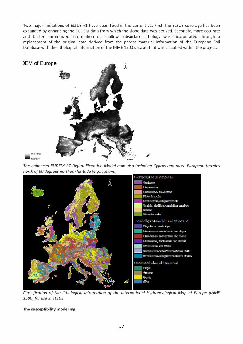
37
Two major limitations of ELSUS v1 have been fixed in the current v2. First, the ELSUS coverage has been expanded by enhancing the EUDEM data from which the slope data was derived. Secondly, more accurate and better harmonized information on shallow subsurface lithology was incorporated through a replacement of the original data derived from the parent material information of the European Soil Database with the lithological information of the IHME 1500 dataset that was classified within the project.
The enhanced EUDEM 27 Digital Elevation Model now also including Cyprus and more European terrains north of 60 degrees northern latitude (e.g., Iceland).
Classification of the lithological information of the International Hydrogeological Map of Europe (IHME 1500) for use in ELSUS The susceptibility modelling
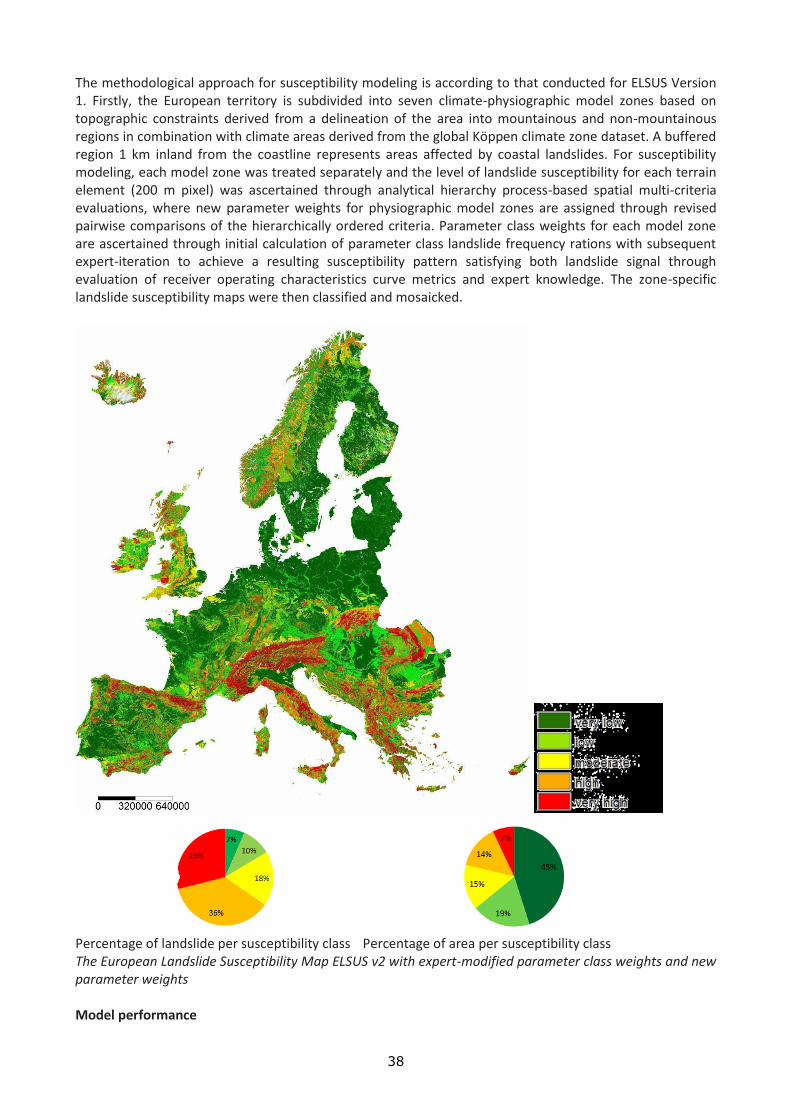
38
The methodological approach for susceptibility modeling is according to that conducted for ELSUS Version 1. Firstly, the European territory is subdivided into seven climate-physiographic model zones based on topographic constraints derived from a delineation of the area into mountainous and non-mountainous regions in combination with climate areas derived from the global Köppen climate zone dataset. A buffered region 1 km inland from the coastline represents areas affected by coastal landslides. For susceptibility modeling, each model zone was treated separately and the level of landslide susceptibility for each terrain element (200 m pixel) was ascertained through analytical hierarchy process-based spatial multi-criteria evaluations, where new parameter weights for physiographic model zones are assigned through revised pairwise comparisons of the hierarchically ordered criteria. Parameter class weights for each model zone are ascertained through initial calculation of parameter class landslide frequency rations with subsequent expert-iteration to achieve a resulting susceptibility pattern satisfying both landslide signal through evaluation of receiver operating characteristics curve metrics and expert knowledge. The zone-specific landslide susceptibility maps were then classified and mosaicked.
Percentage of landslide per susceptibility class Percentage of area per susceptibility class The European Landslide Susceptibility Map ELSUS v2 with expert-modified parameter class weights and new parameter weights Model performance

39
In contrast to ELSUS v1, the new version v2 is available in a resolution of 200 m X 200 m and therefore able to represent regional landslide patterns much better than the v1. The newly incorporated lithology data from IHME 1500 allows assigning higher weights to this factor, resulting in advanced model performance as indicated by ROC curve evaluations when compared to ELSUS v1. As for ELSUS v1, the model performance was evaluated separately for each model zone resulting in higher AUC values for the new ELSUS v2. However, poor model performance can still be observed in the mountainous model zones. However, synoptic ELSUS v2 performs significantly better as v1 when predicting the updated inventory.
Model performance ELSUS v1 versus ELSUS v2 based on the new inventory and a pixel resolution of 1 km
Excerpt of ELSUS v2 over the Balkan region at a resolution of 200 m. The blue dots indicate the landslide locations. Further actions: To improve ELSUS further, it is important to establish a Pan-European network for easy landslide data exchange and update throughout Europe. This platform should be designed in a way that any organization in Europe holding and maintaining small-scale landslide inventory databases can contribute, and that standards for the major landslide attributes location- and typology information are established. With this information it should be possible to update ELSUS periodically, and to derive typology-specific susceptibility maps. Additional landslide susceptibility conditioning factors from Pan-European datasets can be incorporated depending on landslide type. Enhancements of ELSUS v2:

40
For future enhancements of ELSUS v2, it is mandatory to collect more landslide information over Europe since large European areas are still lacking any information. In particular, for major extensive mountainous areas in the Alps and the Pyrenees only very sparse landslide data is available from overview inventories of e.g. Spain, Austria and Switzerland. It can be suspected that better distribution of the landslide information will enhance the map and will also pave the way to more quantitative, data-driven susceptibility modeling. For the production of hazard scenario maps based on ELSUS v2, precipitation data from WORLDCLIM and seismicity data from GSHAP will be incorporated to produce hazard scenarios for both rainfall- and earthquake induced landslides. Susceptibility zonation in Romania: The susceptibility zonation (consisting in three nationwide maps; slides, flows and falls) outlines very well the correlation between the major morphostructural units and different susceptibility classes. The medium and high Carpathians, built mainly on metamorphic and igneous rock formations (sometimes on limestone and dolostones), present the highest susceptibility to (rock/debris) falls and (debris) flows. The low Carpathians, consisting of more or less cohesive flysch formations are very prone to (mud/debris) slides. The Subcarpathian hills and the extended homocline or hilly tablelands shows high susceptibility to (mud/debris) slides and (mud) flows. Further steps will include the integration of dynamic factors (climate maps, peak ground acceleration map) in the analysis
Landslide susceptibility zonation for Romania. Top right: previous landslide susceptibility map created with a heuristic geomorphological method (Balteanu et al. 2010). Top left: Exploratory simulated susceptibility map for slides. Bottom left: Exploratory simulated susceptibility map for flows. Bottom right: Exploratory simulated susceptibility map for falls. Susceptibility zonation in France: The landslide susceptibility zonation is performed with a statistical method (logistic regression) for three landslide types (slides, flows and rockfalls) and four predisposition factors (lithology, landuse, slope gradient and slope aspect).

41
Spatial units of calculation are used in order to differentiate specific climatic and terrain morphological (plains, mountains, coasts) conditions. The calculation tests were carried out on these units in order to propose a statistically optimal model at the scale of the country.
Landslide susceptibility zonation for France (data-driven approach, logistic regression model). Left: climate-physiographic zones for the simulations. Middle: Exploratory simulated susceptibility map for slides and flows. Right: Exploratory simulated susceptibility map for rockfalls.
GEO It is important to develop the technique of compiling time-dependent maps of landslide/debris flow hazard, as it is established that activation of mass-movements occur only in periods of intensive precipitation and relatively elevated temperatures. Such maps can be considered as medium-range predictions of expected mass-movement activation. Our intention is to use the fuzzy logic approach for assessment of time-dependence of landslide/debris flow hazard. It is known that appearance of mass-movements/slumps depends on precipitations: the higher level of precipitations, the higher risk of slumps. This risk of slumps we suppose to estimate using fuzzy methodologies, in particular, most typical fuzzy expected values. Our approach allows estimating the risk of slumps that depends on the level of precipitations (and other parameters) during the particular periods of time: the linguistic value “risk of slumps” with corresponding fuzzy sets “very high”, “high”, “middle”, “low”, “very low”, etc. are defined (by experts or numerical methods). Then we calculate, using real values, the most typical values of fuzzy sets for these values during a particular periods, say, June (notice, that shorter or longer period can be taken as well). Our results allow saying that this month is extremely risky, very risky, etc. The method can reveal the tendency of appearing slumps in Georgia and it can be used for prognosis in future. For this in each pixel of the stationary map of landslide/debris flow hazard (below, Fig. 1. 9) the level of hazard will change from month to month according to the level of triggering factor – monthly precipitation, i.e. we’ll have 12 maps for the year.

42
Fig. 2.1. Landslide susceptibility map of Georgia
For assessment of the triggering factor value the above fuzzy logic approach will be used. At the present stage we are aimed to elaboration of the general algorithm for compilation of the time-dependent landslide/debris flow hazard map, so we’ll use as a pattern of monthly precipitation intensity in mm/month the data obtained by Kirshbaum for a mountainous country – here Himalayan area (Global Distribution of Extreme Precipitation and High-Impact Landslides in 2010 Relative to Previous Years). In future the precipitation/landslide rate monthly data obtained in Georgia will be imported to the general algorithm. From the Fig.2.2 it is evident that the rate of landslides per month is tightly coupled with monthly precipitation level: from November till May (including), when precipitation is minimal (25 mm/month or less) the number of landslides is very low – of the order of 2 per month. That means that the hazard level for these months should change – namely, decrease.
Fig. 2.2. Precipitation analysis results for Himalayan study area
43
Fig 2.2 shows: a) monthly climatology 2 comparing 2010 (red) with 12-year climatology (green); b) normalized threshold exceedance 3 40 values using the globally 79 mm/day threshold for 2010 and 2007 – 2009 with reported landslide 1 events; c) Q-Q plot showing the distribution of quantiles for the 12-year TMPA record (x-axis) 2 vs. the 2010 daily values (y-axis), compared against the 1:1 line (green) and interquartile line. For making decision on the time-dependent landslide/debris flow hazard state using precipitation data the Fuzzy Logic technique is quite appropriate. Fuzzy controllers are very simple conceptually. They consist of an input stage, a processing stage, and an output stage. The input stage maps sensor or other inputs, such as switches, thumbwheels, and so on, to the appropriate membership functions and truth values. The processing stage invokes each appropriate rule and generates a result for each, then combines the results of the rules. Finally, the output stage converts the combined result back into a specific control output value. The most common shape of membership functions is triangular, although trapezoidal and bell curves are also used, but the shape is generally less important than the number of curves and their placement. From three to seven curves are generally appropriate to cover the required range of an input value, or the "universe of discourse" in fuzzy jargon. The processing stage is based on a collection of logic rules in the form of IF-THEN statements, where the IF part is called the "antecedent" and the THEN part is called the "consequent". Typical fuzzy control systems have dozens of rules. Consider a rule for a thermostat: IF (temperature is "cold") THEN (heater is "high") This rule uses the truth value of the "temperature" input, which is some truth value of "cold", to generate a result in the fuzzy set for the "heater" output, which is some value of "high". This result is used with the results of other rules to finally generate the crisp composite output. Obviously, the greater the truth value of "cold", the higher the truth value of "high", though this does not necessarily mean that the output itself will be set to "high", since this is only one rule among many. In some cases, the membership functions can be modified by "hedges" that are equivalent to adjectives. Common hedges include "about", "near", "close to", "approximately", "very", "slightly", "too", "extremely", and "somewhat". These operations may have precise definitions, though the definitions can vary considerably between different implementations. "Very", for one example, squares membership functions; since the membership values are always less than 1, this narrows the membership function. "Extremely" cubes the values to give greater narrowing, while "somewhat" broadens the function by taking the square root. In practice, the fuzzy rule sets usually have several antecedents that are combined using fuzzy operators, such as AND, OR, and NOT, though again the definitions tend to vary: AND, in one popular definition, simply uses the minimum weight of all the antecedents, while OR uses the maximum value. There is also a NOT operator that subtracts a membership function from 1 to give the "complementary" function. There are several different ways to define the result of a rule, but one of the most common and simplest is the "max-min" inference method, in which the output membership function is given the truth value generated by the premise. Rules can be solved in parallel in hardware, or sequentially in software. The results of all the rules that have fired are "defuzzified" to a crisp value by one of several methods. There are dozens in theory, each with various advantages and drawbacks.The "centroid" method is very popular, in which the "center of mass" of the result provides the crisp value. Another approach is the "height" method, which takes the value of the biggest contributor. The centroid method favors the rule with the output of greatest area, while the height method obviously favors the rule with the greatest output value. The diagram below demonstrates max-min inferencing and centroid defuzzification for a system with input variables "x", "y", and "z" and an output variable "n". Note that "mu" is standard fuzzy-logic nomenclature for "truth value":

44
Fig.2.3
Notice how each rule provides a result as a truth value of a particular membership function for the output variable. In centroid defuzzification the values are OR'd, that is, the maximum value is used and values are not added, and the results are then combined using a centroid calculation. Fuzzy control system design is based on empirical methods, basically a methodical approach to trial-and-error. The general process is as follows:
Document the system's operational specifications and inputs and outputs.
Document the fuzzy sets for the inputs.
Document the rule set.
Determine the “defuzzification” method.
Run through test suite to validate system, adjust details as required.
Complete document and release to production. Compilation of algorithm for the monthly time-dependent hazard can be in future developed to near real-time prediction of landslide/debris flow hazard if the corresponding spatio-temporal data on precipitation will be available in Georgia, for example using space data from special satellites. MAR Depuis les années 90, le Maroc connue plusieurs catastrophes naturelles (séismes, inondations, crues torrentielles, invasions acridiennes, désertification, sécheresse, glissement de terrains …) et certains accidents technologiques. Conscient de la coopération internationale dans le domaine de l’évaluation et la prévention des risques Majeurs, il a participé aux différentes décennies des Nations Unies dédiées aux catastrophes naturelles. Ainsi il a participé activement à :
La Décennie Internationale de la Prévention des Catastrophes Naturelles 1990-1999
La Stratégie Internationale de Prévention des Catastrophes 2000-2009
La Plate-forme Mondiale pour la réduction des risques de catastrophe à travers différentes sessions.
Le Maroc a connu, lors des trois dernières décennies plusieurs catastrophes notamment des glissements de terrain qui ont été à l’origine de pertes de vies humaines considérables, d’importants dégâts matériels sur les plans économique et environnemental. Les exemples suivants de glissements de terrains dans les villes et les villages donnent une indication de l'impact sur la population et le tissu urbain: - en 1988, l'effondrement de Hafet Benzakour à Fès a fait 52 morts et détruit des dizaines d'habitations; - à Chefchaouen, un glissement s'est manifesté au collège Lamchichi, de grandes fissures ont affecté l'internat où logeaient 200 collégiens.; - à Taounate, après le glissement de terrain qui a affecté les habitations de Douar Azifat, un plan de zonage a été mis au point, où les zones de glissements ont été considérées non aedificandé;

45
- à Al Hoceima, le site de Quemado est gravement menacé par un grand et profond glissement. Il s'est manifesté par des fissures dans le bâtiment de la Marine Marchande et dans l'Hôtel Quemado; - à Dchar Faoual, dans la province de Tanger, trois maisons ont été dévastées et cinq autres fissurées puis abandonnées; - une coulée pierreuse (dont les blocs dépassent parfois 5 mètres de diamètres) a failli détruire le village d'Antrasse. Tout récemment Novembre 2014, de nombreux glissements de terrain ont affecté les provinces Sud et Centre du pays suite aux intempéries exceptionnelles. Le bilan de ces glissements de terrains sont en cours d’élaboration d’où l’intérêt de poursuivre cette synthèse durant l’année 2015 L’objectif de cette synthèse préliminaire relative à l’inventaire des sites exposés au risque de glissement de terrains est d’avoir une répartition géographique de la problématique des glissements de terrains au Maroc et l’identification des sites qui sont menacés par un retour d’expérience en vue d’élaborer les plans de prévention sectoriels pour limiter les impacts de ces glissements sur les populations, l’environnement et les infrastructures. La chaîne montagneuse du Rif, apparenté à l’orogenèse alpine, connait annuellement des précipitations abondantes. Cette chaîne montagneuse présente des densités de peuplement atteignant parfois des centaines d'habitants par km2. Ces nombreux terrains marneux et argileux, présentent d'immenses glissements de terrain. Ce qui fait de cette zone du Maroc, une région de prédilection pour des recherches et des investigations importantes sur le plan géomorphologique, géologique et géotechnique pour la maintenance des infrastructures notamment routières. C'est incontestablement le secteur le plus touché, et où sont enregistrés le plus de dégâts et de dépenses directes. Par catégories de routes affectées, les glissements inventoriés se répartissent comme suit en 1994: - 70% sur les routes principales; - 20% sur les routes secondaires; - 10% sur les routes tertiaires. Cette répartition ne reflète pas la fréquence d'occurrence des mouvements de terrains par type de routes, aujourd’hui avec le développement actuel du réseau autoroutier et des voies expresses au Maroc, ces estimations nécessitent une actualisation. Depuis 1990, un programme de cartographie de risques naturels a été entamé dans les régions dangereuses qui présentent un haut risque de déclenchement de mouvement du sol. Comme il est impossible de prévoir la date de déclenchement d'un mouvement du sol, il est possible par contre de circonscrire les glissements de terrain dans des zones appelées "zones à haut risque" où toute activité doit être évitée. Cartes des risques naturels liés aux mouvements de terrain : Plus de 2000 instabilités ont été recensées dans le Rif. Le réseau routier est incontestablement le secteur le plus touché, et où sont enregistrés le plus de dégâts et de dépenses directes. La Direction des Routes et de la Circulation Routière évalue à environ 50% du budget total alloué aux Directions Provinciales des Travaux Publics (DPTP) dans le Rif, la part due aux glissements de terrain. La cartographie liée aux risques naturels réalisée au Maroc après l’expérience des cartes géotechniques de quelques grandes villes (Fès, Tanger, Rabat) a été réalisée surtout par des universitaires : - Les cartes des risques naturels liés aux mouvements de terrain dans la ville de Taounate (1995) ; - les cartes des risques naturels liés aux mouvements de terrain dans la ville d’Al Hoceima (1995); - la cartographie des mouvements de terrain à 1/20.000 dans la région de Chefchaouène, Zone Bouhhalla-Amtrasse. (1998) ; - L'aménagement de la région d'Al Hoceima (1998) ; - la cartographie des mouvements de terrain de la région de Tetouan (2002) ; - la cartographie des mouvements de terrain de la Péninsule de Tanger (2004). Principaux travaux scientifiques sur les mouvements de terrain Maurer (1968), a signalé un ensemble d’instabilités de terrain (éboulements et phénomènes d’érosion dans le Rif Central, lors de l’établissement de sa carte géomorphologique du Rif Central. En 1981, El Gharbaoui dresse une cartographie géomorphologique d’un grand détail de la péninsule tangéroise au 1/100 000 en y rapportant les différentes formes de dépôts de pentes et de mouvements de masse.
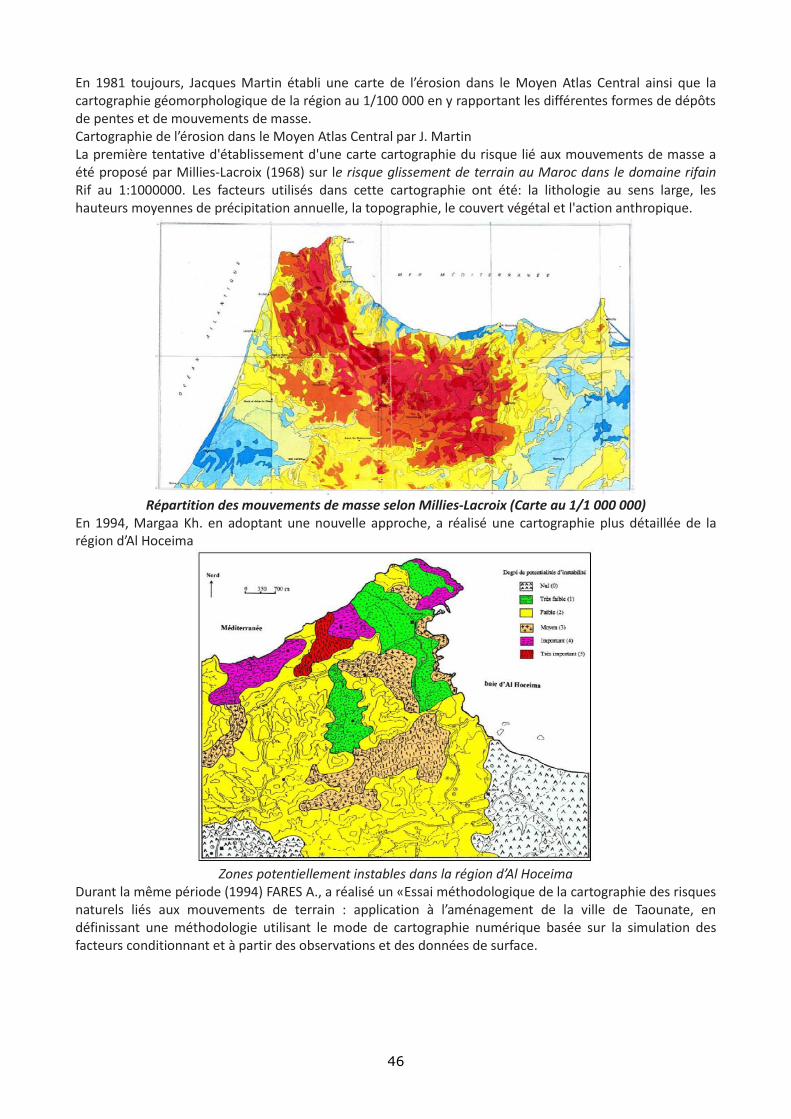
46
En 1981 toujours, Jacques Martin établi une carte de l’érosion dans le Moyen Atlas Central ainsi que la cartographie géomorphologique de la région au 1/100 000 en y rapportant les différentes formes de dépôts de pentes et de mouvements de masse. Cartographie de l’érosion dans le Moyen Atlas Central par J. Martin La première tentative d'établissement d'une carte cartographie du risque lié aux mouvements de masse a été proposé par Millies-Lacroix (1968) sur le risque glissement de terrain au Maroc dans le domaine rifain Rif au 1:1000000. Les facteurs utilisés dans cette cartographie ont été: la lithologie au sens large, les hauteurs moyennes de précipitation annuelle, la topographie, le couvert végétal et l'action anthropique.
Répartition des mouvements de masse selon Millies-Lacroix (Carte au 1/1 000 000)
En 1994, Margaa Kh. en adoptant une nouvelle approche, a réalisé une cartographie plus détaillée de la région d’Al Hoceima
Zones potentiellement instables dans la région d’Al Hoceima
Durant la même période (1994) FARES A., a réalisé un «Essai méthodologique de la cartographie des risques naturels liés aux mouvements de terrain : application à l’aménagement de la ville de Taounate, en définissant une méthodologie utilisant le mode de cartographie numérique basée sur la simulation des facteurs conditionnant et à partir des observations et des données de surface.

47
Fares A., (1994) : Cartographie du risque lié aux mouvements de terrain dans la région de Taounate
En 2005, SOSSEY ALAOUI établi une carte de l’aléa lié aux glissements de terrains au niveau du Rif septentrional.
SOSSEY ALAOUI (2005) : Carte de l’aléa lié aux glissements de terrain dans la péninsule de Tanger
REFERENCES AVENARD J-M., (1965) – L’érosion actuelle dans le bassin du Sebou. Rapport de l’Institut National de Recherche Agronomique, Rabat, 114 p. CHACON J., (1995) – Mouvements de versants et risques associés dans les cordillères de la Méditerranée occidentale. Program. Med. Campus "ETAGE ", Marrakech, Maroc, 20 p.

48
EL GHARBAOUI A., (1981) – La terre et l'Homme dans la péninsule tingitane. Etude sur l'Homme et le milieu dans le Rif occidental. Travaux de l’Institut Scientifique, série Géologie et Géographie Physique, Rabat, n° 15, 439 p. EL KHARIM Y., (2002) – Etude des mouvements de versants dans la région de Tétouan (Rif occidental): Inventaire, analyse et cartographie. Thèse de Doctorat Es-Sciences, Université Abdelmalek Essaadi, Tétouan, Maroc, 250 p. FARES A., (1994) – Essai méthodologique de la cartographie des risques naturels liés aux mouvements de terrain. Application à l'aménagement de la ville de Taounate (Rif, Maroc). Thèse de Doctorat, Université de Franche Comté, 177 p. HIMMI M., ET BENBOUZIYANE J., (1995) – Analyse générale du phénomène des glissements de terrains au nord du Maroc. L'ampleur, les causes et les remèdes pour le réseau routier. Séminaire "Glissements de terrain. Cas des talus du Rif', Ecole Hassania des Travaux Publics., Casablanca, Maroc. MARGAA KH., (1994) – Essai de cartographie des risques naturels : application à l'aménagement de la région d'Al Hoceima (Rif, Nord-Maroc). Thèse Doctorat, Université de Franche-Comté, 196 p. MARTIN J., (1981) – Le Moyen Atlas Central. Etude géomorphologique. Note et Mémoires du Service Géologique N° 258 bis. Ed. Serv. Geol. Maroc, 446p, 31 planches photo, 5 cartes géomorphologiques au 1/100 000. MAURER G., (1968) – Les montagnes du Rif central, étude géomorphologique. Thèse d’état, Université de Paris, 500 p. MILLIES-LACROIX A., (1965) – L'instabilité des versants dans le domaine rifain. Revue Géomorphologie Dynamique, Vol. XV, n° 7, 8, 9, p. 97-109. MILLIES-LACROIX A., (1968) – Les glissements de terrains. Présentation d'une carte prévisionnelle des mouvements de masse dans le Rif (Maroc septentrional). Mines et Géologie, n° 27, p. 45-55. Secrétariat d’Etat auprès du Ministère de l’Energie, des Mines, de l’Eau et de l’Environnement chargé de l’Eau et de l’Environnement, Département de l’Environnement, Direction de la Surveillance et de la Prévention des Risques 2008 : ETUDE POUR LA REALISATION D’UNE CARTOGRAPHIE ET D’UN SYSTEME D’INFORMATION GEOGRAPHIQUE SUR LES RISQUES MAJEURS AU MAROC. MISSION 1 : IDENTIFICATION DES RISQUES LES GLISSEMENTS DE TERRAIN, ETUDES ET MESURES LES 5 DOMAINES, 48 p.

49
ASSESSING DROUGHT RECURRENCE USING NONLINEAR APPROACH
DURATION : 2014 2015 2014 – 2015 TARGET COUNTRIES : Algeria, Azerbaijan, Belgium, Bulgaria, Cyprus, France, Georgia, Germany, Greece,San Marino, Luxemburg, Italy, Malta, Armenia, Moldova, Ukraine, Morocco, Portugal, Romania, Russian Federation, France, “the former Yugoslav Republic of Macedonia”, Spain, Turkey
PARTNERS INVOLVED :
COORDINATING CENTRE : GHHD Tbilisi, Georgia
OTHER CENTRES: ECMHT Baku, Azerbaijan , CRSTRA Biskra, Algeria , AFEM Ankara, Turkey , ECFF Athens, Greece
OTHER PARTNERS :
2014 WORK PACKAGES GHHD, Georgia Work package 1 Description: Collecting weather (temperature and precipitation) electronic time series from 10 meteorological stations in Georgia for the last 60 years. Associated deliverables: Compilation of database of electronic time series on temperature and precipitation from 10 meteorological stations in Georgia for the last 60 years. Work package 2 Description: Collecting statistical data on the droughts in the same time period. Testing linear/nonlinear methods of time series analysis for establishing the temporal pattern of droughts. Associated deliverables: Establishing the temporal pattern of droughts in Georgia in pre-industrial and post-industrial periods using a toolbox of linear/nonlinear methods
CRSTRA, ALGERIA Work package 1 Description: Collection of weather (temperature and precipitation) electronic time series for the last 60 years from 10 meteorological stations in Algeria. Acquisition et mise à disposition de base de données relative aux températures et aux précipitations sur la plus longue série possible pour une dizaine de stations. Associated deliverables: Les données seront transmises à GHHD Tbilissi, les analyses des données climatiques relatives au terrain d’étude Algérie. Celui-ci est retenu comme référence pour sa variabilité climatique. L’échantillonnage de base est composé de 10 stations. Work package 2 Description: Collection of statistical data on the droughts in Algeria over the same time period. Associated deliverables: Electronic data sent to the GHHD
ECMHT, AZERBAIJAN Work package 1 Description: Collection of weather (temperature and precipitation) electronic time series for the last 10 years from 10 meteorological stations in Azerbaijan. Associated deliverables: Electronic data sent to the coordinator Work package 2 Description: Collection of statistical data on the droughts in Azerbaijan over the same time period. Associated deliverables: Electronic data sent to the coordinator

50
ECPFE, GREECE Work package 1 Description: The Greek contribution to the specific task will include a time series of 118 years of required data (max temp, precip) for Athens and relevant time series from 5-10 stations spread in Greece (since the 50s, the final number of stations meeting the criteria of long time series and "arid area" characteristics needs to be determined). Additional information concerning the final number of stations will be submitted, parameters included and other possible related material, as well as the time needed for data collection, QC, and preparation of a data basis in the required form. Associated deliverables: Report sent to the coordinator
2014 RESULTS GEO The project is oriented to analysis of long enough time series of precipitation in 4 countries in order to find retrospectively the meteorological drought periods (i.e. prolonged period with less than average precipitation and high temperature) in order to infer the recurrence rate of droughts. The participants of the project were informed several times on the format of the data needed for analysis, but the meteo-data are obtained only from Algeria. Up to now we have the long enough time series (150 years) of precipitation and temperature in Georgia and 1988-2013 from Algeria. We intend to calculate The Standard Precipitation Index (SPI) or the Palmer Drought Severity Index to measure the duration and intensity of the long-term drought-inducing patterns as well as they persistency/anti-persistency. Drought is a major natural disaster that can have considerable impacts on society, the environment and the economy. In Europe alone, the cost of drought over the past three decades has amounted to over 100 billion Euros. By the end of this century, droughts in Europe are expected to be more frequent and intense due to climate change and increased water use (Forzieri, G. et al Hydrol. Earth Syst. Sci., 18, 85–108, 2014). Long-standing result from global-coupled models has been a projected increase in summer drying in the mid-latitudes in a future, warmer climate, with an associated increased likelihood of drought. Summer dryness is expected to increase in the Mediterranean, Central and Southern Europe during the 21st century, leading to enhanced risk of drought, longer dry spells and stronger soil-moisture deficits. In order to assess drought occurrence it is necessary to have a definition of drought. If the weather pattern lasts a short time (say, a few weeks or a couple months), the drought is considered short-term. But if the weather or atmospheric circulation pattern becomes entrenched and the precipitation deficits last for several months to several years, the drought is considered to be a long-term drought. We intend to calculate widely accepted Standardized Precipitation Index (SPI) is a probability index that considers only precipitation. The SPI is an index based on the probability of recording a given amount of precipitation, and the probabilities are standardized so that an index of zero indicates the median precipitation amount (half of the historical precipitation amounts are below the median, and half are above the median). The index is negative for drought, and positive for wet conditions. As the dry or wet conditions become more severe, the index becomes more negative or positive. The SPI is computed by for several time scales, ranging from one month to 24 months, to capture the various scales of both short-term and long-term drought. Georgia: The drought recurrence probability is high enough in Georgia – in some regions it reaches 40%. Droughts occur most notably in the Kakheti, Shida Kartli and Imereti regions. The 2000 drought in Kakheti and Kvemo-Kartli regions affected 696,000 people and caused economic loss of $200 million. In the recent past, drought cycle for Georgia has changed from 15-20 years to 6 years. Over the period 1995 to 2009, droughts inflicted on agriculture reported economic loss of 400 million GEL. Algeria: Reconstruction of drought severity index for the region from 1456-2002 by analysis of tree ring records show that a single drought year occurred between 12 and 16 times per century, although the number for the 20th century was 19.

51
Greece: The short-time drought occurrence in Greece is high – of the order of 1 per year. From the estimation of the SPI on 3- , 6- and 12-months-time scales shows that the frequency of mild and moderate drought conditions is approximately of the same order of magnitude over the whole Greek territory. On 6- and 12-months-time scales it was found that in almost all cases and for both time scales, the persistence is statistically significant. Turkey: As a semi-arid country, Turkey is already familiar with this concept. It went through extremely dry periods in the years 1928-1930, 1950-1951, 1973-1974, 1988-1989, 1994-1996, 2000-2001 and 2006-2008.The official figures point at a significant increase in not only the frequency, but also the intensity of droughts in the country and with global climate change affecting the Mediterranean basin in particular, it seems even drier days await Turkey. Data The data necessary for analysis should be presented by participants in the following form:
Station (name, coordinates)
Year Month, day
Max. Temperature
Precipitation Drought information (if available, econ. losses)
Remarks (if available, drought severity index)
Methodology The approach to be used is illustrated below on the precipitation data from Georgia. Why is it necessary to use nonlinear dynamics tools for climate change studies? The matter is that atmospheric flows, an example of turbulent fluid flows exhibit signatures of nonlinear dynamics and chaos. They are characterized by self - similar fractal fluctuations of all space - time scales ranging from weather scale of days and month to climate scales tens and more years. Such types of dynamics of natural processes, when forming patterns have different character on different time and space scales, is too complex to be described by traditional (linear) statistical methods. Besides potential of scaling analysis, nonlinear dynamics reveals hidden nonlinear structures in sequences, which at the first glance seem to be random, in other words, reveal order in seemingly disordered data. As a rule such complex dynamics is difficult to be quantified. Fortunately in the last years new methods were developed, which allow to range quantitavely different levels of complexity allowing detection, identification and ordering from fully random (white noise) to more ordered types of systems behavior. Thus used nonlinear dynamics tools give new important quantitative information on climate patterns – the degree of order in climatic time series, long-term correlations and their variation with space and time scales, the recurrence of extreme events and on their persistence or anti-persistence . In order to quantify scaling features in temperature data sets we’ll use method of Detrended Fluctuation Analysis - DFA [Peng, et al. 1994, 1995] as well as Recurrence plots (RP) and Recurrence Quantitative Analysis (RQA). The Standardized Precipitation Index (SPI) We started from traditional method of Standardized Precipitation Index (SPI) calculation often used to detect drought and wet periods at different time scales. SPI becomes important characteristic because droughts affect a large number of people worldwide and cause tremendous economic losses, environmental damage and social hardships. As mentioned above among other indices developed to monitor droughts (Palmer, 1965; Gibbs, 1987; McKee et al., 1993; Meyer et l., 1993) calculation of SPI is most convenient. Computation of the SPI begins with building a frequency distribution from precipitation data at a location for a specified time period. In our case we selected time period from 1956 to 2006 for Tbilisi. For this period quality of daily precipitation data is best comparing to earlier data bases what was important because the calculation of the SPI requires that there is no missing data in the time series. As usual gamma probability density function was fitted to the precipitation data and the cumulative distribution of precipitation was determined. Next equiprobability transformation was made from the cumulative distribution to the standard normal distribution with a mean of zero and variance of one. This procedure gives the SPI (Edwards and McKee, 1997). Generally the SPI can be computed for any time

52
period, we started from 1-month window. These monthly SPI values we analyzed for the entire period of observation as well as for consecutive 10 year windows.
Fig. 4.1. Histogram of frequency of occurrence of one month SPI values for Tbilisi in 1957-2006.
We see in Fig. 4.1, that SPI have maximum at positive values what may be regarded as indication of prevalence of wet events for this time period.
Fig. 4.2. Histogram of frequency of occurrence of one month SPI values for Tbilisi for consecutive 10 year
windows. In Fig.4.2, results of calculation of frequency of SPI occurrence for the 10 year windows is presented. We see prevalence of wet events and just in the last analyzed window (1997-2006) dry events become to prevail. This may be regarded that for last decades chances for drought increases for Tbilisi location. Detrended fluctuation analysis (DFA) Next we proceed to DFA analysis. This is well known method to quantify long-range time-correlations in the investigated data sets [Peng, et al. 1993]. This technique provides a quantitative parameter (DFA scaling exponent) that gives information about the correlation properties of analysed nonstationary data sets. In DFA, the time series x(k) (of length N), is firstly integrated and the so-called “profile” Y(i) is determined. Then Y(i) is divided into boxes of size n, and in each box of length n, the polynomial local trend Yn(i) is calculated and removed from the profile. The root mean square fluctuation of the integrated and detrended series is then calculated:
Frequency of occurence of SPI values(1957-2006)
0
0.05
0.1
0.15
0.2
0.25
-4 -3 -2 -1 0 1 2 3 4
SPI
Fre
qu
en
cy
of
oc
cu
rre
nc
e
Frequency of occurence of SPI values, 10 year windows; 1957-1966(red), 1967-1976(blue),1977-1986(yellow), 1987-1996(green),
1997-2006(pink).
0
0.02
0.04
0.06
0.08
0.1
0.12
0.14
0.16
0.18
0.2
-3.5 -2.5 -1.5 -0.5 0.5 1.5 2.5 3.5
SPI
Fre
qu
en
cy o
f o
ccu
rren
ce

53
2
1
)()(1
)(
N
i
n iYiYN
nF
This process is repeated for all the available scales (box sizes n). If the relationship between F(n) and n is a power-law, the signal is fractal: Scaling exponent α = 0.5 corresponds to white noise while α>0.5 correspond to persistent behavior accordingly [Peng, 1993]. In Fig. 3 results of DFA analysis of monthly rainfall data is presented.
Fig. 3. DFA analysis of rainfall data for Tbilisi, 1957-2006.
We see that rainfall data for Tbilisi shows changed dynamics for considered time period. Clear trend of shift to less persistent behavior is indicated with min (i.e. closest to randomness) in 10 year window prior to mentioned above shift to the prevalence of dryer events in SPI. References Edwards DC, McKee TB. 1997. Characteristics of 20th Century Drought in the United States at Multiple Time Scales. AtmosphericScience Paper No. 634; 1–30. Palmer WC. 1965. Meteorological drought. US Department of Commerce Weather Bureau Research Paper No. 45. Gibbs WJ. 1987. A Drought Watch System. World Climate Programme. WMO/TD No. 193, wcp-134; 1–22. McKee TB, Doesken NJ, Kleist J. 1993. The Relationship of Drought Frequency and Duration to Time Scales. Proceedings of the Eighth Conference on Applied Climatology. American Meteorological Society: Boston; 179–184. Meyer SJ, Hubbard KG, Wilhite DA. 1993. A crop-specific drought index for corn: I. Model development and validation. Agronomy Journal 86: 388–395. Peng, C. K., J. Mietus, J. Hausdorff, S. Havlin, H. E. Stanley, and A. L. Goldberger (1993), Long-Range Anticorrelations and Non-Gaussian Behavior of the Heartbeat, Phys. Rev. Lett. 70, 1343-1346. AZE The best criterion to define the level of drought is to identify the humidity of soil. One of the areas in mountainous regions distinguished for its aridity is the South-East end of Zagatala zone. As the height increases, the decrease in evaporation and the increase of rainfall reduces the probability of the drought. However, in some cases, the drought can be found even in alpine-steppe. In total, the approximate area of drought territories is up to 30 thousand km2. During the drought the air temperature and indicators of humidity deficiency are significantly high, at around 1 pm the temperature observed is 4-50C higher than annual rate, and the actual temperature for mountainous districts is 25-300C. Wind is low during drought due to the presence of anticyclone type of weather. However, in some cases, dry winds of 10-15 m/s speed can be observed. Drought is a natural phenomenon and it occurs as a result of prolonged humidity deficiency. Droughts are defined in three main ways.
DFA of monthly precipitation data, Tbilisi 1957-2006; 10 year windows
0.5
0.55
0.6
0.65
0.7
0.75
0.8
0.85
0.9
0.95
1955 1960 1965 1970 1975 1980 1985 1990 1995 2000
year( window start)
DF
A e
xp
on
en
t

54
1. Meteorological drought is brought about when there is a prolonged period with less than average precipitation. Although it was not a serious problem in Greater Caucasus before, now the climate change increased the risk of its generation. Meteorological drought also damages water supply of forests significantly. As a result, chestnut-trees and oak-trees dry gradually in central and lower mountainous areas.
River station Annual flow
Minimum summer flow
Minimum winter flow
Maximum flow
K R% K R% K R% K R%
1966
Ayrichay – BashDashagil Damarchik outfall
0.71 0.72
78.7 89.4
0.74 0.74
73.5 80.0
0.61 0.74
81.6 88.0
0.62 0.37
53.3 45.8
1971
Ayrichay – BashDashagil Damarchik outfall
0.78 0.62
72.3 96.1
0.66 0.58
79.6 94.7
0.78 0.66
71.4 96.4
0.59 2.40
55.6 12.5
Table 1 - Impact of Meteorological Drought to River Flow 2. Hydrological drought is brought about when the water reserves available in sources fall below the statistical average or when there is no water in riverbeds for prolonged period. Hydrological drought occurs in the area mainly from the end of June until the beginning of September, due to the fact that this is intensive irrigation period, it causes serious water deficiency. Hydrological drought is related to climate change and meteorological drought. Along with reducing snow in mountains, increase of temperature in winter months also causes the early start of high-flow period. So, the snowmelt process ends by the end of June, and hereby the amount of water in the river severely decreases or completely dries out. Sometimes hydrological drought period in the rivers can last up to 7-8 months. In this period the river flow constitutes 20-30% of annual flow. Therefore, water use is limited for a significantly long period during the year. As mentioned above, water scarcity occurs as a result of meteorological and hydrological drought. Water scarcity is defined as the lack of available water resources to meet the daily domestic and economic water demands of a certain region. It increases the weakness of the communities. In essence, water scarcity is divided into physical and economic water scarcity. 1. Physical water scarcity is characteristic for all the villages away from the river-bed. This problem is found in a number of villages of Zagatala and Oguz districts. Increase of temperature in summer months decreases precipitation, hereby resulting in reduction of water in the rivers and severe decrease of water in rivers, drying out of springs and therefore, there is water scarcity in summer months. The population has troubles with watering cattle and daily water supply. 2. Economic water scarcityis defined as the problems generated due to the lack of water supply of the communities for economic reasons. It can happen even in the regions with many water resources. Due to the fact that the region has a multiple number of problems, systematic approach is needed to solve them. Particular adaptation and mitigation strategies reducing the impacts of climate change need to be worked out for each river. Therefore, we offer taking complex measures to study these problems more deeply. These measures could include cultivation of more drought-tolerant plants, save on water (this could be achieved by training the population), reducing the risk of disaster through the effective environmental management and systematic efforts by elaborating the factors causing disasters and increasing the readiness level of the population, improvement of readiness for flood and drought, raising awareness of executive powers and municipalities, raising public awareness (conducting trainings for people to understand the importance of forests and water resources better).

55
ANALYSIS OF PRECIPITATION IN AZERBAIJAN ON MONTHLY BASIS Depending on orographic features, influence of air masses entering the territory of the country and local circulation between the Caspian Sea and dry area, variability of monthly, seasonal, annual and daily maximum precipitation is very big. The highest rainfall in the territory of the Republic falls to Lankaran Natural-economic zone (1600-1800 mm) and the lowest rainfall is in Absheron and Kur-Araz (200-350 mm). Annual average precipitation constitutes 477 mm. The maximum daily rainfall was recorded in Bilasar station of Lankaran in 1955 (334 mm). The rate of annual precipitation in Balakan-Zagatala region changes between 1000-1600 mm. On the Southern slope of Greater Caucasus, in Shamakhi annual average precipitation is 600-1000 mm. In comparison with annual rates (1961-1990), monthly rainfall rates for 1991-2012 as influenced by the climate change are as follows.
Table 1 Changing tendency of precipitation in 1991- 2012 in comparison with the period of 1961 -1990 (standard
rates) (monthly, %)
Stations: Months
I II III IV V VI VII VIII IX X XI XII
Mashtagha -10 21 -25 -30 -17 -19 67 -35 33 -3 50 18
Oil Rocks -25 -44 -41 -25 -39 -30 -56 -53 -19 -14 4 -38
Astara -9 29 -7 -7 14 1 -4 -25 -7 -25 20 -9
Bilasuvar -22 -10 -3 -18 18 -35 -5 -61 15 -5 11 -19
Jafarkhan -15 -4 4 -19 -3 -34 -3 -11 24 -34 14 -31
Yevlakh -1 -28 44 -13 -18 -38 -19 -19 42 -52 -21 -2
Gadabay -21 -3 4 8 -8 -8 2 -5 12 -18 7 -37
Ganja +15 -33 +20 -20 -12 -18 -36 -16 +36 -35 +40 -16
Agstafa -43 -2 4 8 -10 -18 -34 -10 35 -16 26 4
Shaki -11 -6 -1 -9 -5 12 -20 5 16 -37 18 -6
Alibay -13 12 14 4 -2 3 1 20 40 -11 20 2
Altiagaj -16 18 -3 -35 -3 -14 -9 -17 -13 -2 24 -12
Guba -11 29 -4 -33 -16 -14 -13 22 18 5 19 11
Giriz -29 0 -2 -34 -20 -23 -29 -10 31 -14 36 -17
In January and February, excluding only a few stations, the amount of precipitation reduced between 1-44%, while in March in the areas excluding Absheron Peninsula, Lankaran, the Southern part of Kura-Araz Lowlands and Greater Caucasus, the increase in precipitation amount was observed. In April and May excluding a few stations, the general decrease trend with different intensiveness rates was marked in precipitation. In June, July and August the decrease of rainfall was observed in most of the areas. In September excluding only two areas, the precipitation increased, while in October it started to reduce, and increase again with different intensiveness rates in November. In December the rainfall increased at some stations, while decreasing at the others. Statistically significant decrease was recorded only at Gadabay station.
Table 2 Changing tendency of precipitation in 1991- 2012 in comparison with the period of 1961 -1990 (standard
rates) (seasonal, %)
Stations Seasons Year
Winter Spring Summer Autumn
Mashtagha 8 -25 -11 25 4
Oil Rocks -38 -35 -54 -7 -29
Astara 3 -2 -14 -8 -7
Bilasuvar -17 -3 -38 5 -8
Jafarkhan -18 -6 -38 -6 -13
Yevlakh -15 -2 -30 -19 -16
Gadabay -17 -4 -2 -3 -5

56
Ganja -13 -8 -23 2 -12
Agstafa -9 0 -21 10 -6
Shaki -8 -5 0 3 -4
Alibay 0 5 8 15 8
Altiagaj -3 -16 -12 0 -9
Guba 10 -19 -3 14 0
Giriz -9 -21 -21 14 -13
Distribution of Precipitation at Various Heights and Their Comparison with Multi-annual Norm
(1961-1990) X mm
Years Heights, m Within the territory of
the Republic 0 0 - 200 201-500 501-1000 1000
Norm 1961- 1990
334,5
327.5 478.0 534.3 639.7 476,5
Average annual 2006
390.1 321.7 436.8 592.4 569.7 462.3
Difference, mm 55.6 -5.8 -41.2 58.1 -70 -14.2
Average annual 2007
313.1 319.8 540.5 623.1 664.2 492.8
Difference, mm -21.4 -7.7 62.5 88.8 24.5 16.3
Average annual 2008
340.4 298.3 307.2 681.9 644.3 445.1
Difference, mm 5.9 -29.2 -170.8 147.6 4.6 -31.4
Average annual 2009
372.8 396.3 471.0 551.2 650.2 482.6
Difference, mm 38.3 68.8 -7 16.9 10.5 6.1
Average annual 2010
364.5
396.9 450.7 766.1 619.3 527.0
Difference, mm 30.0 69.4 -27.3 231.8 -20.4 50.5
Average annual 2011
512,4
451,2
459,0
822,3
782,3
563,3
Difference, mm 177.9 123.7 -19.0 288.0 142.6 86.8
Average annual 2012
348,5 298,2 347,9 628,4 689,7 453,0
Difference, mm +14,0 -29,3 -130,1 +94,1 +50,0 -23,0
GRE The relevant data are being elaborated by a special team of the National Observatory of Athens. This team with scientific responsible Dr Gerasopoulos, communicates relatively with the EC of Georgia.

57
GLOBAL CHANGE, CULTURAL HERITAGE AND SMART CITIES
DUREE : 2014 – 2015 PAYS VISES: All countries
PARTENAIRES IMPLIQUES :
CENTRE COORDINATEUR : CUEBC Ravello, Italy
AUTRES CENTRES: ICoD La Valletta, Malta
AUTRES PARTENAIRES : ISTITUTO DI SCIENZE DELL'ATMOSFERA E CLIMA (ISAC), CNR-Italy
2014 WORK PACKAGES
CUEBC, ITALY Work package 1 Description: High level training “The future of cultural heritage in smart cities” for scientists, urban planners, engineers, architects, cultural heritage managers focused on pressure of climate and air quality on materials and structures, impact of green economy (including construction, energy and mobility) on cultural heritage and use of ICT for tourism management. Associated deliverables: Minutes of the course Work package 2 Description: Edition of the content of the last 4 Courses on the subject (2010 to 2013). Associated deliverables: Publication of a book
CRSTRA, ALGERIA Work package 1 Description: Intervention au cours de Ravello sur le thème « Bâtir en milieu aride ». Associated deliverables: Mise à disposition du cours sur le site du Centre de Ravello.
2014 RESULTS Rapport sur le Cours Doctoral Européen “THE FUTURE OFCLIMATE CHANGE IN SMART CITIES” (Centre Universitaire Européen pour les Biens Culturels, Ravello, Italie du 6 au 8Octobre 2014) Le 23ème cours de la série « Sciences et Matériaux du Patrimoine Culturel » avait pour thème l’adaptation des villes intelligentes aux risques du changement climatique pour leur patrimoine culturel dans le futur. Ce cours a duré 3 jours, du 6 au 8 octobre 2014. Il aété dispensé intégralement en anglais et a rassemblé 23étudiants. L’origine géographique de ces étudiants était variée :Italie : 13 ;République Tchèque : 3 ; Turquie : 2 ; Israël : 1 ; Algérie : 1 ; Bulgarie : 1 ; Malte : 1 ; Allemagne : 1. Un équilibre a donc été trouvé entre la participation italienne, traditionnellement forte dans ces cours, et la participation extra-italienne. Eugenia Apicella, Secrétaire Générale du CUEBC, a introduit les cours par une allocution de bienvenue présentant le Centre de Ravello et ses activités. Cristina Sabbioni, co-directrice du Cours et directrice de l’Institut des Sciences de l’Atmosphère et du Climat (ISAC) du CNR à Bologne, a donné le premier cours intitulé « Does the concept of smart citiesinclude Cultural Heritage ? ». Gianluca Casagrande, de la Société Géographique Italienne, a parlé de « Smart cities in Rome : between experience and proposals ». Cristina Sabbioni a fait une seconde intervention sur le thème : « Climate Change and Air Quality : impact on Cultural Heritage ».

58
A.Bonazza, chercheuse à l’Institut des Sciences de l’Atmosphère et du Climat (ISAC) du CNR à Bologne, a ensuite parlé sur « Mitigation and adaptation strategies for Cultural Heritage resilence in smart cities ». Luigi Dei, de l’Université de Florence, a montré le rôle important des « Nanosciences and nanotechnologies for Cultural Heritage conservation in smart cities ». Casimir Iwaszkiewicz, co-directeur de « C&I Associates » de Londres, a esposé les « Learning lessons from past : why historic cities are smart cities, including renewable energy ». Ottorino Veneri, de l‘IstitutoMotori du CNR de Naples, a parlé des « Smart cities and transport ». Dario Camuffo, directeur de recherche émérite à l’ISAC-CNR à Padoue, a ensuite traité de « Indoor management for Cultural Heritage ». Milos Drdacky, directeur de l’Institut de Mécanique Théorique et Appliquée de l’Académie Tchèque des Sciences à Prague, a développé les concepts de « Built Heritage resilience and adaptation in face of floods and landslides » J. Cassar, de l’Université de Malte,a donné le dernier cours sur « Adaptation strategies for archaeological sites ». Tous ces exposés théoriques ont été complétés par un atelierpratique intitulé « Case studies : how towns may evolve in smart cities including Cultural Heritage as an added value ? » dirigé par A. Bonazza, C. Iwaszkiewicz et C. Sabbioni, à la fin duquel les étudiants, divisés en groupes de travail, ont présenté oralement leurs propositions de réponses à cette question. L’ensemble du Cours doctoral s’est déroulé dans d’excellentes conditions grâce à la qualité des échanges entre professeurs et étudiants. 23 Students participated to the course: 13 from Italy: Giulia NOCELLA Cesano Maderno, Italy Arianna VIVARELLI ISAC-CNR Padova, Italy Amedeo BRICHESE Politecnico di Milano,Italy Giuliana CAPASSO Padua, Italy Francesca CASINI University Tor Vergata, Roma, Italy Marianna D'ANGIOLO University of Naples “Federico II”, Italy Giulia FACELLI Roma, Italy Silvia FORLATI Verona, Italy Federica GRECO Ancona, Italy Shahryar HABIBI University of Ferrara, Italy Anahita LOHRASBI University of Ferrara, Italy Rachele MANGANO Bologna, Italy Valeria MARZO Milan, Italy 10 from other countries: Toufik HADRI CRSTRA , Biskra, Algeria Nadya VLADIMIROVA Sofia, Bulgaria Riccardo CACCIOTTI Institute of Theoretical and Applied Mechanics, Prague, Czech Republic Anna MORDANOVA Prague, Czech Republic Magdaléna ZÁLEŠÁKOVÁ Brno, Czech Republic Elena SMIRNOVA Bauhaus University Weimar, Germany Rony BETZER Nahalal, Israel Sharon SULTANA National Museum of Archaeology, Heritage Malta Rabia SENGUN ITU-Istanbul Technical University, Turkey Nazan YUCEL Istanbul, Turkey

59
COUPLING TERRESTRIAL AND MARINE DATASETS FOR COASTAL HAZARD ASSESSMENT & RISK REDUCTION IN CHANGING ENVIRONMENTS
DURATION: 2014 – 2015 TARGET COUNTRIES : Euro-Mediterranean countries
PARTNERS INVOLVED :
COORDINATING CENTRE : ICoD La Valletta, Malta
OTHER CENTRES: CERG Strasbourg, France
OTHER PARTNERS: Università di Modena e Reggio Emilia (UNIMORE, Italy), Université de Caen Basse-Normandie (UNICAEN, France), Consiglio Nazionale delle Ricerche: Istituto di Scienze Marine (ISMAR, Bologna, Italy); CNR-IRPI (Padua, Italy)
2014 WORK PACKAGES ICoD, Malta Work package 1 (CERG< ICOD< MODENA) Description: Continued work on integration of various sources of terrestrial and marine datasets building on previous (2011/2012) work in Malta and Normandy Deliverable: Production of a geomorphological map including underwater and emerged areas of study and the production of a scientific paper on this topic Associated deliverable: Production of an end-user leaflet addressing the 'Interest of the terrestrial and marine continuum knowledge for the detection of relationships between foreshore and shallow seabed (or between underwater and emerged areas). Work package 2 (CERG< ICOD< MODENA) Description: Organisation of a 2-day workshop to identify a clear procedure for the development of hazard maps, integrating sea level rise and the anthropic impacts for both rocky coast environments and sandy beaches. Deliverable: workshop report. Associated deliverable: Electronic leaflet describing the agreed methodology. Work package 3 (CERG< ICOD< MODENA) Description: Extension of current monitoring programme of coastal processes in the context of related erosion and landslide hazards. The collection of data on a long time-span is crucial to better understand coastal processes (erosion vs landslides) and distinguish between short-term (seasonal) and longer-term trends. Deliverable: data collection and reports demonstrating to end-users the advantages of individual methodologies for coastal risk management, with ICoD focusing on beach erosion monitoring, Modena (in collaboration with CNR-PD) on landslide GPS monitoring and CERG and the University of Caen (in collaboration with colleagues from Brest and Lausanne) on Laser techniques survey (MLS and TLS) of landslides. Associated deliverable: Leaflet for end-users on 'Interest of monitoring using laser techniques (ALS, TLS & MLS -aerial, terrestrial and mobile-) to quantify the dynamic of the rocky coast (erosion and landslides)'.
CERG, Strasbourg Work package 1 Description: Integration of the new terrestrial and marine datasets with historical information Associated deliverables: Dissemination of the database on a website Work package 2 Description: Construction of coastal hazard maps for the study case

60
Associated deliverables: Easy to read leaflet for end users to present the hazard assessment methodology Work package 3 Description: Monitoring programme of coastal processes Associated deliverables: Guidelines for monitoring coastal processes
UNIMORE, Italy Work package 1 (in collaboration with ICoD and CERG) Description: Continued work on the integration of various sources of terrestrial and marine datasets, with special reference to the Maltese archipelago. Associated deliverables: Production of thematic maps including underwater and emerged areas of studied areas in Malta and production of a scientific paper on this topic (in collaboration with CNR-ISMAR). Work package 2 (in collaboration with ICoD and CERG) Description: Organisation of a 2-days workshop to identify a clear procedure for the development of hazard maps, integrating sea level rise and the anthropic impacts for both rocky coast environments and sandy beaches. Associated deliverables: workshop report (UNIMORE will contribute to the overall report, with special reference to landslide hazard). Work package 3 (in collaboration with ICoD and CERG) Description: Extension of current monitoring programme of coastal processes in the context of related erosion and landslide hazards. The collection of data on a long time-span is crucial to better understand coastal processes (erosion vs landslides) and distinguish between short-term (seasonal) and longer-term trends. Associated deliverables: data collection and reports addressed to end-users showing the advantages of an integrated approach for coastal risk management, with particular reference to landslides (in collaboration with CNR-PD).
2014 RESULTS MAL Work-package 1: Integration of terrestrial and marine data sets In order to outline the geomorphological evolution of the north-western area of the Island of Malta, the geology and morphology of the seafloor are required. The bathymetric survey provided both the morphological data and the backscatter data from the seafloor. The latter was analysed both manually and through the TexAn software (University of Bath, UK) producing a sediment coverage map (Figure 2). Moreover, some geological sections between land and seafloor were made providing a first attempt of geological map of the seabed.

61
Figure 2. Seafloor geological map of the NW area of Malta. The geology on land is provided by the
Geological map by Oil and Exploration Directorate (1993). Even without a ground-truthing through samples, the two maps (sediment coverage and geology) result to be consistent. Crossing them with the geomorphological interpretation, a geomorphological map of the seafloor was produced (Figure 3).
Figure 3. Geomorphological map of the North Western Maltese coastal sea floor.
Work-package 2: Workshop to identify a procedure for the development of hazard maps, integrating sea level rise and the anthropic impacts for both rocky coast environments and sandy beaches.

62
The project coordinator opened the meeting by thanking Prof Mauro Soldati for kindly offering to host and organize the logistics of this meeting. Following several presentations by each of the project partners and intense discussion, the group agreed that the best way forward in the generation of hazard maps is to adopt a stepped aproach that allows a larger geographic area to be addressed in a shorter time frame. This route to hazard mapping is via the development of ‘susceptibility maps’ that also consider cost-benefit issues of the number of people at risk, which can highlight priority action areas via the more in-depth hazard and subsequent risk maps (where a vulnerable element has been identified) and where development is being considered. Susceptibility maps reflect the probability of spatial occurrence of an instability event. These maps combine different spatial factors predisposing to a certain phenomenon/process, and outline areas more prone to the occurrence of a phenomenon/event. For example, a landslide susceptibility analysis combines factors such as slope, geology, rainfall, vegetation, aspect, etc. to produce a map showing where landslides are more likely to occur. No time factor is associated with a susceptibility map (unlike hazard maps which reflect the probability of occurrence in a specified period and within a given area of potentially damaging hazard of a given magnitude). Hazard maps therefore include a time frame/likelihood reference. In this context, one can see the sequence and sense of first preparing susceptibility maps for a given hazard prior to developing more complex hazard and subsequently, risk maps for areas either prioritised by the susceptibility maps e.g. where a vulnerable element is present, or where development is being considered. The subsequent risk maps will indicate the consequences of an event with a likelihood scale. For example, a 500-year flood hazard map may be used to develop a risk map with the 500-year flood indicating the number of buildings per km2 in a damaged state. Work package 3: Coastal monitoring A multipronged evaluation of beach sediment transport patterns has been launched at Ramla Bay on Gozo, Malta, via:
A series of 10 shore perpendicular beach profiles, (Figure 7).
A series of 9 sand-traps (four transects) installed to capture aeolian beach sediment transport over the beach, sand- dune and back-shore areas, (Figure 8).
An extension of the shore profiles to cover the underwater nearshore seabed, (Figure 9).
A study of beach sediment granulometry and pebble / cobble distribution/movement patterns, (Figure 10).
Results, data analysis and interpretation will be available towards the end of 2015 when the above measurements will be reproduced, thus allowing an annual / seasonal comparison of trends.
Figure 7: Ten shore perpendicular beach profiles

63
Figure 8. Beach sediment traps established to capture Aeolian sediment transport.
Figure 9: extension of the shore profiles to cover the near-shore seabed.
Figure 10: Bathymetric elevation obtained from nearshore sediment profiles. FRA Survey and monitoring of rocky coastal erosion using Laser techniques Dieppe coastal cliffs, Normandy Context: The aim of the Project “Coupling terrestrial and marine datasets for coastal hazards assessment and risk reduction in changing environments” of the EUROPA Major Hazards Agreement is the risk reduction in coastal areas thanks to the development of coastal hazards mapping procedures including the impact of sea level rise on coastal processes as a useful basis for multi-hazard assessment. One of the work
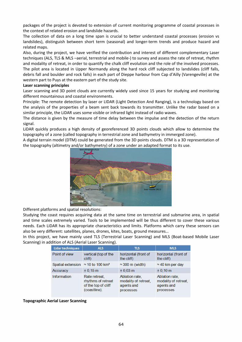
64
packages of the project is devoted to extension of current monitoring programme of coastal processes in the context of related erosion and landslide hazards. The collection of data on a long time span is crucial to better understand coastal processes (erosion vs landslides), distinguish between short term (seasonal) and longer-term trends and produce hazard and related maps. Also, during the project, we have verified the contribution and interest of different complementary Laser techniques (ALS, TLS & MLS –aerial, terrestrial and mobile-) to survey and assess the rate of retreat, rhythm and modality of retreat, in order to quantify the chalk cliff evolution and the role of the involved processes. The pilot area is located in Upper Normandy along the hard rock cliff subjected to landslides (cliff falls, debris fall and boulder and rock falls) in each part of Dieppe harbour from Cap d’Ailly (Varengeville) at the western part to Puys at the eastern part of the study site. Laser scanning principles Laser scanning and 3D point clouds are currently widely used since 15 years for studying and monitoring different mountainous and coastal environments. Principle: The remote detection by laser or LIDAR (Light Detection And Ranging), is a technology based on the analysis of the properties of a beam sent back towards its transmitter. Unlike the radar based on a similar principle, the LiDAR uses some visible or infrared light instead of radio waves. The distance is given by the measure of time delay between the impulse and the detection of the return signal. LiDAR quickly produces a high density of georeferenced 3D points clouds which allow to determine the topography of a zone (called topography in terrestrial zone and bathymetry in immerged zone). A digital terrain model (DTM) could be generated from the 3D points clouds. DTM is a 3D representation of the topography (altimetry and/or bathymetry) of a zone under an adapted format to its use.
Different platforms and spatial resolutions: Studying the coast requires acquiring data at the same time on terrestrial and submarine area, in spatial and time scales extremely varied. Tools to be implemented will be thus different to cover these various needs. Each LiDAR has its appropriate characteristics and limits. Platforms which carry these sensors can also be very different: satellites, planes, drones, kites, boats, ground measures… In this project, we have mainly used TLS (Terrestrial Laser Scanning) and MLS (Boat-based Mobile Laser Scanning) in addition of ALS (Aerial Laser Scanning).
Topographic Aerial Laser Scanning

65
Topographic Aerial Laser Scanning (ALS) provides to cover large areas (~ 50 km²/day) and get field data of high accuracy. The set of points obtained (several points/m2) has a decimeter precision (depending on the altitude of the plane) in latitude, longitude and altitude. Information is then transformed into Digital Terrain Model. If multiple surveys are realized, it will be able to compare the DTM, especially track over time the same geomorphological object (like the toe of the dune, the vegetation limit, the top of the cliff …), providing a quantification of changes of the coastline. For study the dynamics of the Upper Normandy coast, ALS allows to well observe and compare the position of the top of the chalk cliff, and define a cliff retreat rates. But the incidence angle is the key factor for point cloud density and accuracy (Michoud et al., 2014). ALS data have then high inaccuracy and lack of information on vertical areas due to unfavourable high incident angles. It is not possible to observe and quantify the evolution of the toe of the cliffs, or even the whole of the cliff face. Therefore, for vertical rocky coasts, ALS has to be associated with measurements made in ALS and MLS. Ablation rate of the front of cliff by Terrestrial Laser Scanning TLS provides a fine quantification (precision ~ 1-3 cm) of ablation rate, it’s to say all chalk debris fallen from the cliff face (scree or mass movement). These production of debris, are observed with difficulties by ALS, because the top of the cliff are not always and immediately affected even if mass movement is important. These ALS measures show also the spatial distribution of material departures, and propose information about the processes responsible of these movements. In Upper Normandy a diachronic survey by TLS was conducted between 2010 and 2013 every 4-5 months. This study is conducted on two sites, with close lithostratigraphic characteristics, but differently exposed to marine actions. Then, abandoned cliffs recede slower (6-8 cm/y) than active cliffs (24 cm/y, i.e. 3-4 times slower) confirming the high influence of marine actions on the regressive dynamics of the chalk cliffs. In the context of active cliff, scree movements represent 25% of the total retreat of chalk cliff over the studied period. This quantification is very fine but only representative of pilot site (200-300 meters). ALS and TLS measures have to be combined to a new method, boatbased mobile Laser Scanning. Landslides detection and monitoring Capability of Boat-based Mobile Laser Scanning A boat-based mobile LiDAR capability by scanning 3D point clouds of the unstable coastal cliffs has been tested in the pilot area. Methodology and development are given by Michoud et al., 2014. Three acquisition campaigns were performed in September 2012, 2013 and 2014, scanning (1) a 80-km-long shoreline and (2) the same test cliffs in different environmental conditions and device settings. By scanning during favourable meteorological and marine conditions and close to the coast, mobile LiDAR devices are able to quickly scan a long shoreline (40 km/day) with median point spacing up to 10cm. The acquired data are then sufficiently detailed to map geomorphological features smaller than 0.5m2. Furthermore, our capability to detect rockfalls and erosion deposits (>m3) is confirmed. Problems and further enhancements Following spatial and temporal scale adopted, laser techniques (ALS, TLS & MLS) allows to quantify the dynamic of the rocky coast (erosion and landslides). MLS survey appears like a reliable and rapid technique for regularly monitor the cliff dynamic. But at the high spatial and temporal scale, the processes have to be observing with the TLS (Terrestrial Laser Scan). At larger scales, ALS and MLS might thus be used as complementary techniques along long coastlines with successions of gentler and steeper topographies more adapted to resp. ALS and MLS devices (Michoud et al., 2014). MLS capabilities for accurate change detection and mass balance monitoring along subvertical coastlines at low costs (compared to ALS devices and flights) could really support: Bathymetric Aerial Laser Scanning - Cliff retreat rates assessments for different sectors, by automatically extracting surfaces affected by rockfalls, compared to the entire surface of kilometre-long scanned cliffs (Michoud et al., 2014); - Landslide modelling and to manage risks dealing with affected infrastructures and inhabitants. Further actions: For MLS, additional acquisitions should be performed in the North of the study area along gentler slopes to experiment the potential inputs of using both techniques. For the bathymetry, prospection with multibeam sounder is not always possible due to low deep of water, presence of dangerous blocks…

66
Also, the new bathymetric Aerial laser Scanning devices could be providing continuous terrestrial and submarine datasets. A test is planned in 2015. ITA Work package 3: Coastal monitoring The monitoring activity at Anchor Bay and Il-Qarraba is continuing and the most interesting results are from the Anchor Bay site, where GPS benchmarks, fissurimeters and tape-extensometers are installed. The GPS data elaborated so far indicates that the lateral spreading phenomena at Il-Prajjet site continue to be active and give deformation rates more significant than the other instruments. GPS results showed significant movements with a rate of displacement that can be considered with a good approximation quasi-constant. New benchmarks 109 and 110, installed in May 2013, recorded rates of planar displacement consistent with those registered previously by the monitoring network, although no significant height variation were measured so far. The displacements recorded are summarized by Figures 5 and 6 below.
Figure 5: Location of the GPS benchmarks. The arrows represent the direction of the planar deformations and their length and colour the displacement rate. Benchmark 106 has been calculated till last available
measurement of November 2012.
Figure 6: Location of the GPS benchmarks. The size and colour of the circles represent the rate of the vertical
deformation. Benchmark 106 has been calculated till the last available measurement of November 2012.

67
3.A. Policy studies

68
NATIONAL STRATEGIES FOR ALERTING AUTHORITIES AND POPULATION CONCERNING NATURAL AND TECHNOLOGICAL RISKS IN BALKAN COUNTRIES
DURATION : 2014 – 2015 TARGET COUNTRIES : Bulgaria, Croatia, Greece, FYROM, Romania, Serbia, Turkey PARTNERS INVOLVED : COORDINATING CENTRE : ECRP Sofia, Bulgaria OTHER CENTRES: ECPFE Athens, Greece , ECILS Skopje, FYROM , ECBR Bucharest, Romania , AFEM Ankara, Turkey OTHER PARTNERS : Croatia, Serbia
2014 WORK PACKAGES
ECRP, Bulgaria Work package 1 Description: Collect and analyse the materials provided by other partners on National Strategy for alerting authorities and population concerning natural and technological risks Associated deliverables: Draft report on the main trends in that domain
ECPFE, Greece Work package 1 Description: Provides materials on the National Platform and the National Strategy for reducing the Earthquake risk disaster in Greece and provides participation in the workshop; Associated deliverables: Participation in the workshop and relevant presentation
2014 RESULTS BUL In accordance with the decision adopted during the meeting of directors of the centers of European and Mediterranean Major Hazards Agreement (EUR-OPA) of the Council of Europe that took place in 2013 in Strasbourg (France) – European Centre for Risk Prevention, Sofia, Bulgaria coordinated Project “National Strategies for alerting authorities and population concerning natural and technological risks in Balkan countries” with participation of European Centers: ACPFE, Athens, Greece; ECBR, Bucharest, Romania; ECILS, Skopje, FYROM; AFEM, Ankara, Turkey . International document setting out guidelines for reducing disaster the hazard is the Hyogo Framework for action of the United Nations 2005 – 2015: Building the resilience of nations and communities to disasters. The main documents of the European Union in reducing the risk of disasters Council decision establishing the Mechanism of the EU Civil Protection Directive 2007/60/EC on the assessment and management of flood risks, directive 96/82/EC on the control of major accidents involving dangerous substances and Directive 2008/114/EC on the identification and designation of European critical infrastructures and the assessment of the need to improve their protection. Of great importance for strengthening chemical biological, radiological and nuclear (CBRN) security in the Member States and the EU CBRN Action Plan of the EU. Other important documents balanced EU approach and the principle of national responsibility of member states about the prevention are Council Disaster conclusions: “Community framework on disaster prevention within the EU”, “to strengthen the EU’s response to disasters: the role Civil Protection and humanitarian assistance”, “Raising public awareness of Civil Protection” and “Development and implementation of early warning systems in the EU”. In terms of risk assessment play an important role the Council Conclusions on the further development of risk assessment in relation to disaster management in the EU and Council conclusions on integrated flood

69
management within the EU adopted in 2011, and working document of the European Commission “Guidelines for the assessment and risk mapping for disaster management”. Significant international document for the region of Southeast Europe is the Memorandum of Understanding on the institutional framework of the Initiative for preparedness and disaster prevention in South Eastern Europe (DPPI SEE), and the adoption of biennial Strategy and Action Plan Initiative. These documents aim effective regional approach to managing disasters and emergencies by analyzing the current situation available capabilities, challenges and opportunities for enhancing regional cooperation on preparedness and prevention. Short analyze of situation in Balkans countries show that to 2014 three countries (Serbia, FYROM and Bulgaria) have officially National strategy of base UN Hyogo Framework for Action 2005-2015: Building the Resilience of Nations and Communities to Disasters. National Strategy of Serbia and FYROM are documents with joint meaning. Bulgaria how member of EU created National Strategy included and decision of EC in this area. Debatable point for contents of Strategy are: 1. What have to be Type of document for National Strategy? - to be declarative documents for this that country is agree with decision and policy of UN; - to be general document allow for national specification and which who must to conform all institutions of country; - to be detail document with Road map and Plan for realization 2. What hazards have include Strategy?
Main natural and man-made hazards only or and another hazards how Public Health Risks and of course Social Risks too!
Climate change created a lot of Risks which are included in group classic natural risks. But new illness (how Ebola for example) create new situation. Refugees are problems of Red Cross and Classic Civil Defense but Civil Protection and Civil Defense normally are same organizations now. 3. Analysis of the condition and Responsible institutions to reduce disaster risk.
This Analysis depend from Type of document which we like to elaborate and from future strategic objectives and priorities for action.
4. What have to be Main strategic objectives and priorities for action? These objectives and priorities of Strategy come from: first what type document we like to create and second they depend from Hazards.
5. Monitoring and evaluation. Of course Monitoring and evaluation have connection with this: - What Type document we like to create; - Is country is member state of EU or no? (because it have a lot of regulations for EU);
6. Funding It have connection with this what type document we like to create
7. Road Map for the implementation of the Strategy for reducing the risk of disasters. If we like to create working Strategy – have to elaborate and Road Map with responsibility and dead line.
8. National Programme for disaster protection and Annual Plans for implementation of the National Programme. If ours aim is to elaborate working National Strategy (not declarative), we have to have and these Programme and Annual Plan.
Conclusion: Not all countries in Balkan region have a National Strategy of base of UN Hyogo framework for Action 2005-2015. Have to collect different Type National Strategy and elaborate finale variant of brief contents of this Strategy and distribute it to countries in Balkan region. GRE Since our contribution in this Activity are the expenses (travel & accommodation) for the workshop at Sofia scheduled at the end of this year and according to Mr Kolio Kolev this is postponed for next year , you are kindly requested to transfer the relevant budget for 2015.

70
ELABORATE THE SYSTEM OF MEASURES TO SOLVE THE PROBLEMS OF TRANS-BOUNDARY COUNTRIES IN ORDER TO PREVENT HEAVY POLLUTION OF KUR RIVER
DURATION : 2014 – 2015 TARGET COUNTRIES : Turkey, Georgia and Azerbaijan
PARTNERS INVOLVED :
COORDINATING CENTRE : ECMHT- Baku, Azerbaijan
OTHER CENTRES: AFEM - Turkey, GHHD –Georgia
OTHER PARTNERS : Ministry of Ecology and Natural Resources, Azerbaijan Melioration of Water Supply Joint Stock Company, Research Institute of Water Problems, "Azersu" joint-stock company, “Fovqal” Association
2014 WORK PACKAGES ECMHT, BAKU Work package 1 Description: Specification of the degree of pollution of the Kura River in Azerbaijan, Turkey and Georgia. Associated deliverables: Database on the degree of the pollution of the Kura River in Azerbaijan, Turkey and Georgia. Check the radioactive and chemical contamination (dirty) degree of the beginning and end of the river area; find out pollutant dangerous objects, evaluate the state of the water cleaner systems; develop recommendations for their elimination. Work package 2 Description: Determination of main sources of pollutants and their origin Create a database by specifying the degree of the pollution of the Kura River and determining the most dangerous sources of pollutants and their reasons involving appropriate state agencies, municipalities, experts, scientists and coastal residents. Associated deliverables: Draft report on main sources of pollution and potential solutions Degree of the pollution of water and river-bed of Kura river (Azerbaijan, Turkey and Georgia); Condition of water purification plants (if any) available and content of harmful wastes discharged into the river; Probable accidents due to the pollution of water; Influence on the productivity of lands and health of people; Collection of necessary facts to solve the problems.
GHHD, Georgia Work package 1 Description: To organize measurement and collection of necessary information to create database specifying the degree of pollution of the Kura river Associated deliverables: To fix the most dangerous areas of pollution and prepare appropriate recommendation to protect the health of people. To deliver information to population, local government and municipalities.
2014 RESULTS AZE The source of Kura River is a group of springs found in North-East slope of Gizil-Gadik Mountain at a height of 2700m. The total length of the river is 1515 km, the total basin area is 188,000 km2. 174 km of the river length is in the territory of Turkey, 522 km in Georgia, and 819 km is in Azerbaijan. It’s the biggest river of the Southern Caucasus. Being the major water artery of our Republic, this river plays an important role in the country’s water supply.
71
In the water of Kura along the flow, hydrocarbonate ion is prevailing (from Mingachevir to the river mouth), while the sulphate ion increases along the flow. Calcium cation prevails from Mingachevir to Zardab, and then from Zardab to the river mouth,the increase in the amount of natrium+calcium cation is a common case. The water of Kura River is widely used in irrigation, energetics and water supply. Upper course is Shikhli-2 station located on the border with Georgia. This observation station is moderately contaminated as a result of impact of untreated sewage and industry wastewaters discharged into the river. Due to less anthropogenic impacts Yenikand station belongs to moderately polluted water class with total amount of 557.7 mg/l ions Due to little anthropogenic impact and self-cleaning processes, water of middle course falls under moderately polluted water class. Amount of phenols at Yevlakh station is 0,002 mg/l. It belongs to clean water class. Zardab station undergoes the impact of wastewater discharged from agricultural activities. Surra station of the lower course is also moderately polluted with wastewater discharged from residencies, especially Shirvan and Salyan cities. Shirvan, Salyan and North-Eastern Banka observation stations belong to moderately polluted class with more Calcium ion concentration than the allowablelimit. In general, villages along Kura-Araz Rivers have used various water sources. The pollution reasons and features of these waters are different, therefore in different stages various anti-pollution structures have been installed against various types of pollution. The Ministry of Ecology and Natural Resources is involved in providing the population with appropriate ecological information, organizing environmental awareness and promotional works, establishing business relations in this field with the public and NGOs, maintaining close relations with the media, sending the data on water pollution to the relative organizations, posting the information on various environmental issues on the website of the Ministry and regularly updating it. The most hazardous contaminants in Kura River in 2014 are oil and oil products, phenols and copper compounds the concentration of which exceeded the allowable limit in all the stations. The contamination sources of Kura River are sewage and industrial wastewaters from the cities of Georgia.The reason of significant increase in the pollution level of lower stream of Kura is contamination of Araz River and its tributaries with industrial, mining and domestic wastes disposed from Armenia. There are no potential accidents within the country, however it could occur as a result of transboundary pollutants causing big environmental and economic damages. The organizations under the Ministry of Ecology and Natural Resources control the institutions polluting the waters on a regular basis.Communication with the population is organized according to the Plan of Measures by means of which all the information about the institution collected and addressed to the population. The organizations that don’t consider it important to communicate with the population limit their activity only to sending the bulletins prepared for the media to newspapers, magazines and television. However, maintaining the communication with the population in this restricted framework is not appropriate at all. GEO The main sources of Kura river pollution are: Kaspi cement plant, Tbilisi (Avchala) glass plant, Tbilisi Aviation Plant, Rustavi Metallurgical Plant, Rustavi Chemical Plant, Rustavi cement plant, Bolnisi Mining Plant et al., which pollute Kura River with heavy metals (Cu, Zn, Fe, Pb) and the chemical compounds (amonium sulfate, caprolactam, cyanide, etc). The largest source of pollution is the main quarry of Madneuli ore deposit, where also the washing out the ore body (Au, Cu, BaSO4, Pb, Zn, Ag, Cd) occur. The main river of the region is the river Mashavera with its right side branches Kazretula and Poladauri. These rivers are really washouts of the ore body and strongly pollute the groundwater area. These rivers belong to the basins of the main river of the Caucasus – Mtkvari (Kura). The studies of ecological situation began in 1993-94 and continue to this day by various agencies. All of these studies have confirmed the severity of the environmental situation of the area. According to the data in the range 20 km from the quarry, the territory (soil) is classified as contaminated. Soil contamination is more than 3 times then the maximum permissible concentration (MPC). Much worse is the condition of water in the rivers Kazretula and Poladauri, where the concentration of toxic metals in some places is more than MPC 50 or even 100 times. In one site the concentration of Cd reaches 3,8 mg/l, which is 2000 times greater than the normal value of ground water (0,002 mg/l). In the adjacent area of quarry the chemical elements are presented in concentrations
Йевлах
72
exceeding existing standards MPC in Georgia. Almost everywhere are registered the increased concentrations of major pollutants: Cu, Zn, Pb, Ni, Mn, Cr, Ti, Mg, Cd, Hg; their concentration exceeds MPC 3-2 000 times. It should be stressed that the agricultural products (greens, vegetables, wine, etc.) of considered region represent the main source on the market of the capital of Georgia - Tbilisi. Analysis shows that the current system of Kura river water quality control is fragmented, does not provide the organization of alarm systems and in reality the system of operational analysis of the state of the river and the early warning system is absent. So it is highly desirable to organize independent early warning system capable of issuing real-time alarm to react on the spread of contamination with participation of existing institutions.

73
3.B. Awareness initiatives

74
BE SAFE NET. PROTECT YOURSELF FROM HAZARD
DURATION : 2014 – 2015 TARGET COUNTRIES : Global
PARTNERS INVOLVED :
COORDINATING CENTRE : BE-SAFE-NET Nicosia, Cyprus
OTHER CENTRES: CERG Strasbourg, France , ICoD La Valletta, Malta
OTHER PARTNERS : The TESEC - European Centre of Technological Safety (Kiev, Ukraine) is member of the Be Safe Net Editorial Board but it is not listed in the " OTHER CENTRES". The following Centres contributed to the implementation of sections of Be Safe Net: AFEM - European Natural Disasters Training Centre (Ankara, Turkey), CUEBC - European University for the Cultural Heritage (Ravello, Italy), CRSTRA - Scientific and Technical Research Centre on Arid Regions (Biskra, Algeria), ECRP - European Centre for Risk Prevention (Sofia, Bulgaria), GHHD - European Centre on Geodynamical Risks of High Dams (Tbilisi, Georgia) , GFMC Freiburg, Germany
2014 WORK PACKAGES BE SAFE NET, CYPRUS Work package 1 Description: Maintenance and update of the website in view of the Olympiad Associated deliverables: Updated website with specific modules for the competition Work package 2 Description: Publicize the Olympiad Associated deliverables: Leaflet and poster Work package 3 Description: Finalize the Greek version of the website Associated deliverables: Final version in Greek
CERG, STRASBOURG Work package 1 Description: Review the content on "wildfires" and translate in Italian the hazards reviewed Associated deliverables: Final version of hazards sections in Italian Work package 2 Description: Develop 30 multi-choice questions (MCQ) in English for the following natural hazards : "Volcanic Eruptions", "Earthquakes"," Landslides", "Floods", "Drought and Desertification", "Avalanches", "wildfires". Associated deliverables: Final version of the MCQs
ICoD, Malta Work package 1 Description: Develop 30 multi-choice questions (MCQ) in English for the following natural hazards:”Tsunamis", "Hurricanes and Storm Surges" and "Sea Level Rise" Associated deliverables: Final version of the MCQs Work package 2 Description: Revise the draft English versions of all proposed MCQs Associated deliverables: Proposed modification to the MCQs
TESEC, Ukraine Work package 1 Description: Translate in Russian the following hazards: avalanches, landslides, hurricanes, sea level rise, nuclear hazard, chemical hazard

75
Associated deliverables: Final version in Russian Work package 2 Description: Develop 30 multi-choice questions (MCQ) in English for the following natural hazards: nuclear hazards, chemical hazards, dam failure Associated deliverables: Final version of the MCQs
2014 RESULTS During May, a meeting took place in Paphos in order to evaluate the existing material of the website and prepare the website for the Olympiad 2015. During 2014, the following issues took place: 1) Finalize the English version of all hazards. 2) Translation of all other languages (French, Greek, Russian and Italian) 3) Finalize the text of Vegetation fires in English Version. It was agreed the text will be added to the website after the finish of Olympiad 2015 4) Start the preparation for the Olympiad
a) Prepare 10 MCQs for each hazard b) For the announcement: An invitation will be sent to the Permanent Correspondents of the Agreement for diffusion in their countries and to a selected set of schools identified by the Editorial Board. In order to obtain an extensive diffusion, it was suggested to also send the invitation to participate to all Permanent Representations at the Council of Europe in order to reach the national Education Ministries who can diffuse it among schools. c) Other issues were finalized as registration, rules of competition, etc d) Technical aspects of the website discussed with the computing company ‘’Belugga’’ during the meeting in Paphos. Belugga send a proposal concerning the technical proposals and the financial implications of the suggested modifications. The Editorial Board after make some changes come to an agreement and Belugga start the preparation of the website for the Olympiad.
It was included at the proposal apart from the Olympiad aspects: i) the usage of the Q&A module as a self-evaluation tool after the competition and ii) the upgrade of the whole website according to modern tools. Depending on the success of the first competition, Olympiad can be organized regularly to continue to promote the use of the website by school students. The end of 2015 should be used to enrich the present content of the website, in particular with the material developed by the various projects supported by the Agreement in recent years, and potentially with other linguistic versions. But a longer term view on its future goals was also discussed and a first suggestion was to develop it as a scientific library. Such proposal implies nevertheless to change the public to which the website is addressed as school students are not likely to search for such additional material. Three potential new users can be university students, local authorities and the general population but each one requires a different kind of information.

76
IDENTIFICATION AND RISK AWARENESS BY PUPILS IN CASE OF FLOOD PROBLEMS: PREVENTION, PREPARATION AND CONDUCT DURING AND AFTER FLOOD
DURATION : 2014 2015 2014 – 2015 LINE OF ACTION: 3.B. Awareness initiatives
TITLE OF THE PROJECT : Identification and risk awareness by pupils in case of flood problems: prevention, preparation and conduct during and after flood.
TARGET COUNTRIES : Member state of Agreemant
PARTNERS INVOLVED :
COORDINATING CENTRE : ECMNR Chisinau, Moldova
OTHER CENTRES: ECRP Sofia, Bulgaria , ECBR Bucharest, Romania , ,
OTHER PARTNERS : TESEC, Kiev Ukraine
-- Moldova's Water Agency (Ministry of Agriculture) Republic of Moldova
- Service of Civil Protection and Emergency Situations of the Ministry of Internal Affairs
- Ministry of Education of the Republic of Moldova
- Institute of Education and Science of Moldova
- State University of the Republic of Moldova
2014 WORK PACKAGES ECMNR, CHISINAU Work package 1 Description: 1. Collection of the existing materials on identification and awareness of risk and results of teaching experiments (for short- term) in the Republic of Moldova with regard to the protection of pupils in case of flood. 2. Collection of the existing materials in relief of risk awareness by pupils in case of flood and the results of pilot experiments in Bulgaria. 3. Providing public awareness initiatives, promoting educational initiatives and additional material for education in schools. 4. Activities (studies, seminars, projects, training courses, publications, etc.) done by specialized Centres in agreement with educational institutions and the responsible authorities from Moldova and Bulgaria. 5. Disseminating knowledge about the nature of flood and providing training methodical support to teachers and development training skills of appropriate behaviour in case of flood problems to students. Associated deliverables: Distribution of the work package. ECRP is concerned with the collection of the existing materials in relief of risk awareness by pupils in case of flood and the results of pilot experiments in Bulgaria. The report is sent to the coordinator. Work package 2 Description: 1. Analysis of the positive experience and the best practice for risks prevention of Flood problems for
pupils. 2. Drafting the content of the collected training material and drafting of Reports for presentation in the
seminar organized by ECMNR Chisinau in order to inform directly the students, teachers, the State authorities, approving the decision and publishing material, in order to increase public awareness and

77
improve general population preparedness and especially students’ preparedness in case of risk of flood.
3. Drafting recommendations and publishing a book (in English and the official languages of Moldova and Bulgaria) on students’ actions in case of flood: before the flood; during the flood and after the flood.
Associated deliverables: Presentation of the additional study materials, report about the pilot experiment etc. Translation of the materials into Bulgarian.
ECRP, Bulgaria Work package 1 Description: Collection of the existing materials in relief of risk awareness by pupils in case of flood and the results of pilot experiments in Bulgaria. Associated deliverables: Report sent to the coordinator.
TESEC, Ukraine Work package 1 Description: Collection of the existing materials and the results of pilot experiments in Ukraine Associated deliverables: Report sent to the coordinator
2014 RESULTS MOL In order to improve the information on the nature and danger of floods among the pupils, students, school staff and responsible authorities, the existing materials on the identification and perception of risks and on the results of the pedagogical (short-term) experiments from the Republic of Moldova on the protection of pupils n the event of floods were collected. The Centre carried out preventive information activities in preschool establishments, schools and universities to raise the awareness on preventive measures to develop before floods and also during it. The schools has an important role in informing and training young people and it turns out to be a weak link in preschool and school education because there are few activities on the abovementioned topic. These objectives can be attained in the most successful way during integrated activities, which presuppose the combination of objectives from curricular fields, different by content, according to the need of children of knowing elementary protection rules in the event of exceptional situations such as floods. These skills can be developed in integrated activities such as Sciences, Environmental knowledge and ecological culture or Education for a healthy lifestyle. The practice proves that when such integrated activities, drawing contest, didactical games are organized and interactive work methods are applied, children successfully assimilate safety rules in risk situations, proving creativity, an increased interest and appropriate behavioural abilities. The interactive methods optimize teaching and give the freedom to organize teaching more creatively and in a personalized manner. On the 20th November, a workshop on that topic was organized to identify priorities and tools for improving pupils’ training, information and defence in case of flooding. During the workshop, guidelines for an efficient training of pupils and teachers able to improve the management over the prevention, preparation and response to flooding were discussed. As a result of debates, participants reached the conclusion that the elaboration of a collection of didactical games will give the pupils the opportunity to affirm some habitudes, standards of discipline and safety rules in situations of risk. Based on all the previous work, a booklet “The ABC of the behaviour in the event of flood” for pupils has been prepared in English and addresses some major questions: how to get ready for a possible flood? What measures to undertake in the event of flood? How to behave after the water has receded? BUL During the year, Bulgaria was a discussion on training on the prevention of risks to the school level as a result of which they had taken many initiatives in this area. Despite the increased number of natural disasters occurred and others continued the emergency training at the school level to be implemented

78
mainly through school forms. The process of inclusion of this topic in other core subjects in schools for different age groups is very slow and limited. Especially on the issues of protection of individual flood classes are very small. Developed are complex exercises involving the protection of several natural and technological risk it. Classes’ bout protections against flood are accompanied by protection from earthquakes, landslide and more. In Bulgaria, the different institutions seeking to conduct training on the prevention of risks to the school level : the Ministry of the Interior / Fire Guard /, Ministry of Environment and Water, the Ministry of Defense, the Bulgarian Red Cross and many other organizations . With so players in this area who do not coordinate their actions and everyone points their problems as most important, it is understandable that the results are not very good with the exception of environmentalists. In the event of a disaster such as flooding and other problems in a short time be brought into very sharp. Then, however, do not usually follow almost anything specific in training on prevention of risks of school and pre-school level. The following activities have been performed in 2014 by the European Centre for Risk Prevention (ECRP), Sofia within the implementation of the Project: “Identification and risk awareness by pupils in case of flood: prevention, preparation and conduct during and after flood” (Coordinator: ECMNR, Chisinau):
- Collection of the existing materials in relief of risk awareness by pupils in case of flood and the results of pilot experiments in Bulgaria;
- Report sent to the Coordinator; - Translation of the Report in Russian language.

79
PUBLIC AWARENESS AND EDUCATION TOOLS FOR DISASTER RISK REDUCTION AND PREPAREDNESS IN EARTHQUAKE SITUATION
DURATION: 2014 – 2015 TARGET COUNTRIES : ROMANIA, MOLDOVA, BULGARIA, UKRAINE PARTNERS INVOLVED : COORDINATING CENTRE : ECBR Bucharest, Romania OTHER CENTRES: ECMNR Chisinau, Moldova , ECRP Sofia, Bulgaria , , OTHER PARTNERS :
2014 WORK PACKAGES ECMNR, CHISINAU Work package 1 (prepared by ECMNR): Description: 1. Collection of the existing materials on identification and reduction of disaster risk and on prevention of
earthquake situation. 2. Identification of risk areas and promoting training lessons for students in courses on seismic risk
management. 3. Improving understanding by persons and society in terms of seismic risk in order to increase political
awareness and attention on management of risk, preparedness in case of earthquake, including people with disabilities.
4. Supporting a roundtable organized by ECMNR Chisinau in order to inform directly the pupils, teachers, the responsable State authorities to increase people awareness and improve preparedness in case of risk of earthquake.
Associated deliverables: Report sent to the coordinator.
ECRP, Bulgaria Work package 1 Description: Collection of the existing materials in relief of risk awareness by pupils in case of flood and the results of pilot experiments in Bulgaria. Associated deliverables: Report sent to the coordinator.
2014 RESULTS MOL A roundtable was organised on the 24th of September based on the material gathered in relation to the promotion of the risk prevention culture in the event of an earthquake. The participants highlighted the importance of that topic for the Republic of Moldova as the Vrancea seismic zone in Romania is near its territory. The seismic microzonation map of Chisinau allows to identify the seismically unfavourable sectors for buidings but the speakers remarked the lack of knowledge about earthquakes among the population. The provision of methodical support for didactic staff training, for skill development of appropriate behaviour during and after an earthquake as well as the seismic risk management in educational establishments were discussed. The participants recommended to: Publish a book to achieve a better information and comprehension on earthquakes and the adequate behaviour in that event; Prepare a framework and a model alarm and evacuation plan in case of earthquake addressed to the teachers to manage the associated emergency situation; Prepare a guidebook on the rules for antiseismic preparedness, protection, behaviour and action of pupils, disabled people and population.

80
BUL In accordance with the decision adopted during the meeting of directors of the centers of European and Mediterranean Major Hazards Agreement (EUR-OPA) of the Council of Europe that took place in 2013 in Strasbourg, France, European Centre for Risk Prevention, Sofia, Bulgaria participates how partner in a project coordinated by European Centre for Building Rehabilitation (ECBR), Bucharest, Romania. During the year, Bulgaria was a discussion on training on the prevention of risks to the school level as a result of which they had taken many initiatives in this area. Despite the increased number of natural disasters occurred and others continued the emergency training at the school level to be implemented mainly through school forms. The process of inclusion of this topic in other core subjects in schools for different age groups is very slow and limited. Especially on the issues of protection of individual earthquake classes are very small. Developed are complex exercises involving the protection of several natural and technological risk it. Classes’ bout protections against earthquakes are accompanied by protection from flood, landslide and more. Earthquakes occurred during the year in the country and abroad supported the project activity, as these issues were often at the center of public attention. In Bulgaria, the different institutions seeking to conduct training on the prevention of risks to the school level : the Ministry of the Interior / Fire Guard /, Ministry of Environment and Water, the Ministry of Defense, the Bulgarian Red Cross and many other organizations . With so players in this area who do not coordinate their actions and everyone points their problems as most important, it is understandable that the results are not very good with the exception of environmentalists. In the event of a disaster such as earthquakes, flooding and other problems in a short time be brought into very sharp. Then, however, do not usually follow almost anything specific in training on prevention of risks of school and pre-school level. The following activities have been performed in 2014 by the European Centre for Risk Prevention (ECRP), Sofia within the implementation of the project “Public Awareness and Education Tools for Disaster Risk Reduction and Preparedness in Earthquake Crisis Situation, including people with disabilities”(Coordinator – ECRM, Bucharest):
- Summary of the study materials for different risks and classification of materials used in the school for protection during an earthquake;
- Analyze of Bulgarian legislation in risk prevention area; - Report to Coordinator; - Translation of the study materials in English language.

81
INFORM AND INVOLVE THE POPULATION IN THE PREVENTION OF SEISMIC AND TSUNAMI RISKS: MINIMIZE DAMAGE AND INCREASE THE RESILIENCE OF CITIES
DURATION : 2014 – 2015 TARGET COUNTRIES: Portugal, Maroc,
PARTNERS INVOLVED:
COORDINATING CENTRE: CERU Lisbon, Portugal
OTHER CENTRES: CEPRIS Rabat, Morocco, CUEBC Ravello, Italy , ,
OTHER PARTNERS : IDL, Portugal
2014 WORK PACKAGES CERU, Lisbon Work package 1 Description: Organisation d'un séminaire au Portugal pour lancer le projet et établir résultats et principes d'action : implication des autorités (notamment les protections civiles municipales des mairies côtières entre Cascais et Setubal), des associations et des entreprises. Associated deliverables: Rapport sur les principales discussions et résultats du séminaire. Plan de travail détaillé Work package 2 (prepared by CERU & CUEBC): Description: Organisation d'une réunion de travail au sud de Portugal (Lagos), en invitant les responsables de la protection civile municipal des mairies côtières de l'Algarve, pour établir résultats et principes d'actions avec aussi la participation d'associations et entreprises locales L’objectif principal sera d’établir des mécanismes de coordination entre la population et la protection civile, d’informer sur les comportements et les manières de répondre aux séismes au niveau des individus, des ménages et des groupes socio-professionnels, élargissant ce concept aux interventions de réhabilitation, afin d’éviter l’introduction de faiblesses structurelles et si possible d’assurer son renforcement. Associated deliverables: Minutes de la réunion de travail. Identification de matériel d’outreach existante et en manque. Identification des actions à entreprendre pour minimiser le risque des groupes plus vulnérables. Work Package 3: Description: Réalisation des études en manque sur la vulnérabilité sociale et sur la cartographie des risques Associated deliverables: Rapport sur l’analyse de la vulnérabilité sociale et cartographie des risques à Cascais et Lagos.
CEPRIS, Morocco Work Package 1: Description: Organisation de workshop et/ou de journées pour le lancement du Projet aux niveaux des villes cibles au Maroc: Tanger et M'Diq Associated deliverables: Conclusions des réunions Work Package 2: Description: Travaux de terrain pour étudier la vulnérabilité d'un établissement scolaire et d'un hôpital à Tanger en invitant les autorités et les personnes cibles à suivre les différentes étapes de cette opération scientifique. Associated deliverables: Rapports sur la vulnérabilité des bâtiments
CUEBC, Italy Work package 1
82
Description: Participation aux séminaires au Portugal pour lancer le projet et établir résultats et principes d'action : implication des autorités, protection civile, associations et entreprises. Associated deliverables: Voyages au Maroc et à Lagos, Algarve (Portugal)
2014 RESULTS POR According to the EUR-OPA Agreement Guidelines For The 2014-2015 Programme of Activities, the main objectives are:
Using information to save lives and help victims
Using knowledge to reduce vulnerability
Placing people at the heart of disaster risk reduction The main goals of the Project INSPIRED were established according to these principles, such as reduce risk and increase resilience, develop available information, develop warning systems, increase exchange of information and knowledge, promote risk awareness and measures to reduce it, develop exercises and simulations, study and propose solutions to particular vulnerable people. In the aim of INsPIREd project, CERU developed the following activities in 2014:
information and awareness sessions on earthquake and tsunami risks, (among others risks) for the general public. These actions were perform in public areas and were devoted to adults as well as to children. Information on self-protection measures were also addressed.
risks. Situation of disabled and / or handicapped persons. Application: tsunami risk” was held in Setúbal. Civil Protection technicians from Cascais, Lisboa, Amadora, Torres Vedras, Lagos and Setúbal participated in this seminar, as well as technicians from the National Civil Protection. Other participants were from universities, private and state companies (bank, electricity and port facilities) and other municipal technicians. Engineers, architects, sociologists, psychologists, environment technicians among others, were presented and participate in the seminar. At the end, the main actions to be developed during the INsPIREd project were discussed by the project partners.
organization of this seminar. Civil Protection authorities from Lisbon, Cascais and Lagos participated in this seminar. Colleagues from CEPRIS and CUEBC, partners of INsPIREd project, were also present. At the end, the state of progress of the INsPIREd project were discussed by the project partners, main problems to be solved were identified and the actions that should be developed were outlined. Included in this seminar a tribute to Professor Mendes Victor, former CERU President was held.
r Lagos, on seismic and tsunami risk (including safety measures and post-event measures), both in Portuguese and English.
increase the population resilience (main goal of INsPIREd project)
collaboration with the Lagos Municipality. During 2014 the CERU will still participate in the next INsPIREd seminar, that will be held in Tangier, Morocco, during this (November) month. MAR Relevé de Conclusions du Séminaire de Tanger – Maroc 24 – 25 Novembre 2014 Dans le cadre de la participation du Maroc aux activités de l’Accord Européen et Méditerranéen sur les Risques Majeurs (EUR-OP), en accord avec les lignes directrices de cet l’Accord et à l’instar des différentes coopérations et synergies établies au sein du réseau des centres spécialisés euro-méditerranéens dudit Accord, les centres du Portugal, de l’Italie et du Maroc ont développé des travaux scientifiques au titre de l'année 2014 sur un projet commun intitulé : INSPIRED :

83
«Informer et impliquer la population dans la Prévention des risques sismique et de tsunami: minimiser les dommages et accroître la résilience des villes». Ainsi, suite aux travaux du séminaire organisé par le CERU à Lagos (Portugal) les 4-6 septembre 2014, le CEPRIS (Centre Euro-Méditerranéen sur l’Evaluation et la Prévention du Risque Sismique) a organisé un séminaire à Tanger les 24 et 25 septembre 2014, auquel ont été invités les représentants des centres spécialisés du CERU Centro Europeu de Risco Urbanos de Lisboa (Portugal) et le Centro Universitario Europeo per I Beni Culturali de Ravello (Italie), pour présenter l’état d’avancement de ces travaux. Du côté marocain, le CEPRIS a invité à ce séminaire, les autorités centrales de Rabat, et les autorités régionales de Tanger, pour participer à l’animation des travaux et participer aux discussions entre décideurs, experts et universitaires. Des représentants d’organisations internationales et diplomatiques se sont également intéressés aux travaux de ce séminaire de Tanger. Les autorités de la Wilaya de Tanger – Tétouan et le Commandement régionale de la Protection Civile pour la Région Tanger – Tétouan et la Direction du Centre National pour la Recherche Scientifique et Technique qui abrite le CEPRIS ont réservé un soutien important à la préparation et à l’organisation de ce séminaire. Au terme de ces deux journées de séminaire, les travaux ce sont déroulés à travers trois sessions de présentations sur les thèmes suivants:
Evaluation de l’aléa sismique ; Evaluation de l’aléa tsunami ; Evaluation de la vulnérabilité au tsunami ;
A l’issu de chaque session un panel de discussions a été tenu pour débattre des différents présentations et avancements de travaux. A l’issue des travaux de ce séminaire de Tanger, une table ronde a été organisée pour discuter de l’évolution des travaux dans le cadre du projet INSPIRED à travers les quatre villes (Cascais et Lagos) au Portugal et (Tanger et M’Diq) au Maroc. Cette table ronde a été modérée par la Présidente du CERU et le coordonnateur du CEPRIS au nom du Directeur du CEPRIS. Les discussions entre experts et autorités chargées de la gestion des risques en relation avec les objectifs du ce projet notamment ont évoqué les points suivants : • la préparation des informations à délivrer aux institutions nationales dans le domaine de la prévention des risques sismique et tsunami ; • la coopération avec les autorités responsables de l’aménagement et du développement de la prévention ; • l’information du public à travers le système éducatif ;
Evaluation de l’aléa sismique Concernant les données historiques relatives aux événements sismiques et tsunamis qui ont affecté le Maroc au cours de son histoire, les participants ont suggéré une relecture critique des descriptions rapportées dans les textes historiques à la lumière des nouvelles données et conclusions notamment celles issues des simulations de laboratoires. Cette relecture des données historiques sera exploitée pour améliorer l’évaluation aussi bien des aléas sismique et tsunami.
Evaluation de l’aléa tsunami Dans le cadre du projet scientifique INSPIRED et dans le cadre du projet ASTRTE de la commission européenne sur le risque de tsunami, qui enregistre la participation du Maroc et du Portugal, la ville de Tanger a été inscrite pour bénéficier d’études scientifiques très récentes parmi neuf villes portuaires méditerranéennes choisies par le projet ASTARTE. Le développement au niveau de la Région de Tanger a enregistré une densification du système portuaire en cours d’achèvement (Tanger des Ports). Ce développement nécessitera une actualisation des études de l’aléa et de la vulnérabilité des infrastructures et du bâti dans les zones côtières de la ville qui nécessitera la prise en compte de l’évaluation régulière de la bathymétrie des ports pour estimer la hauteur des vagues et la proposition de cartes d’inondations probables en cas de tsunami. Les données bathymétriques seraient disponibles au niveau de l’Agence Nationale des Ports. Concernant les études d’aléa de tsunami, un nouveau modèle probabiliste d'inondations tsunami a été réalisé. ce modèle a été basé sur l’utilisation des tests et expériences de laboratoire et les résultats de mesures marégraphiques développés à travers le monde. Une nouvelle carte d’aléa tsunami pour la ville de Tanger basée sur l’occurrence des cinq séismes qui ont la probabilité la plus crédible de se produire est

84
entrain d'être développée en considérant un mécanisme de mouvement de failles complexes susceptibles de générer un tsunami.
Evaluation de la vulnérabilité au tsunami Les présentations remarquables de la délégation portugaise sur la sensibilisation du public en matière de risque sismique et de tsunami en collaboration avec les services de la protection civile des villes de Cascais et de Lisbonne ont suscité des discussions entre les participants. Les programmes de sensibilisation au Portugal se font à travers des journées de sensibilisations dans le secteur éducatif, des exercices, des dépliants et des brochures. Ces actions de sensibilisation sont organisées à la lumière du Programme NEAMTIC de l’UNESCO. Les participants marocains ont demandé des informations sur la méthode la plus pratique et la plus efficace pour entamer un programme de sensibilisation sur ces risques dans la région de Tanger-Tétouan. Ceci permettra une meilleure réactivité des populations lors de l’occurrence d’événement sismique significatif et d’augmenter la résilience des populations. Le représentant de la Faculté des Sciences de Tanger, a attiré l’attention des participants que la sensibilisation devra également concerner le niveau universitaire et propose l'organisation d'une journée au profit des étudiants en collaboration avec le CNRST. Sur l’étude de la vulnérabilité des constructions situées dans la zone côtière de la ville Tanger, présenté par le CNRST notamment présenté dans le scénario d’inondation proposé dans le tissu urbain de Tanger. Les discussions ont porté sur l'intérêt de poursuivre l’étude de la vulnérabilité au tsunami, en évaluant les dégâts en termes de coût économique et en vies humaines. Le complément d’information à apporter constituerait des informations importantes pour les autorités. Cette évaluation complémentaire de la vulnérabilité devrait tenir compte de différentes périodes de la journée et des saisons : période estivale et période normale. Il s’avère que durant la haute saison, les plages connaissent une influence poussée des estivants. Les effectifs pouvant être évalués à des centaines de milliers de personnes par jour, augmentant considérablement la vulnérabilité des zones touristiques vis-àvis du phénomène tsunami. La plus part des estivants ne sont pas suffisamment sensibilisés sur le phénomène tsunami. Les données sur les caractéristiques de la population de Tanger devront être prises des recensements officiels du Haut Commissariat au Plan à Tanger, basées sur des enquêtes sur l’âge, le niveau d’instruction et l'état d’habitation, le revenu familial, la personne qui draine le revenu, avec une attention particulière aux personnes handicapées. Ces données sont d’une importance capitale pour l’évaluation de la résilience de la population de la ville de Tanger. Les discussions ont concerné également la possibilité de réaliser des exercices en collaboration avec le Commandement Régional de la Protection Civile de la région de Tanger au moyen d’unité de secours mobile spécialisée avec la participation de médecins spécialisés en médecine des catastrophes pour assurer les interventions d’urgences. Pour cela il est nécessaire d’approcher le Département Exercices de la Protection Civile pour étudier les possibilités d’organisation d'un tel exercice.

85
GREATER INVOLVEMENT OF CITIZENS IN THE DECISION-MAKING PROCESS TO PROTECT AGAINST MAN-MADE DISASTERS
DURATION: 2014 – 2015 TARGET COUNTRIES : all member states PARTNERS INVOLVED : COORDINATING CENTRE : TESEC Kiev, Ukraine OTHER CENTRES: ECRP Sofia, Bulgaria , GHHD Tbilisi, Georgia , CEMEC San Marino , ECNTRM Moscow, Russian Federation OTHER PARTNERS : Armenia, Azerbaijan, EC
2014 WORK PACKAGES TESEC, Ukraine Work package 1 Description: Collect and analyse best national experience of emergency planning in the case of man-made disasters, with a focus on public information and involvement in decision-making, taking into account special measures for people with disabilities. Associated deliverables: Report sent to the coordinator Work package 2 Description: Analysis of the collected contributions Associated deliverables: Draft report on the best practices and remaining problems
CEMEC, San Marino Work package 1 Description: Collect and analyse best national experience of emergency planning in the case of man-made disasters, with a focus on public information and involvement in decision-making, taking into account special measures for people with disabilities. Associated deliverables: Report sent to the coordinator for compilation ECMHT, Azerbaijan Work package 1 Description: Collect and analyse best national experience of emergency planning in the case of man-made disasters, with a focus on public information and involvement in decision-making, taking into account special measures for people with disabilities. Associated deliverables: Report sent to the coordinator for compilation
ECRP, Bulgaria Work package 1 Description: Collect and analyse the best national experience of emergency planning in the case of man-made natural disasters, with a focus to public information and involvement in decision-making, taken into account special measures for people with disabilities, children, the elderly, tourists, migrants and other groups of population. Associated deliverables: Report sent to the coordinator.
GHHD, Georgia Work package 1 Description: Collect and analyse best national experience of emergency planning in the case of man-made disasters, with a focus on public information and involvement in decision-making, taken into account special measures for people with disabilities. Associated deliverables: Organization of public information and training on man-made disasters involving decision-makers taking into account special measures for people with disabilities.

86
ECNTRM, Russian Federation Work package 1 Description: Collect and analyse best national experience of emergency planning in the case of man-made disasters, with a focus on public information and involvement in decision-making, taken into account special measures for people with disabilities. Associated deliverables: Report sent to the coordinator.
ECRM, Armenia Work package 1 Description: Collect and analyse best national experience of emergency planning in the case of man-made disasters, with a focus on public information and involvement in decision-making, taken into account special measures for people with disabilities. Associated deliverables: Report sent to the coordinator for compilation
2014 RESULTS UKR During first stage of project the best international and national experience of emergency planning in the case of man-made natural disasters, with a focus to public information and involvement in decision-making, taken to account special measures for people with disabilities, children, the elderly, tourists, migrants and other groups of population On the basis of analysis the recommendation for Emergency Plans in the case of disasters, regarding public information and involvement, taken to account special measures for people with disabilities will be developed and distributed to participated countries together with recommended booklets, websites, pocket books and other documents about basic knowledge and behaviour in the event of emergency. People will receive more information about risk and will be better protected. Questionnaire on involvement of citizens in the decision-making process to protect people against disasters has been developed, distributed to partners and responses have been collected and analized. 1. Do you have in your country procedures, tools or mechanism for risk assessment of man-made and natural disasters for different regions of country? Almost all countries have procedures for risk assessment, But they are not always legally defined as the only legitimate, there is no harmonization in different countries. 2. Do you have regulations or legislation for analysis of risk in item 1? In most countries there are no laws that require a risk assessment of all kinds of emergencies for unified institutionalized procedures. It makes sense to begin work on the development of standardized recommendations for risk assessment. 3. Do you have regulations or legislation for content and requests to State, regional or local Emergency plans? Not all countries have requirements for emergency plans and population informing about. It makes sense to draft a very general guidelines for the content of emergency plans, limiting the part that is needed to inform the public about the possible risks and measures to protect the population. 4. Do you have regulation and procedures for general public informing about possible man-made or natural disasters risk for different regions of country, taking to account different categories of population like the disabled, children, the elderly, tourists, non-native speakers and other groups of population? All countries have a general law requirement to inform the public about the possible emergencies, but there is no specific requirement to inform the public about specific possible emergencies in the region and the relevant emergency plans. The part of plans containing information on possible emergencies in the region and protection measures shoud be developed to make available to the public, to publish this part of the Internet.

87
5. Are general public informed about possible man-made or natural disasters risk for different regions of country, taking to account different categories of population like the disabled, children, the elderly, tourists, non-native speakers and other groups of population? The majority of countries has not systematic approach to inmorming people in the different regions on the most probable and other emergencies specific to a particular region. Not available analysis of actual emergencies and effectiveness of the measures taken. Emergency plans are not available to the public. Obviously, it is necessary to establish common requirements for the structure and content of a website with information for the public about the possible emergencies and measures to protect the population. 6. Who, in accordance with emergency plans, are responsible on initiating of protective measures for the population? In all countries, the local government, the mayors involved in making decisions about the basic protective measures in case of emergencies, so it is the more imperative that they know - what possible emergencies on their territory and how to defend them. It is necessary to organize an international seminar for transfer to mayors of cities international best practices to protect the population at the regional level of emergencies. 7. How population is informed about the possible protective measures? I reality the population does not have access to emergency plans and information about the possible emergencies in the region and measures of protection. It is needed national websites with information for the public about the possible emergency situations in different regions and measures to protect the population. 8. Are public informed about appropriate behaviour and safety measures to be taken in case of a disaster, about the implementation of protective measures? It is necessary to develop recommendations on the structure and content of Web sites with information for the public about the possible emergencies and measures to protect the population. 9. What are your suggestions to better inform the general public about the possible man-made and natural disasters , an appropriate protective measures , including evacuation , for different regions of the country , given the different categories of the population , such as the disabled, children, the elderly , tourists, non-native speakers and other groups? All participants believe that the need to improve public awareness of the possible technological and natural disasters, an appropriate protective measures, including evacuation, for different regions of the country, taking into account the different categories of the population, such as the disabled, children, the elderly, tourists, people not understanding the language and other groups. To do this, use the Internet, modern technical facilities, brochures for different types of hazards, conduct national companies to inform the public. Source of objective information on possible disaster for the region should be contingency plans sections devoted to public information published on the internet. 10. What are your suggestions on the participation of citizens in decision-making regarding their protection, the necessary protective measures, better information about possible man-made and natural disasters in different regions of the country, given the different categories of the population, such as the disabled, children, the elderly, tourists, non-native speakers and other groups? All participants noted that effective participation of citizens in decision-making they need to be informed about possible emergencies and protection measures. If such information is available on national websites, the citizens will be able to offline mode, its advice on improving protection of citizens. Our task is to create recommendations on the content and structure of the national sites. Most active discussion was among Russian speaking participants. In future it is reasonable for more active collaboration create two groups of participants – Russian speaking and English speaking. RUS There was collected and analyzed best national experience of emergency planning in the case of man-made disasters, with a focus on public information and involvement in decision-making, taken into account special measures for people with disabilities. Report was sent to the coordinator.

88
BUL In accordance with the decision adopted during the meeting of directors of the centers of European and Mediterranean Major Hazards Agreement (EUR-OPA) of the Council of Europe that took place in 2013 in Strasbourg, France - European Centre for Risk Prevention, Sofia, Bulgaria participates how partner in a project coordinated by European Centre of Technological Safety (TESEC), Kiev, Ukraine. During the year, European Centre in Sofia collect and analyze national experience of emergency planning in the case of man-made disasters, with a focus public on public information and involvement in decision-making, taken into account special measures for people with disabilities. Especially on the issues of protection of individual earthquake classes are very small. Developed are complex exercises involving the protection of several natural and technological risk it. Classes’ bout protections against earthquakes are accompanied by protection from flood, landslide and more. Earthquakes occurred during the year in the country and abroad supported the project activity, as these issues were often at the center of public attention. In Bulgaria, the different institutions take are part in the decision-making process to protect against man-made disasters: the Ministry of the Interior / Fire Guard /, Ministry of Environment and Water, the Ministry of Defense, the Bulgarian Red Cross and many other organizations . During first stage of project the best international and national experience of emergency planning in the case of man-made and natural disasters, with a focus to public information and involvement in decision-making taken to account special measures for people with disabilities, children, the elderly, tourists, migrants and other groups of population. The following activities have been performed in 2014 by the European Centre for Risk Prevention (ECRP), Sofia within the implementation of the project “Involvement of citizens in the decision-making process to protect against man-made disasters”:
- Discussion of the plan and questionnaire for project; - Preparation of responses the questionnaire; - Dissemination proposals to participants. Collecting proposals for the development of final design
documents and action plan in 2015; - Translation of the materials in English language.
All activities planned for 2014 under this project have been performed. GEO The representative meeting devoted to the involvement of citizens of Georgia in the DRR management is planned for 25 November by the Open Partial Agreement of the Council of Europe on Major Disasters (EUR-OPA), the Ministries of Environment Protection and Internal Affairs. Reports of representatives of these Ministries on the activities related to the topic will be presented. The presentation and dissemination of booklets: “Nuclear hazard. Chernobyl and Fukushima: Lessons for Public Awareness”, “Surviving disasters: a pocket guide for citizens” and “Dam Hazards and Risks” is planned. The Department of Extreme Situations of the Ministry of Internal Affairs of Georgia prepared the answers to the Questionnaire: “Analysis of the regulations’ base on information of population in different countries on risks of extreme events and measures of protection” distributed by TESEC AZE 1. In our country – the Republic of Azerbaijan (AR) there are processes and mechanisms for evaluation of the risk of technogene and natural catastrophes, which are regulated besides the legislative acts and normative-technical documents. «The methods of evaluating risk in the emergency situations » which allows you really evaluate the risk in the technogene and natural catastrphes in the territory of the Republic of Azerbaijan was worked out and published by the association on the preparation of the LAS and ES « Fovqal». 2. There is number of normative and legislative acts, which allow evaluating and analysing the risk, especially: - AR law on Civil Protection (CP) (30.12.1997, №420) and the appropriate Decree of the AR president on the introduction of the law on CP (18.04.1998, №700),

89
-AR law on fire safety ( 10.06.1997, №313) and the appropriate Decree of the AR president on the introduction of the given law (25.07.1997,№619), - AR law on Emergency situations (08.06.2004) and the Decree of the AR president on the introduction of the given law (19.07.2004), -The resolution of the Cabinet of Ministers of Republic of Azerbaijan (CM) № 239,from 30.04.1992 on the state system in the emergency situation, - The resolution of the Cabinet of Ministers of Republic of Azerbaijan №438 from 06.08.1993 on the approval of the status of evacuation of people at peace and at war in the emergency situation, - The resolution of the Cabinet of Ministers of Republic of Azerbaijan №76 from 11.07.1993 on the control strengthening of the radiation safety of people, - The resolution of the Cabinet of Ministers of Republic of Azerbaijan №193 from 25.09.1998 on the provision of Civil Protection, - The resolution of the Cabinet of Ministers of Republic of Azerbaijan №67 from 22.03.2001 on the approval of the rules about conducting expertise on the technique of safety and a number of other normatively-technical documents, 3. Recommendations on the context and requirements of the making the making the emergency plan were made and sent at peace at war for the Ministries and offices, cities, regions, objects and municipalities. 4. There are positions about informing leading structures and population about the possible emergency situation of the peaceful and military character. 5. The work on informing the wide publicity about the possible technogene and natural catastrophes is realized in the plan classes of the Ministry of Emergency situations and the Ministry of Education. (2, 5, 10, 11 forms on the appropriate programs of the Ministry of Education) However, the problem of enlightenment of the population exits. These are invalids, tourist, guests and others, who don t understand the national language. It is necessary to solve these problems. There is no web-site about the enlightener in the population but there is a brochure entitled ‟ How to act in Emergency situations”. There are only 200 copies of it and this brochure is translated into English now. 6. Decision about the protective measures is made in conformity with the situation of civil protection depending on the scale of the extreme situation. 7. Enlightenment of the population about the protective measures is realized by the civil protection services and the heads of the objects of the local means and connections. Text about the information and acting of the population in the Emergency cases is given in the text-books of the pupils and students, as well as in different brochures. 8. In case of catastrophes, enlightener of the population and the realization of the protective measure are made in accordance with the earlier-made measures, which give an opportunity provide the population. 9. It is necessary to prepare visual aids, brochures, booklets of different levels to give an opportunity to the invalids, elderly people and tourists ‘who don’t understand the national language) to be enlightened. 10. It is necessary to from groups of people, who could watch and provide the people s (invalids, tourists and others) evacuation and safety.

90
3.C. Ethics and social values

91
DEVELOPMENT OF INFORMATIVE MATERIAL CONCERNING EARTHQUAKE PROTECTION MEASURES, FOR PEOPLE WITH DISABILITIES
DURATION: 2014 – 2015 TARGET COUNTRIES : all the countries of the activity
PARTNERS INVOLVED :
COORDINATING CENTRE: ECPFE Athens, Greece
OTHER CENTRES:
OTHER PARTNERS : All the centers of the agreement
2014 WORK PACKAGE
ECPFE, Greece Work package 1 Description: Development of informative innovative material concerning Earthquake guidelines to people with disabilities. Especially it is very important to produce this education material to special languages addressed to people with disabilities like, “Easy-to-read”, and augmentative alternative communication“ MAKATON”. The target groups of this activity are : people with Cognitive Impairments, Mentally retarded , illiterates , patients with Alzheimer syndrome , the whole range of autism ,emigrants (who do not speak the local language), carers of people with disabilities etc. Associated deliverables: The design and production of two posters and two leaflets in "easy-to-read" and to "MAKATON" language in English and in Greek, with Earthquake (before -during -after) Protection Measures for people with disabilities.
2014 RESULTS GRE In the framework of this activity, the following has been carried out: 2.1. The deployment of a specialized committee including representatives of Makaton Hellas, also representatives of institutes for people with autism and mental retard ness. In addition in this Committee, a person with cognitive impairment and of course ECPFE staff, also participate. 2.2. This Committee has completed the relevant texts in Greek and in English. 2.3. On behalf the ECPFE staff, we went to the specialized institution “Theotokos”, in Ilion (a suburb of Athens) and took a lot of pictures concerning guidelines (before , during and after the earthquake) so as to match them with the relevant text. 2.4. We are now at the stage to select the most proper photos so as to submit them to the Committee for the final set up of the leaflet and the poster. 2.5. The final work will be printed out in 2015.
92
INVOLVING PEOPLE WITH DISABILITIES IN DISASTER PLANNING AND PREPAREDNESS, AS AN INTEGRAL PART OF DISASTER PREPAREDNESS AND
RESPONSE
DURATION: 2014 – 2015 TARGET COUNTRIES : all member-states
PARTNERS INVOLVED :
COORDINATING CENTRE : ECRM Yerevan, Armenia
OTHER CENTRES: ECPFE Athens , TESEC Kiev
OTHER PARTNERS : Russian Federation, Georgia, Moldova, Bulgaria
2014 WORK PACKAGES
ECRM, Armenia Work package 1 Description: Finalisation of the draft document Associated deliverables: Draft document in Russian and English Work package 2 Description: Discussion of draft document with national partners (institutions, experts and different categories of public): comments, questions and proposals. Associated deliverables: Report sent to the coordinator for compilation. Work package 3 Description: Revision of draft document based on all partners’ comments, questions and proposals. Associated deliverables: Revised document in Russian and English
CEMEC, San Marino Work package 1 Description: Translation of draft document in Italian. Associated deliverables: Draft document in Italian. Work package 2 Description: Discussion of draft document with national partners (institutions, experts and different categories of public): comments, questions and proposals. Associated deliverables: Report sent to ECRM for compilation.
ECPFE, Greece Work package 1 Description: Deployment of a Committee under the aegis of ECPFE, with the participation of individuals with mobility impairments, with the Task to record the special needs of this target group in combination with the Earthquake Protection measures. Production of a relevant report in English and in Greek. Associated deliverables: Report sent to the coordinator
TESEC, Ukraine Work package 1 Description: Translation of draft document in Ukrainian. Associated deliverables: Draft document in Ukrainian. Work package 2 Description: Discussion of draft document with national partners (institutions, experts and different categories of public): comments, questions and proposals.

93
Associated deliverables: Report sent to ECRM for compilation.
2014 RESULTS ARM
1.1. Mechanisms of involving citizens (including the people with disabilities) into decision making, regards ensuring their protection, necessary protective measures, better informing about possible natural and technological disasters are closely mutual conditioned and interdepended with the mechanisms of organization of informing of wider public about relevant aspects of the above problem.
1.2. The problem can be resolved only within a framework of a broader project on preparedness and regular holding of national and municipal campaigns on informing and warning all groups of population about disaster risks, with mechanisms of ensuring participation (in this or other form) all groups of population in a decision making process, aimed at planning and preparing to disasters. “A broader project”, suggested to be realized in 2015, is the modification and updating “The Methodology and Plan for actions aiming to develop and hold National and Municipal “Campaigns” on informing and warning the population about emergencies at central and municipal levels”. The document will be deepened and made broader by given a large number of proposals and mechanisms on ensuring equal opportunities in the above area for specific target groups of population (including the people with disabilities), being mostly vulnerable to possible natural and technological disasters.
2. At performance of present activity, determination of its venue, preliminary context , structure and expected outcomes we proceeded from the below principle provisions .
2.1. Mechanisms of involving citizens (including the people with disabilities) into decision making, regards ensuring their protection, necessary protective measures, better informing about possible natural and technological disasters are closely mutual conditioned and interdepended with the mechanisms of organization of informing of wider public about relevant aspects of the above problem.
1.2. The problem can be resolved only within a framework of a broader project on preparedness and regular holding of national and municipal campaigns on informing and warning all groups of population about disaster risks, with mechanisms of ensuring participation (in this or other form) all groups of population in a decision making process, aimed at planning and preparing to disasters.
1.3. Due to an array of particular problems being handicaps on the way towards informing and involving into decision making process, aimed at planning and preparing to disasters, different categories of population - representatives of specific target groups of population (such as: children; people with disabilities; elderly; people, who fail to understand the language; ethnical minorities; tourists; immigrants; refugees and others), there is a need to develop and identify general methodological approaches and the ways of resolving the stated goals and implementing measures, aimed at their resolving. A universal approach, set forth in this section to resolve the problem, is also dictated by existing priorities in the EUR-OPA Agreement activity.
1.4. Some specific peculiarities of people, composing the above specific target groups of population (primarily people with disabilities) and their greater extend of vulnerability from possible natural and man-made disasters due to these peculiarities, dictated an urgent necessity to create for them a universal “ Manual on preparedness and rules of behavior of people composing this particular category (specific target group) of population at particular disasters, by given their specifics, characteristic of each particular group.
1.5. However, the above universal “ Manuals” at all their informational and specific features taken into account as a whole of people, composing the above target group of population, can serve though useful, extremely necessary, but only basic information and educational materials, assigned for the above categories of population. They need to be more and better developed and make more detailed, by given the specifics of concrete “places of prevailing residence” of people, composing the above particular categories of population, such as work (establishment, organization); relevant educational institution; home; specialized educational-rehabilitation institution and others.
1.6. In order to possess more self-insurance in their actions, actions undertaken by authorities, as well as in actions, performed by administration and personnel of the above “places of their prevailing residence”, the people composing each particular specific target group of population (together with those,

94
representing their interests or being their guardians and trainers) must become themselves at a certain stage the participants of the decision making, regards ensuring their protection, necessary protective measures, better informing about possible natural and technological disasters, the participants of detailed planning of measures, aimed to prepare for a particular disaster and adequate actions in times of a disaster by given all “specific factors” that can impact their survival and life activity in times of disaster. And primarily they should become participants into the process of development, based on the mentioned “universal manuals”, of more detailed information-educational materials and relevant preventive and operative plans of actions in emergencies.
1.7. Identification of practicing some methodological approaches and understanding of the ways, envisaged in designing of more detailed information-educational materials and thoroughly worked out plans of above protection measures, based on the above universal “Manuals”, require consideration of and analyzing in the above aspect the specifics of each particular “place (the establishment or organization) of a prevailing residence” for the mentioned groups of population and the mechanisms, stipulated by this specifics, of involving the representatives of the given group of people along with an establishment (organization) administration and personnel as participants in above processes.
2. Drawn on the above principle provisions, mentioned in section 1. (clauses 1.1.-1.7.) ECRM (Yerevan, Armenia) within the framework of the paper: “Involving people with disabilities in disaster planning and preparedness as an integral part of disaster preparedness and response”, created in 2014 a rather large document, bearing a methodological nature (more than 30 pages), composed from two interrelated sections, mentioned below. “Proposals on better informing of a wide public about possible natural and man-made disasters and carrying out relevant protective measures in diverse regions of the country, by given different categories of population, prone to be most vulnerable to disasters, such as: children; people with disabilities; elderly; people, who fail to understand the language; ethnical minorities; tourists; immigrants; refugees and others”. “Proposals on involving citizens into a decision making process, regards ensuring of their protection, required protective measures, better informing about possible natural and man-made disasters for various regions of the country, by given different categories of population, being most vulnerable to disasters, such as: children; people with disabilities; elderly; people, who fail to understand the language; ethnical minorities; tourists; immigrants; refugees and other.” A brief resume of proposals, being considered in detail and thoroughly substantiated in the above sections, is enclosed to each of the sections. Clause 1.7. of this document analyses of specifics of particular “places of prevailing residence” for most vulnerable groups of population together with analyses of a specific peculiarities for the given group of population and identification of mechanisms, stipulated by this specifics, of involving the representatives of the given group of people along with an establishment (organization) administration and personnel as participants in above processes, are made on an example of a concrete education – rehabilitation establishment for taking care of children with disabilities, namely “The Republican Children’s Rehabilitation Centre” (Yerevan, Armenia). At the same time, within the framework of this activity ECRM, drawn on the above methodological provisions, developed in 2014, implements more deep and specified development of a pilot project of a universal “Manual on preparedness and rules of behavior for people with disabilities, especially children, when an earthquake is real or seems imminent”. GRE A committee of ECPFE staff, has been deployed, in order to produce a leaflet concerning guidelines for individuals with mobile impairments, in Greek and in English. The innovation of this leaflet is that includes Earthquake protection measures (before, during and after of Earthquake) separate for the individuals as well as for their caregivers. This production is at the final stage.
95
SOFT SKILLS IN DISASTER PREPAREDNESS AND RELIEF
DURATION: 2014 – 2015 TARGET COUNTRIES : Algeria, Azerbaijan, Belgium, Bulgaria, Cyprus, France, Georgia, Germany, Greece, San Marino, Luxembourg, Italy, Malta, Armenia, Moldova, Ukraine, Morocco, Portugal, Romania, Russian Federation, France, “the former Yugoslav Republic of Macedonia”, Spain, Turkey
PARTNERS INVOLVED :
COORDINATING CENTRE : CEMEC San Marino
OTHER CENTRES:
OTHER PARTNERS :
2014 WORK PACKAGES
CEMEC, San Marino Work package 1 Description: Preparation of a booklet entitled “Soft skills in disaster preparedness and relief” Associated deliverables: draft booklet “Soft skills in disaster preparedness and relief” Work package 2 Description:
i) design a training course in English for the teaching of soft skills developments; ii) select eligible participants (one per Centre) for the course. Eligibility will be under the
responsibility of each Centre based upon teaching and communication attitudes and competencies.
Associated deliverables: production/dissemination of course teaching material Work package 3 Description: Organisation and implementation of the 2-day teaching course in Rome. For budgetary reasons attendance will be limited to 3 representative participants from 3 EUR-OPA member countries Associated deliverables: Report of the course.
2014 RESULTS The booklet entitled “Soft skills in disaster preparedness and relief” was completed and printed and it will serve as basis for the planned course. The selection of participants has taken place and Portuguese and Azeri candidates were chosen alongside local participants. Due to the lack of availability of the teachers, the initially planned training in December will be postponed to 2015.