Embed Size (px)
Citation preview

Sea Grant College Program Massachusetts Institute of Technology Cambridge, Massachusetts 02139 NOAA Grant No. NA10OAR4170086 Project No. 2011-R/RCM-32
RESULTS FROM PARTICIPATORY HAZARD MITIGATION AND CLIMATE CHANGE ADAPTATION
PLANNING WORKSHOPS IN BOSTON, MASSACHUSETTS
T. Webler, S. Tuler and E. Oriel
MITSG 13-04

So cial and Environme
ntal Th The
The Social and Environmental Research Institute

33333333
Results from participatory hazard mitigation and climate change adaptation planning workshops in Boston, MA SERI
2 2
ABOUT SOCIAL AND ENVIRONMENTAL RESEARCH INSTITUTE (SERI) SERI conducts research on a broad range of social and environmental issues, while emphasizing topics related to participatory and discursive approaches to environmental policy. The Institute conducts applied research projects that realize the practical gains provided by theory and that provide concrete benefits to individuals, society, and the environment. SERI is a non-profit 501(c)(3) institute founded in 1995 and located in Greenfield Massachusetts. ACKNOWLEDGMENTS This material is based upon work supported by MIT Sea Grant and the National Oceanic and Atmospheric Administration. Any opinions, findings, and conclusions or recommendations expressed in this material are those of the authors and do not necessarily reflect the views of MIT Sea Grant or the National Oceanic and Atmospheric Administration (NOAA). AUTHORS AND INVESTIGATORS Dr. Thomas Webler Dr. Seth Tuler Elizabeth Oriel MSc © 2013 by Social and Environmental Research Institute under a Creative Commons Attribution-ShareAlike license: http://creativecommons.org/licenses/by-sa/3.0/
RECOMMENDED CITATION: Webler, T., Tuler, S.P., and Oriel, E. (2013). Results from participatory hazard mitigation and climate change adaptation planning workshops in Boston Massachusetts. Social and Environmental Research Institute: Greenfield MA. Available at: www.seri-us.org/content/MA-Coastal-Hazard-Mitigation-Planning
CREDITS Cover photos: top: Boston Skyline from Atlantic Ocean. Credit: Willem van Bergen (CCShareAlike license) bottom: Muddy River, Fenway. Credit: Thomas Webler.

33333333
Results from participatory hazard mitigation and climate change adaptation planning workshops in Boston, MA SERI
3 3
Introduction Boston is the economic, social, and cultural heart of New England. The greater metropolitan area is home to over 3.2 million people and 99 municipalities. Like most coastal communities, Boston, Massachusetts has experienced extreme weather events, including severe coastal storms and heat waves. Although the City is protected from strong seas by the Boston Harbor Islands, it sits at the confluence of three rivers, which makes it more vulnerable to floodwaters from inland storms. Because much of Boston is built on landfill, flooding and saturated soils can cause serious problems and collateral damage.
Photo: Satellite view of Boston. Credit: Public domain.
Flooding is already a major problem and it is likely to get worse. Snowfall and ice accumulations from winter storms are significant, threatening the structural integrity of buildings, disrupting traffic and normal economic operations. In the summertime, heat waves present a problem for the metropolitan area. They compromise air quality, magnify fire risks, threaten people’s health, and drive people
to seek comfort at parks, pools, and beaches.
Expectations are that the City will face increased exposure to sea level rise and extreme weather, such as coastal storms, winter storms, and heat waves, in years to come from changes in the climate. These weather hazards pose profound risks to the economy, public health, coastal resources, natural features, water systems, and infrastructure.
To better understand and mitigate the impacts of extreme weather events city officials in Boston began updating the City’s hazard mitigation plan (HMP) in 2010. Hazard mitigation plans are typically revised every 5 years. Normally the HMP is based on past events and trends to forecast future impacts. But the City decided it was important to consider projected increases in the severity of storms, sea level rise, and heat due to global climate change.
From January through May 2012, the Social and Environmental Research Institute (SERI), with funding from MIT Sea Grant, facilitated five meetings to discuss the implications of climate change for weather-related hazards in Boston. The Massachusetts Emergency Management Agency (MEMA) encourages a regional planning methodology and awarded the Metropolitan Area Planning Council
This report was prepared by the Social and Environmental Research Institute.
The statements, findings and conclusions in this report do not necessarily reflect those of the City of Boston, the MAPC, MIT Sea Grant, or NOAA.

33333333
Results from participatory hazard mitigation and climate change adaptation planning workshops in Boston, MA SERI
4 4
(MAPC) a planning grant to update the City’s HMP, which is part of a seven inner core city effort. The Office of Emergency Management coordinated the inter-governmental stakeholder collaboration and organized the meetings. Multiple stakeholders, including city and state officials, representatives from non-profits, major institutions, non-governmental organizations and others participated in these meetings. The meetings combined reviews of climate models and data for the region with discussion of local expertise on flooding, winter storm and extreme heat impacts to commerce, vulnerable populations, coastal infrastructure and the City in general.
Using a mediated modeling process called the Vulnerability and Consequences Adaptation Planning Scenarios (VCAPS)
process, SERI led discussions among the stakeholders and documented the vulnerability of Boston to extreme weather events, exacerbated by future climate change, and identified actions to increase resilience. Stakeholders at the meetings were asked to describe the fundamental cause-effect relationships linking weather events, such as severe coastal storms and heat waves. SERI staff diagrammed the stakeholders’ understandings of how these weather-related hazards created damaging consequences. City and state stakeholders provided input about specific management actions that could mitigate the impacts associated with these weather events. SERI developed the VCAPS process with funding from the National Oceanic and Atmospheric Administration (NOAA) and MIT Sea Grant. The results of the workshops are presented here in both diagram and narrative-formats.
Climate Change Impacts Expected for Boston
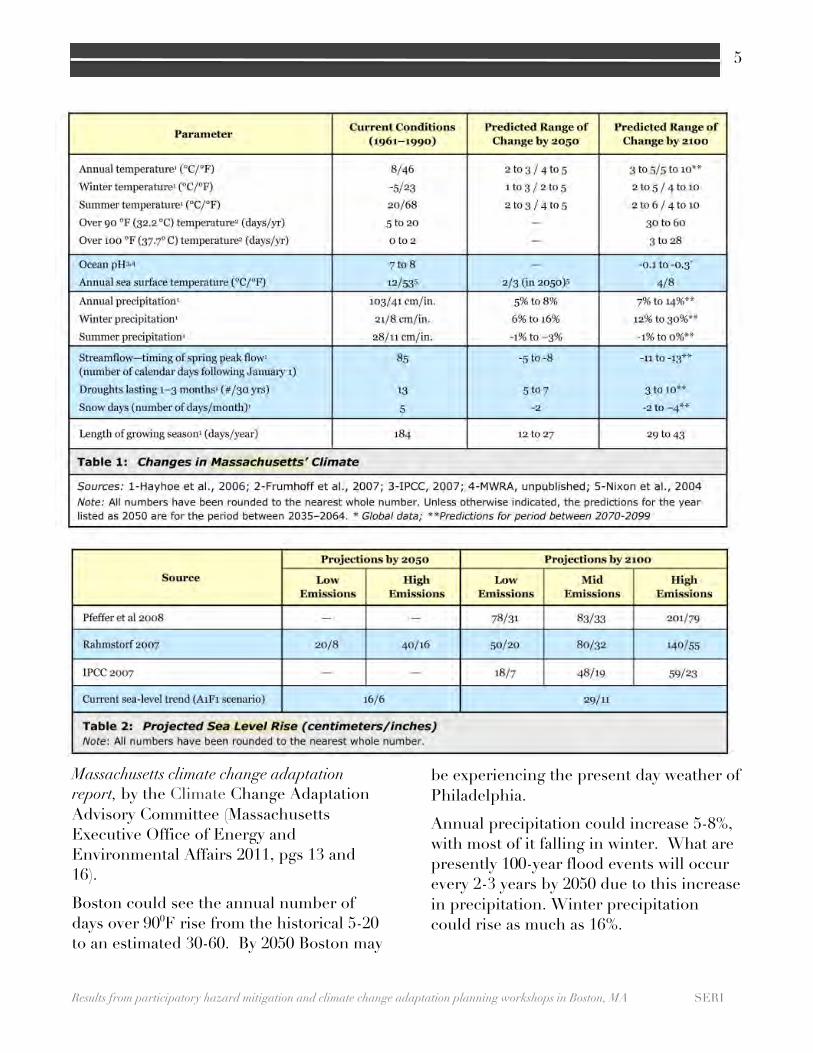
The climate in Boston is changing and will continue to over the coming decades, barring significant global effort to reduce carbon emissions. Temperatures will increase, sea level will rise, and more frequent and severe storms will impact the City (Massachusetts Executive Office of Energy and Environmental Affairs 2011, Frumhoff et al. 2006). By the year 2050, the Intergovernmental Panel for Climate Change (IPCC) reports that under a high emissions scenario the ambient global temperature will increase by 5 to 100F (IPCC 2007, 2012). The way such impacts might be experienced in Massachusetts under three different scenarios is shown in the Tables, which are reprinted from the
33333333
Results from participatory hazard mitigation and climate change adaptation planning workshops in Boston, MA SERI
5 5
Massachusetts climate change adaptation report, by the Climate Change Adaptation Advisory Committee (Massachusetts Executive Office of Energy and Environmental Affairs 2011, pgs 13 and 16).
Boston could see the annual number of days over 900F rise from the historical 5-20 to an estimated 30-60. By 2050 Boston may
be experiencing the present day weather of Philadelphia.
Annual precipitation could increase 5-8%, with most of it falling in winter. What are presently 100-year flood events will occur every 2-3 years by 2050 due to this increase in precipitation. Winter precipitation could rise as much as 16%.
33333333
Results from participatory hazard mitigation and climate change adaptation planning workshops in Boston, MA SERI
6 6
Forecasts for sea level rise (SLR) are contingent on what happens with Greenland’s ice cap and future emissions, but conservative estimates are that Boston will see 8-16” of SLR by 2050.
Background on the Hazard Mitigation Planning (HMP)
Process The Federal Disaster Mitigation Act of 2000 established a framework for municipalities to create plans for managing hazards. Plans must be updated every five years to ensure eligibility for Federal Emergency Management Agency (FEMA) funded hazard mitigation grant projects. The Disaster Mitigation Act came in response to impacts of severe storms, coastal erosion, and flooding events during the last decades and amended the Robert T. Stafford Disaster and Emergency Assistance Act, in accordance with 44 CFR Part 201. The new Act requires that state, local and tribal entities coordinate mitigation actions and projects.
Boston has become a leader in climate change adaptation planning and thus is thoroughly addressing climate change hazards in all its governmental efforts. The City of Boston is exceeding federal standards by including climate change in the HMP.
Boston’s Hazard Mitigation Planning Process
The City of Boston’s Hazard Mitigation Plan is written by the Metropolitan Area Planning Council (MAPC), while the Office of Emergency Management is responsible for coordination of intergovernmental stakeholder collaboration. In 2010, the City of Boston established a multi-agency
Hazard Mitigation Executive Leadership Steering Committee to oversee the process of updating the HMP. The co-chairs of the Leadership Committee are the Mayor’s Cabinet Chiefs and Directors of the Office of Office of Emergency Management and the Office of Energy and Environment.
HMPs usually project future disasters from an inventory of past events. The City decided a more accurate plan incorporates scientific knowledge about projected climatic changes to arrive at a more accurate forecast of future weather-related events. Boston is a leader in hazard mitigation, climate change adaptation, and climate change mitigation planning. The Climate Action Leadership Committee authored a report in April 2010 called Sparking Boston’s Climate Revolution and followed this up a year later with A Climate of Progress, which was an update to the climate action plan (Climate Action Leadership Committee and Community Advisory Committee 2010, Climate Action Leadership Committee and Community Advisory Committee 2012).
On August 5, 2010, the Mayor’s Office of Emergency Management formally requested approval from the state director of the Massachusetts Emergency Management Agency and was granted permission to have an independent hazard risk analysis conducted on the City of Boston. The Northeast States Emergency Consortium (NESEC) Emergency Management Risk Assessment Center conducted a HAZUS MH-Level II analysis of the City’s vulnerabilities to floods, hurricanes, and earthquakes.
As part of the effort to integrate climate change adaptation planning with hazard mitigation planning MAPC and the City

33333333
Results from participatory hazard mitigation and climate change adaptation planning workshops in Boston, MA SERI
7 7
organized with SERI the series of five meetings using VCAPS. The Office for Emergency Management’s Interagency Coordinator invited participants to multi-stakeholder meetings to discuss local hazards and presented the findings of NESEC’s analysis. MAPC gave an introductory presentation at the start of each meeting. Brief overviews of predictions about climate change in the region were also presented. Due to the experimental nature of this effort, MAPC and the City decided to use climate projections only to characterize three types of hazards: flooding, winter storms, and heat waves.
The VCAPS Process The VCAPS (Vulnerability and Consequences Adaptation Planning Scenarios) process combines structured discussion with interactive concept mapping to create visual summaries of local knowledge about vulnerability and resilience. It helps government staff and stakeholders depict how a community is impacted by weather related hazards and the actions that could help reduce those impacts.
A typical VCAPS process begins by identifying a small set of concerns or hazards that the community would like to explore. This focuses and defines the boundaries of the discussion, ensuring that the exercise is relevant to decisions. The discussion centers on one concern at a time. During the discussion, a VCAPS diagram is constructed by the research team while listening to the facilitated dialogue in the room.
The participants at a meeting choose which hazards to focus upon. Groups
sometime define the hazards quite broadly (e.g. super storms) or quite narrowly (e.g. coastal erosion).
After selecting the hazard VCAPS diagramming progresses to trace pathways that describe how that hazard affects the community and its environment. A pathway model is made that documents the sequence of steps that lead to harmful consequences. For example, precipitation causes run-off, which leads to storm sewer overflows, which leads to flooding of underground transformers, which leads to electrocution. Each box in this diagram is called an “intermediary outcome.” There are normally many intermediary outcomes in a pathway.
Photo: Signal box near Museum of Fine Arts Credit: T. Webler 2012
At some point, the pathway of outcomes ends in a consequence. A consequence is an outcome for which it is not necessary to

33333333
Results from participatory hazard mitigation and climate change adaptation planning workshops in Boston, MA SERI
8 8
ask the question, “Why do we care if this happens?” To take the example above about runoff, it is not obvious why we should care about run-off, the mobilization of debris, the clogging of a sewer drain, or flooding of basements. But if flooding leads to electrocution, then electrocution is a consequence, because it is obvious that we all care about loss of life.
Management actions are also identified in the diagram. These are actions that can be taken to change the way the stressor affects the community. VCAPS differentiates between actions taken by private individuals and groups and actions taken by public organizations or government. The diagrams can include actions that are already in place or those that are proposed by the participants.
Contextual factors are the final component in the VCAPS diagram. These are specific qualities associated with an intermediary outcome or consequences that amplify the effect of the hazard. For instance, the mobilization of debris by run-off is made worse when there is more debris on the streets, therefore an amplifying contextual factor might be: “time since last street sweeping.”
VCAPS in Boston Five meetings were held with different groups of City employees and NGO representatives from January through May 2012, focusing on three weather related hazards:
• flooding from precipitation and storm surges,
• winter storms and • extreme heat.
Photo: Boston sewer drain cover near Museum of Fine Arts. Credit: T. Webler 2012.
Organization of the five collaborative stakeholder working group meetings To make meeting size reasonable and still involve a cross-section of City employees at each meeting, we organized five meetings around the following focus groups:
• Water and Sewer • Infrastructure • Regulatory • Building and Facilities • Public Safety
The first meeting was largely among members of the Boston Water and Sewer Commission, but the subsequent meetings involved representatives from numerous government agencies and private groups, such as: Ground Water Trust, Homeless Services Bureau, Environment Department, Historic Preservation, Housing Authority, Boston Public Health Com-mission, Massachusetts Water Resource Authority, Northeast States Emergency Consortium, Coastal Zone Management, Massport-Logan IAP, Inspectional Services, Boston Public

33333333
Results from participatory hazard mitigation and climate change adaptation planning workshops in Boston, MA SERI
9 9
Library, Northeast Document Conservation Center, Massachusetts Board of Library Commissioners, University of Massachusetts Boston, Department of Neighborhood Development, Police and Fire Departments, among others.
The meetings began with presentations on climate change and historical HAZUS-MH Level II hazard data for Boston. Participants then broke into small groups to discuss the City’s vulnerabilities to flooding, winter storms and extreme heat. By design, the focus of each meeting was to consider these hazards from the different management sectors, and each meeting began where the last one left off by asking participants to continue revising and elaborating details in the VCAPS diagrams. SERI and MAPC facilitators worked to make sure all outcomes and consequences were considered. To aid in this task, they developed a list of types of outcomes and consequences: commerce, health and safety, governance, ecology, property, communication systems, transportation systems, power grid, and water treatment. The variety of perspectives at the meetings provided not only broad spectrum and in-depth expertise, but also priorities for hazard mitigation and climate change adaptation management actions.
During the discussions, SERI diagrammed the causal pathways and added contextual factors and management actions to the diagrams as participants mentioned them. The remainder of this report will be a summary of those results. VCAPS diagrams that relate to these abbreviated narratives are attached to this report as Appendices.
Flooding
Boston participants identified two climate stressors responsible for flooding: increased precipitation and sea level rise (SLR). People mentioned that flooding is already a problem in areas of the city and recognized that this will become more frequent and worse. SLR is already noticeable by the increasing frequency with which the peers flood near the Aquarium.
Morrissey Boulevard was identified as an area with cyclical, repetitive flooding, due to astronomically high tides. Flooding here is important because the road is a major arterial and is a primary evacuation route. Raising roadways was mentioned as a mitigation action of high priority to maintain safe evacuation routes, as was installing riprap and building natural ecosystem-based buffers with native vegetation.
Several roadways rely on pumps to clear floodwaters. The reliability of these pumps and their electricity supply are essential. Participants noted several locations where pumps will need to be installed as flooding increases.
Photo: Flooding at Long Wharf during Sandy. 2012. Credit: Matt Conti (Creative Commons 3.0 license). Original source material at: NorthEndWaterfront.com

33333333
Results from participatory hazard mitigation and climate change adaptation planning workshops in Boston, MA SERI
10 10
Public housing complexes near the coast are already susceptible to flooding in basements and rely heavily on sump pumps to keep the basements dry. The public housing department recognized a need to relocate important utilities from basements to higher floors of some buildings.
Run-off from soils, pavements, and roofs can be blocked at catch basins by roadway debris and leaves. This leads to localized flooding or “ponding” in the roadways. Where curb heights are low, this water can migrate into basements of nearby buildings. Public health is impacted from mold that grows as a result of this flooding as the air quality in homes declines. Cleaning catch basins, which is done by staff of the Boston Water and Sewer Commission (BWSC) is a mitigation action that can prevent further hazards in that chain of consequences. Another mitigation action is encouraging property owners to install sump pumps to clear out flooding in basements. The VCAPS diagrams differentiate upstream and downstream actions clearly and this provides officials with an easy-to-understand anatomy of mitigation actions to prevent unwanted consequences.
While progress continues to be made in separating stormwater and sanitary wastewater systems, there are still places where they connect. Stormwater that enters the groundwater can infiltrate into sanitary wastewater lines at those intersections or through cracks in drainage pipes all throughout the system. This is a problem during storms because it increases the amount of sanitary wastewater that needs to be treated by Massachusetts Water Resources Authority (MWRA) at Deer Island.
Rising groundwater that comes from storms and SLR can help ensure that historical wooden pilings are protected from rotting, but too much groundwater in the wrong places can cause serious problems. First, it can mobilize pollutants that are presently stable. Second, it can come into contact with district heating pipes, resulting in explosions. Third, it can flood the subway.
One of the worse scenarios that the group discussed is if sea levels rises enough to overwhelm the Charles River dam. This would lead to flooding of Back Bay, creating numerous problems for the City.
As part of the discussion about flooding participants focused on short and long-range consequences and management actions. Managing long-range issues such as sea level rise’s impact on Deer Island Sewage Treatment Plant seemed outside the range considered for this plan. However, members of MWRA did discuss the vulnerability of the system due to pipes of a certain size and elevation above sea level. Some of this hardware will need to be replaced. These discussions of long-term hazards were crucial, not only to meet FEMA’s request to include long-range impacts, but also for the city and state officials to develop plans for a quite different coastline only a few decades in the future.
Winter Storms Winter storms deposit heavy snow and ice on roofs, sidewalks, utility lines/poles, trees, and roads. Weight of snow on roofs can cause buildings to collapse. If utility lines come down, electricity and communication services are disrupted.

33333333
Results from participatory hazard mitigation and climate change adaptation planning workshops in Boston, MA SERI
11 11
Snow and ice accumulation may also disrupt the transportation system in multiple ways. First, traffic can be impeded by illegally parked cards, roads narrowed by snow and plowed snow, falling trees and tree limbs, and traffic accidents. Roads blocked by private vehicles can disrupt the public transportation system.
Second, falling trees and limbs can damage utility lines and poles, disrupting power and disabling traffic signals. Public buses and trolleys that rely on electricity for power will be stranded, exposing riders to harsh conditions.
Third, snow or ice followed by rain can cause flooding of low-lying areas, blocking roads. Flooding can also occur when catch basins and drainage are blocked from plowed snow.
Photo: Snow storm buried cars on Beacon Hill, January 2005. Credit: Nat Tarbox (Creative Commons 2.0 license). Original at: http://www.flickr.com/photos/nattarbox/1792406300/
Emergency advisories to leave work early have caused “super rush hours.” A consequence can be that people become stranded, as snow builds up while people are stuck in vehicles as they attempt to return home. Abandoned vehicles can block roads, making emergency response
more difficult and further disrupting the transportation system.
Sidewalks are also compromised by winter storms. When sidewalks, ramps, etc. are blocked, mobility of pedestrians is impaired. People may resort to walking in streets, which can lead to injuries from falls or vehicular accidents. Others may be afraid or unable to leave home. Homebound people may run out of food or medications. Fire hydrants can be inaccessible.
In Boston property owners are mandated to clear sidewalks, to help clear fire hydrants and are asked to check on and assist their neighbors. The MBTA also asks people to assist clearing bus stops. However, it is illegal to put snow back on roads.
Structures may collapse or be damaged. If public buildings are damaged, important government services may be disrupted. Commercial activity basically shuts down during extreme winter storms.
Mitigation measures in relation to winter storms were categorized into pre, during and post event. The pre-event category included all prevention actions such as improving communication systems to treating roads.
Heat Waves Heat waves threaten human health for acute periods of time, but they can happen repeatedly over the summer. To mitigate heat, people rely on air conditioning and fans, which stresses the power grid, leading to electricity disruptions.
Loss of power disables cooling systems, but also threatens human health in other

33333333
Results from participatory hazard mitigation and climate change adaptation planning workshops in Boston, MA SERI
12 12
ways. For instance, more and more people are receiving health care at home. Loss of power can render inoperative medical devises and alarms. Evacuations from buildings without electricity or air-conditioning are crucial to avoid heat stress, at work and at home.
Transportation systems suffer with the loss of electricity. With traffic signals out transport can be disrupted and dangerous. This makes it harder for people to reach cooling centers. Moreover, people can be stranded far from home on trains and subways.
Heat waves disproportionally affect the elderly and people with respiratory diseases, such as emphysema. Over time, poor air quality increases asthma rates.
Cooling centers may be stressed to capacity. As crowding within shelters increases both those seeking shelter and staff can experience severe stress. In worst case scenarios personal safety may be an issue. This can be a particular problem within shelters with “blended” populations (e.g., ethnic groups, elderly, children, addicts, disabled).
Photo: National temperature map June 2012 Credit: Public domain (Jet Propulsion Lab)
Heat waves can impact economic activity, cultural artifacts, and governance
functions, particularly when electrical and transport systems are disrupted. For instance, historical documents in public libraries are vulnerable to harm from humidity.
People seek relief from heat at cooling centers or public beaches and pools. Heat can promote bacteria growth leading to the closure of beaches. Illegally open fire hydrants can have serious implications for fire suppression because of decreases in water pressure.
Heat events can also result in damage to infrastructure. For example, it can cause rail lines and bridges to expand. Public transportation may be disrupted if this happens.
Further Discussion The following crosscutting issues arose during the meetings.
Interactions across sectors
The three weather-related hazards have complex impacts, can result in collateral damage, and yet many outcomes and consequences appear in all three hazards. To simplify the complexity, we identified seven sub-systems that are central to the city’s functionality. These are:
• Buildings • Communication • Ecosystems • Electricity • Emergency shelters • Transportation • Water treatment
By producing diagrams for each of these sub-systems, SERI was able to capture the key ideas without having too much repetition in the diagrams.

33333333
Results from participatory hazard mitigation and climate change adaptation planning workshops in Boston, MA SERI
13 13
Regional Coordination Throughout the VCAPS process, stakeholders regularly addressed the importance of mitigating the impacts of different weather events. In some cases these issues are most effectively addressed with regionally coordinated strategies. The reason for this is that watersheds cross municipal boundaries. Consideration of hydrology at the level of the watershed can help identify regional strategies that will most effectively address these shared concerns.
Vulnerable Populations Participants in the VCAPS meetings emphasized the impacts of weather-related stressors on vulnerable populations, which include the elderly, homeless, those receiving medical care at home, disabled, and those in public housing. Flooding from sea level rise and from heavy rain events already occurs in the coastal public housing complexes. Vacating first floors and raising all furnaces and transformers from public housing basements were identified as possible solutions. Communication systems in extreme heat and intense rains may fail which will cut off elderly from important information and perhaps from assistance.
Discussion of Management Actions
As part of the diagramming of flooding, winter storm, and severe heat hazards, SERI and MAPC encouraged the meeting participants to discuss management
actions that could be promoted now and that would increase resilience to storms events. A significant number of management actions was identified by the group.
The participants identified four general types of actions: actions taken as part of routine planning activities (preparatory actions), actions taken in response to specific threats or events (pre-storm/event actions), actions taken during an event (during storm/event actions), and actions taken to recover from the impacts of storms (post-storm/event actions). An example of a pro-active preparatory action is the City’s hazard mitigation planning process. The participants also indicated whether the action was already being done, was a new strategy worthy of further consideration, or has already been implemented.
Photo: The Muddy River. 2012 Credit: T. Webler.

33333333
Results from participatory hazard mitigation and climate change adaptation planning workshops in Boston, MA SERI
14 14
This information provides a picture of the full range of management actions that can be taken by the City, either separately or together. In some cases, coordination among City departments, between the City and other municipalities, or between the City and other regional entities is necessary to tackle hazards.
Conclusion
Examination of local hazards with city and state officials, interested citizens and members of the private sector can illuminate vulnerabilities and highlight potential mitigation projects for municipalities to adopt.
VCAPS is one approach to help elicit and organize this knowledge in a format that can empower local action. The five meetings sponsored by the City of Boston, the Metropolitan Area Planning Commission, and SERI drew upon local experience to document vulnerabilities and mitigation actions.
Like other municipalities across the country, the City of Boston will continue to experience increased exposure to extreme weather. The state, county, and city systems that are in place to manage, cope, and adapt to this weather can be improved upon and will need to innovate more efficient and effective systems to prepare for weather related hazards and to restore services. Such systems ought to be informed with the knowledge and experience of city employees and local stakeholders. VCAPS is one tool to bring this is to fruition.

33333333
Results from participatory hazard mitigation and climate change adaptation planning workshops in Boston, MA SERI
15 15
References Climate Action Leadership Committee and Community Advisory Committee 2010. Sparking Boston's Climate Revolution. Available at: http://www.cityofboston.gov/Images_Documents/BCA-full_rprt_r5_tcm3-19958.pdf. Climate Action Leadership Committee and Community Advisory Committee 2012. Sparking Boston’s Climate Revolution: Recommendations of the Climate Action Leadership Committee and Community Advisory Committee. Available at: http://www.cityofboston.gov/Images_Documents/BCA-full_rprt_r5_tcm3-19958.pdf (last visited August 17, 2011). Frumhoff, PC, JJ McCarthy, JM Melillo, SC Moser, and DJ Wuebbles, 2006. Climate Change in the U.S. Northeast: A report of the Northeast Climate Impacts Assessment. Cambridge, MA: Union of Concerned Scientists. IPCC 2012. Summary for Policymakers. In: Managing the Risks of Extreme Events and Disasters to Advance Climate Change Adaptation [Field, C.B., V. Barros, T.F. Stocker, D. Qin, D.J. Dokken, K.L. Ebi, M.D. Mastrandrea, K.J. Mach, G.-K. Plattner, S.K. Allen, M. Tignor, and P.M. Midgley (eds.)]. A Special Report of Working Groups I and II of the Intergovernmental Panel on Climate Change. NY: Cambridge University Press. IPCC 2007. Climate Change 2007: Synthesis Report (editors: Pachauri, RK & Reisinger, A.). Geneva, Switzerland: IPCC.
Massachusetts Executive Office of Energy and Environmental Affairs 2011. Massachusetts climate change adaptation report. Report of the Climate Change Adaptation Advisory Committee. Boston: Massachusetts Executive Office of Energy and Environmental Affairs.