Embed Size (px)
Citation preview
Environmental Assessment Document
Project No. 46366-01
October 2014
TA-8257 REG: Results-Based Strategy and Sector Planning in the Pacific - 1 FSM/Palau ICT: Environmental and Social Safeguards: Micronesia (Yap-Chuuk) Component
Initial Environmental Examination This Initial Environmental Examination is a document of the borrower. The views expressed herein do not necessarily represent those of ADB’s Board of Directors, Management, or Staff, and may be preliminary in nature.
In preparing any country program or strategy, financing any project, or by making any designation of or reference to a particular territory or geographic area in this document, the Asian Development Bank does not intend to make any judgments as to the legal or other status of any territory or area.
i
TABLE OF CONTENTS
ABBREVIATIONS AND ACRONYMS ............................................................................................................ V EXECUTIVE SUMMARY ............................................................................................................................. VI I. INTRODUCTION.................................................................................................................................. 1
A. THE PROPONENT AND PURPOSE OF THE IEE .................................................................................................. 1 B. PROJECT STATUS AND DOCUMENTATION ...................................................................................................... 3 C. EXTENT AND BOUNDARIES OF THE IEE.......................................................................................................... 3
1) The Project Influence Areas: Nearshore and Landing Sites ........................................................... 3 2) Coastal and offshore corridors ....................................................................................................... 4
D. THE IEE METHODOLOGY ........................................................................................................................... 5 II. POLICY, LEGAL AND ADMINISTRATIVE FRAMEWORK ....................................................................... 6
A. PHYSICAL AND ECOLOGICAL ENVIRONMENT .................................................................................................. 6 1) Relevant Marine Regulations ......................................................................................................... 6 2) Marine Management ..................................................................................................................... 7
B. SOCIO-ECONOMIC ENVIRONMENT .............................................................................................................. 8 1) Customary Ownership and Marine Areas ...................................................................................... 8 2) Legislations on Land Acquisition .................................................................................................... 9 3) Legislation on Cultural Preservations ........................................................................................... 10
C. INTERNATIONAL AND REGIONAL TREATIES, CONVENTIONS AND AGREEMENTS .................................................... 10 D. ADB AND WORLD BANK ......................................................................................................................... 10
III. PROJECT DESCRIPTION ................................................................................................................... 11 A. NEED AND DETAILS ................................................................................................................................ 11
1) Need for Project ........................................................................................................................... 11 B. PROJECT DETAILS AND COMPONENTS OF THE WORK .................................................................................... 11 C. PROJECT LAYOUT AND COMPONENTS OF THE WORK ..................................................................................... 13
IV. BASELINE DATA .............................................................................................................................. 15 A. PHYSICAL ENVIRONMENT ........................................................................................................................ 15
1) Climate ......................................................................................................................................... 15 2) Air Quality and Noise .................................................................................................................... 15 3) Topography, Geology, Soils and Hydrology .................................................................................. 15 4) Seismology and Earthquakes ....................................................................................................... 16 5) Tides ............................................................................................................................................. 16 6) Deep Sea ....................................................................................................................................... 16 7) Hydrothermal Vents ..................................................................................................................... 17 8) Seamounts .................................................................................................................................... 17 9) Unexploded Ordinance ................................................................................................................. 18
B. ECOLOGICAL ENVIRONMENT .................................................................................................................... 19 1) Mangroves ................................................................................................................................... 19 2) Marine Ecosystem ........................................................................................................................ 19 3) Terrestrial Flora ............................................................................................................................ 25 4) Terrestrial Fauna .......................................................................................................................... 26
C. SOCIO-ECONOMIC ENVIRONMENT............................................................................................................. 26 1) Coastal Industries ......................................................................................................................... 27 2) Conservation Areas /Marine Management Areas........................................................................ 28 3) Transportation and Infrastructure ............................................................................................... 30 4) Relevant Tourism Industries ......................................................................................................... 30 5) Socioeconomic Profile .................................................................................................................. 30
ii
6) Public Health ................................................................................................................................ 33 7) Recreational Resources and Development ................................................................................... 33 8) Cultural Values ............................................................................................................................. 33 9) Human Settlement and Land Use ................................................................................................. 33 10) Archaeological and Historical Treasures .................................................................................... 34
V. ANALYSIS OF ALTERNATIVES ........................................................................................................... 35 A. ALTERNATIVE TECHNOLOGIES ................................................................................................................... 35 B. ALTERNATIVE ALIGNMENTS ...................................................................................................................... 35
1) Yap................................................................................................................................................ 35 2) Chuuk............................................................................................................................................ 38
C. ALTERNATIVE METHODS .......................................................................................................................... 40 VI. ANTICIPATED IMPACTS AND MITIGATIVE MEASURES .................................................................... 40
A. PRECONSTRUCTION PERIOD ..................................................................................................................... 40 1) Physical Environment ................................................................................................................... 41 2) Ecological Environment ................................................................................................................ 42 3) Social Environment ....................................................................................................................... 43
B. CONSTRUCTION PERIOD .......................................................................................................................... 43 1) Physical Environment ................................................................................................................... 43 2) Ecological Environment ................................................................................................................ 44 3) Socio-Economic Environment ....................................................................................................... 45
C. OPERATING PERIOD ................................................................................................................................ 45 1) Physical and Ecological Environment ........................................................................................... 45 2) Social Environment ....................................................................................................................... 46
D. POVERTY AND GENDER IMPACT ................................................................................................................ 46 E. LAND ACQUISITION AND RESETTLEMENT ..................................................................................................... 47 F. CUMULATIVE IMPACTS AND MITIGATIVE MEASURES ..................................................................................... 48
1) Environmental .............................................................................................................................. 48 2) Socioeconomic .............................................................................................................................. 48
G. IRREVERSIBLE AND IRRETRIEVABLE IMPACTS ................................................................................................ 48 H. ENVIRONMENTAL AND SOCIAL ENHANCEMENTS/BENEFITS ............................................................................ 48
VII. GRIEVANCE REDRESS MECHANISM ................................................................................................ 49 A. PROPOSED GRIEVANCE REDRESS MECHANISM ............................................................................................. 49
VIII. INFORMATION DISCLOSURE, CONSULTATION AND PARTICIPATION .............................................. 51 A. YAP ..................................................................................................................................................... 51
1) Consultation ................................................................................................................................. 51 2) Questions and Answers ................................................................................................................ 51 3) Summary of the Consultation and of Reply by Government/Consultant ..................................... 52 4) Use of Consultation Results .......................................................................................................... 52 5) Follow Up Program ....................................................................................................................... 52
B. CHUUK ................................................................................................................................................ 52 1) Consultation ................................................................................................................................. 52 2) Questions and Answers ................................................................................................................ 53 3) Summary of Consultation ............................................................................................................. 54 4) Use of Consultation Results .......................................................................................................... 54 5) Follow Up Program ....................................................................................................................... 54
IX. ENVIRONMENTAL AND SOCIAL MANAGEMENT PLAN (ESMP) ........................................................ 55 A. PRECONSTRUCTION ................................................................................................................................ 55
1) Physical Environment ................................................................................................................... 55 2) Ecological Environment ................................................................................................................ 56
iii
3) Social Environment ....................................................................................................................... 57 B. CONSTRUCTION ..................................................................................................................................... 57
1) Physical Environment ................................................................................................................... 58 2) Ecological Environment ................................................................................................................ 58 3) Social Environment ....................................................................................................................... 59
C. OPERATING PERIOD ................................................................................................................................ 59 1) Physical and Ecological Environment ........................................................................................... 59 2) Social Environment ....................................................................................................................... 60
D. PERFORMANCE INDICATORS ..................................................................................................................... 60 E. IMPLEMENTATION ARRANGEMENTS ........................................................................................................... 61 F. INSTITUTIONAL CAPACITY ......................................................................................................................... 62 G. MITIGATION AND MONITORING COSTS ...................................................................................................... 62
1) Environmental Mitigation and Monitoring Costs ......................................................................... 62 2) Social Development Programs and Resettlement Costs ............................................................... 63 3) Total Cost ..................................................................................................................................... 63 4) The Environmental Code of Practice ............................................................................................ 63
X. CONCLUSIONS AND RECOMMENDATIONS ...................................................................................... 63 XI. REFERENCES ................................................................................................................................... 65
Annexes Annex 1. ESMP Annex 2. Consultation Records Annex 3. List of People Met Annex 4. Marine Ecology Special Reports, Databases and Maps List of Figures Figure 1. An example of submarine cable ploughs at sea and being towed from shore to deeper water by a cable laying ship ................................................................................. 4 Figure 2. General organisation and chain of command for fibre optic cable project........ 61 List of Maps Map 1. Project area, showing existing and proposed fibre optic cables............................ 1 Map 2.Proposed Cable Alignment and Project Influence zone, Yap State. .................... 12 Map 3. Proposed alternative Alignments for Chuuk Lagoon ........................................... 13 Map 4. Details of Cable Landing Site In Colonia (A) and in Weno (B) ............................ 14 Map 5. Bathymetry of Yap-Guam-Chuuk Area, Including the Deep Sea Trenches........ 16 Map 6. Nine Municipal/Community Conservation Areas or Management Area of Yap Proper (sourced from YAP-CAP with permission) .......................................................... 29 Map 7. Five proposed Municipal/Community Conservation Areas associated with the Chuuk Lagoon, Chuuk State, FSM (sourced from DMRD). ........................................... 30 Map 8. Location of Alternative Alignment Landing Sites in Yap ..................................... 35 Map 9. Summary of Marine and Coastal features Associated with Yap Cable Alignment ...................................................................................................................................... 37 Map 10. Approximate route of fibre optic cable from the Guam- Pohnpei junction(A) to Chuuk Lagoon and on to Weno (B) ................................................................................ 39
iv
List of Photos Photo 1. Dredging plumes associated with sand mining in Weno, Chuuk state. .... 20
Photo 2. Deep sea cable, shortly after placement on seafloor and growth of anemones
and sea-pens (> 140m depth) on the hard substrate of the cable –taken by a ROV. ..... 46
List of Tables Table 1 A list of debris located in the Woneeday channel, Yap Proper .......................... 18 Table 2.Cetacean Species likely passing through the FSM waters ................................ 25 Table 3. Types of plant communities and area in hectares found in Yap and Chuuk ...... 26 Table 4. Demographic information for FSM ................................................................... 31 Table 5. FSM population statistics for 2010 ................................................................... 31 Table 6. FSM GDP figures for 2012 ............................................................................... 32 Table 7. Screening of Alternative Fibre Optic Cable alignments for Yap ........................ 36 Table 8. The Conservation/Management Areas bordering the preferred Palau-Yap cable alignment ....................................................................................................................... 37 Table 9. Screening of Alternative Fibre Optic Cable alignments for Chuuk .................... 38 Table 10. Grievance Redress Process........................................................................... 50
v
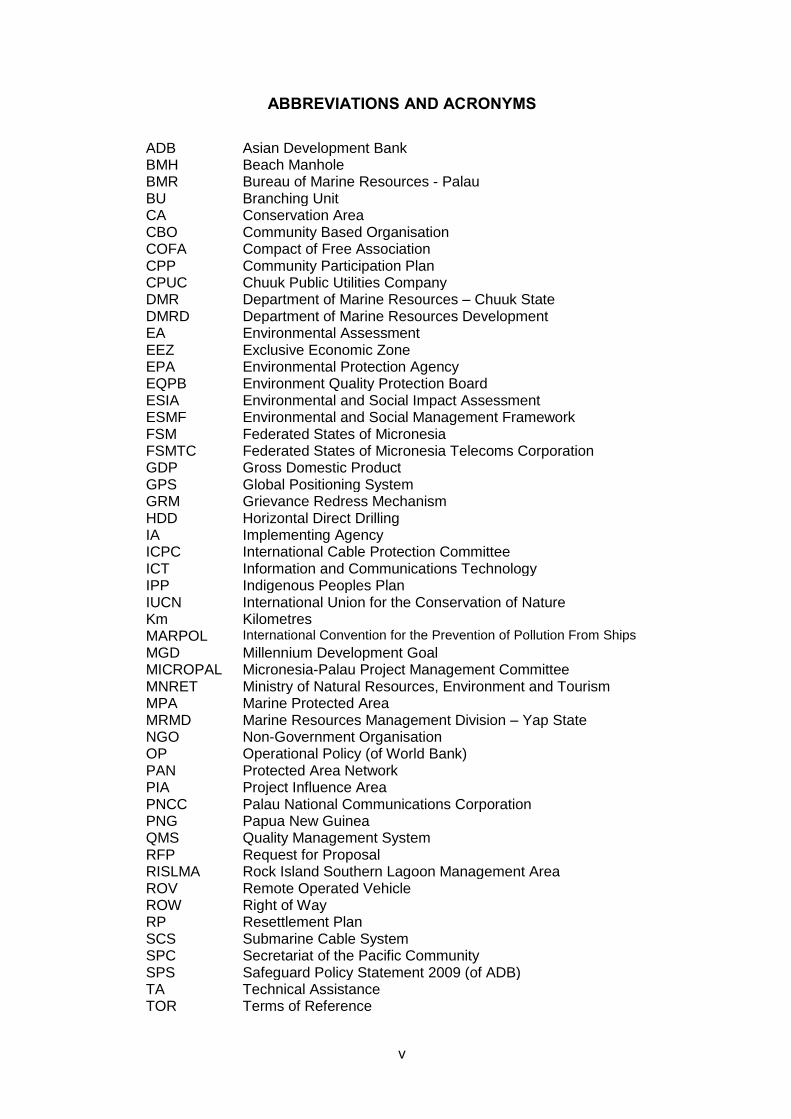
ABBREVIATIONS AND ACRONYMS
ADB Asian Development Bank BMH Beach Manhole BMR Bureau of Marine Resources - Palau BU Branching Unit CA Conservation Area CBO Community Based Organisation COFA Compact of Free Association CPP Community Participation Plan CPUC Chuuk Public Utilities Company DMR Department of Marine Resources – Chuuk State DMRD Department of Marine Resources Development EA Environmental Assessment EEZ Exclusive Economic Zone EPA Environmental Protection Agency EQPB Environment Quality Protection Board ESIA Environmental and Social Impact Assessment ESMF Environmental and Social Management Framework FSM Federated States of Micronesia FSMTC Federated States of Micronesia Telecoms Corporation GDP Gross Domestic Product GPS Global Positioning System GRM Grievance Redress Mechanism HDD Horizontal Direct Drilling IA Implementing Agency ICPC International Cable Protection Committee ICT Information and Communications Technology IPP Indigenous Peoples Plan IUCN International Union for the Conservation of Nature Km Kilometres MARPOL International Convention for the Prevention of Pollution From Ships
MGD Millennium Development Goal MICROPAL Micronesia-Palau Project Management Committee MNRET Ministry of Natural Resources, Environment and Tourism MPA Marine Protected Area MRMD Marine Resources Management Division – Yap State NGO Non-Government Organisation OP Operational Policy (of World Bank) PAN Protected Area Network PIA Project Influence Area PNCC Palau National Communications Corporation PNG Papua New Guinea QMS Quality Management System RFP Request for Proposal RISLMA Rock Island Southern Lagoon Management Area ROV Remote Operated Vehicle ROW Right of Way RP Resettlement Plan SCS Submarine Cable System SPC Secretariat of the Pacific Community SPS Safeguard Policy Statement 2009 (of ADB) TA Technical Assistance TOR Terms of Reference
vi
EXECUTIVE SUMMARY
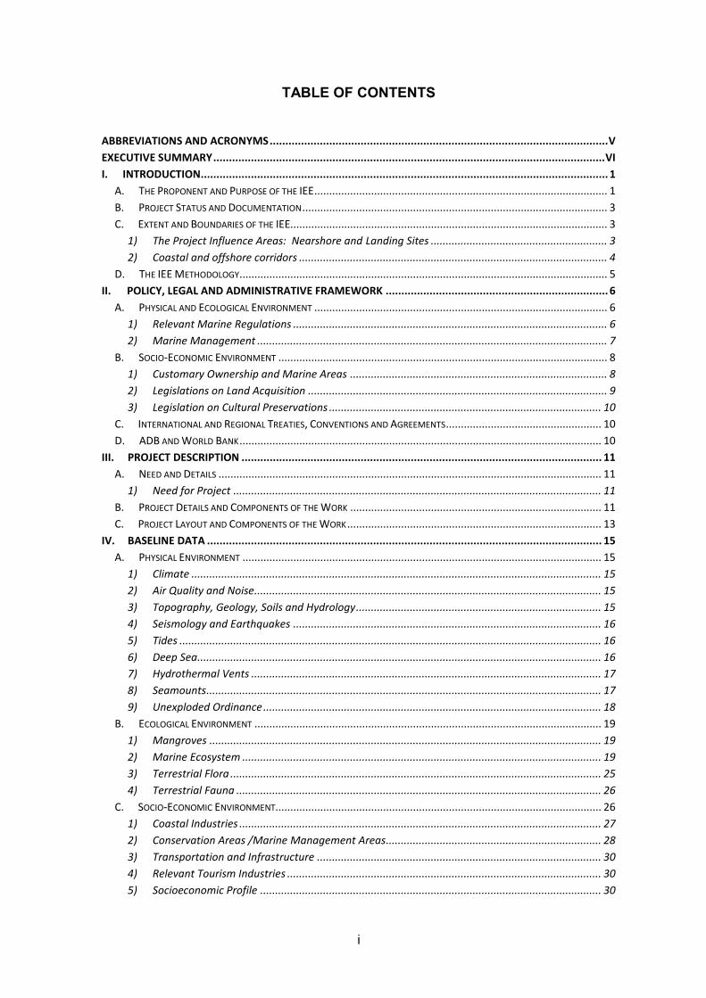
The FSM is comprised of more than 600 islands and atolls spanning across almost 3000 Km of the tropical Pacific Ocean (Map 1). The total population is estimated at roughly 100,000, spread across the four states of Pohnpei, Kosrae, Chuuk and Yap. The economy of the country is based on natural resources exploitation, mostly fisheries, tourism, the transfers through United States (U.S.) Federal Government Compact of Free Association (COFA) grants and remittances from expatriate workers. Further It is dominated by a large public sector.
Similar to Palau, the FSM has slow and expensive telephone and internet connectivity, affecting all public and private services, including education and health, limiting access to international markets and affecting social connection among its rural and urban population. The proposed fibre optic project (the project) will facilitate faster and reliable internet connectivity among the Federated States of Micronesia (FSM) and from there to the rest of the world. The project will be jointly funded by the Asian Development Bank (ADB) and the World Bank (WB), ADB funds were used to finance the preparation of the safeguard documentation. The IEEs for FSM and Palau have been prepared as stand-alone reports, but meeting the common objectives of ADB Safeguard Policy Statement 2009 (SPS) and WB’s Operational Policy 4.01.
The FSM component will be a $ 51 million grant, split between Yap, Chuuk and Kosrae (the latter to receive satellite connection instead of a fibre optic cable). The government of Palau has requested a $25 million ADB loan to finance goods, works services and in addition ADB is providing a $250,000.00 grant (divided between Palau and FSM) for completion of safeguard documentation.
The cable will be placed along the seafloor, with deep sea sections resting on the seabed, and sections inside the 40m contour (approximation), buried about 0.75m below the seabed. The cable will be brought to shore by following existing shipping channel routes, thereby minimally interfering with coastal ecology.
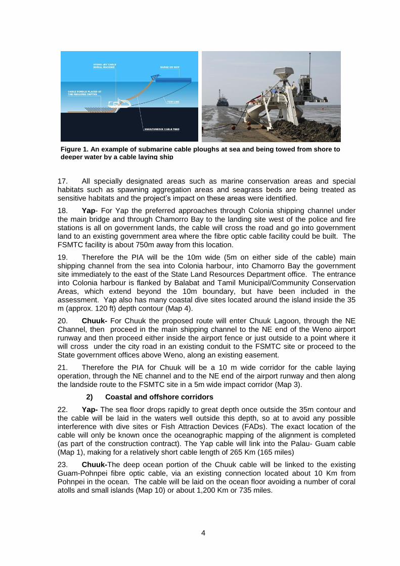
The project will impact a corridor of not more than 0.5 m wide on the sea floor, and in some locations up to 0.75 m beneath the sediment. The cable, 3-7.5 cm in diameter, will be either sitting on the seafloor in the deep ocean, or be buried as it passes through the natural channel through the barrier reef into the Yap or Chuuk nearshore zone. Burial of the cable will be done to reduce interference with coastal fishing gear and reduce the risk of damage from severe storms. As it enters into the nearshore waters, the cable alignment will be in the shipping channel which, inside the barrier reef, is essentially has a coral rubble and sand seafloor. For the last 1 - 2 Km the cable will be buried at a depth of about 0.75m, using a special trenching device (Figure 1) which disturbs an area of about 0.4m wide x 0.7m deep, threads the cable into the trench and closes the trench as it is towed by the cable laying vessel or other heavy equipment, will be used. There is no other disturbance to the sea floor or the water column.
The operation of large ocean going vessels which burn low grade diesel fuel will result in large emissions of greenhouse gases. To begin to address this the contractor will be required to submit emission certificates for their vessels, and show that they meet international standards, most particularly the USEPA’s diesel emission standards for PM, SO2 NOx and the visual-Black smoke test, as defined in the Environmental and Social Management Plan (ESMP).
vii
The distance of the cable from any potentially sensitive habitat such as corals and specific protected areas will be at least 75m for both Yap and Chuuk, eliminating any chances that the work will negatively impact the marine environment.
The landing site for Yap will be on government land to a site already occupied by a small government building. For Chuuk the exact site has not been agreed to but the least costly and the one with the least number of landuse issues will be located on the existing Federated States of Micronesia Telecom Corporation site, opposite to the entrance to the Weno airport; all government land.
The preferred alignments for Yap the Chuuk will not interfere with any of the existing Marine Protected Areas on Yap, the Chuuk’s proposed Marine Protected Areas or any other protected areas; and will maintain a minimum 100m safe distance from these areas.
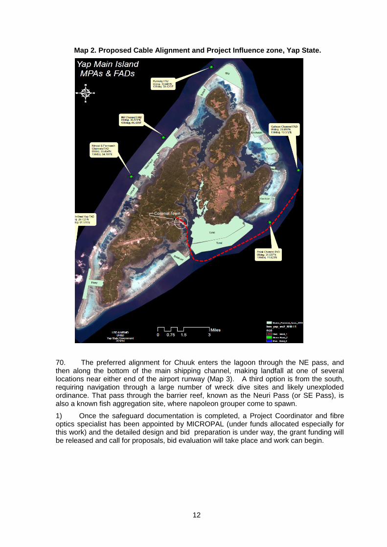
The ESMP, describing 35 mitigative and monitoring actions, including a full set of working area boundaries, work restrictions and timing limits, which will be included in the construction contract specifications and which the contractor will have to comply with. Compliance will be monitored by the Project Coordinator.
Given the small scale impact of the work, and the fact that nearly all of the work takes place on board a vessel at sea with a specially trained crew, no negative social impacts are predicted during any stage of the project. The construction of the cable facility on land will require a small crew of local works, likely a local contractor.
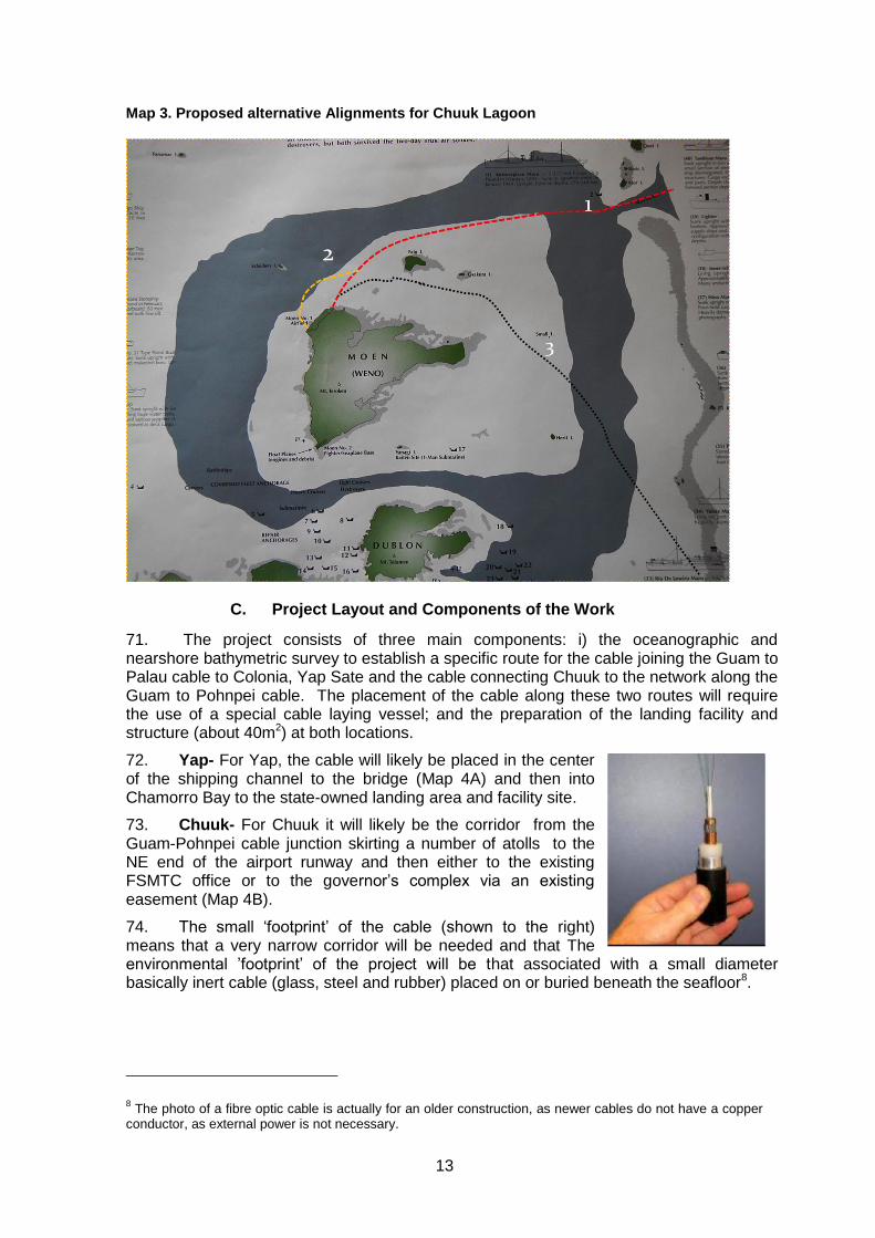
In order to effectively implement the mitigation and monitoring tasks defined in the ESMP, the State PMUs or the project coordinator will hire a senior safeguards technician (monitors) in each state for a period of 2 years. These monitors will assist with implementation and enforcement of the ESMP, primarily during the construction period of the project.
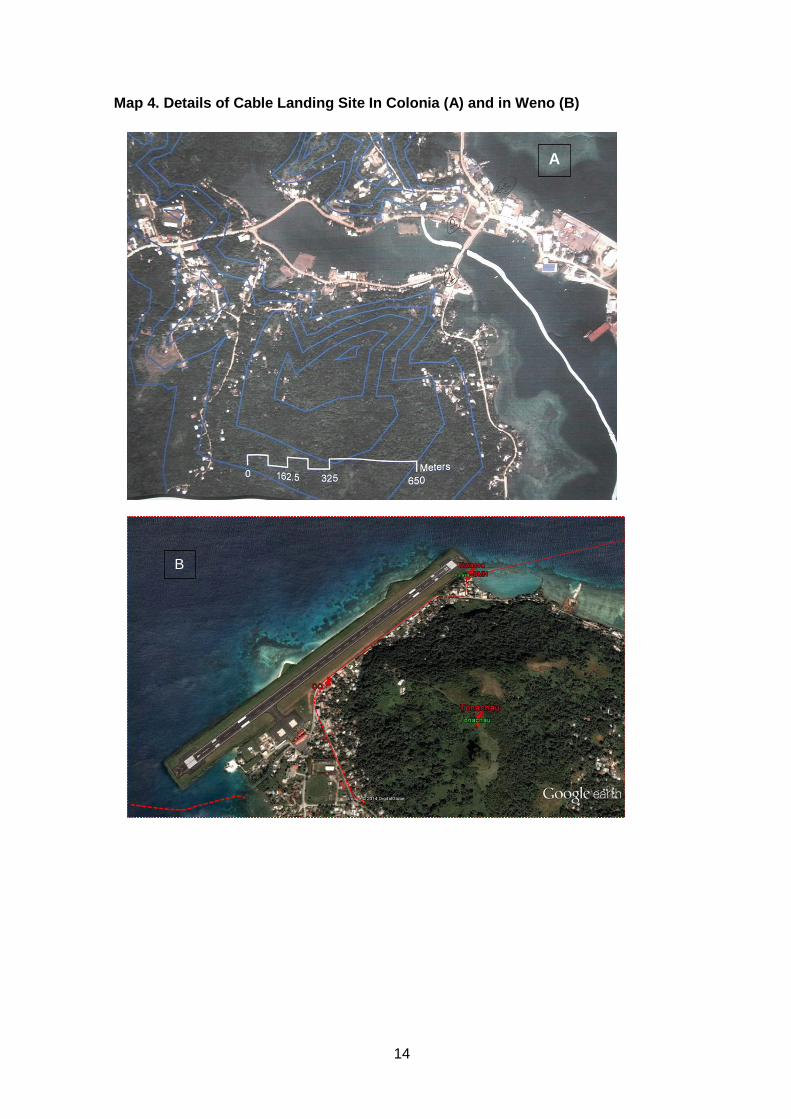
In order to insure no significant environmental and social impact occur, MICROPAL, the project coordinator, the ESMP monitor and the State PMUs are be fully committed to implementing the ESMP. They will meet all the reporting requirements in a timely manner and consistently monitor the contractor, then provide regular feedback and immediately address any non-compliance issues and public complaints.
For the social sector specifically, post installation awareness raising among new subscribers on methods for controlling access to some socially undesirable sites and what to do about them, will be a mandatory requirement for whoever becomes the service provider. The respective state governments will enforce this requirement.
With these actions, it is recommended that no additional environmental or social sector studies are needed, and that this project can move to detailed design and construction.
1
I. INTRODUCTION
A. The Proponent and Purpose of the IEE
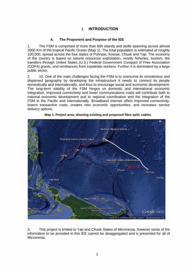
1. The FSM is comprised of more than 600 islands and atolls spanning across almost 3000 Km of the tropical Pacific Ocean (Map 1). The total population is estimated at roughly 100,000, spread across the four states of Pohnpei, Kosrae, Chuuk and Yap. The economy of the country is based on natural resources exploitation, mostly fisheries, tourism, the transfers through United States (U.S.) Federal Government Compact of Free Association (COFA) grants, and remittances from expatriate workers. Further it is dominated by a large public sector.
2. 10. One of the main challenges facing the FSM is to overcome its remoteness and dispersed geography by developing the infrastructure it needs to connect its people domestically and internationally, and thus to encourage social and economic development. The long-term viability of the FSM hinges on domestic and international economic integration. Improved connectivity and lower communications costs will contribute both to national economic development and to regional coordination and the integration of the FSM in the Pacific and internationally. Broadband internet offers improved connectivity, lowers transaction costs, creates new economic opportunities, and increases service delivery options.
3. This project is limited to Yap and Chuuk States of Micronesia, however some of the information to be provided in this IEE cannot be disaggregated and is presented for all of Micronesia.
Map 1. Project area, showing existing and proposed fibre optic cables
2
4. Yap State is the western-most island State in the FSM, located between latitudes 7 to 10 degrees north, longitudes 137 to 148 degrees east and contains four main islands
(Yap, Gagil, Tomil and Rumung) knownas Yap Proper or Wa’ab, with a land areaof
approximately 100 km2. It also has 134 low coralline islands and atolls (22 populated islands) collectively referred to as the ‘outer’ or ‘neighbouring islands’ or ‘Remathau’. The
lifestyle of Yapislanders is among the most traditional inthe FSM, with a highly
sophisticated marine tenure and marine resource management system.
5. Chuuk State is made up of five island regions: Chuuk Lagoon, Mortlocks, Pattiw, Halls and Nomunweito. Chuuk lagoon consists of 11 high mangrove fringed islands located within the lagoon and consists of a series of 24 outer lying atolls and low islands surrounding the lagoon (209 in total) with a total estimated area of 2,150 Km2 and a barrier reef that is approximately 225 kilometers long. Chuuk state has the largest populations within the FSM with the majority of people living on the main islands of Weno, Tonoas, Uman, and Fefan, located in Chuuk Lagoon. Due to activities of WW II battles, Chuuk Lagoon has over 50 shipwrecks and numerous relics on the ocean floor. Unexploded munitions from this time period still remain scattered throughout the lagoon and need to be address during the deployment of the communication cable.
6. With the exception of Phonpei, FSM’s telecommunication system uses unreliable and costly satellite service for all their needs. This means poor, sometimes interrupted serves and very slow internet connections. Given that much of FSM’s economy is service oriented and required reliable and quick internet services, not having such a system for the country is hampering the national economy and is resulting in FSM loosing tourist dollars to other destinations. Based on worldwide experience, in particular the countries in the Pacific Region, reliable, fast and competitively priced internet and telecommunication is essential for attracting business and satisfying tourism demand. To that end the Republic of Palau and the Federated States of Micronesia (FSM) requested the support of the Asian Development Bank (ADB) and the World Bank for a broadband connectivity project that would link both countries to the global internet. The project would provide financing for a submarine fibre optics cable system linking Palau, Yap, and Chuuk to the global cable hub in Guam (Map 1). A World Bank- IDA grant will provide the funding for the project in FSM, while for Palau it will be an ADB loan.
7. FSM’s economy is highly reliant on tourism and fishing, with tourism accounts for more than 20% of the gross domestic product (GDP) and services represent 77% of the GDP. Between 2008 and 2012 tourism arrivals to all of FSM dropped from 47,600 in 2009 to 38,260 in 2012 and climbed back over 41,000 fir 2013 (FSM Bureau of Statistics, 2013). The provision of high quality services such as high speed affordable internet connection is therefore essential to support and sustain economic growth over time.
8. The IEE is being prepared in order to identify any negative environmental and social effects due to the project and to design ways to prevent them from occurring or define ways to minimize then, such that any impacts do not exceed national and international standards.
9. The ADB has retained an international consultant to prepare the mandatory safeguard documents which FSM must deliver prior to a loan approval. These documents are an Initial Environmental Examination (IEE), a Social Assessment, a Land Acquisition and Resettlement plan, as well as Gender and Indigenous Peopled Due Diligence Reports; as well as any necessary frameworks. In addition an Environmental Code of Practice for undersea cable facility siting and construction has been prepared.
10. The project as a whole is being overseen by an international steering group referred to as MICROPAL, and an international technical Project Coordinator; a specialist in submarine cable planning and construction management.
3
11. For Micronesia, the executing agency is the FSM Department of Transport Communication and Infrastructure and a Project Management Unit, which will work with the international director to prepare bid documents, call for proposals, evaluate bids, select a contractor, and monitor the construction.
12. In addition there will be two State-Level Steering Groups who will address state-level siting and design details with the Project Coordinator.
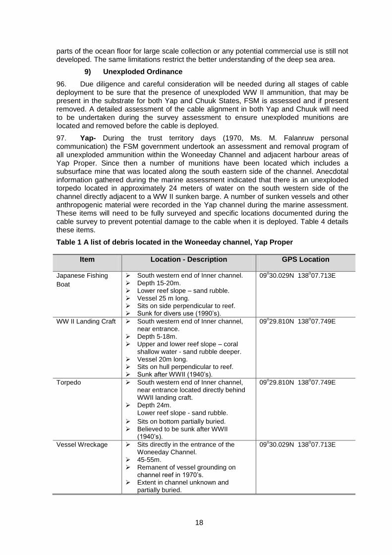
B. Project Status and Documentation
13. At the time when this IEE was prepared, a project feasibility study1, as well as an economic and financial analysis2 of the proposed project had been completed. Both ADB and World Bank had classified this project as Category B, signifying the requirement of an IEE instead of a full environmental impact assessment. The two development partners further agreed that the IEE would adhere to the content and format requirements of the ADB, but would include additional social items in the environmental management plan, reflecting the World Bank’s heavier emphasis on this component in its environmental and social assessment process and reporting.
14. Given that the focus of this IEE is on coastal zones and nearshore marine areas, various marine surveys were completed, are summarized in the IEE, and attached as a detailed report in Annex 4 of this IEE.
15. For the social assessment a stand-alone set of documents was prepared, consisting of a summary poverty reduction and social strategy, a gender action plan, and due diligence reports on involuntary resettlement and effects on Indigenous People; in total six documents.
C. Extent and Boundaries of the IEE
1) The Project Influence Areas: Nearshore and Landing Sites
16. The cable, which will be between 4 and 7.5cm (1.5-2.7”) in diameter will be buried in a trench dug by a towed submarine plough3, requiring a corridor no more than 0.75m wide (accounting for the trenching machine dimensions). The trench will average around 25 cm (10”) in width, and about 0.5-0.75m (20-30”) depth (depending on need), which is opened and then closed once the towed plough (Figure 1) lays the cable into the trench. Therefore the project influence area (PIA) in the nearshore and coastal waters is no more than a 2-4m wide corridor allowing for all possible disturbances and lateral deviations of the plough.
1 Hibbard, John. 2011. Submarine Cable system for Palau. 45pgs
2 World Bank. 2014. Financial Connectivity Study for Palau-FSM (PolyConseil Consultants):35pg
3 This method was selected as the preferred method during the analysis alternatives (Chapter V).
4
17. All specially designated areas such as marine conservation areas and special habitats such as spawning aggregation areas and seagrass beds are being treated as sensitive habitats and the project’s impact on these areas were identified.
18. Yap- For Yap the preferred approaches through Colonia shipping channel under the main bridge and through Chamorro Bay to the landing site west of the police and fire stations is all on government lands, the cable will cross the road and go into government land to an existing government area where the fibre optic cable facility could be built. The FSMTC facility is about 750m away from this location.
19. Therefore the PIA will be the 10m wide (5m on either side of the cable) main shipping channel from the sea into Colonia harbour, into Chamorro Bay the government site immediately to the east of the State Land Resources Department office. The entrance into Colonia harbour is flanked by Balabat and Tamil Municipal/Community Conservation Areas, which extend beyond the 10m boundary, but have been included in the assessment. Yap also has many coastal dive sites located around the island inside the 35 m (approx. 120 ft) depth contour (Map 4).
20. Chuuk- For Chuuk the proposed route will enter Chuuk Lagoon, through the NE Channel, then proceed in the main shipping channel to the NE end of the Weno airport runway and then proceed either inside the airport fence or just outside to a point where it will cross under the city road in an existing conduit to the FSMTC site or proceed to the State government offices above Weno, along an existing easement.
21. Therefore the PIA for Chuuk will be a 10 m wide corridor for the cable laying operation, through the NE channel and to the NE end of the airport runway and then along the landside route to the FSMTC site in a 5m wide impact corridor (Map 3).
2) Coastal and offshore corridors
22. Yap- The sea floor drops rapidly to great depth once outside the 35m contour and the cable will be laid in the waters well outside this depth, so at to avoid any possible interference with dive sites or Fish Attraction Devices (FADs). The exact location of the cable will only be known once the oceanographic mapping of the alignment is completed (as part of the construction contract). The Yap cable will link into the Palau- Guam cable (Map 1), making for a relatively short cable length of 265 Km (165 miles)
23. Chuuk-The deep ocean portion of the Chuuk cable will be linked to the existing Guam-Pohnpei fibre optic cable, via an existing connection located about 10 Km from Pohnpei in the ocean. The cable will be laid on the ocean floor avoiding a number of coral atolls and small islands (Map 10) or about 1,200 Km or 735 miles.
Figure 1. An example of submarine cable ploughs at sea and being towed from shore to deeper water by a cable laying ship
5
D. The IEE Methodology
24. The IEE has been completed based on consultations with government officials to establish a set of alternative alignments and landing sites and secondly a scoping activity defining a preferred alignment and landing site, based mostly on minimizing coastal zone environmental impacts and eliminating land acquisition. This initial scoping easily revealed a preferred alignment and landing site for which the IEE has been completed.
25. The work included a review of relevant secondary information sources, site visits, key respondent interviews, focus group discussion and public consultations to determine existing environment conditions in the PIA corridor and at the landfall. This was followed by an analysis of the potential impacts that the construction and operation of the fibre optic cable could have on the corridor’s natural and socio-cultural environment. The topics for which data were collected included:
sensitive components of the environment within the PIAs, including
Conservation Areas, Fish Attraction Devices and special tourism sites, such as
dive sites;
marine ecology of the coastal zone and nearshore waters likely affected by the
cable project, including bathymetry, benthic and coral conditions along the PIA
corridor;
any land acquisition needs and any other potential impacts;
poverty and gender conditions in relation to the proposed work;
social impacts of faster and more reliable internet connections; and
cultural heritage and archeological sites within the PIA corridor.
26. The following activities were undertaken to assemble the necessary data with which to complete this IEE:
inception mission to establish preferred landfalls for the cables and define with
work to be done;
meeting with FSM’s Ministry of Finance and other agencies that will manage
this project; and,
three field missions to Yap and Chuuk to collect primary data on the nearshore
marine system as well as the landing sites and record social issues focusing on
land acquisition and the need to relocate people or structures to make way for
the cable.
27. In addition, formal half day consultation and information sessions were completed in Yap on July 29th and in Chuuk on August 6th, 2014, with 42 and 30 people respectively, present. Each meeting presentation was followed by lively discussion and both meeting minutes, attendance records and the slide show presentation are provided in Annex 2.
28. A rapid in-water visual field assessment and benthic profiling of the marine environment and key indicator species associated with the proposed cable alignment locations was undertaken in late July and early August 2014.
29. Yap, For Yap, the marine assessment focused on the entrance to the shipping channel as well as the entire corridor past the bridge. An in-water visual field assessment and benthic profile of the marine environment and key indicator species associated with the proposed cable delivery locations for Yap were undertaken on Thursday the 31st (half day) of July. The area assessed included the inshore marine environments located within an extended area of influence of the cable all of which is associated with the natural Woneeday Channel. This included the outer barrier reef, outer and inner channel, sub-tidal
6
and tidal lagoonal reef areas and the cables terminal location on the shoreline within Chamorro Bay.
30. Chuuk- For Chuuk the marine field assessment focused exclusively on the waters from the entrance to Chuuk Lagoon to the landing site at the airport runway. It involved snorkelling surveys at eight sites along the corridor, including both visual observations and photographic records of bottom conditions.
31. The assessment on both islands took a systematic approach collecting biological and environmental information at each site before moving to the next site location. Assessment site locations were selected due to their location and proximity to the cable route, representation of different biological habitats and conservation/protected status. The assessment methodology, specific site locations and detailed findings are presented in Annex 4.
32. Information obtained from the marine assessment provided a holistic description of the natural reef system and resources associated with the cable alignment. This information was then used to gauge potential environmental impacts that will need to be considered and mitigated during the deployment of the cable in the offshore and nearshore ocean.
II. POLICY, LEGAL AND ADMINISTRATIVE FRAMEWORK
A. Physical and Ecological Environment
1) Relevant Marine Regulations
33. The FSM government is mandated through the nation’s constitution to provide overarching laws and regulations associated with the nation’s marine environment and resources for the nation. Due to the traditional and customary traditions of the various ethnic groups that make up the FSM and their traditional coastal and marine ownership patterns, the regulation of marine resources within 12 nautical miles (22.22 Km) of the coast has traditionally been considered the legal province of the States. Therefore, the States are ultimately responsible for protection of their marine resources within the 12-mile limit. However, national legislation associated with resource management within this zone is mandatory at the state level.
34. Through Article IX of the FSM Constitution provides a long list of powers to the Congress, including regulation of the ownership, exploration, and exploitation of natural resources beyond 12 miles from island baselines. National legislation pertaining to the management and protection of marine environment include:
35. Federated States of Micronesia Code (FSCMC) Title 18 – Territory, Economic Zones and Ports of Entry establishes the 200 mile extended fishery zone of the National Government and the 12-mile exclusive fishery zone of the States, their islands, and atolls. Section 106 states that traditionally recognized fishing rights in submerged reef areas shall be preserved and protected.
36. FSMC Title 24 – Marine Resources creates the Micronesian Maritime Authority, now known as National Oceanic Resource Management Authority (NORMA), which regulates the management and exploitation of marine resources within the 200 mile (322 Km) Exclusive Economic Zone (EEZ), addresses foreign fishing agreements, and administers the fishing permit system. Provision is also made for the States to establish entities to regulate commercial use of marine resources within their jurisdictions.
37. FSCMC Title 23, – Resource Conservation, Chapter One addresses conservation of marine species. It prohibits fishing using destructive methods, including the
7
use of explosives, poisons or chemicals. It also sets limits on the taking or killing of hawksbill sea turtles and regulates the taking of sponges. Penalties for violation of its provisions are inadequate, with a fine up to $100 and/or six months imprisonment.
38. FSCMC Title 23, – Resource Conservation, Chapter Two provides for the protection of endangered species of fish, shellfish and game. The Chapter was established in anticipation of ratification of CITES, which has not yet occurred. In 1976, a Regulation went into effect listing several endangered species, including the following marine species: Blue Whale, Sperm Whale, Hawksbill Turtle and the Leatherback Turtle. However, Chapter Two of this Title allows for taking of these species for subsistence food or traditional uses, provided such taking does not further endanger the species involved. Violations may result in a maximum fine of $10,000 and/or imprisonment up to one year.
39. Federated States of Micronesia Environmental Protection Act protects the environmental quality of air, land and water in Micronesia. The Secretary of Health, Education and Social Affairs (HESA) is given general authorization to control and prevent pollution. The Secretary administers a permit system for this purpose and is also authorized to enter into cooperative agreements with the States to implement environmental programs at the State level. The Act contains ample civil penalties for violations of its provisions.
2) Marine Management
40. Yap- The state government under the direction of the national government legislation govern the management of State’s inshore coastal and marine resources. The State government managers the marine resources on behalf of the landowners of Yap from high water on any point of land and extend 12 nautical miles directly offshore. Yap State’s waters consist of the internal waters and the State Fishery Zone. The Fishery Zone includes those waters within “12 miles from island baselines”. An “island baseline” is defined in the Yap State Code as an island or atoll with a fringing reef or barrier reef as a “line following the contour of the seaward edge of the reef system” (i.e. the outer edge of the reef). Internal waters are defined as “waters landward of the baseline, including the lagoons of atolls or islands” (Gravitt, 2006). Adjacent to the state waters is the Economic Excusive Zone (EEZ) that extends out to 200 nautical miles which is managed by the FSM national government.
41. Yap’s Marine Resources Management Division (MRMD) that sits under the portfolio of the Department of Resources and Development (R&D) is mandated to manage the States inshore marine resources in collaboration with other State government divisions and agencies.
42. The R&D Department is charged with promoting “economic development and the conservation and development of agricultural, mineral, forest, water, and land and other natural resources.” The strategic goal of MRMD is to “manage, conserve and develop the marine resources of Yap State in a manner that will provide the best possible economic and social benefit to the people of Yap both today and in the future”.
43. The Yap State code through its chapters provides the legal mandate for the MRMD to manage the nation’s resources. There are a number of laws that provide various levels of protection and management of coastal and marine resources. These include the protection of:
Coconut crabs (Birgus latro) or “ayuy” by banning the taking of crabs with a
shell diameter is less than three inches during the closed season between 01st
of June through to the 30th of September and a complete ban on the sale of
these animals.
Turtles by the banning of the sale of any turtle meat or eggs, however the
collection can be undertaken for traditional purposes.
8
A harvesting seasons of giant clams and a set of size limits for harvesting and
the ban on all sale of clam meat.
Complete harvesting ban on Trochus (T. niloticus) unless an open season has
been declared, and
A complete ban on the use of fish poisons (by natural – plant material and
made – hypochlorus acid), and
A complete ban on the use of explosives.
44. Chuuk- The Chuuk State Constitution recognizes all traditional rights and ownership over all reefs, tidelands, and other submerged lands subject to legislative regulation of their reasonable use. Tidelands traditionally are those lands from the dry land to the deep water at the edge of the reef, and must be shallow enough for Chuukese women to engage in traditional methods of fishing (Gravitt, 2006).
45. Thus, the state government under the direction of the national government legislation govern the management of State’s inshore coastal and marine resources. The government managers the states marine resources on behalf of the landowners of Chuuk from high water on any point of land and extend 12 nautical miles directly offshore. Chuuk State’s waters consist of the internal waters and the State Fishery Zone. The Fishery Zone includes those waters within “12 miles from island baselines”. An “island baseline” is defined in the Chuuk State Code as an island or atoll with a fringing reef or barrier reef as a “line following the contour of the seaward edge of the reef system” (i.e. the outer edge of the reef). Internal waters are defined as “waters landward of the baseline, including the lagoons of atolls or islands” (Gravitt, 2006). Adjacent to the state waters is the EEZ that extends out to 200 nautical miles which is managed by the FSM national government.
46. Chuuk States Department of Marine Resources Development (DMRD) is governed by the Chuuk State Law 5-92 which was signed in 1984 which itself was based on the State Fishery Act of 1983 and is mandated “to promote economic development and to manage and conserve living sea resources” within the jurisdiction of the State. The Department has four divisions, which include: Operational and Technical Supply, Research
and Development, Conservation and Management and Fisheries. The State’s Attorney
General is the primary body responsible for enforcement of the Act.
47. The Chuuk State code through its chapters provides the legal mandate for the DMRD to manage the nation’s resources. The management and/or protection of coastal and marine resources include only a total ban on the use of explosives (dynamite fishing) and the sale of fish collected using this method. There are currently no other laws in the Act that place restrictions on species or methods of harvest. The FSM regulations that protect the harvest of turtles and their eggs, the collection of black pearl oyster (Pinctada margaritifera) and Trochus are not included in the Act, although acknowledged (anecdotal information DMRD).
B. Socio-Economic Environment
1) Customary Ownership and Marine Areas
48. Yap- In Yap, almost all land and aquatic areas are owned or managed by individual estates and usage is subject to traditional control.
49. A key agency associated with the development of community based conservation areas is the Yap Community Action Program, or YapCAP. This agency mission is to operate or support programs aimed at environmental and cultural preservation and other sustainable economic and social development programs in the pursuit of self-reliance for all Yap citizens.
50. The agency’s environmental goals include;
9
Implement the Yap Biodiversity Strategy and Action Plan to ensure the
preservation of Yap’s unique environment.
Work with communities to identify and develop environmental projects, and
then link communities with the appropriate government agencies to aid
implementation.
Seek funding for environmental projects identified by community groups and
other environmental agencies, and administer and regulate the funds.
51. Chuuk- In Chuuk State the majority of the land and aquatic areas are privately owned and acquired through inheritance, gift or, recently, by purchase. In all States, land cannot be sold to non-citizens of the FSM.
52. Due to the presence of a large number of WW II historic shipwrecks and other munitions the Chuuk Lagoon State District Monument Act has been adopted which provides for these items to be designated as a State district monument and therefore preserved. The removal of any equipment associated with these items is illegal.
53. These land and marine ownership patterns greatly influence the strategies and actions required to manage the resources of the states in a sustainable manner.
2) Legislations on Land Acquisition
54. Yap- Most of the lands in Yap are privately owned. Approximately ninety-eight percent of land in Yap State is privately owned, with the majority of State owned land located in the capital of Colonia in the municipalities of Rull and Weloy.4 There is no established Act or Law for Yap State to acquire or determine fair market value of private land in Yap. However due to the need to acquire land for public infrastructure, the Attorney General has developed a Land Acquisition Procedure for acquiring land under the ADB-funded Yap Renewable Energy Project. Pending the approval of the Land Registration Bill, the said land acquisition procedure may guide future land acquisitions for public purpose in Yap State.
55. The Land Registration Bill or Bill No. 7-130, a bill aims to provide for the survey and registration of lands in the State of Yap, and for other purposes. This bill was introduced to the Yap State Parliament in 2010.
56. Non-citizens cannot own land in Yap but they can lease land for a maximum of 99 years, including options to renew. Leasing of lands or making landowners partners or shareholders of projects, therefore, is viewed as the most appropriate arrangement for utilization of land. Upon request, the Yap State Government may act as an intermediary in finding suitable land arrangements. The Yap State Mortgage Law provides the necessary legal framework for land mortgages.5
57. Chuuk- The majority of land in Chuuk is privately or commonly family- owned lands thus the State Government has limited land to locate public infrastructure. This has resulted to continuous challenge of acquiring land for public infrastructure such as power, water and airport. Executive Order (EO) No. 04-2007 of Chuuk State Government adopted the Asian Development Bank valuation zoning system. The EO also provided a zone map and base valuation, with modifications, and promulgating its implementation for acquisition or leasing of private land for public purpose in Chuuk State.
58. The Chuuk State Constitution provides for acquisition of land on its infrastructure requirement based on fair market value. The said EO aims to address concerns on
4 Yap State, Department of Resource and Development website, September 2014
5 Ibid
10
determining the said fair market value, with clear land title and preventing real or apparent conflicts of interest in acquiring lands for the State.
59. This EO was updated after a valuation study supported by a previous ADB technical assistance project (ADB Private Sector Development Program Loan No. 1874) in April 2006 and 1998. From the valuation study, 30 valuation maps were produced. To avoid complicated transactions and perceived unfairness and confusion among and between landowners and the government involved, the valuation came up with simpler adjustments to the zone and base values, using an annual rent of per square meter of10% of the base value, considered fair market value.
3) Legislation on Cultural Preservations
60. Yap- Historic preservation provision exists in the Yap State Code as well as in the State Constitution. A Historic Preservation Office is established pursuant to the “Preservation of Culture” Code Sections. Under this legislation, no person may wilfully remove historic property from Yap or disturb, damage or destroy such property without the express written permission of Governor, a local member of the Council of Traditional Chiefs, and a Historic Preservation Office.
61. Chuuk- The Draft Chuuk Historic Preservation Act. This Bill recognises the importance of physical cultural and historic heritage as well as the intangible heritage in
tradition, arts, crafts and songs. The Bill proposes for the establishment of a Historic Protection Office (HPO) within the Department of Commerce and Industry whose principal objectives shall be to protect and conserve places of historic and cultural interest including intangible heritage.6
62. Legislation exists (as above) which declares the approximately 80 submerged wrecks in the Chuuk Lagoon to be a war memorial and historic site. Removal of artefacts
from the wrecks is prohibited and divers must have permits and be accomplished by licensed guides.7
C. International and Regional Treaties, Conventions and
Agreements
63. The FSM through its membership of a number of international and regional treaties, conventions and agreements (Table A4.2 Annex 4) and its membership to international and regional organizations associated with the marine sector (Table A4.3 Annex 4) manage the nation’s environment, species and inshore and offshore foreign commercial fishing activities that are undertaken within the EEZ.
D. ADB and World Bank
64. According to ADB’s SPS 2009, the FSM environmental assessment was classified as a Category B undertaking, requiring the initial environmental examination that is described in this report. The approach to and content of the IEE is defined in Appendix 1 of SPS 2009. OP/BP 4.01 is the World Bank’s equivalent to SPS 2009. It was revised in early 23013 and now reflects social sector requirements more clearly. Its focus however is on defining the environmental assessment requirements for all WB projects, including a description of the screening and suggested content of the environmental assessment document. The World Bank’s equivalent to the IEE is the Category B Environmental and Social Assessment.
6 Environmental Law in the South Pacific
7 Ibid
11
65. Even though much of the funding for the FSM component of the project is coming from the World Bank, The donors instructed FSM to adhere to ADB’s submission and review procedures, coupled with those of the FSM have been followed.
III. PROJECT DESCRIPTION
A. Need and Details
1) Need for Project
66. At present, FSM relies entirely on satellite links for international connectivity. The high cost, variable and limited availability of this international bandwidth is a major constraint to future development of the country, and slows FSM’s economic and social development. The proposed project would support an investment in a submarine fibre optic cable that would connect FSM with Guam and the rest of the world.
67. The proposed project will contribute to improved public services (including online government services such as health, education and financial services), support the tourism sector, and facilitate better trade and communication among north Pacific island economies.
B. Project Details and Components of the Work
68. The overall project involves the placement of a submarine fibre optic cable from Guam to Palau with a spur to Yap and a long link connecting Chuuk to the Guam Pohnpei cable, for total of over 2,000 Km, much of it in deep ocean waters (Map 1). For Yap the cable will likely make landfall inside Colonia harbour along the shore of Chamorro Bay.
69. For Chuuk there are a number of cable route options once the cable passes through the natural pass in the barrier reef and enters the lagoon (Map 3).
12
Map 2. Proposed Cable Alignment and Project Influence zone, Yap State.
70. The preferred alignment for Chuuk enters the lagoon through the NE pass, and then along the bottom of the main shipping channel, making landfall at one of several locations near either end of the airport runway (Map 3). A third option is from the south, requiring navigation through a large number of wreck dive sites and likely unexploded ordinance. That pass through the barrier reef, known as the Neuri Pass (or SE Pass), is also a known fish aggregation site, where napoleon grouper come to spawn.
1) Once the safeguard documentation is completed, a Project Coordinator and fibre optics specialist has been appointed by MICROPAL (under funds allocated especially for this work) and the detailed design and bid preparation is under way, the grant funding will be released and call for proposals, bid evaluation will take place and work can begin.
13
Map 3. Proposed alternative Alignments for Chuuk Lagoon
C. Project Layout and Components of the Work
71. The project consists of three main components: i) the oceanographic and nearshore bathymetric survey to establish a specific route for the cable joining the Guam to Palau cable to Colonia, Yap Sate and the cable connecting Chuuk to the network along the Guam to Pohnpei cable. The placement of the cable along these two routes will require the use of a special cable laying vessel; and the preparation of the landing facility and structure (about 40m2) at both locations.
72. Yap- For Yap, the cable will likely be placed in the center of the shipping channel to the bridge (Map 4A) and then into Chamorro Bay to the state-owned landing area and facility site.
73. Chuuk- For Chuuk it will likely be the corridor from the Guam-Pohnpei cable junction skirting a number of atolls to the NE end of the airport runway and then either to the existing FSMTC office or to the governor’s complex via an existing easement (Map 4B).
74. The small ‘footprint’ of the cable (shown to the right) means that a very narrow corridor will be needed and that The environmental ’footprint’ of the project will be that associated with a small diameter basically inert cable (glass, steel and rubber) placed on or buried beneath the seafloor8.
8 The photo of a fibre optic cable is actually for an older construction, as newer cables do not have a copper
conductor, as external power is not necessary.
14
Map 4. Details of Cable Landing Site In Colonia (A) and in Weno (B)
A
B
15
IV. BASELINE DATA
75. The Federated States of Micronesia are located within the Caroline Island group of Micronesia and together form the western most archipelago of Oceania. Yap s located approximately 740 Km east of Mindanao in the south west of the Philippines, 480 Km and 1,300km south west of Yap State and Guam, respectively. Yap State is bordered to the east and east west by the remaining three States of the FSM (Chuuk, Pohnpei and Kosrae), Guam to north east. Chuuk is located about 9.5 o north of the equator and some 1000km west of Pohnpei.
A. Physical Environment
1) Climate
76. Yap and Chuuk both have a wet and dry season, the wet season extending from May through September, with frequent typhoon and heavy rain and wind conditions. Other times of the year are predominantly sunny with occasional rain and wind, and daytime temperatures a steady 28oC. Typhoons normally developed within the FSM, particularly the eastern islands including Chuuk State, with server storms affecting Chuuk approximately every 5 years whilst Yap, which normally sits outside the path of these tropical systems, is affected every two decades or so.
2) Air Quality and Noise
77. The project will need an oceanographic survey of the cable route and the placement of the cable, requiring the use of a large ocean-going vessels. Both of these diesel fuelled ships emit large volumes of SO2, NOx, PM10 and PM2.5. The survey vessel will likely be in operation for several weeks, whereas the cable ship about 400 days covering the distance between Yap and the Guam- Palau cable and the Chuuk to the Guam-Pohnpei cable. Air quality in the open ocean is likely very good and at this time meets all international ambient air quality standards.
78. No doubt the operation of the large survey and cable laying vessels will generate noise, but given that the work will be conducted at sea as well as near barrier reefs the background noise level of the waves breaking on the reefs, will negate vessel noise, making it a non-issue.
79. Given that there will be no need for land-side excavation or use of heavy equipment, air quality and noise will be not be an issue.
80.
3) Topography, Geology, Soils and Hydrology
81. Yap State consists of four volcanic islands plus 19 inhabited outer islands and 59 additional atolls, with a total land area of 120 Km2 (46 miles2). Yap State can be divided into two distinct spheres: "Yap Proper" and the "Outer Islands." Yap Proper is a cluster of relatively high islands with volcanic and continental rock, surrounded by a fairly wide reef platform. The Outer Islands are coral islands and atolls scattered over a wide area, with relatively low populations.
82. Chuuk State is made up of five island regions: Chuuk Lagoon (which includes the state capital of Weno), Mortlocks, Pattiw, Halls and Nomunweito islands. Chuuk Lagoon is the largest atoll in the FSM and serves as the population and political center of Chuuk State. Chuuk lagoon is made up of a number of high islands of volcanic origin located within the lagoon and coral islands located on the barrier reef. The Outer islands are all coral islands and atolls scattered over a wide area, with relatively low populations.
16
4) Seismology and Earthquakes
83. Earthquakes impact fibre optic cables when there significant geological plate movements that stress the cable and or when this movements cause deep sea landslide breaking the cables. Based on data from the website http://earthquaketrack.com/r/state-of-yap-micronesia/recent and http://earthquaketrack.com/r/state-of-yap-micronesia/recent , the area around Yap experiences considerable seismic activity, while Chuuk, much less.
84. Yap-Over the past two years the zone between Guam and Yap, along the Marianas Trench has had >30 tremors ranging between 4.6 and 6.6 on the Richter scale, These tremors have occurred mostly around the Marianas Islands and at great depth below sea level (9-160 Km).
85. Chuuk –Chuuk is a much less active area with only ten earthquakes recorded over the past 40 years, and also at depths of 10 to 330 Km below the sea surface.
5) Tides
86. The basic tide parameters associated with Yap and Chuuk States include a maximum tidal variation of just over 1.5 meters (meso-tidal); they are semi-diurnal (2 tides a day) with a strong diurnal inequality with the twice daily tides showing considerable variability in amplitude (Wolanski and Furukawa, 2007). Small seasonal and daily tidal fluctuations have been recorded, which has been related to sea conditions associated with weather patterns existing at the time of the recording. Inclement weather systems e.g. storms, typhoons do have a marked impact on the tidal height and can cause increased coastal erosion if they coincide with high water periods.
6) Deep Sea
87. The deep sea bathymetry associated with the islands of the FSM is complex and includes deep ocean ridge, trench, seamounts and thermal vents. The main Island of Yap (called Yap Proper) is part of an arc-trench system between the Philippine and Pacific continental plates. Yap is located towards the northern end of a generalised ridge system called the Palau-Kyushu ridge which includes the Palau trench which continues in a north easterly direction passing to the south of Yap Proper terminating below the Guam islands and is called the Yap trench (Map 2).
88. The Yap trench has a maximum recorded depth of near 8000 metres with the majority of its length over 6000 m deep. The bathymetry surrounding Chuuk and the waters west of the Yap trench averages between 3500 – 5000 metres deep and includes an undulating benthic substrate.
Map 5. Bathymetry of Yap-Guam-Chuuk Area, Including the Deep Sea Trenches
Existing
Cable
17
7) Hydrothermal Vents
89. There are very few studies and resulting information available detailing hydrothermal vents along the proposed (approximate) cable alignment corridor from Guam to Palau the Yap spur and the Chuuk to Pohnpei link. Hydrothermal vents are present when volcanically heated water issues from cracks in the earth’s crust. Typically, water issuing from these vents can exceed 300° C and is prevented from boiling only by the immense overlying hydrostatic pressure. However, within a few meters of the discharge, the water cools to around 2.5oC. The water is also extremely acidic, thus corrosive, and is capable of leaching out minerals from the surrounding rock.
90. Individual vent structures are usually small, measuring only a few tens of metres across, and stand a similar height off the surrounding sea floor. Individual vents exist within vent fields. These fields, which measure in the order of a few kilometres across, are sites where hydrothermal activity is closest to the surface and within which vents form when heated water reaches the surface. Vents are also individually ephemeral and could occur at any site along the proposed cable alignment at any point in time, replacing sites that become dormant or are destroyed by volcanic activity9.
91. Deep sea thermal vents support unique ecosystems consisting of densely populated organisms occurring within a few hundred square metres of the vent. The communities prey almost exclusively on microorganisms that reduce chemicals to provide energy to sustain a variety of associated, mainly invertebrate, organisms. In the western Pacific hydrothermal vents are dominated by bathymodiolid mussels, “hairy” gastropod, vesicomyid clams, and shrimp (Llodra & Billet 2006). Deep sea vents can be located in varying locations, but generally near volcanic activity, and can range from as shallow as 500m to the deep ocean10.
8) Seamounts
92. Seamounts generally originate as volcanoes and are generally associated with intraplate hotspots, mid ocean ridges or island arcs. They support unique ecosystems that have high biodiversity (endemism has been reported as being high) and act as important aggregations sites for pelagic and demersal fish resources, invertebrates and have been reported to act as important navigational “waypoints” for oceanic migratory species (Rodgers, 2012). Recent studies have shown that the pelagic biodiversity around seamounts is far greater than in areas of open ocean, and even in coastal reef areas. On average, 15% of benthic species found associated with seamounts in the Pacific are endemic either to that specific seamount or to a cluster of seamounts (Alder & Wood, 2004).
93. The main cause of this increased diversity is up-welling currents and oceanographic phenomena that drive primary productivity and create additional ecosystem niches that support more species associated with sea mounts.
94. Benthic areas not associated with hydrothermal vents, sea mounts and active spreading zones, such as the abyssal plains and ridges, also support a diverse albeit less dense populations composed mostly of nematodes, foraminifera, polychaete worms, small peracarid crustaceans, molluscs, nemerteans and a variety of marine worms (Llodra & Billet 2006).
95. Benthic organisms associated with the deep water of FSM have no current national economic importance and are not harvested commercially. The technology to access deep
9 The large-vessel bathymetric survey conducted prior to the final determination of the cable alignment
should be able to detect any hydrothermal fields, and potentially establish a route around them. 10
For more details see https://php.radford.edu/~swoodwar/biomes/?page_id=1027 and http://faculty.college-prep.org/~bernie/sciproject/project/HydroT/hydroint.html
18
parts of the ocean floor for large scale collection or any potential commercial use is still not developed. The same limitations restrict the better understanding of the deep sea area.
9) Unexploded Ordinance
96. Due diligence and careful consideration will be needed during all stages of cable deployment to be sure that the presence of unexploded WW II ammunition, that may be present in the substrate for both Yap and Chuuk States, FSM is assessed and if present removed. A detailed assessment of the cable alignment in both Yap and Chuuk will need to be undertaken during the survey assessment to ensure unexploded munitions are located and removed before the cable is deployed.
97. Yap- During the trust territory days (1970, Ms. M. Falanruw personal communication) the FSM government undertook an assessment and removal program of all unexploded ammunition within the Woneeday Channel and adjacent harbour areas of Yap Proper. Since then a number of munitions have been located which includes a subsurface mine that was located along the south eastern side of the channel. Anecdotal information gathered during the marine assessment indicated that there is an unexploded torpedo located in approximately 24 meters of water on the south western side of the channel directly adjacent to a WW II sunken barge. A number of sunken vessels and other anthropogenic material were recorded in the Yap channel during the marine assessment. These items will need to be fully surveyed and specific locations documented during the cable survey to prevent potential damage to the cable when it is deployed. Table 4 details these items.
Table 1 A list of debris located in the Woneeday channel, Yap Proper
Item Location - Description GPS Location
Japanese Fishing
Boat
South western end of Inner channel. Depth 15-20m. Lower reef slope – sand rubble. Vessel 25 m long. Sits on side perpendicular to reef. Sunk for divers use (1990’s).
09o30.029N 138
o07.713E
WW II Landing Craft South western end of Inner channel, near entrance.
Depth 5-18m. Upper and lower reef slope – coral
shallow water - sand rubble deeper. Vessel 20m long. Sits on hull perpendicular to reef. Sunk after WWII (1940’s).
09o29.810N 138
o07.749E
Torpedo South western end of Inner channel, near entrance located directly behind WWII landing craft.
Depth 24m. Lower reef slope - sand rubble.
Sits on bottom partially buried. Believed to be sunk after WWII
(1940’s).
09o29.810N 138
o07.749E
Vessel Wreckage Sits directly in the entrance of the Woneeday Channel.
45-55m. Remanent of vessel grounding on
channel reef in 1970’s. Extent in channel unknown and
partially buried.
09o30.029N 138
o07.713E
19
Item Location - Description GPS Location
Telecommunication
Cable
Located along western side of Woneeday channel.
24-30 m. Old copper line, believed to originate
from the commercial dock land. Extent remaining unknown, parts have
been removed. Believed to be mostly buried within
channel.
Extent unknown.
Sewerage discharge
pipe line
Treated sewerage discharge location directly east of the treatment plant.
Outside area of cable influence.
09o30.755N 138
o07.722E
98. Chuuk - In Chuuk state, and as a result of activities during WW II and the sinking of the Japanese fleet, considerable materials from these vessels are scattered throughout the Chuuk Lagoon. The majority of the larger vessels and machinery have been located, however it is acknowledged (anecdotal information from many stakeholders) that there would be items scattered throughout the lagoon yet to be identified. Therefore, due diligence will be needed when surveying the cable alignment to locate possible unexploded munitions. There are no known sunken ships or machinery in the main shipping channel. The wreck of the Katsuragisan Maru is located inside the northeast pass and to the north east of the channels entrance. The vessel is 87m long, 2,427 tons and sits on the sand in 70 metres of water. This vessel location is known and is not within the area of influence of the cable. Therefore for Chuuk, the UXO issue is likely marginal.
B. Ecological Environment
1) Mangroves
99. Mangrove forests are a significant coastal habitat that are associated with the coastal estuarine, foreshore and intertidal areas and play a significant role in coastal biological diversity, erosion control and are a natural barrier of protection for the islands. Mangroves forest are found in all four states of FSM and are best developed in the high island states of Pohnpei and Kosrae, however Yap state contains the highest diversity of mangrove species. Chuuk State due to the islands limited land and estuarine areas have only small isolated areas of mangroves however they are present throughout the state (Falanruw, 2001). Cole et al., (1999) estimated that for Chuuk state there was 306 hectares of mangrove forest (2 percent of the land within the State) and for Yap he estimated 1171 ha (10 percent of the land within the state).
2) Marine Ecosystem
100. Inshore Marine Environments - The FSM has an EEZ of 3,004,321 km2, an estimated coastline for all states of 701 Km (SPC, 2013). Yap State consists of one island (Yap Proper) that is derived from volcanic and continental origins that is surrounded by a relatively extended reef flat and shallow lagoon whilst the remaining islands of the state are coral islands and/or atolls. Chuuk State is made of coral atolls and islands that include the Chuuk lagoon which possess both high island of volcanic origin within the lagoon and coral islands located on the barrier reef. All islands associated with both FSM states are surrounded by a coral reef in most cases a barrier reef, which is interrupted at intervals by deep water passes. Distinctive shallow water fringing reef systems are associated with the larger volcanic and continental islands located in both States.
101. All major types of coral reefs are found within Yap and Chuuk including barrier reefs, fringing reefs, atolls and submerged reefs. Common reef habitats include lagoon reefs (pinnacle, patch), passes, channels, shallow reef flats, terraces, submerged reefs,
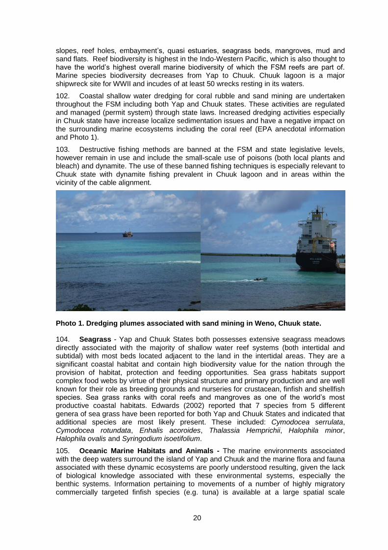
20
slopes, reef holes, embayment’s, quasi estuaries, seagrass beds, mangroves, mud and sand flats. Reef biodiversity is highest in the Indo-Western Pacific, which is also thought to have the world’s highest overall marine biodiversity of which the FSM reefs are part of. Marine species biodiversity decreases from Yap to Chuuk. Chuuk lagoon is a major shipwreck site for WWII and incudes of at least 50 wrecks resting in its waters.
102. Coastal shallow water dredging for coral rubble and sand mining are undertaken throughout the FSM including both Yap and Chuuk states. These activities are regulated and managed (permit system) through state laws. Increased dredging activities especially in Chuuk state have increase localize sedimentation issues and have a negative impact on the surrounding marine ecosystems including the coral reef (EPA anecdotal information and Photo 1).
103. Destructive fishing methods are banned at the FSM and state legislative levels, however remain in use and include the small-scale use of poisons (both local plants and bleach) and dynamite. The use of these banned fishing techniques is especially relevant to Chuuk state with dynamite fishing prevalent in Chuuk lagoon and in areas within the vicinity of the cable alignment.
Photo 1. Dredging plumes associated with sand mining in Weno, Chuuk state.
104. Seagrass - Yap and Chuuk States both possesses extensive seagrass meadows directly associated with the majority of shallow water reef systems (both intertidal and subtidal) with most beds located adjacent to the land in the intertidal areas. They are a significant coastal habitat and contain high biodiversity value for the nation through the provision of habitat, protection and feeding opportunities. Sea grass habitats support complex food webs by virtue of their physical structure and primary production and are well known for their role as breeding grounds and nurseries for crustacean, finfish and shellfish species. Sea grass ranks with coral reefs and mangroves as one of the world’s most productive coastal habitats. Edwards (2002) reported that 7 species from 5 different genera of sea grass have been reported for both Yap and Chuuk States and indicated that additional species are most likely present. These included: Cymodocea serrulata, Cymodocea rotundata, Enhalis acoroides, Thalassia Hemprichii, Halophila minor, Halophila ovalis and Syringodium isoetifolium.
105. Oceanic Marine Habitats and Animals - The marine environments associated with the deep waters surround the island of Yap and Chuuk and the marine flora and fauna associated with these dynamic ecosystems are poorly understood resulting, given the lack of biological knowledge associated with these environmental systems, especially the benthic systems. Information pertaining to movements of a number of highly migratory commercially targeted finfish species (e.g. tuna) is available at a large spatial scale
21
however information pertaining to the movement large iconic fauna groups such as the cetaceans (e.g. whales, dolphins) that are recorded to frequent these waters have little documented information.
106. Information pertaining to deep water benthic fauna and the environments that these organisms reside is all but absent and therefore information pertaining to the organisms and marine benthic habitats associated with the oceanic cable alignment is almost non-existent. Two distinct habitats have been recorded associated with the deep benthic waters of the FSM, however their biodiversity and ecosystem importance is unknown. These habitats include hydrothermal vents and seamounts.
107. Reef systems –Yap- The shallow reef systems located adjacent to the proposed cable alignment is healthy and is in good condition with substantial live coral coverage and associated healthy and diverse populations of marine plants. Populations of invertebrates (e.g. mollusc, echinoderms, crustaceans, polychaetes) and vertebrates (e.g. fin fish) recorded low numbers, especially those species targeted for subsistence harvesting.
108. Live percent hard and soft coral coverage, species and morphology diversity in general decreases from the entrance (barrier reef) of the Woneeday channel on either side moving north. Low percentage coral coverage and presence is located within the intertidal area associated with the terminal end of the proposed cable within Chamorro bay.
109. The reef flats in close proximity to the reef slope on both sides of the channel towards the entrance have good coral coverage, dominated by Porities sp. and Acropora sp., that increases as the water deepens down the reef slope. Landward reef systems have good coral coverage associated with the reef edge, however as the elevation decreases the reef flats are dominated by sea grass beds and sediment, interspersed with Porities sp. coral heads. It is the reef slope areas on both sides of the channel and along its entirety that recorded the highest level of coral coverage, diversity and associated invertebrate flora and fauna. The reef slope in all areas associated with the main and inner channel have steep slopes (refer Plate 6a &9b, Annex 4), ranging between 10 - 40 meters wide before they descend directly to the sea floor. The reef flats vary in size (large and expansive on the landward side), however are shallow and during periods of low water (spring tides) are exposed, with considerable exposure on the landward side of the channel (refer Plates 3a & b, Annex 4).
110. Flora and fauna found in the marine sediments in close proximity to the proposed cable alignment will have a low diversity and low populations. Environments were sunlight is present, the benthic substrate may have marine algae, including cyanobacteria, and/or sea grass. Benthic coverage of these plants will decrease as light penetration diminishes with water depth (e.g. 5-15 m) and will become absent in deeper water. Hard coral populations in general are light limiting however require a stable and solid substrate to attach and survive. In areas of constant sediment movements, especially were light is limited, hard corals are absent. This is demonstrated by the absence of hard corals located in the deep channel areas associated with the proposed cable alignment.
111. Soft corals will show a similar trend however there are a number of filter feeding genera that inhabit soft sediments with good water flow. These animals (e.g. sea pens, anemones) may be present in areas associated with the cable alignment. Sponges and other invertebrates will also be expected in these areas. In addition, there will be a wide variety of detritus feeding invertebrate organisms that will live on or beneath (e.g. burrows) the substrate. These include holothurians (e.g. sea cucumbers, sea urchins), marine worms, and shrimps. Predator invertebrates (e.g. star fish, sea urchins, mantis shrimps) and finfish species will also be present.
112. In summary, the benthic profiles within the areas surveyed are all very similar possessing a hard and soft coral covered reef edge and steep reef slope and a relatively homogenously horizontally flat seabed that has been reported (Smith, 2003) to be was
22
almost devoid of hard benthic structures. The seabed sediment characteristics are a result of tidal currents and water movements within the lagoon.
113. Reef System (Chuuk)- The shallow reef systems located adjacent to the proposed cable alignment are healthy and are in good condition with substantial live coral coverage and associated healthy and diverse populations of marine plants, invertebrates (e.g. mollusc, echinoderms, crustaceans, polychaetes) and vertebrates (e.g. fin fish). During the field assessment, observed numbers of finfish and edible and/or commercial invertebrates were low. Subsequent discussions with staff at DMRD highlighted that the low numbers are a result if un-sustainable fishing pressure.
114. The barrier reef located at the entrance of the Northeast Passage showed a relatively high diversity of hard and soft coral species dominated by massive stony corals interspersed with smaller colonies of branching and crustose forms with an average of 25- 30 percent coral coverage. The northern side of the channel entrance showed higher coral diversity and present coverage than the southern side of the channel whilst areas deeper than 20 meters showed a low percent live hard coral coverage. The deeper sections of the channel (25-35m) predominately consisted of remnant hard coral structures eroded due to wave action interspersed with coral reef sand. It is anticipated that the channel during inclement weather conditions receives considerable wave and current activity.
115. Inshore patch reefs are dominated by a wide size range of massive stony corals (e.g. Porities sp.,) branching and tabular (Acropora sp.) morphological forms interspersed with a fine substrate derived from either or a combination of reef and teridgernous sediments depending on the location of the reef (Plates 17, 18, & 19, Annex 4). Hard coral percent coverage increases from the reef flat, edge and slope. The reef slope in steep and drops away to a sand substrate (13-18m).
116. Hard coral live percent coverage, species and morphological diversity in general was recorded highest on the patch reefs located within the Chuuk Lagoon (southern boarder of the main shipping channel) assessed. Invertebrate diversity mirrors this trend. Sea grass meadows are present in the intertidal areas associated with the islands located within the lagoon. The cable alignment is a considerable distance (5 plus Km) away from these meadows and therefore will have no impacts whatsoever on these biological systems. The shallow water sub tidal and intertidal locations at the southern end of the runway on Weno Island have been heavily dredged both for airport landfill and more recently building material. Therefore the natural marine habitats have been highly modified. There are small patches of remnant marine ecosystems that have not been dredged which contain small stands of massive and branching hard corals and isolated patches of sea grass and macro algae.
117. The reef systems boarding the channel and proposed cable alignment show very similar benthic profiles. Bathymetric data collected from nautical charts of Chuuk lagoon indicates that the sea floor associated with the cable area of influence follows a general pattern of steep sided reef slopes descending directly to the sea floor that is relatively homogeneous flat.
118. Benthic Communities (Yap)- The reef systems boarding the channel and proposed cable alignment show very similar benthic profiles. A bathymetric survey undertaken for Woneeday Channel, Yap Proper (Smith, 2003) indicated that the sea floor follows a general pattern of steep sided reef slopes descending directly to the sea floor where the sea floor showed a homogenous and relatively flat seabed. The sea floor averages between 38 – 42 meters for the majority of outer channel whilst the water depths decreases (averages between 28-30 m) when entering the left hand side channel which leads directly to Chamorro bay, at which point water depth decreases to 10 meters under the road bridge and continues to decrease entering the bay and the cables terminal point located in the intertidal coastal area.
23
119. The shallow water sea floor sediments assessed are composed of both reef and terrigenous derived substrate. The landward (inshore) reefs close to coast are impacted by terrestrial run off from the land and estuarine systems that discharge directly into Chamorro bay. This is reflected in the higher proportion of terrestrial derived finer sediment and expansive shallow water reef flats that are dominated by sea grass, marine invertebrates and mangroves close to shore (refer Plate 11, Annex 4). Substrates found in the main channel and to a certain extent the seaward side reef systems associated with the channels has a higher proportion of coral reef substrate (white fine calcium carbonate sand). Reef sediments dominate the substrate located within the outer channel. It is expected that sediments located on the sea floor within the channel that are directly associated with the proposed cable alignment route would be derived from both reef and terrestrial sources.
120. Benthic Communities (Chuuk)- The reef systems boarding the channel and proposed cable alignment show very similar benthic profiles. Bathymetric data collected from nautical charts of Chuuk lagoon indicates that the sea floor associated with the cable area of influence follows a general pattern of steep sided reef slopes descending directly to the sea floor that is relatively homogeneous flat.
121. The sea floor between the outer barrier reef and the deeper water adjacent to Weno Island through the main shipping channels averages 60 meters depth. The entrance of the northeast channel is relatively shallow with maximum depths of 30 meters whilst the sub tidal and intertidal reef areas directly adjacent to the south eastern corner of the runway (Weno Island) decrease water depth as it enters this area.
122. The shallow water sea floor sediments assessed are composed of both reef and terrigenous derived substrate. The landward (inshore) reefs close to the island coasts are impacted by terrestrial run off from the land that discharges directly into the coastal waters. This is reflected in the higher proportion of terrestrial derived finer sediment and expansive shallow water reef flats located around the islands within the lagoon. Substrates located between the barrier reef and high islands of the lagoon associated with the main shipping pass are dominated by coral reef derived sediments (white fine calcium carbonate sand). It is expected that sediments located on the sea floor within the channel that are directly associated with the proposed cable alignment route would be derived from both reef and terrestrial sources.
123. Other Marine Flora and fauna (Yap and Chuuk)- The field surveys on Yap and Chuuk found in the marine sediments in close proximity to the proposed cable alignment had a low diversity and low populations. In environments where sunlight is present, the benthic substrate had marine algae, including cyanobacteria, and/or sea grass patches growing. Benthic coverage of these plants l decreases as light penetration diminishes with water depth (e.g. 5-15 m) and will become absent in deeper water, where the most ot the cable placement will occur. Hard coral populations in general are light limiting however require a stable and solid substrate to attach and survive. In areas of constant sediment movements, especially were light is limited, hard corals are absent. This is demonstrated by the absence of hard corals in the deep channel areas and open lagoonal waters associated with the proposed cable alignment.
124. Soft corals show a similar trend, however there are a number of filter feeding genera that inhabit soft sediments with good water flow. These animals (e.g. sea pens, anemones) may be present in areas associated with the cable alignment; but in deeper waters. Sponges and other invertebrates will also be expected in these areas. In addition there will be a wide variety of detritus feeding invertebrate organisms that will live on or beneath (e.g. burrows) the substrate. These include holothurians (e.g. sea cucumbers, sea urchins), marine worms, and shrimps. Predator invertebrates (e.g. star fish, sea urchins, mantis shrimps) and finfish species will also be present. The physical presence of these species was not confirmed.
24
125. In summary, the benthic profiles within the areas surveyed are all very similar possessing a hard and coral covered steep reef slope and a relatively homogenously horizontally flat seabed that was almost devoid of hard benthic structures. The seabed sediment characteristics are a result of tidal currents and water movements within the lagoon. Benthic profiles, as described by navigational charts, clearly indicate conditions similar to the descriptions reported during the field surveys for the inner and outer channel. Water depth and summary information for each transect is documented in Annex 4 Table.
126. . Marine Flora, Fauna, Rare and Endangered Species, and Species Richness. The FSM has a rich marine biota and diversity with a high diversity of hard and soft coral, with an estimated of 215 species recorded for Yap proper (Houk and Starmer, 2007), over 928 species of fin fish including 76 families and a diverse invertebrate’s flora and fauna including marine turtles. Detail descriptions of the coral reef habitats and species assemblages associated with the proposed cable alignment are described in below in this report.
127. Threatened and Protected Species- As with other Pacific Nations, data associated with threaten and protected species is restricted in general, to larger well known and studied icon species that are of regional and/or global concern. Information pertaining to other species is limited or non-existent. The FSM continue to identify new marine and terrestrial species including species that are endemic to the nation’s ecosystems. Therefore, at present there is no definitive Yap or Chuuk resource documenting all species that exist and/or are threatened within the states and indeed the nation.
128. The International Union for Conservation of Nature & Natural Resources (IUCN) undertakes a global assessment (Red List) to classify species at varying risk of global extinction using 3 categories (critically endangered, endangered or vulnerable) and includes a fourth when data is not available to allocate a category. The most up to date list provides data on 245 bird species, 19 amphibians, 75 fishes, 60 plants, 75 mammals, 522 invertebrates and 6 reptiles, of which there are currently 308 marine species of concern. The majority of the marine species are corals and since the cable alignment has no physical impact on any coral species at all there is no impacts to the red listed species.
129. Red listed species recorded for the inshore environments of the FSM include a large number of hard and soft corals, marine turtles and a number of finfish species. The species recorded for the oceanic environment of the FSM includes the 12 species of cetaceans (described below), a number of sharks of which two are considered endangered; Oceanic white tip Carcharhinus longimanus, and the silky shark C. falciformis and the shortfin mako (Isurus oxyrinchus) which is vulnerable. In addition, the whale shark (Rhincodon typus) and big eye tuna (Thunnus obesus) are also red listed as vulnerable.
130. Cetaceans - The EEZ of FSM has resident and transient or migratory populations of cetaceans (whales and dolphins). Miller (2009) stated that to date there has been no dedicated scientific survey undertaken to study to identify the marine mammal diversity within the waters of the FSM resulting in a paucity of information on the presence and population status of Cetacean within the nation nor if there area any seasonal migrations. However, Cetacean species are common and their habitat is usually associated with expansive lagoonal systems, reef passes and opens ocean environments such as oceanic islands, oceanic fronts and upwelling, seamounts, canyons, deep-sea trenches and the water column itself. Miller (2009) on behalf of the Whale and Dolphin Conservation Society (WDCS) documented that there are 9 species in total with a confirmed presence in FSM, however, acknowledges that the literature on Cetaceans in the FSM is dominated by anecdotal reports and it is highly possible many more species should be added to this list and includes an additional 3 unconfirmed cetaceans species for FSM. The report does not include information pertaining to the presence of these species in the individual states of the nation. Table 2 lists the cetacean species of the FSM.
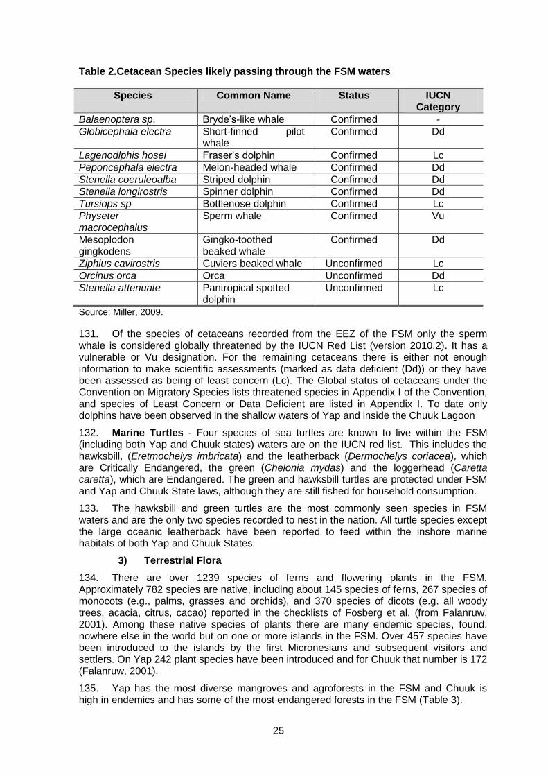
25
Table 2.Cetacean Species likely passing through the FSM waters
Species Common Name Status IUCN Category
Balaenoptera sp. Bryde’s-like whale Confirmed -
Globicephala electra Short-finned pilot whale
Confirmed Dd
Lagenodlphis hosei Fraser’s dolphin Confirmed Lc
Peponcephala electra Melon-headed whale Confirmed Dd
Stenella coeruleoalba Striped dolphin Confirmed Dd
Stenella longirostris Spinner dolphin Confirmed Dd
Tursiops sp Bottlenose dolphin Confirmed Lc
Physeter macrocephalus
Sperm whale Confirmed Vu
Mesoplodon gingkodens
Gingko-toothed beaked whale
Confirmed Dd
Ziphius cavirostris Cuviers beaked whale Unconfirmed Lc
Orcinus orca Orca Unconfirmed Dd
Stenella attenuate Pantropical spotted dolphin
Unconfirmed Lc
Source: Miller, 2009.
131. Of the species of cetaceans recorded from the EEZ of the FSM only the sperm whale is considered globally threatened by the IUCN Red List (version 2010.2). It has a vulnerable or Vu designation. For the remaining cetaceans there is either not enough information to make scientific assessments (marked as data deficient (Dd)) or they have been assessed as being of least concern (Lc). The Global status of cetaceans under the Convention on Migratory Species lists threatened species in Appendix I of the Convention, and species of Least Concern or Data Deficient are listed in Appendix I. To date only dolphins have been observed in the shallow waters of Yap and inside the Chuuk Lagoon
132. Marine Turtles - Four species of sea turtles are known to live within the FSM (including both Yap and Chuuk states) waters are on the IUCN red list. This includes the hawksbill, (Eretmochelys imbricata) and the leatherback (Dermochelys coriacea), which are Critically Endangered, the green (Chelonia mydas) and the loggerhead (Caretta caretta), which are Endangered. The green and hawksbill turtles are protected under FSM and Yap and Chuuk State laws, although they are still fished for household consumption.
133. The hawksbill and green turtles are the most commonly seen species in FSM waters and are the only two species recorded to nest in the nation. All turtle species except the large oceanic leatherback have been reported to feed within the inshore marine habitats of both Yap and Chuuk States.
3) Terrestrial Flora
134. There are over 1239 species of ferns and flowering plants in the FSM. Approximately 782 species are native, including about 145 species of ferns, 267 species of monocots (e.g., palms, grasses and orchids), and 370 species of dicots (e.g. all woody trees, acacia, citrus, cacao) reported in the checklists of Fosberg et al. (from Falanruw, 2001). Among these native species of plants there are many endemic species, found. nowhere else in the world but on one or more islands in the FSM. Over 457 species have been introduced to the islands by the first Micronesians and subsequent visitors and settlers. On Yap 242 plant species have been introduced and for Chuuk that number is 172 (Falanruw, 2001).
135. Yap has the most diverse mangroves and agroforests in the FSM and Chuuk is high in endemics and has some of the most endangered forests in the FSM (Table 3).
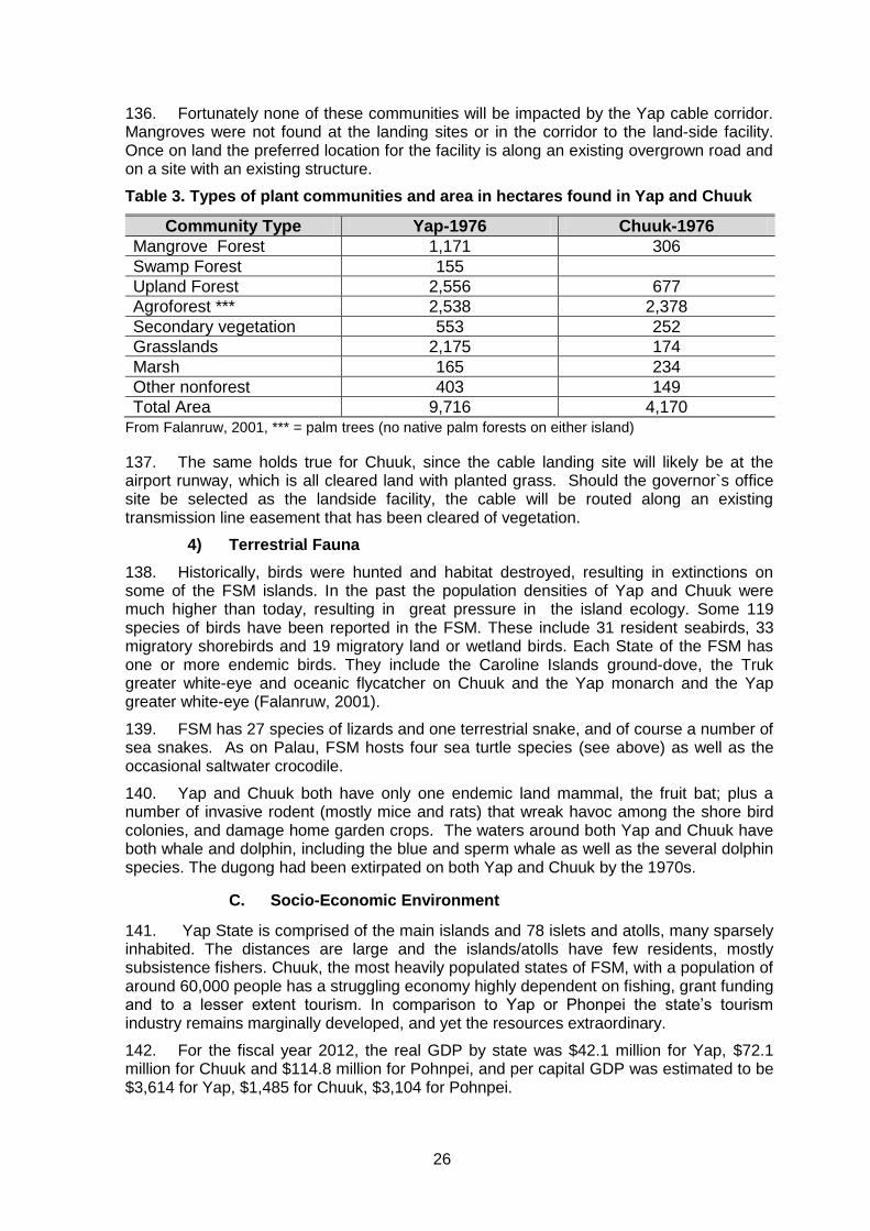
26
136. Fortunately none of these communities will be impacted by the Yap cable corridor. Mangroves were not found at the landing sites or in the corridor to the land-side facility. Once on land the preferred location for the facility is along an existing overgrown road and on a site with an existing structure.
Table 3. Types of plant communities and area in hectares found in Yap and Chuuk
From Falanruw, 2001, *** = palm trees (no native palm forests on either island)
137. The same holds true for Chuuk, since the cable landing site will likely be at the airport runway, which is all cleared land with planted grass. Should the governor`s office site be selected as the landside facility, the cable will be routed along an existing transmission line easement that has been cleared of vegetation.
4) Terrestrial Fauna
138. Historically, birds were hunted and habitat destroyed, resulting in extinctions on some of the FSM islands. In the past the population densities of Yap and Chuuk were much higher than today, resulting in great pressure in the island ecology. Some 119 species of birds have been reported in the FSM. These include 31 resident seabirds, 33 migratory shorebirds and 19 migratory land or wetland birds. Each State of the FSM has one or more endemic birds. They include the Caroline Islands ground-dove, the Truk greater white-eye and oceanic flycatcher on Chuuk and the Yap monarch and the Yap greater white-eye (Falanruw, 2001).
139. FSM has 27 species of lizards and one terrestrial snake, and of course a number of sea snakes. As on Palau, FSM hosts four sea turtle species (see above) as well as the occasional saltwater crocodile.
140. Yap and Chuuk both have only one endemic land mammal, the fruit bat; plus a number of invasive rodent (mostly mice and rats) that wreak havoc among the shore bird colonies, and damage home garden crops. The waters around both Yap and Chuuk have both whale and dolphin, including the blue and sperm whale as well as the several dolphin species. The dugong had been extirpated on both Yap and Chuuk by the 1970s.
C. Socio-Economic Environment
141. Yap State is comprised of the main islands and 78 islets and atolls, many sparsely inhabited. The distances are large and the islands/atolls have few residents, mostly subsistence fishers. Chuuk, the most heavily populated states of FSM, with a population of around 60,000 people has a struggling economy highly dependent on fishing, grant funding and to a lesser extent tourism. In comparison to Yap or Phonpei the state’s tourism industry remains marginally developed, and yet the resources extraordinary.
142. For the fiscal year 2012, the real GDP by state was $42.1 million for Yap, $72.1 million for Chuuk and $114.8 million for Pohnpei, and per capital GDP was estimated to be $3,614 for Yap, $1,485 for Chuuk, $3,104 for Pohnpei.
Community Type Yap-1976 Chuuk-1976
Mangrove Forest 1,171 306
Swamp Forest 155
Upland Forest 2,556 677
Agroforest *** 2,538 2,378
Secondary vegetation 553 252
Grasslands 2,175 174
Marsh 165 234
Other nonforest 403 149
Total Area 9,716 4,170
27
143. The FSM’s Millennium Development Goal report in 2010, recorded that Yap’s poverty rates decreased modestly from 1998 to 2005,although the incidence of absolute poverty average at 2% versus 8% nationally, and the relative poverty is 11% versus 22% nationally. For Chuuk which is the most populated of the four main islands. The basic needs poverty line in Chuuk is 32.9%.
1) Coastal Industries
144. Commercial Fisheries – Deep Sea Oceanic FSM EEZ - The EEZ waters of the FSM support commercial purse seine and long line fishing activities that have both local and foreign ownership and operational involvement principally targeting species of tuna for many years. The commercial fishing fleet operates between State waters and outer boundary of the nation’s EEZ.
145. The purse seine fishing fleet involves the deployment of a circulate net that is moved around a school of pelagic fish, closed at the bottom and removed, whilst the long line fleet as the name suggests runs a line at a certain depth with bait hooks attached to the surface by fishing floats and tracked by GPS. The local long line fleet is restricted in the distances they can travel (license requirements and market longevity of the fish), however will fish throughout the nation’s EEZ, whilst the international pursine fishing fleet moves through international boundaries to access fish.
146. The commercially important and targeted tuna species are highly migratory and information pertaining to precise locations and or movements at any one time is difficult. However computer modelling based on past catch records and environmental parameters can provide reasonable information and accuracy pertaining to spatial and temporal locations of were fish stock should be located; however the spatial scale is within the range of 100 of kilometres.
147. There are no impacts on these fisheries arising from the deployment and operation of the telecommunication cable; however notification to all vessels in the area of the cable vessel and its path is required to avoid any issues.
148. Commercial and Artisanal Fisheries – Inshore - There is no large-scale commercial fishing operations in Yap or Chuuk associated with the inshore waters of the nation. However, both states do fish inshore reef finfish and some invertebrate species for direct export to Guam. Chuuk particularly, has had a substantial reef finfish export market to Guam that has impacted local finfish stocks within the Chuuk Lagoon (personal information DMRD, 2014).
149. Small scale commercial game fishing charters principally employing catch (tag in some cases) and release catering for local and tourist alike, utilising state and territorial waters where small scale reef fishing through national and state regulations and customary ownership rights is allowed. Much of the small-scale fishers capture fish principally for household consumption and secondarily as an additional income stream.
150. Small scale fishing is undertaken in the waters and associated reef systems adjacent to the cable alignment, however fishing directly in the cables area of influence except directly in the north east channel is expected to not occur due primarily to that fact that the cable will be position away from reef system (center of the channel) and fish habitats (especially benthic associated species). Fishing in and near the states’ main shipping channel will be risky and fishers will likely not be willing to risk gear and accidents in marginal fish habitat.
151. Similarly, small scale demonstration/research, artisanal and semi commercial aquaculture of marine and brackish water species are undertaken in both Yap and Chuuk, none of these activities are associated with the cable area of influence.
28
2) Conservation Areas /Marine Management Areas
152. Yap In Yap, almost all land and aquatic areas are owned or managed by individual estates and usage is subject to traditional control. In Chuuk State the majority of the land and aquatic areas are privately owned and acquired through inheritance, gift or, recently, by purchase. In all States, land cannot be sold to non-citizens of the FSM.
153. Yap State has nine designated Conservation Areas (CA) or Marine Management Areas (both terms are interchangeable within Yap, (Map 6Error! Reference source not found. and Annex 4). The designation of a CA is at the municipal/community level and are developed through a consultative process with the respective communities, their chiefs, elected officials, landowners and have been assisted by State government agencies (e.g. Marine Resource Division) and/or NGO’s (e.g. Yap CAP). Each CA is managed by the respective municipalities/communities and do include both State and national laws and regulations.
154. Each CA has been developed to manage and preserve specific marine, lagoonal and/or coastal environments including specific habitats and/or species (refer Annex 3) and are all currently at different levels of development with the majority of the CA still developing individual management plans. Currently all CA include general management strategies to ensure resource harvesting is sustainable and limit or prevent habitat destruction. Two CA have completed their management plans that include “no take zones” as part of their management system. These two CA’s (Balabat Marine Conservation Area and Tamil Marine Management Area) are adjacent to the Woneeday Channel directly either side of the proposed cable alignment. Roughly 20 percent of all marine areas within Yap proper have some form of marine management. There are no CA’s to date designated for marine areas outside of the 12 miles state boundaries.
155. Chuuk- Chuuk State does not have any legislated Marine Managed, Marine Protected or Conservation Areas within the Chuuk lagoon. There are however currently five proposed marine Conservation Areas all of which are under different stages of development. These include Sapwwuk CA, Parem CA, Uman CA, Wichukuno CA and Piaanu CA (Map 7). Piaanu CA has had a management plan developed in 2004, however issues pertaining to landowner disputes need to be finalised before this CA can be moved forward. Moreover, specific information pertaining to the CA boundaries and management issues and concerns are poorly documented for the majority of CA being developed. In general, all 5 proposed CA management strategies are to ensure resource harvesting is sustainable and/or restrictive limiting or banning resource extraction. Wichukuno CA has been specifically developed to manage and preserve the mangrove forest at this location whilst the Piaanu site is specifically developed to provide protection to the habitat and finfish aggregations spawning sites.
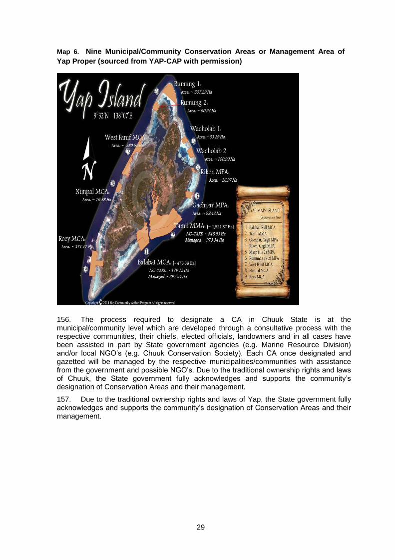
29
Map 6. Nine Municipal/Community Conservation Areas or Management Area of
Yap Proper (sourced from YAP-CAP with permission)
156. The process required to designate a CA in Chuuk State is at the municipal/community level which are developed through a consultative process with the respective communities, their chiefs, elected officials, landowners and in all cases have been assisted in part by State government agencies (e.g. Marine Resource Division) and/or local NGO’s (e.g. Chuuk Conservation Society). Each CA once designated and gazetted will be managed by the respective municipalities/communities with assistance from the government and possible NGO’s. Due to the traditional ownership rights and laws of Chuuk, the State government fully acknowledges and supports the community’s designation of Conservation Areas and their management.
157. Due to the traditional ownership rights and laws of Yap, the State government fully acknowledges and supports the community’s designation of Conservation Areas and their management.
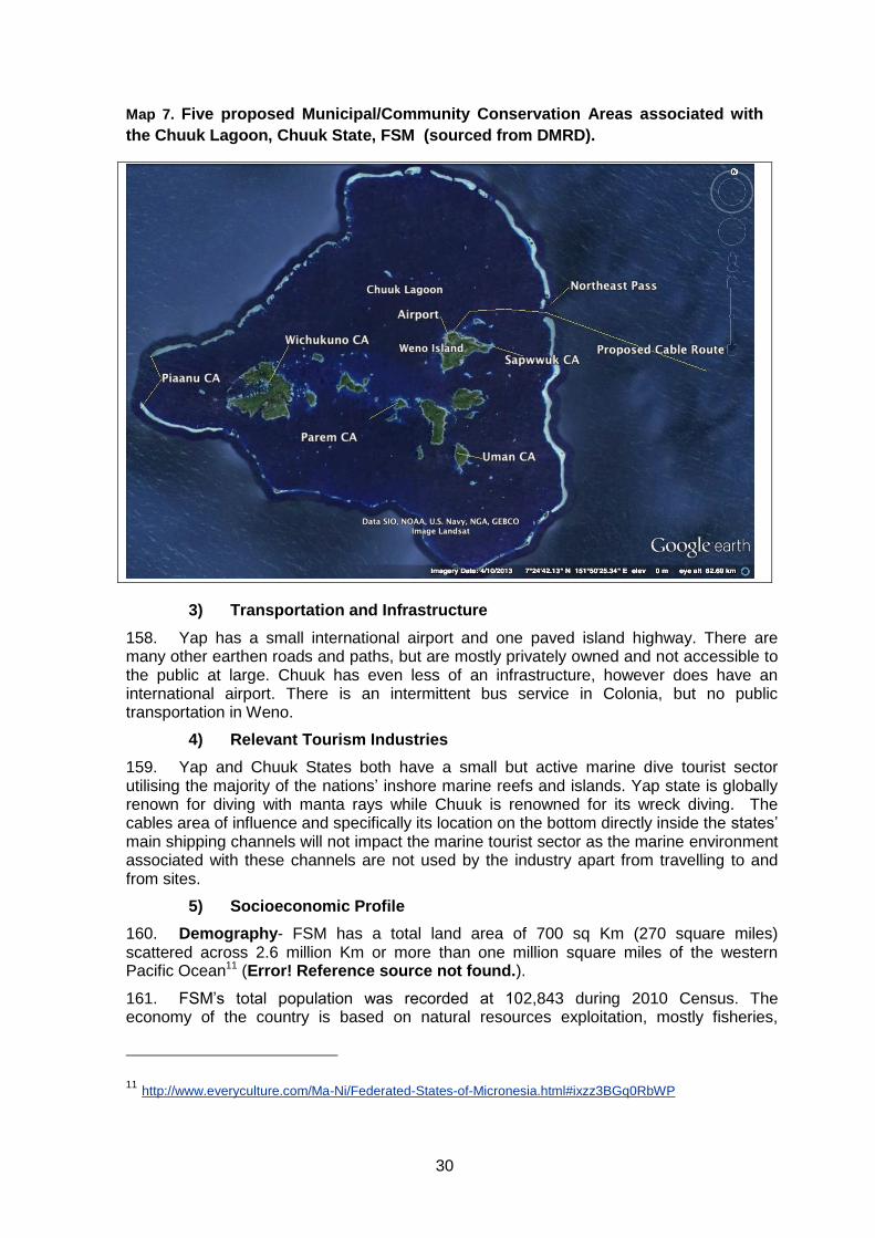
30
Map 7. Five proposed Municipal/Community Conservation Areas associated with
the Chuuk Lagoon, Chuuk State, FSM (sourced from DMRD).
3) Transportation and Infrastructure
158. Yap has a small international airport and one paved island highway. There are many other earthen roads and paths, but are mostly privately owned and not accessible to the public at large. Chuuk has even less of an infrastructure, however does have an international airport. There is an intermittent bus service in Colonia, but no public transportation in Weno.
4) Relevant Tourism Industries
159. Yap and Chuuk States both have a small but active marine dive tourist sector utilising the majority of the nations’ inshore marine reefs and islands. Yap state is globally renown for diving with manta rays while Chuuk is renowned for its wreck diving. The cables area of influence and specifically its location on the bottom directly inside the states’ main shipping channels will not impact the marine tourist sector as the marine environment associated with these channels are not used by the industry apart from travelling to and from sites.
5) Socioeconomic Profile
160. Demography- FSM has a total land area of 700 sq Km (270 square miles) scattered across 2.6 million Km or more than one million square miles of the western Pacific Ocean11 (Error! Reference source not found.).
161. FSM’s total population was recorded at 102,843 during 2010 Census. The economy of the country is based on natural resources exploitation, mostly fisheries,
11 http://www.everyculture.com/Ma-Ni/Federated-States-of-Micronesia.html#ixzz3BGq0RbWP
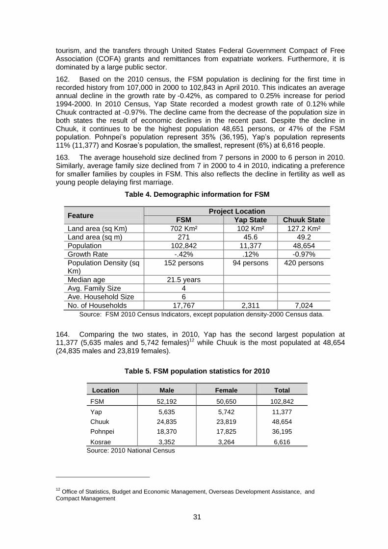
31
tourism, and the transfers through United States Federal Government Compact of Free Association (COFA) grants and remittances from expatriate workers. Furthermore, it is dominated by a large public sector.
162. Based on the 2010 census, the FSM population is declining for the first time in recorded history from 107,000 in 2000 to 102,843 in April 2010. This indicates an average annual decline in the growth rate by -0.42%, as compared to 0.25% increase for period 1994-2000. In 2010 Census, Yap State recorded a modest growth rate of 0.12% while Chuuk contracted at -0.97%. The decline came from the decrease of the population size in both states the result of economic declines in the recent past. Despite the decline in Chuuk, it continues to be the highest population 48,651 persons, or 47% of the FSM population. Pohnpei’s population represent 35% (36,195), Yap’s population represents 11% (11,377) and Kosrae’s population, the smallest, represent (6%) at 6,616 people.
163. The average household size declined from 7 persons in 2000 to 6 person in 2010. Similarly, average family size declined from 7 in 2000 to 4 in 2010, indicating a preference for smaller families by couples in FSM. This also reflects the decline in fertility as well as young people delaying first marriage.
Table 4. Demographic information for FSM
Feature Project Location
FSM Yap State Chuuk State
Land area (sq Km) 702 Km² 102 Km² 127.2 Km²
Land area (sq m) 271 45.6 49.2
Population 102,842 11,377 48,654
Growth Rate -.42% .12% -0.97%
Population Density (sq Km)
152 persons
94 persons 420 persons
Median age 21.5 years
Avg. Family Size 4
Ave. Household Size 6
No. of Households 17,767 2,311 7,024
Source: FSM 2010 Census Indicators, except population density-2000 Census data.
164. Comparing the two states, in 2010, Yap has the second largest population at 11,377 (5,635 males and 5,742 females)12 while Chuuk is the most populated at 48,654 (24,835 males and 23,819 females).
Table 5. FSM population statistics for 2010
Location Male Female Total
FSM 52,192 50,650 102,842
Yap 5,635 5,742 11,377
Chuuk 24,835 23,819 48,654
Pohnpei 18,370 17,825 36,195
Kosrae 3,352 3,264 6,616
Source: 2010 National Census
12 Office of Statistics, Budget and Economic Management, Overseas Development Assistance, and
Compact Management
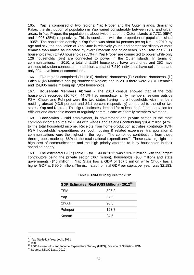
32
165. Yap is comprised of two regions: Yap Proper and the Outer Islands. Similar to Palau, the distribution of population in Yap varied considerably between rural and urban areas. In Yap Proper, the population is about twice that of the Outer Islands at 7,731 (65%) and 4,006 (35%) respectively. This is consistent with the proportion of population since 193513. The population density in Yap State was about 94 persons per sq Km. In 2010, by age and sex, the population of Yap State is relatively young and comprised slightly of more females than males as indicated by overall median age of 22 years. Yap State has 2,311 households with 1,490 households (65%) in Yap Proper are connected to power while only 126 households (5%) are connected to power in the Outer Islands. In terms of communications, in 2010, a total of 1,184 households have telephones and 252 have wireless television connection. In addition, a total of 7,210 individuals have cellphones and only 294 have internet connection14.
166. Five regions comprised Chuuk: (i) Northern Namoneas (ii) Southern Namoneas (iii) Faichuk (iv) Mortlocks and (v) Northwest Region; and in 2010 there were 23,819 females and 24,835 males making up 7,024 households.
167. Household Members Abroad - The 2010 census showed that of the total households recorded (16,767), 44.5% had immediate family members residing outside FSM. Chuuk and Pohnpei were the two states having more households with members residing abroad (43.5 percent and 34.1 percent respectively) compared to the other two states, Yap and Kosrae. This figure indicates demand for at least half of the population for efficient and affordable means to regularly communicate with family members overseas.
168. Economics - Paid employment, in government and private sector, is the most common income source for FSM with wages and salaries contributing $104 million (47%) to the total household income. Receipts from home-production activities contribute 18%. FSM households’ expenditures on food, housing & related expenses, transportation & communications were the highest in the region. The combined contributions from these three groups made up 66% of the total national expenditures15. These data highlight the high cost of communications and the high priority afforded to it by households in their spending priority.
169. The estimated GDP (Table 6) for FSM in 2012 was $326.2 million with the largest contributors being the private sector ($67 million), households ($63 million) and state governments ($45 million). Yap State has a GDP of $57.5 million while Chuuk has a higher GDP at $ 90.5 million. The estimated nominal GDP per capita per year was $2,183.
Table 6. FSM GDP figures for 2012
GDP Estimates, Real (US$ Million) - 201216
FSM 326.2
Yap 57.5
Chuuk 90.5
Pohnpei 153.7
Kosrae 24.5
13 Yap Statistical Yearbook, 2011
14 Ibid
15 2005 Households and Income Expenditure Survey (HIES), Division of Statistics, FSM
16 Source: SBOC Data, 2012
33
6) Public Health
170. There are no potential public health issues associated with this project since nearly all work will take place on the high seas, and construction on land will involve a 5-8 person, local construction crew. Therefore, no additional data on this topic were collected.
7) Recreational Resources and Development
171. Yap is actively promoting its tourism sector, most particularly the dive sites focusing on large marine animal viewing including the manta ray. Yap also has active recreation program in the areas of canoeing. There are no facilities such as modern pools, gymnasiums and outdoor sporting grounds. The project will not impact or deter such development and may in fact stimulate improvement by providing better social media communication.
172. Chuuk promotes its wreck diving industry but has little else it is promoting, despite having some staggeringly beautiful coral atolls and beaches.
173. No additional information was collected regarding this topic.
8) Cultural Values
174. FSM’s states are unique and diverse in terms of culture and language. Prior to western contact, the development of unique traditions, customs and languages within each of the four main island groups occurred as a result of isolation and lack of frequent interaction. Today there are 15 languages spoken in FSM, not counting English. The 15 languages are grouped into five major categories: Kosraean, Pohnpeian, Chuukese, Yapese, and Kapinga-Nukuoro17 .
175. The language of Kapingamarangi and Nukuoro islands are Polynesian in origin, and are closely related to the languages of Tokelau and Tuvalu. The traditional customs, performing arts, and arts and crafts of Kapingamarangi are also closer to those of Polynesia than they are to Micronesia. Because languages vary in each state, English has become the official language used in government and schools18 .
176. All states have matrilineal clan systems in which lineage are passed on through the mother’s line. Yap Island (not including the outlying atolls), however, is a more patrilineal society within a more structured caste system.19
177. One of the most significant physical cultural resources for FSM is the Yap stone money quarry site in Palau, listed as a UNESCO’s World Heritage site. In addition to the quarry site in Palau, FSM also submitted to UNESCO the stone money dancing site in Yap State. The National Archives, Culture, and Historic Preservation Organisation presently continues to work on the submission of some of the most ancient ruins in FSM particularly Nan Madol ruins site and Lelu ruins site, and the Chuuk shipwrecks for nomination to UNESCO’s World Heritage listing.
9) Human Settlement and Land Use
178. Yap- Nimar village, one of the three villages in Weloy Municipality, is the location for the cable landing and cable station sites in Yap State. The cable landing site is a few meters away from the Yap Pacific Dive Resort dive center while the proposed cable station is about 50 meters away from the landing site and the Lands Office. Both sites are on Nimar village, in the center of Colonia and location for government offices such as Yap State administration building, Telecom building, Tourism Bureau Office, Department of
17 M.M. Kim, Into the Deep: Launching Culture and Policy in the Federated States of Micronesia, Secretariat
of the Pacific Community, 2011 18
Ibid 19
Ibid
34
Education headquarters, Post Office and Lands Office. It had 69 households in 2010 Census.
179. During consultations with key government, private sector and non-government organizations, respondents were asked regarding among others expected benefits and potential concerns, if any, of faster internet. All reported that internet is very slow and could be expensive and frustrating to use. All stakeholders agreed that having a faster, reliable and cheaper internet is a priority for government, private sector, non-government organizations such as women groups, and youth and the public. One key respondent (Women’s Interest Group) raised a concern regarding the negative effects of easier access to undesirable websites resulting to vulnerability of young people to human trafficking. Yap State is more prepared organizationally to deal with this concern with an existing inter-agency committee against human trafficking. Members include the Women’s Interest Group, Department of Education, Chamber of Commerce and other government and civil society groups.
180. Chuuk - There are two identified options for the cable landing sites:
(i) North East of end of airport runway near the Kurassa Hotel ;and, (ii) Southeast, or the opposite end of the airport runway, near the CPUC Waste
Treatment Plant.
181. Both sites are on Iras Village ( a part of Weno) in Weno Municipality. The land, part of the airport runway, is in the process of being fully paid for by the Chuuk State Government.
182. There are also two identified options for the cable station sites that include:
(i) FSM Telecommunications Corporation (FSMTC) compound across the airport in Iras Village, or
(ii) State government complex (old Lands Office) in Nantaku Village, also on Weno Municipality.
183. The State government complex is government land and the FSMTC compound considered a government land being a public corporation.
184. The FSMTC compound is closer to airport runway thus ideal location for the cable station if only on the basis of distance. The other option is to construct the cable station within the State government complex that is on a higher ground, but about 1.5 Km or more away from the cable landing site. Both sites will utilize existing government easement along the main road.
10) Archaeological and Historical Treasures
185. Meeting were held with government officials to establish is any archaeological or historically important sites could be impacted by the project. None of the proposed activities associated with this project will impact any of the national archaeological or historical sites/treasures located far from the cable route and landing site.
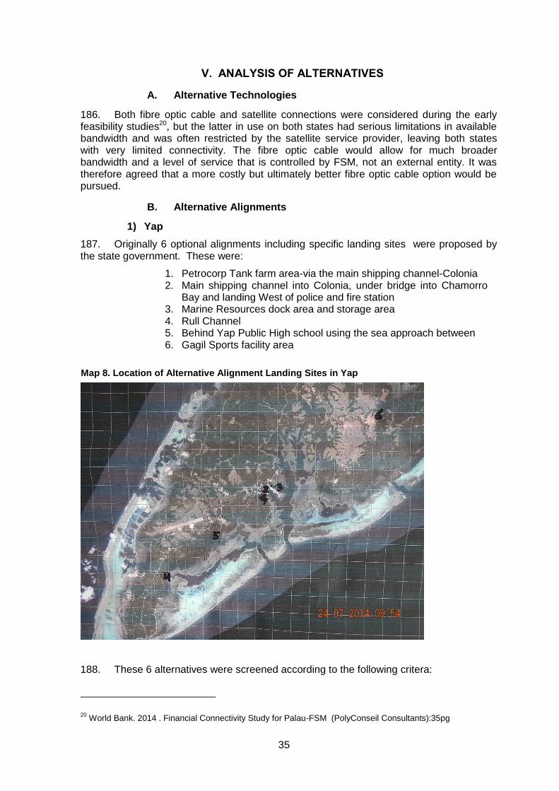
35
V. ANALYSIS OF ALTERNATIVES
A. Alternative Technologies
186. Both fibre optic cable and satellite connections were considered during the early feasibility studies20, but the latter in use on both states had serious limitations in available bandwidth and was often restricted by the satellite service provider, leaving both states with very limited connectivity. The fibre optic cable would allow for much broader bandwidth and a level of service that is controlled by FSM, not an external entity. It was therefore agreed that a more costly but ultimately better fibre optic cable option would be pursued.
B. Alternative Alignments
1) Yap
187. Originally 6 optional alignments including specific landing sites were proposed by the state government. These were:
1. Petrocorp Tank farm area-via the main shipping channel-Colonia 2. Main shipping channel into Colonia, under bridge into Chamorro
Bay and landing West of police and fire station 3. Marine Resources dock area and storage area 4. Rull Channel 5. Behind Yap Public High school using the sea approach between 6. Gagil Sports facility area
188. These 6 alternatives were screened according to the following critera:
20 World Bank. 2014 . Financial Connectivity Study for Palau-FSM (PolyConseil Consultants):35pg
Map 8. Location of Alternative Alignment Landing Sites in Yap
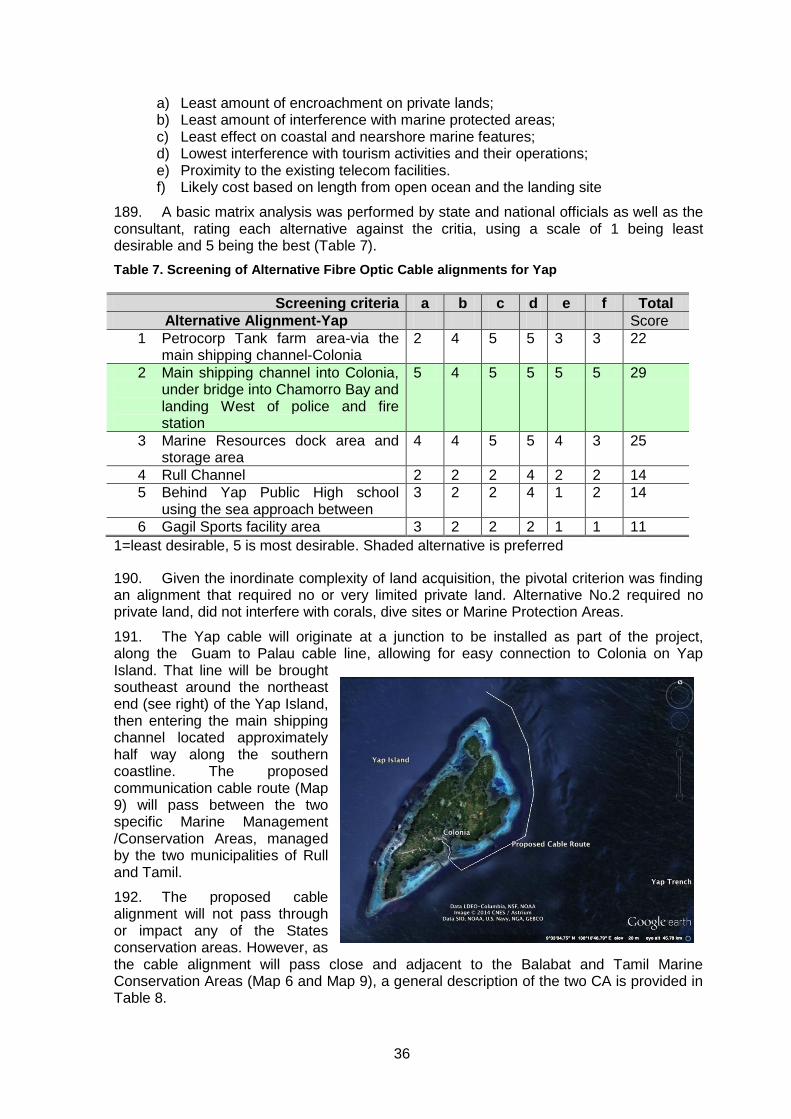
36
a) Least amount of encroachment on private lands; b) Least amount of interference with marine protected areas; c) Least effect on coastal and nearshore marine features; d) Lowest interference with tourism activities and their operations; e) Proximity to the existing telecom facilities. f) Likely cost based on length from open ocean and the landing site
189. A basic matrix analysis was performed by state and national officials as well as the consultant, rating each alternative against the critia, using a scale of 1 being least desirable and 5 being the best (Table 7).
Table 7. Screening of Alternative Fibre Optic Cable alignments for Yap
Screening criteria a b c d e f Total
Alternative Alignment-Yap Score
1 Petrocorp Tank farm area-via the main shipping channel-Colonia
2 4 5 5 3 3 22
2 Main shipping channel into Colonia, under bridge into Chamorro Bay and landing West of police and fire station
5 4 5 5 5 5 29
3 Marine Resources dock area and storage area
4 4 5 5 4 3 25
4 Rull Channel 2 2 2 4 2 2 14
5 Behind Yap Public High school using the sea approach between
3 2 2 4 1 2 14
6 Gagil Sports facility area 3 2 2 2 1 1 11
1=least desirable, 5 is most desirable. Shaded alternative is preferred
190. Given the inordinate complexity of land acquisition, the pivotal criterion was finding an alignment that required no or very limited private land. Alternative No.2 required no private land, did not interfere with corals, dive sites or Marine Protection Areas.
191. The Yap cable will originate at a junction to be installed as part of the project, along the Guam to Palau cable line, allowing for easy connection to Colonia on Yap Island. That line will be brought southeast around the northeast end (see right) of the Yap Island, then entering the main shipping channel located approximately half way along the southern coastline. The proposed communication cable route (Map 9) will pass between the two specific Marine Management /Conservation Areas, managed by the two municipalities of Rull and Tamil.
192. The proposed cable alignment will not pass through or impact any of the States conservation areas. However, as the cable alignment will pass close and adjacent to the Balabat and Tamil Marine Conservation Areas (Map 6 and Map 9), a general description of the two CA is provided in Table 8.
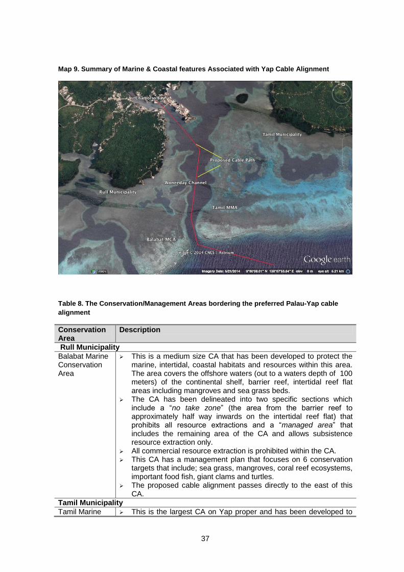
37
Map 9. Summary of Marine & Coastal features Associated with Yap Cable Alignment
Table 8. The Conservation/Management Areas bordering the preferred Palau-Yap cable
alignment
Conservation Area
Description
Rull Municipality
Balabat Marine Conservation Area
This is a medium size CA that has been developed to protect the marine, intertidal, coastal habitats and resources within this area. The area covers the offshore waters (out to a waters depth of 100 meters) of the continental shelf, barrier reef, intertidal reef flat areas including mangroves and sea grass beds.
The CA has been delineated into two specific sections which include a “no take zone” (the area from the barrier reef to approximately half way inwards on the intertidal reef flat) that prohibits all resource extractions and a “managed area” that includes the remaining area of the CA and allows subsistence resource extraction only.
All commercial resource extraction is prohibited within the CA. This CA has a management plan that focuses on 6 conservation
targets that include; sea grass, mangroves, coral reef ecosystems, important food fish, giant clams and turtles.
The proposed cable alignment passes directly to the east of this CA.
Tamil Municipality
Tamil Marine This is the largest CA on Yap proper and has been developed to
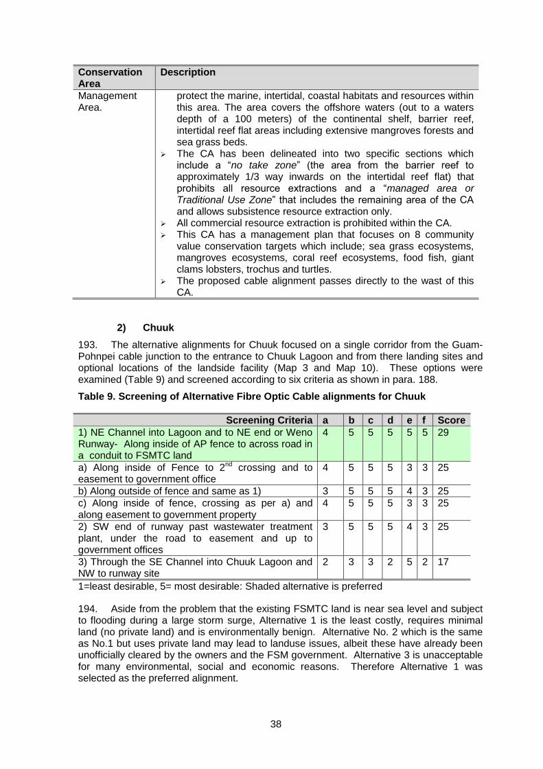
38
Conservation Area
Description
Management Area.
protect the marine, intertidal, coastal habitats and resources within this area. The area covers the offshore waters (out to a waters depth of a 100 meters) of the continental shelf, barrier reef, intertidal reef flat areas including extensive mangroves forests and sea grass beds.
The CA has been delineated into two specific sections which include a “no take zone” (the area from the barrier reef to approximately 1/3 way inwards on the intertidal reef flat) that prohibits all resource extractions and a “managed area or Traditional Use Zone” that includes the remaining area of the CA and allows subsistence resource extraction only.
All commercial resource extraction is prohibited within the CA. This CA has a management plan that focuses on 8 community
value conservation targets which include; sea grass ecosystems, mangroves ecosystems, coral reef ecosystems, food fish, giant clams lobsters, trochus and turtles.
The proposed cable alignment passes directly to the wast of this CA.
2) Chuuk
193. The alternative alignments for Chuuk focused on a single corridor from the Guam-Pohnpei cable junction to the entrance to Chuuk Lagoon and from there landing sites and optional locations of the landside facility (Map 3 and Map 10). These options were examined (Table 9) and screened according to six criteria as shown in para. 188.
Table 9. Screening of Alternative Fibre Optic Cable alignments for Chuuk
Screening Criteria a b c d e f Score
1) NE Channel into Lagoon and to NE end or Weno Runway- Along inside of AP fence to across road in a conduit to FSMTC land
4 5 5 5 5 5 29
a) Along inside of Fence to 2nd crossing and to easement to government office
4 5 5 5 3 3 25
b) Along outside of fence and same as 1) 3 5 5 5 4 3 25
c) Along inside of fence, crossing as per a) and along easement to government property
4 5 5 5 3 3 25
2) SW end of runway past wastewater treatment plant, under the road to easement and up to government offices
3 5 5 5 4 3 25
3) Through the SE Channel into Chuuk Lagoon and NW to runway site
2 3 3 2 5 2 17
1=least desirable, 5= most desirable: Shaded alternative is preferred
194. Aside from the problem that the existing FSMTC land is near sea level and subject to flooding during a large storm surge, Alternative 1 is the least costly, requires minimal land (no private land) and is environmentally benign. Alternative No. 2 which is the same as No.1 but uses private land may lead to landuse issues, albeit these have already been unofficially cleared by the owners and the FSM government. Alternative 3 is unacceptable for many environmental, social and economic reasons. Therefore Alternative 1 was selected as the preferred alignment.
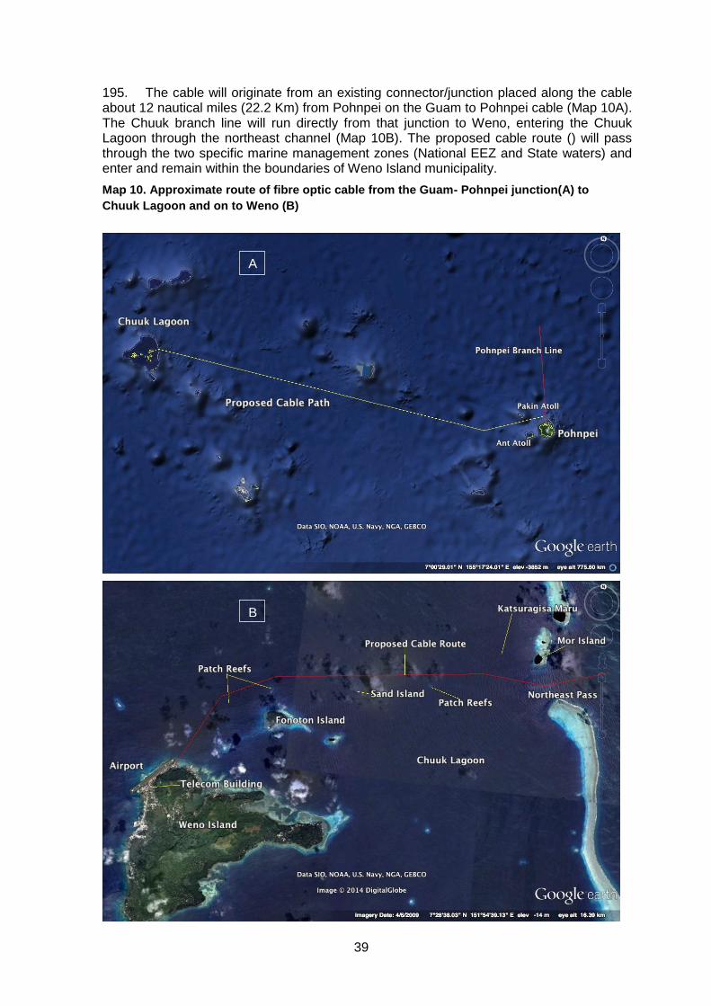
39
195. The cable will originate from an existing connector/junction placed along the cable about 12 nautical miles (22.2 Km) from Pohnpei on the Guam to Pohnpei cable (Map 10A). The Chuuk branch line will run directly from that junction to Weno, entering the Chuuk Lagoon through the northeast channel (Map 10B). The proposed cable route () will pass through the two specific marine management zones (National EEZ and State waters) and enter and remain within the boundaries of Weno Island municipality.
Map 10. Approximate route of fibre optic cable from the Guam- Pohnpei junction(A) to
Chuuk Lagoon and on to Weno (B)
B
A
B
40
C. Alternative Methods
196. Cable placement is done in one of three ways 1) simple placement on the seafloor, 2) burial of the cable, or 3) a combination of the two. Burial is done via a trenching machine (Photo 2.) which is either via a mechanical plough as shown on the photo or via a high pressure water jet. For either method the cable is laid into the trench and covered over in one movement as the device is pulled along. A second method used in the deep open ocean is to simply set the cable on the seafloor, sometimes with additional weights. In shallow sensitive areas, the cable is often floated into place and sunk with divers assisting with specific placement.
197. These options were assessed in relation to the sensitive habitats potentially affected, most importantly coral formations. Hydro-jet trenching in the nearshore zone was ruled out since it creates considerable sediment plumes, while the combination of plough-trenching and cable placement using divers was selected as it minimally disturbed the bottom and did not create sediment plumes. However, the final decision will be left with the cable laying crews, and any deviation from the recommended method will require an environmental evaluation to establish possible additional impacts and necessary mitigative actions.
VI. ANTICIPATED IMPACTS AND MITIGATIVE MEASURES21
A. Preconstruction Period
198. Preventing negative impacts resulting from the completion of this project is all about early planning and provision of specifications that avoid future problems. Fourteen preconstruction period mitigative measures were identified, all related to including contract specifications that define the boundaries the survey and cable placement contractor will be required to work within, in the bid documents, . These 14 actions are summarized in the ESMP (Annex 1) and discussed in greater detail in the following section.
199. All preconstruction mitigative measures defined in the ESMP require that environmental clauses be formulated and added to the contract documents for both the oceanographic survey vessel(s) and the cable placement vessel(s). The key boundaries will be a) 2 Km distance from ocean seamounts, 1 Km distance from hydrothermal vents (at present none have been recorded in the project corridor) and a minimum distance of 75 m from any coral formations defined on maps to be provided to the cable placement contractor (see Section 2.0 of the ESMP).
200. The width and depth of the trench should be kept to a minimum and with the use of a submarine trenching machine22 (Figure 1) can easily be achieved; including covering in of the trench as soon as the cable is placed on the seafloor. In order to avoid fishing gear snagging on the cable, burial in the nearshore waters and offshore fishing grounds (should the cable need to be place on the sea floor in these areas) will be essential. These boundaries and limits will be defined in the contract specifications during the preconstruction period.
201. The second level of boundaries is related to timing and duration of the work. Both the survey and the cable placement contractor will have to be aware of the timing of the
21 Throughout this chapter each mitigative measure has a number included that is cross referenced to the
ESMP. 22
No coral reefs are crossed, therefore HDD methods were not considered, given the very high cost and other effects, such as the need to use drilling lubricants.
41
migration of species at risk, namely the whales and careful planning of operations to avoid or minimize interference with cetacean migrations, generally taking place between November and March will need to be observed. Briefing of the contractors by specialists prior to the start of construction will therefore be essential.
1) Physical Environment
202. 1.1 Air Quality – Air pollutants released from all vessels involved in cable contract work, will be considerable since they burn low grade bunker fuel. To mitigate this effect contract specifications will require all ships used during the contract to submit emission certification for PM, SO2 and NOx to the Project Coordinator and MICROPAL. The results will need to meet emission standards for such vessels, based on the USEPA standards (http://www.epa.gov/otaq/marine.htm CFR-40 set of codes). A smoke density test will also be performed by the technical monitors, using the Canadian Department of Transport Smoke Chart set out in the schedule of the regulations (https://www.dieselnet.com/standards/ca/marine.php), including the chart. For vessels with diesel engines a smoke density less than No. 1 is normally required with the exception that a smoke density of No. 2 for an aggregate of not more than 4 minutes in any 30-minute period is allowed.
203. 1.2 Substrate- The use of foreign (allochthonous) materials when backfilling cable trenches could lead to unknown local area contamination. To avoid that cable-laying contractor’s specification will indicate that ;
all backfill will have to be only original material.
only inert/stable materials will be used in cable laying and anchoring.
204. 1.3. Unexploded ordnance. During all preparation stages of cable deployment, due diligence and careful surveys will need to be undertaken to eliminate the risk of the presence of unexploded WW II munitions in the substrate, where trenching will take place. Particular emphasis and care needs to be exercised in areas associated with the deep waters of the two main shipping channels.
205. Yap - During the trust territory days (Ms. M. Falanruw personal communication, 2014) the FSM government undertook an assessment and removal program of all unexploded ammunition within the Woneeday Channel and adjacent harbour areas of Yap Proper. A survey of at least six sites identified in Table 1 will be required and the area declared free of UXO.
206. Chuuk - Discussions with local authorities suggested that no UXO is likely in the channel and entrance to the lagoon, however a UXO sweep is nevertheless recommended.
207. 1.4 Hydrothermal Vents-Hydrothermal biological communities and their associated ecosystems are fragile in nature and are not subjected to anthropogenic disturbances. However these ecosystems and the communities they support are highly ephemeral in nature and are totally reliant on the lifespan of the vents themselves. The environment associated with an active vent is hostile and subsequently during the deployment of the cable these sites would be actively avoided. A 1-Km avoidance distance is suggested. If avoidance is achieved the impact on vent communities will be non-existent. However, it is likely that the proposed development will have no impact on the hydrothermal vent community associated with FSM waters as long as the cable is not laid upon an active vent.
208. 1.5 Sea Mounts- Seamounts and associated bathymetric features are known to be biodiversity hotspots in the open ocean and subsequently are a target for commercial fishing. The topography of seamounts would increase the difficult of the cable deployment and therefore seamounts and associated bathymetric features should be avoided by the cable route. A 2-Km avoidance distance is suggested. Should such avoidance be
42
achieved, and then impacts on seamount and associated bathymetric features will be negligible.
209. The proposed development will have no impact on the seamount benthic community associated with FSM waters as long as the cable is not laid upon or in close proximity to these communities. Given the cables small environmental ‘footprint’, there will be no impacts associated with the motile benthic or pelagic marine resources associated with seamounts.
2) Ecological Environment
210. 1.6 Conservation Areas - The cable alignments for Yap and Chuuk states do not enter any CA. In Yap State, 2 Conservation Areas are located adjacent to the cables area of influence however no impacts are expected from the project in these CA. In Chuuk State no proposed CA’s are located anywhere near the cable alignment.
211. 1.7 Coastal and Deep Ocean Habitat- Vessel operations in the deep ocean and especially in the waters inside the barrier reef, could result in accidental spills and leaks of hazardous materials or in coastal area vessel grounding, leading to habitat destruction.. To minimize this risk FSM will require contractors to 1) provide specifications of the fuel and lubricant management equipment and storage on vessels used during the survey and cable laying operations, and certify that the installations in in compliance with national regulations and-or MARPOL specifications for fuel management. 2) Maintain a contingency plan to address spills and groundings due to storm events.
212. 1.8 Coral Communities- The cable laying operations will avoid infringing on any live coral reefs or areas where coral is recovering from past degradation. To that end the oceanographic survey team will receive instructions to align the cable around living reefs (based on the 2014 surveys to date no such interaction is anticipated, so long the cable is placed in the shipping channel). This instruction will be provided in the contract document.
213. 1.9 Seagrass- If not placed with care and in the shipping channel the cable could impact local seagrass meadows (albeit minimally, given that the cable is 3-7 cm in diameter). To avoid this, the cable`s placement will be confined to a narrow path (less than 0.4m (15”) wide and 0.75m (29.5”) deep, and these specifications will be included in contract documents, and avoiding seagrass meadows wherever possible. Seagrass meadow locations were identified and none found to be in the recommended cable-placement corridor, or anywhere near it.
214. 1.10 Species At Risk: Whales and Turtles –Whales are known to migrate through the waters the cable alignment survey and cable laying activities will take place in. The work could have two impacts:1) acoustic effect of ocean sonar survey on marine mammals, and 2) entanglement in cable by deep diving cetaceans such as the sperm whale. To reduce the risk of this occurring vessel and survey operators will be instructed, in contract documents to:
1) use best practices for operating vessels in proximity to marine mammals (Annex 4) to be incorporated in contract specification;
2) undertake seafloor survey outside whale presence/migration season, namely
between May and October; 3) post a watch for whales and suspend activities when whales are within 1 Km of
vessel; 4) use multi-beam and/or side-scan sonar only – No Air Guns; and. 5) identify a route to avoid suspended segments of cable by routing along terrain
that does not have sharp changes in relief, and specify this route in the cable-
laying specification.
43
215. Neither the Yap or Chuuk landing sites are turtle habitat or have been known to host breeding activities. Therefore the project will not affect turtles.
3) Social Environment
216. These measures will be implemented once the project coordinator is hired. The coordinator will work with a contract specialist, state marine ecologists from Yap and Chuuk, and using the ESMP as a guide, to prepare specific clauses that will become a part of the legal contract between FSM and the contractor.
217. 1.11 Coastal Resource Users-Subsistence and artisanal fisheries-The failure to define boundaries for the cable placement process and vessel operations could lead to damage to coastal fishing grounds and artisanal fisheries. The limits as defined in this IEE, and transferred to the contract specifications focusing on a narrow disturbance corridor and completion of the work quickly will avoid future problems
218. 1.12 ESMP Implementation Monitor-This IEE established the very weak technical capacity of the executing agency, the Project Coordinator or the PMU, to credibly implement the ESMP. As one of the first tasks for the Project Coordinator, a ESMP implementation technical will need to be appointed for Yap and for Chuuk to lead the delivery of the ESMP tasks through the preconstruction and construction period.
219. 1.13 Community Information – During the consultations it became very clear that the scale of the cable work was exceedingly exaggerated in that cable diameter was thought to be that of a pipeline and the cable contained toxic fluids or emitted electromagnetic radiation, damaging local marine food supplies. Recognizing this concern both the executing agency and PMUs in Yap and Chuuk will conduct at least one additional information session laying out these specification details and highlighting other concerns raised, such as costing and cable connection issues.
220. 1.14 Community Grievance-Complaints and concerns can arise at any time, soon after the Project Coordinator is appointed and activity begins. The quickest way to build distrust and concern is to not have a quick complaints resolution process in place. The Project Coordinator will set in pace the grievance redress mechanism defined in Chapter VIII of this IEE and will assign the monitor to be available to process the complaints through the seven steps to getting resolution.
B. Construction Period
221. The 16 mitigative and monitoring tasks defined for the construction period reflect (listed in the ESMP) the time during the work when nearly all potential negative impacts could occur, nearly all being environmental as opposed to social. The details are described in the following section and a summary is presented in the ESMP (Annex 2).
1) Physical Environment
222. 2.1 Air Quality - The contractor will be required to provide written evidence that vessels have up-to-date emission controls and that emissions have been tested and minimally meet manufacturer’s specifications, but preferably the standards as listed in the references provided for Task 1.1. This action will be followed up by the Project Coordinator and the PMU.
223. 2.2 Substrate-The use of only autochthonous materials for any backfilling will be a defined in specification for the contractor to adhere to and will be enforced by the Project Coordinator and the states’ PMUs
224. 2.3 Hydrothermal Vents- If hydrothermal vents exist anywhere along the alignment; and are detected during the oceanographic survey the 1 Km buffer zone requirement will need to be enforced. Any such features will be mapped by the survey vessel and avoidance as specified in the ESMP will be adhered to.
44
225. 2.4 Sea mounts-The ocean corridor in which the cable is to be placed has not been mapped and therefore seamounts have not been identified. Discussions with officials in Pohnpei suggest that there are no seamounts in the Yap or Chuuk cable corridors. This however will be confirmed during the survey and if seamounts are detected, boundaries as defined in the ESMP, will be adhered to.
2) Ecological Environment
226. 2.5 Marine Coastal Conservation Areas- The specific cable routes have not been defined as the oceanographic survey has yet to take place. However protection of two Yap CAs will be achieved since all vessel operations and cable placement will adhere to the minimum 75m safe-distance from active CA sites.
227. 2.6 Coastal and Deep Ocean Habitat-The contractor will be required to 1) to adhere to contract specifications and FSM laws, storing all fuel, lubricants and transmission fluids in double walled tanks on vessels and if in drums, store below deck; and 2) maintain a contingency plan to address spills and storm events.
228. The trenching operations inside the barrier reef (i.e. once in the shipping channel) to bury the cable, needs to be done quickly and with the least amount of degradation of the benthic substrate the closer cable placement operations are to the shore. The general instruction to the contractor will be to stay in the middle of the shipping channel, making sure that consultation with the national marine navigation agency responsible for channel maintenance. Given that the cable starting from the landing site out to deep water will need to be precisely placed, it will either require placement during low tide with the trencher towed out to deep water by the cable laying vessel (see Figure 1), or during high tide, with the cable floated out and guided to the bottom by divers. Either way the cable placement can be controlled with very precise limits.
229. In the deep ocean the cable placement will need to avoid rapid changes in elevations, i.e. undersea mountains or canyons, hydrothermal vent areas as well as seamounts which are fish congregating and fishing areas. These will be identified by the project proponent as well as during the oceanographic survey.
230. 2.7 Coral Communities-The marine survey identified coral communities within approximately several hundred meters of the cable alignment in Yap. By placing the cable in the shipping channel, all damage can be s avoided and no degradation of a reef is anticipated. Once the oceanographic survey is completed, especially the route inside the barrier reef, the contractor will be given a specific map with an exact alignment that will indicate no-go areas, including any coral areas discovered during the survey.
231. Similar conditions exist for Chuuk, in that corals are found from the top of the slopes of the shipping channel, and more distant from the cable. Adhering to the pre-defined work corridor within the shipping channel will almost guarantee that corals are not damaged. Of course the careful management of fuels and lubricants on board vessels will be an absolute requirement at all times.
232. 2.8 Seagrass - As with corals, the proposed nearshore alignment for the cable will avoid all seagrass beds, however if during the detailed surveys sites are identified, the limits as defined in the ESMP Task 1.9 will be applied.
233. 2.9 and 1.10 Cetaceans (Whales and dolphins)-Contractors installing the cables will need to control cable tension so that the placed cable conforms to contours of seabed as per cable laying specification and-or provide anchors if needed; in this way the cable will be as unobtrusive as possible and eliminate the risk of cable-whale interaction. As well, the ECOP contains specific instructions on minimally intrusive oceanographic survey methods, which the contractor will adhere to.
234. Mangroves have not been addressed since they are not interfered with along either the Yap or Chuuk alignments, and in fact do not occur within at least 500m of either
45
alignment, and are 25m from, the Yap landing point and several Km from the Chuuk landing site.
3) Socio-Economic Environment
235. 2.10 Coastal Resource Users – subsistence and artisanal fisheries-Any damage to coastal, artisanal fisheries will be avoided by contractors adhering to the specifications and confining the cable alignment to a narrow corridor and consulting with the Fisheries Department to assign the best dates for cable placement inside the barrier reef and to define any other avoidance measures. The Project Coordinator and contractor will discuss placement of temporary markers along the corridor where water depth is < 10m.
236. 2.11 Coastal Resource Users – Game fishers- Once a new cable is placed the international agreement requires the owner to notify the International Cable Protection Committee, who then place the new cable on a map. In addition all navigation charts used by vessels travelling this route and entering the shipping channels need to be updated to indicate the location of the new cable. This information will be passed on the licensed fisheries vessels operating inside the 200 nautical mile (370 Km) EEZ of FSM.
237. 2.12 Coastal shipping; Commercial Shipping and Ports- The placement of the cables will mean potential short term danger to ship traffic in the seas. Therefore, the contract will be required to 1) ensure a shipping notice is issued warning of cable-laying, dates, and safe clearance for other activities to 2) Request port authorities to advise local shipping of laying activities and avoidance measures and 3) ensure that marine navigation lights and other national maritime measures are closely followed by the project vessels at all times.
238. 2.13 and 2.14 Landuse and Access-Given that there are no landside acquisition or access issues, the only impact possible could arise if contractors stray from the proposed alignment and encroach into communal resource harvesting areas. The cable route boundaries have been defined in the IEE and as such the contractor will be required to adhere to these conditions, and be permitted to deviate only after consultation with the Project Coordinator
239. 2.15 Environmental Completion Reporting- It is essential that as the construction period comes to a close the Project Coordinator instructs the contractors to prepare the environmental completion report as defined in this ESMP and the contract specifications. That summary report (one for each state) will define the mitigation & monitoring actions completed & what needs to be continued during the operating period.
240. 2.16 Contractor Awareness Raising- It is likely that the contractor will not be aware of the environmental effects associated with vessel movement in the ocean or the urgency to avoid corals and plan the work to interfere minimally with other sensitive marine life such as whales. To address this gap the Project Coordinator and the environmental technician hired by the government will deliver a ½ day workshop on ESMP compliance and linkages between the cable project and marine systems effects.
C. Operating Period
1) Physical and Ecological Environment
241. 3.1 Mitigation Measures Completion Report - Environmental mitigative and monitoring measures during this period are minimal and focus on making sure that the mitigative and monitoring action defined for the construction period are in fact implemented and a completion report filed with MICROPAL, the state governments and the national government. Secondly, the cable operator needs to provide information to subscribers about cable services access controls (such as internet site blocking) to help inform families and measures they can take.
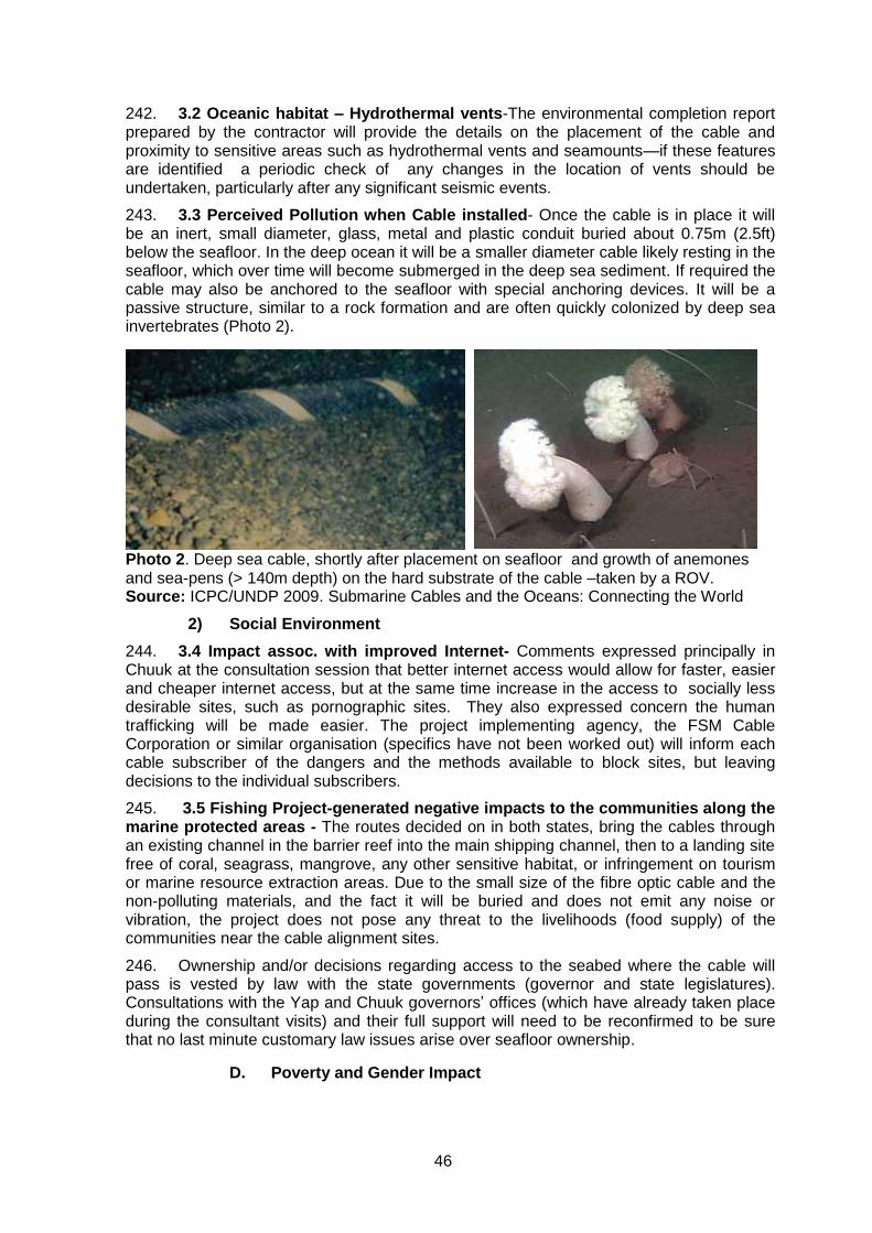
46
242. 3.2 Oceanic habitat – Hydrothermal vents-The environmental completion report prepared by the contractor will provide the details on the placement of the cable and proximity to sensitive areas such as hydrothermal vents and seamounts—if these features are identified a periodic check of any changes in the location of vents should be undertaken, particularly after any significant seismic events.
243. 3.3 Perceived Pollution when Cable installed- Once the cable is in place it will be an inert, small diameter, glass, metal and plastic conduit buried about 0.75m (2.5ft) below the seafloor. In the deep ocean it will be a smaller diameter cable likely resting in the seafloor, which over time will become submerged in the deep sea sediment. If required the cable may also be anchored to the seafloor with special anchoring devices. It will be a passive structure, similar to a rock formation and are often quickly colonized by deep sea invertebrates (Photo 2).
Photo 2. Deep sea cable, shortly after placement on seafloor and growth of anemones and sea-pens (> 140m depth) on the hard substrate of the cable –taken by a ROV. Source: ICPC/UNDP 2009. Submarine Cables and the Oceans: Connecting the World
2) Social Environment
244. 3.4 Impact assoc. with improved Internet- Comments expressed principally in Chuuk at the consultation session that better internet access would allow for faster, easier and cheaper internet access, but at the same time increase in the access to socially less desirable sites, such as pornographic sites. They also expressed concern the human trafficking will be made easier. The project implementing agency, the FSM Cable Corporation or similar organisation (specifics have not been worked out) will inform each cable subscriber of the dangers and the methods available to block sites, but leaving decisions to the individual subscribers.
245. 3.5 Fishing Project-generated negative impacts to the communities along the marine protected areas - The routes decided on in both states, bring the cables through an existing channel in the barrier reef into the main shipping channel, then to a landing site free of coral, seagrass, mangrove, any other sensitive habitat, or infringement on tourism or marine resource extraction areas. Due to the small size of the fibre optic cable and the non-polluting materials, and the fact it will be buried and does not emit any noise or vibration, the project does not pose any threat to the livelihoods (food supply) of the communities near the cable alignment sites.
246. Ownership and/or decisions regarding access to the seabed where the cable will pass is vested by law with the state governments (governor and state legislatures). Consultations with the Yap and Chuuk governors’ offices (which have already taken place during the consultant visits) and their full support will need to be reconfirmed to be sure that no last minute customary law issues arise over seafloor ownership.
D. Poverty and Gender Impact
47
247. Poverty - According to the 2005 FSM Household Income and Expenditure Survey (HIES), about 22.4% of households or 29.9% of the population in the FSM was living below the minimum cost of living or the Basic Needs Poverty Line (BNPL). Comparing to a similar analysis done in 1998, the proportion of households falling below the BNPL has increased, suggesting a slight worsening of overall poverty in the FSM.
248. Poverty in the FSM does not mean hunger or destitution in the traditional sense, but rather the struggle to meet daily or weekly expenses, especially those requiring cash payments23.
249. In the Pacific, including FSM, people express their condition as ‘being in hardship’ rather than in poverty. Causes identified for their hardship include (i) low income, (ii) limited access to basic social services such as sanitation facilities and (iii) limited access to opportunities for gainful income.
250. Vulnerable Population - The poor households in the FSM are those headed by persons of low educational attainment, with no wage or salary from the private and public sectors. Poverty has a gender bias. While female-headed households constituted 20% of the household population in FSM, they constituted 39% of the total number of households in the lower three expenditure deciles. A 2004 Participatory Assessment of Hardship supported by ADB identified the poor households as those who are (i) unemployed and landless; (ii) uneducated youth who did not finish school; (iii) teenage couples with children; (iv) women (widows and single mothers) and men (widowers and elderly); (v) people who owned nothing and were without education or skills; (vi) large families and families without support from their extended families.
251. Gender- From the 2013 Millennium Development Goal Report for FSM, maternal deaths declining but were widely under-reported, and skilled birth attendants were in short supply in both states. Authorities recognize maternal mortality still a problem in FSM. COFA has helped since its grants prioritise spending on health by improving maternal health care missing in national plan.
252. There is low contraceptive use because of poor service delivery due to geography, lack of supplies and cultural/religious beliefs against contraception. Relatively high fertility rate for women above 35 years of age indicate a likely unmet need. Teen birth rates are down. Data on antenatal care are poor, but it is widely recognized as a major challenge. Professional advice on family planning is also weak. Better, cheaper and more reliable telecommunication services should significantly help improve these conditions.
253. The 2013 MDG Report on gender parity in education concluded that this had been achieved at all levels. However, there is the issue of low economic participation of women. Better access to education does not translated into increased participation by women in
the formal sector. This is likely due to deeply entrenched beliefs in the traditional roleof
women, where their role is at home. Also, there is a general lack of job opportunities thus women are turning to subsistence lifestyles. FSM is among the few countries that does not have any women in parliament. Similar to some Pacific countries, the government is considering temporary special measures to reserve four seats in parliament for women.
E. Land acquisition and Resettlement
254. Yap. The project sites in Yap will be located on a government land in Nimar Village in Weloy Municipality, Colonia (Parcel No. 002 F 01) thus will not require land acquisition. Both cable landing site and site for cable station are on a vacant government land across government staff quarters and government offices such as the Post Office and Office of Lands in the capital. The sites are free from residential and business structures. No crops,
23 Analysis of the 2005 Household Income and Expenditure Survey: A report on the estimation of basic
needs poverty lines, and the incidence and characteristics of poverty in the Federated States of Micronesia.
48
food plantations or productive trees will be affected and there will be no physical displacement of people.
255. Chuuk - The proposed cable landing sites in Chuuk will be located on the airport runway (Northeast or Southeast end of the runway), which the State government owns, as has been confirmed in a letter from the governor of Chuuk State to the World Bank, attached to the social documentation accompanying this IEE. The two options for the cable station site are on government land. Option 1 is on the FSM Telecoms compound across the airport runway (Lot No. 007-A-07). Option 2 is on the State government headquarters in Michitiw Village, Weno Municipality, Chuuk (Lot No. 029-A-48).
256. The project will utilize existing government easements to bring the fibre optic cable to the cable station.
F. Cumulative Impacts and Mitigative Measures
1) Environmental
257. Given that the cable installation involves the placement of a 3-7.5 cm diameter solid cable (containing no liquids, and not needing transmission of electrical power24) in a narrow trench on the seabed and will be careful placed (via divers and/or a cable floated into place if needed) in Yap or Chuuk coastal waters over a relatively short period of time, no cumulative effects are foreseen. There are no other known activities occurring at the same time that the cable is to be placed on the seafloor. There may be other construction activities on land, but since both landing will only require the construction of a single room, which may be a simple addition to an existing structure, no cumulative effect will be triggered.
2) Socioeconomic
258. There are no expected irreversible and irretrievable cumulative social impacts resulting from the fibre optic cable project. Due to its small footprint, and even though it will cross the degraded (shipping channel) sections of existing marine protected areas, it is not expected to cause permanent loss of communal fishing grounds and local people’s livelihoods.
G. Irreversible and Irretrievable Impacts
259. Given the very small disturbance to the environment from the cable installation and landside building (30-50 m2 or 325-540 ft2) construction, there will be no irreversible or irretrievable impacts due to the project. Implementation of the mitigative measures defined in the ESMP will ensure that no such impacts occur.
H. Environmental and Social Enhancements/Benefits
260. The fibre optic cable project, if properly prepared, will not only improve people’s access to income and social services but may also enhance social networks particularly family relationships between Yapese and Chuukese, and their respective family members living abroad. Faster internet is also expected to facilitate regular and affordable connections among local and overseas-based groups, particularly women’s organizations who rely on internet to be in-touch. A fibre optic system was installed on Pohnpei, FSM in 2010, and improvements in health care and educational services have been reported. Better internet connections should also help with remote medical services and distance education.
24 If Palau decides to recover an existing cable, placed some years ago, it is likely that this cable will have a
copper transmitter and will require constant power to the repeaters.
49
VII. GRIEVANCE REDRESS MECHANISM
261. Although at this stage, there are no identified environmental and involuntary resettlement complaints associated with the proposed project, a grievance redress mechanism (GRM) is presented in the event that at the later stage there will be a need for one. For example, there could be a grievance filed as a result of fishing gear becoming snagged on the cable, presumed to be due to due to faulty cable placement.
262. The GRM is scaled to the risks and adverse impacts of the project. If promptly addresses the concerns and complaints of potentially affected people using an understandable and transparent process that is gender responsive, culturally appropriate, and at no costs and without retribution, will usually be resolved. The mechanism does not impede access to FSM national or state judicial or administrative procedures. The Project Coordinator, through the State (Yap or Chuuk) Project Committee or management unit (PMU) will appropriately inform the affected people (AP) about this GRM before commencement of any civil works, as part of the consultation session where engineering details costs and feasibility will be tabled (see ESMP Task 1.13 and 1.14).
263. A grievance redress committee will be established to (i) record, categorize and prioritize the grievances; (ii) settle the grievances in consultation with complainant(s) and other stakeholders; (iii) inform the aggrieved parties about the solutions; and (vi) forward the unresolved cases to higher authorities.
264. The four-member committee will be comprised of one member of the executing agency and one member of the Yap or Chuuk Women’s Association, and one member from the implementing agency, the State Cable Corporation ( Yap or Chuuk), and one member from the State Tourism Association. The chair of that committee has yet to be named, but it will likely be someone from the state governor’s office, such as the Chief of Staff or Deputy Governor.
A. Proposed Grievance Redress Mechanism
265. The following seven-step mechanism (Table 10) is proposed for grievance redress of social and environmental matters.
266. During implementation, the PMU as well as the contractor will have a designated staff member responsible for interacting with the GRM. The PMU’s leader will be the grievance focal point, and receive and address project related concerns, via the designated staff member. Concerns will be resolved first by the overall Project Coordinator/Manager, the PMU, and the responsible government authorities. Affected people ill be made fully aware of their rights regarding land ownership and environmental degradation (Division of Lands and Environmental Protection Agency- EPA). During the construction period the contractor will be a key participant in the grievance redress process, and the Project Coordinator will need to confirm that the contractor has assigned a GRM coordinator.
267. Any complaint will be recorded and investigated by the PMU’s staff working with the project manager and the contractor (as appropriate). A complaints register will be maintained, and will show the details and nature of the complaint, the complainant’s name, the date and actions taken as a result of the investigation. It will also cross-reference any non-compliance report and/or corrective action report or other relevant documentation filed under that complaint.
268. When construction starts, a sign will be erected at all sites providing the public with updated project information and summarizing the grievance redress mechanism process including contact person details at the PMU. All corrective actions and complaints
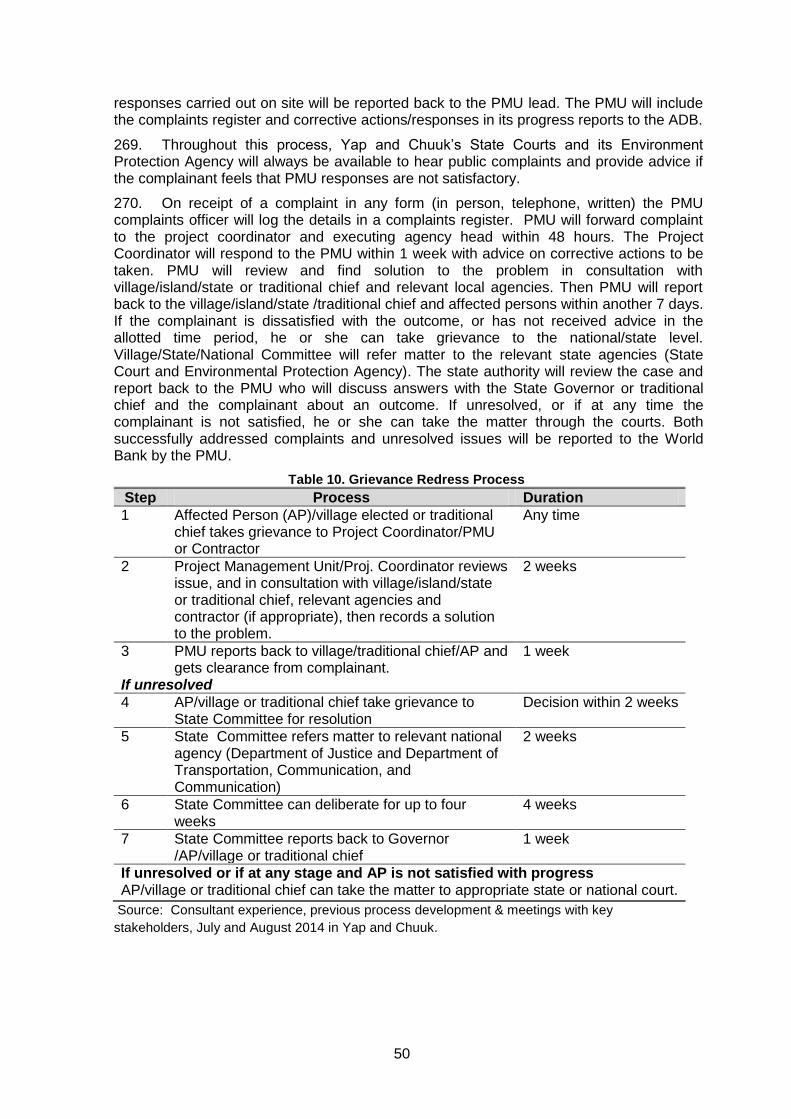
50
responses carried out on site will be reported back to the PMU lead. The PMU will include the complaints register and corrective actions/responses in its progress reports to the ADB.
269. Throughout this process, Yap and Chuuk’s State Courts and its Environment Protection Agency will always be available to hear public complaints and provide advice if the complainant feels that PMU responses are not satisfactory.
270. On receipt of a complaint in any form (in person, telephone, written) the PMU complaints officer will log the details in a complaints register. PMU will forward complaint to the project coordinator and executing agency head within 48 hours. The Project Coordinator will respond to the PMU within 1 week with advice on corrective actions to be taken. PMU will review and find solution to the problem in consultation with village/island/state or traditional chief and relevant local agencies. Then PMU will report back to the village/island/state /traditional chief and affected persons within another 7 days. If the complainant is dissatisfied with the outcome, or has not received advice in the allotted time period, he or she can take grievance to the national/state level. Village/State/National Committee will refer matter to the relevant state agencies (State Court and Environmental Protection Agency). The state authority will review the case and report back to the PMU who will discuss answers with the State Governor or traditional chief and the complainant about an outcome. If unresolved, or if at any time the complainant is not satisfied, he or she can take the matter through the courts. Both successfully addressed complaints and unresolved issues will be reported to the World Bank by the PMU.
Table 10. Grievance Redress Process
Step Process Duration
1 Affected Person (AP)/village elected or traditional chief takes grievance to Project Coordinator/PMU or Contractor
Any time
2 Project Management Unit/Proj. Coordinator reviews issue, and in consultation with village/island/state or traditional chief, relevant agencies and contractor (if appropriate), then records a solution to the problem.
2 weeks
3 PMU reports back to village/traditional chief/AP and gets clearance from complainant.
1 week
If unresolved
4 AP/village or traditional chief take grievance to State Committee for resolution
Decision within 2 weeks
5 State Committee refers matter to relevant national agency (Department of Justice and Department of Transportation, Communication, and Communication)
2 weeks
6 State Committee can deliberate for up to four weeks
4 weeks
7 State Committee reports back to Governor /AP/village or traditional chief
1 week
If unresolved or if at any stage and AP is not satisfied with progress AP/village or traditional chief can take the matter to appropriate state or national court.
Source: Consultant experience, previous process development & meetings with key
stakeholders, July and August 2014 in Yap and Chuuk.
51
VIII. INFORMATION DISCLOSURE, CONSULTATION AND PARTICIPATION
A. Yap
1) Consultation
271. A public consultation session was held on July 29th, between 09:00 and 1130, at the State conference centre in Colonia, Yap State, FSM. 36 people attended the meeting, including key state and municipal government officials, NGOs, as well as fishing and tourism operators. Chiefs from the key municipalities were also in attendance (Annex 2).
272. The government/consultant presentations took one hour, followed by a question and answer period, separated by a short coffee/tea break. The meeting was adjourned around 13:30.
273. In addition to this formal session, the social sector specialist conducted at least three other focus groups, discussing the issues around the location of the facility, the landing site and the fact that none was private. The feedback from these meetings was a resounding yes, with completion of the work and provision of the service as soon as possible.
274. Opening remarks were delivered by the Governor of Yap, who also chaired the session and Infrastructure, followed by Mr. Jolden Jonnyboy, the designated national lead ( although Mark DeOrio is taking over that role) for the project provided a slide show describing the administrative and financial details on how the project will be implemented and the timetable for completion of the major deliverables Thirdly Mr. G. Teleki, the consultant’s team leader provide a detailed presentation on the project background, cable technology and installation options as well as environmental findings followed by social safeguard findings presented by the social sector specialist Ms. Carmine recorded during the field visits to Yap ( two for Mr. Teleki and Ms. Carmine. Finally, Teleki presented the details of the preferred alignment, focusing on the corridor taken by the cable as it passed from the deep sea into the nearshore waters of Yap and Colonia (see Annex 2).
2) Questions and Answers
275. The comments by the participants focused on three areas:
Misconceptions about the size and makeup of the cable, namely large
diameter and containing hazardous materials and associated
environmental impacts
Cost of the service to subscribers over and above the existing
The next step of provision of connections to households, and
If Satawan included local MP wants Ulithi Island included.
276. Misconceptions about the size and makeup of the cable, namely large diameter and containing hazardous materials and associated environmental impacts- A lively discussion concern the diameter, components and option burial methods was conducted among the participants, the proponent, the consultant as well as the Minister or Transport and Infrastructure. Actual samples of the cable were passed around the room and details of into makeup and the fact that it did not contain any liquid or in fact any power supply was clarified.
277. The consultant described optional burial methods, namely towed trencher and hydro-trencher, seafloor placement using anchors, and nearshore floatation and diver directed placement.
52
278. Questions were asked about wide enough consultation and the social sector specialist responded by saying that various meeting with many stakeholder groups had been completed and quite a number of the people attending the meeting had been involved in these sessions.
279. Initial concerns raised during the first meeting, related to possible damage to the marine life particularly fish caught in nearby fishing grounds as well the permitting process for getting permission to cross the MPAs. These questions were discussed during the public consultations and assurances given (and actual cable sections provided) that even if the cable were broken, there would be no environmental threat since it is made up of inert metal and plastic; this included the repeaters.
280. Cost of the service to subscribers over and above the existing rates-The issue of how the cable was to be paid for and the cost to subscribers was another topic of discussion, most importantly the issue of not having a fibre optic cable on land so the cable from the sea would be connected to a copper wire connection, greatly reducing the value of a fibre optic cable system. The response was that a landside cable system is being considered and will be a part of the bidding for the installation and operation of the system.
281. The next step; namely the provision of connections to households- The participants were assured that this step was being planned, but that such services will be provided by the telecommunications service provider and that once the cable was landed the issue of connection to subscribers would be addressed. Affordability would a top priority, and the implementing agency would hold consultations concerning this.
282. Satawan Connection- A local Member of Parliament indicated the Ulithi needed to be considered if Satawan was to be a part of the project. The response was that Satawan would not be a part of this project
3) Summary of the Consultation and of Reply by Government/Consultant
283. The overwhelming opinion of all participants was full support for the project and an urgency to get this in place as quickly as possible. There was not a single negative comment. The presenter responded with thanks and underscored that the safeguard document once drafted would be available for review at the Governor’s Office and Resource Planning Department in Colonia.
4) Use of Consultation Results
284. The points raised, particularly the first two have triggered the addition of further explanation during the future consultations to be delivered by the State PMU, addressing the topics of cable make up, economic feasibility and costing.
5) Follow Up Program
285. The Governor’s Office announced that while no further workshops were planned, people with concerns and complaints could bring these directly to the Governor’s office for resolution.
286. The IEE report will be available for public review for a number for a number of days (details not specified), but does not require disclosure at ADB or World Bank, given that it is an IEE. It will however be placed on ADB’s and World Bank’s website for review at any time.
B. Chuuk
1) Consultation
287. The meeting was opened at 0915 by Mr. Jonnyboy of the FSM lead representative who discussed project administration, financial matters and timetable issues. This was followed by the presentation of the project, as well as environmental and social sector
53
safeguard issues, mitigative measures and accompanying maps showing the location of the preferred alignment into the Chuuk Lagoon. Summary record of the meeting was prepared by the consultant and it plus the attendance sheet is included in Annex 2
288. There followed considerable discussion and it became clear that as with Yap, there was misconception about the scale of the impact from the cable, mostly because the cable was seen as a large conduit emitting electromagnetic radiation and with a hazardous substance inside acting as a kind of insulator. Photos of a cable section were presented and it was explained that the modern cable needs no power and has no liquid inside and were solid rubber, plastic and glass.
A new issue that emerged in Chuuk and which took up considerable time was the concern that the cable could be vandalizes and what action could be taken to prevent that. This was actually a serious consideration and the only solution proposed was that a monitoring-inspection committee be formed to regularly watch over the cable to be sure it not vandalized. The consultant reminded the participants that the cable would be buried 2.5-3 ft below the seafloor and only nautical charts would provide GPS coordinates.
The State officials indicated that an approach would be implemented to safeguard the cable,and that inside the lagoon it would have to be buried.
Concern over the misuse of high-speed internet to access socially undesirable sites as well as dangerous ones dealing with human trafficking was tabled. The consultant indicated that the service provider would need to include with every subscription warnings and means to block access to these sites.
2) Questions and Answers
The following other issues were also discussed
i) concern over interaction of cable laying vessel with other commercial ship traffic
entering through the Northeast Channel into the lagoon? Vessel will be modern
and equipped with all navigation equipment including radar and sounders to
avoid any problems.
ii) life span of the cable? 25-30 years.
iii) depth of the cable how it is positioned within the lagoon. Restated information
already provided in presentation.
iv) concern about ongoing sand mining-dredging locations, these sites need to be
identified so no impacts. We need a map to identify these sites. EPA regulates
these activities-so they know exact locations.
v) ownership issue on land and water. Commercial issues for the laying the cable,
Attorney General’s office assured meeting that easement in the water will not be
a problem? Having people to wave these issues. AG and deputy Governor of
Chuuk State indicated it would be dealt with internally. It is a domestic issue. A
letter of agreement will be developed.
vi) comments associated with Telecom ownership on land for the cable-, willingness
by FSM to allow competition to use the cable. Sharing the service provider--.
Sure for a user fee. The new law passed recently explains this. Internal State
concern – needs more internal FSM national and State government discussions.
Equal access bases. Joldon explained the law. Needs to be sorted out. FSM will
take this lead in due time.
vii) some discussion based on FSM roles and States involvement in the operation of
the new system – more awareness and understanding needed. This will come as
promised by Jolden Jonnyboy; and
54
viii) identified the cost sharing conditions regarding the World Bank grant to FSM.
3) Summary of Consultation
289. The overwhelming opinion of all participants was full support for the project and an urgency to get this in place as quickly as possible. There was not a single negative comment. The presenter responded with thanks and underscored that the safeguard document once drafted would be available for review at the Governor’s Office and Resource Planning Department in Weno.
4) Use of Consultation Results
290. The points raised, particularly the first two have triggered the addition of further explanation during the future consultations to be delivered by the State PMUs, addressing the topics of cable make up, economic feasibility and costing.
5) Follow Up Program
291. The IEE report will be available for public review for a number for a number of days (details not specified), but does not require disclosure at ADB or World Bank, given that it is an IEE. It will however be placed on ADB’s and World Bank’s website for review at any time.
55
IX. ENVIRONMENTAL AND SOCIAL MANAGEMENT PLAN (ESMP)
292. The ESMP is organized into two cross-referenced tables, namely the environmental mitigation table (EmiT), and monitoring table (EmoT), and is provided in detail in Annex 1. These two tables list in details the mitigative measures and monitoring actions that the Executing Agency has committed to implement, from the planning through the operating period of the project. The ESMP table numbering is consistent such that reference can be made in the bid documentation or during any other monitoring activity and the correct mitigative and monitoring measure will always be found. The ESMP reference numbers are also included in the discussion in Chapter IV and VI of this IEE.
293. This approach makes for an ESMP that is practical and can be easily be used during bid document preparation as well as during project implementation. This type of ESMP is short, information rich, and with minimal text to wade through.
A. Preconstruction
294. For the preconstruction or detailed design/planning phase of the project, 14 environmental mitigative and monitoring measures were identified.
295. They focus on advising those who are preparing the bid documents on what and where to insert specifications defining geographic and timing limits of the work was designed to provide guidance on how to avoid negative effects during the construction period. In addition a UXO sweep of the cable corridor to whatever depth is advised by the appropriate authority, will be undertaken.
296. Monitoring actions during this stage will involve simple confirmation that bid documents reflect these requirements and also require bidders to have basic environmental safeguard management qualifications.
1) Physical Environment
297. 1.1 Air Quality– Large volumes of air pollutants will be released from all vessels involved in cable contract. Contract specifications prepared by FSM will require all project vessels to submit emission certification confirming PM, SO2 and NO2 emissions, given that these ships generally burn low grade (dirty) bunker fuel. These certificates will be retained by the State PMUs. In addition, stack smoke density test results will also be required (see paragraph 221 for details).
298. 1.2 Substrate- The use of foreign (from outside the project area) materials when backfilling cable trenches could lead to unknown local area contamination. To avoid that cable-laying contractor’s specification should indicate that ;
all backfill will have to be only autochthonous materials.
only inert/stable materials will be used in cable laying and anchoring.
299. These mitigative measures will be monitored via periodic inspection by the PMUs and progress reporting by the cable placement vessels.
300. 1.3. Unexploded ordnance. During all preparation stages of cable deployment, due diligence and careful surveys will need to be undertaken to eliminate the risk of the presence of unexploded WWII munitions in the substrate where trenching will take place. Particular emphasis and care need to be exercised in areas associated with the deep waters of the main shipping channel. The Palauan government is also working to locate and remove all unexploded ammunition in its coastal zone and EEZ. Details of areas ‘cleaned” in relation to the cable alignment need to be discussed between the contractor and each state agency before cable deployment commences.
301. 1.4 Hydrothermal Vents- Although none are presently known to exist in the general alignment of the cable between Yap, Guam and Palau, and along the Chuuk cable
56
route, the oceanographic survey may turn up such a site. Physical damage to vents by the cable laying process is possible, as is damage to the cable from the 300oC+ temperatures of the venting water. Therefore specification requiring the oceanographic survey team to identify a cable route that maintains a minimum clearance of 1 Km from active hydrothermal vents will be defined in the design specification.
302. 1.5 Sea Mounts-Placing a cable across a seamount, which is an important fishing ground and fish gathering area can lead to habitat damage and conflict with fisher people. To avoid this, contract documentation will include the requirement for the survey team to identify a cable route that maintains a minimum clearance of 2 Km from the base of any seamount(s) if discovered, and specify this route in the design specification.
2) Ecological Environment
303. 1.6 Conservation Areas- These areas managed by local communities for sustainable marine resources use and consumption need to be protected from any encroachment by the cable laying activity. These CAs are mapped and well known locally and will be collected by the Project Coordinator. Yap has two such areas in proximity to the cable alignment and the contractor will need to reconfirm that the route chosen is the least
disruptive for these two sites. The contract specifications require a ≥ 75m distance from CA
boundaries, i.e., all survey and cable laying vessels will maintain this distance at all times. Chuuk has no such issues, although several CAs are being proposed.
304. 1.7 Coastal and Deep Ocean Habitat- Vessel operations in the deep ocean and especially in the waters inside the barrier reef, could result in accidental spills and leaks of hazardous materials or, in shallower coastal areas, vessel grounding, leading to habitat destruction. To minimize this risk the Yap and Chuuk EPAs will require contractors to 1) provide specifications of the fuel and lubricant management equipment and storage on vessels used during the survey and cable laying operations, and certify that the installations are in compliance with national regulations and-or MARPOL specifications for fuel management, 2) maintain a contingency plan to address spills and groundings due to storm events; and 3) have on board modern navigation equipment used to avoid vessel grounding.
305. 1.8 Coral Communities- The cable laying operations will avoid infringing on any live coral reefs or areas where coral is recovering from past degradation. To that end the oceanographic survey team will receive instructions to align the cable around living reefs. Not however that, based on the 2014 surveys to date, no such interaction is anticipated, so long the cable is placed in the shipping channel. No living coral was observed in the channels, but was abundant along the upper walls of the channels, particularly in the Chuuk Lagoon. This instruction will be provided in the contract document.
306. 1.9 Seagrass- No seagrass meadows were found in the proposed cable-placement corridor. In the event that a deviation during the detailed design period is required the following boundaries are defined. If not placed with care and in the shipping channel the cable could impact local seagrass meadows (albeit minimally, given that the cable`s size. To avoid this, the cable`s placement will be confined to a narrow path (less than 0.4m (15”) wide and 0.75m (29.5”) deep, and these specifications will be included in contract documents, and seagrass meadows will be avoided.
307. 1.10 Species At Risk –Whales are known to migrate through the waters where the cable alignment survey and cable laying activities will take place in. The work could have two impacts: 1) acoustic and disorienting effect of ocean sonar survey on marine mammals.; and 2) entanglement of deep diving cetaceans such as the sperm whale in cable . To reduce the risk of this occurring, vessel and survey operators will be instructed to:
1) use best practices for operating vessels in proximity to marine mammal (Annex 4)areas;
57
2) undertake seafloor survey outside whale presence/migration season, namely not
between June and September; 3) post a watch for whales and suspend activities when whales are within 1 Km of
vessel; 4) use multi-beam and/or side-scan sonar only – No air guns; and, 5) lay cable segments in terrain that does not have sharp changes in relief requiring
suspension between points and creating a real obstacle., Low relief routes will be sought out.
3) Social Environment
308. For the preconstruction or detailed design/planning phase of the project, four social-specific mitigative and monitoring measures were identified.
309. The project has the potential to generate misinformation about the cable and possible effects and possible social disruption of the work. A consultation was completed during the preconstruction stage to inform the public about the work and it very minor impacts, and FSM indicated that it would hold additional meetings.
310. Secondly, all public complaints and concerns need to be addressed and to that end a grievance redress mechanism (see Chap. VI) has been established and its procedure will be clearly defined during the information sessions held by the project PMU.
311. 1.11 Coastal Users and Subsistence and Artisanal Fisheries - Damage to ecosystem integrity and fishery productivity through loss or damage to local fishing grounds. Using the data on design limits found in the IEE, prepare contract specifications defining trenching/cable laying activities to be limited to a narrow corridor and trenching to be followed by immediate burial.
312. 1.12 Technical Capacity to Implement the ESMP-There is a lack of experience and technical understand by the executing agency concerning ESMP implementation. As a result the value of the ESMP could be compromised. To avoid this, one of the first tasks of the Project Coordinator or the lead of the PMUs will be to retain an environmental technician familiar with ESMP implementation. These technicians will be retained for at least the two years, (including detailed design and construction), to help implement and record the delivery of the ESMP in the two states.
313. 1.13 Community Information- – Misconceptions regarding the project may raise people’s fears regarding project footprint and potential damages to marine food supply. To address this at least one consultation targeting government, non-government and community consultations will be completed in each state prior to commencement of civil works, during construction and after project completion.
314. 1.14 Community Grievances-Concerns about the details of the project, particularly the financial aspects as related to household connection charges and service provider rates, have already surfaced and will need to be addressed by the government. There may also be other, as yet unknown issues related to, e.g., fishing gear damage due to cable placement. Both Yap and Chuuk have indicated that at least one additional special meeting (as part of the same meetings proposed in Task 1.13) will be held to address the financial and costing issues. While the grievance redress mechanism has been established the committee composition is not yet fixed, but will be established by the Project coordinator and the State PMUs working within the state governments. The use of the seabed and customary ownership is another issue where concerns will need to be addressed and local level memoranda of agreement are already in preparation.
B. Construction
58
315. There are 16 mitigation and monitoring actions and 12 of them define boundaries or limits on how, where and when cable placement and burial should take place. There are also actions needed to confirm the environmental compliance of equipment, such as the survey and cable laying vessels’ fuel management and storage systems as well as their emission certification. Awareness raising of the contractor, via a briefing session is also an important task and will be undertaken shortly after the contract is awarded.
316. The monitoring table (Annex 1 EMoT) defines how the mitigative measures need to checked and records completed, followed by submission to MICROPAL, the State and national government agencies and the World Bank/ADB.
1) Physical Environment
317. 2.1 Air Quality–as defined in Chapter V the Project Coordinator will ensure that the contractor vessels have been properly maintained and that the emissions are acceptable for the vessels and within FSM standards and those described in Task 1.1.
318. 2.2 Substrate-The Project Coordinator will require assurance from the contractor that only local materials were used to backfill trenches and will record this in the regular reporting to MICROPAL and the World Bank.
319. 2.3 Hydrothermal Vents- Hydrothermal vents require a 1 Km buffer zone, i.e. distance from any cable laying operation. This action is triggered only if vents are found along the alignment. This will be known after the detailed oceanographic survey takes place, at which time the Project Coordinator will need to implement this mitigative measure to be sure that these sites are not damaged or destroyed.
320. 2.4 Sea mounts-Seamounts will require a 2 Km buffer zone, i.e., distance from cable laying operations (if possible). This action is triggered only if sea mounts are found along the alignment. This will be known only after the detailed oceanographic survey takes place, at which time the Project Coordinator will need to implement this mitigative measure to be sure that these sites are not damaged or destroyed
2) Ecological Environment
321. 2.5 Marine Coastal Conservation Areas- The oceanographic survey will establish the exact route of the cable, but that design will be bounded by the location and limits of the CAs as defined in the IEE and as available in greater details from the executing agency and the two PMUs. The Project Coordinator, working with the contractor will ensure that these boundaries are maintained and that any potential unavoidable encroachment be cleared in writing with the communities involved prior to cable placement taking place.
322. 2.6 Coastal and Deep Ocean Habitat-vessel operations as part of the cable survey and placement task will pose a very low risk that these vessels will spill fuel, dump waste or run aground, this damaging habitat. Contractor vessels will be equipped with up-to-date navigation and sonar equipment and will be required to adhere to international standards regarding fuel storage and handling and on-board waste management. As part of the contractor confirmation exercise, the Project Coordinator will conduct an inspection of the vessels to ensure that the contractor has met basic requirements. Secondly, the route of the alignment must avoid interference with coastal marine habitat that is outside the shipping channel.
323. 2.7 Coral Communities-The contactor will comply with the requirement for the maintenance of at least a 75m distance from coral communities while working in the nearshore waters by using the survey maps and bypassing any coral formation identified during the survey. Such finds are unlikely at least in the nearshore areas, given that there were no such formations found in the Yap approaches and channel or the Chuuk NE entrance to the lagoon and shipping channel (See Annex 4).,
59
324. 2.8 Seagrass- Avoidance of encroachment onto seagrass meadow is a requirement and to date the cable alignment does not interfere with any seagrass bed. If previously undetected beds are found during the survey, the contractor and Project Coordinator will be required to realign the cable so that it interfered minimally and if possible avoids these sensitive areas altogether.
325. 2.9 and 1.10, Cetaceans – Contractors will need to consult with Guam marine mammal authorities to establish which whales generally move through the work corridor waters, and plan the cable laying operation to take place during period of low or now whale movement ( to the extent that this can be determined, given the lack of survey data). The contractor(s) will be required to keep a record of such consultation in the event that the Project Coordinator or WB/ADB requests it. The Environmental Code of Practice for Fibre Optic Cable Projects, prepared as guiding framework for such projects, contains specific instructions concerning whales and cable laying operations, which contracts are required to adhere to.
3) Social Environment
326. 2.10 Coastal Resource Users – subsistence and artisanal fisheries-Contractors will be required to respond to issue arising due to incorrect cable placement of complaints about disruption of local fisheries. The best action will be to avoid encroachment, which should be relatively easy as the contractor will have consulted with authorities (Fisheries Dept. or the State Fisherman’s Association) concerning the location of fishing areas.
327. 2.11 Coastal Resource Users – Game fishers – Contractor(s) will be required to notify the Yap and Chuuk Marine Resources Departments and coastguard of the cable location and indicate any areas along the route that are near fishing ground. This will help avert cable-fishing gear issues
328. 2.12 Coastal shipping – commercial shipping and ports- For this possible impact leading to vessel delays or accidents, the cable laying project will need to be well advertised with the shipping industry such the vessels operating in the waters are aware of the cable laying exercise. A ship to ship broadcast informing vessels of cable laying operation will also be considered, but keeping within any security conditions
329. 2.13 and 2.14 Landuse and Access- No land acquisition or access-related effects will arise since the cable corridor is are either in the deep ocean, in the commercial shipping channel in both Yap and Chuuk, and the government lands on shore.
330. 2.15 Environmental Completion Reporting-The Project Coordinator will ensure that this report is completed at the end of the construction period and submitted by the contractor to MICROPAL, each state implementing agency and WB/ADB.
331. 2.16 Contractor Awareness Raising- Given the likely gap in the contractor’s technical capacity in ESMP implementation and environmental awareness, a short workshop will be delivered by the Project Coordinator at the start of the construction period, covering ESMP implementation as well as working with sensitive marine features, habitats and species.
C. Operating Period
1) Physical and Ecological Environment
332. 3.1 Mitigation Measures Record- During the operating period environmental issue arising will be mostly complaints about the cable interfering with fishing and landuse disputes plus possibly items related to the construction of the landside-fibre optic room. The implementing agencies in each state (State Cable Corporations) will keep ledger if actions taken and resolutions, and make this available to the executing agency as well as the donors.
60
333. 3.2 Oceanic habitat – Hydrothermal Vents- Should the detailed survey reveal the presence of hydrothermal vents, a design to bypass this area of seafloor will be prepared and measures implemented as defined in the ESMP.
334. 3.3 Perceived Marine Pollution –Misinformation about the cable will persist and local communities will need reassurances that it is safe. To that end the grievance committed will remain active in each state and provide information and resolve complaints and concerns as they arise-This function will be transferred to the implementing agency as soon as there is adequate technical capacity.
2) Social Environment
335. 3.4 Impact assoc. with improved Internet-To make all cable subscribers aware of the dangers of better internet access, a meeting with or letters to subscribers will be delivered by the service provider, informing them of potentially undesirable sites and the means to block access to these locations.
336. 3.5 Fishing- There is a very low risk that the cable, once in place will results in snagging of fishing gear. Given that the cable is smooth, except for the repeaters, it sits on the bottom of the sea and is marked on navigation charts, fishers should have all the information needed to avoid such problems. Near shore, the cable will likely be buried 0.75m below the seafloor, eliminating any chances of damage to fishing gear.
D. Performance Indicators
337. Given that nearly all of the potential negative impacts would occur during the construction period, and that robust environmental contract clauses will be able to avoid all impacts. key performance indicators will be:
i) confirmation that the 35 ESMP tasks are defined in as specific individual
or grouped environmental and social clauses, in the contract bid
documents.
ii) confirmation that environmental management criteria are included as part of
the contractor selection process, including their experience preparing and
implementing ESMPs, working in sensitive tropical locations such coral
reefs, recognizing fish aggregation/spawning areas, seagrass meadows
and seamounts;
iii) a safeguards monitor-technician retained by the project coordinator’s office
or the national government, providing on-the-job assistance with information
distribution, community consultation and compliance monitoring tasks;
iv) a written record of the briefing on safeguards and inspection of vessels, as
they are defined in the ESMP and contract specification, completed with the
survey and cable placement contractors, as soon as the contractors have
been selected.
v) compliance monitoring checklists prepared and being used and due
diligence notes, completed as defined in the ESMP, and making the notes
available in an easily accessible file for the contractor, Project Coordinator
and others to use.
vi) a written mitigation and monitoring completion report, listing all mitigation
and monitoring measures defined in the ESMP, their implementation timing,
monitoring and any follow up actions; and,
vii) a written record of interviews with local fishers, examining any cable
placement issues, vis-à-vis fishing gear damage.
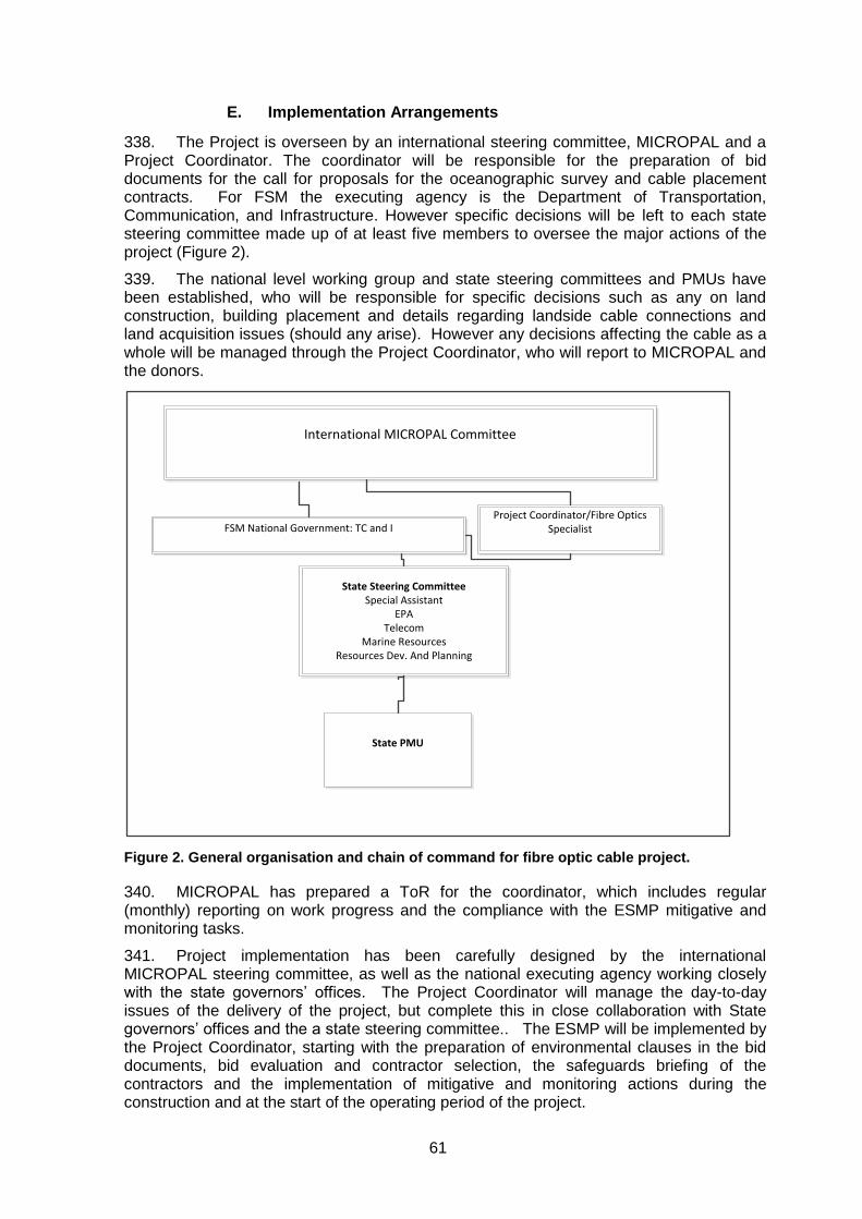
61
E. Implementation Arrangements
338. The Project is overseen by an international steering committee, MICROPAL and a Project Coordinator. The coordinator will be responsible for the preparation of bid documents for the call for proposals for the oceanographic survey and cable placement contracts. For FSM the executing agency is the Department of Transportation, Communication, and Infrastructure. However specific decisions will be left to each state steering committee made up of at least five members to oversee the major actions of the project (Figure 2).
339. The national level working group and state steering committees and PMUs have been established, who will be responsible for specific decisions such as any on land construction, building placement and details regarding landside cable connections and land acquisition issues (should any arise). However any decisions affecting the cable as a whole will be managed through the Project Coordinator, who will report to MICROPAL and the donors.
International MICROPAL Committee
Project Coordinator/Fibre Optics Specialist
FSM National Government: TC and I
State Steering CommitteeSpecial Assistant
EPATelecom
Marine ResourcesResources Dev. And Planning
State PMU
Figure 2. General organisation and chain of command for fibre optic cable project.
340. MICROPAL has prepared a ToR for the coordinator, which includes regular (monthly) reporting on work progress and the compliance with the ESMP mitigative and monitoring tasks.
341. Project implementation has been carefully designed by the international MICROPAL steering committee, as well as the national executing agency working closely with the state governors’ offices. The Project Coordinator will manage the day-to-day issues of the delivery of the project, but complete this in close collaboration with State governors’ offices and the a state steering committee.. The ESMP will be implemented by the Project Coordinator, starting with the preparation of environmental clauses in the bid documents, bid evaluation and contractor selection, the safeguards briefing of the contractors and the implementation of mitigative and monitoring actions during the construction and at the start of the operating period of the project.
62
342. As soon as possible the Project Coordinator will work with the states to establish State steering committees, whose function it will be to make all decisions concerning the project in their state. The proposed composition of this committee is as follows:
State Governor’s Executive Assistant or Dep. Governor, Chair
Pollution Control person from EPA
Representative of FSMTC
Marine Resources person, and
Resource and Development Planning person
343. Any necessary revisions to the ‘ESMP due to detailed design findings will be led by the project coordinator. The PMUs and State Steering Committees (Figure 2) will administer the contractor at the national level, oversee all the engineering activities but in close cooperation with the Project Coordinator. The PMU will work closely with the Project Coordinator and the environmental monitoring technician to implement compliance monitoring of the construction period mitigation measures.
F. Institutional Capacity
344. Both Yap and Chuuk have competent Environmental Protection Agencies, but these are under staffed and under equipped. Both have some experience with implementing international environmental assessment requirements. Conversely, the executing agency, Project Coordinator and contractor, will have no such skill. The bid documents will include a clause requiring bidders to have basic ESMP implementation skills.
345. The consultant therefore recommends that two senior safeguards technician be retained as part of the state PMUs to complete the monitoring tasks, work with the contractors and report on each of the performance indicators, assessing how the project is progressing in relation to the safeguard tasks specified; as well as guide the contractor(s). This is an important action that FSM will implement as soon as the grant/loan arrangements are in place.
346. Not all legal instruments have been finalized, however the MICRPAL committee includes a lawyer capable of providing specific advice, as for example on any customary law issues that might arise. The two state steering committees have not been established and will be in place before contractor selection takes place. These, however are minor issues that will not delay project implementation.
G. Mitigation and Monitoring Costs
1) Environmental Mitigation and Monitoring Costs
347. The ESMP lists 14 preconstruction, 16 construction period and 5 operating period mitigation and monitoring actions. During the construction period field monitoring will be required, weekly, when the cable placement is ongoing inside the barrier reef. The deep ocean work is expected to take about 400 days in total (rough estimate) with the oceanographic survey being completed several weeks ahead of the cable placement operation25. The work inside the barrier reef on Yap will be very quick (about five days) since the channel entrance is marked immediately after the entrance through the natural reef opening. Chuuk lagoon is one of the largest in the world and Weno is about half way across this area and therefore the survey work will likely take 8-12 days. It is during these periods that inspection of vessel operations will need to be conducted.
25 Although not confirmed with the contractors, the survey ship will be able to transmit digital data to the
cable laying contractor and a specific alignment mapped, without having to wait for the survey, taking upwards of 3 months to complete.
63
348. Therefore the total cost for the environmental mitigation and monitoring, is estimated to be around USD 65,000 per state, including the salary of a safeguards technician/monitor26 for a two year employment period. This work would include all reporting and contractor briefing. Monitoring vessels and any equipment will be provided by the Marine Resources Division or Marine Navigation Division of the state governments, with the project paying for fuel. Once alignments have been surveyed and all construction tasks are fixed, and after the negotiations with the various government agencies have been completed during the detailed design period, the exact costs will be updated.
349. Deep sea corridor inspections are not anticipated, unless the project coordinator has such a requirement, in which case the monitor would go along and additional funds would be made available.
2) Social Development Programs and Resettlement Costs
350. Social mitigation and monitoring will involve at least five tasks (ESMP-Annex 2). Cost of community awareness activities such as community meetings/public consultations and information materials prior to construction, during and after construction is expected to be approximately $20,000.00, or about $ 10,000 in each State of Yap and Chuuk, for the complete development period.
351. There is no land acquisition required for the project. However, one of the proposed landing cable sites, inside the airport runway which should be Department of Transportation land, has an outstanding amount to be paid by the government to the former private owner. This amount is still unknown and the issue remains active.
352. Another option is for the State Government to install the cable immediately outside the airport fence and use the roadway easements and ROWs.
3) Total Cost
353. Combining both the environmental and social mitigation and monitoring cost the total estimate costs for each state will be around US$75,000 and will cover the entire project cycle.
4) The Environmental Code of Practice
354. This work required the preparation of an Environmental Code of Practice for corridor selection, placement of the cable, and siting of the landing stations. The Environmental Code of Practice listed many of the items defined in this ESMP and added further detail on boundaries and restriction to be adhered to by contractors conducting work in the marine environment and on shore. It has been prepared as a companion volume with this IEE.
X. CONCLUSIONS AND RECOMMENDATIONS
355. The project will impact a corridor of not more than 0.5 m wide on the sea floor, and in some locations up to 0.75 m beneath the sediment. The cable, 3-7.5cmm in diameter, will be either sitting on the seafloor in the deep ocean, then buried as it passes through the natural channel through the barrier reef into the Yap or Chuuk nearshore zone. Burial of the cable will be done to reduce interference with coastal fishing gear and reduce the risk of damage from severe storms.
356. As it enters into the nearshore waters, the cable alignment will be in the shipping channel which, inside the barrier reef, is essentially a coral rubble and sand seafloor. For
26 A national instead of international specialist.
64
the last 1 - 2 Km the cable will be buried at a depth of about 0.75m, using a special trenching device (Figure 1) which disturbs an area of about 0.4m wide x 0.7m deep, threads the cable into the trench and closes the trench as it is towed by the cable laying vessel or other heavy equipment, will be used. There is no other disturbance to the sea floor or the water column.
357. The distance of the cable from any potentially sensitive habitat such as corals and specific protected areas will be 75m-100m for both Yap and Chuuk, eliminating any chances that the work will negatively impact the marine environment.
358. The landing site for Yap will be on government land to a site already occupied by a small government building. For Chuuk the exact site has not been agreed to but the least costly and the one with the least number of landuse issues will be located on the existing FSMTC site, opposite to the entrance to the Weno airport.
359. The preferred alignments for Yap the Chuuk will not interfere with any of the existing MPAs (Yap) or the proposed MPA (Chuuk) or any other protected areas; and will maintain a minimum 100m safe distance from these areas.
360. The ESMP defines a full set of working area boundaries, work restrictions and timing limits, which will be included in the construction contract specifications and which the contractor will have to comply with. Compliance will be monitored by the Project Coordinator and an ESMP monitor.
361. Given the small scale impact of the work, and the fact that nearly all of the work takes on board a vessel at sea with a specially trained crew, no negative social impacts are predicted during any stage of the project.
362. The operation of large ocean going vessels which burn low grade diesel fuel will result in large emissions of greenhouse gases. To begin to address this the contractor will be required to submit emission certificates for their vessels, and show that they meet international standards, most particularly the USEPA’s diesel emission standards for PM, SO2 NOx and the visual-Black smoke test, as defined in the ESMP.
363. The construction of the cable facility on land will require a small crew of local works, likely a local contractor.
364. In order to effectively implement the mitigation and monitoring tasks defined in the ESMP, the State PMUs or the project coordinator will hire an environmental monitor in each state for a period of 2 years. That monitor will assist with implementation and enforcement of the ESMP, primarily during the construction period of the project.
365. In order to insure no significant environmental and social impact occur, MICROPAL, the project coordinator, the ESMP monitor and the State PMUs, will be fully committed to implementing the ESMP. They will meet all the reporting requirements in a timely manner and consistently monitor the contractor, then provide regular feedback and immediately address any non-compliance issues and public complaints.
366. For the social sector specifically, post installation awareness raising among new subscribers on methods for controlling access to some socially undesirable sites and what to do about them, will be a mandatory requirement for whoever becomes the service provider. The two state governments will be responsible for enforcing this requirement.
367. With these actions, it is recommended that no additional environmental or social sector studies are needed, and that this project can move to detailed design and construction.
65
XI. REFERENCES
Alder, J. & Wood, L., 2004. Managing and protecting seamount ecosystems. In: Morato T, Pauly D eds Seamounts: biodiversity and fisheries. Fisheries Centre Research Report 12(5). Pp. 67– 73. Berzina, A and Saksina, T., 2013. Piloting responsible marine seismic surveys in Sakhalin: New Approaches help minimise risk to marine mammals in environmentally sensitive areas. In. Marine News – Industry in the Environment. Carter, L., Burnett, D., Drew, S., Marle, G., Hagadom, L., Bartlett-McNeil, D., and N. Irvine., 2009. Submarine cables and the oceans – Connecting the World. UNEP-WCMW Biodiversity Series No. 31 – ICPC/UNEP-WCMC. Cole, T. G., Ewel, K. C., and Devoe, N. N. 1999. Structure of mangroves trees and forests of Micronesia. Forest Ecology and Management 117: 95-109. Department of the Environment, Heritage and Local Government, Government of Ireland 2007. Code of practice for the protection of marine mammals during acoustic seafloor surveys in Irish Waters. Dublin, Republic of Ireland. Edwards, A (2002). Marine Biodiversity of the FSM. FSM government Report. 20pp. English, S., Wilkinson, C. & Baker, V., (Ed). 1997. Survey manual for Tropical Marine Resources, 2nd Edition. Australian Institute of Marine Science publication. 390pp. Falanruw, M. 2001. Terrestrial Biodiversity of the FSM. FSM Government publication, 35pp. FSM Government, 2003. National Biodiversity Strategic Action Plan. FSM Government Publication, 67pp. Gavitt, J. D. (2006 ). A threats and needs assessment of coastal marine areas in the states of Kosrae, Chuuk, and Yap, Federated States of Micronesia. Wild Aid publications. Heezen B 1953. Whales entangled in deep sea cables, Deep Sea Research 4(1957–1958): 105–114. Llodra R, Billett D 2006. Deep-sea ecosystems: pristine biodiversity reservoir and technological challenges. In: Duarte CM ed. The exploration of marine biodiversity: scientific and technological challenges. Bilbao, Spain, Fundacion BBVA. Pp 63–92. Houk, P. and J. Starmer. 2007. Rapid ecological assessment for Yap, Ngulu, and Ulithi,
Yap State, Federated States of Micronesia: quantitative assessments of coral-reef
assemblages and macroinvertebrate abundances. Yap Action Community Program. Yap,
Federated States of Micronesia. 43 pp.
Llodra R, Billett D 2006. Deep-sea ecosystems: pristine biodiversity reservoir and technological challenges. In: Duarte CM ed. The exploration of marine biodiversity: scientific and technological challenges. Bilbao, Spain, Fundacion BBVA. Pp 63–92.
66
Miller, C., (2009). Current State of knowledge of Cetacean Threat, Diversity and Habitats in the Pacific Islands region, 2009 Revision. WDCS International. 77p. Nowacek D, Thorne L, Johnston D, Tyack, P., 2007. Responses of cetaceans to anthropogenic noise. Mammal Review 37 (2): 81–115. Rodgers, A., (2012). An Ecosystem Approach to Management of Seamounts in Southern Indian Ocean. Volume 1. Overview of Sea mount Ecosystems and Biodiversity. IUCN Global Marine and Polar Programme. Scientific Committee on Antarctic Research (SCAR) 2006. Report on marine acoustics and the Southern Ocean, produced for Antarctic Treaty Consultative meeting. Scott Polar Research Institute, Cambridge, United Kingdom. SPC, 2013. Pacific Islands Fisheries Address Book. SPC publication of Fisheries, Aquaculture and Marine Ecosystems. Pp 76. Smith, R., 2003. Multibeam bathymetry of Yap Harbour. South Pacific Applied GeoScience Commission. Whale and Dolphin Conservation Society 2009. Current state of knowledge of cetacean threats, diversity and habitats in the Pacific Islands region: 2009 revision for second meeting of the signatories to Convention on Migratory Species Memorandum of Understanding for the Conservation of Cetaceans and their Habitats in the Pacific Islands Region, Auckland, New Zealand, 28–29 July 2009. Wood M, Carter L 2008. Whale entanglements with submarine telecommunication cables. IEEE Journal of Oceanic Engineering 33(4): 445 - 450.
A-1
ANNEXES
Annex 1: The Environmental And Social Management Plan (ESMP) Annex 2: The Consultation and Information Session Record and Presentation Annex 3: The list of People Met and Consulted Annex 4: The Marine Ecology Detailed Findings
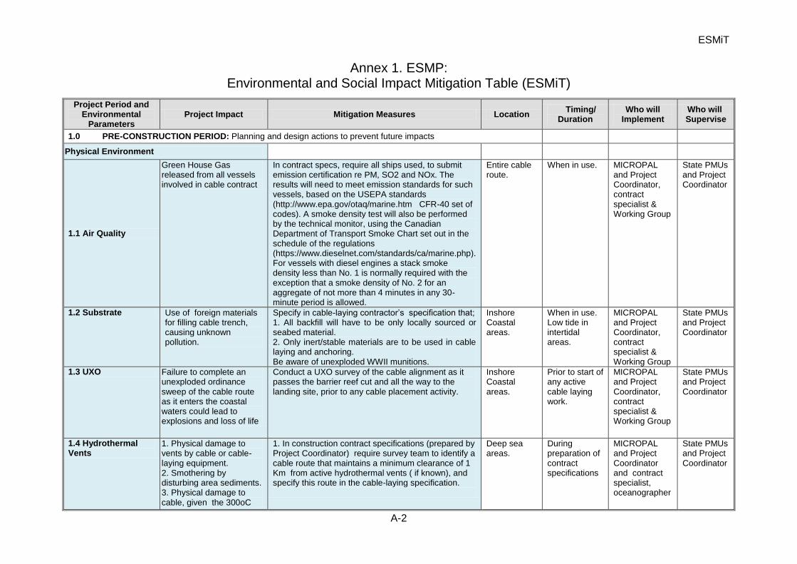
ESMiT
A-2
Annex 1. ESMP: Environmental and Social Impact Mitigation Table (ESMiT)
Project Period and Environmental
Parameters Project Impact Mitigation Measures Location
Timing/ Duration
Who will Implement
Who will Supervise
1.0 PRE-CONSTRUCTION PERIOD: Planning and design actions to prevent future impacts
Physical Environment
1.1 Air Quality
Green House Gas released from all vessels involved in cable contract
In contract specs, require all ships used, to submit emission certification re PM, SO2 and NOx. The results will need to meet emission standards for such vessels, based on the USEPA standards (http://www.epa.gov/otaq/marine.htm CFR-40 set of codes). A smoke density test will also be performed by the technical monitor, using the Canadian Department of Transport Smoke Chart set out in the schedule of the regulations (https://www.dieselnet.com/standards/ca/marine.php). For vessels with diesel engines a stack smoke density less than No. 1 is normally required with the exception that a smoke density of No. 2 for an aggregate of not more than 4 minutes in any 30-minute period is allowed.
Entire cable route.
When in use. MICROPAL and Project Coordinator, contract specialist & Working Group
State PMUs and Project Coordinator
1.2 Substrate Use of foreign materials for filling cable trench, causing unknown pollution.
Specify in cable-laying contractor’s specification that; 1. All backfill will have to be only locally sourced or seabed material. 2. Only inert/stable materials are to be used in cable laying and anchoring. Be aware of unexploded WWII munitions.
Inshore Coastal areas.
When in use. Low tide in intertidal areas.
MICROPAL and Project Coordinator, contract specialist & Working Group
State PMUs and Project Coordinator
1.3 UXO Failure to complete an unexploded ordinance sweep of the cable route as it enters the coastal waters could lead to explosions and loss of life
Conduct a UXO survey of the cable alignment as it passes the barrier reef cut and all the way to the landing site, prior to any cable placement activity.
Inshore Coastal areas.
Prior to start of any active cable laying work.
MICROPAL and Project Coordinator, contract specialist & Working Group
State PMUs and Project Coordinator
1.4 Hydrothermal Vents
1. Physical damage to vents by cable or cable- laying equipment. 2. Smothering by disturbing area sediments. 3. Physical damage to cable, given the 300oC
1. In construction contract specifications (prepared by Project Coordinator) require survey team to identify a cable route that maintains a minimum clearance of 1 Km from active hydrothermal vents ( if known), and specify this route in the cable-laying specification.
Deep sea areas.
During preparation of contract specifications
MICROPAL and Project Coordinator and contract specialist, oceanographer
State PMUs and Project Coordinator
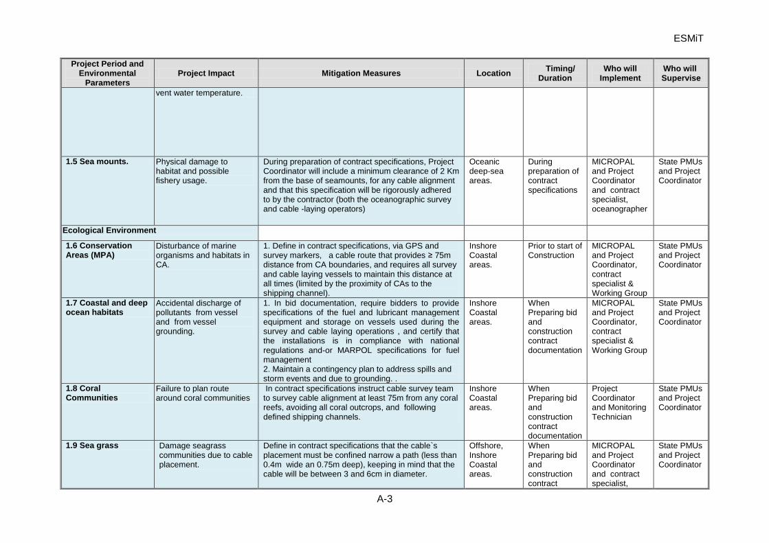
ESMiT
A-3
Project Period and Environmental
Parameters Project Impact Mitigation Measures Location
Timing/ Duration
Who will Implement
Who will Supervise
vent water temperature.
1.5 Sea mounts. Physical damage to habitat and possible fishery usage.
During preparation of contract specifications, Project Coordinator will include a minimum clearance of 2 Km from the base of seamounts, for any cable alignment and that this specification will be rigorously adhered to by the contractor (both the oceanographic survey and cable -laying operators)
Oceanic deep-sea areas.
During preparation of contract specifications
MICROPAL and Project Coordinator and contract specialist, oceanographer
State PMUs and Project Coordinator
Ecological Environment
1.6 Conservation Areas (MPA)
Disturbance of marine organisms and habitats in CA.
1. Define in contract specifications, via GPS and survey markers, a cable route that provides ≥ 75m distance from CA boundaries, and requires all survey and cable laying vessels to maintain this distance at all times (limited by the proximity of CAs to the shipping channel).
Inshore Coastal areas.
Prior to start of Construction
MICROPAL and Project Coordinator, contract specialist & Working Group
State PMUs and Project Coordinator
1.7 Coastal and deep ocean habitats
Accidental discharge of pollutants from vessel and from vessel grounding.
1. In bid documentation, require bidders to provide specifications of the fuel and lubricant management equipment and storage on vessels used during the survey and cable laying operations , and certify that the installations is in compliance with national regulations and-or MARPOL specifications for fuel management 2. Maintain a contingency plan to address spills and storm events and due to grounding. .
Inshore Coastal areas.
When Preparing bid and construction contract documentation
MICROPAL and Project Coordinator, contract specialist & Working Group
State PMUs and Project Coordinator
1.8 Coral Communities
Failure to plan route around coral communities
In contract specifications instruct cable survey team to survey cable alignment at least 75m from any coral reefs, avoiding all coral outcrops, and following defined shipping channels.
Inshore Coastal areas.
When Preparing bid and construction contract documentation
Project Coordinator and Monitoring Technician
State PMUs and Project Coordinator
1.9 Sea grass Damage seagrass communities due to cable placement.
Define in contract specifications that the cable`s placement must be confined narrow a path (less than 0.4m wide an 0.75m deep), keeping in mind that the cable will be between 3 and 6cm in diameter.
Offshore, Inshore Coastal areas.
When Preparing bid and construction contract
MICROPAL and Project Coordinator and contract specialist,
State PMUs and Project Coordinator
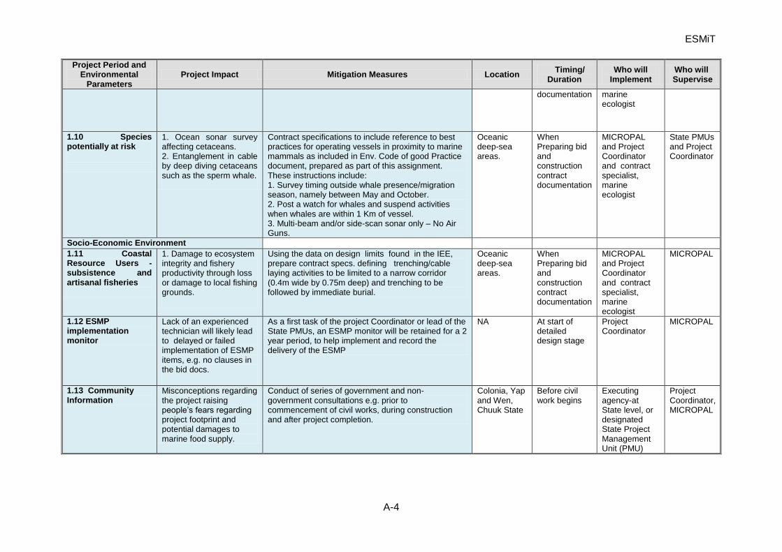
ESMiT
A-4
Project Period and Environmental
Parameters Project Impact Mitigation Measures Location
Timing/ Duration
Who will Implement
Who will Supervise
documentation marine ecologist
1.10 Species potentially at risk
1. Ocean sonar survey affecting cetaceans. 2. Entanglement in cable by deep diving cetaceans such as the sperm whale.
Contract specifications to include reference to best practices for operating vessels in proximity to marine mammals as included in Env. Code of good Practice document, prepared as part of this assignment. These instructions include: 1. Survey timing outside whale presence/migration season, namely between May and October. 2. Post a watch for whales and suspend activities when whales are within 1 Km of vessel. 3. Multi-beam and/or side-scan sonar only – No Air Guns.
Oceanic deep-sea areas.
When Preparing bid and construction contract documentation
MICROPAL and Project Coordinator and contract specialist, marine ecologist
State PMUs and Project Coordinator
Socio-Economic Environment
1.11 Coastal Resource Users - subsistence and artisanal fisheries
1. Damage to ecosystem integrity and fishery productivity through loss or damage to local fishing grounds.
Using the data on design limits found in the IEE, prepare contract specs. defining trenching/cable laying activities to be limited to a narrow corridor (0.4m wide by 0.75m deep) and trenching to be followed by immediate burial.
Oceanic deep-sea areas.
When Preparing bid and construction contract documentation
MICROPAL and Project Coordinator and contract specialist, marine ecologist
MICROPAL
1.12 ESMP implementation monitor
Lack of an experienced technician will likely lead to delayed or failed implementation of ESMP items, e.g. no clauses in the bid docs.
As a first task of the project Coordinator or lead of the State PMUs, an ESMP monitor will be retained for a 2 year period, to help implement and record the delivery of the ESMP
NA At start of detailed design stage
Project Coordinator
MICROPAL
1.13 Community Information
Misconceptions regarding the project raising people’s fears regarding project footprint and potential damages to marine food supply.
Conduct of series of government and non-government consultations e.g. prior to commencement of civil works, during construction and after project completion.
Colonia, Yap and Wen, Chuuk State
Before civil work begins
Executing agency-at State level, or designated State Project Management Unit (PMU)
Project Coordinator, MICROPAL
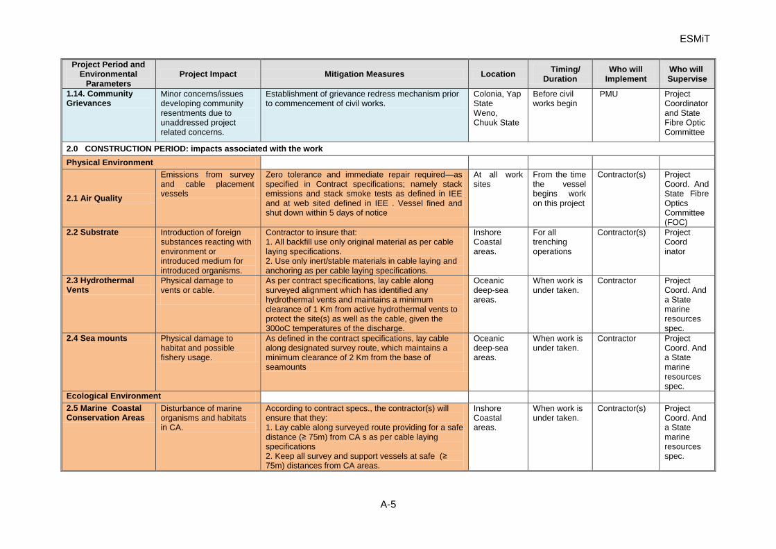
ESMiT
A-5
Project Period and Environmental
Parameters Project Impact Mitigation Measures Location
Timing/ Duration
Who will Implement
Who will Supervise
1.14. Community Grievances
Minor concerns/issues developing community resentments due to unaddressed project related concerns.
Establishment of grievance redress mechanism prior to commencement of civil works.
Colonia, Yap State Weno, Chuuk State
Before civil works begin
PMU Project Coordinator and State Fibre Optic Committee
2.0 CONSTRUCTION PERIOD: impacts associated with the work
Physical Environment
2.1 Air Quality
Emissions from survey and cable placement vessels
Zero tolerance and immediate repair required—as specified in Contract specifications; namely stack emissions and stack smoke tests as defined in IEE and at web sited defined in IEE . Vessel fined and shut down within 5 days of notice
At all work sites
From the time the vessel begins work on this project
Contractor(s) Project Coord. And State Fibre Optics Committee (FOC)
2.2 Substrate Introduction of foreign substances reacting with environment or introduced medium for introduced organisms.
Contractor to insure that: 1. All backfill use only original material as per cable laying specifications. 2. Use only inert/stable materials in cable laying and anchoring as per cable laying specifications.
Inshore Coastal areas.
For all trenching operations
Contractor(s) Project Coord inator
2.3 Hydrothermal Vents
Physical damage to vents or cable.
As per contract specifications, lay cable along surveyed alignment which has identified any hydrothermal vents and maintains a minimum clearance of 1 Km from active hydrothermal vents to protect the site(s) as well as the cable, given the 300oC temperatures of the discharge.
Oceanic deep-sea areas.
When work is under taken.
Contractor Project Coord. And a State marine resources spec.
2.4 Sea mounts Physical damage to habitat and possible fishery usage.
As defined in the contract specifications, lay cable along designated survey route, which maintains a minimum clearance of 2 Km from the base of seamounts
Oceanic deep-sea areas.
When work is under taken.
Contractor Project Coord. And a State marine resources spec.
Ecological Environment
2.5 Marine Coastal Conservation Areas
Disturbance of marine organisms and habitats in CA.
According to contract specs., the contractor(s) will ensure that they: 1. Lay cable along surveyed route providing for a safe distance (≥ 75m) from CA s as per cable laying specifications 2. Keep all survey and support vessels at safe (≥ 75m) distances from CA areas.
Inshore Coastal areas.
When work is under taken.
Contractor(s) Project Coord. And a State marine resources spec.
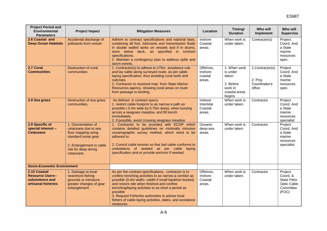
ESMiT
A-6
Project Period and Environmental
Parameters Project Impact Mitigation Measures Location
Timing/ Duration
Who will Implement
Who will Supervise
2.6 Coastal and Deep Ocean Habitats
Accidental discharge of pollutants from vessel.
Adhere to contract specifications and national laws, containing all fuel, lubricants and transmission fluids in double walled tanks on vessels and if in drums, store below deck, as specified in contract specifications. 2. Maintain a contingency plan to address spills and storm events.
Inshore Coastal areas.
When work is under taken.
Contractor(s) Project Coord. And a State marine resources spec.
2.7 Coral Communities
Destruction of coral communities
1. Contractor(s) to adhere to ≥75m avoidance rule and lay cable along surveyed route, as per cable-laying specification, thus avoiding coral reefs and outcrops. 2. Contractor to received map from State Marine Resources agency, showing coral areas on route from passage to landing.
Offshore, Inshore coastal areas.
1. When work is under taken. 2. Before work in coastal areas begins
1.Contractor(s) 2. Proj. Coordinator’s office
Project Coord. And a State marine resources spec.
2.8 Sea grass Destruction of sea grass communities.
As defined in contract specs; 1. restrict cable footprint to as narrow a path as possible ( 0.4m wide by 0.75m deep), when burying across a seagrass meadow, and fill trench immediately. 2. if possible, avoid crossing seagrass meadow
Inshore Intertidal Coastal areas.
When work is under taken.
Contractor Project Coord. And a State marine resources specialist
2.9 Specific of special Interest – Cetaceans
1. Disorientation of cetaceans due to sea floor mapping using standard sonar gear
2. Entanglement in cable risk for deep diving cetaceans
1. Contractor to be provided with ECOP which contains detailed guidelines on minimally intrusive oceanographic survey method, which need to be adhered to. 2. Control cable tension so that laid cable conforms to undulations of seabed as per cable laying specification and-or provide anchors if needed.
Oceanic deep-sea areas.
When work is under taken.
Contractor Project Coord. And a State marine resources specialist
Socio-Economic Environment
2.10 Coastal Resource Users– subsistence and artisanal fisheries
1. Damage to local nearshore fishing grounds or introduce greater changes of gear entanglement
As per the contract specifications, contractor is to confine trenching activities to as narrow a corridor as possible (0.4m width—width if small backhoe bucket) and restore site when finished and confine trenching/laying activities to as short a period as possible 3. Request Fisheries authorities to advise local fishers of cable laying activities, dates, and avoidance measures.
Offshore, Inshore Coastal areas.
When work is under taken.
Contractor Project Coord. & State Fibre Optic Cable Committee (FOC)
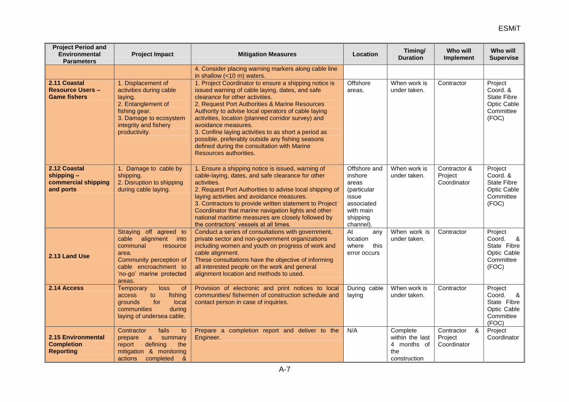
ESMiT
A-7
Project Period and Environmental
Parameters Project Impact Mitigation Measures Location
Timing/ Duration
Who will Implement
Who will Supervise
4. Consider placing warning markers along cable line in shallow (<10 m) waters.
2.11 Coastal Resource Users – Game fishers
1. Displacement of activities during cable laying. 2. Entanglement of fishing gear. 3. Damage to ecosystem integrity and fishery productivity.
1. Project Coordinator to ensure a shipping notice is issued warning of cable laying, dates, and safe clearance for other activities. 2. Request Port Authorities & Marine Resources Authority to advise local operators of cable laying activities, location (planned corridor survey) and avoidance measures. 3. Confine laying activities to as short a period as possible, preferably outside any fishing seasons defined during the consultation with Marine Resources authorities.
Offshore areas.
When work is under taken.
Contractor Project Coord. & State Fibre Optic Cable Committee (FOC)
2.12 Coastal shipping – commercial shipping and ports
1. Damage to cable by shipping. 2. Disruption to shipping during cable laying.
1. Ensure a shipping notice is issued, warning of cable-laying, dates, and safe clearance for other activities. 2. Request Port Authorities to advise local shipping of laying activities and avoidance measures. 3. Contractors to provide written statement to Project Coordinator that marine navigation lights and other national maritime measures are closely followed by the contractors’ vessels at all times.
Offshore and inshore areas (particular issue associated with main shipping channel).
When work is under taken.
Contractor & Project Coordinator
Project Coord. & State Fibre Optic Cable Committee (FOC)
2.13 Land Use
Straying off agreed to cable alignment into communal resource area. Community perception of cable encroachment to ‘no-go’ marine protected areas.
Conduct a series of consultations with government, private sector and non-government organizations including women and youth on progress of work and cable alignment. These consultations have the objective of informing all interested people on the work and general alignment location and methods to used.
At any location where this error occurs
When work is under taken.
Contractor Project Coord. & State Fibre Optic Cable Committee (FOC)
2.14 Access Temporary loss of access to fishing grounds for local communities during laying of undersea cable.
Provision of electronic and print notices to local communities/ fishermen of construction schedule and contact person in case of inquiries.
During cable laying
When work is under taken.
Contractor Project Coord. & State Fibre Optic Cable Committee (FOC)
2.15 Environmental Completion Reporting
Contractor fails to prepare a summary report defining the mitigation & monitoring actions completed &
Prepare a completion report and deliver to the Engineer.
N/A Complete within the last 4 months of the construction
Contractor & Project Coordinator
Project Coordinator
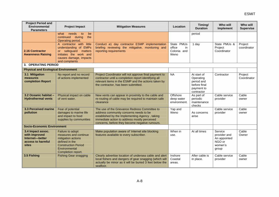
ESMiT
A-8
Project Period and Environmental
Parameters Project Impact Mitigation Measures Location
Timing/ Duration
Who will Implement
Who will Supervise
what needs to be continued during the Operating period.
period
2.16 Contractor Awareness Raising
A contractor with little understanding of EMPs or safeguard matters initiates the work and causes damage, impacts and complaints
Conduct a1 day contractor ESMP implementation briefing reviewing the mitigative, monitoring and reporting requirements
State PMUs office in Colonia and Weno
1 day State PMUs & Project Coordinator
Project coordinator
3. OPERATING PERIOD
Physical and Ecological Environment
3.1 Mitigation measures completion Report
No report and no record of actions implemented
Project Coordinator will not approve final payment to contractor until a completion report identifying all relevant items in the ESMP and the actions taken by the contractor, has been submitted.
NA At start of Operating period and before final payment to contractor
Contractor Project Coordinator
3.2 Oceanic habitat – Hydrothermal vents
Physical impact on cable of vent water.
New vents can appear in proximity to the cable and re-routing of cable may be required to maintain safe clearance
Offshore deep water environment.
As part of periodic maintenance checks
Cable service provider
Cable owner
3.3 Perceived marine pollution
Fear of potential damages to marine life and impact to food supplies by communities
The use of the Grievance Redress Committee to address community concerns needs to be established by the Implementing Agency , taking immediate action to address mostly perceived concerns, before they become negative rumours.
Yap and Weno
As concerns arise
Cable service provider
Cable owner
Socio-Economic Environment
3.4 Impact assoc. with improved Internet—better access to harmful sites
Failure to adopt measures and continue mitigation actions defined in the Construction Period Environmental Completion report.
Make population aware of ‘internet site blocking features available to every subscriber.
When in use.
At all times Service provider and An appointed NGO or women’s group
Cable Owner
3.5 Fishing Fishing Gear snagging Clearly advertise location of undersea cable and alert local fishers and dangers of gear snagging (which will actually be minor as it will be buried 3 feet below the seafloor.
Inshore Coastal areas.
After cable is in place.
Cable service provider
Cable owner
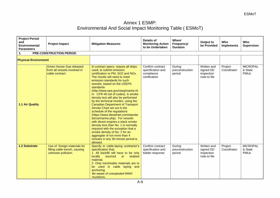
ESMoT
A-9
Annex 1 ESMP: Environmental And Social Impact Monitoring Table ( ESMoT)
Project Period and Environmental Parameters
Project Impact Mitigation Measures Details of Monitoring Action to be Undertaken
When/ Frequency/ Duration
Output to be Provided
Who Implements
Who Supervises
1. PRE-CONSTRUCTION PERIOD
Physical Environment
1.1 Air Quality
Green House Gas released from all vessels involved in cable contract
In contract specs, require all ships used, to submit emission certification re PM, SO2 and NOx. The results will need to meet emission standards for such vessels, based on the USEPA standards (http://www.epa.gov/otaq/marine.htm CFR-40 set of codes). A smoke density test will also be performed by the technical monitor, using the Canadian Department of Transport Smoke Chart set out in the schedule of the regulations (https://www.dieselnet.com/standards/ca/marine.php). For vessels with diesel engines a stack smoke density less than No. 1 is normally required with the exception that a smoke density of No. 2 for an aggregate of not more than 4 minutes in any 30-minute period is allowed.
Confirm contract specification and compliance certification
During preconstruction period
Written and signed DD inspection note-to file
Project Coordinator
MICROPAL & State PMUs
1.2 Substrate Use of foreign materials for filling cable trench, causing unknown pollution.
Specify in cable-laying contractor’s specification that; 1. All backfill will have to be only locally sourced or seabed material. 2. Only inert/stable materials are to be used in cable laying and anchoring. Be aware of unexploded WWII munitions.
Confirm contract specification and bidder response
During preconstruction period
Written and signed DD inspection note-to file
Project Coordinator
MICROPAL & State PMUs
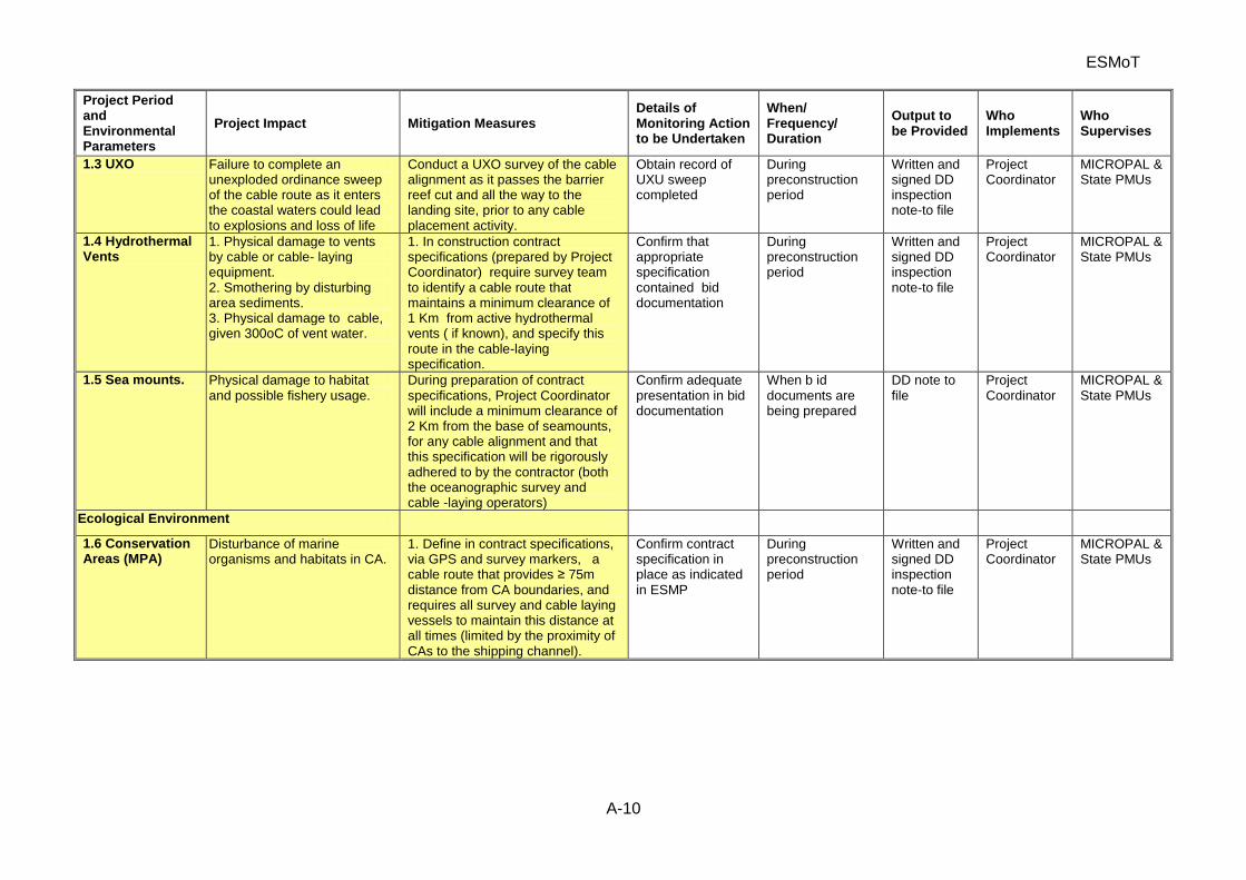
ESMoT
A-10
Project Period and Environmental Parameters
Project Impact Mitigation Measures Details of Monitoring Action to be Undertaken
When/ Frequency/ Duration
Output to be Provided
Who Implements
Who Supervises
1.3 UXO Failure to complete an unexploded ordinance sweep of the cable route as it enters the coastal waters could lead to explosions and loss of life
Conduct a UXO survey of the cable alignment as it passes the barrier reef cut and all the way to the landing site, prior to any cable placement activity.
Obtain record of UXU sweep completed
During preconstruction period
Written and signed DD inspection note-to file
Project Coordinator
MICROPAL & State PMUs
1.4 Hydrothermal Vents
1. Physical damage to vents by cable or cable- laying equipment. 2. Smothering by disturbing area sediments. 3. Physical damage to cable, given 300oC of vent water.
1. In construction contract specifications (prepared by Project Coordinator) require survey team to identify a cable route that maintains a minimum clearance of 1 Km from active hydrothermal vents ( if known), and specify this route in the cable-laying specification.
Confirm that appropriate specification contained bid documentation
During preconstruction period
Written and signed DD inspection note-to file
Project Coordinator
MICROPAL & State PMUs
1.5 Sea mounts. Physical damage to habitat and possible fishery usage.
During preparation of contract specifications, Project Coordinator will include a minimum clearance of 2 Km from the base of seamounts, for any cable alignment and that this specification will be rigorously adhered to by the contractor (both the oceanographic survey and cable -laying operators)
Confirm adequate presentation in bid documentation
When b id documents are being prepared
DD note to file
Project Coordinator
MICROPAL & State PMUs
Ecological Environment
1.6 Conservation Areas (MPA)
Disturbance of marine organisms and habitats in CA.
1. Define in contract specifications, via GPS and survey markers, a cable route that provides ≥ 75m distance from CA boundaries, and requires all survey and cable laying vessels to maintain this distance at all times (limited by the proximity of CAs to the shipping channel).
Confirm contract specification in place as indicated in ESMP
During preconstruction period
Written and signed DD inspection note-to file
Project Coordinator
MICROPAL & State PMUs
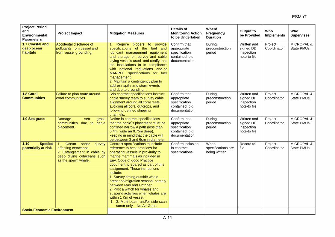
ESMoT
A-11
Project Period and Environmental Parameters
Project Impact Mitigation Measures Details of Monitoring Action to be Undertaken
When/ Frequency/ Duration
Output to be Provided
Who Implements
Who Supervises
1.7 Coastal and deep ocean habitats
Accidental discharge of pollutants from vessel and from vessel grounding.
1. Require bidders to provide specifications of the fuel and lubricant management equipment and storage on survey and cable laying vessels used and certify that the installations in in compliance with national regulations and-or MARPOL specifications for fuel management 2. Maintain a contingency plan to address spills and storm events and due to grounding. .
Confirm that appropriate specification contained bid documentation
During preconstruction period
Written and signed DD inspection note-to file
Project Coordinator
MICROPAL & State PMUs
1.8 Coral Communities
Failure to plan route around coral communities
Via contract specifications instruct cable survey team to survey cable alignment around all coral reefs, avoiding all coral outcrops, and following defined shipping channels.
Confirm that appropriate specification contained bid documentation
During preconstruction period
Written and signed DD inspection note-to file
Project Coordinator
MICROPAL & State PMUs
1.9 Sea grass Damage sea grass communities due to cable placement.
Define in contract specifications that the cable`s placement must be confined narrow a path (less than 0.4m wide an 0.75m deep), keeping in mind that the cable will be between 3 and 6cm in diameter.
Confirm that appropriate specification contained bid documentation
During preconstruction period
Written and signed DD inspection note-to file
Project Coordinator
MICROPAL & State PMUs
1.10 Species potentially at risk
1. Ocean sonar survey affecting cetaceans. 2. Entanglement in cable by deep diving cetaceans such as the sperm whale.
Contract specifications to include reference to best practices for operating vessels in proximity to marine mammals as included in Env. Code of good Practice document, prepared as part of this assignment. These instructions include: 1. Survey timing outside whale presence/migration season, namely between May and October. 2. Post a watch for whales and suspend activities when whales are within 1 Km of vessel. 1. 3. Multi-beam and/or side-scan
sonar only – No Air Guns.
Confirm inclusion in contract specifications
When specifications are being written
Record to file
Project Coordinator
MICROPAL & State PMUs
Socio-Economic Environment
ESMoT
A-12
Project Period and Environmental Parameters
Project Impact Mitigation Measures Details of Monitoring Action to be Undertaken
When/ Frequency/ Duration
Output to be Provided
Who Implements
Who Supervises
1.11 Coastal Resource Users – subsistence and artisanal fisheries
1. Damage to ecosystem integrity and fishery productivity through loss or damage to local fishing grounds.
Using the data on design limits found in the IEE, prepare contract specs. defining trenching/cable laying activities to be limited to a narrow corridor and trenching to be followed by immediate burial.
Confirm that contract specification is properly written and includes specs.
When specifications are being written
Record to file
Project Coordinator
MICROPAL & State PMUs
1.12 ESMP implementation monitor
Lack of an experienced technician will likely lead to delayed or failed implementation of ESMP items, e.g. no clauses in the bid docs.
Asa first task of the project Coordinator or lead of the State PMUs, an ESMP monitor will be retained for a 2 year period, to help implement and record the delivery of the ESMP
Confirm that the technician is on staff since the start of the project
At start of the detailed design stage
Note to file Project Coordinator
MICROPAL & State PMUs
1.13 Community Information
Misconceptions regarding the project raising people’s fears regarding project footprint and potential damages to marine food supply.
Conduct of series of government and non-government consultations e.g. prior to commencement of civil works, during construction and after project completion.
1.14. Community Grievances
Minor concerns/issues developing community resentments due to unaddressed project related concerns.
Establishment of grievance redress mechanism prior to commencement of civil works.
Confirm that requirements for a grievance redress mechanism is in Contract specs. and and that it is in the IEE
During detailed design stage
A note to file Project Coordinator
MICROPAL & State PMUs
2. CONSTRUCTION PERIOD
Physical Environment
2.1 Air Quality
Emissions from survey and cable placement vessels
Zero tolerance and immediate repair required—as specified in Contract specifications; namely stack emissions and stack smoke tests as defined in IEE and at web sited defined in IEE . Vessel fined and shut down within 5 days of notice
Collect emission testing results from contractor
Prior to start of work
Record to file
Project Coordinator
State PMUs & MICROPAL
ESMoT
A-13
Project Period and Environmental Parameters
Project Impact Mitigation Measures Details of Monitoring Action to be Undertaken
When/ Frequency/ Duration
Output to be Provided
Who Implements
Who Supervises
2.2 Substrate Introduction of foreign substances reacting with environment or introduced medium for introduced organisms.
Contractor to insure that: 1. All backfill use only original material as per cable laying specifications. 2. Use only inert/stable materials in cable laying and anchoring as per cable laying specifications.
Inspect backfilling operation to insure no foreign material used and substrate replaced quickly
During this work—in nearshore waters
DD note Project Coordinator
State PMUs MICROPAL
2.3 Hydrothermal Vents
Physical damage to vents or cable.
As per contract specifications, lay cable along surveyed alignment which has identified any hydrothermal vents and maintains a minimum clearance of 1 Km from active hydrothermal vents to protect the site(s) as well as the cable, given the 300oC temperatures of the discharge.
If hydrothermal vents detected during initial ocean, survey, periodically check on cable location to be sure it is placed in compliance with the limits defined.
When the detailed design is completed and the cable placement is to take place
Compliance checklist-signed
Coordinator working with env. monitor
Project Coordinator
2.4 Sea mounts Physical damage to habitat and possible fishery usage.
As defined in the contract specifications, lay cable along designated survey route, which maintains a minimum clearance of 2 Km from the base of seamounts
If seamounts are identified by local fishers, during the detailed design work, the monitor will check on cable location to be sure it is placed in compliance with the limits defined.
When the detailed design is completed and the cable placement is to take place
Compliance checklist-signed
Coordinator working with env. monitor
Project Coordinator
Ecological Environment
2.5 Marine Coastal Conservation Areas
Disturbance of marine organisms and habitats in CA.
According to contract specs., the contractor(s) will ensure that they: 1. Lay cable along surveyed route providing for a safe distance (≥ 75m) from CA s as per cable laying specifications 2. Keep all survey and support vessels at safe distances from CA areas.
Inspect cable laying operation in coastal waters and confirm minimum distance from CAs is maintained
As soon as work takes place inside the barrier reef—inside the passage into nearshore waters
Record of inspection and findings—written and photos
Project Coordinator and env. monitor
Project Coordinator
2.6 Coastal and Deep Ocean Habitats
Accidental discharge of pollutants from vessel.
Adhere to contract specifications and national laws, containing all fuel, lubricants and transmission
Inspect both survey and cable laying vessel of
At start of work and for all vessels used
Written compliance checklist
Proj. Coordinator working with
Project Coordinator
ESMoT
A-14
Project Period and Environmental Parameters
Project Impact Mitigation Measures Details of Monitoring Action to be Undertaken
When/ Frequency/ Duration
Output to be Provided
Who Implements
Who Supervises
fluids in double walled tanks on vessels and if in drums, store below deck, as specified in contract specifications. 2. Maintain a contingency plan to address spills and storm events.
contractor and confirm compliance
env. monitor
2.7 Coral Communities
Destruction of coral communities
1. Contractor(s) to adhere to ≥75m avoidance rule and lay cable along surveyed route, as per cable-laying specification, thus avoiding coral reefs and outcrops. 2. Contractor to received map from State Marine Resources agency, showing coral areas on route from passage to landing.
Inspect cable laying operations in vicinity of coral formations and confirm compliance
1. When work is going on in vicinity of coral areas 2. defined during the detailed design work
Written compliance report ( can be bullet format, with photos. Confirm that contractor has coral community location map
Proj. Coordinator working with env. monitor
Project Coordinator
2.8 Sea grass Destruction of sea grass communities.
As defined in contract specs; 1. restrict cable footprint to as narrow a path as possible ( 0.4m wide by 0.75m deep), when burying across a seagrass meadow, and fill trench immediately. 2. if possible, avoid crossing seagrass meadow
Inspect cable laying operations in seagrass area, and confirm compliance
When work is going on in and around Seagrass meadows
Compliance checklist-signed
Proj. Coordinator working with env. monitor
Project Coordinator
2.9 Species of Special Interest - Cetaceans
Entanglement in cable risk for deep diving cetaceans
Control cable tension so that laid cable conforms to undulations of seabed as per cable laying specification and-or provide anchors if needed.
Discussion with person in charge of cable placement to confirm understanding re cetacean sensitivity
At start of survey and start of cable placement
DD note to file
Coordinator working with env. monitor
Project Coordinator
Socio-Economic Environment
2.10 Coastal Resource Users Coastal Resource Users, subsistence and artisanal fisheries
Damage to local nearshore fishing grounds or introduce greater changes of gear entanglement
As per the contract specifications, confine trenching activities to as narrow a corridor as possible and restore site when finished and confine trenching/laying activities to as short a period as possible 3. Request Fisheries authorities to advise local fishers of cable laying
1. Examine trenching activity in nearshore waters and establish compliance with work area limits defined in ESMP. 2.Interview fishers
When trenching going on in nearshore waters
DD note to file
Coordinator working with env. monitor
Project Coordinator
ESMoT
A-15
Project Period and Environmental Parameters
Project Impact Mitigation Measures Details of Monitoring Action to be Undertaken
When/ Frequency/ Duration
Output to be Provided
Who Implements
Who Supervises
activities, dates, and avoidance measures. 4. Consider placing warning markers along cable line in shallow (<10 m) waters.
to determine if contractor met to advise re cable laying activity 3. Locate cable markers or other means
2.11 Coastal Resource Users– Game fishers
1. Displacement of activities during cable laying. 2. Entanglement of fishing gear. 3. Damage to ecosystem integrity and fishery productivity.
1. Project Coordinator to ensure a shipping notice is issued warning of cable laying, dates, and safe clearance for other activities. 2. Request Port Authorities & Marine Resources Authority to advise local operators of cable laying activities, location (planned corridor survey) and avoidance measures. 3. Confine laying activities to as short a period as possible, preferably outside any fishing seasons defined during the consultation with Marine Resources authorities.
Shipping notice(s) issued.
When work is under taken.
1. Shipping notice(s) cited and/or content recorded verification report 2. Recorded and photo- graphed observations
Project Coordinator and ESMP monitor, and other specialts as required
State PMUs
2.12 Coastal shipping – commercial shipping and ports
1. Physical injury of cable by shipping. 2. Disruption to shipping during cable laying.
1. Ensure a shipping notice is issued, warning of cable-laying, dates, and safe clearance for other activities. 2. Request Port Authorities to advise local shipping of laying activities and avoidance measures. 3. Contractors to provide written statement to Project Coordinator that marine navigation lights and other national maritime measures are closely followed by the contractors’ vessels at all times.
Shipping (local and international) notice(s) issued. Appropriate markers and signage employed
When work is under taken.
1. Shipping notice(s) cited and/or content recorded verification report 2. Written observations photography.
Project Coordinator and ESMP monitor,
State PMUs
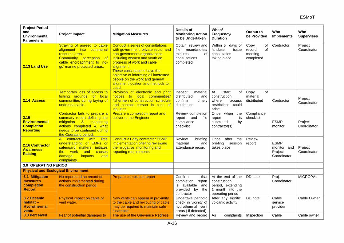
ESMoT
A-16
Project Period and Environmental Parameters
Project Impact Mitigation Measures Details of Monitoring Action to be Undertaken
When/ Frequency/ Duration
Output to be Provided
Who Implements
Who Supervises
2.13 Land Use
Straying of agreed to cable alignment into communal resource area. Community perception of cable encroachment to ‘no-go’ marine protected areas.
Conduct a series of consultations with government, private sector and non-government organizations including women and youth on progress of work and cable alignment. These consultations have the objective of informing all interested people on the work and general alignment location and methods to used.
Obtain review and file record/notes/ minutes of consultations completed
Within 5 days of landuse issue consultation taking place
Copy of record of meeting completed
Contractor Project Coordinator
2.14 Access
Temporary loss of access to fishing grounds for local communities during laying of undersea cable.
Provision of electronic and print notices to local communities/ fishermen of construction schedule and contact person in case of inquiries.
Inspect material distributed and confirm timely distribution
At start of construction where access restrictions could arise
Copy of material distributed Contractor
Project Coordinator
2.15 Environmental Completion Reporting
Contractor fails to prepare a summary report defining the mitigation & monitoring actions completed & what needs to be continued during the Operating period.
Prepare a completion report and deliver to the Engineer.
Review completion report and file compliance checklist
Once when the report is submitted by contractor(s)
Compliance checklist
ESMP monitor
Project Coordinator
2.16 Contractor Awareness Raising
A contractor with little understanding of EMPs or safeguard matters initiates the work and causes damage, impacts and complaints
Conduct a1 day contractor ESMP implementation briefing reviewing the mitigative, monitoring and reporting requirements
Review briefing material and attendance record
Once after the briefing session takes place
Review report ESMP
monitor and Project Coordinator
Project Coordinator
3.0 OPERATING PERIOD
Physical and Ecological Environment
3.1 Mitigation measures completion Report
No report and no record of actions implemented during the construction period
Prepare completion report
Confirm that completion report is available and provided by the contractor
At the end of the construction period, extending 1 month into the operating period
DD note Proj. Coordinator
MICROPAL
3.2 Oceanic habitat – Hydrothermal vents
Physical impact on cable of vent water.
New vents can appear in proximity to the cable and re-routing of cable may be required to maintain safe clearance
Undertake periodic check in vicinity of hydrothermal vent areas ( if detected)
After any signific. volcanic activity
DD note Cable service provider
Cable Owner
3.3 Perceived Fear of potential damages to The use of the Grievance Redress Review and record As complaints Inspection Cable Cable owner
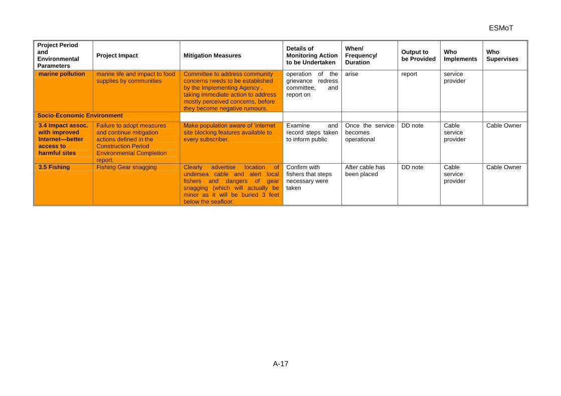
ESMoT
A-17
Project Period and Environmental Parameters
Project Impact Mitigation Measures Details of Monitoring Action to be Undertaken
When/ Frequency/ Duration
Output to be Provided
Who Implements
Who Supervises
marine pollution marine life and impact to food supplies by communities
Committee to address community concerns needs to be established by the Implementing Agency , taking immediate action to address mostly perceived concerns, before they become negative rumours.
operation of the grievance redress committee, and report on
arise report service provider
Socio-Economic Environment
3.4 Impact assoc. with improved Internet—better access to harmful sites
Failure to adopt measures and continue mitigation actions defined in the Construction Period Environmental Completion report.
Make population aware of ‘internet site blocking features available to every subscriber.
Examine and record steps taken to inform public
Once the service becomes operational
DD note Cable service provider
Cable Owner
3.5 Fishing Fishing Gear snagging Clearly advertise location of undersea cable and alert local fishers and dangers of gear snagging (which will actually be minor as it will be buried 3 feet below the seafloor.
Confirm with fishers that steps necessary were taken
After cable has been placed
DD note Cable service provider
Cable Owner
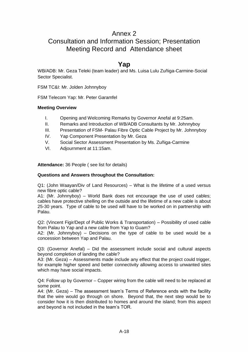
A-18
Annex 2 Consultation and Information Session; Presentation
Meeting Record and Attendance sheet
Yap WB/ADB: Mr. Geza Teleki (team leader) and Ms. Luisa Lulu Zuñiga-Carmine-Social
Sector Specialist.
FSM TC&I: Mr. Jolden Johnnyboy
FSM Telecom Yap: Mr. Peter Garamfel
Meeting Overview
I. Opening and Welcoming Remarks by Governor Anefal at 9:25am.
II. Remarks and Introduction of WB/ADB Consultants by Mr. Johnnyboy
III. Presentation of FSM- Palau Fibre Optic Cable Project by Mr. Johnnyboy
IV. Yap Component Presentation by Mr. Geza
V. Social Sector Assessment Presentation by Ms. Zuñiga-Carmine
VI. Adjournment at 11:15am.
Attendance: 36 People ( see list for details)
Questions and Answers throughout the Consultation:
Q1: (John Waayan/Div of Land Resources) – What is the lifetime of a used versus new fibre optic cable? A1: (Mr. Johnnyboy) – World Bank does not encourage the use of used cables; cables have protective shelling on the outside and the lifetime of a new cable is about 25-30 years. Type of cable to be used will have to be worked on in partnership with Palau. Q2: (Vincent Figir/Dept of Public Works & Transportation) – Possibility of used cable from Palau to Yap and a new cable from Yap to Guam? A2: (Mr. Johnnyboy) – Decisions on the type of cable to be used would be a concession between Yap and Palau. Q3: (Governor Anefal) – Did the assessment include social and cultural aspects beyond completion of landing the cable? A3: (Mr. Geza) – Assessments made include any effect that the project could trigger, for example higher speed and better connectivity allowing access to unwanted sites which may have social impacts. Q4: Follow up by Governor – Copper wiring from the cable will need to be replaced at some point. A4: (Mr. Geza) – The assessment team’s Terms of Reference ends with the facility that the wire would go through on shore. Beyond that, the next step would be to consider how it is then distributed to homes and around the island; from this aspect and beyond is not included in the team’s TOR.
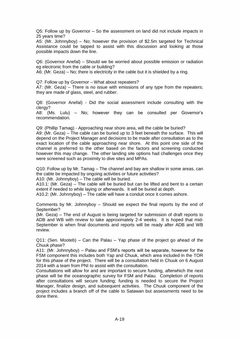
A-19
Q5: Follow up by Governor – So the assessment on land did not include impacts in 25 years time? A5: (Mr. Johnnyboy) – No; however the provision of $2.5m targeted for Technical Assistance could be tapped to assist with this discussion and looking at those possible impacts down the line. Q6: (Governor Anefal) – Should we be worried about possible emission or radiation eg electronic from the cable or building? A6: (Mr. Geza) – No; there is electricity in the cable but it is shielded by a ring. Q7: Follow up by Governor – What about repeaters? A7: (Mr. Geza) – There is no issue with emissions of any type from the repeaters; they are made of glass, steel, and rubber. Q8: (Governor Anefal) - Did the social assessment include consulting with the clergy? A8: (Ms. Lulu) – No; however they can be consulted per Governor’s recommendation. Q9: (Phillip Tamag) - Approaching near shore area, will the cable be buried? A9: (Mr. Geza) – The cable can be buried up to 3 feet beneath the surface. This will depend on the Project Manager and decisions to be made after consultation as to the exact location of the cable approaching near shore. At this point one side of the channel is preferred to the other based on the factors and screening conducted however this may change. The other landing site options had challenges once they were screened such as proximity to dive sites and MPAs. Q10: Follow up by Mr. Tamag – The channel and bay are shallow in some areas, can the cable be impacted by ongoing activities or future activities? A10: (Mr. Johnnyboy) – The cable will be buried. A10.1: (Mr. Geza) – The cable will be buried but can be lifted and bent to a certain extent if needed to while laying or afterwards. It will be buried at depth. A10.2: (Mr. Johnnyboy) – The cable will have a conduit once it comes ashore. Comments by Mr. Johnnyboy – Should we expect the final reports by the end of September? (Mr. Geza) – The end of August is being targeted for submission of draft reports to ADB and WB with review to take approximately 2-4 weeks. It is hoped that mid-September is when final documents and reports will be ready after ADB and WB review. Q11: (Sen. Mooteb) – Can the Palau – Yap phase of the project go ahead of the Chuuk phase? A11: (Mr. Johnnyboy) – Palau and FSM’s reports will be separate, however for the FSM component this includes both Yap and Chuuk, which area included in the TOR for this phase of the project. There will be a consultation held in Chuuk on 6 August 2014 with a team from PNI to assist with the consultation. Consultations will allow for and are important to secure funding, afterwhich the next phase will be the oceanographic survey for FSM and Palau. Completion of reports after consultations will secure funding; funding is needed to secure the Project Manager, finalize design, and subsequent activities. The Chuuk component of the project includes a branch off of the cable to Satawan but assessments need to be done there.
A-20
Q12: (Frank Haregaichig – Dept of Resources & Development) – When did Chuuk become a part of the project? A12: (Mr. Johnnyboy) – Yap and Palau were included in the initial project targeted with previous fund, with Kosrae and Chuuk also discussed and considered to be able to include of all FSM States. IDA 17 and this project had Chuuk along with Yap as the first component for FSM. Q13: (Governor Anefal) – The people of Yap want the project to be as inclusive as possible with our sister States, however I hope that the width and breadth of the project is now final so that project planning does not drag out further. A13: (Mr. Johnnyboy) – The estimated $51m for this project needs to be confirmed and with reports, design, and others to be finalized by the deadlines indicated, we’re hoping that the total figure can be finalized by November. A13.1: (Mr. Geza) – ADB and WB is hoping that Chuuk provides as much information as possible in support of their component for this project so that everything can be finalized by the deadlines targeted. Q14: (Sen. Raglmar-Subolmar) – Given that Satawan is being considered to be linked for Chuuk, the cable going for Yap will pass Ulithi on the way to Guam and as a central island in the neighboring islands, Ulithi can also be considered. A14: (Mr. Johnnyboy) – Ulithi is between Yap and Guam, however the challenge with Ulithi is the trench between Yap and Ulithi. Additional information from Mr. Johnnyboy – The challenge is possibly holding up this project with completing all of the surveys and assessments for Yap and Chuuk, because an important next phase is the survey to be conducted by the ship with a cost estimated at about $100K/day. Q15: (Philip Tamag) – What is the timeframe for funding becoming available? A15: (Mr. Johnnyboy) – Micro-Pal will help with coming up with milestones for the project. A15.1: (Mr. Geza) – Once the loan is activated, the Project Manager needs to be hired and brought on to work with governments to come up with bid documents, and the assessments to be approved and incorporated into the bid documents. A15.2: (Mr. Johnnyboy) – Correction, funding has been set aside and is available to hire the Project Manager. Q16: Follow up by Mr. Tamag – When will the project be completed, what is the timeline? A16: (Mr. Johnnyboy) – Schedules will be determined and decided with the Project Manager and in consultation with the States. Q17: Follow up by Mr. Tamag – Will the project take 3-4 years for completion then? A17: (Mr. Geza) – An estimated timeline of about 300 or so days to lay the cable from Guam to Palau via Yap. A17.1: (Mr. Johnnyboy) – The project will take an estimated 18 months to be completed, dependent on how the cable is laid. Q18: (Governor Anefal) – Who does the Project Manager report to or is supervised by? A18: (Mr. Johnnyboy) – The Project Manager reports to Micro-Pal with their time to be split between Palau and FSM. Q19: Follow up by Governor Anefal – The Project Manager will be one person, will they have clerical staff or such support?
A-21
A19: (Mr. Johnnyboy) – The Project Manager is being focused on now, and he/she will need to rely on officials and others for assistance, however this can be worked out in the Project Manager’s contract. Q20: (Governor Anefal) – I have a recommendation with composition of the State Steering Committee. Governor proceeded to recommend adding representatives from the Yap State Legislature, Chamber of Commerce, Council of Pilung, and the Council of Tamol to the State Steering Committee. Q21: (Phillip Tamag) – What is the onshore facility after the cable is landed? A21: (Mr. Garamfel) – The cable once landed will need to be diverted to the Earth Station either through utility poles or underground. Additional information from Mr. Johnnyboy – The Telecom Act of 2014 grants open access, with FSMTC to operate under this law and Regulatory Authority. Other users have rights to access through open access where FSM Telecom is one carrier that will lease bandwidth from the cable. Q22: (Sen. Raglmar-Subolmar) – Yap cannot own the cable then? A: (Mr. Johnnyboy) – That will be up to Yap State in terms of how to organize formulation of managing the cable. Q23: (Governor Anefal) – I share the concern of meeting deadlines as well and the addition of Satawan to the project impacting the FSM moving forward. We talked about IDA 16 supporting this project and now we are in IDA 17 with the newly discussed addition of Satawan to the project. Q24: (Governor Anefal) – Has the issue of possibly coming across mines or ordnances being considered as we came across this before where we had to ask assistance from the US military to come in and detonate ordnances found in the channel. A24: (Mr. Geza) – UXO specialists will be brought in as part of this project and will note this to be highlighted and included in th and make sure included in the recommendations.
Attendance List-Yap_ Public Consultations
29 July 2014 Yap
No. Name Office/Organization
01. Christina Fillmed Environmental Protection Agency
02. Frank Haregaichig Dept of Resources & Development
03. Leona Tamag Women’s Interest Office/Yap Women’s Association
04. Paul J. Ayin Quality Catch
05. Sebastian Anefal Governor – Yap State
06. John W.K. Fillmed Dept. of Youth & Civic Affairs
07. Marie Laamar Yap Chamber of Commerce
08. Stella Laamar Manta Ray Bay Hotel
A-22
09. Vincent Figir Dept. of Public Works & Transportation
10. Joseph Giliko Yap State Legislature
11. James Yinug Marine Resources Management Division (Dept of R&D)
12. George Pong Yap Fishing Authority
13. Peter Tharngan Waab Transportation Company
14. Peter J. Tairuwepiy Council of Tamol
15. Theodore Pong Maap Community
16. David Y. Marmar Tomil Council – Meerur Representative
17. Steven Mar Council of Pilung
18. John E. Mooteb Tomil Resources Conservation Trust/Yap State Legislature
19. Dominic Fanasog Dept. of Education
20. Aaron Lukan Yap Cooperative Association
21. Ray Igechep Office of Planning & Budget
22. Dominic Taruwemai Dept. of Health Services
23. Vitus Foneg Tomil Resources Conservation Trust
24. John Waayan Division of Land Resources (Dept. of R&D)
25. Peter Garamfel FSM TC
26. Lorenzo Sartilug Dept. of Education
27. Jeffrey Adalbai Yap Chamber of Commerce
28. Liyon Sulog Yap Marina Sports Bar & Grill
29. Tom Fetan Yap Chamber of Commerce
30. Sara Fillmed United Airlines
31. Jesse Raglmar Yap State Legislature
32. Alphonso Ganang Village View Hotel (VVH)
33. Philip T. Ranganbay Yap Chamber of Commerce
34. John P. Runman Yap State Historic Preservation Office ( DY&CA)
35. Katherine K. Gisog FSM Development Bank
36. Manuel Maleichog Dept. of Public Works & Transportation
A-23
Consultation and Information Session; Presentation Meeting Record and Attendance sheet:
Chuuk
Note: These minutes are abbreviated as no state staff was available to assist with
minutes. The consultants recorded observation, questions and answers-
WB/ADB: Mr. Geza Teleki (team leader) and Ms. Luisa Lulu Zuñiga-Carmine-Social
Sector Specialist and Steve Lindsay, Marine Ecology Specialist, Consultants.
FSM TC&I: Mr. Jolden Johnnyboy
FSM Telecom Yap: Mr. Peter Garamfel
Date: August 6, 2014, at Truk Stop Hotel Conference Center, Weno, Chuuk State
Meeting Overview
I. Opening and Welcoming Remarks by Jolden Jonnyboy at 9:15am.
II. Remarks and Introduction of WB/ADB Consultants by Mr. Johnnyboy
III. Presentation of FSM- Palau Fibre Optic Cable Project by Mr. Johnnyboy
IV. Chuuk Component Presentation by Mr. Geza Teleki with assistance from
Ms. Carmine and Mr. Lindsay
V. Question and Answer Session
VI. Adjournment at 11:15am.
Attendance: 32 People ( see list for details)
Questions and Answers throughout the Consultation:
1. Internet use issues with public information, people trafficking, pornography etc.
2. Comment with interaction of normal vessels entering the Northeast Passage. Concerning usage with commercial vessels?
3. Life span of the cable? 25-30 years. 4. Issues with radioactive, issues with cable affecting marine live? No issues
certainly not radioactivity, no power issues, hazardous materials etc. Discussed the issue with pollutions from the boat GCF or hitting reefs etc.
5. Social impact on cable associated with telecommunication to other islands within Chuuk State? Domestic systems not included in this activity. Will it be delivered etc?
6. Depth of the cable how it is positioned within the lagoon. Restated information already provided. Concern about ongoing sand mining-dredging locations, these sites need to be identified so no impacts. We need a map to identify these sites. EPA regulates these activities-so they know exact locations.
7. Ownership issue on land and water. Commercial issues for the laying the cable, Attorney General’s office. Easement in the water? Having people to wave these issues. This will be an issue, but AG and deputy Governor Chuuk state indicated it would be dealt with internally. It is a domestic issue. A letter of agreement will be developed.
8. Comment on elevation of the terminal site. Land ownership not a problem.
A-24
9. Comments associated with Telecom ownership on land for the cable, will they be willing to allow competition using the cable. Sharing the service provider. The new law passed recently explains this. Internal State concern – needs more internal FSM national and State government discussions. Equal access bases. Joldon explained the law most understand now. Needs to be sorted out. FSM will take this lead in due time.
10. Geza brought up importance of the IEE and other safeguards documents will be signed off by the States therefore must review since it wil become a legal requirement. Our role is to provide the information for the States.
11. Domestic cable issues – Big issue and many comments. Much interest of connection of other islands within Chuuk lagoon and the islands of the State. The state government needs to make a call on these domestic issues.
12. Some discussion based on FSM roles and States – more awareness and understanding needed. This will come as promised by Jolden .
13. Identified the cost sharing arrangements of the WB IDA Grant for FSM; 14. Any pollutions issues with the cable when sitting in the oceans. No
electromagnetic or hazardous materials issues with the new cable. 15. Tangle of fishing gear with cable. 16. Issues with theft of cable, damage etc. 17. The state committee needs to address much of the above.
A-25
Chuuk Attendance Sheet
A-26
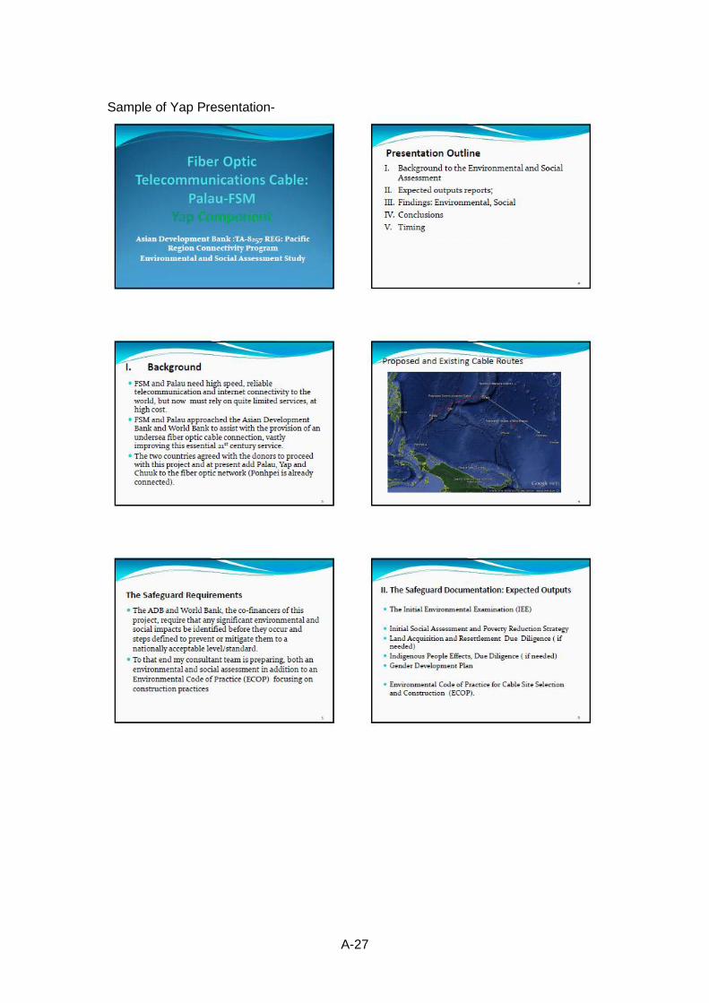
A-27
Sample of Yap Presentation-
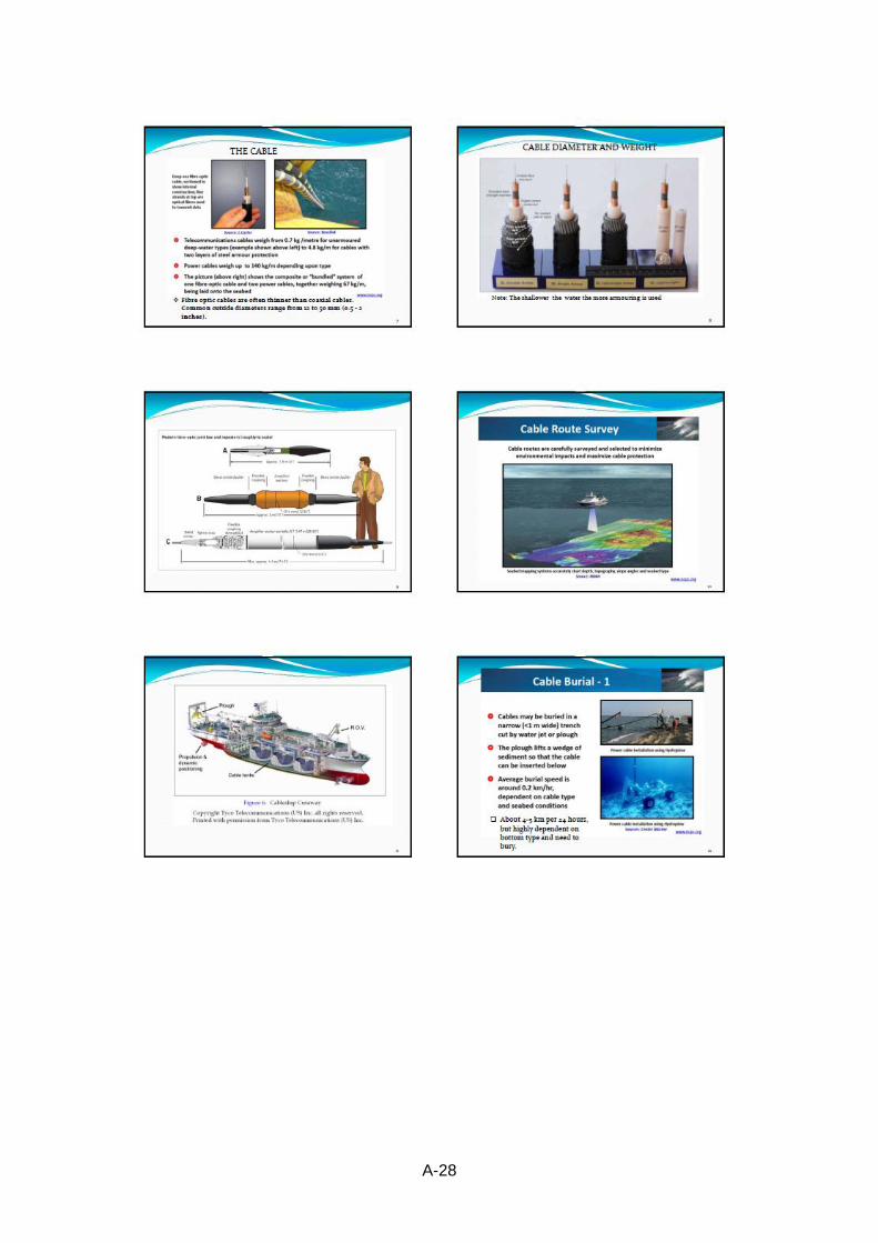
A-28
A-29
A-30
A-31
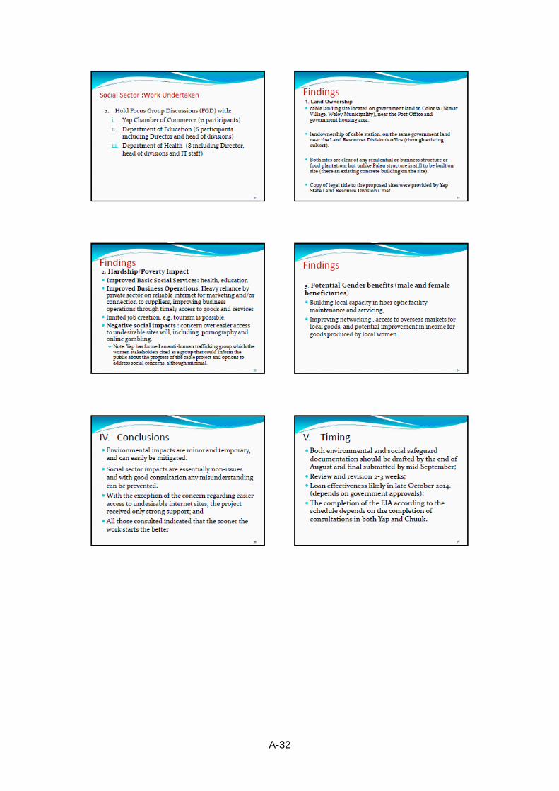
A-32
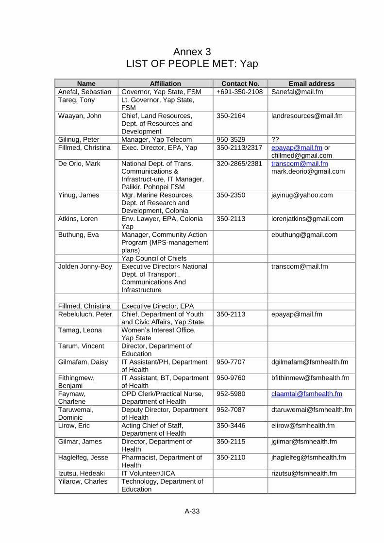
A-33
Annex 3 LIST OF PEOPLE MET: Yap
Name Affiliation Contact No. Email address
Anefal, Sebastian Governor, Yap State, FSM +691-350-2108 [email protected]
Tareg, Tony Lt. Governor, Yap State, FSM
Waayan, John Chief, Land Resources, Dept. of Resources and Development
350-2164 [email protected]
Gilinug, Peter Manager, Yap Telecom 950-3529 ??
Fillmed, Christina Exec. Director, EPA, Yap 350-2113/2317 [email protected] or [email protected]
De Orio, Mark National Dept. of Trans. Communications & Infrastruct-ure, IT Manager, Palikir, Pohnpei FSM
320-2865/2381 [email protected] [email protected]
Yinug, James Mgr. Marine Resources, Dept. of Research and Development, Colonia
350-2350 [email protected]
Atkins, Loren Env. Lawyer, EPA, Colonia Yap
350-2113 [email protected]
Buthung, Eva Manager, Community Action Program (MPS-management plans)
Yap Council of Chiefs
Jolden Jonny-Boy Executive Director< National Dept. of Transport , Communications And Infrastructure
Fillmed, Christina Executive Director, EPA
Rebeluluch, Peter Chief, Department of Youth and Civic Affairs, Yap State
350-2113 [email protected]
Tamag, Leona Women’s Interest Office, Yap State
Tarum, Vincent Director, Department of Education
Gilmafam, Daisy IT Assistant/PH, Department of Health
950-7707 [email protected]
Fithingmew, Benjami
IT Assistant, BT, Department of Health
950-9760 [email protected]
Faymaw, Charlene
OPD Clerk/Practical Nurse, Department of Health
952-5980 [email protected]
Taruwemai, Dominic
Deputy Director, Department of Health
952-7087 [email protected]
Lirow, Eric Acting Chief of Staff, Department of Health
350-3446 [email protected]
Gilmar, James Director, Department of Health
350-2115 [email protected]
Haglelfeg, Jesse Pharmacist, Department of Health
350-2110 [email protected]
Izutsu, Hedeaki IT Volunteer/JICA [email protected]
Yilarow, Charles Technology, Department of Education
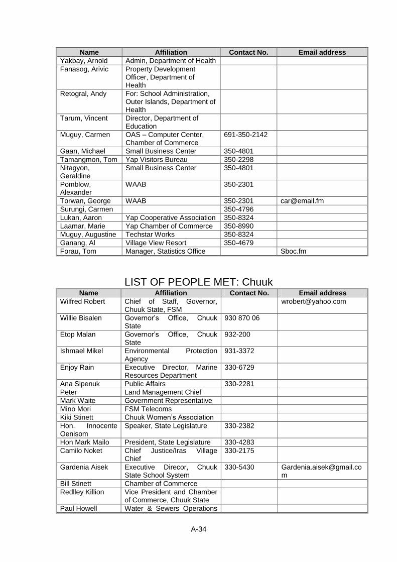
A-34
Name Affiliation Contact No. Email address
Yakbay, Arnold Admin, Department of Health
Fanasog, Arivic Property Development Officer, Department of Health
Retogral, Andy For: School Administration, Outer Islands, Department of Health
Tarum, Vincent Director, Department of Education
Muguy, Carmen OAS – Computer Center, Chamber of Commerce
691-350-2142
Gaan, Michael Small Business Center 350-4801
Tamangmon, Tom Yap Visitors Bureau 350-2298
Nitagyon, Geraldine
Small Business Center 350-4801
Pomblow, Alexander
WAAB 350-2301
Torwan, George WAAB 350-2301 [email protected]
Surungi, Carmen 350-4796
Lukan, Aaron Yap Cooperative Association 350-8324
Laamar, Marie Yap Chamber of Commerce 350-8990
Muguy, Augustine Techstar Works 350-8324
Ganang, Al Village View Resort 350-4679
Forau, Tom Manager, Statistics Office Sboc.fm
LIST OF PEOPLE MET: Chuuk Name Affiliation Contact No. Email address
Wilfred Robert Chief of Staff, Governor, Chuuk State, FSM
Willie Bisalen Governor’s Office, Chuuk State
930 870 06
Etop Malan Governor’s Office, Chuuk State
932-200
Ishmael Mikel Environmental Protection Agency
931-3372
Enjoy Rain Executive Director, Marine Resources Department
330-6729
Ana Sipenuk Public Affairs 330-2281
Peter Land Management Chief
Mark Waite Government Representative
Mino Mori FSM Telecoms
Kiki Stinett Chuuk Women’s Association
Hon. Innocente Oenisom
Speaker, State Legislature 330-2382
Hon Mark Mailo President, State Legislature 330-4283
Camilo Noket Chief Justice/Iras Village Chief
330-2175
Gardenia Aisek Executive Direcor, Chuuk State School System
330-5430 [email protected]
Bill Stinett Chamber of Commerce
Redlley Killion Vice President and Chamber of Commerce, Chuuk State
Paul Howell Water & Sewers Operations

A-35
Name Affiliation Contact No. Email address
Manager
Peter Attein Head, Land Management
Jennifer Killion Senior Program Assistant, International Organization for Migration (IOM)
Virginia Mamangon
PC Counselor, College of Micronesia (COM)
Marylene Bisalen HR Specialist, COM
Macleen Remit Secretary, COM
Kaum Assio CRD Agent, COM
Mike Abbe Coordinator, CRE, COM
Jayleen Kokis Library Assistant, COM
Ben Akkin Project Manager, COM
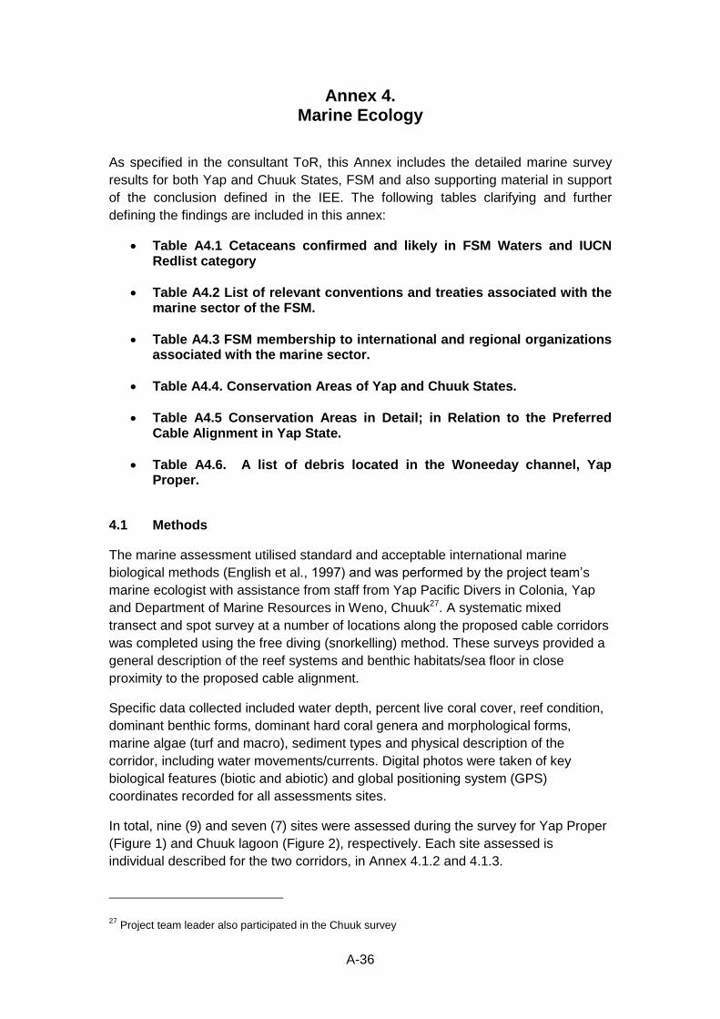
A-36
Annex 4. Marine Ecology
As specified in the consultant ToR, this Annex includes the detailed marine survey
results for both Yap and Chuuk States, FSM and also supporting material in support
of the conclusion defined in the IEE. The following tables clarifying and further
defining the findings are included in this annex:
Table A4.1 Cetaceans confirmed and likely in FSM Waters and IUCN Redlist category
Table A4.2 List of relevant conventions and treaties associated with the marine sector of the FSM.
Table A4.3 FSM membership to international and regional organizations associated with the marine sector.
Table A4.4. Conservation Areas of Yap and Chuuk States.
Table A4.5 Conservation Areas in Detail; in Relation to the Preferred Cable Alignment in Yap State.
Table A4.6. A list of debris located in the Woneeday channel, Yap Proper.
4.1 Methods
The marine assessment utilised standard and acceptable international marine
biological methods (English et al., 1997) and was performed by the project team’s
marine ecologist with assistance from staff from Yap Pacific Divers in Colonia, Yap
and Department of Marine Resources in Weno, Chuuk27. A systematic mixed
transect and spot survey at a number of locations along the proposed cable corridors
was completed using the free diving (snorkelling) method. These surveys provided a
general description of the reef systems and benthic habitats/sea floor in close
proximity to the proposed cable alignment.
Specific data collected included water depth, percent live coral cover, reef condition,
dominant benthic forms, dominant hard coral genera and morphological forms,
marine algae (turf and macro), sediment types and physical description of the
corridor, including water movements/currents. Digital photos were taken of key
biological features (biotic and abiotic) and global positioning system (GPS)
coordinates recorded for all assessments sites.
In total, nine (9) and seven (7) sites were assessed during the survey for Yap Proper
(Figure 1) and Chuuk lagoon (Figure 2), respectively. Each site assessed is
individual described for the two corridors, in Annex 4.1.2 and 4.1.3.
27 Project team leader also participated in the Chuuk survey
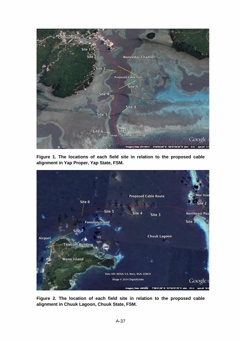
A-37
Figure 1. The locations of each field site in relation to the proposed cable
alignment in Yap Proper, Yap State, FSM.
Figure 2. The location of each field site in relation to the proposed cable
alignment in Chuuk Lagoon, Chuuk State, FSM.
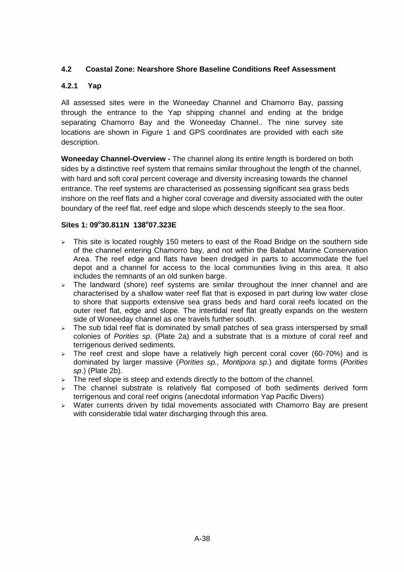
A-38
4.2 Coastal Zone: Nearshore Shore Baseline Conditions Reef Assessment
4.2.1 Yap
All assessed sites were in the Woneeday Channel and Chamorro Bay, passing
through the entrance to the Yap shipping channel and ending at the bridge
separating Chamorro Bay and the Woneeday Channel.. The nine survey site
locations are shown in Figure 1 and GPS coordinates are provided with each site
description.
Woneeday Channel-Overview - The channel along its entire length is bordered on both
sides by a distinctive reef system that remains similar throughout the length of the channel,
with hard and soft coral percent coverage and diversity increasing towards the channel
entrance. The reef systems are characterised as possessing significant sea grass beds
inshore on the reef flats and a higher coral coverage and diversity associated with the outer
boundary of the reef flat, reef edge and slope which descends steeply to the sea floor.
Sites 1: 09o30.811N 138o07.323E
This site is located roughly 150 meters to east of the Road Bridge on the southern side of the channel entering Chamorro bay, and not within the Balabat Marine Conservation Area. The reef edge and flats have been dredged in parts to accommodate the fuel depot and a channel for access to the local communities living in this area. It also includes the remnants of an old sunken barge.
The landward (shore) reef systems are similar throughout the inner channel and are characterised by a shallow water reef flat that is exposed in part during low water close to shore that supports extensive sea grass beds and hard coral reefs located on the outer reef flat, edge and slope. The intertidal reef flat greatly expands on the western side of Woneeday channel as one travels further south.
The sub tidal reef flat is dominated by small patches of sea grass interspersed by small colonies of Porities sp. (Plate 2a) and a substrate that is a mixture of coral reef and terrigenous derived sediments.
The reef crest and slope have a relatively high percent coral cover (60-70%) and is dominated by larger massive (Porities sp., Montipora sp.) and digitate forms (Porities sp.) (Plate 2b).
The reef slope is steep and extends directly to the bottom of the channel. The channel substrate is relatively flat composed of both sediments derived form
terrigenous and coral reef origins (anecdotal information Yap Pacific Divers) Water currents driven by tidal movements associated with Chamorro Bay are present
with considerable tidal water discharging through this area.
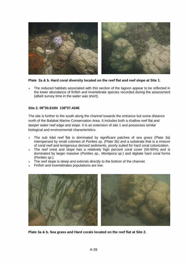
A-39
Plate 2a & b. Hard coral diversity located on the reef flat and reef slope at Site 1.
The reduced habitats associated with this section of the lagoon appear to be reflected in the lower abundance of finfish and invertebrate species recorded during the assessment (albeit survey time in the water was short).
Site 2. 09o30.616N 138o07.434E The site is further to the south along the channel towards the entrance but some distance
north of the Balabat Marine Conservation Area. It includes both a shallow reef flat and
deeper water reef edge and slope. It is an extension of site 1 and possesses similar
biological and environmental characteristics.
The sub tidal reef flat is dominated by significant patches of sea grass (Plate 3a) interspersed by small colonies of Porities sp. (Plate 3b) and a substrate that is a mixture of coral reef and terrigenous derived sediments, poorly suited for hard coral colonization.
The reef crest and slope has a relatively high percent coral cover (50-60%) and is dominated by larger massive (Porities sp., Montipora sp.) and digitate hard coral forms (Porities sp.).
The reef slope is steep and extends directly to the bottom of the channel. Finfish and invertebrates populations are low.
Plate 3a & b. Sea grass and Hard corals located on the reef flat at Site 2.
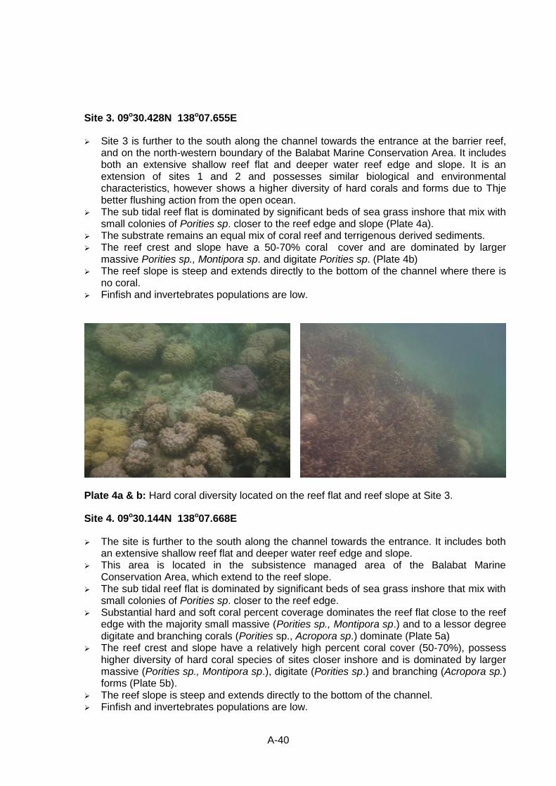
A-40
Site 3. 09o30.428N 138o07.655E
Site 3 is further to the south along the channel towards the entrance at the barrier reef, and on the north-western boundary of the Balabat Marine Conservation Area. It includes both an extensive shallow reef flat and deeper water reef edge and slope. It is an extension of sites 1 and 2 and possesses similar biological and environmental characteristics, however shows a higher diversity of hard corals and forms due to Thje better flushing action from the open ocean.
The sub tidal reef flat is dominated by significant beds of sea grass inshore that mix with small colonies of Porities sp. closer to the reef edge and slope (Plate 4a).
The substrate remains an equal mix of coral reef and terrigenous derived sediments. The reef crest and slope have a 50-70% coral cover and are dominated by larger
massive Porities sp., Montipora sp. and digitate Porities sp. (Plate 4b) The reef slope is steep and extends directly to the bottom of the channel where there is
no coral. Finfish and invertebrates populations are low.
Plate 4a & b: Hard coral diversity located on the reef flat and reef slope at Site 3.
Site 4. 09o30.144N 138o07.668E
The site is further to the south along the channel towards the entrance. It includes both an extensive shallow reef flat and deeper water reef edge and slope.
This area is located in the subsistence managed area of the Balabat Marine Conservation Area, which extend to the reef slope.
The sub tidal reef flat is dominated by significant beds of sea grass inshore that mix with small colonies of Porities sp. closer to the reef edge.
Substantial hard and soft coral percent coverage dominates the reef flat close to the reef edge with the majority small massive (Porities sp., Montipora sp.) and to a lessor degree digitate and branching corals (Porities sp., Acropora sp.) dominate (Plate 5a)
The reef crest and slope have a relatively high percent coral cover (50-70%), possess higher diversity of hard coral species of sites closer inshore and is dominated by larger massive (Porities sp., Montipora sp.), digitate (Porities sp.) and branching (Acropora sp.) forms (Plate 5b).
The reef slope is steep and extends directly to the bottom of the channel. Finfish and invertebrates populations are low.
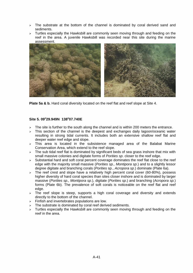
A-41
The substrate at the bottom of the channel is dominated by coral derived sand and sediments.
Turtles especially the Hawksbill are commonly seen moving through and feeding on the reef in the area. A juvenile Hawksbill was recorded near this site during the marine assessment.
Plate 5a & b. Hard coral diversity located on the reef flat and reef slope at Site 4.
Site 5. 09o29.949N 138o07.740E
The site is further to the south along the channel and is within 200 meters the entrance. This section of the channel is the deepest and exchanges daily lagoon/oceanic water
resulting in strong tidal currents. It includes both an extensive shallow reef flat and deeper water reef edge and slope.
This area is located in the subsistence managed area of the Balabat Marine Conservation Area, which extend to the reef slope.
The sub tidal reef flat is dominated by significant beds of sea grass inshore that mix with small massive colonies and digitate forms of Porities sp. closer to the reef edge.
Substantial hard and soft coral percent coverage dominates the reef flat close to the reef edge with the majority small massive (Porities sp., Montipora sp.) and to a slightly lessor degree digitate and branching corals (Porities sp., Acropora sp.) dominate (Plate 6a).
The reef crest and slope have a relatively high percent coral cover (60-80%), possess higher diversity of hard coral species than sites closer inshore and is dominated by larger massive (Porities sp., Montipora sp.), digitate (Porities sp.) and branching (Acropora sp.) forms (Plate 6b). The prevalence of soft corals is noticeable on the reef flat and reef edge.
The reef slope is steep, supports a high coral coverage and diversity and extends directly to the bottom of the channel.
Finfish and invertebrates populations are low. The substrate is dominated by coral reef derived sediments. Turtles especially the Hawksbill are commonly seen moving through and feeding on the
reef in the area.
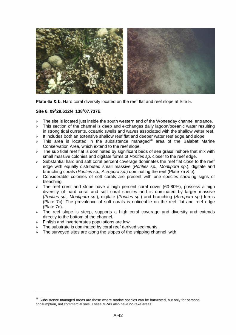
A-42
Plate 6a & b. Hard coral diversity located on the reef flat and reef slope at Site 5.
Site 6. 09o29.612N 138o07.737E
The site is located just inside the south western end of the Woneeday channel entrance. This section of the channel is deep and exchanges daily lagoon/oceanic water resulting
in strong tidal currents, oceanic swells and waves associated with the shallow water reef. It includes both an extensive shallow reef flat and deeper water reef edge and slope. This area is located in the subsistence managed28 area of the Balabat Marine
Conservation Area, which extend to the reef slope. The sub tidal reef flat is dominated by significant beds of sea grass inshore that mix with
small massive colonies and digitate forms of Porities sp. closer to the reef edge. Substantial hard and soft coral percent coverage dominates the reef flat close to the reef
edge with equally distributed small massive (Porities sp., Montipora sp.), digitate and branching corals (Porities sp., Acropora sp.) dominating the reef (Plate 7a & b).
Considerable colonies of soft corals are present with one species showing signs of bleaching.
The reef crest and slope have a high percent coral cover (60-80%), possess a high diversity of hard coral and soft coral species and is dominated by larger massive (Porities sp., Montipora sp.), digitate (Porities sp.) and branching (Acropora sp.) forms (Plate 7c). The prevalence of soft corals is noticeable on the reef flat and reef edge (Plate 7d).
The reef slope is steep, supports a high coral coverage and diversity and extends directly to the bottom of the channel.
Finfish and invertebrates populations are low. The substrate is dominated by coral reef derived sediments. The surveyed sites are along the slopes of the shipping channel with
28 Subsistence managed areas are those where marine species can be harvested, but only for personal
consumption, not commercial sale. These MPAs also have no-take areas.
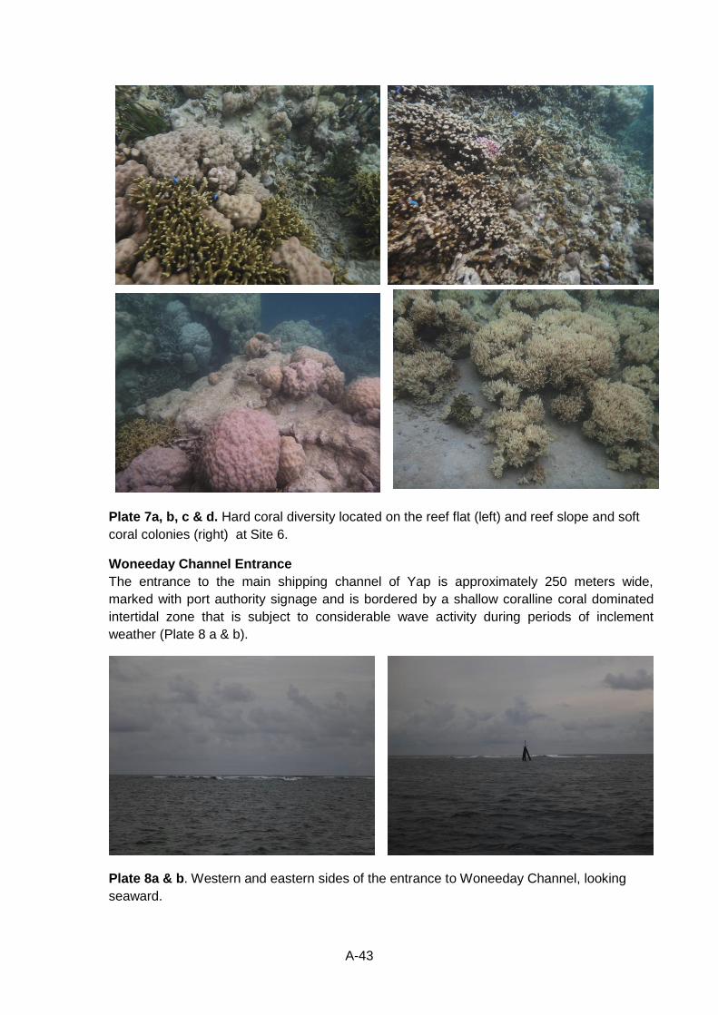
A-43
Plate 7a, b, c & d. Hard coral diversity located on the reef flat (left) and reef slope and soft
coral colonies (right) at Site 6.
Woneeday Channel Entrance
The entrance to the main shipping channel of Yap is approximately 250 meters wide,
marked with port authority signage and is bordered by a shallow coralline coral dominated
intertidal zone that is subject to considerable wave activity during periods of inclement
weather (Plate 8 a & b).
Plate 8a & b. Western and eastern sides of the entrance to Woneeday Channel, looking
seaward.
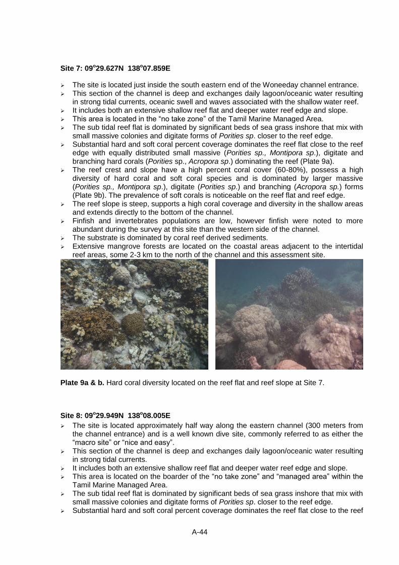
A-44
Site 7: 09o29.627N 138o07.859E
The site is located just inside the south eastern end of the Woneeday channel entrance. This section of the channel is deep and exchanges daily lagoon/oceanic water resulting
in strong tidal currents, oceanic swell and waves associated with the shallow water reef. It includes both an extensive shallow reef flat and deeper water reef edge and slope. This area is located in the “no take zone” of the Tamil Marine Managed Area. The sub tidal reef flat is dominated by significant beds of sea grass inshore that mix with
small massive colonies and digitate forms of Porities sp. closer to the reef edge. Substantial hard and soft coral percent coverage dominates the reef flat close to the reef
edge with equally distributed small massive (Porities sp., Montipora sp.), digitate and branching hard corals (Porities sp., Acropora sp.) dominating the reef (Plate 9a).
The reef crest and slope have a high percent coral cover (60-80%), possess a high diversity of hard coral and soft coral species and is dominated by larger massive (Porities sp., Montipora sp.), digitate (Porities sp.) and branching (Acropora sp.) forms (Plate 9b). The prevalence of soft corals is noticeable on the reef flat and reef edge.
The reef slope is steep, supports a high coral coverage and diversity in the shallow areas and extends directly to the bottom of the channel.
Finfish and invertebrates populations are low, however finfish were noted to more abundant during the survey at this site than the western side of the channel.
The substrate is dominated by coral reef derived sediments. Extensive mangrove forests are located on the coastal areas adjacent to the intertidal
reef areas, some 2-3 km to the north of the channel and this assessment site.
Plate 9a & b. Hard coral diversity located on the reef flat and reef slope at Site 7.
Site 8: 09o29.949N 138o08.005E
The site is located approximately half way along the eastern channel (300 meters from the channel entrance) and is a well known dive site, commonly referred to as either the “macro site” or “nice and easy”.
This section of the channel is deep and exchanges daily lagoon/oceanic water resulting in strong tidal currents.
It includes both an extensive shallow reef flat and deeper water reef edge and slope. This area is located on the boarder of the “no take zone” and “managed area” within the
Tamil Marine Managed Area. The sub tidal reef flat is dominated by significant beds of sea grass inshore that mix with
small massive colonies and digitate forms of Porities sp. closer to the reef edge. Substantial hard and soft coral percent coverage dominates the reef flat close to the reef
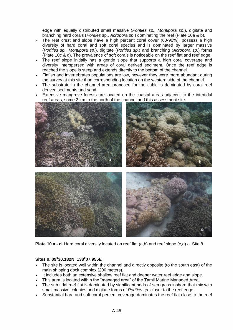
A-45
edge with equally distributed small massive (Porities sp., Montipora sp.), digitate and branching hard corals (Porities sp., Acropora sp.) dominating the reef (Plate 10a & b).
The reef crest and slope have a high percent coral cover (60-90%), possess a high diversity of hard coral and soft coral species and is dominated by larger massive (Porities sp., Montipora sp.), digitate (Porities sp.) and branching (Acropora sp.) forms (Plate 10c & d). The prevalence of soft corals is noticeable on the reef flat and reef edge.
The reef slope initially has a gentle slope that supports a high coral coverage and diversity interspersed with areas of coral derived sediment. Once the reef edge is reached the slope is steep and extends directly to the bottom of the channel.
Finfish and invertebrates populations are low, however they were more abundant during the survey at this site than corresponding location on the western side of the channel.
The substrate in the channel area proposed for the cable is dominated by coral reef derived sediments and sand.
Extensive mangrove forests are located on the coastal areas adjacent to the intertidal reef areas, some 2 km to the north of the channel and this assessment site.
Plate 10 a - d. Hard coral diversity located on reef flat (a,b) and reef slope (c,d) at Site 8.
Sites 9: 09o30.182N 138o07.955E
The site is located well within the channel and directly opposite (to the south east) of the main shipping dock complex (200 meters).
It includes both an extensive shallow reef flat and deeper water reef edge and slope. This area is located within the “managed area” of the Tamil Marine Managed Area. The sub tidal reef flat is dominated by significant beds of sea grass inshore that mix with
small massive colonies and digitate forms of Porities sp. closer to the reef edge. Substantial hard and soft coral percent coverage dominates the reef flat close to the reef
b a
c d
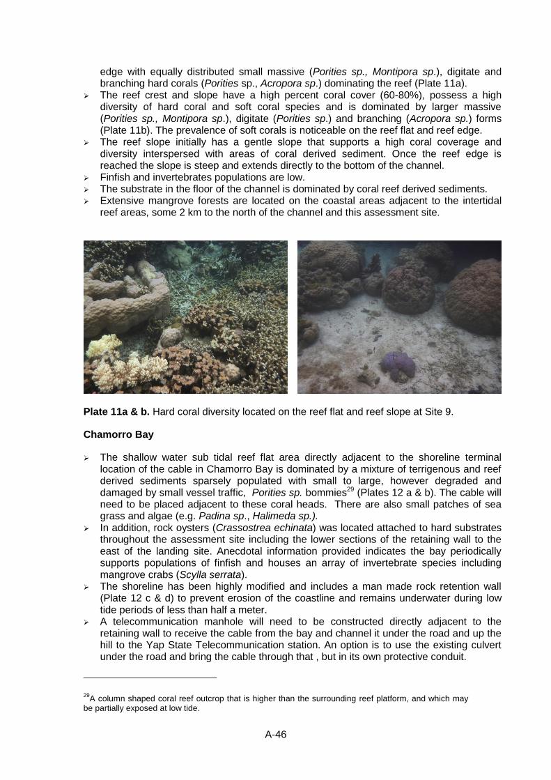
A-46
edge with equally distributed small massive (Porities sp., Montipora sp.), digitate and branching hard corals (Porities sp., Acropora sp.) dominating the reef (Plate 11a).
The reef crest and slope have a high percent coral cover (60-80%), possess a high diversity of hard coral and soft coral species and is dominated by larger massive (Porities sp., Montipora sp.), digitate (Porities sp.) and branching (Acropora sp.) forms (Plate 11b). The prevalence of soft corals is noticeable on the reef flat and reef edge.
The reef slope initially has a gentle slope that supports a high coral coverage and diversity interspersed with areas of coral derived sediment. Once the reef edge is reached the slope is steep and extends directly to the bottom of the channel.
Finfish and invertebrates populations are low. The substrate in the floor of the channel is dominated by coral reef derived sediments. Extensive mangrove forests are located on the coastal areas adjacent to the intertidal
reef areas, some 2 km to the north of the channel and this assessment site.
Plate 11a & b. Hard coral diversity located on the reef flat and reef slope at Site 9.
Chamorro Bay
The shallow water sub tidal reef flat area directly adjacent to the shoreline terminal location of the cable in Chamorro Bay is dominated by a mixture of terrigenous and reef derived sediments sparsely populated with small to large, however degraded and damaged by small vessel traffic, Porities sp. bommies29 (Plates 12 a & b). The cable will need to be placed adjacent to these coral heads. There are also small patches of sea grass and algae (e.g. Padina sp., Halimeda sp.).
In addition, rock oysters (Crassostrea echinata) was located attached to hard substrates throughout the assessment site including the lower sections of the retaining wall to the east of the landing site. Anecdotal information provided indicates the bay periodically supports populations of finfish and houses an array of invertebrate species including mangrove crabs (Scylla serrata).
The shoreline has been highly modified and includes a man made rock retention wall (Plate 12 c & d) to prevent erosion of the coastline and remains underwater during low tide periods of less than half a meter.
A telecommunication manhole will need to be constructed directly adjacent to the retaining wall to receive the cable from the bay and channel it under the road and up the hill to the Yap State Telecommunication station. An option is to use the existing culvert under the road and bring the cable through that , but in its own protective conduit.
29A column shaped coral reef outcrop that is higher than the surrounding reef platform, and which may
be partially exposed at low tide.
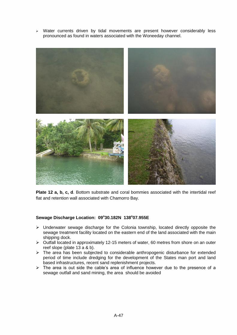
A-47
Water currents driven by tidal movements are present however considerably less pronounced as found in waters associated with the Woneeday channel.
Plate 12 a, b, c, d. Bottom substrate and coral bommies associated with the intertidal reef
flat and retention wall associated with Chamorro Bay.
Sewage Discharge Location: 09o30.182N 138o07.955E
Underwater sewage discharge for the Colonia township, located directly opposite the sewage treatment facility located on the eastern end of the land associated with the main shipping dock.
Outfall located in approximately 12-15 meters of water, 60 metres from shore on an outer reef slope (plate 13 a & b).
The area has been subjected to considerable anthropogenic disturbance for extended period of time include dredging for the development of the States man port and land based infrastructures, recent sand replenishment projects.
The area is out side the cable’s area of influence however due to the presence of a sewage outfall and sand mining, the area should be avoided
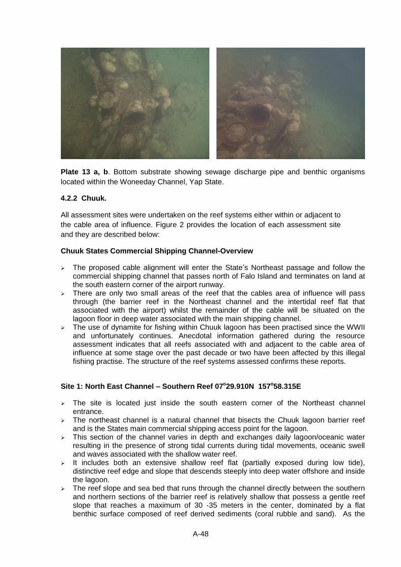
A-48
Plate 13 a, b. Bottom substrate showing sewage discharge pipe and benthic organisms
located within the Woneeday Channel, Yap State.
4.2.2 Chuuk.
All assessment sites were undertaken on the reef systems either within or adjacent to
the cable area of influence. Figure 2 provides the location of each assessment site
and they are described below:
Chuuk States Commercial Shipping Channel-Overview
The proposed cable alignment will enter the State’s Northeast passage and follow the commercial shipping channel that passes north of Falo Island and terminates on land at the south eastern corner of the airport runway.
There are only two small areas of the reef that the cables area of influence will pass through (the barrier reef in the Northeast channel and the intertidal reef flat that associated with the airport) whilst the remainder of the cable will be situated on the lagoon floor in deep water associated with the main shipping channel.
The use of dynamite for fishing within Chuuk lagoon has been practised since the WWII and unfortunately continues. Anecdotal information gathered during the resource assessment indicates that all reefs associated with and adjacent to the cable area of influence at some stage over the past decade or two have been affected by this illegal fishing practise. The structure of the reef systems assessed confirms these reports.
Site 1: North East Channel – Southern Reef 07o29.910N 157o58.315E
The site is located just inside the south eastern corner of the Northeast channel entrance.
The northeast channel is a natural channel that bisects the Chuuk lagoon barrier reef and is the States main commercial shipping access point for the lagoon.
This section of the channel varies in depth and exchanges daily lagoon/oceanic water resulting in the presence of strong tidal currents during tidal movements, oceanic swell and waves associated with the shallow water reef.
It includes both an extensive shallow reef flat (partially exposed during low tide), distinctive reef edge and slope that descends steeply into deep water offshore and inside the lagoon.
The reef slope and sea bed that runs through the channel directly between the southern and northern sections of the barrier reef is relatively shallow that possess a gentle reef slope that reaches a maximum of 30 -35 meters in the center, dominated by a flat benthic surface composed of reef derived sediments (coral rubble and sand). As the
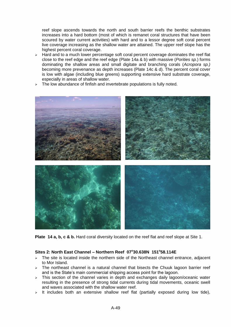
A-49
reef slope ascends towards the north and south barrier reefs the benthic substrates increases into a hard bottom (most of which is remanet coral structures that have been scoured by water current activities) with hard and to a lessor degree soft coral percent live coverage increasing as the shallow water are attained. The upper reef slope has the highest percent coral coverage.
Hard and to a much lower percentage soft coral percent coverage dominates the reef flat close to the reef edge and the reef edge (Plate 14a & b) with massive (Porities sp.) forms dominating the shallow areas and small digitate and branching corals (Acropora sp.) becoming more prevenance as depth increases (Plate 14c & d). The percent coral cover is low with algae (including blue greens) supporting extensive hard substrate coverage, especially in areas of shallow water.
The low abundance of finfish and invertebrate populations is fully noted.
Plate 14 a, b, c & b. Hard coral diversity located on the reef flat and reef slope at Site 1.
Sites 2: North East Channel – Northern Reef 07o30.638N 151o58.114E
The site is located inside the northern side of the Northeast channel entrance, adjacent to Mor Island.
The northeast channel is a natural channel that bisects the Chuuk lagoon barrier reef and is the State’s main commercial shipping access point for the lagoon.
This section of the channel varies in depth and exchanges daily lagoon/oceanic water resulting in the presence of strong tidal currents during tidal movements, oceanic swell and waves associated with the shallow water reef.
It includes both an extensive shallow reef flat (partially exposed during low tide),
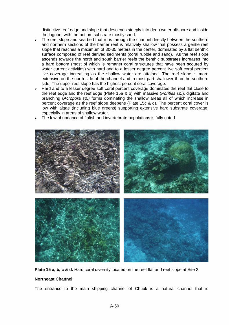
A-50
distinctive reef edge and slope that descends steeply into deep water offshore and inside the lagoon, with the bottom substrate mostly sand.
The reef slope and sea bed that runs through the channel directly between the southern and northern sections of the barrier reef is relatively shallow that possess a gentle reef slope that reaches a maximum of 30-35 meters in the center, dominated by a flat benthic surface composed of reef derived sediments (coral rubble and sand). As the reef slope ascends towards the north and south barrier reefs the benthic substrates increases into a hard bottom (most of which is remanet coral structures that have been scoured by water current activities) with hard and to a lesser degree percent live soft coral percent live coverage increasing as the shallow water are attained. The reef slope is more extensive on the north side of the channel and in most part shallower than the southern side. The upper reef slope has the highest percent coral coverage.
Hard and to a lesser degree soft coral percent coverage dominates the reef flat close to the reef edge and the reef edge (Plate 15a & b) with massive (Porities sp.), digitate and branching (Acropora sp.) forms dominating the shallow areas all of which increase in percent coverage as the reef slope deepens (Plate 15c & d). The percent coral cover is low with algae (including blue greens) supporting extensive hard substrate coverage, especially in areas of shallow water.
The low abundance of finfish and invertebrate populations is fully noted.
Plate 15 a, b, c & d. Hard coral diversity located on the reef flat and reef slope at Site 2.
Northeast Channel
The entrance to the main shipping channel of Chuuk is a natural channel that is
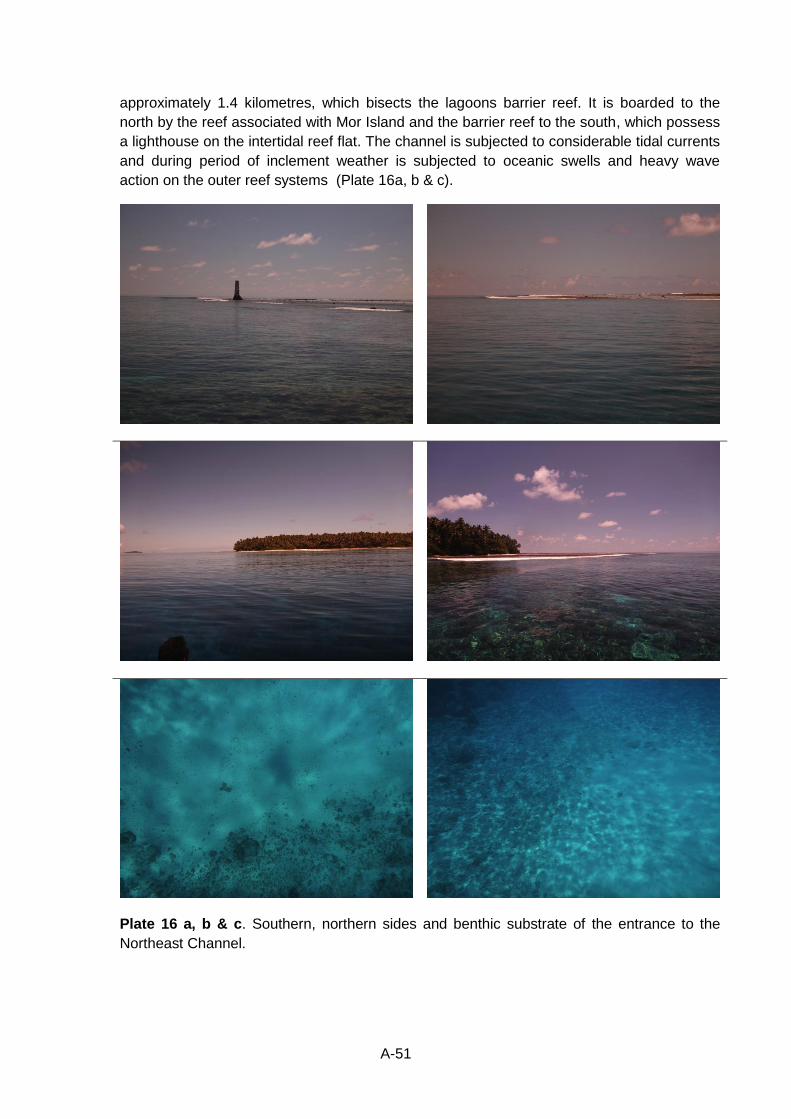
A-51
approximately 1.4 kilometres, which bisects the lagoons barrier reef. It is boarded to the
north by the reef associated with Mor Island and the barrier reef to the south, which possess
a lighthouse on the intertidal reef flat. The channel is subjected to considerable tidal currents
and during period of inclement weather is subjected to oceanic swells and heavy wave
action on the outer reef systems (Plate 16a, b & c).
Plate 16 a, b & c. Southern, northern sides and benthic substrate of the entrance to the
Northeast Channel.
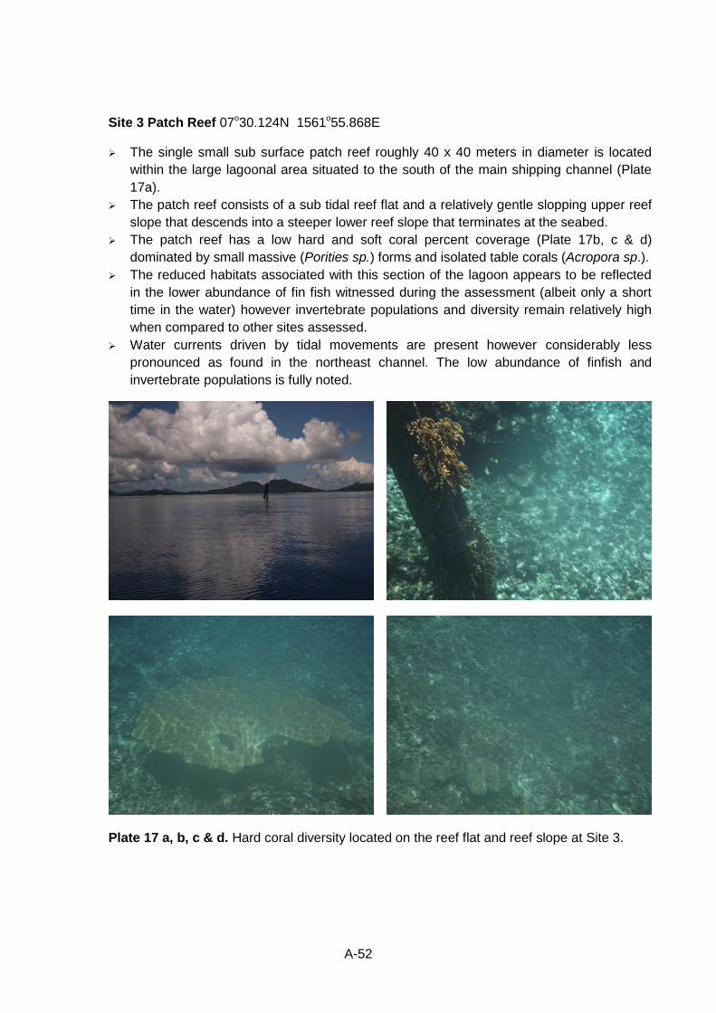
A-52
Site 3 Patch Reef 07o30.124N 1561o55.868E
The single small sub surface patch reef roughly 40 x 40 meters in diameter is located
within the large lagoonal area situated to the south of the main shipping channel (Plate
17a).
The patch reef consists of a sub tidal reef flat and a relatively gentle slopping upper reef
slope that descends into a steeper lower reef slope that terminates at the seabed.
The patch reef has a low hard and soft coral percent coverage (Plate 17b, c & d)
dominated by small massive (Porities sp.) forms and isolated table corals (Acropora sp.).
The reduced habitats associated with this section of the lagoon appears to be reflected
in the lower abundance of fin fish witnessed during the assessment (albeit only a short
time in the water) however invertebrate populations and diversity remain relatively high
when compared to other sites assessed.
Water currents driven by tidal movements are present however considerably less
pronounced as found in the northeast channel. The low abundance of finfish and
invertebrate populations is fully noted.
Plate 17 a, b, c & d. Hard coral diversity located on the reef flat and reef slope at Site 3.
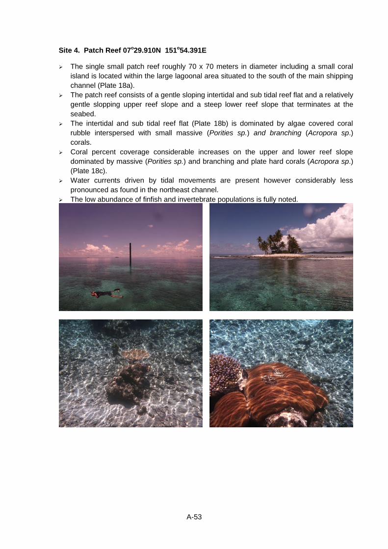
A-53
Site 4. Patch Reef 07o29.910N 151o54.391E
The single small patch reef roughly 70 x 70 meters in diameter including a small coral
island is located within the large lagoonal area situated to the south of the main shipping
channel (Plate 18a).
The patch reef consists of a gentle sloping intertidal and sub tidal reef flat and a relatively
gentle slopping upper reef slope and a steep lower reef slope that terminates at the
seabed.
The intertidal and sub tidal reef flat (Plate 18b) is dominated by algae covered coral
rubble interspersed with small massive (Porities sp.) and branching (Acropora sp.)
corals.
Coral percent coverage considerable increases on the upper and lower reef slope
dominated by massive (Porities sp.) and branching and plate hard corals (Acropora sp.)
(Plate 18c).
Water currents driven by tidal movements are present however considerably less
pronounced as found in the northeast channel.
The low abundance of finfish and invertebrate populations is fully noted.
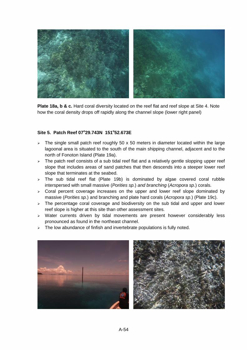
A-54
Plate 18a, b & c. Hard coral diversity located on the reef flat and reef slope at Site 4. Note
how the coral density drops off rapidly along the channel slope (lower right panel)
Site 5. Patch Reef 07o29.743N 151o52.673E
The single small patch reef roughly 50 x 50 meters in diameter located within the large
lagoonal area is situated to the south of the main shipping channel, adjacent and to the
north of Fonoton Island (Plate 19a).
The patch reef consists of a sub tidal reef flat and a relatively gentle slopping upper reef
slope that includes areas of sand patches that then descends into a steeper lower reef
slope that terminates at the seabed.
The sub tidal reef flat (Plate 19b) is dominated by algae covered coral rubble
interspersed with small massive (Porities sp.) and branching (Acropora sp.) corals.
Coral percent coverage increases on the upper and lower reef slope dominated by
massive (Porities sp.) and branching and plate hard corals (Acropora sp.) (Plate 19c).
The percentage coral coverage and biodiversity on the sub tidal and upper and lower
reef slope is higher at this site than other assessment sites.
Water currents driven by tidal movements are present however considerably less
pronounced as found in the northeast channel.
The low abundance of finfish and invertebrate populations is fully noted.
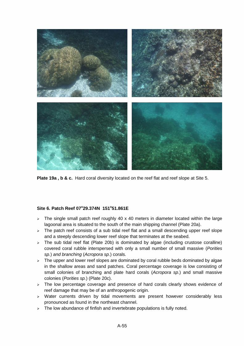
A-55
Plate 19a , b & c. Hard coral diversity located on the reef flat and reef slope at Site 5.
Site 6. Patch Reef 07o29.374N 151o51.861E
The single small patch reef roughly 40 x 40 meters in diameter located within the large
lagoonal area is situated to the south of the main shipping channel (Plate 20a).
The patch reef consists of a sub tidal reef flat and a small descending upper reef slope
and a steeply descending lower reef slope that terminates at the seabed.
The sub tidal reef flat (Plate 20b) is dominated by algae (including crustose coralline)
covered coral rubble interspersed with only a small number of small massive (Porities
sp.) and branching (Acropora sp.) corals.
The upper and lower reef slopes are dominated by coral rubble beds dominated by algae
in the shallow areas and sand patches. Coral percentage coverage is low consisting of
small colonies of branching and plate hard corals (Acropora sp.) and small massive
colonies (Porities sp.) (Plate 20c).
The low percentage coverage and presence of hard corals clearly shows evidence of
reef damage that may be of an anthropogenic origin.
Water currents driven by tidal movements are present however considerably less
pronounced as found in the northeast channel.
The low abundance of finfish and invertebrate populations is fully noted.
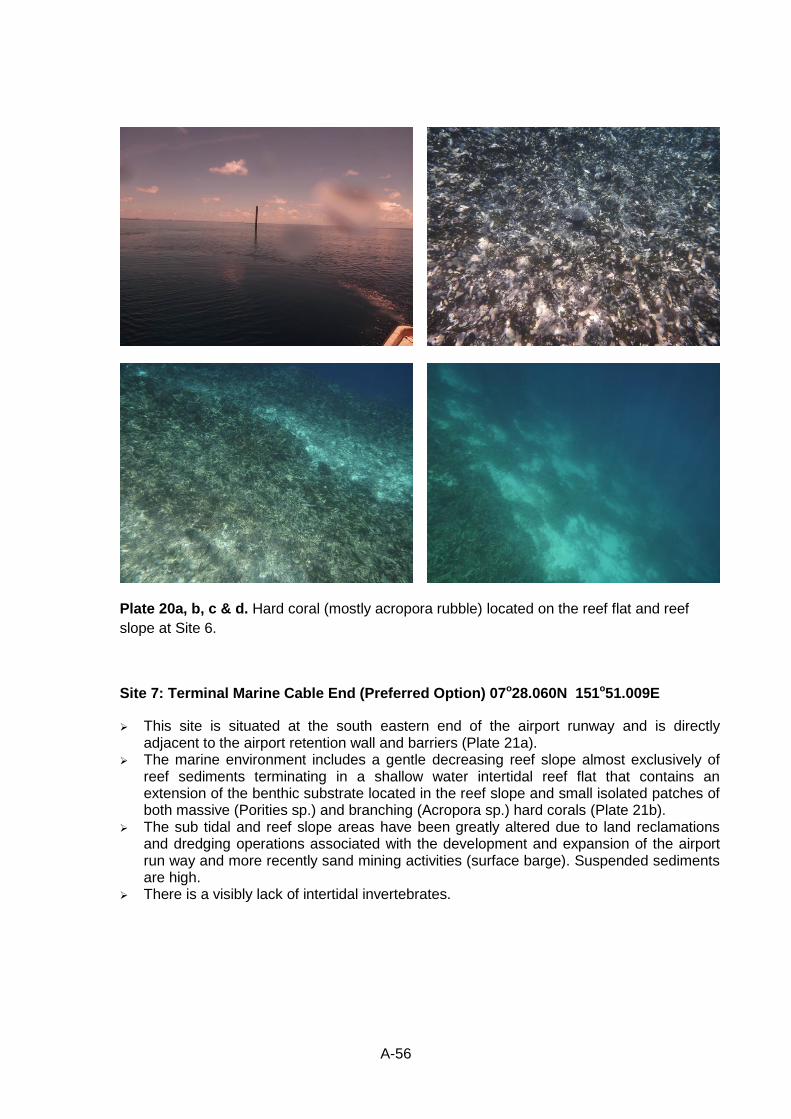
A-56
Plate 20a, b, c & d. Hard coral (mostly acropora rubble) located on the reef flat and reef
slope at Site 6.
Site 7: Terminal Marine Cable End (Preferred Option) 07o28.060N 151o51.009E
This site is situated at the south eastern end of the airport runway and is directly adjacent to the airport retention wall and barriers (Plate 21a).
The marine environment includes a gentle decreasing reef slope almost exclusively of reef sediments terminating in a shallow water intertidal reef flat that contains an extension of the benthic substrate located in the reef slope and small isolated patches of both massive (Porities sp.) and branching (Acropora sp.) hard corals (Plate 21b).
The sub tidal and reef slope areas have been greatly altered due to land reclamations and dredging operations associated with the development and expansion of the airport run way and more recently sand mining activities (surface barge). Suspended sediments are high.
There is a visibly lack of intertidal invertebrates.
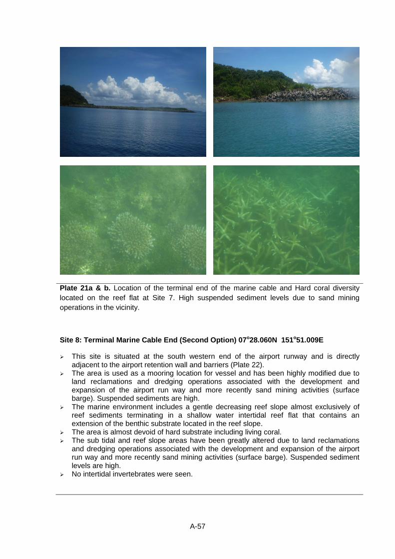
A-57
Plate 21a & b. Location of the terminal end of the marine cable and Hard coral diversity
located on the reef flat at Site 7. High suspended sediment levels due to sand mining
operations in the vicinity.
Site 8: Terminal Marine Cable End (Second Option) 07o28.060N 151o51.009E
This site is situated at the south western end of the airport runway and is directly adjacent to the airport retention wall and barriers (Plate 22).
The area is used as a mooring location for vessel and has been highly modified due to land reclamations and dredging operations associated with the development and expansion of the airport run way and more recently sand mining activities (surface barge). Suspended sediments are high.
The marine environment includes a gentle decreasing reef slope almost exclusively of reef sediments terminating in a shallow water intertidal reef flat that contains an extension of the benthic substrate located in the reef slope.
The area is almost devoid of hard substrate including living coral. The sub tidal and reef slope areas have been greatly altered due to land reclamations
and dredging operations associated with the development and expansion of the airport run way and more recently sand mining activities (surface barge). Suspended sediment levels are high.
No intertidal invertebrates were seen.
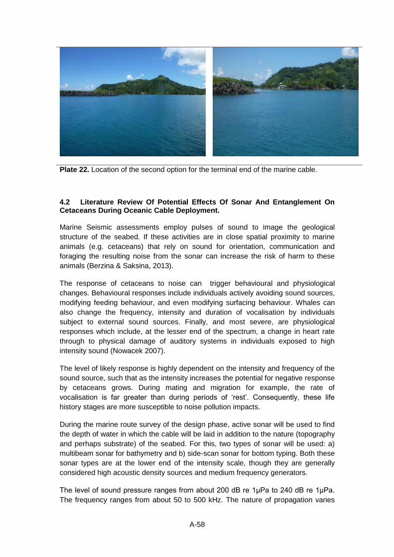
A-58
Plate 22. Location of the second option for the terminal end of the marine cable.
4.2 Literature Review Of Potential Effects Of Sonar And Entanglement On Cetaceans During Oceanic Cable Deployment. Marine Seismic assessments employ pulses of sound to image the geological
structure of the seabed. If these activities are in close spatial proximity to marine
animals (e.g. cetaceans) that rely on sound for orientation, communication and
foraging the resulting noise from the sonar can increase the risk of harm to these
animals (Berzina & Saksina, 2013).
The response of cetaceans to noise can trigger behavioural and physiological
changes. Behavioural responses include individuals actively avoiding sound sources,
modifying feeding behaviour, and even modifying surfacing behaviour. Whales can
also change the frequency, intensity and duration of vocalisation by individuals
subject to external sound sources. Finally, and most severe, are physiological
responses which include, at the lesser end of the spectrum, a change in heart rate
through to physical damage of auditory systems in individuals exposed to high
intensity sound (Nowacek 2007).
The level of likely response is highly dependent on the intensity and frequency of the
sound source, such that as the intensity increases the potential for negative response
by cetaceans grows. During mating and migration for example, the rate of
vocalisation is far greater than during periods of ‘rest’. Consequently, these life
history stages are more susceptible to noise pollution impacts.
During the marine route survey of the design phase, active sonar will be used to find
the depth of water in which the cable will be laid in addition to the nature (topography
and perhaps substrate) of the seabed. For this, two types of sonar will be used: a)
multibeam sonar for bathymetry and b) side-scan sonar for bottom typing. Both these
sonar types are at the lower end of the intensity scale, though they are generally
considered high acoustic density sources and medium frequency generators.
The level of sound pressure ranges from about 200 dB re 1μPa to 240 dB re 1μPa.
The frequency ranges from about 50 to 500 kHz. The nature of propagation varies
A-59
depending on the nature of the survey, although it can generally be expected to
conform to a conical pattern with a greater swath being covered in deeper water.
To survey deeper water it is necessary to use lower frequency to compensate for the
attenuating properties of seawater. However, the lower the frequency of source used,
the lower the resolution of images collected. Therefore, it is likely that for most
operations the maximum detectable frequency will be used.
Information resulting from the Antarctic Treaty Consultative meeting on acoustic
effects on cetaceans in the Southern Ocean found the following level of responses
and associated likelihoods of occurrence for multibeam sonar (Scientific Committee
on Antarctic Research, 2006) and, given the similar acoustic properties of side-scan,
a similar response is likely for the use of side-scan sonar.
Individuals show no response or only a temporary (minutes) behaviour change. No change to environment or populations. Expected in almost all instances; and,
Individuals show short-term (hours) behavioural change. Temporary displacement of a small proportion of a population; small proportion of habitat affected; no impact on ecosystem function, could occur .
The main concern associated is its effect on whales that utilise the waters in the
vicinity of the proposed cable route is interference with migration and movement
activities, and due to the oceanographic survey or cable laying process. Information
is not available on specific movements of whales and dolphins through the FSM
waters, but is generally in the fall and spring of the year. During this period there is a
very small risk that a proportion of the population will be temporarily disrupted and
could result in modified migration behaviour.
Given this concern, best practice should be followed when sonar is used during the
route survey. This best practice is described in Chapter VI of this report. If this best
practice is followed, most of the concerns can be mitigated and the impact would be
rendered insignificant.
Given that the vessels involved in the route survey and cable laying stages are likely
to be in the region for only relatively short periods of time and given that the
proposed cable route area is traversed regularly by other vessels, the proposed
development does not constitute a significant additional ship-noise burden.
Another potential impact is entanglement or physical contact by cetaceans with the
cable when it is being laid. Given that the cable laying process will take place over a
very short period of time, however, this is considered extremely unlikely and is
therefore considered an insignificant impact.
Between 1877 and 1955 there were 16 records of cetaceans becoming entangled in
unsupported sections of submarine cables. The most at risk cetaceans are the deep
diving toothed species such as sperm whales (Heezen 1953), whose feeding
behaviour involves swimming along the seabed with the lower jaw skimming the
sediment. Another survey of cable fault databases (Wood & Carter 2008) containing
records of 5740 cable faults, between 1959 and 2006, failed to find a single record of
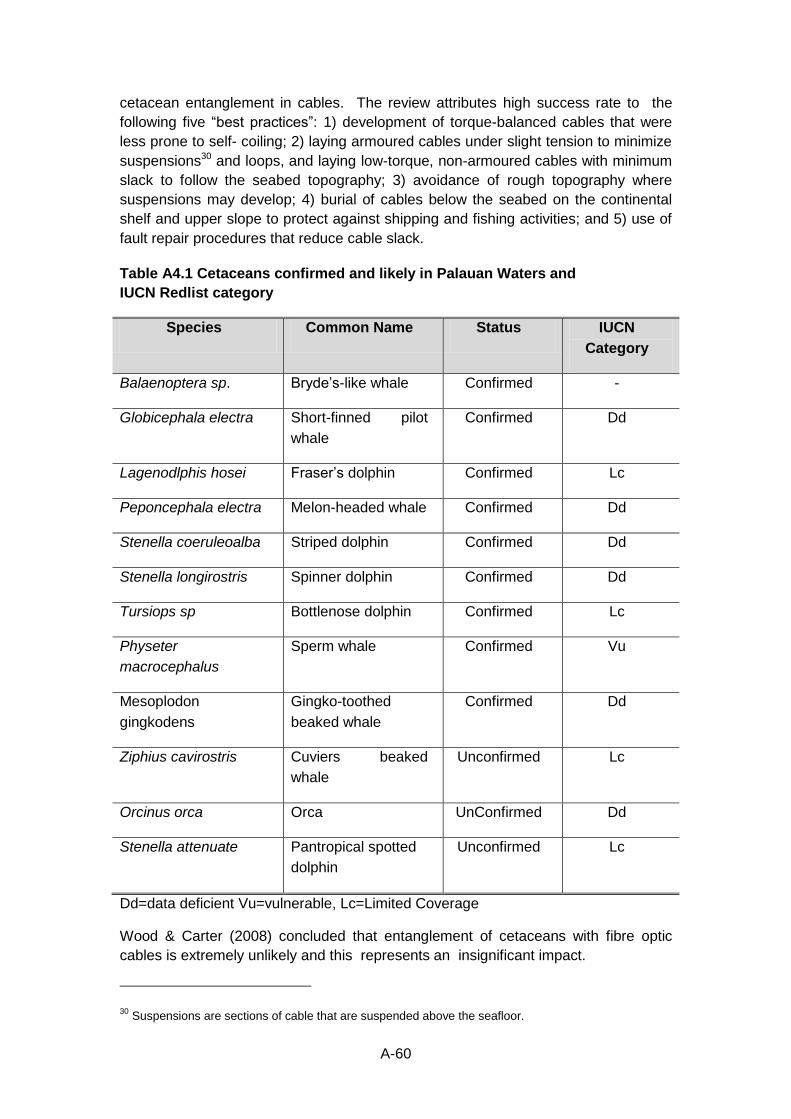
A-60
cetacean entanglement in cables. The review attributes high success rate to the
following five “best practices”: 1) development of torque-balanced cables that were
less prone to self- coiling; 2) laying armoured cables under slight tension to minimize
suspensions30 and loops, and laying low-torque, non-armoured cables with minimum
slack to follow the seabed topography; 3) avoidance of rough topography where
suspensions may develop; 4) burial of cables below the seabed on the continental
shelf and upper slope to protect against shipping and fishing activities; and 5) use of
fault repair procedures that reduce cable slack.
Table A4.1 Cetaceans confirmed and likely in Palauan Waters and
IUCN Redlist category
Species Common Name Status IUCN
Category
Balaenoptera sp. Bryde’s-like whale Confirmed -
Globicephala electra Short-finned pilot
whale
Confirmed Dd
Lagenodlphis hosei Fraser’s dolphin Confirmed Lc
Peponcephala electra Melon-headed whale Confirmed Dd
Stenella coeruleoalba Striped dolphin Confirmed Dd
Stenella longirostris Spinner dolphin Confirmed Dd
Tursiops sp Bottlenose dolphin Confirmed Lc
Physeter
macrocephalus
Sperm whale Confirmed Vu
Mesoplodon
gingkodens
Gingko-toothed
beaked whale
Confirmed Dd
Ziphius cavirostris Cuviers beaked
whale
Unconfirmed Lc
Orcinus orca Orca UnConfirmed Dd
Stenella attenuate Pantropical spotted
dolphin
Unconfirmed Lc
Dd=data deficient Vu=vulnerable, Lc=Limited Coverage
Wood & Carter (2008) concluded that entanglement of cetaceans with fibre optic
cables is extremely unlikely and this represents an insignificant impact.
30 Suspensions are sections of cable that are suspended above the seafloor.
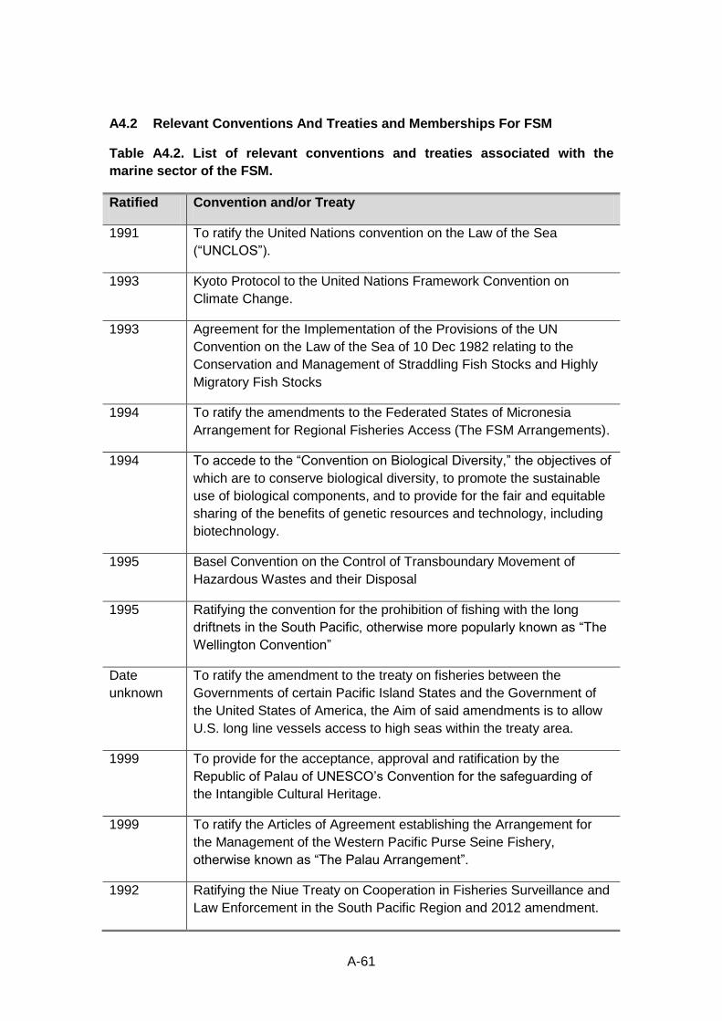
A-61
A4.2 Relevant Conventions And Treaties and Memberships For FSM
Table A4.2. List of relevant conventions and treaties associated with the
marine sector of the FSM.
Ratified Convention and/or Treaty
1991 To ratify the United Nations convention on the Law of the Sea
(“UNCLOS”).
1993 Kyoto Protocol to the United Nations Framework Convention on
Climate Change.
1993 Agreement for the Implementation of the Provisions of the UN
Convention on the Law of the Sea of 10 Dec 1982 relating to the
Conservation and Management of Straddling Fish Stocks and Highly
Migratory Fish Stocks
1994 To ratify the amendments to the Federated States of Micronesia
Arrangement for Regional Fisheries Access (The FSM Arrangements).
1994 To accede to the “Convention on Biological Diversity,” the objectives of
which are to conserve biological diversity, to promote the sustainable
use of biological components, and to provide for the fair and equitable
sharing of the benefits of genetic resources and technology, including
biotechnology.
1995 Basel Convention on the Control of Transboundary Movement of
Hazardous Wastes and their Disposal
1995 Ratifying the convention for the prohibition of fishing with the long
driftnets in the South Pacific, otherwise more popularly known as “The
Wellington Convention”
Date
unknown
To ratify the amendment to the treaty on fisheries between the
Governments of certain Pacific Island States and the Government of
the United States of America, the Aim of said amendments is to allow
U.S. long line vessels access to high seas within the treaty area.
1999 To provide for the acceptance, approval and ratification by the
Republic of Palau of UNESCO’s Convention for the safeguarding of
the Intangible Cultural Heritage.
1999 To ratify the Articles of Agreement establishing the Arrangement for
the Management of the Western Pacific Purse Seine Fishery,
otherwise known as “The Palau Arrangement”.
1992 Ratifying the Niue Treaty on Cooperation in Fisheries Surveillance and
Law Enforcement in the South Pacific Region and 2012 amendment.
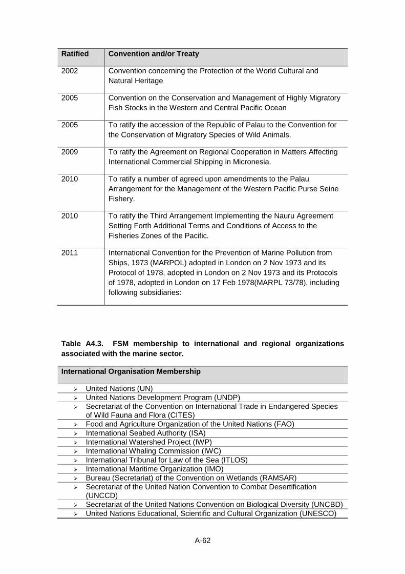
A-62
Ratified Convention and/or Treaty
2002 Convention concerning the Protection of the World Cultural and
Natural Heritage
2005 Convention on the Conservation and Management of Highly Migratory
Fish Stocks in the Western and Central Pacific Ocean
2005 To ratify the accession of the Republic of Palau to the Convention for
the Conservation of Migratory Species of Wild Animals.
2009 To ratify the Agreement on Regional Cooperation in Matters Affecting
International Commercial Shipping in Micronesia.
2010 To ratify a number of agreed upon amendments to the Palau
Arrangement for the Management of the Western Pacific Purse Seine
Fishery.
2010 To ratify the Third Arrangement Implementing the Nauru Agreement
Setting Forth Additional Terms and Conditions of Access to the
Fisheries Zones of the Pacific.
2011 International Convention for the Prevention of Marine Pollution from
Ships, 1973 (MARPOL) adopted in London on 2 Nov 1973 and its
Protocol of 1978, adopted in London on 2 Nov 1973 and its Protocols
of 1978, adopted in London on 17 Feb 1978(MARPL 73/78), including
following subsidiaries:
Table A4.3. FSM membership to international and regional organizations
associated with the marine sector.
International Organisation Membership
United Nations (UN)
United Nations Development Program (UNDP)
Secretariat of the Convention on International Trade in Endangered Species of Wild Fauna and Flora (CITES)
Food and Agriculture Organization of the United Nations (FAO)
International Seabed Authority (ISA)
International Watershed Project (IWP)
International Whaling Commission (IWC)
International Tribunal for Law of the Sea (ITLOS)
International Maritime Organization (IMO)
Bureau (Secretariat) of the Convention on Wetlands (RAMSAR)
Secretariat of the United Nation Convention to Combat Desertification (UNCCD)
Secretariat of the United Nations Convention on Biological Diversity (UNCBD)
United Nations Educational, Scientific and Cultural Organization (UNESCO)
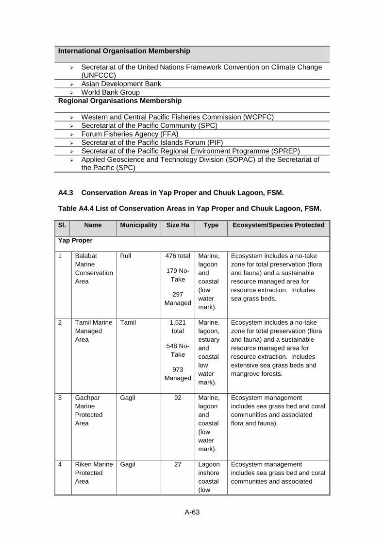
A-63
International Organisation Membership
Secretariat of the United Nations Framework Convention on Climate Change (UNFCCC)
Asian Development Bank
World Bank Group
Regional Organisations Membership
Western and Central Pacific Fisheries Commission (WCPFC)
Secretariat of the Pacific Community (SPC)
Forum Fisheries Agency (FFA)
Secretariat of the Pacific Islands Forum (PIF)
Secretariat of the Pacific Regional Environment Programme (SPREP)
Applied Geoscience and Technology Division (SOPAC) of the Secretariat of the Pacific (SPC)
A4.3 Conservation Areas in Yap Proper and Chuuk Lagoon, FSM.
Table A4.4 List of Conservation Areas in Yap Proper and Chuuk Lagoon, FSM.
Sl. Name Municipality Size Ha Type Ecosystem/Species Protected
Yap Proper
1 Balabat
Marine
Conservation
Area
Rull 476 total
179 No-
Take
297
Managed
Marine,
lagoon
and
coastal
(low
water
mark).
Ecosystem includes a no-take
zone for total preservation (flora
and fauna) and a sustainable
resource managed area for
resource extraction. Includes
sea grass beds.
2 Tamil Marine
Managed
Area
Tamil 1,521
total
548 No-
Take
973
Managed
Marine,
lagoon,
estuary
and
coastal
low
water
mark).
Ecosystem includes a no-take
zone for total preservation (flora
and fauna) and a sustainable
resource managed area for
resource extraction. Includes
extensive sea grass beds and
mangrove forests.
3 Gachpar
Marine
Protected
Area
Gagil 92 Marine,
lagoon
and
coastal
(low
water
mark).
Ecosystem management
includes sea grass bed and coral
communities and associated
flora and fauna).
4 Riken Marine
Protected
Area
Gagil 27 Lagoon
inshore
coastal
(low
Ecosystem management
includes sea grass bed and coral
communities and associated
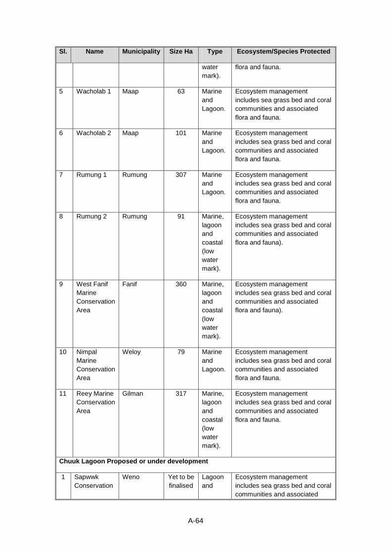
A-64
Sl. Name Municipality Size Ha Type Ecosystem/Species Protected
water
mark).
flora and fauna.
5 Wacholab 1 Maap 63 Marine
and
Lagoon.
Ecosystem management
includes sea grass bed and coral
communities and associated
flora and fauna.
6 Wacholab 2 Maap 101 Marine
and
Lagoon.
Ecosystem management
includes sea grass bed and coral
communities and associated
flora and fauna.
7 Rumung 1 Rumung 307 Marine
and
Lagoon.
Ecosystem management
includes sea grass bed and coral
communities and associated
flora and fauna.
8 Rumung 2 Rumung 91 Marine,
lagoon
and
coastal
(low
water
mark).
Ecosystem management
includes sea grass bed and coral
communities and associated
flora and fauna).
9 West Fanif
Marine
Conservation
Area
Fanif 360 Marine,
lagoon
and
coastal
(low
water
mark).
Ecosystem management
includes sea grass bed and coral
communities and associated
flora and fauna).
10 Nimpal
Marine
Conservation
Area
Weloy 79 Marine
and
Lagoon.
Ecosystem management
includes sea grass bed and coral
communities and associated
flora and fauna.
11 Reey Marine
Conservation
Area
Gilman 317 Marine,
lagoon
and
coastal
(low
water
mark).
Ecosystem management
includes sea grass bed and coral
communities and associated
flora and fauna.
Chuuk Lagoon Proposed or under development
1 Sapwwk
Conservation
Weno Yet to be
finalised
Lagoon
and
Ecosystem management
includes sea grass bed and coral
communities and associated
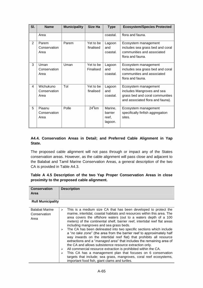
A-65
Sl. Name Municipality Size Ha Type Ecosystem/Species Protected
Area coastal. flora and fauna.
2 Parem
Conservation
Area
Parem Yet to be
finalised
Lagoon
and
coastal.
Ecosystem management
includes sea grass bed and coral
communities and associated
flora and fauna.
3 Uman
Conservation
Area
Uman Yet to be
Finalised
Lagoon
and
coastal.
Ecosystem management
includes sea grass bed and coral
communities and associated
flora and fauna.
4 Wichukuno
Conservation
Area
Tol Yet to be
finalised
Lagoon
and
coastal.
Ecosystem management
includes Mangroves and sea
grass bed and coral communities
and associated flora and fauna).
5 Piaanu
Conservation
Area
Polle 242km Marine,
barrier
reef,
lagoon.
Ecosystem management
specifically finfish aggregation
sites.
A4.4. Conservation Areas in Detail; and Preferred Cable Alignment in Yap
State.
The proposed cable alignment will not pass through or impact any of the States
conservation areas. However, as the cable alignment will pass close and adjacent to
the Balabat and Tamil Marine Conservation Areas, a general description of the two
CA is provided in Table A4.3.
Table A 4.5 Description of the two Yap Proper Conservation Areas in close
proximity to the proposed cable alignment.
Conservation
Area
Description
Rull Municipality
Balabat Marine
Conservation
Area
This is a medium size CA that has been developed to protect the marine, intertidal, coastal habitats and resources within this area. The area covers the offshore waters (out to a waters depth of a 100 meters) of the continental shelf, barrier reef, intertidal reef flat areas including mangroves and sea grass beds.
The CA has been delineated into two specific sections which include a “no take zone” (the area from the barrier reef to approximately half way inwards on the intertidal reef flat) that prohibits all resource extractions and a “managed area” that includes the remaining area of the CA and allows subsistence resource extraction only.
All commercial resource extraction is prohibited within the CA. This CA has a management plan that focuses on 6 conservation
targets that include; sea grass, mangroves, coral reef ecosystems, important food fish, giant clams and turtles.
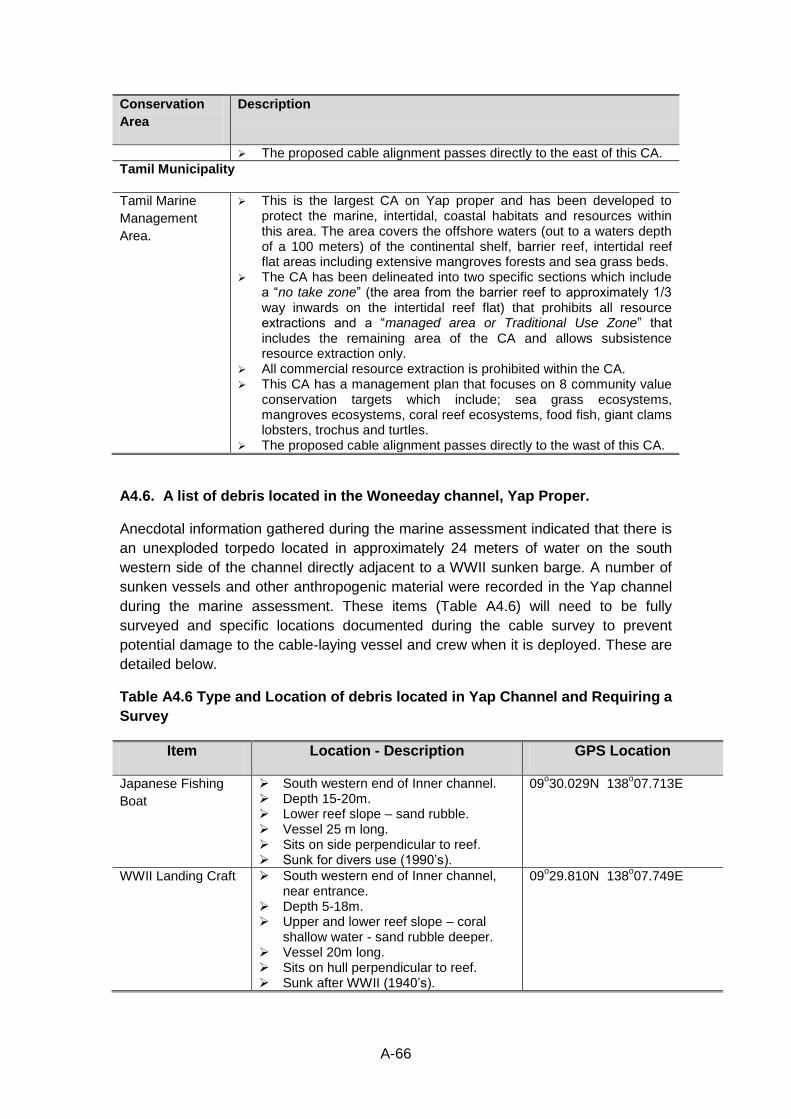
A-66
Conservation
Area
Description
The proposed cable alignment passes directly to the east of this CA.
Tamil Municipality
Tamil Marine
Management
Area.
This is the largest CA on Yap proper and has been developed to protect the marine, intertidal, coastal habitats and resources within this area. The area covers the offshore waters (out to a waters depth of a 100 meters) of the continental shelf, barrier reef, intertidal reef flat areas including extensive mangroves forests and sea grass beds.
The CA has been delineated into two specific sections which include a “no take zone” (the area from the barrier reef to approximately 1/3 way inwards on the intertidal reef flat) that prohibits all resource extractions and a “managed area or Traditional Use Zone” that includes the remaining area of the CA and allows subsistence resource extraction only.
All commercial resource extraction is prohibited within the CA. This CA has a management plan that focuses on 8 community value
conservation targets which include; sea grass ecosystems, mangroves ecosystems, coral reef ecosystems, food fish, giant clams lobsters, trochus and turtles.
The proposed cable alignment passes directly to the wast of this CA.
A4.6. A list of debris located in the Woneeday channel, Yap Proper.
Anecdotal information gathered during the marine assessment indicated that there is
an unexploded torpedo located in approximately 24 meters of water on the south
western side of the channel directly adjacent to a WWII sunken barge. A number of
sunken vessels and other anthropogenic material were recorded in the Yap channel
during the marine assessment. These items (Table A4.6) will need to be fully
surveyed and specific locations documented during the cable survey to prevent
potential damage to the cable-laying vessel and crew when it is deployed. These are
detailed below.
Table A4.6 Type and Location of debris located in Yap Channel and Requiring a
Survey
Item Location - Description GPS Location
Japanese Fishing
Boat
South western end of Inner channel. Depth 15-20m. Lower reef slope – sand rubble. Vessel 25 m long. Sits on side perpendicular to reef. Sunk for divers use (1990’s).
09o30.029N 138
o07.713E
WWII Landing Craft South western end of Inner channel, near entrance.
Depth 5-18m. Upper and lower reef slope – coral
shallow water - sand rubble deeper. Vessel 20m long. Sits on hull perpendicular to reef. Sunk after WWII (1940’s).
09o29.810N 138
o07.749E
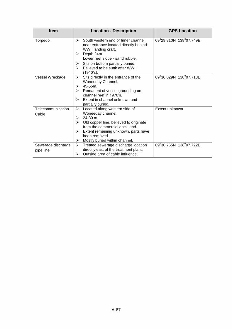
A-67
Item Location - Description GPS Location
Torpedo South western end of Inner channel, near entrance located directly behind WWII landing craft.
Depth 24m. Lower reef slope - sand rubble.
Sits on bottom partially buried. Believed to be sunk after WWII
(1940’s).
09o29.810N 138
o07.749E
Vessel Wreckage Sits directly in the entrance of the Woneeday Channel.
45-55m. Remanent of vessel grounding on
channel reef in 1970’s. Extent in channel unknown and
partially buried.
09o30.029N 138
o07.713E
Telecommunication
Cable
Located along western side of Woneeday channel.
24-30 m. Old copper line, believed to originate
from the commercial dock land. Extent remaining unknown, parts have
been removed. Mostly buried within channel.
Extent unknown.
Sewerage discharge
pipe line
Treated sewerage discharge location directly east of the treatment plant.
Outside area of cable influence.
09o30.755N 138
o07.722E