Embed Size (px)
Citation preview

w RESTON
DENSITY CONTROL UNDER THE RESIDENTIAL PLANNED COMMUNITY (RPC) CHAPTER OF THE FAIRFAX COUNTY
ZONING ORDINANCE

RESTON
DENSITY CONTROL UNDER THE RESIDENTIAL PLANNED COMMUNITY (RPC) CHAPTER OF THE FAIRFAX COUNTY
ZONING ORDINANCE
Prepared. By
GULF RESTON, INC. PLANNING AND ENGINEERING STAFF
October 1970

TABLE OF CONTENTS
Page No.
1 The Year 2000 Plan The Development of the Reston Plan 2
Drafting of the RPC Ordinance . . . 2
Population Density Adopted as a Measure 3
Population Measure - Theoretical rather than Actual 5
Overall Density Control 6 6 The Public Factor • • • •
Calculation of Density within Segments of the Community 11 8
1962 Master Plan 16 1968 Master Plan
1970 Proposed Land Use Plan . 17 21 Plat of Areas Zoned RPC 23 Plat of Subdivided Areas of RPC ................... 31 Conclusion ......
List of Tables
I Population Under 1962 Plan . . . . 12
II Analysis of Public Factor 1962 Plan 13 14 Ill Allocation of Public Factor Lands 1962 Plan
IV Computation of Density 1962 Plan ...................... 15
V Comparison of 1962, 1968, and 1970 Plans 18 19 VI Allocation of Public Factor Lands 1968 and 1970 Plans .
VII Computation of Density 1968 and 1970 Plans 20
Vlll Distribution of Population within RPC Zoned Areas 22
IX Dwelling Unit Distribution within Subdivided Areas .... 24 X Analysis of Public Factor Lands within Subdivided Areas 26
XI Calculation of Gross Residential Areas within 28 Subdivided Areas
XII Theoretical Population within Subdivided Areas 29

The Year 2000 Plan
The idea of a new town at Reston was a private dream as
long ago as 1890. It became a public planning concept m 1961
upon the publication by the National Capital Regional Planning
Council of "A Policies Plan for the Year 2000 - The Nation s
Capital". The plan proposed six corridors of urban development
reaching out from the central city into the Maryland and Vir
ginia suburbs. Tne corridors were foreseen as consisting of
cluster developments spaced along freeway and transit routes,
each surrounded by park-like "greenbelts" of low density. Each
new corridor community was seen as providing a range of employ
ment opportunity, complete community services and a variety of
housing types ranging from large single-family home lots to
high-rise apartments. Tne urban corridor principle of the plan
won immediate acceptance from Fairfax County Planners as a pref
erable alternative to the "suburban sprawl" of the earlier McHugh
plan. One of the proposed density clusters in the Year 2000
Plan fell on Reston which was then known as Sunset Hills and
which consisted of 6745 acres recently purchased by Lefcourt
Realty Corporation from A. Smith Bowman and Sons. Tne idea of
a cluster development - a new town - at that location was accepted
by the Fairfax County Planners along with the urban corridor
concept.
-1-

The Development of the Reston Plan
In mid 1961, Robert E. Simon purchased the Reston Prop
erty in the name of Palindrome Corporation (later known as
Reston Inc.). With the Year 2000 Plan as prologue, Mr.
Simon employed Harlan Bartholomew and later Whittlesey and
Conklin to plan a new town. The Whittlesey and Conklin plan,
consisting of a mixture of all types of residential dwellings
with commercial and industrial uses, was presented to the County
in 1962. The plan proposed seven village centers, one town
center and "sinews" of high density residential uses running
throughout the community. It proposed a separation of vehrcular
and pedestrian traffic and the location of community facilities
within walking distance of a majority of residents. The plan
was accepted by Fairfax County in 1962 as a part of the Compre
hensive Plan of the County as a whole. It was amended in 1968
to reflect the addition of several hundred acres not in the
original plan and to make minor adjustments in the shape of por
tions of the community. With minor changes it remains the blue
print for the development of the Community of Reston.
effing of the RPC__Ordinance
Soon after Whittlesey and Conklin were employed, it be-
came apparent that the Fairfax County Zoning Ordinance did not
afford enough flexibility to permit the development of a new
town. Although the "alternate density" concept had been incor
porated in the ordinance to encourage provision of permanent
open space, there was no provision for mixing uses and no pro
vision for review of community design concepts. Accordingly,
-2-

t.,.,.,,..........
a joint task force of representatives of the developer and
County staff members undertook the preparation of a planned
community ordinance: to implement the Res ton plan , Serving on
the task force for the County were Messrs. Payne, Schumann,
Burrage, Ashburn, Smedley and White; for the developer were
Messrs . Conklin, Rossant, Saunders, Kent, Boothe and Prichard .
Of course, the ordinance requested by the Reston developer
had to be of general application, and it was so drawn. Tne first
draft of the planned community zone submitted by the developer
provided for a density of 14 persons per acre which was computed
to be the approximate population density of land developed under
R-12.5 zoning. The developer proposed that all uses be permitted
in the RPC zone and that density be computed for the community
as a whole, including land used for commercial and industrial
purposes and all other non-residential areas. In support of the
requested density of 14 persons per acre, the developer submitted
population density statistics from the 1960 Census showing then
existing densities in Fairfax County, in Census tracts 4E, 11A,
11C, 12B, 17F, 23E, 24B and 3OA, ranging from 11.4 persons per
acre to 25.2 persons per acre.
Population Density Adopted as a Measure
The pre-1962 zoning ordinance regulated density by regu
lating lot size and setbacks, although lot area averaging was
permitted under the alternate density concept. The idea of
persons per acre rather than lot size emerged in a task force
discussion0 It was included in the first RPC draft as an alter
native to area and setback requirements and never questioned
_3-

t ,_y & u i k -J it. - - li y ... J "I g I « p. ] ^ ,. „£t ^^ f..i j-Ttm-rfi-fT-rt#-
thereafter. The numbers used in the draft emerged from a
comparison with density averages under conventional zoning.
A dwelling-units-per-aere measure was never included m any
draft of the RFC ordinance, although the Staff calculated that
some 24,885 dwelling units would be permitted in Reston under
the Whittlesey and Conklin plan -
Following submission of the first RFC draft, the County
staff recommended that industrial and heavy commercial be ex
cluded from the new zone. All later drafts so provided. Ulti
mately, the Planning Staff recommended that residential density
be limited to 11.4 persons per acre for an entire community, or
14 persons for the residential portion only. The Reston repre
sentatives concurred. The Planning Commission, however, recom
mended a density of 10 persons per acre for the entire community
Upon adoption of the RPC Ordinance on July 18, 1962, the Board
of County Supervisors fixed the density in RFC at 11 persons
per acre including associated general commercial and industrial
land, or 13 persons per acre excluding commercial and indus
trially zone land. Thus, the density included in the ordinance
was a compromise between the developer of Reston, the County
Staff, the Commission and The County Board of Fairfax County.
As far as the RPC Ordinance was concerned, the limit of 11 per
sons per gross acre proved not meaningful and was dropped from
the 1969 amended RPC Ordinance. The meaningful limit was and
remains 13 persons per gross acre of RPC zoned land.
In addition to the recommendation that overall density
in the Reston plan and in the RPC Ordinance be reduced from 14
to 11.4 persons per acre, the County Staff recoimnended, the
-4-

r | —* a | S 5 3 ? 5 * * '• j j J j I I I M . 1 — — b g - - - — « J
I \ _I L—. - . , «... .j «— ~1 Wm4. L,~I.J 'itsmaad I—»i kasiai. Lss*
developer concurring, that three types of varying density be
provided for: high, low and medium. The purpose of varying
the density within the planned community was to insure that
greenbelts be prov ided around new towns as proposed in the Year
2000 Plan. It was felt by the Planning Staff and the developer
that if the planned community zone included a high density resi
dential area adjacent to a greenbelt area, it would be difficult
to prevent equivalent density under conventional zoning in the
proposed greenbelt. Since one acre zoning was envisioned in
much of the greenbelt areas and the then County population
average in single-family detached homes was 3.7 persons per acre,
the population of the low density areas was set approximately
the same, at 3.8 persons per acre. This, it was felt, would
provide an easy transition from the greenbelt to the planned
community. The medium density area was set at 14 persons per
acre, the then population equivalent of the R-12-.5 zone. High
density was set at 60 persons per acre which was the then approx
imate yield of high-rise apartments.
Population Measure is Theoretical Rather than Actual
The 1962 RPC original ordinance contained in Section (c)
a formula for computing population density. It provides that
the factor of 3.7 persons should be used for computing the
population in each single-family dwelling, 3.0 persons for
garden type apartments or town houses and 1.5 persons per high-
rise apartment unit. The factors were drawn from County-wide
averages. There was no prov is ion in the ord inane e and no
discussion about changing from time to time as County averages
changed or as the actual population varied from time to time
in Reston and other planned communities. The factors are
-5-

simply a method for converting persons per acre into dwelling
units per acre. Hindsight indicates that it may have been
better from a draftsmanship standpoint to have expressed the
density in terms of dwelling units per acre and to have omitted
the formula section. Nonetheless, it was included and has
been continued in the amended ordinances.
Overall Density Control
Section (c) also contained a provision that as each section
of a planned community is placed of record under the Subdivision
Control Ordinance, the density shall be computed anew. It pro
vides that never in the history of the development will the
developer be permitted to exceed a density of 13 persons per acre.
Since this computation is to be made at the time of subdivision
rather than at the time of each subsequent census, it is clear
that the density control was and continues to be based upon a
theoretical population rather than upon actual population. There
was no provision and no discussion of any provision which would
have required a change in the Reston plan or the RPC Ordinance
based upon different population average factors from those con
tained in the original ordinance.
The Public Factor
It was clear during the preparation of the ordinance and
during the hearings before the Planning Commission and the Board
of Supervisors that in computing allowable population all areas
within the RPC zoned land not used as residential property should
be included. The 13 person per acre limit applies to all land
in an RPC zone, regardless of use. The Staff memorandum to the
-6-

Board of Supervisors dated May 16, 1962, spoke of a public
factor" to be used in the computation of density. The public
factor was stated to include not only publicly owned land and
streets, schools and similar uses, but other non-residential
property in the RPC zone. The discussion gave rise to the
"density bank" concept. Mr. Simon proposed - and the developer
of any other new town or planned community under the RPC zone
is required — to donate elementary and junior high school sites
and to provide adequate recreational areas. Obviously, such
facilities should be centrally located so as to be readily
available to the largest possible number of persons. This means
in general that such facilities are located in or adjacent to
medium or high density areas even though serving portions of the
community in low density areas. For each school site set aside
by the developer, the developer is entitled to a certain amount
of density to be placed on other acreage. The same is true for
parks and other public and quasi-publie community facilities.
That density may be taken throughout the community. It is not
necessary to locate the extra units a developer is entitled to
for a school site in a high density area within the same or
another high density area. In other words, it was never suggested
that a new town developed under the RPC zone should be three
communities, one a low density community, one a medium density
community and the other a high density community with each
community containing all the necessary amenities to meet its
need. The community facilities required are supplied to the
community as a whole and the density is therefore available to
the developer for the community as a whole.

Calculation of Density within Segments of the Community
The original conception of density control was that control
would lie at the subdivision point. Under Section (c) of the
ordinance, the developer is required to submit a recomputation
of density with each subdivision section. It is incumbent on
the developer to demonstrate to the County at that point that
it has not exceeded 13 persons per acre. These computations
have been made by the Reston staff and submitted to the Subdi
vision Control office of Fairfax County for approval.
Of course, there must be some logical method for alloca
ting among the high, low and medium density areas the density
credit the developer is entitled to for providing schools, recre
ation areas, streets and other non-residential areas. The method
used by the County Staff in the May 16, 1962 memorandum and from
that time on has been an arithmetical basis. In 1962, the resi
dential portion of Reston (excluding the planned town center and
the planned industrial land) was divided in acreages of planned
high, low and medium density as
Acres % of Total
44.6% Low Density 2,009
Medium Density 1,901 42.2%
High Density 531 11.8%
Village Center-mixed high density & commercial 65 1.4%
4, 506 100 .0% TOTAL
Since the land planned for low density consisted of 44.6% of
the total, the low density area was entitled to 44,6% of the
density bank. Since the medium density area was 42.2% of the
-8-

total, it was entitled to 42.2% of the density bank. Since
the high density was 11.8% of the total, it was entitled to
11.8% of the density bank. As an example, if a 10-acre school
s ite were donated, the developer would be entitled to a dens ity
credit for 10 acres or 130 theoretical persons. (10 x 13.0 =
130) 44.6% of that credit would be applied to the low density
area, 42.2% to the medium density area and 11.8% to the high
dens ity area. If the credit is figured in acres as the Staff
did in the May 16, 1962 memorandum, 4.5 acres would be added
to the net low density area and 3.8 persons allowed for each
of the 4.5 extra acres in addition to the actual acreage in the
net low density area. If single —family detached houses were
being considered, 4.5 extra single-family detached dwellings
could be located in the low density area because of that par
ticular school site. (4.5 x 3.8 persons per acre = 17.1 persons
L 3.7 persons per single family house = 4.6 d .u .*) Similarly
for the same school site, the developer would be entitled to
add 4.2 acres to his net medium density and 1.2 acres to net
high density acres. The number of extra dwelling units the
developer would be entitled to wouId, of course, depend upon
the type of units. If garden apartments were being considered
in a medium density area, the developer under the example would
be entitled to a credit figured as follows: 4.2 acres x 14 pers
per acre = 58.8 persons f 3 persons per garden apartment unit =
19.6 extra dwelling units. The concept is the same as under the
alternate density provision which was in the zoning ordinance
before the adoption of the RPC Ord inance and s imilar to the
"bonus" feature of the PDH Chapter of the Zoning Ordinance.
-9-
*Under the 1969 Revised RPC ordinance a factor of 3.8 persons per single family dwe11ing house was substituted. Under that measure 4.5 d.u. would be added.

of course, this means that the population of low density
areas in an RPC zone is somewhat higher than the 3.8 persons per
acre figure expressed in the RPC Ordinance. Exactly how high
depends upon how much non-residential land is included in the
community under development. The calculations of the County
Staff in 1962, which were based upon the Reston plan which pro
posed a 42% public factor, foresaw a population of 5.5 persons
per acre of net low density area. That figure is not controlling
of course, for two reasons: First, it was based upon the Staff s
recommendation of an overall limitation of 14 persons per gross
acre which was later reduced by the Board of County Supervisors
to 13 persons per gross acre, and secondly, because it was based
upon the 1962 plan rather than upon the community as developed.
The actual limitation of population in low density areas must
be determined as the community develops, as the land is sub
divided, and as the land uses for which density credit is given
are established. It is the purpose of this monograph to explain
by the tables which follow the "public factor" - or density bank
of the Reston Community as planned and as developed to date.
-10-

F l G U R E O N E
1 9 6 2 R e s t o n P l a n R e p r o d u c e d .
Abbreviations
CEM CEMETERY
GC GOLF COURSE
GR GOVERNMENT RESERVE
HC HEALTH COMPLEX
HS HIGH SCHOOL
IND INDUSTRIAL AREA
IS INTERMEDIATE SCHOOL
P PARK
PGHS POST GRADUATE HIGH SCHOOL
SP SPORTS PARK
N <2>
800 1600 2400 Feet 1 1 1 1 Legend
• HIGH DENSITY RESIDENTIAL
LEOIJ MED. DENSITY RESIDENTIAL INDUSTRIAL AREAS
LOW DENSITY RESIDENTIAL i i PERMANENT OPEN SPACE
COMMERCIAL AREAS 5 FLOOD PLAINS
RESTON MASTER PLAN Fai r fax County , Vi rg in ia
PALINDROME CORPORATION Developer
WHITTLESEY & CONKLIN Ci ty P lanners REVISED MAY 7 1962 *OOprf-D r /&,f962

TABLE I
DISTRIBUTION OF POPULATION UNDER THE 1962 RESTON PLAN
% of Net
Area % of Total Residential
(Acres) Acreage Acreage
(a) Residential Segments of Community 44.6% Low Density (3.8 persons per acre) 2,009 29.8%
Medium Density(14 persons per acre) 1, 901 28.2% 42 .2%
531 7.9% 11.8% High Density (60 persons per acre) Village Center(60 persons per acre) 65 1.0% 1.4%
(Mixed-high density & commercial)
Net Residential Area 4, 506 66.9% 100.0%
(b) Public Factor Land* 1,257 18.6%
Gross Residential Area-to be Developed under RPC Zoning 5,763 85.5%
(c) Non-Residential Areas-to be Developed under Conventional Zoning;
Industrial Areas 892 13.2% 90 1.3% Town Center
6,745 100.0% TOTAL AREA
* Large schools, outer beltway, lakes, parks and other major public and semi—public uses. See Table II.
-12-

TABLE II
ANALYSIS OF THE PUBLIC FACTOR UNDER THE 1962 RESTON PLAN
Acres
Golf Courses 260
Intermediate Schools 60
High Schools 64
Post Graduate High School 42
Lakes 96
Parks 521
Outer Beltway 132
Cemetery 32
Hospital Complex 30
Community Facilities —_20_
TOTAL 1, 257
OTE - The 1962 Master Plan did not contain any calculation of acreage to be consumed by roads and streets (except the outer belt-way) » elementary schools, churches or minor open spaces which are normally included in +-v,0 "Public Factor" of a community.
-13-

TABLE III
ALLOCATION OF PUBLIC FACTOR DENSITY AMONG RESIDENTIAL AREAS
UNDER THE 1962 RESTON PLAN
Computation of Gross Residential Area
Net Public Gross Residential + Per Cent X Factor = Residential Area of Total Area Area
Low Density- 2,009 acres + (44.6% X 1257) = 2,570 acres
Medium Density 1,901 acres + (42.4% X 1257) = 2,431 acres
High Density 531 acres + (11.8% X 1257) = 679 acres
Village Center 65 acres + ( 1.4% X 1257) = 83 acres
TOTALS 4,506 acres + 100.0% X 1257 = 5,763 acres acres
-14-

TABLE IV
COMPUTATION OF DENSITY UNDER THE 1962 RESTON PLAN
Persons
Gross Residential Theoretical Area (from Table III)
Population Limits in RPC Zone
Population Permitted
Low Density 2, 570 acres X 3 .8 persons/acre 9, 766 persons
Medium Density 2, 431 acres X 14 persons/acre 34,048 persons
High Density 679 acres X 60 persons/acre 40,680 persons
Village Center 83 acres X 60 persons/acre 4, 980 persons
TOTAL 5, 763 acres 89,474 persons
NOTE - The 1962 RPC Ordinance contained a secondary population control limiting density to 11 persons per acre for the entire community, including associated general commercial and industrial areas. Since the total acreage in Reston in 1962 was 6,745 acres, the permitted population in the entire community was limited to 74,195 (6,745 x 11 = 74,195)<, For the effect of 11 persons per acre limit see Table V.
-15-

FIGURE TWO
1968 Revised Reston Plan Reproduced.

: s s j -i t
FIGURE THREE
Proposed 1970 Revis ions to Reston Plan.
RESTON MASTER PLAN FAIRFAX COUNTY, VIRGINIA
GULF RESTON, INC OCTOBER 1970
MILE
2400 FEET
LAND USE PLAN • LOW DENSITY RESIDENTIAL
3.8 PERS./GROSS RES. ACRE SINGLE FAMILY, TOWNHOUSES
MEDIUM DENSITY RESIDENTIAL 14 PERS./GROSS RES. ACRE
LOTS, SINGLE FAMILY, TOWNHOUSES, GARDEN APARTMENTS
HIGH DENSITY RESIDENTIAL 60 PERS./GROSS RES. ACRE
TOWNHOUSES, GARDEN APARTMENTS HIGH RISE APARTMENTS
INDUSTRIAL AREA
TOWN CENTER
VILLAGE CENTER
CONVENIENCE CENTER
SPECIAL STUDY AREAS
OPEN SPACE
INSTITUTIONAL
-17-

j L__J f "1 ?• I
TABLE V
COMPARISON OF THE 1962 RESTON PLAN 1968 REVISION AND PROPOSED 1970 REVISIONS
(a) Residential
Low Density Medium Density HighDensity Village Centers (Commercial & High Density)
Sub Totals
(b) Public Factor Land
Golf Courses Elementary Schools Intermediate Schools HighSchools P. G. High School Lakes Parks Beltway Maj or Roads Cemetery Hospital Community Facilities at T.C, Sub Totals
(c) Industrial and Commercial
Special Study Areas Industrial Town Center Sub Totals
TOTALS
1962 1968 Plan Revised Plan
2009 acres 1901 531
65 4506 acres
260 0 60 64 42 96 521 132 0 32 30 20
1257 acres
892 90 982 acres
6745 acres
1570 acres 2075 551
78 4274 acres
289 0 58 62 50 96 562 132 234 17 30 20
1550 acres
150 1271 86
1507 acres
7331 acres
1970 Proposed Plan
1576 acres 2028 598
112 4314 150* 4464 acres
320 66** Q * *
o ** 43 125 570 132 234 0 30 20
1540 acres
150 1265 (150)* 1415 acres
7419 acres
*This is now included in the residential land under the 1969 R.P.C. Ordinance.
** Ten elementary, two intermediate, and two high school indicated on the Community Facilities Plan are not included because exact location and acreage has not been approved. Acreage for these facilities is therefore still included in the residential acreages indicated.
-18-

«i n-' fessd:. <-=^4; L—4: I. I
TABLE VI
ALLOCATION OF PUBLIC FACTOR DENSITY AMONG RESIDENTIAL AREAS
UNDER THE 1968 REVISED PLAN AND UNDER THE PROPOSED 1970 REVISIONS
(a) 1968 Revised Plan
Public Gross Net Residential Percent Factor Residential
Area + of Total X Area = Area
Low Density 1570 acres + (36.7% X 1550 = 2138 acres =
Medium Density 2075 acres + (48.6% X 1550 2828 acres
High Density 551 acres + (12.9% X 1550 750 acres : 108 acres Village Center 78 acres + ( 1.8% X 1550
=
TOTALS 4274 acres + (100% X 1550 5824 acres
(b) Proposed 1970 Revised Plan
2120 acres Low Density 1576 acres + (35 .3% X 1540 + 1540 2727 acres Medium Density 2028 acres (45.4% X
= .
High Density 598 acres + (13.4% X 1540 — 804 acres =:
Village Center 112 acres + ( 2 .5% X 1540 151 acres
150 acres + ( 3 .4% X 1540 ~~" 202 acres Town Center *
+ 1540 6004 acres TOTALS 4464 acres (100% X =
*The 1969 Revised R.P.C. Ordinance dropped the 11 persons per acre control for the R.P. C. zoned land plus associated commercial and industrial areas; retaining the 13 persons per acre control of R.P.C. zoned land as the only over-all density control. It also permitted a town center to be developed in R.P.C. zones and allowed mixed residential and commercial uses in the town center.
-19-

TABLE VII
COMPUTATION OF DENSITY UNDER THE 1968 REVISED RESTON PLAN
AND UNDER THE 1970 PROPOSED REVISIONS
PERSONS
(a) Under the 1968 Revised Plan
Gross Residential Population Theoretical
Area Limits in Population Permitted (From Table VIII) R.P.C. Zone
2138 acres X 3.8 persons/acre 8124 persons Low Density 282.8 acres X 14 persons/acre 39592 persons Medium Density
High Density 750 acres X 60 persons/acre 45000 persons
108 acres X 60 persons/acre 6480 persons Village Center
5824 acres 99,196 persons* TOTAL
fb) Under the 1970 Proposed Revisions
2120 acres X 3.8 persons/acre 8052 persons Low Density X 14 persons/acre 38178 persons Medium Density 2727 acres
804 acres X 60 persons/acre 48240 persons High Density Village Center 151 acres X 60 persons/acre 9060 persons
202 acres X 60 persons/acre 12120 persons Town Center
6004 acres 11^650 persons ** TOTAL
*The 1962 R.P.C. Ordinance, in effect in 1968, contained a secondary population control limiting density to 11 persons per acre for the entire community, including associated general commercial and industrial areas. Since the total acreage in Reston in 1968 was 7331 acres, the permitted population in the entire community was limited to 80,641 (7331 x 11 — 80,641).
**The 1969 R.P.C. Ordinance contains a secondary population control limiting density to 13 persons per acre for the gross residential area. Since the gross residential area in Reston in 1970 is 6,004 acres, the permitted population in the entire community is limited to 78,052 (6004 x 13 - 78,052)
-20-

FIGURE FOUR
Plat o f a r e a s zoned R F C .
er"ADD'N TO tsrR.P.C. &-s>o/
RES TOM MASTER PLAN PARCELS AMD DENSITY ACREAGES
ZONIhJG /IS OF OCT. 20J3G&
PEV/SED- OCTOSG2, /970 FOR ZONED Ft PEAS ONLY
-21-
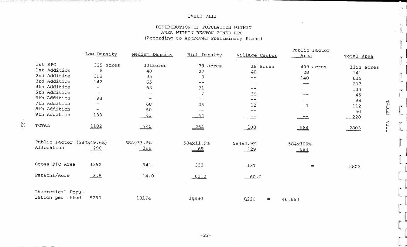
TABLE VIII
DISTRIBUTION OF POPULATION WITHIN AREA WITHIN RESTON ZONED RPC
(According to Approved Preliminary Plans)
Medium Density High Density Village Center
321acres 79 acres 18 acres 40 27 40 95 3 65 63 71
7 38
68 25 12 50 43 52
264 108
584x33.6% 584x11.9% 584x4.9% 196 69 29
941 333 137
14.0 60 .0 60 .0
133.74 19980 £>220
Public Factor Area
409 acres 28
140
584
584x100% 584
46,664
Total Area
1152 acres 141 636 207 134 45 98
> 112 to ir1 50
228
2803 H H
2803
1st 1st 2nd 3rd 4 th 5 th 6 th 7 th 8th 9th
i fO fo TOTAL 1
RPC Addition Addition Addition Addition Addition Addition Addition Addition Addition
Low Density
325 acres 6
398 142
98
133
Public Factor (584x49.6%) Allocation 290
Gross RPC Area 1392
Persons/Acre 3.8
Theoretical Population permitted 5290
-22-

Plat showing area of subdivided part of Reston, and parts for which f inal have been approved.
De-us/ty Computations
On/o/NAL Mastpp Plan
SECTIONS <S, 8, /O, /2, }<A, /8,
AMD ze
RESTON MASTER PLAN PARCELS AAJD DENSITY ACREAGES
ZONING /IS OF OCT 20, I2GG
REVISED- OCTOBER,/970 POM ZONED AND SUBDIVIDED
A ME AS ONLY
-23-

TABLE IX
DWELLING UNIT DISTRIBUTION IN PARTS OF RESTON FOR WHICH FINAL PLANS HAVE BEEN APPROVED
(Units Planned) Single Family Town Garden High
Section Detached Hous: Apts Rise
(a) Northern Section
1st 1st Add. to 1
80 271 173
46 152
299
2nd Add. to 1 3 5 7 7-A 9
8 34
174
202 26 48
366
48
261 198
276
9-A 42
9-B 11 133
13 15 15-A 17 19 21
227 230
132 216 545 240 230
150 200
23 96
Sub-Total N. 301 1, 681 2, 201 925
Streets (outside of Sects)
Catholic Church
TOTAL NORTH 301 1,681 2.201 925
-24-
Page 1 of 2
Total Dwelling Units
696 325 8
512 74 48 261 738 42
133
132 216 927 670 230 96
5,108
5 ,108
Gross Area
155 63 3 81 10 8 13 231 7 4 13 3 7 13 83 82 25 12.
813
16
10
839

10 .03 persons/Gr<
839
• I
Page 2 of 2
TABLE IX (cont'd.)
(Units Planned) Total Single Family Town Garden High Dwelling Gross
Section Detached House Apts . Rise Units Area
Carried Forward -North Section 301 1,681 2,201 925 5,108
(b) Southern Section
2 79 21 - 100 96
4 132 - _ 132 125
4-A 88 - - 88 113
6 131 - - 131 108
8 98 - - 98 111
10 130 - - 130 101
12 73 -_ 73 83
14 48 - - 48 21
16 136 -_ 136 132
18 114 - - 114 98
26 135 125 - 260 67
Sub-Total S. Route #602
1,164 -
146 - -
—
-
1,310 —
1, 055 1
Stable — - - - - 4
TOTAL - SOUTH 1,164 146 _ 1, 310 1,060
TOTAL RESTON 1,465 1,827 2,201 925 6,418 1,899
Persons/Unit 3.8 3.0 3.0 1.5
Theoretical Population 5,567 5,481 6,603 1,388 = 19,039
Theoretical Population -• 19.039 10 .03 persons/Gr< oss Residential Acre Gross Residential Acre 1,899
Note: 13 persons/Gross Residential Acre permitted by Ordinance.
-25-

TABLE X
ANALYSIS OF PUBLIC FACTOR IN PARTS OF RESTON FOR WHICH
FINAL PLANS HAVE BEEN APPROVED
Section Number Streets Schools Lake
Golf Courses
Recre ation Areas
I 1st.Add. 2nd. Add. 3 5
17 8
13 2
10 28 9 5
11
7-A 9 9-A 9-B II 13 15 15-A 17 19 21 23
22 1
3 4
13
14 6 2
Misc.open Space & Comm. Fac. (Wiehle No. Shore, Cath. Church 16
Sub-Total North 86 37 28 34
Sec. 25 N. Golf Crse 164
TOTAL NORTH 86 37 28 164 34
-26-

717
Page 2 of 2
TABLE X (cont'd.)
Section Streets Schools Lake
Golf Courses
Recreation Areas
Parks & Misc. Open
Church
Carried Forward Kjorth Section J.1 v >L C X X M V1 w1 J— V A * 86 37 28 164 34 65 30 444
2 4 4-A 6 8 10 12 14 16 18 26 Stable Rt. 602 XX L. A W W 4d
Sub-Total South
H.W. School X J. & Bl e fc—' X* * A
TOTAL SOUTH
9 18 11 13 12 12 14 4 14 10 6
123
123
14
14 11
25
3 4
3 4 1
15
15
34 36 17 30 49 28 33 2 26 16 17
288
288
46 58 28 42 61 40 47 6 40 40 26 4 1
439 11
450
TOTAL RESTON 209 62 28 164 49 353 30 894
Total Reston w/o N. Golf Crse. & H.W. School 209 51 28 49 351 30 717
-27-

__
TABLE XI
CALCULATION OF GROSS RESIDENTIAL AREA IN PARTS OF RESTON
FOR WHICH FINAL PLANS APPROVED
Net Residential % of Public Factor Gross Residential Section No. Area (Acres) ± Total x (Acres) = Area—(Acres)
(a) Northern Section
=
1 85 + 15 .2 X 278 (42) 127 ii — 1st Add. to 1 46 + 8.2 X 1!
(23) 69
2nd. Add. to 1 2 + 0.4 X ( 1) — 3
52 + 9.3 X II (26) — 78 3 8 + 14 X II ( 4) = 12 5
7 8 + 14 X 11 ( 4) = 12
7-A 13 + 2.3 X 11 ( 6) = 19
9 155 + 27 .6 X 19 (77) = 232
9-A 6 + 1.1 X 11 ( 3) 9 —
= 9-B 11
-
13 + -
2.3 X IE ( 6) 19 -13
—
15 -
7 + 1.3 X II ( 4) = — 11
15-A 11 + 2.0 X II ( 5) 16
17 68 + 12.1 X II (34) = 102 II (29) = 88 o
I —I
D Le X + 19 59 II = 24 ( 8) II ( 6) 18
+ 2.9 X 21 16 + 2.1 X 23 12
TOTAL NORTH 561 + 100.0 X (278) = 839
(b) Southern Section
-50 + 8.1 X 86 439 (36) II 2 o
1 —1
0 0 114 (47) ll (60) 145
X 4 67 + + 13.7 X 4-A 85
6 66 + 10.6 X II = 112 (46) IK (36) = 86 8 50 + 00
H
X + 9.8 10 61 X II = 104 (43)
= II (25) 61 (ID
+ 5.8 X 12 36 = 26 15 + 2.4 X 14
It
= II 14.8 X (65) 157 " 16 92 II = 99 (41) II (29) = 70
+ 9.3 X 18 58 26 41 + 6.6 X
= TOTAL SOUTH 621 + 100.0 X 439 1,060
=
TOTAL RESTON 1, 182 + 100.0 X 717 1,899
-28-

Page 1
TABLE XII
THEORETICAL POPULATION OF PARTS OF RESTON FOR WHICH FINAL PLANS APPROVED
(a) Northern Area (dwelling units)
Section Number
Single Family
Town Houses
Garden Apartments
High Rise
Total d.u.,
Low Density Section 9 174 38 212
Low Total 174 38 212
Persons/d.u. x3.8 x3 .0
Theoretical Population 661 JJA 775
Medium Density Section 1 80 230 - — 310
1st Add. to 1 - 173 152 — 325
2nd Add. to 1 8 _ - — 8
Section 3 34 202 - 276 512
Section 5 - 26 48 - 74 Section 7 - 48 - - 48
Section 9 - 328 198 - 526
Section 9-A - 42 - - 42
Section 9-B - - - — —
Section 11 - - 133 - 133
Section 13 - - — — —
Section 17 5 179 440 - 624
Section 19 - 230 - - 230
Section 21 - - 230 - 230
Section 23 - 96 - - 96
Medium Total 127 1554 1201 276 3158 Persons/d.u. x3•8 x3.0 x3.0 xl.5
Theoretical Population 483 4662 3603 414 — 9162.
High Density Section 1 Section 7-A
41 46 261
299 -
386 261
Section 9 1 Section 15 132 - 132
Section 15-A 216 - 216
Section 17 - 48 105 150 303
Section 19 - ~ 240 200 440
High Total Persons/d.u.
89 x3.0
1000 x3 .0
649 xl. 5
1738
Theoretical Population 267 3000 974 = 4241
TOTAL THEORETICAL POPULATION - NORTH SECTION
6603 1388 = 14178
-29-

Page 2 of 2
TABLE XII (cont'd-)
Gross Section Number
Single Family
Town Houses
Garden Apartments
High Rise
Total d.u.
Residential Area (Acres!
Carried forward North Sec. 1144 5043 6603
(b) Southern Area (Dwelling Units)
1388 = .,14178
Low Density Section 2 79 21 - - 100 96 Section 4 132 - - - 132 125 Section 4-A 88 - - - 88 113 Section 6 131 - - 131 108 Section 8 98 - - - 98 111 Section 10 130 - - - 130 101 Section 12 73 - - - 73 83 Section 14 48 - - - 48 21 Section 16 136 - - - 136 132 Section 18 114 - - - 114 98
Low Total 1029 21 - 1050 persons/d.u. x3.8 x3.0
Theoretical Population 3910 63 ~ ~ = 3973
Medium Density Section 26 135 125 - - 260 67 persons/d.u. x3.8 x3.0
Theoretical Population 513 375 888
High Density None
TOTAL THEORETICAL POPULATION -SOUTHERN SECTION
4423 438 - - 4861
TOTAL THEORETICAL POPULATION -ALL OF RESTON
5567 5481 6603 1388 19039
-30-

CONCLUSION
The tables demonstrate that as of 1970, Reston is developing
as it was planned in 1962 and considerably below the population
density limits established by Fairfax County in the RPC Ordinance.
2803 acres have been zoned RPC (Table VIII); 1899 acres have been
subdivided (Table IX). When the subdivided areas have been developed
in accordance with approved final plans, Reston will contain 6418
dwelling units and a theoretical population of 19,039 persons. The
population density will be 10.03 persons per acre as compared with
the limit of 13 persons per acre (Table XI). The 6418 approved
dwelling units consist of 1465 single-family detached houses, 1827
townhouses, 2201 garden apartments and 925 high-rise units. 584
acres of the 2803 RPC-Zoned acres are designated on preliminary
plans as the Public Factor (Table VIII), but that tells only part
of the story. The density bank presently contains 717 acres (Tables
X and XI) since additional public factor acres are indicated on
final plans over those shown on preliminary plans. The 717 acres
in the density bank will shortly increase to 894 acres (Table X)
by the inclusion of the Hunters Woods School and the Reston North
Golf Course. Those two areas will be added to the density banl
when they are either included within a recorded subdivision or
subjected to an open space easement. Also to be included in the
future are the Reston South Golf Course (about 160 acres), the
south lakes (85 acres), and ten elementary, two intermediate, and
two high school sites not yet defined as to location. If the areas
in the density bank outside subdivided areas were considered, the
population density of the 1899 acres for which final plans have
-31-

been approved would fall below 10 persons per acre. The reasons
present density falls so far below the planned ultimate density
are that many of the open space requirements for the entire
community, such as golf courses and lakes, have been met ahead
of need and because a large percentage of land so far subdivided
falls within the low density category. Overall per acre density
will increase as future development includes a greater proportion
of high and medium density.
In conclusion, the RPC Ordinance is working: Reston is
developing as it was planned in a variety of housing types; the
public factor is greater than the 42% foreseen by the Staff in
1962; and population density has been successfully controlled at
the subdivision point.
-32-