Embed Size (px)
Citation preview

Responding to environmental Responding to environmental emergencies in real time at emergencies in real time at the Canadian Meteorological the Canadian Meteorological
Center using SPICenter using SPI(as a management and visualisation tool for global to local scale (as a management and visualisation tool for global to local scale
emergencies)emergencies)
Jean-Philippe Gauthier BilodeauJean-Philippe Gauthier Bilodeau
ECMWF 10ECMWF 10thth Workshop on meteorological operational systems Workshop on meteorological operational systems
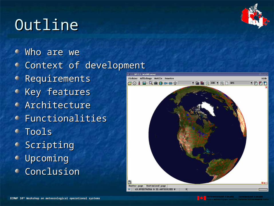
OutlineOutline
Who are weWho are we
Context of developmentContext of development
RequirementsRequirements
Key featuresKey features
ArchitectureArchitecture
FunctionalitiesFunctionalities
ToolsTools
ScriptingScripting
UpcomingUpcoming
ConclusionConclusion

ECMWF 10ECMWF 10thth Workshop on meteorological operational systems Workshop on meteorological operational systems
Who are we Who are we (within CMC)(within CMC)
Environmental Emergency Response Division (EER)Environmental Emergency Response Division (EER)24/7 Operational response capacity24/7 Operational response capacityAir transport and dispersion modelling Air transport and dispersion modelling Global to local scalesGlobal to local scalesR&D work related to EER activitiesR&D work related to EER activitiesOfficial mandates : Official mandates :
VolcanicVolcanicNuclearNuclear
Other applications: dispersion modeling for Other applications: dispersion modeling for chemical and biological (virus),chemical and biological (virus),forest firesforest firesinsect migrationinsect migration……
ECMWF 10ECMWF 10thth Workshop on meteorological operational systems Workshop on meteorological operational systems
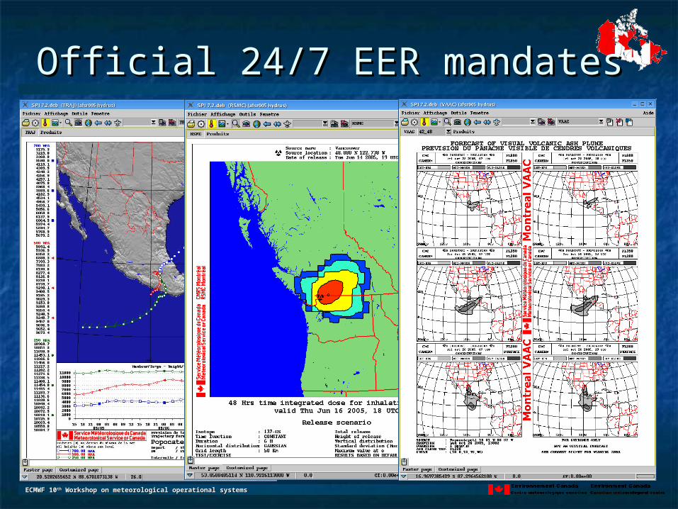
Official 24/7 EER mandatesOfficial 24/7 EER mandates
Canadian Meteorological CenterCanadian Meteorological Center
VAAC (Volcanic Ash Advisory Center)VAAC (Volcanic Ash Advisory Center)
RSMC (Regional Specialized Meteorological CenterRSMC (Regional Specialized Meteorological Center
CTBT (Comprehensive Test Ban Treaty)CTBT (Comprehensive Test Ban Treaty)
National dispersion guidanceNational dispersion guidance
ECMWF 10ECMWF 10thth Workshop on meteorological operational systems Workshop on meteorological operational systems
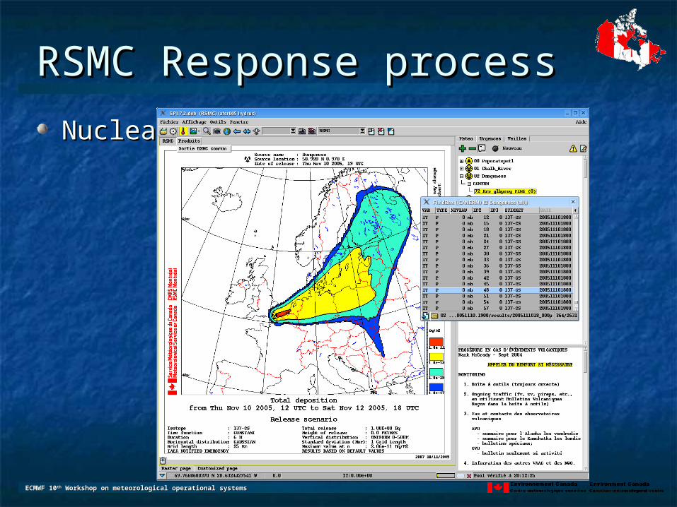
RSMC Response processRSMC Response process
Nuclear emergency at DungenessNuclear emergency at Dungeness
ECMWF 10ECMWF 10thth Workshop on meteorological operational systems Workshop on meteorological operational systems
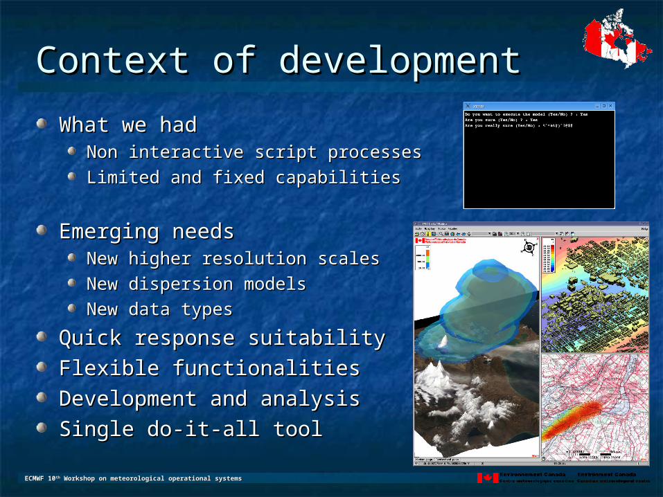
Context of developmentContext of development
What we hadWhat we hadNon interactive script processesNon interactive script processes
Limited and fixed capabilitiesLimited and fixed capabilities
Emerging needsEmerging needsNew higher resolution scalesNew higher resolution scales
New dispersion modelsNew dispersion models
New data typesNew data types
Quick response suitabilityQuick response suitability
Flexible functionalitiesFlexible functionalities
Development and analysisDevelopment and analysis
Single do-it-all toolSingle do-it-all tool

ECMWF 10ECMWF 10thth Workshop on meteorological operational systems Workshop on meteorological operational systems
RequirementsRequirements
Stability / RobustnessStability / Robustness
EfficiencyEfficiency
Extensibility / FlexibilityExtensibility / Flexibility
Simplicity / Support workloadSimplicity / Support workload
Ease of useEase of use
Scripting / AutomatisationScripting / Automatisation
Portability (Software – Hardware)Portability (Software – Hardware)
ECMWF 10ECMWF 10thth Workshop on meteorological operational systems Workshop on meteorological operational systems
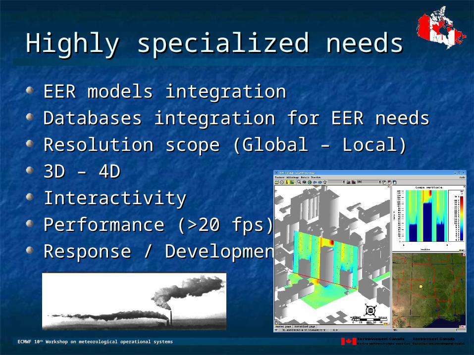
Highly specialized needsHighly specialized needs
EER models integrationEER models integration
Databases integration for EER needsDatabases integration for EER needs
Resolution scope (Global – Local)Resolution scope (Global – Local)
3D – 4D3D – 4D
InteractivityInteractivity
PerformancePerformance (>20 fps) (>20 fps)
Response / DevelopmentResponse / Development

ECMWF 10ECMWF 10thth Workshop on meteorological operational systems Workshop on meteorological operational systems
In house developmentIn house development (Why is it such a good (Why is it such a good
idea for us)idea for us)
By in house we mean within the divisionBy in house we mean within the division
Complete knowledge of the applicationComplete knowledge of the application
Bug fixing within minutes, not monthsBug fixing within minutes, not months
New needs answered within hours or daysNew needs answered within hours or days
Handling of specific situations on the flyHandling of specific situations on the fly
Development process simpleDevelopment process simple
Project management simplifiedProject management simplified

ECMWF 10ECMWF 10thth Workshop on meteorological operational systems Workshop on meteorological operational systems
Key featuresKey features
Page conceptPage concept
Visualisation and Data objectsVisualisation and Data objects
Viewport / Projection / CameraViewport / Projection / Camera
Layering vs Real worldLayering vs Real world
Always 3DAlways 3D
InteractivityInteractivity
LayoutsLayouts
ScriptingScripting
WYSIWYGWYSIWYG
ECMWF 10ECMWF 10thth Workshop on meteorological operational systems Workshop on meteorological operational systems
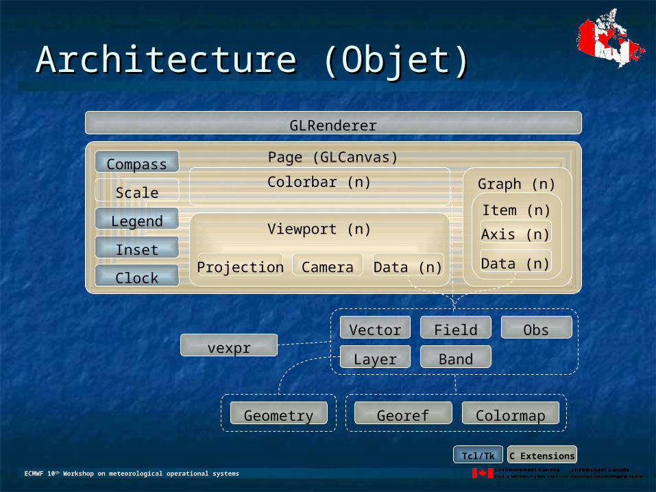
Architecture (Objet)Architecture (Objet)
Page (GLCanvas)
Viewport (n)
Projection Camera
Field
Graph (n)
Item (n)
Axis (n)
Obs
Layer Band
Data (n) Data (n)
Vector
GLRenderer
vexpr
GeorefGeometry Colormap
Colorbar (n)Compass
Scale
Legend
Inset
Clock
Tcl/Tk C Extensions
ECMWF 10ECMWF 10thth Workshop on meteorological operational systems Workshop on meteorological operational systems
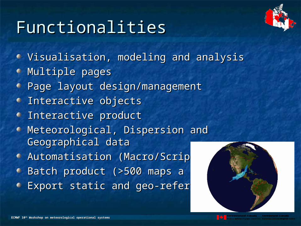
FunctionalitiesFunctionalities
Visualisation, modeling and analysisVisualisation, modeling and analysis
Multiple pagesMultiple pages
Page layout design/managementPage layout design/management
Interactive objectsInteractive objects
Interactive productInteractive product
Meteorological, Dispersion and Geographical dataMeteorological, Dispersion and Geographical data
Automatisation (Macro/Script)Automatisation (Macro/Script)
Batch product (>500 maps a day)Batch product (>500 maps a day)
Export static and geo-referencedExport static and geo-referenced
ECMWF 10ECMWF 10thth Workshop on meteorological operational systems Workshop on meteorological operational systems
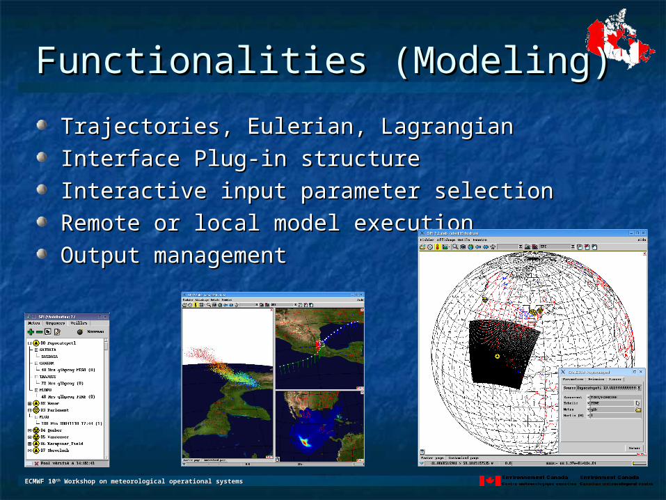
Functionalities (Modeling)Functionalities (Modeling)
Trajectories, Eulerian, LagrangianTrajectories, Eulerian, Lagrangian
Interface Plug-in structureInterface Plug-in structure
Interactive input parameter selectionInteractive input parameter selection
Remote or local model executionRemote or local model execution
Output managementOutput management

ECMWF 10ECMWF 10thth Workshop on meteorological operational systems Workshop on meteorological operational systems
Functionalities (Visualisation)Functionalities (Visualisation)
Model Data (Meteorological and dispersion)Model Data (Meteorological and dispersion)
Observation DataObservation Data
Geographical Data (Vector, Raster)Geographical Data (Vector, Raster)1:50000 and 1:250000 topographic maps Canadian coverage1:50000 and 1:250000 topographic maps Canadian coverage
Multiple viewportMultiple viewport
Always 3DAlways 3D
3D Objects3D Objects
VolumeVolume
Fly-bysFly-bys

ECMWF 10ECMWF 10thth Workshop on meteorological operational systems Workshop on meteorological operational systems
Functionalities (Analysis)Functionalities (Analysis)
Vectorial expression parserVectorial expression parserArithmetic, statistic, logical,…Arithmetic, statistic, logical,…
Graphs Graphs Cross-Section, Vertical profile, Time profile, Time Cross-Section, Vertical profile, Time profile, Time Series, Scatter plot, Contingency diagram, …Series, Scatter plot, Contingency diagram, …
Easy observation data integrationEasy observation data integration
Data manipulation functionalitiesData manipulation functionalities

ECMWF 10ECMWF 10thth Workshop on meteorological operational systems Workshop on meteorological operational systems
ToolsTools
Extension architectureExtension architecture
AnimatorAnimator
DrawingDrawing
Geographical Data Geographical Data ManagerManager
Macro ManagerMacro Manager
ConsoleConsole
Message WriterMessage Writer
Your toolYour tool

ECMWF 10ECMWF 10thth Workshop on meteorological operational systems Workshop on meteorological operational systems
ScriptingScripting
Same language than application itself (TCL)Same language than application itself (TCL)
Extended for our needsExtended for our needs
Maximum versatilityMaximum versatility
Access to all of application functionsAccess to all of application functions
Simple self contained data Simple self contained data objectsobjects
Powerful, simple and efficientPowerful, simple and efficient
Not only mapping but Not only mapping but processingprocessingReplace binaries with unified Replace binaries with unified scriptsscripts
ECMWF 10ECMWF 10thth Workshop on meteorological operational systems Workshop on meteorological operational systems
UpcomingUpcoming
Pixel/vertex shadersPixel/vertex shaders
ThreadThread
More GIS CapabilitiesMore GIS Capabilities
Add Cache/Performance on rasterAdd Cache/Performance on raster
New graph types (box plot, 3D graphs, …)New graph types (box plot, 3D graphs, …)
Performance, … yet againPerformance, … yet again
Distribution setup (LGPL)Distribution setup (LGPL)
DemoDemo

ECMWF 10ECMWF 10thth Workshop on meteorological operational systems Workshop on meteorological operational systems
If (Time left >2Min) thenIf (Time left >2Min) then

ECMWF 10ECMWF 10thth Workshop on meteorological operational systems Workshop on meteorological operational systems
ConclusionConclusion
Operational EER response tool developed at Operational EER response tool developed at CMC over the past 6 yearsCMC over the past 6 yearsUsed in a 24/7 highly specialized environmentUsed in a 24/7 highly specialized environmentFlexible design for easy expansion to meet Flexible design for easy expansion to meet emerging needs in high resolution modelingemerging needs in high resolution modelingUser-friendliness and performance to meet User-friendliness and performance to meet strict operational requirements strict operational requirements Integration of global to local meteorological, Integration of global to local meteorological, dispersion and GIS datadispersion and GIS dataAdvanced functionalities and flexibility for Advanced functionalities and flexibility for R&D purposesR&D purposes