Embed Size (px)
Citation preview

Presentation Identifier (Title or Location), Month 00, 2008
Resource and Environmental Studies on
the Marcellus Shale
Daniel J. Soeder, NETL
Geology and Environmental ScienceMorgantown, WV

2
National Energy Technology Lab
• Functions within USDOE
Office of Fossil Energy
• Only federally owned and
operated National Laboratory
• Locations in
– Morgantown, WV
– Pittsburgh, PA
– Albany, OR
– Houston, TX
– Fairbanks, AK
• Expertise includes coal,
natural gas, oil and related
environmental technology
• Organized into 7 units:– Strategic Center for Natural Gas
and Oil (SCNGO)
– Strategic Center for Coal (SCC)
– Office of Research and
Development (ORD)
– Office of Systems, Analyses
and Planning (OSAP) (econ)
– Project Management Center
(PMC) (utilization)
– Plus 2 internal business units

3
ORD Shale Gas Project Areas
Resource Characterization Improve the predictability of recoverable gas from the Marcellus Shale and
other gas shales.
Constrain estimates of gas-in-place.
Environmental Assessment Measure the environmental impacts from shale gas drilling and production.
Perform a rigorous environmental assessment at a “typical” well site.
This seminar: Brief history of shale geology and gas development
Summary of NETL resource characterization program
Discussion about environmental impacts and assessment
Questions and conversation

4
What is Shale?o Sedimentary rock formed from mud
o Composed of fine-grained material: clay,
quartz, organic matter, and other minerals.
o Clay-rich shales are fissile: split into thin sheets
o Shale types: organic-rich (black) and organic
lean (gray or red)
o Shale porosity ~ 10%, permeability is very low.
Pore spaces between grains are small.
o Gas occurs in fractures, in pores and adsorbed
onto organic materials and clays.
o High permeability pathways are needed for
economical rates of gas production.

5
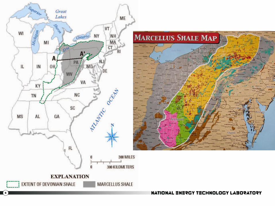
Why “Marcellus” Shale?
Geologists name rocks after a location
where the exposures are representative
of the formation.
This is known as the “type locality.”
Descriptions are published in the
scientific literature (Cooper,1936)
The type locality for the Marcellus Shale
is an outcrop on Slate Hill, a mile south
of the town of Marcellus, New York, in
Onondaga County.
Town named for Marcus Claudius
Marcellus (268–208 BC), a famous
Roman general and consul.
6

7
Appalachian Basin Stratigraphy

8
From Boyce, 2010: Middle Devonian (390 MA)
9
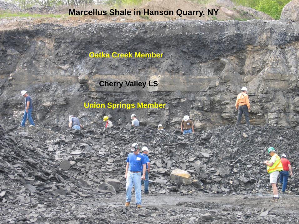
Marcellus Shale in Hanson Quarry, NY
Oatka Creek Member
Cherry Valley LS
Union Springs Member

10
Basic Petroleum Geology
Conventional Reservoir: concentrated deposit of recoverable oil and/or gas.
NEED:
1. Source rock: 1-2% organics (kerogen)a. Types I and II kerogen (petroleum + gas)
b. Type III kerogen (coal + gas)
2. Thermal maturity
3. Reservoir rock
4. Seal and Trap
5. Migration pathway
If any one of these is missing,
no production.
Shale gas: Need only 1 and 2

11
Why is the resource so large?

12
Microscopic Features in Black Shale
Woody
organic >
10 µm
Pyrite >
Microfracture parallel to bedding
Nanoporosity inside kerogen

13
Marcellus φ & K Remarkably High

14
Findings published in March, 1988:
National Petroleum Council had
assessed the gas potential of
Appalachian Basin shales at 0.1 to 0.6
scf/ft3 in 1980.
“…the measured initial reservoir
pressure of the Marcellus Shale in
EGSP Well WV-6 was 3500 psi
…(which) results in a potential in-situ
gas content of 26.5 scf/ft3…”
Data showed 44 to 265 times as much
gas in shale as NPC estimate.

15
Vertical versus Horizontal Wells
Mitchell Energy – offshore directional drilling technology applied to Barnett Shale, 1990’s
Range Resources – applied “Barnett” completion to Marcellus Shale in 2005

16
Hydraulic Fracturing• Hydraulic fracturing for gas and oil has been used since 1949.
• A hydrofrac creates high-permeability pathways into a formation.
• Hydraulic fractures are made by filling the well with fluid and then
increasing the pressure until the rock strength is exceeded.
• Fluid and proppant are pumped out into the fractures; the proppant stays
behind and keeps the fractures open after pressure is released.

17
Marcellus Gas Production
• Range Resources, Renz #1 well,
October 2004, Washington County,
PA; vertical, poor return from Trenton
– Black River Limestone, tested
Marcellus Shale; IP 300 MCFD
• Range Resources, Gulla #9 well,
2005; “Barnett completion” drilled
horizontally, IP 4 MMCFD
• November, 2008: Engelder estimated
recoverable gas from the Marcellus
at 363 TCF; since revised upward.
• With the addition of shale gas, some
industry executives claim the total
energy value of domestic natural gas
is twice the amount of oil in Saudi
Arabia.

18
Hot spots in the southern
Marcellus Play: SW corner
of Pennsylvania, north-
central WV and the northern
panhandle, small piece of
southeastern Ohio
A “play” in oil and gas is
defined as geologically
similar prospects with a
similar source, reservoir,
and trap controls on
hydrocarbon migration,
accumulation, and storage.
(Patchen, 1996)
In plain English: Find out
where other people are
successfully drilling, and go
drill there.

19
NETL Characterization Research
Tools:
Rock Petrography Lab (NETL-MGN)
• Standard petrographic microscopes
• Source Rock Analyzer (RockEval)
• Scanning electron microscopy with ion
polisher (NETL and LBNL)
Precision Petrophysical Analysis Lab (WVU)
• Porosity and permeability of shale
• Behavior under in situ pressures
Rock and brine chemical analyses
• Separation Design Group, Waynesburg PA
• Geochemical expertise at WVU Department
of Geography & Geology
X-ray Computerized Axial Tomography (CAT
Scan)
• Current Medical C-T scanner: 250 micron
resolution
• New Industrial C-T scanner in Morgantown:
5 micron resolution
• New Micro-CT scanner in Pittsburgh: 1
micron resolution; testing on shale
Geologic Framework Model (EarthVision)
Carbon Sequestration Lab (NETL-PGH)
• Pore size distribution
• Behavior of different gases in pore system
Which properties control the amount of gas in shale?
How do these properties vary with geology, and are they predictable?
Can the resource estimates of recoverable shale gas be better constrained?

20
Resource Characterization Summary
• Goal: better understand links between Marcellus Shale geology and
gas productivity.
• Outcome: improve gas shale resource predictability.
• Applications: gas resources in other shales; behavior of shale with
other gases.
• Benefits: policymakers, small drillers, regulators and the general
public.

21
DOE goal: Encourage the production of domestic energy resources in an
environmentally-responsible manner.
Three problems with shale gas:
Not all of the potential environmental impacts are known • What are the long-term and cumulative effects on the landscape, terrestrial and aquatic
ecosystems, water resources, and air quality?
• Which environmental impacts are more important than others?
Some known environmental impacts are not regulated• Surface water withdrawals are not regulated in West Virginia
• Brine discharge regulations in Pennsylvania were lax until recently
Existing regulations are not fully enforced.• West Virginia has 17 inspectors for hundreds of oil and gas wells
• Pennsylvania has lost many personnel from DEP and DCNR to industry
Models for approaches to regulation of gas production:
• Drug company model: prove the product is safe before proceeding
• Automobile company model: proceed with best design; fix any problems
Environmental Issues - Marcellus Shale

22
NETL Environmental Objectives
Programmatic Goals Investigate the short and long term environmental impacts of drilling for
gas in the Marcellus Shale.
Obtain data to help regulators assess environmental indicators.
Project Objectives Measure baseline environmental parameters prior to drilling.
Monitor air, water, habitat, soil, landscape and ecological impacts during drilling and production phases, and for some time afterward.
Investigate landscape effects, resettlement, succession and edge effects.
Anticipated outcomes:
• Improve BMPs for shale gas production to reduce environmental impacts.
• Define environmental indicators for focused regulatory monitoring.
• Publish data to create a more informed environmental debate.

23
Short and Long Term Issues
Short Term (construction)• Water withdrawals
• Flowback disposal
• Light and noise
• Drilling ponds – wildlife
• Air quality
• Seismic activity
Long Term (occupancy)• Pad on landscape
• GW contamination
• Habitat fragmentation
• Solids disposal on site
• Invasive species
• Edge effects; succession

24
Impacts to Landscapes
• The 3 to 4 million gallons of water needed to fracture a well must be transported to the drill site.
• Proppant (sand) and chemical additives must also be brought in.
• Many drill pads are only accessible by unimproved rural roads.
• Small watersheds and headwater streams may be at risk from erosion, sedimentation and spills.
• Invasive species might hitchhike with the water and equipment.
• Impoundments can leak into streams and groundwater.

25
145 pieces of equipment on 5-acre drill pad for Marcellus Shale hydrofrac

26
Drilling and Water Resources
• Each stage of a hydrofrac uses 300,000 to 500,000 gallons of water, up to 3 to 4 million gallons per well.
• Water resource agencies (SRBC) allow frac water withdrawals at high flows under an industrial water use permit. Not all locations require permits (WV).
• Non-permit withdrawals: streamflow? Flow bypass requirements? Other withdrawals from same stream?
• Proper disposal of flowback fluids
– Wastewater treatment - TDS
– Reinjection
– Recycling

27
Flowback Fluid
• Hydrofrac fluid is in contact with the rock; about 25% is recovered after the frac and pumped back out.
• Porewater in the Marcellus Shale is very salty with high TDS.
– Concentrated brine, not dissolved solids from pore minerals.
– Flowback starts out fresh, and increases in TDS during recovery.
• Source of the brine, and relationship between brine chemistry and bulk rock geochemistry of shale are not well understood.
• Marcellus Shale coalition funded water-quality analysis of fluids
recovered in time series from 19 shale wells:
– chloride at more than 100 g/L (NaCl, MgCl)
– TDS of almost 200 g/L - about 6X seawater
– Barium and strontium are unusually high – source unknown
– Metals present at hundreds of mg/L
– Composition “similar” to other Appalachian brines, but concentrations higher.
– No data on radioactivity or “NORM” because of high TDS

28
Groundwater Contamination
• Can hydraulic fracturing directly
contaminate aquifers?
• Hydraulic conductivity, flow gradients,
the depth of the target formation, and
GWTT suggest that such contamination
is unlikely.
• No definitive evidence of direct water
contamination from deep hydraulic
fracturing has been documented.
• GW contamination from surface spills
and leaky impoundments is a far greater
risk.
• A hydraulic fracturing tracer test with a
drillback experiment to sample aquifers
would provide a definitive answer.

29
Hydraulic Fracture Heights and Aquifers
0
1000
2000
3000
4000
5000
6000
7000
8000
9000
1 51 101 151 201 251 301 351
Dep
th (
ft)
Frac stages (sorted on Perf Midpoint)
Marcellus Mapped Frac Treatments
Deepest Aquifer Depth
fracTOP
perfTOP
Perf Midpoint
perfBTM
fracBTM
OH
PA
WV

30
Reference: Fisher, Kevin, 2010, Data confirm safety of well fracturing, The American Oil and Gas Reporter, July 2010, www.aogr.com
31
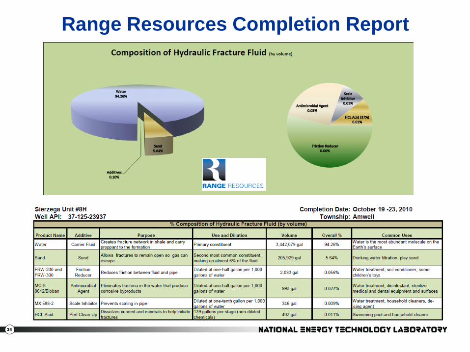
Range Resources Completion Report

32
Surface Leaks and Spills• Much greater threat to groundwater and surface water contamination:
concentration and gravity.
• Spilled hydraulic fracture chemicals may be consumed by animals with
fatal results.
• Monitoring of groundwater downgradient of pad, and stream monitoring
at the mouth of small watersheds could detect chemicals.
DATA NEEDS:
What steps can be taken to protect the
environment from chemicals? (closed
loop, dikes, berms, trenches, fences, etc.)
Foolproof leak detection and warning?
Less toxic substitutes: ozone for biocide
Can volume of chemicals on the pad be
reduced? (premixing, JIT delivery, etc.)

33
Drinking Water Contamination
• Many people are concerned that Marcellus
Shale drilling is a threat to their drinking
water supply (not just New York City).
• Cumulative effects of drilling might degrade
a water supply watershed.
• USEPA (Ada, OK lab) is investigating
possible links between hydrofracs and
drinking water contamination.
– Public input gathered in 2010
– Technical expert workshops scheduled
for spring 2011
• Could a monitoring program on tributaries
and groundwater provide an early warning
for spills?

34
Stray Gas
• Media reports suggest methane in water wells is sourced from
nearby Marcellus Shale production.
• Other possible sources for methane are biogenic gas in aquifer,
shallow coal, or from other shales above Marcellus in an uncased
borehole. Difficult to trace.
DATA NEEDS:
Documentation of possible methane in the well before
the arrival of the drill rig.
Potential for mobilization of pre-existing gas in the
aquifer by vibrations from the drilling activity.
Define the migration path for gas behind a casing to get
into an aquifer and then to a water well.
Investigate the configuration of wells and aquifers from
these incidents
A precise isotopic method or tracer is needed to
determine the origin of the gas.

35
Radioactivity and Metals
• Organic matter in black shale has an affinity for radionuclides.
• Target horizons in the shales have high gamma log counts –
typically above 290 API units.
• Other metals are also a concern: As, Ba, Cd, Co, Cr, Cu, Li, Mn, Mo,
Ni, Pb, Sn, Sr, V, Zn, and Zr measured in Marcellus above MRL
• A leaching study of drill cuttings seeks to define the potential scope
of this issue.
• Funding is uncertain.
Black shale was deposited in anoxic conditions.
Heavy metals in the shale have been in a reduced
state for hundreds of millions of years.
Hundreds of tons of drill cuttings from the black
shale are exposed to oxygen and rain water.
Oxidized forms of metals are usually much more
soluble in water.
Track 1 Track 2Track 3
From Boyce, 2010

36
Existing Stream & Groundwater Contaminants
• BTEX: Benzene, toluene, ethylbenzene, xylenes: the water soluble
components of gasoline, commonly sourced from leaking
underground storage tanks or surface spills.
• DNAPL & LNAPL: non-aqueous phase liquids (jet fuel, diesel)
• Endocrine Disruptors: external compounds that interfere with or
mimic natural hormones in the body (EPA, 1997)
– Sources: pesticides (atrazine, carbaryl), industrial chemicals (phenols, PCBs),
plastics (phthalates), fire-resistant fabrics, detergents, household chemicals,
pharmaceuticals, and synthetic hormones
– Common transmission route: Municipal sewage via wastewater treatment plant
effluent (USGS). Please don’t flush old medicines!
– Effects: intersex fish: Potomac River, Minnesota lakes
• Nitrates: plant fertilizers, sourced from agricultural operations
• Pesticides: herbicides and insecticides from agriculture operations
• Heavy metals: commonly sourced from mining operations
• Chlorinated solvents: engine degreasers, coolant fluids
• Methane and CO2 gas: from natural attenuation of organics

37
Environmental Site Assessment• Interagency meeting in Harrisburg in June 2010, followed by a
meeting with Range Resources.
• Range offered DOE several future site locations for monitoring.
• NETL asked the other agencies from the Harrisburg meeting for
suggestions on what to monitor.
– Six federal agencies: USGS, USFWS, USACE, USFS, NPS, DOE
– Three river basin commissions: Delaware, Susquehanna, Ohio
– Four state governments: NY, PA, WV, MD
• About 150 individual suggestions in total were received.
• Suggestions were compiled into a large spreadsheet, duplicates
combined, suggestions categorized and passed back to Range.
• Range offered Pennsylvania locations in Washington and Lycoming
Counties.
• USEPA is interested in collecting data from these sites and
collaborating on their drinking water study.
• DOE program funding is uncertain – some monitoring will be done.

38
Baseline Monitoring Sites
Allegheny National Forest
Lycoming
Washington
Allegheny
Greene

39
Category Parameters to Monitor before during after
Air Measure methane, CO2, dust, fumes, ozone x x x
Drilling Impacts of noise and lights on wildlife x
Drilling Monitor wildlife use of drilling ponds as a water source x x
Drilling Collect fluid and gas samples during drilling x
Drilling Seismic monitoring of hydrofrac x
Drilling Assess integrity of well and casing x x
Ecology Assessment of land and aquatic species assemblage x x
Ecology Invasive species assessment x x
Ecology Rare, threatened or endangered (RTE) species x x
Habitat Effects of cleared pad on habitat/edge effects x x x
Habitat Resettlement of area afterward; succession x x
Landscape Monitor sediment, erosion and topography changes x x x
Site char Land use, geology, topography, hydrogeologic setting, etc. x
Social Property values, land access, timber, farming, etc x x
Soil Road/pad impacts on soil compaction, infiltration, etc. x x
Water Establish surface water flow monitoring network x x x
Water Establish groundwater monitoring network: existing/new wells x x x
Water Establish water quality monitoring sites x x x

40
NETL SCNGO Environmental ProgramsWater Management
Comprehensive Lifecycle Planning and
Management System for Addressing Water
Issues Associated With Shale Gas
Development in New York, Pennsylvania and
West Virginia-Arthur Langhus Layne LLC
Integration of Water Resource Models with
Fayetteville Shale Decision and Support
Systems-University of Arkansas
Frac Flowback and Produced Water
Cost Effective Recovery of Low-TDS Frac
Flowback Water for Re-Use-GE Global
Research
Pilot Testing: Pretreatment Options to Allow
Re-Use of Frac Flowback and Produced
Brine for Gas Shale Resource Development-
Texas A&M University
An Integrated Water Treatment Technology
Solution for Sustainable Water Resource
Management in the Marcellus Shale-Altela,
Inc.
Sustainable Management of Flowback Water
during Hydraulic Fracturing of Marcellus
Shale for Natural Gas Production-University
of Pittsburgh
Zero Discharge Water Management for
Horizontal Shale Gas Well Development-
West Virginia University
Produced Water Treatment Catalog and
Decision Tool-Arthur Langhus Layne LLC
EPAct Program - External
Barnett and Appalachian Shale Water
Management and Reuse Technologies - Gas
Technology Institute
Pretreatment Processing for Salt By-Product
Recovery- GE Global Research
An Integrated Framework for the Treatment
and Management of Produced Water -
Colorado School of Mines
41
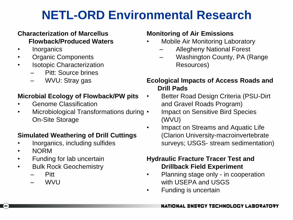
NETL-ORD Environmental Research
Characterization of Marcellus
Flowback/Produced Waters
• Inorganics
• Organic Components
• Isotopic Characterization
– Pitt: Source brines
– WVU: Stray gas
Microbial Ecology of Flowback/PW pits
• Genome Classification
• Microbiological Transformations during
On-Site Storage
Simulated Weathering of Drill Cuttings
• Inorganics, including sulfides
• NORM
• Funding for lab uncertain
• Bulk Rock Geochemistry
– Pitt
– WVU
Monitoring of Air Emissions
• Mobile Air Monitoring Laboratory
– Allegheny National Forest
– Washington County, PA (Range
Resources)
Ecological Impacts of Access Roads and
Drill Pads
• Better Road Design Criteria (PSU-Dirt
and Gravel Roads Program)
• Impact on Sensitive Bird Species
(WVU)
• Impact on Streams and Aquatic Life
(Clarion University-macroinvertebrate
surveys; USGS- stream sedimentation)
Hydraulic Fracture Tracer Test and
Drillback Field Experiment
• Planning stage only - in cooperation
with USEPA and USGS
• Funding is uncertain

42
Marcellus Environmental Summary
Goals
Assess short/long term environmental
impacts.
Address scientific concerns
Outcomes
Rigorous study with well-documented data
Applications
Public information to create a more
informed environmental debate.
Benefits
Improved practices for shale gas
production.
Environmental indicators for focused
regulatory monitoring.

43
Positive Things about Natural Gas
• Energy Independence:
– Natural gas is an abundant domestic resource.
– Expensive and difficult to import as a cryogenic liquid
– Efficiently transmitted over land through a pipeline.
• Infrastructure: A nationwide infrastructure for natural gas already exists, unlike other resources such as wind, solar or ethanol.
• Greenhouse Gas Reduction and Environmental Benefits:
– Gas is the cleanest fossil fuel in terms of air emissions: • No sulfur; no ash as combustion products
• No cracking or refining – essentially pure methane
• Low NOx and ozone, no photochemical smog
• Lowest carbon dioxide emission per BTU of any fossil fuel.
– Can directly substitute for coal and petroleum combustion
– No mountaintop removal mining or offshore drilling is required
– Can be used as a transportation fuel to replace imported oil
– Small gas turbines can economically generate electricity
44
Daniel J. Soeder
USDOE/NETL
3610 Collins Ferry Road
P.O. Box 880
Morgantown, WV 26507
(304) 285-5258
http://www/netl.doe.gov
Questions?
< Eastern Alberta badlands, Canada