Embed Size (px)
Citation preview
Legal Publication(Published in The Derby Informer on October 13, 2021)
Gilmore & Bell, P.C.09/08/2021
RESOLUTION NO. 06-2021
A RESOLUTION STATING THAT THE CITY OF DERBY, KANSAS IS CONSIDERING FURTHER AMENDING ORDINANCE NO. 2242 OF THE CITY THAT ESTABLISHED THE DERBY STAR BOND PROJECT
DISTRICT TO INCLUDE ADDITIONAL PROPERTY IN SUCH DISTRICT; PROVIDING FOR A SUBSTANTIAL CHANGE TO THE DISTRICT PLAN; AND PROVIDING FOR NOTICE OF A PUBLIC HEARING TO
CONSIDER SUCH ACTIONS.
WHEREAS, pursuant to K.S.A. 12-17,160 et seq. (the “Act”), the City of Derby, Kansas (the “City”) is authorized to create a STAR bond project district within an eligible area of the City for certain purposes set forth in the Act; and
WHEREAS, by Ordinance No. 2242, passed on September 8, 2015 and published on September 16, 2015, the City Council of the City (the “Governing Body”) established a STAR bond district pursuant to the Act, designated as the Derby STAR Bond Project District (the “District”) and approved a plan for the District (the “District Plan”); and
WHEREAS, by Ordinance No. 2394, passed on August 27, 2019 and published on September 4, 2019, the City Council of the City (the “Governing Body”) expanded the boundaries of the District and approved a substantial change to the District Plan; and
WHEREAS, the Governing Body desires to expand the boundaries of the District to include an approx-imate 43 acre tract of property within the limits of the City located north east of the intersection of Amber Ridge Road and Tall Tree Road, which is adjacent to the existing District boundaries, in order to provide a site for con-struction of additional public infrastructure and development of a major commercial entertainment and tourism area and related attractions within the District; and
WHEREAS, the Governing Body is authorized by the Constitution of the State of Kansas (particularly Article 12, Section 5) and the Act to pass an ordinance further amending Ordinance No. 2242 to expand the boundaries of the District and adopt a substantial change to the District Plan, subject to conducting a public hearing after notice provided in the Act.
NOW, THEREFORE, BE IT RESOLVED BY THE GOVERNING BODY OF THE CITY OF DERBY, KANSAS, AS FOLLOWS:
Section 1. Ordinance Amendment. The Governing Body is considering an amendment to Ordi-nance No. 2242, as previously amended by Ordinance No. 2394, particularly to Section 3 thereof relating to the District Plan and to Exhibits A and B in order to expand the boundaries of the District to provide a site for con-struction of additional public infrastructure and development of a major commercial entertainment and tourism area and related attractions.
Section 2. Public Hearing. Notice is hereby given that the Governing Body shall conduct a public hearing to consider such ordinance amendments on October 26, 2021 at 6:30 p.m. or as soon thereafter as possible, in the Council Room, Derby City Hall, 611 Mulberry Rd, Suite 300, Derby, Kansas 67037. Following the conclusion of the public hearing, the Governing Body will consider passage of an ordinance that would further amend Ordinance No. 2242 as described in Section 1 hereof, including expansion of the District boundaries to include certain property then located within the boundaries of the City.
Section 3. District Boundaries and Location. The legal description of the District, including the ad-ditional property to be included with the proposed amendment, is contained in Exhibit A hereto. A map generally outlining the boundaries of the District, including the additional property to be included, is attached as Exhibit B hereto.
Section 4. Proposed Changes to District Plan. The District Plan, contained in Section 3 of Ordi-nance No. 2242, as amended, will be further amended to describe the additional improvements anticipated to be made within the contemplated expanded boundaries of the District
Section 5. Document Availability. A copy of such legal description and map referenced in Section 3 hereof and the modifications to the District Plan, when prepared, will be available for inspection by the public during regular office hours at the office of the City Clerk located at the Derby City Hall, 611 Mulberry Rd, Suite 300, Derby, Kansas 67037.
Section 6. Notice. The City Clerk shall give notice of the public hearing in accordance with the pro-visions of the Act, which shall include that a copy of this Resolution, including Exhibits A and B, shall be:
(a) provided via certified mail, return receipt requested, to the Board of County Commissioners of Sedgwick County, Kansas and the Board of Education of USD 260, Sedgwick County, Kansas (Derby);
(b) provided via certified mail, return receipt requested, to each owner and occupant of land within the District and the property proposed to be added to the District not more than 10 days following the date of adoption of this Resolution; and
(c) published once in the official City newspaper not less than one week nor more than two weeks preceding the date fixed for the public hearing.
Section 7. Further Action. The Mayor, City Manager and other officials and employees of the City, including Gilmore & Bell, P.C., Bond Counsel, are hereby further authorized and directed to take such other actions as may be appropriate or desirable to accomplish the purposes of this Resolution.
Section 8. Effective Date. This Resolution shall take effect and be in force from and after its adop-tion by the Governing Body.
ADOPTED by the City Council of the City of Derby, Kansas on September 14, 2021.
(SEAL) /s/ Randy White _________________________________________ Mayor
ATTEST:
/s/ Lynn Ciarleglio_________________________________________ City Clerk
CERTIFICATE
I hereby certify that the above and foregoing is a true and correct copy of the foregoing resolution of the City of Derby, Kansas, adopted by the City Council on September 14, 2021, as the same appears of record in my office.
DATED: September 14, 2021.
/s/ Lynn Ciarleglio _________________________________________ City Clerk
EXHIBIT A
LEGAL DESCRIPTION OF EXISTING DISTRICT BOUNDARIES
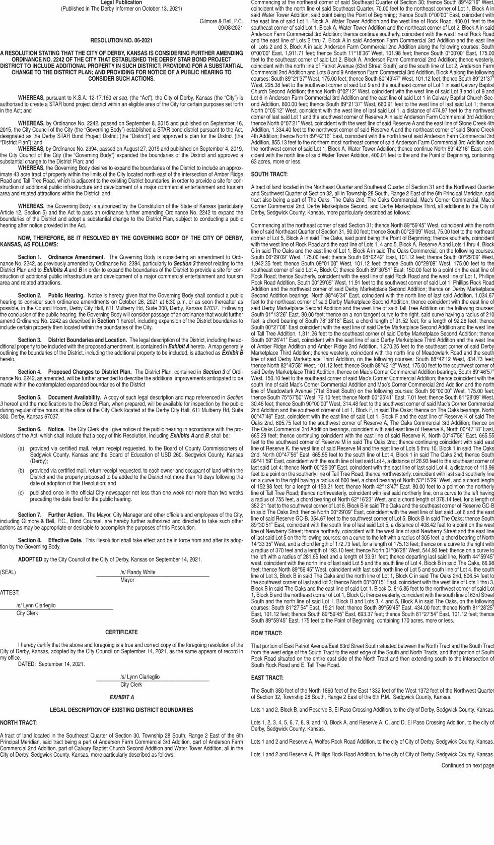
NORTH TRACT:
A tract of land located in the Southeast Quarter of Section 30, Township 28 South, Range 2 East of the 6th Principal Meridian, said tract being a part of Anderson Farm Commercial 3rd Addition, part of Anderson Farm Commercial 2nd Addition, part of Calvary Baptist Church Second Addition and Water Tower Addition, all in the City of Derby, Sedgwick County, Kansas, more particularly described as follows:
Commencing at the northeast corner of said Southeast Quarter of Section 30; thence South 89°42’16” West, coincident with the north line of said Southeast Quarter, 70.00 feet to the northeast corner of Lot 1, Block A in said Water Tower Addition, said point being the Point of Beginning; thence South 0°00’00” East, coincident with the east line of said Lot 1, Block A, Water Tower Addition and the west line of Rock Road, 400.01 feet to the southeast corner of said Lot 1, Block A, Water Tower Addition and the northeast corner of Lot 2, Block A in said Anderson Farm Commercial 3rd Addition; thence continue southerly, coincident with the west line of Rock Road and the east line of Lots 2 thru 7, Block A in said Anderson Farm Commercial 3rd Addition and the east line of Lots 2 and 3, Block A in said Anderson Farm Commercial 2nd Addition along the following courses: South 0°00’00” East, 1,911.71 feet; thence South 11°18’36” West, 101.98 feet; thence South 0°00’00” East, 175.00 feet to the southeast corner of said Lot 2, Block A, Anderson Farm Commercial 2nd Addition; thence westerly, coincident with the north line of Patriot Avenue (63rd Street South) and the south line of Lot 2, Anderson Farm Commercial 2nd Addition and Lots 8 and 9 Anderson Farm Commercial 3rd Addition, Block A along the following courses: South 89°21’37” West, 175.00 feet; thence South 80°49’47” West, 101.12 feet; thence South 89°21’37” West, 295.38 feet to the southwest corner of said Lot 9 and the southeast corner of Lot 1 in said Calvary Baptist Church Second Addition; thence North 0°02’12” West, coincident with the west line of said Lot 8 and Lot 9 and Lot 6 in Anderson Farm Commercial 3rd Addition and the east line of said Lot 1 in Calvary Baptist Church Sec-ond Addition, 800.00 feet; thence South 89°21’37” West, 660.91 feet to the west line of last said Lot 1; thence North 0°05’12” West, coincident with the west line of last said Lot 1, a distance of 474.97 feet to the northwest corner of last said Lot 1 and the southwest corner of Reserve A in said Anderson Farm Commercial 3rd Addition; thence North 0°07’21” West, coincident with the west line of said Reserve A and the east line of Stone Creek 4th Addition, 1,334.40 feet to the northwest corner of said Reserve A and the northeast corner of said Stone Creek 4th Addition; thence North 89°42’16” East, coincident with the north line of said Anderson Farm Commercial 3rd Addition, 855.13 feet to the northern most northeast corner of said Anderson Farm Commercial 3rd Addition and the northwest corner of said Lot 1, Block A, Water Tower Addition; thence continue North 89°42’16” East, coin-cident with the north line of said Water Tower Addition, 400.01 feet to the and the Point of Beginning, containing 63 acres, more or less.
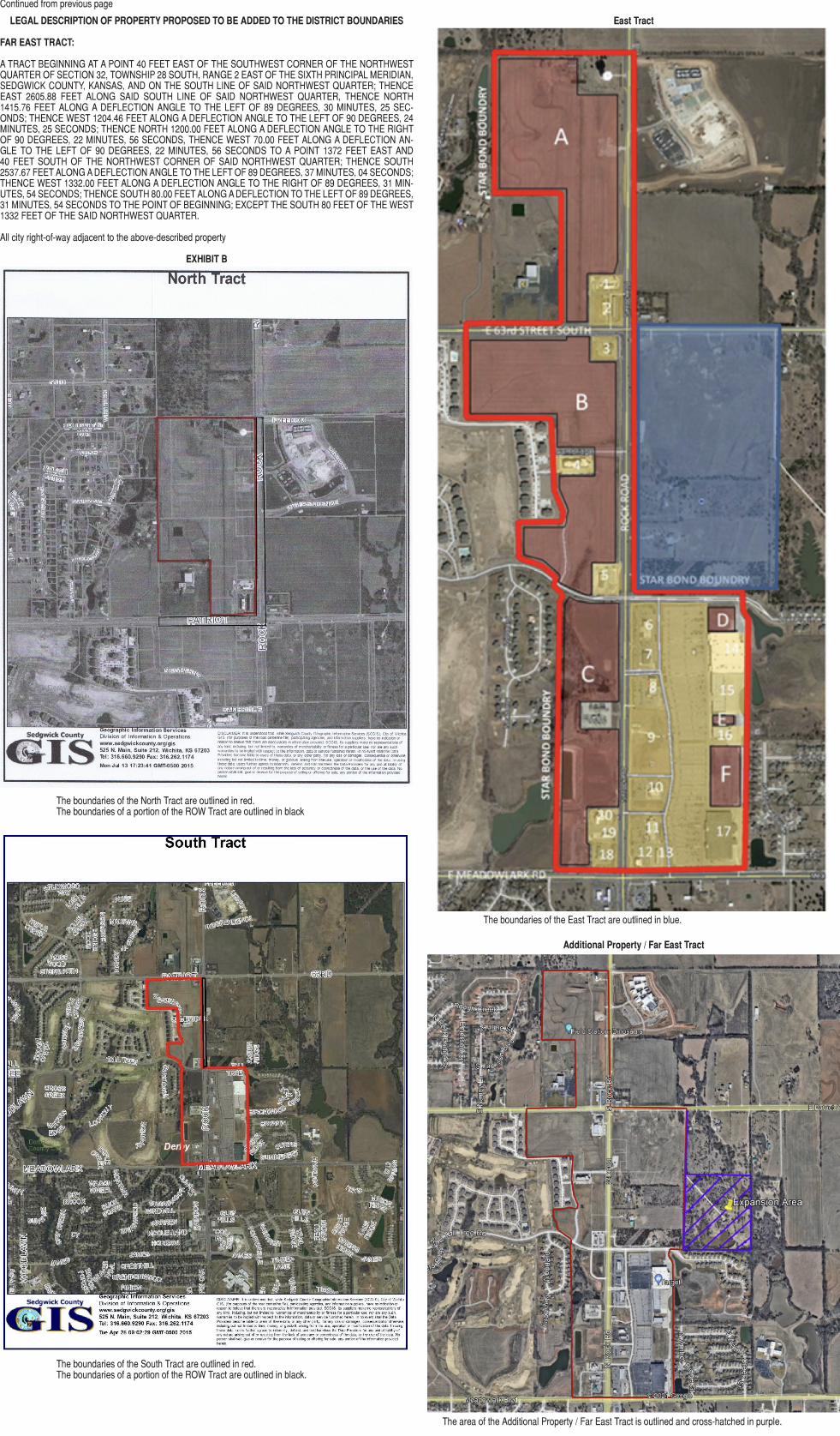
SOUTH TRACT:
A tract of land located in the Northeast Quarter and Southeast Quarter of Section 31 and the Northwest Quarter and Southwest Quarter of Section 32, all in Township 28 South, Range 2 East of the 6th Principal Meridian, said tract also being a part of The Oaks, The Oaks 2nd, The Oaks Commercial, Mac’s Corner Commercial, Mac’s Corner Commercial 2nd, Derby Marketplace Second, and Derby Marketplace Third, all additions to the City of Derby, Sedgwick County, Kansas, more particularly described as follows:
Commencing at the northeast corner of said Section 31; thence North 89°59’45” West, coincident with the north line of said Northeast Quarter of Section 31, 90.00 feet; thence South 00°29’09” West, 75.00 feet to the northeast corner of Lot 5, Block A in said The Oaks, said point being the Point of Beginning; thence southerly, coincident with the west line of Rock Road and the east line of Lots 1, 4 and 5, Block A, Reserve A and Lots 1 thru 4, Block C in said The Oaks and the east line of Lot 1, Block A in said The Oaks Commercial, on the following courses: South 00°29’09” West, 175.00 feet; thence South 08°02’42” East, 101.12 feet; thence South 00°29’09” West, 1,942.35 feet; thence South 09°01’00” West, 101.12 feet; thence South 00°29’09” West, 175.00 feet to the southeast corner of said Lot 4, Block C; thence South 89°30’51” East, 150.00 feet to a point on the east line of Rock Road; thence Southerly, coincident with the east line of said Rock Road and the west line of Lot 1, Phillips Rock Road Addition, South 00°29’09” West, 11.91 feet to the southwest corner of said Lot 1, Phillips Rock Road Addition and the northwest corner of said Derby Marketplace Second Addition; thence on Derby Marketplace Second Addition bearings, North 88°46’34” East, coincident with the north line of last said Addition, 1,034.67 feet to the northeast corner of said Derby Marketplace Second Addition; thence coincident with the east line of said Derby Marketplace Second Addition and the west line of said Tall Tree Addition on the following courses: South 01°13’26” East, 80.00 feet; thence on a non tangent curve to the right, said curve having a radius of 210 feet, a chord bearing of South 78°38’18” East, a chord length of 91.52 feet, for a length of 92.26 feet; thence South 00°27’08” East coincident with the east line of said Derby Marketplace Second Addition and the west line of Tall Tree Addition, 1,311.26 feet to the southeast corner of said Derby Marketplace Second Addition; thence South 00°26’41” East, coincident with the east line of said Derby Marketplace Third Addition and the west line of Amber Ridge Addition and Amber Ridge 2nd Addition, 1,270.25 feet to the southeast corner of said Derby Marketplace Third Addition; thence westerly, coincident with the north line of Meadowlark Road and the south line of said Derby Marketplace Third Addition, on the following courses: South 88°42’12 West, 834.73 feet; thence North 82°45’58” West, 101.12 feet; thence South 88°42’12” West, 175.00 feet to the southwest corner of said Derby Marketplace Third Addition; thence on Mac’s Corner Commercial Addition bearings, South 89°46’57” West, 150.10 feet to the southeast corner of said Mac’s Corner Commercial Addition; thence coincident with the south line of said Mac’s Corner Commercial Addition and Mac’s Corner Commercial 2nd Addition and the north line of Meadowlark Avenue (71st Street South) on the following courses: South 90°00’00” West, 175.00 feet; thence South 75°57’50” West, 72.10 feet; thence North 00°25’41” East, 7.01 feet; thence South 81°28’09” West, 30.46 feet; thence South 90°00’00” West, 314.48 feet to the southwest corner of said Mac’s Corner Commercial 2nd Addition and the southeast corner of Lot 1, Block F, in said The Oaks; thence on The Oaks bearings, North 00°47’46” East, coincident with the east line of said Lot 1, Block F and the east line of Reserve K of said The Oaks 2nd, 605.75 feet to the southwest corner of Reserve A, The Oaks Commercial 3rd Addition; thence on The Oaks Commercial 3rd Addition bearings, coincident with said east line of Reserve K, North 00°47’18” East, 665.29 feet; thence continuing coincident with the east line of said Reserve K, North 00°47’56” East, 665.55 feet to the southwest corner of Reserve M in said The Oaks 2nd; thence continuing coincident with said east line of Reserve K, the west line of said Reserve M and the east line of Lots 5 thru 10, Block 1 in said The Oaks 2nd, North 00°47’56” East, 665.55 feet to the south line of Lot 4, Block 1 in said The Oaks 2nd; thence South 89°41’59” East, coincident with the south line of last said Lot 4, a distance of 28.93 feet to the southeast corner of last said Lot 4; thence North 00°29’09” East, coincident with the east line of last said Lot 4, a distance of 113.96 feet to a point on the southerly line of Tall Tree Road; thence northwesterly, coincident with last said southerly line on a curve to the right having a radius of 800 feet, a chord bearing of North 53°15’29” West, and a chord length of 152.98 feet, for a length of 153.21 feet; thence North 42°13’47” East, 80.00 feet to a point on the northerly line of Tall Tree Road; thence northwesterly, coincident with last said northerly line, on a curve to the left having a radius of 755 feet, a chord bearing of North 62°16’23” West, and a chord length of 378.14 feet, for a length of 382.21 feet to the southwest corner of Lot 6, Block B in said The Oaks and the southeast corner of Reserve GC-B in said The Oaks 2nd; thence North 00°29’09” East, coincident with the west line of last said Lot 6 and the east line of said Reserve GC-B, 354.67 feet to the southwest corner of Lot 5, Block B in said The Oaks; thence South 89°30’51” East, coincident with the south line of last said Lot 5, a distance of 408.42 feet to a point on the west line of Newberry Street; thence northerly, coincident with the west line of said Newberry Street and the east line of last said Lot 5 on the following courses: on a curve to the left with a radius of 305 feet, a chord bearing of North 14°33’35” West, and a chord length of 172.73 feet, for a length of 175.13 feet; thence on a curve to the right with a radius of 370 feet and a length of 193.10 feet; thence North 01°06’28” West, 544.93 feet; thence on a curve to the left with a radius of 281.65 feet and a length of 33.91 feet; thence departing last said line, North 44°59’45” west, coincident with the north line of last said Lot 5 and the south line of Lot 4, Block B in said The Oaks, 66.98 feet; thence North 89°59’45” West, coincident with last said north line of Lot 5 and south line of Lot 4, the south line of Lot 3, Block B in said The Oaks and the north line of Lot 1, Block C in said The Oaks 2nd, 806.54 feet to the southwest corner of last said lot 3; thence North 00°00’15” East, coincident with the west line of Lots 1 thru 3, Block B in said The Oaks and the east line of said Lot 1, Block C, 815.85 feet to the northwest corner of said Lot 1, Block B and the northeast corner of Lot 1, Block C; thence easterly, coincident with the south line of 63rd Street South and the north line of said Lot 1, Block B and Lots 3, 4 and 5, Block A in said The Oaks, on the following courses: South 81°27’54” East, 19.21 feet; thence South 89°59’45” East, 434.00 feet; thence North 81°28’25” East, 101.12 feet; thence South 89°59’45” East, 693.37 feet; thence South 81°27’54” East, 101.12 feet; thence South 89°59’45” East, 175 feet to the Point of Beginning, containing 170 acres, more or less.
ROW TRACT:
That portion of East Patriot Avenue/East 63rd Street South situated between the North Tract and the South Tract from the west edge of the South Tract to the east edge of the South and North Tracts, and that portion of South Rock Road situated on the entire east side of the North Tract and then extending south to the intersection of South Rock Road and E. Tall Tree Road.
EAST TRACT:
The South 380 feet of the North 1860 feet of the East 1332 feet of the West 1372 feet of the Northwest Quarter of Section 32, Township 28 South, Range 2 East of the 6th P.M., Sedgwick County, Kansas.
Lots 1 and 2, Block B, and Reserve B, El Paso Crossing Addition, to the city of Derby, Sedgwick County, Kansas.
Lots 1, 2, 3, 4, 5, 6, 7, 8, 9, and 10, Block A, and Reserve A, C, and D, El Paso Crossing Addition, to the city of Derby, Sedgwick County, Kansas.
Lots 1 and 2 and Reserve A, Wolfes Rock Road Addition, to the city of City of Derby, Sedgwick County, Kansas.
Lots 1 and 2 and Reserve A, Phillips Rock Road Addition, to the city of City of Derby, Sedgwick County, Kansas.
Continued on next page
LEGAL DESCRIPTION OF PROPERTY PROPOSED TO BE ADDED TO THE DISTRICT BOUNDARIES
FAR EAST TRACT:
A TRACT BEGINNING AT A POINT 40 FEET EAST OF THE SOUTHWEST CORNER OF THE NORTHWEST QUARTER OF SECTION 32, TOWNSHIP 28 SOUTH, RANGE 2 EAST OF THE SIXTH PRINCIPAL MERIDIAN, SEDGWICK COUNTY, KANSAS, AND ON THE SOUTH LINE OF SAID NORTHWEST QUARTER; THENCE EAST 2605.88 FEET ALONG SAID SOUTH LINE OF SAID NORTHWEST QUARTER, THENCE NORTH 1415.76 FEET ALONG A DEFLECTION ANGLE TO THE LEFT OF 89 DEGREES, 30 MINUTES, 25 SEC-ONDS; THENCE WEST 1204.46 FEET ALONG A DEFLECTION ANGLE TO THE LEFT OF 90 DEGREES, 24 MINUTES, 25 SECONDS; THENCE NORTH 1200.00 FEET ALONG A DEFLECTION ANGLE TO THE RIGHT OF 90 DEGREES, 22 MINUTES, 56 SECONDS, THENCE WEST 70.00 FEET ALONG A DEFLECTION AN-GLE TO THE LEFT OF 90 DEGREES, 22 MINUTES, 56 SECONDS TO A POINT 1372 FEET EAST AND 40 FEET SOUTH OF THE NORTHWEST CORNER OF SAID NORTHWEST QUARTER; THENCE SOUTH 2537.67 FEET ALONG A DEFLECTION ANGLE TO THE LEFT OF 89 DEGREES, 37 MINUTES, 04 SECONDS; THENCE WEST 1332.00 FEET ALONG A DEFLECTION ANGLE TO THE RIGHT OF 89 DEGREES, 31 MIN-UTES, 54 SECONDS; THENCE SOUTH 80.00 FEET ALONG A DEFLECTION TO THE LEFT OF 89 DEGREES, 31 MINUTES, 54 SECONDS TO THE POINT OF BEGINNING; EXCEPT THE SOUTH 80 FEET OF THE WEST 1332 FEET OF THE SAID NORTHWEST QUARTER.
All city right-of-way adjacent to the above-described property
EXHIBIT B
The boundaries of the North Tract are outlined in red. The boundaries of a portion of the ROW Tract are outlined in black
The boundaries of the South Tract are outlined in red.The boundaries of a portion of the ROW Tract are outlined in black.
East Tract
The boundaries of the East Tract are outlined in blue.
Additional Property / Far East Tract
The area of the Additional Property / Far East Tract is outlined and cross-hatched in purple.
Continued from previous page


![I.D. No. 1 11/04/2021 RESOLUTION NO. [2868]](https://img.pdfslide.us/doc/110x75/61f2a0091248db29392cab45/id-no-1-11042021-resolution-no-2868.jpg)