Embed Size (px)
Citation preview
RESOLUTION NO. 04-31
A RESOLUTION OF THE CITY COUNCIL OF THE CITY OF GOLETA APPROVING THE ADDENDUM DATED JUNE 24, 2004 TO THE
ENVIRONMENTAL IMPACT REPORT (04-EIR-01) AND ADOPTING CEQA FINDINGS, MITIGATION MONITORING AND REPORTING PLANS, AND A STATEMENT OF OVERRIDING CONSIDERATIONS FOR THE COMSTOCK
HOMES DEVELOPMENT AND ELLWOOD-DEVEREUX COAST OPEN SPACE AND HABITAT MANAGEMENT PLAN
WHEREAS, in March 2003 the City of Goleta entered into a Memorandum
of Understanding with the University of California, Santa Barbara, and the County of Santa Barbara to implement the various recommendations within the Joint Proposal for the Ellwood – Devereux Coast, a report issued by the University and County in 2003;
WHEREAS, the three entities have participated in the preparation of the
Draft Ellwood – Devereux Coast Open Space and Habitat Management Plan; WHEREAS, a key goal of the Joint Proposal and the Open Space Plan is
to complete a land exchange between the City of Goleta and the Santa Barbara Development Partnership/Comstock Homes to transfer potential residential development from the environmentally-sensitive Ellwood Mesa Property situated along the ocean bluffs to a less-sensitive 36-acre site located further inland within the existing City-owned Santa Barbara Shores Park;
WHEREAS, an application was submitted by the City of Goleta on March
5, 2004 requesting approval of a Tentative Parcel Map, Development Plan, and related Design Review Board approval to create the 36-acre parcel at Santa Barbara Shores Park for the purposes of the Comstock Homes Development and to relocate and expand the existing public parking lot at the park;
WHEREAS, an application was originally submitted by Comstock Homes
to the County of Santa Barbara on November 21, 2001 and resubmitted to and authorized by the newly-incorporated City of Goleta on August 20, 2002, requesting approval of a Vesting Tentative Map and related Design Review Board approval to create 78 residential lots for development of single-family dwellings on the proposed 36-acre parcel at the City-owned Santa Barbara Shores Park;
WHEREAS, it was determined that the proposed project, inclusive of all its various components, was subject to the California Environmental Quality Act; that one or more significant effects on the environment may occur, and that preparation of an Environmental Impact Report would be required;
1
WHEREAS, Draft and Final Environmental Impact Reports were prepared by URS Corporation under contract to the City of Goleta;
WHEREAS, a Notice of Preparation of an Environmental Impact Report
was issued on July 25, 2003, for a 30-day review by responsible, trustee, and interested agencies and individuals;
WHEREAS, a Scoping Meeting was held on August 13, 2003; WHEREAS, the Draft EIR was prepared pursuant to State CEQA
Guidelines §15126, including direct, indirect, and cumulatively significant effects and proposed mitigation measures; significant irreversible environmental changes; growth-inducing impacts; and project alternatives;
WHEREAS, a Notice of Completion was filed with the State Office of Planning and Research (OPR) and distributed to responsible, trustee, and interested agencies and individuals on March 26, 2004;
WHEREAS, a Notice of Availability of, and Public Hearing on, the Draft
Environmental Impact Report (04-EIR-01) was noticed by publication in two newspapers of general circulation within the City of Goleta on March 18 and March 21, 2004, and by direct mailing to interested agencies and individuals in the manner prescribed by the State CEQA Guidelines and the City of Goleta’s CEQA Guidelines;
WHEREAS, the Notice of Availability of, and Public Hearing on, the Draft
Environmental Impact Report was distributed to the Office of the County Clerk of the County of Santa Barbara for posting for a period of at least 30 days;
WHEREAS, the State Clearinghouse [SCH # 2003071179] assigned a 45-
day review period from March 26, 2004 to May 6, 2004;
WHEREAS, a public hearing to receive comments on the adequacy of the Draft EIR was held at joint meetings of the Goleta Planning Agency and City Council on April 12, 19, and 22, 2004 and was concluded on May 10 and May 18, 2004;
WHEREAS, a total of 42 letters or written statements were received on
the Draft EIR, and more than 590 separate comments were provided either in written statements or in oral comments at the public hearings;
WHEREAS, in response to oral and written public comments received,
revisions were made to the Draft EIR and a proposed Final EIR was released on June 11, 2004, pursuant to the requirements of the State CEQA Guidelines, including written responses to comments received on the draft document;
2
WHEREAS, in response to the findings in the EIR and comments by the City and public, Comstock Homes submitted a revised project plan on June 18, 2004 requesting approval of a Vesting Tentative Map and related Design Review Board approval to create 68 residential lots for development of single-family dwellings on the proposed 36-acre parcel at the City-owned Santa Barbara Shores Park;
WHEREAS, an Addendum to the Final EIR, dated June 24, 2004, was
prepared for the revised project by URS Corporation, under contract to the City; and
WHEREAS, the City Council has reviewed the proposed Final
Environmental Impact Report, including comments and responses to comments, as well as the Addendum dated June 24, 2004, and has considered the entire administrative record with respect to the Environmental Impact Report. NOW, THEREFORE, BE IT RESOLVED BY THE CITY COUNCIL OF THE CITY OF GOLETA AS FOLLOWS:
Section 1. Recitals. The City Council hereby finds and determines the foregoing recitals, which are incorporated herein by reference, are true and correct.
Section 2. EIR Certification. By separate action set forth in Resolution
04-27, the City Council has certified the Final Environmental Impact Report (04-EIR-01) for the Comstock Homes Development and Ellwood-Devereux Coast Open Space and Habitat Management Plan.
Section 3. Approval of Addendum. The City Council finds that: 1. The Addendum dated June 24, 2004 describes the revised project and
identifies changes to the CEQA analysis presented in the Final Environmental Impact Report (04-EIR-01).
2. The revised project does not result in any of the conditions described in §15162 of the State CEQA Guidelines calling for a subsequent EIR. Specifically, changes in the project and changes associated with the circumstances under which the project is undertaken do not result in major revisions to the EIR and do not result in new significant environmental effects or a substantial increase in the severity of previously identified significant effects. There is also no new information of substantial importance that would cause new significant effects or a substantial increase in the severity of previously identified significant effects. Additionally, there are no new feasible mitigation measures or alternatives considerably different from those analyzed in the EIR that are now available.
3
3. The Addendum dated June 24, 2004 has been completed in compliance with State CEQA Guidelines §15164 and has been presented to the City Council. The Council has considered the information in the Addendum prior to taking action on the projects.
4. The City Council hereby approves the Addendum dated June 24, 2004 for the Comstock Homes Development and Ellwood Mesa Open Space Plan.
Section 4. CEQA Findings. The City Council finds that the proposed
projects mitigate environmental impacts to the maximum extent feasible, and changes and alterations intended to avoid or substantially lessen the significant environmental effects identified in the Environmental Impact Report (04-EIR-01) and Addendum dated June 24, 2004, have been incorporated into the projects as required conditions of approval where feasible, pursuant to §15090 of the State CEQA Guidelines. The Findings set forth in Exhibit 1 to this Resolution are hereby adopted and incorporated herein by this reference.
Section 5. Mitigation Monitoring and Reporting Plans. Public Resources Code §21081.6 (State CEQA Guidelines §15097) requires that the City adopt reporting or monitoring programs for the changes to the project which it has adopted or made a condition of approval in order to mitigate or avoid significant effects on the environment. The procedures for mitigation monitoring and verification are described for each mitigation measure in the previously-certified Final EIR. The approved project description, the mitigation measures as described in the FEIR, and the conditions of approval, with their corresponding permit monitoring requirements (including Condition Compliance Program), are hereby adopted as the monitoring program for this project. The monitoring program is designed to ensure compliance during project implementation.
Section 6. Statement of Overriding Considerations. In considering the approval of the Comstock Homes Development and Ellwood-Devereux Coast Open Space Plan projects, the City Council has balanced the benefits of the projects against unavoidable adverse environmental impacts and finds that the benefits of the projects outweigh the adverse environmental effects. The Council finds that the adverse environmental effects are “acceptable” based on the Statement of Overriding Considerations in Exhibit 2, which is hereby adopted pursuant to §15093 of the State CEQA Guidelines.
Section 7. Documents. The documents and other materials which constitute the record of proceedings upon which this decision is based are in the custody of the City Clerk, City of Goleta, 130 Cremona Drive, Suite B, Goleta, California, 93117.
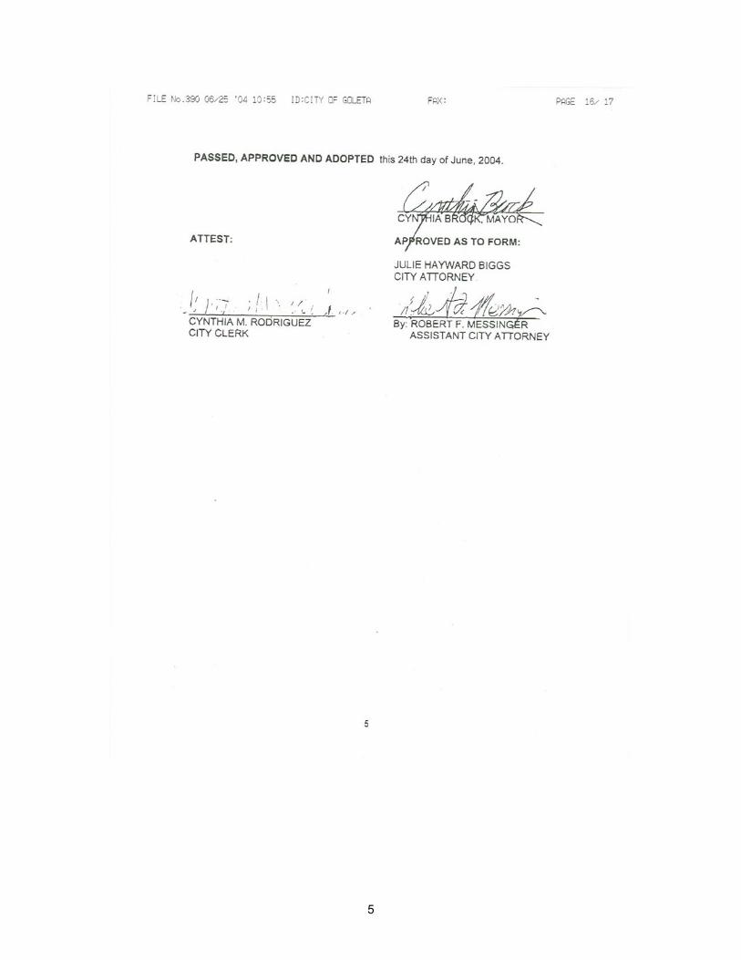
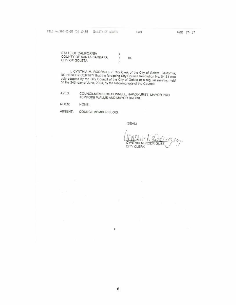
Section 8. The City Clerk shall certify to the adoption of this resolution.
4
5
6
EEXXHHIIBBIITT 11 -- EEIIRR FFIINNDDIINNGGSS RREEGGAARRDDIINNGG PPOOTTEENNTTIIAALLLLYY SSIIGGNNIIFFIICCAANNTT EENNVVIIRROONNMMEENNTTAALL IIMMPPAACCTTSS
SECTION 1.0 FINDINGS REGARDING POTENTIALLY SIGNIFICANT ENVIRONMENTAL
IMPACTS WHICH CAN BE MITIGATED TO A LEVEL OF LESS THAN SIGNIFICANT (CLASS II)
EExxhhiibbiitt 11
EEIIRR FFiinnddiinnggss RReeggaarrddiinngg PPootteennttiiaallllyy SSiiggnniiffiiccaanntt EEnnvviirroonnmmeennttaall IImmppaaccttss
The City of Goleta finds that, based upon the threshold criteria for significance (CEQA Thresholds) presented in the FEIR, the following aspects of the project will result in environmental impacts which have been determined by the City to be significant, but which can be mitigated through feasible mitigation measures, identified in the FEIR, to levels of insignificance. These feasible mitigation measures will be adopted by the City as conditions for project approval. Moreover, these measures are fully enforceable through permit conditions, approvals and agreements. Based upon the environmental analyses presented in the FEIR, and the Addendum to the FEIR dated June 24, 2004, no substantial evidence has been submitted to or identified by the City that indicates that the following impacts would in fact occur at levels requiring a determination of significance that cannot be mitigated.
1.1 GEOLOGY AND GEOLOGIC HAZARDS
1.1.1 Significant Impacts
Twelve Geology and Geologic Hazards Class II impacts have been identified relating to topography, erosion, seismic hazards, soils, and slope stability. Each of these impacts can be mitigated through measures that are feasible, will be adopted by the City of Goleta, and are fully enforceable. The specific impacts are:
Impact Geo-1 – Change in Topography. Project grading during construction would result in substantial changes in topography. The proposed project would require removal of the upper 3 to 4 feet of soils in proposed building areas, but should not create unstable slopes. The most significant change in topography would occur on the southern portion of the property, where up to 6 feet of fill will be placed to infill a shallow gully for a proposed road.
Impact Geo-2 – Erosion. Project grading during construction would potentially cause increased erosion and sedimentation. Project construction would result in temporary exposure of ground surfaces until proposed vegetation could stabilize these areas. Near-surface soils are characterized as having medium to rapid runoff rates and moderate to high erosion hazards. Impervious surfaces installed in the early stages of construction could concentrate water flow, also potentially leading to increased erosion and siltation in Devereux Creek and its tributaries.
Impact Geo-4 – Seismic Hazards. An earthquake on a nearby fault could result in significant ground shaking and possibly ground rupture at the project site. An earthquake on the More Ranch or other nearby fault could create strong ground motions at the site. Ground motions caused by seismic waves are measured as ground acceleration (g). According to Caltrans (Mualchin, 1996), the estimated peak ground acceleration at the site is approximately 0.6 g.
\\coast\share\Board Meeting Materials\June Board Items\13 Ellwood Mesa-Travis\NEW FINAL Exhibit 1 to Exhibit 4 City's EIR findings.doc Exhibit 1 – Page 1
EEXXHHIIBBIITT 11 -- EEIIRR FFIINNDDIINNGGSS RREEGGAARRDDIINNGG PPOOTTEENNTTIIAALLLLYY SSIIGGNNIIFFIICCAANNTT EENNVVIIRROONNMMEENNTTAALL IIMMPPAACCTTSS
Proposed structures and underground utilities could suffer considerable damage from strong ground motions, and must be designed accordingly.
EExxhhiibbiitt 11
EEIIRR FFiinnddiinnggss RReeggaarrddiinngg PPootteennttiiaallllyy SSiiggnniiffiiccaanntt
EEnnvviirroonnmmeennttaall IImmppaaccttss
Impact Geo-5 – Expansive Soils. Surficial soils encountered within the depths affected by proposed grading include slightly expansive soils. Test results indicate that the upper 4 feet of onsite soil materials have a low to medium potential for expansion. Soils with expansion potential contain clay minerals that expand when wet and shrink when dry. Repeated shrinking and swelling of the soil can result in damage to foundations, fill slopes, utilities, and other associated facilities.
Impact Geo-6 – Collapsible Soils. The surface soils are dry and porous to depths of 36 to 48 inches below existing grade, and are susceptible to collapse, compression, and settlement with increasing moisture content. Potential impacts associated with compressible and collapsible soils include foundation settling.
Impact Geo-7 – Change in Topography. Project grading during trail construction would result in minor changes in topography. The grading required to construct the Anza Trail, Santa Barbara Shores parking area, bluff stairs and infilling of erosional gullies on the southeast portion of Ellwood Mesa is relatively minor. No geologic hazards would be created as a result. This is because the grading would generally be spread across a large gently-sloping area, would be constructed pursuant to established California Building Code (CBC) and City of Goleta Grading Ordinance standards, and should not involve the creation of unstable slopes. Beneficial impacts to topography would result from infilling of deep anthropogrenic – induced gullies along the northeast portion of Ellwood Mesa.
Impact Geo-8 – Erosion. Project grading during construction would potentially cause substantially increased erosion and sedimentation. Project construction would result in temporary exposure of ground surfaces until proposed vegetation and/or trail surfacing materials could stabilize these areas. Uncontrolled runoff from blufftop and beach access trails appears to be contributing to erosion of the bluffs. Near-surface soils on Ellwood Mesa are characterized as having medium to rapid runoff rates and moderate to high erosion hazards. Trail surfaces could concentrate water flow, also potentially leading to increased erosion and siltation in Devereux Creek and its tributaries. The Open Space Plan includes an option to construct bridges, boardwalks, and stairs in the immediate vicinity of Devereux Creek. Short-term impacts associated with these structures could result in erosion, although the long-term beneficial impacts of such structures would significantly reduce erosion.
Impact Geo-9 – Slope Stability. Preliminary grading plans have not been completed for proposed parking, trail construction, or other improvements. These plans will be developed at a later date and will delineate existing and proposed final grade elevations and proposed drainage features. Given the gently sloping nature of the site in most areas, any final slopes included in the project would not be anticipated to create unstable slopes. In any case, engineered slopes included in the project would be required to meet established standards in the CBC and City of Goleta Grading Ordinance. With adherence to established standards and implementation of the
Exhibit 1 – Page 2
EEXXHHIIBBIITT 11 -- EEIIRR FFIINNDDIINNGGSS RREEGGAARRDDIINNGG PPOOTTEENNTTIIAALLLLYY SSIIGGNNIIFFIICCAANNTT EENNVVIIRROONNMMEENNTTAALL IIMMPPAACCTTSS
Open Space Plan recommended practices for trail construction, impacts will likely be less than significant.
EExxhhiibbiitt 11
EEIIRR FFiinnddiinnggss RReeggaarrddiinngg PPootteennttiiaallllyy SSiiggnniiffiiccaanntt EEnnvviirroonnmmeennttaall IImmppaaccttss
Impact Geo-10 – Seismic Hazards. An earthquake on a nearby fault could result in significant ground shaking and possibly ground rupture at the project site. The nearest fault is about 200 feet south of the proposed project site. An earthquake on the More Ranch or other nearby fault could create strong ground motions at the site. Ground motion caused by seismic waves is measured as ground acceleration (g). Peak ground accelerations on bedrock of 0.6 g or greater may occur at the site. Existing as well as any proposed structures and underground oil pipelines and utilities, where present, could suffer considerable damage from this magnitude earthquake. Open Space Plan structures that could be affected include trail surfaces, boardwalks, bridges, stairs, parking, and restrooms. Only habitable structures are subject to Alquist-Priolo fault hazard zone setbacks in California.
However, engineering designs must incorporate reinforcement and materials that can withstand seismic activity effects related to anticipated credible ground acceleration factors.
Given that these measures are regulated by the CBC and City of Goleta ordinances, they will be required as part of standard plan check review of open space improvements by the City of Goleta.
Impact Geo-11 – Expansive Soils. Surficial soils encountered within the depths affected by proposed grading for the new road, parking lot and restroom at Santa Barbara Shores may include slightly expansive soils. Test results from borings collected from the Comstock Homes Development immediately to the west indicate that the upper 4 feet of onsite soil materials have a low to medium potential for expansion. Soils with expansion potential contain clay minerals that expand when wet and shrink when dry. Repeated shrinking and swelling of the soil can result in damage to foundations, roads, utilities, and other associated facilities.
Impact Geo-12 – Collapsible Soils. Test results from borings collected from the Comstock Homes Development immediately to the west of the proposed new parking lot and restroom at Santa Barbara Shores indicate that surface soils are dry and porous to depths of 36 to 48 inches below existing grade, and are susceptible to collapse, compression, and settlement with increasing moisture content.
Impact Geo-13 – Cumulative Impacts. The cumulative impacts related to geologic processes resulting from buildout of proposed projects located within the Devereux Slough watershed (including soil erosion) could be significant due to the potential for increased erosion and sedimentation in Devereux Slough. The proposed Comstock Homes Development and Open Space Plan improvements have the potential to cause significant short-term impacts.
\\coast\share\Board Meeting Materials\June Board Items\13 Ellwood Mesa-Travis\NEW FINAL Exhibit 1 to Exhibit 4 City's EIR findings.doc Exhibit 1 – Page 3
EEXXHHIIBBIITT 11 -- EEIIRR FFIINNDDIINNGGSS RREEGGAARRDDIINNGG PPOOTTEENNTTIIAALLLLYY SSIIGGNNIIFFIICCAANNTT EENNVVIIRROONNMMEENNTTAALL IIMMPPAACCTTSS
1.1.2 Facts Supporting the Impact Findings EExxhhiibbiitt 11
EEIIRR FFiinnddiinnggss RReeggaarrddiinngg PPootteennttiiaallllyy SSiiggnniiffiiccaanntt
EEnnvviirroonnmmeennttaall IImmppaaccttss
The geology and geologic hazards of the project site were evaluated through detailed literature review, field investigations and GIS analyses conducted by a professional geologist. In general, the topography and soils in the area have been disturbed as a result of decades of human activities. These activities have led to increased runoff, erosion, and sedimentation in local water bodies such as Devereux Creek and Slough. The site is also crossed by three major fault zones. These faults are active, seismogenic structures.
The proposed project would necessitate additional modifications to site topography that could further increase runoff, erosion and sedimentation. Moreover, the local faults could result in ground shaking that could damage proposed structures and underground utilities.
As discussed in the Addendum to the FEIR dated June 24, 2004, the 68-unit revised site plan will result in fewer geology and geologic hazards impacts as compared to the originally proposed 78-unit project due to the need for less surface and subsurface disturbance and the non-filling of the majority of Drainage B. Although the revised site plan would involve more grading and modification of subsurface topography in the northeastern residential pod development area, the additional grading and alteration of topography would lessen visual effects compared to the previously proposed 78-unit project. The applicant’s proposed use of engineered retaining walls in the northeastern residential pod area is expected to stabilize cut slopes and thereby mitigate potential unstable slope conditions. Furthermore, the Comstock Homes Development 68-unit Project, as conditioned to delete the northeast pod of six homes, would eliminate the need for any alteration of topography in the northeastern residential pod development area because these homes are no longer part of the 68-unit Project, thus, further reducing impacts to geology and geologic hazards.
In accordance with the City of Goleta CEQA Threshold criteria used for determining significance, impacts would be considered significant if the proposed development activity could result in significantly increased erosion, landslides, soil creep, mudslides, or unstable slopes. In addition, impacts would be considered significant if people or structures would be exposed to major geologic hazards, such as seismic hazards, upon implementation of the project. Using these criteria, the City of Goleta has determined that these impacts are significant. The City has also determined that the following mitigation measures will reduce these impacts to a level less than significant.
1.1.3 Mitigation Measure Summary
Based upon the analyses presented in Section 4 of the FEIR and the Addendum to the FEIR dated June 24, 2004, the following Mitigation Measures are determined to be feasible.
Mitigation Measure Geo-1. A Final Grading Plan shall be prepared and implemented. Grading shall be supervised by a qualified geotechnical engineer. This measure will reduce impacts to topography (Impacts GEO-1 and GEO-7), soil erosion (Impacts GEO-2 and GEO-
Exhibit 1 – Page 4
EEXXHHIIBBIITT 11 -- EEIIRR FFIINNDDIINNGGSS RREEGGAARRDDIINNGG PPOOTTEENNTTIIAALLLLYY SSIIGGNNIIFFIICCAANNTT EENNVVIIRROONNMMEENNTTAALL IIMMPPAACCTTSS
8), expansive and collapsible soils (Impacts GEO-5, GEO-6, GEO-11, and GEO-12), slope stability (Impact GEO-9), and cumulative impacts (Impact GEO-13).
EExxhhiibbiitt 11
EEIIRR FFiinnddiinnggss RReeggaarrddiinngg PPootteennttiiaallllyy SSiiggnniiffiiccaanntt EEnnvviirroonnmmeennttaall IImmppaaccttss
Mitigation Measure Geo-2. Grading and drainage plans shall be designed to minimize erosion. This measure will reduce impacts to topography (Impact GEO-1), soil erosion (Impacts GEO-2 and GEO-8), expansive and collapsible soils (Impacts GEO-5, GEO-6, GEO-11, and GEO-12), and cumulative impacts (Impact GEO-13).
Mitigation Measure Geo-3. A 50-foot building setback on either side of the More Ranch fault will be maintained. This measure would reduce the seismic hazards (Impacts GEO-4 and GEO-10).
Mitigation Measure Geo-4. The City of Goleta shall approve plans for CBC Seismic Zone consistency. This measure would reduce the seismic hazards (Impacts GEO-4 and GEO-10).
Mitigation Measure Geo-5. Open Space Plan improvements that require a foundation shall be made according to plans that specify earthquake standards for CBC Seismic Zone 4. This measure would reduce seismic hazards (Impact GEO-10).
Mitigation Measure Geo-6. Natural sea cliff erosion and retreat shall be monitored every 10 years and after every El Nino winter. The City of Goleta shall intervene and manage the relocation of the Coastal Trail if unsafe conditions exist along the bluffs as the result of landslides, erosion, and cliff retreat. This measure would reduce the potential for increased cliff slope instability (Impacts GEO-9 and GEO-13).
1.1.4 Findings Regarding Mitigation Measures and Project Alterations Incorporated Into Revised Site Plan Dated June 18, 2004
Pursuant to Public Resources Code Section 21081 (a) and State CEQA Guidelines Section 15091(a), the City of Goleta hereby finds that the impacts identified above are substantially reduced by the mitigation measures identified above. These mitigation measures will be incorporated as required changes or alterations to the project, as conditions of approval, and would lessen the significant environmental effects to a level below significance. Therefore, the City of Goleta finds that the mitigation measures stipulate requirements that are feasible and enforceable. Specifically, the Geology and Geohazard mitigation measures require:
• An approved grading, drainage, and revegetation plan. This Plan will enable the City to review and approve measures to reduce erosion and sedimentation, minimize the impact of collapsible soils, and ensure slope stability prior to project approval and start of construction.
• A registered civil or geotechnical engineer to supervise and verify all grading activities. This engineer will ensure that appropriate, approved measures are in fact being implemented during construction and will be empowered to stop any activity that would cause significant adverse impacts.
\\coast\share\Board Meeting Materials\June Board Items\13 Ellwood Mesa-Travis\NEW FINAL Exhibit 1 to Exhibit 4 City's EIR findings.doc Exhibit 1 – Page 5
EEXXHHIIBBIITT 11 -- EEIIRR FFIINNDDIINNGGSS RREEGGAARRDDIINNGG PPOOTTEENNTTIIAALLLLYY SSIIGGNNIIFFIICCAANNTT EENNVVIIRROONNMMEENNTTAALL IIMMPPAACCTTSS
• The use of low expansive soils to mitigate the potential effects of expansive soils. Where appropriate, building areas shall be backfilled with nonplastic, low expansion soils. Highly expansive soil will not be placed within the upper 3 feet below buildings. Measures recommended by Pacific Materials Laboratory (2002) such as providing positive drainage away from slabs, presoaking and compacting soils prior to pouring slabs, and other foundation design recommendations shall be implemented to mitigate the potential effects of expansive soils.
EExxhhiibbiitt 11
EEIIRR FFiinnddiinnggss RReeggaarrddiinngg PPootteennttiiaallllyy SSiiggnniiffiiccaanntt
EEnnvviirroonnmmeennttaall IImmppaaccttss
• Implementation of a 50-foot setback on either side of a mapped fault, and earthquake standards for CBC Seismic Zone 4. The setback and Seismic Zone 4 standards will minimize the potential impact of ground disturbance from active faults in the project vicinity.
Such measures have been demonstrated on previous projects to be feasible and effective, therefore, the City of Goleta will adopt these measures as conditions of project approval. Once implemented, these mitigation measures will reduce the impacts described above to levels below significance.
As discussed in the Addendum to the FEIR dated June 24, 2004, the 68-unit revised site plan will result in fewer geology and geologic hazards impacts as compared to the originally proposed 78-unit project. Even with fewer impacts, the project alterations evaluated in the Addendum to the FEIR dated June 24, 2004, do not substantially change the impact conclusions or required mitigation measures described above. Furthermore, the Comstock Homes Development 68-unit Project, as conditioned to delete the northeast pod of six homes, would eliminate the need for any alteration of topography in the northeastern residential pod development area because these homes are no longer part of the 68-unit project, thus, further reducing impacts to geology and geologic hazards.
1.2 HYDROLOGY AND WATER QUALITY
1.2.1 Significant Impacts
Twelve Hydrology and Water Quality Class II impacts have been identified. Each of these impacts can be mitigated through measures that are feasible, will be adopted by the City of Goleta, and are fully enforceable. The specific impacts are:
Impact H/WQ-1 – Onsite and Downstream Flooding. The Comstock Homes Development would result in permanent changes to topography and potential changes in hydrology of the area due to the creation of additional impervious ground coverage that would substantially reduce the ability of the site to absorb surface water runoff.
Impact H/WQ-2 – Erosion and Sedimentation from Residential Development. Increased runoff could result in increased long-term erosion and sedimentation, and therefore decreased water quality in Devereux Creek and Devereux Slough. The majority of the project runoff is proposed to flow to Devereux Creek at several locations in the southern portion of the
Exhibit 1 – Page 6
EEXXHHIIBBIITT 11 -- EEIIRR FFIINNDDIINNGGSS RREEGGAARRDDIINNGG PPOOTTEENNTTIIAALLLLYY SSIIGGNNIIFFIICCAANNTT EENNVVIIRROONNMMEENNTTAALL IIMMPPAACCTTSS
site. The runoff would be conveyed to the creek via overland flow from two biofilter/detention basins and/or storm drains that would flow directly to tributaries of Devereux Creek. Additional runoff would be directed toward Hollister Avenue via overland flow on the northern perimeter of the developed area.
EExxhhiibbiitt 11
EEIIRR FFiinnddiinnggss RReeggaarrddiinngg PPootteennttiiaallllyy SSiiggnniiffiiccaanntt EEnnvviirroonnmmeennttaall IImmppaaccttss
Impact H/WQ-3 – Pollutants in Runoff from the Residential Development. Pollution from vehicles, roadways, and parking areas, as well as from landscape and household chemicals, during construction and post-construction, could be carried in surface runoff into Devereux Creek, thereby degrading the quality of waters contributing to Devereux Slough from this portion of its watershed. Devereux Slough and its watershed have been extensively altered over the past century by urban and recreational development. The proposed biofilter/detention basins are designed to capture the majority of project runoff and allow for filtering prior to release in the watershed. However, some homes drain directly to tributaries of Devereux Creek, leading to potential water quality impacts.
Impact H/WQ-5 – Trail Construction at Phelps Ditch. The Open Space Plan provides for continued maintenance of public access and possible future recreational trail improvements on the existing flood control road easement located on the west side of Phelps Ditch. If future trail improvements are implemented in this area, then construction of those improvements adjacent to the creek could result in discharges of solid or liquid wastes and/or sediment into the creek. Pending detailed design of trail improvements near Phelps Ditch, the potential exists for water quality impacts associated with trail construction, use, and maintenance.
Impact H/WQ-6 – Flooding from the Open Space Plan Area. The Open Space parking area would encompass approximately one-half acre of gently sloping undeveloped land located immediately south of Hollister Avenue, between the Comstock Homes Development site and the eastern eucalyptus grove. The parking lot surface would likely be constructed with a pervious concrete, dyed to match the buff color of the native soil. Depending on the design and performance of the actual ground surface materials selected for this area, the parking area could reduce the ground surface area capable of absorbing rainfall and therefore increase stormwater runoff across the site and into site drainages. Flooding potential could be increased due to the proposed parking area if impervious surfaces are used. The increased runoff could result in greater risks of flooding if proposed site drainages, including Devereux Creek, were not capable of handling the flow.
Impact H/WQ-7 – Erosion and Sedimentation from the Open Space Parking Area. Increased runoff from the Open-Space parking area could potentially result in increased long-term erosion and sedimentation, and therefore decreased water quality in Devereux Creek.
Impact H/WQ-8 – Trail Construction, Well Abandonment, and Remediation. Trail construction, well re-abandonment, and site remediation activities could result in short-term water quality impacts. Pollution from construction vehicles and activities could be carried in surface runoff into Devereux Creek, thereby degrading the quality of waters contributing to the Devereux Slough from this portion of the watershed. Some common sources of construction
\\coast\share\Board Meeting Materials\June Board Items\13 Ellwood Mesa-Travis\NEW FINAL Exhibit 1 to Exhibit 4 City's EIR findings.doc Exhibit 1 – Page 7
EEXXHHIIBBIITT 11 -- EEIIRR FFIINNDDIINNGGSS RREEGGAARRDDIINNGG PPOOTTEENNTTIIAALLLLYY SSIIGGNNIIFFIICCAANNTT EENNVVIIRROONNMMEENNTTAALL IIMMPPAACCTTSS
site pollution include spilled oil, fuel, and fluids from vehicles and heavy equipment; construction debris; sediment created by erosion; irrigation runoff containing pesticides or weed killers; and materials such as used motor oil, antifreeze, and paint products. In addition to these pollutants, potential well re-abandonment and soil remediation activities could result in runoff from contaminated soils reaching Devereux Creek.
EExxhhiibbiitt 11
EEIIRR FFiinnddiinnggss RReeggaarrddiinngg PPootteennttiiaallllyy SSiiggnniiffiiccaanntt
EEnnvviirroonnmmeennttaall IImmppaaccttss Impact H/WQ-9 – Flood Impacts from Devereux Creek Bridge and Boardwalk
Scenario. If the optional Devereux Creek bridge and boardwalk scenario is pursued, then those structures would need to be designed so as to avoid creating on obstruction to flood waters in Devereux Creek. Design details will only be developed at the time that the creek crossing scenario is pursued. Therefore, pending design details, the potential exists that the optional trail improvements could – if not properly designed, sited, and maintained – result in long-term flood hazards.
Impact H/WQ-10 – Pollutants from Devereux Creek Bridge and Boardwalk Scenario. If these structures were built, then there would be the potential for short-term construction impacts to water quality, and long-term impacts to flooding. Short-term impacts could include trail erosion and sedimentation to Devereux Creek resulting from vehicle access and earthwork activities in the creek itself and on the slopes of Devereux Creek. Fuel spills or other material leaks from vehicles or equipment could potentially reach Devereux Creek if not properly prevented or controlled.
Impact H/WQ-11 – Cumulative Pollutant Loading from Use of Open Space Area. Pollution from trash and domestic animal waste, including dogs and horses, could be carried in surface runoff into Devereux Creek, thereby degrading the quality of waters contributing to the Devereux Slough from this portion of its watershed. Increased public use of the Open Space Plan area could result in adverse impacts to water quality, such as through introduction of domestic animal wastes and associated increases in nutrient loading and/or bacterial pathogens. The Open Space Plan provides for long-term monitoring and maintenance of the open space lands and watercourses.
Impact H/WQ-12 – Cumulative Pollutant Loading from the Residential Development. Two bioswales are proposed to be constructed as part of the Comstock Homes Development. This design feature is intended to prevent the potential for polluted runoff to enter the watershed, and thus the project, as designed, would not contribute to the cumulative pollutant runoff and resulting surface water impacts on Devereux Creek and Slough. However, if not properly designed, installed, and maintained, these bioswales have the potential to allow the project to directly contribute to erosion-inducing siltation of surface waters and runoff of pollutants as a result of increased impervious surfaces, pesticide and herbicide use, and oil and grease residues. This direct contribution of pollutants in an already degraded watershed could result in cumulative impacts to water quality in the Devereux Creek and Slough.
Impact H/WQ-13 – Cumulative Flooding from the Residential Development. Increased stormwater runoff as a result of the Comstock Homes Development’s increased
Exhibit 1 – Page 8
EEXXHHIIBBIITT 11 -- EEIIRR FFIINNDDIINNGGSS RREEGGAARRDDIINNGG PPOOTTEENNTTIIAALLLLYY SSIIGGNNIIFFIICCAANNTT EENNVVIIRROONNMMEENNTTAALL IIMMPPAACCTTSS
impervious surfaces together with potential increased runoff from other future developments in the watershed could exacerbate existing flood hazards downstream from the development site. One detention basin is proposed to be constructed. Together with the overall drainage design, the detention basin is intended to reduce flood runoff rates and volumes to levels that approximate the present pre-development rate and volume of runoff. Thus the project, as designed, is not expected to contribute to cumulative flooding impacts on Devereux Creek and Slough.
EExxhhiibbiitt 11
EEIIRR FFiinnddiinnggss RReeggaarrddiinngg PPootteennttiiaallllyy SSiiggnniiffiiccaanntt EEnnvviirroonnmmeennttaall IImmppaaccttss
1.2.2 Facts Supporting the Impact Findings
The hydrology and water quality impacts of the project were evaluated through detailed literature review, field investigations, and site plan reviews. In general, Devereux Creek forms the primary hydrologic feature at the project site, and various tributaries and small drainages that flow into Devereux Creek are located throughout the site. Minor drainage features are formed near the bluffs, resulting in eroded slopes at several locations throughout the site. Onsite drainages have been disturbed as a result of decades of human activities. These activities have led to increased runoff, erosion, and sedimentation in Devereux Creek and Slough, and introduction of non-native species in the riparian corridor. Urban runoff from upstream land uses within the watershed has contributed to water quality degradation.
The Comstock Homes Development would increase impervious surfaces and introduce new urban land uses in close proximity to Devereux Creek and other onsite drainages. These factors could further degrade water quality within the Devereux Creek watershed by increasing site runoff, erosion and sedimentation. Moreover, construction activities for the residential development, as well as for the Open Space improvements, could contribute sediment, oil and grease, and other pollutants into these drainage features.
As discussed in the Addendum to the FEIR dated June 24, 2004, the 68-unit revised site plan will result in fewer hydrology and water quality impacts as compared to the originally proposed 78-unit project because the revised site plan would involve 10 less residential units and, thus, less surface disturbance and residential development with associated creation of impermeable surfaces (i.e., less effects on increases in site runoff). In addition, the revised site plan relocates and re-designs the northern detention basin/bioswale to better maintain the natural flows to Devereux Creek via Drainage B than the previously proposed 78-unit project. The Comstock Homes Development 68-unit Project, as conditioned to delete the northeast pod of six homes, would further reduce impacts associated with surface disturbance in the northeastern residential pod development area because these homes are no longer part of the 68-unit project, thus, further reducing impacts to hydrology and water quality.
The Addendum also describes the City of Goleta requirement for the applicant to construct a sewer lift station to route all sewage effluent from the residential development back via subsurface pipeline to the north to the GWSD Hollister Avenue sewer trunkline. Connection to the GWSD Hollister Avenue sewer trunkline would allow the project to avoid further contribution to the potential volume of possible leaks and associated water quality degradation
\\coast\share\Board Meeting Materials\June Board Items\13 Ellwood Mesa-Travis\NEW FINAL Exhibit 1 to Exhibit 4 City's EIR findings.doc Exhibit 1 – Page 9
EEXXHHIIBBIITT 11 -- EEIIRR FFIINNDDIINNGGSS RREEGGAARRDDIINNGG PPOOTTEENNTTIIAALLLLYY SSIIGGNNIIFFIICCAANNTT EENNVVIIRROONNMMEENNTTAALL IIMMPPAACCTTSS
in nearby Devereux Creek through the use of the existing GWSD Devereux Creek sewer trunkline. Connection to the GWSD Hollister Avenue sewer trunkline would also preclude the need for ongoing maintenance activities, including vegetation clearing and vehicular disturbance, thereby reducing sediment input and associated water quality impacts on Devereux Creek.
EExxhhiibbiitt 11
EEIIRR FFiinnddiinnggss RReeggaarrddiinngg PPootteennttiiaallllyy SSiiggnniiffiiccaanntt
EEnnvviirroonnmmeennttaall IImmppaaccttss
In accordance with the City of Goleta CEQA Threshold criteria used for determining significance, impacts would be considered significant if they degrade surface or groundwater quality in violation of the Central Coast RWQCB Basin Plan (2002), or other applicable water quality regulations, and/or result in substantial degradation of water quality conditions that could affect beneficial uses of receiving waters. Using these criteria, the City of Goleta has determined that these impacts are significant. The City has also determined that the following mitigation measures will reduce these impacts to a level less than significant.
1.2.3 Mitigation Measure Summary
Based upon the analyses presented in Section 4 of the FEIR and the Addendum to the FEIR dated June 24, 2004, the following Mitigation Measures are determined to be feasible.
Mitigation Measure H/WQ-1. Outlet pipes, velocity reduction structures (e.g., rip-rap) and detention basins/bioswales shall be designed, constructed, inspected, and maintained at the Comstock Homes Development site to reduce off-site runoff velocities and to prevent off-site flooding and long-term erosion induced sedimentation in Devereux Creek and Slough. Detention basins/bioswales shall be constructed during initial site grading and shall be functional during the construction phase. Detention basins/bioswales shall be maintained frequently throughout the construction phase to remove accumulated sediment. These features shall be depicted on grading and drainage plans. This mitigation will address onsite and downstream flooding impacts at the Comstock site (Impact H/WQ-1), erosion and sedimentation from the Comstock site (Impact H/WQ-2), pollutants in runoff from residential development (Impacts H/WQ-3 and H/WQ-12), and cumulative flooding related to residential development throughout the watershed (Impact H/WQ-13).
Mitigation Measure H/WQ-2. To reduce runoff from impervious areas and allow for infiltration at the Comstock Homes Development site to the maximum extent feasible, pervious materials or surfaces (e.g., porous pavement or unit pavers on sand) shall be incorporated into the project design in key areas, such as adjacent to concrete walkways and road surfaces. The City of Goleta shall incorporate similar measures for the Open Space parking and restroom area, and at trail improvement sites. This mitigation will address onsite and downstream flooding impacts at the Comstock site (Impact H/WQ-1), erosion and sedimentation from the Comstock site (Impact H/WQ-2), pollutants in runoff from residential development (Impacts H/WQ-3 and H/WQ-12), pollutants from construction and use of the Phelps Ditch Trail (Impact H/WQ-5), flooding at or downstream from the Open Space parking area (Impact H/WQ-6), erosion and sedimentation from the Open Space parking area (Impact H/WQ-7), and cumulative flooding related to residential development throughout the watershed (Impact H/WQ-13).
Exhibit 1 – Page 10
EEXXHHIIBBIITT 11 -- EEIIRR FFIINNDDIINNGGSS RREEGGAARRDDIINNGG PPOOTTEENNTTIIAALLLLYY SSIIGGNNIIFFIICCAANNTT EENNVVIIRROONNMMEENNTTAALL IIMMPPAACCTTSS
Mitigation Measure H/WQ-4. All new structures (e.g., bridges) in Devereux Creek and its tributaries shall be designed, inspected, and maintained to minimize obstruction and collection of debris that could impede flows and result in localized flooding. This mitigation will address flooding at or downstream from the Open Space parking area (Impact H/WQ-6), erosion and sedimentation from the Open Space parking area (Impact H/WQ-7), water quality impacts from trail construction (Impact H/WQ-8), flood impacts from the Devereux Creek Bridge and Boardwalk (Impact H/WQ-9) and pollutant impacts from the Devereux Creek Bridge and Boardwalk (Impact H/WQ-10).
EExxhhiibbiitt 11
EEIIRR FFiinnddiinnggss RReeggaarrddiinngg PPootteennttiiaallllyy SSiiggnniiffiiccaanntt EEnnvviirroonnmmeennttaall IImmppaaccttss
Mitigation Measure H/WQ-5. The drainage plan for the Comstock Homes Development shall include permanent detention basins/bioswales designed to retain runoff and maintain pre-development runoff rates associated with a 25-year storm event. The bioswale shall be designed to ensure that the retention time of water and the plants selected are adequate to reduce the concentrations of target pollutants. Where feasible, local plant sources (i.e. collected from the watershed or propagated cuttings or seed collected from the watershed) shall be used. The detention basins shall be placed immediately upstream of stormwater pollution source reduction and biological treatment systems, such as oil-water separators and bioswales. The plan shall include specifications for the bioswales to be maintained in working order, and shall assign enforceable responsibility for long-term inspection and maintenance. This mitigation will address onsite and downstream flooding impacts at the Comstock site (Impact H/WQ-1), erosion and sedimentation from the Comstock site (Impact H/WQ-2), pollutants in runoff from residential development (Impacts H/WQ-3 and H/WQ-12), and cumulative flooding related to residential development throughout the watershed (Impact H/WQ-13).
Mitigation Measure H/WQ-6. The applicant shall submit a copy of the Notice of Intent to obtain coverage under the Construction General Permit of the National Pollutant Discharge Elimination System issued by the California Regional Water Quality Control Board. This mitigation will address erosion and sedimentation from the Comstock site (Impact H/WQ-2), pollutants in runoff from residential construction (Impact H/WQ-3) and cumulative pollutants due to construction throughout the watershed (Impact H/WQ-12).
Mitigation Measure H/WQ-7. The Open Space parking area shall be designed to minimize degradation of storm water quality. A site-specific Erosion and Sediment Control Plan shall be developed for the parking area. The Plan shall incorporate appropriate BMPs such as oil/water separators, sand filters, landscaped areas for infiltration, basins, or other equivalent BMPs designed to intercept and effectively prohibit pollutants from discharging to onsite drainages. The BMPs selected shall be maintained in working order. The Plan shall included long-term maintenance plans. The location and type of BMPs shall be shown on all site, building and grading plans. This mitigation will erosion and sedimentation from the Open Space parking area (Impact H/WQ-7).
Mitigation Measure H/WQ-8. The drainage plan for the Comstock Homes Development shall provide for treatment of all polluted run-off (e.g., from streets and driveways). The plan shall include specifications for the drains and treatment/filtration systems to be maintained in
\\coast\share\Board Meeting Materials\June Board Items\13 Ellwood Mesa-Travis\NEW FINAL Exhibit 1 to Exhibit 4 City's EIR findings.doc Exhibit 1 – Page 11
EEXXHHIIBBIITT 11 -- EEIIRR FFIINNDDIINNGGSS RREEGGAARRDDIINNGG PPOOTTEENNTTIIAALLLLYY SSIIGGNNIIFFIICCAANNTT EENNVVIIRROONNMMEENNTTAALL IIMMPPAACCTTSS
working order and shall assign enforceable responsibility for long-term inspection and maintenance. This mitigation will address pollutants in runoff from residential development (Impact H/WQ-3).
EExxhhiibbiitt 11
EEIIRR FFiinnddiinnggss RReeggaarrddiinngg PPootteennttiiaallllyy SSiiggnniiffiiccaanntt
EEnnvviirroonnmmeennttaall IImmppaaccttss
Mitigation Measure H/WQ-9. Animal waste minimization measures (e.g., mutt-mitt dispensers) shall be implemented in the vicinity of Devereux Creek, consistent with the Ellwood Mesa Open Space Plan recommendations. Mutt-mitt dispensers shall be installed and maintained by the Comstock Homes Development at appropriate Open Space access points within the Comstock Homes Development, and installed and maintained by the City of Goleta at public trailheads. Educational displays/signs shall be installed which provide information about water quality in the Devereux Creek watershed, and appropriate educational materials shall be incorporated into the Homeowners’ Association literature. The displays shall include information pertaining to animal waste and surface water pollution prevention. This mitigation will address cumulative pollutant loading in the watershed as a result of long-term use of the Open Space area (Impact H/WQ-11).
Mitigation Measure H/WQ-10. A Pesticide, Herbicide, and Fertilizer Maintenance Plan shall be prepared that minimizes the use of these materials in common areas and private landscape areas, particularly during the rainy season. Biodegradable pesticides and herbicides shall be maximized. Grasses not generally susceptible to pest disease shall be planted in the common turf areas. This mitigation will address pollutants in runoff from residential development (Impact H/WQ-3).
Mitigation Measure H/WQ-11. If trail improvements are constructed at the Phelps Ditch Trail site, or if boardwalks, stairs, or other public access improvements are constructed in or across Devereux Creek, these improvements shall be constructed during the dry season. Construction methods shall include appropriate Best Management Practices to prevent construction equipment leaks or spills from entering Devereux Creek and Phelps Ditch. Structures shall not use chemically treated materials that could leach into water. Trails and structures shall be periodically inspected during the wet season to ensure structural integrity and avoidance of flood hazards or obstructions. Maintenance and repairs shall be performed as needed. This mitigation will address pollutants in runoff from construction of Open Space improvements (Impacts H/WQ-8 and H/WQ-10), flood impacts from Open Space improvements (Impact H/WQ-9), and cumulative pollutant loading throughout the watershed as a result of long-term use of the Open Space (Impact H/WQ-11).
1.2.4 Findings Regarding Mitigation Measures and Project Alterations Incorporated Into Revised Site Plan Dated June 18, 2004
Pursuant to Public Resources Code Section 21081 (a) and State CEQA Guidelines Section 15091(a), the City of Goleta hereby finds that the impacts identified above are substantially reduced by the mitigation measures identified above. These mitigation measures will be incorporated as required changes or alterations to the project, as conditions of approval, and would lessen the significant environmental effects to a level below significance. Therefore, the
Exhibit 1 – Page 12
EEXXHHIIBBIITT 11 -- EEIIRR FFIINNDDIINNGGSS RREEGGAARRDDIINNGG PPOOTTEENNTTIIAALLLLYY SSIIGGNNIIFFIICCAANNTT EENNVVIIRROONNMMEENNTTAALL IIMMPPAACCTTSS
City of Goleta finds that the mitigation measures stipulate requirements that are feasible and enforceable. Specifically, the Hydrology and Water Quality mitigation measures require:
EExxhhiibbiitt 11
EEIIRR FFiinnddiinnggss RReeggaarrddiinngg PPootteennttiiaallllyy SSiiggnniiffiiccaanntt EEnnvviirroonnmmeennttaall IImmppaaccttss
• An approved grading, drainage, and revegetation plan as specified in the FEIR. This Plan will include provisions for treatment of all polluted runoff from streets and driveways. Specific features will include retention basins and bioswales that will be designed to ensure that the retention time of water and the plants selected are adequate to reduce the concentrations of target pollutants. These plans will enable the City to review and approve measures to prevent offsite pollution, control onsite flooding, and prevent excessive offsite flood runoff prior to project approval and start of construction. A registered civil engineer will supervise and verify all grading activities. This engineer will ensure that appropriate, approved measures are in fact being implemented during construction and will be empowered to stop any activity that would cause significant adverse impacts to water quality. Ongoing inspection and maintenance of the flood control and pollution prevention features of the plan will ensure that the project does not result in significant flood impacts or sedimentation and pollutant runoff during the life of the project.
• Use of pervious materials or surfaces (e.g., porous pavement or unit pavers on sand) in the residential project design and in the Open Space improvements. These features will ensure that the project reduces runoff from impervious areas and allows for infiltration at the site to the maximum extent feasible, thus minimizing the potential impacts of onsite and downstream flooding impacts, erosion and sedimentation, and pollutants in runoff.
• Proper design, inspection and maintenance of all new structures (e.g., bridges) in Devereux Creek and its tributaries. This mitigation measure will minimize the project’s potential to obstruct flood waters and collect debris that could impede flows and result in localized flooding in the Open Space area.
• A Storm Water Pollution Prevention Plan in compliance with the Construction General Permit of the National Pollutant Discharge Elimination System issued by the California Regional Water Quality Control Board. This mitigation will ensure that project construction does not result in erosion, sedimentation, or other pollutants in construction runoff from the residential development.
• A site-specific Erosion and Sediment Control Plan for the Open Space parking area. The plan will enable the City to review and approve measures to prevent offsite pollution prior to project approval and start of construction. Ongoing inspection and maintenance of the plan features will ensure that the project does degrade storm water quality as a result of construction and long-term public use of the Open Space parking area.
• Installation and maintenance of animal waste minimization measures such as mutt-mitts dispensers and public education materials at trailheads within the Ellwood Mesa Open Space area. These measures will be incorporated into the Homeowners’ Association literature, and will reduce the project’s potential to result in cumulative pollutant loading in the watershed as a result of long-term use of the Open Space area.
\\coast\share\Board Meeting Materials\June Board Items\13 Ellwood Mesa-Travis\NEW FINAL Exhibit 1 to Exhibit 4 City's EIR findings.doc Exhibit 1 – Page 13
EEXXHHIIBBIITT 11 -- EEIIRR FFIINNDDIINNGGSS RREEGGAARRDDIINNGG PPOOTTEENNTTIIAALLLLYY SSIIGGNNIIFFIICCAANNTT EENNVVIIRROONNMMEENNTTAALL IIMMPPAACCTTSS
• A Pesticide, Herbicide, and Fertilizer Maintenance Plan for the Comstock Homes Development. Implementation of this plan will minimize the use of these materials in common areas and private landscape areas, thus reducing the project’s potential to result in pollutants in runoff from residential development.
EExxhhiibbiitt 11
EEIIRR FFiinnddiinnggss RReeggaarrddiinngg PPootteennttiiaallllyy SSiiggnniiffiiccaanntt
EEnnvviirroonnmmeennttaall IImmppaaccttss
• Construction of trails and public access improvements during the dry season, and use of construction Best Management Practices. Implementation of this measure will ensure that the project does not result in construction equipment leaks or spills, that structures do not use chemically treated materials that could leach into water, and that long-term water quality impacts from these improvements are avoided.
Such measures have been demonstrated on previous projects to be feasible and effective, therefore, the City of Goleta will adopt these measures as conditions of project approval.
As discussed in the Addendum to the FEIR dated June 24, 2004, the 68-unit revised site plan will result in fewer hydrology and water quality impacts as compared to the originally proposed 78-unit project as a result of less surface disturbance from the 10 fewer units and through improved water quality benefits from the connection of the revised residential development to the GWSD Hollister sewer trunkline. Even with fewer impacts, the project alterations evaluated in the Addendum to the FEIR dated June 24, 2004, do not substantially change the impact conclusions or required mitigation measures described above. Furthermore, the Comstock Homes Development 68-unit Project, as conditioned to delete the northeast pod of six homes, would further reduce impacts associated with surface disturbance in the northeastern residential pod development area because these homes are no longer part of the 68-unit project, thus, further reducing impacts to hydrology and water quality.
1.3 BIOLOGICAL RESOURCES
1.3.1 Significant Impacts
Ten Biological Resources Class II impacts have been identified relating to special-status plants and animals, wetlands/stream corridors, exotic plants, and water pollution. Each of these impacts can be mitigated through measures that are feasible, will be adopted by the City of Goleta, and are fully enforceable. The specific impacts are:
Impact Bio-1 – Southern Tarplant. Construction of the Comstock Homes Development and two trail connections into the Ellwood Mesa Open Space at Trail 24 could result in the loss of habitat for the southern tarplant, a CNPS 1B plant. Although this species was not encountered during surveys and its preferred habitat, vernal pools, does not occur within the proposed development footprint, it is found less than one mile east and southeast of the Ellwood Mesa parcel on the Venoco Lease and Coal Oil Point Reserve (COPR) in grassland/scrub habitats similar to that found in the development footprint. Its annual habit and wind-dependent seed dispersal mechanism means it may not be present at a particular site in all
Exhibit 1 – Page 14
EEXXHHIIBBIITT 11 -- EEIIRR FFIINNDDIINNGGSS RREEGGAARRDDIINNGG PPOOTTEENNTTIIAALLLLYY SSIIGGNNIIFFIICCAANNTT EENNVVIIRROONNMMEENNTTAALL IIMMPPAACCTTSS
years and it can appear at distant sites via seed carried by the wind from off-site populations. The development footprint is within dispersal range of known populations.
EExxhhiibbiitt 11
EEIIRR FFiinnddiinnggss RReeggaarrddiinngg PPootteennttiiaallllyy SSiiggnniiffiiccaanntt EEnnvviirroonnmmeennttaall IImmppaaccttss
Impact Bio-2 – Western Snowy Plover. The coastal populations of the western snowy plover has declined as a nesting species throughout California, in part due to human disturbance of sandy beaches typically used for nesting and roosting (Remsen, 1978). In recent years, the nesting and overwintering populations have increased (Sandoval, 2003). These increases are due in part to plover management conducted by the COPR staff. Fencing around nesting habitat, decent programs, and public education are effective management tools (Sandoval 2003). The proposed project would increase the permanent human population on Ellwood Mesa by 200 or more people living within 1.5 miles of snowy plover critical habitat and a major plover breeding colony on the beach at COPR.
Impact Bio-3 – Monarch Butterflies. Construction of the proposed Comstock Homes Development and Ellwood Mesa Open Space trail connections would place residential development within 350 feet of the “Ellwood North” monarch overwintering site (Site 62 of Meade, 1999), located in the large eucalyptus grove along the eastern property boundary of the Santa Barbara Shores parcel, and within 200 feet of the “Sandpiper Golf Course” autumnal/overwintering site (Site 60 of Meade, 1999). Residential development would remove approximately 190 of the 450 mature eucalyptus trees that occur along the northern and western boundaries of the project site to allow for residential unit construction and provide an adequate fire and safety buffer from these windrows. Because the majority of the trees proposed for removal are located along the southwestern parcel boundary, at least 65% (approximately 50 trees) of the existing eucalyptus windrow north of the “Sandpiper Golf Course” monarch autumnal/overwintering site would be eliminated by residential development. The “Ellwood North” grove, “Sandpiper Golf Course” grove, and the portions of the eucalyptus windrow north of the latter site are considered ESHA areas by the City of Goleta. Exposure of the “Ellwood North” and the “Sandpiper Golf Course” groves to increased human activity in and around the groves and air-borne smoke and chemicals from residential emission sources, as well as the altered micro-climate resulting from the loss of most of the southwesterly windrow, could have a significant detrimental affect on these populations.
\\coast\share\Board Meeting Materials\June Board Items\13 Ellwood Mesa-Travis\NEW FINAL Exhibit 1 to Exhibit 4 City's EIR findings.doc Exhibit 1 – Page 15
Impact Bio-5 – Nesting Habitat for Raptors and Loggerhead Shrikes. The project would place residences within 150 to 200 feet of the white-tailed kite nest site observed in the eucalyptus windrow along the western border of the project area in 1997 (Storrer and Philbrick, 1998). A pair of Cooper’s hawks nested in eucalyptus trees in the same windrow and fledged three young in 1997, and a pair nested at the same location again in 1999 (Storrer, 2003). This location is within 100 feet of the proposed development footprint. Raptors typically show high site fidelity for nest sites. Residential development will remove eucalyptus trees from this windrow and may cause this species to abandon the nest site. White-tailed kites are also known to nest in the eucalyptus grove to the southeast of the proposed residential development (Storrer and Philbrick, 1998). This nest site is approximately 200 feet from the nearest proposed residence. The proximity of the west site to the proposed residence may cause this species to abandon the nest site.
EEXXHHIIBBIITT 11 -- EEIIRR FFIINNDDIINNGGSS RREEGGAARRDDIINNGG PPOOTTEENNTTIIAALLLLYY SSIIGGNNIIFFIICCAANNTT EENNVVIIRROONNMMEENNTTAALL IIMMPPAACCTTSS
Impact Bio-6 – Other Special-Status Wildlife. Several other special-status wildlife species do not occur in the Comstock Homes Development area, but are known to occur or have a moderate probability of occurring elsewhere in the area or on adjacent lands, (e.g., University-owned lands and the COPR). They could be affected directly and indirectly by increased human presence, increased pet activity, and collecting. These species include, but are not limited to: globose dune beetle, sandy beach tiger beetle, southwestern pond turtle, California horned lizard, and silvery legless lizard.
EExxhhiibbiitt 11
EEIIRR FFiinnddiinnggss RReeggaarrddiinngg PPootteennttiiaallllyy SSiiggnniiffiiccaanntt
EEnnvviirroonnmmeennttaall IImmppaaccttss
Impact Bio-10 – Wetlands. The City of Goleta requires a minimum 50-foot buffer from riparian corridors and associated wetland features. Riparian buffers can be adjusted upward or downward as deemed appropriate. The minimum 50-foot buffer along the riparian corridor was determined to be adequate since the primary hydrologic source for the wetlands within these drainages is upstream, rather than sheet flow from adjacent areas. Construction of the Comstock Homes Development would maintain a 100-foot wetland buffer around the isolated wetland on Drainage B and a minimum 50-foot stream corridor buffer around Drainages A1, A2, and A with three exceptions. A proposed Comstock Homes Development access road would encroach into the 50-foot stream corridor buffer on Drainage A1, shading a small patch of freshwater marsh, two detention basins would encroach into the 50-foot stream corridor buffer on Drainage A, and a portion of one residential lot (Lot 75) would be partially located in the 50-foot stream buffer adjacent to the Drainage A1 outlet under Hollister Avenue.
Impact Bio-11 – Exotic Plants. The proposed project would introduce new residences and increased public access into the Open Space Plan area, that although already heavily used for passive recreation, remains in a primarily undeveloped condition. The residential development on the Comstock Homes Development involves installation of extensive landscaping including private lawns and landscaped areas, non-native streetscape, and subdivision landscape improvements. The inclusion of extensive landscaping into an area where none has existed before could result in the exposure of the surrounding natural vegetation to non-native invasive and/or exotic plant species. However, non-native annual grasses and forbs already comprise most of the flora of the proposed development site, and invasive plants can be controlled with a number of mitigation measures. The Ellwood Mesa Open Space trail connections through the Comstock Homes Development connect into an existing trail (Trail 24). Pedestrian access could introduce exotic plant species, however, these access points replace the existing two trail connections and would unlikely create additional impacts.
Impact Bio-12 – Water Pollution. Extensive areas of hardscape, such as roadways, driveways, and sidewalks, generate runoff during storm events that can convey petroleum-product contaminants as well as fertilizers, herbicides, fungicides, pesticides and other landscape chemicals to sensitive habitats, such as Devereux Creek and Devereux Slough. The applicant has proposed constructing a series of storm water collection facilities that will capture surface runoff from the development footprint before it reaches Devereux Creek.
Exhibit 1 – Page 16
Impact Bio-19 – Impacts Associated with Proposed Anza Trail Widening. The Anza Trail is located on the northern portion of Ellwood Mesa and Santa Barbara Shores and
EEXXHHIIBBIITT 11 -- EEIIRR FFIINNDDIINNGGSS RREEGGAARRDDIINNGG PPOOTTEENNTTIIAALLLLYY SSIIGGNNIIFFIICCAANNTT EENNVVIIRROONNMMEENNTTAALL IIMMPPAACCTTSS
avoids impacts to vernal pools located to the south, monarch roosts and raptor nests to the north, and native grasslands scattered throughout the mesa area. Widening of the Anza Trail will result in the removal of 0.65 acre of non-native (annual) grassland, 0.06 acre of coyote bush scrub, and 0.002 acre of Venturan coastal sage scrub for a total of 0.712 acres of habitat loss. This habitat loss will be offset by the restoration of closed trails within the Ellwood Mesa Open Space.
EExxhhiibbiitt 11
EEIIRR FFiinnddiinnggss RReeggaarrddiinngg PPootteennttiiaallllyy SSiiggnniiffiiccaanntt EEnnvviirroonnmmeennttaall IImmppaaccttss
Impact Bio-21 – Short-Term Impacts Associated with Proposed Parking Lot and Restroom. The proposed parking lot and restroom are located south of Hollister Avenue between the proposed residential development and the eucalyptus woodlands to the east. Short-term construction-related impacts include noise and dust impacts to the monarch butterfly aggregations and raptor nests in the adjacent eucalyptus woodlands.
Impact Bio-22 – Long Term Impacts Associated with Proposed Parking Lot and Restroom. The proposed Open Space Plan area parking lot and restroom at Hollister Avenue would result in increased human activity and increased traffic and vehicular exhaust in an area currently supporting native, open habitats. Direct impacts would include the loss of 0.5 acre of coyote bush scrub, coastal sage scrub, and non-native grassland habitat, which may be used by raptors as foraging habitat, as well as potential disturbance to raptor nest sites and monarch butterfly aggregation sites in the eucalyptus woodland to the east.
Impact Bio-24 – Cumulative Impacts. The proposed Comstock Homes Development together with the County’s Ocean Meadows Residences and the University’s Faculty and Family Student Housing would result in cumulative effects on biological resources. This project would contribute to increased recreational use of the combined City’s Ellwood Mesa Open Space and University’s South Parcel (re-designated from residential to open space), Coal Oil Point Natural Reserve, and adjacent beaches, which would increase impacts to biotic resources and sensitive habitats on these sites. These impacts would act synergistically with uses generated by recently constructed developments including Sandpiper Golf Course, Bacara Resort and Spa, Winchester Commons, Storke Ranch, Mountain View Homes, and Glen Annie Townhomes. All of these projects likely contribute significant human presence, automobiles, trash, light, noise, and pet activity to the area, which is expected to create unfavorable conditions for wildlife movement.
1.3.2 Facts Supporting the Impact Findings
Biological resources in the project area were evaluated through literature review, validation of previous field investigations, new field investigations, and GIS analyses conducted by professional biologists. In summary, five aquatic habitats, seven native terrestrial habitats, and four non-native terrestrial habitats occur within the project area. Grassland (non-native and native) and eucalyptus woodland are the dominant habitat types. Previous and existing human activities are responsible for the large proportion of non-native species found in the area. The project area supports a variety of wildlife species typical of coastal ecosystems. Reptile and amphibian diversity is comparatively limited, avian resources are diverse, and diversity is low for large and medium sized mammals and relatively high for small mammals. Wildlife movement
\\coast\share\Board Meeting Materials\June Board Items\13 Ellwood Mesa-Travis\NEW FINAL Exhibit 1 to Exhibit 4 City's EIR findings.doc Exhibit 1 – Page 17
EEXXHHIIBBIITT 11 -- EEIIRR FFIINNDDIINNGGSS RREEGGAARRDDIINNGG PPOOTTEENNTTIIAALLLLYY SSIIGGNNIIFFIICCAANNTT EENNVVIIRROONNMMEENNTTAALL IIMMPPAACCTTSS
between foothill and montane regions and the project area occurs only infrequently because there are many intervening barriers to dispersal. Southern tarplant, monarch overwintering and aggregation sites, nesting raptors, western snowy plover, are examples of special-status species occurring within the project area.
EExxhhiibbiitt 11
EEIIRR FFiinnddiinnggss RReeggaarrddiinngg PPootteennttiiaallllyy SSiiggnniiffiiccaanntt
EEnnvviirroonnmmeennttaall IImmppaaccttss
The proposed Comstock Homes Development and Ellwood Mesa Open Space Plan improvements would displace native and non-native habitats, displace potential southern tarplant habitat and potentially occurring wildlife species, encroach in riparian/stream corridor buffers, introduce exotic plants from new residence landscape plantings, and decrease water quality resulting from additional urban runoff into local drainages. Implementing the proposed Comstock Homes Development project could increase disturbance to special-status wildlife species, such as western snowy plovers and nesting/foraging raptors, as a result of increased human and pet activity in the Open Space Plan area and adjacent areas.
As discussed in the Addendum to the FEIR dated June 24, 2004, the 68-unit revised site plan will result in fewer biological resource impacts as compared to the originally proposed 78-unit project because the revised site plan avoids the significant impacts to all eucalyptus woodland/raptor ESHAs and setback buffers (including the monarch butterfly aggregation site near the southwest corner of the site), and would not require the removal of the eucalyptus trees/windrow along the southwestern border of the residential development footprint. The 68-unit revised site plan would also avoid the eucalyptus woodland/raptor ESHA and 100-foot setback buffer to the east of the development.
The Addendum site plan also avoids direct impacts to wetlands, including the vast majority of associated stream/riparian setback buffers. Exceptions include the northeastern residential pod access road crossing of the stream/riparian buffer surrounding Drainage A1 and the minor encroachment of the relocated northern detention basin/bioswale into the stream/riparian buffer for Drainages A1 and A. In addition, the revised site plan relocates and re-designs the site layout to better maintain the natural flows to Devereux Creek via Drainage B than the previously proposed 78-unit project. Furthermore, the Comstock Homes Development 68-unit Project, as conditioned to delete the northeast pod of six homes, would eliminate the impacts associated with the access road crossing for the northeast residential pod development area because these homes are no longer part of the 68-unit project, thus, further reducing impacts to biological resources.
The Addendum also describes the City of Goleta requirement for the applicant to construct a sewer lift station to route all sewage effluent from the residential development back via subsurface pipeline to the north to the GWSD Hollister Avenue sewer trunkline. Connection to the GWSD Hollister Avenue sewer trunkline would allow the project to avoid further contribution to the potential volume of possible leaks and associated water quality degradation in nearby Devereux Creek through the use of the existing GWSD Devereux Creek sewer trunkline. Connection to the GWSD Hollister Avenue sewer trunkline would also preclude the need for ongoing maintenance activities, including vegetation clearing and vehicular disturbance
Exhibit 1 – Page 18

EEXXHHIIBBIITT 11 -- EEIIRR FFIINNDDIINNGGSS RREEGGAARRDDIINNGG PPOOTTEENNTTIIAALLLLYY SSIIGGNNIIFFIICCAANNTT EENNVVIIRROONNMMEENNTTAALL IIMMPPAACCTTSS
in this sensitive biological area, thereby reducing sediment input and associated water quality impacts on Devereux Creek.
EExxhhiibbiitt 11
EEIIRR FFiinnddiinnggss RReeggaarrddiinngg PPootteennttiiaallllyy SSiiggnniiffiiccaanntt EEnnvviirroonnmmeennttaall IImmppaaccttss
In accordance with the City of Goleta CEQA Threshold criteria used for determining significance, impacts would be considered significant if the proposed development and Open Space Plan conflicts with adopted environmental plans and goals of the community; substantially affects a rare or endangered species of animal, plant, or the habitat of the species; interferes substantially with the movement of any resident or migratory fish or wildlife species; or substantially diminishes habitat for fish, wildlife, or plants. Using these criteria, the City of Goleta has determined that the impacts as previously summarized are significant. The City has also determined that mitigation measures will reduce these impacts to a level less than significant.
1.3.3 Mitigation Measure Summary
Based upon the analyses presented in Section 4 of the FEIR and the Addendum to the FEIR dated June 24, 2004, the following Mitigation Measures are determined to be feasible.
Mitigation Measure Bio-1 – Southern Tarplant Protection. Although not known to occur in the proposed Comstock Homes Development area, Southern tarplant is known from nearby habitats and could potentially occur onsite. A qualified biologist shall conduct field surveys during the spring flowering season, as well as prior to construction, to detect the target species and any other special-status plants. If special-status plants are identified during the field survey, and the plants are unavoidable, lost special-status plants shall be replaced in the Open Space Plan area in suitable habitat through a revegetation plan developed by a qualified, local restoration biologist. The applicant shall prepare a detailed grading plan that defines the limits of grading. The detailed grading plan shall be reviewed and approved by City of Goleta staff prior to approval of the tentative tract map for the residential development project (Impact Bio-1).
Mitigation Measure Bio-2 – Western Snowy Plover Protection. To reduce potential impacts associated with increase visitor use of trails near the snowy plover nesting area and Sands Beach, the City of Goleta will provide an annual contribution to the COPR or a similar program to assure that such a program can continue to implement, and augment as necessary, to preserve and protect the snowy plover roost area. Comstock Homes Development will be required to pay a one-time mitigation fee to the City, which would be used to establish an endowment. The income from the endowment would meet the annual funding obligation (Impact Bio-2).
Mitigation Measure Bio-3 – Butterflies, Raptors, and General Wildlife Protection. Fencing around the perimeter of the Comstock Homes Development site shall include 6-foot-minimum height fencing. These actions will help to isolate noise and human and pet presence between the development and important monarch aggregation sites, raptor foraging habitat, and wildlife habitats surrounding the development footprint.
\\coast\share\Board Meeting Materials\June Board Items\13 Ellwood Mesa-Travis\NEW FINAL Exhibit 1 to Exhibit 4 City's EIR findings.doc Exhibit 1 – Page 19
EEXXHHIIBBIITT 11 -- EEIIRR FFIINNDDIINNGGSS RREEGGAARRDDIINNGG PPOOTTEENNTTIIAALLLLYY SSIIGGNNIIFFIICCAANNTT EENNVVIIRROONNMMEENNTTAALL IIMMPPAACCTTSS
Temporary construction fencing with chain link or other material satisfactory to the City of Goleta shall be installed to indicate the grading limits of the development footprint and the parking lot in the field in order to minimize disturbance to adjacent grassland habitats. Fencing shall be shown on project grading and building plans and shall remain in place throughout all grading and construction activities until the perimeter wall or other similar permanent structure is in place (Impacts Bio-1 and Bio-6).
EExxhhiibbiitt 11
EEIIRR FFiinnddiinnggss RReeggaarrddiinngg PPootteennttiiaallllyy SSiiggnniiffiiccaanntt
EEnnvviirroonnmmeennttaall IImmppaaccttss
Mitigation Measure Bio-4 – Construction Timing – Raptors. A survey by a City of Goleta-qualified biologist shall be conducted immediately prior to construction in order to establish the current breeding and roosting status of resident raptors throughout the proposed development footprint, as well as the Santa Barbara Shores and Ellwood Mesa parcels. The survey shall include recommendations regarding minimizing impacts during construction, including but not limited to, setbacks, fence protection, restrictions on construction scheduling, etc. The survey shall take into account expected increases and decreases in raptors over the construction period and shall include a map showing known roosting and nesting sites. Consistent with the raptor protection program detailed in the Open Space Plan, construction shall be timed to avoid the nesting season for raptors. Prior to construction, a qualified biologist will survey for active nests in and around the project area. Construction work within 500 feet of active nest(s) will be suspended until the young have fledged the nest (Impact Bio-6).
Mitigation Measure Bio-5 – Construction Timing – Monarch Butterflies. All construction or noise-generating work associated with this project, including residential, trail, and parking lot construction, shall be seasonally timed to avoid noise- and human activity-related impacts to overwintering monarch butterflies (October-March). This restriction also applies to removal of the windrow of eucalyptus trees bordering the western edge of the proposed Comstock Homes Development project. However, it is recognized that this may be impractical due to the length of time site preparation and construction activities would be interrupted. If work must occur between October and March, prior to work, a qualified biologist shall survey all eucalyptus trees within 500 feet of the residential development area to determine use by monarchs. If butterfly aggregations are found within 500 feet of the work area, work activities shall be halted until monarchs have left the site (Impact Bio-3).
Mitigation Measure Bio-6 – Monarch Inventory and Monitoring Fund Contribution. The applicant shall contribute funds to a monarch inventory and monitoring program, per the Open Space and Habitat Management Plan. These funds will allow the City of Goleta to properly coordinate management of the existing monarch overwintering sites in the proposed Ellwood Mesa Open Space Plan area by hiring a monarch specialist to coordinate research efforts, evaluate the condition of the population and groves, detect trends in butterfly health, number, and behavior, and support awareness of butterfly migration to ensure that the existing monarchs aggregations are protected (Impact Bio-3).
Exhibit 1 – Page 20
Mitigation Measure Bio-7 – Fire Protection Program for Eucalyptus Groves. A Fire Protection Program for the eucalyptus groves shall be developed by the applicant and submitted with the Final Development Plan and Tract Map. This program shall address
EEXXHHIIBBIITT 11 -- EEIIRR FFIINNDDIINNGGSS RREEGGAARRDDIINNGG PPOOTTEENNTTIIAALLLLYY SSIIGGNNIIFFIICCAANNTT EENNVVIIRROONNMMEENNTTAALL IIMMPPAACCTTSS
measures within the Comstock Homes development to reduce the risk of fire and increase the potential for control should a fire occur. The program shall also prohibit smoking and motor vehicles and shall include signage stating these restrictions in the Comstock Homes Development access points to the Open Space area (Impact Bio-6).
EExxhhiibbiitt 11
EEIIRR FFiinnddiinnggss RReeggaarrddiinngg PPootteennttiiaallllyy SSiiggnniiffiiccaanntt EEnnvviirroonnmmeennttaall IImmppaaccttss
Mitigation Measure Bio-8 – Native Grassland Mitigation. Comstock Homes Development shall revise its site plan to re-route the detention basin adjacent to the west bank of Drainage A1 to avoid the native grassland habitat. The modification will include a slight shift to the north and will avoid all native grassland habitat resources. Native grasslands within the development footprint shall be surveyed and the amount of habitat to be removed shall be determined by measuring the surface area of current native grassland areas for off-site mitigation at a ratio of 3:1. The mitigation plan shall include provisions for restoration of any native grassland removed due to project construction. Restoration shall occur within the confines of the Santa Barbara Shores and Ellwood Mesa properties in the Open Space Plan area at the following mitigation ratio: 3:1. Comstock Homes Development shall have a one-time funding obligation under Mitigation Bio-8 (Impact Bio-6).
Mitigation Measure Bio-9 – Riparian Avoidance and Buffer Mitigation Plan. The applicant shall revise the Comstock Homes Development site plan to re-route the access road bridge crossing over Drainage A1 to avoid shading the wetland habitat. The modification will include a slight shift to the south and will avoid all wetland habitat resources. The applicant shall prepare a Riparian Buffer Mitigation Plan to address project-generated impacts on adjacent riparian resources resulting from construction activities within 50 feet of riparian areas in the Comstock Homes Development. Riparian buffer mitigation includes a restoration program to restore and revegetate all riparian buffer areas disturbed by construction of project improvements including detention basins/drainage swales, roads, and infrastructure. Where buffer areas are permanently lost to development, the plan shall include provisions for the enhancement (restoration and/or revegetation) of off-site wetland and vernal pool buffers within the adjacent Open Space Plan area (Ellwood Mesa) on a 3:1 basis (Impact Bio-10).
Mitigation Measure Bio-10 – Landscape Plan. In order to protect the genetic integrity of the native plant populations on the undeveloped portions of the subject property, the project Landscape Plan shall be prepared to prohibit the use of non-locally collected native plants and seed materials for any native species used within or adjacent to open space areas (including plantings proposed for habitat/buffer restoration, native grassland mitigation, and landscape plantings outside perimeter fencing). Whenever native species are specified for plantings or seeding, all seed or plant material shall come from sources within the Devereux Creek watershed. In some cases, such as for native grassland and wetland buffer species, seed shall be collected from the proposed development area, Santa Barbara Shores, or the Ellwood Mesa Open Space (Impacts Bio-1 and Bio-11).
Mitigation Measure Bio-11 – Biological Resource Protection. Comstock Homes shall prepare and install biological resources protection signage, consistent with the Open Space Plan details, at open space access points within the proposed residential development at the two
\\coast\share\Board Meeting Materials\June Board Items\13 Ellwood Mesa-Travis\NEW FINAL Exhibit 1 to Exhibit 4 City's EIR findings.doc Exhibit 1 – Page 21
EEXXHHIIBBIITT 11 -- EEIIRR FFIINNDDIINNGGSS RREEGGAARRDDIINNGG PPOOTTEENNTTIIAALLLLYY SSIIGGNNIIFFIICCAANNTT EENNVVIIRROONNMMEENNTTAALL IIMMPPAACCTTSS
trailheads. The City would be responsible for signs at the tops of the beach access trails, and at appropriate locations along the beach, advising that dogs must be on leashes, that leash laws are strictly enforced, of the penalty for allowing dogs to be off leashes, and the reasons why dogs must be on leashes (stressing protection of snowy plovers and other shorebirds and raptor foraging and nesting information). The leash requirements for dogs shall also be incorporated into the CCRs given to homeowners in the residential development. The CCRs shall also inform all homeowners of the potential impact stray domestic and feral cats can have on wildlife populations and the need to minimize the potential for cats to roam the Open Space Area. Night lighting within and around the perimeter of the proposed residential development shall be of the minimum wattage necessary for safety and shall be shielded and directed downward to minimize light “pollution” to adjacent open space. The CCRs shall include restrictions on the type and intensity of lights allowed in back yards (e.g., lights must be shielded and down-directed) (Impacts Bio-2, Bio-10, and Bio-11).
EExxhhiibbiitt 11
EEIIRR FFiinnddiinnggss RReeggaarrddiinngg PPootteennttiiaallllyy SSiiggnniiffiiccaanntt
EEnnvviirroonnmmeennttaall IImmppaaccttss
Mitigation Measure Bio-12 – Eucalyptus Woodland Replacement Plan. The Open Space and Habitat Management Plan identifies measures for protection of monarch butterflies and associated habitat, including eucalyptus trees. Approximately 50 eucalyptus trees occur within the Sandpiper Golf Course Aggregation in the Comstock Homes Development footprint. This ESHA also supports raptor roosting habitat. The eucalyptus woodland ESHA lost as a result of the Comstock Homes Development is unmitigable as loss of an ESHA is inconsistent with the California Coastal Act. Although inconsistent, mitigation, such as eucalyptus woodland replacement in common open spaces, could offset some losses (Impacts Bio-3 and Bio-4).
Mitigation Measure Bio-13 – Water Quality Protection. Improvements to the hydrology and water quality of Drainages A1, A2, and B shall be accomplished by grading and designing the development sites to direct storm water runoff into retention basins rather than to storm drain lines directly linked to Devereux Creek. The applicant has proposed construction of a series of retention basins to capture and filter storm water runoff from the development footprint. These basins shall be constructed during initial site grading and shall be functional during the construction phase. The floor of the storm water retention basins shall be vegetated with native, locally occurring wetland plants that will filter and process runoff and pollutants.
The applicant shall include pervious surfaces in the project design in key areas, such as adjacent to concrete walkways and road surfaces, to enable surface runoff to percolate into the ground to the maximum extent feasible. All ground disturbances and vegetation removal shall be prohibited in the 100-foot setback established for isolated wetlands on Drainage B and 50-foot setback for riparian areas on Drainages A1, A2, and A within and associated with the unnamed eastern tributary of Devereux Creek to the maximum extent feasible (Impacts Bio-10 and Bio-12).
Mitigation Measure Bio-14 – Implementation of the Ellwood-Devereux Coast Open Space Plan. The Open Space Plan includes measures for protection and management of biological resources in the Ellwood Mesa Open Space area. These measures are summarized in Section 3.0 of this EIR. Proposed management actions related to biological resources are
Exhibit 1 – Page 22
EEXXHHIIBBIITT 11 -- EEIIRR FFIINNDDIINNGGSS RREEGGAARRDDIINNGG PPOOTTEENNTTIIAALLLLYY SSIIGGNNIIFFIICCAANNTT EENNVVIIRROONNMMEENNTTAALL IIMMPPAACCTTSS
divided into management programs that address different sensitive resources including monarch butterfly populations, snowy plover management habitat enhancement and restoration, and special-status plant and wildlife species management opportunities.
EExxhhiibbiitt 11
EEIIRR FFiinnddiinnggss RReeggaarrddiinngg PPootteennttiiaallllyy SSiiggnniiffiiccaanntt EEnnvviirroonnmmeennttaall IImmppaaccttss
Parking lot development and Anza Trail widening are the only associated Class II impacts in the Ellwood Mesa Open Space area and mitigation is proposed onsite through implementing restoration in the closed trails described in the Open Space Plan. Implementation of any offsite mitigation described in Mitigation Measures Bio-1 through Bio-12 within the Ellwood Mesa Open Space area will be the responsibility of the City, but would be funded partially by applicant-paid mitigation fees (Impacts Bio-1, Bio-6, Bio-19, Bio-21, Bio-22, and Bio-24).
1.3.4 Findings Regarding Mitigations Measures and Project Alterations Incorporated Into Revised Site Plan Dated June 18, 2004
Pursuant to Public Resources Code Section 21081 (a) and State CEQA Guidelines Section 15091(a), the City of Goleta hereby finds that the impacts identified above are substantially reduced by the mitigation measures identified above. These mitigation measures will be incorporated as required changes or alterations to the project, as conditions of approval, and would lessen the significant environmental effects to a level below significance. Therefore, the City of Goleta finds that the mitigation measures stipulate requirements that are feasible and enforceable. Specifically, the Biological Resources mitigation measures require:
• An approved grading and drainage as specified in the FEIR. This plan will enable the City to review and approve measures to reduce or avoid impacts to native and non-native habitats including wetlands and streams, wildlife resources, and special-status species such as nesting raptors, prior to project approval and start of construction.
• An approved landscape plan as specified in the FEIR. The Landscape Plan establishes the requirement to utilize seed and plant material from the Devereux Creek watershed in all revegetation areas, including the Comstock Homes Development landscaping in common use areas that are within or adjacent to the open space. The Landscape Plan requirement supports the protection of native plant species in the open space and reduces the potential for exotic species introduction.
• Construction timing will attempt to avoid the raptor nesting season and monarch butterfly aggregation timing, per the requirements in the FEIR. Construction timing constraints enable the City to minimize or avoid impacts to raptors and monarch butterfly aggregation sites. If avoidance is infeasible, the City requires protective buffers for active nests and aggregation activity. The City finds that this measure ensures the protection of nesting raptors and butterfly aggregation sites.
• A qualified biologist monitor specific phases of construction. Onsite biological monitoring will ensure that appropriate, approved measures are in fact being implemented during construction and will be empowered to stop any activity that would cause a violation of mitigation measures.
\\coast\share\Board Meeting Materials\June Board Items\13 Ellwood Mesa-Travis\NEW FINAL Exhibit 1 to Exhibit 4 City's EIR findings.doc Exhibit 1 – Page 23
EEXXHHIIBBIITT 11 -- EEIIRR FFIINNDDIINNGGSS RREEGGAARRDDIINNGG PPOOTTEENNTTIIAALLLLYY SSIIGGNNIIFFIICCAANNTT EENNVVIIRROONNMMEENNTTAALL IIMMPPAACCTTSS
• A one-time endowment from the Comstock Homes Development to the City for snowy plover protection. The endowment will provide an annual contribution to the COPR or a similar program to assure that such a program can continue to implement and augments, as necessary measures to preserve and protect the snowy plover roost at Sands Beach.
EExxhhiibbiitt 11
EEIIRR FFiinnddiinnggss RReeggaarrddiinngg PPootteennttiiaallllyy SSiiggnniiffiiccaanntt
EEnnvviirroonnmmeennttaall IImmppaaccttss
• A one-time endowment from the Comstock Homes Development to the City for native grassland restoration and a requirement to modify detention basin locations to avoid native grasslands, wherever feasible. The endowment will provide provisions for restoration of any native grassland removed due to project construction. The requirement for avoidance and restoration enables the City to replace habitat impacts at a 3:1 ratio within the project area (Ellwood Mesa) with the intent of expanding the existing patches of well-developed native grasslands.
• An approved riparian avoidance and buffer mitigation plan as specified in the FEIR. This plan will enable the City to review and approve measures to reduce or avoid impacts to native and non-native habitats including wetlands and streams prior to project approval and start of construction.
• The Open Space Plan will result in planned implementation of priority improvements in the Open Space Plan area, including increased protection for biological resources. Funds for Open Space Plan improvements will be paid for by the City (with partial funding from applicant-paid mitigation fees), thus, ensuring that the mitigation will be implemented.
Such measures have been demonstrated on previous projects to be feasible and effective, therefore, the City of Goleta will adopt these measures as conditions of project approval. Once implemented, these mitigation measures will reduce the impacts described above to levels below significance.
As discussed in the Addendum to the FEIR dated June 24, 2004, the 68-unit revised site plan will result in fewer biological resource impacts as compared to the originally proposed 78-unit project because the revised site plan avoids the significant impacts to all eucalyptus woodland/raptor ESHAs and setback buffers (including the monarch butterfly aggregation site near the southwest corner of the site), and would not require the removal of the eucalyptus trees/windrow along the southwestern border of the residential development footprint. Specifically, Impact Bio-3 (Monarch Butterflies) and Impact Bio-5 (Nesting Habitat for Raptors and Loggerhead Shrikes) that are Class II impacts for the 68-unit revised site plan were Class I for the previously proposed 78-unit project. The 68-unit revised site plan would also avoid the eucalyptus woodland/raptor ESHA and 100-foot setback buffer to the east of the development. Even with fewer impacts, the project alterations evaluated in the Addendum to the FEIR dated June 24, 2004, do not substantially change the impact conclusions or required mitigation measures described above. Furthermore, the Comstock Homes Development 68-unit Project, as conditioned to delete the northeast pod of six homes, would eliminate the impacts associated with the access road crossing for the northeast residential pod development area because these homes are no longer part of the 68-unit project, thus, further reducing impacts to biological resources.
Exhibit 1 – Page 24
EEXXHHIIBBIITT 11 -- EEIIRR FFIINNDDIINNGGSS RREEGGAARRDDIINNGG PPOOTTEENNTTIIAALLLLYY SSIIGGNNIIFFIICCAANNTT EENNVVIIRROONNMMEENNTTAALL IIMMPPAACCTTSS
1.4 HAZARDS AND HAZARDOUS MATERIALS EExxhhiibbiitt 11
EEIIRR FFiinnddiinnggss RReeggaarrddiinngg PPootteennttiiaallllyy SSiiggnniiffiiccaanntt EEnnvviirroonnmmeennttaall IImmppaaccttss
1.4.1 Significant Impacts
Three direct hazards and hazardous materials impacts will occur as a result of project implementation that the City of Goleta has determined will be significant. Each of these impacts can be mitigated through measures that are feasible, will be adopted by the City of Goleta, and are fully enforceable. The specific impacts are:
Impact HM-1 – Impacts from abandoned oil wells. There are eight known abandoned wells in the location of the Ellwood Mesa Open Space Plan area. Due to the less stringent regulations pertaining to drilling activities in the past, these wells were not abandoned in accordance with current safety standards with the possible exception of Doty #7. The possibility exists for oil, methane or toxic gases (aromatic hydrocarbons or hydrogen sulfide) to migrate up through these wells and release to the environment. Release of methane gas has the potential to result in fire or explosion. Exposure to toxic gases could pose a health hazard to the public and/or workers engaged in construction/well abandonment activities. In addition, contaminated soil may be encountered during excavation of these wells and associated sumps or construction activities near the well locations.
Impact HM-2 – Impacts from known or potential contaminated soil. Soils in this area have the potential to be impacted by hazardous materials associated with past oil development activities. Construction activities associated with residential development of the Comstock Homes Development, trail construction within the Ellwood Mesa Open Space Plan area, or remedial activities located throughout the project area could uncover impacted soils and expose construction workers and recreational users of the site to potential health hazards. In addition, remediation activities could result in temporary impacts to recreational use of the Ellwood Mesa Open Space Plan Area due to trail closures and traffic from vehicles involved in remediation.
Impact HM-3 – Impacts from physical hazards related to oil development equipment and debris. Abandoned oil wells and oilfield debris are present within the Ellwood Mesa Open Space Plan area and pose physical hazards to public health and safety. Debris consists of concrete, steel cables, piping, wood, wire, steel plates, etc. In addition, there are a number of areas throughout the Open Space Plan area that have not been examined at all or have only been evaluated in terms of some parameters. Debris has not been identified on the Comstock Homes Development site, the Coronado Butterfly Preserve, or the Phelps Ditch Trail. Additional subsurface debris could be uncovered during construction activities associated with residential development or trail construction.
1.4.2 Facts Supporting the Impact Findings
Hazards and hazardous materials in the project area were evaluated based on a Phase I Environmental Site Assessment (ESA) of the Ellwood Devereux Joint Proposal Area prepared
\\coast\share\Board Meeting Materials\June Board Items\13 Ellwood Mesa-Travis\NEW FINAL Exhibit 1 to Exhibit 4 City's EIR findings.doc Exhibit 1 – Page 25
EEXXHHIIBBIITT 11 -- EEIIRR FFIINNDDIINNGGSS RREEGGAARRDDIINNGG PPOOTTEENNTTIIAALLLLYY SSIIGGNNIIFFIICCAANNTT EENNVVIIRROONNMMEENNTTAALL IIMMPPAACCTTSS
in December 2003, previous investigations and reports covering the project region, interviews with agency personnel, and a review of relevant regulatory agency records. The proposed project is located in a historic oil field. Previous assessments indicate that residual petroleum hydrocarbons and petrochemical contaminants are associated with past oil drilling activities. Potential impacts to soil and groundwater could have resulted from historic oil wells, tanks, flowlines or sumps, and other oil field-related equipment.
EExxhhiibbiitt 11
EEIIRR FFiinnddiinnggss RReeggaarrddiinngg PPootteennttiiaallllyy SSiiggnniiffiiccaanntt
EEnnvviirroonnmmeennttaall IImmppaaccttss
Existing studies have not identified hazardous material contamination on the Comstock Homes Development site, or the Coronado Butterfly Preserve. Impacts are associated with areas of known hazardous material contamination on the proposed Ellwood Mesa Open Space Plan area, as well as potential impacts from unknown hazards that could be encountered during construction or during long-term public use of the Ellwood Mesa Open Space Plan area. The possibility exists for contaminants to migrate up through the abandoned wells and release into the environment. Soils have the potential to be contaminated. Debris from previous oil development activity poses a potential risk to the public as a physical hazard.
As discussed in the Addendum to the FEIR dated June 24, 2004, neither the previously proposed 78-unit Comstock Homes Development nor the now proposed 68-unit revised site plan would result in any significant impacts related to hazards or hazardous materials. Furthermore, the Comstock Homes Development 68-unit Project, as conditioned to delete the northeast pod of six homes, would not result in any significant impacts to hazards or hazardous materials. While the planned sewer lift station in Lot 72 will require a diesel fuel storage tank for the emergency generator, it will be located within an appropriately designed and sized spill containment area and implementation of appropriate design and monitoring procedures will reduce any hazards to acceptable levels.
In accordance with threshold criteria for determining significance, impacts would be considered significant if the oil and gas wells and associated production, gas and hazardous liquid pipelines, or oil and/or gas processing and storage facilities pose a potential threat to the public. In addition, implementation of the proposed project may have a significant adverse impact with respect to hazards and hazardous materials if it would result in any of the following:
• Create a significant hazard to the public or the environment through the routine transport, use, or disposal of hazardous materials
• Create a significant hazard to the public or the environment through reasonably foreseeable upset and accident conditions involving the release of hazardous materials into the environment
• Emit hazardous emissions or handle hazardous or acutely hazardous materials, substances, or waste within one-quarter mile of an existing or proposed school
• Be located on a site which is included on a list of hazardous materials sites compiled pursuant to Government Code Section 65962.5, and as a result, create a significant hazard to public or environment
Exhibit 1 – Page 26
EEXXHHIIBBIITT 11 -- EEIIRR FFIINNDDIINNGGSS RREEGGAARRDDIINNGG PPOOTTEENNTTIIAALLLLYY SSIIGGNNIIFFIICCAANNTT EENNVVIIRROONNMMEENNTTAALL IIMMPPAACCTTSS
Using these criteria, the City of Goleta has determined that these impacts are significant. The City has also determined that mitigation measures will reduce these impacts to a level less than significant.
EExxhhiibbiitt 11
EEIIRR FFiinnddiinnggss RReeggaarrddiinngg PPootteennttiiaallllyy SSiiggnniiffiiccaanntt EEnnvviirroonnmmeennttaall IImmppaaccttss
1.4.3 Mitigation Measure Summary
Based upon the analyses presented in Section 4 of the FEIR and the Addendum to the FEIR dated June 24, 2004, the following Mitigation Measures are determined to be feasible.
Mitigation Measure HM-1. Historic oil wells that require re-abandonment shall be abandoned to current standards. To mitigate methane and toxic gas hazards, DOGGR has established standards for well abandonment, including re-abandonment of historic oil wells. The FPD has recommended that all wells located in the Open Space Plan area meet current standards. Historic oil wells will be re-abandoned under the direction of DOGGR and the FPD in compliance with California Code of Regulations Title 14, Chapter 4 and Section 3106 of the Public Resource Code (Impact HM-1).
Mitigation Measure HM-2. Additional assessment, and possibly remediation, of the soils at or near the surface in the Ellwood Mesa Open Space Plan area and proposed residential development area shall be conducted as required by the FPD. Decisions regarding future remediation requirements for the area and the residential areas shall be based on a screening level human health and ecological risk evaluation. Depending on the results of the screening level risk assessments, more detailed quantitative risk assessments may be required by FPD, as necessary (Impact HM-1 and Impact HM-2).
Mitigation Measure HM-3. As necessary, Site Remediation Action Plans shall be developed. Upon FPD concurrence with the recommendations presented the Phase II ESAs, remedial action plans shall be prepared for submittal to the FPD (Impact HM-3).
Mitigation Measure HM-4. Site Remediation shall be implemented and oil field debris will be removed. Once approved by the FPD, the RAPs will be implemented (Impact HM-2 and HM-3).
Mitigation Measure HM-5. A Soil Management Plan for the residential development envelopes and trail construction areas shall be developed and implemented, as appropriate. The objective of the Soil Management Plan is to provide guidance for the proper handling, onsite management, and disposal of impacted soil that may be encountered during construction activities (i.e., excavation and grading). The plan shall include practices that are consistent with the California Title 8, Occupational Safety and Health Administration (Cal-OSHA) regulations, as well as FPD remediation standards that are protective of the planned use. Appropriately trained FPD professionals will be onsite during preparation, grading, and related earthwork activities to monitor soil conditions encountered. In order to confirm the absence or presence of hazardous substances associated with former land use, a sampling strategy shall be implemented (Impacts HM-1 and HM-2).
\\coast\share\Board Meeting Materials\June Board Items\13 Ellwood Mesa-Travis\NEW FINAL Exhibit 1 to Exhibit 4 City's EIR findings.doc Exhibit 1 – Page 27
EEXXHHIIBBIITT 11 -- EEIIRR FFIINNDDIINNGGSS RREEGGAARRDDIINNGG PPOOTTEENNTTIIAALLLLYY SSIIGGNNIIFFIICCAANNTT EENNVVIIRROONNMMEENNTTAALL IIMMPPAACCTTSS
1.4.4 Findings Regarding Mitigations Measures and Project Alterations Incorporated Into Revised Site Plan Dated June 18, 2004
EExxhhiibbiitt 11
EEIIRR FFiinnddiinnggss RReeggaarrddiinngg PPootteennttiiaallllyy SSiiggnniiffiiccaanntt
EEnnvviirroonnmmeennttaall IImmppaaccttss
Pursuant to Public Resources Code Section 21081 (a) and State CEQA Guidelines Section 15091(a), the City of Goleta hereby finds that the impacts identified above are substantially reduced by the mitigation measures identified below. These mitigation measures will be incorporated as required changes or alterations to the project, as conditions of approval, and would lessen the significant environmental effects to a level below significance. Therefore, the City of Goleta finds that the mitigation measures stipulate requirements that are feasible and enforceable. Specifically, the hazards and hazardous materials mitigation measures require:
1. File a Notice of Intent to re-abandon wells in the Ellwood Mesa Open Space prior to issuance of the Land Use Permit. Implementing the well abandonment plan ensures that public health and safety is improved over current conditions and the proper closure of the wells is finalized.
2. Prepare Phase II ESA Work Plan, and possibly remediation, of the soils at or near the surface in the Ellwood Mesa Open Space Plan area and proposed residential development area prior to the issuance of the Land Use Permit. Following work plan approval, the City requires plan implementation to protect public health and safety. Decisions regarding future remediation requirements for the area and the residential areas shall be based on a screening level human health and ecological risk evaluation. Remediation activity, if any, will be conducted per the work plan. The result of the additional assessment and possible remediation further protects and improves public health and safety over existing conditions.
3. Prepare Site Remediation Action Plans, if any are required, prior to the issuance of the Land Use Permit. The Site Remediation Action Plans detail remediation goals and clean-up standards, haul road access routes, alternatives to protect natural resources, and construction methods.
4. Prepare and implement a Soil Management Plan for the residential development envelopes and trail construction areas, as appropriate. The objective of the Soil Management Plan is to provide guidance for the proper handling, onsite management, and disposal of impacted soil that may be encountered during construction activities (i.e., excavation and grading). This measure ensures that proper identification and clean-up of impacted soil occurs per agency requirements.
Such measures have been demonstrated on previous projects to be feasible and effective, therefore, the City of Goleta will adopt these measures as a condition of project approval. Once implemented, these mitigation measures will reduce the impacts described above to levels below significance.
Exhibit 1 – Page 28
As discussed in the Addendum to the FEIR dated June 24, 2004, neither the previously proposed 78-unit Comstock Homes Development nor the now proposed 68-unit revised site plan would result in any significant impacts related to hazards or hazardous materials. Furthermore, the Comstock Homes Development 68-unit Project, as conditioned to delete the
EEXXHHIIBBIITT 11 -- EEIIRR FFIINNDDIINNGGSS RREEGGAARRDDIINNGG PPOOTTEENNTTIIAALLLLYY SSIIGGNNIIFFIICCAANNTT EENNVVIIRROONNMMEENNTTAALL IIMMPPAACCTTSS
northeast pod of six homes, would not result in any significant impacts to hazards or hazardous materials. Therefore, the project alterations, including the installation of the sewer lift station and associated diesel fuel storage tank, evaluated in the Addendum to the FEIR dated June 24, 2004, do not substantially change the impact conclusions or required mitigation measures described above.
EExxhhiibbiitt 11
EEIIRR FFiinnddiinnggss RReeggaarrddiinngg PPootteennttiiaallllyy SSiiggnniiffiiccaanntt EEnnvviirroonnmmeennttaall IImmppaaccttss 1.5 LAND USE
1.5.1 Significant Impacts
One cumulative impact has been identified relating to land use that has been deemed significant, but capable of being mitigated through measures that are feasible, will be adopted by the City of Goleta, and are fully enforceable. The specific impact is:
Impact Land-2. The proposed project, in combination with other proposed projects and a general increase in population and use intensity of the Open Space Plan area, would cumulatively add to a long-term demographic trend of increased public use, access, or activities in the Open Space Plan area. From a cumulative land use perspective, this increase in public use, access, and activity could result in disturbance to sensitive habitats and cultural resources, and general deterioration of the recreational resources. The Comstock Homes Development project would add residential development located immediately adjacent to the Ellwood Mesa Open Space Plan area. Residents of these homes would likely use the open space area on a regular basis. However, without additional baseline information on the level of current and projected use of the area by the general public, it is difficult to quantify the project’s contribution to the cumulative impact at this time.
1.5.2 Facts Supporting the Impact Findings
Land uses within the Open Space Plan Area were identified by examining existing plans, land use maps, policies, zoning ordinances and designations. This examination was supplemented through agency discussions, field inspections and GIS analyses.
The Open Space Plan Area is within the Coastal Zone of the State of California and is subject to the City of Goleta’s Coastal Zoning Ordinance. The Open Space Plan Area encompasses 650 acres of open space of which 238 acres fall within the City of Goleta. Successful implementation of the Open Space Plan is predicated on re-locating residential housing away from an undeveloped site near the coast to a 36-acre vacant parcel adjacent to Hollister Avenue and instituting several land use designation changes.
\\coast\share\Board Meeting Materials\June Board Items\13 Ellwood Mesa-Travis\NEW FINAL Exhibit 1 to Exhibit 4 City's EIR findings.doc Exhibit 1 – Page 29
As discussed in the Addendum to the FEIR dated June 24, 2004, neither the previously proposed 78-unit Comstock Homes Development nor the now proposed 68-unit revised site plan would result in any significant impacts to land use. Impacts related to land use are essentially the same for the previously proposed 78-unit project and the 68-unit revised site plan project, except for the beneficial change related to the future elimination of maintenance activities by the GWSD in the segment of Devereux Creek adjacent to the project. Furthermore,
EEXXHHIIBBIITT 11 -- EEIIRR FFIINNDDIINNGGSS RREEGGAARRDDIINNGG PPOOTTEENNTTIIAALLLLYY SSIIGGNNIIFFIICCAANNTT EENNVVIIRROONNMMEENNTTAALL IIMMPPAACCTTSS
the Comstock Homes Development 68-unit Project, as conditioned to delete the northeast pod of six homes, would not result in any significant impacts to land use.
EExxhhiibbiitt 11
EEIIRR FFiinnddiinnggss RReeggaarrddiinngg PPootteennttiiaallllyy SSiiggnniiffiiccaanntt
EEnnvviirroonnmmeennttaall IImmppaaccttss
In applying the City of Goleta CEQA Threshold land use criteria to determine impact significance, the City of Goleta has determined that one criterion applies. This criterion states that an impact is deemed significant if the project will:
“Conflict with any applicable land use plan, policy, or regulation of an agency with jurisdiction over the project (including, but not limited to the general plan, specific plan, local coastal program, or zoning ordinance) adopted for the purpose of avoiding or mitigating an environmental effect”.
The City has also determined that the following mitigation measure will reduce this impact to a level less than significant.
1.5.3 Mitigation Measure Summary
Based upon the analyses presented in Section 4 of the FEIR and the Addendum to the FEIR dated June 24, 2004, the following Mitigation Measures are determined to be feasible.
Mitigation Measure Land Use-1. The Comstock Homes Development shall include measures designed to reduce potential long-term impacts to the Open Space Plan area. Specific measures shall include, at a minimum:
• Maintenance of the common open space areas within the development footprint
• Maintenance of the public trails connecting the development to the Open Space Plan area
• Installation and maintenance of interpretive signs and mutt-mitt stations at trailheads leading from the development to the Open Space Plan area
• Use of educational materials in project CCRs to promote appreciation of resource protection policies and practices within the Ellwood Mesa Open Space Plan area, and to ensure the maintenance of open space plan areas within the development footprint
As the Ellwood Mesa Open Space Plan site improvements are implemented over time, those improvements and the associated maintenance and management activities shall be implemented in accordance with the design guidelines of the Ellwood Mesa Open Space Plan. These guidelines include trail alignments that avoid or minimize impacts to sensitive resources, and measures such as habitat restoration, defined trail edges, trail maintenance, and interpretive/educational signs and trailhead information. Taken together, these guidelines are designed to improve and preserve habitats and habitat linkages, maintain and improve public coastal access and recreation, and increase public awareness and appreciation of natural, cultural, and recreational resources, thus diminishing the risk of unintentional or intentional deterioration of these resources.
Exhibit 1 – Page 30
EEXXHHIIBBIITT 11 -- EEIIRR FFIINNDDIINNGGSS RREEGGAARRDDIINNGG PPOOTTEENNTTIIAALLLLYY SSIIGGNNIIFFIICCAANNTT EENNVVIIRROONNMMEENNTTAALL IIMMPPAACCTTSS
EExxhhiibbiitt 11
EEIIRR FFiinnddiinnggss RReeggaarrddiinngg PPootteennttiiaallllyy SSiiggnniiffiiccaanntt EEnnvviirroonnmmeennttaall IImmppaaccttss
1.5.4 Findings Regarding Mitigations Measures and Project Alterations Incorporated Into Revised Site Plan Dated June 18, 2004
Pursuant to Public Resources Code Section 21081 (a) and State CEQA Guidelines Section 15091(a), the City of Goleta hereby finds that the impact identified above is significant but is reduced by the mitigation measures identified below. These mitigation measures will be incorporated as required changes or alterations to the project, as a condition of approval, and would lessen the significant environmental effect to a level below significance. Therefore, the City of Goleta finds that the mitigation measure stipulates requirements that are feasible and enforceable. Specifically, the land use mitigation measure includes:
• Directing use of the Open Space Plan Area to properly designed and maintained trails
• Implementing habitat conservation and restoration activities
• Providing educational materials that stress the public’s role in protecting Open Space habitats
• Installing mutt-mitts
These measures will help to reduce the impacts to the Open Space Plan Area resulting from increased use of the area by the Comstock Home residences by simultaneously managing that use while continuing to restore and protect sensitive habitats.
Such measures have been demonstrated on previous projects to be feasible and effective, therefore, the City of Goleta will adopt this measure as a condition of project approval. Once implemented, these measures will reduce the impacts described above to levels below significance.
As discussed in the Addendum to the FEIR dated June 24, 2004, neither the previously proposed 78-unit Comstock Homes Development nor the now proposed 68-unit revised site plan would result in any significant impacts to land use. Furthermore, the Comstock Homes Development 68-unit Project, as conditioned to delete the northeast pod of six homes, would not result in any significant impacts to land use. Therefore, the project alterations evaluated in the Addendum to the FEIR dated June 24, 2004, except for the beneficial change related to the future elimination of maintenance activities by the GWSD in the segment of Devereux Creek adjacent to the project, do not substantially change the impact conclusions or required mitigation measures described above.
1.6 VISUAL RESOURCES
1.6.1 Significant Impacts
Two Class II visual impacts have been identified in the FEIR that are considered to be significant. Both of these impacts can be mitigated through measures that are feasible, will be adopted by the City of Goleta, and are fully enforceable. The specific impacts are:
\\coast\share\Board Meeting Materials\June Board Items\13 Ellwood Mesa-Travis\NEW FINAL Exhibit 1 to Exhibit 4 City's EIR findings.doc Exhibit 1 – Page 31
EEXXHHIIBBIITT 11 -- EEIIRR FFIINNDDIINNGGSS RREEGGAARRDDIINNGG PPOOTTEENNTTIIAALLLLYY SSIIGGNNIIFFIICCAANNTT EENNVVIIRROONNMMEENNTTAALL IIMMPPAACCTTSS
Impact Vis-3 – Neighborhood Compatibility. The Comstock Homes Development project proposes 78 residences with floor areas ranging from 2,900 to 4,500 square feet. These are larger units than typical residences in the nearby Santa Barbara Shores residential neighborhood. The relative impact of the size of the proposed residences can be reduced by making most of the perimeter units single story so that they are visually more compatible with other residences in the area. Also, it is important to provide adequate diversity within the neighborhood so that all the units do not appear to be too similar. While there is certainly precedent for the stucco and tile roof architectural design theme in the project area, other design styles should also be considered that are compatible with and subordinate to the natural character of the site and compatible with surrounding neighborhoods. While variation in architectural style is desirable, such variation should still create a sense of visual cohesion.
EExxhhiibbiitt 11
EEIIRR FFiinnddiinnggss RReeggaarrddiinngg PPootteennttiiaallllyy SSiiggnniiffiiccaanntt
EEnnvviirroonnmmeennttaall IImmppaaccttss
Impact Vis-5 – Light and Glare from Residential Development and Open Space Improvements. There is a potential for visual impacts due to night lighting and glare generated by the residential development and the Open Space Plan parking area. Light and glare can substantially degrade existing visual conditions when new development occurs in existing open spaces where nearby uses may be disturbed or the view by those using adjacent public areas is significantly affected. Without shielding, lighting would become a dominant feature in the landscape. However, after full darkness the number of people using the open space drops to a minimal level. There will be short-term significant lighting and glare impacts until the vegetative screening grows into relative maturity in five years. Once the landscape plantings mature, the lighting impact will be similar to and seen within the context of the existing Santa Barbara Shores residential neighborhood.
1.6.2 Facts Supporting the Impact Findings
The visual resources of the project area were identified and evaluated using existing documents and field reconnaissance with City of Goleta staff to locate Key Observation Points (KOPs). Applicable visual resource management policies were considered and baseline and simulation photographs were developed.
The project site is located within an area prized for its scenic vistas of the ocean, mountains and expansive open space. At present, there are no structures within the open space area. Construction of the Comstock Homes would intrude upon the visual experience of visitors to this area.
As discussed in the Addendum to the FEIR dated June 24, 2004, the revised site plan would substantially reduce visual resource impacts relative to the previously proposed 78-unit Comstock Homes Development. However, the revised site plan would still result in significant impacts to visual resources for Impact Vis-1 (KOP Analysis) and Impact Vis-7 (Loss of Scenic Coastal Views and Open Space). The applicant’s revised site plan includes lowering of the finished grade by approximately 4 to 12 feet in the northeastern residential pod and the conversion from 2-story to 1-story homes. These residential design changes would substantially lower the rooflines of the homes and lessen obstruction of Channel Islands views from Hollister
Exhibit 1 – Page 32
EEXXHHIIBBIITT 11 -- EEIIRR FFIINNDDIINNGGSS RREEGGAARRDDIINNGG PPOOTTEENNTTIIAALLLLYY SSIIGGNNIIFFIICCAANNTT EENNVVIIRROONNMMEENNTTAALL IIMMPPAACCTTSS
Avenue and Santa Ynez Mountain views from the Ellwood Mesa Open Space. As shown on the figures in the Addendum, views of the Channel Islands from the south side of Hollister Avenue would not be blocked by the homes in the revised and lowered northeastern residential pod from the given observation points, the upper portions of the residences, including the rooflines, would be visible in the foreground and would influence the view setting. Additionally, the figures in the Addendum also indicate that the upper portions of the homes in the revised and lowered northeastern residential pod would be visible in the foreground of views of the Santa Ynez Mountains from the open space areas to the south. The Comstock Homes Development 68-unit Project, as conditioned to delete the northeast pod of six homes, would substantially reduce impacts to visual resources resulting from the northeast pod of homes.
EExxhhiibbiitt 11
EEIIRR FFiinnddiinnggss RReeggaarrddiinngg PPootteennttiiaallllyy SSiiggnniiffiiccaanntt EEnnvviirroonnmmeennttaall IImmppaaccttss
In accordance with the Threshold criteria used for determining significance, a proposed project would result in a significant visual impact, if it would result in one or more of the following conditions:
• Development would be incompatible in appearance with surrounding uses, structures, or the intensity of existing development
• Create new glare sources that would substantially degrade existing visual conditions, or create light sources that would substantially alter nighttime lighting characteristics of the project area
• An important visual resource or view would be obstructed
• Result in a project-specific condition or view, or cumulatively contribute to an existing condition or view, that could be considered to be objectionable or inconsistent with the character of the project site or region.
The City of Goleta has determined that project development “would be incompatible in appearance with surrounding uses, structures, or the intensity of existing development” and could create “new glare sources that would substantially degrade existing visual conditions, or create light sources that would substantially alter nighttime lighting characteristics of the project area”.
Using these criteria, the City of Goleta has determined that these visual impacts are significant. The City has also determined that the following mitigation measures will reduce these impacts to a level less than significant.
1.6.3 Mitigation Measure Summary
Based upon the analyses presented in Section 4 of the FEIR and the Addendum to the FEIR dated June 24, 2004, the following Mitigation Measures are determined to be feasible.
Mitigation Vis-3 – Building Mass. To minimize views of residences in the Comstock Homes Development from surrounding public areas, including the Anza Trail, other trails within the Ellwood Mesa Open Space Plan area, and the parking area east of the Comstock project site, the applicant shall construct single level residences on lots 1, 2, 41-57, 74, 75, and 78
\\coast\share\Board Meeting Materials\June Board Items\13 Ellwood Mesa-Travis\NEW FINAL Exhibit 1 to Exhibit 4 City's EIR findings.doc Exhibit 1 – Page 33
EEXXHHIIBBIITT 11 -- EEIIRR FFIINNDDIINNGGSS RREEGGAARRDDIINNGG PPOOTTEENNTTIIAALLLLYY SSIIGGNNIIFFIICCAANNTT EENNVVIIRROONNMMEENNTTAALL IIMMPPAACCTTSS
as indicated on the site plan reviewed by this EIR. The height of single-level homes shall not exceed 19.5 feet at the roofline.
EExxhhiibbiitt 11
EEIIRR FFiinnddiinnggss RReeggaarrddiinngg PPootteennttiiaallllyy SSiiggnniiffiiccaanntt
EEnnvviirroonnmmeennttaall IImmppaaccttss
Mitigation Measure Vis-4 – Neighborhood Compatibility. The project shall be reviewed and approved by the City of Goleta Design Review Board (DRB). The DRB shall review the project and recommend changes to the architectural design so as to minimize incompatibility with surrounding neighborhoods. The applicant shall modify and vary its architectural design in accordance with the recommendations of the DRB.
Mitigation Measure Vis-5A – Lighting and Glare. To prevent night time glare, any exterior lighting installed on the project site shall be of low intensity, low glare design, and shall be hooded to direct light downward onto the subject parcel and prevent spill over onto adjacent parcels. All light fixtures shall be shielded so that neither the lamp nor the related reflective interior surface is visible from any of the KOPs. All light poles, fixtures, and hoods shall be dark colored (non-reflective). Security and street lighting shall be shielded so as not to create glare when viewed from the KOPs. The light poles and fixtures shall not be obtrusive to travelers along Hollister Avenue or the public open space areas.
Mitigation Measure Vis-5B – Night Lighting. To prevent night time light and glare from the proposed Santa Barbara Shores public parking area, all public parking lot and restroom lighting shall be set on a timer to shut off no more than 90 minutes after sundown.
1.6.4 Findings Regarding Mitigations Measures and Project Alterations Incorporated Into Revised Site Plan Dated June 18, 2004
Pursuant to Public Resources Code Section 21081 (a) and State CEQA Guidelines Section 15091(a), the City of Goleta hereby finds that the impacts identified above are substantially reduced by the mitigation measures identified below. These mitigation measures will be incorporated as required changes or alterations to the project, as conditions of approval, and would lessen the significant environmental effect to a level below significance. Therefore, the City of Goleta finds that the mitigation measures stipulate requirements that are feasible and enforceable. Specifically, the visual mitigation measures require:
• Reducing housing mass on select sites to achieve greater compatibility with the existing neighborhood
• Design review to ensure compatibility of the proposed project with existing residences
• Shielded fixtures to direct low intensity, low glare lighting downward, thus minimizing the amount of light that is produced and visible from a distance
• Shutting down lighting (by means of a timer) at the parking lot and restrooms no more than 90 minutes after sundown, thus minimizing the period during which light impacts would occur.
Exhibit 1 – Page 34
EEXXHHIIBBIITT 11 -- EEIIRR FFIINNDDIINNGGSS RREEGGAARRDDIINNGG PPOOTTEENNTTIIAALLLLYY SSIIGGNNIIFFIICCAANNTT EENNVVIIRROONNMMEENNTTAALL IIMMPPAACCTTSS
The applicant shall submit revised site plans indicating single-level homes on the specified lots, revised elevations for the single-level residence design, and building plans indicating the measure of structure heights. In addition to the refined site plan, the applicant shall also submit final grading plans indicating finished floor elevations. The plan shall include the height, location, and intensity of all exterior lighting. The DRB shall review the project and recommend changes to the architectural design so as to minimize incompatibility with surrounding neighborhoods. The applicant shall modify and vary its architectural design in accordance with the recommendations of the DRB.
EExxhhiibbiitt 11
EEIIRR FFiinnddiinnggss RReeggaarrddiinngg PPootteennttiiaallllyy SSiiggnniiffiiccaanntt EEnnvviirroonnmmeennttaall IImmppaaccttss
Plans submitted to City of Goleta shall be subject to approval by the DRB prior to approval of Land Use Permits.
Such measures have been demonstrated on previous projects to be feasible and effective, therefore, the City of Goleta will adopt these measures as a condition of project approval. Once implemented, these mitigation measures will reduce the impacts described above to levels below significance.
As discussed in the Addendum to the FEIR dated June 24, 2004, the revised site plan would substantially reduce visual resource impacts relative to the previously proposed 78-unit Comstock Homes Development. However, the revised site plan would still result in significant impacts to visual resources for Impact Vis-1 (KOP Analysis) and Impact Vis-7 (Loss of Scenic Coastal Views and Open Space). Therefore, the project alterations evaluated in the Addendum to the FEIR dated June 24, 2004, including the reduction in the height of the homes in the northeast pod, do not substantially change the impact conclusions or required mitigation measures described above. Furthermore, the Comstock Homes Development 68-unit Project, as conditioned to delete the northeast pod of six homes, would substantially reduce any impacts to visual resources resulting from the northeast pod of homes.
1.7 RECREATION
1.7.1 Significant Impacts
One Recreation Class II impact has been identified relating to short-term recreation restrictions during trail construction, well abandonment and possible soil remediation activities in the Open Space area. These impacts can be mitigated through measures that are feasible, will be adopted by the City of Goleta, and are fully enforceable. The specific impacts are:
Impact Rec-7 – Trail Construction, Well Abandonment and Soil Remediation. Trail construction, abandonment of historic wells, possible remediation of impacted soils, and debris removal activities on the Ellwood Mesa Open Space Plan area could result in temporary trail closures, temporary loss of coastal access, and short-term nuisance effects from dust, debris, or potential hazards. Potential long-term impacts to recreation could result if existing hazards are worsened of if new hazards are created as a result of these activities. The potential environmental effects of these activities are evaluated in Sections 4.2 through 4.15 of the FEIR.
\\coast\share\Board Meeting Materials\June Board Items\13 Ellwood Mesa-Travis\NEW FINAL Exhibit 1 to Exhibit 4 City's EIR findings.doc Exhibit 1 – Page 35
EEXXHHIIBBIITT 11 -- EEIIRR FFIINNDDIINNGGSS RREEGGAARRDDIINNGG PPOOTTEENNTTIIAALLLLYY SSIIGGNNIIFFIICCAANNTT EENNVVIIRROONNMMEENNTTAALL IIMMPPAACCTTSS
1.7.2 Facts Supporting the Impact Findings EExxhhiibbiitt 11
EEIIRR FFiinnddiinnggss RReeggaarrddiinngg PPootteennttiiaallllyy SSiiggnniiffiiccaanntt
EEnnvviirroonnmmeennttaall IImmppaaccttss
The impacts of the project on recreation resources were evaluated through review of recreational user survey data, field observations and interviews, literature review, consultation with public agencies and interest groups, and site plan reviews. In general, the project area provides numerous recreational opportunities, including beaches, golf courses and urban and rural parks. The 36-acre residential development site is presently used as a trailhead parking area for access to the Santa Barbara Shores Park and the adjacent Ellwood Mesa and Ellwood Beach access. This 217-acre site consists of undeveloped open space that can be accessed by an existing trail network via foot, bike, or horse along several trails. Several interconnected, unimproved bluff trails are located on the Ellwood Mesa. From the bluff area, a number of relatively steep informal coastal access trails are used by visitors in the area The Ellwood Mesa is linked to the University of California's undeveloped open space lands to the east, thus providing a major portion of the Ellwood-Devereux Open Space area. No trail improvements or benches currently exist in the Ellwood Mesa bluff area.
The EIR's assessment of potential recreational impacts is based on 1) the CEQA thresholds and recreation resource analysis guidelines which suggest that a project would have a significant impact if it would increase use of an existing neighborhood and regional park or other recreational facility, or require the construction or expansion of recreational facilities which might have an adverse physical effect on the environment; and 2) written and oral public input to the Notice of Preparation (NOP) specific to this project, including workshops held in 2003 regarding the Open Space Plan Preliminary Concepts document.
As discussed in the Addendum to the FEIR dated June 24, 2004, the revised site plan would reduce the extent of trail closures within the 36-acre Comstock Homes Development envelope. Both the previously proposed 78-unit Comstock Homes Development and the 68-unit revised site plan project would result in significant impacts related to the conversion of the 36-acre northwestern portion of Santa Barbara Shores Park to residential use (Impact Rec-3 in the FEIR). Additionally, both the previously proposed 78-unit and the 68-unit revised site plan contribute to significant cumulative effects on Open Space area usage (Impact Rec-8 in the FEIR). The 68-unit revised site plan would contribute less to cumulative effects on Open Space usage due to the 10-unit reduction in homes and the commensurate reduction in new residents. The Comstock Homes Development 68-unit Project, as conditioned to delete the northeast pod of six homes, would further reduce cumulative effects on Open Space usage due to a further reduction in the number of units and it will also result in the maintenance of public access easements through the development into the Open Space area.
In addition, as described in the Addendum, the proposed revised Open Space access parking lot configuration would result in more parking spaces (49 versus 40), including 4 more double-length spaces that could accommodate equestrian trailers (7 versus 3) or other oversized vehicles such as RVs or buses. Of the spaces dedicated for single vehicles in the revised parking lot configuration, 3 are designated for disabled users (i.e., one more than previously proposed).
Exhibit 1 – Page 36
EEXXHHIIBBIITT 11 -- EEIIRR FFIINNDDIINNGGSS RREEGGAARRDDIINNGG PPOOTTEENNTTIIAALLLLYY SSIIGGNNIIFFIICCAANNTT EENNVVIIRROONNMMEENNTTAALL IIMMPPAACCTTSS
Using the CEQA Appendix G criteria, the City of Goleta has determined that impacts to regional recreational resources are not significant. However, by also using the public input to the Open Space Plan Preliminary Concepts as a further guideline to assess significance, the City of Goleta has determined that certain impacts to recreational resources are significant. The City has also determined that the following mitigation measures would reduce these impacts to a level less than significant.
EExxhhiibbiitt 11
EEIIRR FFiinnddiinnggss RReeggaarrddiinngg PPootteennttiiaallllyy SSiiggnniiffiiccaanntt EEnnvviirroonnmmeennttaall IImmppaaccttss
1.7.3 Mitigation Measure Summary
Based upon the analyses presented in Section 4 of the FEIR and the Addendum to the FEIR dated June 24, 2004, the following Mitigation Measures are determined to be feasible.
Mitigation Rec-4 – Trail Construction, Well Abandonment and Soil Remediation. Impacts to recreation shall be minimized to the maximum extent feasible during trail construction, abandonment of historic wells, soil remediation, debris removal, and other physical construction and maintenance activities within the Ellwood Mesa Open Space. Temporary signs shall be posted at trailheads and along haul routes and major trail intersections notifying trail users of the location and timing of scheduled activities, and notifying the public of alternative routes. Onsite traffic controllers shall be employed to ensure public safety during working hours. If hauling is required, haul routes shall remain open to the public during non-working hours, and no barriers or obstruction shall be erected that would otherwise prohibit public use of the trails, subject to public safety requirements. Excavated areas shall be fenced to avoid any public safety hazards excavated areas shall be backfilled such that open pits shall be no deeper than 5 feet, and slopes no steeper than 2:1 until site contouring has been completed.
A complaint telephone number shall be provided on the public notifications. Complaints and actions taken to resolve complaints shall be logged by the City of Goleta. As necessary to ensure public safety, additional temporary signs shall be posted at work sites. This mitigation will address impacts to recreation due to temporary trail closures, temporary loss of coastal access, and short-term nuisance effects from dust, debris, or potential hazards (Impact Rec-7). Additional mitigation measures outlined in Sections 4.2 through 4.15 of this EIR shall be implemented to further minimize recreation impacts caused by hazards, excessive noise, dust or other nuisances.
1.7.4 Findings Regarding Mitigations Measures and Project Alterations Incorporated Into Revised Site Plan Dated June 18, 2004
Pursuant to Public Resources Code Section 21081 (a) and State CEQA Guidelines Section 15091(a), the City of Goleta hereby finds that the impacts identified above are substantially reduced by the mitigation measures identified below. These mitigation measures will be incorporated as required changes or alterations to the project, as conditions of approval, and would lessen the significant environmental effect to a level below significance. Therefore, the City of Goleta finds that the mitigation measures stipulate requirements that are feasible and enforceable. Specifically, the Recreation mitigation measures require:
\\coast\share\Board Meeting Materials\June Board Items\13 Ellwood Mesa-Travis\NEW FINAL Exhibit 1 to Exhibit 4 City's EIR findings.doc Exhibit 1 – Page 37
EEXXHHIIBBIITT 11 -- EEIIRR FFIINNDDIINNGGSS RREEGGAARRDDIINNGG PPOOTTEENNTTIIAALLLLYY SSIIGGNNIIFFIICCAANNTT EENNVVIIRROONNMMEENNTTAALL IIMMPPAACCTTSS
• Temporary signs posted at trailheads and along haul routes and major trail intersections notifying trail users of the location and timing of scheduled activities, and notifying the public of alternative routes
EExxhhiibbiitt 11
EEIIRR FFiinnddiinnggss RReeggaarrddiinngg PPootteennttiiaallllyy SSiiggnniiffiiccaanntt
EEnnvviirroonnmmeennttaall IImmppaaccttss
• Onsite traffic controllers to ensure public safety during working hours
• Haul routes to remain open to the public during non-working hours, and no barriers or obstruction shall be erected that would otherwise prohibit public use of the trails, subject to public safety requirements
• Backfilling and fencing of excavated areas to avoid public safety hazards until site contouring has been completed
• Posting a complaint telephone number to the City of Goleta to address complaints and log the actions taken to resolve complaints.
• Onsite construction monitors to ensure that appropriate, approved measures are in fact being implemented during construction and remediation activities and the monitors will be empowered to stop any activity that would cause significant adverse impact to recreation
Such measures have been demonstrated on previous projects to be feasible and effective, therefore, the City of Goleta will adopt these measures as a condition of project approval. Once implemented, these mitigation measures will reduce the impacts described above to levels below significance.
As discussed in the Addendum to the FEIR dated June 24, 2004, the revised site plan would reduce the extent of trail closures within the 36-acre Comstock Homes Development envelope. However, both the previously proposed 78-unit Comstock Homes Development and the 68-unit revised site plan project would result in significant impacts related to the conversion of the 36-acre northwestern portion of Santa Barbara Shores Park to residential use and contribute to significant cumulative effects on Open Space area. The Comstock Homes Development 68-unit Project, as conditioned to delete the northeast pod of six homes, would further reduce cumulative effects on Open Space usage due to a further reduction in the number of units and it will also result in the maintenance of public access easements through the development into the Open Space area. Therefore, the project alterations evaluated in the Addendum to the FEIR dated June 24, 2004, including the revisions to the Open Space parking lot, do not substantially change the impact conclusions or required mitigation measures described above.
1.8 CULTURAL RESOURCES
1.8.1 Significant Impacts
Two significant cultural resources impacts from the project have been identified in the FEIR. Both have to do with the increased potential exposure of cultural resources to damage or degradation as a result of project implementation. Each of these impacts can be mitigated
Exhibit 1 – Page 38
EEXXHHIIBBIITT 11 -- EEIIRR FFIINNDDIINNGGSS RREEGGAARRDDIINNGG PPOOTTEENNTTIIAALLLLYY SSIIGGNNIIFFIICCAANNTT EENNVVIIRROONNMMEENNTTAALL IIMMPPAACCTTSS
through measures that are feasible, will be adopted by the City of Goleta, and are fully enforceable. The specific impacts are:
EExxhhiibbiitt 11
EEIIRR FFiinnddiinnggss RReeggaarrddiinngg PPootteennttiiaallllyy SSiiggnniiffiiccaanntt EEnnvviirroonnmmeennttaall IImmppaaccttss
Impact Cultural-1. Grading activities associated with site preparation at the Comstock Homes Development site, trail improvements and restoration activities in the Open Space Plan area, and/or excavations associated with potential hazardous waste remediation activities in the project area could impact previously undiscovered cultural resources. In the event that project related activities impact a previously undiscovered CRHR eligible cultural resource, this would be considered an impact that can be feasibly mitigated.
Impact Cultural-2. The proposed project, in combination with other proposed projects and a general increase in population and use intensity in the Open Space Plan area, would cumulatively add to a long-term trend of increased public use, access or activities in the Open Space Plan area. This increase in public use, access, and activity could result in disturbance or looting of previously undiscovered CRHR eligible sites.
1.8.2 Facts Supporting the Impact Finding
The potential for cultural resources to exist within the project area was determined through a combination of literature review, field inspection, and GIS analysis conducted by a professional archaeologist.
As discussed in the Addendum to the FEIR dated June 24, 2004, neither the previously proposed 78-unit Comstock Homes Development nor the now proposed 68-unit revised site plan would result in any significant impacts to cultural resources. Furthermore, the Comstock Homes Development 68-unit Project, as conditioned to delete the northeast pod of six homes, would not result in any significant impacts to cultural resources.
The Threshold criteria used by the City of Goleta to determine cultural resources impact significance contain three elements: Historical, Ethnic, and Archaeological. Of these three elements, only the Archaeological one applies to this project.
Although impacts to known cultural resources are not expected, the project could affect previously undiscovered resources that are eligible for protection under federal and state requirements. Moreover, increased public activity within the Ellwood Mesa Open Space Plan Area could endanger previously undiscovered and eligible sites.
Using these criteria, the City of Goleta has determined that these impacts are significant. The City has also determined that the following mitigation measures will reduce these impacts to a level less than significant.
1.8.3 Mitigation Measure Summary
Based upon the analyses presented in Section 4 of the FEIR and the Addendum to the FEIR dated June 24, 2004, the following Mitigation Measures are determined to be feasible.
\\coast\share\Board Meeting Materials\June Board Items\13 Ellwood Mesa-Travis\NEW FINAL Exhibit 1 to Exhibit 4 City's EIR findings.doc Exhibit 1 – Page 39
EEXXHHIIBBIITT 11 -- EEIIRR FFIINNDDIINNGGSS RREEGGAARRDDIINNGG PPOOTTEENNTTIIAALLLLYY SSIIGGNNIIFFIICCAANNTT EENNVVIIRROONNMMEENNTTAALL IIMMPPAACCTTSS
Mitigation Measure Cultural-1. All earth disturbances within the construction area shall be monitored by a City qualified archaeologist and a Native American Consultant pursuant to County Archaeological Guidelines.
EExxhhiibbiitt 11
EEIIRR FFiinnddiinnggss RReeggaarrddiinngg PPootteennttiiaallllyy SSiiggnniiffiiccaanntt
EEnnvviirroonnmmeennttaall IImmppaaccttss
Mitigation Measure Cultural-2. In the event that archaeological remains are encountered during grading, work shall be stopped immediately or redirected until City qualified archaeologist and Native American representatives are retained by the applicant to evaluate the significance of the find pursuant to Phase 2 investigations of the County Archaeological Guidelines. If remains are found to be significant, they shall be subject to the Phase 3 mitigation program consistent with County Archaeological Guidelines funded by the applicant.
Mitigation Measure Cultural-3. The Comstock Homes Development shall develop and provide to homeowners, educational material related to resource protection policies and practices within the Ellwood Mesa Open Space Plan area, and within common open space areas of the development footprint.
1.8.4 Findings Regarding Mitigations Measures and Project Alterations Incorporated Into Revised Site Plan Dated June 18, 2004
Pursuant to Public Resources Code Section 21081 (a) and State CEQA Guidelines Section 15091(a), the City of Goleta hereby finds that the impacts identified above are substantially reduced by the mitigation measures identified below. These mitigation measures will be incorporated as required changes or alterations to the project, as conditions of approval, and would lessen the significant environmental effect to a level below significance. Therefore, the City of Goleta finds that the mitigation measures stipulate requirements that are feasible and enforceable. Specifically, the cultural resources mitigation measures require:
• Oversight by a qualified archaeologist and Native American consultant to ensure that previously undiscovered resources are not accidentally damaged or degraded;
• Provision of stop work authority to the qualified archaeologist to permit time to evaluate and properly handle any remains that may be found;
• Provision of educational materials to residents regarding cultural resource protection policies and practices.
Such measures have been demonstrated on previous projects to be feasible and effective, therefore, the City of Goleta will adopt these measures as a condition of project approval. Once implemented, these mitigation measures will reduce the impacts described above to levels below significance.
As discussed in the Addendum to the FEIR dated June 24, 2004, neither the previously proposed 78-unit Comstock Homes Development nor the now proposed 68-unit revised site plan would result in any significant impacts to cultural resources. Furthermore, the Comstock Homes Development 68-unit Project, as conditioned to delete the northeast pod of six homes,
Exhibit 1 – Page 40
EEXXHHIIBBIITT 11 -- EEIIRR FFIINNDDIINNGGSS RREEGGAARRDDIINNGG PPOOTTEENNTTIIAALLLLYY SSIIGGNNIIFFIICCAANNTT EENNVVIIRROONNMMEENNTTAALL IIMMPPAACCTTSS
would not result in any significant impacts to cultural resources. Therefore, the project alterations evaluated in the Addendum to the FEIR dated June 24, 2004, do not substantially change the impact conclusions or required mitigation measures described above.
EExxhhiibbiitt 11
EEIIRR FFiinnddiinnggss RReeggaarrddiinngg PPootteennttiiaallllyy SSiiggnniiffiiccaanntt EEnnvviirroonnmmeennttaall IImmppaaccttss
1.9 TRAFFIC AND CIRCULATION
1.9.1 Significant Impacts
One Class II impact has been identified relating to the need to revise the existing traffic signal at the Hollister Avenue/Ellwood School intersection to accommodate the re-located Santa Barbara Shores Park. This impact can be mitigated through a mitigation measure that is feasible, will be adopted by the City of Goleta, and is fully enforceable. The specific impact is:
Impact Traffic-3. The proposed access to the open space would require major revisions to the existing traffic signal at the Hollister Avenue/Ellwood School intersection.
1.9.2 Facts Supporting the Impact Findings
The City of Goleta CEQA Thresholds apply to intersection and roadway safety. The City of Goleta considers an impact to be significant if the project’s access to a major road or arterial would require access that would create an unsafe situation, a new traffic signal, or major revisions to an existing traffic signal.
The existing designated off-street public parking for open space recreation is currently provided by a dirt parking lot containing approximately 15 parking spaces at Santa Barbara Shores Park. As described in the FEIR and revised in the Addendum to the FEIR dated June 24, 2004, this lot would be removed as part of the Comstock Homes Development and replaced by a 45-space parking facility on Hollister Avenue directly opposite the Ellwood School entrance driveway. The parking lot will now include 2 more double-length spaces that could accommodate equestrian trailers or other oversized vehicles and such as RVs or buses and 3 spaces designated for disabled users (i.e., one more than previously proposed) as compared to the originally proposed parking lot described in the FEIR.
Reconfiguration of the existing signalized Hollister Avenue/ Ellwood School intersection and modification to the existing signal would be required to ensure that safe entrances to Ellwood School and the open space area are maintained. The parking lot driveway connection should be aligned with the Ellwood School entrance driveway.
As discussed in the Addendum to the FEIR dated June 24, 2004, neither the previously proposed 78-unit Comstock Homes Development nor the now proposed 68-unit revised site plan would result in any significant impacts to traffic safety at the existing signalized Hollister Avenue/ Ellwood School intersection. Furthermore, the Comstock Homes Development 68-unit Project, as conditioned to delete the northeast pod of six homes, would not result in any significant impacts to traffic safety at the existing signalized Hollister Avenue/ Ellwood School intersection.
\\coast\share\Board Meeting Materials\June Board Items\13 Ellwood Mesa-Travis\NEW FINAL Exhibit 1 to Exhibit 4 City's EIR findings.doc Exhibit 1 – Page 41
EEXXHHIIBBIITT 11 -- EEIIRR FFIINNDDIINNGGSS RREEGGAARRDDIINNGG PPOOTTEENNTTIIAALLLLYY SSIIGGNNIIFFIICCAANNTT EENNVVIIRROONNMMEENNTTAALL IIMMPPAACCTTSS
Therefore, applying the threshold criteria for roadway and intersection safety, the City of Goleta has determined that this impact is significant. The City has also determined that the following mitigation measure will reduce this impact to a level less than significant.
EExxhhiibbiitt 11
EEIIRR FFiinnddiinnggss RReeggaarrddiinngg PPootteennttiiaallllyy SSiiggnniiffiiccaanntt
EEnnvviirroonnmmeennttaall IImmppaaccttss
1.9.3 Mitigation Measure Summary
Based upon the analyses presented in Section 4 of the FEIR and the Addendum to the FEIR dated June 24, 2004, the following Mitigation Measures are determined to be feasible.
Mitigation Measure Traffic-3. Access to the Open Space Plan Santa Barbara Shores Parking Lot is proposed on Hollister Avenue directly opposite the Ellwood School entrance driveway. The addition of a southern leg to the existing signalized Hollister Avenue/Ellwood School intersection would result in the reconfiguration of the intersection and modification of the signal. The parking lot driveway connection should be aligned with the Ellwood School entrance driveway. An encroachment permit will be required from the City for the frontage improvements along Hollister Avenue adjacent to the parking lot.
1.9.4 Findings Regarding Mitigations Measures and Project Alterations Incorporated Into Revised Site Plan Dated June 18, 2004
Pursuant to Public Resources Code Section 21081 (a) and State CEQA Guidelines Section 15091(a), the City of Goleta hereby finds that the impact identified above is substantially reduced by the mitigation measure identified below. The mitigation measure will be incorporated as required changes or alterations to the project, as conditions of approval, and would lessen the significant environmental effect to a level below significance. Therefore, the City of Goleta finds that the mitigation measure stipulates requirements that are feasible and enforceable. Specifically, the traffic and circulation mitigation measure requires:
• Reconfiguration of the existing signalized intersection of Hollister Avenue and Ellwood School
• Receipt of an encroachment permit from the City for the frontage improvements along Hollister Avenue adjacent to the parking lot.
Such measures have been demonstrated on previous projects to be feasible and effective, therefore, the City of Goleta will adopt this mitigation measures as a condition of project approval. Once implemented, this mitigation measure will reduce the impact described above to levels below significance.
As discussed in the Addendum to the FEIR dated June 24, 2004, neither the previously proposed 78-unit Comstock Homes Development nor the now proposed 68-unit revised site plan would result in any significant impacts to traffic safety at the existing signalized Hollister Avenue/ Ellwood School intersection. Furthermore, the Comstock Homes Development 68-unit Project, as conditioned to delete the northeast pod of six homes, would not result in any significant impacts to traffic safety at this intersection. Thus, the project alterations evaluated in
Exhibit 1 – Page 42
EEXXHHIIBBIITT 11 -- EEIIRR FFIINNDDIINNGGSS RREEGGAARRDDIINNGG PPOOTTEENNTTIIAALLLLYY SSIIGGNNIIFFIICCAANNTT EENNVVIIRROONNMMEENNTTAALL IIMMPPAACCTTSS
the Addendum to the FEIR dated June 24, 2004, including the revisions to the Open Space parking lot, do not substantially change the impact conclusions or required mitigation measures described above.
EExxhhiibbiitt 11
EEIIRR FFiinnddiinnggss RReeggaarrddiinngg PPootteennttiiaallllyy SSiiggnniiffiiccaanntt EEnnvviirroonnmmeennttaall IImmppaaccttss
1.10 NOISE
1.10.1 Significant Impacts
The project could cause one direct Class II noise impact and one cumulative Class II noise impact. The direct impact stems from the effect of traffic noise along Hollister Avenue on Comstock Homes sites near Hollister. The cumulative impact relates to the impact of construction noise on existing residences, if both the parking facility and Comstock Homes are under construction simultaneously. Both of these impacts can be mitigated through measures that are feasible, will be adopted by the City of Goleta, and are fully enforceable. The specific impacts are:
Impact N-1 – Hollister Traffic Noise. Future noise levels from traffic on Hollister Avenue could result in a significant impact to the northern lots within the Comstock Homes Development.
Impact – Cumulative Noise Impact. If construction activities were simultaneously underway at the Comstock Homes Development site and the new open space parking facilities, it is possible but unlikely that the net peak noise level would result in a significant impact to existing nearby residences.
1.10.2 Facts Supporting the Impact Findings
The major existing noise source in the vicinity of the proposed Comstock Homes Development is roadway traffic on Hollister Avenue. Noise measurements were made over a period of 30 minutes along Hollister Avenue on November 10, 2003, along with traffic counts and other observations. The Federal Highway Administration (FHWA) noise estimating procedure and Caltrans SOUND32 model were used to determine existing and projected future noise levels.
According to this analysis, the 65dBA Community Noise Equivalent Level (CNEL) extends approximately 60 feet into the project site. Over time, increased traffic along Hollister Avenue would cause noise levels for houses constructed on the northernmost lots (Lots 1, 75, 76, 77 and 78) to exceed 65dBA. However, in the Comstock Homes Development 68-unit Project, as conditioned to delete the northeast pod of six homes, only Lot 1 will be exposed to noise levels that exceed 65dBA from Hollister Avenue traffic since Lots 75, 76, 77 and 78 are eliminated.
Grading and construction noise associated with housing development or parking lot construction would result in short-term noise levels of 80 to 90 dBA at a distance of 50 feet. If houses and the parking lot were simultaneously being constructed, it is possible but unlikely that the net peak noise level would exceed 90 dBA. However, the low potential for noise levels to
\\coast\share\Board Meeting Materials\June Board Items\13 Ellwood Mesa-Travis\NEW FINAL Exhibit 1 to Exhibit 4 City's EIR findings.doc Exhibit 1 – Page 43
EEXXHHIIBBIITT 11 -- EEIIRR FFIINNDDIINNGGSS RREEGGAARRDDIINNGG PPOOTTEENNTTIIAALLLLYY SSIIGGNNIIFFIICCAANNTT EENNVVIIRROONNMMEENNTTAALL IIMMPPAACCTTSS
adversely affect existing residences would be offset by the benefit of a reduction in the total duration of construction.
EExxhhiibbiitt 11
EEIIRR FFiinnddiinnggss RReeggaarrddiinngg PPootteennttiiaallllyy SSiiggnniiffiiccaanntt
EEnnvviirroonnmmeennttaall IImmppaaccttss
As described in the Addendum to the FEIR, dated June 24, 2004, both the previously proposed 78-unit Comstock Homes Development and the 68-unit revised site plan project would result in significant noise impacts. However, the 68-unit revised site plan would involve less construction then the previously proposed 78-unit project due to 10 less residential units and the reduction in the number of 2-story homes.
The revised site plan would require less grading but more export of excess cut material than the previously proposed 78-unit project. The additional truck traffic required to haul and export the excess cut soil material would contribute to significant construction noise impacts for several months. Furthermore, the Comstock Homes Development 68-unit Project, as conditioned to delete the northeast pod of six homes, would involve even less construction than the 68-unit project and would not require truck traffic to haul the excess cut soil material because of the elimination of the northeast pod of homes, subsequently reducing the significant noise impacts. The planned sewer lift station will have an underground (submerged) electrical pump that is expected to be inaudible at the fenceline. The backup diesel generator would generate noise on a periodic, but infrequent basis (twice per year during 1-hour event safety testing).
Construction noise impacts associated with the relocated parking lot and restroom in the Open Space area would be the same for the previously proposed 78-unit project and the 68-unit revised site plan project. The lowered elevation of the northeastern residential pod would negate the need for the previously proposed sound wall south of Hollister Avenue.
The basic City of Goleta CEQA Threshold criterion used to determine significant impacts to residential areas is an Ldn or CNEL of 65 dBA or greater. With the anticipated traffic increases along Hollister Avenue, future noise levels for the northernmost homes and lots would be over 65 dBA.
The threshold for construction noise is any residence or sensitive receptor within 1,600 feet of the construction equipment. This is based on the assumption that peak noise levels from construction equipment range from 80-90 dBA at 50 feet, and a distance of 1,600 feet is necessary to reduce these peaks to 65 dBA or less. If construction was underway at both the Comstock Homes Development and the new open space parking facilities, the net peak noise level may exceed 90 dBA.
Using these threshold criteria, the City of Goleta has determined that the projected Hollister traffic noise levels and construction noise levels may have a significant impact on certain residences. The City of Goleta has also determined that the following mitigation measures are feasible and will reduce these impacts to a level less than significant.
Exhibit 1 – Page 44
EEXXHHIIBBIITT 11 -- EEIIRR FFIINNDDIINNGGSS RREEGGAARRDDIINNGG PPOOTTEENNTTIIAALLLLYY SSIIGGNNIIFFIICCAANNTT EENNVVIIRROONNMMEENNTTAALL IIMMPPAACCTTSS
1.10.3 Mitigation Measure Summary EExxhhiibbiitt 11
EEIIRR FFiinnddiinnggss RReeggaarrddiinngg PPootteennttiiaallllyy SSiiggnniiffiiccaanntt EEnnvviirroonnmmeennttaall IImmppaaccttss
Based upon the analyses presented in Section 4 of the FEIR and the Addendum to the FEIR dated June 24, 2004, the following Mitigation Measures are determined to be feasible.
Mitigation Measure N-1. The project developer shall construct a 6-foot high solid wall along the northern portions of the project perimeter in substantial conformance with the location shown on the tentative subdivision map for the project. Building inspectors shall check to see that the wall is complete prior to completing final inspection of the northernmost lots.
Mitigation Measure N-2. Construction activity for site preparation and for future development shall be limited to the hours between 7:00 a.m. and 4:00 p.m., Monday through Friday. No construction shall occur on State holidays (e.g. Thanksgiving, Labor Day). Construction equipment maintenance shall be limited to the same hours. This requirement shall be printed on grading and building plans prior to the approval of Land Use Permits. Signs shall be placed onsite prior to grading and construction stating these restrictions. Non-noise generating construction activities such as interior painting are not subject to these restrictions.
Mitigation Measure N-3. To the extent feasible to meet project schedule, construction within the open space parking area shall be restricted to days when school is not in session at the Ellwood Elementary School (e.g., during summer vacation or winter or spring break). This requirement shall be printed on grading and building plans prior to approval of Land Use Permits. Building Inspectors and Permit Compliance shall spot check and respond to complaints related to open space parking construction. This measure will reduce the impact of construction noise on nearby Ellwood Elementary School.
Mitigation Measure N-4. Stationary construction equipment that generates noise in excess of 65 dBA at the project boundaries shall be shielded and located as far towards the interior of the construction site as practical to minimize the noise levels at the residences to the east, the Ellwood Elementary School to the northeast, and the golf course to the west.
1.10.4 Findings Regarding Mitigations Measures and Project Alterations Incorporated Into Revised Site Plan Dated June 18, 2004
Pursuant to Public Resources Code Section 21081 (a) and State CEQA Guidelines Section 15091(a), the City of Goleta hereby finds that the impacts identified above are substantially reduced by the mitigation measures identified below. These mitigation measures will be incorporated as required changes or alterations to the project, as conditions of approval, and would lessen the significant environmental effect to a level below significance. Therefore, the City of Goleta finds that the mitigation measures stipulate requirements that are feasible and enforceable. Specifically, the noise mitigation measures require that:
\\coast\share\Board Meeting Materials\June Board Items\13 Ellwood Mesa-Travis\NEW FINAL Exhibit 1 to Exhibit 4 City's EIR findings.doc Exhibit 1 – Page 45
EEXXHHIIBBIITT 11 -- EEIIRR FFIINNDDIINNGGSS RREEGGAARRDDIINNGG PPOOTTEENNTTIIAALLLLYY SSIIGGNNIIFFIICCAANNTT EENNVVIIRROONNMMEENNTTAALL IIMMPPAACCTTSS
• A barrier wall will be erected along Hollister Avenue. With this wall and with noise reducing housing elements (i.e. wood framing), the impact of future traffic noise from Hollister Avenue on certain Comstock houses and lots would be below the threshold of significance
EExxhhiibbiitt 11
EEIIRR FFiinnddiinnggss RReeggaarrddiinngg PPootteennttiiaallllyy SSiiggnniiffiiccaanntt
EEnnvviirroonnmmeennttaall IImmppaaccttss
• Construction activities will be limited to certain hours and days. These restrictions will ensure that noise impacts from construction are restricted to daylight hours during typical work days. Moreover, if construction of the new parking lot is limited to times when school is not in session, the impact to Ellwood Elementary School will be mitigated.
• Stationary construction equipment shall be shielded. These measures will reduce the noise levels of operating construction equipment to levels below significance.
These measures have been demonstrated on previous projects to be feasible and effective, therefore, the City of Goleta will adopt these measures as conditions of project approval. Once implemented, these mitigation measures will reduce the impacts described above to levels below significance.
As described in the Addendum to the FEIR, dated June 24, 2004, both the previously proposed 78-unit Comstock Homes Development and the 68-unit revised site plan project would result in significant noise impacts. However, the 68-unit revised site plan would involve less construction then the previously proposed 78-unit project due to 10 less residential units and the reduction in the number of 2-story homes. However, even with the project alterations evaluated in the Addendum to the FEIR dated June 24, 2004, including the reduction in number of units, reduction in the number of 2-story units, the removal of excess cut soil and subsequent truck trips, and the operation of the sewer lift station and emergency generator, the impact conclusions or required mitigation measures described above do not change substantially as compared to the originally proposed project. The Comstock Homes Development 68-unit Project, as conditioned to delete the northeast pod of six homes, would involve even less construction than the 68-unit project and would not require truck traffic to haul the excess cut soil material because of the elimination of the northeast pod of homes, further reducing significant noise impacts.
1.11 AIR QUALITY
1.11.1 Significant Impacts
Three direct air quality impacts and two cumulative air quality impacts will occur as a result of project implementation that the City of Goleta has determined will be significant. Each of these impacts can be mitigated through measures that are feasible, will be adopted by the City of Goleta, and are fully enforceable. The specific impacts are:
Impact AQ-1 – Construction Dust. Ground disturbances and equipment operation during Comstock Homes Development construction activities would generate construction-related air pollutant emissions from two general activity categories, entrained dust and vehicle emissions. Entrained dust results from the exposure of earth surfaces to wind from the direct disturbance
Exhibit 1 – Page 46
EEXXHHIIBBIITT 11 -- EEIIRR FFIINNDDIINNGGSS RREEGGAARRDDIINNGG PPOOTTEENNTTIIAALLLLYY SSIIGGNNIIFFIICCAANNTT EENNVVIIRROONNMMEENNTTAALL IIMMPPAACCTTSS
and movement of soil, resulting in PM10 emissions. Vehicle exhaust is generated by internal combustion engines used by construction equipment and vehicles, resulting in emissions of CO, ROG, NOx, and PM10.
EExxhhiibbiitt 11
EEIIRR FFiinnddiinnggss RReeggaarrddiinngg PPootteennttiiaallllyy SSiiggnniiffiiccaanntt EEnnvviirroonnmmeennttaall IImmppaaccttss
Impact AQ-3. Operations of the project would produce significant reactive organic gases (ROG) emissions from all combined residential project sources, including vehicular traffic, wood burning fireplaces, space heating, water heating, and consumer products. The project would also generate vehicle emissions mainly due to commuting activities. During winter days, the main sources of project emissions would be wood-burning fireplaces/stoves.
Impact AQ-6 – Construction Dust. Ground disturbances and equipment operation during parking lot, restroom, and trail construction activities would generate construction-related air pollutant emissions from two general activity categories, entrained dust and vehicle and equipment emissions. Entrained dust results from the exposure of earth surfaces to wind from the direct disturbance and movement of soil, resulting in PM10 emissions. Vehicle exhaust is generated by internal combustion engines used by construction equipment and vehicles, resulting in emissions of CO, ROG, NOx, and PM10.
Impact AQ-7 – Construction Dust. PM10 emissions from project construction would result in a potentially significant contribution to cumulative PM10 impacts in the area. Santa Barbara County is currently a non-attainment area for PM10 emissions. Project generated PM10 emissions could exacerbate such non-attainment.
Impact AQ-9. Emissions of ROG from residential emissions would result in significant and unavoidable contributions to cumulative air quality impacts in the South Central Coast Air Basin. Regional emissions would increase as a result of the proposed project.
1.11.2 Facts Supporting the Impact Findings
The State of California has established ambient air quality standards to protect human health. The federal government has also established health-based standards (“primary” standards), which are generally less stringent than state standards. In addition, the federal government has established “secondary” standards to protect public welfare. State and federal standards have been established for ozone, carbon monoxide (CO), nitrogen dioxide, sulfur dioxide, suspended particulate matter 10 micrometers or less in size (PM10), and lead. Air quality measurements indicate that the South Central Coast Air Basin is a “nonattainment” area for the federal and state ozone and PM10 standards.
Ozone is formed in the atmosphere through a series of chemical reactions involving NOx and reactive organic compound (ROG), and sunlight occurring over a period of several hours. The major source of NOx in the County is combustion of fossil fuels for transportation, energy, and heat.
\\coast\share\Board Meeting Materials\June Board Items\13 Ellwood Mesa-Travis\NEW FINAL Exhibit 1 to Exhibit 4 City's EIR findings.doc Exhibit 1 – Page 47
EEXXHHIIBBIITT 11 -- EEIIRR FFIINNDDIINNGGSS RREEGGAARRDDIINNGG PPOOTTEENNTTIIAALLLLYY SSIIGGNNIIFFIICCAANNTT EENNVVIIRROONNMMEENNTTAALL IIMMPPAACCTTSS
Based on emissions data, the largest single source of PM10 emissions in the County is entrained paved road dust. Other major sources include dust from construction, demolition, agricultural tilling, entrained road dust from unpaved roads, natural dust and sea-salt, and particulate matter released during fuel combustion. The County violates both the state PM10 24-hour and annual standards. As a result, the County is currently designated nonattainment for the state PM10
standard.
EExxhhiibbiitt 11
EEIIRR FFiinnddiinnggss RReeggaarrddiinngg PPootteennttiiaallllyy SSiiggnniiffiiccaanntt
EEnnvviirroonnmmeennttaall IImmppaaccttss
Construction of the Comstock Homes Development, new parking lot, restrooms, and trails will generate dust, particularly during earth moving activities. Moreover, vehicle exhaust from construction equipment and vehicles will generate emissions of CO, ROG, NOx, and PM10.
For the project, the major sources of ROG emissions from the Comstock Homes Development are wood burning fireplaces, space heating, water heating, consumer products, and commuter traffic. The projected ROG emissions from these sources exceed the 25 pounds per day significance threshold applied by the City of Goleta. A mitigation measure to prohibit wood-burning stoves has been proposed that would reduce ROG emissions to below the threshold of significance. In the absence of this mitigation measure, ROG emissions from project implementation are considered to be a significant impact.
As discussed in the Addendum to the FEIR dated June 24, 2004, the originally proposed 78-unit project and the 68-unit revised site plan project would have similar ROG emission related impacts. However, the 68-unit revised site plan project would have fewer units and thus less potential for wood burning emissions and fewer associated vehicular traffic emissions. The Comstock Homes Development 68-unit Project, as conditioned to delete the northeast pod of six homes, would involve even fewer units and thus even less potential for wood burning emissions and fewer associated vehicular traffic emissions than the 68-unit project. The condition restricting fireplaces to those that use natural gas would substantially reduce air pollutants and specifically reduce daily ROG emissions to a less than significant level.
The emergency backup diesel generator for the sewer lift station (associated with 68-unit revised site plan project, but not originally proposed 78-unit project) would be used infrequently for short periods of time (e.g., estimated at about 2 hours per year under normal conditions). No significant air quality effects are anticipated for this added project component.
The City does not have quantitative emission significance thresholds for short-term construction activities, as construction emissions from land development projects have been accounted for in the 2001 Clean Air Plan. However, since Santa Barbara County currently violates the state standard for PM10, construction activities that generate fugitive dust (PM10) would be required to implement standard dust control measures to ensure that these emissions remain less than significant.
The Threshold for cumulative air quality impacts, either regional or localized, is based on existing programs and plans, including the County’s Air Quality Attainment Plan (AQAP),
Exhibit 1 – Page 48
EEXXHHIIBBIITT 11 -- EEIIRR FFIINNDDIINNGGSS RREEGGAARRDDIINNGG PPOOTTEENNTTIIAALLLLYY SSIIGGNNIIFFIICCAANNTT EENNVVIIRROONNMMEENNTTAALL IIMMPPAACCTTSS
implementation of standard County Grading Ordinance, and dust control measures based on the County’s AQAP.
EExxhhiibbiitt 11
EEIIRR FFiinnddiinnggss RReeggaarrddiinngg PPootteennttiiaallllyy SSiiggnniiffiiccaanntt EEnnvviirroonnmmeennttaall IImmppaaccttss
Using these criteria, the City of Goleta has determined that the construction and operational air quality impacts are significant. The City has also determined that the following mitigation measure will reduce these impacts to a level less than significant.
1.11.3 Mitigation Measure Summary
Based upon the analyses presented in Section 4 of the FEIR and the Addendum to the FEIR dated June 24, 2004, the following Mitigation Measures are determined to be feasible.
Mitigation Measure AQ-1. Dust generated by project construction shall be kept to a minimum by following the dust control measures listed below:
a. Water trucks or sprinkler systems shall be used during construction as appropriate to keep all areas of vehicle movement damp enough to prevent dust from leaving the site. At a minimum, such areas shall be watered down in the late morning and after completion of work at the end of the day. Reclaimed water shall be used whenever possible.
b. The frequency of watering shall be increased when wind speeds exceed 15 mph if soils are not completely wet. If wind speeds increase to the point that the dust control measures cannot prevent dust from leaving the site, construction activities shall be suspended.
c. Gravel pads shall be installed at all access points to prevent tracking of mud onto public roads.
d. The project proponent shall provide street cleaning along Hollister Avenue if soil track-out occurs on this street.
e. If importation, exportation, or stockpiling of fill is involved, soil stockpiled for more than two days shall be covered and kept moist, or treated with soil binders to prevent dust generation. Trucks transporting fill material to and from the site shall be tarped from the point of origin.
f. After clearing, grading, earth moving, or excavation is completed, the disturbed area shall be treated by watering, revegetating, or by spreading soil binders until the area is paved or otherwise developed so that dust generation will not occur.
g. A person or persons shall be designated by the contractor or builder to monitor the dust control program and to order increased watering, as necessary, to prevent transport of dust offsite. Such monitoring responsibilities shall include holiday and weekend periods when work may not be in progress. The contractor shall provide the name and telephone number of such person to the SBCAPCD and the City of Goleta prior to approval of any Land Use Permit for any project grading or construction activities.
Mitigation Measure AQ-2. The applicant shall obtain a letter from the MTD describing options to accommodate bus usage by project residents, if additional bus service and/or bus
\\coast\share\Board Meeting Materials\June Board Items\13 Ellwood Mesa-Travis\NEW FINAL Exhibit 1 to Exhibit 4 City's EIR findings.doc Exhibit 1 – Page 49

EEXXHHIIBBIITT 11 -- EEIIRR FFIINNDDIINNGGSS RREEGGAARRDDIINNGG PPOOTTEENNTTIIAALLLLYY SSIIGGNNIIFFIICCAANNTT EENNVVIIRROONNMMEENNTTAALL IIMMPPAACCTTSS
stops adjacent to the project site would increase the ability of project residences to use the MTD bus system. Agreement on an approach must be made with MTD prior to approval of the Land Use Permit. Copies of the transit information and agreed upon design features shall be reviewed and approved by the City of Goleta prior to Land Use Permit approval for the residential project.
EExxhhiibbiitt 11
EEIIRR FFiinnddiinnggss RReeggaarrddiinngg PPootteennttiiaallllyy SSiiggnniiffiiccaanntt
EEnnvviirroonnmmeennttaall IImmppaaccttss Mitigation Measure AQ-3. The applicant shall incorporate the following energy
conservation measures into project building plans unless the applicant proves that incorporation of a specific measure is infeasible:
a. Heat transfer modules shall be installed in all furnaces.
b. Light colored, water-based paint and roofing materials shall be used on all structures.
c. If feasible, the use of solar panels for water heating systems and water heater systems that heat water only on demand shall be incorporated into the design of all habitable structures.
d. If feasible, the applicant shall modify building plans to include the installation of electrical hookups for vehicles in garages.
e. Building plans submitted for approval of building permits shall include design elements that maximize the use of natural lighting.
f. All parking lots shall be constructed of concrete or other non-polluting materials instead of asphalt.
g. Building plans submitted for approval of building permits shall include provisions of the installation of energy efficient appliances and lighting.
h. The project landscape plan shall be revised where necessary to use landscaping to shade all buildings and parking lots.
Prior to approval of any Land Use Permit for construction of residential dwelling units and/or accessory habitable structures, the City of Goleta shall review the project building plans and provide recommendations on increasing energy efficiencies in project design. Where feasible, the proposed energy conservation measures shall be incorporated into the project building plans prior to the approval of any Land Use Permit or building permit for construction of residential units and the Final Development Plan/final landscaping plan shall be revised to address items #b, c, d, e, f, g, and h above prior to approval of the Final Development Plan.
Mitigation Measure AQ-4. To reduce significant daily ROG, NOx, and PM10 emissions during winter days from combined project sources, only natural gas fireplaces shall be allowed.
All plans submitted for approval of building permits shall indicate which units will be equipped with a fireplace(s) and specify that said fireplace(s) is natural gas burning only. The proposed fireplace designs shall be incorporated into the project building plans prior to approval of any Land Use Permit for residential dwelling construction.
Exhibit 1 – Page 50
EEXXHHIIBBIITT 11 -- EEIIRR FFIINNDDIINNGGSS RREEGGAARRDDIINNGG PPOOTTEENNTTIIAALLLLYY SSIIGGNNIIFFIICCAANNTT EENNVVIIRROONNMMEENNTTAALL IIMMPPAACCTTSS
EExxhhiibbiitt 11
EEIIRR FFiinnddiinnggss R1.11.4 Findings Regarding Mitigations Measures and Project Alterations
Incorporated Into Revised Site Plan Dated June 18, 2004 Reeggaarrddiinngg PPootteennttiiaallllyy SSiiggnniiffiiccaanntt EEnnvviirroonnmmeennttaall IImmppaaccttss
Pursuant to Public Resources Code Section 21081 (a) and State CEQA Guidelines Section 15091(a), the City of Goleta hereby finds that the impacts identified above are substantially reduced by the mitigation measures identified below. These mitigation measures will be incorporated as required changes or alterations to the project, as conditions of approval, and would lessen the significant environmental effect to a level below significance. Therefore, the City of Goleta finds that the mitigation measure listed above is feasible and enforceable. Specifically it requires:
• Well-established dust control practices including watering, re-vegetation, use of tarps, gravel, and street sweeping. These measures will reduce the amount of dust that becomes airborne, or fugitive.
• Encouragement of the use of bus transit by area residents and consideration of additional bus service.
• Incorporation of certain energy conservation measures into building plans for the residences.
• Restriction of fireplaces to those that are natural gas burning.
The City will ensure that these measures are included as notes attached to the residential grading plans and building plans and will be reviewed and approved prior to the granting of any Land Use Permit for grading or structural development. Dust control measures will be implemented at the commencement of, during, and after project construction, as appropriate. City building and safety grading inspectors and permit compliance staff shall perform periodic site inspections. SBCAPCD inspectors shall respond to nuisance complaints.
The City of Goleta finds that the provision of additional public transport options (if warranted), and the installation of energy conserving measures would reduce the ROG emissions from the project. Moreover, these measures are feasible and enforceable. The City shall check for inclusion of agreed upon design features on the Final Development Plan and shall review and approve project codes, covenants, and restrictions (CC&Rs) prior to approval of any Land Use Permit for final map recordation. The City shall review MTD agreement prior to occupancy clearance. City building inspectors shall site inspect for inclusion of City of Goleta approved energy conservation measures during project construction.
The City will also confirm that building plans specify that wood-burning fireplaces are prohibited. City inspectors will field verify that homes are built according to building plans and that these air pollution reduction measures are adhered to during construction.
\\coast\share\Board Meeting Materials\June Board Items\13 Ellwood Mesa-Travis\NEW FINAL Exhibit 1 to Exhibit 4 City's EIR findings.doc Exhibit 1 – Page 51
EEXXHHIIBBIITT 11 -- EEIIRR FFIINNDDIINNGGSS RREEGGAARRDDIINNGG PPOOTTEENNTTIIAALLLLYY SSIIGGNNIIFFIICCAANNTT EENNVVIIRROONNMMEENNTTAALL IIMMPPAACCTTSS
Such mitigation measures have been demonstrated on previous projects to be feasible and effective, therefore, the City of Goleta will adopt these measures as a condition of project approval. Once implemented, these mitigation measures will reduce the impacts described above to levels below significance.
EExxhhiibbiitt 11
EEIIRR FFiinnddiinnggss RReeggaarrddiinngg PPootteennttiiaallllyy SSiiggnniiffiiccaanntt
EEnnvviirroonnmmeennttaall IImmppaaccttss
As discussed in the Addendum to the FEIR dated June 24, 2004, the originally proposed 78-unit project and the 68-unit revised site plan project would have similar ROG emission related impacts. The Comstock Homes Development 68-unit Project, as conditioned to delete the northeast pod of six homes, would involve even fewer units and thus even less potential for wood burning emissions and fewer associated vehicular traffic emissions than the 68-unit project. Therefore, the project alterations evaluated in the Addendum to the FEIR dated June 24, 2004, including the reduction in the number of units and the operation of the sewer lift station, do not substantially change the impact conclusions or required mitigation measures described above.
1.12 PUBLIC SERVICES
1.12.1 Significant Impacts
The City of Goleta finds that there are three significant public services impacts that could result from project implementation. Each of these impacts can be mitigated through measures that are feasible, will be adopted by the City of Goleta, and are fully enforceable. The specific impacts are:
Impact PS-5 – Increased Demand on Fire Protection Services. The proposed project would present an increase in the number of people requiring fire protection services. The Comstock Homes Development would generate approximately 235 new residents in the area. Residential units within the Development would be exposed to moderate to high fire hazards due to their close proximity to mature eucalyptus trees and extensive grasslands. The Comstock Homes Development would not hinder the Fire Department’s ability to maintain a response time of 5 minutes or less.
Impact PS-9 – Cumulative Increased Demand on Public Services. As there are a significant number of proposed and pending projects within the vicinity of the proposed Comstock Homes Development and the Ellwood Mesa Open Space Plan area, it is anticipated that the subject project would incrementally contribute to cumulative impacts to public services in the region.
Impact PS-10 – Impact to Landfill Capacity. Considering anticipated project build-out in the vicinity of the Goleta Valley, the Comstock Homes Development would incrementally contribute to a significant increase in the solid waste stream, further diminishing capacity at the Tajiguas landfill. As the increase in housing and corresponding waste streams generated by the Comstock Homes Development were anticipated as a part of the regional planning and zoning
Exhibit 1 – Page 52
EEXXHHIIBBIITT 11 -- EEIIRR FFIINNDDIINNGGSS RREEGGAARRDDIINNGG PPOOTTEENNTTIIAALLLLYY SSIIGGNNIIFFIICCAANNTT EENNVVIIRROONNMMEENNTTAALL IIMMPPAACCTTSS
process, mitigation measures established as a part of this development result in a cumulative impact on solid waste disposal that is considered to be feasibly mitigated.
EExxhhiibbiitt 11
EEIIRR FFiinnddiinnggss RReeggaarrddiinngg PPootteennttiiaallllyy SSiiggnniiffiiccaanntt EEnnvviirroonnmmeennttaall IImmppaaccttss
1.12.2 Facts Supporting the Impact Findings
The public services analyses address levels of service needed to support City residents in the areas of law enforcement, fire protection, schools, utility easements, water supply, sewer service, solid waste and energy. The existing and projected capacity for each of these services was determined through interviews with City officials, review of literature, and an assessment of pertinent policies, procedures, and funding mechanisms.
The houses in the proposed Comstock Homes Development will house approximately 200 residents. The Development will increase demand for each public service.
As described in the Addendum to the FEIR dated June 24, 2004, neither the previously proposed 78-unit Comstock Homes Development nor the 68-unit revised site plan project would result in any significant impacts on public services. The demand for public services would be similar for the previously proposed 78-unit project and the 68-unit revised site plan project. The 68-unit revised site plan would be expected to place incrementally less demand for most public services due to 10 fewer residential units and fewer residents. The Comstock Homes Development 68-unit Project, as conditioned to delete the northeast pod of six homes, would have less demand for public services than the 68-unit project due to the reduction from 68 to 62-units. However, the 68-unit revised site plan project would utilize more electricity than the previously proposed 78-unit project for operation of the electrically powered sewer lift station pumping facilities (i.e., versus the previously proposed gravity flow system to the GWSD Devereux Creek trunkline).
The City of Goleta has a Threshold criterion for assessing project impacts to schools:
“A significant level of school impacts is generally considered to occur when a project would generate sufficient students to require an additional classroom”.
The County of Santa Barbara has established a Threshold criterion for solid waste generation based on landfill capacity that is applicable to this project. However, the City does not have specific Threshold criteria for assessing the significance of project impacts to sewer service (waste water), energy consumption, fire and police protection. Nevertheless, the Goleta Community Plan and Appendix G of CEQA provide guidance for determining significance.
Using these criteria, the City of Goleta has determined that the project will cause a significant impact on fire protection services, and will incrementally contribute to an increased cumulative demand on public services and landfill capacity. The City has also determined that the following mitigation measures will reduce these impacts to levels below significance.
\\coast\share\Board Meeting Materials\June Board Items\13 Ellwood Mesa-Travis\NEW FINAL Exhibit 1 to Exhibit 4 City's EIR findings.doc Exhibit 1 – Page 53
EEXXHHIIBBIITT 11 -- EEIIRR FFIINNDDIINNGGSS RREEGGAARRDDIINNGG PPOOTTEENNTTIIAALLLLYY SSIIGGNNIIFFIICCAANNTT EENNVVIIRROONNMMEENNTTAALL IIMMPPAACCTTSS
1.12.3 Mitigation Measure Summary EExxhhiibbiitt 11
EEIIRR FFiinnddiinnggss RReeggaarrddiinngg PPootteennttiiaallllyy SSiiggnniiffiiccaanntt
EEnnvviirroonnmmeennttaall IImmppaaccttss
Based upon the analyses presented in Section 4 of the FEIR and the Addendum to the FEIR dated June 24, 2004, the following Mitigation Measures are determined to be feasible.
Mitigation Measure PS-2. The applicant shall pay the applicable Goleta Development Impact Fees in effect at the time of project approval, including school, sheriff, and fire fees, prior to occupancy. The City of Goleta shall ensure payment is made prior to issuing certificates of occupancy.
Mitigation Measure PS-3. The applicant shall notify GUSD and SBHSD of the expected buildout date of the project to allow the districts time to plan for the new students. A copy of the notice shall be sent to the City of Goleta prior to Land use Permit approval.
Mitigation Measure PS-10. The applicant shall provide an adequate number of fire hydrants as determined by the Fire Department. Prior to approval of Land Use Permits, the applicant shall meet with the County Fire Department to review placement of additional fire hydrants throughout the site. Hydrants shall be installed prior to occupancy clearance.
1.12.4 Findings Regarding Mitigations Measures and Project Alterations Incorporated Into Revised Site Plan Dated June 18, 2004
Pursuant to Public Resources Code Section 21081 (a) and State CEQA Guidelines Section 15091(a), the City of Goleta hereby finds that the impacts identified above are substantially reduced by the mitigation measures identified below. These mitigation measures will be incorporated as required changes or alterations to the project, as conditions of approval, and would lessen the significant environmental effect to a level below significance. Therefore, the City of Goleta finds that these mitigation measures stipulate requirements that are feasible and enforceable. One of the key mechanisms utilized by the City of Goleta to ensure that primary public services are maintained commensurate with growth are the Goleta Development Impact Fees. These fees provide the fire, police departments, and school districts with a revenue stream that enables them to provide a relatively consistent level of service. Other services providers such as the Goleta Water District, Goleta West Sanitary District, Southern California Edison, and Southern California Gas not only have planned for the anticipated growth through participation in the development of the regional plans and zoning ordinances, but also benefit from revenue streams from the new developments through assorted connection and hook-up charges, ensuring a continuation of adequate service.
Based on the foregoing, the City finds that the proposed mitigation measures have been demonstrated on previous projects to be feasible and effective. Therefore, the City of Goleta will adopt these measures as a condition of project approval. Once implemented, these mitigation measures will reduce the public services impacts to levels below significance.
Exhibit 1 – Page 54

EEXXHHIIBBIITT 11 -- EEIIRR FFIINNDDIINNGGSS RREEGGAARRDDIINNGG PPOOTTEENNTTIIAALLLLYY SSIIGGNNIIFFIICCAANNTT EENNVVIIRROONNMMEENNTTAALL IIMMPPAACCTTSS
As described in the Addendum to the FEIR dated June 24, 2004, neither the previously proposed 78-unit Comstock Homes Development nor the 68-unit revised site plan project would result in any significant impacts on public services. The Comstock Homes Development 68-unit Project, as conditioned to delete the northeast pod of six homes, would have less demand for public services than the 68-unit project due to the reduction from 68 to 62-units. Therefore, the project alterations evaluated in the Addendum to the FEIR dated June 24, 2004, including the reduction in the number of units and the operation of the sewer lift station, do not substantially change the impact conclusions or required mitigation measures described above.
EExxhhiibbiitt 11
EEIIRR FFiinnddiinnggss RReeggaarrddiinngg PPootteennttiiaallllyy SSiiggnniiffiiccaanntt EEnnvviirroonnmmeennttaall IImmppaaccttss
\\coast\share\Board Meeting Materials\June Board Items\13 Ellwood Mesa-Travis\NEW FINAL Exhibit 1 to Exhibit 4 City's EIR findings.doc Exhibit 1 – Page 55

EEXXHHIIBBIITT 11 -- EEIIRR FFIINNDDIINNGGSS RREEGGAARRDDIINNGG PPOOTTEENNTTIIAALLLLYY SSIIGGNNIIFFIICCAANNTT EENNVVIIRROONNMMEENNTTAALL IIMMPPAACCTTSS
SECTION 2.0 FINDINGS REGARDING SIGNIFICANT ENVIRONMENTAL IMPACTS THAT CANNOT BE FEASIBLY MITIGATED TO BELOW A LEVEL OF
SIGNIFICANCE (CLASS I)
EExxhhiibbiitt 11
EEIIRR FFiinnddiinnggss RReeggaarrddiinngg PPootteennttiiaallllyy SSiiggnniiffiiccaanntt
EEnnvviirroonnmmeennttaall IImmppaaccttss
The City of Goleta finds that, based on the threshold criteria for significance presented in the FEIR and the Addendum to the FEIR dated June 24, 2004, the following effects of the project will be significant and cannot be avoided or reduced through mitigation to a level less then significant. Environmental impacts that are significant and unavoidable (Class I) impacts have been identified for biological resources, visual resources, recreation, traffic and circulation, noise, and air quality. Nevertheless, as discussed in the Statement of Overriding Considerations, these impacts are considered to be acceptable when balanced against the economic, social, ecological and other benefits of the project.
2.1 BIOLOGICAL RESOURCES
2.1.1 Significant Impacts
Five significant (Class I) biological resources impacts were identified in the FEIR. These include four impacts to onsite habitats or wildlife species and one cumulative impact to wildlife in the region. These impacts can be mitigated using feasible mitigation measures, but not to levels below significance. The impacts are as follows:
Impact Bio-4 – Roosting and Foraging Habitat for Raptors, Loggerhead Shrikes, and Bats. Several special-status raptor species routinely use the Comstock Homes Development, Santa Barbara Shores, and Ellwood Mesa parcels, including white-tailed kite (nesting, roosting, and foraging year-round), turkey vulture (roosting and foraging year-round), sharp-shinned hawk (roosting and foraging in winter), Cooper’s hawk (nesting, roosting, and foraging year-round), northern harrier (roosting and foraging in winter), and burrowing owl (roosting and foraging in winter). The area also is used by several common raptors such as red-tailed hawks, red-shouldered hawks, barn owls, and great horned owls. Loggerhead shrikes forage throughout the project area, including the proposed development footprint. Grasslands and woodlands in the area also provide potential foraging habitat for pallid bat, western red bat, Yuma myotis, and Townsend’s big-eared bat.
The Comstock Homes Development project, including the trail connections to the open space, would reduce available roosting and/or foraging habitat for these species in the existing open space area by about 18 acres, or about 15 percent of the total acreage of open space. It also would increase human presence and pet activity, which could disrupt foraging patterns. Dogs, and especially cats, whether domestic or feral, can be a significant source of harassment and/or predation on wildlife and the prey populations on which they depend for food. Night lighting would increase in undeveloped portions of the open space area near residential development, which may be beneficial for bat foraging behavior, but could negatively affect diurnal avian
Exhibit 1 – Page 56
EEXXHHIIBBIITT 11 -- EEIIRR FFIINNDDIINNGGSS RREEGGAARRDDIINNGG PPOOTTEENNTTIIAALLLLYY SSIIGGNNIIFFIICCAANNTT EENNVVIIRROONNMMEENNTTAALL IIMMPPAACCTTSS
species. In general, these impacts could adversely affect use of the remaining open space as roosting, nesting, and/or foraging habitat for these species.
EExxhhiibbiitt 11
EEIIRR FFiinnddiinnggss RReeggaarrddiinngg PPootteennttiiaallllyy SSiiggnniiffiiccaanntt EEnnvviirroonnmmeennttaall IImmppaaccttss
Impact Bio-9 – Native Grassland. The Comstock Homes Development site would remove 0.416 acre of native grasses as part of the surface disturbance associated with residential development. The Ellwood Mesa Open Space trail connections to the south of the development are designed to avoid native grasslands. Removal of more than 0.25 acre of native grassland where the native species comprise at least 10 percent of the total relative ground cover, and which are part of a larger ecosystem, is considered significant impact by the City of Goleta and the CDFG.
Impact Bio-24 – Cumulative Impact to Wildlife Resources. The geographic context for the analysis of Biological Resources impacts is the Devereux Slough Ecological System, which generally includes the area between Sandpiper Golf Course on the west, Storke Road on the east, the Pacific Ocean on the south, and development on the north. The Goleta Community Plan EIR (Ogden, 1991), as well as other EIRs, such as The Residences at Sandpiper Supplemental EIR (SAIC, 2001), concluded that future development of open space parcels within the Devereux Slough Ecological System, which includes the project area, would be significant. Anticipated cumulative impacts on the slough ecosystem from these projects include significant cumulative such as (1) loss of upland movement corridors; (2) loss of foraging habitat (grassland) for resident and migratory raptors; (3) impacts to special-status biological resources; (4) degradation of water quality in Devereux Creek and Devereux Slough from increased pollutant runoff and sedimentation; and (5) introduction of non-native and/or non-indigenous plants.
Cumulative losses of open land and degradation of the Devereux Creek and Devereux Slough watershed would be significant, and cannot be feasibly mitigated. Little progress has been made to effectively mitigate loss of native plant communities including native grasslands and coastal sage scrub communities in the foothills and on the coastal plain. In addition, wildlife movement corridors and connectivity between open lands or publicly owned lands are not being preserved.
2.1.2 Facts Supporting the Impact Findings
Biological resources in the project area were evaluated through literature review, validation of previous field investigations, new field investigations, and GIS analyses conducted by professional biologists. In summary, five aquatic habitats, seven native terrestrial habitats, and four non-native terrestrial habitats occur within the project area. Grassland (non-native and native) and eucalyptus woodland are the dominant habitat types. Previous and existing human activities are responsible for the large proportion of non-native species found in the area. The project area supports a variety of wildlife species typical of coastal ecosystems. Monarch overwintering and aggregation sites, and nesting, foraging, and roosting raptors are examples of special-status species occurring within the project area.
\\coast\share\Board Meeting Materials\June Board Items\13 Ellwood Mesa-Travis\NEW FINAL Exhibit 1 to Exhibit 4 City's EIR findings.doc Exhibit 1 – Page 57

EEXXHHIIBBIITT 11 -- EEIIRR FFIINNDDIINNGGSS RREEGGAARRDDIINNGG PPOOTTEENNTTIIAALLLLYY SSIIGGNNIIFFIICCAANNTT EENNVVIIRROONNMMEENNTTAALL IIMMPPAACCTTSS
Construction of the proposed Comstock Homes Development would place residential development within the buffer of a monarch overwintering site, and would remove approximately 190 of the 450 mature eucalyptus trees to the north of the overwintering site. The residential development would cause the loss of 18 acres of raptor and loggerhead shrike foraging habitat and place residences within close proximity to known raptor nesting and roosting sites. Small, fragmented native grassland patches would be removed as a result of the proposed development.
EExxhhiibbiitt 11
EEIIRR FFiinnddiinnggss RReeggaarrddiinngg PPootteennttiiaallllyy SSiiggnniiffiiccaanntt
EEnnvviirroonnmmeennttaall IImmppaaccttss
The cumulative loss of grassland foraging habitat that has occurred as a result of the existing and proposed developments, including the Comstock Homes Development, on the coastal plain in the Devereux Slough watershed could lead to further reductions in raptor populations in the Goleta area and marginalization of remaining foraging areas in the region.
As discussed in the Addendum to the FEIR dated June 24, 2004, the 68-unit revised site plan will result in fewer biological resource impacts as compared to the originally proposed 78-unit project because the revised site plan avoids the Class I impacts to all eucalyptus woodland/raptor ESHAs and setback buffers (including the monarch butterfly aggregation site near the southwest corner of the site), and would not require the removal of the eucalyptus trees/windrow along the southwestern border of the residential development footprint. The 68-unit revised site plan would also avoid the eucalyptus woodland/raptor ESHA and 100-foot setback buffer to the east of the development. The Comstock Homes Development 68-unit Project, as conditioned to delete the northeast pod of six homes, also avoids the Class I impacts as noted above. As a result, Impacts Bio-3 and Bio-5 are now considered to be significant, but feasibly mitigated (Class II) impacts.
In accordance with the Threshold criteria (as provided in Appendix G of the CEQA Guidelines) used for determining significance, impacts would be considered significant if the proposed development and Open Space Plan conflicts with adopted environmental plans and goals of the community; substantially affects a rare or endangered species of animal, plant, or the habitat of the species; interferes substantially with the movement of any resident or migratory fish or wildlife species; or substantially diminishes habitat for fish, wildlife, or plants. Using these criteria, the City of Goleta has determined that the impacts as previously summarized are significant. The City has also determined that mitigation measures will reduce these impacts to a level less than significant.
Using the CEQA Appendix G criteria, the City of Goleta has determined that, given the uniqueness and sensitivity of protected raptors, monarch butterflies, and native grasslands, the biological resources thresholds will be exceeded. Therefore, the project will have significant impacts on biological resources that cannot be mitigated to a level below significance. Nevertheless, the City has proposed the following mitigation measures to somewhat reduce the above impacts.
Exhibit 1 – Page 58
EEXXHHIIBBIITT 11 -- EEIIRR FFIINNDDIINNGGSS RREEGGAARRDDIINNGG PPOOTTEENNTTIIAALLLLYY SSIIGGNNIIFFIICCAANNTT EENNVVIIRROONNMMEENNTTAALL IIMMPPAACCTTSS
2.1.3 Mitigation Measure Summary EExxhhiibbiitt 11
EEIIRR FFiinnddiinnggss RReeggaarrddiinngg PPootteennttiiaallllyy SSiiggnniiffiiccaanntt EEnnvviirroonnmmeennttaall IImmppaaccttss
Based upon the analyses presented in Section 4 of the FEIR and the Addendum to the FEIR dated June 24, 2004, the following Mitigation Measures are determined to be feasible. . However, these measures will not reduce the impacts to a level below significance and no other feasible mitigation measures are known which would further reduce the impacts.
Mitigation Measure Bio-3 – Butterflies, Raptors, and General Wildlife Protection. Fencing around the perimeter of the Comstock Homes Development site shall include 6-foot-minimum height fencing. These actions will help to isolate noise and human and pet presence between the development and important monarch aggregation sites, raptor foraging habitat, and wildlife habitats surrounding the development footprint. The Comstock Homes Development 68-unit Project, as conditioned to delete the northeast pod of six homes, no longer has Class I impacts to monarch aggregation sites. These impacts are now considered Class II (refer to Section 1.3.3 of Exhibit 1).
Temporary construction fencing with chain link or other material satisfactory to the City of Goleta shall be installed to indicate the grading limits of the development footprint and the parking lot in the field in order to minimize disturbance to adjacent grassland habitats. Fencing shall be shown on project grading and building plans and shall remain in place throughout all grading and construction activities until the perimeter wall or other similar permanent structure is in place (Impact Bio-4).
Mitigation Measure Bio-4 – Construction Timing – Raptors. A survey by a City of Goleta-qualified biologist shall be conducted immediately prior to construction in order to establish the current breeding and roosting status of resident raptors throughout the proposed development footprint, as well as the Santa Barbara Shores and Ellwood Mesa parcels. The survey shall include recommendations regarding minimizing impacts during construction, including but not limited to, setbacks, fence protection, restrictions on construction scheduling, etc. The survey shall take into account expected increases and decreases in raptors over the construction period and shall include a map showing known roosting and nesting sites. Consistent with the raptor protection program detailed in the Open Space and Habitat Management Plan, construction shall be timed to avoid the nesting season for raptors. Prior to construction, a qualified biologist will survey for active nests in and around the project area. Construction work within 500 feet of active nest(s) will be suspended until the young have fledged the nest (Impact Bio-4).
Mitigation Measure Bio-7 – Fire Protection Program for Eucalyptus Groves. A Fire Protection Program for the eucalyptus groves shall be developed by the applicant and submitted with the Final Development Plan and Tract Map. This program shall address measures within the Comstock Homes development to reduce the risk of fire and increase the potential for control should a fire occur. The program shall also prohibit smoking and motor vehicles and shall include signage stating these restrictions in the Comstock Homes
\\coast\share\Board Meeting Materials\June Board Items\13 Ellwood Mesa-Travis\NEW FINAL Exhibit 1 to Exhibit 4 City's EIR findings.doc Exhibit 1 – Page 59
EEXXHHIIBBIITT 11 -- EEIIRR FFIINNDDIINNGGSS RREEGGAARRDDIINNGG PPOOTTEENNTTIIAALLLLYY SSIIGGNNIIFFIICCAANNTT EENNVVIIRROONNMMEENNTTAALL IIMMPPAACCTTSS
Development access points to the Open Space area (Impact Bio-3, Impact Bio-4, and Impact Bio-5).
EExxhhiibbiitt 11
EEIIRR FFiinnddiinnggss RReeggaarrddiinngg PPootteennttiiaallllyy SSiiggnniiffiiccaanntt
EEnnvviirroonnmmeennttaall IImmppaaccttss
Mitigation Measure Bio-8 – Native Grassland Mitigation. Comstock Homes Development shall revise its site plan to re-route the detention basins adjacent to the west bank of Drainage A1 to avoid the native grassland habitat. The modification will include a slight shift to the north and will avoid all native grassland habitat resources. Native grasslands within the development footprint shall be surveyed and the amount of habitat to be removed shall be determined by measuring the surface area of current native grassland areas for off-site mitigation at a ratio of 3:1. The mitigation plan shall include provisions for restoration of any native grassland removed due to project construction. Restoration shall occur within the confines of the Santa Barbara Shores and Ellwood Mesa properties in the Open Space Plan area at the following mitigation ratio: 3:1. Comstock Homes Development shall have a one-time funding obligation under Mitigation Bio-8 (Impact Bio-4 and Impact Bio-9).
Mitigation Measure Bio-10 – Landscape Plan. In order to protect the genetic integrity of the native plant populations on the undeveloped portions of the subject property, the project Landscape Plan shall be prepared to prohibit the use of non-locally collected native plants and seed materials for any native species used within or adjacent to open space areas (including plantings proposed for habitat/buffer restoration, native grassland mitigation, and landscape plantings outside perimeter fencing). Whenever native species are specified for plantings or seeding, all seed or plant material shall come from sources within the Devereux Creek watershed. In some cases, such as for native grassland and wetland buffer species, seed shall be collected from the proposed development area, Santa Barbara Shores, or the Ellwood Mesa Open Space (Impact Bio-9).
Mitigation Measure Bio-11 – Biological Resource Protection. Comstock Homes shall prepare and install biological resources protection signage, consistent with the Open Space Plan details, at open space access points within the proposed residential development at the two trailheads. The City would be responsible for signs at the tops of the beach access trails, and at appropriate locations along the beach, advising that dogs must be on leashes, that leash laws are strictly enforced, of the penalty for allowing dogs to be off leashes, and the reasons why dogs must be on leashes (stressing protection of snowy plovers and other shorebirds and raptor foraging and nesting information). The leash requirements for dogs shall also be incorporated into the CCRs given to homeowners in the residential development. The CCRs shall also inform all homeowners of the potential impact stray domestic and feral cats can have on wildlife populations and the need to minimize the potential for cats to roam the Open Space Area. Night lighting within and around the perimeter of the proposed residential development shall be of the minimum wattage necessary for safety and shall be shielded and directed downward to minimize light “pollution” to adjacent open space. The CCRs shall include restrictions on the type and intensity of lights allowed in back yards (e.g., lights must be shielded and down-directed) (Impact Bio-3 and Impact Bio-4).
Exhibit 1 – Page 60
EEXXHHIIBBIITT 11 -- EEIIRR FFIINNDDIINNGGSS RREEGGAARRDDIINNGG PPOOTTEENNTTIIAALLLLYY SSIIGGNNIIFFIICCAANNTT EENNVVIIRROONNMMEENNTTAALL IIMMPPAACCTTSS
Mitigation Measure Bio-12 – Eucalyptus Woodland Replacement Plan. The Open Space and Habitat Management Plan identifies measures for protection of monarch butterflies and associated habitat, including eucalyptus trees. Approximately 50 eucalyptus trees occur within the Sandpiper Golf Course Aggregation in the Comstock Homes Development footprint. This ESHA also supports raptor roosting habitat. The eucalyptus woodland ESHA lost as a result of the Comstock Homes Development is unmitigable as loss of an ESHA is inconsistent with the California Coastal Act. Although inconsistent, mitigation, such as eucalyptus woodland replacement in common open spaces, could offset some losses (Impact Bio-3 and Impact Bio-4).
EExxhhiibbiitt 11
EEIIRR FFiinnddiinnggss RReeggaarrddiinngg PPootteennttiiaallllyy SSiiggnniiffiiccaanntt EEnnvviirroonnmmeennttaall IImmppaaccttss
Mitigation Measure Bio-14 – Implementation of the Ellwood-Devereux Coast Open Space Plan. The Ellwood-Devereux Coast Open Space Plan includes measures for protection and management of biological resources in the Ellwood Mesa Open Space area. These measures are summarized in Section 3.0 of this EIR. Proposed management actions related to biological resources are divided into management programs that address different sensitive resources including monarch butterfly populations, snowy plover management habitat enhancement and restoration, and special-status plant and wildlife species management opportunities.
Parking lot development and Anza Trail widening are the only associated Class II impacts in the Ellwood Mesa Open Space area and mitigation is proposed onsite through implementing restoration in the closed trails described in the Ellwood-Devereux Coast Open Space Plan. Implementation of any offsite mitigation described in Mitigation Measures Bio-1 through Bio-12 within the Ellwood Mesa Open Space area will be the responsibility of the City, but would be funded partially by applicant-paid mitigation fees (Impact Bio-3, Impact Bio-4, Impact Bio-5, Impact Bio-9, and Impact Bio-24).
2.1.4 Findings Regarding Mitigations Measures and Project Alterations Incorporated Into Revised Site Plan Dated June 18, 2004
Pursuant to Public Resources Code Section 21081 (a) and State CEQA Guidelines Section 15091 (a), the City finds that the impacts stated above will be substantially reduced by the identified mitigation measures. The City further finds that in spite of the changes or alterations that have been required in or incorporated into the project, these impacts can be reduced but not to a level less than significant. Moreover, the City finds that there are no additional mitigation measures that might avoid or reduce these impacts because specific economic, legal, social, biological, and other considerations make other mitigation measures infeasible. Nevertheless, these unavoidable significant effects are considered acceptable when balanced against the overriding benefits of the project, as set forth in the Statement of Overriding Considerations [Public Resources Code Section 21081(a)(3), CEQA Guidelines Section 15091(a)(3)].
As discussed in the Addendum to the FEIR dated June 24, 2004, the 68-unit revised site plan will result in fewer biological resource impacts as compared to the originally proposed 78-unit
\\coast\share\Board Meeting Materials\June Board Items\13 Ellwood Mesa-Travis\NEW FINAL Exhibit 1 to Exhibit 4 City's EIR findings.doc Exhibit 1 – Page 61
EEXXHHIIBBIITT 11 -- EEIIRR FFIINNDDIINNGGSS RREEGGAARRDDIINNGG PPOOTTEENNTTIIAALLLLYY SSIIGGNNIIFFIICCAANNTT EENNVVIIRROONNMMEENNTTAALL IIMMPPAACCTTSS
project because the revised site plan avoids the Class I impacts to all eucalyptus woodland/raptor ESHAs and setback buffers (including the monarch butterfly aggregation site near the southwest corner of the site), and would not require the removal of the eucalyptus trees/windrow along the southwestern border of the residential development footprint. The 68-unit revised site plan would also avoid the eucalyptus woodland/raptor ESHA and 100-foot setback buffer to the east of the development. As a result, Impacts Bio-3 and Bio-5 are now considered to be significant, but feasibly mitigated (Class II) impacts.
EExxhhiibbiitt 11
EEIIRR FFiinnddiinnggss RReeggaarrddiinngg PPootteennttiiaallllyy SSiiggnniiffiiccaanntt
EEnnvviirroonnmmeennttaall IImmppaaccttss
Furthermore, the project alterations evaluated in the Addendum to the FEIR dated June 24, 2004, including the avoidance of direct impacts to wetlands, relocation and re-design of the northern detention basin/bioswale, and construction of a sewer lift station to route effluent from the residential development back via subsurface pipeline to the north to the GWSD Hollister Avenue sewer trunkline, do not substantially change the impact conclusions or required mitigation measures described above. The Comstock Homes Development 68-unit Project, as conditioned to delete the northeast pod of six homes, also avoids the Class I impacts as noted above.
While the implementation of mitigation measures will reduce the project-related biological resources impacts, including such impacts as encroachment into the buffer of butterfly overwintering habitat; loss of raptor foraging, roosting, and nesting habitat; loss of native grassland; and cumulative impacts to wildlife in the region, the City of Goleta finds that these measures will not reduce the impacts to a level below significance. These impacts are considered significant and unmitigable due to the fact that these resources are designated ESHA or considered unique and rare by the City of Goleta and, as such, cannot be mitigated to less than significance. Moreover, the City of Goleta finds that only relocation of the entire project away from the Ellwood Mesa-Santa Barbara Shores area could reduce the biological resources impacts to a level below significance. As set forth in the Statement of Overriding Considerations, such relocation is not feasible or consistent with the overall land swap that forms the basis for creating the Ellwood Mesa Open Space Plan Area. The creation of the Ellwood Mesa Open Space Plan Area results in numerous benefits spelled out in the Statement of Overriding Considerations. Thus, the unavoidable significant biological resources impacts are considered acceptable when balanced against the overall benefits of the project.
2.2 VISUAL RESOURCES
2.2.1 Significant Impacts
Five significant (Class I) visual resources impacts were identified. These include four impacts from Key Observation Points (KOPs) and a significant cumulative impact. These impacts can be mitigated using feasible mitigation measures, but not to levels below significance.
Impact Vis-G-2(A) – Key Observation Point G-2(A). KOP G-2(A) faces directly toward the site representing views as might be seen by a traveler moving south toward the project site on Viajero Road or by a pedestrian looking toward the project site at this portion of Hollister
Exhibit 1 – Page 62
EEXXHHIIBBIITT 11 -- EEIIRR FFIINNDDIINNGGSS RREEGGAARRDDIINNGG PPOOTTEENNTTIIAALLLLYY SSIIGGNNIIFFIICCAANNTT EENNVVIIRROONNMMEENNTTAALL IIMMPPAACCTTSS
Avenue. From this location, the proposed mass and height of the two-story structures would dominate the scene. View quality is rated high and viewer sensitivity is rated moderate, but viewer exposure is rated as high as a result of the potential for longer duration of views by travelers at this location. The combined ratings of high view quality and viewer exposure result in high visual impact susceptibility. Visual impact severity also is classified as high. Project impacts from KOP G-2(A) are classified as significant and unavoidable.
EExxhhiibbiitt 11
EEIIRR FFiinnddiinnggss RReeggaarrddiinngg PPootteennttiiaallllyy SSiiggnniiffiiccaanntt EEnnvviirroonnmmeennttaall IImmppaaccttss
Impact Vis-G-6 – Key Observation Point G-6 (From drainage swale portion of open space viewing north). This KOP is approximately where the Anza Trail and Western Perimeter Trail intersect at the drainage swale. Panoramic views of the coastline, mountains and coastal plain are of high visual quality. Viewers from this location would typically be heading toward the public parking area at Hollister Avenue and would view the project site in the context of the urban setting to the north. Viewers are expected to have high sensitivity to views and potential changes to views. Assuming most trail users may view the site for 5-15 minutes, viewer exposure is rated as high.
The project would create a major visual change to the middle ground view from open grassland and chaparral to that of development. The visual contrast would be high. Project impacts from KOP G-6 are classified as significant and unavoidable.
Impact Vis-G-7 – Key Observation Point G-7 (From middle of hill descending from bluff/open space, viewing north). The elevation of this KOP is roughly the same as the proposed Comstock Homes Development site. As with the other KOPs located along trails, viewers are expected to have high sensitivity to views and potential changes to views based on the fact that they have chosen to visit the area typically for recreational uses. Assuming most trail users may view the site for 5-15 minutes, viewer exposure is rated as high.
The project would create a major visual change to the middle ground view from open grassland and chaparral to that of urban development, which contrasts with the open area and surrounding vegetation forms. The visual impact susceptibility is classified as high based on high ratings for view quality, viewer sensitivity, and viewer exposure. Visual impact severity is classified as high based on moderate view impairment in combination with high project dominance and visual contrast. Project impacts from KOP G-7 are classified as significant and unavoidable.
Impact Vis-G-8 – Key Observation Point G-8 (From level portion of bluff open space viewing north). Overall scenic quality from this KOP is rated high. This KOP is very similar to KOP G-7, thus visual impact susceptibility ratings are the same for this KOP. While the view of the project site from KOP G-8 is similar to KOPs G-7, the project site is more distant and occupies less of the total viewshed. Project dominance is rated high. Based on the high ratings for view quality, viewer sensitivity, and viewer exposure, the visual impact susceptibility is classified high. Visual impact severity is classified as high based on moderate view impairment, and high visual contrast and project dominance. Project impacts from KOP G-8 are classified as significant and unavoidable.
\\coast\share\Board Meeting Materials\June Board Items\13 Ellwood Mesa-Travis\NEW FINAL Exhibit 1 to Exhibit 4 City's EIR findings.doc Exhibit 1 – Page 63
EEXXHHIIBBIITT 11 -- EEIIRR FFIINNDDIINNGGSS RREEGGAARRDDIINNGG PPOOTTEENNTTIIAALLLLYY SSIIGGNNIIFFIICCAANNTT EENNVVIIRROONNMMEENNTTAALL IIMMPPAACCTTSS
Impact Vis-7 – Loss of Scenic Coastal Vistas and Open Space. Implementation of the proposed residential project would contribute to the cumulative loss of coastal open space areas and associated visual resources. This loss is considered a significant and unavoidable impact.
EExxhhiibbiitt 11
EEIIRR FFiinnddiinnggss RReeggaarrddiinngg PPootteennttiiaallllyy SSiiggnniiffiiccaanntt
EEnnvviirroonnmmeennttaall IImmppaaccttss
2.2.2 Facts Supporting the Impact Findings
The visual resources of the project area were identified and evaluated through review of existing documents and field reconnaissance with City of Goleta personnel to locate Key Observation Points (KOPs). Each KOP is a location that best represents overall views towards the project as seen from existing residences, public roads, trails, and recreation areas. A total of nine KOPs were selected. Applicable visual resource management policies were also considered. Baseline and simulation photographs were developed. Using this information, a visual impact rating was determined for each KOP.
The project site is located within an area prized for its scenic vistas of the ocean, mountains and expansive open space. At present, there are no structures within the open space area. Construction of the Comstock Homes would intrude upon the visual experience of visitors to this area.
As discussed in the Addendum to the FEIR dated June 24, 2004, the revised site plan would substantially reduce visual resource impacts relative to the previously proposed 78-unit Comstock Homes Development. However, the revised site plan would still result in significant impacts to visual resources for Impact Vis-1 (KOP Analysis) and Impact Vis-7 (Loss of Scenic Coastal Views and Open Space). The applicant’s revised site plan includes lowering of the finished grade by approximately 4 to 12 feet in the northeastern residential pod from 2-story to 1-story homes. These residential design changes would substantially lower the rooflines of the homes and lessen obstruction of Channel Islands views from Hollister Avenue and Santa Ynez Mountain views from the Ellwood Mesa Open Space. As shown on the figures in the Addendum, views of the Channel Islands from the south side of Hollister Avenue would not be blocked by the homes in the revised and lowered northeastern residential pod from the given observation points, the upper portions of the residences, including the rooflines, would be visible in the foreground and would influence the view setting. Additionally, the figures in the Addendum also indicate that the upper portions of the homes in the revised and lowered northeastern residential pod would be visible in the foreground of views of the Santa Ynez Mountains from the open space areas to the south. The Comstock Homes Development 68-unit Project, as conditioned to delete the northeast pod of six homes, would substantially reduce impacts to visual resources resulting from the northeast pod of homes.
In accordance with the Threshold criteria used for determining significance, a proposed project would result in a significant visual impact, if it would result in one or more of the following conditions:
Exhibit 1 – Page 64
EEXXHHIIBBIITT 11 -- EEIIRR FFIINNDDIINNGGSS RREEGGAARRDDIINNGG PPOOTTEENNTTIIAALLLLYY SSIIGGNNIIFFIICCAANNTT EENNVVIIRROONNMMEENNTTAALL IIMMPPAACCTTSS
• Development would be incompatible in appearance with surrounding uses, structures, or the intensity of existing development
EExxhhiibbiitt 11
EEIIRR FFiinnddiinnggss RReeggaarrddiinngg PPootteennttiiaallllyy SSiiggnniiffiiccaanntt EEnnvviirroonnmmeennttaall IImmppaaccttss
• Create new glare sources that would substantially degrade existing visual conditions, or create light sources that would substantially alter nighttime lighting characteristics of the project area
• An important visual resource or view would be obstructed
• Result in a project-specific condition or view, or cumulatively contribute to an existing condition or view, that could be considered to be objectionable or inconsistent with the character of the project site or region.
Using these criteria, the City of Goleta has determined that when the project is viewed from four KOPs, south of the project site, the visual thresholds will be exceeded. Therefore, the project will have significant impacts on visual resources that cannot be mitigated to a level below significance. Nevertheless, the City has proposed the following mitigation measures to somewhat reduce the above impacts.
2.2.3 Mitigation Measure Summary
Based upon the analyses presented in Section 4 of the FEIR and the Addendum to the FEIR dated June 24, 2004, the following Mitigation Measures are determined to be feasible. However, these measures will not reduce the impacts to a level below significance and no other feasible mitigation measures are known which would further reduce the impacts.
Mitigation Measure Vis-1 – Landscape Screening.
1A: To minimize views of residences in the Comstock Homes Development from surrounding public areas, including the Anza Trail and other trails within the Ellwood Mesa Open Space, and the parking and restroom area east of the Comstock project site, the applicant shall install additional landscape screening to supplement the applicant’s proposed landscape plan as follows:
• The rear yards of lots 41-59 and the side yards of lots 74-75 shall be planted by the applicant with screening trees, preferably California native species which will reach at least 20 feet in height or more at maturity, such as Quercus agrifolia or Quercus tomentella. Tree placement should result in the canopies of mature trees overlapping somewhat to provide fairly dense screening. Larger trees, and especially oaks, can take longer to get established in the landscape than trees from smaller containers; therefore, at least 50% of the trees indicated in the landscape plan should be from containers no smaller than 1 gallon or an equivalent size.
• Tree plantings shall be interplanted with fast growing native shrub species, which will provide early screening and can be removed in four to five years as trees reach a substantial size. Proposed tree planting should be effective in five years as seen in Photo C for KOPs G-5 through G-9. Adequate irrigation shall be installed and maintained for a minimum of five years.
\\coast\share\Board Meeting Materials\June Board Items\13 Ellwood Mesa-Travis\NEW FINAL Exhibit 1 to Exhibit 4 City's EIR findings.doc Exhibit 1 – Page 65
EEXXHHIIBBIITT 11 -- EEIIRR FFIINNDDIINNGGSS RREEGGAARRDDIINNGG PPOOTTEENNTTIIAALLLLYY SSIIGGNNIIFFIICCAANNTT EENNVVIIRROONNMMEENNTTAALL IIMMPPAACCTTSS
• The applicant shall prepare CC&Rs for the residential community and make the City of Goleta a participant, regulating the removal/replacement of the screening trees. The owner/tenant of residences on the lots identified above desiring to remove said trees shall be required to consult with the City and prepare a landscape plan for City approval.
EExxhhiibbiitt 11
EEIIRR FFiinnddiinnggss RReeggaarrddiinngg PPootteennttiiaallllyy SSiiggnniiffiiccaanntt
EEnnvviirroonnmmeennttaall IImmppaaccttss
1B: To minimize views of residences in the Comstock Homes Development from the Sandpiper Golf Course, the applicant shall install additional landscape screening to supplement the plantings proposed in the applicant’s landscape plan as follows:
• A planting of California native trees and/or dense shrubs which effectively shield the view of the new structures by 80% or more (equivalent to the existing eucalyptus screen) shall be planted upon implementation of project construction so that the said screening is mature and effective in five years. Selected tree species shall reach at least 20 feet in height. The screening planting will be located at the rear of the following lots: 1-5, 8-9, 34-39; and at the side and rear yard of lot 40 between the proposed residences and the privacy wall. Site planning should provide a minimum setback of 10 feet for side and rear yards of the specified lots to allow adequate space for tree planting.
• The applicant shall prepare CC&Rs for the residential community and make the City of Goleta a participant, regulating the removal/replacement of the screening trees. The owner/tenant of residences on the lots identified above desiring to remove said trees shall be required to consult with the City and prepare a landscape plan for City approval.
• Climbing vines and a planted landscape buffer of tall shrubs shall be planted and maintained along the west side of the privacy wall to soften the appearance of the wall as viewed from Sandpiper Golf Course. The applicant shall provide a 5-foot setback between the proposed privacy wall and the golf course property line to allow adequate space for the landscape buffer. Adequate irrigation shall be installed and maintained for a minimum of five years.
1C: To minimize views of residences in the Comstock Homes Development from Hollister Avenue, the applicant shall install additional landscape screening to supplement the plantings proposed in the applicant’s landscape plan as follows:
• Proposed street tree plantings along Hollister Avenue shall be interplanted with fast growing native shrubs species which will provide early screening and can be removed in four to five years as the larger trees reach a size adequate to provide the screening shown in Photos 1C, 2C, and 3C (Figures 4.9-3 and 4.9-6).
• Climbing vines and/or tall shrubs shall be planted and maintained along the north side of the privacy wall to soften the appearance of the wall as viewed from Hollister Avenue. Adequate irrigation shall be installed and maintained for a minimum of five years.
Mitigation Measure Vis-2 – Building Colors. To minimize impacts to visual resources by the Comstock Homes Development the building material colors selected shall be muted
Exhibit 1 – Page 66
EEXXHHIIBBIITT 11 -- EEIIRR FFIINNDDIINNGGSS RREEGGAARRDDIINNGG PPOOTTEENNTTIIAALLLLYY SSIIGGNNIIFFIICCAANNTT EENNVVIIRROONNMMEENNTTAALL IIMMPPAACCTTSS
tones in substantial conformance with the building character of the photo simulations identified as Photo C for KOPs G-1 through G-9.
EExxhhiibbiitt 11
EEIIRR FFiinnddiinnggss RReeggaarrddiinngg PPootteennttiiaallllyy SSiiggnniiffiiccaanntt EEnnvviirroonnmmeennttaall IImmppaaccttss
Mitigation Measure Vis-3 – Building Mass. To minimize views of residences in the Comstock Homes Development from surrounding public areas, including the Anza Trail, other trails within the Ellwood Mesa Open Space Plan area, and the parking area east of the Comstock project site, the applicant shall construct single level residences on lots 1, 2, 41-57, 74, 75, and 78 as indicated on the site plan reviewed by this EIR. The height of single-level homes shall not exceed 19.5 feet at the roofline.
2.2.4 Findings Regarding Mitigations Measures and Project Alterations Incorporated Into Revised Site Plan Dated June 18, 2004
Pursuant to Public Resources Code Section 21081 (a) and State CEQA Guidelines Section 15091 (a), the City finds that the impacts stated above will be substantially reduced by the identified mitigation measures. The City further finds that in spite of the changes or alterations that have been required in or incorporated into the project, these impacts can be reduced but not to a level less than significant. Moreover, the City finds that there are no additional mitigation measures that might avoid or reduce these impacts because specific economic, legal, social, biological, and other considerations make other mitigation measures infeasible. Nevertheless, these unavoidable significant effects are considered acceptable when balanced against the overriding benefits of the project, as set forth in the Statement of Overriding Considerations [Public Resources Code Section 21081(a)(3), CEQA Guidelines Section 15091(a)(3)].
As discussed in the Addendum to the FEIR dated June 24, 2004, the revised site plan would substantially reduce visual resource impacts relative to the previously proposed 78-unit Comstock Homes Development. However, the revised site plan would still result in significant impacts to visual resources for Impact Vis-1 (KOP Analysis) and Impact Vis-7 (Loss of Scenic Coastal Views and Open Space). The Comstock Homes Development 68-unit Project, as conditioned to delete the northeast pod of six homes, would substantially reduce any impacts to visual resources resulting from the northeast pod of homes. Therefore, the project alterations evaluated in the Addendum to the FEIR dated June 24, 2004, including the reduction in the height of the homes in the northeast pod, do not substantially change the impact conclusions or required mitigation measures described above.
While the use of landscape screening, muted building colors, and single-story residences on select lots will reduce the visual impacts of the project, the City of Goleta finds that these measures will not reduce the impacts to a level below significance. Moreover, the City of Goleta finds that only relocation of the entire project away from the Ellwood Mesa-Santa Barbara Shores area could reduce the visual impacts to a level below significance. As set forth in the Statement of Overriding Considerations, such relocation is not feasible or consistent with the overall land swap that forms the basis for creating the Ellwood Mesa Open Space Plan Area. The creation of the Ellwood Mesa Open Space Plan Area results in numerous benefits spelled
\\coast\share\Board Meeting Materials\June Board Items\13 Ellwood Mesa-Travis\NEW FINAL Exhibit 1 to Exhibit 4 City's EIR findings.doc Exhibit 1 – Page 67
EEXXHHIIBBIITT 11 -- EEIIRR FFIINNDDIINNGGSS RREEGGAARRDDIINNGG PPOOTTEENNTTIIAALLLLYY SSIIGGNNIIFFIICCAANNTT EENNVVIIRROONNMMEENNTTAALL IIMMPPAACCTTSS
out in the Statement of Overriding Considerations. Thus, the unavoidable significant visual impacts are considered acceptable when balanced against the overall benefits of the project.
EExxhhiibbiitt 11
EEIIRR FFiinnddiinnggss RReeggaarrddiinngg PPootteennttiiaallllyy SSiiggnniiffiiccaanntt
EEnnvviirroonnmmeennttaall IImmppaaccttss
2.3 RECREATION
2.3.1 Significant Impacts
Four significant Class I recreation impacts were identified. These include one impact related to the residential development and rezone, two impacts related to trail closures and user restrictions, and a significant cumulative impact related to long-term increase in recreational use of the project area. These impacts can be mitigated using feasible mitigation measures, but not to levels below significance.
Impact Rec-3 – Residential Rezone and Development. The project would rezone the 36-acre northwestern portion of the existing Santa Barbara Shores Park and convert the site to residential use, thus displacing approximately 4,600 feet, or 0.87 miles, of existing undeveloped trails (approximately 6% of all trails in the Ellwood Mesa Open Space Plan area), and displace the existing 15-space off-street parking area and informal on-street parking. In addition to these existing site features, the Hollister Avenue frontage at Santa Barbara Shores presently provides approximately 1,200 feet of unobstructed “gateway” access (i.e., the entire north side of the parcel, excluding the eastern eucalyptus windrow). The Comstock Homes Development would significantly alter the character of this trailhead area by adding a substantial urban development on this frontage and reducing the available public frontage to approximately 600 feet, approximately half of the present frontage area. These changes to the existing recreational experience at the Santa Barbara Shores frontage area are classified as significant and unavoidable. The Comstock Homes Development 68-unit Project, as conditioned to delete the northeast pod of six homes, would not result in any net loss of trails since public access easements through the residential development into the Open Space area will be maintained.
Impact Rec-5 – Open Space Trail Closures. The Ellwood Mesa area has unique recreational importance due to its diversity of undeveloped trails and unrestricted trail uses. Therefore, proposed trail closures and other efforts to formalize the trail system and other potential changes to the rural character of the existing recreational resource is potentially significant. Implementation of the Open Space Plan could result in closure of an estimated 5.44 miles (or 37%) of the estimated 14.73 miles of existing footpaths within the City of Goleta’s Ellwood Mesa Open Space Plan area. This would be in addition to the loss of 0.87 miles of trails from the Comstock development. The remaining 9.3 miles, or 63%, of existing trails would remain available for passive public recreation and coastal access. Trail closures would likely occur over an extended period of time as site restoration and trail construction activities are implemented.
Numerous comments received in the public scoping meetings for this the EIR expressed concerns that trail closures could significantly alter the existing open and unrestricted “semi-wilderness” feeling that characterizes the Ellwood Mesa recreational experience by restricting
Exhibit 1 – Page 68
EEXXHHIIBBIITT 11 -- EEIIRR FFIINNDDIINNGGSS RREEGGAARRDDIINNGG PPOOTTEENNTTIIAALLLLYY SSIIGGNNIIFFIICCAANNTT EENNVVIIRROONNMMEENNTTAALL IIMMPPAACCTTSS
trail users to fewer and more formalized trails. From the perspective of past and present trail users, trail closures could change their recreational experience from a rural and unrestricted experience with numerous trail choices to a more restrictive and more formalized trail system. As public use of the area gradually increases over time, particularly with the addition of the Comstock Homes residences directly adjacent to the open space, the remaining trails could experience crowding, thus further diminishing the very open and unrestricted experience that exists today. These proposed changes represent a significant shift from the historical pattern and are classified as significant and unavoidable.
EExxhhiibbiitt 11
EEIIRR FFiinnddiinnggss RReeggaarrddiinngg PPootteennttiiaallllyy SSiiggnniiffiiccaanntt EEnnvviirroonnmmeennttaall IImmppaaccttss
Impact Rec-6 – Open Space Trail User Restrictions. In addition to eliminating approximately one third of the existing trails, certain user groups would be restricted to a subset of the remaining trails. Plan implementation would allow pedestrian access on all open trails, but would limit the trails available to bicyclists and equestrians (as described in Section 3 and shown on Figures 11 and 12). Equestrian trails would be limited to a single loop trail on the Ellwood Mesa, a total of 1.46 miles, or 10% of the existing Ellwood Mesa trails. Further, equestrian beach access would be prohibited on the three existing Ellwood Mesa coastal access points, and restricted to a single point at existing Access D located on the University’s adjacent property to the east. A portion of the designated equestrian loop will be on the proposed Anza Trail. As currently envisioned, the Anza Trail would provide a separate single track tread; this trail design would effectively require “in-line” riding as opposed to side-by-side riding which is presently unrestricted. Parking for horse trailers (estimated at six or more informal spaces along Hollister Avenue) would be reduced to three designated spaces within the proposed public parking at the Santa Barbara Shores parking area. On-street trailer parking would likely not be practical at the Hollister Avenue frontage due to the residential development frontage improvements. Taken together, these changes would alter the existing pattern of equestrian access to and use of the Ellwood Mesa by reducing the number of equestrian users at a given time, by potentially crowding the equestrians onto multi-use trails, and by limiting the range of options for equestrian trail riding compared to existing use patterns and opportunities. Bicyclists would be restricted to an estimated 5.22 miles, or 35%, of the existing Ellwood Mesa trails that are presently unrestricted (with the exception of the Main Monarch Grove trails). Bicyclists would generally be restricted to the open grassland area of the Ellwood Mesa, and would be required to walk their bicycles in the eucalyptus woodlands, riparian areas, and coastal bluff trails.
Restrictions on specific user groups could result in greater numbers and multiple types of users on the remaining trails, compared with present-day uncontrolled use patterns. Members of the public expressed concern about the potential crowding effect that would result from trail restrictions. These proposed changes represent a significant shift from the historical pattern and are classified as significant and unavoidable.
Impact Rec-8 – Cumulative Increase in Open Space Usage. The proposed project, in combination with other proposed projects and a general increase in population and use intensity in the Open Space Plan area, would cumulatively add to a long-term trend of increased public use, access or activities in the Open Space Plan area. In addition to the various planned commercial and residential development projects in the general project vicinity, the proposed
\\coast\share\Board Meeting Materials\June Board Items\13 Ellwood Mesa-Travis\NEW FINAL Exhibit 1 to Exhibit 4 City's EIR findings.doc Exhibit 1 – Page 69
EEXXHHIIBBIITT 11 -- EEIIRR FFIINNDDIINNGGSS RREEGGAARRDDIINNGG PPOOTTEENNTTIIAALLLLYY SSIIGGNNIIFFIICCAANNTT EENNVVIIRROONNMMEENNTTAALL IIMMPPAACCTTSS
Ocean Meadows Residences (County) and University Student and Faculty Housing projects would contribute to cumulative use and demand for recreation resources. This increase in public use, access, and activity could result in further restrictions on recreational use of the area and overall deterioration of the recreational resources. The project’s contribution to this cumulative impact is classified as significant and unavoidable.
EExxhhiibbiitt 11
EEIIRR FFiinnddiinnggss RReeggaarrddiinngg PPootteennttiiaallllyy SSiiggnniiffiiccaanntt
EEnnvviirroonnmmeennttaall IImmppaaccttss 2.3.2 Facts Supporting the Impact Findings
The impacts of the project on recreation resources were evaluated through review of recreational user survey data, field observations and interviews, literature review, consultation with public agencies and interest groups, and site plan reviews conducted by a certified land use planner. In general, the project area provides numerous recreational opportunities, including beaches, golf courses and urban and rural parks. The 36-acre residential development site is presently used as a trailhead parking area for access to the Santa Barbara Shores Park and the adjacent Ellwood Mesa and Ellwood Beach access. This 217-acre site consists of undeveloped open space that can be accessed by an existing trail network via foot, bike, or horse along several trails. Several interconnected, unimproved bluff trails are located on the Ellwood Mesa. From the bluff area, a number of relatively steep informal coastal access trails are used by visitors in the area The Ellwood Mesa is linked to the University of California's undeveloped open space lands to the east, thus providing a major portion of the Ellwood-Devereux Open Space area. No trail improvements or benches currently exist in the Ellwood Mesa bluff area.
The EIR's assessment of potential recreational impacts is based on 1) the CEQA thresholds and recreation resource analysis guidelines which suggest that a project would have a significant impact if it would increase use of an existing neighborhood and regional park or other recreational facility, or require the construction or expansion of recreational facilities which might have an adverse physical effect on the environment; and 2) written and oral public input to the Notice of Preparation (NOP) specific to this project, including workshops held in 2003 regarding the Open Space Plan Preliminary Concepts document.
As discussed in the Addendum to the FEIR dated June 24, 2004, the revised site plan would reduce the extent of trail closures within the 36-acre Comstock Homes Development envelope. Both the previously proposed 78-unit Comstock Homes Development and the 68-unit revised site plan project would result in significant impacts related to the conversion of the 36-acre northwestern portion of Santa Barbara Shores Park to residential use (Impact Rec-3 in the FEIR). Additionally, both the previously proposed 78-unit and the 68-unit revised site plan contribute to significant cumulative effects on Open Space area usage (Impact Rec-8 in the FEIR). The 68-unit revised site plan would contribute less to cumulative effects on Open Space usage due to the 10-unit reduction in homes and the commensurate reduction in new residents. The Comstock Homes Development 68-unit Project, as conditioned to delete the northeast pod of six homes, would further reduce cumulative effects on Open Space usage due to a further reduction in the number of units and it will also result in the maintenance of public access easements through the residential development into the Open Space area.
Exhibit 1 – Page 70
EEXXHHIIBBIITT 11 -- EEIIRR FFIINNDDIINNGGSS RREEGGAARRDDIINNGG PPOOTTEENNTTIIAALLLLYY SSIIGGNNIIFFIICCAANNTT EENNVVIIRROONNMMEENNTTAALL IIMMPPAACCTTSS
In addition, as described in the Addendum, the proposed revised Open Space access parking lot configuration would result in more parking spaces (49 versus 40), including 4 more double-length spaces that could accommodate equestrian trailers (7 versus 3) or other oversized vehicles such as RVs or buses. Of the spaces dedicated for single vehicles in the revised parking lot configuration, 3 are designated for disabled users (i.e., one more than previously proposed).
EExxhhiibbiitt 11
EEIIRR FFiinnddiinnggss RReeggaarrddiinngg PPootteennttiiaallllyy SSiiggnniiffiiccaanntt EEnnvviirroonnmmeennttaall IImmppaaccttss Using the CEQA Appendix G criteria, the City of Goleta has determined that impacts to
regional recreational resources are not significant. However, by also using the public input to the Open Space Plan Preliminary Concepts as a further guideline to assess significance, the City of Goleta has determined that certain impacts to recreational resources are significant and unavoidable. The City has also determined that the following mitigation measures will reduce these impacts but not to a level less than significant.
2.3.3 Mitigation Measure Summary
Based upon the analyses presented in Section 4 of the FEIR and the Addendum to the FEIR dated June 24, 2004, the following Mitigation Measures are determined to be feasible. However, these measures will not reduce the impacts to a level below significance and no other feasible mitigation measures are known which would further reduce the impacts.
Mitigation Measure Rec-1 – Public Access Easements Through the Subdivision. An agreement shall be provided for dedication in perpetuity of the public access easements through the subdivision. Information regarding public access easements shall be included in the CC&Rs for the subdivision. Public access signage shall be installed at the Hollister Avenue frontage and at other appropriate locations within the subdivision and on the perimeter of the Open Space lands. This mitigation provides partial mitigation for Impact Rec-1. The agreement and dedications shall be reviewed and approved by the City of Goleta prior to tract map approval for the residential project. Prior to the recordation of the final tract map, the map shall contain a note stating that easements for public access are provided into and through the residential development. A copy of the landowner notification shall be submitted for review and approval by the City of Goleta prior to recordation of the tract map.
Mitigation Measure Rec-2 – Contributions to Open Space Plan Area Improvements. The Comstock Homes applicant shall contribute funds to the City of Goleta for construction of the public parking improvements at Hollister Avenue. The funding amount shall be determined in consultation with the City of Goleta and shall at a minimum be sufficient to replace the present day off-street 15-space parking capacity as well as any existing on-street parking capacity that would be displaced by the development. The applicant shall also provide funds for trail improvements, habitat restoration, and other improvements in the Ellwood Mesa Open Space Plan area. The funding amount shall be determined in consultation with the City of Goleta and shall at a minimum be sufficient to construct and maintain trails equivalent in length to the present day trails within the 36-acre residential parcel that would be displaced by the development. This mitigation provides partial mitigation for Impact Rec-1. Funding for open space recreational amenities shall be identified in a legal agreement between the applicant and
\\coast\share\Board Meeting Materials\June Board Items\13 Ellwood Mesa-Travis\NEW FINAL Exhibit 1 to Exhibit 4 City's EIR findings.doc Exhibit 1 – Page 71
EEXXHHIIBBIITT 11 -- EEIIRR FFIINNDDIINNGGSS RREEGGAARRDDIINNGG PPOOTTEENNTTIIAALLLLYY SSIIGGNNIIFFIICCAANNTT EENNVVIIRROONNMMEENNTTAALL IIMMPPAACCTTSS
City of Goleta prior to recordation of the tract map. Funds shall be made available to the City of Goleta prior to recordation of the tract map. The City of Goleta will ensure that funding for recreational amenities have been spelled out in a legal agreement with the applicant and that monies are provided to the City of Goleta at the agreed upon levels prior to recordation of the tract map.
EExxhhiibbiitt 11
EEIIRR FFiinnddiinnggss RReeggaarrddiinngg PPootteennttiiaallllyy SSiiggnniiffiiccaanntt
EEnnvviirroonnmmeennttaall IImmppaaccttss Mitigation Measure Rec-3 – Open Space Trail Closure Plan. Trail closures shall be
limited to the extent feasible without substantially compromising the habitat restoration, resource protection, and public safety goals of the Open Space Plan. Prior to closing a trail or trail segment, additional site investigations shall be conducted as appropriate to document the prevailing recreational uses of the trail (number and types of users over multiple seasons) at the time of the proposed closure. This mitigation provides partial mitigation for Impacts Rec-5 and Rec-6. The Trail Closure Plan shall be reviewed and approved by the City of Goleta prior issuance of Land Use Permits. The City of Goleta will conduct additional site investigations, as appropriate, to support trail closure recommendations in the Trail Closure Plan prior to issuance of Land Use Permits.
2.3.4 Findings Regarding Mitigations Measures and Project Alterations Incorporated Into Revised Site Plan Dated June 18, 2004
Pursuant to Public Resources Code Section 21081 (a) and State CEQA Guidelines Section 15091 (a), the City finds that the impacts stated above will be substantially reduced by the identified mitigation measures. The City further finds that in spite of the changes or alterations that have been required in or incorporated into the project, these impacts can be reduced but not to a level less than significant. Moreover, the City finds that there are no additional mitigation measures that might avoid or reduce these impacts because specific economic, legal, social, biological, and other considerations make other mitigation measures infeasible. Nevertheless, these unavoidable significant effects are considered acceptable when balanced against the overriding benefits of the project, as set forth in the Statement of Overriding Considerations [Public Resources Code Section 21081(a)(3), CEQA Guidelines Section 15091(a)(3)].
As discussed in the Addendum to the FEIR dated June 24, 2004, the revised site plan would reduce the extent of trail closures within the 36-acre Comstock Homes Development envelope. However, both the previously proposed 78-unit Comstock Homes Development and the 68-unit revised site plan project would result in significant impacts related to the conversion of the 36-acre northwestern portion of Santa Barbara Shores Park to residential use and contribute to significant cumulative effects on Open Space area. The Comstock Homes Development 68-unit Project, as conditioned to delete the northeast pod of six homes, would further reduce cumulative effects on Open Space usage due to a further reduction in the number of units and it will also result in the maintenance of public access easements through the residential development into the Open Space area. Therefore, the project alterations evaluated in the Addendum to the FEIR dated June 24, 2004, including the revisions to the Open Space parking
Exhibit 1 – Page 72
EEXXHHIIBBIITT 11 -- EEIIRR FFIINNDDIINNGGSS RREEGGAARRDDIINNGG PPOOTTEENNTTIIAALLLLYY SSIIGGNNIIFFIICCAANNTT EENNVVIIRROONNMMEENNTTAALL IIMMPPAACCTTSS
lot, do not substantially change the impact conclusions or required mitigation measures described above.
EExxhhiibbiitt 11
EEIIRR FFiinnddiinnggss RReeggaarrddiinngg PPootteennttiiaallllyy SSiiggnniiffiiccaanntt EEnnvviirroonnmmeennttaall IImmppaaccttss
While the trail easements, contributions to open space improvements, and implementation of a trail closure plan will reduce the recreation impacts of the project, the City of Goleta finds that these measures will not reduce the impacts to a level below significance. Moreover, the City of Goleta finds that only relocation of the entire project away from the Ellwood Mesa Open Space Plan area could reduce the recreation impacts to a level below significance. As set forth in the Statement of Overriding Considerations, such relocation is not feasible or consistent with the overall land swap that forms the basis for creating the Ellwood Mesa-Santa Barbara Shores area. The creation of the Ellwood Mesa Open Space Plan Area results in numerous benefits spelled out in the Statement of Overriding Considerations. Thus, the unavoidable significant recreation impacts are considered acceptable when balanced against the overall benefits of the project.
2.4 TRAFFIC AND CIRCULATION
2.4.1 Significant Impacts
Two significant Class I traffic and circulation impacts were identified. These include a project specific contribution of peak hour trips (P.H.T.) to the Storke and Hollister intersection and a cumulative plus project specific contribution of P.H.T.s to the same intersection. These impacts can be mitigated using feasible mitigation measures, but not to levels below significance. The impacts are as follows:
Impact Traffic-2. The Comstock Homes Development would generate 79 P.M. PHT at the study-area intersections, resulting in a significant project impact at the Hollister Avenue/Storke Road intersection. Levels of service were calculated for the study-area intersections assuming the existing + project P.M. peak hour traffic forecasts.
Impact Traffic-6. The Storke Road/Hollister Avenue intersection is forecast to operate at LOS E under cumulative plus project conditions. The project would add 0.01 to the V/C ratio, resulting in a cumulatively significant impact.
2.4.2 Facts Supporting the Impact Findings
The circulation system in the vicinity of the proposed Comstock Homes Development and Ellwood Mesa Open Space Plan areas is comprised of regional highways, arterial streets, and collector streets. The EIR used current data regarding the operating status of the circulation system including area roadway and intersection level of service volumes.
Because traffic flow on urban street networks is most restricted at intersections, a detailed traffic analysis must examine the operating conditions of critical intersections during peak travel periods.
\\coast\share\Board Meeting Materials\June Board Items\13 Ellwood Mesa-Travis\NEW FINAL Exhibit 1 to Exhibit 4 City's EIR findings.doc Exhibit 1 – Page 73
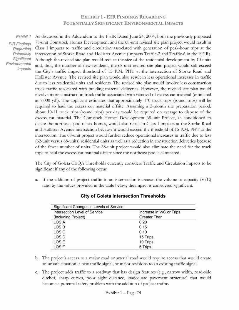
EEXXHHIIBBIITT 11 -- EEIIRR FFIINNDDIINNGGSS RREEGGAARRDDIINNGG PPOOTTEENNTTIIAALLLLYY SSIIGGNNIIFFIICCAANNTT EENNVVIIRROONNMMEENNTTAALL IIMMPPAACCTTSS
As discussed in the Addendum to the FEIR Dated June 24, 2004, both the previously proposed 78-unit Comstock Homes Development and the 68-unit revised site plan project would result in Class I impacts to traffic and circulation associated with generation of peak-hour trips at the intersection of Storke Road and Hollister Avenue (Impacts Traffic-2 and Traffic-6 in the FEIR). Although the revised site plan would reduce the size of the residential development by 10 units and, thus, the number of new residents, the 68-unit revised site plan project would still exceed the City’s traffic impact threshold of 15 P.M. PHT at the intersection of Storke Road and Hollister Avenue. The revised site plan would also result in less operational increases in traffic due to less residential units and residents. The revised site plan would involve less construction truck traffic associated with building material deliveries. However, the revised site plan would involve more construction truck traffic associated with removal of excess cut material (estimated at 7,000 yd3). The applicant estimates that approximately 470 truck trips (round trips) will be required to haul the excess cut material offsite. Assuming a 2-month site preparation period, about 10-11 truck trips (round trips) per day would be required on average to dispose of the excess cut material. The Comstock Homes Development 68-unit Project, as conditioned to delete the northeast pod of six homes, would also result in Class I impacts at the Storke Road and Hollister Avenue intersection because it would exceed the threshold of 15 P.M. PHT at the intersection. The 68-unit project would further reduce operational increases in traffic due to less (62-unit versus 68-units) residential units as well as a reduction in construction deliveries because of the fewer number of units. The 68-unit project would also eliminate the need for the truck trips to haul the excess cut material offsite since the northeast pod is eliminated.
EExxhhiibbiitt 11
EEIIRR FFiinnddiinnggss RReeggaarrddiinngg PPootteennttiiaallllyy SSiiggnniiffiiccaanntt
EEnnvviirroonnmmeennttaall IImmppaaccttss
The City of Goleta CEQA Thresholds currently considers Traffic and Circulation impacts to be significant if any of the following occur:
a. If the addition of project traffic to an intersection increases the volume-to-capacity (V/C) ratio by the values provided in the table below, the impact is considered significant.
City of Goleta Intersection Thresholds
Significant Changes in Levels of Service Intersection Level of Service (Including Project)
Increase in V/C or Trips Greater Than
LOS A LOS B LOS C LOS D LOS E LOS F
0.20 0.15 0.10 15 Trips 10 Trips 5 Trips
b. The project’s access to a major road or arterial road would require access that would create an unsafe situation, a new traffic signal, or major revisions to an existing traffic signal.
Exhibit 1 – Page 74
c. The project adds traffic to a roadway that has design features (e.g., narrow width, road-side ditches, sharp curves, poor sight distance, inadequate pavement structure) that would become a potential safety problem with the addition of project traffic.
EEXXHHIIBBIITT 11 -- EEIIRR FFIINNDDIINNGGSS RREEGGAARRDDIINNGG PPOOTTEENNTTIIAALLLLYY SSIIGGNNIIFFIICCAANNTT EENNVVIIRROONNMMEENNTTAALL IIMMPPAACCTTSS
d. Project traffic would utilize a substantial portion of an intersection’s capacity where the intersection is currently operating at acceptable levels of service but with cumulative traffic would degrade to or approach LOS D (V/C 0.80) or lower. Substantial is defined as a minimum change of 0.03 for an intersection which would operate from 0.80 to 0.85, a change of 0.02 for an intersection which would operate from 0.86 to 0.90, and a change of 0.01 for an intersection which would operate greater than 0.90.
EExxhhiibbiitt 11
EEIIRR FFiinnddiinnggss RReeggaarrddiinngg PPootteennttiiaallllyy SSiiggnniiffiiccaanntt EEnnvviirroonnmmeennttaall IImmppaaccttss
Using these criteria, the City of Goleta has determined that the Traffic and Circulation thresholds will be exceeded. Therefore, the project will have significant impacts on traffic and circulation in the project area that cannot be mitigated to a level below significance. Nevertheless, the City has proposed the following mitigation measures to somewhat reduce the above impacts.
2.4.3 Mitigation Measure Summary
The proposed Comstock Homes residential development project would result in a potentially significant project-specific impact at Storke Road/Hollister Avenue intersection. Three improvement options are identified (Mitigation Traffic 1-a, 1-b, and 1-c). These potential intersection improvements are not programmed at this time and are unfunded and no other feasible mitigation measures are known which would further reduce the impacts.
Improving the level of service at this intersection would require additional analysis of options previously identified by the County as part of the Goleta Transportation Improvement Plan (GTIP, 1997/1999), as well as other alternatives. The City of Goleta is reviewing adequacy of proposed improvements as well as possible alternative improvements as part of its ongoing General Plan process. Once the appropriate improvement or combination of improvements is identified, total costs (including acquisition of any right-of-way) and timing of implementation would need to be determined. Preliminarily, it appears that costs could be approximately $3 million for improvements that have been previously identified (Mitigations Traffic 1-a, 1-b, and 1-c). Costs of alternative improvements are unknown a this time but could be as high as $12 million in the event of extensive right-of-way acquisition. Implementation could take as long as approximately 7 years (2011).
The project’s obligation to lessen the potentially significant project-specific impact could include full payment for one of the identified Mitigations Traffic 1-a, 1-b, or 1-c or a partial contribution to a more comprehensive improvement as described in Mitigation Traffic 1-d, the scope of which is yet to be defined.
Mitigation Measure Traffic-1a. One of the operational constraints at the Storke Road/Hollister Avenue intersection is the lack of a westbound merge lane for the heavy right-turn movement from southbound Storke Road onto westbound Hollister Avenue. Vehicles traveling southbound on Storke Road turning right onto Hollister Avenue are at times delayed at the yield sign waiting for gaps in the westbound traffic stream on Hollister Avenue. These vehicles form queues that back up onto Storke Road and affect the southbound through
\\coast\share\Board Meeting Materials\June Board Items\13 Ellwood Mesa-Travis\NEW FINAL Exhibit 1 to Exhibit 4 City's EIR findings.doc Exhibit 1 – Page 75
EEXXHHIIBBIITT 11 -- EEIIRR FFIINNDDIINNGGSS RREEGGAARRDDIINNGG PPOOTTEENNTTIIAALLLLYY SSIIGGNNIIFFIICCAANNTT EENNVVIIRROONNMMEENNTTAALL IIMMPPAACCTTSS
movements at the traffic signal. Providing a merge lane in front of the service station on this corner of the intersection would allow the vehicles to turn onto Hollister Avenue without being delayed by the through traffic. With this improvement in place, the intersection would operate at LOS C-D (V/C 0.806) with existing + project volumes. This improvement would off-set the project’s traffic addition and thus mitigate the impacts of the project.
EExxhhiibbiitt 11
EEIIRR FFiinnddiinnggss RReeggaarrddiinngg PPootteennttiiaallllyy SSiiggnniiffiiccaanntt
EEnnvviirroonnmmeennttaall IImmppaaccttss Mitigation Measure Traffic-1b. The Goleta Transportation Improvement Plan (GTIP)
includes an improvement for the intersection that involves adding a third eastbound left-turn lane. The GTIP improvement would also require adding a third lane on Storke Road northbound from Hollister Avenue to the U.S. 101 southbound ramp intersection. There are currently two northbound lanes on Storke Road and the third lane would be required to accept the traffic from the three eastbound left turn lanes on Hollister Avenue. Implementation of the third left-turn lane would also require widening of Hollister Avenue adjacent to the Camino Real Marketplace site, which may require additional right-of-way from adjacent properties. The intersection’s operation would be improved to LOS C (V/C 0.77) with this improvement.
Mitigation Measure Traffic-1c. The previous GTIP (1997 version) included a project to add a third westbound through lane at the Storke Road/Hollister Avenue intersection. This mitigation would improve the intersection’s operation to LOS C (V/C 0.78). The third westbound through lane option at the intersection would require acquisition of right-of-way from developed properties on the north side of Hollister Avenue west of Storke Road (from a gas station and a recently constructed office building), as well as right-of-way from a vacant parcel located east of the intersection.
Mitigation Measure Traffic-1d. The applicant shall post a performance security (or utilize another mechanism acceptable to the City of Goleta) and enter into an agreement with the City of Goleta for: a) the implementation of one or more of Mitigations Traffic 1-a, 1-b, or 1-c; and/or b) the analysis of improvement alternatives, engineered design of approved improvement alternatives, and/or construction of approved improvement alternatives. The applicant’s financial obligation under this requirement shall not exceed $1 million.
Actual completion of necessary improvements listed above would not occur prior to occupancy of the proposed development project and, therefore, only partial mitigation is considered to be available at this time. As a result, project-specific impacts at the Storke Road/Hollister Avenue intersection remain significant and unavoidable.
All other potentially significant project-specific impacts would be satisfactorily mitigated below the level of significance through implementation of Mitigation Traffic-2, -3, and -4.
Cumulatively significant impacts are considered satisfactorily mitigated below the level of significance through payment of development impact fees (CEQA Guidelines Section 15130[a][3]). Transportation fees are currently $9,959/single-family unit and the estimated fee amount is $776,802. The exact fee amount would be determined at the time of map recordation and would be based on the fee schedule in effect when paid.
Exhibit 1 – Page 76

EEXXHHIIBBIITT 11 -- EEIIRR FFIINNDDIINNGGSS RREEGGAARRDDIINNGG PPOOTTEENNTTIIAALLLLYY SSIIGGNNIIFFIICCAANNTT EENNVVIIRROONNMMEENNTTAALL IIMMPPAACCTTSS
EExxhhiibbiitt 11
EEIIRR FFiinnddiinnggss RReeggaarrddiinngg PPootteennttiiaallllyy SSiiggnniiffiiccaanntt EEnnvviirroonnmmeennttaall IImmppaaccttss
2.4.4 Findings Regarding Mitigations Measures and Project Alterations Incorporated Into Revised Site Plan Dated June 18, 2004
Pursuant to Public Resources Code Section 21081 (a) and State CEQA Guidelines Section 15091 (a), the City finds that the impacts stated above will be substantially reduced by the identified mitigation measures. The City further finds that in spite of the changes or alterations that have been required in or incorporated into the project, these impacts can be reduced, but not to a level less than significant. Moreover, the City finds that there are no additional mitigation measures that might avoid or reduce these impacts because specific economic, legal, social, biological, and other considerations make other mitigation measures infeasible. Nevertheless, these unavoidable significant effects are considered acceptable when balanced against the overriding benefits of the project, as set forth in the Statement of Overriding Considerations [Public Resources Code Section 21081(a)(3), CEQA Guidelines Section 15091(a)(3)].
As discussed in the Addendum to the FEIR Dated June 24, 2004, both the previously proposed 78-unit Comstock Homes Development and the 68-unit revised site plan project would result in Class I impacts to traffic and circulation associated with generation of peak-hour trips at the intersection of Storke Road and Hollister Avenue. Thus, the project alterations evaluated in the Addendum to the FEIR dated June 24, 2004, including the reduction in the number of units and subsequent reduced construction schedule and the removal of excess cut materials by truck trips, do not substantially change the impact conclusions or required mitigation measures described above. The Comstock Homes Development 68-unit Project, as conditioned to delete the northeast pod of six homes, would also result in Class I impacts at the Storke Road and Hollister Avenue intersection because it would exceed the threshold of 15 P.M. PHT at the intersection. The 68-unit project would further reduce operational increases in traffic due to less (62-unit versus 68-units) residential units as well as a reduction in construction deliveries because of the fewer number of units. The 68-unit project would also eliminate the need for the truck trips to haul the excess cut material offsite since the northeast pod is eliminated.
Therefore, the City of Goleta finds that only relocation of the entire project away from the Ellwood Mesa Open Space Plan area could reduce the traffic and circulation impacts to the Storke and Hollister Avenue intersection to a level below significance. As set forth in the Statement of Overriding Considerations, such relocation is not feasible or consistent with the overall land swap that forms the basis for creating the Ellwood Mesa-Santa Barbara Shores area. The creation of the Ellwood Mesa Open Space Plan Area results in numerous benefits spelled out in the Statement of Overriding Considerations. Thus, the unavoidable significant traffic and circulation impacts to the Storke and Hollister intersection are considered acceptable when balanced against the overall benefits of the project.
\\coast\share\Board Meeting Materials\June Board Items\13 Ellwood Mesa-Travis\NEW FINAL Exhibit 1 to Exhibit 4 City's EIR findings.doc Exhibit 1 – Page 77
EEXXHHIIBBIITT 11 -- EEIIRR FFIINNDDIINNGGSS RREEGGAARRDDIINNGG PPOOTTEENNTTIIAALLLLYY SSIIGGNNIIFFIICCAANNTT EENNVVIIRROONNMMEENNTTAALL IIMMPPAACCTTSS
2.5 NOISE EExxhhiibbiitt 11
EEIIRR FFiinnddiinnggss RReeggaarrddiinngg PPootteennttiiaallllyy SSiiggnniiffiiccaanntt
EEnnvviirroonnmmeennttaall IImmppaaccttss
2.5.1 Significant Impacts
Two Class I noise impacts have been identified in the FEIR. These include short-term noise levels generated by construction activities at the Comstock Homes Development site and the new open space parking area. These impacts can be mitigated using feasible mitigation measures, but not to levels below significance. The impacts are as follows:
Impact N-2. Short-term noise levels from grading and construction activities within the Comstock Homes project could reach maximum values of over 80 dBA near the Ellwood School, and 72 dBA at the residences to the east in Santa Barbara Shores. Park users and golfers at the Sandpiper Golf Course could experience short peak noise levels up to 90 dBA. Noise at these levels would disrupt normal outdoor activities, but would only occur when heavy equipment is operating within the Comstock Homes Development project at a location nearest to the school, residences or golf course. This impact could occur intermittently for up to 6 to 8 weeks during grading activities. Even though construction noise would be periodic and short-term in nature, it would cause a significant and unavoidable impact.
Impact N-3. Grading and construction noise during development of the new access drive, parking, restroom, and staging area for the park area would affect the existing residences to the east of the parking area, as well as the Ellwood School. Construction would take approximately three months. The heavy grading and earth moving phase for the project would take one to two weeks. Portions of the Ellwood School and many of the residences are less than 500 feet away; and these locations may experience short peak noise levels up to 80 dBA during the periods of heavy construction activity. Open Space visitors in the area during construction may also be exposed to construction noise up to 90 dBA in the immediate vicinity of construction equipment. This is considered a short-term significant and unavoidable impact.
2.5.2 Facts Supporting the Impact Findings
Grading and construction noise levels were determined using published information on noise levels for equipment typically used in this type of work. Grading and construction noise associated with housing development or parking lot construction would result in short-term noise levels of 80 to 90 dBA.
As described in the Addendum to the FEIR, dated June 24, 2004, both the previously proposed 78-unit Comstock Homes Development and the 68-unit revised site plan project would result in significant noise impacts. However, the 68-unit revised site plan would involve less construction then the previously proposed 78-unit project due to 10 less residential units and the reduction in the number of 2-story homes.
The revised site plan would require less grading but more export of excess cut material than the previously proposed 78-unit project. The additional truck traffic required to haul and export the
Exhibit 1 – Page 78
EEXXHHIIBBIITT 11 -- EEIIRR FFIINNDDIINNGGSS RREEGGAARRDDIINNGG PPOOTTEENNTTIIAALLLLYY SSIIGGNNIIFFIICCAANNTT EENNVVIIRROONNMMEENNTTAALL IIMMPPAACCTTSS
excess cut soil material would contribute to significant construction noise impacts for several months. The Comstock Homes Development 68-unit Project, as conditioned to delete the northeast pod of six homes, would reduce the Class I impacts associated with construction noise since it would involve less construction due to the reduction in the number of residential units (62-units versus 68-units). In addition, the construction noise resulting from the haul and export of excess cut soil material would not occur since this grading is associated with the northeast pod of homes which is now eliminated. The planned sewer lift station will have an underground (submerged) electrical pump that is expected to be inaudible at the fenceline. The backup diesel generator would generate noise on a periodic, but infrequent basis (twice per year during 1-hour event safety testing).
EExxhhiibbiitt 11
EEIIRR FFiinnddiinnggss RReeggaarrddiinngg PPootteennttiiaallllyy SSiiggnniiffiiccaanntt EEnnvviirroonnmmeennttaall IImmppaaccttss
Construction noise impacts associated with the relocated parking lot and restroom in the Open Space area would be the same for the previously proposed 78-unit project and the 68-unit revised site plan project. The lowered elevation of the northeastern residential pod would negate the need for the previously proposed sound wall south of Hollister Avenue. Furthermore, the Comstock Homes Development 68-unit Project, as conditioned to delete the northeast pod of six homes, would further negate this needs since the northeast pod is now eliminated.
The basic Threshold criterion used to determine significant impacts to residential areas is an Ldn or CNEL of 65 dBA or greater. The Threshold for construction noise is any residence or sensitive receptor within 1,600 feet of the construction equipment. This is based on the assumption that peak noise levels from construction equipment range from 80-90 dBA at 50 feet, and a distance of 1,600 feet is necessary to reduce these peaks to 65 dBA or less.
There are no explicit recommendations for noise levels in recreation and open space areas within the Thresholds and Guidelines Manual. As a further point of reference, noise standards in the Santa Barbara County General Plan Noise Element, indicate that neighborhood parks are compatible with Ldn values up to 70 dBA, and golf courses and riding stables are compatible with Ldn values up to 75 dBA (County of Santa Barbara, 1986). While such levels may be acceptable in the transition areas as one leaves major streets and enters the Ellwood Mesa Open Space Plan area, they do not seem compatible with the sense of isolation and tranquility that is important in the ocean bluff, eucalyptus grove, and larger open space areas. For most of the open space, noise levels should be maintained at levels below an Ldn or CNEL of 65 dBA, similar to residential and other sensitive uses.
Using these criteria, the City of Goleta has determined that, given the proximity of the construction and grading activities to sensitive receptors (residences, Ellwood School, Open Space users, golfers), noise thresholds would be exceeded by construction and grading equipment. These noise impacts are considered to be unavoidable and cannot be mitigated to levels below significance. Nevertheless, the City has proposed the following mitigation measures to somewhat reduce the above impacts.
\\coast\share\Board Meeting Materials\June Board Items\13 Ellwood Mesa-Travis\NEW FINAL Exhibit 1 to Exhibit 4 City's EIR findings.doc Exhibit 1 – Page 79
EEXXHHIIBBIITT 11 -- EEIIRR FFIINNDDIINNGGSS RREEGGAARRDDIINNGG PPOOTTEENNTTIIAALLLLYY SSIIGGNNIIFFIICCAANNTT EENNVVIIRROONNMMEENNTTAALL IIMMPPAACCTTSS
2.5.3 Mitigation Measure Summary EExxhhiibbiitt 11
EEIIRR FFiinnddiinnggss RReeggaarrddiinngg PPootteennttiiaallllyy SSiiggnniiffiiccaanntt
EEnnvviirroonnmmeennttaall IImmppaaccttss
Based upon the analyses presented in Section 4 of the FEIR and the Addendum to the FEIR dated June 24, 2004, the following Mitigation Measures are determined to be feasible. However, these measures will not reduce the impacts to a level below significance and no other feasible mitigation measures are known which would further reduce the impacts.
Mitigation Measure N-2 – Construction Timing. Construction activity for site preparation and for future development shall be limited to the hours between 7:00 a.m. and 4:00 p.m., Monday through Friday. No construction shall occur on State holidays (e.g., Thanksgiving, Labor Day). Construction equipment maintenance shall be limited to the same hours. Non-noise generating construction activities such as interior painting are not subject to these restrictions. Signs stating these restrictions shall be provided by the contractor and posted on site. This signage requirement shall be printed on grading and building plans prior to the approval of Land Use Permits.
Mitigation Measure N-3 – Additional Limitation of Construction Timing for Open Space Parking Area. To the extent feasible to meet project schedule, construction within the open space parking area shall be restricted to days when school is not in session at the Ellwood Elementary School (e.g., during summer vacation or winter or spring break). This requirement shall be printed on grading and building plans prior to approval of Land Use Permits.
Mitigation Measure N-4 – Construction Equipment. Stationary construction equipment that generates noise in excess of 65 dBA at the project boundaries shall be shielded and located as far towards the interior of the construction site as practical to minimize the noise levels at the residences to the east, the Ellwood Elementary School to the northeast, and the golf course to the west. The equipment area shall be designated on building and grading plans. Equipment and shielding shall remain in the designated location throughout construction activities.
2.5.4 Findings Regarding Mitigations Measures and Project Alterations Incorporated Into Revised Site Plan Dated June 18, 2004
Pursuant to Public Resources Code Section 21081 (a) and State CEQA Guidelines Section 15091 (a), the City finds that the impacts stated above will be lessened by the identified mitigation measures. The City further finds that in spite of the changes or alterations that have been required in or incorporated into the project, these impacts can be reduced but not to a level less than significant. Moreover, the City finds that there are no additional mitigation measures that might avoid or reduce these impacts because specific economic, legal, social, biological, and other considerations make other mitigation measures infeasible. Nevertheless, these unavoidable significant effects are considered acceptable when balanced against the overriding benefits of the project, as set forth in the Statement of Overriding Considerations [Public Resources Code Section 21081(a)(3), CEQA Guidelines Section 15091(a)(3)].
Exhibit 1 – Page 80
EEXXHHIIBBIITT 11 -- EEIIRR FFIINNDDIINNGGSS RREEGGAARRDDIINNGG PPOOTTEENNTTIIAALLLLYY SSIIGGNNIIFFIICCAANNTT EENNVVIIRROONNMMEENNTTAALL IIMMPPAACCTTSS
As described in the Addendum to the FEIR, dated June 24, 2004, both the previously proposed 78-unit Comstock Homes Development and the 68-unit revised site plan project would result in significant noise impacts. However, the 68-unit revised site plan would involve less construction then the previously proposed 78-unit project due to 10 less residential units and the reduction in the number of 2-story homes. However, even with the project alterations evaluated in the Addendum to the FEIR dated June 24, 2004, including the reduction in number of units, reduction in the number of 2-story units, the removal of excess cut soil and subsequent truck trips, and the operation of the sewer lift station and emergency generator, the impact conclusions or required mitigation measures described above do not change substantially as compared to the originally proposed project. The Comstock Homes Development 68-unit Project, as conditioned to delete the northeast pod of six homes, would reduce the Class I impacts associated with construction noise since it would involve less construction due to the reduction in the number of residential units (62-units versus 68-units). In addition, the construction noise resulting from the haul and export of excess cut soil material would not occur since this grading is associated with the northeast pod of homes which is now eliminated.
EExxhhiibbiitt 11
EEIIRR FFiinnddiinnggss RReeggaarrddiinngg PPootteennttiiaallllyy SSiiggnniiffiiccaanntt EEnnvviirroonnmmeennttaall IImmppaaccttss
Therefore, the City of Goleta finds that the restrictions placed on hours of operation, and the clustering of equipment towards the interior of the construction site are feasible measures that have been shown to reduce offsite noise levels. Moreover, these measures are enforceable. Building Inspectors and Permit Compliance shall spot check and respond to complaints related to construction, and can issue violations that may result in the suspension of permits.
Nevertheless, the City finds that these measures will not reduce noise impacts to a level below significance. Moreover, the City has concluded that only elimination of construction and grading activities would cancel significant noise impacts. Such elimination would negate the benefits to be derived from having the Comstock Homes Development and new parking lot completed. As stipulated in the Statement of Overriding Considerations, the Comstock Homes Development is a critical component of the land swap required for creating the Ellwood Mesa Open Space Plan Area. The new parking lot provides much needed public access to the Open Space by replacing the parking displaced by Comstock Homes Development. Thus, the unavoidable significant noise impacts related to construction and grading are considered acceptable when balanced against the overall benefits of the project.
\\coast\share\Board Meeting Materials\June Board Items\13 Ellwood Mesa-Travis\NEW FINAL Exhibit 1 to Exhibit 4 City's EIR findings.doc Exhibit 1 – Page 81
EEXXHHIIBBIITT 11 -- EEIIRR FFIINNDDIINNGGSS RREEGGAARRDDIINNGG PPOOTTEENNTTIIAALLLLYY SSIIGGNNIIFFIICCAANNTT EENNVVIIRROONNMMEENNTTAALL IIMMPPAACCTTSS
SECTION 3.0 FINDINGS THAT THE IDENTIFIED PROJECT ALTERNATIVES
ARE NOT FEASIBLE
EExxhhiibbiitt 11
EEIIRR FFiinnddiinnggss RReeggaarrddiinngg PPootteennttiiaallllyy SSiiggnniiffiiccaanntt
EEnnvviirroonnmmeennttaall IImmppaaccttss
The Final EIR, 04-EIR-01, evaluated the alternatives listed below for their potential to reduce or eliminate potentially significant impacts:
• Alternative 1: No Project Alternative
• Alternative 2: Reduced Development Envelope Option A (FEIR Figure 6.2-1)
• Alternative 3: Reduced Development Envelope Option B (FEIR Figure 6.2-2)
• Alternative 4: Reduced Development Envelope Option C (FEIR Figure 6.2-1)
• Alternative 5: Reduced Development Envelope Option D (FEIR Figure 6.2-3)
• Alternative 6: Offsite Alternative (FEIR Figure 6.2-4)
• Alternative 7: Reduced Open Space Plan Alternative
The key project objectives that are pertinent to this analysis are:
• Shift existing private development rights (Santa Barbara Development Partnership [SBDP]) within the jurisdiction of the City of Goleta from privately-owned coastal mesa habitat and open space to less environmentally sensitive City of Goleta-owned park property (Santa Barbara Shores Park) through a property exchange and/or through the purchase of development rights. This exchange would increase the size of Santa Barbara Shores Park from approximately 116.16 to 216.78 acres and would designate the entire park as permanent open space.
• Associated with the shift of development rights to the north and away from the coast, allow some level of residential development of the Comstock Homes Development site (up to 78 units, maximum) on a 36-acre portion of the existing City of Goleta 116.16-acre Santa Barbara Shores Park that is directly south of Hollister Avenue. The actual number of residential units is dependent, in part, on the developer’s need to make a reasonable return on the investment to justify the property exchange.
• Maintain and improve passive enhanced open space recreation opportunities and preserve and restore environmentally sensitive habitat in the portions of the proposed Open Space Plan area under the City’s jurisdiction, in coordination with the University of California at Santa Barbara and the County of Santa Barbara.
The City Council finds that each of the specified alternatives is infeasible and less desirable than the revised Comstock Homes 68-unit revised project submitted on June 18, 2004 as conditioned to delete the northeastern pod of six (6) homes, and the alternatives are therefore rejected for the following reasons:
Exhibit 1 – Page 82
EEXXHHIIBBIITT 11 -- EEIIRR FFIINNDDIINNGGSS RREEGGAARRDDIINNGG PPOOTTEENNTTIIAALLLLYY SSIIGGNNIIFFIICCAANNTT EENNVVIIRROONNMMEENNTTAALL IIMMPPAACCTTSS
3.1 ALTERNATIVE 1: NO PROJECT ALTERNATIVE EExxhhiibbiitt 11
EEIIRR FFiinnddiinnggss RReeggaarrddiinngg PPootteennttiiaallllyy SSiiggnniiffiiccaanntt EEnnvviirroonnmmeennttaall IImmppaaccttss
This Alternative could result in the development of five (5) dwelling units in the Ellwood Mesa area on each of the five legal parcels that comprise the Ellwood Mesa site owned by the Santa Barbara Development Partnership. This alternative would require appropriate site layout for the units and various improvements to be constructed and maintained in order to serve the new units on Ellwood Mesa, including access roads and driveways; water supply main and distribution lines; municipal sewer connections; electrical interconnections; and natural gas supply interconnection.
Under this alternative the proposed land exchange and associated shift of development rights to the north away from the Ellwood Mesa coast to the less environmentally sensitive City of Goleta-owned Santa Barbara Shores Park would not occur. The No Project Alternative, if selected, would result in elimination of proposed development from the 36-acre portion of the Santa Barbara Shores property as well as loss of Open Space Plan opportunities. Implementation of the Open Space Plan and associated biological, recreational, and open space benefits would not occur. Additionally, selection of Alternative 1 could have greater impacts on biological resources than the revised 68-unit project (and Alternatives 2 through 5, and 7) as a result of potential direct and indirect impacts to, and fragmentation of, biological and other resources.
In summary, this alternative would achieve none of the project objectives, would forego all of the benefits associated with the land exchange and Open Space Plan itemized in the Statement of Overriding Considerations, and could result in similar or greater environmental impacts than the revised 68-unit project as conditioned to delete the northeastern pod of six (6) homes. For these reasons, the No Project Alternative is considered infeasible and is rejected.
3.2 ALTERNATIVE 2: REDUCED DEVELOPMENT ENVELOPE OPTION A
This alternative includes 78 or fewer single-family residences on the 36-acre Santa Barbara Shores property, in the same general area and configuration as the proposed project. However, under this alternative, the development area would avoid the environmentally sensitive habitat and associated buffer for the monarch butterfly and raptor roosting and nesting along the southern portion of the western boundary of the 36-acre portion of the Santa Barbara Shores property. Additionally, this alternative would avoid the placement of drainage control/water quality basins within the riparian buffer in the east-central portion of the development and within the environmentally sensitive habitat overlay setback along the southern boundary of the development area. Under this alternative, approximately 9 lots in the southwest portion of the proposed development area would not be developed due to their proximity to eucalyptus woodlands and buffers. The area of the proposed cul-de-sac serving these 9 lots would also not be available for development. In addition, it is assumed that 2 to 4 additional lots would not be developed due to the need to relocate drainage control/water quality basins away from environmentally sensitive habitat overlay setbacks and riparian buffers. The total area available for residential development under Alternative 2 is approximately 21.04 acres. Unless the proposed lot size and layout are revised, about 15 percent fewer lots would be developed under
\\coast\share\Board Meeting Materials\June Board Items\13 Ellwood Mesa-Travis\NEW FINAL Exhibit 1 to Exhibit 4 City's EIR findings.doc Exhibit 1 – Page 83
EEXXHHIIBBIITT 11 -- EEIIRR FFIINNDDIINNGGSS RREEGGAARRDDIINNGG PPOOTTEENNTTIIAALLLLYY SSIIGGNNIIFFIICCAANNTT EENNVVIIRROONNMMEENNTTAALL IIMMPPAACCTTSS
this alternative, compared to the 78-unit project. The developed area would be allowed to impact all or portions of 6 separate isolated native grassland acres totaling approximately 0.41 acre (including 10-foot buffers) in the southcentral portion of the development area. An access road across the drainage to the cul-de-sac in the northeast portion of the site would be allowed to impact the riparian buffer under this alternative.
EExxhhiibbiitt 11
EEIIRR FFiinnddiinnggss RReeggaarrddiinngg PPootteennttiiaallllyy SSiiggnniiffiiccaanntt
EEnnvviirroonnmmeennttaall IImmppaaccttss The proposed Open Space Plan improvements would be the same for this alternative as for the
proposed 78-unit project.
The 68-unit revised project as conditioned to delete the northeastern pod of six (6) homes, incorporates many of the Alternative 2 elements and provides additional resource protection as follows:
• The 68-unit project would provide more than the minimum 100-foot buffer from the nearby monarch butterfly aggregation area and raptor roosting and nesting area and a 50-foot or greater buffer from the southern portion of the western windrow, which is considered contributory habitat to the butterfly aggregation and raptor ESHA. This is an adjustment to the continuous 100-foot buffer shown for Alternative 2 in Figure 6.2-1 of the FEIR, but is considered adequate.
• The 68-unit project would preserve a greater length of the corridor associated with Drainage B, than would be preserved under Alternative 2.
• The 68-unit project eliminates the six (6) homes in the northeastern pod and therefore eliminates the need to construct the access road/drainage crossing over Drainage A1, thereby avoiding impacts to wetlands. Impacts associated with excavation and grading at this location would also be avoided.
• The 68-unit project would provide a buffer equal to or greater than the 50-foot minimum (Coastal Zoning Ordinance, Article II, Section 35-97.19.1) for the Drainage A1 and A2 riparian corridors and associated wetland features. The buffer ranges from 50 – 70 feet and is considered adequate for the biologic and hydrologic function of these resources.
• The 68-unit project eliminates the six (6) homes in the northeastern pod and therefore eliminates the visual impact created at this location and preserves the Channel Island view corridor.
• The 68-unit project shifts lots in the northwest corner of the 36-acre development envelope approximately 20 feet eastward, providing greater protection for the eucalyptus windrow at this location than would be provided under Alternative 2.
• The 68-unit project would also provide continuous public open space along the western property boundary through dedication of property at this location to the City of Goleta. A similar dedication of public open space would not occur under Alternative 2.
On balance, the 68-unit revised project submitted on June 18, 2004 as conditioned to delete the northeastern pod of six (6) homes, would accomplish the same or greater habitat protection and
Exhibit 1 – Page 84
EEXXHHIIBBIITT 11 -- EEIIRR FFIINNDDIINNGGSS RREEGGAARRDDIINNGG PPOOTTEENNTTIIAALLLLYY SSIIGGNNIIFFIICCAANNTT EENNVVIIRROONNMMEENNTTAALL IIMMPPAACCTTSS
impact mitigation as Alternative 2, while allowing for a number of residential units that would preserve the economic feasibility of the development project so that the benefits associated with the land exchange and Open Space Plan can be realized (as itemized in the Statement of Overriding Considerations). For this reason, Alternative 2 is considered infeasible and is less desirable than the 68-unit project, and is therefore rejected.
EExxhhiibbiitt 11
EEIIRR FFiinnddiinnggss RReeggaarrddiinngg PPootteennttiiaallllyy SSiiggnniiffiiccaanntt EEnnvviirroonnmmeennttaall IImmppaaccttss 3.3 ALTERNATIVE 3: REDUCED DEVELOPMENT ENVELOPE OPTION B
This alternative would involve 78 or fewer single-family residences on the 36-acre portion of the Santa Barbara Shores property, in the same general area and configuration as the proposed project. However, similar to the design of Alternative 2, development in accordance with Alternative 3 would avoid riparian areas and riparian buffers, as well as eucalyptus woodlands and associated environmentally sensitive habitat overly buffers. Approximately 25 percent fewer lots (about 19 lots less) would be developed under this alternative, compared to the proposed project. The seven residential lots proposed on the cul-de-sac adjacent to Hollister Avenue in the northeast portion of the property, as well as the associated access road/drainage crossing, would not occur under this alternative. Similar to Alternative 2, the developed area would be allowed to impact all or portions of six separate isolated native grassland areas totaling 0.41 acre (with the 10-foot buffer) in the southcentral portion of the development area. The total area available for residential development under this alternative is approximately 19.08 acres.
The proposed Open Space Plan improvements would be the same for this alternative as for the proposed project.
The 68-unit revised project as conditioned to delete the northeastern pod of six (6) homes, incorporates many of the Alternative 3 elements and provides additional resource protection as follows:
• The 68-unit project would provide more than the minimum 100-foot buffer from the nearby monarch butterfly aggregation area and raptor roosting and nesting area and a 50-foot or greater buffer from the southern portion of the western windrow, which is considered contributory habitat to the butterfly aggregation and raptor ESHA. This is an adjustment to the continuous 100-foot buffer shown for Alternative 3 in Figure 6.2-2 of the FEIR, but is considered adequate.
• The 68-unit project would preserve a greater length of the corridor associated with Drainage B, than would be preserved under Alternative 3.
• Similar to Alternative 3, the 68-unit project eliminates the six (6) homes in the northeastern pod and therefore eliminates the need to construct the access road/drainage crossing over Drainage A1, thereby avoiding impacts to wetlands. Impacts associated with grading and excavation at this location would also be avoided.
• The 68-unit project would provide a buffer equal to or greater than the 50-foot minimum (Coastal Zoning Ordinance, Article II, Section 35-97.19.1) for the Drainage A1 and A2
\\coast\share\Board Meeting Materials\June Board Items\13 Ellwood Mesa-Travis\NEW FINAL Exhibit 1 to Exhibit 4 City's EIR findings.doc Exhibit 1 – Page 85
EEXXHHIIBBIITT 11 -- EEIIRR FFIINNDDIINNGGSS RREEGGAARRDDIINNGG PPOOTTEENNTTIIAALLLLYY SSIIGGNNIIFFIICCAANNTT EENNVVIIRROONNMMEENNTTAALL IIMMPPAACCTTSS
riparian corridors and associated wetland features. The buffer ranges from 50 – 70 feet and is considered adequate for the biologic and hydrologic function of these resources.
EExxhhiibbiitt 11
EEIIRR FFiinnddiinnggss RReeggaarrddiinngg PPootteennttiiaallllyy SSiiggnniiffiiccaanntt
EEnnvviirroonnmmeennttaall IImmppaaccttss
• Similar to Alternative 3, the 68-unit project also eliminates the six (6) homes in the northeastern pod and therefore eliminates the visual impact created at this location and preserves the Channel Island view corridor.
• The 68-unit project shifts lots in the northwest corner of the 36-acre development envelope approximately 20 feet eastward, providing greater protection for the eucalyptus windrow at this location than would be provided under Alternative 3.
• The 68-unit project would also provide continuous public open space along the western property boundary through dedication of property at this location to the City of Goleta. A similar dedication of public open space would not occur under Alternative 3.
On balance, the 68-unit revised project submitted on June 18, 2004 as conditioned to delete the northeastern pod of six (6) homes, would accomplish the same or greater habitat protection and impact mitigation as Alternative 3, while allowing for a number of residential units that would preserve the economic feasibility of the development project so that the benefits associated with the land exchange and Open Space Plan can be realized (as itemized in the Statement of Overriding Considerations). For this reason, Alternative 3 is considered similar to, but is considered environmentally less desirable than the 68-unit project and is therefore rejected.
3.4 ALTERNATIVE 4: REDUCED DEVELOPMENT ENVELOPE OPTION C
This alternative is a variation of Alternative 2, in that attached single-family townhouse residential units would be introduced into the project. Alternative 4 includes 78 single-family detached and attached units (mix undetermined) on the 36-acre portion of the Santa Barbara Shores property, in the same general area and configuration as the proposed project. However, in this alternative, the developed area would avoid most riparian areas and riparian buffers, as well as eucalyptus woodlands and associated environmentally sensitive habitat overlay buffers. Similar to Alternatives 2 and 3, the developed area would be allowed to impact isolated native grassland areas. An access road across the drainage to the cul-de-sac in the northeast portion of the site would be allowed to impact the riparian buffer under this alternative. The total area available for residential development under this alternative is approximately 21.2 acres.
The proposed Open Space Plan improvements would be the same for this alternative as for the proposed 78-unit project.
The 68-unit revised project as conditioned to delete the northeastern pod of six (6) homes, incorporates many of the Alternative 4 elements and provides additional resource protection as follows:
Exhibit 1 – Page 86
• The 68-unit project would provide more than the minimum 100-foot buffer from the nearby monarch butterfly aggregation area and raptor roosting and nesting area and a 50-foot or greater buffer from the southern portion of the western windrow, which is considered
EEXXHHIIBBIITT 11 -- EEIIRR FFIINNDDIINNGGSS RREEGGAARRDDIINNGG PPOOTTEENNTTIIAALLLLYY SSIIGGNNIIFFIICCAANNTT EENNVVIIRROONNMMEENNTTAALL IIMMPPAACCTTSS
contributory habitat to the butterfly aggregation and raptor ESHA. This is an adjustment to the continuous 100-foot buffer shown for Alternative 4 in Figure 6.2-1 of the FEIR, but is considered adequate.
EExxhhiibbiitt 11
EEIIRR FFiinnddiinnggss RReeggaarrddiinngg PPootteennttiiaallllyy SSiiggnniiffiiccaanntt EEnnvviirroonnmmeennttaall IImmppaaccttss
• The 68-unit project would preserve a greater length of the corridor associated with Drainage B, than would be preserved under Alternative 4.
• The 68-unit project eliminates the six (6) homes in the northeastern pod and therefore eliminates the need to construct the access road/drainage crossing over Drainage A1, thereby avoiding impacts to wetlands. Impacts associated with grading and excavation at this location would also be avoided.
• The 68-unit project would provide a buffer equal to or greater than the 50-foot minimum (Coastal Zoning Ordinance, Article II, Section 35-97.19.1) for the Drainage A1 and A2 riparian corridors and associated wetland features. The buffer ranges from 50 – 70 feet and is considered adequate for the biologic and hydrologic function of these resources.
• The 68-unit project eliminates the six (6) homes in the northeastern pod and therefore eliminates the visual impact created at this location and preserves the Channel Island view corridor.
• The 68-unit project shifts lots in the northwest corner of the 36-acre development envelope approximately 20 feet eastward, providing greater protection for the eucalyptus windrow at this location than would be provided under Alternative 4.
• The 68-unit project would also provide continuous public open space along the western property boundary through dedication of property at this location to the City of Goleta. A similar dedication of public open space would not occur under Alternative 4.
On balance, the 68-unit revised project submitted on June 18, 2004 as conditioned to delete the northeastern pod of six (6) homes, would accomplish the same or greater habitat protection and impact mitigation as Alternative 4, while allowing for a number of residential units that would preserve the economic feasibility of the development project so that the benefits associated with the land exchange and Open Space Plan can be realized (as itemized in the Statement of Overriding Considerations). For this reason, Alternative 4 is considered infeasible and is less desirable than the 68-unit project, and is therefore rejected.
3.5 ALTERNATIVE 5: REDUCED DEVELOPMENT ENVELOPE OPTION D
This alternative is a variation of Alternatives 2 and 4, in that sensitive biological resources are avoided and attached single-family townhouse units are introduced into the project. Alternative 5 includes 78 detached single-family and attached townhouse units (mix undetermined) on the 36-acre portion of the Santa Barbara Shores property, in the same general area and configuration as the proposed project. Similar to Alternatives 2, 3, and 4, under this alternative, the developed area would avoid most riparian buffers, as well as eucalyptus woodlands and associated environmentally sensitive habitat overlay setbacks. However, unlike Alternatives 2, 3, and 4, the developed area would not be allowed to impact isolated native grasslands. Native grassland areas
\\coast\share\Board Meeting Materials\June Board Items\13 Ellwood Mesa-Travis\NEW FINAL Exhibit 1 to Exhibit 4 City's EIR findings.doc Exhibit 1 – Page 87
EEXXHHIIBBIITT 11 -- EEIIRR FFIINNDDIINNGGSS RREEGGAARRDDIINNGG PPOOTTEENNTTIIAALLLLYY SSIIGGNNIIFFIICCAANNTT EENNVVIIRROONNMMEENNTTAALL IIMMPPAACCTTSS
and associated 10-foot buffers would impact the configuration of about 10 lots as proposed, as well as one cul-de-sac. This alternative would remove approximately 0.41 acre from development due to the exclusion of native grassland areas and associated buffers. The total developable area under this alternative is approximately 20.6 acres. An access road across the drainage to the cul-de-sac in the northeast portion of the site would be allowed to impact the riparian buffer under this alternative.
EExxhhiibbiitt 11
EEIIRR FFiinnddiinnggss RReeggaarrddiinngg PPootteennttiiaallllyy SSiiggnniiffiiccaanntt
EEnnvviirroonnmmeennttaall IImmppaaccttss
The proposed Open Space Plan improvements would be the same for this alternative as for the proposed 78-unit project.
The 68-unit revised project as conditioned to delete the northeastern pod of six (6) homes, incorporates many of the Alternative 5 elements and provides additional resource protection as follows:
• The 68-unit project would provide more than the minimum 100-foot buffer from the nearby monarch butterfly aggregation area and raptor roosting and nesting area and a 50-foot or greater buffer from the southern portion of the western windrow, which is considered contributory habitat to the butterfly aggregation and raptor ESHA. This is an adjustment to the continuous 100-foot buffer shown for Alternative 5 in Figure 6.2-3 of the FEIR, but is considered adequate.
• The 68-unit project would preserve a greater length of the corridor associated with Drainage B, than would be preserved under Alternative 5.
• The 68-unit project eliminates the six (6) homes in the northeastern pod and therefore eliminates the need to construct the access road/drainage crossing over Drainage A1, thereby avoiding impacts to wetlands.
• The 68-unit project would provide a buffer equal to or greater than the 50-foot minimum (Coastal Zoning Ordinance, Article II, Section 35-97.19.1) for the Drainage A1 and A2 riparian corridors and associated wetland features. The buffer ranges from 50 – 70 feet and is considered adequate for the biologic and hydrologic function of these resources.
• The 68-unit project eliminates the six (6) homes in the northeastern pod and therefore eliminates the visual impact created at this location and preserves the Channel Island view corridor.
• The 68-unit project shifts lots in the northwest corner of the 36-acre development envelope approximately 20 feet eastward, providing greater protection for the eucalyptus windrow at this location than would be provided under Alternative 5.
• The 68-unit project would also provide continuous public open space along the western property boundary through dedication of property at this location to the City of Goleta. A similar dedication of public open space would not occur under Alternative 5.
The 68-unit revised project submitted on June 18, 2004 as conditioned to delete the northeastern pod of six (6) homes, would not avoid isolated native grasslands in the southcentral portion of
Exhibit 1 – Page 88
EEXXHHIIBBIITT 11 -- EEIIRR FFIINNDDIINNGGSS RREEGGAARRDDIINNGG PPOOTTEENNTTIIAALLLLYY SSIIGGNNIIFFIICCAANNTT EENNVVIIRROONNMMEENNTTAALL IIMMPPAACCTTSS
the development envelope due to the further deletion of lots that would be required. On balance, the 68-unit project, would accomplish the same or greater habitat protection and impact mitigation as Alternative 5, while allowing for a number of residential units that would preserve the economic feasibility of the development project so that the benefits associated with the land exchange and Open Space Plan can be realized (as itemized in the Statement of Overriding Considerations). For this reason, Alternative 5 is considered infeasible and less desirable than the 68-unit project, and is therefore rejected.
EExxhhiibbiitt 11
EEIIRR FFiinnddiinnggss RReeggaarrddiinngg PPootteennttiiaallllyy SSiiggnniiffiiccaanntt EEnnvviirroonnmmeennttaall IImmppaaccttss
3.6 ALTERNATIVE 6: OFFSITE ALTERNATIVE
The alternative includes approximately 54 attached townhouses and single-family detached residences on an approximately 17.4-acre property on the south side of Hollister Avenue on the northern portion of Sandpiper Golf Course (see FEIR Figure 6.2-4). This alternative site is part of the Sandpiper Golf Course property and is located immediately west of the proposed Comstock Homes Development site. The existing zoning for this alternative site is Design Residential (DR-0.1). The DR-0.1 zoning designation allows for 1 unit per 10 acres. Therefore, the site would need to be rezoned to allow for a development project at a density similar to the Comstock Homes project. Since this site is less than half the size of the proposed project, it is anticipated that the average lot sizes in this subdivision would be smaller than the lots in the proposed project. Additionally, it is assumed that the development would consist of a mix of single-family detached residences and attached townhouses.
Development of the site identified for Alternative 6 was analyzed as a component of the Final EIR for the Sandpiper Golf Course, Clubhouse, Day Care Center, and Residential Development Project that was prepared by the Santa Barbara County Planning and Development Department (SB County, 1995).
It is currently unknown if or how the applicant for the Comstock Homes Development could obtain rights to develop the Sandpiper Golf Course site instead of the proposed project site. Selection of this alternative would eliminate the potential for the land exchange and the Open Space Plan opportunities. This alternative would achieve none of the project objectives and would forego all of the project benefits that are itemized in the Statement of Overriding Considerations. For these reasons, the City of Goleta finds that the offsite alternative is infeasible and less desirable than the 68-unit project, and is therefore rejected.
3.7 ALTERNATIVE 7: REDUCED OPEN SPACE PLAN ALTERNATIVE
This alternative includes a reduced level of site improvements throughout the Ellwood Mesa Open Space Plan area compared to the current proposal. This alternative assumes the following features:
• Santa Barbara Shores parcel map would be approved and the Ellwood Mesa properties and Coronado Butterfly Preserve parcels would be rezoned to Recreation as planned in the current proposal.
\\coast\share\Board Meeting Materials\June Board Items\13 Ellwood Mesa-Travis\NEW FINAL Exhibit 1 to Exhibit 4 City's EIR findings.doc Exhibit 1 – Page 89
EEXXHHIIBBIITT 11 -- EEIIRR FFIINNDDIINNGGSS RREEGGAARRDDIINNGG PPOOTTEENNTTIIAALLLLYY SSIIGGNNIIFFIICCAANNTT EENNVVIIRROONNMMEENNTTAALL IIMMPPAACCTTSS
Exhibit 1 – Page 90
EExxhhiibbiitt 11
EEIIRR FFiinnddiinnggss RReeggaarrddiinngg PPootteennttiiaallllyy SSiiggnniiffiiccaanntt
EEnnvviirroonnmmeennttaall IImmppaaccttss
• The Comstock Homes Development project on the 36-acre portion of the Santa Barbara Shores property would proceed.
• Replacement of the existing offstreet parking with 20 spaces located in the same location as the proposed 40-space parking area.
• No provision for onstreet or offstreet equestrian parking.
• No restroom.
• No trail improvements (i.e., the designated Anza Trail would not be improved with compacted fines surfacing, defined shoulders, separate equestrian tread, etc).
• No beach access improvements. It is assumed that existing coastal access is adequate.
• No habitat restoration.
• No remediation (unless required separately).
• No provisions for coordinated long-term management or maintenance and associated grant funding efforts.
It should be noted that some of the site improvements listed above may or may not be implemented, even under the proposed Open Space Plan. Many of these items are considered to be “opportunities” that may or may not be funded in the future. The initial improvement that is assumed to be implemented (i.e., already funded) under the proposed Open Space Plan consists of the Santa Barbara Shores parking lot. The other “opportunities” would be implemented over time as funding allows. For the purpose of the EIR alternatives analysis and for the purpose of these findings, it is assumed that all of the potential future actions of the Open Space Plan would be implemented over time.
The City would control future land uses on the Ellwood Mesa properties, thus the beneficial land use impacts associated with the parcel map and the rezone would be the same as in the proposed Open Space Plan. However, potential benefits of site restoration, debris removal, infilling and management of erosional gullies, and coastal access improvements would not be realized under this alternative. The potential benefits of these proposed Open Space Plan management actions affect several issue areas including biological resources, geologic resources, water quality, hazards and hazardous materials, and recreation. The continued long-term unmaintained and uncontrolled use of the existing trail system, without these proposed improvements, could result in further degradation of the existing habitats and would likely result in further exacerbation of the existing problems related to coastal erosion, water quality and public safety (e.g., hazards and obstructions, unmaintained beach access). The lack of management actions would eliminate potential beneficial impacts. Therefore, this alternative would not achieve the project objectives and would forego many of the project benefits that are itemized in the Statement of Overriding Considerations. For these reasons, the City of Goleta finds that the reduced Open Space Plan alternative is infeasible and less desirable than the proposed Open Space Plan, and therefore is rejected.
EEXXHHIIBBIITT 22 -- SSTTAATTEEMMEENNTT OOFF OOVVEERRRRIIDDIINNGG CCOONNSSIIDDEERRAATTIIOONNSS
SECTION 1.0 STATEMENT OF OVERRIDING CONSIDERATIONS
EExxhhiibbiitt 22
SSttaatteemmeenntt ooff OOvveerrrriiddiinngg CCoonnssiiddeerraattiioonnss The FEIR (04-EIR-01) and Addendum dated June 24, 2004 identify the following significant
and unavoidable impacts:
A. Comstock Homes Development 68-unit Revised Project, as conditioned to delete the northeast pod of 6 homes
1. Impact BIO-4: Roosting and Foraging Habitat for Raptors, Loggerhead Shrikes, and Bats.
2. Impact BIO-9: Native Grassland.
3. Impact BIO-24: Cumulative Biological Resource Impacts.
4. Impact VIS- 1: Key Observation Points G-2(A), G-6, G-7, and G-8.
5. Impact VIS-7: Loss of Scenic Coastal Vistas and Open Space.
6. Impact REC-3: Residential Rezone and Development.
7. Impact REC-8: Cumulative Increase in Open Space Usage.
8. Impact Traffic-2: P.M. Peak Hour Trips/Impacts at Storke Road/Hollister Avenue Intersection.
9. Impact Traffic-6: Cumulative Impact on Intersection of Storke Road/Hollister Avenue.
10. Impact N-2: Construction Noise (Residential Development).
B. Ellwood Mesa Open Space Plan
1. Impact REC-5: Open Space Plan Trail Closures.
2. Impact REC-6: Open Space Plan Trail User Restrictions.
3. Impact N-3: Construction Noise (Parking Lot and Restroom Facilities).
The City Council has determined that the projects (Comstock Homes Development 68-unit Revised Project, as conditioned to delete the northeast pod of 6 homes, and the Ellwood Mesa Open Space Plan) are consistent with applicable plans and policies. Having balanced the benefits of the projects against potential significant and unavoidable impacts, the City Council hereby determines that the projects’ potential unavoidable impacts are acceptable in light of the projects’ benefits, and that approval of the projects is warranted, notwithstanding that all identified impacts are not fully mitigated (CEQA Sections 15043, 15092, and 15093). Each benefit set forth below constitutes an overriding consideration warranting approval of the project independent of the other benefits.
Exhibit 2 – Page 1
EEXXHHIIBBIITT 22 -- SSTTAATTEEMMEENNTT OOFF OOVVEERRRRIIDDIINNGG CCOONNSSIIDDEERRAATTIIOONNSS
1. General Project Benefits EExxhhiibbiitt 22
SSttaatteemmeenntt ooff OOvveerrrriiddiinngg
CCoonnssiiddeerraattiioonnss
a. The overarching public benefit of the project (Comstock Homes Development 68-unit Revised Project, as conditioned to delete the northeast pod of 6 homes, and the Ellwood Mesa Open Space Plan) is the completion of a land exchange between SBDP/Comstock Homes and the City of Goleta, whereby SBDP/Comstock Homes will transfer title to the environmentally-sensitive Ellwood Mesa property to the City in exchange for the 36-acre site for the residential development in the existing City-owned Santa Barbara Shores Park property plus additional monetary compensation. This acquisition will result in the Ellwood Mesa being permanently protected as public open space. Completion of the land exchange will create a contiguous public open space area of more than 250 acres within the City of Goleta that will be adjacent to another 400 acres of open space located within the jurisdictions of the University of California, Santa Barbara, and the County of Santa Barbara. Public ownership of the Ellwood Mesa will preserve numerous sensitive coastal resources, including coastal bluffs and beaches, monarch butterfly aggregation sites and related habitat areas, raptor nesting and foraging habitats, vernal pools and other wetland areas, riparian habitats, and native grassland habitats.
b. The Comstock Homes Development has offered to donate to the City of Goleta approximately 12.8 acres of the 36-acre portion of Santa Barbara Shores Park that Comstock Homes will receive in the land exchange. This12.8 acres of land includes sensitive habitat areas and related buffer zones, including the eucalyptus windrow adjacent to Sandpiper Golf Course, the habitat within Drainage B, and the habitat within Drainages A1 and A2. This donation will result in a public benefit in that these resource areas will be permanently preserved as public open space.
2. Open Space Plan Adoption
a. The City of Goleta will adopt the Ellwood Mesa Open Space Plan. This plan is part of a larger collaborative effort (Ellwood-Devereux Coast Open Space and Habitat Management Plan) between the City of Goleta, County of Santa Barbara, and University of California, Santa Barbara, to comprehensively plan the land use of the Ellwood-Devereux Coast to reduce the amount of residential development, relocate development to inland locations away from sensitive coastal resources, and establish a 652-acre contiguous area along the coast that includes open space and natural resources managed for public access and natural resource protection.
The area proposed for inclusion in the Open Space Plan area is one of scenic beauty, tranquility, and expansiveness. It supports a variety of habitats including grasslands, coastal scrub, beaches, vernal pools, eucalyptus woodlands, and the Devereux Slough. The area has been appreciated as a natural haven by generations of hikers, joggers, surfers, horseback riders, and cyclists.
The overall goal of the Ellwood-Devereux Open Space and Habitat Management Plan is to protect and enhance the Ellwood-Devereux Open Space Plan Area and provide for
Exhibit 2 – Page 2\\coast\share\Board Meeting Materials\June Board Items\13 Ellwood Mesa-Travis\NEW FINAL Exhibit 2 to Ex4 City's
EEXXHHIIBBIITT 22 -- SSTTAATTEEMMEENNTT OOFF OOVVEERRRRIIDDIINNGG CCOONNSSIIDDEERRAATTIIOONNSS
public access compatible with the conservation of its regionally significant coastal resources. The Open Space Plan describes management goals, policies, and actions to guide management of public access and habitat protection. The primary elements of the Open Space Plan are a trail system and a suite of opportunities to restore coastal habitats.
EExxhhiibbiitt 22
SSttaatteemmeenntt ooff OOvveerrrriiddiinngg CCoonnssiiddeerraattiioonnss
Through the adoption of the Ellwood Mesa Open Space Plan, the City of Goleta expects that this will facilitate achieving the goals of the Ellwood-Devereux Open Space and Habitat Management Plan as they apply to City of Goleta lands within the boundary of the Open Space Plan.
3. Biological Resource Benefits
a. The Comstock Homes Development 68-unit Revised Project, as conditioned to delete the northeast pod of 6 homes, and the Ellwood Mesa Open Space Plan will preserve a substantial portion of the Ellwood Mesa area as undeveloped public open space for passive recreational uses.
b. The Ellwood Mesa Open Space Plan will result in the restoration and preservation of sensitive habitat areas into a new Open Space area for permanent ownership by the City of Goleta.
c. The Comstock Homes Development 68-unit Revised Project, as conditioned to delete the northeast pod of 6 homes, has been relocated from an area of greater resources constraints, in close proximity to existing development along the Hollister Avenue corridor.
d. The Comstock Homes Development 68-unit Revised Project, as conditioned to delete the northeast pod of 6 homes, and the Ellwood Mesa Open Space Plan preserves, where feasible, and enhances onsite resources through the facilitation of Open Space Plan goals. Common open space areas in the 36-acre residential development envelope have been incorporated and designed to minimize impacts to sensitive biological resources and will be deeded to the City of Goleta for future incorporation into the Ellwood Mesa Open Space Plan area.
e. The Comstock Homes Development 68-unit Revised Project, as conditioned to delete the northeast pod of 6 homes, will contribute one-time fees to crate an annual endowment for perpetual monitoring and enhancement of environmentally sensitive habitat areas within the Ellwood Mesa Open Space Plan.
f. The Comstock Homes Development 68-unit Revised Project, as conditioned to delete the northeast pod of 6 homes, and the Ellwood Mesa Open Space Plan will create educational opportunities for the public to study the natural history of the sensitive biological resources of the Ellwood Mesa area (e.g., monarch butterflies, eucalyptus woodlands, vernal pools, and native grasslands) through interpretive signs to be provided by the project. In addition, the project will benefit the general public and scientists through implementation of the Open Space Plan.
Exhibit 2 – Page 3
EEXXHHIIBBIITT 22 -- SSTTAATTEEMMEENNTT OOFF OOVVEERRRRIIDDIINNGG CCOONNSSIIDDEERRAATTIIOONNSS
g. The Comstock Homes Development 68-unit Revised Project, as conditioned to delete the northeast pod of 6 homes, and the Ellwood Mesa Open Space Plan project will provide pedestrian, equestrian, and bicycle paths that will provide the public with a permanent legal means of access to Ellwood Beach. These path systems will attempt to control and direct public access to avoid impacts from increased numbers of people crossing its environmentally sensitive habitat areas. Interpretive signage will educate the public to site biological resources.
EExxhhiibbiitt 22
SSttaatteemmeenntt ooff OOvveerrrriiddiinngg
CCoonnssiiddeerraattiioonnss
h. The Comstock Homes Development 68-unit Revised Project, as conditioned to delete the northeast pod of 6 homes, and the Ellwood Mesa Open Space Plan will provide to the public, a legal and permanent means of access to Ellwood Beach through the provision of a re-located public parking area and through a dedicated public access (non-vehicular) easement through the private residential development to the Open Space area at locations that will avoid ecological damage to the natural resources on portions of the property.
i. The Ellwood Mesa Open Space Plan will facilitate fire management in the eucalyptus grove to address fire danger associated with these trees.
j. The Ellwood Mesa Open Space Plan will facilitate elimination of the practice of illegal dumping on the Ellwood Mesa properties.
k. The Ellwood Mesa Open Space Plan will facilitate the elimination of the illegal use of motorcycles on the Ellwood Mesa properties.
4. Recreational Resource Benefits.
a. The Comstock Homes Development 68-unit Revised Project, as conditioned to delete the northeast pod of 6 homes, and the Ellwood Mesa Open Space Plan project will improve and maintain existing public recreational trails in the Ellwood Mesa Open Space Plan area, including existing access to the beach, through permanent provision of pedestrian, bicycle and equestrian trails.
b. The Comstock Homes Development 68-unit Revised Project, as conditioned to delete the northeast pod of 6 homes, and the Ellwood Mesa Open Space Plan project will facilitate the cleanup, restoration and maintenance of the Ellwood Mesa for the benefit and enjoyment of the public at large in perpetuity.
5. Visitor-Serving Benefits.
a. The Comstock Homes Development 68-unit Revised Project, as conditioned to delete the northeast pod of 6 homes, and the Ellwood Mesa Open Space Plan project will create an environmentally sensitive and well designed visitor-serving recreational and residential development within the Coastal Zone consistent with the high priority given recreational use and public access under the Coastal Act (Public Resources Code Section 30222.)
Exhibit 2 – Page 4\\coast\share\Board Meeting Materials\June Board Items\13 Ellwood Mesa-Travis\NEW FINAL Exhibit 2 to Ex4 City's
EEXXHHIIBBIITT 22 -- SSTTAATTEEMMEENNTT OOFF OOVVEERRRRIIDDIINNGG CCOONNSSIIDDEERRAATTIIOONNSS
Exhibit 2 – Page 5
EExxhhiibbiitt 22
SSttaatteemmeenntt ooff OOvveerrrriiddiinngg CCoonnssiiddeerraattiioonnss
b. The Comstock Homes Development 68-unit Revised Project, as conditioned to delete the northeast pod of 6 homes, and the Ellwood Mesa Open Space Plan project will provide a substantial ratio of open space to development. Moreover, others areas of the Santa Barbara County coast are not able to accommodate the recreational use and public access proposed as part of the Open Space Plan area because of their congestion and the small size and fragmented ownership of most parcels of coastal land.
6. Long and Short Term Employment Opportunities
a. The Comstock Homes Development 68-unit Revised Project, as conditioned to delete the northeast pod of 6 homes, will directly create temporary construction jobs over a two-year period and will release money into the regional economy in direct construction expenses.
7. Archeological Resource Benefits
a. The Ellwood Mesa Open Space Plan project will result in protection of areas that are presently subject to vandalism and disturbance by trespassers through the use of trail maintenance public education, and interpretive signage.
8. Transportation Improvements
a. A Class I bicycle trail will be constructed on the Comstock Homes Development 68-unit Revised Project, as conditioned to delete the northeast pod of 6 homes, and the Ellwood Mesa Open Space Plan project site, including a connection to the Coastal Trail.