Embed Size (px)
Citation preview
BEFORE THE BOARD OF SUPERVISORS OF THE COUNTY OF SANTA CRUZ,
STATE OF CALIFORNIA
RESOLUTION NO.
On the motion of Supervisor
duly seconded by Supervisor
the following Resolution is adopted:
RESOLUTION APPROVING THE CEQA NEGATIVE DECLARATION AND ADOPTING
AMENDMENTS TO THE SANTA CRUZ COUNTY GENERAL PLAN AND LOCAL COASTAL
PLAN PUBLIC SAFETY ELEMENT AND CONSERVATION AND OPEN SPACE ELEMENT
AND AMENDMENTS TO THE SANTA CRUZ COUNTY CODE AND LOCAL COASTAL
PROGRAM IMPLEMENTATION PLAN REGARDING GEOLOGIC HAZARDS,
FLOODPLAIN REGULATIONS, GRADING REGULATIONS, AND EROSION CONTROL
WHEREAS, it is necessary to guide the future physical development of the County of Santa Cruz
and address historic, current and future land uses; and
WHEREAS, it is necessary to protect the community from natural hazards, as well as from
hazards produced from the built environment; and
WHEREAS, the Safety Element of the General Plan / Local Coastal Plan provides for the
protection of the community from any unreasonable risks associated with the effects of seismically
induced surface rupture, ground shaking, ground failure, tsunami, seiche, and dam failure; slope
instability leading to mudslides and landslides, subsidence and other seismic and geologic hazards known
to the legislative body; flooding; and wildland and urban fires; and
WHEREAS, the goal of the Safety Element is to protect human life, private property and the
environment, and to minimize public expenses by preventing inappropriate use and development or
location of public facilities and infrastructure in those areas which, by virtue of natural dynamic processes
or proximity to other activities, present a potential threat to the public health, safety and general welfare;
and
WHEREAS, the purpose of the Geologic Hazards Ordinance, the Floodplain Regulations, the
Grading Regulations, and the Erosion Control Ordinance are to implement policies of the General Plan /
Local Coastal Program; and
WHEREAS, this project to amend portions of the General Plan / Local Coastal Program and the
County Code that address public safety was initiated to increase the resilience of the community relative
to the expected impacts of climate change in Santa Cruz County, and to implement several Priority
Actions in the County’s Local Hazard Mitigation Plan; and
WHEREAS, in 2011 the Planning Department obtained funding from the Department of Housing
and Community Development Community Development Block Grant Disaster Recovery Initiative (DRI)
grant program to implement recommendations of the Local Hazard Mitigation Plan related to flooding,
coastal bluffs and beaches, erosion, and fire; and
WHEREAS, coastal communities are particularly vulnerable to impacts from sea level rise and
hazards that result from increased extreme weather attributable to climate change, including coastal bluff
erosion, increased coastal and riverine flooding, and increased fire hazard, as well as loss of biodiversity
and environmental resources; and
WHEREAS, in 2013 the County adopted a Climate Action Strategy to address the two pillars of
community response to climate change: reduction of greenhouse gas emissions and adaptation to the
environmental changes that are expected to occur; and
WHEREAS, many of the General Plan / Local Coastal Program policies and code amendments in
this package are being proposed in order to implement the adaptation portion of the Climate Action
Strategy, minimize impacts from climate change, and increase resilience in unincorporated Santa Cruz
County; and
WHEREAS, the Planning Department has duly considered adoption of, or update to, a
groundwater sustainability plan or groundwater management plan and has determined that, in accordance
with State law, the Sustainable Groundwater Management Act, groundwater management plans are
currently in development and are required to be completed by 2020 or 2022, depending on the state of the
applicable basin, and that therefore no adoption or update to a groundwater sustainability plan or
groundwater management plan is required at this time; and
WHEREAS, environmental review was completed for the proposed General Plan / Local Coastal
Program and Ordinance Amendments and the determination was made that the proposed amendments
would not have any significant environmental impacts, and a Negative Declaration was prepared in
accordance with the California Environmental Quality Act, and was circulated for public review and
comment; and
WHEREAS, at its regular meetings on October 10, 2018, October 24, 2018, December 12, 2018,
February 13, 2019, March 13, 2019, and November 13, 2019 the Planning Commission conducted a duly
noticed public hearing and considered the public comments received during the public hearing on the
proposed General Plan / Local Coastal Program and Ordinance Amendments, and considered all evidence
and testimony received at the public hearing; and
WHEREAS, the Planning Commission adopted a Resolution by a unanimous vote of its full
membership recommending adoption of the proposed amendments to the General Plan / Local Coastal
Program and the SCCC 16.10 Geologic Hazards, 16.13 Floodplain Regulations, 16.20 Grading
Regulations, and 16.22 Erosion Control based upon a finding of consistency with the General Plan and
Local Coastal Program; and
WHEREAS, the Board of Supervisors of the County of Santa Cruz hereby finds and determines
in its reasonable discretion on the basis of the entire record before it that the proposed amendments to the
General Plan and Local Coastal Program are integrated, internally consistent and compatible with the
policies of the General Plan and Local Coastal Program; and
WHEREAS, the Board of Supervisors further finds and determines in its reasonable discretion on
the basis of the entire record before it that the proposed amendments to the Santa Cruz County Code and
Local Coastal Program Implementing Ordinances are consistent and compatible with and will not
frustrate the objectives, policies, general land uses, and programs specified in the General Plan and Local
Coastal Program, as amended; and
WHEREAS, the Board of Supervisors of the County of Santa Cruz hereby finds and determines
in its reasonable discretion on the basis of the entire record before it that the proposed amendments to the
Local Coastal Program and Local Coastal Program Implementing Ordinances are consistent with the
Coastal Act, its goals and policies, including the protection of the overall quality of the coastal zone
environment and its natural and artificial resources and the implementation of coordinated planning and
development for mutually beneficial uses in the coastal zone; and
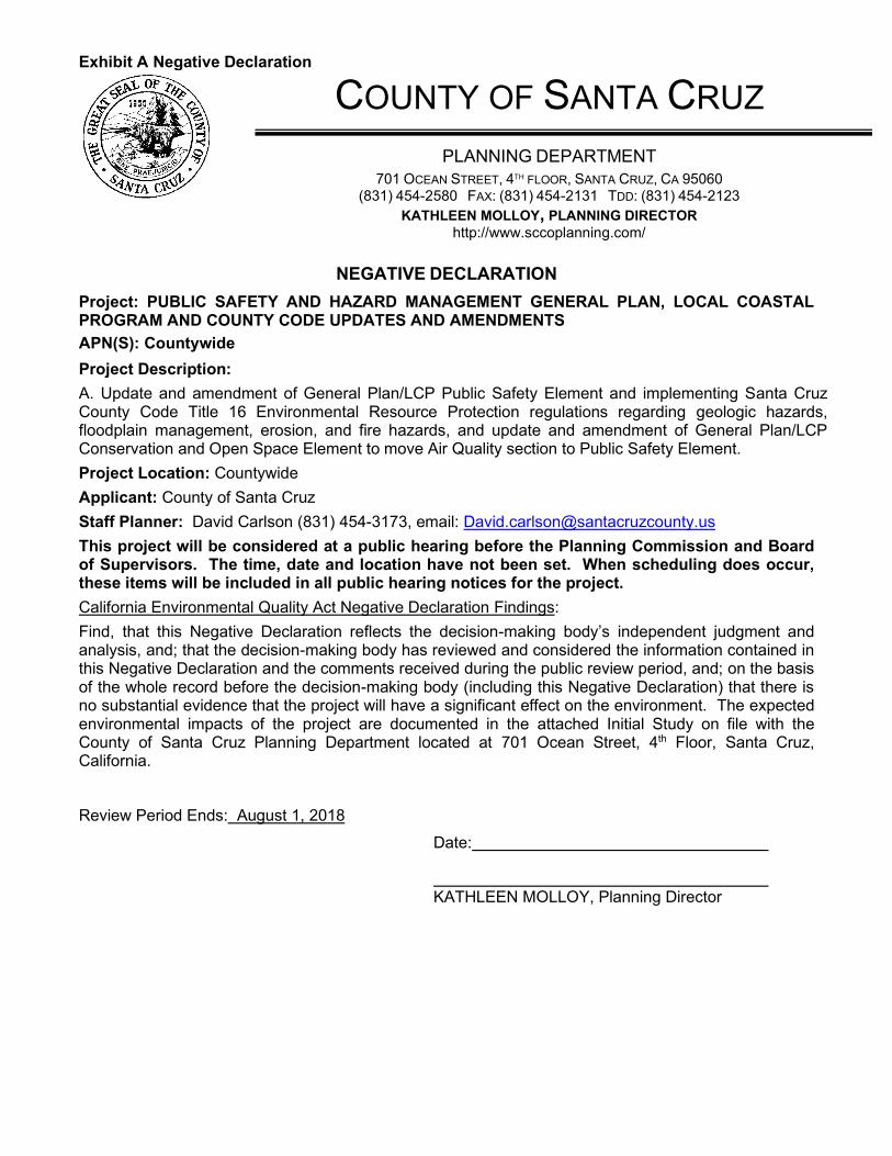
Exhibit A Negative Declaration
COUNTY OF SANTA CRUZ
PLANNING DEPARTMENT
701 OCEAN STREET, 4TH FLOOR, SANTA CRUZ, CA 95060 (831) 454-2580 FAX: (831) 454-2131 TDD: (831) 454-2123
KATHLEEN MOLLOY, PLANNING DIRECTOR http://www.sccoplanning.com/
NEGATIVE DECLARATION
Project: PUBLIC SAFETY AND HAZARD MANAGEMENT GENERAL PLAN, LOCAL COASTAL PROGRAM AND COUNTY CODE UPDATES AND AMENDMENTS
APN(S): Countywide
Project Description:
A. Update and amendment of General Plan/LCP Public Safety Element and implementing Santa Cruz County Code Title 16 Environmental Resource Protection regulations regarding geologic hazards, floodplain management, erosion, and fire hazards, and update and amendment of General Plan/LCP Conservation and Open Space Element to move Air Quality section to Public Safety Element.
Project Location: Countywide
Applicant: County of Santa Cruz
Staff Planner: David Carlson (831) 454-3173, email: [email protected]
This project will be considered at a public hearing before the Planning Commission and Board of Supervisors. The time, date and location have not been set. When scheduling does occur, these items will be included in all public hearing notices for the project.
California Environmental Quality Act Negative Declaration Findings:
Find, that this Negative Declaration reflects the decision-making body’s independent judgment and analysis, and; that the decision-making body has reviewed and considered the information contained in this Negative Declaration and the comments received during the public review period, and; on the basis of the whole record before the decision-making body (including this Negative Declaration) that there is no substantial evidence that the project will have a significant effect on the environment. The expected environmental impacts of the project are documented in the attached Initial Study on file with the County of Santa Cruz Planning Department located at 701 Ocean Street, 4th Floor, Santa Cruz, California.
Review Period Ends: August 1, 2018
Date:
KATHLEEN MOLLOY, Planning Director
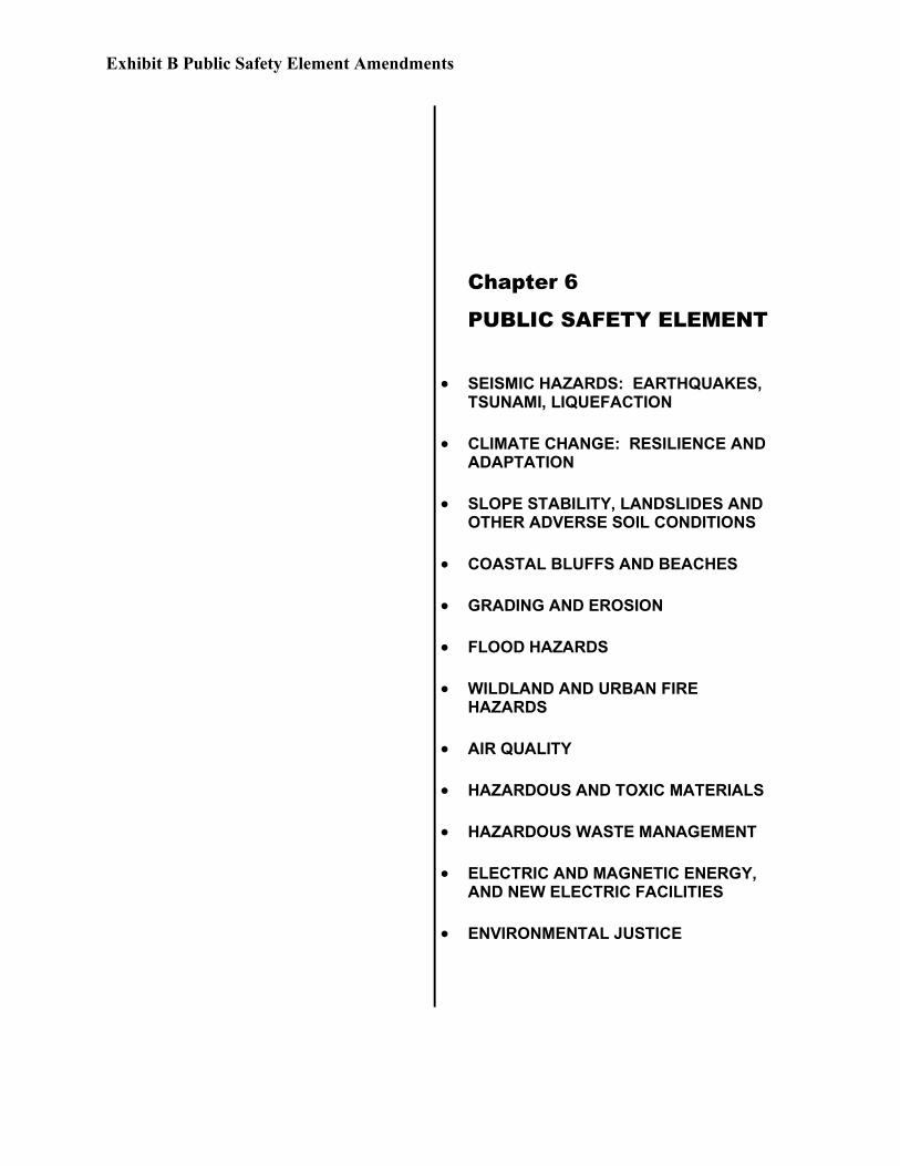
Exhibit B Public Safety Element Amendments
Chapter 6
PUBLIC SAFETY ELEMENT
• SEISMIC HAZARDS: EARTHQUAKES, TSUNAMI, LIQUEFACTION
• CLIMATE CHANGE: RESILIENCE AND ADAPTATION
• SLOPE STABILITY, LANDSLIDES AND OTHER ADVERSE SOIL CONDITIONS
• COASTAL BLUFFS AND BEACHES
• GRADING AND EROSION
• FLOOD HAZARDS
• WILDLAND AND URBAN FIRE HAZARDS
• AIR QUALITY
• HAZARDOUS AND TOXIC MATERIALS
• HAZARDOUS WASTE MANAGEMENT
• ELECTRIC AND MAGNETIC ENERGY, AND NEW ELECTRIC FACILITIES
• ENVIRONMENTAL JUSTICE

Exhibit B Public Safety Element Amendments
This page intentionally left blank
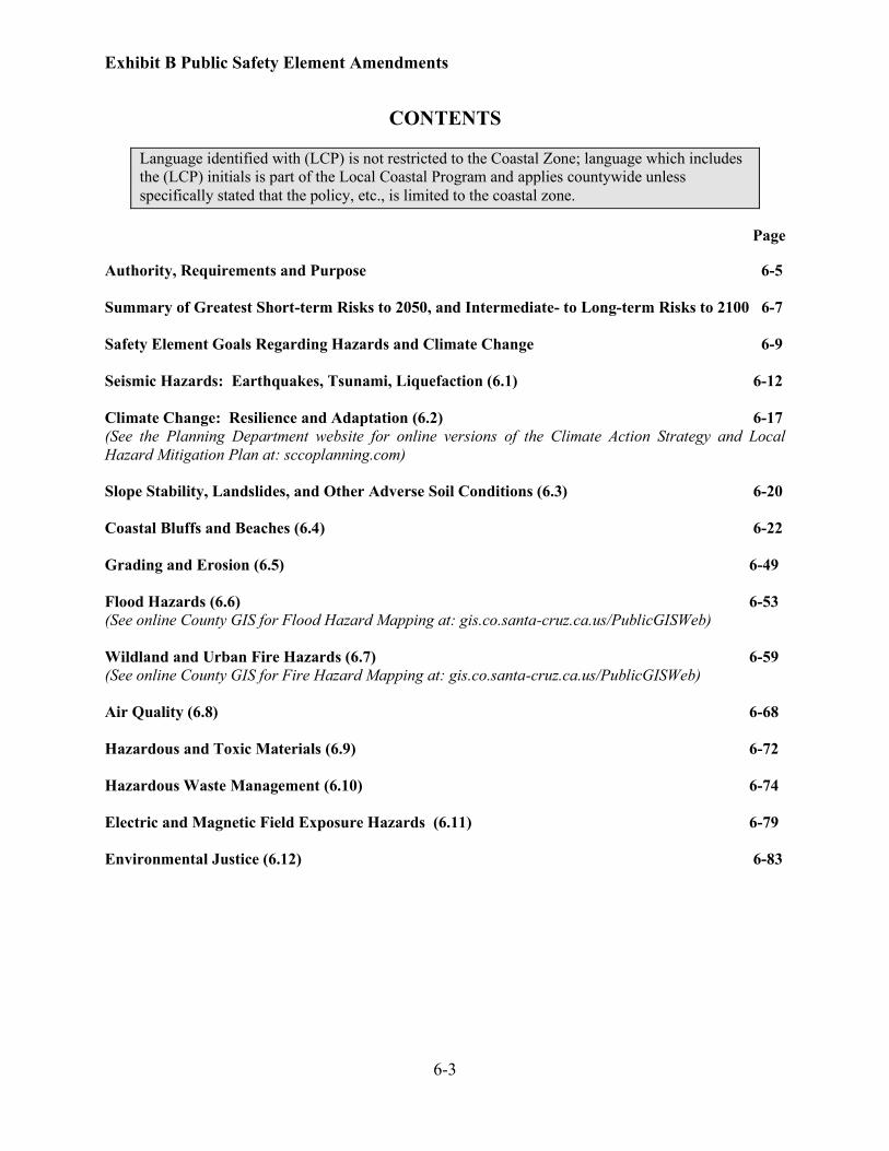
Exhibit B Public Safety Element Amendments
6-3
CONTENTS
Language identified with (LCP) is not restricted to the Coastal Zone; language which includes
the (LCP) initials is part of the Local Coastal Program and applies countywide unless
specifically stated that the policy, etc., is limited to the coastal zone.
Page
Authority, Requirements and Purpose 6-5
Summary of Greatest Short-term Risks to 2050, and Intermediate- to Long-term Risks to 2100 6-7
Safety Element Goals Regarding Hazards and Climate Change 6-9
Seismic Hazards: Earthquakes, Tsunami, Liquefaction (6.1) 6-12
Climate Change: Resilience and Adaptation (6.2) 6-17
(See the Planning Department website for online versions of the Climate Action Strategy and Local
Hazard Mitigation Plan at: sccoplanning.com)
Slope Stability, Landslides, and Other Adverse Soil Conditions (6.3) 6-20
Coastal Bluffs and Beaches (6.4) 6-22
Grading and Erosion (6.5) 6-49
Flood Hazards (6.6) 6-53
(See online County GIS for Flood Hazard Mapping at: gis.co.santa-cruz.ca.us/PublicGISWeb)
Wildland and Urban Fire Hazards (6.7) 6-59
(See online County GIS for Fire Hazard Mapping at: gis.co.santa-cruz.ca.us/PublicGISWeb)
Air Quality (6.8) 6-68
Hazardous and Toxic Materials (6.9) 6-72
Hazardous Waste Management (6.10) 6-74
Electric and Magnetic Field Exposure Hazards (6.11) 6-79
Environmental Justice (6.12) 6-83

Exhibit B Public Safety Element Amendments
6-4
This page intentionally left blank
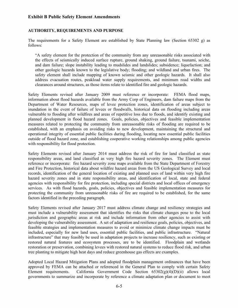
Exhibit B Public Safety Element Amendments
6-5
AUTHORITY, REQUIREMENTS AND PURPOSE
The requirements for a Safety Element are established by State Planning law (Section 65302 g) as
follows:
“A safety element for the protection of the community from any unreasonable risks associated with
the effects of seismically induced surface rupture, ground shaking, ground failure, tsunami, seiche,
and dam failure; slope instability leading to mudslides and landslides; subsidence; liquefaction; and
other geologic hazards known to the legislative body; flooding; and wildland and urban fires. The
safety element shall include mapping of known seismic and other geologic hazards. It shall also
address evacuation routes, peakload water supply requirements, and minimum road widths and
clearances around structures, as those items relate to identified fire and geologic hazards.
Safety Elements revised after January 2009 must reference or incorporate: FEMA flood maps,
information about flood hazards available from the Army Corp of Engineers, dam failure maps from the
Department of Water Resources, maps of levee protection zones, identification of areas subject to
inundation in the event of failure of levees or floodwalls, historical data on flooding including areas
vulnerable to flooding after wildfires and areas of repetitive loss due to floods, and identify existing and
planned development in flood hazard zones. Goals, policies, objectives and feasible implementation
measures related to protecting the community from unreasonable risks of flooding are required to be
established, with an emphasis on avoiding risks to new development, maintaining the structural and
operational integrity of essential public facilities during flooding, locating new essential public facilities
outside of flood hazard zone, and establishing cooperative working relationships among public agencies
with responsibility for flood protection.
Safety Elements revised after January 2014 must address the risk of fire for land classified as state
responsibility areas, and land classified as very high fire hazard severity zones. The Element must
reference or incorporate: fire hazard severity zone maps available from the State Department of Forestry
and Fire Protection, historical data about wildfire hazard areas from the US Geological Survey and local
records, identification of the general location of existing and planned uses of land within very high fire
hazard severity zones and in state responsibility areas, and identification of local, state and federal
agencies with responsibility for fire protection, including special districts and local offices of emergency
services. As with flood hazards, goals, policies, objectives and feasible implementation measures for
protecting the community from unreasonable risks of fire are required to be established, for the same
factors identified in the preceding paragraph.
Safety Elements revised after January 2017 must address climate change and resiliency strategies and
must include a vulnerability assessment that identifies the risks that climate changes pose to the local
jurisdiction and geographic areas at risk and include information from other agencies to assist with
developing the vulnerability assessment. A set of adaptation and resilience goals, policies, objectives, and
feasible strategies and implementation measures to avoid or minimize climate change impacts must be
included, especially for new land uses, essential public facilities, and public infrastructure. “Natural
infrastructure” that may feasibly be used in adaptation projects to increase resiliency, such as existing or
restored natural features and ecosystem processes, are to be identified. Floodplain and wetlands
restoration or preservation, combining levees with restored natural systems to reduce flood risk, and urban
tree planting to mitigate high heat days and reduce greenhouse gas effects are examples.
Adopted Local Hazard Mitigation Plans and adopted floodplain management ordinances that have been
approved by FEMA can be attached or referenced in the General Plan to comply with certain Safety
Element requirements. California Government Code Section 65302(g)(4)(D)(ii) allows local
governments to summarize and incorporate by reference a climate adaptation plan or document to meet
Exhibit B Public Safety Element Amendments
6-6
Safety Element requirements if the material substantially complies or is substantially equivalent. Santa
Cruz County approved a Climate Action Strategy in February 2013 and adopted an updated Local Hazard
Mitigation Plan in June 2016, and these documents substantially comply with the State’s new climate
change requirements for Safety Elements. These documents are hereby incorporated by reference. A
summary showing how the requirements are met is provided within the Climate Change: Resilience and
Adaptation section.
In Santa Cruz County, the impacts of climate change and sea level rise are projected to accelerate hazards
to coastal bluffs and beaches, and therefore this Safety Element establishes new and modified goals,
policies, objectives and implementation measures for property located on coastal bluffs and for beaches
and lagoons. Approaches differ for urbanized properties located within the Urban and Rural Services
Lines, and the remaining rural and open space areas along the coast. Within the urban areas where
development intensity is higher and existing coastal armoring is common, more extensive project analysis
is required to address increased risks due to climate change, sea level rise, wave attack, and coastal
flooding. In the more rural areas, however, parcels are larger, development intensity is lower, and the
increased risks related to sea level rise can be adequately addressed with a lessor level of project analysis
compared to projects in the urban area.
In 2016, the State of California also adopted requirements for General Plans to address environmental
justice for disadvantaged communities. Disadvantaged communities are defined as low-income areas (at
or below 80% of area median household income) that are disproportionately affected by environmental
pollution and other hazards that can lead to negative health effects, exposure or environmental
degradation. While the unincorporated area of Santa Cruz County does not contain communities that
meet the technical definition, certain sub-area of unincorporated Santa Cruz County can at times be of
similar status as a disadvantaged community, depending upon how the geographic limits are defined and
upon economic circumstances of the area population as the economy and housing market changes. This
Safety Element therefore incorporates environmental justice requirements and generally addresses these
unique or compounded health risks for these certain sub-areas that may at times qualify as disadvantaged
communities, including policies regarding promotion of civil engagement in public decision making, and
prioritization of improvements and programs that address the needs of disadvantaged communities.
Exhibit B Public Safety Element Amendments
6-7
SUMMARY OF GREATEST SHORT-TERM RISKS TO 2050, AND INTERMEDIATE- TO
LONG-TERM RISKS TO 2100
The Climate Action Strategy (CAS) Vulnerability Assessment concluded that over the next 30+ years to
2050, it is expected that the highest risks to the County of Santa Cruz will come from:
• Potential water shortages due to the combination of increasing temperatures, changes in precipitation
patterns increasing climatic water deficit, increased saltwater intrusion, decreased groundwater
recharge, and higher demand. This has a very high probability of occurrence and also significant
(high) consequences.
• Rising water table beneath the Rio Del Mar Esplanade is already an issue. As sea level continues to
rise, the present problems will be exacerbated. The consequence of a continuing water table rise on
commercial and residential structures and infrastructure, including the wastewater pump station is
high, and the likelihood of this taking place in the immediate future is high.
• Potential increase in future coastal storm frequency and/or intensity will increase cliff retreat rates as
well as cause potential damage to oceanfront property or public infrastructure. The coastlines of
northern California, Oregon and Washington have experienced increasingly intense winter storms and
greater wave heights over the last 25 years, both of which may be leading to more severe winter
erosion (Allan and Komar, 2000). The consequence of coastal bluff erosion is high due to the extent
of high-value public and private improvements (infrastructure, structures, etc.)
• Flooding in Santa Cruz County has occurred in each of the primary drainages and will continue to
occur in the future given certain sets of meteorological conditions. Previous occurrences are well
documented for all primary drainages with the exception of Aptos Creek, which is not gauged. In
addition, low-lying areas such as Rio Del Mar Esplanade/Flats will experience more frequent
flooding and inundation from sea level rise and increased wave heights. As a result, the consequence
would be high in terms of structural and economic loss, with the probability of such an event
occurring also being high.
• Groundwater extraction rates from the Pajaro River Valley groundwater basin have exceeded
sustainable pumping rates for decades, causing groundwater levels to drop significantly, resulting in
areas of saltwater intrusion and rendering some coastal groundwater wells unsuitable for use. With
the rise in sea level in the coming decades, saltwater intrusion will be exacerbated. The probability of
saltwater intrusion is high due to the current groundwater overdraft situation in the Pajaro Valley, and
the consequence of this occurring is high due to the economic effects of fallowing large expanses of
farmland to reduce groundwater pumping. However, efforts are being developed to reduce
groundwater pumping and to stop saltwater intrusion. The success of these efforts will be challenged
by the additional effects of climate change.
• Many of the wells located within the boundaries of the Soquel Creek Water District are also
threatened with saltwater intrusion. A reduction in groundwater pumping will likely be necessary to
meet the protective and target water levels necessary to avoid saltwater intrusion into the wells.
• Heat waves in Santa Cruz County are likely to become more frequent in the future due to climate
change; however, due to the marine climate, temperature increases would be moderate. As a result,
the consequence would be low while the probability of such an event occurring is high.
• Climate change is expected to result in additional risk of increased fire frequency, size, and severity
beyond the historic range of natural wildfire variability due to increasing length of the fire season,
drier fuels, and decreasing forest health. These changes are being driven by alterations in temperature
Exhibit B Public Safety Element Amendments
6-8
and precipitation regimes (generally, warmer and drier). As a result, the consequence would be high
while the probability of such an event occurring is low.
The Local Hazard Mitigation Plan concluded that over the intermediate to long term (2050 to 2100), in
addition to water shortages and a rise in the water table, it is expected that other climate change related
events would increase to high and very high levels of risk within the County:
• Potential water shortages, as described for the period 2010-2050, shift from a high probability of
occurrence to a very high probability of occurrence as climate change progresses.
• Even though many of the areas of highest vulnerability have already been armored with riprap or
seawalls, coastal cliff erosion continues to take place. The value of property and infrastructure in this
area is very high, and in the long-term, with a rising sea level and increased winter wave attack, this
risk is expected to increase to a very high level.
• Rise in the water table beneath the Rio Del Mar Esplanade as described for the period 2010-2050
shifts from a high probability of occurrence to a very high probability of occurrence as sea level rise
progresses.
• Shoreline inundation would affect a number of developed areas along the County shoreline,
particularly at the maximum projected sea level values for 2050-2100. The potential for flooding of
the Rio Del Mar Esplanade and Beach Drive, for example, has a very high probability of occurring
with a high consequence if it were to happen. If winter precipitation increases in the longer-term
future, although it is not clear from the models that have been run to date that this will occur, the
probability will increase, raising the risk of flooding.
• Flooding, as described for the period 2010-2050, shifts from a high probability of occurrence to a
very high probability of occurrence as climate change progresses.
• Saltwater intrusion of groundwater as described for the period 2010-2050 would continue as sea level
rise progresses. The probability of saltwater intrusion increases to very high, and the consequence is
very high due to the economic effects of fallowing large expanses of farmland to reduce groundwater
pumping. Efforts are underway to reduce groundwater pumping to stop saltwater intrusion; however,
the success of these efforts will be challenged by the additional effects of climate change.
• Heat waves as described for the period 2010-2050 shift from a high probability of occurrence to a
very high probability of occurrence as climate change progresses.
• Climate change is expected to continue to contribute to increased wildfires as described for the period
2010-2050 with the probability of occurrence shifting from low to moderate as climate change
progresses.
Exhibit B Public Safety Element Amendments
6-9
SAFETY ELEMENT GOALS REGARDING HAZARDS AND CLIMATE CHANGE
The goals, objectives, policies and implementation measures of this Public Safety Element are derived
from the necessity to protect the community from natural hazards, as well as from hazards produced from
the built environment. Primary goals of the Safety Element include:
SE-1: To protect human life, private property and the environment.
SE-2: To minimize public expenses by preventing inappropriate use and development or location of
public facilities and infrastructure in those areas which, by virtue of natural dynamic processes or
proximity to other activities, present a potential threat to the public health, safety and general welfare.
Santa Cruz strives to be a disaster-resistant county that can avoid, mitigate, survive, recover from, and
thrive after a disaster while maintaining its unique character and way of life. County government should
be able to provide critical services in the immediate aftermath of a devastating event of any kind. The
people, buildings and infrastructure of Santa Cruz should be resilient to disasters. A key County objective
stated in the Local Hazard Mitigation Plan (LHMP) is to have basic government services and commercial
functions resume quickly after a damaging earthquake or other significant event. The LHMP has four
primary goals for reducing disaster risk in Santa Cruz, which are incorporated into this Safety Element:
SE-3: Avoid or reduce the potential for loss of life, injury and economic damage to Santa Cruz residents
from earthquakes, wildfires, floods, drought, tsunami, coastal erosion, landslide and dam failure.
SE-4: Increase the ability of the County government to serve the community during and after hazard
events.
SE-5: Protect Santa Cruz’s unique character, scenic beauty and values from being compromised by
hazard events.
SE-6: Encourage mitigation activities to increase the disaster resilience of institutions, private companies
and systems essential to a functioning Santa Cruz.
The projected increases in levels of fire, flood, erosion and coastal bluff hazards due to climate change
require adjustments in preparation and responses, including modified approaches to regulating properties
on coastal bluffs and beaches, new flood and fire hazard reduction policies, and ensuring functionality of
essential public facilities and infrastructure. Table 7.1 of the County’s Climate Action Strategy presents a
comprehensive series of strategies designed to respond to the following CAS climate adaptation goals,
which are incorporated into this Safety Element:
SE-7: Protect the unique character, scenic beauty and culture in the natural and built environment from
being compromised by climate change impacts.
SE-8: Support initiatives, legislation, and actions to respond to climate change.
SE-9: Encourage and support actions that reduce risks and vulnerabilities now, while recognizing the
importance of identifying, making decisions about, and preparing for impacts and risks that may develop
in the future.
SE-10: Support the reduction of risks from other environmental hazards, noting the strong
interrelationships and benefits between reducing risk from climate change, non-climate change-related
disasters, and most other environmental hazards.
Exhibit B Public Safety Element Amendments
6-10
SE-11: Build resilience into all programs, policies and infrastructure.
SE-12: Encourage climate change resilience planning and actions in private companies, institutions, and
systems essential to a functioning County of Santa Cruz.
SE-13: Encourage community involvement and public-private partnerships to respond to potential
climate impacts, particularly for those most vulnerable.
SE-14: Ensure that the County of Santa Cruz remains a safe, healthy and attractive place with a high
quality of life for its residents, businesses and visitors.
This Safety Element incorporates these goals of the LHMP and CAS in order to recognize climate change
projections and to support adaptation approaches that improve the resilience of essential facilities, public
infrastructure, coastal natural resources, and human communities to the impacts of climate change and sea
level rise; and to ensure informed acceptance of risk and liability releases by private property owners who
elect to develop or make improvements in areas subject to hazards.
Additional goals (beyond the above goals contained in the LHMP and CAS) related to climate change,
regarding geologic, flooding and wave run-up hazards along the shoreline and coastal bluffs, include the
following:
SE-15: Seek funding for and encourage public, special district and private activities to prepare more
specific plans for how various portions of the shoreline/coastal bluff that are located within the
urban/rural services lines should transition in the future, to a feasible outcome that could exist in the near-
to mid-term with a design that improves impacts on coastal resources while continuing to protect
important coastal infrastructure, existing development ,and other visitor-serving built and natural
environments.
SE-16: Ensure that public investments along the shoreline consider projections for sea level rise and
prioritize and design projects to avoid and minimize risks to the improvements, considering the desired
expected life for such public improvements.
SE-17: Seek to internalize private costs of repair, replacement and/or abatement of structures on
shorelines and coastal bluffs to private property owners, while also recognizing that in some locations
public agencies, special districts and private property owners should work together to achieve mutually
beneficial conditions in the near- to mid-term, while recognizing that the long-term may mean that
improvements must be relocated or removed.
This Safety Element is divided into sections based on the particular hazards that exist in Santa Cruz
County and related topics. Information and discussion about each of these hazards or topics is presented
at the start of each section, followed by the relevant objectives, policies and implementation measures for
the hazard or topic. The hazards and topics are presented in the following order:
1. Seismic and Soil Hazards: Earthquakes, Tsunami, Liquefaction
2. Climate Change: Resilience and Adaptation
3. Slope Stability, Landslides and Other Adverse Soil Conditions
4. Coastal Bluffs and Beaches
5. Grading and Erosion
Exhibit B Public Safety Element Amendments
6-11
6. Flood Hazards
7. Wildland and Urban Fire Hazards
8. Air Quality
9. Hazardous and Toxic Materials
10. Hazardous Waste Management
11. Electric and Magnetic Energy, and New Electrical Facilities
12. Environmental Justice
Exhibit B Public Safety Element Amendments
6-12
SEISMIC HAZARDS: EARTHQUAKES, TSUNAMI, LIQUEFACTION
EARTHQUAKES. An earthquake is a sudden release of energy in the earth’s crust. Caused by movement
along fault lines, earthquakes vary in size and severity. The focus of an earthquake is found at the first
point of movement along the fault line, and the epicenter is the corresponding point above the focus at the
earth’s surface. Damage from earthquakes varies with the local geologic conditions, the quality of
construction, the energy released by the earthquake, the distance from the earthquake’s focus, and the
type of faulting that generates the earthquake. Ground motion is the primary cause of damage and injury
during earthquakes and can result in surface rupture, liquefaction, landslides, lateral spreading,
differential settlement, tsunamis, building failure and broken utility lines, leading to fire and other
collateral damage. Typically, areas underlain by thick, water-saturated, unconsolidated material will
experience greater shaking motion than areas underlain by firm bedrock, but in some cases, relief may
intensify shaking along ridge tops. Fires and structural failure are the most hazardous results of ground
shaking. Most earthquake-induced fires start because of ruptured power lines and gas or electrically
powered stoves and equipment, while structural failure is generally the result of age and type of building
construction. Fault rupture and earthquake related Ground Cracking could occur in several locations
within the County of Santa Cruz. Several fault zones cross Santa Cruz County, and movement along
these faults can cause fault-related surface deformation (e.g., surface fault rupture) where the fault reaches
the surface of the ground. Both the County of Santa Cruz and the State of California have identified
zones where the San Andreas and other active faults have and can cause fault-related surface deformation.
Within these zones it is likely that movement along these faults will damage structures, roads, utilities,
and other fixed facilities. In addition to these zones, other ground cracking was observed during the
Loma Prieta earthquake and the San Francisco earthquake of 1906. Many of these ground cracks can be
attributed to movement or consolidation of large and moderate sized landslides while other ground cracks
were most likely related to ridge spreading. Although much of the ground cracking was found near the
fault zones and in the Summit area of the county, other ground cracking was found on ridge tops
throughout the County of Santa Cruz.
In geologic time, Santa Cruz County was very recently the epicenter of a very significant earthquake. At
5:04 PM on October 17, 1989, a magnitude 7.1 event rocked the Monterey Bay and San Francisco Bay
regions. The initial quake lasted only 22 seconds, although in the two weeks that followed, more than
4,000 aftershocks were recorded, with 20 of these greater than magnitude 5 on the on the Richter Scale.
The epicenter of the Loma Prieta earthquake was about 10 miles east-northeast of the City of Santa Cruz
in the Aptos planning area on the San Andreas fault. In Santa Cruz County, 674 dwellings, 32 mobile
homes and 310 businesses were destroyed in the earthquake. Replacement of un-reinforced masonry
chimneys made up the majority of subsequent residential repairs, followed by foundation replacement on
older wood frame houses which predated current building codes and lacked basic seismic safety features
such as foundation bolts and sufficient structural bracing. Significant damage to streets, water systems,
sewer systems and other public infrastructure was related to liquefaction and subsidence. Due to the
County’s susceptibility to earthquakes and other natural hazards, disaster response planning is an on-
going process.
TSUNAMI. A tsunami is a series of waves generated by an impulsive disturbance in a large body of
water such as an ocean or large lake. Tsunamis are produced when movement occurs on faults in the
ocean floor, usually during very large earthquakes. Sudden vertical movement of the ocean or lake floor
by a fault, landslide or similar movement displaces the overlying water, creating a wave that travels
outward from the source. The waves can travel across oceans and maintain enough energy to damage
distant shorelines. The most recent tsunami in Santa Cruz County occurred as a result of the magnitude
9.0 earthquake in Japan on March 11, 2011. In Japan nearly 16,000 deaths occurred as a result of the
earthquake and tsunami, which generated a wave of water up to 113 feet in height travelling inland up to
six miles, and which also caused meltdown of a nuclear energy plant. This 2011 tsunami hit the Santa
Exhibit B Public Safety Element Amendments
6-13
Cruz Harbor with waves estimated to be several feet, combined with swift and chaotic currents causing
approximately $20 million in damage. Santa Cruz County is at risk from both local and distant source
tsunamis.
LIQUEFACTION. Liquefaction is the transformation of loose, water-saturated granular materials (such
as sand or silt) from a solid to a liquid state. Liquefaction commonly, but not always, leads to ground
failure such as subsidence. Liquefaction potential varies significantly, and site-specific analysis is needed
to accurately determine liquefaction potential in earthquake prone areas.
Objective 6.1-1 Seismic Hazards: Earthquakes
(LCP) To reduce the potential for loss of life, injury, and property damage resulting from
earthquakes by regulating the siting and design of development in seismic hazard areas;
encouraging open space, agricultural or low-density land use in the fault zones; and
increasing public information and awareness of seismic hazards.
Objective 6.1-2 Seismic Hazards: Tsunami
(LCP) To reduce the potential for loss of life, injury, and property damage resulting from tsunamis
by: providing signage and warning systems in tsunami hazard areas to increase public
awareness of hazard and actions to take in event of tsunami, publicizing evacuation routes,
and designing structures as feasible to withstand tsunamis or to minimize damage that may
occur due to tsunamis.
Objective 6.1-3 Seismic Hazards: Liquefaction and Subsidence
(LCP) To reduce the potential for loss of life, injury, and property damage resulting from location of
improvements in areas that contain soils subject to liquefaction and subsidence by: avoiding
location of critical and essential facilities in areas subject to these conditions, and adopting
building codes that, for areas where development is allowable, requires site-specific analysis
and adequate mitigations to be incorporated into project designs.
Policies
6.1.1 Geologic Review for Development in Designated Fault Zones
(LCP) Require a review of geologic hazards for all discretionary development projects, including the
creation of new lots, in designated fault zones. Fault zones designated for review include the
Butano, Sargent, Zayante, and Corralitos complexes, as well as the State designated Seismic
Review Zones. Required geologic reviews shall examine all potential seismic hazards and
may consist of a Geologic Hazards Assessment and/or a more complete geologic
investigation report where required by the County. An assessment may be prepared by
County staff under supervision of the County Geologist, or registered geologist at the
applicant’s choice and expense. Any Geologic Hazards Assessment or Geologic
Investigation Report must be accepted by the County Geologist in order to use its findings
and/or incorporate its mitigations into a proposed development project.
6.1.2 Geologic Reports for Development in Alquist-Priolo Zones
(LCP) Require a preliminary geologic report or full engineering geology report for development on
parcels within Alquist-Priolo State-designated seismic review zones.
6.1.3 Engineering Geology Report for Public Facilities in Fault Zones
(LCP) Require a full engineering geology report by a registered geologist whenever a significant
potential hazard is identified by a Geologic Hazards Assessment or Preliminary Geologic
Exhibit B Public Safety Element Amendments
6-14
Report, and prior to the approval of any new public facility or critical structure within the
designated fault zones.
6.1.4 Site Assessment or Investigation Regarding Liquefaction Hazard
(LCP) Require site-specific hazards assessment and/or investigation by a registered geologist and/or
civil engineer of all development proposals in areas designated as having a moderate, high or
very high liquefaction potential, and require mitigations identified by reports to be
incorporated into project designs in order to meet building codes.
6.1.5 Location of New Development Away from Potentially Hazardous Areas
(LCP) Require the location and/or clustering of development away from potentially hazardous areas
where feasible, in order to avoid or minimize exposure to hazards. Review, revise, and/or
condition project development permits as warranted, based on the recommendations of the
site’s Hazard Assessment or other technical reports.
6.1.6 Siting of New Water Supply Reservoirs and Small Water Retention Facilities
(LCP) Require a full engineering geologic investigation prior to the construction of new water
supply reservoirs, and if an unmitigable hazard exists, deny the proposed reservoir. Require
smaller water retention facilities to be sited and engineered in a manner that will avoid or
mitigate potential hazards that could arise from failure of the facilities, especially to habitable
structures and public and private access roads.
6.1.7 Dam Safety Act
(LCP) New dams shall be constructed according to high seismic design standards of the Dam Safety
Act and as specified by structural engineering studies. Smaller reservoirs will be reviewed
for potential seismic hazards as a part of the environmental review and/or building/grading
permit review processes.
6.1.8 Design Standards for New Public Facilities
(LCP) Require all new public facilities and critical structures to be designed to withstand the
expected ground shaking during the design earthquake on the San Andreas Fault, as well as
projected hazards due to climate change and sea level rise.
6.1.9 Recordation of Notice of Geologic Hazards, Acceptance of Risk, Liability Release, and
Indemnification
(LCP) As a condition of development approval and/or prior to the issuance of a building/grading
permit for development/development activities and new and substantially improved structures
in geologic hazard areas, require the owner of a parcel in an area of potential geologic
hazards to record on the property/title deed, with the County Recorder, a Notice of Geologic
Hazards, Acceptance of Risk, Liability Release, and Indemnification in a form approved by
the County. The Notice shall include information about the nature of the hazard(s) as
determined by the geologic and/or geotechnical investigation, provide that the current and all
future owners and successors in interest accept the risks to people and property, and includes
a release of liability of and waiver of claims against the County of Santa Cruz for any
damages or injury in connection with the permitted development.
6.1.10 Siting, Design and Density Review of Proposed Development for Acceptable Risk Levels
(LCP) Approve the final density and design of a development or building/grading proposal, and
location of proposed development on a site, only as consistent with the recommendations of
the technical reports. Deny the location or design of the proposed development if it is found
that the hazards on the site cannot be mitigated to within acceptable risk levels for the nature
Exhibit B Public Safety Element Amendments
6-15
of the development, as established by industry standards and as evidenced by property owner
willingness to record on title a Notice of Geologic Hazards, Acceptance of Risk, and Liability
Release.
6.1.11 Setbacks from Faults
(LCP) Exclude from density calculations for land divisions, land within 50 feet of the edge of the
area of fault induced offset and distortion of an active or potentially active fault trace. In
addition, all new habitable structures on existing lots of record shall be set back a minimum
of fifty (50) feet from the edge of the area of fault induced offset and distortion of an active or
potentially active fault trace. This setback may be reduced to a minimum of twenty-five (25)
feet based upon paleoseismic studies that include observation trenches. Reduction of the
setback may only occur when both the consulting registered geologist preparing the study and
the County Geologist observe the trench and concur that the reduction is appropriate. Critical
structures and facilities shall be set back a minimum of one hundred (100) feet from the edge
of the area of fault induced offset and distortion of an active or potentially active fault traces.
6.1.12 Minimum Parcel Size in Fault Zones
(LCP) Outside the Urban Services Line and Rural Services Line, require a minimum parcel of 20
gross acres for the creation of new parcels within state and County designated seismic review
zones if proposed building sites lie within the fault zone. Require a minimum parcel of 10
gross acres for the creation of new parcels within the portions of the County designated
seismic review zones that are not part of a State Alquist-Priolo Earthquake Fault Zone, and
which lie outside the Urban and Rural Services Lines and Coastal Zone, if 25% or more of
the parcel perimeter is bounded by parcels 1-acre or less in size. Inside the Urban Services
Line and Rural Services Line, allow density consistent with the General Plan and LCP Land
Use designation if all structures are to be set back at least 50 feet from fault traces and meet
all other conditions of technical reports and of applicable provisions of the County Code.
Programs
a. Periodically update seismic design and soil hazards design criteria and the Building and
Grading regulations, with the advice of qualified professionals and consistent with State law,
as information becomes available in order to support construction of safe structures in areas
of seismic hazards, liquefaction hazards and other soil conditions subject to ground failure or
cracking during seismic events. (Responsibility: Planning Department)
b. Continue to evaluate existing public facilities to determine whether they can maintain
structural integrity during the design earthquake, and fund and carry out retrofits, retirements
and/or replacements as may be needed to ensure public safety at public facilities during such
earthquake events, with priority given to critical facilities. (Responsibility: Public Works,
Board of Supervisors, California Department of Forestry)
c. Target the following structures to meet California Building Code seismic safety standards for
existing buildings:
Critical facilities:
• Essential facilities: buildings whose use is necessary during an emergency;
• Buildings whose occupancy is involuntary;
• High occupancy buildings.
(Responsibility: Planning Department, Public Works, Board of Supervisors, State of
California)
Exhibit B Public Safety Element Amendments
6-16
d. Support seismic retrofit projects, including through priority permit processing and through
special financing programs such as housing rehabilitation loans for qualified low-income
homeowners from State and local funding programs as may be available. (Responsibility:
Planning Department, Santa Cruz County Housing Authority, Board of Supervisors)
e. Comprehensively map the Geologic Hazard Combining Zone District to include areas having
a high, moderate or uncertain surface rupture potential, as well as known areas subject to high
liquefaction hazards, and make the Geologic Hazards map(s) and related technical
information available to the public on the county website. (Responsibility: Board of
Supervisors, Planning Commission, Planning Department, Information Services
Department/GIS)
f. Comprehensively map the Geologic Hazard Combining Zone District to include areas subject
to high liquefaction hazard when precise technical information regarding the extent and
activity of liquefiable materials is available. (Responsibility: Board of Supervisors, Planning
Commission, Planning Department, Information Services Department/GIS)
g. Revise existing seismic and geologic hazard maps as new, reliable information becomes
available. (Responsibility: Planning Department, Information Services Department/GIS)
h. Evaluate the probable response of community service agencies and emergency facilities to a
damaging earthquake, and develop contingency plans for post-disaster emergency operations,
including evacuation procedures. (Responsibility: County Office of Emergency Services,
Human Services Department, Health Services Agency and Department of Public Works)
i. Develop public education programs to increase public awareness of seismic and geologic
hazards, and to inform the public of proper procedures before, during and after an earthquake
that can help to minimize injury and property loss. (Responsibility: Planning Department,
County Office of Emergency Services)
Exhibit B Public Safety Element Amendments
6-17
CLIMATE CHANGE: RESILIENCE AND ADAPTATION
Santa Cruz County approved a Climate Action Strategy CAS) in February 2013 and adopted an updated
Local Hazard Mitigation Plan (LHMP) in June 2016. Materials in those documents provide substantial
compliance with California Government Code requirements to address climate change, including but not
limited to a vulnerability assessment, and adaptation and resilience goals, policies, objectives, and
feasible strategies and implementation measures to avoid or minimize climate change impacts, especially
for new land uses, essential public facilities, and public infrastructure.
The CAS Executive Summary summarizes the content of the document, including material that meets
requirements for Safety Elements, as presented below.
Californians are already experiencing impacts from climate change (California Natural
Resources Agency, 2009), and a wide variety of impacts are likely to be felt with increasing magnitude as
the concentration of greenhouse gases (GHGs) in the atmosphere continues to rise (City of Santa Cruz,
2011). The first portion of the County’s Climate Action Strategy (CAS) reports the results of the GHG
emissions inventory for Santa Cruz County, proposes targets for GHG reduction, and outlines strategies
and implementing actions to achieve the targets. The second portion focuses on vulnerability assessment
and strategies for adapting to the types of impacts that are likely to occur in Santa Cruz County. The
CAS incorporates input from the local community and non- governmental agencies that are working to
mitigate and respond to climate change.
GHG emissions inventories were prepared for County government operations and for community
activities for 2005 and updated for 2009. Total emissions for government operations in 2009 were
approximately 34,000 metric tons of CO2 equivalent (CO2e), a decrease of 12 percent from 2005. T total
emissions for community activities were approximately 1,030,000 metric tons in 2009, a decrease of more
than 50 percent from 2005. The dramatic decrease in community emissions reflects the closure of the
Davenport cement plant, which accounted for approximately 90 percent of the commercial/industrial
emissions in 2005. The inventories indicate that 70 percent of the community emissions in 2009 were
generated by the transportation sector. A separate, simplified inventory of GHG emissions from
agricultural activity was prepared for 2011. Agricultural emissions other than electricity emissions were
in the range of 17,000 metric tons of CO2e. This represents, at most, two percent of GHG emissions
countywide (2009 data).
State legislation requires California to reduce GHG emissions to 1990 levels by 2020. Based on
the 2005 community emissions inventory, 1990 emissions levels for Santa Cruz County were estimated.
Santa Cruz County has already met the target for 2020 due to the closing of the Davenport cement plant.
The State has also set a long-term reduction target for 2050, which is 80 percent below 1990 levels. The
CAS incorporates the two state targets and sets an interim target for 2035. A “business as usual”
estimate of future emissions is used to gauge the amount of effort required to meet the reduction targets.
GHG reduction strategies are proposed for the three sectors with the highest emissions:
transportation, energy, and solid waste. The amount of emissions reductions that can be expected from
each strategy is estimated. Calculations indicate that the emissions targets for 2035 and 2050 can be
met, but that a sustained commitment to full implementation of the strategies will be required. The
largest reduction will come from state and federal standards for fuel efficiency and vehicle emissions and
from the California renewable energy portfolio standard (58 percent), followed by a cleaner energy
supply from Community Choice Energy (CCE) if that type of regional energy authority is formed (22
percent), energy efficiency (9 percent), transportation and land use planning (5 percent), green business
(3 percent), and electric vehicles (3 percent). The CAS finds that if a CCE is not feasible the gap may be
closed with greater reductions from other strategies, including a method to provide incentives for local
Exhibit B Public Safety Element Amendments
6-18
renewable power and energy conservation similar to what a CCE would provide. However, a feasibility
study was subsequently completed which has determined that it is feasible, and a collection of local
governments are pursuing formation. Priority for implementation of GHG reduction efforts will be a
function of the estimated potential for emissions reduction, cost to implement, and co-benefits of efforts.
A plan for monitoring the implementation of emissions reduction is included in the CAS, which
includes identifying the group with responsibility for implementation, periodic reporting, and a
recommendation for updating the GHG emissions inventories every five years.
A vulnerability assessment was prepared to identify the conditions that may occur in Santa Cruz
County as a result of the various components of climate change (increasing temperature, rising sea level,
and shifts in the precipitation regime) and the locations, infrastructure and economic sectors that are
particularly vulnerable to negative impacts.
The assessment identifies the coastal areas that are most susceptible to increased flooding, storm
surge, beach and coastal bluff erosion from winter storms. Winter storm damage may become more
frequent than in the past as a result of heightened sea levels persisting longer as sea level rises (Cayan et
al., 2008; Cloern et al., 2011), and precipitation that is concentrated in fewer months each year (Flint,
L.E., and Flint, A.L., 2012). The analysis is based on 16–66 inches (42–167 cm.) of sea level rise by
2100, as forecast by the National Academy of Sciences (National Research Council, 2012). Inundation,
rising groundwater, and increased saltwater intrusion into groundwater will also affect low-lying areas.
The systems that will be most affected are residential coastal property, wastewater treatment
infrastructure, coastal roads and bridges, beaches, coastal and wetland ecosystems, and water supply
from coastal wells. The vulnerability assessment also identifies potential effects of precipitation changes
and increased temperature of between 3.6–7.2 degrees Fahrenheit (2–4 degrees Celsius) (Flint, L.E., and
Flint, A.L., 2012) on water supply, wildfire, biodiversity, and public health. Particular attention is given
to the significant decrease in redwood habitat that may occur, especially if the current trend of
decreasing coastal fog continues (Flint, L.E., and Flint, A.L., 2012).
Tourism and agriculture, two top revenue producing and job generating sectors of the local
economy, are closely tied to the climate and are therefore vulnerable to climate change. Tourism relies
on beaches, coastal attractions, redwoods, and vulnerable infrastructure for access to and around the
coast. Agriculture will be affected by increases in temperature, changing pest patterns, changing fog
dynamics, and increased potential for both flood and drought.
A risk analysis was performed to determine which impacts from climate change present the
greatest risk to people and to the natural and built environments. In the short to intermediate term
(2010–2050) water shortage was identified as the largest risk. In the intermediate to long term (2050–
2100) rising water table, coastal bluff erosion, and increased flooding and landslides join water shortage
as greatest risks.
Climate adaptation goals are established as a guide for evaluating adaptation strategies.
Specific adaptation strategies include new actions as well as acknowledgement of existing plans and
programs, which such as the adopted Local Hazard Mitigation Plan (LHMP), while not explicitly about
climate change, address the salient issues. Some proposed strategies emphasize avoidance of hazards
while others focus on future planning efforts and specific engineering solutions to protect existing
development. However, all emphasize building connections among people and among organizations to
accomplish the climate adaptation goals in a framework of partnership.
It is expected that the County’s Climate Action Strategy will be modified periodically as scientific
research progresses, new information becomes available and new ideas and priorities are brought forward
Exhibit B Public Safety Element Amendments
6-19
as more people become involved in responding to climate change in Santa Cruz County. Such CAS
updates will not be considered to be formal amendments to the General Plan, but as updates to
implementation materials, as consistent with key goals and objectives of the CAS and General Plan.
The June 2016 update of the Local Hazard Mitigation Plan (LHMP) includes a great deal of the
information, assessments and mitigation strategies that required to be included in a General Plan Safety
Element. The first two parts of the LHMP address the planning process used and present a Community
Profile, including key transportation routes and critical infrastructure locations. The third part identifies
the hazards, presents risk and vulnerability assessments, estimates hazard loss estimates for existing and
planned development, and outlines mitigation goals, strategies and actions, for the following types of
hazards: earthquakes and liquefaction, wildfires, floods and coastal storms, drought, tsunami, coastal
erosion, dam failure, landslide, expansive soils, and climate change. The LHMP contains an extensive
number of maps further illustrating hazard types, including maps of levee flood gates, fault rupture zones,
liquefaction areas, earthquake intensities, critical fire hazard areas, recent fires, flood zones, repetitive
loss properties, Pajaro River flood risk, water agency service areas, tsunami inundation areas, coastal
erosion areas, Newell Creek dam inundation area, slides and earthflows, landslide hazard areas, and
expansive soils.
The fourth part of the LHMP presents the Mitigation Strategy, and the fifth part addresses the plan
maintenance process. It is expected that the County’s LHMP will be updated every five years or as
required by law. Such LHMP updates will not be considered to be formal amendments to the General
Plan, but as updates to implementation materials, as consistent with key goals and objectives of the
LHMP and General Plan.
Objective 6.2.1 Climate Change: Resilience and Adaptation
(LCP) Implement the Climate Action Strategy approved in February 2013, as well as the Local Hazard
Mitigation Plan approved in June 2016, in order to increase resilience and adapt to the effects of
climate change. Update the CAS and LHMP as new science and approaches are available.
Updates to the CAS and LHMP shall not require amendment of the General Plan and Local
Coastal Program as long as the updates are in substantial conformance with the goals of this
Safety Element and those documents, and further improve hazard information, resiliency and
adaptation strategies.
Objective 6.2.2 Local Hazard Mitigation Plan and Climate Action Strategy
(LCP) Comply with Government Code 65302(g)4 and incorporate by reference and implement the
County’s Local Hazard Mitigation Plan (LHMP) and updates approved by the Federal Emergency
Management Agency (FEMA) and the Governor’s Office of Emergency Services. The LHMP has
been updated to address climate change adaptation consistent with the County’s Climate Action
Strategy (CAS) and updates. The LHMP identifies the risks that climate change poses to the
County and the geographic areas at risk from climate change impacts. The LHMP creates a set of
adaptation and resilience goals, policies, and objectives for the protection of the community. The
LHMP creates a set of feasible implementation measures designed to minimize impacts of
climate change, avoid at-risk areas, and utilize natural infrastructure where feasible to increase
resiliency to climate change.
Exhibit B Public Safety Element Amendments
6-20
SLOPE STABILITY, LANDSLIDES AND OTHER ADVERSE SOIL CONDITIONS
LANDSLIDES. Landslides are the rapid downward movement of rock, earth, or artificial fill on a slope.
Factors causing landsliding include the rock strength and orientation of elements on the slope, erosion,
weathering, high rainfall, steepness of slopes, and human activities such as the removal of vegetation and
inappropriate grading. Severe rainstorms in January 1982 caused multiple landslides throughout the Bay
Area and especially in the Santa Cruz Mountains. One very large composite landslide along Love Creek,
west of Loch Lomond Reservoir, killed ten people. This landslide was and continues to be an indicator of
the potential severity of landslide activity and the need for observation and/or mitigation. Other
landslides, including debris flows, destroyed homes killing several other people. In addition to damage to
homes, widespread landslide damage occurred to roadways, driveways, and stream channels.
OTHER ADVERSE SOIL CONDITIONS. A variety of other adverse soil conditions result in a need for
site-specific geotechnical/soils reports to ensure that appropriate specifications are incorporated into the
design of proposed improvements. Expansive soils are generally clays or sedimentary rocks derived from
clays, which experience volume changes as a result of moisture variation. The hazard that expansive soils
create can be significant. Many of the expansive soils do not create large areas of destruction; however,
they can disrupt supply lines (i.e. roads, power lines, railways, and bridges) and damage structures. The
effects on structures can be dramatic if expansive soils supporting structures are allowed to become too
wet or too dry. Lightly loaded one-story or two-story buildings, warehouses, residences, and pavements
are especially vulnerable to damage because these structures are less able to suppress the differential
heave of the swelling foundation soil than heavy, multistory structures. Patios, driveways and walkways
may also crack and heave as the underlying expansive soils become wet and swell. Other adverse soil
conditions can include but not be limited to areas of unconsolidated fill due to historic or improper
grading, undermined slopes, roads or structures, and areas of low soil strength.
Objective 6.3 Slope Stability, Landslides and Other Adverse Soil Conditions
(LCP) To reduce life safety hazards and property damage caused by landslides, debris flow, adverse
soil conditions, and other ground movements affecting land use activities in areas of unstable
geologic formations, potentially unstable slopes and adverse soil conditions.
Policies
6.3.1 Geologic Hazards Assessments, Soils/Geotechnical Report or Geologic Report for
Development on and Near Slopes
(LCP) Require a geologic hazards assessment, soils/geotechnical report or geologic report for
proposed development, including grading and building permits, that is potentially affected by
slope instability hazards that exist on or near the site, regardless of the slope gradient on
which the development itself is proposed. Such assessment or reports may be prepared by
County staff under supervision of the County Geologist, or by a registered geologist or civil
engineer, as required by the County and at the applicant’s choice and expense. Any Geologic
Hazards Assessment, Soils/ Geotechnical Report or Geologic Report must be accepted by the
County Geologist in order to use its findings and/or incorporate its mitigations into a
proposed development, grading or building project.
6.3.2 Engineering Geology Report or Soils/Geotechnical Report
(LCP) Require an engineering geology report by a registered geologist and/or a soils/geotechnical
engineering report prepared by a qualified professional when the hazard assessment identifies
potentially unsafe geologic conditions in an area of proposed development.
6.3.3 Conditions and Design Specifications for Development, Building and Grading Permits
Exhibit B Public Safety Element Amendments
6-21
(LCP) Condition development permits and ensure design/mitigation specifications have been
incorporated into building and grading plans based on the recommendations of the Hazard
assessment and other technical reports.
6.3.4 Mitigation of Geologic Hazards and Density, Design and Location Considerations
(LCP) Deny the location of a proposed development or permit for a grading or building project if it
is found that geologic hazards cannot be mitigated to within acceptable risk levels for the
nature of the proposed project; and approve development proposals or permits only if the
project’s density, design, and location reflects consideration of the degree of hazard on the
site, as determined by technical information.
6.3.5 Slope Considerations for Land Division Calculations
(LCP) Exclude land with slopes exceeding 30 percent in urban areas and 50 percent in rural areas
and land with recent or active landslides from density calculations for land divisions.
6.3.6 Location of Structures and Drainage Considerations in Unstable Areas
(LCP) Require location and/or clustering of structures away from potentially unstable slopes
whenever a feasible building site exists away from the unstable areas. Require drainage plans
that direct runoff and drainage away from unstable slopes.
6.3.7 Location of Septic Leachfields
(LCP) Prohibit the location of septic leachfields in areas subject to landsliding, unless investigation
by a registered geologist and soils engineer demonstrates that such placement will not
adversely affect slope stability.
6.3.8 Recordation of Notice of Geologic Hazards, Acceptance of Risk, Liability Release, and
Indemnification
(LCP) As a condition of development approval and/or prior to the issuance of a building/grading
permit for development/development activities and new and substantially improved structures
in geologic and/or coastal hazard areas, require the owner of a parcel in an area of potential
geologic hazards to record on property title/deed, with the County Recorder, a Notice of
Geologic Hazards, Acceptance of Risk, Liability Release, and Indemnification in a form
approved by the County. The Notice shall include information about the nature of the
hazard(s) as determined by the geologic and/or geotechnical investigation, provides that the
current and all future owners and successors in interest accept the risks to people and
property, and includes a release of liability of and waiver of claims against the County of
Santa Cruz for damages or injury in connection with the approved development.
Programs
a. Require property owners and public agencies to control or mitigate landslide conditions
which threaten structures or roads, including improper or unauthorized drainage affecting county
roads and/or drainage facilities through applicable Notice and Order and/or abatement processes.
(Responsibility: Planning Department, Public Works Department)
b. Maintain and periodically update public information brochures and information available
on the county website concerning landslide hazards and guidelines for hillside development, as
new information becomes available. (Responsibility: Planning Department)
Exhibit B Public Safety Element Amendments
6-22
COASTAL BLUFFS AND BEACHES: INFORMATION AND REVIEW OF POLICY INTENT
Coastal communities are particularly vulnerable to impacts from sea level rise and hazards that result
from extreme weather, including flooding and inundation, erosion, and wave impacts. State law and
current scientific projections regarding climate change and sea level rise require that the County update
policies related to development on coastal bluffs and beaches, and relationship of such to shoreline and
coastal bluff armoring, in order to acknowledge and incorporate sea level rise into development standards
and into conditions of approval that apply to projects proposed on sites subject to coastal hazards.
Policies are needed to guide regulatory responses by the County and Coastal Commission to proposed
changes on existing developed properties due to involuntary damage (from coastal hazards or other
hazards such as fire), as well as to proposed demolition/replacement projects or reconstructions that are
pursued voluntarily by property owners. Policies are also needed to address projects that involve only
existing shoreline protection structures themselves, such as proposals to maintain, rehabilitate or replace
such structures in a manner that would reduce existing impacts on coastal resources, or that would act to
protect critical public infrastructure. Areas that are anticipated to accommodate shoreline protection
structures in the mid-to-longer term are considered to be "shoreline protection exception areas", which
would be designated only within certain portions of the existing urbanized area of unincorporated Santa
Cruz County.
Much of the Santa Cruz County coastline, particularly in the urbanized developed areas, has some level of
armoring (walls, riprap, etc.). The primary type of coastal armoring in this area is riprap, but concrete,
steel, wood, and gabion basket armoring also exist. Such improvements are themselves considered
"structures" and some of the protection structures existed (within "existing developed areas") prior to the
Coastal Act. Some of these structures are well-maintained and some less so, with varying levels of
impacts on coastal resources depending upon condition and location.
East Cliff Drive is located within an urbanized area that was an existing developed area at the time the
Coastal Act was adopted, and it is one of the four primary east-west transportation corridors in Santa Cruz
County which include Highway One, Soquel Drive/Avenue, the Santa Cruz Branch Rail Line (not
presently used for but publicly owned and planned for multi-modal transportation) and East Cliff
Drive/Portola Drive/Opal Cliffs Drive. East Cliff Drive, along with its transition as it becomes Opal
Cliffs Drive, connects the Santa Cruz Harbor area to the Capitola Village area. A modern seawall has
been constructed by the County of Santa Cruz in the Pleasure Point area along East Cliff Drive that
should greatly reduce potential damage from coastal erosion to East Cliff Drive as well as the homes on
the inland side of the road. This seawall is featured in the Coastal Commission’s Sea Level Rise
Guidance document as a model and desired approach for protecting public access and scenic and visual
qualities when armoring is necessary and allowable. Transition to this type of seawall between Pleasure
Point and the City of Capitola city limits, which is considered to be a "shoreline protection exception
area" is a desired outcome for this portion of the urbanized coastal area of Santa Cruz County, which will
open up more beach and shoreline area through removal of rip rap and the like, avoid future deposition of
emergency protection that is typically rip rap, reduce visual impacts, and increase coastal access for the
general public.
It is not uncommon for East Cliff Drive, a key arterial road, to be closed or damaged where it crosses
Schwann Lake, Corcoran Lagoon and Moran Lake during large winter storms. In flood hazard areas it is
not appropriate to construct hard armoring structures that divert or block flood waters or that artificially
modify lagoon areas. Future sea level rise may require that bridges be built to cross the lagoon frontages,
if it is necessary to maintain the East Cliff Drive transportation corridor in either the current or a
nearby/modified road location. Such bridges would be designed to maximize lagoon function.
Exhibit B Public Safety Element Amendments
6-23
Expectations about the “design life” of improvements are an important consideration when establishing
policies related to coastal bluff and other development on an eroding coastline. County policies in the
1994 General Plan/Local Coastal Program required throughout the unincorporated area a geologic setback
from the top of a coastal bluff of 25 feet or a setback sufficient, at the time of application submittal, to
provide a building site for an assumed 100-year design life of the structure, whichever is greater.
Updated County policies require evaluation of the geologic setback for development projects on coastal
bluffs considering not only historical shoreline and bluff retreat data, but also acceleration of shoreline
and bluff retreat due to continued and accelerated sea level rise, and other climate impacts according to
best available science. The level of uncertainty regarding the rate and amount of future sea level rise and
future effects on coastal properties makes it difficult to predict when, where, and how much the coast will
change in the future. Current reasonable professional projections for the Santa Cruz coastal area (State of
Californian Sea Level Rise Guidance 2018 medium risk aversion scenario for Monterey tide gauge), are
0.9 feet of sea level rise from the year 2000 conditions to 2040, and 3.1 to 4.3 feet from year 2000
conditions to the year 2100. In that this Safety Element is intended to address the 2020 to 2040
timeframe, an adaptive approach is reflected that anticipates refinement of policies in the future with
subsequent update(s), as well as an implementation of policies and requirements within the 2020-2040
timeframe for conditioning and mitigating impacts of coastal developments.
The updated Safety Element includes new policies and requirements for development projects subject to
coastal and geologic hazards. A key principle is "private internalization of the risks and costs of
improving, maintaining and abating development projects/structures on sites that are subject to coastal
hazards", so that the public (governments, taxpayers, insurance policyholders) are not the parties who
ultimately bear the costs of private property owner investment decisions when the time comes that it is
environmentally, practically and economically infeasible to continue the existence of portions or all of
structures/improvements subject to coastal hazards. Property owners will be required to acknowledge and
accept the risk of building along the coast within a context of rising sea levels. In this way, it is expected
that property owners and future buyers and financiers of property along the coast will be well aware of
and prepare for such risks, including potential future costs of adaptation, mitigation of on-going impacts
on coastal resources, and eventual privately-funded removal of structures that can no longer feasibly exist
due to sea level rise. Another key principle is to foster coordination between property owners along
similarly-situated portions of the coastline, to pursue coordinated shoreline protection projects where such
currently predominantly exist (i.e. within designated "shoreline protection exception areas", so that
privately-financed replacement projects can greatly reduce impacts on coastal resources and improve
public access, while also acting to protect critical public accessways and infrastructure so that local
government/agencies may prioritize financial resources to other climate change adaptive responses
(avoiding forest fires, managing flood risks, relocating pump stations, building bridges, and so forth).
Although shoreline armoring may reduce or delay coastal erosion processes as long as it remains
functioning, ultimately coastal erosion continues, periodic maintenance and repair is needed, and
shoreline armoring devices may eventually fail, especially as storm surge and episodic wave action
destroys and/or impacts improvements. At some point in the future, which is not expected to occur within
the 20-year term of this Safety Element (2020-2040) coastal erosion processes may overwhelm the
capacity of shoreline and coastal bluff armoring, in terms of feasibility from both physical and cost
considerations. Existing regulatory tools such as the Building Code provide legal mechanisms for local
government to react to evolving conditions by requiring non-occupancy and/or removal of all or portions
of a building or shoreline armoring device with consideration of any secondary impacts of such removal.
Policies in this Safety Element establish "triggers" for when local officials will require private property
owners to hire geologic and engineering professionals to more closely manage the required responses by
owners of threatened properties, in order to protect public health and safety and coastal resources (i.e.
protection of the structure itself is a lesser or deemed irrelevant priority).
Exhibit B Public Safety Element Amendments
6-24
While shoreline armoring remains in place, it modifies coastal erosion, coastal processes, and sand
transport through the reduction of wave erosion energy, or reflection or refraction of wave energy. For
example, focused erosion can occur at the ends of the armoring. More broadly, shoreline armoring has
impacts on natural shoreline processes, including ultimately a loss of beach and public recreational
opportunities in many areas, and thus the use of armoring as a response to coastal hazards must be
carefully examined in this context. While shoreline armoring can be helpful in protecting against coastal
erosion, proper setbacks from the brow of bluffs, drainage control, and special construction are all
necessary to protect structures, roadways, and utilities from damage for the duration of the expected
design life of the improvements.
Different Contexts: Within Urbanized Areas, Rural Areas, Areas of Lower Sandy Bluffs and
Beaches, and Areas Subject to Different Geology/Geography
A fundamental land use policy of Santa Cruz County since adoption of the Measure J growth
management framework in 1978 is to encourage new development to locate within existing developed
urban areas, and to protect agricultural land and natural resources. Santa Cruz County has a long
established Urban and Rural Services Line (USL/RSL) which defines an area of the county characterized
by urban densities of development based on a pattern of existing supporting urban infrastructure. In
contrast, areas along the coast that are not within the USL/RSL are characterized by low-intensity
development, agriculture and open space. However, geologic and geographic contexts are not uniform
within either the urban service area, rural service areas, or areas outside of the USL/RSL boundaries,
especially for development built on/at beach level or on/along coastal lagoons. Along the coast the USL
includes the communities of Live Oak, Soquel and Aptos/Seacliff/Rio del Mar, including the Beach
Drive, Pot Belly Beach and Las Olas areas. The RSL includes locations that reflect urban patterns of
development within more rural contexts, including La Selva Beach, Place de Mer, Sand Dollar Beach,
Canon Del Sol, Sunset Beach, Via Gaviota and Pajaro Dunes. Projects located on beaches must be
restricted to maximum permissible "elevation strategies" to elevate structures above coastal flood waters
and hazards, which generally is established as a "one non-habitable story" amount of elevation (i.e.
approximately 10 feet), and height variances to accommodate structural elevations for
replacement/redeveloped structures should not exceed approximately 10 feet in any case and may be
lower in certain locations to prevent impacts on coastal resources. This applies to projects on beaches
where habitable portions of new structures are required to be elevated above flood levels, and not to
projects on coastal bluff where new structures are required to be setback from the eroding bluff edge. In
summary, the policy objectives reflected in this Safety Element are different depending upon history,
location, urbanized character, and geologic/geographic context.
The area of the County along the coast within the USL is essentially urbanized and dominated by single-
family residential development on top of coastal bluffs and on beaches or back beach areas. The USL
boundary at the west is the Santa Cruz Harbor coastal resource and City of Santa Cruz city limit. The
boundary at the east extends to and includes the community of Seascape. This urbanized area along the
coast includes the City of Capitola city limits, and the Capitola shoreline is currently protected with rip
rap, and coastal bluff armoring within the key coastal visitor serving resource of Capitola Village. This
urbanized area along the coast also contains critical public infrastructure such as roads, sewer, water
supply, drainage, parking lots and train tracks. In many areas, such as along Opal Cliffs Drive, only one
row of residential lots establishes a buffer between public roads and infrastructure and the coastal bluff
and beach. Those existing roads and infrastructure improvements support public access to the coast, and
support structures, businesses and economic activity related to visitor accommodations and tourism, a key
job and business sector for Santa Cruz County. As the existing homes become threatened by coastal bluff
erosion it will be important to consider how the homes can be protected while also preserving
infrastructure and increasing public access to the coast.
Exhibit B Public Safety Element Amendments
6-25
Shoreline and coastal bluff armoring are common within the USL/RSL, currently protecting about one-
half of the existing urbanized area along the coast. These urban areas are part of an historical pattern of
development that has been present for decades along the County’s coast, and most of this urban
development occurred before the Coastal Act became effective in 1977. The currently existing types of
shoreline and coastal bluff armoring include natural stone riprap, concrete or wood retaining walls, gabion
baskets, and concrete riprap of various shapes and sizes. Some of these existing measures take up areas
of the beach that otherwise would be available to the public (at least in the near- to mid-term before sea
level rise may consume the shoreline in certain locations), some have more visual impacts than others,
and some are better-maintained than others.
Shoreline and coastal bluff armoring are not common outside of the urbanized coastal areas of Santa Cruz
County. Armoring that does exist for development that has been built on or along beaches and coastal
lagoons can have greater impacts on coastal resources. Given the distinctly different contexts that exist
within the unincorporated area, the proposed coastal bluffs and beaches and armoring policies reflect a
“hybrid approach”, with “managed natural retreat” (“MNR”) establishing the regulatory approach in the
rural, beach and lagoon areas, and “conditional accommodation, acceptance of risk, and adaptation”
(“AAA”) establishing the regulatory approach in certain urbanized areas. However, the AAA policies
themselves differentiate between coastal bluff sites involving the less-erodible Purisima rock formation
(e.g. higher existing bluffs along Opal Cliffs Drive that are included within a designated "shoreline
protection exception area") and more-erodible sandy coastal bluff areas that are typically shorter and
typically adjacent to higher-value coastal shorelines accessed by the public.
Objective
The objective of the coastal bluffs and beaches policies is to recognize and reasonably minimize risks to
life, property, and public infrastructure in coastal hazard areas; and to minimize and mitigate for adverse
impacts on coastal resources from permitted development within coastal hazard areas. Meeting this
objective requires a careful balancing of impacts on public vs. private resources and investments, with
appropriate mitigation based upon principles of nexus and proportionality consistent with the Coastal Act.
The approach of the County is one of balance: while climate change, sea level rise, and damage from
greater storm wave attacks are realities; a practical and reality-based adaptive approach that recognizes
different contexts and histories of sub-areas is necessary, given applicable legal and political constraints.
A key goal over the stated 20-year timeframe of the 2020 Safety Element is to “get ready” and have
property owners obligated to “internalize private property owner risks and future costs of adaptation” so
that the public does not bear costs or obligations. In order to establish this platform over the next twenty
years, it is considered reasonable to allow property owners in certain defined areas to pursue new or
redevelopment/replacement of existing homes only one time unless located within a designated Shoreline
Protection Exception Area or an adopted Shoreline Management Plan provides otherwise, and to maintain
and repair homes and existing shoreline protection structures. The timeframe would be from the date the
new Safety Element is adopted. In exchange for approvals of coastal development permits that allow
“redevelopment/replacement” (>50%) activity on properties that are also reliant on shoreline or coastal
bluff armoring, a property owner must accept a package of conditions that include payment of sand
mitigation in-lieu fees, recreation in-lieu fees, and otherwise minimizing public impacts and costs. Also,
while Coastal Development Permits would not expire, conditions and/or terms of monitoring,
maintenance, and repair programs would be written in such a way that there is a check-in every 20 years
(or less time as may be warranted in the future), and a new phase of mitigation obligations may be
imposed based on conditions/impacts on coastal resources that are occurring at the time of the check-ins.
The Coastal Act actually anticipated the difficulty of creating policy along the diverse coastline of
California. It recognizes that at times, Coastal Act policies may conflict, and it is difficult to balance
Exhibit B Public Safety Element Amendments
6-26
achievement of competing interests. Notably, Section 30007.5 of the Coastal Act (“Legislative findings
and declarations; resolution of policy conflicts”) provides guidance for such balancing:
“The Legislature further finds and recognizes that conflicts may occur between one or more
policies of the division. The Legislature therefore declares that in carrying out the provisions of this
division such conflicts be resolved in a manner which on balance is the most protective of significant
coastal resources. In this context, the Legislature declares that broader policies which, for example,
serve to concentrate development in close proximity to urban and employment centers may be more
protective, overall, than specific wildlife habitat and other similar resource policies.” [bold text
emphasis added]
Other key provisions of the Coastal Act which provide guidance for policy development include sections
30001(c) and (d) (regarding “Legislative findings and declarations; ecological balance”), which finds and
declares:
(c) “That to promote the public safety, health and welfare, and to protect public and private
property, wildlife, marine fisheries, and other ocean resources, and the natural environment, it is
necessary to protect the ecological balance of the coastal zone and prevent its deterioration and
destruction.”
(d) “That existing developed areas, and future developments that are carefully planned and
developed consistent with the policies of this division, are essential for the economic and social well-
being of the people of this state and especially to working persons employed within the coastal zone”.
[emphasis added]
Section 30001.5 of the Coastal Act (“Legislative findings and declarations; goals”) includes the following
goals for the coastal zone, and includes both natural and man-made (“artificial” or developed)
resources: [Bold text emphasizes point that development was anticipated with "balance of
developed & natural" policy basis; bolding not intended to minimize importance of natural coastal
resources.]
a. Protect, maintain, and where feasible, enhance and restore the overall quality of … its natural
and artificial resources.
b. Assure orderly, balanced utilization and conservation of coastal zone resources taking into
account the social and economic needs of the people of the state.
c. Maximize public access to and along the coast and maximize public recreational opportunities in
the coastal zone consistent with sound resource conservation principles and constitutionally
protected rights of private property owners.
d. Assure priority for coastal-dependent and coastal-related development over other development
on the coast.
County of Santa Cruz Coastal Bluffs and Beaches Guiding Principles
Key information and guiding principles related to coastal bluffs and beaches, and shoreline and coastal
bluff armoring, which have guided formation of policies, include the following considerations supporting
a “hybrid approach”. The approach reflects a strategy of “managed natural retreat” (“MNR”) for rural,
agricultural and open space areas, as well as for developments located on beaches and along coastal
lagoons, and of “conditional accommodation, acceptance of risk, and adaptation” (“AAA”), also known
as “incentivized managed retreat”, for existing developed areas within the Urban and Rural Services
Lines. However, the AAA Guiding Principles differentiate between coastal bluff sites involving the less-
erodible portions of the Purisima rock formation (e.g. higher existing bluffs along Opal Cliffs Drive) and
Exhibit B Public Safety Element Amendments
6-27
more-erodible coastal bluff areas backing the beaches between the harbor and Pleasure Point and the
south county beaches (typically adjacent to higher-value coastal shorelines accessed by the public).
GUIDING PRINCIPLES: REGULATION OF PROPOSED DEVELOPMENT ACTIVITIES ON
COASTAL BLUFFS & BEACHES
o At the time the Coastal Act was effective in 1977, the urbanized areas of Santa Cruz County were
largely developed in a similar form as today, and as of 2019 approximately one-half of the
properties within the urbanized area (within the Urban and Rural Services Lines) are protected by
some form of shoreline and coastal bluff armoring. Recognize that the 2020 update of policies
and regulations for coastal bluffs and beaches does not affect terms of existing permits for
shoreline and coastal bluff armoring unless a triggering event occurs such as a proposed
development project or work that exceeds the scope of authorized maintenance and repair. Such
armoring is typically subject to requirements for monitoring, maintenance and repair – which also
confers an expectation of and a reasonable right to such monitoring, maintenance and repair
activity.
o For certain urbanized properties along East Cliff Drive Parkway/Opal Cliffs Drive between
Soquel Point (Pleasure Point) and Capitola city limit, which are located on less-erodible taller
coastal bluffs (predominately Purisima Formation rock/geology) and which were predominately
urbanized prior to approval of the Coastal Act, it is not considered reasonable or feasible to
expect that existing legally permitted shoreline and coastal bluff armoring will be removed or
cease to exist within the immediate or near future, even in the face of climate change and sea
level rise. Nearly all of these properties with existing shoreline protection structures would have
adverse impacts on adjacent properties/structures if existing shoreline protection is removed
within the twenty-year timeframe of this Safety Element. Therefore, the goal for this geographic
area is to maintain, rehabilitate and/or replace existing shoreline protection structures, and allow
new shoreline protection structures, in a coordinated manner, largely at private expense, so that
impacts on public coastal resources are reduced. This may include integration of existing
shoreline protection structures with the new structures. Removal of a majority of existing rip rap
and assorted disparate material, avoidance of emergency placement of rip rap, and mitigation of
visual, beach, recreation and access impacts are broad goals for this area. However, any
permitted armoring must be regularly monitored, properly maintained, and repaired when needed.
This area would be designated as a Shoreline Protection Exception Area.
o Recognize that the Coastal Act explicitly allows shoreline and coastal bluff armoring to be
installed to protect existing structures and public beaches in danger from erosion, when designed
to eliminate or mitigate adverse impacts on local shoreline sand supply. Existing structures
include roadways used to access coastal resources, critical public facilities such as water and
sewer lines, and visitor-serving assets such as vacation rentals and commercial areas, in addition
to private homes and other private improvements.
o Recognize that there is a different geologic/geographic context, even within the pre-Coastal Act
urbanized areas within the USL/RSL, for developments/structures that exist on coastal bluffs and
beaches and on/along coastal lagoons, due to greater impacts on valuable environmental and
public coastal resources as well as greater vulnerability to sea level rise and associated risks. For
these properties, unless located within a designated Shoreline Protection Exception Area or an
adopted Shoreline Management Plan provides otherwise, allow only one
"redevelopment/replacement" (defined as a project involving modification/reconstruction of 50%
or more of major structural components or an addition of more than 50% of the existing habitable
area of the structure for projects on coastal bluffs, as defined in SCCC 16.10) in the future after

Exhibit B Public Safety Element Amendments
6-28
adoption of the 2020 Public Safety Element and implementing coastal bluff and beaches
provisions of the Santa Cruz County Code.
o Recognize that the Coastal Act also recognizes that new development would occur after adoption
of the Act in 1977, and that approved developments can be considered essential for economic and
social well-being. New development within identified urbanized portions of the USL/RSL may
be allowed to conditionally rely upon existing armoring, as determined appropriate through the
coastal development permit process, however, new development outside of designated Shoreline
Protection Exception Areas will be limited to one cycle of substantial remodel or "replacement/redevelopment" after the effective date of this 2020 Safety Element.
o Recognize that the Coastal Act and other land use laws require consideration of private property
rights and ensure that policy and permitting decisions do not unduly expose the County of Santa
Cruz to litigation.
o For projects located on coastal bluffs, beaches and lagoons, establish a threshold for requiring
geologic review, as well as requirements for deed restriction, evaluation of existing armoring, and
mitigation of the impact of existing armoring; to be projects that meet or exceed the definition of
"development/development activities" as codified by Santa Cruz County Code Chapter 16.10
Geologic Hazards. This definition establishes the threshold for application of certain coastal
bluffs and beaches policies (note that some projects may be considered "development" by
Chapter 13.20 Coastal Regulations and may require a coastal development permit but may not
meet the Chapter 16.10 definition of "development/development activities" with its 50%
threshold that triggers assessment of consistency with these GP/LCP Coastal Bluffs and Beaches
policies and implementing regulations). Those policies use the identifier, SCCC 16.10, after the
term development to indicate the policy applies to development as defined in SCCC 16.10. This
is to avoid confusion with the definition of development for purposes of the Coastal Zone
Regulations (SCCC 13.20) and the need for a Coastal Development Permit. (California Code of
Regulations §13252 provides that "maintenance" means less than 50% of a structure is worked on
or improved; except that certain areas such as beaches, coastal lagoons and coastal bluffs are
subject to more stringent permit requirements).
o Recognize that for projects located on beaches and dunes in flood hazard areas, the threshold for
requiring geologic review, as well as requirements for deed restriction, evaluation and mitigation
of the impact of existing armoring, and elevation of the structure above the flood hazard level, is
established to be projects that meet or exceed the definition of substantial improvement found in
Santa Cruz County Code Chapter 16.13 Floodplain Regulations. Additionally, establish policies
to provide that development projects located on beaches must be restricted to maximum
permissible "elevation strategies" for elevation of structures above waters and hazards, which
generally is established as a "one non-habitable story" amount of elevation (approximately 10
feet), and height variances to accommodate structural elevations for replacement/redeveloped
structures should not exceed approximately 10 feet in any case and may be lower in certain
locations to prevent impacts on coastal resources.
o Recognize that it is the intention that developments on and along beaches and coastal lagoons are
not protected by new coastal protection structures, and that impacts on coastal resources are
generally greater from developments in these locations. In these areas strictly adhere to riparian
setbacks requirements for development along coastal lagoons (GP/LCP 5.2.5).
o Recognize that existing legally permitted structures and armoring will continue to exist pursuant
to existing valid coastal development permits and other historic and valid permits. New
requirements shall only be imposed as a result of a triggering event pursuant to these policies
Exhibit B Public Safety Element Amendments
6-29
including but not limited to an application for a new coastal development permit that exceeds a
defined scope of work, a violation of County Code, or the structure or armoring becomes unsafe.
o Strive to avoid placement of new rip rap that is typically associated with “emergency permits”, in
favor of early planning for construction of modern more-vertical armoring approaches in
identified urbanized "shoreline protection exception areas" that would reduce or replace rip rap,
in a manner that would lead to improved public access and improved visual resources during the
planning horizon for the expected life of structures, when armoring is determined to be
appropriate. Establish triggers for when property owners would be required to address imminent
danger from coastal hazards.
o Recognize that roadways crossing the mid-County lagoons (Schwann, Corcoran, and Moran) are
not candidates for seawall protection, and that future road designs for crossing the lagoons will
likely require bridges if the roads are to continue in their current locations, which should be a
priority adaptation project for the County and adjacent cities in light of regional significance.
o Recognize that the dredging practices of the Santa Cruz Port District, especially dredging spoils
disposal location, have impacts to the amount of sand transported downcoast during winter
months and to the amount of downcoast erosion. Work with the Santa Cruz Port District to
implement dredging disposal policies which minimize downcoast impact and maximize beaches
during high recreational seasons.
o Coordinate with jurisdictions in the County on a county-wide regional sediment management
policy and plan.
o Pursue a “managed natural retreat” strategy within rural, agricultural and open space areas, which
reflects accommodation of natural processes and policies which do not favor shoreline and
coastal bluff armoring, with new development placed beyond a 75-year (100-year for critical
structures) geologic setback line.
o Pursue an “adaptation” strategy within urbanized areas that conditionally accommodates
improvements to and replacements of structures on coastal bluffs, but that emphasizes the risks
due to sea level rise and increased coastal hazards. Implement different approaches within
designated Shoreline Protection Exception Areas within the urbanized area, as compared to areas
that are not designated that will be allowed only one "redevelopment/replacement" after the
effective date of this Safety Element unless the property is later included within a Shoreline
Management Plan that establishes Shoreline Protection Exception Areas for identified properties
included in the Plan area.
o Realize that adaptation will take place over decades, in light of past and existing conditions,
private property rights, and uncertainty about future conditions; but prepare for the time that sea
level rise and climate change will mean that development along the shoreline will need to be
removed, and ensure that private property owners internalize the risks and ultimately bear the
costs of adaptation and removal, if necessary based on conditions on the ground.
o Within identified urbanized areas, a primary goal is to establish a regulatory approach that will
allow for replacement of existing armoring, where allowed, with modern measures that are
considered near- to mid-term improvements. Strive to ensure that these measures are unified in
appearance, remove rip rap as feasible to increase sandy beach areas, incorporate public access
features as feasible, are colored and treated to better match natural materials, participate in
programmatic mitigation approaches that fund priority investments in sand replenishment, public
recreation and beach access, and provide funds for eventual removal of measures in the longer-
term when repair and replacements are no longer feasible or appropriate.
Exhibit B Public Safety Element Amendments
6-30
o Recognize that the County will periodically update the Safety Element and applicable regulations
in order to reflect evolving conditions and best available science, with periodic review every five
years when the Local Hazard Mitigation Plan (LHMP) that is incorporated by reference into the
Safety Element is adopted. Amendment of the Safety Element would occur as needed to ensure
ongoing internal consistency. The planning horizon and timeframe of this current Safety Element
is to the year 2040, when these policies are expected to be more comprehensively updated.
Applications submitted after the update is adopted would be subject to updated policies.
o Recognize that shoreline development may have impacts on surfing resources in the County.
o Recognize that in the near- to mid-term, expenditures by private owners of certain coastal bluff
properties (e.g. Opal Cliffs Drive) for shoreline and coastal bluff armoring will allow time for the
County of Santa Cruz to identify funding for and carry out priority adaptation projects related to
relocation of critical public infrastructure (which may also include roads and bridges) that must
be undertaken in the future.
o Recognize that Shoreline Management Plans may be needed to plan for and implement sea level
rise adaptation strategies in certain hazardous areas of the County, especially for the area between
the Harbor /7th Avenue and Pleasure Point Drive where shorter sandy bluffs rather than taller
Purisima Formation coastal bluffs exist. The area that would most benefit from development of a
Shoreline Management Plan in order to establish a vision and refined guidance for future
development rights, is for the Harbor/7th Avenue to Pleasure Point Drive/Soquel Point area, and
grant applications will be submitted as feasible for available sources. The County will strive to
support development of Shoreline Management Plans to be adopted by 2035 as Local Coastal
Program implementation regulations. Shoreline Management Plans will need to address potential
effects of development, shoreline armoring, at-grade and elevated buildings, especially on beach
and at lagoon areas, and could identify potential opportunities to improve public access to the
coast, protection of coastal resources, and adaptation of public roads and infrastructure.
o Development projects located on beaches (including within certain Rural Service Areas such as
for Beach Drive, Las Olas and Pot Belly Beach properties), must be restricted to maximum
permissible "elevation strategies" to elevate structures above waters and hazards as sea level rises
in the future, which generally is established as a "one non-habitable story" amount of elevation
(approximately 10 feet), and height variances to accommodate structural elevations for
replacement/redeveloped structures should not exceed approximately 10 feet in any case and may
be lower in certain locations to prevent impacts on coastal resources. This would apply only to
projects on beaches and not on coastal bluffs.
o In conjunction with approval of coastal development permits for a new home or major project
involving an existing home located on a coastal bluff or on the shoreline, impose conditions of
approval consistent with principles of nexus and proportionality, including:
o Acceptance of risk associated with geologic and coastal hazards by owners.
o Waiver of any claim of damage or liability against and indemnification of the County for
any damages or injury in connection with the permitted development.
o Ensure monitoring, maintenance and repair programs are implemented for existing
shoreline and coastal bluff armoring.
o Ensure property owners are aware of their responsibilities to respond to coastal hazards
should the site or structure become unsafe.
Exhibit B Public Safety Element Amendments
6-31
o Require property owners within certain areas of the USL/RSL to recognize that should a
future Shoreline Management Plan become effective, future activity that exceeds
“maintenance and repair” of existing shoreline and coastal bluff armoring may only be
considered if determined to be consistent with the Shoreline Management Plan.
o Require property owners to recognize that local jurisdictions have the power to require
that unsafe/dangerous structures be vacated and/or abated/removed, under the County
Building Code (including the Uniform Code for Abatement of Structural and Geologic
Hazards), and notice and order of the Building Official, when site conditions are such that
hazards to life and public safety are no longer acceptable.
o When otherwise allowable, require new or repaired or modification of existing shoreline
armoring to be the least environmentally damaging alternative and ensure that all impacts
are mitigated.
o Require property owners to recognize that as sea level rises, the public trust boundary
will in most cases migrate inland, resulting in currently private lands becoming public
land that is held in the public trust for public trust purposes, including public access and
recreation and other coastal-dependent uses.
Objective 6.4 Coastal Bluffs and Beaches
(LCP) To reduce, minimize to an acceptable level, and internalize costs of private property
investments, the risks to life, property, and public infrastructure from coastal hazards,
including projected hazards due to sea level rise, wave run-up and coastal erosion, and to
minimize impacts on coastal resources from developments granted coastal development
permits and granted extensions to monitoring, maintenance, and repair programs for
shoreline protection structures.
General Shoreline Policies
6.4.1 Shoreline Policy Framework and Time Horizon
(LCP) Recognize the diverse nature of the coastline and coastal development in the County and
implement a policy hierarchy with general policies that apply to all projects, policies that
apply to shoreline type, policies that apply to project type, and policies that address ongoing
adaptation to sea level rise along the County’s coastline and in specific shoreline areas.
Recognizing that shoreline and blufftop areas are inherently dynamic and hazardous places to
build, particularly with respect to climate change and sea level rise in the coming decades,
while at the same time understanding that property owners and project applicants seek a level
of assurance regarding County land use policies that apply to proposed projects, the shoreline
and coastal bluff policies of this Safety Element shall be considered to be in effect until the
year 2040, by which time the expectation is that shoreline management plans and an updated
set of policies within a Safety Element Amendment will have been adopted. Projects
proposed after adoption of any updated policies and regulations would be subject to the
updated policies and regulations. Carry out 5-year reviews and amend policies as warranted
at the time each Local Hazard Mitigation Plan is adopted (2025, 2030, 2035) to ensure
internal consistency (the LHMP is required to be updated every five years).
6.4.2 Site Development to Minimize Coastal Hazards and Protect Coastal Resources
(LCP) Require all development/development activities (SCCC 16.10) to be sited and designed to
avoid, and where unavoidable to minimize, coastal hazards affecting the proposed
development, and to not contribute to increased coastal hazards on adjacent properties, as
Exhibit B Public Safety Element Amendments
6-32
determined by the geologic hazards assessment or through geologic and engineering
investigations and reports, and within acceptable risk levels for the nature of the proposed
development. Consider the effects of projected sea level rise in designing proposed
improvements. Protect coastal resources (e.g. public access, beaches, and coastal habitats)
from significant impacts through project design. Where impacts are unavoidable either deny
the project or impose mitigation measures to reduce risks to acceptable levels and reduce
impacts on coastal resources to less than significant levels.
6.4.3 Coastal Hazard Technical Reports to Use Best Available Science for Sea Level Rise
Projections and Calculations of Geologic/Coastal Hazards Setbacks
(LCP) Recognize the scientific uncertainty by using within technical reports and project designs
reasonably foreseeable projections of sea level rise (SLR) within the acceptable range
established by the best available science and statewide guidance. The projection to be used in
technical reports shall be based upon current best professional practices and best available
science, which as of 2020 is considered to be ) 0.9 feet of sea-level rise between 2000 and
2040, and 3.1 feet to 4.3 feet of sea-level rise between 2000 and 2100. (State of California
Sea Level Rise Guidance medium risk aversion scenario for the Monterey tide gauge). This
policy may mean that certain developments are proposed, conditioned and mitigated based
upon a shorter expected life as defined by a site-specific geologic study and application filed
with the County.
6.4.4 Identifying Planning Horizons and Expected Design Life Timeframes for New
Structures
(LCP) The time horizon to use to evaluate the impacts of projected future sea level rise on a
proposed development is an expected "standard" design life; applications for a less-than-
standard design life may be considered as a geologic setback exception included in the
project development entitlements requested. Under the Santa Cruz County regulatory
approach, a residential or commercial structure has an expected standard design life of 75
years. A critical structure or facility has an expected standard design life of 100 years. The
hazards analysis prepared in association with a coastal development permit application shall
evaluate the site over the applicable 75- or 100-year standard and shall include analysis
supporting any requested exception to the design life/geologic setback. The proposed
structure would be set back or designed to avoid hazards over the proposed "expected life"
planning horizon. In areas subject to future hazards, the expected design life of any particular
development may be limited by site conditions. The expected life of development in the
coastal zone is not an entitlement to maintain development in hazardous areas for the stated
design life, but rather shall be used for sea level rise planning, structure siting, and permitting
purposes. The actual life of the development shall be as dictated by actual conditions on the
ground at any time in the future, and subject to conditions of approval which include
triggers/requirements for monitoring, maintenance, repair, and abatement as appropriate over
time.
6.4.5 Geologic Hazards Assessment and Technical Reports in Coastal Hazard Areas
(LCP) Require a geologic hazards assessment or full geologic, geotechnical, hydrologic, and/or
other engineering report(s) for all development/development activities (SCCC 16.10), and
foundation replacement or upgrade, within coastal hazards areas. Other technical reports
may be required if significant potential hazards are identified by the hazards assessment.
Reports must be prepared based on current best professional practices and best available
science, consistent with this Safety Element and implementing provisions of the Santa Cruz
County Code. Setback calculations shall consider historical shoreline and bluff retreat factors
but must also consider projected acceleration of retreat due to sea level rise, wave run-up and
Exhibit B Public Safety Element Amendments
6-33
other climate impacts according to best available science, which may include requirements
for alternatives analysis under a range of future possible scenarios. Reports must be accepted
by the County in order to use report findings as the basis for design of proposed structures or
improvements.
6.4.6 Prohibit New Lots or Parcels in Coastal Hazard Areas
(LCP) Do not allow the creation of new lots or parcels in areas subject to coastal hazards, or within
geologic setback areas necessary to ensure a building site for an expected 75 or 100-year
lifetime, or where development would require the construction of public facilities or utility
transmission lines within coastal hazard areas.
6.4.7 New Development in Hazardous Areas Not Located Within a Shoreline Protection
Exception Area
(LCP) Outside Shoreline Protection Exception Areas, allow new construction or placement of any
habitable structure, including a manufactured home and including a non-residential structure
occupied by property owners, employees and /or the public in areas subject to storm wave
inundation or beach or bluff erosion on existing undeveloped lots of record, only under the
following circumstances:
(a) A technical report(s), including a geologic hazards assessment, geologic, geotechnical,
hydrologic, or other engineering report, demonstrates that the potential hazard can be
adequately mitigated by providing a minimum 75 or 100-year geologic/coastal hazards
setback calculated at the time of submittal of the development application without
consideration of shoreline armoring.
(b) As an alternative to the 75 or 100-year hazard setback, the property owner may apply for
a Geologic/Coastal Hazards Setback Exception to request that the geologic setback applicable
to the site reflect a shorter expected lifespan for the development on condition that the
property owner fully accepts the risk of same and agrees to removal of all development on the
site (including any shoreline armoring) as may be required by triggers or other conditions
identified in the conditions of development approval and to be incorporated within the Notice
that is required and recorded pursuant to Policy 6.4.9.
(c) Mitigation of the potential hazard is not dependent on shoreline or coastal bluff armoring,
except when within identified areas within the USL/RSL consistent with these Section 6.4
policies and provided such armoring is existing, legally established, and is required to be
monitored, maintained, and repaired, and to mitigate its coastal resource impacts; and
(d) The owner records a Notice of Geologic/Coastal Hazards, Acceptance of Risk, and
Liability Release on the property deed pursuant to Policy 6.4.9.
6.4.8 Density Calculations
(LCP) Exclude areas subject to coastal inundation, as defined by geologic hazard assessment or full
geologic report, as well as bluff faces, sandy beach areas, and areas subject to the public trust
from use for density calculations.
6.4.9 Required Recordation on Deed of Notice of Geologic/Coastal Hazard, Acceptance of
Risk, Liability Release, and Indemnification as a Condition of Coastal Development
Permit Approval
(LCP) As a condition of approval of Coastal Development Permits for development/development
activities (SCCC 16.10) on sites subject to coastal hazards, require the applicant to record on
Exhibit B Public Safety Element Amendments
6-34
title/deed to the property, prior to issuance of a building permit or grading permit, a Notice of
Geologic/Coastal Hazard, Acceptance of Risk, Liability Release, and Indemnification. The
Notice shall be in a form approved by the County of Santa Cruz, and shall include, but not be
limited to, the following acknowledgements and agreements, on behalf of the applicant and
all successors and assigns, as applicable to the specific project:
Coastal Hazards. That the site is subject to coastal hazards including but not limited to
episodic and long-term shoreline retreat and coastal erosion, high seas, ocean waves, storm
surges, tsunami, tidal scour, coastal flooding, liquefaction and the interaction of same;
Assume and Accept Risks. To assume and accept the risks to the Applicant and the
properties that are the subject of a Coastal Development Permit of injury and damage from
such coastal and geologic hazards in connection with the permitted development;
Waive Liability. To unconditionally waive any claim of damage or liability against the
County of Santa Cruz its officers, agents, and employees, for injury or damage to the
permitted development, occupants of the site, or the general public in connection with the
permitted development as related to geologic/coastal hazards;
Indemnification. To indemnify and hold harmless the County its officers, agents, and
employees, with respect to the County’s approval of the development against any and all
liability, claims, demands, damages, costs (including costs and fees incurred in defense of
such claims), expenses, and amounts paid in settlement to the extent arising from any injury
or damage in connection with the permitted development and geologic/coastal hazards (along
with other standard indemnification provisions applied to all development permits by the
County);
Property Owner Responsible. That any adverse effects to property caused by the permitted
development, as related to geologic/coastal hazards potential or actual effects, shall be fully
the responsibility of the property owner. That cost of monitoring, maintenance, repair,
abatement and/or future removal of structures shall be fully the responsibility of the property
owner;
Flood Insurance. If the structure is built so that it does not comply with an effective BFE
data as may be shown on future final Flood Insurance Rate Maps (FIRM), acknowledging
that the structure may be subject to a higher flood insurance rating, likely resulting in higher-
risk annual flood insurance premium if the property owner purchases flood insurance
(voluntarily, or as required by mortgage lenders). If a program is created in the future that
removes the subject location from being eligible for FEMA flood insurance, agree to abide
with the terms of such a program.
Formation of GHAD or CSA. The property owner and / or any future heirs or assigns, by
accepting a Coastal Development Permit, acknowledges that a Geologic Hazard Abatement
District (GHAD) or County Service Area (CSA) may be formed in the future by the County
(or other public agency) or a private entity to address geologic and coastal hazards along the
shoreline and coastal bluff (or related unit thereof) and coastal resources that exist in the
project area, and assessments may be proposed and/or imposed for costs of projects and/or
activities related to the protection against and/or abatement of geologic and coastal hazards.
Public Funds. That public funds may not be available in the future to repair or continue to
provide services to the site (e.g., maintenance of roadways or utilities) and under such
circumstances the County does not guarantee essential services to the site will continue to be
provided, especially to sites that have or will soon become public trust lands as the mean high
tide line migrates inland due to sea-level rise;
Occupancy. That the occupancy of structures where sewage disposal or water systems are
rendered inoperable may be prohibited;
Public Trust Lands. That the structure may eventually be located on public trust lands,
which removes private ownership rights from such areas; and
Exhibit B Public Safety Element Amendments
6-35
Removal or Relocation. In accordance with County regulations and Orders of the Chief
Building Official, County Geologist, and/or Civil Engineer, that all development on the site,
including shoreline and coastal bluff armoring, may be required to be removed or relocated
and the site restored at the owner’s expense if future site conditions and coastal hazards
warrant such action consistent with Policies 6.4.32 through 6.4.35 below.
6.4.10 Exceptions Takings Analysis
(LCP) Where full adherence to all LCP policies, including for setbacks and other hazard avoidance
measures, would preclude a reasonable economic use of the property as a whole in such a
way as to result in an unconstitutional taking of private property without just compensation,
the County of Santa Cruz or Coastal Commission if having primary jurisdiction or on appeal,
may allow some form of development that provides for the minimum economic use necessary
to avoid an unconstitutional taking of private property without just compensation. There is no
taking that needs to be avoided if the proposed development constitutes a nuisance or is
otherwise prohibited pursuant to other background principles of property law (e.g., public
trust doctrine). In no case shall the coastal bluff setback be less than 25 feet except as
specifically allowed by Policies 6.4.13 and 6.4.28. Continued use of an existing structure,
including with any permissible repair and maintenance (which may be exempt from
permitting requirements), may provide a reasonable economic use. If development is allowed
pursuant to this policy, it must be consistent with all LCP policies to the maximum extent
feasible. Approval of a lesser level of hazard reduction based upon accepting a lower than
normal expected lifespan for the proposed improvements, may be based on conditions of
approval to include requirements to remove improvements as life safety hazards become
more imminent and upon notice of the County Building Official and County Geologist, and
possible other limitations on future reconstruction or redevelopment of improvements.
Shoreline Policies by Shoreline Type
6.4.11 Geologic/Coastal Hazards Setbacks from Coastal Bluffs for New Development,
Redevelopment and Reconstruction on Coastal Bluffs Located Within the Urban and
Rural Services Lines
(LCP) All development (SCCC 16.10) on a coastal bluff site, and all nonhabitable structures for
which a building permit is required, shall be set back a minimum of 25 feet from the top edge
of the bluff on sites located within the Urban and Rural Services Lines (USL/RSL). A
setback greater than 25 feet may be required based on conditions on and adjoining the site,
based upon recommendations of required geologic, soil engineering and/or other technical
reports, in order to provide a stable building site for the reasonably foreseeable future.
Within the USL/RSL, the geologic/coastal hazards setback shall be sufficient to provide a
stable building site for a 75 or 100-year assumed expected life of the improvements,
calculated at the time of application for permits when the technical reports are submitted,
unless a geologic setback exception is approved.
Within the Urban and Rural Services Lines, the calculation of the 75 or 100-year
geologic/coastal setback, or alternate timeframe setback requested under an exception
procedure, will take into consideration the effect of existing legally established shoreline or
coastal bluff armoring. If the geologic setback relies on existing armoring, the applicants will
be required to re-evaluate such armoring consistent with Policy 6.4.25 regarding shoreline
armoring, including that and such armoring is required to be monitored, maintained and
repaired and to mitigate its coastal resource impacts. However, armoring installed under an
emergency coastal permit will not be factored into the setback calculation unless a regular
Exhibit B Public Safety Element Amendments
6-36
Coastal Development Permit is issued, and all conditions of the permit are met. In addition,
technical reports prepared for sites within the Urban and Rural Services Lines will also
include analysis based upon an alternative calculation of the 75 or 100-year setback that
neglects any effect of existing armoring, in order to provide a measure of the effects of the
existing armoring on the site conditions and provide information for decision making.
Furthermore, in areas within the USL/RSL that are NOT within designated Shoreline
Protection Exception Areas (the area from Soquel Point along East Cliff/Opal Cliffs Drives to
the Capitola city limit is within a Shoreline Protection Exception Area; other areas may be
established in conjunction with adoption of future Shoreline Management Plans), allow one
project that qualifies as a substantial remodel or "redevelopment/replacement" in the future
after adoption of the 2020 Public Safety Element and implementing regulations (defined as
modification/reconstruction of 50% or more of major structural components or an addition of
more than 50% of the existing habitable area of the structure, as defined in SCCC 16.10)
unless found consistent with a later-adopted Shoreline Management Plan.
6.4.12 Geologic/Coastal Hazards Setbacks from Coastal Bluffs for New Development,
Redevelopment and Reconstruction Outside of the Urban and Rural Services Lines
(LCP) All development (SCCC 16.10) on a coastal bluff site, and all nonhabitable structures for
which a building permit is required, shall be set back a minimum of 25 feet from the top edge
of the bluff on sites located outside of the Urban and Rural Services Lines (USL/RSL). A
setback greater than 25 feet may be required based on conditions on and adjoining the site,
based upon recommendations of required geologic, soil engineering and/or other technical
reports, in order to provide a stable building site for the reasonably foreseeable future.
Outside the USL/RSL, the geologic/coastal hazards setback shall be sufficient to provide a
stable building site for a 75 or 100-year setback, calculated at the time of application for
permits when the technical reports are submitted.
Outside the Urban and Rural Services Lines, for properties located on coastal bluffs, the
calculation of the 75 or 100-year geologic/coastal hazards setback shall be based on existing
site conditions and shall not take into consideration the effect of any existing shoreline or
coastal bluff armoring. New shoreline or coastal bluff armoring is not allowed outside the
Urban and Rural Services Lines. Authorized maintenance and repair of existing armoring is
allowed to continue under an approved monitoring, maintenance, and repair program.
6.4.13 Modification, Reconstruction, or Replacement of Damaged Structures on Coastal Bluffs
(LCP) If structures located on or at the top of a coastal bluff are damaged as a result of coastal
hazards, including slope instability and seismically induced landslides, and where the loss
involves 50 percent or more of Major Structural Components, allow reconstruction if all
applicable LCP policies and regulations can be met, including the minimum 25-foot and the
applicable 75 or 100-year geologic/coastal setbacks, or alternate setback authorized by an
approved setback exception that establishes a shorter-term expected design life for the
structure
For structures involuntarily damaged by other than coastal hazards (fire, for example), where
the loss involves 50 percent or more of the Major Structural Components, allow repair “in
kind” but encourage relocation to increase the setback if feasible. Allow other than “in-kind”
reconstruction, redevelopment or replacement of involuntarily damaged structures in
accordance with all applicable LCP policies and regulations.
Exhibit B Public Safety Element Amendments
6-37
Exemption: Public beach facilities and replacements consistent with Coastal Act Policy
30610(g).
6.4.14 Bluff Face Development
(LCP) Structures, grading, and landform alteration on bluff faces are prohibited, except for the
following: public access structures with connection to public roads and/or public access
easements, or as appropriate where no feasible alternative means of public access exists, or
shoreline or coastal bluff armoring if otherwise allowed by the LCP. Such structures shall be
designed and constructed to be visually compatible with the surrounding area to the
maximum extent feasible and to minimize effects on erosion of the bluff face.
6.4.15 Flood Hazard Policies
(LCP) As further addressed in Section 6.6 Flood Hazards, all structures shall be located outside of
the flood hazard area, wherever possible, and to incorporate floodproofing measures as
required by FEMA and local flood regulations in areas subject to flood hazards, provided
such floodproofing measures are consistent with the shoreline armoring policies for
development along coastal bluffs and the shoreline.
6.4.16 Flood Hazard Mitigation
(LCP) If it is infeasible for development to avoid flooding hazards, it shall be designed to minimize
risks from flooding, including as influenced by sea level rise, over the anticipated life of the
development to the maximum extent feasible and otherwise constructed using design
techniques that will limit damage caused by floods. (See Policies in Section 6.6 and the
Floodplain Regulations)
6.4.17 Reconstruction or Replacement of Damaged Structures due to Storm Wave Inundation
(LCP) If structures located in areas subject to storm wave inundation are damaged as a result of any
cause and the loss involves 50 percent or more of the value of the structure before the damage
occurred (substantial damage), allow such repair (substantial improvement) only if all
applicable regulations and LCP policies can be met. Also see policies in Section 6.6 Flood
Hazards.
Exceptions: Public beach facilities and replacements subject to Coastal Act Section
30610(g).
6.4.18 Pajaro Dunes
(LCP) Siting and design of new development and other development activities in the Pajaro Dunes
Community shall take into account the extent of erosion of the primary frontal dune during
the 100-year flood (or 1% annual chance flood). Development shall be elevated a sufficient
amount to prevent impacts to coastal resources, assure structural stability of the development,
and avoid coastal hazards over the expected lifespan of the development in accordance with
the Flood Hazard policies in Section 6.6 and the Floodplain Regulations.
6.4.19 Rocky Shoreline Development
(LCP) Development atop rocky shoreline areas with no beach or limited beach shall not impact
existing public access to the shoreline and shall incorporate conditions of approval as
appropriate to increase public access to the shoreline.
6.4.20 Development Along Creeks and Rivers in the Coastal Zone
(LCP) Where creeks and rivers discharge to the coastal zone recognize the combined effects of
riverine flooding and coastal storm flooding causing elevated flood levels relative to existing
Exhibit B Public Safety Element Amendments
6-38
FEMA flood mapping. Require hydrologic analysis to determine risk and appropriate
development restrictions and flood resistant designs in these areas.
6.4.21 Habitat Buffers
(LCP) Provide buffers from the edge of wetlands or other environmentally sensitive habitat areas
including riparian habitat, in accordance with habitat protection policies. Development shall
ensure that as sea level rises buffer areas shall also expand appropriately to allow for
migration of wetlands and other shoreline habitats. Uses and development within buffer areas
shall be limited to uses allowed under the County’s policies and ordinances involving
sensitive habitat and riparian corridor protection. All development, such as grading, buildings
and other improvements, adjacent to or draining directly to a habitat area must be sited and
designed so it does not disturb habitat values, impair functional capacity, or otherwise
degrade the habitat area.
Shoreline Policies by Project Type
6.4.22 Publicly Owned Facilities
(LCP) Existing publicly-owned and quasi-public facilities that are coastal-dependent or visitor
serving uses such as public access improvements and lifeguard facilities, that are located on
the beach or within 25 feet or within a calculated 75 or 100-year setback from the edge of the
bluff, may be maintained, repaired, and/or replaced. Any repair or replacement shall be
designed and sited to avoid the need for shoreline protection to the extent feasible.
6.4.23 Public Works Facilities
(LCP) Public works projects as defined in the Coastal Act shall be consistent with the Local Coastal
Program.
6.4.24 Public Services in Coastal Hazard Areas
(LCP) Prohibit utility facilities and service transmission systems, including internet/broadband
service, in coastal hazard areas, unless they are necessary to serve existing development or
public facilities.
6.4.25 Structural Shoreline and Coastal Bluff Armoring
(LCP) (a) Limit shoreline and coastal bluff armoring within the Urban and Rural Services Lines to
serve coastal dependent uses or to protect existing structures or public beaches from
significant threats, unless located within and proposed in accordance with adopted policies
and/or plans under a Shoreline Protection Exception Area or Shoreline Management Plan, in
which cases the projects must be determined to be in substantial conformance with such
policies and Plan(s). Armoring shall be designed to eliminate or mitigate adverse impacts on
local shoreline sand supply. Armoring may also be considered for vacant lots where both
adjacent parcels are already similarly protected, or vacant lots which through lack of
protection threaten adjacent or nearby developed lots; or those which protect public roads and
infrastructure, and coastal recreation areas. Developments on and along beaches and coastal
lagoons shall not be protected by new shoreline protection structures. New shoreline or
coastal bluff armoring is not allowed outside the Urban and Rural Services Lines. Authorized
maintenance and repair of existing armoring is allowed to continue under approved
monitoring, maintenance, and repair programs.
(b) Through the coastal development permit review process for projects involving
development (SCCC 16.10), require evaluation of existing shoreline and coastal bluff
armoring in accordance with all applicable sub-sections of this policy 6.4.25. Unless triggered
Exhibit B Public Safety Element Amendments
6-39
by a proposed development project or work that exceeds the scope of maintenance and repair
of an existing shoreline or coastal bluff armoring structure, the term of a permit for an
existing armoring structure shall not be altered.
Project Review
(c) Require any application for shoreline and coastal bluff armoring located outside of
Shoreline Protection Exception Area(s) to include a thorough analysis of all reasonable
alternatives to the proposed armoring including, but not limited to, the following:
(1) Consistency with an approved shoreline management plan, if applicable
(2) Relocation or partial removal of the threatened structure
(3) Protection of the upper bluff and blufftop (including through planting appropriate
native or non-invasive vegetation and removing invasive plant species, and better
drainage controls) or the area immediately adjacent to the threatened structure
(4) Natural or “green” infrastructure (like vegetated beaches, dune systems, and
wetlands)
(5) Engineered shoreline or coastal bluff armoring (such as beach nourishment,
revetments, or vertical walls)
(6) Other engineered systems to buffer coastal areas
(7) Combinations or hybrids of the above
(d) Shoreline or coastal bluff armoring shall be designed as close as possible to the coastal
bluff or structure requiring protection and must be designed to minimize adverse impacts.
Design considerations include but are not limited to the following:
(1) Minimize the footprint of the armoring on the beach
(2) Provide for public recreational access
(3) Provide for future access for maintenance of the armoring
(4) Strive for a continuous lateral pedestrian access as physically feasible
(5) Minimize visual intrusion by using materials that blend with the color or natural
materials in the area, contouring to match nearby landforms as much as possible, and
using vegetation for screening
(6) Meet approved engineering standards and applicable County Code provisions for the
site as determined through the coastal development, building, and grading permit
process
(7) The design must be based on detailed technical studies to accurately define geologic,
hydrologic and oceanographic conditions affecting the site
(8) Eliminate or mitigate adverse impacts on local shoreline sand supply
(9) All armoring structures shall incorporate permanent survey monuments for future use
in establishing a survey monument network along the coast for use in monitoring
seaward encroachment or slumping of armoring and erosion trends
(e) Unless the existing armoring is being appropriately maintained by an approved Geologic
Hazard Abatement District Plan of Control or other joint maintenance agreement, for
Exhibit B Public Safety Element Amendments
6-40
development activities (SCCC 16.10) protected by existing shoreline and coastal bluff
armoring, the coastal permit application shall include:
(1) Re-assessment of the need for the armoring (see paragraph (l) below)
(2) A report on the need for any repair or maintenance of the device (see paragraph (k)
below)
(3) Evaluation of the stability and condition of the armoring and recommendations for
maintenance, repair, or modification, and potential for removal based on changed
conditions
(4) A report on changed geologic and hydrologic site conditions including but not
limited to changes relative to sea level rise
(5) Assessment of impacts to sand supply and public recreation
(6) Recommendation to avoid or mitigate impacts to sand supply and public recreational
resources
(7) If approved, such development associated with existing shoreline or coastal bluff
armoring shall meet all other applicable requirements of this policy, including with
respect to the impact mitigation requirements
(f) For sites protected by existing rip rap or similar material, or nonengineered legacy
structures, require that the applicant submit a report at the time of filing an application for
a coastal development permit for development (SCCC 16.10), including an evaluation of
the stability and condition of the armoring and recommendations for maintenance, repair,
or modification, and potential for removal based on changed conditions. The report shall
include a Recovery Plan for the maintenance and repair, or potential removal of all or a
portion of the existing rip rap revetment, to recover migrated rip rap and to provide for
least disturbance of the beach and shoreline while also functioning as necessary to protect
the structures on and adjacent to the parcel. The Recovery Plan must incorporate Best
Management Practices for maintenance and repair to address potential impacts to
sensitive species and environmental resources, as well as Best Management Practices for
construction during maintenance and repair activities.
Conditions of Approval
(g) Shoreline or coastal bluff armoring should be the least environmentally damaging
feasible alternative to serve coastal-dependent uses or to protect a structure or a public
beach in danger from erosion
(1) Hard armoring (such as seawalls and revetments, etc.) shall only be allowed if soft
alternatives (such as managed retreat/relocation, beach nourishment, vegetative
planting, and drainage control, etc.) are not feasible, or are not the least
environmentally damaging feasible alternative
(2) Permit shoreline or coastal bluff armoring only if non-structural measures are
infeasible from an engineering standpoint or not economically viable
(3) Hard armoring is limited as much as possible to avoid coastal resource impacts
(4) Alternatively, an approved Shoreline Management Plan or projects within a
designated Shoreline Protection Exception Area may authorize hard armoring for
identified sections of the coast.
Exhibit B Public Safety Element Amendments
6-41
(h) No shoreline or coastal bluff armoring shall be allowed for the sole purpose of protecting
an accessory structure.
(i) All shoreline and coastal bluff armoring shall be sited and designed to eliminate or
mitigate adverse impacts on coastal resources to the maximum feasible extent. All
unavoidable coastal resource impacts shall be appropriately mitigated. Any approved
new, replacement, reconstructed or redeveloped shoreline protection structure must not
result in unmitigated impacts to coastal resources including.
(1) Reduced or restricted public beach access
(2) Adverse effects on shoreline processes and sand supply
(3) Increased erosion or flooding on adjacent properties,
(4) Adverse effects on coastal visual or recreational resources, or harmful impacts on
wildlife and fish habitats or archaeological or paleontological resources
(j) Mitigation Programs. Require mitigation of unavoidable adverse impacts on coastal
resources, including payment of in lieu fees where on-site or in-kind options are not
possible. The shoreline or coastal bluff armoring project shall include proportional
mitigation for all unavoidable coastal resource impacts, including impacts on shoreline
sand supply, sandy beaches, public recreational access, public views, natural landforms,
and water quality. At a minimum, the effects of the armoring with respect to retention of
sand generating materials, the loss of beach/sand due to its footprint, and passive erosion
shall be evaluated. Proportional in-lieu fees may be used as a proxy for impact mitigation
if in-kind options (such as developing new public access facilities) are not possible, and if
such in-lieu fees are deposited in an interest-bearing account managed by the County and
used only for mitigations offsetting unavoidable adverse impacts of the project. Required
mitigation shall be determined based on reasonable calculation of unavoidable adverse
impacts of a specific project on coastal resources, and may include the following:
(1) Sand Mitigation - to mitigate for loss of beach quality sand which would otherwise
have been deposited on the beach the County may collect a fee proportional to the
impact of the project on the deposit of beach quality sand which would have
otherwise occurred to implement projects which mitigate for loss of beach quality
sand due to or coastal bluff armoring. The methodology used to determine the
appropriate mitigation fee will be as approved by the California Coastal Commission
and which may be administratively amended from time to time by the Commission.
Unless amended, the methodology applies to coastal bluff environments and does not
apply to sand dune environments such as Pajaro Dunes. The mitigation fee shall be
deposited in an interest-bearing account designated by the Planning Director or
County Parks Director.
(2) Public Recreation Mitigation - to mitigate for public recreational impacts associated
with actual loss of public recreational opportunities, including access, caused by the
armoring, the County shall identify mitigation that allows for objective quantification
of the value of beach and shoreline area that is related in both nature and extent to the
impact of the project. Project applicants have the option of proposing an on-site or in-
kind public recreation/access project or payment of fees to the County in lieu of on-
site or in-kind mitigation of impacts. The in-kind public recreational/access project
Exhibit B Public Safety Element Amendments
6-42
may be an on-site easement or improvement or other off-site public use or access
amenity. At the County’s discretion, these projects may be accepted if it can be
demonstrated that they would provide a directly related recreation and/or access
benefit to the general public. Fees paid to the County to mitigate public recreational
impacts shall be calculated based on the cost to provide alternative public
recreational opportunity, proportional to the loss of public recreational opportunity
caused by the project. Unless an alternative method is adopted, the methodology used
to calculate fees paid to the County for use of County-owned property, such as rights-
of-way, shall be the methodology for calculating the public recreation in-lieu fee that
would satisfy this mitigation requirement. Fees for use of County-owned property
may be established and amended by the County from time to time.
(k) No approval shall be given for any development activity involving shoreline or coastal
bluff armoring that does not include a requirement for submittal and County acceptance
of a Monitoring, Maintenance and Repair Program prior to finalization of the
building/grading permit for the structure. The Program shall include, but is not limited to
the following elements;
(1) Monitoring by a professional engineer or geologist familiar and experienced with
coastal structures and processes.
(2) Report to the County upon completion of construction of the armoring and every five
years or less thereafter, as determined by either the County Geologist or a qualified
professional, for as long as the armoring remains authorized. Reports shall be
reviewed and accepted by the County Geologist.
(3) The report shall detail the condition of the structure and list any recommended
maintenance and repair work
(4) The monitoring plan and periodic report shall address impacts to shoreline processes
and beach width, public access, and availability of public trust lands for public use
(5) The monitoring, maintenance and repair program shall be recorded on the title/deed
of the property
(6) The program shall allow for County removal or repair of shoreline or coastal bluff
armoring, at the owner’s expense, if its condition creates a public nuisance or if
necessary, to protect the public health and safety
(7) The program shall include any other monitoring, maintenance, and repair activities
the County determines necessary to avoid or mitigate impacts to coastal resources
(8) The term of the Program shall be 20-years. Extension beyond 20 years will require an
application to amend the condition of approval of the Coastal Development Permit to
extend the Monitoring, Maintenance, and Repair Program at which time the Program
shall be updated if necessary, to address changed shoreline conditions, and may
include additional and/or renewed requirements for mitigation of then-existing
impacts of the project on coastal resources for the requested term of extension.
(l) Armoring Duration. The shoreline or coastal bluff armoring shall only be authorized until
the time when the existing structure that is protected by such a device 1) is no longer
present; or 2) no longer requires armoring. Unless already authorized within an approved
Monitoring, Maintenance and Repair Program pursuant to approved coastal development
permit that addresses the anticipated removal of the protection structure, permittees shall
Exhibit B Public Safety Element Amendments
6-43
be required to submit a coastal permit application to remove the authorized shoreline or
coastal bluff armoring within six months of a determination that the armoring is no longer
authorized to protect the structure it was designed to protect because the structure is no
longer present or no longer requires armoring.
(m) Maintenance and Repair Authorized. Approved shoreline or coastal bluff armoring may
be maintained and repaired (with building or grading permits as needed) in accordance
with conditions of approval of Coastal Development Permits authorizing the armoring;
but exceeding authorized maintenance and repair may require updated technical reports
and may require approval of an amendment of the coastal development permit. Repair
and maintenance activities may require issuance of a coastal development permit,
consistent with the Title 14, Section 13252, of the California Code of Regulations.
Emergency Authorization
(n) In cases of emergency, an emergency shoreline protective device may be approved on a
temporary basis only, and only under the condition that the device is required to be
removed unless a regular coastal development permit is approved for retention of the
structure. In such cases, a complete coastal development permit application shall be
required to be submitted within 60 days following construction of the temporary
emergency shoreline protective device, unless an alternate deadline is authorized by the
Planning Director for good cause and good faith efforts continue toward submittal of the
application. Any such temporary emergency shoreline protective device shall be sited and
designed to be the minimum necessary to abate the identified emergency, and to be as
consistent as possible with all LCP shoreline protective device standards, including in
terms of avoiding coastal resource impacts to the maximum feasible extent. Mitigation
for impacts will be required through the regular coastal development permit process,
although mitigation commensurate with the duration of impacts caused by the emergency
temporary device may also be required as determined by the County to be warranted. The
County shall notify the Coastal Commission upon receipt of a request for an emergency
shoreline protective device within the County’s coastal permit jurisdiction.
6.4.26 Drainage and Landscape Plans
(LCP) Require drainage and landscape plans to consider potential hazards on and off site, to require
removal of invasive plants and replacement with native bluff and/or other county-approved
acceptable species in the area within 15 feet of the blufftop edge and below and be approved
by the County Geologist prior to the approval of development in coastal hazard areas.
Require that approved drainage and landscape development not contribute to offsite impacts
and that the defined storm drain system or Best Management Practices be utilized where
feasible. The applicant shall be responsible for the costs of repairing and/or restoring any off-
site impacts caused by drainage and landscape work on the site.
6.4.27 Drainage and Improvements within 25 feet or applicable setback from coastal bluff.
(LCP) Drainage systems shall be designed to ensure that no drainage will flow over the coastal
bluff. The drainage system (including water from landscaping and irrigation) shall not
contribute to coastal bluff erosion. Furthermore, all drainage system components shall be
maintained in good working order. All deck, stairs etc. within the 25-foot or applicable
geologic/coastal setback are required to be structurally detached from other structures and not
require a building permit.
6.4.28 Foundation Replacement and/or Upgrade
Exhibit B Public Safety Element Amendments
6-44
(LCP) Foundation replacement and/or foundation upgrades involving 50% or more of the existing
foundation shall meet the 25-foot minimum and the applicable 75- or 100-year geologic
setback requirements. An exception to those requirements is allowed for foundation
replacement and/or upgrade for existing structures that are located partly or wholly or
partially within the setback if the property owner agrees to record a Notice of
Geologic/Coastal Hazard prior to issuance of the building permit, and if the Planning Director
determines that:
(1) the structure will be relocated to maximize the geologic setback from the coastal bluff or
shoreline; or
(2) the structure cannot be relocated to meet the setback due to inadequate parcel size.
6.4.29 Additions to Existing Structures Located on Coastal Bluff and Beaches
(LCP) Additions of any size to existing structures located on coastal bluff sites, including second
story and cantilevered additions that extend the existing structure in a seaward direction, shall
comply with the applicable geologic/coastal hazards setback requirements of Policies 6.2.11
and 6.2.12. Prohibit additions of any size to existing structures located on beaches or in the
wave run-up zone, including second story and cantilevered additions, that extend the existing
structure in a seaward direction.
6.4.30 Swimming Pools and Spas
(LCP) All new swimming pools, spas and similar in-ground and above-ground water recreation or
fishpond types of features shall be located landward of the applicable geologic/coastal hazard
setback. Any new water-containing features of this nature shall have double-wall
construction with leak detection systems and drains to facilities and locations approved by the
County.
6.4.31 Accessory Structures
(LCP) Coastal Development Permits are required for accessory structures in coastal hazard areas
(including on blufftops and in the shoreline area), whether habitable or nonhabitable, and
whether or not a building permit is required under Chapter 12.10 Building Regulations.
CDPs authorizing accessory structures must include a condition of approval that requires the
property owner and all successors in interest to remove the structure if the County Geologist,
the Building Official or a licensed geotechnical engineer determines that the accessory
structure is at risk of failure due to erosion, landslide or other form of bluff collapse or
geologic/coastal hazard. In the event that portions of the development fall to the bluffs or
ocean before they are removed/relocated, the landowner shall be required to remove all
recoverable debris associated with the development from the bluffs and ocean and lawfully
dispose of the material in an approved disposal site.
Ongoing Adaptation
6.4.32 Removal Conditions/Development Duration
(LCP) Coastal development permits for projects involving development (SCCC 16.10) on private
property located in areas subject to coastal hazards shall be conditioned to indicate that it may
be required that it be removed, and the affected area restored if:
(a) the Building Official and/or the County Geologist has issued a final Notice and Order that
the structure has become permanently unsafe to occupy due to bluff failure, erosion of the
bluff, or coastal hazards;
(b) essential services to the site can no longer feasibly be maintained (e.g., utilities, roads);
Exhibit B Public Safety Element Amendments
6-45
(c) removal is required pursuant to implementation of an adopted Shoreline Management
Plan; or
(d) as provided by conditions of approval for a permit that has been accepted and
implemented by an owner of the property.
Such condition shall be recorded on a deed restriction against the subject property. See Policy
6.4.9.
6.4.33 Abatement of Unsafe Site or Structure
(LCP) If coastal hazards result in an unsafe site or unsafe structure, dangerous conditions shall be
abated in accordance with County regulations and Orders of the Chief Building Official. If
all or any portion of improvements are deemed uninhabitable, the improvements shall be
removed, and the affected area restored, unless an alternative response is approved by the
County of Santa Cruz, and by the California Coastal Commission if the project is within the
Coastal Commission’s original jurisdiction. Alternative responses to coastal hazards may
include (1) pursuit of a Coastal Development Permit consistent with County Code regulations
in Chapter 13.20 (Coastal Zone Regulations) and Chapter 16.10 (Geologic Hazards); and/or
(2) pursuit of an alternative consistent with an adopted shoreline management plan.
6.4.34 Bluff or Beach Erosion Trigger for Technical Report
(LCP) If the mean high tide line or the blufftop edge migrates to within 15 feet of a principal
structure or to any other point where the site or structure is deemed unsafe by County
regulations and/or the County Geologist, Civil Engineer, or Chief Building Official, the
property owner shall retain a licensed geologist or civil engineer with experience in coastal
processes and hazard response to prepare a geotechnical investigation and Coastal Hazards
Report that addresses whether all or any portions of the residence and related development
are threatened by coastal hazards, and that identifies actions that should be taken to ensure
safe use and occupancy, which may include removal or relocation of all or portions of the
threatened development and improvements, or other alternate responses. The property owner
shall undertake activities to pursue an appropriate response in accordance with adopted and
applicable County of Santa Cruz and California Coastal Commission regulations. The
geotechnical investigation and Coastal Hazards Report shall be submitted to the Executive
Director of the California Coastal Commission, and to the Planning Director, Chief Building
Official and County Geologist of Santa Cruz County. If the residence or any portion of the
residence is proposed to be removed, the Applicant shall submit a Removal and Restoration
Plan. In the event that any structure in the future is located below mean high tide on state
lands and subject to a state lease, strive to retain local control of any lease revenue.
6.4.35 Removal and Restoration
(LCP) If an appropriate government agency so orders, or as a result of the above-referenced
geotechnical investigation and Coastal Hazards Report, it is determined that any portion of
the approved development must be removed due to coastal hazards, or if removal is required
pursuant to Policies 6.4.9 or 6.4.32 or 6.4 33, a Removal and Restoration Plan shall be
submitted to the County for review and approval. No removal activities shall commence until
the Removal and Restoration Plan and all other required plans and permits are approved. The
plan shall specify that in the event that portions of the development fall to the bluffs or ocean
before they are removed/relocated, the landowner will remove all recoverable debris
associated with the development from the bluffs and ocean and lawfully dispose of the
material in an approved disposal site. If it is determined that separate grading and coastal
development permits are required in order to authorize the activities, the application shall be
submitted as soon as immediately feasible, including all necessary supporting information to
Exhibit B Public Safety Element Amendments
6-46
ensure it is complete. The Removal and Restoration Plan shall clearly describe the manner in
which such development is to be removed and the affected area restored so as to best protect
coastal resources, and shall be implemented immediately upon County approval, or County
approval of required permit applications, as may be required.
6.4.36 Repetitive Loss Properties
(LCP) Repetitive loss properties shall be subject to the requirements of Policy 6.4.17 regarding
damage due to flooding, storm wave impacts, and inundation. Repetitive loss means flood-
related damages sustained by a structure on two separate occasions during a 10-year period
for which the cost of repairs at the time of each such event, on the average, equals or exceeds
25 percent of the market value of the structure before the damage occurred.
6.4.37 Shoreline Management Plan(s)
(LCP) Seek funding to assist with more specific planning that would assess alternatives and identify
preferred strategies for how various segments of the urbanized area shoreline/coastal bluffs
could transition if more comprehensive modern approaches to shoreline protection were
implemented by the County and/or private property owners through Geologic Hazard
Abatement District(s) or County Service Area(s); rather than property-by-property measures.
Consistent with Policy 6.4.1, the shoreline and coastal bluff policies of this Safety Element
shall be considered to be in effect until the year 2040, by which time the expectation is that
shoreline management plan(s) and/or an updated set of policies within a Safety Element
Amendment will have been adopted. Should a future Shoreline Management Plan(s) become
effective, all future proposed development shall be found to be substantially consistent with
the provisions of the approved management Plan. Shoreline Management Plan(s) would
identify any subareas that would be designated as Shoreline Protection Exception Areas,
would identify the nature of planned improvements, would identify appropriate adaptation
options to implement if and when shoreline and coastal bluff armoring is no longer a feasible
solution, would identify triggers for when other adaptation options should be implemented,
and would identify priority areas for future adaptation responses.
6.4.38 Repair and Maintenance Requiring a Coastal Development Permit
(LCP) Ensure consistency with Title 14, Section 13252, of the California Code of Regulations
regarding repair and maintenance activities requiring a coastal development permit which
identifies different thresholds depending on the nature and location of the repair and
maintenance activity.
Programs
(LCP) a. Relocate if feasible, essential public facilities such as sewer lines and sanitation pump
stations to locations outside of coastal hazard areas when they are due for expansion or
replacement or major upgrade. (Responsibility: Public Works)
(LCP) b. Develop and implement a program to correct existing erosion problems along coastal
bluffs caused by public drainage facilities and monitor and enforce compliance of private
drainage facilities with approved designs and applicable standards. (Responsibility: Public
Works)
(LCP) c. Review existing public coastal protection structures to evaluate the presence of adverse
impacts such as pollution problems, loss of recreational beach area, and fish kills and
implement feasible corrective actions. (Responsibility: Public Works, Environmental
Health, Planning Department)
Exhibit B Public Safety Element Amendments
6-47
(LCP) d. Support, encourage, and seek funding from FEMA and other appropriate agencies for the
initiation of a review of all shoreline protective structures to evaluate their effectiveness and
potential for becoming public hazards. Shoreline armoring can become public hazards, for
example, if they are in such a state of disrepair that portions have fallen or are in imminent
danger of falling onto beaches. Where it is determined that such structures are public hazards
or where they provide ineffective protection due to inadequate maintenance, notify the
property owner and require the property owner to either maintain the structure to a reasonable
level or remove and replace the structure as feasible consistent with applicable policies and
regulations. Consider County action to maintain or remove and replace the structure and
recover costs by a lien against the property if the property owner does not act within one year
of such notice. (Responsibility: Planning Department, Board of Supervisors)
(LCP) e. Notify private property owners in areas subject to coastal hazards they are responsible for
costs of responding to property damage due to coastal erosion, coastal flooding, and wave
run-up hazards, including but not limited to repair, replacement, relocation and/or removal of
a portion or all of damaged structures. Encourage property owners to create a contingency
fund to cover future costs to modify, relocate and/or remove development that may become
threatened in the future by sea level rise and/or when removal triggers are met. Costs for
removal and restoration may be based on estimates provided by a licensed building
moving/demolition contractor for the amount of contingency funds necessary to remove the
structure, including any seawall and restore the site. The amount of contingency funds should
be reviewed every ten years and adjusted to account for changed site conditions, inflation and
other conditions that effect the amount of future contingency funds needed. (Responsibility:
Planning Department)
(LCP) f. Support, encourage, seek funding, and cooperate with the Coastal Conservancy, Coastal
Commission, State Lands Commission, and the Army Corps of Engineers for the
establishment and maintenance of a permanent survey monument monitoring network along
the coast. Utilize existing monuments set by Caltrans, other public agencies, geologic
consultants, and others to the greatest degree possible. Incorporate the use of these
monuments into all future planning for shoreline protective structures. Provide geo-reference
(latitude and longitude) for each monument and structure. (Responsibility: Planning
Department, Public Works)
(LCP) g. Explore, with regional, state and federal agencies as appropriate, whether it is desirable or
feasible to create a program that would exclude certain areas of the coast and/or certain types
of projects, from being eligible for FEMA insurance or other programs that involve shifting
costs of private property repair, replacement or abatement to public agencies or to insurance
ratepayers in general.
(LCP) h. Consider the best available and most recent scientific information with respect to the
effects of coastal hazards and long-range sea level rise when establishing sea level rise maps,
scenarios, and assumptions for use in geologic, geotechnical, hydrologic and engineering
investigations, including coastal hazards analyses. Support scientific studies that increase and
refine the body of knowledge regarding potential sea level rise in the County, and possible
responses to it.
(LCP) i. Research and identify a range of financing mechanisms to support the implementation of
adaptation strategies, including through grant programs (e.g. State Coastal Conservancy
Exhibit B Public Safety Element Amendments
6-48
Climate Ready grants, NOAA Coastal Resilience grants, FEMA/Cal OES Hazard Mitigation
funding) and utilization of in-lieu fees collected as mitigation for shoreline armoring.
(LCP) j. Work with entities that plan or operate infrastructure, such as Public Works, Santa Cruz
County Sanitation District, Water Districts, the Regional Transportation Commission,
Caltrans and PG&E, to plan for potential realignment of public infrastructure impacted by sea
level rise, with emphasis on critical accessways.
(LCP) k. Support efforts to develop and implement innovative design alternatives that reduce or
eliminate flood damage, especially those which would qualify through FEMA as acceptable
alternatives to elevation under the National Flood Insurance Program (NFIP). Encourage
homeowners to implement voluntary floodproofing measures in conjunction with
development that is not required to be elevated.
(LCP) l. Shoreline Management Plan(s) Pursue grant funding to enable creation of Shoreline
Management Plan(s) for the shoreline areas within the Urban and Rural Services Lines,
where such Plans would be structured around sections of the shoreline with similar existing
conditions and potential hazards. Shoreline Management Plans will need to address
potential effects of development, shoreline armoring, at-grade and elevated buildings,
especially on beach and at lagoon areas, and could identify potential opportunities to improve
public access to the coast, protection of coastal resources, and adaptation of public roads and
infrastructure. Shoreline management plans would include the short- and long-term goals for
the specified area, the management actions and policies necessary for reaching hazard
reduction, environmental and public access goals, and necessary monitoring and maintenance
to ensure effectiveness. Shoreline Management Plan(s) would examine priorities for
shoreline management, timelines, options, specific projects to be implemented, phasing and
action triggers. As components of the management plans, assess seasonal and long-term
shoreline changes and the potential for flooding or damage from erosion, sea level rise,
waves, and storm surge. Plans would provide requirements for adapting existing
development, public improvements, coastal access, recreational areas, and other coastal
resources. Plans would assess the impact of existing and future development, and evaluate
the feasibility of hazard avoidance, managed retreat, restoration of the sand supply and beach
nourishment in appropriate areas. Plans would incorporate strategies necessary to manage
and adapt to changes in wave, flooding, and erosion hazards due to sea level rise.
(LCP) m. The County will work with coastal property owners to seek funding for preparation of
Shoreline Management Plan(s), which would identify specific objectives for defined
(sub)area(s) of the County’s coastline. Any subareas would be defined geographically where
multiple adjacent properties would be managed toward the same objective, with policies that
apply in the areas.
Exhibit B Public Safety Element Amendments
6-49
6.5 GRADING AND EROSION HAZARDS
Erosion is closely related to slope stability and this section of the Safety Element addresses the need for
drainage and erosion control plans for certain grading and development projects. It also sets forth
standards for the prevention of erosion and siltation on properties irrespective of whether permits are
being sought for property improvements.
Thresholds for when discretionary grading permits, exception permits, winter grading permits (consistent
with both the grading and erosion control regulations), and land clearing permits are required for
development projects are also established in this section.
Land Clearing Permits are required for any land clearing of existing natural areas of one-quarter acre or
more. The threshold for when this permit is required has been lowered in response to increasing erosion
and damage to habitats that has resulted from increased intensity of certain special agricultural activities,
including but not limited to cannabis cultivation.
Agricultural grading on less than twenty percent slopes, as well as vineyards and associated terracing
(irregardless of slope), does not require a regular grading permit and is instead subject to agricultural
grading regulations. However, defined “specialized agricultural activities” such as greenhouses, indoor
growing, aquaculture and any cannabis cultivation activities involving more than 100 cubic yards is not
considered agricultural grading and requires a regular grading permit, and grading on twenty percent
slopes or more also requires a regular grading permit.
Objectives 6.5 Erosion
(LCP) To control erosion and siltation originating from existing conditions, grading activities,
current land-use activities, from new developments, and new and existing cannabis activity
and related development, to reduce damage to soil, water, and biotic resources.
Policies
6.5.1 Slope Restrictions
(LCP) Prohibit structures in discretionary projects on slopes in excess of 30 percent. A single-
family dwelling on an existing lot of record may apply for an Exception Permit to be
excepted from the prohibition where siting on greater slopes would result in less land
disturbance, or siting on lesser slopes is infeasible.
6.5.2 Grading Projects to Comply with Codes and Engineer’s Recommendations,
and Incorporate Mitigation Measures
(LCP) Grading permits involving less than 1,000 cubic yards of earth material on less than 20
percent slopes which are processed as ministerial building permits, must comply with the
standards of applicable county codes and the recommendations of a soils or geotechnical
report in order to be approved and issued. Discretionary grading permits above this threshold
may be processed concurrently with a building permit and are processed administratively.
Discretionary grading permits for grading of 8,000 cubic yards or more, or for grading of
1,000 cubic yards or more if the grading area is visible to the public from a designated scenic
public road or visible to the public within a designated scenic area, are subject to approval of
the Planning Commission and conditions of approval may be imposed. Standards for
exemptions from a requirement for a discretionary grading permit are established by the
County Code Grading Regulations. Deny any grading project where a potentially significant
Exhibit B Public Safety Element Amendments
6-50
danger to soil or water resources has been identified and adequate mitigation measures cannot
be undertaken.
6.5.3 Abatement of Grading and Drainage Problems
(LCP) Require, as a condition of development approval for new development on a site, or for
grading subject to a requirement for a discretionary grading permit, that of any grading or
drainage condition on the property which gives rise to existing or potential erosion problems
be abated.
6.5.4 Erosion Control Measures and/or Erosion Control Plan Approval Required for
Development
(LCP) Require that all grading permits processed as ministerial building permits include erosion
control measures within the grading plan that meet county and professional standards.
Require approval of an Erosion Control Plan in conjunction with a Winter Grading Permit for
all proposed winter grading or other development that is subject to the Erosion Control
regulations such as a Land Clearing Permit, as specified in the Erosion Control and Grading
ordinances. Vegetation removal shall be minimized and limited to that amount indicated on
the approved plans but shall be consistent with fire safety requirements.
6.5.5 Installation of Erosion Control Measures
Require the installation of the required erosion control plan for winter grading activities
subject to the Erosion Control ordinance, by either October 15, or the advent of significant
rain, or project completion, whichever occurs first and depending upon the nature of the
project and the time that grading will occur. Prior to October 15, require adequate erosion
control measures to be implemented during grading activities to prevent erosion from early
storms, and that the area of grading be free of loose and erodible soils upon completion of
grading activities. For permitted discretionary grading and development activities, require
protection of exposed soil from erosion between October 15 and April 15 and require
vegetation and stabilization of disturbed areas prior to completion of the project. For
agricultural activities, require that adequate measures are taken to prevent excessive sediment
from leaving the property.
6.5.6 Earthmoving in Least Disturbed or Water Supply Watersheds
Prohibit earthmoving operations in areas of very high or high erosion hazard potential and in
Least Disturbed or Water-Supply Watersheds between October 15 and April 15, unless
preauthorized by the Planning Director through issuance of a Winter Grading Permit in
compliance with the Grading and Erosion Control Ordinances. If such activities take place,
measures to control erosion must be in place at the end of each day’s work.
6.5.7 Reuse of Topsoil and Native Vegetation Upon Grading Completion
Require topsoil to be stockpiled and reapplied upon completion of grading to promote
regrowth of vegetation, including revegetation to be established from seeds of native plant
species and grasses that are retained within the topsoil and nearby undisturbed native plant
species and grasses; native vegetation should be used in replanting disturbed areas to enhance
long-term stability.
6.5.8 On-Site Sediment Containment
(LCP) Require containment of all sediment on the site during construction and require drainage
improvements for the completed development that will provide runoff control to, at a
minimum, not exceed pre-development levels in compliance with applicable standards,
including onsite retention or detention where downstream drainage facilities have limited
Exhibit B Public Safety Element Amendments
6-51
capacity. Runoff control systems or Best Management Practices shall be adequate to prevent
any significant increase in site runoff over pre-existing volumes and velocities and to
maximize on-site collection of non-point source pollutants.
6.5.9 Site Design to Minimize Grading
(LCP) Require site design in all areas to minimize grading activities and reduce vegetation removal
based on the following guidelines:
(a) Structures should be clustered;
(b) Access roads and driveways shall not cross slopes greater than 30 percent unless a Slope
Exception Permit has been approved by the County in accordance with the Grading
Ordinance and Policy 6.5.1 of the Safety Element; and cuts and fills should not exceed 10
feet unless they are wholly underneath the footprint and adequately retained;
(c) Foundation designs should minimize excavation or fill;
(d) Building and access envelopes should be designated on the basis of site inspection by the
applicant’s qualified soils professional and approved by County staff to avoid particularly
erodable areas;
(e) Require all fill and sidecast material to be recompacted to engineered standards, reseeded,
and mulched and/or covered with erosion control fabric.
6.5.10 Land Clearing Permit
(LCP) Require an administrative discretionary Land Clearing Permit and an erosion control plan for
clearing one-quarter or more acres, except when clearing is for existing agricultural uses.
Clearing grazing lands of existing native grasses or other existing vegetation, for the purpose
of establishing more intensive agriculture such as row crops, wine grapes, greenhouses or
cannabis cultivation, requires a Land Clearing Permit. Require that any erosion control and
land clearing activities be consistent with all General Plan and LCP Land Use Plan policies
and implementing regulations of the County Code.
6.5.11 Sensitive Habitat Considerations for Land Clearing Permits
(LCP) Require a Land Clearing Permit for any amount of land clearing in a sensitive habitat area
and for clearing more than one quarter acre in Water Supply Watershed, Least Disturbed
Watershed, very high and high erosion hazard areas no matter what the parcel size. Require
that any land clearing be consistent with all General Plan and LCP Land Use policies and
implementing regulations of the County Code.
6.5.12 Cannabis Industry: Avoid Excessive Grading
(LCP) In order to protect public health and safety and prevent negative environmental impacts from
grading and land disturbance, avoid excessive grading and disturbance associated with
cannabis activities. This includes grading for access roads and other site improvements such
as pads, structures, terracing and other infrastructure, including grading which may be
required to meet fire code or other standards. Carefully evaluate grading that would
significantly alter topography, visual character of an area or coastal resources, and avoid or
minimize such alteration. Consider or favor alternate locations that would require less
disturbance. Deny licenses and land use permits where necessary to implement this policy.
6.5.13 Cannabis Industry: Site Restoration
(LCP) Ensure that sites used for cannabis activities are restored to pre-graded condition, as
appropriate, when cannabis activities are relocated, activity has ceased, or a cannabis license
is no longer valid.
Exhibit B Public Safety Element Amendments
6-52
6.5.14 Ensure Property Owners Comply with Regulations to Prevent Runoff, Erosion and
Pollution
Ensure that all property owners, whether or not they are involved with pursuing or
implementing development or grading/building permits, are aware of County Code Title 7
provisions prohibiting activities that generate water and other pollution, such as that produced
by improper conditions that allow accelerated erosion to affect waterways and habitats.
6.5.15 Regular Grading Permits required for Specialized Agricultural Activities and Grading
on Slopes of Twenty Percent or More
Agricultural grading on less than twenty percent slopes, as well as vineyards and associated
terracing (irregardless of slope), does not require a regular grading permit and is instead
subject to agricultural grading regulations. However, defined “specialized agricultural
activities” such as greenhouses, indoor growing, aquaculture and any cannabis cultivation
activities involving more than 100 cubic yards is not considered agricultural grading and
requires a regular grading permit, and grading on twenty percent slopes or more for any crop
other than vineyards also requires a regular grading permit.
Programs
(LCP) a. Establish an active erosion control education program for the general public, builders,
and staff, in cooperation with the Resource Conservation District and the Soil Conservation
Service. (Responsibility: Environmental Health, Public Works and Planning Department)
b. Enforce the comprehensive Erosion Control and Runoff and Pollution Control ordinances
requiring control of existing erosion problems as well as the installation of erosion, sediment,
and runoff control measures in new developments. (Responsibility: Environmental Health,
Public Works and Planning Department)
(LCP) c. Pursue grants or other cost-sharing programs with outside and/or private or non-profit
funding to assist property owners with control of existing problems that are too large to be
effectively controlled by the owner. (Responsibility: Planning Department)
(LCP) d. Encourage use of Resource Conservation District programs to control existing erosion
problems. (Responsibility: Planning Department)
Exhibit B Public Safety Element Amendments
6-53
FLOOD HAZARDS
Flooding and coastal storms present similar risks and are usually related types of hazards in the County of
Santa Cruz. Coastal storms can cause increases in tidal elevations (called storm surge), wind speed,
coastal erosion, and debris flows, as well as flooding. During a flood, excess water from rainfall or storm
surge accumulates and overflows onto the banks, beaches, and adjacent floodplains. Floodplains are
lowlands adjacent to rivers, lakes and oceans that are subject to recurring floods. Several factors
determine the severity of floods, including rainfall intensity and duration, creek and storm drain system
capacity, and the infiltration rate of the ground.
A flood occurs when a waterway receives a discharge greater than its conveyance capacity. Floods may
result from intense rainfall, localized drainage problems, tsunamis or failure of flood control or water
supply structures such as levees, dams or reservoirs. Floodwaters can carry large objects downstream with
a force strong enough to destroy stationary structures such as homes and bridges and can break utility
lines. Floodwaters also saturate materials and earth resulting in the instability, collapse and destruction of
structures as well as the loss of human life.
Floods usually occur in relation to precipitation. Flood severity is determined by the quantity and rate at
which water enters the waterway, increasing volume and velocity of water flow. The rate of surface
runoff, the major component to flood severity, is influenced by the topography of the region as well as the
extent to which ground soil allows for infiltration in addition to the percent of impervious surfaces. It is
important to note that a stream can crest long after the precipitation has stopped.
As storms arrive onto land from the Pacific and rise over the mountains and ridges that border the eastern
boundaries of the County, the air associated with those storms cools and that cooling results in large
amounts of precipitation. The topography provides fairly steep and well- defined watershed areas to
funnel the falling rain into runoff tributaries. Periods of very heavy rainfall are common throughout fall
and winter months and the two rivers in the County, along with several creeks and streams, can rise to
flood stage in a short period of time. Settlement and habitation in the County, from the historic Ohlone
Indian camps through the founding of the Santa Cruz Mission in 1791, and subsequent logging
communities throughout the 1800’s, tended to acknowledge the floodplain areas of the rivers and streams,
building on the higher ground. However, as the population grew, particularly in the middle 1900’s, low
lying areas near virtually every waterway were encroached upon for housing, business, or agricultural
development.
Climatologists point out that the period between 1920 and 1970, the years of most significant growth in
Santa Cruz County, was a “dry cycle” for most of central California. Only one or two instances of serious
winter weather in the 1950’s highlighted the consequence of development in low-lying areas. Over time,
land that had previously been avoided was developed for both commercial and residential use in the
floodplains of the San Lorenzo and Pajaro Rivers, Soquel and Aptos Creeks, and along the beaches. As a
consequence, substantial portions of the City of Santa Cruz and the City of Watsonville have been
flooded, houses and businesses in the San Lorenzo Valley have been damaged or destroyed by
floodwaters, and there have been losses along Soquel Creek, Aptos Creek, and in beach areas on multiple
occasions over the past half-century.
Future projections of climate change impacts indicate that flood hazards will increase in coastal areas due
to sea level rise, and in inland areas due to hydrologic changes in watersheds that may include more
frequent and more intense rain events and consequent increases in flood hazards. Policies are updated to
provide additional flood protection to plan for future increases in flood hazards.
Exhibit B Public Safety Element Amendments
6-54
The policies of the Flood Hazards section require new development to be located outside of the flood
hazard area, wherever possible, and to incorporate floodproofing measures as required by FEMA and
local flood regulations in areas subject to flood hazards.
Objective 6.6 Flood Hazards
(LCP) To reasonably protect new, replacement, reconstructed, modified, and existing structures
from flood hazards, including sea level rise and coastal wave run-up hazards, in order to
minimize economic damages within the expected lifespans of such structures; and to address
threats to public health and safety, prevent adverse impacts on floodplains, and maintain their
beneficial function for flood water storage and transport and for biotic resource protection.
Policies
6.6.1 Geologic/Flood/Coastal Hazards Assessments and Reports, and Use of Best Available
Science Required in Flood Hazard Areas and on Coastal Bluff Locations
(LCP) Require an assessment of geologic, coastal, and flood hazards for all development, and
building/grading proposals within the County’s flood hazard areas in order to identify flood
hazards and development constraints. Recognize scientific uncertainty by using within
technical reports and project designs a reasonably foreseeable projection of sea level rise
within the acceptable range established by the best available science and statewide guidance.
Any Hazards Assessment or Investigation Report must be accepted by the County Geologist
in order to use its findings and/or incorporate its mitigations into a proposed development
project.
6.6.2 Development Proposals Protected from Flood Hazard
(LCP) Approve only those grading applications and development proposals that are adequately
protected from flood and coastal hazards and which do not add to flooding damage or
potential within applicable regulatory or expected lifespans of structures. This may include
the requirement for foundation design which minimizes displacement of flood waters, as well
as other mitigation measures. Require all developments to be sited and designed to avoid or
minimize flood hazards for the expected lifespans of principal structures associated with the
development.
6.6.3 Development on or Adjacent to Coastal Bluffs and Beaches
(LCP) Allow development in areas immediately adjacent to coastal bluffs and beaches only if a
geologist determines that wave action, storm swell and tsunami inundation are not a hazard to
the proposed development or that such hazard can be adequately mitigated and conditioned to
protect life/safety, and within the applicable regulatory or expected lifespans of structures.
Such determination shall be made by the County Geologist, or a registered geologist may
conduct this review at applicant’s choice and expense.
6.6.4 Locate New Public Facilities Outside Flood Hazard Areas
(LCP) Require new utilities, critical facilities and non-essential public structures to be located
outside the flood hazard areas, unless such facilities are necessary to serve existing uses,
there is no other feasible location, and construction of these structures will not increase
hazards to life or property within or adjacent to the flood hazard area.
6.6.5 New Parcels in Flood Hazard Areas
(LCP) Allow the creation of new parcels, including those created by minor land division or
subdivision, in the flood hazard areas only under the following circumstances:
Exhibit B Public Safety Element Amendments
6-55
(a) A full hydrologic report and any other appropriate technical report(s) must demonstrate
that each proposed parcel contains at least one building site, including as applicable a
septic system and leach field site, which is not subject to flood hazard within the expected
lifespan of the development, and that public utilities and facilities such as sewer, gas,
electrical and water systems can be located and constructed to minimize flood damage
and not cause a health hazard.
(b) The final recorded map shall indicate the limits and elevations of the flood hazard area as
certified by a registered professional engineer or surveyor.
(c) Adequate drainage to reduce exposure to flood hazards must be provided.
(d) Preliminary land division proposals shall identify all flood hazard areas and the elevation
of the base flood. (Revised by Res. 81-99)
6.6.6 Density Calculations
(LCP) In all areas exclude the portion of the property designated within the flood hazard area from
density calculations. Require clustering of allowable units to minimize flood hazards, as
warranted and feasible given the location of the development.
6.6.7 New Construction to be Outside Flood Hazard Areas
(LCP) Restrict new construction to the area outside the flood hazard areas, if a buildable portion of
the parcel exists outside such areas.
6.6.8 Elevation of Residential Structures
(LCP) Require elevation of the habitable portions of residential structures above the base flood
elevation where constructed within a flood hazard area. Require floodproofing or elevation of
non-residential structures. Required that foundations do not cause floodwater displacement
except where necessary for floodproofing.
6.6.9 Require Freeboard
(LCP) Freeboard is a factor of safety measured in feet above a base flood elevation or height for
purposes of floodplain management. Freeboard is required to compensate for the many
unknown factors that could contribute to flood heights or elevations greater than the height or
elevation calculated for a selected size flood and floodway conditions, such as wave action,
bridges, climate change, sea level rise, and the hydrological effect of urbanization of the
watershed. For all structures located on parcels that are partially or wholly in Coastal A and V
Zones, freeboard above the wave run-up elevation shall be based on a reasonably foreseeable
projection of sea level rise within the acceptable range established by the best available
science and statewide guidance. For habitable structures located in flood hazard areas outside
of Coastal A and V Zones, freeboard, above the base flood elevation shall be determined by
the Planning Director.
6.6.10 Septic Systems, and Leach Fields
(LCP) Septic systems and leach fields to serve previously undeveloped parcels shall not be located
within the flood hazard area. The capacity of existing systems in the flood hazard area shall
not be increased. Septic systems shall be located and designed to avoid impairment or
contamination in accordance with County Sewage Disposal Regulations.
6.6.11 Fill Placement
(LCP) Allow grading within the 100-year floodplain only if there is no net increase in fill, or if it can
be demonstrated through analysis by a qualified engineer’s report that is reviewed and
accepted by the County, and by FEMA if applicable, that the grading will not have
cumulative adverse impacts on or off site. No fill is allowed in the floodway.
Exhibit B Public Safety Element Amendments
6-56
6.6.12 Flood Control Structures
(LCP) Allow flood control structures only to protect existing development (including agricultural
operations) where no other alternative is feasible and where such protection is necessary for
public safety. The structures must be designed or must incorporate mitigations/conditions of
approval to ensure that they do not adversely affect sand supply, increase erosion or flooding
on adjacent properties, or restrict stream flows below minimum levels necessary for the
maintenance of fish and wildlife habitats.
6.6.13 Required Recordation on Deed of Notice of Geologic/Coastal Hazard, Acceptance of
Risk, Liability Release, and Indemnification Prior to Permit Approval
(LCP) Prior to issuance of a building or grading permit for substantial improvement on sites subject
to flood hazards, require the applicant to record on title/deed to the property a Notice of
Geologic/Coastal Hazard, Acceptance of Risk, and Liability Release. The Notice shall be in
a form approved by the County of Santa Cruz, and shall include, but not be limited to, the
following acknowledgements and agreements, as applicable to the specific project:
Coastal Hazards (if applicable). That the site is subject to coastal hazards including but not
limited to episodic and long-term shoreline retreat and coastal erosion, high seas, ocean
waves, storm surge, tsunami, tidal scour, coastal flooding, liquefaction and the interaction of
same;
Assume and Accept Risks. To assume and accept the risks to the Applicant and the
properties that are the subject of a building or grading permit of injury and damage from such
geologic/flood/coastal hazards in connection with the permitted development;
Waive Liability. To unconditionally waive any claim of damage or liability against the
County of Santa Cruz and its officers, agents, and employees, for injury or damage to the
permitted development, occupants of the site, or the general public in connection with the
permitted development as related to geologic/coastal hazards;
Indemnification. To indemnify and hold harmless the County and its officers, agents, and
employees, with respect to the County’s approval of the development against any and all
liability, claims, demands, damages, costs (including costs and fees incurred in defense of
such claims), expenses, and amounts paid in settlement to the extent arising from any injury
or damage in connection with the permitted development;
Property Owner Responsible. That any adverse effects to property caused by the permitted
development shall be fully the responsibility of the property owner. That cost of abatement
and/or future removal of structures shall be the responsibility of the property owner;
Flood Insurance. If the structure is built so that it does not comply with an effective BFE
data as may be shown on future final Flood Insurance Rate Maps (FIRM), acknowledging
that the structure may be subject to a higher flood insurance rating, likely resulting in higher-
risk annual flood insurance premium if the property owner purchases flood insurance
(voluntarily, or as required by mortgage lenders). If a program is created in the future that
removes the subject location from being eligible for FEMA flood insurance, agree not to
protest and to abide with the terms of such a program.
Formation of GHAD or CSA. The property owner and / or any future heirs or assigns, by
accepting this permit, acknowledge that a Geologic Hazard Abatement District (GHAD) or
County Service Area (CSA) may be formed in the future by the County or other private entity
to address geologic/flood/coastal hazards, and assessments may be proposed for the
abatement of geologic hazards.
Public Funds. That public funds may not be available in the future to repair or continue to
provide services to the site (e.g., maintenance of roadways or utilities) and under such
circumstances the County does not guarantee essential services to the site will continue to be
Exhibit B Public Safety Element Amendments
6-57
provided, especially to sites that have or will soon become public trust lands as the mean high
tide line migrates inland due to sea-level rise;
Occupancy. That the occupancy of structures where sewage disposal or water systems are
rendered inoperable may be prohibited;
Public Trust Lands. That the structure may eventually be located on public trust lands; and
Removal or Relocation. In accordance with County regulations and Orders of the Chief
Building Official, County Geologist, or Civil Engineer, that all development on the site,
including shoreline and coastal bluff armoring, may be required to be removed or relocated
and the site restored at the owners expense if it becomes unsafe, it is no longer located on
private property, or if essential services to the site can no longer feasibly be maintained
consistent with Policies 6.4.32 through 6.4.35.
Programs
a. Continue the Floodplain Management Program in accordance with the Federal Flood
Insurance Program. (Responsibility: Planning Department)
b. Revise County floodplain maps as updated adopted FEMA Maps are published.
(Responsibility: Planning Department, FEMA)
c. Comprehensively map the Geologic Hazards Combining District in order to place all
existing regulations into one concise and consistent ordinance and to notify future buyers of
the policies as they pertain to affected parcels. (Responsibility: Planning Commission,
Planning Department)
d. Maintain culverts and drainage facilities on County roads and seek to eliminate logjams
and other obstructions from stream courses. (Responsibility: Public Works, Environmental
Health Department).
e. Continue to provide information to property owners located in flood hazard areas and
coastal high hazard areas to encourage participation in the Federal Flood Insurance Program.
(Responsibility: Planning Department).
f. Maintain the Automated Local Evaluation in Real Time (ALERT) Systems along the San
Lorenzo River, Soquel Creek, Pajaro River, and Corralitos Creek. Implement a floodplain
warning system for Aptos Creek and Valencia Creek. The Pajaro River Basin continues to be
monitored by the National Weather Service. (Responsibility: Planning Public Works
Department, County Office of Emergency Services)
g. Maintain detailed tsunami evacuation plans for coastal areas subject to the tsunami
hazard. (Responsibility: County Office of Emergency Services)
(LCP) h. Consider incorporating more detailed information on tsunami inundation levels into the
existing flood hazard program when this information is available. Existing development
regulations would then apply to areas subject to this hazard. (Responsibility: County Office
of Emergency Services, Planning)
i. Prepare and adopt an emergency warning system and detailed evacuation plans for areas
subject to inundation in the event of failure of the Newell Creek Dam. (Responsibility:
County Office of Emergency Services)

Exhibit B Public Safety Element Amendments
6-58
j. Work with relevant state and federal agencies to continue to monitor potential rise in sea
level due to climate change and refine regulations and develop long term programs to address
the impacts. (Responsibility: Planning Department, Board of Supervisors)
k. Continue to work with the Joint Powers Authority to relocate the Santa Cruz County
Emergency Operations Center from the basement of the County Government Center, where it
is vulnerable to flooding. (Responsibility: Board of Supervisors, Office of Emergency
Services, County Administrative Office.

Exhibit B Public Safety Element Amendments
6-59
WILDLAND AND URBAN FIRE HAZARDS
Introduction
A wildland fire may be defined as any unwanted fire involving outdoor vegetation. This may be
perceived as only occurring in forests, rangelands or agricultural fields, but it might also occur in vacant
lots, highway medians, parks, golf courses and rural residential areas. The term Wildland Urban Interface
(WUI) describes many of these areas. The nature of wildland fire has changed with incidents in the WUI.
The potential for both life and property losses in the WUI is exponentially higher than non-populated
wildlands. In addition, human influence has greatly increased the number and variety of potential sources
of ignition. Wildland fires are influenced by three factors: fuel, weather and topography. Wildfire
spread depends on the type of fuel involved (grass, brush and trees). Weather influences wildland fire
behavior with factors such as wind, relative humidity, temperature, fuel moisture and possibly lightning.
Several of these factors can modify the rate the fire will burn. Topography is the biggest influence on fire
severity. While normal weather conditions in the Santa Cruz Mountains can be categorized as cold and
damp with extensive marine influence (fog), several times each year conditions are created where fuel
moisture levels have been measured below 5% with temperatures above 90o, and north winds greater than
45 mph.
Large areas of the County have been mapped as Critical Wildfire Hazard Areas due to accumulations of
wildfire prone vegetation, steep and dry slopes and the presence of structures vulnerable to wildland fires.
These areas are generally situated in the steeper higher elevations of the county. Most of these areas are
along the border of Santa Clara County or in the Coastal ridges between Highway 9 and Highway 1.
While the map of Critical Fire Hazard Areas remains relevant for areas of increased wildfire risk, it
should be noted that wildland fires may occur anywhere within the County.
The potential magnitude or severity of future fires could be predicted from experience gained from the
recent fires of 2008/2009. In those fires, spotting exceeding 1 mile, torching of conifers, flame lengths
exceeding 100’, area ignition and sheeting were all observed. In 2008, over 75 structures were destroyed
on 3 fires alone. Similar fuels (Manzanita/Knobcone, Eucalyptus, chaparral, and mixed conifer
forestland), topography and weather conditions are expected to be encountered in future fires creating a
repeat of extreme fire behavior exhibited in recent large local fires.
Santa Cruz County is ranked 9th among 413 western state counties for percentage of homes along the
WUI and 14th in California for fire risk. During the preparation of the countywide Community Wildfire
Protection Plan (CWPP), numerous assets at risk were identified. These include thousands of residences,
several schools including a State University, several youth camps, and numerous commercial facilities.
There are 5 local public water systems with extensive infrastructure situated within high hazard areas.
Three state highways and 3 major power transmission Rights of Way cross through vulnerable areas. Due
to topography and limited access, both the protection plus potential reconstruction of these assets will be
hampered.
The impact of wildfire on a community is far-reaching. The most significant impacts would be loss of
life, environmental damage and loss of property. Air quality is also a major issue, which can force the
closure of schools and businesses as well as limit human activity. Damage to infrastructure such as
culverts, roads and bridges can be difficult to locate and repair in a timely manner. During the rainy
season, burned-over areas are subject to mudslides and debris torrents which can be exacerbated by
infrastructure damage. Sedimentation due to winter rains can destroy fish habitats, which can have a
catastrophic effect on the eco-system.
Exhibit B Public Safety Element Amendments
6-60
A fire threat will always exist in the WUI. There will always be flammable vegetation, structures and
human activities creating a situation where it is not “if” but “when” the next large fire occurs in the
county.
This Wildland and Urban Fire Hazards section addresses natural fire hazards as well as fire hazards from
human activity and increased hazard levels projected to occur as a result of climate change. In
compliance with State law, this section establishes road standards and development requirements for fire
prevention and response.
Fire History
Prior to about 1950 information on wildfire in Santa Cruz County was limited to verbal history and
newspaper accounts. After the Division of Forestry began gathering data in the 1950’s, significant
wildfires in Santa Cruz and adjacent counties were documented in the early 1960’s and again in the
1980’s (Lexington fire). The devastating wildfires that occurred in Santa Cruz County in 2008 (Summit,
Martin and Trabing fires) and 2009 (Lockheed and Loma fires) burned a combined area of nearly 14,000
acres and numerous homes and structures. What makes wildfire different today as compared to the early
part of the last century is the number of people living in the rural area, or the Wildland Urban Interface
(WUI). According to the United States Census, the population of Santa Cruz County has increased by
nearly 200,000 people since the middle of the last century, from 66,534 in 1950 to 262,340 in 2010.
Much of the increase occurred in urban areas, but rural areas have experienced significant population
increases, as well. This has caused the fire agencies to change approaches to fire hazards from focusing
primarily on the fire to dealing with increasing demands for protecting roads, structures, and people.
Because there are not enough firefighters or fire apparatus to protect each and every home during a
wildfire, the community and government must take greater responsibility for preventative measures to
make homes, neighborhoods, and the community more defensible from wildfire. (Source: San Mateo -
Santa Cruz Unit Strategic Fire Plan)
Fire Plans
The San Mateo - Santa Cruz Unit Strategic Fire Plan identifies and prioritizes pre-fire and post-fire
management strategies and tactics meant to reduce losses within the Unit. There is a history of
collaborative efforts between fire agencies and communities including Las Cumbres, Olive Springs and
Bonny Doon. Efforts such as these have resulted in numerous fuel reduction projects and community
education. More recently, the Unit has seen an unprecedented level of pre-fire “grass roots” organization,
including the formation of the Soquel, South Skyline, and Bonny Doon Fire Safe Councils. Also, with the
assistance of the Resource Conservation District (RCD) through a grant from the United States Fish and
Wildlife Service, a Community Wildfire Protection Plan (CWPP) was developed with input from
stakeholders throughout Santa Cruz County. In 2010, the Board of Supervisors for Santa Cruz County
adopted the 2010 San Mateo County – Santa Cruz County CWPP. The Unit Strategic Fire Plan is meant
to work in collaboration with the CWPP.
The CWPP attempts to identify fire hazards, as seen across the landscape, and provide strategies to
mitigate wildfire risk and restore healthier, more resilient ecosystems while protecting life and property.
A CWPP also serves as a tool for the accrual of grant funding to aid in the implementation of wildfire
prevention projects. The CWPP is a guidance document that recommends both general and specific
projects in priority fuel reduction areas and provides recommendations to reduce the ignitability of
structures. Local projects are subject to appropriate permitting and environmental review processes. The
CWPP was developed collaboratively by CAL FIRE, Resource Conservation District of Santa Cruz and
San Mateo Counties, the United State Fish and Wildlife Service, other agencies, and members of the
community.
Exhibit B Public Safety Element Amendments
6-61
The San Mateo – Santa Cruz Unit Strategic Fire Plan and the CWPP address areas with inadequate access
and evacuation routes and identify risk to life and property from wildland fire and provide information on
firefighter safety, community evacuation and recommended actions by first responders. The plans also
Address post-fire responsibilities for natural resource recovery, including watershed protection
reforestation, and ecosystem restoration.
State and Local Responsibility Areas
Wildland fire protection in California is the responsibility of the State, local government, or the federal
government depending on location. The State Responsibility Area (SRA) is the area of the state where
financial responsibility for the prevention and suppression of wildfires is primarily the responsibility of
the state. Of course, the partnership of private property owners is essential for implementing fire
prevention strategies. In general, SRA includes forest-covered lands, whether of commercial value or not,
or brush or grass-covered lands. SRA does not include lands within city boundaries or in federal
ownership. Fire protection in SRA is typically provided by CAL FIRE. However, in Santa Cruz County,
autonomous fire protection districts provide fire protection in large parts of the SRA. Local responsibility
areas (LRA) include incorporated cities and other urbanized areas, and cultivated agriculture lands. Local
responsibility area fire protection is typically provided by city fire departments, fire protection districts,
and by CAL FIRE under contract to local government.
CAL FIRE is the County Fire Department for the unincorporated areas of Santa Cruz County that are not
included in an autonomous fire protection district. In addition, the County contracts with CAL FIRE to
provide fire protection for Pajaro Dunes, and to provide administrative and staffing needs for the Pajaro
Valley Fire Protection District.
Because the majority of wildland fires occur in the SRA, there is potential for many different agencies in
the county to be affected. In many cases, fires occur in Mutual Threat Zones (MTZ’s) or in areas near
adjoining jurisdictions and also in the LRAs. It is through mutual relationships with local government
agencies where initial attack resources become larger and more effective. The following Santa Cruz
County local government agencies are typically available and involved in suppressing wildland fires:
Aptos/La Selva Fire Protection District
Scotts Valley Fire Protection District
Boulder Creek Fire Protection District
Central Fire Protection District of Santa Cruz County
Felton Fire Protection District
Santa Cruz City Fire Department
Watsonville Fire Department
Zayante Fire Protection District
Ben Lomond Fire Protection District
Branciforte Fire Protection District
Pajaro Valley Fire Protection District
A person who owns, leases, controls, operates, or maintains a building or structure in, upon, or adjoining
SRAs are required by Public Resource Code (PRC) 4291 to maintain defensible space around structures
on their property. Defensible space means the area adjacent to a structure or dwelling where wildfire
prevention or protection practices are implemented to provide defense from an approaching wildfire or to
minimize the spread of a structure fire to wildlands or surrounding areas. Responsibility for maintaining
defensible space is limited to 100 feet from structure(s) or to the property line, whichever is closer.
Defensible space inspections are completed by inspectors from CAL FIRE, engine companies, and fire
protection districts (Central and Aptos/La Selva). Educational materials are distributed to residents
Exhibit B Public Safety Element Amendments
6-62
during inspections, through direct mailing, and at public events including a brief pamphlet focusing on
defensible space and a document called “Living With Fire in Santa Cruz County”.
The Santa Cruz County Code requires new projects and construction to meet fire safety standards
consistent with State law (PRC 4290). Chapter 7.92 of the County Code establishes requirements for fuel
modification and emergency water supply, as well as minimum fire safe driveway and road standards.
New structures built in Santa Cruz County must also comply with fire safety building regulations. These
building codes require the use of ignition-resistant building materials in higher risk areas and establish
design standards to improve the ability of a building to survive a wildfire.
CAL FIRE has mapped areas of very high fire hazard within LRA and SRA. Mapping of the areas,
referred to as Very High Fire Hazard Severity Zones (VHFHSZ), is based on relevant factors such as
fuels, terrain, and weather. The Fire Code of Santa Cruz County (County Code Chapter 7.92) includes
provisions to improve the ignition resistance of buildings, especially from firebrands. The updated fire
hazard severity zones will be used by the Building Official to determine appropriate construction
materials for new buildings in the Wildland-Urban Interface. In addition, pursuant to State law, the
updated zones will also be used by property owners to comply with natural hazards disclosure
requirements at time of the property sale, and with the 100-foot defensible space clearance requirements.
The County’s GIS mapping information system has been updated to incorporate the FHSZ maps for Santa
Cruz County. These maps complement the existing General Plan Resources and Constraints maps
designating Critical Fire Hazard Areas.
Objective 6.7 Fire Hazards
To protect the public from the hazards of fire through citizen awareness, prevention measures
for mitigating the risks of fire, responsible fire protection planning, and built-in systems for
fire detection and suppression.
Policies
6.7.1 Defensible Space
In the State Responsibility Area and Very High Fire Hazard Severity Zones within the Local
Responsibility Area maintain defensible space around structures in compliance with State
law, County Fire Code, and local fire district ordinances. The amount of fuel modification
necessary shall take into account the flammability of the structure as affected by building
material, building standards, location, and type of vegetation. Fuels shall be maintained in a
condition so that a wildfire burning under average weather conditions would be unlikely to
ignite the structure. This does not apply to single specimens of trees or other vegetation that
are well-pruned and maintained so as to effectively manage fuels and not form a means of
rapidly transmitting fire from other nearby vegetation to a structure or from a structure to
other nearby vegetation. The intensity of fuels management may vary in the vicinity of the
structure, with the most intense management being immediately around the structure.
Consistent with fuels management objectives, steps should be taken to minimize erosion. For
the purposes of this policy, “fuel” means any combustible material, including petroleum-
based products and wildland fuels.
6.7.2 Defensible Space in Environmental Resource Areas
Fuel reduction activities that remove or dispose of vegetation are required to comply with all
federal, state or local environmental protection laws, including, but not limited to, laws
Exhibit B Public Safety Element Amendments
6-63
protecting threatened and endangered species, sensitive habitats, water quality, air quality,
and cultural/archeological resources, and must obtain any and all required permits.
6.7.3 Exception in Sensitive Habitat for Defensible Space
Establishment and maintenance of defensible space in order to comply with state law may
qualify for an exception to the Sensitive Habitat Protection Ordinance if the following
findings can be made: 1) That adequate measures will be taken to ensure consistency with
the purpose of Chapter 16.32 to minimize the disturbance of sensitive habitats; and 2) It can
be demonstrated by biotic assessment, biotic report, or other technical information that the
exception is necessary to protect public health, safety, and welfare.
6.7.4 Access Standards
Require all new structures, including additions and Accessory Dwelling Units of more than
500 new square feet (not including Conversion ADUs), added to single-family dwellings on
existing parcels of record, to provide and maintain an adequate driveway or road for fire
protection in conformance with the adopted standards of State law, County Fire Code, and
local fire district ordinances.
6.7.5 Exceptions to Access Road Standards
Exceptions to these standards and requirements that apply to all new structures (except
Conversion Accessory Dwelling Units or ADUs 500 square feet or less), including additions
or ADUs of more than 500 new square feet to single-family dwellings on existing parcels of
record, may be granted at the discretion of the fire code official for single-family dwellings
on existing parcels of record as follows:
(a) When the existing access road is acceptable to the Fire Department having jurisdiction.
(b) In addition, any of the following mitigation methods may be required prior to issuance of
a building permit and/or as a condition of discretionary development approval:
(1) Participation in an existing or formation of a new road maintenance group or
association.
(2) Completion of certain road improvements such as fill potholes, resurface access road,
provide turnouts, cut back brush, etc. are made, as determined by the fire officials,
and provided that the fire department determines that adequate fire protection can
still be provided.
(3) Provision of approved fire protection systems as determined by the fire code official.
(c) The level of road improvement required shall bear a reasonable relationship to the
magnitude of development proposed.
6.7.6 Conditions and Requirements for Approval of Discretionary Development Permits
and/or Ministerial Building Permits
Impose requirements on new development through the building permit review process, and/or
condition approval of all discretionary development permits for new structures and additions,
including for additions of 500 square feet or more, and to new single-family dwellings on
existing parcels of record, to meet and maintain at all times fire protection standards in
conformance with adopted standards of State law, County Fire Code, and local fire district
ordinances.
6.7.7 Fire Protection Standards for Land Divisions Outside the Urban Services Line
Require all new minor land divisions and subdivisions outside the Urban Services Line to
meet the following fire protection standards:
Exhibit B Public Safety Element Amendments
6-64
(a) If a proposed building site is located on a dead-end access road and is more than one-half
mile from the nearest intersection with a through road, then secondary access must be
provided. (See section 6.8.8, Standards for Dead-End Roads). If building site is located
within a 5-minute response time from the fire department and within 500 feet of a
county-maintained road, then secondary access will not be required. Secondary access is
defined as a 12-foot-wide all-weather surface roadway with a recorded right of access
and maintenance agreement. The secondary access may be provided with a gate or other
barrier on the approval of the fire code official. If these conditions cannot be met,
development may take place only at the lowest density allowed for the area by the
General Plan and LCP Land Use Plan.
(b) All primary and secondary roads shall meet the requirements of this section and shall be
maintained through a County Service Area or a joint road maintenance agreement with
all property owners of record.
(c) Location within the response time of 20 minutes from the fire station which is responsible
for serving the parcel. Response time is defined as the length of time between the
dispatch of ground fire vehicles from the fire station to their arrival at the location of the
proposed structure(s). In areas exceeding 20 minutes response time, development may
take place only at the lowest density allowed by the General Plan and LCP Land Use
Plan.
(d) Locate the building site outside any designated Critical Fire Hazard Area and Very High
Fire Hazard Severity Zone (VHFHSZ). If building sites cannot be located outside a
Critical Fire Hazard Area and VHFHSZ, the following criteria shall be met:
(1) If the building site is served by a through access road or by secondary access,
development may be approved only at the lowest density allowed by the General
Plan and LCP Land Use Plan.
(2) If the parcel is on a dead-end access road and cannot develop secondary access,
development may consist of only one single-family residence on the existing
parcel of record; all land divisions must be denied.
(e) The project can meet the vegetation modification requirements called for by the fire code
official, based upon an on-site inspection, including appropriate erosion control facilities.
The homeowner must maintain this vegetation modification in order to assure long-term
protection. Land clearing of one-quarter acre or more, or other vegetation modification
within a Sensitive Habitat Area, shall be in conformance with the Erosion Control
Ordinance and/or Sensitive Habitats Ordinance of the Santa Cruz County Code, including
obtaining a Land Clearing Permit and/or Biotic Permit if required, and state timberland
conversion regulations if applicable.
(f) The project can meet and maintain the standards established by the fire code official for
water supply and/or water storage for fire-fighting purposes.
6.7.8 Standards for New Dead-End Roads
Prohibit newly constructed dead-end roads without secondary access serving more than one
parcel in new minor land divisions or subdivisions which exceed the following distances from
an adequate through road unless approved by the applicable fire protection agency, the
Department of Public Works, and by the Planning Commission; in no case shall a new dead-
end road exceed ½ mile in length.
Urban & Suburban General Plan and LCP Land Use Plan designation 500’
Rural General Plan and LCP Land Use Plan designation 1000’
Mountain General Plan and LCP Land Use Plan designation 1500’
Exhibit B Public Safety Element Amendments
6-65
The standard for new subdivisions of 5 or more lots shall not exceed 500’ from a through
road unless acceptable to and recommended by the applicable fire protection agencies and the
Department of Public Works and approved by the Planning Commission.
6.7.9 Maintenance for Private Roads
Require the creation or expansion of County Service Areas (to provide road maintenance),
road maintenance agreements or associations (deemed adequate to provide appropriate road
maintenance) for all new private roads, and for land divisions in rural areas served by private
roads.
6.7.10 Certification of Adequate Fire Protection Prior to Permit Approval
(LCP) Require all land divisions, multi-unit residential complexes, commercial and industrial
complexes, public facilities and critical utilities to obtain certification from the appropriate
fire protection agency that adequate fire protection is available, prior to permit approval.
6.7.11 Public Facilities Within Critical Fire Hazard Areas
(LCP) Discourage location of public facilities and critical utilities in Critical Fire Hazard Areas and
Very High Fire Hazard Severity Zones. When unavoidable, special precautions shall be
taken to ensure the safety and uninterrupted operation of these facilities.
6.7.12 Consistency with Adopted Codes Required for New Development
(LCP) Require all new development to be consistent with the California Fire Code, California
Building Code, and other adopted County and local fire agency ordinances.
6.7.13 Land Divisions Access Requirements
(LCP) (a) Require all private roads used for either primary or secondary access to be maintained
through road maintenance agreements and/or associations or through a County Service
Area.
(b) Prohibit land divisions where any new building site is located more than ½ mile from a
through road unless secondary access is provided.
(c) In the North Coast and Bonny Doon planning areas, prohibit new land divisions where
any new building site is located more than ½ mile from a publicly maintained road even
where secondary access is provided.
6.7.14 Fire Protection Standards for Land Divisions Inside the Urban Services Line
Require all new land divisions within the Urban Services Line to be consistent with the
California Fire Code, California Building Code, and other adopted County and local fire
agency ordinances.
6.7.15 Local Ordinances
Adopt and have certified by the Board of Forestry and Fire Protection local ordinances which
meet or exceed the minimum statewide standards in the SRA Fire Safe Regulations.
Programs
a. Encourage fire protection agencies to enter into first alarm response and initiate
contractual agreements in order to assure that the fire unit nearest the fire will respond on
first alarm to a fire emergency. (Responsibility: County Fire Marshal, Board of
Supervisors, local fire protection agencies)
Exhibit B Public Safety Element Amendments
6-66
b. Newly constructed or approved public and private roads and streets must be identified by
a name or number through a consistent countywide system, which provides for sequenced
or patterned numbers and/or non-duplicating naming within the County. All signs shall
be mounted and oriented in a uniform manner. This program does not require any entity
to rename or renumber existing roads or streets, unless a threshold established by the
County Code has been exceeded. A roadway providing access only to a single
commercial or industrial occupancy shall not require naming or numbering.
(Responsibility: Planning Department, County Fire Marshal)
c. Define levels of fire protection services using criteria relating to distance from fire
stations, density of development and magnitude of fire risk. (Responsibility: Board of
Supervisors, local fire protection agencies)
d. Develop fuel break standards for new development to separate communities or clusters of
structures from native vegetation. (Responsibility: County Fire Marshal, Board of
Supervisors, State Department of Forestry, and local fire protection agencies)
e. Develop an overall fuel break plan in Critical Fire Hazard Areas and implement the plan
in conjunction with CAL FIRE and fire protection agencies. (Responsibility: CAL
FIRE, County Fire Marshal, local fire protection agencies, Office of Emergency Services)
f. Provide, to the maximum extent feasible, two emergency access routes for all
communities, with at least one developed to County standards. (Responsibility: Board of
Supervisors, Planning Department, Public Works)
g. Upgrade water distribution systems where deficient to ensure adequate peak load water
supply requirements for fire protection within the service areas of recognized water
purveyors. Priority shall be given to areas within the Urban Services Line.
(Responsibility: Water Purveyors, County Fire Department, local fire protection
agencies, County Office of Emergency Services)
h. Give priority to areas within the Urban Services Line when planning expansion of fire
protection facilities and equipment. (Responsibility: fire protection agencies, Board of
Supervisors)
i. Maintain a joint communications center. (Responsibility: Board of Supervisors,
Communications Director, County Fire Department, California Department of Forestry
and Fire Protection, local fire protection agencies, County Office of Emergency Services)
j. Periodically review the “Santa Cruz County Master Fire Plan” and the “Santa Cruz
County Community Wildfire Protection Plan” and update the plans as necessary.
(Responsibility: CAL FIRE, Resource Conservation District, County Fire Marshal, local
fire protection agencies, County Office of Emergency Services)
k. Encourage CAL FIRE to provide land and air fire-fighting facilities and equipment
adequate to meet estimated peak fire demands. (Responsibility: Board of Supervisors,
County Fire Marshal)
l. Encourage fire protection agencies to establish educational fire prevention programs in
order to have the public recognize its responsibility in preventing fires. (Responsibility:
Exhibit B Public Safety Element Amendments
6-67
County Fire Marshal, local fire protection agencies, County Office of Emergency
Services)
m. Review and update on a periodic basis the countywide Emergency Management Plan.
Include the appropriate County agencies in all phases of disaster contingency planning.
(Responsibility: Board of Supervisors, Office of Emergency Services)
(LCP) n. Update the Critical Fire Hazard Map and fire hazard severity zone maps as new site-
specific information becomes available which more precisely defines these areas.
(Responsibility: Planning Department, County Fire Department, CAL FIRE, local fire
protection agencies)
n. Identify fire hazard severity zones within the Urban Services Line and rural areas with
topography, hazardous fuels, structures, density similar to those found in the Oakland
Hills fire of 1991. (Responsibility: County Fire Marshal, local fire protection agencies)
(LCP) p. In cooperation with fire protection agencies, develop coordinated action programs to
reduce the hazard to existing development in critical fire hazard areas and fire hazard
severity zones such as the following:
(1) Assessment districts to finance road improvements and secondary access; water
storage, distribution and hydrant facilities; purchase of pumper trucks and/or
vegetation clearance and fuel break construction.
(2) Fire hazard inspection and code enforcement.
(3) Public education programs on fire prevention.
(Responsibility: Planning Department, County Fire Marshal, local fire protection agencies,
Board of Supervisors)
q. Amend and update the Santa Cruz County General Plan Safety Element Wildland and
Urban Fire Hazards section as needed, to reflect fire code amendments. (Responsibility:
Board of Supervisors, County Fire Marshal, local fire protection agencies, Planning
Department)
r. Encourage fire protection agencies to maintain ongoing emergency service trainings
Exhibit B Public Safety Element Amendments
6-68
AIR QUALITY
This new section of the Safety Element shifts and amends policies from the Conservation and Open Space
Element of the county’s 1994 General Plan. This section also overlaps with many policies and programs
found in the Circulation Element. Location of the Air Quality section within the Public Safety Element
reflects importance of air quality and greenhouse gas emissions as related to climate change, as well as
public health and safety impacts on the population caused by air pollution.
Atmospheric pollution is determined by the amount of pollutant emitted and the atmosphere’s ability to
transport and dilute it. In Santa Cruz County, coastal mountains exert strong influence on atmospheric
circulation, creating a breezy coastal environment with generally good ambient air quality. However, in
the San Lorenzo Valley and certain small inland valley areas, air quality can be poor at times due to wood
smoke generated by fireplaces used for heating and other purposes. Also, localized sources can cause
odors or create dust or other air quality problems. Fuels and solvents used for vehicles, space and water
heating, industrial processes, and commercial uses; and incineration processes, fires, and pesticides are
typical pollutant sources. Autos are the largest source of pollutants.
Air Quality Management Plans (AQMPs) are developed for regions throughout the state to meet the air
quality requirements and standards for specific pollutants, including ozone, nitrogen oxide and dioxide,
sulfur dioxide, carbon monoxide, and suspended particles, as outlined in the federal and State Clean Air
Acts. The North Central Coast Air Basin (Monterey, Santa Cruz, and San Benito counties) has been
designated as a moderate, transitional non-attainment area because it exceeds air quality standards for
ozone and inhaled particulate matter. The region’s AQMP prescribes methods for attaining ozone and
particulate matter standards and for maintaining air quality in the region.
Attainment of air quality standards is achieved through measures to control emissions from stationary
sources (factories, commercial activities, etc.) and mobile sources (cars and trucks). The County of Santa
Cruz offers low-cost permits for change-outs of woodstoves and fireplaces from wood-burning to gas.
Transportation control measures (TCMs) and land use programs also contribute to improving air quality.
In addition to attaining air quality standards for ozone and particulate matter, the Monterey Bay Unified
Air Pollution Control District, the County, and regional and local agencies are concerned with reducing
stratospheric ozone depletion and regulating the emission of chlorofluorocarbons (CFCs), carbon dioxide,
and other “greenhouse gases” (GHGs).
GOAL: Take actions consistent with the region’s air quality management plan, and focus
special attention on assisting with efforts to reduce wood smoke pollution in San Lorenzo Valley
Objective 6.8-1 To improve the air quality of Santa Cruz County by meeting or exceeding state
and federal ambient air quality standards, protect County residents from the health hazards of air
pollution, protect agriculture from air pollution induced crop losses and prevent degradation of the scenic
character of the area.
Objective 6.8-2: Address localized air quality issues, including indoor air quality.
Objective 6.8-3: Implement incentive programs to assist homeowners with replacement of
wood-burning fireplaces and woodstoves with gas-fired appliances.
Policies
6.8.1 New Development
Exhibit B Public Safety Element Amendments
6-69
Require future development projects to implement applicable Monterey Bay Unified Air
Pollution Control District (MBUAPCD) control measures and/ or air quality mitigations in the
design of new projects as set forth in the District’s “CEQA Guidelines.” Cf. M3.3.4.
6.8.2 Non-Attainment Pollutants
Prohibit any net increase in emissions of non-attainment pollutants or their precursors above the
thresholds established by the MBUAPCD from new or modified stationary sources.
6.8.3 Air Quality Mitigations
Require land use projects generating high levels of air pollutants (i.e., manufacturing facilities,
hazardous waste handling operations) to incorporate air quality mitigations in their design.
6.8.4(a)Offshore Oil Development
Prohibit development, construction, or installation of any onshore facility necessary for or
intended to support offshore oil or gas exploration and development unless a General Plan and
Local Coastal Program amendment is approved by the voters of the County which allows such
development. (See policies in sections 5.3 and 5.4.) Revised by Res. 142-2014
6.8.4(b)Onshore Oil and Gas Development
Prohibit development, construction, installation, or use of any facility necessary for or intended to
support oil or gas exploration or development from any surface location within the
unincorporated area of the County of Santa Cruz, whether the subsurface portion(s) of such
facility is within or outside the unincorporated area of the County of Santa Cruz, and prohibit
development, construction, installation or use of any facility necessary for or intended to support
oil or gas exploration or development from surface locations outside the unincorporated area of
the County of Santa Cruz which may begin, pass through or terminate below the surface of land
located within the unincorporated area of the County of Santa Cruz. This prohibition applies to
facilities directly involved in oil and gas exploration, production, and refinement such as wells,
pipelines and pumps. Revised by Res. 142-2014
6.8.5 Sensitive Land Uses
Locate air pollution-sensitive land uses away from major sources of air pollution or require
mitigation measures to protect residential and sensitive land uses from freeways, arterials, point
source polluters, and hazardous material locations.
6.8.6 Plan for Transit Use
Encourage commercial development and higher density residential development to be located in
designated centers or other areas that can be easily served by transit.
6.8.7 Alternatives to the Automobile
Emphasize transit, bicycles and pedestrian modes of transportation rather than automobiles, as
well as telecommuting and alternative work schedules.
6.8.8 Encouraging Landscaping
Maintain vegetated and forested areas and encourage cultivation of street trees and yard trees for
their contributions to improved air quality.
5.18.9 Greenhouse Gas Reduction
Support and implement local actions and County, State and federal plans and legislation
promoting the reduced emission of carbon dioxide and other greenhouse gases, and actions to
achieve reduction goals and standards.
Exhibit B Public Safety Element Amendments
6-70
6.8.10 Elimination of Ozone Depleting Chemicals
Support and implement local actions to achieve the most rapid possible international, national,
state, and local elimination of the emission of ozone-depleting chemicals.
Programs
a. Implement the Urban Forestry Master Plan to increase the urban tree canopy. (Responsibility:
Board of Supervisors, County Departments)
b. Support air quality monitoring, air pollution control strategies, and enforcement by the
Monterey Bay Unified Air Pollution Control District. (Responsibility: Board of Supervisors)
c. Control aerial spraying of pesticides and fertilizers, to the degree possible, to prevent
contamination of areas adjacent to sprayed areas. (Responsibility: Agricultural Commissioner)
d. Ensure that agricultural burning practices are in accordance with state and regional laws and
permit open burning of debris only in instances where other disposal methods are not feasible.
(Responsibility: State Department of Forestry, Regional Air Quality Control District,
Agricultural Commissioner)
e. Encourage public education programs promoting reduced emissions from transportation-
generated pollutants and area-wide sources and encourage lesser polluting transportation
alternatives through the construction of bikeways and the provision of public transit.
(Responsibility: Board of Supervisors, Santa Cruz Metropolitan Transit District, Transportation
Commission)
f. Ensure that forestry and agricultural wastes are chipped rather than burned where feasible and
permissible considering disease control and other land use compatibility factors. (Responsibility:
State Department of Forestry, Regional Air Quality Control District, Agricultural Commissioner)
g. Closely monitor industrial processes and require them to utilize the best available procedures
to protect air quality. (Responsibility: Planning Commission, Regional Air Quality Control
District)
h. Update and implement a Trip Reduction Ordinance. (Responsibility: Planning Department,
Planning Commission, Board of Supervisors)
i. Replace County-owned and encourage replacement of privately-owned fire extinguishers with
models that do not use ozone depleting compounds. (Responsibility: General Services, Board of
Supervisors)
j. Encourage and support tree planting programs by governmental agencies, private business,
individuals and non-profit organizations with a goal of planting at least one tree in Santa Cruz
County each year for every person born in the County during such year. (Responsibility: County
Administrative Office, Board of Supervisors)
k. Investigate methods for developing a carbon dioxide budget for the County that limits carbon
dioxide emissions.
l. Implement chlorofluorocarbon (CFC) recycling and elimination regulations.
Exhibit B Public Safety Element Amendments
6-71
m. Strive to eliminate the use of polystyrene foam (PSF) packaging products throughout the
county.
n. Permit major indirect sources of air pollution only if they provide transportation measures to
reduce their impacts to a less-than-significant level, consistent with applicable MBUAPCD
recommended mitigation and control measures as set forth in the District’s “CEQA Guidelines.”
Cf. LU1.2.
o. Implement and enforce a Smoking Pollution Control Ordinance.
Exhibit B Public Safety Element Amendments
6-72
HAZARDOUS AND TOXIC MATERIALS
Santa Cruz County government has played a leadership role in helping to minimize toxic hazards to the
citizens and residents of Santa Cruz County. In 1984, the Board of Supervisors adopted as a statement of
basic policy that it should be a statewide goal completely to eliminate the toxic contamination of any
portion of the State’s environment, including the land, water, and air resources of the State.
In June 1990, by adopting Measure C, the people of Santa Cruz County made a specific finding that “the
introduction of toxic chemicals into all parts of the environment, in increasing quantities, has led to the
pollution of the ocean, and of fresh water supplies, and to the presence of toxic chemicals in the tissues of
virtually every living thing, placing the future of life on this planet in jeopardy.” Measure C requires
Santa Cruz County government to attempt to eliminate the use of toxic materials within Santa Cruz
County where possible, and requires the reduction, recycling, and reuse of such materials, to the greatest
extent possible, where complete elimination of their use is not feasible.
This section of the General Plan and LCP Land Use Plan states the basic objectives of Santa Cruz County
with respect to hazardous and toxic materials, and also includes provisions relating to hazardous waste
management. The provisions relating to hazardous waste management are a summary of the facilities
siting provisions of the Santa Cruz County Hazardous Waste Management Plan (CHWMP), required by
State law. Additional background information and more detailed policies, programs, and technical data
are included in the County’s Hazardous Waste Management Plan.
Objective 6.9 Hazardous and Toxic Materials
To eliminate, to the greatest degree possible, the use of hazardous and toxic materials, and
where it is not feasible completely to eliminate the use of such materials, then to maximize
the reduction in the use of such materials, so as to ensure that such materials will not
contaminate any portion of the County’s environment, including the land, water, and air
resources of the County.
Policies
6.9.1 Hazardous Materials Ordinance
Maintain the County’s Hazardous Materials ordinance, placing on users of hazardous and
toxic materials the obligation to eliminate or minimize the use of such materials whenever
possible, and in all cases to minimize the release, emission, or discharge of hazardous
materials to the environment, and properly to handle all hazardous materials and to disclose
their whereabouts. Further, maintain the County’s ordinance relating to ozone-depleting
compounds. Ensure that any amendment of existing ordinance provisions is based on a
finding that the amendments will provide protection to the environment and the community
against toxic hazards that is equal to or stronger than the existing provisions.
6.9.2 County Use of Toxic/Hazardous Materials
Eliminate wherever possible, and minimize where elimination is not feasible, the use of
hazardous and toxic materials in the operations and programs of County government.
6.9.3 Maintenance of Standards for Use and Control
Ensure that Santa Cruz County maintains standards for the use and control of hazardous
materials which are at least equal in their protection for the environment and the community
to measures imposed by other local governments within Santa Cruz County, and in adjoining
counties.
Exhibit B Public Safety Element Amendments
6-73
Programs
a. Enact an ordinance regulating the storage, transportation, and use of toxic gases, with
standards at least as protective as those found in comparable ordinances adopted by local
governments within Santa Clara County. (Responsibility: Environmental Health, Planning
Department, County Office of Emergency Services, Board of Supervisors)
b. Implement, where funding can be made available, programs to provide assistance to
businesses, farmers, and homeowners, to assist them in eliminating and reducing the use of
toxic materials. (Responsibility: Environmental Health, Planning Department, Agricultural
Commissioner, County Administrative Office)
c. Continue County programs facilitating the safe disposal of household hazardous wastes.
(Responsibility: Public Works)
Exhibit B Public Safety Element Amendments
6-74
HAZARDOUS WASTE MANAGEMENT
The Hazardous Waste Management section is a summary of the facilities siting provisions of the Santa
Cruz County Hazardous Waste Management Plan (CHWMP), required by state law. Additional
background information and more detailed policies, programs and technical data are included in the
CHWMP. The intent of this section is to restate the substantive provision, relating to hazardous waste
management facilities siting of the CHWMP. If any portion of this section appears to conflict with the
County Hazardous Waste Management Plan, the County Hazardous Waste Management Plan shall
prevail.
Objective 6.10 Hazardous Waste Management
To ensure that hazardous waste management facilities will be safely sited to protect public
health and the environment, and to ensure the general management of hazardous waste occurs
in accordance with the implementation policies specified in the Santa Cruz County
Hazardous Waste Management Plan, and any applicable state and federal regulations.
ALL FACILITIES WHICH COLLECT, HANDLE, TRANSPORT, TREAT, STORE OR
DISPOSE OF HAZARDOUS WASTE
Policies
6.10.1 Managing the County’s Fair Share of Hazardous Waste
Any proposed facility shall be consistent with the fair share principle, and with any inter-
jurisdictional agreements on hazardous waste management entered into by Santa Cruz
County.
6.10.2 Sizing Facilities
Facilities shall be designed and sized primarily to meet the hazardous waste management
needs of this County, or to meet any broader future commitments made as part of an inter-
jurisdictional agreement, or upon a determination of the local body that the project meets
local planning criteria and serves public needs.
6.10.3 Location of Facilities
Require any proposed hazardous waste management facility to be located only in those
general areas identified in the Hazardous Waste Management Plan.
6.10.4 Conformance to Federal, State and Local Siting Standards
Require all hazardous waste land disposal facilities to conform to the siting standards
contained in state statues as well as conform to the General Plan and LCP Land Use Plan and
Zoning ordinances of the County of Santa Cruz.
6.10.5 Floodplains and Sensitive Habitats
Prohibit any facility to be located within a floodplain or area which could adversely impact
any sensitive habitat.
6.10.6 Depth to Groundwater
Require a minimum 20-foot distance between any hazardous waste facility and the highest
anticipated elevation of the underlying groundwater. Proposed sites must be evaluated for
consistency with this criterion by a registered geologist before permitting.
6.10.7 Mineral Resources Areas
Exhibit B Public Safety Element Amendments
6-75
Allow facilities to be sited only where they will not preclude extraction of minerals necessary
to sustain the economy of the state.
6.10.8 Non-Attainment Air Areas (Federal Clean Air Act)
Allow facilities to be sited within federally designated Non-Attainment Air Areas only under
the following conditions:
(a) A risk assessment must be completed and shall consider physical and chemical
characteristics of the specific types of wastes that will be handled and design features of
the facility. The assessment must show that emissions will not significantly contribute to
non-attainment of standards;
(b) The emissions generated must be mitigated; and
(c) The emissions generated from such facilities shall not be greater than those associated
with the transportation of hazardous waste outside of the non-attainment area.
6.10.9 Prime Agricultural Land
Demonstrate an overriding public service need before approving the siting of hazardous
waste management facilities in commercial agricultural lands.
6.10.10 Distance from Residences
(a) Require a Risk Assessment for the siting of a hazardous waste management facility and a
500-foot minimum buffer zone from the nearest urban and suburban density residentially
zoned areas. The risk assessment shall consider the physical and chemical characteristics
of the specific type of waste(s) that will be handled and any design feature necessary for
the facility.
(b) Require any facility handling ignitable, volatile or reactive wastes to be sited a minimum
of 2000 feet from the nearest residence unless the developer can show that the public is
sufficiently safeguarded in the event of an accident.
6.10.11 Distance from Immobile Populations
(a) Require a Risk Assessment for the siting of a hazardous waste management facility and a
500-foot minimum buffer zone from an immobile population, which includes places
where large numbers of people may gather and also includes schools, hospitals,
convalescent homes, prisons, facilities for the mentally ill, or similar places. The risk
assessment shall consider the physical and chemical characteristics of the specific type of
waste(s) that will be handled and any design feature necessary for the facility.
(b) Require any facility handling ignitable, volatile or reactive wastes proposed to be sited
within one mile of an immobile population, to prepare, at the developer’s expense, a
study detailing the maximum credible accident from a facility’s operation.
6.10.12 Emergency Response/Safe Transportation Routes
Locate facilities of any type so as to minimize distances to major transportation services.
Locate all facilities in areas where the fire departments are trained to respond to hazardous
materials accidents. Road networks leading to major transportation routes should not pass
through residential neighborhoods, should minimize residential frontages in other areas, and
shall be demonstrated to be safe with regard to road design and construction, weight
allowances, accident rates, excess traffic, etc.
6.10.13 Public Services
Limit all facility types to sites where public water and sewer and emergency facilities are
available, except for existing landfill sites.
Exhibit B Public Safety Element Amendments
6-76
TRANSFER STATIONS FOR HOUSEHOLD AND SMALL QUANTITY BUSINESS
GENERATORS
Existing and projected hazardous waste generation rates identified in the Santa Cruz County Hazardous
Waste Management Plan indicate a need only for local collection and temporary storage (transfer)
facilities to receive hazardous waste from household and small quantity (business) generators. Any and
all such facilities sited in the unincorporated area of Santa Cruz County shall be subject to the following
siting policies.
Policies
6.10.14 Require Environmental Review
Require proposed facilities to comply with the California Environmental Quality Act prior to
approval of any permit or commitment of funding for construction of the facility. At a
minimum, projects shall be reviewed for their susceptibility to natural hazards, including
seismic and slope stability; and reviewed for their impacts to natural resources including
groundwater and Water Supply Watersheds. Consider approval of such facilities only when a
risk assessment is performed which indicates that the risks can be made acceptable through
proper engineering and appropriate conditions are included as part of the design and
construction of the facility.
6.10.15 Permeable Strata and Soils
Require all above-ground facilities to have engineered structural design features, common to
other types of industrial facilities, including spill containment and monitoring devices.
6.10.16 PSD Area (Prevention of Significant Deterioration Areas)
Permit these facilities to be sited in PSD Areas, as defined in the Hazardous Waste
Management Plan, only if they are necessary to handle potentially hazardous wastes
generated by visitors or residents in recreational or cultural facility areas which are in the
PSD zone. PSD areas meet the ambient air standards of the Clean Air Act, and thus should
be prevented from significant deterioration.
6.10.17 Proximity to Waste Generators
Locate household hazardous waste collection facilities close to residential and/or commercial
zoned areas to encourage their use.
6.10.18 Recreational, Historic, Cultural and Scenic Areas
Allow household hazardous waste management facilities to be located in areas of
recreational, historic, cultural or scenic resources only to the extent that they are necessary to
handle hazardous wastes generated by visitors, workers or residents in these areas.
TREATMENT /STORAGE DISPOSAL FACILITIES FOR INDUSTRIAL GENERATORS
Existing and projected hazardous waste generation rates identified in the Santa Cruz County Hazardous
Waste Management Plan do not indicate a need for local treatment, storage or disposal facilities for
industrial generators within Santa Cruz County. The existing and projected needs for treatment, storage
and disposal of hazardous wastes can continue to be met by out-of-County facilities. Therefore, no
industrial treatment, storage or disposal facility will be allowed within Santa Cruz County, unless at some
future time a need can be demonstrated as determined by the Board of Supervisors. Upon such
determination, then the following siting policies shall apply.
Exhibit B Public Safety Element Amendments
6-77
Policies
6.10.19 Seismic Hazards
Prohibit facilities of any type to be built in zones of potential surface rupture faulting, areas of
high liquefaction potential, and areas most susceptible to landslides (slopes greater than
15%).
6.10.20 Slope Stability
Prohibit facilities of any type to be built in zones of slope instability. These areas include
slopes greater than 30% and areas subject to liquefaction and subsidence due to natural and
man-made causes.
6.10.21 Groundwater Resources
Prohibit facilities of any type to be built in areas which are known or suspected to be a sole
source aquifer or principal aquifer recharge area for a region.
6.10.22 Water Supply Watersheds
Prohibit facilities of any type to be built in areas which are known or suspected to be a Water
Supply Watershed area.
6.10.23 Permeable Stratums and Soils
Exclude these facilities unless they are immediately underlain by geologic materials with a
permeability of not more than 1 x 10 to the seventh power cm/second, and thick enough to
prevent vertical movement of fluid to groundwater.
6.10.24 Prevention of Significant Deterioration (PSD) Areas
Consider and, if appropriate, conditionally approve, facilities in PSD areas, unless an analysis
shows that air emissions cannot be adequately mitigated. These are areas which meet the
ambient air standards of the Clean Air Act, and thus should be prevented from significant
deterioration.
6.10.25 Coastal Zone
(LCP) Prohibit hazardous waste treatment/storage/disposal facilities of any type to be built in the
areas of the Coastal Zone.
6.10.26 Recreational, Cultural or Scenic Areas
Prohibit industrial hazardous waste management facilities in areas of historic preservation
and other cultural or scenic areas, as defined by the Santa Cruz County General Plan and LCP
Land Use Plan.
6.10.27 Proximity to Waste Generators
Locate industrial hazardous waste collection facilities close to Large Quantity Generator
(LOG) sources to minimize the risk of transportation.
Programs
a. Update the County Hazardous Waste Management Plan a minimum of every three years
for compliance with State and federal regulations. (Responsibility: Environmental Health,
Planning Department, Board of Supervisors)

Exhibit B Public Safety Element Amendments
6-78
b. Identify the types of treatment, storage and disposal facilities needed in Santa Cruz
County, identify general areas where such facilities can be located, and, where appropriate,
develop agreements with other counties to handle hazardous wastes produced in Santa Cruz
County. (Responsibility: Environmental Health, Planning Department, Public Works, Board
of Supervisors)
Exhibit B Public Safety Element Amendments
6-79
ELECTRIC AND MAGNETIC FIELD EXPOSURE HAZARDS
A number of studies have examined the potential for risk to human health that may exist due to long term
exposure to electric or magnetic fields found adjacent to electric powerlines. Some of these studies have
found a potential for risk to human health. Siting of sensitive land uses (such as schools) and housing
next to powerlines may, therefore, have an environmental health impact on users of the sensitive land uses
and the residents of such housing.
ELECTRIC AND MAGNETIC FIELDS
In Santa Cruz County electric power is transferred from power generating stations to substations by
means of 115,000-volt transmission lines. Substations are used to “step down” the electricity’s voltage to
facilitate the transfer from transmission to distribution lines. Distribution lines bring electricity from
substations into neighborhoods. In Santa Cruz County, distribution lines operate at voltages from 4,000
to 21,000 volts. A magnetic field measured in units of milligauss, and an electric field, measured in volts
per meter, found in the vicinity of these powerlines, and commonly called together the electromagnetic
field, are a consequence of the delivery of the electric power. These fields fall off rapidly in strength with
increased distance from the powerlines.
The strength of a magnetic field at a given site depends on several factors such as how many conductors
are carrying the electric current, their spacing, and height above the ground. The magnetic field will also
be proportional to the value of electric current being carried, which varies with electric power demand by
time of day, day of week, season of the year, and changes over the years due to growth. Furthermore, the
magnetic field also varies with height, so that the magnetic field in a second story bedroom could be
substantially larger than the magnetic field found three feet off the ground in a first story living room.
This is a consequence of getting closer to the current carrying conductors with increase in structure height
or even change in ground height. The value of the magnetic field is essentially independent of the
powerline voltage.
In contrast to the magnetic field, the electric field from powerline does not depend on the current being
carried, but it dependent on the voltage of the line. The higher the line voltage the higher will be the
electric field magnitude around the line. The value of the electric field will also be drastically modified
by objects in the field. For example, the presence of housing, trees, shrubs, and people will markedly
change the electric field value at a given location.
Measurements of the existing electric and magnetic fields across a given site, and at a given time, are
easily made and may be available at no cost from local utilities. Estimates of the fields expected can also
be obtained from existing computer programs, but would be based on assuming ideal conditions, such as
parallel lines with no sag and level ground.
A typical 115,000-volt transmission powerline would have a magnetic field of 25 to 40 milligauss directly
under the powerline at a height of three feet. The magnetic field would decrease with distance from the
powerline and would drop off to a level of 1.5 milligauss at a distance of about 150 feet from the
powerline, at the same three-foot height. The same 115,000-volt transmission powerline might have an
electric field of 1,000 volts per meter directly under the powerline and the electric field would drop to 50
volts per meter at a distance of somewhere between 100 and 200 feet from the powerline. Any objects in
the vicinity of the powerline would drastically change these electric field values.
Numerous studies have suggested a potential for adverse health effects due to long term exposure to
electric and magnetic fields, such as found near powerlines. The siting of housing, or other habitable

Exhibit B Public Safety Element Amendments
6-80
structures, such as schools, near powerlines will increase the electric and magnetic field exposure to
future residents above the background levels and may thus increase the risk of disease.
Exhibit B Public Safety Element Amendments
6-81
LIMITING ELECTRIC AND MAGNETIC FIELD EXPOSURE
Due to the potential for adverse health effects a practice of “prudent avoidance” is recommended.
Prudent avoidance means limiting exposures that can be avoided with relatively small investments of
money or effort and generally includes increasing the distance and decreasing the time of exposure
between people and sources of electric and magnetic fields.
There are no national standards or regulations specifically for powerline magnetic fields. Some local
attempts at regulation have, however, been made to date. California has not established any limitations
for siting homes near powerlines, although some guidelines are currently being used for school sites near
transmission powerlines. The School Facilities Planning Division requires that no new schools be sited
100 feet from the edge of the right-of-way of 100,000-to-110,000-volt lines; 150 feet from 220,000-to-
230,000- volt lines; and 250 feet from 345,000-volt lines.
There are generally three approaches to mitigating adverse impacts from electric and magnetic fields.
The first typically involves site planning techniques to set habitable structures back from sources of
electric and magnetic fields and thereby avoid hazardous doses. The second is to use engineering
solutions, such as reconfiguring the powerlines, to mitigate electric and magnetic fields. The third, more
difficult (and costly) approach involves placing powerlines underground and removing constraints to site
development by significantly diminishing the magnetic field strength or completely eliminating the
electric field, thus reducing the potential health hazard.
1. Site Planning
With a transmission or distribution powerline crossing a subdivision site, the subdivision could be
designed to set habitable buildings back from the powerlines, in a manner consistent with the current
state of scientific knowledge.
2. Undergrounding the Powerline
It is possible substantially to reduce the electric and magnetic fields by undergrounding the
powerlines in a metallic pipe. The electric field would be essentially eliminated by the shielding of
the metallic pipe and the magnetic field could be considerably reduced because the conductors are
placed closer together causing the magnetic fields from the individual conductors to partially cancel
each other.
3. Reconfiguring the Powerlines
The number of conductors in a transmission or distribution powerline can be increased and their
current fed (phased) in ways to achieve significant cancellation of the electric and magnetic fields
near the ground. The techniques to considerably lower the fringing electric and magnetic fields
around powerlines are known at this time. In addition, there is considerable research effort underway
in this area.
Objective 6.11a Electric and Magnetic Energy
To protect the public from potential health hazards associated with electric and magnetic
fields based on the then current state of scientific knowledge through appropriate limitations
on the use and development of land near electric transmission and distribution powerlines and
substations which could create health hazards.
Objective 6.11b New Electrical Facilities
The planning, siting, and construction of future electrical facilities should minimize electric
and magnetic fields near sensitive areas (for example schools, hospitals, playgrounds),
Exhibit B Public Safety Element Amendments
6-82
residential uses, existing areas of high electric and magnetic exposure, and areas of future
development.
Policies
6.11.1 Prudent Avoidance
In regard to exposure of electric and magnetic fields, the policy of the County of Santa Cruz
is one of “prudent avoidance.” Prudent avoidance assumes that exposure to electric and
magnetic fields may present a health risk. The policies in this section shall apply to
residential land divisions or other new discretionary development and other sensitive land
uses, not including development of one single-family dwelling on an existing lot of record.
6.11.2 Measuring Ambient Magnetic Fields
Require the measurement of the ambient magnetic fields for all residential land divisions or
other new discretionary development (not including development of one single-family
dwelling on an existing lot of record) where such property is within 150 feet of 21 kv or
greater transmission or distribution powerlines of the electric power delivery system. The
measurements should delineate the area on the site where the magnetic field is above the level
at which potential health effects may exist, based on the then current state of scientific
knowledge.
6.11.3 Development Mitigation Measures
Utilize the following techniques to minimize exposure to potentially hazardous electric and
magnetic fields from electric powerlines.
(a) Site Planning – Locate and/or cluster habitable building envelopes away from the
potentially hazardous electric and magnetic fields consistent with the current state of
scientific knowledge.
(b) Underground the Powerline – Reduce the electric and magnetic fields by undergrounding
powerlines in a metallic pipe or other appropriate insulator.
(c) Reconfigure the Powerline – Reconfigure lines and conductors in transmission or
distribution lines to achieve significant cancellation of the electric and magnetic fields
near the ground.
6.11.4 New Transmission and Distribution Facilities
The siting of new transmission and distribution powerlines and substations shall minimize
electric and magnetic fields near existing sensitive areas, residential uses, existing areas of
high electric and magnetic field exposure, and areas of future development. Public exposure
to electric and magnetic fields shall not be increased where practical alternatives exist.
Programs
a. Work with PG&E and other relevant private and public organizations to maintain EMF
informational handouts and reference lists for public education. (Responsibility: Public
Works Department, Environmental Health)
b. Identify those areas where a potential hazard from exposure to electric and magnetic
fields exist by mapping the location of the transmission lines, distribution lines, and
substations in the County. (Responsibility: Public Works Department, Environmental Health,
Information Service-GIS)
Exhibit B Public Safety Element Amendments
6-83
ENVIRONMENTAL JUSTICE
In 2016, the State of California also adopted requirements for General Plans to address environmental
justice for disadvantaged communities. Disadvantaged communities are defined as low-income areas (at
or below 80% of area median household income) that are disproportionately affected by environmental
pollution and other hazards that can lead to negative health effects, exposure or environmental
degradation. While the unincorporated area of Santa Cruz County contains a small agricultural area near
Watsonville that meets the technical definition of disadvantaged community, certain sub-areas of
unincorporated Santa Cruz County can at times be of similar status as a disadvantaged community,
depending upon how the geographic limits are defined and upon economic circumstances of the area
population as the economy and housing market changes. This Safety Element therefore incorporates
environmental justice requirements and generally addresses these unique or compounded health risks for
these certain sub-areas that may at times qualify as disadvantaged communities, including policies
regarding promotion of civil engagement in public decision making, and prioritization of improvements
and programs that address the needs of disadvantaged communities.
In Santa Cruz, the community areas and environmental hazards that may at times qualify as
disadvantaged communities affected by pollution or hazards include:
1. Areas of San Lorenzo Valley affected by woodsmoke from heavy use of fireplaces and
woodstoves in homes;
2. Areas in San Lorenzo Valley that are affected by the lack of sewer infrastructure and existence of
older and possibly failing septic systems;
3. Areas in Davenport that are subject to high water and sewer treatment rates due to the nature of
infrastructure and small number of users;
4. Areas in Soquel and Live Oak that are subject to moratoriums due to inadequate and/or
undersized stormwater and sanitation infrastructure; and
5. Areas within the Soquel Creek Water District that are served by a groundwater basin that is in
overdraft and households subject to high costs to connect to and be served by the system.
6. Area within the Freedom area of the County affected by high costs to maintain and upgrade sewer
infrastructure.
Objective 6.12.1 Environmental Justice
Address unique or compounded health risks for areas that may be considered disadvantaged
communities affected by pollution or hazards, through developing plans to address the
pollution or hazards, and providing funding as feasible through the Capital Improvement Plan
and County Budget processes and through seeking funding from federal, state, regional or
local grant programs.
Policies
6.12.1 Civil Engagement
Promote civil engagement within disadvantaged communities in public decision making.
6.12.2 Woodburning Fireplaces and Stove
Exhibit B Public Safety Element Amendments
6-84
In recognition of the broad public health benefits that result from decreased burning of wood
and wood pellets to heat homes, reduce or waive permit fees for change-outs of woodburning
fireplaces and stoves to gas-fired appliances.
6.12.3 Cement Plant Re-Use
Support a re-use of the cement plant site in Davenport that will modernize and improve water
and sewage treatment and will lower costs to community residents and businesses.
6.12.4 Septic Systems
Support modern septic treatment approaches in the San Lorenzo Valley in order to phase out
underperforming septic systems and improve water quality and the environment.
6.12.5 Groundwater Management
Support efforts of the Soquel Creek Water District to identify a water source that will prevent
further overdraft of the aquifer and lead to recharge and recovery of the aquifer.
6.12.6 Drainage and Sanitation Facilities
Update Stormwater Drainage and Sanitation Facilities Master Plans in order to ensure
availability of infrastructure to serve planned development in the Soquel and Live Oak areas.
6.12.7 Local Income Surveys
Perform local income surveys to determine if an area is considered a disadvantaged
community in order to qualify for grant opportunities from state and federal sources.
6.12.8 Disadvantaged Communities
Prioritize improvements and programs that address the needs of disadvantaged communities.
Exhibit C Conservation and Open Space Element deletions
AIR QUALITY
This section overlaps with many policies and programs found in Chapter 3 – Circulation.
Objective 5.18 Air Resources
To improve the air quality of Santa Cruz County by meeting or exceeding state and federal ambient
air quality standards, protect County residents from the health hazards of air pollution, protect
agriculture from air pollution induced crop losses and prevent degradation of the scenic character
of the area.
Policies 5.18.1 New Development
Ensure new development projects are consistent at a minimum with the Monterey Bay Unified
Air Pollution Control District Air Quality Management Plan and review such projects for
potential impact on air quality.
5.18.2 Non-Attainment Pollutants Prohibit any net increase in emissions of non-attainment pollutants or their precursors from new
or modified stationary sources which emit 25 tons per year or more of such pollutants.
5.18.3 Air Quality Mitigations Require land use projects generating high levels of air pollutants (i.e., manufacturing facilities,
hazardous waste handling operations) to incorporate air quality mitigations in their design.
5.18.4 (a) Offshore Oil Development Prohibit development, construction, or installation of any onshore facility necessary for or intended
to support offshore oil or gas exploration and development unless a General Plan and Local Coastal
Program amendment is approved by the voters of the County which allows such development. (See
policies in sections 5.3 and 5.4.) Revised by Res. 142-2014
5.18.4 (b) Onshore Oil and Gas Development Prohibit development, construction, installation, or use of any facility necessary for or intended to
support oil or gas exploration or development from any surface location within the unincorporated
area of the County of Santa Cruz, whether the subsurface portion(s) of such facility is within or
outside the unincorporated area of the County of Santa Cruz, and prohibit development,
construction, installation or use of any facility necessary for or intended to support oil or gas
exploration or development from surface locations outside the unincorporated area of the County
of Santa Cruz which may begin, pass through or terminate below the surface of land located within
the unincorporated area of the County of Santa Cruz. This prohibition applies to facilities directly
involved in oil and gas exploration, production, and refinement such as wells, pipelines and pumps.
Revised by Res. 142-2014
5.18.5 Sensitive Land Uses Locate air pollution sensitive land uses, including hospitals, schools and care facilities, away
from major sources of air pollution such as manufacturing, extracting facilities.
Exhibit C Conservation and Open Space Element deletions
5.18.6 Plan for Transit Use
Encourage commercial development and higher density residential development to be located in
designated centers or other areas that can be easily served by transit.
5.18.7 Alternatives to the Automobile
Emphasize transit, bicycles and pedestrian modes of transportation rather than automobiles
5.18.8 Encouraging Landscaping
Maintain vegetated and forested areas, and encourage cultivation of street trees and yard trees for
their contributions to improved air quality.
5.18.9 Greenhouse Gas Reduction
Implement state and federal legislation promoting the national goal of 35% reduction of carbon
dioxide and other greenhouse gases by 2000.
5.18.10 Elimination of Ozone Depleting Chemicals
Support and implement local actions to achieve the most rapid possible international, national,
state, and local elimination of the emission of ozone-depleting chemicals.
Programs
a. Implement the Urban Forestry Master Plan to increase the urban tree canopy. (Responsibility:
Board of Supervisors, Redevelopment Agency)
b. Continue to support air quality monitoring, air pollution control strategies, and enforcement by
the Monterey Bay Unified Air Pollution Control District. (Responsibility: Board of Supervisors)
c. Control aerial spraying of pesticides and fertilizers, to the degree possible, to prevent
contamination of areas adjacent to sprayed areas. (Responsibility: Agricultural Commissioner)
d. Ensure that agricultural burning practices are in accordance with state and regional laws and
permit open burning of debris only in instances where other disposal methods are not feasible.
(Responsibility: State Department of Forestry, Regional Air Quality Control District, Agricultural
Commissioner)
e. Encourage lesser polluting transportation alternatives through the construction of bikeways and
the provision of public transit. (Responsibility: Board of Supervisors, Santa Cruz Metropolitan
Transit District, Transportation Commission)
f. Ensure that forestry and agricultural wastes are chipped rather than burned where feasible and
permissible considering disease control and other land use compatibility factors. (Responsibility:
State Department of Forestry, Regional Air Quality Control District, Agricultural Commissioner)
g. Closely monitor industrial processes and require them to utilize the best available procedures to
protect air quality. (Responsibility: Planning Commission, Regional Air Quality Control District)
Exhibit C Conservation and Open Space Element deletions
h. Maintain and enforce a Trip Reduction Ordinance as required from the Congestion Management
Plan and Air Quality Management Plan. (Responsibility: Planning Department, Planning
Commission, Board of Supervisors)
i. Replace County-owned and encourage replacement of privately-owned fire extinguishers with
models that do not use ozone depleting compounds. (Responsibility: General Services, Board of
Supervisors)
j. Encourage and support tree planting programs by governmental agencies, private business,
individuals and non-profit organizations with a goal of planting at least one tree in Santa Cruz
County each year for every person born in the County during such year. (Responsibility: County
Administrative Office, Board of Supervisors)