Embed Size (px)
Citation preview

Residential Design Guide
Supplementary Planning Document
Residential Design Guide
Supplementary Planning Document
October 2014
Residential Design Guide
Supplementary Planning Document

Ashfield Residential Design SPD 2014
1
Contents Page 1.0 Introduction 2 2.0 Distinctive Character of Ashfield 4
3.0 The Design Approach 6
4.0 Public Spaces, Green Infrastructure, 26
Landscape and Biodiversity
5.0 Safer Places – Tackling Crime through Design 29
6.0 Sustainable Design 33 7.0 The Water Environment 36
8.0 Minerals & the Coal Mining Legacy 41
9.0 Planning Application Requirements 43
10.0 Policy Background and Best Practice Design Guidance 49
Appendix 1 Building for Life 12 Questions 53

Ashfield Residential Design SPD 2014
2
1.0 Introduction 1.1 This draft Supplementary Planning Document (SPD) has been prepared for
consultation by Ashfield District Council to help ensure high quality residential developments are achieved in the District. The SPD sets out how the Council expects the location, form and type of residential development in Ashfield will be considered through the design process.
1.2 Following the consultation all comments received will be taken into
consideration and amendments will be undertaken where necessary. Upon adoption, this SPD will be taken into account as a material consideration which will have considerable weight in making decisions on planning applications.
1.3 This SPD relates to the design of new residential development throughout the
District. It is the intention that once adopted, this SPD will replace the existing Supplementary Planning Guidance Note 1 (SPG) – New Residential Development (April 1994).
1.4 One of the fundamental aims of the planning system is to deliver high quality,
and well designed development that makes a positive contribution to its surroundings, creating better shaped places for the future. The need for high quality design is embedded in the National Planning Policy Framework (NPPF). Design is one of the core planning principles (paragraph 17) with more detailed advice set out in Part 7 “Requiring Good Design”.
1.5 The Ashfield Local Plan Review, 2002 (ALPR) was adopted in November
2002. A number of policies within the ALPR are ‘saved’ policies under the provisions of the Planning & Compulsory Purchase Act 2004; Schedule 8(1(3))1. Due weight can be given to these policies under NPPF paragraph 215, according to their degree of consistency with the NPPF.
1.6 In Ashfield, the design quality of new development over recent years has been
mixed. It is important for the Council to raise the quality of new development in the District, especially in terms of crime prevention and sustainability. The guidance in the SPD reflects local distinctiveness but still provides scope for innovative design.
1.7 There are already a number of publications, such as ‘By Design2’, the ‘Urban
Design Compendium3’ and ‘Buildings for Life 124’, which provide general guidance on what is good design and this document will build on relevant guidance in the context of Ashfield.
1 The saved policies in the Ashfield Local Plan Review 2002 are identified on the Council’s website 2 By Design: urban design in the planning system towards better practice, CABE, 2000 3 Urban Design Compendium 4 Buildings for Life: Delivering Great Places to Live, CABE, 2008

Ashfield Residential Design SPD 2014
3
1.8 The main purpose of this document is to:
• Assist applicants in achieving an attractive, sustainable, well-designed, high quality environment that integrates housing, employment and community uses, together with infrastructure and green infrastructure;
• Provide applicants with the understanding of the local context, help identify features of importance, and ensure that proposals are appropriately designed to be compatible with their surroundings;
• Assist applicants by informing them what information is required to
accompany planning applications to justify their proposals and demonstrate what impact they would have.
Ashfield Residential Design SPD 2014
4
2.0 Distinctive Character of Ashfield
2.1 This Supplementary Planning Document (SPD) sets out the guidelines used in
determining planning applications for residential development. It should be read in conjunction with other planning policies, which are set out below.
2.2 The geology, Sherwood Forest and the development of agricultural, coal mining, textile and aerospace engineering industries have helped to create a distinctive historic character in Ashfield, which is evident in the pattern of development and architectural features throughout the District.
2.3 In the north of the District, the towns of Sutton in Ashfield and Kirkby in Ashfield started out as small farming settlements and traces of the towns’ agricultural past can be seen in many of their listed buildings. Kirkby Cross, which dates back to the Eighth Century, started out as a small farming settlement with a commercial core. Properties here are constructed in stone or red brick with red pan-tile or slate roofs; this has created a more traditional image.
2.4 The towns have more recently evolved around the mining and textile industries. Street patterns in many areas of the two towns typically consist of rows of red brick terrace houses with slate roofs which were built around the beginning of the Twentieth Century, some of which have retained their original architectural features in the form of stone lintels and scrolled corbels. Later developments include distinctive large red brick Edwardian properties with generously sized bay windows. The early to mid Twentieth Century saw a pattern of semi-detached and detached brick built properties being developed, many of which are generously proportioned.
2.5 In the rural areas of Ashfield, Selston, Jacksdale and Underwood, there are a combination of building types and styles. Stone built properties are less common, and are mainly linked to the farming heritage of the area. Such properties may contain either red pan-tiled roofs or slate roofs. Red brick terrace and semi-detached properties with slate roofs (many with Welsh slate), which date back to the beginning of the nineteenth and twentieth century are more typical, especially in the Jacksdale area; mainly because they were purposefully built to house the mining community. There are also smaller pockets of similar development within Selston and Underwood. Selston has rapidly expanded over the course of the Twentieth Century although traces of the settlements farming heritage are still evident in the form of stone built properties with slate or terracotta pan-tiled roofs. Underwood has evolved at a slower pace; the second half of the Twentieth Century saw a small influx of low rise, modern development within the settlement.
2.6 The expansion of Hucknall, to the south of the District, has been heavily influenced by the mining industry and the presence of Rolls Royce. It has strong ties with Nottingham and this is evident in the vernacular building styles. Within the linear town centre, rows of three storey Victorian terrace red brick properties with slate roofs, some with their original timber sash windows,

Ashfield Residential Design SPD 2014
5
are typical. Immediately surrounding the town centre, to the north and west, this pattern of red brick development continues but the majority of houses here tend to be two-storey and, to a greater extent, the properties are Edwardian in character. Further afield the time periods of development become less obvious, with a mix of 1930s and Post World War II properties. The area to the far west of Hucknall, where Rolls Royce is located, is a more recent addition to the town. Properties here are typically Post World War II in age and character. Landscape Character
2.7 With regard to Ashfield’s historic landscape, the Greater Nottinghamshire Landscape Character Assessment (LCA) provides an appraisal of the District. The District is divided into three distinctive geological zones; the Nottinghamshire Coalfield; the Magnesium Limestone Ridge; and the Sherwood area. Within each zone are distinctive landscape areas which have been categorised into individual areas. Each area has been assessed in relation to the condition and strength of the landscape and an action plan prepared, relating to the future conservation of the landscape. A copy of the LCA can be viewed on the Council’s website.

Ashfield Residential Design SPD 2014
6
3.0 The Design Approach 3.1 In order for a scheme to integrate well into the existing area the design
process should be comprehensive. The approach to design set out below accords with Building for Life 12, which contains a set of 12 questions, within three chapters. The chapters are as follows:
• Integrating into the neighbourhood • Creating a place • Street and home
3.2 It is crucial that the needs of all users are considered from the outset (inclusive
design). In order to achieve sustainable development the design of the scheme must address the physical needs of a wide range of people.
3.3 The NPPF emphasises that it is important to plan positively for the achievement of high quality and inclusive design for all development (para 57), it identifies that it is proper to seek to promote or reinforce local distinctiveness (para. 60) and that permission should be refused for development of poor quality that fails to take the opportunities available for improving the character and quality of an area and the way it functions (para. 64). Therefore, it is essential in achieving these requirements that developers/designers look at and understand the place where they are proposing to build.
3.4 It is important to understand the area, how it functions and what makes it locally distinctive. Development schemes should reflect or be sensitive to local character.
3.5 The site appraisal should provide a SWOT analysis of the site and the
surrounding area. It should seek to draw out the strengths of an area whilst also identifying opportunities to address threats or weaknesses.
Stage 1: Neighbourhood Integration
Integrating the scheme into the existing neighbourh ood 3.6 The analysis of the area should consider housing requirements, local
character, connections, public realm, scale of existing development, landscape/topography, access to existing facilities and services, public transport; and site boundaries.
Factors to consider include: • How the scheme will enhance the character of the area;
• What will be the optimum layout of the scheme, particularly in relation to
the surrounding area?
• How will the scheme connect to the wider area – are there opportunities to improve existing routes and connections to public transport? Are there opportunities to link to existing green routes or create new ones?

Ashfield Residential Design SPD 2014
7
• How the scheme can take advantage of the landscape features/topography of the site?
• How can the scheme take advantage of the orientation of the site and microclimates?
• What will be the most appropriate density and mix of dwellings for the
area/site?
• How will existing landmark features/buildings fit into the scheme?
• How can both existing and new boundaries be incorporated into the scheme?
• Are there any designations on the site or nearby, for example Conservation
Area, which may restrain the development form?
• Consider access to public open space – can the scheme take advantage of existing spaces and are there opportunities to provide access to new, high quality public spaces?
• Explore and exploit opportunities for a reduction in the schemes
environmental impact and identify opportunities for the enhancement of biodiversity.
3.7 Developers should aim to design well integrated schemes which connect to
the existing area. Schemes do not have to replicate existing development within the area but they should respect and reflect local vernacular. Boundary treatments should be handled sensitively and privacy should be maintained. Existing hedgerows and mature trees should be retained unless there is a strong justification for their removal.
A well integrated scheme should blend seamlessly into the existing landscape5
5 Scheme designed by Paul Davis and Partners Architects and Urban Designers

Ashfield Residential Design SPD 2014
8
Movement 3.8 Activity is the life blood of a successful community. The ease with which
people can move within and between neighbourhoods fundamentally affects activity. Once the fundamental elements of the layout are fixed, a strategy for movement can be designed.
3.9 Successful places are areas where people enjoy living and visiting. It is vitally important to get the building layout right in order to promote sustainable development. Buildings which are designed around interconnecting routes provide an environment which is easy to access and travel through. Connectivity needs to be carefully considered at the very beginning of the design stage of all large scale development schemes in order to promote sustainable development. Buildings should fit to the surrounding landscape and blend with adjacent schemes/properties. In order to ensure that large scale schemes (10 dwellings or more) are sustainably designed, applicants are required to show evidence that the proposed design:
• creates a coherent and connected street pattern; • establishes clear distinctions between public and private space; • frames streets and public spaces with active building frontages.
3.10 The evidence which is required to show how this has been achieved includes:
• A contextual site plan showing how the scheme fits into the surrounding area. In addition to the details of the site, the plan should incorporate a buffer are outside the site area. It should show all relevant community land uses within the area e.g. schools; medical centres; open spaces etc. Transport routes (including access to public transport) should also be incorporated into the plan.

Ashfield Residential Design SPD 2014
9
• A more detailed plan showing: � how the scheme connects to the wider road network and public
transport infrastructure;
� how it respects the existing routes in and around the site (e.g. desire lines);
� that it treats the highways as streets rather than roads, for all modes of
traffic (pedestrians, cyclists, cars etc);
� how it provides a high quality street environment incorporating appropriate levels of parking;
� how it minimises the area taken up by the highway;
� how pedestrians and cyclists can move around (including wheelchair
users and pushchair users);
� where pedestrian priority areas are located.
Plan of movement through the site (Llewelyn Davies Yeang) courtesy of Manual for Streets 3.11 Manual for Streets, and Manuel for Streets 2 a highway design guidance
document produced by the Department for Transport, provides guidance on

Ashfield Residential Design SPD 2014
10
the design and layout of streets to ensure that developments are well connected to the existing area. It is aimed at creating well designed residential streets. The document sets out the process which needs to be undertaken in order to ensure that residential streets meet the needs of all users. It advocates a partnership approach between developers and local authorities. The design principles sections set out the concepts for creating well connected streets at the town centre and neighbourhood level. It also addresses design issues relating to crime reduction. Applicants are advised to seek direction from Manual for Streets early in the design stage to ensure that residential schemes accord with national guidance.
Landscape Features, Townscape and Topography
3.12 New development should incorporate existing landscape features, such as hedgerows, wherever possible to ensure that the scheme is well integrated. The topography of the landscape will influence the layout of the scheme. On sites with more uneven gradients, schemes should be designed to ensure that there is minimal visual impact on new and existing development.
3.13 In sites located within or next to existing urban areas or settlements plans should highlight:
• the character of the townscape, including the street pattern,
• the relationship between buildings and the street,
• the age, scale and architectural style of buildings, and
• any statutory or local plan designations such as listed buildings or
conservation areas.
3.14 On the edge of settlements the layout should be arranged so dwellings are orientated to be outward facing to address the countryside, rather than turning their back to the countryside. Where plot boundaries are located against the countryside they should normally comprise soft planting and reinforce the transitional qualities of the edge. Hard boundaries comprising only walls or fences will normally be inappropriate unless they are designed to reflect the rural character.
Orientation and Microclimates 3.15 It is fundamental to ensure developments work with the passage of the sun
across the sky. Knowledge of the path of the sun is essential in design to ensure optimum passive solar gain and a reduction in glare. It is important to remember that the position of the sun in the sky is dynamic, changing according to time of day, time of year and the site’s latitude. Solar paths should be modelled dynamically to pick up on all eventualities. The positioning of buildings needs careful thought to ensure that overshadowing is minimised. Openings of Living Rooms should be primarily orientated southwards. Optimum benefits arise from orientations ranging from due south to 30º from
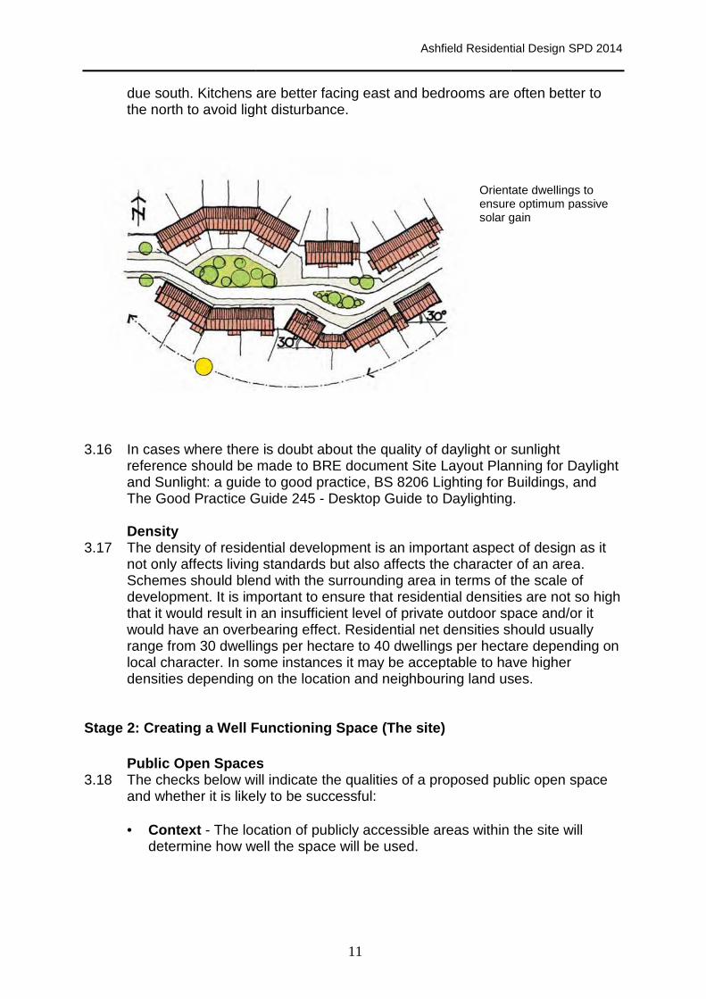
due south. Kitchens are better facing east andthe north to avoid light disturbance.
3.16 In cases where there is doubt about the quality of daylight or sunlight
reference should be made to BRE document Site Layout Planning for Daylight and Sunlight: a guide to good practice, BS 8206 Lighting for Buildings, and The Good Practice Guide Density
3.17 The density of residenot only affects living standardsSchemes should blend with the surrounding ardevelopment. It is important to ensure that residential densities are not so high that it would result in an insufficient level of private outdoor space and/or it would have an overbearing effect. Residential net densities shoulrange from 30 dwellings per hectare to 40 dwellings per hectare depending on local character. In some instances it may be acceptable to have higher densities depending on the location and neighbouring land uses.
Stage 2: Creating a Well Functio
Public Open Spaces3.18 The checks below will
and whether it is likely to be
• Context - The location of publicly accessible areas within the site will determine how well
Ashfield Residential
11
Kitchens are better facing east and bedrooms are often better to the north to avoid light disturbance.
Orientate dwellings to ensure optimum passive solar gain
In cases where there is doubt about the quality of daylight or sunlight reference should be made to BRE document Site Layout Planning for Daylight and Sunlight: a guide to good practice, BS 8206 Lighting for Buildings, and
tice Guide 245 - Desktop Guide to Daylighting.
he density of residential development is an important aspect of design as it affects living standards but also affects the character of an area
Schemes should blend with the surrounding area in terms of the scale of It is important to ensure that residential densities are not so high
it would result in an insufficient level of private outdoor space and/or it would have an overbearing effect. Residential net densities shoulrange from 30 dwellings per hectare to 40 dwellings per hectare depending on local character. In some instances it may be acceptable to have higher densities depending on the location and neighbouring land uses.
Creating a Well Functio ning Space (The site)
Public Open Spaces he checks below will indicate the qualities of a proposed public
is likely to be successful:
The location of publicly accessible areas within the site will well the space will be used.
Ashfield Residential Design SPD 2014
edrooms are often better to
Orientate dwellings to ensure optimum passive
gain
In cases where there is doubt about the quality of daylight or sunlight reference should be made to BRE document Site Layout Planning for Daylight and Sunlight: a guide to good practice, BS 8206 Lighting for Buildings, and
Desktop Guide to Daylighting.
ntial development is an important aspect of design as it but also affects the character of an area.
ea in terms of the scale of It is important to ensure that residential densities are not so high
it would result in an insufficient level of private outdoor space and/or it would have an overbearing effect. Residential net densities should usually range from 30 dwellings per hectare to 40 dwellings per hectare depending on local character. In some instances it may be acceptable to have higher densities depending on the location and neighbouring land uses.
public open space
The location of publicly accessible areas within the site will

Ashfield Residential Design SPD 2014
12
• Activities bordering the space - The surrounding land uses will affect how many users the space will attract. Informal surveillance by passers by will have a significant effect on how safe the space will feel.
• Activities within the space - Spaces should be multi-functional; a range
of activities should be achievable within the space at different times of day or year.
• Microclimate - The most successful spaces are those that feel
comfortable. Spaces which are sheltered from the wind, which capture both sunshine and shade provide the best solution.
• Scale - The scale needs to be suitable for the intended function of the
space. Smaller spaces can work just as well as larger spaces depending on the intended use.
• Proportion - The level of containment will influence how well a space is
defined. A sense of place may be lost if there is too little containment.
• Objects within the space - Interesting features such as trees, changes in level and public art can provide interest within a space and can act as a focus.
• Management - Public open space will require a management plan to
ensure that quality is maintained and places feel safe and secure.
Detailing the public realm 3.19 The detail of the public realm will have a significant impact on the quality of the
place. Effective coordination is needed from the design stage through to delivery and maintenance. The following should be considered in detail:
• Street furniture - Street furniture should be of a good quality and the
designer should liaise with the bodies which will be responsible for maintaining it to ensure that quality will not be compromised following future repairs. Clutter should be avoided wherever possible (refer to Manual for Streets). Street lighting and street signs can be fixed to buildings, where appropriate, if this is planned in advance and legal covenants are in place where necessary.
• Trees – Opportunities should be taken to incorporate existing trees and hedgerows into the design of the development. Well maintained trees to the front of properties or on the street help to improve the street’s appearance and create habitats. With climate change, their contribution to shading the street will be increasingly valuable. Designers should work with the Council and the Highway Authority from an early stage to ensure that problems relating to future maintenance can be overcome. It is essential that detailed specifications are produced in order that trees are planted correctly and will grow well, without causing future problems. Siting and correct species selection are also important factors.

Ashfield Residential Design SPD 2014
13
• Lighting - A coordinated lighting strategy that works with the public realm can reduce clutter. Lighting levels can be designed to relate to the street hierarchy, rather than being of standardised brightness, subject to Highways requirements. Lighting should not result in any detrimental harm to natural ecosystems.
Multifunctional space
3.20 Multifunctional space often works in many situations. Manual for Streets advises that to create places that work for all members of the community, a street should:
• Help to build and strengthen the community it serves;
• Meet the needs of all users by embodying the principles of inclusive design;
• Form part of a well-connected network;
• Be attractive and have its own distinctive identity;
• Be cost-effective to construct and maintain;
• Be safe.
Manual for Streets identifies that SuDs systems
Can be successfully incorporated into streets (Andrew Cameron, WSP)
Street hierarchy
3.21 When setting out street layouts and designing corridor sections, the following aspects of the movement and visual hierarchy need to be considered:
• Movement hierarchy
� Traffic volume;
Ashfield Residential Design SPD 2014
14
� Number of dwellings served; � Type of vehicles accommodated; � Whether or not there is direct access to individual properties.
• Visual hierarchy
� Scale (the distance between building fronts); � Enclosure (as determined by building heights); � Carriageway and footpath widths; � Street trees which can subdivide a street into different zones.
3.22 The busiest and best connected streets do not necessarily have the widest
corridors. Street sections need to be appropriate to each segment of a movement corridor. It is important to identify those streets whose key function is place rather than movement. This will include residential areas and town centres. For these areas, consideration should be given to how street design can enhance and promote a sense of place.
Connectivity
3.23 Street networks should be well connected in order to make it easier for pedestrians and cyclists to move around. This also helps to disperse traffic more evenly and takes away the need for busier trunk roads which are less pedestrian friendly and less visually attractive.
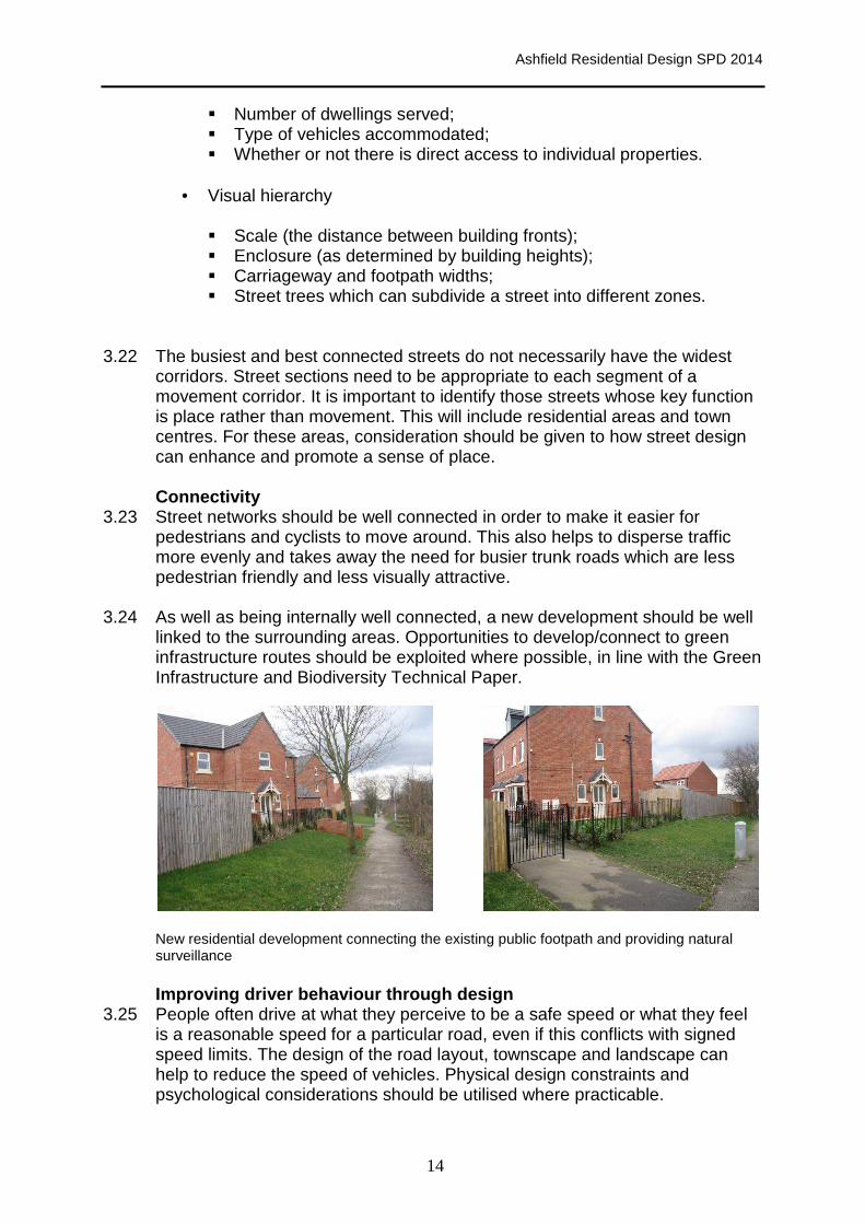
3.24 As well as being internally well connected, a new development should be well linked to the surrounding areas. Opportunities to develop/connect to green infrastructure routes should be exploited where possible, in line with the Green Infrastructure and Biodiversity Technical Paper.
New residential development connecting the existing public footpath and providing natural surveillance
Improving driver behaviour through design
3.25 People often drive at what they perceive to be a safe speed or what they feel is a reasonable speed for a particular road, even if this conflicts with signed speed limits. The design of the road layout, townscape and landscape can help to reduce the speed of vehicles. Physical design constraints and psychological considerations should be utilised where practicable.

Ashfield Residential Design SPD 2014
15
Safety
3.26 The design of the scheme should incorporate a layout which is aimed at reducing traffic speed. Manual for Streets sets out a number of ways in which road safety can be addressed. Good visibility is paramount to a successful scheme. Car parking and landscaping should be carefully considered in order to prevent barriers to pedestrian and cyclist movement. It is advisable to seek advice from the Development Management section prior to the design stage of an application so that this can be resolved at an early stage. The Safer Places Chapter provides guidance relating to crime reduction and design.
Walkable neighbourhoods
3.27 The street pattern and level of connectivity are critical to making a neighbourhood walkable. Routes that offer long-distance views of where pedestrians are heading tend to be more popular. Sense of safety is a key aspect in determining people’s choice of walking and cycling. In order to make safe and secure streets, the following fundamental factors should be considered when designing for the pedestrian: • Pedestrian routes should be part of shared corridors and road space;
• Building frontages (front doors and windows to habitable rooms) should be
along the streets;
• Adequate street lighting for night-time safety;
• Shared public space can create more activity and provide natural surveillance;
• Ensure routes are accessible for users of all abilities.
Footpath linking up to surrounding areas and providing natural surveillance The Safer Places Chapter provides more detailed guidance on designing out crime.

Ashfield Residential Design SPD 2014
16
Legibility 3.28 Streets and footpaths should be well defined so that all users can easily
navigate a route through the development. There should be clear sight lines to important buildings, public spaces and points of activity. Landscape treatments and architectural features should be used to define public spaces and routes.
Residential development provides clear sight of public open space/footpaths, providing safe access along pavements for pedestrians
Make cycling an attractive option
3.29 Traffic calming measures can make it easier and safer for cyclists to share roads. However, it is essential that the calming measures do not create conditions which are dangerous or uncomfortable for cyclists. The details of design and construction are most important. Cyclists should not be directed over sudden changes in level or uneven surfaces or forced into the line of motor vehicles, at road narrowings or chicanes. Nottinghamshire County Council’s Cycling Design Guide (2006) provides more detailed guidance.
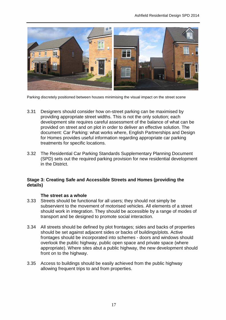
Accommodating the car
3.30 Car parking has a significant impact on the quality and usability of the public realm. If parking is poorly designed, people will often use surrounding public realm which is not designed to accommodate parked cars. Parking should be safe and convenient but not dominate the streetscene. Parking with frontage access can overcome many of these issues and provide the most effective and attractive parking solution - it is convenient, and it can increase the activity and safety of the street.
Ashfield Residential Design SPD 2014
17
Parking discretely positioned between houses minimising the visual impact on the street scene 3.31 Designers should consider how on-street parking can be maximised by
providing appropriate street widths. This is not the only solution; each development site requires careful assessment of the balance of what can be provided on street and on plot in order to deliver an effective solution. The document: Car Parking: what works where, English Partnerships and Design for Homes provides useful information regarding appropriate car parking treatments for specific locations.
3.32 The Residential Car Parking Standards Supplementary Planning Document (SPD) sets out the required parking provision for new residential development in the District.
Stage 3: Creating Safe and Accessible Streets and H omes (providing the details)
The street as a whole 3.33 Streets should be functional for all users; they should not simply be
subservient to the movement of motorised vehicles. All elements of a street should work in integration. They should be accessible by a range of modes of transport and be designed to promote social interaction.
3.34 All streets should be defined by plot frontages; sides and backs of properties should be set against adjacent sides or backs of buildings/plots. Active frontages should be incorporated into schemes - doors and windows should overlook the public highway, public open space and private space (where appropriate). Where sites abut a public highway, the new development should front on to the highway.
3.35 Access to buildings should be easily achieved from the public highway allowing frequent trips to and from properties.
Ashfield Residential Design SPD 2014
18
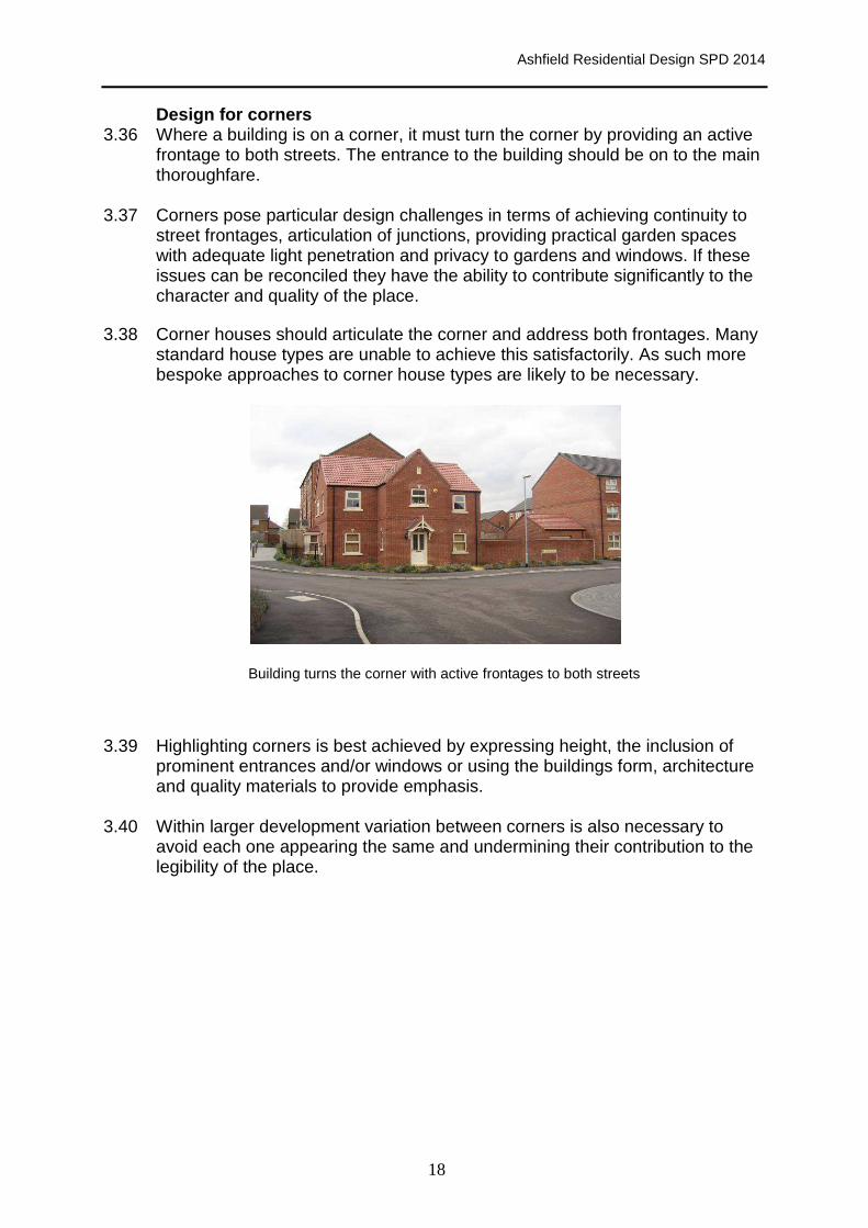
Design for corners 3.36 Where a building is on a corner, it must turn the corner by providing an active
frontage to both streets. The entrance to the building should be on to the main thoroughfare.
3.37 Corners pose particular design challenges in terms of achieving continuity to street frontages, articulation of junctions, providing practical garden spaces with adequate light penetration and privacy to gardens and windows. If these issues can be reconciled they have the ability to contribute significantly to the character and quality of the place.
3.38 Corner houses should articulate the corner and address both frontages. Many standard house types are unable to achieve this satisfactorily. As such more bespoke approaches to corner house types are likely to be necessary.
Building turns the corner with active frontages to both streets 3.39 Highlighting corners is best achieved by expressing height, the inclusion of
prominent entrances and/or windows or using the buildings form, architecture and quality materials to provide emphasis.
3.40 Within larger development variation between corners is also necessary to avoid each one appearing the same and undermining their contribution to the legibility of the place.

Ashfield Residential Design SPD 2014
19
Examples house types designed to handle a corner and address both frontages, adding interest to the street scene.
Main components of a street 3.41 A range of housing types and styles adds interest to the street scene and
breaks the monotony of identical house types. Applicants must demonstrate that the key components of a street can be accommodated within the scheme. Where necessary, proposals should include cross sections for key streets from one building frontage to the other (spanning the entire street). All elements of the street (both public and private spaces) should be included. This will demonstrate how the street will function as a whole.
Components to include:
1. Plots and buildings, including details of set backs, building lines, external
spaces, parking and boundaries;
2. The street space, including: • Footways; • Space requirements for cycling; • Verges; • Street trees; • On-street parking; • Carriageway; • Speed reduction measures; • Sustainable drainage systems; • Street lighting; • Street furniture; • Utilities (current needs and future requirements); • IT and Broadband and • Surface materials.

Ashfield Residential Design SPD 2014
20
Example of a Sustainable Urban Design Drainage System (SuDS)
Materials 3.42 Building materials and colours should be chosen for their high quality, to
complement site context and to strengthen the local distinctiveness of the area.
3.43 The use of locally relevant building materials, techniques and detailing can reinforce local distinctiveness and strengthen the special character and identity of a place.
3.44 Materials used in boundaries, elevations and roofs should harmonise with the predominant local character, colour tones and texture where these make a positive contribution to the area. For sites with a weak or indifferent context, materials can be used to help introduce a stronger sense of identity to a place.
3.45 Developers are encouraged to utilise locally produced traditional materials or recycle and re-use building materials such as stone, bricks and tiles, to help integrate a development into its context (provided these are not taken from walls and structures that are themselves important elements of the areas character.
3.46 The choice of materials needs to take account of their durability as well as aesthetic considerations and character. It can be tempting to select materials based on their low cost and ease of maintenance. This can be particularly inviting where houses are to be managed by an external organisation such as a housing association. However, low cost, low maintenance materials lack integrity and undermine the quality of a place.
3.47 The Council strongly encourages the innovative design of new residential developments in terms of the role it can play towards the requirement for zero carbon developments. Further information regarding sustainable design for new residential developments can be found in section 6.

Ashfield Residential Design SPD 2014
21
Homes 3.48 Homes should provide a comfortable, safe and private space which can be
enjoyed by the occupants. In order to ensure this can be achieved minimum separation distances should be applied having regard to site conditions and context. Separation distances should have regard to location, the conversion of existing buildings, the character of the area and topography. Where the existing pattern of an area has established a lesser standard, reduced distances may be acceptable. On sloping sites, there may need to be greater distances between properties or a change to the orientation of buildings to avoid overlooking. When submitting planning applications where there are topographical constraints, applicants will be required to demonstrate how overlooking has been addressed.
3.49 The diagram below (figure 1) illustrates the minimum distances between habitable rooms of dwellings at various angles. Table 1 below sets out the minimum distances (m) that will normally be expected according to the angle of the dwellings.
Habitable rooms are:
• Living rooms; • Dining Rooms; • Kitchens; • Bedrooms; • Other rooms not defined as • non-habitable rooms.
Non habitable rooms are:
• Hall/landing; • Bathroom/WCs; • Utility rooms; • Garages or other
outbuildings.

Ashfield Residential Design SPD 2014
22
Angle of direct sight line at dwelling A 90º 80º 70º 60º 50º 40º 30º 20º
90º 21 21 20 19 18 16 12 8
80º 21 20 19 18 16 12 8
70º 20 19 18 16 12 8
60º 19 18 16 12 8
50º 18 16 12 8
40º 16 12 8
30º 12 8
20º 8 Table 1 Minimum distances between habitable rooms
3.50 Private outdoor space should adequately provide for the requirements of all
occupants. Dwellings should normally have a minimum single area of private open space, excluding parking areas and garage spaces, in accordance with Table 2 which sets out the minimum outdoor amenity space requirements for dwellings.
Dwelling type/No. of Bedrooms
Minimum outdoor amenity space requirements (sqm)
1 or 2 bed house 50
3 bed house 70
4+ bed house 90
Flats 25 per flat
Residential institutions 20 per resident Table 2. Minimum area amenity space
3.51 It is important to ensure that the outlook of dwellings is of a reasonable quality.
The Council will not be supportive of proposals where dwellings have a poor outlook onto an unsightly area.
Internal Space Standards (Guidance)
3.52 In order to protect the amenity and well-being of the future occupants, each dwelling should be adequate for the family or household which is likely to occupy it. New housing is expected to be big enough to meet the needs of the occupants for living, cooking, dining, sleeping, washing and storage of household goods with convenient access to adequate amenity space. Developers must demonstrate that rooms are functional for their purpose and that dwellings provide sufficient room for storage.
Ang
le o
f dire
ct s
ight
line
at
dwel
ling
B
Ashfield Residential Design SPD 2014
23
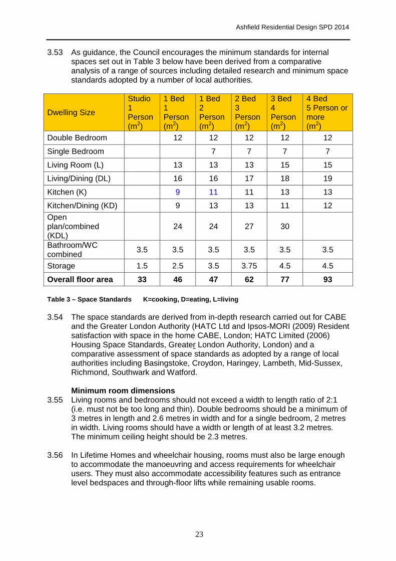
3.53 As guidance, the Council encourages the minimum standards for internal spaces set out in Table 3 below have been derived from a comparative analysis of a range of sources including detailed research and minimum space standards adopted by a number of local authorities.
Dwelling Size
Studio 1 Person (m2)
1 Bed 1 Person (m2)
1 Bed 2 Person (m2)
2 Bed 3 Person (m2)
3 Bed 4 Person (m2)
4 Bed 5 Person or more (m2)
Double Bedroom 12 12 12 12 12
Single Bedroom 7 7 7 7
Living Room (L) 13 13 13 15 15
Living/Dining (DL) 16 16 17 18 19
Kitchen (K) 9 11 11 13 13
Kitchen/Dining (KD) 9 13 13 11 12
Open plan/combined (KDL)
24 24 27 30
Bathroom/WC combined
3.5 3.5 3.5 3.5 3.5 3.5
Storage 1.5 2.5 3.5 3.75 4.5 4.5
Overall floor area 33 46 47 62 77 93 Table 3 – Space Standards K=cooking, D=eating, L=li ving 3.54 The space standards are derived from in-depth research carried out for CABE
and the Greater London Authority (HATC Ltd and Ipsos-MORI (2009) Resident satisfaction with space in the home CABE, London; HATC Limited (2006) Housing Space Standards, Greater London Authority, London) and a comparative assessment of space standards as adopted by a range of local authorities including Basingstoke, Croydon, Haringey, Lambeth, Mid-Sussex, Richmond, Southwark and Watford.
Minimum room dimensions
3.55 Living rooms and bedrooms should not exceed a width to length ratio of 2:1 (i.e. must not be too long and thin). Double bedrooms should be a minimum of 3 metres in length and 2.6 metres in width and for a single bedroom, 2 metres in width. Living rooms should have a width or length of at least 3.2 metres. The minimum ceiling height should be 2.3 metres.
3.56 In Lifetime Homes and wheelchair housing, rooms must also be large enough to accommodate the manoeuvring and access requirements for wheelchair users. They must also accommodate accessibility features such as entrance level bedspaces and through-floor lifts while remaining usable rooms.

Ashfield Residential Design SPD 2014
24
Outdoor storage 3.57 Well designed and located outdoor storage is paramount for the success of all
developments. Refuse and recycling storage space should be well integrated into the curtilage of each residential property. It should be easily accessible but discreetly located so that it does not dominate the street scene. There should be adequate space to accommodate all bins and recycling containers.
3.58 Access for waste vehicles in terms of vehicle heights, weights, turning circles, width, etc. needs to be taken into account in the design of residential developments. For details of the amount of space required, carry distances and other technical requirements developers should make early contact with Ashfield District Council’s Environment Department. Table 4 identifies Ashfield’s waste collection requirements as at October 2014.
Typical No of
Bins Required Optional Other matters
Dwellings
• 240 litre waste bin. • 240 litre recycling
bin. • 15 kg glass box
• 240 litre garden waste bin.
For larger families or where health issues arise, extra bins may be required.
Apartments
Calculated on the basis of every 4.5 households requiring: • 1100 litre waste
bin. • 1100 litre recycling
bin.
The access and egress route for the 1100 bins should: • Incorporate drop kerbs
onto the road; • Not include steps on
the route.
Table Four: Ashfield District Council, Waste Colle ction Requirements as at October 2014
A central path between townhouses/terrace Screened enclosures create a more attractive area properties enables bins to be stored out of for bin storage. The use of planting softens the sight to the rear of dwellings. scheme.

Ashfield Residential Design SPD 2014
25
Management and maintenance
3.59 The on-going management and maintenance of places is a key aspect of their long-term viability and quality. Our streets, parks and public spaces must provide high quality places that can be maintained at a reasonable cost. Maintenance issues and costs therefore need to be considered as part of the design process to ensure that maintainable schemes can be achieved and managed thereafter. Funds spent on a good design and hard wearing materials can be saved through lower maintenance costs over the lifetime of the asset.
3.60 Developers should work closely with the planning and highway authorities during the design stages to ensure that their adoption requirements can be achieved without undermining the quality of the public realm. This is particularly important where schemes propose creative or non-standard design solutions in order to resolve any issues around adopting highways at an early stage.

Ashfield Residential Design SPD 2014
26
4.0 Public Spaces, Green Infrastructure, Landscape and Biodiversity
4.1 A large area of Ashfield District is rural and urban fringe Countryside and Green Belt. The Council’s Landscape Character Assessment (2009) identifies three types of landscape character; Magnesian Limestone Ridge, Nottinghamshire Coalfields and Sherwood. The District contains woods, rivers and fields as well as agricultural land, important natural habitats and areas for formal and informal recreation.
4.2 The District has a good proportion of green space ranging from the historic parks at Annesley Hall, Hardwick Hall (registered) and Skegby Hall (non-registered) to the large town parks of Titchfield (Hucknall), Kingsway (Kirkby) and The Lawn (Sutton), to the smaller formal open spaces throughout the area and the less formal open spaces and green corridors. Public Realm open spaces include the Market Place in Hucknall, Portland Square in Sutton and the pedestrianised area of Lowmoor Road in Kirkby.
4.3 Parks, play areas, nature reserves as well as less formal smaller areas to sit and relax, act as the heart of Ashfield’s communities, bringing people together and providing welcome breathing space within the built-up areas, as well as opportunities for health, education, sport and leisure, recreation, culture and the enhancement of natural habitats.
4.4 Ashfield’s green spaces are an important asset, they help to reduce CO2 emissions and contribute towards the quality of life that local people enjoy. To achieve the Council’s objectives, developers/applicants will be expected to demonstrate how the proposed development will: • Create attractive streets and spaces:
New streets and public spaces should be designed to be safe, attractive and useable by many people with different needs. General aspects to consider include: local character, existing landscape and wildlife features, the size and type of space, location and prominence, connections to the wider area, circulation patterns and desire lines. Public space should be designed as an integral and complementary part of any development. Boundary treatments should enhance public space, streets and public space should be well-lit, avoiding dark corners. Public space that is poorly located, low quality and of a form and layout that limits its usefulness will not be supported.
• Prepare management plans (if appropriate): The long term success of any public space will depend on the adequacy of the management and maintenance arrangements. These arrangements will need to be considered at the outset. Management agreements will be required for shared areas that will not be adopted by the District Council or Parish Council.
• Integrate high quality, functional green and public spaces with the
existing green infrastructure network: This will enhance permeability to promote walkable streets and cycle paths

Ashfield Residential Design SPD 2014
27
to provide easy access to other green spaces, the urban fringe and the wider Countryside. Access should be provided to a variety of spaces for everyone, including adequate provision for those with disabilities or impairments. Spaces should be provided in accordance with the Council’s Green Space Strategy and Green Infrastructure and Biodiversity Technical Paper.
• Creatively incorporate a variety of biodiversity fe atures appropriate to their location: o National Planning Policy Framework paragraph 109 emphasises the
importance of enhancing the natural and local environment. Development should incorporate opportunities to enhance the local environment as conserving and enhancing biodiversity makes both environmental and economic sense. People value an environment rich in wildlife and it facilitates both physical and mental health. A good environment is reflected in both the attractiveness of a development and the potential price people are willing to pay to live in there.
o This will help to prevent biodiversity loss, reverse habitat fragmentation, promote priority habitats and maintain and enhance links to the existing network of wildlife corridors and local wildlife sites (SINCs). Important design principles to consider include:
o Where protected species exist on or next to a site, mitigation measures
should be incorporated to protect species, enhance biodiversity and allow improved connectivity to the wider green infrastructure network;
o Local native species should be used in all biodiversity schemes. Locally
distinctive flora and fauna and natural features like trees, hedgerows, water bodies and grassland should be incorporated and/or enhanced.
o Where a development results in a loss of biodiversity, provision should
be made to compensate for its loss in the locality to ensure an overall biodiversity gain is achieved.
• Create spaces that will inspire, excite, challenge and satisfy children:
This will encourage outdoor play and activity, social interaction and provide an understanding of the environment and aid personal development. The community should be involved in the design of the space so that it meets their needs. Play provision should be consistent with the Council’s Green Space Strategy and early discussions with the relevant officers of the Council are encouraged.
• Ensure open space and play provision is laid out to the recognised,
certified standard: Where the Council is to provide future maintenance, facilities should be suitably laid out and maintained to the point of transfer. Maintenance plans should be provided for private spaces to ensure that the space remains attractive and well used.

Ashfield Residential Design SPD 2014
28
• Use landscape to integrate the development with its surroundings: The use of landscaping should be appropriate to the scale and layout of the development. High quality landscaping can reduce the impact non-residential development (particularly service yards and car parks) will have on the local landscape.
• Make use of public art: To be successful, art should be incorporated at the earliest stage in the design and not when the scheme is completed. Public art should not be limited to traditional forms; it can also be incorporated into functional objects to provide a theme for an area or can be combined with making provisions for play. Signage, lighting schemes and architectural detail should all be considered to integrate public art within an area, adding to and shaping the character. Community involvement is important to ensure that the art reflects its locality. Future maintenance of art works also needs to be carefully considered.
Biodiversity in buildings
4.5 Traditionally buildings have provided both roost sites for bats and nesting opportunities for birds. Bat populations have fallen considerably so that it has become necessary for all British bat species to be protected. Birds such as swifts, swallows, house martins, sparrows and starlings will all use the structure of a building to make nests. The reduction in available nesting and roosting sites is implicated in the decline of these species.
4.6 The emphasis on climate change and more energy efficient designs means that building do need to be more ‘airtight’ but this does not mean there has to be less space for biodiversity. With a little planning in advance, provision can be made for nesting birds and roosting bats in or on buildings. Consequently, it is important that both buildings and any extensions are designed and refurbished in a way in which biodiversity can be enhanced.
4.7 Sources of further advice on enhancing biodiversity in buildings include the following:
• Natural England identifies the Exeter Residential Design Guide SPD,
an example of best practice which includes advice in Appendix 2 of the requirements for different species.
• Biodiversity by Design. A guide for sustainable communities. The Town and Country Planning Association 2004
• Designing for Biodiversity: A Technical Guide for New and Existing Buildings (2nd edition) Brian Murphy, Kelly Gunnell and Carol Williams RIBA Publishing.

Ashfield Residential Design SPD 2014
29
5.0 Safer Places – Tackling Crime Through Design 5.1 Everyone deserves to live, work and relax in a safe environment. This means
a greater awareness is needed relating to the use of and design of buildings, streets, open spaces and landscaping to create a sense of security. Crime prevention measures are difficult to install once a development is complete, so it is essential public safety and crime reduction is considered at the planning stage. The aim of this chapter is to outline ways in which developments can incorporate safety measures into their design.
Place Survey Results: The Fear of Crime
5.2 A Place Survey was undertaken by Ipsos MORI in 2008/09 to assess the perceptions of residents in seven local authority areas in Nottinghamshire. The survey was undertaken on behalf of a consortium of local authorities, which include: Ashfield DC, Bassetlaw DC, Broxtowe BC, Gedling BC, Mansfield DC, Newark and Sherwood DC, Nottingham City Council, and Nottinghamshire County Council.
5.3 Perceptions of crime and safety are often central to whether residents see an
area as a good place to live or not. In Nottinghamshire, although most (88%) felt safe during the day, just half (49%) felt safe outside at night, with 34% feeling unsafe at night. Residents of Ashfield and Mansfield are most likely to feel unsafe after dark. This makes it all the more important to ensure that all new development is designed to a high standard and every opportunity should be taken to ensure that crime is addressed through the design process.
National Policy and Guidance relating to Crime Prev ention and Planning
5.4 Government Guidance: Safer Places, The Planning System and Crime Prevention (2004), sets out in detail the key aspects which, in terms of planning, help to contribute to the creation of sustainable communities. The guide specifies that there are seven attributes of sustainable communities that are particularly relevant to crime prevention (see table). These are:
• Access and movement : places with well defined routes, spaces and
entrances that provide for convenient movement without compromising security;
• Structure : places that are structured so that different uses do not cause conflict;
• Surveillance: places where all publicly accessible spaces are overlooked; • Ownership: places that promote a sense of ownership, respect, territorial
responsibility and community; • Physical protection: places that include necessary, well-designed
security features; • Activity: places where the level of human activity is appropriate to the
location and creates a reduced risk of crime and a sense of safety at all times;
• Management and maintenance: places that are designed with management and maintenance in mind, to discourage crime in the present and the future.

Ashfield Residential Design SPD 2014
30
Design Guidance 5.5 Guidance on Planning and crime prevention is set out in Planning Practice
Guidance Paragraph: 010 Reference ID: 26-010-20140306. Table Five, below is based on the seven attributes of sustainable communities as outlined by Government Guidance: Safer Places, The Planning System and Crime Prevention (2003). While the document has been archived the Table provides a checklist to facilitate crime prevention through design. Natural surveillance offers one of the best crime prevention solutions. Developments must be well designed, enabling natural surveillance to be easily achieved. The following checklist sets out ways in which design can assist in crime prevention.
7 Attributes of Sustainable Communities relating to Crime Prevention
Development Checklist
1) Surveillance a. Surveillance cuts across all areas and has been incorporated into each of the following sections – guidance is marked with a (S). It relates to natural surveillance, whereby places can be viewed by people within the vicinity of the area.
2) Access and Movement a. Existing well used rights of way should be incorporated into the development;
b. Footpaths and cycle paths should be overlooked wherever possible (S);
c. Footpaths should be wide enough to allow free flowing movement;
d. Routes should be well sign-posted where appropriate;
e. Ensure there are a number of exit points on footpaths/cycle paths where practical;
f. Footpaths and cycle paths should not be located to the rear of properties (S);
g. High fencing/walls should not be installed along the boundaries of footpaths or cycle paths (S);
h. Footpaths should be direct and avoid blind bends (S);
i. An element of landscaping should be incorporated into the design of footpaths and cycle paths;
j. Planting should allow a clear view through the footpath/cycle path (S);
3) Structure a. Boundary treatments should be designed in such a way as to allow natural surveillance e.g. the height should be kept to a minimum in public areas (e.g. to the front of properties) (S);
b. Main entrances should be clearly visible and face the street (S);
c. Entrances should be visible from the windows within the dwelling (S);
d. Blank gable facades should be avoided especially on corner/end plots (i.e. windows should be located on

Ashfield Residential Design SPD 2014
31
7 Attributes of Sustainable Communities relating to Crime Prevention
Development Checklist
gable ends) (S); e. Secure bin storage facilities should be provided
within the curtilage of properties; f. Rear gardens should abut each other; g. Dwellings should be arranged to encourage
neighbour contact; h. Pedestrian links should be overlooked by
neighbouring properties (S); i. Car parking should be located in areas which are
overlooked and well lit. Residential parking should be located within the curtilage of the dwelling and small parking courtyards (for up to 6 vehicles) and/or on street parking bays should be overlooked and located in close proximity to properties. Both hard and low level, low maintenance soft landscaping should be incorporated into the design of the parking areas (S).
4) Ownership Defensible space: public areas should be well defined to promote a sense of ownership, respect and territorial responsibility. The use of textured or coloured paving materials and soft landscaping can help to define public spaces. This will remove uncertainty about public/private ownership of space.
5) Physical Protection Security measures should be incorporated into each scheme. The proposal should be compliant with the standards set out in the Secured by Design guidance. Further information is available at: www.securedbydesign.com
6) Activity a. A mix of dwellings (e.g. ranging from 1 bed to 4 bed properties) should be provided to promote occupation at all times of the day (S);
b. Where possible, streets should be well connected to promote activity. An endless series of cul-de-sacs should be avoided (S);
7) Management and maintenance
a. Care should be taken to ensure that areas within the public realm are of a good quality design;
b. Facilities management systems should be put in place for areas within the public realm and for tenanted properties;
c. Residents and business users should be encouraged to become involved in the long term maintenance of development schemes in order to promote a sense of responsibility and ownership.
Table Five, The seven attributes of sustainable communities as outlined by Government Guidance: Safer Places, The Planning System and Cri me Prevention (2003).

Ashfield Residential Design SPD 2014
32
5.6 Key points
• Applicants are advised to seek advice from the Council’s Development team who in turn will liaise with the Architectural Liaison Officer for Nottinghamshire Police as early in the design stages as possible;
• The seven attributes set out above should be incorporated into the design of each development scheme;
• The Design and Access Statement should provide a detailed explanation of the scheme and how crime has been addressed through design.

Ashfield Residential Design SPD 2014
33
6.0 Sustainable Design 6.1 Ensuring the efficient use of resources both in the construction of new
developments and throughout their lifetime is essential in order to minimise the impact on the environment. The consumption of natural resources and the resultant emission of carbon dioxide is a significant contributor to climate change. In 2009 the Government estimated that in the UK net emissions of carbon dioxide were 473.7 million tonnes6. Of this, energy use in buildings accounted for nearly half, and just under a quarter came from the energy used to heat, light and run our homes. It is therefore essential that steps are taken to reduce the resources used by new development in order to reduce the impact of climate change. This is currently undertaken through Building Regulations, the Code for Sustainable Homes (residential), BREEAM (non-residential) and via the planning system. There are however planned changes so that the Building Regulation Standards will become the key control for sustainable construction.
6.2 Although the implementation of sustainable energy and buildings has
traditionally rested with Building Control through the legislation of Building Regulations, the Government are now seeing the issues of sustainable design as a responsibility for the planning and construction industry as a whole. The measures set out in this section of the document are not intended to be seen as a hindrance to the planning and construction process, but rather as an opportunity to enforce a joined up approach to Building Control and Planning. Approved Document L of the Building Regulations identifies the requirements to implement energy efficient methods. The consideration of energy saving and efficient designs at the planning stage, will ensure more options are pursued and opportunities taken, to install technologies and methods to limit energy consumption and maximise self-generated power, allowing for a more sustainable and environmentally considerate process.
6.3 Key to delivering a more sustainable environment within Ashfield is the
willingness of developers and applicants to enter into early and meaningful discussions with the appropriate officers of the Council. At a pre-application stage, this will help to identify and resolve any potential conflicts between meeting sustainable design objectives and other planning objectives. To ensure that energy efficiency and resource use are fully considered in all new developments Ashfield District Council will expect applicants and developers to demonstrate the satisfactory environmental performance of their proposals. This should be achieved through compliance with the requirements outlined below which vary according to the size of the proposal. Where appropriate, the Council would encourage developers to consult with the local community at an early stage while there is still scope to make changes to the proposals. Local communities will be able to raise issues for the developer to consider, and make suggestions which could improve the development and reduce its impact on the neighbourhood.
6 Department of Energy and Climate Change: http://www.decc.gov.uk/en/content/cms/statistics/climate_stats/gg_emissions/uk_emissions/2009_final/2009_final.aspx

Ashfield Residential Design SPD 2014
34
6.4 Design and access statements should identify the design principles and concept that have been applied to the development. These statements, having regard to the nature of the development and type of application, should demonstrate how the proposed designs and layouts will promote sustainability, including the following key elements of sustainable design: . 1) Energy needs and supply issues are addressed as follows:
• Reduction in the demand for energy use in the whole lifetime of the
development through appropriate design, construction and insulation standards;
• Using energy efficient supply measure to meet any energy demands;
• Allowing for the effects of climate change throughout the lifetime of the proposed development.
2) Water management:
• Improving efficiency in the use of water and conserving water
resources; • Incorporating sustainable drainage systems (SUDS) to manage
surface water runoff and reducing flood risk both within and resulting from new developments.
3) Waste management:
• Minimising waste, including both construction and future
users/occupiers waste;
• Maximising opportunities of reuse, recycling and composting.
4) Access and Travel (The importance of an integrated approach to land use and transport planning) • Minimising the need for travelling;
• Maximising sustainable journeys.
5) Biodiversity:
• Opportunities to improve biodiversity connectivity to nearby green
spaces should be investigated as part of the design and layout process. Regard should be had to the green spaces and habitats identified in the Council’s Green Space Strategy 2008 and Green Infrastructure and Biodiversity Technical Paper 2013 or any updates.

Ashfield Residential Design SPD 2014
35
• Conservation and enhancement of biodiversity as set out in the UK Biodiversity Action Plan (where applicable), the Nottinghamshire Local Biodiversity Action Plan and the Ashfield Green Infrastructure and Biodiversity Technical Paper.
6) Conservation of the historic environment including archaeology, historic
buildings, parks, gardens and conservation areas.

Ashfield Residential Design SPD 2014
36
7.0 The Water Environment 7.1. Water management and reducing the risk of flooding from all sources7 is a key
aspect of sustainable development. This is reflected in the Water Framework Directive, the NPPF and Planning Practice Guidance. At a District level, information is provided in the Ashfield Strategic Flood Risk Assessment, 2009 and the Greater Nottingham and Ashfield Outline Water Cycle Study undertaken by Entec (2010). Flood Risk
7.2. The NPPF requires the Council, in determining planning applications, to avoid inappropriate development in areas at risk from flooding, to ensure flood risk is not increased elsewhere and only consider development appropriate in areas at risk of flooding where the application is informed by a site-specific flood risk assessment. A Flood Risk Assessment (FRA) needs to be submitted alongside planning applications in areas that are known to be at risk of river flooding (within Flood Zones 2 or 3) and/or are greater than one hectare in area or where other flood risks have been identified.
7.3. Sources of information on flood risk include:
a) Planning Practice Guidance. This should be applied in conjunction with the
information in the Council’s Strategic Flood Risk Assessment (SFRA) in particularly Table 15 and Table 16.
b) The SFRA identifies “other sources of flooding “set out in tables and maps
for Sutton-in-Ashfield, Kirkby-in-Ashfield, Hucknall and the Rural Area. However, this reflects a relatively broad brush approach. Therefore, they should not be interpreted as providing definitive sources of flooding but used to identify whether additional investigation is necessary by a site specific flood risk assessment.
c) The Environment Agency with Natural England and the Forestry
Commission has produced guidance that explains their roles in new developments. 'Building a Better Environment' provides initial information to help you make the most of new development for people and the environment. It also signposts to more technical advice, including consents and permits you might need.
d) The Environment Agency’s website identifies a range of detailed maps –
‘What’s in your backyard?’ to show various environmental constraints that may affect your development. Maps include:
• groundwater aquifers
7 “Flood risk” means risk from all sources of flooding - including from rivers, directly from rainfall on the ground surface, rising groundwater, overwhelmed sewers and drainage systems and from reservoirs, lakes and other artificial sources.

Ashfield Residential Design SPD 2014
37
• groundwater Source Protection Zones (SPZs) • flood maps • river quality • reservoir flood maps • surface water maps
e) Some applications will fall under Environment Agency Flood Risk Standing
Advice (FRSA) and may not need an FRA. The Standing Advice matrix is used by Local Planning Authorities to establish the level of environmental risk involved without the need to consult the Environment Agency directly. See the What do I need to do for my Flood Risk Assessment? advice on the Environment Agency website.
f) The County Council, as the Lead Flood Risk Authority, is likely to hold increasing information over time on flood risk in the County.
7.4. Developers are advised to discuss flood risk matters with the Environment
Agency at the pre-application stage as this can identify any water related issues that need to be resolved at an early stage.
Water Quality
7.5. The EU Water Framework Directive applies to surface water and groundwater. The Directive has a number of objectives which include preventing deterioration of aquatic ecosystems and protect, enhance and restore water bodies to ‘good’ status. The Council as the local planning authority must have regard to the River Basin Management Plans Humber River Basin District, 20098 in relation to the Idle and Torne District Catchment and the Lower Trent and Erewash District Catchment. This Plan contains the main issues for the water environment and the actions needed to tackle them. In line with the objectives of the Water Framework Directive, development must not result in any water body failing to meet the status class set out in the Humber River Basin Management Plan covering the water environment in Ashfield.
7.6. Development will be permitted where proposals do not have a negative impact on water quality, either directly through pollution of surface or ground water or indirectly through overloading of the sewerage system and Wastewater Treatment Works. The ‘no deterioration’ policy of the Water Framework Directive requires that current environmental conditions are maintained or improved. It is therefore a key element of any development that it does not have an adverse impact on water quality and ecology. Where appropriate, the Council, as the local planning authority will make planning permission conditional upon there being adequate sewerage facilities to cater for the development without the development resulting in ecological damage or having an adverse impact on the water quality.
7.7. As a substantial area of Ashfield is on a principal aquifer there is a particular emphasis on protecting ground water from contamination and enhancing the
8 National Planning Policy Framework, 2012 paragraph 165

Ashfield Residential Design SPD 2014
38
water environment. Further information on water quality is set out in the Council’s Infrastructure Delivery Plan.
7.8. Although some pollution arising from runoff may be unavoidable and water
treatment at every outfall may be impractical, by moderating flows and filtering runoff, SuDS can deliver significant reductions in impact on the water resource by means of ground infiltration, storage and filtration or bio-filtration. Development sites will be required to use mitigation measures to minimise any resultant pollution. In consultation with the Environment Agency the Council may require a Water Framework Directive Assessment (WFDA) as part of a planning application. Sustainable Drainage Systems (SuDS)
7.9. The detailed design of the surface water proposals based on Sustainable Drainage (SuDS) principles, should be submitted and approved before any development commences and preferably with the detailed planning applications. The SuDS principles are to mimic natural catchment processes thereby reducing flood risk by encouraging soakage on-site (where appropriate), reducing pollutant concentrations (such as hydrocarbons from roads) in the water for disposal, reducing the volume of surface water being discharged from the site and, where discharge occurs to existing watercourses/drains, limiting the flow by on-site attenuation and flow control structures to the natural ‘greenfield’ run-off rate.
7.10. The design should follow the hierarchy of preference for different types of surface water drainage systems as set out in Approved Document H of the Building Regulations and the SuDS Manual produced by CIRIA, i.e. soakage on site before discharge to watercourse/drains. If you propose to discharge surface water from a new building or development into an existing watercourse, you may be required to make improvements downstream (to enable the watercourse to deal with any increased flow) or to provide storage to control the rate of flow from the site.
7.11. Details of future methods of maintenance of SuDS systems, the body that will
be responsible and the method of funding of the maintenance will also be required.
7.12. Under the Flood and Water Management Act 2010, Nottinghamshire County
Council is the SUDS Approving Body (SAB). When Section 3 of the Act is implemented, an application to the County Council will be necessary to approve drainage plans for both permitted developments and for planning applications.
Other Consent
7.13. Investigations should be carried out to check for the presence of land drainage systems (i.e. watercourses and culverts) on or abutting an application site. Applicants should be aware of their responsibilities in respect of these systems.

Ashfield Residential Design SPD 2014
39
7.14. Applicants who are proposing to carry out any works within eight metres of the bank of a ‘main’ river, including demolition, construction or storage, will require a Flood Defence Consent, in addition to any planning permission granted. Additionally, works may require further assessment (such as a Water Framework Directive Assessment) depending on the impacts on the river. Applicants are strongly advised to contact the Environment Agency directly for any proposals close to a watercourse. The Main Rivers designated in Ashfield comprise the following:
� River Erewash from Park Lane, Kirkby in Ashfield � River Leen from Castle Mill Farm, Papplewick. � Baker Lane Brook from the Hucknall By-pass, Hucknall.
(August 2014)
Further information is available in the Environment Agency “Living on the Edge' guide which explains your rights and responsibilities in relation to riverside ownership.
7.15. Ordinary watercourses are all those watercourses that are not designated as
main rivers. Changes to an ordinary watercourse which may affect flow or flood risk will require written consent from Nottinghamshire County Council, as the Lead Local Flood Authority, prior to carrying out such works. This can include erection or alterations to bridges, culverts, weirs, trash screens, pipes crossings in channel or any other obstruction to the flow of an ordinary watercourse as any change has the potential to increase flood risk to people and property.
7.16. Flood risk management authority can designate a feature on your land as a flood risk management asset, for example a garden wall where it can help to reduce flood risk. Features and structures that have been designated as an asset cannot be altered, removed or replaced without the consent of the responsible authority. Nottinghamshire County Council maintains a register of structures or features which in the opinion of the authority, are likely to have a significant effect on a flood risk in its area.
7.17. Future access for undertaking maintenance of land drainage systems must be
considered when designing the development layout. 7.18. You are recommended to contact Nottinghamshire County Council’s Flood
Risk Management Team before carrying out any work which will impacts on an ordinary watercourse or check to establish that a structure close to a watercourse has not be registered. (Tel: 0115 977 4590 or [email protected]).
Water as a resource 7.19. There is a requirement to save water with the Watercycle Study for Greater
Nottingham and Ashfield indicating that the water resource situation in the

Ashfield Residential Design SPD 2014
40
East Midlands is significantly constrained with little opportunity to develop new water resource schemes. In addition, substantial carbon and energy can be saved by using water more efficiently as energy is used in processing, transporting pumping and taking away waste water and for water treatment. Consequently the design of buildings and the water services is a key aspect in saving water to save. Guidance such as the Environment Agency’s 'Building a Better Environment' and ‘Water efficiency in new homes An introductory guide for housebuilders’ NHBC Foundation, 2009 identifies how buildings can be designed to save water through a variety of water efficiency measures.
7.20. Where possible, consideration should be given to the use of green roofs, rainwater harvesting systems and similar water recycling systems.
Foul Drainage 7.21. Proposals for dealing with foul water drainage will need to be addressed in
any residential planning application. Usually, this will mean connecting the development to the public foul sewerage network either directly or indirectly. Approval will be required from Severn Trent for direct connections to the public sewer.
7.22. Outline applications will need to provide sufficient information to show that any
indicative layout proposed is capable of being implemented without causing flooding or pollution.
7.23. If an application proposes to connect a development to an existing private
drainage system then details of the existing system should be shown on the application drawings. Applications in areas where there is no public sewerage network available or where a connection is not practical, must be accompanied by a ‘Foul Drainage Assessment’ (FDA), to demonstrate that an alternative means of disposal can be achieved. The FDA must include a full assessment of the site, its location and the method of sewage storage, treatment and disposal. Environment Agency consent is required for any proposed discharge.
7.24. No surface water is to be connected to the foul drainage system. Where
possible, consideration should be given to the use of greywater recycling systems.
7.25. Any relevant correspondence with Severn Trent or the Environment Agency
should be submitted with the application. Onsite and offsite sewers to be offered for adoption will need to comply with the requirements of Severn Trent.
7.26. Prior to completing planning application forms, applicants are advised to view
the public sewer records held by Severn Trent Water Ltd. Any proposal that affects a public sewer will need discussion with Severn Trent. This may include connecting to, altering, or building over/close to, a public sewer.

Ashfield Residential Design SPD 2014
41
8.0 Minerals & the Coal Mining Legacy
Mining Legacy 8.1. Ashfield has a mining legacy which may need to be considered in taking
forward residential development schemes in certain areas. Whilst most past mining is generally benign in nature, potential public safety and stability problems can be triggered and uncovered by development activities.
8.2. The Council as the local planning authority will considered issues raised by mines entries and other mining legacy matters to ensure that site allocations and other policies and programmes will not lead to future public safety hazards. It is important that new development recognises the problems and how they can be positively addressed so that new development is safe, stable and sustainable.
8.3. The Coal Authority has defined a Development High Risk Area, within which defined mining legacy features are present which may lead to land instability. The Development High Risk Area for Ashfield is illustrated on the plan contained on: http://coal.decc.gov.uk/en/coal/cms/services/planning/strategy/ashfield_distr/ashfield_distr.aspx
8.4. In the Development High Risk Area any planning application will need to be
accompanied by a Coal Mining Risk Assessment which considers the mining legacy present and identifies what remediation, mitigation or treatment measures are necessary to allow development to go ahead. Advice on Coal Mining Risk Assessments is available on The Coal Authority website at: http://coal.decc.gov.uk/en/coal/cms/services/planning/strategy/strategy.aspx
8.5. Residential layouts will need to take account the presence of certain mining legacy features. The Coal Authority will not support the erection of any new development above or within the zone of influence of mine entries, even where these have been treated. Residential layouts will need to be designed so as to include appropriate stand-off distances around any mine entries. Advice on developing above mine entries is available at:http://coal.decc.gov.uk/assets/coal/whatwedo/4265-policy-for-building-over-or-within-the-influencing.pdf Mineral Resources
8.6. Ashfield contains mineral resources which may in due course be included within defined Mineral Safeguarding Areas (MSAs). MSAs will be defined in the Nottinghamshire Minerals Plan which is currently in preparation by Nottinghamshire County Council. The District Council is under a general obligation set out in National Planning Policy to prevent the unnecessary sterilisation of mineral resources of national and local importance. As part of taking forward residential development, consideration should therefore be given to the potential prior extraction of the mineral resource ahead of development. The most commonly minerals that can be prior extracted are
Ashfield Residential Design SPD 2014
42
sand & gravel and surface coal. In the case of the latter the removal of remnant coal can be a cost effective way of mitigating unstable land issues arising from mining legacy. Other Consents
8.7. Prior extraction of surface coal requires an Incidental Coal Agreement from The Coal Authority. Further information can be found at: http://coal.decc.gov.uk/en/coal/cms/services/licensing/license_apps/license_apps.aspx
8.8. Under the Coal Industry Act 1994 any intrusive activities, including initial site
investigation boreholes, and/or any subsequent treatment of coal mine workings/coal mine entries for ground stability purposes require the prior written permission of The Coal Authority, since such activities can have serious public health and safety implications. Failure to obtain permission will result in trespass, with the potential for court action. Application forms for Coal Authority permission and further guidance can be obtained from The Coal Authority’s website at:
http://coal.decc.gov.uk/en/coal/cms/services/permits/permits.aspx
8.9. Contact details for individual operators that may be able to assist with coal
extraction in advance of development can be obtained from the Confederation of Coal Producers’ website at www.coalpro.co.uk/members.shtml.

Ashfield Residential Design SPD 2014
43
9.0 Planning Application Requirements
Pre-Application Advice 9.1. The Council has now adopted a charging schedule for pre-application advice;
this is available on the Council’s website. Applicants are advised to contact the Development Team prior to submitting a planning application to seek advice about the proposal. For more complex planning applications it is advisable to have at least one pre-application meeting with a Planning Officer. A pre-application meeting will help the applicant to: 1. Find out what will be required to be submitted with the application; 2. Find out about the planning process and what needs to be considered
when drawing up a proposal i.e. in relation to Local Planning Policies, design, the affect on neighbouring development etc.
3. Gauge whether the scheme is likely to be considered favourably by the Council;
4. Reduce the likelihood of submitting an invalid application. 9.2. It is essential that applicants take along as much information about the
proposal as possible to the pre-application meeting. Useful information to take to a pre-application meeting includes scaled plans and sketches showing the design and layout of the scheme and how it relates to the surrounding area. In addition to this it would also be useful to provide information about the following issues: roads/traffic; noise; flooding; drainage; footpaths; watercourses; sewers; access to services/facilities. It is always best to contact a Planning Officer to check what information will be required prior to attending a pre-application meeting. Historic Assets
9.3. A heritage statement should be submitted with applications affecting historic assets (e.g. listed buildings; Scheduled Ancient Monuments, properties in conservation areas). The Historic Environment Record (HER) at Nottinghamshire County Council should be consulted as a minimum and expert advice should be sought where necessary prior to the submission of a planning application. The HER contains detailed information relating to a range of historic assets within Nottinghamshire. Applicants are also strongly advised to seek advice from the Development Management section of the Council. Ideally, a pre-application meeting should be held to discuss the details of the proposal in order to ensure that it complies with current legislation and planning policies, and, is of an appropriate design which is sensitive to the heritage asset/s in question i.e. conservation area or listed building.
Planning Application Submission
9.4. The National Standard Planning Application Form (1APP), introduced on 6th April 2008, is the only way of submitting a planning application to all planning authorities in England.
9.5. You can download the forms from the Council’s website or alternatively, an
application can be submitted electronically via the Planning Portal website.

Ashfield Residential Design SPD 2014
44
You should check the Validation Lists to make sure you have included all the relevant documents and forms with your application. For more information please see the Planning’ section of the Council’s website which provides details of the planning application process. Design and Access Statements
9.6. A Design and Access Statement (DAS) is a written statement which provides the justification for a planning application. It is a legal requirement for certain types of planning application and for proposed development within a World Heritage Site or Conservation Area. A Design and Access Statement is a short report which sets out the design process; it should give details of the proposed scheme in a structured format. The information contained within a Design and Access Statement must be proportionate to the complexity of the proposal. In addition to the written statement, it is also beneficial to include maps, photos and drawings to illustrate the key points of the scheme. When is a Design and Access Statement required?
9.7. A Design and Access Statement must be submitted with a planning application for major development. It is required for both outline and full planning applications. Lower thresholds apply in conservation areas and World Heritage Sites, where some smaller applications must also be accompanied by a Design and Access Statement. Listed building consent applications must also include a Design and Access Statement. Applications for a material change of use do not need to be accompanied by a Design and Access Statement.
9.8. A Design and Access Statement must explain the design principles and concepts that have been applied to the development. It must also demonstrate how the proposed development’s context has influenced the design. The Statement must explain the applicant’s approach to access and how relevant Local Plan policies have been taken into account, any consultation undertaken in relation to access issues, and how the outcome of this consultation has informed the proposed development. Applicants must also explain how any specific issues which might affect access to the proposed development have been addressed.
9.9. The level of detail in a Design and Access Statement should be proportionate to the complexity of the application, but should not be long. For most straightforward planning applications, the Design and Access Statement may only need to be a page long.
9.10. A Design and Access Statement should clearly set out how the design of the
proposal relates to the existing building/area in terms of the layout, scale, massing, materials and architectural features. Account should be taken of the history and evolution of a building/area. Where relevant, applicants should also make reference to the Historic Environment Record and how it has influenced the scheme. (Please see the requirements for sustainable design in Paragraph 6.4).

Ashfield Residential Design SPD 2014
45
The Design and Access Statement process 9.11. Prior to designing the scheme and writing the Design and Access Statement,
applicants are advised to: 1. Undertake an assessment of the following:
• Physical Character: Determine how the scheme will fit with the local
landscape in terms of existing types of development, the scale and design of buildings; movement of people/vehicles (highways/parking);
• Social: How will local people be affected by the development? • Economic: How will the development impact on the local economy? • Planning policy: which policies are applicable to the proposal?
2. Involve the community:
• Undertake consultation with the local community; • Determine what type of consultation methods are suitable/most
effective (depending on the scale of the scheme); • Evaluate the findings of the consultation.
3. Evaluate the results
• Determine what design options are available for the scheme based on the evaluation of the first two stages of this process (Assessment and Involvement).
4. Design the scheme
• Following the evaluation stage applicants are in a better position to start to design their scheme based on the findings of the first two stages.
Writing the Design and Access Statement
9.12. A Design and Access Statement needs to be succinct and should demonstrate that the applicant has a good understanding of the character and circumstances of the local area. The design and use of the proposed scheme must respect the character of the local area. Applicants are advised to use photographs, visuals/drawings, and written text to demonstrate the appearance of the scheme in its surrounding context. The following is suggested as a format for the written report:
1. Area character/Land use: Provide details of the character of the area and justify why the proposed land use is appropriate for this area. With regard to appropriate land uses, it may be useful to make reference to local and national planning policies and the existing land uses in the surrounding area. It is important to demonstrate how the proposal will connect with the wider area.
Ashfield Residential Design SPD 2014
46
2. Amount : In certain circumstances, where densities are higher or lower than average, it may be useful to provide justification for the amount of development proposed (e.g. number of dwellings/size of units) and demonstrate why this is appropriate for this area. Consider the density and scale of development in the area; how will it affect the way the area functions i.e. in terms of traffic, pedestrian movement, impact on local services etc. Include details about constraints which may have influenced/restricted the size of the scheme. 3. Layout (use written explanation, plans and drawings ): Provide details of the layout of the scheme. Applicants should use illustration to demonstrate how the roads and footpaths provide good connections both within the site and to the surrounding area. Vehicular and pedestrian movement and the orientation of the buildings should be demarcated on the plans/drawings. Diagrams and written text should demonstrate how natural daylight and natural surveillance (crime reduction) have been considered within the scheme. Issues to take into consideration in this section include: defining public and private space within the scheme; identifying how changes in levels will be addressed; what would be the most optimum position for windows and doors; how will landscaping features affect movement. 4. Scale: Provide an explanation about the scale of the buildings and how they sit within the existing built or natural environment. Three dimensional visuals/drawings usefully show how schemes will fit into the existing landscape. 5. Landscaping: Landscaping should be a key consideration at an early stage in the design process. The Design and Access Statement should demonstrate how the design of outdoor spaces (both public and private spaces) will enhance the scheme through both appearance and functionality. Applicants should also set a strategy for the long term maintenance of public spaces. The scheme will also need to address the issues/obstacles which are likely to affect the disabled and elderly e.g. level changes; non slip surfacing; signage/visual aids; the need for resting places; lighting etc. 6. Appearance: The Design and Access Statement should set out the thought process which has led to the overall design of the scheme. For example, is this a scheme which will blend seamlessly with its surroundings or is it a statement scheme which will set the context for the regeneration of an area. Applicants are encouraged to submit visuals (coloured drawings, photographs etc) showing an interpretation of the completed scheme. Details of the proposed materials should also be included within this section of the Design and Access Statement. Where materials have not been decided, it would be useful to provide details of a range of materials which are being considered for the scheme. The Design and Access Statement should also take account of the changes in light throughout the day and through the seasons i.e. how will this affect the scheme in terms of natural light; orientation of buildings, microclimate.

Ashfield Residential Design SPD 2014
47
7. Access Statement: The statement should clearly set out how the applicant has addressed access issues through the design of the scheme, with particular reference to the inclusion of disabled people. This should include how relevant local planning policies have been applied. The policy approach set out in the design and access statement will inform decisions taken further down the line in the development process.
Pre-Application Advice
9.13. There are two aspects to this section – 1) Transport, and 2) Inclusiveness. Although these can be interrelated it is better to show how the scheme addresses each aspect separately. 1) Transport With regard to transport, the statement should explain why the road layout provides the best solution for vehicular and pedestrian movement through the site and how it provides access to public transport. Applicants should explain: • the reasoning behind the location of the access points; • The reasoning behind the layout of the roads and footpaths; and • how the layout of the scheme provides the optimum solution for access to
public transport. Applicants need to clearly show that pedestrians (including the disabled) and vehicles can move safely and comfortably through the site. Diagrams should be used to show how footpaths, roads, and sight lines will be linked both within the scheme and to the surrounding area. 2) Inclusivenes The internal layouts of buildings need to be shown; the visibility of entrances and access to the buildings through entrance areas or front doors, as well as access to facilities such as toilets, meeting rooms, shops or sports centres should be clearly demarcated and explained. This section should also explain how levels change within public spaces, including pavements and dropped kerbs, bus stops, parking spaces including blue badge holders at train stations, and parks. It should show how using symbols and pictures can help people navigate their way through the site.
Consultation 9.14. Applicants need to demonstrate that they have undertaken adequate public
consultation on access issues and that the results have fed into the design of the scheme. It is vitally important that a cross-section of society is involved in the consultation process to enable the designer/applicant to address the needs of all users.
9.15. For major residential developments, please make reference to the Building for Life 12 questions in Appendix 1 and submit with your Planning Application.

Ashfield Residential Design SPD 2014
48
Residential development schemes should accord with all aspects of Building for Life.
Ashfield Residential Design SPD 2014
49
10.0 Policy Background and Best Practice Design Gu idance
Pre-Application Advice 10.1. This Supplementary Planning Document (SPD) sets out the guidelines used in
determining planning applications for residential development. It should be read in conjunction with other planning policies, which are set out below. National Guidance
10.2. The National Planning Policy Framework (NPPF) highlights the Government’s position regarding the importance of design to the built environment. The Core Planning Principles (NPPF paragraph 17) requires local planning authorities to:
‘always seek to secure high quality design and a good standard of amenity for all existing and future occupants of land and buildings’.
More detailed advice is set out in the Part 7 “Requiring Good Design”. The Government’s objective for the planning system is to promote good design that ensures attractive, usable and durable places and sees this as a key element in achieving sustainable development. Part 7 provides more detailed national guidance on the key principles of design and sets the context for the determination of planning applications. (Paragraph’s 56 to 68). This includes: • That “good design is indivisible from good planning and should contribute
positively to making places better for people” (paragraph 56).
• Local authorities should consider using design codes where they could help deliver high quality outcomes (paragraph 59).
• That design goes beyond aesthetic considerations and stresses the
importance of connections between people and places and the integration of new development into the natural, built and historic environment (paragraph 61).
• Permission should be refused for development of poor design that fails to
take the opportunities available for improving the character and quality of an area and the way it functions. (Paragraph 64)
10.3. The Ashfield Local Plan Review 2002 (ALPR) was adopted in November
2002. A number of policies within the ALPR are ‘saved’ policies under the provisions of the Planning & Compulsory Purchase Act 2004; Schedule 8(1(3))9. Due weight can be given to these policies under NPPF paragraph 215, according to their degree of consistency with the NPPF. Policies within the document include those that ensure residential development will not adversely affect the character, quality, amenity or safety of the environment and the design is acceptable in terms of appearance, scale and siting. The
9 The saved policies in the Ashfield Local Plan Review 2002 are identified on the Council’s website

Ashfield Residential Design SPD 2014
50
majority of the ALPR 2002 policies have been saved and they provide a robust framework for making decisions on planning applications. The main policy considerations in this instance are: • Policy ST1 – Development; • Policy HG3 – Housing Density; • Policy HG5 – New Residential Development; • Policy HG6 – Public Open Space in New Residential Developments; • Policy HG8 – Residential Care Facilities, Houses in Multiple Occupation,
Bedsits, Flats and Hostels. Best Practice Design Guidance
10.4. The best practice guidance below must, wherever possible be taken into account by developers.
10.5. Manual for Streets - Manual for Streets is a highway design guidance document produced by the Department for Transport. It is aimed at creating well designed residential streets. The document sets out the process which needs to be undertaken in order to ensure that residential streets meet the needs of all users. It advocates a partnership approach between developers and local authorities. The design principles sections set out the concepts for creating well connected streets at the town centre and neighbourhood level. It also addresses design issues relating to crime reduction. Applicants are advised to seek direction from Manual for Streets early in the design stage to ensure that residential schemes accord with national guidance.
10.6. Nottinghamshire County Council (NCC) is the Highway Authority for the area covered by this SPD. The Authority has adopted the 6C’s Highways Design Guide (three cities and three counties) which is hosted by Leicestershire County Council. This guide details issues relating to the design and adoption of new roads. In order to be adopted, all aspects of the public realm need to satisfy the technical requirements of the Highway Authority. The home page for the Design Guide can be found using the following link http://.leics.gov.uk/index/6csdg.htm
10.7. The Government’s ‘Safer Places’ 10 document provides `guidance on how good planning can reduce crime by ‘designing out’ opportunities for crime and ‘designing in’ community safety. The key aspects of this document are set out in section 5 of this document.
10.8. The Code for Sustainable Homes is the national standard for the sustainable design and construction of new homes, it aims to reduce our carbon emissions and create homes that are more sustainable. The Code goes further than the current building regulations, but is entirely voluntary, and is intended to help promote even higher standards of sustainable design although it is recognised that with impending changes to Building regulations this may change in the future.
10 Safer Places: The Planning System and Crime Prevention, ODPM, 2004

Ashfield Residential Design SPD 2014
51
10.9. Achieving good design and sustainable development are the core principles underlying planning. At the heart of sustainable development is the simple idea of ensuring a better quality of life for everyone, now and for future generations.
10.10. Building for Life 12 - Building for Life 12 (BfL12) is a nationally recognised design guide which is led by three partners: Cabe at the Design Council, Design for Homes and the Home Builders Federation, supported by Nottingham Trent University. Its aim is to provide a basis for the creation of well-designed homes and neighbourhoods. Local communities, local authorities and developers are encouraged to use BfL12 as a guide to creating good places to live.
10.11. The scheme sets out a list of 12 criteria which are considered to form the basis
of good design. Residential schemes should aim to address the 12 BfL questions. In addressing the 12 questions, schemes should aspire to be attractive, functional and sustainable places. BfL12 accords with the National Planning Policy Framework and the Government’s commitment to build more homes, better homes and involve local communities in planning. The 12 questions are designed to guide discussions between local communities, the local planning authority, the developer of a proposed scheme and other stakeholders. BfL12 is also designed to assist local planning authorities in assessing the quality of proposed and completed developments; and as a point of reference in the preparation of local design policies.
10.12. The scoring system for BfL12 is based on a simple ‘traffic light’ system (red,
amber and green) it is recommended that new developments should secure as many ‘greens’ as possible whilst minimising the number of ‘ambers’ and avoiding ‘reds’. The more ‘greens’ the better a development will be. A red light gives warning that an aspect of a development needs to be reconsidered. A development proposal might not achieve 12 greens for a variety of reasons. Where a proposal is identified as having one or more 'ambers', this would point to the need to rethink whether these elements can be improved, however local circumstances may justify why the scheme cannot meet the higher standard expected of a green
10.13. The 12 Building for Life questions are set out in Appendix 1.
10.14. Heritage - The effect of development on heritage assets should be considered at the earliest stage in the design process. English Heritage has produced a range of guidance aimed at assisting Councils and developers in the development process. The Council will utilise guidance produced by English Heritage in the determination of planning proposals which have the potential to affect heritage assets. Applicants are also advised to seek guidance from the publications produced by English Heritage.
10.15. Ashfield District - Ashfield District Council is committed to developing safe and sustainable neighbourhoods. The vision contained within the Ashfield Local Plan sets out the Council’s commitment to the creation of well designed
Ashfield Residential Design SPD 2014
52
development of a high quality. This closely aligns with the Vision in the Ashfield and Mansfield Community Strategy11: “A dynamic, attractive and prosperous area that we can be proud of”.
10.16. The Council’s Corporate Plan also reflects this vision with its priority objectives being:
• A dynamic productive and rewarding local economy; • Community responsibility for an attractive and safe environment; • Stronger and more resilient communities where people want to live, work,
play and be involved; • Ashfield District Council is an enabler of local leadership in Ashfield.
11 Ashfield and Mansfield Community Strategy: 2013-2023
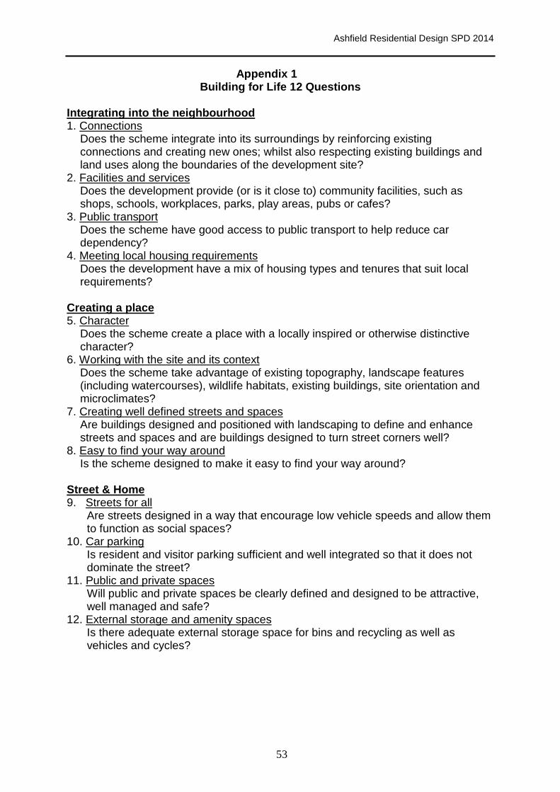
Ashfield Residential Design SPD 2014
53
Appendix 1 Building for Life 12 Questions
Integrating into the neighbourhood 1. Connections
Does the scheme integrate into its surroundings by reinforcing existing connections and creating new ones; whilst also respecting existing buildings and land uses along the boundaries of the development site?
2. Facilities and services Does the development provide (or is it close to) community facilities, such as shops, schools, workplaces, parks, play areas, pubs or cafes?
3. Public transport Does the scheme have good access to public transport to help reduce car dependency?
4. Meeting local housing requirements Does the development have a mix of housing types and tenures that suit local requirements?
Creating a place 5. Character
Does the scheme create a place with a locally inspired or otherwise distinctive character?
6. Working with the site and its context Does the scheme take advantage of existing topography, landscape features (including watercourses), wildlife habitats, existing buildings, site orientation and microclimates?
7. Creating well defined streets and spaces Are buildings designed and positioned with landscaping to define and enhance streets and spaces and are buildings designed to turn street corners well?
8. Easy to find your way around Is the scheme designed to make it easy to find your way around?
Street & Home 9. Streets for all
Are streets designed in a way that encourage low vehicle speeds and allow them to function as social spaces?
10. Car parking Is resident and visitor parking sufficient and well integrated so that it does not dominate the street?
11. Public and private spaces Will public and private spaces be clearly defined and designed to be attractive, well managed and safe?
12. External storage and amenity spaces Is there adequate external storage space for bins and recycling as well as vehicles and cycles?

Ashfield Residential
Ashfield District Council
Urban Road, Kirkby-in-Ashfield, Nottingham,
Tel: (01623) 450000 Fax: (01623) 457585 Website
54
Ashfield Residential Design SPD 2014
Ashfield District Council
field, Nottingham, NG17 8DA
Website: www.ashfield-dc.gov.uk

Consultation Statement – Residential Design Guide S upplementary Planning Document (SPD)
The Town and Country Planning (Local Planning) (Eng land) Regulations 2012
Introduction
The purpose of this SPD is to set out the Council’s approach to ensure high quality residential developments are achieved in the District. The SPD sets out how the Council expects the location, form and type of residential development in Ashfield will be considered through the design process. It is consistent with the National Planning Policy Framework and the Saved Polices within the Ashfield Local Plan Review 2002.
This statement is the ‘Consultation Statement’ for the SPD as required by the Town & Country Planning (Local Planning) (England) Regulations 2012. Revisions have
been made following receipt of representations on the SPD.
This Consultation Statement describes the consultation that was undertaken, provides a summary of responses received, and the Council’s responses to these comments. The Consultation Statement has been up-dated following completion of the representation period on 8th August 2014.
Consultation Regulations
The SPD is produced in accordance with the Town and Country Planning (Local Planning) (England) Regulations 2012. The relevant regulations relating to the consultation process are explained below.
Regulation 12: Regulation 12(a) requires the Council to produce a consultation statement before adoption of the SPD, this must set out who has been consulted, a summary of the issues raised, and how these issues were incorporated in to the SPD
Regulation 12 (b) requires the Council to publish the documents for a minimum of 4 week consultation, specify the date when responses should be received, and identify the address to which responses should be sent.
This statement is the ‘Consultation Statement’ for the SPD as required by regulation 12(a). The document also sets out information about the consultation as required by regulation 12(b). As the SPD progresses towards adoption, the ‘Consultation Statement’ will be expanded to recognise involvement by outside bodies and public participation during the consultation period.
Regulation 13: Regulation 13 stipulates that any person may make representations about the SPD and that the representations must be made by the end of the

consultation date referred to in regulation 12. This consultation statement sets out this requirement.
Regulation 14: This regulation relates to the adoption of the SPD. When the Council adopt the SPD it must make the SPD and adoption statement available under regulation 35. The Council should also send a copy of the adoption statement to any person who has asked to be notified of the adoption of the SPD.
Regulation 35: Regulation 12 states that when seeking representations on an SPD documents must be made available in accordance with regulation 35. This requires the Council to make documents available by taking the following steps:
• Make the document available at the principal office and other places within the area that the Council considers appropriate;
• Publish the document on the Council’s website.
The Statement of Community Involvement
The SCI was originally adopted in 2006 and was then updated in 2010 and July 2013. The procedures for consultation follow the guidelines in the SCI.
Consultation Period
Consultation on the SPD was carried out in accordance with the Town and Country Planning (Local Planning) (England) Regulations 2012. The SPD and the Consultation Statement was made available for inspection for a six week period between 24th June and 8th August 2014.
Copies of the SPD and this consultation statement were available (in accordance with Regulation 35) during normal office hours at:
Ashfield District Council offices, Urban Road, Kirkby-in- Ashfield, Nottingham, NG17 8DA on Mondays to Fridays 8.30am to 5.00pm (4.30 Fridays).
Copies were also be available for inspection during normal opening hours in the Council offices at Watnall Road, Hucknall, Fox Street, Sutton in Ashfield, and Nottingham Road, Selston.
In addition:
• Notification letters were been sent to bodies identified under the duty to cooperate and as specific consultations bodies under the regulations where the SPD is relevant to those parties.
• To other parties on the Local Plan consultation database where the SPD is considered to be potentially relevant to those parties.
• Notification letters were sent to all Parish Councils within the District • A press notice was posted in local papers the week commencing 23rd June
2014.

• The documents were available to be viewed on the District Council’s website at: http://www.ashfield-dc.gov.uk/20715.aspx.
Consultation Responses
The consultation on this document was open until Friday 8th August 2014. It identified that comments could be made in writing to the Forward Planning Team at Ashfield District Council, Urban Road, Kirkby-in-Ashfield, Nottingham, NG17 8DA or email [email protected] or the online comment form. It stressed that responses will be made public and a summary of the main issues raised from the consultation and how those issues have been addressed will be made available on the Council’s website in accordance with the Regulations.
Parties Consulted
The parties the Council consulted are set out in Appendix One.

Summary of the issues raised / how these issues wer e incorporated in to the SPD During the six week consultation period five individuals/organisations responded with representations/comments in relation to the SPD. A summary of the main issues raised and how those issues have been addressed in the SPD are set out in the Table below.
Respondents Name
Section of SPD
Comment/ Summary of p roposed amendment
Council response
Environment Agency
6.0 Sustainable Design
We welcome that issues such as water management, biodiversity and waste management will be sustainability indicators when developers submitted D & A statements.
The Council welcomes support for this aspect.
Environment Agency
7.0 The Water Environment
The sub topics on the water environment are comprehensive and sufficiently detailed on all the environmental topics we would wish to see. We are encouraged that full consideration has been given to these environmental matters which will assist in removing obstacles in the development management process.
The Council welcomes support for this aspect.
Environment Agency
7.0 The Water Environment
• We recommend that within the flood risk section developers are advised to discuss flood risk matters with the Environment Agency at pre-application stage.
• Emphasis should be given to Water
Framework Directive in relation to water quality.
• Text amended to include pre application advice from the EA.
• Amendments made to “Other Consent” to give contact details and information on locations of main rivers.
• Amendments made to water quality
identifying that development should not have a negative impact on water quality, either directly through pollution of surface or ground water or indirectly

through overloading of the sewerage system and Wastewater Treatment Works.
(Reflected in amendments to the Final SPD in paragraphs 7.1, 7.4, 7.5, 7.6, 7.14, 7.15, 7.16, & 7.18)
Natural England General Natural England did not make specific comments as the topic of the SPD does not relate to their remit to any significant extent. However, a general reference was made to: • Biodiversity enhancements - This SPD
should encourage the taking of opportunities to incorporate features which are beneficial to wildlife into proposals for development with a reference to an example of best practice. (Exeter Residential Design Guide).
• Landscape enhancements - The SPD may
provide opportunities to enhance the character and local distinctiveness of the surrounding natural and built environment; use natural resources more sustainably; and bring benefits for the local community, for example through green space provision and access to and contact with nature.
• Protected species – Referred to the availability to councils of standing advice.
• The SPD in para 4.4 identifies that “Creatively incorporate a variety of biodiversity features appropriate to their location” is important as this will help to prevent biodiversity loss, reverse habitat fragmentation, promote priority habitats and maintain and enhance links to the existing network of wildlife corridors and local wildlife sites (SINCs).
• Additional text included to set out general advice on Biodiversity in Buildings.
• Para 6.4 amended to reflect the opportunities to improve biodiversity connectivity to nearby green spaces as part of the design and layout process.
• The SPD in para 4.4 identifies a
requirement in developments to “Use landscape to integrate the development with its surroundings”. The use of landscaping should be appropriate to the scale and layout of the development.

• Strategic Environmental
Assessment/Habitats Regulations Assessment - Identified that a SPD may occasionally be found likely to give rise to significant effects which have not been formally assessed in the context of a higher level planning document, for example saved policies. If there is any doubt on the need to carry out a SA or HRA a screening assessment should be carried out.
High quality landscaping can reduce the impact non-residential development (particularly service yards and car parks) will have on the local landscape.
• A SEA screening assessment has been
undertaken. (Reflected in amendments to the Final SPD in paragraphs 4.4, 4.5, 4.6, 4.7 & 6.4)
Coal Authority General The SPD seems comprehensive and addresses many issues, however, The Coal Authority considers that the SPD should also include reference to the possible need to undertake prior extraction of minerals and to unstable land arising from mining legacy.
Text incorporated with the SPD to identify: • Surface Coal Resources and Prior
Extraction - Ashfield District Council area contains coal resources which are capable of extraction by surface mining operations.
• Mining Legacy – the area covered by Ashfield District Council area has been subjected to coal mining. Mining entries and other features need to be taken into account in the interests of safety.
(Taken forward in the Final SPD in paragraphs 8.1,8.2, 8.3, 8.4, 8.5, 8.6, 8.7, 8.8 & 8.9)
IBA Planning Ltd
Paragraph
The guidance document should not be so prescriptive as to require 'all' Design and
The wording has been amended as it was considered that the level of information

6.4 Access Statements to respond to all 7 key elements of sustainable design - otherwise there is a danger that such a blanket requirement would inevitably become an (unnecessary) minimum local requirement capable of invalidating otherwise perfectly acceptable planning applications.
should reflect the nature of the development and type of application. However, as the response set out, the Town and Country Planning (Development Management Procedure) (Amendment) Order 2013 has amended the requirements for design and access statements. The Regulations mean that statements are only required for larger applications for application for development in designated areas. Given the emphasis by the NPPF on sustainable development, statements should address these elements. (Reflected in amendments to the Final SPD in paragraphs 6.4 & 9.10)
Development Management Ashfield District Council
Paragraph 5.5
Need to reference Planning Practice Guidance (Reflected in amendments to the Final SPD in paragraph 5.5).
Development Management Ashfield District Council
Paragraph 6.4
Delete “CO2 emissions are in line with current Building Regulations calculation by SAP (Standard Assessment Procedure) for dwellings or SBEM (Simplified Building Energy Model) or an approved DSM (Dynamic Simulation Model) for buildings which are not dwellings;”
Deleted as it simply repeats the Building Regulations and there is no necessity to duplicate the requirement.
Development Management Ashfield District Council
Paragraph 6.4
Access and Travel (The importance of an integrated approach to land use and transport planning)
Amendment included for clarification (Reflected in amendments to the Final SPD in paragraphs 6.4)
Ashfield District Paragraphs Ashfield Community Strategy & Ashfield Amend to include latest Vision and Priorities

Council 10.15 & 10.16
Corporate Plan update Vision and priorities (Reflected in amendments to the Final SPD in paragraph 10.15 & 10.16)
Waste & Environmental Services, Ashfield District Council
Paragraph 3.54
Concern expressed regarding residential design in relation to waste management.
Paragraph 3.55, additional paragraph on vehicular access in terms of vehicle heights, weights, turning circles, width, etc. needs to be taken into account in the design of residential developments. (Reflected in amendments to the Final SPD in paragraph 3.58)
Annesley Community Committed to Ensuring Sustainable Settlements. (ACCESS)
General The 3 SPDs “should be should be withdrawn, synchronised and published at the same time as the next Examination Local Plan edition.”
No changes are proposed. The first issue on any residential application is whether the residential development would be appropriate in the location in question based on the policies in the ALPR and the provision of the NPPF. If acceptable in principle, the design SDP would be a factor in determining the planning application in that it would be expect the layout etc would meet the requirements in the SPD.
ACCESS General Concern expressed that coal mining issues are not covered by the SPD.
Additional wording including reflecting the response from the Coal Authority. (Taken forward in the Final SPD in paragraphs 8.1,8.2, 8.3, 8.4, 8.5, 8.6, 8.7, 8.8 & 8.9)
ACCESS General ACCESS believe the following important consideration from the NPPF have been omitted from this document and should be
The SPD objective is to deliver high quality developments in Ashfield. The provisions within the SPD provide additional

included within its text, since Ashfield Local Plan review 2002 (ALPR) does not contain sufficient information on noise and contaminated land.
information in relation to Policies in the ALPR. The SPD cannot introduce new policies and it is consider that issues relating to both noise and contamination are covered by the provisions within the NPPF and National Planning Practice Guidance. Where appropriate, both noise and contamination reports are required from applicants and decisions would be taken reflecting information from Environmental Health Officers and where appropriate Statutory Consultees such as the Environment Agency.
ACCESS Para 1.4 a) Any reference to the NPPF should also include the paragraph number and b) NPPF Para 64 should be quoted here, in that “That permission may be refused for development of poor design that fails to take the opportunities available for improving the character and quality of an area and the way it functions.
The SPD does not look to repeat policies in the ALPR or the NPPF unless there is specific relevance to paragraph in the SPD. However, an additional paragraph has been incorporate to the SPD in Section 3 to emphasis the importance of NPPF para 57, 60 and 64 on design and that it is essential that developers understand the place where they are proposing to build. (Taken forward in the Final SPD in paragraph 3.3)
ACCESS Para 2.1 — 2-3
Paragraphs fail to mention the Sherwood Forest and the Ancient Woodland areas and the bedrock geology, which preceded the mining activities and decided where earlier settlements were formed. We believe that this
Amend to reflect geology and Sherwood Forest. (Reflected in amendments to the Final SPD in paragraph 2.2)

should be included.
ACCESS Para 2.4 Ignores the conservation area of Annesley Village and the uniqueness of such streets as such i.e. “Forest Road” in Annesley Woodhouse which not only has similar properties but provides a shopping promenade. It also fails to mention that particularly in the rural areas many of the properties are bungalows.
The paragraph is part of a general; introduction to the SPD, it is not intended to describe specific areas. However, amendments are proposed to SPD para 3.5 to reflect the need to take account of designated areas and to include a para 3.13 to reflect “townscape”.
(Reflected in amendments to the Final SPD in paragraph 3.3, 3.6, 3.13 & 3.14)
ACCESS Para 3.3 & Para 3.4
• Development schemes should not just reflect or be sensitive to local character but to the local environment, ecology and geology.
• NPPF Para 118 sets out a number of principles which should aim to preserve and enhance biodiversity. T there is no reference within this document to NPPF Para 118 which we feel is an important element in the design approach, whether of inclusion, and there should a requirement under the SWOT analysis to include analysis on Ecological. Geographical, Biological and Geological aspects.
• Local character reflects the distinctive identity of a particular place that results from the interaction of many factors including these aspects. Change to reflect importance of local character.
(Reflected in amendments to the Final SPD in paragraph 3.3, 3.6, 3.13 & 3.14)
• Environmental aspects in Section 4 have been strengthened following comments from Natural England.
• The SPD does not propose to repeat all para from NPPF. It identifies that a SWOT analysis is necessary which should consider the proposed development against the design aspects

set out in the SPD.
ACCESS Para 3.5 The paragraphs fails to grasp the requirements to assess ecological, biological, or historic features of the existing site or how the proposed site may affect neighbouring areas, which may contain these features. We ask that reference to these be included.
The paragraph takes into account biodiversity and amendments are proposed to para 3.5 to reflect the need to take account of designated areas and to include a para 3.13 to reflect “townscape”. (Reflected in amendments to the Final SPD in paragraph 3.3, 3.6, 3.13 & 3.14).
ACCESS Para 3.5 The factors given fail to consider any negative aspect of any development. e,g. How can the scheme take advantage of the orientation of the site and micro-climates. We there believe that this aspect of fully describing the disadvantages as well as the advantages will promote better sustainable design and more importantly occupant satisfaction.
No change proposed as this is included in building layout. (See orientation and micro climates).
ACCESS Para 3.6 We suggest that this be reworded to reflect that these Ancient Woodlands, Ancient hedgerows and TOP’s will not be removed under any circumstance and that suitable mitigation should be in place for hedges and mature trees where there is a strong case for their removal. We do not believe that the Ashfield Local Plan 2002, stresses this importance.
No changes are proposed as this is reflect in the Ashfield Local Plan Review, Policy EV8 and in the NPPF paragraph 118.
ACCESS Para 3.8 We ask that consideration be given to ensuring that developments of over 50 dwellings be
No changes are proposed. Once adopted the SPD will be a material consideration.

treated as extra large scale. To aid traffic movement especially relating to emergency vehicles there should be at least 2 entry/exit points onto the nearest adopted highway. If there is a single access/egress we ask that suitable parking, to prevent pavement parking be given a high priority. Too many of the recent developments have failed to account for typical car ownership, and also visitor parking which reflects in congestion and often routes which are inaccessible for fire engines etc. Longer term it is people’s lives we have to protect not developers profit margins.
The SPD requires any application to identify connections and other highway issues. Advice would be sought from the Highway Authority and, in appropriate circumstances, the Highway Agency over these issues. The Residential Car Parking SPD addresses issues relating to parking provisions.
ACCESS Para 3.9 • Para 3.9 states “It should show all relevant community land uses within the area e.g. schools; medical centres; open spaces etc. Transport routes (including access to public transport) should also be incorporated into the plan.” We believe that this statement is too narrow and will fail to reflect other important aspects regarding the developments location in respect to the surrounding area. We ask that this statement be amended to read — “It should show all adjacent land uses e.g. Private woodlands, business including type, etc., and also including relevant community land uses within the area e.g. schools; medical centres; open spaces etc. Transport routes (including access to public transport)
• No change proposed. The objective of para 3.9 is to identify the context of the application. The SPD identifies that a contextual site plan should be provided showing how the scheme fits into the surrounding area. It specifically identifies community infrastructure and transport routes as key aspects. As a generalization, it is not considered reasonable to include all existing land uses including business types.
• It is not considered that the Council should be prescriptive in terms of specific distances from the proposed development.

should also be incorporated into the plan.”
• Response set out a proposed Table for buffer zones related to the size of development.
(Amendment made to Plan in paragraph 3.10 for clarification purposes in the Final SPD)
ACCESS Para 3.10 & 3.11
Your para 1.14 One of the main concerns for local residents is that of security and theft. Requested a paragraph is added that states: “Routes that are located to rear of houses for joint properties, more than semi-detached properties, where possible should be designed out”
No change proposed as designing out crime is covered within Section 5 of the SPD.
ACCESS Para 3.11 Include reference to “Manual for Streets (2007)” companion document dated 2010.
Included a reference to Manual for Streets 2 (Reflected in amendments to the Final SPD in paragraph 3.11)
ACCESS Para 3.12 Fails to take account of ancient hedgerows and requests that additional paragraph included to protect ancient hedgerows.
No changes are proposed to the wording on hedgerows as “Important” hedgerows are protected from removal by the Hedgerows Regulations 1997. Various criteria specified in the Regulations are used to identify “important” hedgerows for wildlife, landscape or historical reasons
However, additional paragraph to strengthen the emphasis son local character and townscape identified earlier in ACCESS response.
(Reflected in amendments to the Final SPD

in paragraph 3.13, & 3.14)
ACCESS Para 3.13 A very important aspect has been omitted, that relating to the Sun being blocked from new developments either by existing built or natural structures on adjoining land. i.e Dense woods.
Additional paragraph included to identify sources of additional good practice guidance. (Reflected in amendments to the Final SPD in paragraph 3.16)
ACCESS Para 3.14 • There seems to be a contradiction in statements within these paragraphs and an omission. There is no mention of this type of construction within this document which forms an invaluable part of the chain.
• The conflicting statements are “Schemes should blend with the surrounding area in terms of the scale of development”..., and “Residential net densities should usually range from 30 dwellings per hectare to 40 dwellings per hectare depending on local character. In some instances it may be acceptable to have higher densities depending on the location and neighbouring land uses”
• Housing density in the withdrawn local plan Page 179, is not repeated here in its entirety.
• In addition, density of development may bring added difficulties as regards to car parking etc. Please consider modifying the
• No changes are proposed to para 3.14. The Council does not consider there is a conflict in the paragraph.
• The SPD has to be considered as a whole rather than as an isolated paragraph. Therefore, these wider aspects in relation to the design of the specific scheme will be taken into account in any planning application or pre-application process.
• Change to para 3.5 to reflect the appropriate mix of dwellings on a development.
• The SPD reflect policies within the ALPR it cannot create a new policy such as was set out in the Ashfield Local Plan Publication 2013.
• The paragraph is reflective of the Policy in the ALPR.

3rd sentence within this paragraph to: It is important to ensure that residential densities are not so high such that it would result in an insufficient level of private outdoor space, pavement parking, highway congestion etc., as well as/or have an overbearing effect”.
ACCESS Para 3.16 In relation to trees amend as better habitats are created from existing hedges and hedges within the site. Consider changing this opening sentence to reflect the advantages of existing trees and hedgerows.
Amend wording to include: ”Opportunities should be taken to incorporate existing trees and hedgerows into the design of the development.” And to highlight impact of light on eco systems (Reflected in amendments to the Final SPD in paragraph 3.19)
ACCESS Para 3.16 Concerned expressed over the potential for lighting to impact on rare mammals etc
Amend para 3.16 lighting to include additional wording. (Reflected in amendments to the Final SPD in paragraph 3.19).
ACCESS Para 3.18 Concern expressed that traffic volume will be underestimated unless designers are specifically required and take full account within the Movement Hierarchy, for such as extra volume caused by delivery vehicles, visitors to properties, emergency vehicles etc.
No changes proposed. Advice is obtained from the Highway Authority on planning applications regarding the traffic aspects of a development.
ACCESS Para 3.22 Concern expressed over the use of speed humps. Proposed that add to this paragraph. “Speed humps will only be considered if all
No changes proposed. Advice is obtained from the Highway Authority on speed reduction measures and any requirements in relation to a new development.

other options are not suitable”
ACCESS Para 3.26 Support the statement welcome the statement that cycling should be an attractive option, and cyclists should share roads. However, this paragraph and Paragraph 3.27, the SPD should identify that dwellings include sufficient capacity within the garage or an outdoor shed for dwellings of multi-storey and multi-occupancy where internal storage is not available.
No changes proposed. The storage of cycles is not seen as a substantive issue which needs to be addressed in the SPDs.
ACCESS Para 3.29 - 3 The Draft Residential Car Parking Standards Supplementary Planning Document (SPD) sets out the required parking provision for new residential development in the District. This standard appears only to have made allowance for residents, not visitors etc. To prevent congestion parking requirements/allowance should be added for visitors, doctors, nurses, etc.,
No change proposed. Issues over parking typically relate to the occupants of a dwelling. The provision of parking for temporary visitors is not seen as a substantive issue which needs to be addressed in the SPDs.
Para 3.38 Should include IT and Broadband within the utilities.
Amend to include IT and Broadband (Reflected in amendments to the Final SPD in paragraph 3.41)
ACCESS Para 3.45 Ensure that overlooking aspect not only covers the dwellings within the development zone but also existing houses abutting the new development zone who may be overshadowed by the new development. This should also take into account the sun’s low horizon in winter.
No changes proposed. The minimum distances relate to new and existing dwellings.

ACCESS Para 3.47 Issue of sheds for cycle storage/lawn
mowers/garden tools. Do the minimum standards allow sufficient amenity space especially if a shed is erected?
No changes proposed. The SPD identifies minimum amenity space required. How occupants utilized that space is a matter for their determination. Permitted development rights for households will allow a significant part of this area to be developed for sheds and many other kinds of structure for a purpose incidental to the enjoyment of the dwelling house.
ACCESS Para 3.49 New housing is expected to be big enough to meet the needs of the occupants for living, cooking, dining, sleeping, washing and storage of household goods with convenient access to adequate amenity space”. Do cycles lawnmowers fall into this category of household goods. Where are these to be stored?
It is anticipated that cycles and lawnmowers would be stored in garages or sheds.
ACCESS Para 3.50 — Are the minimum figures in the Table correct as there appears to be an anomaly in that the kitchen area for a 1 bed/1 person is 13m2 whilst that for a 1 bed/2 person unit is 4m2 less at 9m2,
Figure adjusted and clarified that it is guidance. (Reflected in amendments to the Final SPD in paragraph 3.53)
ACCESS Para 3.54 Outdoor storage space neglects that required for cycle/lawnmower/gardening tools. — Is it assumed that for a family of 4 all these can be accommodated within the garage space. If we are to reduce the number of cars on Britain’s roads, we must not only encourage and provide cycle routes but allow for cycle
• The SPD is intended to bring improvements to the overall design of developments rather than being prescriptive. The figures set out in Table 3 Space Standards are based on evidence to justify this approach.
storage. • Cycling requirements on any application have regard to the response from the Highway Authority, which would reflect The 6C Highway Design Guide 2010 - Section DG16: Parking for cycles.
ACCESS Para 4.2 Evidence for Green Corridors? Green Corridors are identified in the “Green Infrastructure and Biodiversity Technical Paper” 2013.
ACCESS Para 4.4 The criteria set out under “Creatively incorporate a variety of biodiversity features appropriate to their location” does not cover the loss of biodiversity such as ancient hedgerows, bog meadows, and/or wild flower meadows full and rich with flora and fauna — that it cannot be replaced or replicated.
Additional paragraph to be included to include that development should incorporate opportunities to enhance the local environment as conserving and enhancing biodiversity makes both environmental and economic sense. (Reflected in amendments to the Final SPD in paragraph 4.4, 4.5, 4.6 & 4.7).
ACCESS Para 5.1 Issue with motorcycles in relation to footpaths and public space. Proposed amended wording to allow members of the public, cyclists and disabled persons access but which will prevent access by motorbikes”
No changes proposed. It is not considered that typically this issue is specifically related to the development.
ACCESS Para 5.5 “Government Guidance: Safer Places, The Planning System and Crime Prevention (2003)” has been archived on 7 March 2014
• It is considered that the Table in the SPD provides a useful checklist to facilitate crime prevention through design and should be retained.
• Reference has been included to the Planning Practice Guidance on planning and crime.
(Reflected in amendments to the Final SPD

in paragraph 5.5).
ACCESS Para 5.5 Access and Movement suggested add
f) add to current sentence - communal pathways to rear of dwellings should also be designed out.
g) add — High fencing should also not be installed on boundaries between the development and existing dwellings.
No changes proposed. These issues would be considered as part of any application and advice would be sought from the Architectural Liaison Officer for Nottinghamshire Police.
ACCESS Para 6.2 Concerns expressed regarding passive shading by tall trees, orientation, location and sun horizon to the creation of frost pockets.
No change proposed. The paragraph emphasises the importance of considering energy efficiency at an early stage of the design of development rather than specific issues.
ACCESS Para 6.3 Suggested amendment to the SPD to add. “For developments of over 50 dwellings, local residents should be engaged with at the earliest opportunity”
The Council cannot require a developer to consult with the local community. However, additional wording has been included to encourage developers to consult with the local community at an early stage (Reflected in amendments to the Final SPD in paragraphs 6.3)
ACCESS Water management.
Add — surface run-off from new developments shall be no greater than the existing green field rate to prevent introducing greater flows downstream which may lead to flooding elsewhere.
No change proposed. This is an issue that would be subject to the advice from the Environment Agency and the Nottinghamshire County Council as the Lead Local Flood Authority.
ACCESS Water Concern expressed that flooding and the • No changes proposed. The SPD cannot
Management Para 7.1,
importance of water sources/aquifer and coal mining which were included in the Local Plan (for examination) are not repeated within the SPD.
introduce new policy. The SPD provides guidance on areas that should be considered in submitting a planning application and this includes both flood risk and water quality issues.
• The SPD includes reference to the water aquifers in para 7.5. (Final SPD para 7.7).
• Additional comments on coal mining issues are including in the SPD reflecting comments from the Coal Authority
ACCESS Water
Management para 7.7 — 7.10
Additional wording proposed that “SUDS designs for all developments of over 50 dwellings are required at the initial planning stage”
No changes proposed. The SPD para 7.8 identifies the hierarch of surface water drainage systems. (Final SPD para 7.10).
ACCESS Para 7.11 Add “and have carried out investigations prior to the final planning stage and decisions by Council”.
No changes proposed. This section relates to other consents and provides advisory information to potential applicants of other consents that may be required in relation to the development.
ACCESS Para 8.7 Define what is meant by major developments. No changes proposed. Planning Regulations identify Major development.
Para 8.9 Raised what is defined as a straight forward planning application and suggested amended wording?
The wording reflects the advice on the Planning Portal on Design & Access Statements.
ACCESS Para 8.11 The Design and Access advises applicants on too narrow a field or required responses.
The SPD reflects wider guidance on Design and Access Statement.
ACCESS Para 8.14 ACCESS’s past experience of this, often shows that “Adequate Consultation” takes
No changes proposed. The Council cannot require a developer to consult with the local

place at inconvenient times and short notice. The council should determine and publish what adequate is. Would this differ for differing size schemes?
community.

APPENDIX 1 – LIST OF CONSULTEES Notification of Residential Design Guide Consultation was issued to the following:
Ian Baseley Edwinstowe
Mr J Beardsmore Shurdington
Ms Caron Clare
Gloria de Piero Kirkby in Ashfield
Mr Terence Fenning Eastwood
Mr C Hatcher Caversham
Robert Hughs Edwinstowe
Mr Richard Kemp Watnall
Ms Jacqueline Knowles Kirkby in Ashfield
Mr. H. Smith Hucknall
Mr Brian Thorpe Barnby, Newark
Mr Richard Walters Nottingham
F A Webster Nottingham
Mr & Mrs Andrew and
Jane Wilson
Mansfield
Mr B Woollard Sherwood Park
A Division Nottinghamshire Police Ms Nicky Taylor Mansfield
ACCESS Mr P Olko Kirkby in Ashfield
Adlington Planning Team Kevin Waters Congleton
Alfreton Road Tenants and Residents
Association
Mr Neil Jones Sutton in Ashfield
Amber Valley Borough Council Ripley
Anchor Trust Bradford
Andrew Martin Associates Mr Robert Woollard Kirkby in Ashfield
Annesley & Felley Parish Council Mr John Barlow Mansfield
Antony Aspbury Associates Mike Downes Basford
Armstrong Burton Planning Sutton Coldfield
Ashfield CPRE John Deacon
Ashfield Homes Ltd Sutton in Ashfield
Ashfield Links Forum Sutton in Ashfield
Ashfield Watch Bill Bailey
Ault Hucknall Parish Council Mrs E R Price North Wingfield
Avant Garde Management Ltd Mr Jason Savage Kirkby in Ashfield
BADJER Mr James Parry Nottingham
Barton Willmore Planning Jennifer Walters Solihull
Ben Hunt Planning Ltd Ben Hunt West Bridgford
Bestwood St Albans Parish Council Mrs P M Hall Hucknall
Blackwell Parish Council Mr J Radford Mansfield
Bloomer Tweedale R A Gough Wolverhampton

Bolsover District Council Mr Ian Collis Clowne
Bovis Homes Ltd. Mr B Herrod Coleshill
Bowden Land Limited Mr R Bowden Ockbrook
BPS Mr Bob Pick Ripley
BRE Samantha Borley Garston
Brinsley Parish Council Mrs M Frost Eastwood
Broadway Malyan Planning Dominick Veasey Weybridge
Browne Jacobson Tom Edwards Nottingham
Broxtowe Borough Council Mr S J Dance Beeston
Business Environments Planning M Millington Warrington
Carsic Tenants & Residents Association Christine Whitehead Sutton in Ashfield
Cerda Planning Victoria Lane Birmingham
Chris Thomas Ltd Chris Thomas Stoke Bishop
Churngold Land Mr J Johnson Hadley
Clowes Developments (Midlands)
Limited
R Ofield Long Eaton
Colin Rae Associates Mr Colin Rae Nottingham
Colliers CRE Adam Pyrke London
Connell Wilson S J Marlow Nottingham
Coxmoor Tenants and Residents
Association
Pat Simms Kirkby in Ashfield
Coxmoor Tenants and Residents
Association
Mr George Slack Kirkby in Ashfield
CPRE (Nottingham) Mr A Johnson Linby
Crest Nicholson (Midlands) Ltd Mr John Pearce Amington Heights
CWS Property Group P G Neary Manchester
Cyden Homes Ltd Mr Dave Logan Laceby
D2N2 Local Enterprise Partnership
Coordinator
Matthew Wheatley Nottingham
David Lock & Associates James Sylvester Milton Keynes
David Tyldesley and Associates Mr D Tyldesley Hucknall
David Wilson Homes BDW Helen Bareford Bardon Hill, Coalville
DDP LLP Peter Hilldrup Leeds
De Montfort Housing Leicester
Derbyshire Building Society Duffield
Derbyshire County Council Mr David Harvey Matlock
Derbyshire Police and Crime
Commissioner
Mr Alan Charles Ripley
Derwent Living Association Derby
Dev Plan Ilkley
Development Planning Design Services Graham Smith Old Town
Development Planning Partnership Claire Whittaker Leeds
DPDS Mr A Plumb Derby
DPP Emma Gomersal Leeds
Dr Malcolm Bell Ltd Dr Malcolm Bell Etherley

DTZ Pieda Consulting Mark Jackson Birmingham
East Midlands Housing Association Sutton in Ashfield
Ellis Riley and Son Warsop
Ellis, Fermor & Negus Ripley
Elphin Properties A J Kenney Kirkby in Ashfield
English Heritage Claire Searson Northampton
Environment Agency Mr Andrew Pitts West Bridgford
Equal Opportunities Commission Manchester
Fairhurst Sophie Gooch Newcastle upon
Tyne
Fisher German LLP Ian Calverley Retford
Flint Bishop & Barnett John B Blackhurst Ashbourne
FLP Julie Davies Congleton
Framptons Mrs Louisa Cusdin Banbury
Freeth Cartwright Mr Paul Brailsford Nottingham
Friends of Teversal Group Mr R Goad Sutton in Ashfield
Fusion on line Mr S Wildman Lytham St Annes
Gedling Borough Council Ms A Gibson Arnold
George Street Area Tenants &
Residents Association
Mr Fred Bramley Hucknall
George Wimpey Strategic Land Ms H Guy Leicester
Gerald Eve Chartered Surveyors Julian Hood London
GL Hearn Catriona Fraser
Gladedale (Lincoln) Ltd Mr Twigg Kingsley Road
Gladman Baljinder Tiwana Congleton
Grace Machin Planning & Property Mr N Grace Nottingham
Greasley Parish Council Mr Andrew Marshall Newthorpe
Guiness Trust Group High Wycombe
Hallam Land Management Mr Paul Burton Sheffield
Hardwick Legal Mr Geoff Gilbert Sutton in Ashfield
Harris Lamb Chartered Surveyors James Hollyman Edgbaston
Haslam Homes Mr D Foster
Healdswood Tenants & Residents
Association
Ann Patrick Sutton in Ashfield
Healey & Baker Robert Clarke Hanover Square
Heaton Planning Jenna Polak Keyworth
HEB Chartered Surveyors Mr J Bishop Nottingham
Henry Boot Homes Pete Jackson Sheffield
Henry Mein Partnership D Bowden Nottingham
Hucknall Safer Neighbourhoods
Committee - North & Central Ward
Mr R N Gow Hucknall
Ian Baseley Associates Mr Nick Baseley Edwinstowe
Indigo Planning Ltd Kate Girling Leeds
Januarys Robert Harrison Cambridge
JMB Developments Mr John Booth Brinsley

John Church Planning Consultancy Ltd Clay Cross
John D Collins & Associates John Collins Matlock
John Willcock Planning J Willcock Lowergate
KARA Kirkby in Ashfield
Kirkby & District Conservation Society Mrs Christine Kidger Kirkby in Ashfield
Kirkby & District Neighbourhood
Watch
Mr Colin T Axam Kirkby in Ashfield
Kirkby Residents Green Belt
Association
Kirkby-in-Ashfield
Kirkby Woodhouse Community
Association
Mr J McQuone Kirkby in Ashfield
Kirkwells Mr Michael Wellock BSc,
Dip TP, DMS, MRTPI
Burnley
Land Planning & Development
Consultancy
Mark R Cavell Beeston
Landmark Information Group Limited Steven Irving Eagle Way
Lawnside Tenants & Residents
Association
Pauline Coupe Sutton in Ashfield
Leicester Housing Association Ltd Nottingham
Levvel Ltd. Westbourne
Lewis and Hickey Architects Nottingham
LHA - ASRA Group Ltd Leicester
Liam Doherty Architects Mr Liam Doherty Bramcote
Linby Parish Council Kathryn Holmes Hucknall
Locheil Homes Mr R. Cameron Sutton in Ashfield
Longhurst Nottingham
Lovel Beverley
Lowland Derbyshire and
Nottinghamshire LNP
Ms Heather Stokes Nottingham
M. B. Property Southwell
Mansfield and Ashfield NHS Clinical
Commissioning Group
Mansfield
Mansfield District Council Mr R Routledge Mansfield
Marrons David Prichard Meridian Business
Park
Martin Bramich Associates Lisa Finney Knowle
McDyre & Co. G R Bridge Frodsham
Merriman Limited Cossington
MONO Consultants Ltd Ms Ginny Hall Glasgow
Nathaniel Lichfield and Partners Mr David Gavin London
Natural England Ms Roslyn Deeming Crewe
Neighbourhood Watch Mr J A Hardy Hucknall
Network Rail Mrs M Lake York
Newark and Sherwood District Council Matthew Norton Newark
Newstead Parish Council Mrs J Johnson Linby

NHS Nottingham County Mansfield
NJL Consulting Justine Entezari BA
(Hons) Mplan
Heald Green
North British Housing Association Sherwood Rise
NorthCountry Homes Group Ltd Paul Stock Barlborough
Nottingham City Council Mr Matt Gregory Nottingham
Nottingham Community Housing
Association
Sherwood Rise
Nottinghamshire County Council Mrs Lisa Bell Nottingham
Nottinghamshire Police Kevin Brown Hucknall
Nottinghamshire Police and Crime
Commissioner
Mr Paddy Tipping West Bridgford
Nuthall Parish Council Sue Stack Nuthall
Office of Rail Regulation London
OPUN Julie Tanner Melton
Oxalis Planning Ltd J R Holmes Edwalton
P.J. Lilley Limited Mr Lilley Hucknall
Papplewick Parish Council Mr Laura Poole Papplewick
Park Portfolio Ltd A P Watson East Bridgford
Peacock and Smith Mark Eagland Leeds
Pegasus Planning Group Miss Helen Wallis Lockington
Persimmon Homes Mr Nigel Hainsworth Leicester
Peter Wigglesworth Planning Ltd Peter Wigglesworth Matlock
Peveril Homes Ltd Belper
Phoenix Planning (UK) Ltd Paula Money Eastwood
Pinxton Parish Council Marion Knight Pinxton
Places for People Port Way
Planning and Design Group (UK)
Limited
Mr David Peck Nottingham
Planning Potential Charlotte Boyes Harrogate
Planning Resources Ltd Mrs J Padfiled Sherfield - on -
Loddon
Planware Ltd Mr Oliver Mitchell Sudbury
Redrow Homes (Midlands) Ltd Edward Irving Tamworth
RenewableUK Gemma Grimes London
Richard Savidge 2010 Ltd Mr Richard Savidge Alfreton
RPS Newark Mr Christopher Dwan Newark
RPS Planning and Development Mr Mark Sackett Birmingham
Rushcliffe Borough Council Richard Mapletoft West Bridgford
Safer Neighbourbood Committee -
Central & North
Mrs Angela Gregory Hucknall
Savills Mr Roger Freeston Nottingham
Scott Wilson Mr Simon Betts Chilwell
SEARCH Mr Andrew Greaves RIBA Spalding
Selston Parish Council Ms S Ball Nottingham

Severn Trent Water Ltd. Matt Foster Anstey
Signet Planning Mr Paul Stone Nottingham
Somercotes Parish Council Somercotes
South Normanton Parish Council Mr R Shipman South Normanton
SSR Planning Mr Simon Smith Northampton
Stanton Hill Safer Neighbourhood Chris Hopkinson Sutton in Ashfield
Stewart Doncaster Associates Mr J Doncaster Hilcote
Storey SSP Ms G Aukland Leeds
Strutt And Parker Mr Richard Foxon Market Harborough
Stuart Knowles Properties Mr Stuart Knowles Thorny Wood
Summit Planning Associates Mrs Amanda Olley Alderley Edge
Summit Residents Association Mrs Pugh Kirkby in Ashfield
Sutton Heritage Society Mrs S J Peters Sutton in Ashfield
Sutton Heritage Society Mrs Marg Thorne Sutton in Ashfield
Sutton Junction Residents Association Mr John Mattison Sutton in Ashfield
Tarmac Topmix Ltd Andrew Kitchen Retford
Taylor Wimpey UK Ltd Mr Keith Oliver Hook
Tenants Voices: New Cross Mr Ken Carnell Sutton in Ashfield
Terence O'Rourke Plc. Amy Sharpe Bournemouth
Terrence Hill Group Philip Leech London
The Coal Authority Miss Rachael A Bust Mansfield
The Co-operative Group Matthew Stafford Manchester
The Highways Agency Mr Kamaljit Khokhar Birmingham
The Houldsworth Trust Mr J G H Sztejer Burton Joyce
The Planning Bureau Limited Mr Matthew Shellum Bournemouth
The Skegby Appreciation Society Mr Ian Bunting Sutton in Ashfield
The Tyler-Parkes Partnership Mr J R Sammons Hall Green
Three C's (Marketing Services)
Associates
John S Briggs Crowle
Tibshelf Parish Council Mr K Bradshaw Tibshelf
TURLEY ASSOCIATES Birmingham
Tym And Partners Mr Adam Bunn Leicester
Underwood Action Group Cllr R Sears-Pccavey Nottingham
URS Infrastructure & Environment UK
Ltd
Basingstoke
W A Barnes Mr N J B Carnall Sutton in Ashfield
W Westerman Ltd Mr Robert Westerman Chilwell
Walton & Co Vicki Richardson Leeds
Washdyke Properties Mr G Cropley Hucknall
Waterloo Housing Group Birmingham
Business Park
Wealforce Ltd Underwood
Webster Associates Mr Peter Webster Stow Longa
West Hucknall Safer Neighbourhoods Mr Colin Bailey Hucknall
Westerman Homes Mr Robert Westerman Chilwell

Western Power Distribution Tipton
White Young Green Chris Palmer Bristol
Wilson Bowden Developments Mr R Henderson Leicestershire
Wood Frampton Mr B Weaver Leamington Spa
Further information:
Further information is available from Forward Planning, Ashfield District Council Offices, Urban Road, Kirkby-in-Ashfield, Nottingham NG17 8DA or by calling the Forward Planning Team on 01623 457381 / 457382 / 457383 or by emailing [email protected]