Embed Size (px)
Citation preview
Ontario Geological SurveyOpen File Report 6139
Report of Activities, 2003Resident Geologist Program
Kirkland Lake Regional
Resident Geologist Report:
Sudbury District
2004

ONTARIO GEOLOGICAL SURVEY
Open File Report 6139
Report of Activities, 2003Resident Geologist Program
Kirkland Lake Regional Resident Geologist Report:Sudbury District
by
M. Cosec, J.M. Gaudreau, J.B. Selway and S.A. Beauchamp
2004
Parts of this publication may be quoted if credit is given. It is recommended thatreference to this publication be made in the following form:
Cosec, M., Gaudreau, J.M., Selway, J.B. and Beauchamp, S.A. 2004. Report ofActivities 2003, Resident Geologist Program, Kirkland Lake Regional ResidentGeologist Report: Sudbury District; Ontario Geological Survey, Open File Report6139, 33p.
e Queen’s Printer for Ontario, 2004


iii
e Queen’s Printer for Ontario, 2004.
Open File Reports of the Ontario Geological Survey are available for viewing at the Mines Library in Sudbury, at theMines andMinerals InformationCentre in Toronto, and at the regionalMines andMinerals officewhose district includesthe area covered by the report (see below).
Copies can be purchased at Publication Sales and the office whose district includes the area covered by the report. Al-though a particular report may not be in stock at locations other than the Publication Sales office in Sudbury, they cangenerally be obtainedwithin 3working days.All telephone, fax, mail and e-mail orders should be directed to the Publica-tion Sales office in Sudbury. Use of VISA or MasterCard ensures the fastest possible service. Cheques or money ordersshould be made payable to the Minister of Finance.
Mines and Minerals Information Centre (MMIC) Tel: (416) 314-3800Macdonald Block, Room M2-17900 Bay St.Toronto, Ontario M7A 1C3
Mines Library Tel: (705) 670-5615933 Ramsey Lake Road, Level A3Sudbury, Ontario P3E 6B5
Publication Sales Tel: (705) 670-5691(local)933 Ramsey Lake Rd., Level A3 1-888-415-9845(toll-free)Sudbury, Ontario P3E 6B5 Fax: (705) 670-5770
E-mail: [email protected]
Regional Mines and Minerals Offices:
Kenora - Suite 104, 810 Robertson St., Kenora P9N 4J2
Kirkland Lake - 10 Government Rd. E., Kirkland Lake P2N 1A8
Red Lake - Box 324, Ontario Government Building, Red Lake P0V 2M0
Sault Ste. Marie - 70 Foster Dr., Ste. 200, Sault Ste. Marie P6A 6V8
Southern Ontario - P.O. Bag Service 43, Old Troy Rd., Tweed K0K 3J0
Sudbury - Level B3, 933 Ramsey Lake Rd., Sudbury P3E 6B5
Thunder Bay - Suite B002, 435 James St. S., Thunder Bay P7E 6S7
Timmins - Ontario Government Complex, P.O. Bag 3060, Hwy. 101 East, South Porcupine P0N 1H0
Toronto - MMIC, Macdonald Block, Room M2-17, 900 Bay St., Toronto M7A 1C3
This report has not received a technical edit. Discrepanciesmay occur for which the OntarioMinistry ofNorthernDevel-opment andMines does not assume any liability. Source references are included in the report andusers are urged to verifycritical information. Recommendations and statements of opinions expressed are those of the author or authors and arenot to be construed as statements of government policy.
If you wish to reproduce any of the text, tables or illustrations in this report, please write for permission to the TeamLeader, Publication Services, Ministry of Northern Development and Mines, 933 Ramsey Lake Road, Level B4,Sudbury, Ontario P3E 6B5.
Cette publication est disponible en anglais seulement.
Parts of this report may be quoted if credit is given. It is recommended that reference be made in the following form:
Cosec,M., Gaudreau, J.M., Selway, J.B. andBeauchamp, S.A. 2004. Report ofActivities 2003, ResidentGeologistProgram,KirklandLakeRegional ResidentGeologist Report: Sudbury District;Ontario Geological Survey,Open File Report 6139, 33p.


vii
CONTENTS
Sudbury District–2003INTRODUCTION ........................................................................................................................................................ 1MINING ACTIVITY.................................................................................................................................................... 1
Nickel and Copper Production.................................................................................................................................. 1Falconbridge Limited ........................................................................................................................................... 3Fnx Mining Company Incorporated / Dynatec Corporation ................................................................................. 3Inco Limited ......................................................................................................................................................... 4
Industrial Mineral Production................................................................................................................................... 5Agricultural Mineral Prospectors Incorporated .................................................................................................... 5Inco Limited ......................................................................................................................................................... 5Lafarge Canada Incorporated ............................................................................................................................... 5Renger Resources Limited.................................................................................................................................... 5Unimin Canada Limited ....................................................................................................................................... 6
ADVANCED EXPLORATION.................................................................................................................................... 8Falconbridge Limited................................................................................................................................................ 8
EXPLORATION ACTIVITY....................................................................................................................................... 8Aurora Platinum Corporation ................................................................................................................................. 12Champion Bear Resources Limited ........................................................................................................................ 12Crowflight Minerals Incorporated .......................................................................................................................... 14FNX Mining Company Incorporated and Dynatec Corporation – Sudbury Joint Venture ..................................... 15Hedman Resources Limited .................................................................................................................................... 15JML Resources Limited.......................................................................................................................................... 15Mustang Minerals Corporation............................................................................................................................... 16Namex Explorations Incorporated .......................................................................................................................... 16Pacific North West Capital Corporation................................................................................................................. 17Temex Resources Corporation – Wilson Lake Project ........................................................................................... 19Tres-Or Resources Limited..................................................................................................................................... 19United Reef Limited ............................................................................................................................................... 20Ursa Major Minerals Incorporated ......................................................................................................................... 20Wallbridge Mining Company Limited.................................................................................................................... 21
RESIDENT GEOLOGIST STAFF AND ACTIVITIES............................................................................................. 23PROPERTY EXAMINATIONS................................................................................................................................. 25
Wolverine Exploration Silica Property................................................................................................................... 25RECOMMENDATIONS FOR EXPLORATION....................................................................................................... 27
Platinum Group Elements (PGE), Ni, Cu ............................................................................................................... 27Offset Dikes of the Sudbury Igneous Complex....................................................................................................... 27Flagstone................................................................................................................................................................. 27
OGS ACTIVITIES AND RESEARCH BY OTHERS................................................................................................ 29Sudbury Basin......................................................................................................................................................... 29East Bull Lake / River Valley ................................................................................................................................. 31Miscellaneous Grenville Province .......................................................................................................................... 31
ACKNOWLEDGEMENTS ........................................................................................................................................ 33REFERENCES............................................................................................................................................................ 33

viii
TABLES
1. Summary of claims recorded and assessment work credits filed in the Sudbury Mining Division in 2003. 1
2. McCreedy West - phase 1 mining; measured and indicated resources estimate .......................................... 3
3. Industrial mineral and dimension stone producers in the Sudbury Mining Division in 2003 ...................... 6
4. Exploration activity in the Sudbury District in 2003 ................................................................................... 8
5. Property visits conducted by the Sudbury District office in 2003 ............................................................... 23
6. Composition of samples from the quartz veins on the Wolverine Exploration Silica Property................... 25
7. Mineral deposits not being mined in the Sudbury District in 2003.............................................................. 28
8. Publications received by the Sudbury District Geologist office in 2003 ..................................................... 32
FIGURES
1. Metal prices in 2003 .................................................................................................................................... 2
2. Producing mines in the Sudbury area in 2003 ............................................................................................. 4
3. Industrial mineral and dimension stone producers in the Sudbury District in 2003 .................................... 7
4. Exploration activity in the Sudbury District in 2003 ................................................................................... 11
5. Property visits conducted by the Sudbury District office in 2003 ............................................................... 24
6. Wolverine Exploration Silica Property, Davis Township, claim 1199037 .................................................. 26
PHOTOS
1. Outcrops on Wolverine Exploration Silica Property, Davis Township, claim 1199037.............................. 26
1
Kirkland Lake Regional Resident Geologist (SudburyDistrict)–2003
M. Cosec1, J.M. Gaudreau2, J.B. Selway2 and S.A. Beauchamp2
1District Geologist, Sudbury District, Resident Geologist Program, Ontario Geological Survey
2District Support Geologist, Sudbury District, Resident Geologist Program, Ontario Geological Survey
INTRODUCTIONThe Sudbury District Geologist Office includes the judicial districts of Sudbury, Manitoulin, Parry Sound, Muskoka,and parts of Nipissing and the County of Renfrew. It encompasses approximately 45 000 square km and over 340geographical townships.
Nickel-copper mining operations predominate in the district. The Sudbury area is among the oldest and mosteconomically viable mining camps in the world. Since 1888, approximately CAN$150 billion has been achievedfrom approximately one billion tons of ore raised.
For the first time in a quarter of a century, the Sudbury camp has a third mining company (aside from FalconbridgeLimited and Inco Limited), that being the FNX Mining Company Incorporated/Dynatec Corporation Joint Venture atthe McCreedy West Mine in the North Range of the Sudbury Igneous Complex.
Table 1. Summary of claims recorded and assessment work credits filed in the Sudbury Mining Division in 2003.Year Claim Units Recorded Claim Units Cancelled Claim Units Active Total ($) assessment work
2003 2801 6519 16 691 $5,249,246.00
2002 4946 8332 24 501 $11,662,525.00
2001 8501 3531 27 444 $4,326,222.00
2000 10 693 3313 22 433 $4,441,042.00
1999 3094 2469 15 215 $2,241,392.00
1998 2445 3815 13 056 $2,182,037.00
MINING ACTIVITY
Nickel and Copper ProductionThere were 13 nickel-copper mines operated by Falconbridge Limited, FNX Mining Company Incoporated/DynatecCorporation, and Inco Limited in 2003. Nickel prices rose significantly in late 2003, reaching 14-year highs andfinishing the year up 135% from the end of 2002. Copper and cobalt prices were also higher. Refer to Figure 1.
The strong nickel prices were driven by a tight supply, increasing demand from Asia, a shortage of stainless steel,and a lack of new sources of supply (Inco Limited, press release, February 3, 2004).

SUDBURY DISTRICT–2003
2
Figure 1. Metal prices in 2003.

M. Cosec et al.
3
FALCONBRIDGE LIMITED
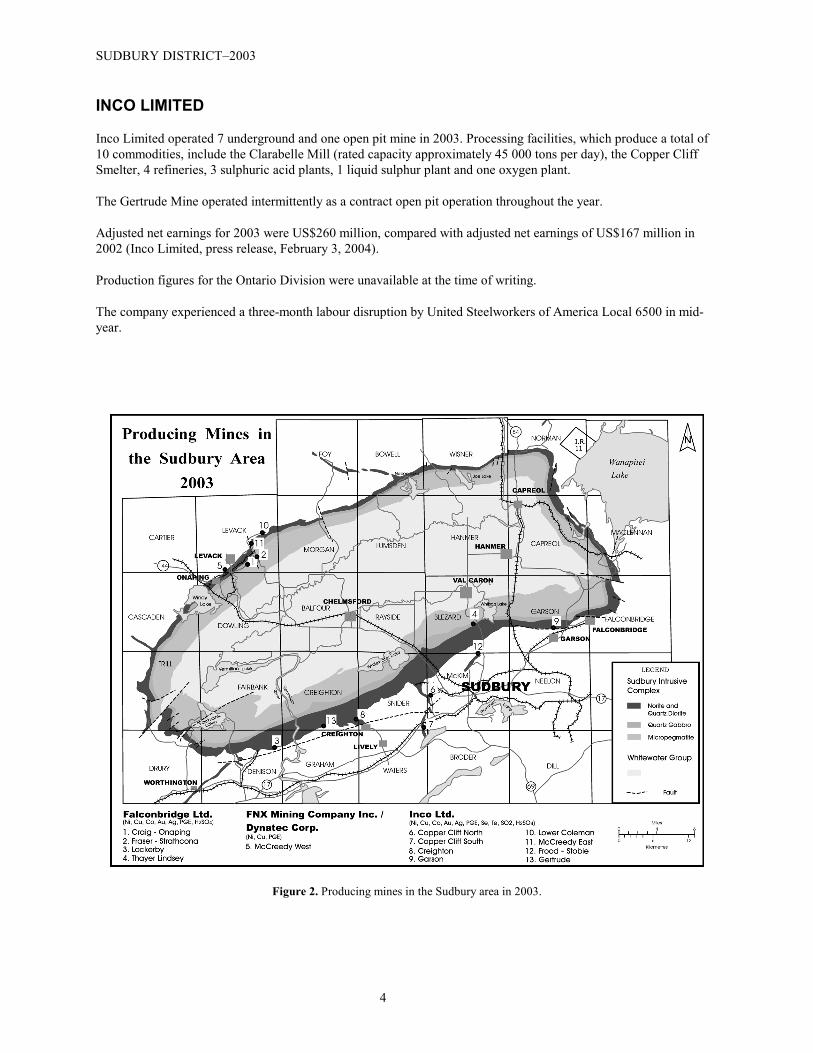
Falconbridge Limited operated 4 mines in the Sudbury area in 2003. These include the Craig-Onaping and Fraser-Strathcona mines in Levack Township, the Lockerby Mine in Denison Township, and the Thayer Lindsley Mine inBlezard Township. Refer to Figure 2.
All ore is concentrated at the company’s Strathcona Mill, which has a capacity of approximately 10 000 tons per day.Copper concentrate is shipped to the Kidd Metallurgical Division for smelting and refining. Nickel-copperconcentrate is shipped to the Sudbury smelter for refining. The Sudbury smelter produced matte containing nickel,copper and cobalt, as well as precious metals and platinum group elements, and has the capacity to produce 130 000tons per year. The matte is shipped to Nikkelverk refinery in Norway for further processing.
Roaster gas is treated in an adjacent plant to produce sulphuric acid, thereby reducing suphur dioxide emissions. Theplant has a capacity to produce 300 000 tons of sulphuric acid per year.
Production statistics for 2003 were unavailable at the time of writing.
For 2003, Falconbridge Limited Sudbury operations recorded net income of $194 million, compared to $50 millionin 2002 (Falconbridge Limited, press release, February 5, 2004). Falconbridge Limited also celebrated 75 years ofoperations since its inception in 1928.
FNX MINING COMPANY INCORPORATED / DYNATEC CORPORATION
Production resumed at the former Inco Limited McCreedy West Mine by the FNX Mining CompanyIncorporated/Dynatec Corporation Joint Venture. This past-producing mine is one of 5 non-core asset properties thathave been optioned from Inco Limited. Production started in September of 2003, with a mining rate of 1000 tons perday by early 2004. The ore is taken to surface by ramp, crushed and taken to the Inco Limited Clarabelle Mill forprocessing. Table 2 shows the resource estimates for a five-year mining plan (FNX Mining Company Incorporated,press release, 2003).
Table 2. McCreedy West – phase 1 mining; measured and indicated resources estimate.
Deposits Metals Tons Cu (%) Ni (%) TPM (oz/t)
700 Cu-TPM 139 000 6.10 0.81 0.18
950 Cu-TPM 520 000 1.44 0.27 0.16Upper Main Ni 48 000 0.46 1.88 -Inter Main Ni 866 000 0.24 2.02 -East Main Ni 167 000 0.51 2.36 -
Total Recovered Metal 1.7MM tons 38 MM lbs 50 MM lbs 98 000 oz
Inferred Resource Estimate Tons Cu (%) Ni (%) TPM (oz/t)Total Inferred Resources 376 000 0.40 1.75 0.18
TPM = Total Precious Metals (Pt + Pd + Au + Ag)
SUDBURY DISTRICT–2003
4
INCO LIMITED
Inco Limited operated 7 underground and one open pit mine in 2003. Processing facilities, which produce a total of10 commodities, include the Clarabelle Mill (rated capacity approximately 45 000 tons per day), the Copper CliffSmelter, 4 refineries, 3 sulphuric acid plants, 1 liquid sulphur plant and one oxygen plant.
The Gertrude Mine operated intermittently as a contract open pit operation throughout the year.
Adjusted net earnings for 2003 were US$260 million, compared with adjusted net earnings of US$167 million in2002 (Inco Limited, press release, February 3, 2004).
Production figures for the Ontario Division were unavailable at the time of writing.
The company experienced a three-month labour disruption by United Steelworkers of America Local 6500 in mid-year.
Figure 2. Producing mines in the Sudbury area in 2003.
M. Cosec et al.
5
Industrial Mineral ProductionSeveral industrial mineral commodities were produced in the Sudbury District in 2003 (Table 3, Figure 3).Commodities produced include dolostone, silica, trap rock, flagstone, organic soil conditioner, and sundry varietiesof coloured landscape aggregate. Numerous companies extracted a considerable amount of sand and gravel forvarious purposes.
AGRICULTURAL MINERAL PROSPECTORS INCORPORATED
This company continued its fourth year of seasonal operations producing vermiculite and calcite from the BurnsMine in Venturi and Tofflemire townships, on the Spanish River Carbonatite Complex.
The product is marketed as an agricultural mineral fertilizer and soil conditioner for certified organically producedand conventionally produced crops. The average mineral composition is 70% calcite, 10% apatite, 15%biotite/vermiculite, and 5% accessory minerals. Present markets include Ontario, Michigan, Quebec, Vermont,Pennsylvania, and New York State.
In 2003, approximately 4000 tons were removed from a small pit. To date, the total production is approximately13 000 tons.
INCO LIMITED
Inco Limited produced high-purity silica from Paleoproterozoic quartz arenite of the Huronian Supergroup at itsLawson Quarry in Whitefish Falls. The material is used as flux at the Inco Limited Copper Cliff smelter. Productionstatistics are confidential.
LAFARGE CANADA INCORPORATED
Lafarge Canada Incorporated quarried 4.4 million tons of dolostone from its Meldrum Bay quarry in DawsonTownship on the western end of Manitoulin Island. Massive dolostones of the Paleozoic Era are excavated in asingle lift of approximately 50 feet. The material is classified as 70% construction aggregate and 30% metallurgicalgrade flux. Lake freighters ship the material to markets in southern Ontario and the United States (M. Wickett,Lafarge Canada Incorporated, personal communication, 2003).
RENGER RESOURCES LIMITED
Renger Resources Limited crushed, sorted and shipped 400 000 tons of low-grade iron ore from the former MooseMountain Iron Mine in Hutton Township.
The material is from an unprocessed stockpile that remained after the mine ceased operations in 1981. It is shippedby truck to the Canadian National Railway Company siding at Milnet, where it is loaded into maintenance-of-wayhopper cars for use as railway ballast. The railway is decreasing its reliance on smelter slag due to perceivedenvironmental concerns (R. Gervais, Renger Resources Limited, personal communication, 2003).

SUDBURY DISTRICT–2003
6
UNIMIN CANADA LIMITED
Unimin Canada Limited produced approximately 500 000 tons of high-grade silica from Bar River Formation quartzarenite of the Paleoproterozoic Huronian Supergroup on Badgeley Island. The material is shipped to Midland,Ontario and Ashtabula, Ohio for further processing (Cosec et al. 2003).
Table 3. Industrial mineral and dimension stone producers in the Sudbury Mining Division in 2003 (keyed to Figure 3).
No. Township / Area Company / Individual Commodity
1 Badgeley Island Unimin Canada Ltd. Silica
2 Bigwood Allstone Quarry Products Inc. Flagstone (Gneiss), Landscaping Stone
3 Curtin Inco Ltd. Silica
4 Dana Upper Canada Stone Company Ltd. Decorative Crushed Stone (Anorthosite)
5 Dawson Lafarge Canada Ltd. Aggregate (Limestone)
6 Gordon Canadian Colour Rock Inc. Flagstone (Limestone), Landscaping Stone
7 Hugel Rintala Construction Company Limited Decorative Crushed Stone (Feldspar)
8 Hutton Renger Resources Limited Ballast
9 McAuslan McLaren’s Bay Mica Stone Quarries Flagstone (Gneiss)
10 McDougall Mill Lake Stone Quarry Ltd. Flagstone (Gneiss)
11 Ratter Crea-Mac Contracting Company Ltd. Decorative Crushed Stone (Granite)
12 Venturi Agricultural Mineral Prospectors Organic Fertilizer

M. Cosec et al.
7
Figu
re 3
. Ind
ustri
al m
iner
al a
nd d
imen
sion
ston
e pr
oduc
ers i
n th
e Su
dbur
y D
istri
ct in
200
3 (k
eyed
to T
able
3).

SUDBURY DISTRICT–2003
8
ADVANCED EXPLORATIONAdvanced exploration was conducted at most underground mining operations as part of individual mine plans.
Falconbridge LimitedAn aggressive exploration program continued at the Nickel Rim South project where drilling has outlined an inferredresource of 6.3 million T grading 1.7% Ni, 3.4% Cu, 2.2 g/t Pt, 2.5 g/t Pd, and 1.5 g/t Au (Giancola 2003). A pilothole for an exploration shaft also commenced in 2003. More detailed information is presented in Cosec et al. 2003.
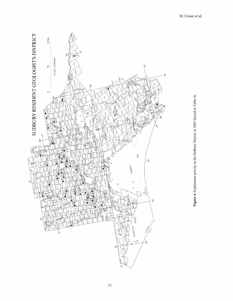
EXPLORATION ACTIVITYThe focus of exploration activity in the Sudbury District shifted somewhat in 2003 toward Ni-Cu-PGE explorationon the Sudbury Igneous Complex.
A total of 45 individual exploration programs were conducted in 2003, a slight decease from 2002. Refer to Table 4,Figure 4. Programs of note are highlighted below.
Table 4. Exploration activity in the Sudbury District in 2003 (keyed to Figure 4).
AbbreviationsAEM ......................................... Airborne electromagnetic survey IP ....................................................Induced polarization surveyAM .......................................................Airborne magnetic survey Lc ........................................................................... LinecuttingARA ................................................. Airborne radiometric survey Met........................................................... Metallurgical testing
Beep ...................................................................Beep Mat survey OD ............................................................ Overburden drillingBulk....................................................................... Bulk sampling ODH.................................................... Overburden drill hole(s)DD .................................................................... Diamond drilling PEM ............................................ Pulse electromagnetic surveyDDH ........................................................... Diamond drill hole(s) PGM...................................................... Platinum group metalsDGP .......................................................... Down-hole geophysics Pr ............................................................................ProspectingGC .................................................................Geochemical survey RES ...............................................................Resistivity surveyGEM ............................................ Ground electromagnetic survey Samp .............................................. Sampling (other than bulk)GL ....................................................................Geological Survey Seismic ..............................................................Seismic surveyGM .........................................................Ground magnetic survey SP ............................................................. Self-potential surveyGRA ................................................... Ground radiometric survey Str .............................................................................. StrippingGrav ...................................................................... Gravity survey Tr ............................................................................. TrenchingHLEM ............................. Horizontal loop electromagnetic survey UG ............................... Underground exploration/developmentHM ......................................................... Heavy mineral sampling VLEM ............................. Vertical loop electromagnetic surveyIM .................................. Industrial mineral testing and marketing VLFEM...................Very low frequency electromagnetic survey
No. Township or Area
Company Name Year Type of Work AFRO Number Resident GeologistOffice File
Designation
1 Angus Tres-Or Minerals Inc. 2003 Data 2.25143 SP002
1 Angus Tres-Or Minerals Inc. 2003 GRA, GM, GL, Lc 2.26136 SP003
2 Baldwin Ursa Major Minerals Inc. 2003 IP, GM, Lc 2.25478 SP018
2 Baldwin Barry, A. 2003 Tr, Pr 2.26115 SP019
2 Baldwin Ursa Major Minerals Inc., D&H Cons.
2003 Lc, GEM, GM 2.26615 SP020
2 Baldwin F.T. Archibald 2003 Samp, GL, Lc, Tr 2.27026 SP021
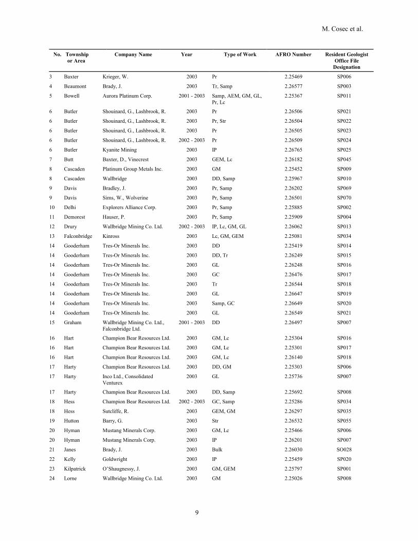
M. Cosec et al.
9
No. Township or Area
Company Name Year Type of Work AFRO Number Resident GeologistOffice File
Designation
3 Baxter Krieger, W. 2003 Pr 2.25469 SP006
4 Beaumont Brady, J. 2003 Tr, Samp 2.26577 SP003
5 Bowell Aurora Platinum Corp. 2001 - 2003 Samp, AEM, GM, GL,Pr, Lc
2.25367 SP011
6 Butler Shouinard, G., Lashbrook, R. 2003 Pr 2.26506 SP021
6 Butler Shouinard, G., Lashbrook, R. 2003 Pr, Str 2.26504 SP022
6 Butler Shouinard, G., Lashbrook, R. 2003 Pr 2.26505 SP023
6 Butler Shouinard, G., Lashbrook, R. 2002 - 2003 Pr 2.26509 SP024
6 Butler Kyanite Mining 2003 IP 2.26765 SP025
7 Butt Baxter, D., Vinecrest 2003 GEM, Lc 2.26182 SP045
8 Cascaden Platinum Group Metals Inc. 2003 GM 2.25452 SP009
8 Cascaden Wallbridge 2003 DD, Samp 2.25967 SP010
9 Davis Bradley, J. 2003 Pr, Samp 2.26202 SP069
9 Davis Sims, W., Wolverine 2003 Pr, Samp 2.26501 SP070
10 Delhi Explorers Alliance Corp. 2003 Pr, Samp 2.25885 SP002
11 Demorest Hauser, P. 2003 Pr, Samp 2.25909 SP004
12 Drury Wallbridge Mining Co. Ltd. 2002 - 2003 IP, Lc, GM, GL 2.26062 SP013
13 Falconbridge Kinross 2003 Lc, GM, GEM 2.25081 SP034
14 Gooderham Tres-Or Minerals Inc. 2003 DD 2.25419 SP014
14 Gooderham Tres-Or Minerals Inc. 2003 DD, Tr 2.26249 SP015
14 Gooderham Tres-Or Minerals Inc. 2003 GL 2.26248 SP016
14 Gooderham Tres-Or Minerals Inc. 2003 GC 2.26476 SP017
14 Gooderham Tres-Or Minerals Inc. 2003 Tr 2.26544 SP018
14 Gooderham Tres-Or Minerals Inc. 2003 GL 2.26647 SP019
14 Gooderham Tres-Or Minerals Inc. 2003 Samp, GC 2.26649 SP020
14 Gooderham Tres-Or Minerals Inc. 2003 GL 2.26549 SP021
15 Graham Wallbridge Mining Co. Ltd., Falconbridge Ltd.
2001 - 2003 DD 2.26497 SP007
16 Hart Champion Bear Resources Ltd. 2003 GM, Lc 2.25304 SP016
16 Hart Champion Bear Resources Ltd. 2003 GM, Lc 2.25301 SP017
16 Hart Champion Bear Resources Ltd. 2003 GM, Lc 2.26140 SP018
17 Harty Champion Bear Resources Ltd. 2003 DD, GM 2.25303 SP006
17 Harty Inco Ltd., ConsolidatedVenturex
2003 GL 2.25736 SP007
17 Harty Champion Bear Resources Ltd. 2003 DD, Samp 2.25692 SP008
18 Hess Champion Bear Resources Ltd. 2002 - 2003 GC, Samp 2.25286 SP034
18 Hess Sutcliffe, R. 2003 GEM, GM 2.26297 SP035
19 Hutton Barry, G. 2003 Str 2.26532 SP055
20 Hyman Mustang Minerals Corp. 2003 GM, Lc 2.25466 SP006
20 Hyman Mustang Minerals Corp. 2003 IP 2.26201 SP007
21 Janes Brady, J. 2003 Bulk 2.26030 SO028
22 Kelly Goldwright 2003 IP 2.25459 SP020
23 Kilpatrick O’Shaugnessy, J. 2003 GM, GEM 2.25797 SP001
24 Lorne Wallbridge Mining Co. Ltd. 2003 GM 2.25026 SP008

SUDBURY DISTRICT–2003
10
No. Township or Area
Company Name Year Type of Work AFRO Number Resident GeologistOffice File
Designation
24 Lorne Inco Ltd. 2003 GM 2.25739 SP009
25 Mackelcan Flag Resources 2003 GM, GEM 2.25178 SP025
25 Mackelcan Flag Resources 2003 DD 2.26189 SP026
25 Mackelcan Flag Resources 2003 DD 2.26186 SP027
25 Mackelcan Flag Resources 2003 DD 2.26539 SP028
25 Mackelcan Flag Resources 2003 DD, Samp 2.27128 SP029
25 Mackelcan Flag Resources 2003 DD, Samp 2.26708 SP030
26 Maclennan Wallbridge Mining Co. Ltd. 2002 - 2003 DD, Samp 2.25391 SP024
27 Maria Industrial Minerals 2002 - 2003 Bulk 2.26315 SP010
28 Marshay Barry, A. 2003 Tr, Samp 2.26669 SP002
29 McKinnon Daniels, G. 2003 Pr, Samp 2.26010 SP015
30 McLaren Morin, R. 2001 - 2003 Pr, Samp 2.25660 SP001
31 Milne Tres-Or Minerals Inc. 2003 GM 2.26474 SP005
32 Monestime Ardiel, M. 2001 - 2003 Pr 2.24855 SP002
33 Nairn Mustang Minerals Corp. 2003 Pr, Samp 2.25636 SP004
34 Neelon Alaire & Sons Ltd. 2003 GM 2.25918 SP012
34 Neelon Alaire & Sons Ltd. 2003 VLFEM 2.27047 SP013
35 Norman Barry, A. 2003 Str 2.26717 SP041
35 Norman Brady, J., Namex 2002 - 2003 DD, Samp 2.26003 SP042
35 Norman Brady, J., Namex 2003 - 2004 GC, GM, Pr, Str 2.27039 SP043
36 Parkin Champion Bear Resources Ltd. 2002 - 2003 DD 2.25334 SP077
36 Parkin Champion Bear Resources Ltd. 2003 GL 2.26576 SP079
36 Parkin Champion Bear Resources Ltd. 2003 AEM 2.26827 SP080
36 Parkin Brady, J., Namex 2003 - 2004 AEM, AM 2.26949 SP081
37 Parkman Harron, G. 2003 GC, Samp 2.26436 SP012
37 Parkman Harron, G. 2003 GC, Samp 2.26451 SP013
37 Parkman Grenville Gold 2003 AM 2.25342 SP014
37 Parkman Grenville Gold 2003 GM 2.26882 SP015
38 Porter Ursa Major Minerals Inc. 2003 IP, GM, Lc 2.26053 SP012
39 Rathbun Flag Resources Ltd. 2003 DD 2.25137 SP055
39 Rathbun Flag Resources Ltd. 2003 DD 2.26190 SP057
40 Scadding Brady, J. 2003 Str, Pr, Ptr 2.25976 SP054
41 Shakespeare Blue, P. 2003 Samp, Pr 2.27198 SP014
42 Tofflemire Agricultural Mineral Prosp. Inc. 2003 Str 2.26521 SP004
42 Tofflemire Agricultural Mineral Prosp. Inc. 2003 IM 2.26790 SP005
43 Trill Wallbridge Mining Co. Ltd. 2002 - 2003 Samp, GL, IP 2.26430 SP006
44 Vogt Gagnon, G., Gagnon, R. 2002 - 2003 Pr 2.25582 SP003
45 Wisner Barry, G. 2003 Ptr 2.26338 SP021
M. Cosec et al.
11
Figu
re 4
. Exp
lora
tion
activ
ity in
the
Sudb
ury
Dis
trict
in 2
003
(key
ed to
Tab
le 4
).

SUDBURY DISTRICT–2003
12
Aurora Platinum CorporationAurora Platinum Corp. has several properties in the Sudbury basin, including the Foy, Footwall, North Range andNickel Lake properties. The Foy and Footwall properties are optioned from or joint ventured with FalconbridgeLimited, and the Nickel Lake property is optioned from Inco Limited (www.auroraplatinum.com).
Foy Project
The Foy project is located 30 km northwest of the City of Sudbury along the North Range of the Sudbury IgneousComplex. It covers the Foy Offset Dike for a strike length of 10.5 km.
Footwall Project
The Footwall project is located 15 km northeast of the City of Sudbury in Falconbridge Township, along the SouthRange of the Sudbury Igneous Complex (SIC). The area covers an 8 km strike length of the SIC between the Garsonand Norduna nickel-copper-PGM mines. The Footwall Project covers both Marginal South Range andfootwall/structural deposit environments. Falconbridge Limited is the operator of this project and a compilationprogram of all mine records, geological, geochemical and geophysical data is ongoing.
North Range Project
The North Range project is located 30 km northwest of the City of Sudbury. The North Range Project claims arecontiguous with the Foy Project claims covering footwall breccia rocks of the Sudbury Igneous Complex.
Nickel Lake Project
The Nickel Lake project is located 30 km north-northwest of the City of Sudbury along the North Range of theSudbury Igneous Complex. The property covers the Foy Offset Dike from Nickel Lake in the east to Foster Lake inthe west (1.4 km strike length). Several airborne geophysical anomalies extend in an intermittent fashion along theentire length of the Nickel Lake-Foster Lake corridor.
Diamond drilling results from the Nickel Lake property included a zone of massive sulphide intersected in boreholeNi-15, from surface to 17.87 m, grading 1.69% Ni, 0.43% Cu, 0.07% Co, 0.23 g/t Au, 0.64 g/t Pt and 0.88 g/t Pd.This intersection included a higher grade zone from 9.65 m to 15.67 m (6.02 m) that returned a weighted averagegrade of 4.38% Ni, 0.93% Cu, 0.16% Co, 0.55 g/t Pt and 1.75 g/t Pd. Borehole Ni-15 was drilled vertically todetermine the subsurface geometry of an embayment located along the hanging wall of the Foy Offset and to drill-test a coincident airborne (AeroTEM) conductor. The embayment appears to be trough-shaped with the massivesulphides lying along the base. The intersected mineralization appears to coincide with the surface projection of aBHUTEM non-decaying-conductor lying at the northwest end of Nickel Lake (Aurora Platinum, press release,February 12, 2003).
Champion Bear Resources LimitedChampion Bear Resources’ primary target is platinum group and precious metals and to a lesser extent polymetallicbase metal and pegmatite-hosted tantalum deposits. Champion Bear has 4 properties in the Sudbury District:Halcyon, Parkin North, Parkin South and Iron Mask.
Halcyon Property
Champion Bear Resources Ltd. has completed geological mapping, magnetic surveys and Mobile Metal Ion (MMI)geochemical surveys over the southern half of its Halcyon property. Forty-five kilometres of geological mapping andmagnetic surveys were completed. Twenty-four kilometres of MMI sampling was concentrated over 4 previouslyoutlined gold and base metal targets and the extension of the structure hosting the FNX Norman zone (ChampionBear Resources, press release, October 22, 2003).

M. Cosec et al.
13
The southwestern portion of the Halcyon property is underlain primarily by mafic volcanic rocks. Several smallisolated (sulphide and oxide facies) iron formations, a small dioritic intrusion and several Nipissing gabbro and/ordiabase dikes are present within the volcanics (Champion Bear Resources, press release, October 22, 2003).Anomalous gold has been reported from at least 3 iron formation zones and several carbonated shear zones, allhosted in mafic volcanics (Champion Bear Resources, press release, June 25, 2003).
Dr. M. Fedikow (P.Geo.) identified several MMI anomalies. One northwest-trending multi-element anomaly (Cu,Zn, Cd, Co, Au, Ag, Ni, Pt and Pd) was traced along a strike length of 730 m and several other isolated cluster andsingle-element anomalies for Au, Ag and Pt were identified (Champion Bear Resources, press release, October 22,2003). The MMI anomalies flank a large magnetic anomaly, trending both northwest and northeast (Champion BearResources, press release, December 17, 2003).
Preliminary results from grab samples collected during the reconnaissance visit to the Halcyon property confirm thepresence of gold and base metals on the property. Three of eight grab samples from “zone 3” assayed 3.18 g/t Au,1.75 g/t Au and 1.12 g/t Au. These samples are from an iron formation hosted within mafic volcanics. Seven grabsamples from “zone 1” contained anomalous Cu-Ni-Co values. Cu content ranged from 343 ppm to 2850 ppm(0.29%); Ni values ranged from 100 to 999 ppm; and Co ranged from 58 to 1030 ppm. These values are all from ashear zone cutting previously trenched massive sulphides adjacent to a mafic intrusive. An adjacent area alsoreturned anomalous Cu and Zn values up to 748 ppm and 668 ppm, respectively (Champion Bear Resources, pressrelease, June 25, 2003).
Parkin North Property
Champion Bear has also completed an MMI survey consisting of 140 samples along a 2.2 km strike length of theParkin Offset dike immediately north of the Wallbridge Milnet property. The most significant response is a multi-sample Ni, Pd-Co anomaly centered approximately 100 m northwest of previous drilling on this property.Prospecting on the Parkin North claims 2.2 km to the north of the Parkin South claims encountered high gold gradesfrom three grab samples of 252.0, 56.7 and 22.3 g/t Au (Champion Bear Resources, press release, September 3,2003).
Parkin South Property
Champion Bear Resources Ltd. has deepened two previous holes, Nos. BS-16-02 and BS-18-03, drilled on its ParkinSouth claim block, and has carried out downhole geophysical (UTEM) surveys and detailed surface mapping. Thetwo holes were extended to determine the thickness of the dike and to allow for downhole geophysical surveying.Both holes encountered additional zones of disseminated sulphides within inclusion-bearing phases of the offset dike(Champion Bear Resources, press release, September 3, 2003).
Within diamond drill hole BS-16-02, an 11.8 m section from 317.8 to 329.6 m encountered 0.5 to 2% disseminatedsulphides including pyrrhotite, pyrite and minor chalcopyrite. BS-16-02 also encountered disseminated sulphidemineralization from 154 to 249 m (Champion Bear Resources, press release, May 7, 2003).
Diamond drill hole BS-18-03 traced the anomalous, disseminated-sulphide-bearing, inclusion-rich portion of theParkin Offset dike to a vertical depth of 700 m (Champion Bear Resources, press release, September 3, 2003). Thesection from 476 to 521 m contained sporadic blebs of sulphide mineralization in inclusions up to 3 x 5 cm(Champion Bear Resources, press release, May 7, 2003). The recent downhole UTEM survey identified a small in-hole conductor in hole BS-18-03 at approximately 710 m depth, interpreted as being due to the strongly magneticupper portion of the serpentinized unit (Champion Bear Resources, press release, September 3, 2003). Drill hole BS-18-03 also encountered several narrow quartz-epidote veins and silicified zones with anomalous gold mineralizationup-hole from the zone of disseminated sulphides. The 0.4 m section of core from 368.45 to 368.85 m assayed 1430ppb Au, and the 0.4 m section of core from 393.55 to 393.95 m assayed 289 ppb Au and 1775 ppm Cu (ChampionBear Resources, press release, May 7, 2003).

SUDBURY DISTRICT–2003
14
Diamond drill hole PN-03-03 was drilled to test an IP anomaly located 150 m east of the offset dike, east of holePN-02-03. Mineralization was limited to anomalous gold values found in a 4 m section of altered gabbro from 18.0to 22.0 m, which contained 3 to 10% disseminated fine-grained arsenopyrite locally (Champion Bear Resources,press release, May 7, 2003).
Iron Mask Property
Champion Bear has continued its geological mapping program on the central portion of the Iron Mask claims west ofCartier, Ontario. This is part of a 135 km mapping and ground geophysical program to evaluate the potential of thisproperty to host Olympic Dam style mineralization. Mapping to date has been able to trace a highly magnetic skarnzone, intermittently, along a strike length of almost 3 km. The Cobalt Shaft showing is located along this skarn zone.Two grab samples collected by Champion Bear in 2002, from a shear cutting the skarn zone, returned greater than10% Co, 8.4% Ni and 3.5% Cu (Champion Bear Resources, press release, June 25, 2003).
Thin section petrographic examination has confirmed two new outcrop areas of Sudbury breccia. The two outcropsare approximately 2.3 km apart and lie along a northeast trend. Structural studies and drilling are underway todetermine if this may be the extension of the Hess offset trend (Champion Bear Resources, press release, September3, 2003).
Crowflight Minerals IncorporatedCrowflight Minerals is currently focused on three properties located in the Sudbury Basin: the AER-Kidd property islocated on the Worthington Offset nearby Inco’s Totten and McIntyre mines; the Airport property is located on thesoutheast rim of the Basin about 1.2 km east of Falconbridge’s past producer, Norduna Mines; and the MarbleMountain prospect is on the western extension of the Parkin Offset.
AER-Kidd Property
Crowflight’s first core drill hole (W03-01) drilled into the Worthington Offset intersected disseminated sulphidemineralization. This hole, drilled near the AER-Kidd/Inco Totten boundary, targeted a previously known borehole(U09-E23) intersection completed in the mid 1960’s. The borehole intersected 80 m of the Worthington Offset Dikecontaining over 40 m of mineralized quartz diorite. The more mineralized centrally located section of inclusion-bearing quartz diorite, from 928.4 m to 934.87 m, yielded an average of 0.195% Cu, 0.186% Ni, with the highestPGM assaying combined 1.2 g/t (Crowflight Minerals, news release, December 5, 2003). All mineralization occurswithin the Quartz Diorite offset dike with massive lenses of Ni-rich sulphide surrounded by Cu-rich stringermineralization within a wider disseminated sulphide halo (Crowflight Minerals, news release, December 10, 2003).Detailed field mapping along the western boundary adjacent to Inco’s Totten property has revealed the presence ofmassive chalcopyrite veins (Crowflight Minerals, news release, September 16, 2003).
Anomalous time-domain electromagnetic responses were detected in borehole W03-01 from a depth of 700 m to theend of the hole at 950 m. The responses indicate an in-hole or near-hole multiple conductor response typical of localstringer sulphide mineralization. A relatively strong off-hole, lateral response was also measured, suggesting amassive or semi-massive sulphide body is in the vicinity of the hole and apparently beyond the hole. This response islikely coincident with the strong magnetotelluric (MT) anomaly (Crowflight Minerals, news release, December 10,2003).
Airport Property
Recent deep-penetrating IP geophysics survey has outlined several distinct anomalies. The geophysics survey wasstructured to investigate a model target of massive sulphide in the Sudbury Basin footwall rocks at the AirportProperty, located just outside the east rim of the SIC (Crowflight Minerals, news release, October 7, 2003).
M. Cosec et al.
15
Marble Mountain Prospect
Marble Mountain Prospect covers a 6.5 km strike length of the western extension of the Parkin Offset. Work byCrowflight’s exploration personnel has identified a potentially significant extension of the Parkin Offset along awest-northwest-trending radial offset dike. Two grab samples of massive to semi-massive chalcopyrite in quartzdiorite exposed in an old pit on the property returned Pt values of 19.9 g/t and 13.0 g/t; Pd values of 0.65 g/t and 8.7g/t; and Au values of 0.02 g/t and 2.68 g/t, respectively. Mineralization is also widespread in quartz veins in thewallrock quartzites and marbles south of the quartz diorite body. Grab samples of this mineralization with highsulphide content returned significant values of Au ranging from 3.28 g/t to 19.1 g/t (Crowflight Minerals, newsrelease, December 16, 2003).
FNX Mining Company Incorporated and Dynatec Corporation –Sudbury Joint VentureA significant amount of diamond drilling was conducted at the McCreedy West, Levack, Norma and Victoria mines.Geological descriptions are posted on the company’s website (www.fnxmining.com) and in Cosec et al. 2003.
Hedman Resources LimitedHedman Resources Limited announced the placement of a “Letter of Intent” in which Perlite Canada Inc. hopes topurchase the first 4000 tons of horticultural grades of vermiculite ore from Hedman’s soon to be acquired mining andprocessing facilities (Hedman Resources Limited, press release, December 12, 2003). Hedman currently producesand sells vermiculite, a low-density, biologically inert product with a chemically active surface used as an additive,filler, absorbent, fertilizer and soil cover in a number of industry end-user applications (Hedman Resources Limited,press release, December 12, 2003).
The Cardib vermiculite deposit comprises 6 claims totaling 17 units of approximately 40 acres each (680 acres) andother unpatented claims. Inspection of the grounds disclosed numerous indicators that many additional vermiculiteveins snake through this property (Hedman Resources Limited, press release, December 4, 2003). Preliminary testingof the vermiculite ore from the Cardib deposit is promising, as it appears to be asbestos-free vermiculite. A bulksample of vermiculite ore was submitted to a mineralogy laboratory for mineralogical examination and identificationof asbestos mineral phases. The sample was found to consist primarily of vermiculite, chlorite and minor hematite,with no evidence of fibrous or asbestos minerals (Hedman Resources Limited, press release, December 24, 1996).
JML Resources LimitedJML Resources Limited can earn a 50% interest in the Scadding Gold Property from Currie Rose Resources. The256 hectare property is located approximately 50 km northeast of Sudbury in Scadding Township. During the1980’s, limited production of 140 000 tons grading 0.21 ounces of Au were extracted from four shallow zones on theproperty (www.jmlresources.com).
JML Resources Limited completed its first phase of diamond drilling and geophysics in the North Target Zone areaand the East West zone. These areas encompass two of four known gold occurrences on the property. The programwas designed to further test the existence, continuity, and grade of gold, as well as the thickness of the hoststratigraphy.
An eleven-hole, 1405 m diamond drilling program was completed in 2003. Gold mineralization occurs together withiron-rich sulphides in east-trending, chlorite-rich, brecciated shear zones. Alteration of the host rocks includescarbonatization and albitization.
The geophysical program included a detailed magnetic survey as well as induced polarization surveys. The surveyresults identified an extension of the known zones, as well as additional targets in the remaining two zones for thenext phase of diamond drilling (JML Resources Limited, press release, December 16, 2003).

SUDBURY DISTRICT–2003
16
Mustang Minerals CorporationThroughout 2003, Mustang Minerals focused on the acquisition and exploration of high potential Ni-Cu-PGEproperties in the Sudbury area. Properties include the Hyman Township nickel property, the Nairn Township nickelproperty, the East Bull Lake and River Valley properties, and the Manchester Nickel property(www.mustangminerals.com). They also acquired partial interest in the Scadding Gold Property (see JML ResourcesLimited).
Hyman Township Nickel Property
Located west of Sudbury. Phase one diamond drilling is to evaluate the property in order to target Ni-Cu-PGMmineralization. Three holes were drilled and sections of up to 0.25% combined Ni + Cu were intersected. Mustangterminated the option on the portion of the property that was drilled (Mustang Minerals Corporation, press release,October 20, 2003).
Manchester Nickel Property
The Manchester Nickel Property was optioned from Inco Ltd. The property includes a 2.5 km section of theManchester Offset Dike, one of three known offset dikes on the south range of the Sudbury Igneous Complex.Intermittent exploration by Inco in the 1970’s included a reconnaissance diamond drilling program, whichintersected nickel mineralization in several drill holes. Phase one drilling by Mustang was undertaken to test fornickel and platinum group metals in areas where mineralization was previously encountered. A comprehensivegeophysical program was completed by Quantec, as well as reinterpretation of all historical geophysical data. Asecond phase diamond drilling program over the offset dike followed. Results were not posted in 2003 (MustangMinerals Corporation, press release, November 10, 2003).
Namex Explorations IncorporatedNamex Explorations Incorporated has several properties in the Sudbury Basin: the Woods Creek and Tottenproperties located on the western part of the SIC; and the Black Creek, Terra Incognita, Golden Pine and Post Creekproperties situated on the northeast part of the SIC (http://namex-explorations.com).
Woods Creek
The Woods Creek property consists of 56 claim units located in Hyman Township. The property has four sulphideoccurrences in Nipissing diabase; three of these are old pits showing chalcopyrite and pyrrhotite with anomalousindications of platinum and palladium. A new, 2 to 3 m wide sulphide showing, containing sections of massive anddisseminated pyrrhotite and chalcopyrite mineralization, was recently revealed by blasting. The sulphides are nickelbearing. Woods Creek property outcrop samples assayed 1.22% Cu, 0.95% Ni with anomalous PGM contents.Diamond drill hole WCB intersected 23 feet of mineralized Nipissing diabase with assay values up to 1.09% Ni,0.37% Cu and 329 ppb combined Pt+Pd. Drill hole WCC intersected 14 feet of mineralization in altered diabase,assaying up to 0.16% Ni, 0.19% Cu and 169 ppb combined Pt+Pd+Au (Namex Explorations Incorporated, pressrelease, January 20, 2003).
Black Creek Property
The Black Creek property consists of 94 claim units located in Parkin and Hutton townships. Within the Black Creekproperty, there are extensive gold + arsenic anomalies in tills and soils. Both gold and base metal occurrences aredocumented on the property as well as numerous occurrences of placer gold in the tills. Morphology of gold grains intill suggests they are locally derived. A pronounced circular magnetic high covered with 15 m of glacial till is alsobeing investigated. Preliminary assessment of the mineral potential of the Black Creek property has revealed anextensive alluvial type gold occurrence on the property. A reconnaissance soil geochemical survey over part of thisdeposit has returned significant gold and palladium results (Namex Explorations Incorporated, press release, October16, 2003).

M. Cosec et al.
17
Terra Incognita
The Terra Incognita property consists of 41 claim units located in Parkin Township. A ground magnetometer andVLF survey was completed in 2003 revealing several conductors with strong cross-overs that are indicative of abedrock source and that have some corresponding magnetic features. No outcrop is available for mapping andsampling due to overburden cover and low, swampy ground. Soil geochemical MMI surveys have been conducted(Namex Explorations Incorporated, press release, October 16, 2003).
Golden Pine
The Golden Pine property consists of 38 claim units located in Parkin Township. Namex is folding together theBlack Creek and Terra Incognita properties into the Golden Pine. The combined properties will be 6920 contiguousacres, over 8 square miles, covering a 17 km long by 3 km wide Archean greenstone belt with gold occurrences atboth ends. Thirty-seven samples of mineralized rock, collected from trenches and blasted outcrop from an areaapproximately 2500 feet by 850 feet, were assayed. These assays include values of 0.09, 0.14, 0.29, 0.54, 0.56, 0.62,and 1.286 oz. gold per ton (Namex Explorations Incorporated, press release, October 16, 2003).
Post Creek and Post Creek East Properties
The Post Creek property consists of 24 claim units and the Post Creek East property consists of 11 claim units. Bothare located in east Norman Township. Recent work has verified that the ore-hosting formation of the Whistle Offsetcontinues in a northeasterly direction onto the Post Creek properties.
On the west end of the Post Creek property a ground magnetometer survey, prospecting, geochemical sampling andoverburden stripping has been completed over previously identified airborne magnetic and electromagneticanomalies. Results indicate these geophysical anomalies are related to a north-trending zone of silicificationdeveloped within massive basalt and gabbro. These rocks contain 1-5% disseminated pyrrhotite and chalcopyrite atthe northern portion, and 1-5% disseminated and veinlet chalcopyrite and sphalerite in the southern portion. Up to1% disseminated pyrrhotite is present along the entire 200-metre trend. MMI soil geochemical survey results indicatethe North Anomaly is characterized by anomalous gold, nickel, cobalt and palladium in overlying soil (NamexExplorations Incorporated, press release, November 4, 2003).
On the Post Creek property, Namex assayed 156 core samples from diamond drill holes PC-1, PC-2 and PC-3. Thesediamond drill holes are hosted by medium-grained gabbro; Sudbury breccia with gabbro fragments containing 30%disseminated pyrite with lesser chalcopyrite; and altered gabbro crosscut by quartz-epidote stringers and patches withup to 5% disseminated pyrite and rare chalcopyrite. Drill holes PC-1 and PC-2 encountered silicified and sericitizedandesite with up to 5% disseminated pyrite. A 20-foot mineralized interval in hole PC-1 assayed 0.03% Cu, 41 ppbAu and 28 ppb Pt + Pd. Drill hole PC-2 intersected a 77-foot mineralized interval with up to 5% disseminated pyriteand lesser chalcopyrite. Values of up to 0.02% Cu, 0.03% Pb and 30 ppb Au were obtained from assays (NamexExplorations Incorporated, press release, March 6, 2003).
Pacific North West Capital CorporationPacific North West Capital Corp. is an exploration company focused on the discovery of platinum group metals.PFN is currently exploring the River Valley Project (joint ventured with Anglo American Platinum CorporationLimited) and the Agnew Lake Project, currently under option to Anglo Platinum (www.pfncapital.com).
River Valley
PFN’s main project is the River Valley Project. The River Valley property is located in Dana Township and in thesouthwest corner of Pardo Township, about 20 road km northwest of the village of River Valley. The propertycovers most of the northern portion (northern contact and main body) of the intrusion and represents the largestsingle land-holding and exploration budget for all of PFN’s properties.
SUDBURY DISTRICT–2003
18
The River Valley property is primarily underlain by rocks of the River Valley Intrusion, a large, layered maficintrusion that covers more than 100 km and consists primarily of pyroxenite, melagabbro, gabbro and leucogabbrowith subordinate anorthosite, gabbronorite and troctolite. The property covers most of the northern contact of theRiver Valley Intrusion and all of a northern offshoot of the main body of the intrusion. Most of the knownmineralization occurs as disseminated and bleb sulphides (chalcopyrite dominated) within a heterogeneous rockpackage that is proximal to the country rocks or margin of the intrusion (side-wall and/or footwall rocks). Thisheterogeneous rock package includes melanocratic to leucocratic breccias and pegmatitic to vari-textured brecciazones.
The River Valley property includes two main mineralized areas with anomalous PGM (Pt+Pd+Rh), Au, Cu and Nisulphide mineralization: the Dana Lake Zone and Azen Creek Zone. The Dana Lake Zone is located within thenorthwest corner of the claim group and consists of 4 discovery areas, viz. north to south: Road zone, North zone,Trench zone and South zone. These 4 zones of PGM-Cu-Ni mineralization represent a strike length of greater than700 m. The Azen Creek Zone is located about 6 km southeast of the Dana Lake Zone and consists of one discoveryarea (Main showing) (Pacific North West Capital Corp., news release, October 29, 2003).
Drill hole DL-154, collared in the Dana Lake South Deposit, intersected 5.02 g/t Pd+Pt over 47 m (154 ft), thehighest grade intersection to date. This mineralized zone in the marginal breccia unit is bracketed by above averagegrade mineralization, shows consistently high values, and is open to depth. The total mineralized intersection was68 m @ 3.72 g/t Pt+Pd (Pacific North West Capital Corp., news release, September 8, 2003).
Pacific North West Capital Corp. reports further PGM values have now been intersected in numerous initial drillholes collared in the area lying between Dana North, at the north end of the River Valley Property and Azen Creek, a6 km strike length. Outstanding assays from Dana Lake are also reported. The discovery of mineralization withineach of the new zones is consistent with the geological target defined in the Dana Lake/Lismer’s Ridge area. ThePGM mineralization is associated with sulphide minerals mainly within the marginal breccia unit of the River ValleyIntrusive (Pacific North West Capital Corp., new release, November 19, 2003).
A significant new zone of mineralization has been delineated on the River Valley PGM Property. Hole VA-01intersected 73 m (239 ft) of 1.52 g/t PGM including 23 m (75 ft) of 2.2 g/t PGM. The mineralization is centred onthe Varley Zone located 3 km south of the Lismer's Ridge area. PFN has known for some time that higher platinumand palladium values (>10 g/t PGM) outcrop in gabbroic breccias in the Varley Zone (Pacific North West CapitalCorp., news release, October 29, 2003).
Agnew Lake
The Agnew Lake property is located in Shakespeare, Dunlop, Shibananing and Gough townships, about 60 km westof Sudbury. The property overlies the Agnew Lake layered mafic intrusion. This intrusion is similar in age andcomposition to the River Valley Intrusion and, like the River Valley Intrusion, carries substantial PGM values incontact-associated magmatic breccias close to the intrusive contact. The Agnew Lake Intrusion is exposed as acrudely elliptical body measuring roughly 10 km by 6 km, with its long axis trending about 110°.
The complex is hosted by sulphur-poor granitic rocks of the Algoman Granitoid Suite, and the intrusion is overlainby Matinenda Formation conglomerate, which forms part of the lower sedimentary sequence in the HuronianSupergroup. Post-emplacement faulting and late emplacement of mafic dikes and/or sills generally obscure thecontact relations at the base and along the exposed contact of the complex. The Agnew Lake Intrusion is apparentlyconnected to the East Bull Lake Complex by the Streich dike, which is generally interpreted as the initial feeder toboth intrusions (Vogel 1996).
Available geological mapping in the vicinity of the recently identified conductors indicate they are located at or nearthe contact of the Agnew Intrusion, in an area not previously explored by the joint venture. A number of youngermafic dikes are also present in close proximity to the two conductors, which are both overburden covered. Thestronger of the two conductors is located 400 m northwest of a known Pt-Pd showing, which has returned grades of

M. Cosec et al.
19
up to 15.6 g/T Pt+Pd, hosted within one of the younger (Nipissing) dikes (Pacific North West Capital Corp., newsrelease, December 15, 2003).
Initial follow-up prospecting by PFN has resulted in the discovery of a narrow, high-grade zone of Au-Agmineralization located in close proximity to one of the two EM conductors. Grab samples from the discoveryshowing of the new “V” zone returned Au values ranging from 156 ppb to 76.2 g/t (2.45 ounces Au per tonne) and0.7 to 206 g/t Ag (6.62 ounces Ag per tonne). The precious metal mineralization is associated with a sulphide-bearing quartz vein system located along the contact between a gabbro dike and argillaceous sediments 140 m fromthe interpreted center of the Spectrum Airborne EM anomaly (Pacific North West Capital Corp., news release,December 15, 2003).
Temex Resources Corporation – Wilson Lake ProjectThe Wilson Lake project is comprised of 1244 claim units, totaling over 20 000 hectares, all within a 25 km radiusof Temagami, Ontario and owned 100% by Temex. The property was recently freed from a thirty-year staking banimposed by the “Temagami Land Caution”. The Wilson Lake project lies entirely within the Lake TimiskamingStructural Zone, a major, deep-crustal feature that is host to more than 50 kimberlites over a strike length of 300 km.Temex completed a combination of Mobile Metal Ion (MMI) soil geochemical surveys, airborne and groundgeophysical surveys, and Kimberlite Indicator Mineral (KIM) geochemical till sampling. In addition, a recentlycompleted GIS-based, multi-parameter compilation of existing data has outlined 10 major areas of priority interestfor on-going diamond exploration. Previous till sampling by Temex on the Wilson Lake project returned values ofup to several hundred KIM’s per 10 kg till sample, as well as a significant number containing G10 garnets.Background KIM counts in the area range from 1 to 3 KIM/10 kg sample. The objective of the current field programis to obtain additional information on areas of interest and KIM dispersion trains, and to examine potential sourcelocations in the field. An airborne magnetic/EM survey at 50 m line-spacing has recently been flown over the highestpriority area that contains numerous KIM anomalies. A diatreme breccia complex and related system of lamprophyredikes that have petrographic and mineralogical affinities to the diamond-bearing rocks from the Wawa region is alsobeing mapped and sampled as part of the current program (Temex Resources Corporation, news releases, February26, 2003 and November 4, 2003).
Based on a combination of gold grain data from previous till sampling surveys (industry and government) andregional structural analyses, seven empirical gold targets worthy of further work have been targeted. The highestpriority target has three anomalous till samples collected by Temex proximal to an east-northeast-trending shearzone, which contained from 16 to 138 pristine gold grains and from 40 to 187 total gold grains. These totals areconsidered to be highly anomalous and indicative of a local bedrock source. A number of multi-gram goldintersections in drilling have been obtained by previous exploration programs in the region, confirming the overallgold potential of the area (Temex Resources Corporation, news release, November 4, 2003).
Tres-Or Resources LimitedTres-Or Resources Ltd. has substantial land packages centered around the village of Temagami in northeasternOntario. The Temagami Diamond Claim project consists of 100 000 hectares of contiguous claim units covering partof the Archean Superior Craton, and extends south across the Grenville Front into the Grenville ParautochthonousBelt. The area exhibits many major north- to northwest-trending faults and lineaments (associated with theTimiskaming Structural Zone) that intersect major east- to northeast-trending structures.
The Temagami Diamond Claim project area contains diamond potential indicators such as sub-calcic G10 Cr-pyropegarnets, eclogitic garnets and Cr- and Mg-rich chromites, and is in close proximity to deep-seated geologic structuresthat are believed to be associated with kimberlite emplacement. Recent airborne magnetic surveys outline a numberof discrete kimberlite-type anomalies that correlate with indicator chemistry.
Compiled kimberlite indicator mineral (KIM) counts from Tres-Or’s work programs, which included the collectionand processing of over 600 till samples, has confirmed at least four KIM dispersion trains occur in different parts ofthe Temagami Diamond Claim. Tres-Or’s sampling confirm these indicator trains include good indicator mineral

SUDBURY DISTRICT–2003
20
chemistry suggestive of diamond-bearing kimberlite sources. The indicator mineral surface textures suggest that atleast some of the KIM train sources likely originate on Tres-Or’s claims (http://www.tres-or.com).
United Reef LimitedUnited Reef Limited is exploring for a Ni-Cu-PGE deposit on the Nickel Offsets property on the Foy Offset, 40 kmnorthwest of Sudbury. The Nickel Offsets property hosts the Nickel Offsets Mine, which produced 208 000 tons ofNi-Cu ore between 1943 and 1957 through two shafts, with reported recoveries of 4.56 million pounds of Ni and3.32 million pounds of Cu. United Reef has previously confirmed the presence of significant values for PGM’s inmaterial mined on the property.
United Reef Limited announced the results of its initial Time Domain Induced Polarization (IP) reconnaissancesurvey carried out on the Nickel Offsets Property. The company acquired eight lines of chargeability and resistivitydata covering 6.9 line km across portions of the Foy Offset, quartz diorite and quartz diorite breccia dike.Interpretation of the survey results identified conductors to a depth of 100 to 125 m. New chargeability anomalies,outside of the former mine’s workings, have been identified at 3 locations:
• 3+00 E, 1+50 N: broad chargeability high near surface, steeply dipping to north, on hangingwall side of the FoyOffset dike (Shaft 2 area).
• 13+00 W, BL0: 50-m wide chargeability anomaly at a depth of 90 m; possible updip extension of previously minedore lens (west of Shaft 1).
• 16+00 W, 1+00 S: narrow source located at a depth of 35 m on hangingwall side of the Foy Offset dike (west ofShaft 1).
Targets for drilling include these new IP anomalies and possible remnant blocks of mineralization within the existingmine workings (United Reef Limited, press release, February 5, 2004).
Ursa Major Minerals IncorporatedUrsa Major Minerals’ Sudbury area projects are located in Shakespeare, Porter, Baldwin and Hyman townships, westof Sudbury, comprising approximately 303 claim units (www.ursamajorminerals.com). Ursa has earned a 75%interest from Falconbridge Limited in the Shakespeare property. The Shakespeare property hosts Ni-Cu-PGEmineralization in a mafic intrusion dike related to the Sudbury Igneous Complex. A sample submitted to theGeochronology Laboratory of the Royal Ontario Museum yielded an age of 2217 Ma. This age is significantly olderthan the age of the Sudbury Igneous Complex but is similar in age to Nipissing intrusions. Based on successfulexploration at the Shakespeare deposit, Ursa Major has developed an exploration target for Ni-Cu-PGEmineralization in Nipissing age (ca. 2.22 Ga) mafic intrusions located near the southern boundary of the ArcheanSuperior geological province (Ursa Major Minerals, press release, August 21, 2003).
Nickel-copper-PGM mineralization at the Shakespeare deposit has been identified over a strike length of over1100 m, and the deposit remains open on strike and at depth. As of November 24, 2003, Ursa Major had completed50 holes for 9300 m on the project (Ursa Major Minerals, press release, November 25, 2003). An IndicatedResource of 4.87 million tonnes grading 0.43% Ni, 0.43% Cu, 0.03% Co, 0.22 g/t Au, 0.41 g/t Pt and 0.45 g/t Pd hasbeen defined over a 300 m strike length in 2003 (Ursa Major Minerals, press release, December 17, 2003). TheShakespeare property has a near-surface Inferred Resource of 2.1 million tons grading 0.36% Ni, 0.42% Cu, 0.44 g/tPd, 0.40 g/t Pt, and 0.22 g/t Au (www.ursamajorminerals.com).
Diamond drilling has delineated one major zone of near-surface, disseminated to net-textured sulphidemineralization. Twenty-two (22) intersections reported to date have a length-weighted average grade of 0.47% Ni,0.49% Cu, 0.03% Co, 0.45 g/t Pt, 0.50 g/t Pd and 0.25 g/t Au with average width of 131 feet (40 m) (Ursa MajorMinerals, press release, April 30, 2003). Drill highlights include hole U3-30 that intersected 57.3 m grading 0.42%Ni, 0.44% Cu, 0.03% Co, 0.25 g/t Au, 0.40 g/t Pt and 0.48 g/t Pd. This intersection included 9.7 m of 0.67% Ni,

M. Cosec et al.
21
0.46% Cu, 0.05% Co, 0.26 g/t Au, 0.47 g/t Pt and 0.42 g/t Pd (Ursa Major Minerals, press release, November 25,2003).
Metallurgical test work carried out at SGS-Lakefield Research Limited on drill core samples from the Shakespearedeposit provided initial estimates of base metal recoveries and evaluation potential concentrate grades. Test workwas completed on two composite samples obtained from drill holes U3-08 and U3-09. Sulphide minerals are mainlypyrrhotite with lesser chalcopyrite and pentlandite. As a base case, open circuit recoveries for a concentrate grade of22.2% Cu + Ni are 93.5% for Cu and 68.8% for Ni. Recoveries for platinum were 68.7% in the base case (UrsaMajor Minerals, press release, December 4, 2003).
Ursa Major recently completed a borehole electromagnetic (EM) survey of 11 drill holes at the Shakespeare deposit,which has successfully identified conductive targets on-strike and down-dip from the known deposit. The mostsignificant target is a strongly conductive source extending northeast from the deposit. This conductor appears to bean extension of a higher-grade zone of mineralization identified in several recent drill holes. The three-dimensionalpulse time-domain EM borehole survey was conducted by Crone Geophysics and Exploration Ltd. using a CronePulse EM system, which identified a long wavelength anomaly at the west end of the deposit (Ursa Major Minerals,press release, December 17, 2003).
Spectral induced polarization (IP)/resistivity and magnetometer surveys conducted by JVX Ltd. have resulted inseveral high priority drill targets located in prospective geological settings along strike to the east of the Ni-Cu-PGEdiscovery on the Shakespeare property. In particular, JVX Ltd. has identified anomalies with a strong spectral IP andcoincident magnetic response located east of the area of current drilling and in Baldwin Township east-northeast ofthe current drilling. The target in Baldwin Township was tested with two short diamond drill holes and assaysindicate a narrow zone of strongly anomalous PGM mineralization with values up to 1.7 g/t Pt and 0.7 g/t Pd over0.8 m (Ursa Major Minerals, press release, August 21, 2003). Recent spectral IP and time-domain electromagnetic(TDEM) geophysical surveys indicate that an anomaly extends for at least a further 240 m east of the area of currentdrilling (Ursa Major Minerals, press release, April 8, 2003).
Wallbridge Mining Company LimitedWallbridge Mining Company Limited currently has 24 footwall contact properties on the Sudbury Igneous Complex(SIC) including their Windy Lake, Milnet, Worthington and Wisner properties. In total, these properties cover over250 km2 of SIC. Wallbridge Mining’s Sudbury area properties are the basis for joint venture agreements withLonmin Plc. and Falconbridge Limited.
Windy Lake
Geophysical survey data incorporated into a 3-D modeling tool with a geological data model illustrated a ‘trough’within the Windy Lake embayment on the north rim of the SIC. A highly conductive anomaly detected to the east ofdiamond drill hole WL-009 is situated within this trough-shaped structure (Wallbridge Mining Company, pressrelease, January 9, 2003). Geochemical results from drill holes WL-003, WL-006 and WL-009 within theembayment contain anomalous (> 0.3% Cu + Ni) values, with metal content increasing toward the conductive bodyabove WL-009 (Wallbridge Mining Company, press release, April 14, 2003).
Wallbridge reports that diamond drill hole WL-009B has confirmed the presence of copper- and nickel-bearingsulphide mineralization associated with the conductive anomaly under Windy Lake. The hole intersected severalzones of disseminated to net-textured pyrrhotite (+/- chalcopyrite) mineralization within a thickened portion ofsublayer, the basal unit of the SIC. Sulphide contents generally range between 3% and 15%, with local sectionscontaining in excess of 30% sulphides over widths of approximately 0.5 m. Sections of the mineralization areconductive, and it is believed that this wide zone of mineralization and multiple conductive zones represent acomponent of the conductive anomaly observed from hole WL-009. Mineralization intersected in this hole sits15 to 80 m above the contact of the SIC. Assay results from hole WL-009B range up to 0.99% Cu + Ni (0.52% Cu,0.47% Ni). Total Cu + Ni contents show an increase of 73% from hole WL-009 to WL-009B. The increase in
SUDBURY DISTRICT–2003
22
sulphide and nickel-copper content indicates an east-southeasterly trend for the mineralized sublayer embayment andprovides a vector for further exploration (Wallbridge Mining Company, press release, June 19, 2003).
Milnet Property – Parkin Offset
The Milnet property is located on the Parkin Offset dike, on the northeast corner of the Sudbury Basin. The ParkinOffset is believed to be the faulted extension of the Whistle Offset, which hosts the Whistle Mine and FNX’sNorman Project. On the Milnet property, drilling will target the down-plunge extension of the Number 2 zone at thepast-producing Milnet Mine. This mine was in operation in the late 1940s and early 1950s and produced 157 130tons @ 1.49% Ni, 1.54% Cu, 2.25 g/t Pt and 2.98 g/t Pd. High-grade intersections in two old underground drill holesreturned 1.34% Cu and 3.43% Ni over 1.5 m core length in hole 4-121; 5.31% Cu and 10.07% Ni over 0.3 m corelength in hole 4-128; and 1.10% Cu and 1.17% Ni over 0.4 m core length in hole 4-128 (the holes were not assayedfor PGEs). These intersections are located in a pinched section of the dike, which represents the down-plungeextension of the structural feature that hosted the Milnet No. 2 zone (Wallbridge Mining Company, press release,May 28, 2003).
Worthington Property
At the Worthington property, trenching of a new occurrence of quartz diorite offset dike, discovered by Wallbridgegeologists during reconnaissance mapping, exposed disseminated nickel-copper mineralization over a strike length of600 m. Regional work by Wallbridge geologists appears to confirm that this dike, referred to as the Mystery Offsetfurther to the southwest, is actually the faulted extension of the prolific Worthington Offset. Values in the trenchesrange up to 0.19% Cu, 0.18% Ni and 0.57 g/t Pt + Pd + Au in material containing about 5% sulphides (WallbridgeMining Company, press release, September 17, 2003).
Wisner Property
Wallbridge Mining Company Limited announced the discovery of high grade Pt + Pd footwall mineralization on itsWisner property, located on the North Range of the Sudbury Basin. Initial channel sampling results from tworecently stripped areas located approximately 40 m apart have returned high grade Pt, Pd and Au values. Twodistinct styles of mineralization are present. The first consists primarily of narrow fracture fills, stockworks anddisseminations of chalcopyrite+/-pentlandite- millerite in a low-sulphide-bearing unit. The second style, hostingvalues of up to 15.81 g/t Pt+Pd+Au in material with very low sulphide contents (0.09% S) occurs at the limits ofcurrent sampling. Ownership of the Wisner property is 55% Wallbridge and 45% Falconbridge Limited (WallbridgeMining Company, press release, September 30, 2003).
M. Cosec et al.
23
RESIDENT GEOLOGIST STAFF AND ACTIVITIESIn 2003, M. Cosec, District Geologist; District Support Geologists D. Farrow and M. Gaudreau; and Acting DistrictSupport Geologists S. Beachamp and J. Selway staffed the Sudbury District Geology office. L. Sikora and J. Millanprovided office and field assistance under the Summer Experience Program.
The District Geologist completed his term as councillor with the Association of Professional Geoscientists of Ontarioand successfully completed the Professional Practise and Ethics examination. He continued to serve as the mineralindustry representative on the area team of the Regional Economic Development Branch, Northern DevelopmentDivision, MNDM. He also continued to provide input to the Paleozoic Working Group of the Ontario GeologicalSurvey.
M. Cosec attended the annual Prospectors and Developers Associated of Canada meeting in Toronto, the NortheastRegional Geoscience Symposium in Haileybury, and the Ontario Prospectors Association Geoscience Symposium inToronto.
Staff contributed to and provided assistance to the MNDM corporate display at the annual Sudbury Gem andMineral show in July. Field trips of the Sudbury Structure were provided to a variety of academic groups andindividuals throughout the year. Over 3000 telephone and office enquiries were handled by office in 2003.
Table 5. Property visits conducted by the Sudbury District office in 2003.
Number(keyed to Figure
5)
Property / Occurrence Township Commodity
1 Tearlach Resources Ltd. Lorne Ni, Cu, PGE
2 Crowflight Minerals Inc. Totten Ni, Cu, PGE
3 Ike Burns Exploration Corp. Venturi diamonds
4 H. Wier Gilbert Pb, Zn
5 Inco Limited Levack Ni, Cu, PGE
6 Falconbridge Limited (Craig Mine) Levack Ni, Cu, PGE
7 Wallbridge Mining Company Limited Parkin Ni, Cu, PGE
7 Ike Burns Exploration Corp. (Erana Quarry) Parkin dimension stone
8 Pacific North West Capital Corp. Dana PGE
9 J. Bennett Pringle garnet
10 P. Martel Drury silica
11 Wolverine Explorations Davis silica
12 Moose Mountain Mine Hutton ballast
13 Morton Lake area Roberts trap

SUDBURY DISTRICT–2003
24
Figu
re 5
. Pro
perty
vis
its c
ondu
cted
by
the
Sudb
ury
Dis
trict
off
ice
in 2
003
(key
ed to
Tab
le 5
).
M. Cosec et al.
25
PROPERTY EXAMINATIONS
Wolverine Exploration Silica PropertyD. Hanes discovered high-purity silica in hydrothermal quartz veins in Davis Township in June 2003. The propertyis located in Lot 2, Concession 1 on claim 1199037 (Figure 6). Access to the property is via the old North Road fromMarkstay on Highway 17 East, to Crearer Road into Davis Township, then follow the north branch road to theproperty. Traversing east off the road within claim 1199037, the quartz outcrops (Photo 1) are visible at the bottomof the grade near location 536146E / 5164344N (NAD83), UTM Zone 17.
The quartz vein (stripped areas Q2 to Q5), on the north flank, has a well-defined contact with chlorite schist and itsdip is nearly vertical. From stripped area Q1 to Q6, the quartz vein is approximately 175 m long, and is 5 to 7 mwide at the east end of Q2. True width has not yet been determined because of thick overburden. A rock chip fromthe quartz vein was collected at each stop and the 6 pieces were combined as one sample (Davis Q1-Q6) (see Table6). Geochemical analysis showed that this sample contains 99.67 wt% SiO2.
A second quartz vein, located to the east of the beaver dam (see Figure 6), also intrudes chlorite schist. The quartzvein forms a ridge that is 7 m high above the marsh (Photo 1, left). This quartz vein is exposed over 35 m, across awidth of 5 to 8 m. The trend is approximately 070° NE. The vein is open to the southeast as the overburden is thick.
The old shaft (see Figure 6) is about 4.5 m deep and exposes a quartz vein which contains emerald green carbonate.There is a large amount of white quartz scattered around the outside of the shaft.
The two quartz veins have been stripped by hand and assayed. Power stripping is needed to more accuratelydetermine the width of the quartz veins and drilling is needed to determine their depth extent.
Table 6. Composition of samples from the quartz veins on the Wolverine Exploration Silica Property.
Sample #
(Detection Limit)
SiO2
wt%(0.01)
TiO2
wt%(0.01)
Al2O3
wt%(0.01*)
Fe2O3
wt%(0.01)
MnOwt%(0.01)
MgOwt%(0.01)
CaOwt%(0.01)
Na2Owt%(0.01)
K2Owt%(0.01)
P2O5
wt%(0.01)
LOIwt%(0.05)
TOTALwt%(n/a)
Davis Q1 – Q6 99.67 N/D 0.06* 0.01 N/D N/D N/D N/D N/D 0.02 0.08 99.75
Davis 191 Q1 99.43 N/D 0.67** 0.02 N/D N/D 0.01 N/D N/D N/D 0.14 100.24
Davis 197 Ridge 99.58 N/D 0.85** N/D N/D N/D N/D N/D 0.02 N/D 0.12 100.51
Davis 198 Shaft 99.69 N/D 0.58** N/D N/D N/D N/D N/D N/D N/D 0.14 100.36
* Aluminum content is normal due to Agate preparation** Aluminum content is elevated due to ceramic crusher preparationN/D = Not detected

SUDBURY DISTRICT–2003
26
Figure 6. Wolverine Exploration Silica Property, map of Davis Township, claim 1199037. Modified from map supplied byD. Hanes, Wolverine Exploration. (BD = beaver dam.)
Photo 1. Outcrops on Wolverine Exploration Silica Property, claim 1199037. Left: Hydrothermal quartz vein on east side ofmarsh. Right: Stripped area, outcrop Q3. Contact located on west side only.
M. Cosec et al.
27
RECOMMENDATIONS FOR EXPLORATION
Platinum Group Elements (PGE), Ni, CuExploration for platinum group elements has been the dominant activity in the Sudbury District for the past severalyears. The majority of exploration work is being conducted on differentiated mafic intrusive rocks of the 2.45 GaEast Bull Lake suite of rocks that include the River Valley, Agnew, and East Bull Lake complexes. Some work isalso being carried out on 2.22 Ga Nipissing gabbro intrusive rocks, both east and west of Sudbury.
Much of this ground is held in good standing under the Mining Act as claims, leases and patents, with a substantialamount of assessment work yet to be applied. As such, opportunities for land acquisition on ground underlain bythese mafic intrusive rocks are limited. However, several marginal areas of mafic intrusive rocks may also beprospective for platinum group elements. These include, but are not necessarily restricted to, the following:
1) mafic intrusive rocks north of the East Bull Lake complex in Lockeyer and Mandamin townships;2) mafic intrusive rocks, particularly those currently considered as Nipissing gabbro west of Sudbury to Elliot Lake
and hosted in Huronian Supergroup metasedimentary rocks of the Penokean Fold Belt;3) Archean mafic intrusive rocks hosted within the Benny greenstone belt;4) mafic intrusive complexes hosted within the Central Gneiss Belt (i.e. Whitestone, Arnstein and Eau Claire areas,
Mattawan Township, McConkey Township);5) areas within the Grenville Front Tectonic Zone east of the River Valley complex (Flett, Angus, and Parkman
townships).
Targets to consider include known Ni-Cu occurrences, previously considered uneconomic for those metals, withemphasis on platinum group elements. There are two distinct styles of mineralization, namely:
1) disseminated magmatic sulphides, particularly within inclusion leucogabbronorite;
2) disseminated to massive, structurally controlled sulphides
Both types are enriched in platinum, palladium, copper, nickel, and gold. Recent work in the area suggests magmaticsulphides are more strongly enriched in the platinum group elements.
Offset Dikes of the Sudbury Igneous ComplexExploration activity related to the search for undiscovered Offset Dikes of the Sudbury Igneous Complex hasincreased significantly following recent discoveries by Inco Limited at Kelly Lake on the Copper Cliff Offset and theTotten Mine on the Worthington Offset. Recent discoveries by FNX Mining Company Incorporated on the ParkinOffset and Tearlach Resources Limited on the Worthington Offset have further fueled the search. Known OffsetDikes can extend tens of kilometers beyond the limits of the SIC margin. Prospective ground includes those areasunderlain by Archean granitic and migmatitic rocks, particularly north and west of the Sudbury Igneous Complex.
FlagstoneExploration for high-quality flagstone should be emphasized, as production from one of Ontario’s oldest and largestflagstone operations, the Mill Lake Stone Quarry, will be constrained in the coming years. This type of gneissic rockcan be found along the Parry Sound shear zone from Parry Sound east to Huntsville. The Muskoka flagstone is inhigh demand and close to large markets.

SUDBURY DISTRICT–2003
28
Table 7. Mineral deposits not being mined in the Sudbury District in 2003.
AbbreviationsAF ...................................................................... Assessment Files MLS ..................................................... Mining Lands, Sudbury
CMH ...................................................Canadian Mines Handbook MR..................................................................Mining Recorder
GR.....................................................................Geological Report NM.............................................................The Northern Miner
MDC ...................................................... Mineral Deposit Circular OFR ............................................................... Open File Report
MDIR........................................ Mineral Deposit Inventory record PC ......................................................Personal Communication
DepositName/NTS
Commodity Tonnage-Grade Estimatesand/or Dimensions
OwnershipReferences
ReserveReferences
Status
Angus deposit(MDIR31L14SW00014)
Ti, Fe 141 000 000 T @ 34.58% Fe,15.64% TiO2 to 1000 feet deep
Northoka Holdings Ltd. AF Angus Twp. Inactive patents
Bissett Creek deposit(MDIR31L01SE00002)
flake graphite 26 038 000 T @ 1.86% flakegraphite; 4 744 000 T @ 2.99%graphite
Industrial Minerals Inc. AF Maria Twp. Active
Brazeau Prospect(MDIR31L02NE0010)
Va, Ti, Fe,(garnet)
110 000 T @ 0.76% V2O3, 7.9%TiO2, 35.2% Fe for two lenses to100 ft.; 950 000 T for 6 lenses to100 ft.
A. Clark MRC 11 Inactive
Burwash LakeProspect (MDIR41P02SW00006)
Fe 15 possible pit areas outlinedcontaining indicated or inferredreserves of 450 000 tons per vert.foot, aver. 20.7 % Fe. Potentialtonnage est. @ 100 million tons.Preliminary concentration tests –concentrate grading 68.2% Fe,5.0% SiO2 with recovery of 93%
Ownership unknown MRC 11 Inactive
Butler (Crocan Lake)prospect (MDIR31L11SE00012)
Kyanite 50 million tons @ 13-17% kyanite Kyanite Mining Corp. AF Butler Twp. Inactive
Butler Vermiculitedeposit (MDIR31L11SE00003)
Vermiculite “A” zone: 144 000 T @ 50-90%vermiculite
Hedman Res. Ltd. n/a Active
Cummings LakeProspect (MDIR41I16NE00036)
Fe 327.9 million tons @ 26.9%soluable Fe total
Rio Algom Ltd. MRC 11 Inactive,undergroundexploration andbulk sampling
Errington/VermilionMines (MDIR41I11SW00006)
Zn, Cu, Pb 4.4 million tons @ 1.33% Cu,1% Pb, 4% Zn; 9 million tons @1.14% Cu, 1% Pb, 3.8% Zn(drilling by Falconbridge Ltd. hasincreased these figures)
Falconbridge Ltd. MRC 12 Inactive, pastproducer
Falcon Gold (MDIR41I10SE00003)
Au Estimate 60 000 tons @ 0.23oz/Au ton
Kinross Gold Corp. E. Stringer,prospector,PC 1995
Inactive,undergrounddevelopment1900’s
Fostung (Texas)(MDIR41I04NE00036)
W, Mo F33-10 zone, 100 000tonnes/vertical m @ 0.214% WO4
with 81 200 tonnes/vertical m @0.23% WO4 and 0.016 % MoS2
Breakwater ResourcesLtd.
Ginn, R. M. andBeechan, A. W.,
CIM Bulletin,V. 77, No. 863,
p. 60, 1984
Inactive, extensivework by SulpetroMinerals Limited inlate 1970’s, early1980’s
Geneva Lake Mine(MDIR41I13SE00002)
Cu, Pb, Zn(Ag, Au)
170 000 T @ 11% Zn. (Smallproduction - 80 588 tons highgrade ore)
Natural ResourceHolding & ConsultingInc.
Properties withMineral Inventories,
Ontario, Canada,February 1996
Inactive, past-producer 1940s

M. Cosec et al.
29
DepositName/NTS
Commodity Tonnage-Grade Estimatesand/or Dimensions
OwnershipReferences
ReserveReferences
Status
Kidd Copper(AER Nickel)
Ni, Cu, PGE Estimated 0.5 M tons averaging0.71% Cu, 0.62% Ni in RobinsonZone (No. 1 Shaft area); 0.275 Mtons @ similar grade in RosenZone (No. 2 Shaft area)
Crowflight MineralsInc.
Canadian MinesHandbook(1969-70)
Active diamonddrilling
Parkin Calcite(MDIR41I15SW00041)
CaCO3 147 460 probable and possibletons of “good, fair and poor”calcite
J. Brady AF Parkin SP025 Inactive
Spanish River Mine(MDIR41I05SW00014)
Cu, PGE Estimate 0.9 million tons@ 0.5% Cu + PGM
D&H ConsultingServices Inc.
AF Inactive, past-producer 1969-70.14 500 T stockpileon surface
Stralak Deposit(MDIR41I13SE00044)
Zn, Cu, Pb (Ag) 800 000 tons @ 4% Zn, 0.3% Cu,0.5% Pb, 2.0 opT Ag
Stralak Resources Inc. AF Inactive, last active1993, diamonddrilling
Sudbury Shakespeare(MDIR41I05SW00076)
Ni, Cu, PGE Estimated 2.1 million tons @0.36% Ni, 0.42% Cu, 0.44 g/t Pd,0.40 g/t Pt, 0.22 g/t Au
Falconbridge Ltd., UrsaMajor Minerals Inc.
Ursa Major Min.(company report)
Active
Wikwemikong(MDIR41H13SE00012)
dolomite Undetermined but possiblysignificant
WikwemikongUnceded IndianReserve
n/a Inactive, somewidely spaceddiamond drill holes.Feasibility andseveral reports
Note: The resource estimates in this table do not follow the required disclosure for reserves and resources as outlined in NationalInstrument 43-101 and are historic figures generated by past workers.
OGS ACTIVITIES AND RESEARCH BY OTHERSRecent publications and research work focussed on areas within the Sudbury District are listed below.
Sudbury Basin1) Ames, D.E., Kjarsgaard, I.M. and Douma, S.L. 2003. Sudbury Ni-Cu-PGE ore mineralogy compilation: SudburyTargeted Geoscience Initiative (TGI); Natural Resources Canada, Geological Survey of Canada, Open File 1787,1 CD.
2) Dessureau, G. 2003. Geochemistry of the mafic and felsic norite in the Whistle Embayment: implications for thecrystallization history of the Sudbury Igneous complex, Sudbury, Ontario; unpublished M.Sc. thesis, LaurentianUniversity, Sudbury, Ontario, 134p.
3) Dubois, A.J. and Benn, K. 2003. Mapping and structural analysis in the southwestern Sudbury Basin:implications for mineral exploration; Ontario Geological Survey, Open File Report 6109, 26p.
The work presented here is included in the Sudbury Targeted Geoscience Initiative (TGI) designed to gain a betterunderstanding of the tectonic deformation of the Sudbury Structure. The work is focussed on one of the moststructurally complex parts of the structure, an area of 220 km2 in Trill, Drury, Denison and Fairbank townships.
4) Dubois, A.J. and Benn, K. 2003. Structural analysis and three-dimensional modelling of the southwesternSudbury Basin: implications and recommendations for mineral exploration; Ontario Geological Survey, Open FileReport 6121, 38p.

SUDBURY DISTRICT–2003
30
The work presented here is included in the Sudbury Targeted Geoscience Initiative (TGI) and is a continuation ofwork completed for OFR 6109. Results of mapping, petrographic studies and relogging of drill cores areincorporated into three-dimensional structural models of the study area. The results reveal that an early stage ofnormal faulting is required to explain the map pattern and structural repetitions documented in the drill cores. Theearly stage of normal faulting was most likely coincident with the cooling of the Sudbury Igneous Complex and mayhave been due to collapse of the walls of the crystallizing melt body.
5) Humminicki, M. 2002. Geology, Mineralogy and Geochemistry of the Kelly Lake Ni-Cu-PGE deposit, Sudbury,Ontario; unpublished M.Sc. thesis, Laurentian University, Sudbury, Ontario, 219p.
6) E. L’Heureux, H. Ugalde, B. Milkereit, J. Boyce, W. Morris, N. Eyles of the University of Toronto andMcMaster University gave a KEGS presentation on December 10, 2003 entitled “Marine magnetic, gravity andseismic surveying for the determination of structural deformation and a possible meteorite impact in Lake Wanapitei,Ontario”. They concluded that Lake Wanapitei impact crater is at most 5 km in diameter based on the magneticsignature of the dikes, seismic character of sediment bed and gravity anomaly.
7) Legault, D., Lafrance, B. and Ames, D.E. 2003. Structural study of Sudbury Breccia and sulphide veins, LevackEmbayment, north range of the Sudbury Structure, Ontario; Geological Survey of Canada, Current Research, no.2003-C1, 9p.
The paper concludes that the Sudbury breccia originated by in situ brecciation during propagation of impact shockwaves, rather than by milling and friction melting along superfaults during collapse of impact crater walls. Sulphideveins were emplaced in tensile fractures that propagated perpendicular to gneissic foliation and coincided withhydrothermal activity.
8) Lesher, C.M. [editor] and Thurston, P.C. [editor] 2002. A special issue devoted to the mineral deposits of theSudbury Basin; in Economic Geology and the Bulletin of the Society of Economic Geologists, v. 97(7), p.1373-1625.
Numerous papers on Sudbury are published in this special issue and include discussions on mineralization in the Foyoffset dike, Whistle-Parkin offset dike, Worthington offset dike, Copper Cliff offset dike, Copper Cliff North area,Copper Cliff South mine, North Range and Strathcona Embayment, Victor Deep, McCreedy East, and Trillabelledeposits.
9) Naldrett, Anthony J. 2003. From impact to riches; evolution of geological understanding as seen at Sudbury,Canada; in GSA Today, v.13(2), p.4-9.
10) Napoli, M.G. 2003. Geology of the Wanapitei Complex, Grenville Front, Ontario; unpublished M.Sc. thesis,Laurentian University, Sudbury, Ontario, 236p.
11) Rousell, Don H., Fedorowich, John S. and Dressler, Burkhard O. 2003. Sudbury Breccia (Canada); a product ofthe 1850 Ma Sudbury Event and host to footwall Cu-Ni-PGE deposits; in Earth-Science Reviews, v.60(3-4), p.147-174.
They concluded that the Sudbury Ni-Cu-PGE magmatic sulphide deposits may be classified into four types based onstructural setting: Sudbury Igneous Complex – footwall contact, footwall, offset and sheared deposits. SudburyBreccia is the main host for footwall deposits. Sudbury Breccia locally hosts mineralization in radial concentricoffset dikes.
12) Vaillancourt, C., Sproule, R.A., MacDonald, C.A. and Lesher, C.M. 2003. Investigation of mafic-ultramaficintrusions in Ontario and implications for platinum group element mineralization: Operation Treasure Hunt; OntarioGeological Survey, Open File Report 6102, 335p.

M. Cosec et al.
31
This report divides PGE mineralization into five types and describes localities of PGE mineralization across Ontario,including Sudbury basin, Temagami greenstone belt, Nipissing Diabase Dikes and Caribou Lake intrusion andPapineau Intrusion (Grenville Province).
13) The University of New Brunswick Impact Geology Group, led by J. Spray, conducted research on several areasof the Sudbury Igneous Complex, as follows:
• M. Boast investigated the metamorphic basement rocks beneath the SIC as part of a Ph.D. thesis.
• A.J. Murphy, also as part of a Ph.D. thesis, worked on the geological setting of the Whistle and Parkin offsetdikes.
• J.P. O’Conner described the geological setting of the Manchester Offset dike as part of his M.Sc. thesis.
• M. Tuchscherer conducted similar work on the Foy Offset Dike.
• R.G. Scott investigated the geological setting and magnetics of the South Range Brecia.
East Bull Lake / River Valley1) Easton, R.M. 2003. Geology and mineral potential of the Paleoproterozoic River Valley Intrusion and relatedrocks, Grenville Province; Ontario Geological Survey, Open File Report 6123, 172p.
The study examined East Bull Lake intrusive suite rocks located in Crerar, Dana, Henry, Loughrin and Streettownships. At least 5 main bodies of East Bull Lake intrusive suite rocks are present in the study area: River Valley,Loughrin Lake, Third Concession and Contact intrusions and Street metagabbro. Mineral exploration for copper,nickel and platinum-group elements in the study area should focus on East Bull Lake intrusive suite bodies thatexhibit a well-defined stratigraphy containing a variety of mafic rock types, as well as areas where primary intrusivecontacts are preserved.
2) Easton, R.M. 2003. Whole-rock and mineral chemistry, assay and petrographic data for the River ValleyIntrusion, Crerar and Dana Townships, Grenville Province, Ontario; Ontario Geological Survey, MiscellaneousRelease – Data 95.
3) James, R.S., Easton, R.M., Peck, D.C. and Hrominchuk, J.L. 2002. The East Bull Lake intrusive suite: remnantsof an approximately 2.48 Ga large igneous and metallogenic province in the Sudbury area of the Canadian Shield; inEconomic Geology and the Bulletin of the Society of Economic Geologists, v. 97(7), p.1577-1606.
4) James, R.S., Jobin-Bevans, S., Easton, R.M., Wood, P., Hrominchuk, J.L., Keays, R.R. and Peck, D.C. 2002.Platinum-group element mineralization in Paleoproterozoic basic intrusions in central and northeastern Ontario,Canada; in Special Volume - Canadian Institute of Mining and Metallurgy 1982, v. 54, p.339-365.
Includes East Bull Lake intrusion and Nipissing Diabase.
Miscellaneous Grenville Province1) Easton, R.M. 2003. Project Unit 03-009. Reconnaissance study of the geology and mineral potential of theEastern Tomiko Terrane, Grenville Province; in Summary of Field Work and Other Activities 2003, OntarioGeological Survey, Open File Report 6120, p. 16-1 to 16-25.
The purpose of this study was to determine if Tomiko terrane is favourable host for Broken Hill-type zinc-leadmineralization, to collect samples for geochronology and to determine if additional detailed field study is warranted.
SUDBURY DISTRICT–2003
32
2) Easton, R.M. 2002. Geology of mafic intrusions of Flett and Angus townships, Grenville Province; OntarioGeological Survey, Open File Report 6090, 70p.
The Fanny Lake and Fall Lake intrusions are located in Flett and Angus townships and are roughly 32 km southeastof the community of Temagami, Ontario. This study focussed on the tectonic affinity and mineral potential of theseintrusions. Sulphide-bearing zones or above background levels of copper, nickel or platinum group elements werenot detected in the Fanny Lake intrusion or in the Fall Lake intrusion.
Table 8. Publications received by the Sudbury District Geologist office in 2003.
Title Author Type and Year of Publication
Proterozoic Geology of the Lake Panache-Collins Inlet Area,Ontario (two copies)
Frarey, M.J. Geological Survey of Canada, Paper83 – 22, 61p., 1985
Project Report Airborne Gravity Evaluation Survey, Timmins,Ontario, (two copies)
Sander Geophysics Ltd. and Elieff, S. Timmins Economic DevelopmentCorporation, Discover AbitibiInitiative, 37p., 2003
Bats and Mines, Resource Publication No. 3 (three copies) Tuttle, M.D. and Tayor, D.A.R. Bat Conservation International Inc.,50p., 1998
Canadian Mines Handbook 2003 – 2004 Business Information Group, 768p.,2003
Precambrian Geology Compilation Series Sault Ste. Marie –Blind River Sheet, scale 1:250 000
Johns, G.W., McIlraith, S. and Muir, T.L. Ontario Geological Survey, Map 2670,2003
Precambrian Geology, Shining Tree South Area Johns, G.W. Ontario Geological Survey,Preliminary Map P.3531, 2003
Investigation of Mafic-Ultramafic Intrusions in Ontario andImplications for Platinum Group Element Mineralization:Operation Treasure Hunt
Vaillancourt, C., Sproule, R.A., MacDonald, C.A.and Lesher, C.M.
Ontario Geological Survey, Open FileReport 6102, 335p., 2003
Mapping and Structural Analysis in the Southwestern SudburyBasin: Implications for Mineral Exploration
Dubois, A.J. and Benn, K. Ontario Geological Survey, Open FileReport 6109, 26p., 2003
Report of Activities, 2002, Resident Geologist Program, RedLake Regional Resident Geologist Report: Red Lake andKenora Districts
Lichtblau, A., Ravnaas, C., Storey, C.C., Raoul,A., Kosloski, L. and Wilson, S.
Ontario Geological Survey, Open FileReport 6110, 112p., 2003
Report of Activities, 2002, Resident Geologist Program,Thunder Bay North Regional Resident Geologist Report:Thunder Bay North District
Mason, J.K., White, G.D., O’Brien, M.S. andKomar, C.
Ontario Geological Survey, Open FileReport 6111, 37p., 2003
Report of Activities, 2002, Resident Geologist Program,Thunder Bay South Regional Resident Geologist Report:Thunder Bay South District
Schnieders, B.R., Scott, J.F., Smyk, M.C. andO’Brien, M.S.
Ontario Geological Survey, Open FileReport 6112, 55p., 2003
Report of Activities, 2002, Resident Geologist Program,Timmins Regional Resident Geologist Report: Timmins andSault Ste. Marie Districts
Atkinson, B.T., Hailstone, M., Seim, G.Wm.,Wilson, A.C., Draper, D.M., Farrow, D., Hope, P.and Koroschetz, A.M.
Ontario Geological Survey, Open FileReport 6113, 84p., 2003
Report of Activities, 2002, Resident Geologist Program,Kirkland Lake Regional Resident Geologist Report: KirklandLake and Sudbury District
Meyer, G., Cosec, M., Grabowski, G.P.B.,Guindon, D.L., Beauchamp, S. and Chaloux, E.C.
Ontario Geological Survey, Open FileReport 6114, 72p., 2003
Report of Activities, 2002, Resident Geologist Program,Southern Ontario Regional Resident Geologist Report:Southeastern and Southwestern Districts, Mines and MineralsInformation Centre and Petroleum Resources Centre
Sangster, P.J., McGuinty, W.J., Papertzian, V.C.,Steele, K.G., Lee, C.R., Barua, M., Laidlaw, D.A.and Carter, T.R.
Ontario Geological Survey, Open FileReport 6115, 118p., 2003
Report of Activities, 2002, Resident Geologist Program,Regional Land Use Geologist Report: Northwestern,Northeastern and Southern Ontario Regions
Debicki, R.L., Drost, A.P., Hinz, P., Rowell, D.J.and Yule, G.R.
Ontario Geological Survey, Open FileReport 6116, 27p., 2003
Regional Modern Alluvium Sampling Survey of the Sault Ste.Marie-Espanola Corridor, Northeastern Ontario: OperationTreasure Hunt
Reid, J.L. Ontario Geological Survey, Open FileReport 6117, 147p., 2003
Summary of Field Work and Other Activities Baker, C.L., Kelly, R.I., Parker, J.R., Ayer, J.A.and Easton, R.M.
Ontario Geological Survey, Open FileReport 6120, 2003

M. Cosec et al.
33
Title Author Type and Year of Publication
Structural Analysis and Three-Dimensional Modelling of theSouthwestern Sudbury Basin: Implications andRecommendations for Mineral Exploration
Dubois, A.J. and Benn, K. Ontario Geological Survey, Open FileReport 6121, 38p., 2003
Geology and Mineral Potential of the Paleoproterozoic RiverValley Intrusion and Related Rocks, Grenville Province
Easton, R.M. Ontario Geological Survey, Open FileReport 6123, 172p., 2003
ACKNOWLEDGEMENTSThe authors wish to acknowledge the various company representatives that contribute to the content of this report.J.C. Ireland, Northeast Regional Manager, Ontario Geological Survey, and G.H. Brown, Publication ServicesSection are credited for their patience and editorial support.
REFERENCESCosec, M., Beauchamp, S. and Meyer, G. 2003. Sudbury District Report of Activities; in Report of Activities 2002,
Resident Geologist Program, Kirkland Lake Regional Resident Geologist Report: Kirkland Lake and SudburyDistricts, Ontario Geological Survey, Open File Report 6114, 72p.
Giancola, D. 2003. Canadian Mines Handbook; Hollinger Canadian Newspapers L.P., Don Mills 768p.
Metric Conversion Table
Conversion from SI to Imperial Conversion from Imperial to SI
SI Unit Multiplied by Gives Imperial Unit Multiplied by Gives
LENGTH1 mm 0.039 37 inches 1 inch 25.4 mm1 cm 0.393 70 inches 1 inch 2.54 cm1 m 3.280 84 feet 1 foot 0.304 8 m1 m 0.049 709 chains 1 chain 20.116 8 m1 km 0.621 371 miles (statute) 1 mile (statute) 1.609 344 km
AREA1 cm@ 0.155 0 square inches 1 square inch 6.451 6 cm@1 m@ 10.763 9 square feet 1 square foot 0.092 903 04 m@1 km@ 0.386 10 square miles 1 square mile 2.589 988 km@1 ha 2.471 054 acres 1 acre 0.404 685 6 ha
VOLUME1 cm# 0.061 023 cubic inches 1 cubic inch 16.387 064 cm#1 m# 35.314 7 cubic feet 1 cubic foot 0.028 316 85 m#1 m# 1.307 951 cubic yards 1 cubic yard 0.764 554 86 m#
CAPACITY1 L 1.759 755 pints 1 pint 0.568 261 L1 L 0.879 877 quarts 1 quart 1.136 522 L1 L 0.219 969 gallons 1 gallon 4.546 090 L
MASS1 g 0.035 273 962 ounces (avdp) 1 ounce (avdp) 28.349 523 g1 g 0.032 150 747 ounces (troy) 1 ounce (troy) 31.103 476 8 g1 kg 2.204 622 6 pounds (avdp) 1 pound (avdp) 0.453 592 37 kg1 kg 0.001 102 3 tons (short) 1 ton (short) 907.184 74 kg1 t 1.102 311 3 tons (short) 1 ton (short) 0.907 184 74 t1 kg 0.000 984 21 tons (long) 1 ton (long) 1016.046 908 8 kg1 t 0.984 206 5 tons (long) 1 ton (long) 1.016 046 90 t
CONCENTRATION1 g/t 0.029 166 6 ounce (troy)/ 1 ounce (troy)/ 34.285 714 2 g/t
ton (short) ton (short)1 g/t 0.583 333 33 pennyweights/ 1 pennyweight/ 1.714 285 7 g/t
ton (short) ton (short)
OTHER USEFUL CONVERSION FACTORS
Multiplied by1 ounce (troy) per ton (short) 31.103 477 grams per ton (short)1 gram per ton (short) 0.032 151 ounces (troy) per ton (short)1 ounce (troy) per ton (short) 20.0 pennyweights per ton (short)1 pennyweight per ton (short) 0.05 ounces (troy) per ton (short)
Note:Conversion factorswhich are in boldtype areexact. Theconversion factorshave been taken fromor havebeenderived from factors given in theMetric PracticeGuide for the CanadianMining andMetallurgical Industries, pub-lished by the Mining Association of Canada in co-operation with the Coal Association of Canada.


ISSN 0838--3677ISBN 0--7794--6193--2