Embed Size (px)
Citation preview

RESERVOIRS ACT (1975)
SUPERVISING ENGINEER'S REPORT
Reservoir Name : Lawton Hall Lake Reservoir
Inspection Date : 8 May 2013
Report Date : 31 May 2013
Supervising Engineer: K D GARDINER
Undertaker : Mr and Mrs Haddon
This report is issued in accordance with the requirements of Section 12 of the Reservoirs Act
(1975).
* Appointed to the panel of All Reservoirs Engineers under the Reservoirs Act 1975 until 30
July 2017
REPORT CONTENTS
SECTION 1. Supervising Engineer’s Statement and Summary
SECTION 2. Record of Inspection
SECTION 3. Document Inspection
SECTION 4. Description of Site and Conditions Found
SECTION 5. Recommendations of Last Statutory Inspection
APPENDICES - used and updated as required
Appendix 1 Summary of Statutory Reservoir Inspections
2013
Appendix 2 Sketch of disused overflow and drawdown
facilities
1988
Appendix 3 A selection of photographs taken during the
inspection
2013

RESERVOIRS ACT (1975)
SUPERVISING ENGINEER'S STATEMENT AND SUMMARY
Reservoir Name : Lawton Hall Lake
Date of Inspection : 8 May 2013
Supervising Engineer : K D Gardiner
STATEMENT OF COMPLIANCE
This is my first report as Supervising Engineer. The last statutory Section 10 inspection was carried
out by Dr A K Hughes on 22 January 2008. Under the current undertaker the reservoir has not been
operated in accordance with the Reservoirs Act or with the requirements of the previous Inspecting
Engineer. Almost all the recommendations of the previous Inspecting Engineer have not been
carried out.
The latest statutory Section 10 inspection was carried out by me on 8 May 2013. The next statutory
inspection should be carried out on or before 22 January 2017
OTHER COMMENTS
The present owners/undertakers did not receive the last Section 10 report on purchase of the
reservoir or any other documentation and were only made aware of their duties and liabilities
under the Reservoirs Act by the Enforcement Authority.
I was appointed as Supervising Engineer by letter dated 25 April 2013
Supervising Engineer:
Date:

Section 2 Record of Inspection
Name of Reservoir: Lawton Hall Lake Reservoir
Supervising Engineer: :K D GARDINER
Reservoir undertaker and owner: Mr and Mrs Haddon
Kendal
Brown Edge
Stoke-on-Trent
Tel 07737 281829
Accompanied by: Mr and Mrs Haddon
Date of Inspection: 8 May 2013
Water Level at Time of Inspection: At Top Water Level.
Weather: At Time of Inspection: Fine and dry and quite cool.
Preceding Period: Mostly dry
Hazards Identified Prior to Inspection None
Hazards Identified During Inspection None

SECTION 3. DOCUMENT INSPECTION
Schedule of Drawings & Microfilms
Original Drawings/Tracings held at: None.
Datum Level: None
Level of lowest point on overflow: Reported to be 101.72*m AOD. (This is probably the level
of the concrete overflow channel invert.)
Comments: No drawings or other documentation was available except two previous inspecting
Engineers’ Reports and the last Supervising Engineer’s report made available to me by the
Enforcement Authority.
Mr and Mrs Haddon did not receive any documentation from the previous owners and were
unaware of their duties and responsibilities under the Reservoirs Act until notified by the
Enforcement Authority that a Statutory Inspection was overdue.
Statutory Reservoir Record
No Prescribed Form of Record was available for inspection.
Instrumentation
None
SECTION 4. DESCRIPTION OF SITE AND CONDITIONS FOUND
INFLOW CONTROLS & BYWASH ARRANGEMENTS
(i) Inflow Control Structures: There is no inflow control
(ii) Bywash Channel: A bywash channel runs next to the reservoir on the west side in open
channel and in culvert. The bywash runs into the overflow culvert through the west abutment of
the dam.
At the head of the reservoir the Kidsgrove brook enters a brick culvert which connects to the
bywash. The upstream headwall to this culvert has collapsed at some time in the past and the
roof of the culvert is exposed locally. The headwall and the first 5 or 6 metres of the culvert are
within land belonging to Lawton Hall Farm. There was a fallen sapling across the entrance to
the culvert and the flow was within about half a metre of the soffit. If this culvert should become
blocked or collapse the stream will back up, overtop the access track constructed over the culvert
and enter the reservoir. Collapse of the culvert will also cut off the farm buildings from the
meadows to the east of the reservoir.
The track alongside the bywash has been fenced by the adjoining landowner which blocks
access. Gates should be provided to obtain access for tree management and bank repair.
The bywash is culverted for most of its length, the longest section past Lawton Hall being more
than 200m long. The portals appeared to be in good condition at present but are being damaged
by tree roots. The culverts were not inspected internally. The culvert cross-sections appeared
similar to that through the dam abutment. The ground above the culverts supports large trees and
root infiltration is inevitable.
The open sections of bywash are very overgrown and the banks are crumbling in places. There
are fallen trees alongside the bywash and saplings growing out of it which could be lifted and
carried downstream in a severe flood.
Where there is no culvert, the dividing bank between the bywash and the reservoir is variable in
nature. The bank has been brought to level since the last Inspection. The bank carries a
significant number of mature trees and some were reported to have fallen into the reservoir on
the last inspection, but there were none on this occasion. Should fallen trees move into the
reservoir they could block the spillway.
(iii) Other Structures: None.
RESERVOIR SITUATION
(i) Valley Sides: The side slopes above the bywash are locally quite steep, and on the right
hand side of the reservoir the land slopes gently toward the reservoir and is devoted to arable
farming.
(ii) Access: Access to the dam crest is via a stone surfaced track, about 500m long, provided
as part of the works in 2003. Access to the track is off a small housing estate road named “The
Spinney” which is off the A34 Kidsgrove to Congleton road. Access along the track is
constricted by a 3m wide farm gate at the entrance and by overhanging trees which could be
quite easily cut back in an emergency if required.
EMBANKMENT OR DAM
(i) Upstream Face:
The upstream face slopes steeply down to a low masonry retaining wall at about Top Water
Level approximately 4m below the crest. To the left of the dam centreline the wall is mostly
intact although there are many saplings and shrubs growing within it and from the base. To the
right of the centreline the wall has all but disappeared. Above the wall the slope is generally
about 1 in 2 although the bank is very uneven and contains flatter sections and areas where the
face is almost vertical. There are many large tree stumps in the right-hand of the face. It appears
that a tree has at some time fallen into the reservoir and taken a large part of the wall with it.
Mr Haddon informs me that below the wall the slope is much flatter and then steepens again but
this is impossible to verify at the current water level.
At the right-hand end of the dam, a flat area has been excavated into the face to accommodate a
large canvass bivouac structure used as protection when fishing. The slope behind this structure
is almost vertical and consists of bare earth and tree stumps.
(ii) Crest:
The crest, which carries a well trafficked carriage road/footpath, is in a satisfactory condition
with good line and level. There is a car park just beyond the west abutment. The crest can be
used for access. Erosion has been caused by the run-off from the tracks leading onto the dam
(iii) Downstream Face:
The downstream face is very steep and has no grass cover. The line and level is generally good
but the face supports a significant number of mature trees and saplings. The toe of the dam is
very wet, overgrown and difficult to inspect.
(iv) Drainage:
The toe of the embankment is very wet and boggy with standing water. This area is very
overgrown and it was not possible to identify any drains or observe any flows. There is reported
to be a drainage system in this area but none can be found.
In addition there is a surface stream that comes down the valley just off the right hand mitre.
The channel is very close to the mitre as the stream turns away from the dam and it is clear that
high flows in the stream could flow onto the dam.
OVERFLOW WORKS
(i) Overflow Weir & Approach:
The main overflow consists of a reinforced concrete channel forming a broad crested side weir
some 1.55 metres wide and 0.65 metres deep, discharging into the bywash. The weir is fitted
with grooves for stop-logs. The bywash is faced with large stones through and over which the
flow runs. There is no formal spillway channel into the bywash. The channel is spanned by an
open mesh steel walkway.
The water level at the time of the inspection was at about TWL with small waves lapping over
the overflow. One stop-log about 300mm high was padlocked in position within the stop-log
channels built into the structure.

The bank adjacent to the weir is lowered on either side of the overflow structure by a depth of
about 0.35 metres and the whole area reinforced with interlocking concrete blockwork to provide
an auxiliary spillway. The armoured length extends approximately four metres north of the
overflow and 6m to the south. At either end there is an armoured slope 2m long up to the
general level of the bank. Again there is no formal channel to convey the flow to the bywash.
.
The approach to the weir was clear and the channel structure itself appeared to be in a
satisfactory condition. There was reported, at the last statutory inspection in 2008, to have been a
spillway consisting of a concrete slab which had broken up. There was no sign of it on this
occasion, just very rough rocks and pieces of concrete lining the bywash bank. There were also
large rocks in the bywash itself and at the culvert entrance.
The open mesh steel walkway spanning the overflow channel is somewhat bent and is partially
supported with timber props made from branches.
There were many sticks and leaves lining the channel invert and one medium sized log. The face
of the bywash in the position of the spillway was also strewn with such debris.
The reinforced grass section of spillway appeared to be in a satisfactory condition but again there
is no formal spillway chute into the bywash.
The far bank of the bywash appears to be in natural rock. It appears that there was once some
formal rock protection from the impinging flow but this is now in a very poor state.
There are a number of trees, saplings and bushes growing near to the spillway and around the
upstream culvert portal.
(ii) Discharge Culvert:
The bywash is carried past the dam in a brick culvert some 2.6 metres wide and 1.75 metres
high. The culvert is approximately 44 metres long and is constructed through the left hand
abutment of the dam. The culvert has a change of direction to the left about 15m from the
downstream portal. The base of the culvert is flat and strewn with rocks.
The flow was such that the bywash and overflow culvert could be entered with care. The
brickwork appeared in good condition. It is reported that the culvert brickwork was grouted in
2003. The base of the culvert is flat and strewn with rocks. There was a tree stump lying in the
culvert at the downstream portal.
(iii) Stilling basin
There is a cascade structure at the downstream end of the culvert. The first step is in brickwork
about 1.2m high and below this there is a reinforced concrete stilling basin. The sidewalls are
stepped and taper outwards. There is a v-notch formed in the end wall of the basin. This
structure was built as part of the 2003 improvements.

The stilling basin is in good condition but erosion is occurring due to water overtopping the
sidewalls of the basin. The headwall at the downstream portal of the culvert is in poor condition
with many missing bricks. The wall appears to have been buttressed in brick and masonry on
either side at some point but the support to these buttresses appears to have been lost during the
construction of the new basin.
DRAWOFF WORKS
(i) Outlet works
These works are indicated on the schematic prepared by Mr Davies as part of his Statutory
Inspection report in 1988. (See Appendix 2) The records indicate that there were drawoff
facilities at the left-hand end of the dam that apparently have been sealed up, however I was
unable to locate any of these facilities during my inspection.
(i) Scour facility
Records indicate that there was a ‘well’ some 900 mm in diameter in the left-hand abutment,
upstream of the crest, discharging to a culvert at the base of the dam in the north-west corner.
Mr Davies describes the well as brick lined, containing water at the same level as the reservoir
and having an ancient corroded windlass across its top. It is likely that this was once part of the
scour arrangement which was sealed in 2003.
SECTION 5 Recommendations from the last Statutory Inspection
I carried out the S10 inspection on 8 May 2013 but as a historical record I have reported in detail on
the recommendations of the last Inspecting Engineer. Subsequent S12 reports will include my S10
recommendations and the actions taken, although most of my recommendations are similar to those
from the previous S10 which have generally not been carried out.
Inspecting Engineer: Dr A K Hughes
Inspection Date: 22 January 2008.
Recommendations Comments
1 Recommendations in the “interests of safety”
a that the wall at the base of the upstream face be
repaired.
Not carried out
b all trees and saplings are cut back/removed from
the wall.
Not carried out
c the apron on the downstream side of the overflow
be rebuilt.
Not carried out
d all trees and saplings in the area around the
entrance to the culvert be removed.
Not carried out
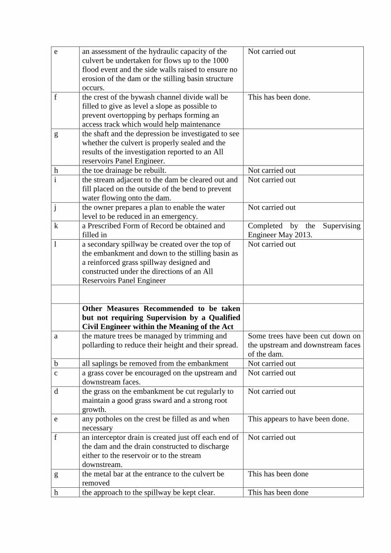
e an assessment of the hydraulic capacity of the
culvert be undertaken for flows up to the 1000
flood event and the side walls raised to ensure no
erosion of the dam or the stilling basin structure
occurs.
Not carried out
f the crest of the bywash channel divide wall be
filled to give as level a slope as possible to
prevent overtopping by perhaps forming an
access track which would help maintenance
This has been done.
g the shaft and the depression be investigated to see
whether the culvert is properly sealed and the
results of the investigation reported to an All
reservoirs Panel Engineer.
h the toe drainage be rebuilt. Not carried out
i the stream adjacent to the dam be cleared out and
fill placed on the outside of the bend to prevent
water flowing onto the dam.
Not carried out
j the owner prepares a plan to enable the water
level to be reduced in an emergency.
Not carried out
k a Prescribed Form of Record be obtained and
filled in
Completed by the Supervising
Engineer May 2013.
l a secondary spillway be created over the top of
the embankment and down to the stilling basin as
a reinforced grass spillway designed and
constructed under the directions of an All
Reservoirs Panel Engineer
Not carried out
Other Measures Recommended to be taken
but not requiring Supervision by a Qualified
Civil Engineer within the Meaning of the Act
a the mature trees be managed by trimming and
pollarding to reduce their height and their spread.
Some trees have been cut down on
the upstream and downstream faces
of the dam.
b all saplings be removed from the embankment Not carried out
c a grass cover be encouraged on the upstream and
downstream faces.
Not carried out
d the grass on the embankment be cut regularly to
maintain a good grass sward and a strong root
growth.
Not carried out
e any potholes on the crest be filled as and when
necessary
This appears to have been done.
f an interceptor drain is created just off each end of
the dam and the drain constructed to discharge
either to the reservoir or to the stream
downstream.
Not carried out
g the metal bar at the entrance to the culvert be
removed
This has been done
h the approach to the spillway be kept clear. This has been done

i the stones that have moved into the bywash
channel be pulled back
Not carried out
j the trees and bushes be kept back (at least 1m)
from the spillway.
Not carried out
k an inspection of the culvert be undertaken by the
Supervising Engineer when low flow conditions
allow.
The culvert was inspected on 8
May 2013
l the bywash channel be kept clear of debris. Not carried out
m any trees that have fallen into the reservoir be
removed.
There are no fallen trees in the
reservoir.
n the trees on the bywash channel divide wall be
managed/trimmed and pollarded.
Not carried out
Measures Recommended in the Interests of
Improving Monitoring and Supervision under
Section 11 of the Act
a the areas of dampness on and just off the toe be
watched for signs of increased flow or turbid
flow.
Not carried out
b water levels are recorded at least once a month
and at times of high flows
Not carried out recently
c someone should visit the site at least once a week. This has probably occurred
Matters to be watched by the Supervising
Engineer in accordance with Section 10(4) of
the Act
I recommend that the Supervising Engineer visits
the site at least once a year and pays attention to
any settlement, leakage or movement and in
particular ensures that:-
1 the Prescribed Form of Record is complete This has now been completed
2 the spillway is kept clear The spillway is relatively clear.
3 he watches for signs of seepage Not carried out recently
Recommendation as to the date of the next statutory inspection
The next statutory inspection should be carried out on or before 26 June 2017.
APPENDIX 1
Reservoir Data Summary
Name of Reservoir : Lawton Hall Lake Reservoir
Flood Category of Reservoir: C
Map Reference: SJ 825 558
Use: Fishing Lake
Date of completion of construction: Between 1645 and 1760
Type of Dam: Earth embankment dam probably homogeneous.
Maximum Height: 12m.
Crest Length: 100m
Spillway type: Side weir into bywash.
length: Spillway channel 1.55m Lowered section of dividing bank 7m
level: Spillway channel 101.72mAOD* Lowered section of dividing bank 102.5 mAOD*
*These levels require verification
Freeboard: 2..36m.
Peak outflow: 16 cumecs This was reported as the 1 in 100yr flood by Mr D Davies
Freeboard at peak (incl wave surcharge): 4.4m
Upstream protection: Stone wall at TWL partially collapsed..
Draw-off & Scour: None functional
Valve arrangements: None .
Constructional Difficulties & Subsequent Major Works
None recorded.

APPENDIX 1
Summary of Statutory Reservoir Inspections ________________________________________________________________
This is not a full list. It has been compiled from the information made available to me.
Inspection Date Engineer Précis of Main Recommendations and Comments
(Period to next inspection) _______________________________________________________________
8/2/88 D DAVIES . (19 months)
R1. Every flood like that of 23 Aug 1987 be recorded
R2 Bypass repairs be undertaken and loose timber and bushes which may
block the tunnel be cleared with some pollarding.
R3 The tunnel and stilling poll be de-watered for inspection.
R4 A permanent overflow as a stop-log groove be constructed and used
temporarily for water diversion during de-watering.
R5 The downstream haunch of the dam be better drained by rodding and
cleaning out two brick culverts
R6 Careful but restrained exploration of the newly discovered well, whetherit
links with the downstream culvert.
R7 A transverse trench be cut across the dam crest to prove the position and
quality of the clay core.
R8 Any direct feeding of the inlet stream into the lake should have regard to
its quality as advised by the Water Authority.
R9 A detailed section of the dam at its greatest height with soundings within
the lake be carried out to ascertain the depth of silt and whether slips have
occurred within the lake.
R10 Abandoned or redundant work such as the eastern lake overflow br
properly sealed.
R11 The SE to oversee the above and advise the Inspecting Engineer when
critical stages (if any) are reached, as informed by the owner.
R12 The undertakers pursue a strict policy of vigilance and active correction
in order that the tunnel enjoys free passage of water at all times.
R13 The above remedial works be completed in such a way as the owner
thinks best.
R14 It is possible that during the repair work amendments may be dictated by
the nature of the environment, when the Supervising Engineer should be
informed.
R15 The remedial works should be completed by October 1st 1989
R16 The next inspection should take place not later than October 1st 1989
25/9/00 P G Mackey (Mr Mackey refers to his reports of July 1993, Sept 1993, Dec
1993, January 1994, October 1994, October 1999 February 2000. However no
details of the recommendations are given He also refers to a report by Mr D
Davies of May 1990 but again no recommendations are quoted.)
1. Statutory records should be maintained.
2. Investigations are required as follows –
a) Clearing of the dam and exposing all hydraulic structures
b) Clearing of culverts and drainage including the east mitre overflow
c) CCTV investigation and reporting as to conditions of the culverts
and overflows
d) West mitre diversion culvert : This to be investigated structurally
and with regard to capacity. Requires surveys and calculations.
Recommends a computer numerical model
3. Works of Safety (currently foreseeable)
a) Repair and maintenance of west mitre diversion channel and
associated culverts
b) Formalization of drainage at eastern mitre upstream and
downstream. Ponding, formalising outfalls to overflows and culverts.
c) Work of reconstructing the west mitre inlet diversion channel
including outlet conditions downstream.
d) Additional work identified to hydraulic structure valves etc in
confirming the design requirements for making the dam safe and
certifying in accordance with the Act.
e) Work associated with draining the downstream shoulder and
associated areas in improving stability.
Works in providing an adequate overflow structure from the lake.
(5 years)
Reports of Supervising Engineers under the Reservoirs Act 1975
Only one report is available
DATE OF VISIT SUPERVISING ENGINEER
18 May 2011 F K Swettenham

APPENDIX 2
Sketch of disused overflow and drawdown facilities.


APPENDIX 3 A selection of photographs taken during the inspection.
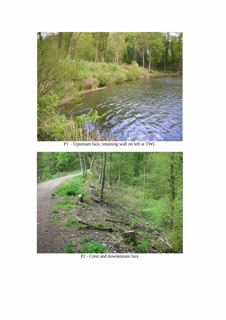
P1 – Upstream face, retaining wall on left at TWL
P2 - Crest and downstream face

P3 – Upstream portal of overflow culvert
P4 “Spillway” into bywash
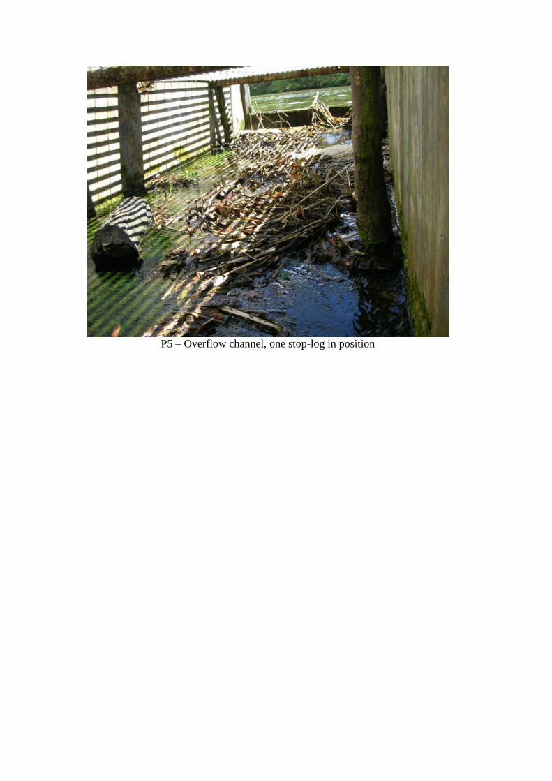
P5 – Overflow channel, one stop-log in position
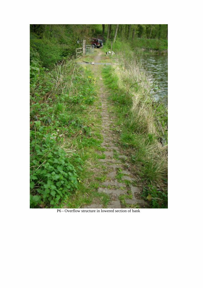
P6 - Overflow structure in lowered section of bank
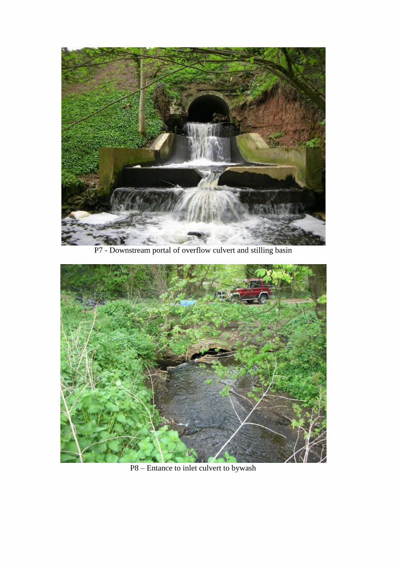
P7 - Downstream portal of overflow culvert and stilling basin
P8 – Entance to inlet culvert to bywash