Embed Size (px)
Citation preview

Researcher 2016;8(1s) http://www.sciencepub.net/researcher
195
Results Of Research On Geo-Physics
Gangadhara Rao Irlapati
H.No.5-30-4/1, Saibaba Nagar, Jeedimetla, Hyderabad – 500 055, Telangana State, INDIA Email ID: [email protected]
Abstract: Geophysics is the physics of the earth and its environment in soace; also the study of the earth using quantitative physical methods the geophysics refers to the earth shape, gravitational & magnetic field, internal structure and composition, dynamics and plate tectonics, oceans, atmosphere etc. I have consducted many reasearches in the field of geophysics and invented some related discoveries & inventions which may also be useful in understanding the extent of the use of geophysics. [Gangadhara Rao Irlapati. Results Of Research On Geo-Physics. Researcher 2016;8(1s):195-212]. ISSN 1553-9865 (print); ISSN 2163-8950 (online). http://www.sciencepub.net/researcher. 8. doi:10.7537/marsrsj0801s16.08. Key Words: earth quakes, Geoscope, monsoons Introduction: I have conducted many researches on the earthquakes during the year of 1980-87 and invented the Geoscope which can help to forewarn the earthquakes in advance Sri. AJVB Maheswara Rao Member of Parliament (Loksabha) was recommended the Geoscope to Sri K. R. Narayanan Minister of science & Technology Department for further research and development in the services of the country. In 1989, the Honble High Court of Andhra Pradesh was also issued orders to the government of India, Ministry of science & Technology, council of scientific and Industrial Research to provide research facilities to carryout the experiments in National Geophysical Research Institute, Hyderabad for Implementation in the service of the country. G. R. Irlapati; S Geoscope: Geoscope means- a mechanical architecture established in between the underground and observatory with the help of bore-well proposed for conducting geological studies to know the earthquakes, ores and water currents etc.
A borehole having suitable width and depth has to be dug. An observatory having research &analysis facilities has to be constructed on the borehole Apparatus & sensors to recognize the geo- physical and geo-chemical changes generated in the underground such as foreshocks, chemical changes, electrogeopulses, micro-vibrations, pressure, geomagnetic forces etc should be inserted into the underground and linked with the concerned analysis sections of the observatory that is above the ground to study the changes taking place in the underground.
That means-relative results of geological & geographical researches &developments of past, present and future should be interposed, coordinated and constantly developed. The apparatus related to the geology and geography such as Richter scale etc also should be set in the observatories of the Geoscope. we can make many more modern ideas& modifications
thus bringing many more improvements & developments in the Geoscope.
And we can build many more types of Geoscopes thus connecting many more levels for national wide network, more and required geoscope centers should be established in the earthquake zones where earthquakes occur frequently and there should be establish a central office to co-ordinate and codify the data of warnings about the onset of earthquake. The central office should analysis the data and estimate the time, epicenter, area etc details of the impending earthquake and send to the authorities and people to take precautions. National Geoscope Project
Many extensive researches were conducted on the national geoscopic forewarning system to detect the geological changes in advance. In this system, there should be established three level centers i. e., Local Geoscope Centre, Regional Geoscope Centre and Central Geoscope Centre for maintaining the system in a coordinated manner. Local Geoscope Centre: One or more required number of Geoscopes should be established in the expected earthquake zones. The observation personnel in the respective Geoscopes should watch the onset of earthquakes day and night. Regional Geoscope Centre: There should be established a Regional Geoscopic Centre at every expected quake zone to co-ordinate and codify the information supplied by the local geoscopic centers of the zone. Central Geoscope Centre: There should be established a Central Geoscopic Centre to co-ordinate and codify the information supplied by the Regional Geoscopic Centers from all over country in a coordinated manner. Performance: Whenever a Local Geoscopic Centre sends warning about the onset of earthquakes, the observation personal should immediately send the

Researcher 2016;8(1s) http://www.sciencepub.net/researcher
196
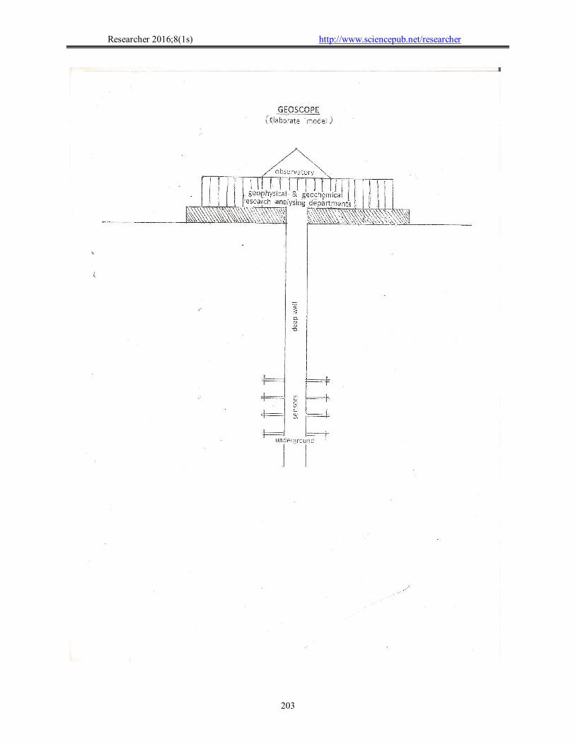
information to its Regional Geoscopic Centre. The Regional Geoscopic Centre should analysis the information and send it to the Central Geoscopic Centre. The Central Geoscope Centre analyze the information supplied by the Local Geoscopic Centers, Regional Geoscopic Centers and estimates the epicenter, time, area to be affected urban places etc., details of the impending earthquake and send to the authorities, and media and warnings in advance to take precautions. Types Of Geoscope Models Simple Geoscope: This is a simple construction involving no expenditure. A deep well having suitable width and depth has to be dug. Construct a room over the well. Wash the inner walls of the room with white Lime. Fix an ordinary electric bulb in the room. Home Made Geoscope: This construction involves no expenditure. Even students, children’s and science enthusiasts can make the Home-Made Geoscope and detect the earth-quakes 24 to 28 hrs in advance. By making certain changes and alterations, the house having a well can be converted into a Geoscope i. e., wash the inner walls of the house with white Lime. Fix ordinary electric bulbs in the room. Performance: Observe the colour of the room lighting daily. When the bulb glows, the light in room generally appears white in color, but before occurrence of an earth-quake, the room lighting turns blue in colour. The onset of earth-quake can be guessed by this “Seismic luminescence Emission”. Principle: Due to stress of continental plates and some other reasons on a place where there are favorable chances for earth-quake to occur, the pressure is induced in the underground. As a result, there is a steady rise in the pressure around the focus centre. Because of the large disparity in the magnitude of energies involved, gas anomalies such as (a) Helium emission (b) chemicoseismic anomalies of sulphur, calcium, nitrogen etc., chemical compounds (c) seismic atomic radiations of radioactive mineral compounds show up much earlier even at large distance from the epic-centre which enter the well through the underground springs. These gas anomalies occupy the room in this manner; emit radiation which gives blue colour (some times red) to the room. Micro Geoscope: Micro-Geoscope is an elaborate construction. For this model a deep bore-well having suitable width and depth has to be dug. An observatory having the most modern high-technological research facilities has to be constructed on that well. Most modern mechanical systems like electronic, physical and chemical sensors and apparatus to recognize the rise and fall of the underground water levels, micro-vibrations and waves generated in the underground, differences in pressure, temperature and other seismic activities should be
inserted into the underground and linked with the concerned research analyzing departments of the observatory that is above the well to observe the seismic changes taking place in the underground. The results of researches on the quakes like Richter scale etc., also should be setup in the Geoscope. That means relative results of past, present and future pertaining to the earthquakes or seismic researches should be interposed, co-ordinate, and constantly developed. We can make many more changes thus bringing many more developments in the geoscope.
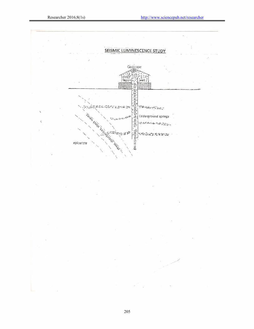
Observe the geophysical & geochemical changes such as foreshocks, chemical changes, ground water levels, strain in rocks, thermal anomalies, fractroluminescence’s gas anomalies, electrogeopulses, micro-vibrations, pressure, geomagnetic forces, etc taking place in the underground. The onset of earthquakes can be guessed by observing the aforesaid changes in the concerned analyzing departments of the observatory. Studies: I have proposed much type of studies to study the earth’s underground through the Geoscope. At present we discuss two types of studies of many of them. Seismic Luminescence Study: This is a very easy and simple study in the Geoscope Project. Construct a room over a well having suitable width and depth. Wash the inner walls of the room with white lime. Fix an ordinary electric bulb in the room. (Otherwise by making certain changes and alternations any home or office having a well can be converted into the Geoscope. Wash the inner walls of the house with white lime. Fix an ordinary electric bulb but don’t fix fluorescent lamp in the house. This method involves no expenditure).
Observe the colour of the lightning in the Geoscope room daily 24 hours 365 days. When the bulb glows, the lightning in the room generally appears as white (reddish). But before occurrence of an earth-quake, the room lightning turns violet in colour.
Because, before occurring of an earthquake-gas anomalies such as radon, helium, hydrogen and chemico-mineral evaporations such as sulphur, calcium, nitrogen and other fracto-luminescence radiations show up earlier even at large distances from the epicenter due to stress, disturbances, shock waves and fluctuations in the underground forces. These gas anomalies & fracto luminescence radiations and other chemical evaporations enter into the well through the underground springs. When these anomalies occupy the room above the well, the room lighting turns violet in colour. The light in the room scattered in the presence of these gas anomalies, fracto-luminescence radiations and other chemico-mineral evaporations the ultra violet radiation is emitted more and the room

Researcher 2016;8(1s) http://www.sciencepub.net/researcher
197
lighting turns in violet colour. Our eye catches these variations in the radiation of the lighting in the room easily since.
a) The violet rays having smaller wave length. b) The violet radiation having property of
extending greatly. c) The light becoming weak in the violet region. d) The eyes having greater sensitivity to violet
radiation. Due to all reasons the room may appear violet in
colour then we can predict the impending earth quakes 12 hours in advance. Electro Geopulses Study: This is also easy study to recognize the impending earth quake. A borehole having suitable width and depth has to be dug. An earth wire or rod should be inserted into the underground by the borehole and linked with the concerned analysis section having apparatus to detect, compare measure of the electric currents of the electric circuit of the earth systems. Otherwise by observing the home electric fans. etc. We can also study the electrogeopulses studies to predict the impending earth quake.
Observe the changes in the electric currents of the earth system 24 hours, 365 days. From a power station, the electricity is distributed to the far-off places. Normally the circuit of the power supply being completed through the earth system. Whenever if the disturbances occurs in the layers of the earth’s underground, the fluctuation rate will be more due to the earth quake obstructions such as pressure, faults, vibrations, water currents etc., of the earth’s underground. So we can forecast the impending earth quake by observing the obstruction of electric currents of circuit of the earth system in the observatory of the Geoscope and also by the obstruction sounds in the electric fans etc. Experiments Carriedout: I have carried out a number of experiments on the Geoscope project and all were successfully proved out in practice. The risk of earthquakes in Andhra Pradesh is less but the source is greater in north India however. Indian Weather Time Scale: I have conducted many researches on the Indian weather and proposed hundreds and thousands of Indian weather Time Scale pertaining to the all Homogeneous Regions, Meteorological Subdivisions, states and districts of Indian which can help tp forecast the weather changes in advance in 1980, Sri G. Surya Rao MLA had sent these Indian weather time scales to the chief minister of Andhra Pradesh for consideration and necessary action in 2004, some consultations were made with the planning department to implement the Indian weather time scale at the directorate of Economics & Statistics department in 2006, some correspondences were made with the environment, forest, science & Technology
department for implementation of the Indian weather time scale the same scales were sent to the chief minister of Andhra Pradesh in 2003. And the same was again submitted to the chief minister of Andhra Pradesh in 2006. Many consultations were made with the commissioner for disaster Management in the years of 2008,2009 about the implementation of Indian weather time scale. In 2010, these scales were consulated with the A. P state council of science & Technology in 2008, Sri T. Subbirami Reddy, Honable Union Minister of state had recommended the Indian weather time scale to the Indian Meteorological department for implementation in the services to the country. Later consultations were made with the India meteorological department about the Indian weather time scale during the years of 2008-2008. Abstract: I have conducted many extensive researches on the astronomical forces and its effects on the earth climate particularly on various regions of the India. The variations in the solar cycle affects and stimulate the earth climate. The moon affects and stimulate the ocean tides and atmosphere too. The movement of axis of the earth inclined at 23 ½ degrees from vertical to its path around the sun affects and stimulate the earth weather and leads to formation of monsoons and seasons etc. So the astronomical forces affect and stimulate the earth climate it may be more or less but it is true. These scales may be taken as a part of scientific study of astronomical forces & its effects on the earth climate. Keywords: Indian weather, astronomical forces. Introduction: In the time and scale of the universe some things from astronomy to atom including living beings have been repeating once in every certain time or period. For example, the south and north magnetic poles have been shifting in every certain period. The sun spots have been repeating once in every eleven years. The lunar and solar eclipses have also been occurring once in every 18.6 years. The seasons such as winter, autumn etc. also have been repeating once in every year in the same month of the year. The periodical menses in the females repeating once in every month. Construction: On the basis of the said universal facts, I have prepared a time scale with 21 blocks, each block containing certain prescribed cycle of years in which similar calendar years repeating one after another that leads similar weather conditions of those previous years to future years likely repeating every year approximately. The rainfall of the years, have been entering in the scale in percentages or as it is pertaining to month, season, annual wise of the each and every year. If we managing the scale in this manner continuously, we may assuming the weather conditions of the anterior years on the basis of the posteriors years weather. On the basis of the principle,

Researcher 2016;8(1s) http://www.sciencepub.net/researcher
198
we can assume that a considerable, of course it may be little chance of predication for an ensuing years by study the data of earlier years.
I have prepared a model Indian weather time scale along with hundreds of additional scales in which all weather conditions such as rainfall, temperature, cyclones, river water etc of all homogeneous regions sub-divisions of India were studied and analyzed elaborately. Indian weather time scale Whole India Indian weather time scale West peninsular Indian weather time scale East peninsular Indian weather time scale North west Indian weather time scale North central Indian weather time scale North east Indian weather time scale North mountains Indian weather time scale India Indian weather time scale North east Indian weather time scale North west Indian weather time scale West central Indian weather time scale South peninsular Indian weather time scale Kerala Indian weather time scale Tlangana Indian weather time scale South interior karnataka Indian weather time scale North interior karnataka Indian weather time scale Coastal karnataka Indian weather time scale Tamilnadu & pondicherry Indian weather time scale Rayalseema Indian weather time scale Coastal andhra pradesh Indian weather time scale Chattisgarh Indian weather time scale Vidrba Indian weather time scale Marathwada Indian weather time scale Madhya maharasthra Indian weather time scale Konkan & goa Indian weather time scale Saurashtra, kutch & diu Indian weather time scale Gujarat Indian weather time scale East madhya pradesh Indian weather time scale West madhya pradesh Indian weather time scale East rajasthan Indian weather time scale West rajasthan Indian weather time scale Punjab Indian weather time scale Haryana, chandigarh & delhi Indian weather time scale Uttaranchal Indian weather time scale West uttar pradesh Indian weather time scale East uttar pradesh Indian weather time scale Bihar Indian weather time scale Jarkhand Indian weather time scale Orissa Indian weather time scale Gaggetic west bengal Indian weather time scale Sub, him, west bengal & sikkim Indian weather time scale Nagaland, manipur, mizoram & tripura Indian weather time scale
Assam & meghalaya, north assam Indian weather time scale West uttar pradesh plans Indian weather time scale January temperature Indian weather time scale February temperature Indian weather time scale March temperature Indian weather time scale April temperature Indian weather time scale May temperature Indian weather time scale June temperature Indian weather time scale July temperature Indian weather time scale August temperature Indian weather time scale September temperature Indian weather time scale October temperature Indian weather time scale November temperature Indian weather time scale December temperature Indian weather time scale Annual rainfall fluctuations Indian weather time scale Winter rainfall fluctuations Indian weather time scale Summer rainfall fluctuations Indian weather time scale Summer monsoon rainfall fluctuations Indian weather time scale Post monsoon Indian rainfall fluctuations Indian weather time scale June month rainfall fluctuations Indian weather time scale July month Indian rainfall fluctuations Indian weather time scale August month rainfall fluctuations Indian weather time scale September month rainfall fluctuations Indian weather time scale Ganga river waters Indian weather time scale Yamuna river waters Indian weather time scale Bhramaputhra river waters Indian weather time scale Indus river waters Indian weather time scale Mahanandi river waters Indian weather time scale Godavari river waters Indian weather time scale Krishna river waters Indian weather time scale Kaveri river waters Indian weather time scale Narmada river waters Indian weather time scale Tapati river waters Indian weather time scale Studies Carried Out: Many experiments were carried out on the Indian weather Time Scale and it was successfully proved out.
Firstly, see the Indian weather time scale. In this scale, the June, July, August and September months of the summer monsoon season were taken in a table in which the each month is also divided into three parts the Telangana, Rayalaseema and Coastal Andhra regions. The monthly wise rainfall data of the months of the regions from 1870 to till available years are taken in the form of percentages or as it is and entering in the scale pertaining to the region wise of the each and every year. If we managing the scale in this manner continuously, we may assuming the weather conditions of the anterior years on the basis of the posterior years weather.

Researcher 2016;8(1s) http://www.sciencepub.net/researcher
199
Example for assuming the dry season or suppose to predict the rainfall situation in the summer season of the ensuing year 2019: study the 7th cycle in which wet conditions in 10 years and dry conditions in 14 years were occurred in the month of June : wet conditions in 2 years and dry conditions in 22 years were occurred in the month of July : wet conditions in 4 years and dry conditions in 20 years were occurred in the month of August and wet conditions in 8 years and dry conditions in 16 years were occurred in the month of September. On the whole, wet conditions in 24 times and dry conditions in 72 times repeated in the summer monsoon season of the 7th cycle (As a result, there were dry conditions occurred in the 2002 year also). Therefore it is a considerable chance to predict that a dry season will be repeated in the ensuing year of 2019.
Example for assuming the wet season or suppose to predict the rainfall situation in the summer season of the ensuing year 2022: study the 10th cycle in which wet conditions in 13 years and dry conditions in 8 years were occurred in the month of June: wet conditions in 13 years and dry conditions in 8 years were occurred in the month of July: wet conditions in 9 years and dry conditions in 12 years were occurred in the month of August and wet conditions in 19 years and dry conditions in 2 years were occurred in the month of September. On the whole, wet conditions in 54 times and dry conditions 30 times were repeated in the summer monsoon season of the 10th cycle. As a result, there were wet conditions occurred in the 2005 years also. Therefore, it is a considerable chance to predict that a wet season will be occurred in the ensuing year of 2022.
In the same manner, we can study the remaining All Indian weather time scales of all Homogeneous regions and subdivisions, states and districts of India. Conclusions: We can make many more modifications thus bringing many more developments in the Indian weather time scale and its all additional Indian weather time scale. Publications: Many journals have published several publications about the Indian weather time Scale the Andhra Pradesh has published a news commentary on the Indian weather time scale. The Andhra Pradesh has published a news commentary on the Indian weather Time scale in 2003. An article was published about these scales in news book in 2007.
References 1. Improved seasonal drought forecasts using
reference evapotranspiration anomalies, danielj, MCEvoy, justin l Huntington, john F Mejia, Michael T Hobbins, geophysical research letters, 14-1-2016.
2. Encyclopedia of solid earth physics geophysical journal international, 129,319-329.
3. Operational earth quake forecasting. 4. Advances in geophysics volume 28B books.
google. co. in. 5. System earth via geodetic-geophysical space
techniques-frank M Flenchtner, Thomas gruber, andreas guntner-2010, science forecasts.
6. Department of meteorology and geophysics (www.univie.ac@department of meteorology and geophysics.
7. Shear-wave splitting: New geophysics and earth quakes; link springer.com.
8. Operational earth quake forecasting www.geos.ed.ac.uk.
9. www.quakefinder.com. 10. www/en-wikipedia.org/wiki/cyclic model. 11. The Steinhardt-turok model. 12. The Baun-frampton model. 13. Loop quantum cosmology. 14. En.wikipedia.org/wiki/multiverse. 15. Heliocentric model. 16. Geocentric model. 17. Copernican model. 18. Heliocentric model vs geocentric model. 19. en.wikipedia.org/wiki/big bang theory. 20. en.wkipedia.org/wiki/steadystate theory. 21. www.astro.ucla.edu/-wright/steady stat. 22. www.ncdc.noaa.gov/data-access/numerical-
weather-prediction. 23. En.wikipedia.org/wiki/numerical- weather-
prediction. 24. The history of numerical weather prediction –
NOAA; 25. Fundamentals of numerical weather
prediction/ebooks.cambridge.org. 26. Ken ring, the moon and lunar science predict
weather. 27. Moon predict weather lore /
www.almanac.com/content/moon-lore-weather. 28. Climate change, sunspots activity & lunar
/cosmic cycles (www.the longerview.com.au/sunmoon-climate.html.

Researcher 2016;8(1s) http://www.sciencepub.net/researcher
200
Appendices:

Researcher 2016;8(1s) http://www.sciencepub.net/researcher
201

Researcher 2016;8(1s) http://www.sciencepub.net/researcher
202
Researcher 2016;8(1s) http://www.sciencepub.net/researcher
203

Researcher 2016;8(1s) http://www.sciencepub.net/researcher
204
Researcher 2016;8(1s) http://www.sciencepub.net/researcher
205

Researcher 2016;8(1s) http://www.sciencepub.net/researcher
206

Researcher 2016;8(1s) http://www.sciencepub.net/researcher
207
Indian weather time scale.

Researcher 2016;8(1s) http://www.sciencepub.net/researcher
208

Researcher 2016;8(1s) http://www.sciencepub.net/researcher
209

Researcher 2016;8(1s) http://www.sciencepub.net/researcher
210
Researcher 2016;8(1s) http://www.sciencepub.net/researcher
211

Researcher 2016;8(1s) http://www.sciencepub.net/researcher
212
9/1/2016