Embed Size (px)
Citation preview

LOCAL TRANSPORTATION AND LAND USE COORDINATION: TOOLS AND GAPS
Final Report
prepared forTHE STATE OF MONTANADEPARTMENT OF TRANSPORTATION
in cooperation withTHE U.S. DEPARTMENT OF TRANSPORTATIONFEDERAL HIGHWAY ADMINISTRATION
June 2010
prepared byGeorge D. Mazur
Cambridge Systematics, Inc.Oakland, California
FHWA/MT-10-002/8195
R E S E A R C H P R O G R A M S

You are free to copy, distribute, display, and perform the work; make derivative works; make commercial use of the work under the condition that you give the original author and sponsor credit. For any reuse or distribution, you must make clear to others the license terms of this work. Any of these conditions can be waived if you get permission from the sponsor. Your fair use and other rights are in no way affected by the above.

Local Transportation and Land Use Coordination: Tools and Gaps
Cambridge Systematics, Inc.
Local Transportation and Land Use Coordination: Tools and Gaps
prepared for
Montana Department of Transportation
prepared by
Cambridge Systematics, Inc. 555 12th Street, Suite 1600 Oakland, California 94607
with
Renaissance Planning Group, Inc. Robert Peccia & Associates, Inc.
June 2010

Local Transportation and Land Use Coordination: Tools and Gaps
Cambridge Systematics, Inc. ii
TECHNICAL REPORT DOCUMENTATION PAGE 1. Report No. FHWA/MT-10-002/8195
2. Government Accession No.
3. Recipient’s Catalog No.
4. Title and Subtitle Local Transportation and Land Use Coordination: Tools and Gap
5. Report Date June 2010 6. Performing Organization Code
7. Author(s) George D. Mazur
8. Performing Organization Report No.
9. Performing Organization Name and Address Cambridge Systematics, Inc 555 12th Street, Suite 1600 Oakland, CA 94607
10. Work Unit No. 11. Contract or Grant No. Contract Number 308603 Project Number 8195
12. Sponsoring Agency Name and Address Research Programs Montana Department of Transportation 2701 Prospect Avenue PO Box 201001 Helena MT 59620-1001
13. Type of Report and Period Covered Final; September 2008 to June 2010 14. Sponsoring Agency Code 5401
15. Supplementary Notes. Research performed in cooperation with the Montana Department of Transportation and the U.S. Department of Transportation, Federal Highway Administration. Project information can be found at http://www.mdt.mt.gov/research/projects/planning/smart_trans.shtml. 16. Abstract The effective coordination of transportation and land use planning decisions is vital to Montana’s long-term economic growth and fiscal well being. Toward this end, this research project entailed a best practices study of land use and transportation planning across the United States, with a particular focus on issues and strategies relevant to Montana. The resulting Montana Transportation and Land Use Resources for Growing Communities is drawn from the information developed through the study as well as surveys and discussions with land use planners and transportation professionals across the State. The intent of this online resource is to provide information about off-the-shelf policies, practices, analytic methods, data sources, and software that can help officials in Montana’s growing communities coordinate transportation and land use decisions. Development of the online resource centered around four research objectives to facilitate coordinated transportation and land use planning in growing Montana communities: development and extension of local street networks; local transportation system financing; assessment of development impacts on local and state roads; and directions for multimodal and transit development. Finally, the research identified promising but underdeveloped planning approaches worthy of further research and/or development in subsequent efforts. Six “gaps” in practice and available information were found to be particularly acute for small, rapidly growing communities: funding transportation; transferable processes and data for community-level transportation analysis; multijurisdictional approaches and incentives; multimodal transportation system needs and opportunities; staff-level training resources to improve community and interagency communication; and effective growth policies and success stories. Research problem statements were developed for these six topics. 17. Key Words transportation, land use, toolkit, smart growth, small communities, pedestrians, bicyclists, coordination, planning, public transportation, multimodal
18. Distribution Statement Unrestricted. This document is available through the National Technical Information Service, Springfield, VA 21161.
19. Security Classif. (of this report) Unclassified
20. Security Classif. (of this page) Unclassified
21. No. of Pages 148
22. Price

Local Transportation and Land Use Coordination: Tools and Gaps
Cambridge Systematics, Inc. iii
DISCLAIMER STATEMENT
This document is disseminated under the sponsorship of the Montana Department of Transportation and the United States Department of Transportation in the interest of information exchange. The State of Montana and the United States Government assume no liability of its contents or use thereof.
The contents of this report reflect the views of the authors, who are responsible for the facts and accuracy of the data presented herein. The contents do not necessarily reflect the official policies of the Montana Department of Transportation or the United States Department of Transportation.
The State of Montana and the United States Government do not endorse products of manufacturers. Trademarks or manufacturers’ names appear herein only because they are considered essential to the object of this document.
This report does not constitute a standard, specification, or regulation.
ALTERNATIVE FORMAT STATEMENT
MDT attempts to provide accommodations for any known disability that may interfere with a person participating in any service, program, or activity of the Department. Alternative accessible formats of this information will be provided upon request. For further information, call (406) 444-7693, TTY (800) 335-7592, or Montana Relay at 711.
Local Transportation and Land Use Coordination: Tools and Gaps
Cambridge Systematics, Inc. iv
Table of Contents 1.0 Introduction/Background ..................................................................................... 1
2.0 Research Approach ................................................................................................ 3
2.1 Research Panel ............................................................................................... 3
2.2 Stakeholder Surveys ...................................................................................... 4
2.3 Stakeholder Interviews ................................................................................. 4
2.4 Data Assembly and Analysis ....................................................................... 6
2.5 Website Mockup ............................................................................................ 7
2.6 Website Content Development .................................................................... 8
2.7 Gap Analysis .................................................................................................. 9
3.0 Results .................................................................................................................... 14
3.1 Data Assembly and Analysis ..................................................................... 14
3.2 Stakeholder Feedback ................................................................................. 20
3.3 Montana Transportation and Land Use: Resources for Growing Communities................................................................................................. 39
3.4 Gap Analysis ................................................................................................ 49
3.5 Research Problem Statements .................................................................... 65
4.0 Conclusions ........................................................................................................... 67
5.0 Implementation and Recommendations ......................................................... 69
5.1 Initial Deployment Activity ....................................................................... 69
5.2 Ongoing Deployment and Maintenance Recommendations .................. 75
6.0 Bibliography ......................................................................................................... 82
Appendix A – Web Survey Questions and Tabulations ....................................... 88
Appendix B – Initial Stakeholder Interview Guide ............................................. 103
Appendix C – Stakeholder Outreach (Round 1) Interview Guide ........................ 105
Appendix D – Research Problem Statements ........................................................ 106
Appendix E – Webinar Invitation ............................................................................ 138
Appendix F – Informational Brochure .................................................................... 140

Local Transportation and Land Use Coordination: Tools and Gaps
Cambridge Systematics, Inc. v
List of Tables Table 3.1 Tool Evaluation Matrix .............................................................................. 16
Table 3.2 Summary Evaluation of Technical Analysis Tool Examples ............... 19
Table 3.3 Examples of Effective Planning on Land Use in Non-Transportation Topics ................................................................................ 24
Table 3.4 Hierarchy and Relationship of Tool Categories, Subcategories, and Implementations ................................................................................. 42
Table 3.5 Gap Analysis Conclusions ........................................................................ 51
Table 5.1 Maintenance Tasks and Estimated Effort ............................................... 80
Table A.1 Primary Geographic Scope of Respondents’ Planning Organization ............................................................................................... 88
Table A.2 Respondents’ Role in Local Planning Process in Montana .................. 88
Table A.3 Respondents’ Involvement in Montana’s Local Planning Processes ...................................................................................................... 89
Table A.4 Effectiveness of Local Planning Practices in Montana in Addressing Impacts of Land Development on Transportation ........... 89
Table A.5 Strategies to Improve Coordination between Transportation and Land Development Planning in Montana’s Local Communities ........ 90
Table A.6 Effectiveness of Local Planning Practices in Addressing Impacts of Land Development Decisions on the Following Non-Transportation Topics ................................................................................ 91
Table A.7 Frequency in Using Certain Resources to Assist in Planning or Policy-Making Responsibilities ................................................................ 96
Table A.8 Most Helpful Resources to Assist in Planning or Policy-Making Responsibilities ........................................................................................... 97
Table A.9 Topic Areas Searched for Relating to Transportation or Land Use in Last Two Years ............................................................................... 97
Table A.10 Top Three Issues Where More Information Would Be Helpful ......... 98
Table A.11 Relative Importance of Topics For Toolkit Content Development ...... 99
Table A.12 Topic Area with Greatest Need for New Information and Examples .................................................................................................. 100
Table A.13 Support for an Internet-Based Peer Network in Professional Planning Duties ....................................................................................... 101

Local Transportation and Land Use Coordination: Tools and Gaps
Cambridge Systematics, Inc. vi
List of Figures Figure 2.1 Research Plan ................................................................................................ 3
Figure 3.1 Effectiveness of Local Planning Practices in Addressing Impacts of Land Development Decisions on Various Transportation Issues ............................................................................................................ 22
Figure 3.2 Key Actions to Take to Improve Coordination between Transportation and Land Use Planning in Montana ............................ 23
Figure 3.3 Topics Where Website Should Provide Support Information and Examples ...................................................................................................... 25
Figure 3.4 Home Page .................................................................................................. 40
Figure 3.5 Portal to Planning and Policy Category .................................................. 41
Figure 3.6 Portal to “Design Standards and Policy” Subcategory ......................... 44
Figure 3.7 Portal to “Multimodal Street Classification Systems” Implementation .......................................................................................... 45
Figure 3.8 Sample Case Study Layout ....................................................................... 46
Figure 3.9 Montana Transportation and Land Use Planning Resources .............. 47
Figure 3.10 National Transportation and Land Use Planning Resources ............. 48
Figure 3.11 Sample Layout of a “How Do I?” Page .................................................. 49
Figure E.1 Webinar Invitation ................................................................................... 139
Figure F.1 Informational Brochure ........................................................................... 141

Local Transportation and Land Use Coordination: Tools and Gaps
Cambridge Systematics, Inc. 1
1.0 Introduction/Background The effective coordination of transportation and land use planning decisions is vital to Montana’s long-term economic growth and fiscal well being. Toward this end, this research project entailed a best practices study of land use and transportation planning across the United States, with a particular focus on issues and strategies relevant to Montana. The resulting Montana Transportation and Land Use Resources for Growing Communities is drawn from the information developed through the study as well as surveys and discussions with land use planners and transportation professionals across the State.
The intent of this online resource is to provide information about off-the-shelf policies, practices, analytic methods, data sources, and software that can help officials in Montana’s growing communities coordinate transportation and land use decisions. The online resource is organized by four major tool categories (coordination and consensus building; policy and planning, financing; technical analysis) and includes 33 unique tool implementation strategies.
The online resource illustrates successful tool application in communities throughout Montana and similar states through a series of examples and cross-cutting case studies. Tools and tool implementation strategies can be accessed by category or a “How do I?” list of typical questions and situations often faced by Montana planners as they seek to coordinate land use and transportation planning. The online resource also provides an overview of transportation planning in Montana and links to key transportation planning resources in Montana and around the nation.
Development of the online resource centered around four research objectives to facilitate coordinated transportation and land use planning in growing Montana communities throughout different phases of implementation:
1. Development and Extension of Local Street Networks – Sustainable community development relies heavily on the development of integrated and coordinated transportation networks. The design of the network is critical to future transportation and land use harmony.
2. Local Transportation System Financing – Transportation system improvements are costly and often present financial challenges for local governments, particularly when undertaken retroactively. A wide variety of tools, from linking the financing of transportation improvements and the growth that creates the need, to reducing infrastructure costs, are in use in communities across the country.
3. Assessment of Development Impacts on Local and State Roads – While analytical approaches for individual projects are generally well-known and in widespread use, the overall decision-making process suffers when they are applied on a development-by-development basis without consideration of
Local Transportation and Land Use Coordination: Tools and Gaps
Cambridge Systematics, Inc. 2
comprehensive or cumulative impacts. Even when decision-making occurs on a project-specific basis, tools are needed to approach coordinating development and infrastructure needs at a broader transportation system level rather than simply reacting to projects on a case-by-case basis.
4. Directions for Multimodal/Transit Development – Options exist to coordinate land use with non-highway transportation investments, even in low-density settings. Even in smaller towns, designing for a more compact, mixed-use, and walkable environments can be effective at shifting short trips from automobile to walking or bicycling, as well as making transit more feasible.
In the process of developing the online resource, the research project identified promising but underdeveloped planning approaches worthy of further research and/or development in subsequent efforts. These “gaps” in practice and available information were found to be particularly acute for small, rapidly growing communities.
Sections 2.0 to 5.0 of this report present the research approach, results, conclusions, and recommendations of the research study underlying development of the online resource. Section 6.0 describes the online resource implementation process to date and recommended procedures for additional content development and maintenance. A bibliography is included in Section 8.0.
Local Transportation and Land Use Coordination: Tools and Gaps
Cambridge Systematics, Inc. 3
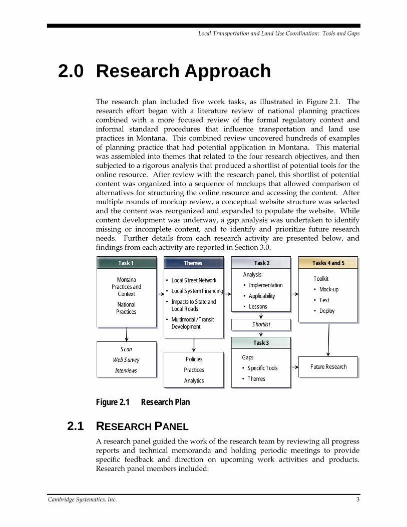
2.0 Research Approach The research plan included five work tasks, as illustrated in Figure 2.1. The research effort began with a literature review of national planning practices combined with a more focused review of the formal regulatory context and informal standard procedures that influence transportation and land use practices in Montana. This combined review uncovered hundreds of examples of planning practice that had potential application in Montana. This material was assembled into themes that related to the four research objectives, and then subjected to a rigorous analysis that produced a shortlist of potential tools for the online resource. After review with the research panel, this shortlist of potential content was organized into a sequence of mockups that allowed comparison of alternatives for structuring the online resource and accessing the content. After multiple rounds of mockup review, a conceptual website structure was selected and the content was reorganized and expanded to populate the website. While content development was underway, a gap analysis was undertaken to identify missing or incomplete content, and to identify and prioritize future research needs. Further details from each research activity are presented below, and findings from each activity are reported in Section 3.0.
Task 3
Task 1 Task 2
Montana Practices and
Context
National Practices
• Local Street Network
• Local System Financing
• Impacts to State and Local Roads
• Multimodal / Transit Development
Scan
Web Survey
Interviews
Analysis
• Implementation
• Applicability
• Lessons
Gaps
• Specific Tools
• Themes
Shortlist
Tasks 4 and 5
Toolkit
• Mock-up
• Test
• Deploy
Future ResearchPolicies
Practices
Analytics
Themes
Figure 2.1 Research Plan
2.1 RESEARCH PANEL A research panel guided the work of the research team by reviewing all progress reports and technical memoranda and holding periodic meetings to provide specific feedback and direction on upcoming work activities and products. Research panel members included:

Local Transportation and Land Use Coordination: Tools and Gaps
Cambridge Systematics, Inc. 4
• Sue Sillick, MDT Research; Project Manager;
• Hal Fossum, MDT Planning; Panel Chair;
• Michelle Bryan Mudd, Missoula;
• Kris Christensen, MDT Research;
• Tim Davis, Montana Smart Growth Coalition;
• Chris Saunders, City of Bozeman;
• Andrew Finch, City of Great Falls;
• Ann Cundy / Stephanie Millar / Steve Earle, Missoula;
• Mike Tierney, MDT Planning;
• Jerry Grebenc, Montana Community Technical Assistance Program;
• Harold Stepper, Jefferson County; and
• Lloyd Rue, Federal Highway Administration (Montana Division Office).
Four panel meetings were held at key review and decision points in the projects.
2.2 STAKEHOLDER SURVEYS An on-line survey was conducted to better understand the current state-of-planning practices and resources used by local jurisdictions in Montana. The 17-question survey asked Montana planning professionals about existing practices linking land development to infrastructure needs, subject areas and resources they frequently consult, and their suggested areas and approaches for improvement. Eighty-two respondents from a diverse range of planning environments provided the feedback. Survey questions and a summary of responses received are included in Appendix A. Survey results were used to identify more specific areas of need and interest within the four research objectives, uncover existing tools currently deployed in Montana, and provide insight on the resources currently used by local planners.
2.3 STAKEHOLDER INTERVIEWS Interviews of land use and transportation planning professionals in Montana were conducted to obtain more detailed information on current practices and needs. Interviewees were selected based on their on-line survey responses and represent a range of geography and community growth types. The following individuals participated in the interviews:

Local Transportation and Land Use Coordination: Tools and Gaps
Cambridge Systematics, Inc. 5
• Candi Beaudry, Director Billings Planning and Community Services Department
• Scott Walker, Transportation Planner Billings Planning and Community Services Department
• Wyeth Friday, Planning Division Manager Billings Planning and Community Services Department
• Ron Wenger, Transit Manager Billings MET Transit
• James Caniglia, Planner City of Laurel
• Roger Millar, Director City of Missoula, Office of Planning and Grants
• Stephen Earle, Mountain Line Transit Manager Missoula Urban Transportation District
• Phil Smith, Planner City of Missoula, Bicycle and Pedestrian Office
• Dennis Stranger, Planner/Building Inspector City of Hamilton, Office of Community Development
• Tom Jentz, Director City of Kalispell, Planning Department
• Jeff Harris, Director Flathead County, Planning and Zoning Office
• David Taylor, Director City of Whitefish, Planning and Building Department
• Andy Epple, Director City of Bozeman, Department of Planning and Community Development
• Chris Saunders, Planner City of Bozeman, Department of Planning and Community Development
• Greg Sullivan, Director Gallatin County, Planning Department
• Chris Scott, Transportation Planner Gallatin County, Planning Department
• Jason Karp, Planner City of Belgrade
• Joyce Weaver, Planner City of Polson, Building and Planning Department

Local Transportation and Land Use Coordination: Tools and Gaps
Cambridge Systematics, Inc. 6
• Sue Shannon, Director Lake County, Planning Department
• Greg McGann, Planner/Sanitarian Carbon County
• Duane Ferdinand, Director City of Lewistown, Planning Department
• John Marks, Director City of Miles City, Planning and Community Development
• Bruce Larson, Director City of Miles City, Public Works Department
Interview questions explored how planning processes were conducted and coordinated within the communities; delved into specific community needs under each of the four research objectives; and explored obstacles planners face when conducting their duties. The interview questions are listed in Appendix B.
2.4 DATA ASSEMBLY AND ANALYSIS A literature review of national and state practices relevant to the four research objectives were conducted to provide a basis for identification of tools local communities in Montana can use to better coordinate transportation and land use planning.
Twelve telephone interviews were conducted to resolve gaps from literature review findings that were most relevant for growing Montana communities. Though varied by interview, questions obtained additional information about the communities where each tool was applied, the parties involved in creating and refining each tool, and keys to successful implementation of each tool. The following tool users were interviewed:
• Mia Zmud, Director NuStats (Community Visioning and Planning)
• Faith Ingulsrud, Planning Coordinator Vermont Department of Housing Affairs (Special Area Planning)
• Kathleen Brace, Director of City Planning City of Fort Collins, Colorado (Development Exactions and Impact Fees)
• Cindy Jones, Planner Citrus County, Florida (Special Area Regulations)

Local Transportation and Land Use Coordination: Tools and Gaps
Cambridge Systematics, Inc. 7
• Alisa Babler, Permit Engineer Colorado Department of Transportation (DOT) (Special Area Regulations)
• Tracy Newsome, Director of City Planning City of Charlotte, North Carolina (Special Area Regulations)
• Kristine Williams, Director of the Planning and Corridor Management Program Center for Urban Transportation Research (Third Party Technical Assistance)
• Stevan Gorchester, Executive Director Washington State Transportation Investment Board (Planning and Regulatory Analysis, Third Party Funding Assistance)
• Melissa Tooley, Director of the University Transportation Center for Mobility Texas Transportation Institute (Third Party Technical Assistance)
• David Brown, Project Director/City Engineer City of Greenville, North Carolina (Leveraging Funds)
• Barbara Steck, Deputy Director, Fresno Council of Governments Fresno Council of Governments (Planning and Regulatory Analysis)
• Christine Kai, Planner/Modeler Fresno Council of Governments (Planning and Regulatory Analysis)
The results of the literature review and tool user interview were compiled into 14 tools pertaining to the four major tool categories of coordination and consensus building, policy and planning, financing, and technical analysis. Implementation strategies of varying complexity and cost of implementation were included under each tool. A set of evaluation factors addressing relevance to local Montana communities (from stakeholder surveys and interviews) and the four research objectives were used to identify tools for incorporation into the online resource. Details regarding the evaluation are presented along with results in Section 3.1.
2.5 WEBSITE MOCKUP Several mockups were prepared and provided to the research panel and representatives from local Montana communities for review. Reviewer feedback was used to select and refine a preferred website structure prior to full-scale development. The mockup was prepared in HTML format and was populated with example content to illustrate the conceptual structure of the online resource.

Local Transportation and Land Use Coordination: Tools and Gaps
Cambridge Systematics, Inc. 8
2.6 WEBSITE CONTENT DEVELOPMENT Website content was developed from information gathered during the data assembly and analysis process. For each tool category, tool, and tool implementation strategy findings were structured to provide users with an understanding of the concept, implementation needs (cost, complexity, parties to involve, how to get started), keys to success and potential pitfalls, and additional resources. Federal and state transportation planning resources were identified and organized for inclusion.
For each implementation strategy, one or more examples were developed to briefly illustrate a real-world application of the strategy, along with a link for more information. About 170 examples were included in the final online resource, which averaged to about five examples for each of the 33 tools. Most tools have between three and six examples, although three of the tools have more than 10 examples each. The case examples cover a range of community types. While small western communities are more heavily represented, there are a number of poignant examples at the state level as well as communities that are larger in size and elsewhere in the country.
In addition to the strategy-specific examples, eight case studies were developed to serve as the primary method for demonstrating tool application. Three of the case studies feature Montana communities, four case studies feature small communities in other western states, and one case study features a medium-size community in the Southeast U.S. Each case study demonstrates cross-cutting application of tools and strategies in order to address a range of transportation and land use planning issues for communities of different types. The case studies provide readers with a comprehensive understanding of the factors they should consider and address in order to plan and conduct a successful planning or problem-solving process. The focus for the case studies is as follows:
• Billings Arterial Fee Program focuses on financing tools, but also touches on coordination and consensus building tools.
• Bozeman Capital Improvement Program (CIP) Funding focuses on financing tools, but also features elements from several other tool categories.
• Missoula UFDA Plan focuses on community and coordination tools, especially community engagement, and also features a few technical analysis tools and planning and policy tools.
• Eastern Planning Initiative features application of 15 different tools in the technical analysis and community and coordination tool categories.
• “Fix Five” Multijurisdictional Fee Program, in Redding, California is similar to Bozeman in that it focuses on financing tools but also features elements from several other tool categories.
• PlanCheyenne focuses on technical analysis tools, particularly in terms of planner activities.
Local Transportation and Land Use Coordination: Tools and Gaps
Cambridge Systematics, Inc. 9
• Sedona Road Runner Project features several technical analysis tools and policy and planning tools.
• Windsor-Severance Cooperative Planning Area features interagency coordination and technical analysis tools.
The conceptual structure of the online resource was refined using feedback from the mockup review. Conceptual additions and revisions allowed users to easily access information via tool category, a “How do I?” menu, and reference section.
A draft website was demonstrated to local transportation and land use planners as part of a Transportation and Land Use Summit held in conjunction with the Montana Associate of Planners (MAP) conference in Red Lodge, Montana on October 1, 2009. In December 2009, 13 stakeholders were given access to the draft final website and asked to provide feedback on the user friendliness, content sufficiency, and policy implications of the online resource. Reviewer feedback from both implementation activities was used to finalize content, and inform planning for subsequent deployment and maintenance.
2.7 GAP ANALYSIS The gap analysis identified the actions, additional information, and further research needed to fully address the focus areas of local street networks, multimodal and transit development, transportation system financing, and assessment of development impacts in smaller, rapidly growing communities. Addressing the identified gaps will allow the online resource to more fully serve its intended role of supporting Montana’s local transportation and land use planning and decision-making practices.
The gap analysis examined each tool category, tool subcategory, and implementation tool; and was structured around four factors:
1. Need not currently served. What is the specific gap in practice or available information?
2. Purpose and application of proposed tool enhancement or addition. How can the gap be addressed by a tool that is feasible from the standpoints of development cost, breadth of agency interest, and ease of implementation and integration into current practice?
3. Probable resource needs. What is the range of development costs for the proposed tool?
4. Market for research and potential partner agencies. How broad is the interest in the tool in terms of community size and geography? What types of agencies are likely to perceive a benefit from the tool addition or enhancement?

Local Transportation and Land Use Coordination: Tools and Gaps
Cambridge Systematics, Inc. 10
Gap Analysis Data Data analysis results and website content provided the primary data for the gap analysis. The various rounds of Montana stakeholder outreach also served as key data and analysis guidance. Specifically, outreach efforts uncovered strong interest among Montana’s local transportation and land use planning professionals in several topics:
• Local road and multimodal transportation financing tools;
• Strategies for local road network development;
• Impact analysis procedures;
• Legal and regulatory issues; and
• Best practices in Montana.
The research team paid careful attention to the website’s treatment of these five issues during the gap analysis.
These data were supplemented with other recently developed transportation and land use toolkits from Massachusetts, New Jersey, New York, Pennsylvania, and some nongovernmental organizations. These other toolkits provided comparison points from which to benchmark the breadth and depth of content in the Montana Transportation and Land Use Resources for Growing Communities.
Gap Analysis Process The gap analysis was conducted in two phases. The first phase assessed the sufficiency of the website content for each tool category, subcategory, and implementation. The second phase suggested potential website additions and enhancements for tools that were identified as having gaps.
Phase I Gap Analysis – Sufficiency Analysis For the sufficiency analysis, the research team qualitatively considered the breadth, depth, and quality of website coverage across several metrics that tested coverage of the research objectives:
• State of Practice. Does content present a range of planning, policy, and decision-making applications for the tool?
• Community Type. Does content describe potential application in communities of appropriate size and growth profile?
• Resource Need. Does content describe tool application at varying levels of staff capability and resource availability?
• Montana Usage. Does content demonstrate current or potential uses for the tool within Montana’s communities?
• Peer Community Usage. Does content demonstrate current or potential uses for the tool in similar communities outside of Montana?

Local Transportation and Land Use Coordination: Tools and Gaps
Cambridge Systematics, Inc. 11
• Case Studies. Are detailed or cross-cutting tool applications documented through case studies?
One of the three following qualitative scores was assigned based on the research team’s assessment of how well the metric is addressed in light of the state of the practice (as demonstrated in other toolkits) and desired toolkit features, as described by the research panel and stakeholders:
1. No. Tool is minimally addressed for the metric;
2. Some. Tool is partially addressed for the metric; and
3. Yes. Tool is substantially addressed for the metric.
Gaps were then identified based on the range of scores across the six metrics. In general, the research team made a gap determination for tools that had: 1) a “no” score for one or more metrics; or 2) a “some” score for three or more metrics. The research team departed from these general rules in a few instances where a “gap/no-gap” decision related solely to the number of examples or case studies in the current online resource. For cases in which the research team identified gaps, the primary nature of the gap was assigned to one of the following categories:
• Tool not well developed. The online resource provides sufficient tool coverage, but the tool itself is not well developed for the intended purpose in Montana.
• Tool not at range of scales. The tool and/or content cannot be easily adapted for use by planners of varying capabilities or agencies with varying resources, nor can they cover the breadth of planning issues faced in Montana.
• Tool not developed to Montana context. The tool and/or content are not well developed for small, fast-growth communities in the intermountain west.
• Insufficient examples. The number of case studies and examples in the online resource is insufficient to demonstrate a broad range of potential application in Montana communities.
Phase II Gap Analysis – Website Additions and Enhancements The second phase of the gap analysis focused on the subset of tool subcategories and implementations for which gaps were identified. For this tool subset, potential website enhancements or additions were identified, the types of tools were specified, development and maintenance costs were bracketed, and the potential interest from research partners was gauged. The second phase concluded with the research team recommending a research priority. This sequence of activities in the Phase II analysis considered the following topics:

Local Transportation and Land Use Coordination: Tools and Gaps
Cambridge Systematics, Inc. 12
• Type(s) of tools. This topic refers to the general nature and structure of the proposed tool addition or enhancement.
– Additional content. Further on-line material similar to the nature of content in the current online resource.
– Hardcopy material. Standalone material such as pamphlets or guidebooks to provide more detailed insight or specialized content than can reasonably be included in an on-line toolkit.
– Sample analytic approaches. Guidance on technical procedures, best practices, and rules of thumb for analyzing transportation and land use issues in smaller communities.
– Sample statutes, ordinances, applications, etc. Very specific on-line guidance and suggestions that have been tried and proven successful in one or more communities. This type of tool could range from model codes/ordinances to simple sketch-planning tools built directly into the online resource.
– Software or on-line tutorials. New software procedures or “how-to” material that are intended to be downloaded and used independently from the online resource.
– Other.
• Relative cost range for development and maintenance. This topic relates to estimated short- and long-term resource needs (staff time, direct costs, etc.) to develop and maintain the new tool. The ranges can be interpreted as follows:
– Low: Less than $100,000 in development cost. Less than 0.1 full-time equivalent (FTE) staff person in ongoing maintenance.
– Medium: Between $100,000 and $300,000 in development cost. Between 0.1 and 0.4 FTE in ongoing maintenance.
– High: More than $300,000 in development cost. More than 0.4 FTE in ongoing maintenance.
• Likely perceived value for potential partners. This topic captures the research team’s assessment of how much value different groups of Montana Department of Transportation’s (MDT) partners are likely to place on the proposed research topic and resulting product. The “low,” “medium,” and “high” rankings reflect the research team’s perception of the likelihood of these different groups supporting the research proposal – either as a direct funding partner or a cosponsor for external research grants. Stakeholder groups included:
– Montana communities and state agencies;
– Peer communities and states in western U.S.; and
– Other state and national organizations.

Local Transportation and Land Use Coordination: Tools and Gaps
Cambridge Systematics, Inc. 13
Each tool addition or enhancement was assigned a “relative suggested priority for future development” – either low, medium, or high – based on the research team’s assessment of three factors:
1. Extent to which the product would directly address one, or preferably more, of the objectives from the current research effort:
– Development and extension of local street networks;
– Local transportation system financing;
– Assessment of development impacts on local and state roads; and
– Directions for multimodal/transit development.
2. The value proposition that potential partners are likely to perceive from the product of the research effort.
3. The relative cost of developing and maintaining the tool with greater weight given to lower cost.
The priorities are relative to each other, and are intended to help structure a multiyear program of research and website improvement.

Local Transportation and Land Use Coordination: Tools and Gaps
Cambridge Systematics, Inc. 14
3.0 Results This section presents research results that supported development of the Montana Transportation and Land Use Resources for Growing Communities. While the basic processes of literature review, stakeholder outreach, evaluation, mockup, and content development were relatively straightforward and sequential, in many ways it is difficult to summarize the results of these research activities separate from the online resource. Indeed, the Montana Transportation and Land Use Resources for Growing Communities is the major research product. Therefore, Section 3.0 focuses on results at major decision points in website development.
3.1 DATA ASSEMBLY AND ANALYSIS Literature review results were compiled into 14 preliminary tools to be evaluated for potential inclusion in the online resource. Each tool consisted of multiple implementation examples of varying complexity. The tools related to four important categories of transportation and land use planning:
1. Coordination and consensus building;
2. Plans, policies, and regulations;
3. Funding and incentives; and
4. Technical analysis procedures.
A set of evaluation factors addressing relevance to local Montana communities (from Stakeholder Surveys and Stakeholder Interviews) and the four research objectives were used to winnow down the number of tools and associated implementation strategies identified through the literature review and tool user interview process. The evaluation factors used are defined as follows:
• Tool Type. What is the general nature of the tool and how is it intended to be applied? A policies tool will establish or change current policies. A practices tool entails a specific planning method or process. Analytic methods are used to evaluate alternatives or answer specific questions. A data sources tool offers ways to gather, obtain, or gain access to sources of information.
• Implementation Mechanism. What is needed to implement the tool? Legislative mechanisms include development or changes in municipal, regional, or state codes. Planning process mechanisms include changes in or adoption of new planning processes. Plan development mechanisms include development and adoption of transportation or land use plans.
• Montana Context. What is the current institutional context in Montana? While statewide regulations do not prohibit use of the identified tools, some are explicitly allowed (or in use); whereas, others may require further investigation prior to implementation.
Local Transportation and Land Use Coordination: Tools and Gaps
Cambridge Systematics, Inc. 15
• Complexity of Initiation and Maintenance. How difficult is the tool to set up and maintain? There are cases where the time and resource requirements for initiation are high, but once in place, maintenance efforts are relatively low. In other cases, time and resource requirements may be reversed or unrelated.
Results of the evaluation are shown in Table 3.1. This evaluation resulted in assigning each tool a high, medium, or low ranking for potential inclusion in the online resource. Tools identified as high-priority addressed specific issues identified through this study and would likely require lower investments of time and resources to implement. The medium-priority tools may be more difficult to implement in local communities, and do not address as many of the study objectives identified need; nonetheless, they still meet key planning needs as identified in the survey and interviews. Low-priority tools are generally of high complexity and difficult for local communities to implement without substantial assistance. It should be noted that a “low” priority ranking should NOT be interpreted as indicating that a tool does not provide useful information. Rather, the priorities relate specifically to the research team’s perception of a tool’s ability to help coordinate local transportation and land use planning in Montana’s communities.
Technical analysis tools were identified as a fundamental transportation and land use planning tool, and central to assessing development impacts, understanding multimodal and transit options, and identifying viable opportunities for local street networks. The wide range of capabilities and implementation examples were evaluated using an independent set of evaluation factors considering the data intensity, software requirements, level of complexity to apply the tool and explain it to decision-makers, and extent of existing examples in Montana. The results of the Technical Analysis Tool implementation example evaluation are shown in Table 3.2.
Overall, nine tool subcategories (in addition to technical analysis tools) were recommended by the research team for development of website content:
1. Interagency/Multidisciplinary Coordination;
2. Development Exactions;
3. Third Party Technical Assistance;
4. Third Party Funding Assistance;
5. Community Visioning;
6. Growth Management;
7. Special Area Planning;
8. Design Standards and Regulations; and
9. Developing Multimodal Systems and Networks.

Local Transportation and Land Use Coordination: Tools and Gaps
Cambridge Systematics, Inc. 16
Table 3.1 Tool Evaluation Matrix
Tool Tool Implementation
Tool Type Study Objectives Geographic
Scope Community Type Implementation
Mechanism MT
Context Complexity of Initiation
Complexity of Maintenance Recommended Priority
Polic
ies
Prac
tices
Analy
tic M
etho
ds
Data
Sou
rces
Deve
lopm
ent
of L
ocal
Stre
et
Netw
orks
Loca
l Tra
nspo
rtatio
n Sy
stem
Fin
ance
Asse
ssm
ent
of D
evelo
pmen
t Im
pact
s
Multi
mod
al/Tr
ansit
De
velo
pmen
t
Regi
onal
Loca
l
Urba
n
Rura
l
Rapi
d Gr
owth
Legi
slativ
e
Plan
ning
Pro
cess
Plan
Dev
elopm
ent
Expl
icitly
Allo
wed
High
Med
Low
High
Med
Low
High
Med
Low
Coordination and Consensus Building Community Visioning Scenario planning x x x x x x x x x x x x x Visualization x x x x x x x x x x x x x x x Visual preference survey x x x x x x x x x x x x x x Charrettes x x x x x x x x x x x x x x x Workshops, facilitated meetings, and gaming exercises x x x x x x x x x x x x x x x x Interagency/Multidisciplinary Coordination Program-/project-specific initiatives x x x x x x x x x x x x x x x x x Planning process development x x x x x x x x x x x x x Resource and funding coordination x x x x x x x x x x x x x x x x Shared development of plans and policies x x x x x x x x x x x x x x x x x x Plans, Policies, and Regulations Growth Management Growth policies (comprehensive plans) x x x x x x x x x x x x Concurrency/adequate public facilities ordinances x x x x x x x x x x x x x x x Development of regional impact analysis x x x x x x x x x x x x x x x Urban growth boundaries x x x x x x x x x x x x x Rural land conservation easements x x x x x x x x x x Transfer of development rights x x x x x x x x x x x Transportation planning and access management x x x x x x x x x x x x x x x Special Area Planning Corridor plans x x x x x x x x x x x x x x x Neighborhood/subarea plans x x x x x x x x x x x x x Downtown master plans x x x x x x x x x x x x Interchange area plan x x x x x x x x x x x x Multimodal transportation plans x x x x x x x x x x x x x Extraterritorial jurisdiction/cooperative planning area x x x x x x x x x x x x x Special Area Regulations Growth management areas x x x x x x x x x x x x x x Overlay zoning x x x x x x x x x x x x x Special transportation planning areas/highway corridor
designations x x x x x x x x x x x x x x x x
Corridor access management ordinances x x x x x x x x x x x x x x x x

Local Transportation and Land Use Coordination: Tools and Gaps
Cambridge Systematics, Inc. 17
Table 3.1 Tool Evaluation Matrix (continued)
Tool Tool Implementation
Tool Type Study Objectives Geographic
Scope Community Type Implementation
Mechanism MT
Context Complexity of Initiation
Complexity of Maintenance Recommended Priority
Polic
ies
Prac
tices
Analy
tic M
etho
ds
Data
Sou
rces
Deve
lopm
ent
of L
ocal
Stre
et
Netw
orks
Lo
Loc
al Tr
ansp
orta
tion
Syst
em F
inan
ce
Asse
ssm
ent
of D
evelo
pmen
t Im
pact
s
Multi
mod
al/Tr
ansit
De
velo
pmen
t
Regi
onal
Loca
l
Urba
n
Rura
l
Rapi
d Gr
owth
Legi
slativ
e
Plan
ning
Pro
cess
Plan
Dev
elopm
ent
Expl
icitly
Allo
wed
High
Med
Low
High
Med
Low
High
Med
Low
Design Standards and Regulations Manuals and guidelines x x x x x x x x x x x x x Multimodal street classification system x x x x x x x x x x x x x x Access management requirements x x x x x x x x x x x x x Frontage road requirements x x x x x x x x x x x x Access management alternatives in transportation plans x x x x x x x x x x x x Land use regulations x x x x x x x x x x x x x Implementation (Financing and Incentives) Developing Multimodal Systems and Networks Developing pedestrian and cycling infrastructure x x x x x x x x x x x x x x Recreational trails x x x x x x x x x x x x x Providing transit x x x x x x x x x Car sharing x Traffic calming x x x x x x x x x x x x Transportation demand management x x x x x x x x x Complete streets policies and programs x x x x x x x x x x x x x x x Financing Districts Tax increment financing districts x x x x x x x x x x x x Resort and local options taxes x x x x x x x x x x x x x x Urban transportation districts x x x x x x x x x x x x x x Parking benefit districts x x x x x x x x x x x x Development Incentives Trip credits x x x x x x x x x x x Economic development funds for transportation and access x x x x x x x x x x x x x x Density awards and bonuses x x x x x x x x x x x Transfer of development rights x x x x x x x x x x x x x Development Exactions Impact fee x x x x x x x x x x x x x Street oversizing fee x x x x x x x x x x x x x Utility fee x x x x x x x x x x x x x Community benefits and offsets x x x x x x x x x x x x Leveraging Funds Public-public partnership x x x x x x x x x x x x x Public-private partnership x x x x x x x x x x x x State funding programs x x x x x x x x x x x x x

Local Transportation and Land Use Coordination: Tools and Gaps
Cambridge Systematics, Inc. 18
Table 3.1 Tool Evaluation Matrix (continued)
Tool Tool Implementation
Tool Type Study Objectives Geographic
Scope Community Type Implementation
Mechanism MT
Context Complexity of Initiation
Complexity of Maintenance Recommended Priority
Polic
ies
Prac
tices
Analy
tic M
etho
ds
Data
Sou
rces
Deve
lopm
ent
of L
ocal
Stre
et
Netw
orks
L
Loca
l Tr
ansp
orta
tion
Syst
em F
inan
ce
Asse
ssm
ent
of D
evelo
pmen
t Im
pact
s
Multi
mod
al/Tr
ansit
De
velo
pmen
t
Regi
onal
Loca
l
Urba
n
Rura
l
Rapi
d Gr
owth
Legi
slativ
e
Plan
ning
Pro
cess
Plan
Dev
elopm
ent
Expl
icitly
Allo
wed
High Med Low High Med Low High Med Low Third-Party Technical Assistance Nonprofit organizations x x x x x x x x x x x x x x x x Universities and educational courses x x x x x x x x x x x x x x x x Regional assistance x x x x x x x x x x x x x x x x State and Federal assistance x x x x x x x x x x x x x x x x Private consultants x x x x x x x x x x x x x x x x Third-Party Funding Assistance Fund swaps x x x x x x x x x x x x x State DOT administration of Federal funds x x x x x x x x x x x x x Independent agency administration of state funds x x x x x x x x x x x x x Locally driven programmed funds x x x x x x x x x x x x x
Notes:
This symbol is used to indicate evaluation results for tool subcategories.
X This symbol is used to indicate evaluation results for tool implementation mechanisms.

Local Transportation and Land Use Coordination: Tools and Gaps
Cambridge Systematics, Inc. 19
Table 3.2 Summary Evaluation of Technical Analysis Tool Examples
Tool Tool Implementation
Tool Type Study Objectives Data Requirements Software Requirements Usage Complexity MT Implementation Geographic
Scope Recommendation
Analy
tic
Meth
ods
Data
Sou
rces
Softw
are
Deve
lopm
ent
of L
ocal
Stre
et
Netw
orks
Loca
l Tr
ansp
orta
tion
Syst
em
Fina
ncin
g
Deve
lopm
ent
Impa
cts
Asse
ssm
ent
Multi
mod
al/Tr
ansit
De
velo
pmen
t
Low
Med
High
N/A
None
Basic
Spec
ialize
d
N/A
Low
Med
High
In U
se
Poss
ible
Regi
onal
Loca
l
High
Med
Low
Primary Data Collection GPS Data Collection Methods Traffic Count Databases Secondary Data Collection Data Gateway Data Clearinghouse Consolidated Mapping Program Traffic Analysis Software Tools Sketch Planning Software Tools (Cumulative Impact Analysis Procedures) Travel Demand Models Spreadsheet-Based Growth Model GIS-Based Growth Model Analytical/Deterministic Software Tools Traffic Signal Optimization Software Tools Macroscopic Simulation Models Mesoscopic Simulation Models Microscopic Simulation Models Multimodal Analysis Tools Multimodal Level of Service (Walking, Cycling, Transit) Develop Multimodal Access Alternatives Real Accessibility Index Travel Model Post-Processors Connectivity and Accessibility Analysis Tools Connectivity Ratio Local Circulation Map Mobility Gap Travel Model Post-Processors Tools to Integrate Transportation and Land Use Induced Growth Analysis Identification of LU and other Impacts Scenario Planning Software Tool (CommunityViz) Scenario Planning Software Tool (QUANTM) Scenario Planning Software Tools – Spatial Growth Model
Local Transportation and Land Use Coordination: Tools and Gaps
Cambridge Systematics, Inc. 20
Subsequent discussions with the research panel led to continued development of the financing district and development incentive tool subcategories. Through these same discussions, a decision was made to delete third party technical assistance and third party funding assistance from the tool shortlist. As the selected material was further refined and amended during website development, several of the tool subcategories were combined in order to improve layout and content flow. The final tool subcategories and related implementation examples are discussed in Section 3.3.
3.2 STAKEHOLDER FEEDBACK The use of stakeholder feedback was essential in determining the needs of local jurisdictions in Montana and designing a toolkit to meet those needs. First, a web-based survey was distributed to obtain input from stakeholders involved in transportation, land use, and related community development topics at the local level throughout Montana. Second, interviews were conducted with a number of land use and transportation planning professionals in Montana to determine current practices and needs and to gauge reaction to the mockup. Finally, the research panel provided valuable input throughout the project, especially for the mockup review.
Based on the feedback received, key considerations for the development of a toolkit to better coordinate local transportation and land use planning efforts were identified. For example, both the web survey and the interviews suggest that identifying ways to finance necessary transportation system improvements and their maintenance should be a major topic, and the online resource was adjusted accordingly.
Web-Based Survey The web-based survey was conducted to better understand the current state-of-planning practices and resources used by local jurisdictions in Montana. Survey findings were essential in guiding the development of the online resources. The 17-question survey asked respondents about existing practices linking land development to infrastructure needs, subject areas and resources they frequently consult, and their suggested areas and approaches for improvement. Eighty-two respondents from a diverse range of planning environments provided the feedback, which is summarized in this section. Full questions and responses are detailed in Appendix A.
Survey Respondents Survey responses primarily reflect the views of local or regional public-sector planning professionals who are involved in multiple aspects of planning.
• Almost 50 percent of respondents are involved in planning at the municipal level, with an additional 25 percent at the regional level. A large number of

Local Transportation and Land Use Coordination: Tools and Gaps
Cambridge Systematics, Inc. 21
respondents involved in planning at the “other” level were from countywide agencies.
• Over one-half of the respondents are public-sector planning professionals (i.e., staff planner, manager). Together, appointed committee members and elected officials comprise about another 25 percent of the respondents. The remainder of respondents were consultants, contract employees, private developers, or other stakeholders.
• Survey respondents are involved in multiple aspects of the local planning process. Almost 90 percent are involved in transportation planning and more than 75 percent in land use planning. Over one-half the respondents are involved in economic and community development and/or open space planning.
• Responses represent various diverse viewpoints in different areas of Montana. Responses were received from high-growth areas, such as Missoula and Bozeman; more moderate growth areas, such as Billings and Great Falls; and smaller communities across the State, such as Havre, Laurel, Miles City, and Glendive.
Planning Practices Survey respondents were asked a series of questions about how effective existing local planning practices are at addressing linkages between land development and infrastructure needs (e.g., transportation, wastewater, storm water, etc.), as well as suggested areas for improvement.
• Local planning practices were judged more effective at addressing the land development – transportation linkages on local and neighborhood roads than regional and state highways. As shown in Figure 3.1, planning practices are also considered less effective at addressing linkages between land development and transit service.
• Compared to how well linkages between land development and non-transportation infrastructure needs are addressed, linkages between land development and transportation appear to be addressed equally or better than most infrastructure needs. Land development linkages to wastewater, storm water, and drinking water are relatively well addressed, as are linkages to waterways, wetlands, and parks.
Figure 3.2 displays the ranking of priority actions to improve coordination between land development and transportation planning.
Better communication between state and local offices was the most highly supported action to improve coordination between land use and transportation planning in local communities. Respondents suggested specific actions to improve project notification/advertising, and address differences in local versus statewide project context, requirements, and timeframe.

Local Transportation and Land Use Coordination: Tools and Gaps
Cambridge Systematics, Inc. 22
Figure 3.1 Effectiveness of Local Planning Practices in Addressing Impacts of Land Development Decisions on Various Transportation Issues
Funding for complete streets, context-sensitive design, public transit, and nonmotorized modes also was a highly ranked action for improvement. Many respondents felt that for urban areas, a better appreciation of linking nonmotorized modes within the road hierarchy was important. For rural areas, equestrian issues and trail maintenance was a concern.
Respondents also provided examples of effective local planning practices linking land development and non-transportation topics. A sampling of these responses is shown in Table 3.3.
Planning Resources and Topics Respondents were asked to provide information about topic areas in which they need more information and resources they consult as part of their planning and/or policy-making role.
• Respondents tend to use and find on-line resources, state and national conferences, and professional associations most helpful when seeking information to assist planning and policy-making decisions. The Community Technical Assistance Program (CTAP), webinars, model codes, and seminars were mentioned least often as helpful resources.
• Forty-seven percent of survey respondents were interested in having an Internet-based peer network to share resources, and 38 percent responded “maybe.” Survey respondents appear to be receptive toward having a peer network that could share ideas developed for the website and beyond.
0
5
10
15
20
25
30
35
40
State Highways Regional Highways Local Roads Neighborhood Roads Pedestrian Access and Connectivity
Bicycle Access and Connectivity
Transit Service
Very Effective Somewhat Effective Somewhat Ineffective Very Ineffective Don't Know No Opinion
Number of Respondents

Local Transportation and Land Use Coordination: Tools and Gaps
Cambridge Systematics, Inc. 23
Figure 3.2 Key Actions to Take to Improve Coordination between Transportation and Land Use Planning in Montana
Survey respondents were asked a series of questions to determine topics in which they would like to see additional resources and tools. Types of information that would be most useful for survey respondents can be grouped into four major categories:
1. Finance and funding issues such as how to fund local street maintenance, as well as nonmotorized facilities and historic resources.
2. Legal and regulatory issue such as water rights, special improvement districts, impacts of sprawl on community budgeting.
3. Best practices in Montana, including parking standards, energy efficient subdivisions, how to create a sustainable economy, managing smart growth, safety and accident information.
4. Impact analysis procedures such as development studies, timelines for when typical projects get done, long-term project costs and impacts, project cost-sharing.
2
0
2
0
6
6
8
0
12
25
0 5 10 15 20 25 30
Create database of best case examples
More interdisciplinary consultation (i.e., conservation districts, watershed groups, 3rd party review)
More attention paid to rural areas
Change transportation finance policies (i.e., tax increment districts, traffic impact fees)
Broader public participation and awareness, attention to community needs
No improvement needed; already effective
More authority, resources and/or direct funding to local governments
Improve long-range planning
Funding for Complete Streets; Context Sensitive Design; focus on public transit and NMT
Better communication between state and local offices
Number of Respondents

Local Transportation and Land Use Coordination: Tools and Gaps
Cambridge Systematics, Inc. 24
Table 3.3 Examples of Effective Planning on Land Use in Non-Transportation Topics
Sewer and Wastewater • The City Capital Improvement Plan process for sewer and water improvements helps to coordinate water and sewer services on a municipal level.
• Local Fish, Wildlife, and Parks (FWP) biologists and planners, Department of Natural Resources and Conservation, and environmental health groups coordinate regularly to discuss wastewater issues.
• The City of Helena works with developers and the State on Custer Avenue in Helena to ensure that storm water is addressed.
• Kalispell has effective planning of water, wastewater, and storm water for the next 50 years within three miles of city limits.
Wildlife Management • New subdivision proposals are sent to state and health and wildlife agencies. • Montana FWP and MDT Wildlife Corridors that allow wildlife to migrate across major
highways (e.g., the tunnel near Bozeman Pass).
Watershed and Lakeshore Development
• The city council of Whitefish’s recommendation from the lakeshore committee to set guidelines for lake and riverside development.
• The “Living Watershed” by the Whitefish Lake Institute is an example of positive collaboration.
Parks and Open Space • Gallatin County’s Open Space bond and the Gallatin County Open Lands program also do a good job addressing these issues.
• City of Helena and Lewis and Clark County municipal services. • City of Bozeman has dealt with a variety of transportation and land use issues
positively. • FWP Recreational Trails Program. • Design Review Board and Planning work hard to preserve parks and open space. • Park Review Board works well with both Planning and Neighborhood Councils and
Trail Committee.
Growth Management • Laurel, Montana’s combined planning jurisdiction with Yellowstone County allows for an orderly transition outside the town corporate limits.
• Missoula’s UFDA planning set specific geographic targets for accommodating growth while minimizing/optimizing impacts.
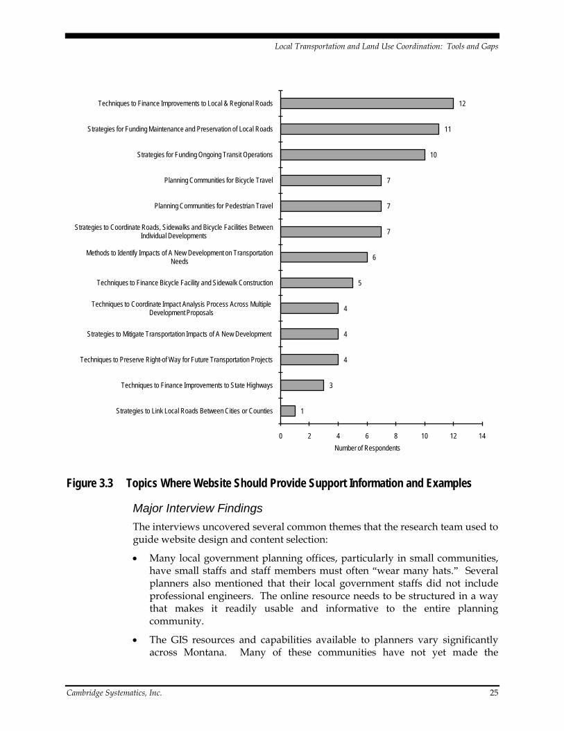
Figure 3.3 shows the detailed topics where the online resource could provide the most support information and examples. A substantial focus is placed on local and regional roads, and both the financing of improvements and the funding of maintenance for those roads. Transit also emerged as a major focus, with nonmotorized transportation also a topic area of interest.
Initial Interviews Interviews of land use and transportation planning professionals in Montana were conducted to determine current practices and needs. The interviews included a range of geography (with populations ranging from less than 10,000 to 100,000) and community growth types. In total, 23 local planning professionals were interviewed for this project. Many of these individuals had participated in the earlier web-based survey that was reported in the prior section of this report. The interview guide is included in Appendix B.
Local Transportation and Land Use Coordination: Tools and Gaps
Cambridge Systematics, Inc. 25
Figure 3.3 Topics Where Website Should Provide Support Information and Examples
Major Interview Findings The interviews uncovered several common themes that the research team used to guide website design and content selection:
• Many local government planning offices, particularly in small communities, have small staffs and staff members must often “wear many hats.” Several planners also mentioned that their local government staffs did not include professional engineers. The online resource needs to be structured in a way that makes it readily usable and informative to the entire planning community.
• The GIS resources and capabilities available to planners vary significantly across Montana. Many of these communities have not yet made the
1
3
4
4
4
5
6
7
7
7
10
11
12
0 2 4 6 8 10 12 14
Strategies to Link Local Roads Between Cities or Counties
Techniques to Finance Improvements to State Highways
Techniques to Preserve Right-of Way for Future Transportation Projects
Strategies to Mitigate Transportation Impacts of A New Development
Techniques to Coordinate Impact Analysis Process Across Multiple Development Proposals
Techniques to Finance Bicycle Facility and Sidewalk Construction
Methods to Identify Impacts of A New Development on Transportation Needs
Strategies to Coordinate Roads, Sidewalks and Bicycle Facilities Between Individual Developments
Planning Communities for Pedestrian Travel
Planning Communities for Bicycle Travel
Strategies for Funding Ongoing Transit Operations
Strategies for Funding Maintenance and Preservation of Local Roads
Techniques to Finance Improvements to Local & Regional Roads
Number of Respondents

Local Transportation and Land Use Coordination: Tools and Gaps
Cambridge Systematics, Inc. 26
transition to generating and managing the type of digital information that can be useful to planning efforts. Moving to broader use of GIS in these communities will require substantial initial and ongoing investment.
• A few planners noted that decision-makers do not appear to consider the long-term cumulative impacts to the transportation system that are caused by the land use changes they approve. Providing some basic information about how land use changes can impact the transportation system may be very beneficial for the online resource.
• Identifying ways to finance necessary transportation system improvements should be a major website topic. Most planners interviewed noted their communities have many times more transportation needs than available funding.
• While national case studies can illuminate the broad range of available land use and transportation planning tools, it is important to highlight best practices in Montana’s communities.
Key Information Learned from Interviews Staffing and Available Planning Resources
The interviews showed a wide discrepancy in staffing among planning departments. As expected, the larger communities typically had the largest number of personnel and specialized staff. The Missoula Office of Planning and Grants (OPG) was the largest planning office among the communities, where interviews were conducted, with more than 60 staff and five departmental divisions. OPG’s staff included 20 general discipline planners, four transportation planners, and four planners devoted to long-range planning. The planning offices in Flathead County, the City of Bozeman, Gallatin County, and Billings had staffs of 10 or more at the time of the interviews. However, Planning and Community Services Department in Billings is slated to lose three staff positions due to budget cuts.
Within the moderately sized and small community growth areas, planning departments typically have five or fewer staff members and several city or county planning offices consist of just one staff planner responsible for all planning functions and services. Carbon County’s planner also fulfills duties as the county sanitarian.
During the interviews, transportation planners as a distinct job classification were identified only in Missoula, Billings, Great Falls, and Gallatin County. However, there was an indication that some staff planners in the larger communities devote significant amounts of time to this planning discipline.
Funding and staffing were listed as impediments to planning in many communities. The lack of planning staff in many of the small community growth areas has required planners to focus on administration and development review processes at the expense of long-range planning. This situation also occurs in

Local Transportation and Land Use Coordination: Tools and Gaps
Cambridge Systematics, Inc. 27
moderately sized high-growth communities although the downturn in the economy and associated decrease in development activity has tended to alleviate some of the staffing concerns. Several planners pointed out that their communities did not have a professional engineer on staff, and such a position could aid the review of technical submittals like traffic impact studies.
Typical Roles and Responsibilities
Based on the interview question responses, planning departments are typically responsible for long-range land use planning (growth policies); transportation planning (to various extents depending on community size); neighborhood and subarea planning; drafting and administering zoning and subdivision regulations; environmental permitting, grant writing, and administration; and special projects. Issuing building permits and building inspections is a duty often handled by another division in some planning departments.
Planners provide input and influence the transportation planning process in four notable ways:
1. Developing land use and transportation-related goals, objectives and policies for the community’s long-range Growth Policy or subarea plans.
2. Participating in the preparation of community Transportation Plans.
3. Providing comments, recommendations, and conditions of approval during subdivision review and zoning processes.
4. Coordinating projects and proposals with other local government staff and MDT. In most communities, the public works department also is involved in matters affecting the road and street system.
Metropolitan planning organizations (MPO) have additional roles and responsibilities because they provide administrative support to the transportation policy coordinating committees (PCC) and technical advisory committees (TAC) within the communities. MPO staff members participate in the development of unified planning work programs, transportation improvement programs, and long-range transportation plans in their communities.
Software and GIS Capabilities
All planning offices contacted have typical office productivity software and most have access to at least some type of GIS resources. Communities with the most extensive GIS resources and capabilities included Missoula, Billings, Bozeman/Gallatin County, and Kalispell/Whitefish/Flathead County. Several small planning offices indicated the only available GIS resources were the result of rural addressing efforts to benefit emergency services providers and the information had limited use for planning applications. Of those interviewed, it appears the larger communities like Missoula, Billings, Kalispell, and Bozeman appear to be making the most use of GIS. Missoula used GIS extensively in its recent Urban Fringe Development Area project to identify the most developable

Local Transportation and Land Use Coordination: Tools and Gaps
Cambridge Systematics, Inc. 28
lands in the community. Missoula and Bozeman/Gallatin County also use GIS to track permitted developments and subdivisions.
Several planners mentioned Google Earth and its value to the planning process by using its aerial photography to the more recent “Street View” capabilities, which provide 360-degree on-the-ground photography in select areas. One of the planners interviewed suggested that improved digital mapping resources could benefit planning for all communities in Montana.
The results of the interviews suggest visualization software is infrequently used by Montana planners. While many planners were aware of this software, the amount of time and costs associated with getting staff trained to use the software was cited as a major reason for not using the tool. Flathead County has used CommunityViz to help to establish residential densities for zoning purposes. The City of Whitefish has the software, but has not used it to date.
MDT’s Planning Division has performed all travel demand modeling for the State’s urban areas for many years. Planners from the Missoula and Billings MPOs indicated they are in the process of assuming the responsibility for travel demand modeling within their communities. This shift will allow for quicker turnarounds with modeling efforts, enable the model to be updated and revised more easily, and allow local planning offices to use other features of the travel demand model like multimodal considerations.
Input from Planners on Land Use Changes and Development Proposals
All of the planners interviewed indicated they rely on a multistep process to review land use proposals. In some communities, developers and potential subdivision applicants are encouraged to share their proposals with planning before entering the formal development review process. These “presubmittal” meetings help ensure the applicant is aware of key requirements and allow planning staff to highlight potential concerns or to suggest modifications more consistent with local plans and with the mindsets of local planning boards and elected officials.
Most of those interviewed said their communities use some form of development review committee composed of technical staff from various city or county departments to review proposals to ensure they meet development standards. Subdivision and zoning proposals are reviewed by planning staff and a staff report is forwarded on to the appropriate decision-maker (ranging from the planning director, to the planning board and city or county elected officials). Planning staff, planning boards, and elected officials all help establish conditions of approval for new subdivisions. These conditions often include requirements for right-of-way and easement dedications, constructing transportation infrastructure, and ensuring transportation network connectivity. Planners noted that transportation recommendations are often made through recommendations placed on zoning requests.
Local Transportation and Land Use Coordination: Tools and Gaps
Cambridge Systematics, Inc. 29
Relationships between Growth Policies, Land Use Plans, and Transportation Plans
There was general agreement among planners about the relationships between growth policies, land use plans, and transportation plans. Growth policies provide the overall policy guidance and vision for the development of communities. Land use plans (including neighborhood and subarea plans) guide the development of specific areas of the community in conformance with the general guidance in the growth policy. Transportation plans layout how the transportation system will be developed in response to the guidance in the growth policy. The development regulations enacted by local governments also reflect the policies contained in the growth policy and transportation plan documents.
Several planners stated that the transportation plan is one of the most used planning documents in the community, and both the transportation plan and growth policy are referenced when reviewing development proposals. Development proposals are reviewed against the policies outlined in each document. While the growth policy does not have “hard and fast lines” for the transportation network, it lays out broad goals and desires for the transportation system. The transportation plan provides the specifics about road hierarchy, access, and jurisdiction that are considered during development reviews.
Coordination with MDT
All planners interviewed indicated they routinely coordinate with MDT and seek their comments about projects that require access to state-maintained highways or that have the potential to impact state highway facilities due to land use changes. This coordination generally occurs when planning offices submit development proposals directly to MDT for comments. Several planners in small community growth areas commented that developers or subdivision applicants are required to contact the appropriate MDT staff to obtain review comments and coordinate access to the state road system. The planning offices then follow-up as needed with MDT staff to ensure that the agency’s comments are duly considered and incorporated into the conditions required for approval of the development.
Coordination usually occurs with the local MDT office or appropriate MDT district office and often depends on the type of project being proposed. Minor actions may be adequately addressed through coordination with local MDT offices and major new developments may need to be reviewed by staff in the district offices and/or by the Planning Division in Helena. Several planners noted that there is a 15-day period to determine if accurate information has been provided to conduct the review.
A coordination practice worth noting occurs in Kalispell where Planning Department staff members conduct weekly site review meetings to discuss current planning applications, development proposals, construction projects, and other issues. The site review meetings are attended by various technical staff from other city departments, local transit authorities, local MDT staff, and often the applicants for development proposals. These meetings provide an excellent

Local Transportation and Land Use Coordination: Tools and Gaps
Cambridge Systematics, Inc. 30
opportunity to coordinate and discuss land use projects and potential effects on the transportation network early on.
The transportation coordinating committees in MPO communities and several of the moderately sized communities in the State appear to provide one of the best means to ensure good coordination between MDT, local government officials, planners, and technical staff on transportation projects and plans and major new land use development proposals. Committee meetings are held frequently (monthly) and the makeup of these committees is large and diverse enough that key information and valuable guidance can be obtained by planning staff at the meetings. These committees are generally well regarded and have helped coordinate transportation planning and establish transportation system improvement priorities for many years in their respective communities.
A notable suggestion for enhancing coordination between MDT and local planning agencies was creating an on-line clearinghouse where current information about MDT projects and their status can be obtained. Since many new development projects happen adjacent to or relatively close to state-maintained highways, knowing what projects are planned and the status of the projects would be valuable information for coordinating land use and transportation planning. MDT is in the process of developing a link on its web site that will provide baseline information of MDT projects included in the current STIP. The most recent mock up includes an interactive map that allows users to select listed projects and find out their status (type of project, contractor, phase of construction, etc.).
Communicating Transportation and Land Use Planning Information with Others
Planning agencies regardless of size appear to make good use of web pages to make land use and/or transportation planning documents and associated information available to the public. The most extensive planning web pages often provide many other resources, including information about community transportation projects and data like functional classifications for the major road system or traffic counts on major roadways. Other information like the status of permitted subdivisions within a jurisdiction can sometimes be found on planning web pages.
Apparent Disconnects Between Land Use and Transportation Planning
A variety of responses about the apparent disconnects between land use and transportation planning in Montana was elicited from those interviewed. A sample of the responses is provided below.
• State highway system planning has traditionally had a rural focus aimed at facilitating the movement of freight, linking communities, and enhancing traffic safety and operations. Montana is not as rural a state as many believe since most residents live in towns or cities and transportation improvements need to better consider these urban environments and needs.

Local Transportation and Land Use Coordination: Tools and Gaps
Cambridge Systematics, Inc. 31
• There has been a significant underinvestment in transportation infrastructure for a long time, and the costs of implementing the recommended network changes are very high. Most transportation plans identify many more transportation improvements than can realistically be implemented over the planning period given the current availability of funding. For example, the City of Kalispell has $200 million in recommended transportation projects but only receives about $1 million per year in urban funds and still has not paid for their share of the last major urban project.
• Many communities do an exceptional job of developing and updating their plans (growth policy, transportation plan, water system master plan, parks, and recreation plan) for infrastructure items but sufficient funding is lacking to make many of the necessary improvements.
• Some respondents perceived that a relatively low value is placed on the benefits of planning in Montana. Land use planning needs to be a priority so it can help identify where infrastructure is needed, where access should be provided, and how the design of the transportation system as a whole can be coordinated.
• There is a lack of recognition and preparedness for the changes in land use that will occur as a result of major changes to the transportation system. Infrastructure improvements almost always seem to be reactive instead of proactive, which means needed facilities might not be in place to serve new development when impacts occur.
• Decision-makers tend to deemphasize the cumulative effects that developments can have on the transportation system. While the impacts of a single development may be relatively minor, the aggregate effects of multiple developments in the same area may be very significant.
• Land use and transportation planning are sometimes viewed as separate things. Better coordination and discussion about how one affects the other is required at local and state level. Making the case to decision-makers and the public that they are linked is difficult. Decision-makers and the public often do not understand or recognize what the real costs are for maintaining and using the transportation system.
• Land use planning is often driven by developers and not by the best overall long-range planning needs of the community. Land use decisions drive infrastructure investments. Decision-makers sometimes tend to downplay the negatives of development proposals due to their potential economic benefits and may overlook what is really best for the community.
• There is a need for a process that ensures communication, coordination, and cooperation between agencies that have responsibilities for the transportation systems. Too often, this communication just happens when individual projects are underway in communities.

Local Transportation and Land Use Coordination: Tools and Gaps
Cambridge Systematics, Inc. 32
Jurisdictional Issues that Affect Land Use and Transportation Planning
Based on the interviews, planners appear to maintain good working relationships with planning staff in other jurisdictions. However, the relationships between the elected officials of cities and counties may not always be as good and there can be some significant differences when it comes to planning and land use changes. Some of these differences may be political and others reflect different approaches to planning and coping with land use changes. In the extreme, it was the opinion of one planner that county officials in his jurisdiction are reluctant to provide the necessary infrastructure into some lands adjacent to the city. The officials appear to have little or no interest in developing these lands. Development patterns allowed to occur on county lands outside cities sometimes create situations where expansion of the road network and other infrastructure is difficult and costly.
A number of planners noted the importance of developing coordinated land use regulations that apply to cities and the extraterritorial zoning on lands adjacent to city boundaries but under county jurisdiction. One of Gallatin County’s planners commented that the City of Belgrade’s planning staff effectively acts as the County’s planning agents in the jurisdictional area around Belgrade.
The City of Whitefish is in the midst of a jurisdictional dispute with Flathead County regarding planning and land use regulatory authority in the two-mile jurisdictional area around Whitefish. The Flathead County Commissioners voted to rescind an interlocal agreement between the city and the county that created the two-mile planning and zoning area for Whitefish and take over planning and zoning responsibility for the area. The matter has been heard and appealed in Flathead County District Court and was considered by the Montana Supreme Court in 2008. The City is now seeking a permanent injunction that would put the interlocal agreement back in force. The outcome of this legal dispute could limit the City’s ability to plan for land use changes and transportation system improvements on the outskirts of the community.
The Missoula and Billings MPOs conduct planning for both the city and county while other local government offices are either city or county. The planners in Billings were of the opinion this arrangement sometimes creates challenging conditions in getting both entities to agree. For example, there is a unified zoning code for the city and county area surrounding Billings that was well accepted by both local governments. However, efforts to develop a unified set of subdivision regulations did not gain acceptance by these entities. The director of the Missoula OPG did not identify any jurisdictional issues and commented that the City of Missoula and Missoula County generally have similar views toward land use and transportation issues.
Financing Transportation System Improvements
The planners interviewed suggest that local governments lack a comprehensive strategy for financing transportation or other infrastructure improvements. All communities rely on a variety of funding mechanisms to help pay for and

Local Transportation and Land Use Coordination: Tools and Gaps
Cambridge Systematics, Inc. 33
maintain the road network, including Federal and state funding, grants, general tax revenue, improvement districts, annual street maintenance assessments, tax increment financing, and development exactions. Several of those interviewed commented that many of the more notable transportation system improvements in their communities have come out of the subdivision review process through development exactions and off-site improvements paid for by developers.
Most communities use system development fees that are devoted to making water and sewer improvements to serve new developments. Developers also are often required to make proportional contributions to future infrastructure improvements to help offset the impacts of their developments.
In communities where impact fee programs have been established, the fees are most often devoted to water and sewer systems, fire and police protection, parks, storm water, and streets. Gallatin County once had an impact fee program, but the program was discontinued after it was not revised in accordance with legislatively mandated requirements. The County has since done a study for a new impact fee, but the county commissioners have not chosen to implement the fees.
The City of Billings has instituted an Arterial Fee that is unique in Montana. This noteworthy program levies a fee on all properties within the City and the resulting revenue is used specifically for constructing and improving arterial roads in the community. Interviews suggest the City of Bozeman has considered such a fee.
The City of Whitefish has been designated as a “resort community” by the state, and has implemented a resort tax that devotes a portion of the revenue to making street improvements and implementing trails projects. The community has been very successful at getting these transportation system improvements built since it adopted the tax.
Mockup Outreach This section summarizes the key agreements or decisions made for the website mockup during the research panel meetings and the stakeholder review of the mockup.
Panel Feedback The research panel conducted extensive review of several rounds of mockups. The panel’s feedback and ultimate direction to the research team is summarized below.
Website Structure
The panel supported the use of a HTML structure primarily because such a structure would be less complex to manage than if a database structure was used and would likely require less time and effort when website updates are made.

Local Transportation and Land Use Coordination: Tools and Gaps
Cambridge Systematics, Inc. 34
Peer Network as Component of the Online Resource
The panel directed the research team to eliminate a peer network (blog or listserv) due to the lack of a long-term peer network moderator. The panel suggested that the peer network concept should be revisited after a permanent maintenance and update plan is established, after completion of the research project.
Examples and Case Studies
Examples and case studies for each strategy serve as a cornerstone of the online resource. The panel supported the inclusion of brief examples illustrating real world applications of each strategy, and between four and eight case studies that detail the integrated use of multiple tools and strategies. Each strategy will have one or more examples that will briefly illustrate a real-world application of the strategy, along with a link for more information. There are about 170 examples included in the online resource, which averages to about five examples for each of the 33 tools. In addition to the strategy-specific examples, eight case studies are to serve as the primary method for demonstrating tool application. Three of the case studies feature Montana communities, four case studies feature small communities in other western states, and one case study features a medium-size community in the Southeast U.S. Each case study demonstrates cross-cutting application of tools and strategies in order to address a range of transportation and land use planning issues for communities of different types.
Website Composition
The panel reviewed and largely concurred with the “Data Assembly and Analysis Results,” and directed the research team to proceed with website development following the recommendations outlined in Tables 3.1 and 3.2. A new broad category for “Financing Transportation Improvements” was added to incorporate appropriate strategies from other related tool categories (Development Exactions, Financing Districts, and Development Incentives).
The panel also directed the research team to drop three of the recommended categories. Strategies from “Developing Multimodal Systems and Networks” were to be folded into “Design Standards and Regulations.” As appropriate, information from “Third Party Technical Assistance” and “Third Party Financial Assistance” was to be instead incorporated into a summary discussion of planning procedures and responsibilities in Montana.
Stakeholder Outreach, Round 1 Seven Montana planning practitioners were invited to review the revised mock-up in late July 2009. The invitees were chosen from a larger list of candidates suggested by the panel, with an attempt made to include individuals who were not interviewed during this project’s prior outreach efforts. Six of these individuals reviewed the online resource and participated in either an in-person or telephone interview:

Local Transportation and Land Use Coordination: Tools and Gaps
Cambridge Systematics, Inc. 35
1. Steve Hess, Senior Planner, Butte-Silver Bow Planning Department;
2. Cal Cumin, Consulting Planner (Billings) and Forrest Mandeville, Planner, Stillwater County Planning Department;
3. Anne Cossitt, Cossitt Consulting (Park City);
4. Randy Carpenter, Land Use Planner, Sonoran Institute, Northwest Office (Bozeman);
5. Ann Cundy, Senior Transportation Planner, Missoula Office of Planning and Grants; and
6. Marcy Hamburg, City/County Planner, Richland County Planner Office (Sidney).
Each interview began with a brief background discussion about the Local Transportation and Land Use research project, a summary of major activities completed to date, and upcoming project tasks. Reviewers were then asked a series of questions that were intended to elicit their opinions about the appearance, organization, and sample content provided in the mock-up. These questions are listed in Appendix C.
Nine general observations and suggestions were drawn from these six interviews. Where appropriate, the research team incorporated the idea in the online resource. However, several comments (number 6 through number 9) are not directly addressed in the draft since they are somewhat inconsistent with direction provided by the panel.
1. All reviewers were supportive of the website concept and acknowledged its potential value as a planning resource for Montana communities. In general, reviewers felt the organization and entry portals for the website were logical and the topics addressed generally covered the range of issues faced by local transportation and land use planners and local decision-makers. However, to ensure its use, the online resource needs to present relevant and current information that can be applied to communities of all sizes.
2. There appeared to be a general consensus among those interviewed that the Montana Association of Planners (MAP) and the Department of Commerce, CTAP should play a role in helping maintain the content of the website and contribute to its future development.
3. Several reviewers noted the content appears pretty heavily weighted towards land use planning. While this is important, reviewers felt the online resource should present information about the important linkages between land use and transportation, why a transportation plan is valuable to communities, what information is needed for a good plan.
4. Few suggestions were received for projects that might comprise examples or case studies for the online resource. However, reviewers noted that examples and case studies should always provide contact information and

Local Transportation and Land Use Coordination: Tools and Gaps
Cambridge Systematics, Inc. 36
links to relevant documents. Planners also want to know what problem or issue was being addressed and the outcome of the project.
5. Several reviewers commented about the importance of responding promptly to questions posed by website users. If questions are not answered within a reasonable amount of time, the website may lose credibility and those seeking information may be discouraged from returning.
6. When informed that a blog (or similar feature) has been discussed as a potential toolkit element, most reviewers supported the idea.
7. A few individuals suggested that the online resource needs to appeal to a wider audience than just the planning community. Volunteer planning board members, local government department heads, and elected officials are all potential users and there is a need to provide materials that can help educate those making decisions in the community.
8. Several reviewers appeared to be seeking specific guidance to help resolve ongoing or recent planning issues within their communities such as concerns over items like when local governments should require developers to pave roadways, fire protection, storm water management, etc.
9. Some additional topics were suggested for inclusion in the online resource:
a. Planning and wildlife considerations;
b. Planning for transportation-related noise;
c. Conservation design – sustainability and energy efficient subdivision design;
d. Best practices and new trends in planning;
e. MDT’s transportation planning process (How does MDT plan, justify and develop projects?); and
f. Comprehensive set of links to growth policies, community transportation plans, and Nonmotorized Transportation Plans documents for Montana communities.
Several specific suggestions also were made regarding website functionality. These items were addressed during draft website development:
• Several reviewers felt the items listed under the “Planner Activity” portal are too wordy and should be further refined or grouped differently. For example, the activity titled identifying and planning for transportation needs might be better phrased as preparing transportation plans similar to the item for land use plans.
• The home page needs to make it apparent to potential users what the online resource is about and how it can be used. There needs to be a stronger identifier that clearly lets the user know they are in the “Toolkit” since it will be accessed from MDT’s webpage.

Local Transportation and Land Use Coordination: Tools and Gaps
Cambridge Systematics, Inc. 37
• Several reviewers thought the entire subject line should be an active link instead of using the “boxes with the plus signs” on pages subsequently accessed from the items listed under the “Tool Category” or “Planner Activity” portals.
• Consider providing less information on the website pages or use more of the page to present information. Consider using drop-down menus or buttons to help navigate around the website instead of page reloads.
Transportation and Land Use Summit A Transportation and Land Use Summit was held in conjunction with the Montana Associate of Planners (MAP) conference in Red Lodge, Montana to allow stakeholders to review draft elements and talk about how tools may be applicable for their areas. The summit entailed a 90-minute presentation and open discussion on the afternoon on October 1, 2009 during the MAP conference. Conference participants were provided the following overview prior to the summit:
The Montana Department of Transportation (MDT) is undertaking a research project that will produce an online toolkit of policies, practices, analytic methods, data sources, software and other ideas – collectively known as tools – that can assist Montana’s expanding cities and surrounding areas in better coordinating transportation and land use planning and decision-making. This toolkit is oriented for local transportation and land use planners, and will feature “off-the-shelf” tools now in use nationally that are practical in Montana. The toolkit will illustrate successful tool application in communities throughout Montana and similar states through a series of vignettes and cross-cutting case studies. The research project is also aimed at identifying promising but underdeveloped planning approaches that are worthy of further research and/or development in subsequent efforts. This presentation will represent the public introduction of the draft toolkit. The research team will provide a brief overview of the research objectives and activities, describe the toolkit structure and major content, and demonstrate use of the toolkit. The research team will also lead a facilitated discussion with conference attendees.
The primary intent of the summit was to generate interest and excitement in the online resource, gather suggestions on feasible enhancements between the draft and final versions of the online resource, and generate longer-term deployment and maintenance ideas that could be discussed with the research panel. The research team structured the summit into six presentation elements:
1. Overview of the research project and website objectives;
2. Review of survey results and stakeholder feedback;
3. Demonstration of the online resource;
4. Further information on case studies and vignettes;

Local Transportation and Land Use Coordination: Tools and Gaps
Cambridge Systematics, Inc. 38
5. Transition to facilitated discussion, including testimonial from panel member Chris Saunders on how he will use the online resource; and
6. Facilitated discussion.
The research team approached the facilitated discussion with a short list of questions to help keep things moving, but a very flexible framework to allow the discussion to evolve. The five discussion topics were:
1. “Will this information help you improve the integration of local decision about transportation and land use?”
2. “What material presented today would you be most likely to use?”
3. “How could the online resource evolve to be more useful and relevant for your needs?”
4. “Are there major gaps in planning practice or examples that have not been identified?”
5. “Are there ways to improve the website’s organization or content to further improve its usefulness to Montana’s local planners?”
Approximately one-half of the summit consisted of open discussion with the approximately 30 participants. Summit participants were generally MAP members, and were typically either employees of Montana county or local governments or planning consultants. The major input and feedback from the summit participants is described in Section 6.0 (Implementation).
Stakeholder Outreach, Round 2 MDT’s representatives to the research panel conducted an additional round of stakeholder outreach in early December 2009. As part of this outreach, 13 individuals were asked to review the final online resource. None of these individuals had been previously interviewed for this project. The individuals were asked to respond to five questions:
1. “MDT does not want to dictate local policy. Does the website content seem to suggest otherwise?”
2. “What key topics or resources are missing?”
3. “Is it easy to find useful information? How could it be made more user-friendly?”
4. “How would you use this site?”
5. “What is your general opinion of the work?”
Seven of the 13 individuals provided written comments. There was general agreement among the respondents on the following items:
• Substantive agreement with the content was expressed. Most respondents liked the work and gave their own ideas. Respondents were informed by MDT that most substantive suggestions will be considered in later updates.

Local Transportation and Land Use Coordination: Tools and Gaps
Cambridge Systematics, Inc. 39
• The web site seems transparent about its purpose. No respondents noted that this seems to be pushing policy or agendas.
• Ease of navigation was typically noted as a positive.
• Almost all the general evaluative comments were very positive. Respondents liked the site and reported that it exceeded their expectations.
• Some reports of slow load times, perhaps associated with photos, and some formatting issues.
• Some respondents noted that content seemed heavily weighted towards Coordination and Consensus Building and policy, with more content needed on technical analysis topics.
One respondent provided slightly more critical feedback, suggesting that the website pages were hard to print (preferred a print edition), the content seemed general, and the “look and feel” could be fresher (it looks like a standard MDT web page).
3.3 MONTANA TRANSPORTATION AND LAND USE: RESOURCES FOR GROWING COMMUNITIES The Montana Transportation and Land Use: Resources for Growing Communities web site can be accessed at: http://www.mdt.mt.gov/research/toolkit/.
The website contents are available through three major “portals” entitled Tools, Resources, and “How Do I?” described in more detail below. All three portals are available on the home page, as shown in Figure 3.4. In addition, a drop-down menu displayed on the left side of all pages allows the user to navigate easily from one type of portal to another.

Local Transportation and Land Use Coordination: Tools and Gaps
Cambridge Systematics, Inc. 40
Figure 3.4 Home Page
In addition to the main portals, the menu includes a “contact us” link to a pop-up message form in which the user can compose and send questions and comments to the MDT online resource manager. In addition, the user can type a word or phrase into the “search” bar to pull up a list of relevant pages; although the online resource currently resides on the overall MDT web site, the search function is internal to the online resource. Finally, a banner at the top of each page providers the user with links to the main MDT web site.
Tools Portal The Tools portal features four major categories: communication and consensus building; planning and policy development; financing; and technical analysis. Within each category, the user is provided with an overview description and links to related subcategories and tool implementations. Figure 3.5 illustrates the

Local Transportation and Land Use Coordination: Tools and Gaps
Cambridge Systematics, Inc. 41
portal for the planning and policy category.1
A few tools appear in more than one category. Table 3.4 displays a list of all tools and implementation strategies included in the online resource.
Figure 3.5 Portal to Planning and Policy Category
1 http://www.mdt.mt.gov/research/toolkit/m1/pptools.shtml.

Local Transportation and Land Use Coordination: Tools and Gaps
Cambridge Systematics, Inc. 42
Table 3.4 Hierarchy and Relationship of Tool Categories, Subcategories, and Implementations
1. Coordination and Consensus-Building Tools a. Community Engagement
i. Charrettes ii. Visioning and Scenario Planning iii. Visualization iv. Workshops
b. Interagency Coordination i. Resource and Funding Coordination ii. Shared Development Of Plans and Policies
2. Planning and Policy Tools a. Growth Management
i. Growth Policies ii. Concurrency/APF Ordinances iii. Development of Regional Impact Review iv. Urban Growth Boundaries v. Rural Land Conservation Easements vi. Transfer Of Development Rights
b. Design Standards i. Access Management ii. Frontage Road Requirements iii. Land Use Regulations iv. Roadway Design Manuals and Guidelines v. Multimodal Street Classification Systems vi. Pedestrian and Bicycle Facilities and Trails
3. Financing Tools a. Development Exactions and Incentives
i. Impact Fees ii. Trip Credits iii. Density Awards and Bonuses iv. Transfer Of Development Rights
b. Financing Districts i. Tax Increment Financing Districts ii. Resort And Local Option Taxes iii. Urban Transportation Districts iv. Parking Benefit Districts v. Transportation Utility Fees
4. Technical Analysis Tools a. Data Collection
i. Primary Data Collection ii. Secondary Data Collection
b. Traffic Analysis i. Sketch Planning Software ii. Multimodal Analysis
c. Transportation and Land Use Analysis i. Connectivity Measures ii. Scenario Planning Analysis

Local Transportation and Land Use Coordination: Tools and Gaps
Cambridge Systematics, Inc. 43
Within each tool page, the user can read an overview of the tool and then “drill down” further to a variety of relevant subcategories and implementation strategies. Figure 3.6 illustrates the portal for the design standards and policy subcategory,2 which nests under the planning and policy category. Figure 3.7 illustrates the portal for the multimodal street classification system implementation strategy,3
Within each strategy page, the user can read a detailed description of the strategy’s purpose, function, and applicability to various situations, along with examples, case studies, and links to more information as well as relevant Montana statutes. The information is presented in a readable “question and answer” format illustrated with graphics and a “dashboard” of quick references that help the user assess the potential usefulness of the strategy to his or her situation.
which nests under the design standards and policy subcategory.
Resources Portal The “Resources” portal provides links to case studies and a variety of resource material organized into three basic pages. First, the case studies page provides links to the eight case studies compiled for the research project. As noted above, each tool strategy page provides links to selected case studies; this summary list in the resource portal simply provides a quick way to look at all of them. Figure 3.8 illustrates the layout of the case study page, using Missoula as an example.4
The “Montana Transportation Planning 101” page, as shown in Figure 3.9, provides an introduction to basic transportation planning concepts, practices, and resources specifically relevant to Montana.
As shown in the dashed box on the figure, each case study also is available for download in PDF format.
5 Finally, the “Key Transportation Planning Resources” page, shown in Figure 3.10, provides a broader overview of national best practices and links to reference material commonly used by transportation planners and engineers.6
2 http://www.mdt.mt.gov/research/toolkit/m1/pptools/dsr.shtml. 3 http://www.mdt.mt.gov/research/toolkit/m1/pptools/ds/mscs.shtml. 4 http://www.mdt.mt.gov/research/toolkit/m1/casestudies/missoula_ufda_mt.shtml. 5 http://www.mdt.mt.gov/research/toolkit/m1/mp101.shtml. 6 http://www.mdt.mt.gov/research/toolkit/m1/genres.shtml.

Local Transportation and Land Use Coordination: Tools and Gaps
Cambridge Systematics, Inc. 44
Figure 3.6 Portal to “Design Standards and Policy” Subcategory

Local Transportation and Land Use Coordination: Tools and Gaps
Cambridge Systematics, Inc. 45
Figure 3.7 Portal to “Multimodal Street Classification Systems”
Implementation

Local Transportation and Land Use Coordination: Tools and Gaps
Cambridge Systematics, Inc. 46
Figure 3.8 Sample Case Study Layout

Local Transportation and Land Use Coordination: Tools and Gaps
Cambridge Systematics, Inc. 47
Figure 3.9 Montana Transportation and Land Use Planning Resources

Local Transportation and Land Use Coordination: Tools and Gaps
Cambridge Systematics, Inc. 48
Figure 3.10 National Transportation and Land Use Planning Resources
“How Do I?” Portal The “How Do I?” portal features a list of typical questions and situations often faced by Montana planners as they seek to coordinate land use and transportation plans. When the user clicks on a question, a page comes up with a brief discussion of relevant issues and links to tools, strategies, and case studies. This portal provides access to the same information as the “Tools” portal, but in a way that allows the user to quickly find tools related to a specific concern. The questions were compiled by the research team using themes developed from the stakeholder survey and interviews, and were reviewed and revised in consultation with the research panel. Figure 3.11 provide a sample layout for the “Funding Transportation Improvements” page.7
7 http://www.mdt.mt.gov/research/toolkit/m2/fti.shtml.

Local Transportation and Land Use Coordination: Tools and Gaps
Cambridge Systematics, Inc. 49
Figure 3.11 Sample Layout of a “How Do I?” Page
3.4 GAP ANALYSIS A gap analysis was undertaken to assess the sufficiency of information gathered for the online resource in meeting the research objectives – namely, providing a range of activities and examples that local planners could follow to better coordinate transportation and land-use decisions in smaller, rapidly growing communities. The gap analysis extended the data assembly and analysis work steps by critically evaluating the assembled content and the feedback gained through multiple rounds of stakeholder outreach. This evolution identified areas

Local Transportation and Land Use Coordination: Tools and Gaps
Cambridge Systematics, Inc. 50
where additional information is needed due to shortcomings in either the state of the practice or the extent of current documentation.
The entire gap analysis process is summarized in tabular form in Table 3.5. Phase I of the process is summarized in the left-hand portion of each page (to the left of the “other comments” column), while Phase II is summarized in the right-hand portion of each page. The overall research priority recommendations are shown in the right-most column in this table.
The development and maintenance cost ranges shown in Table 3.5 reflect the research team’s opinion of the likely effort to develop and maintain a tool that addresses the identified gap. The cost ranges include agency staff time, contractors or consultants, research administration, information technology support (where applicable), and related costs. The ranges can be interpreted as follows:
• Low: Less than $100,000 in development cost. Less than 0.1 FTE in ongoing maintenance.
• Medium: Between $100,000 and $300,000 in development cost. Between 0.1 and 0.4 FTE in ongoing maintenance.
• High: More than $300,000 in development cost. More than 0.4 FTE in ongoing maintenance.
The nature of the gaps and suggested tools for the 21 implementations and two subcategories with gaps are described below. These conclusions are organized by tool category.
Coordination and Consensus Building Many Montana communities face a challenge with facilitating communication and coordination, given limited staff and funding resources. Also, many Montana communities have no professional planners, let alone professional facilitators, available to design and conduct a consensus-building process. Yet the importance of a well structured, carefully managed process cannot be denied. Poorly designed public meetings or committee work sessions can really damage a community’s ability to identify shared goals and work together toward accomplishing them. The major need for the implementations within this tool category relate to identifying additional examples, tools, and technical resources that citizen planners and small staffs can use to structure their own transportation and land use planning processes.

Local Transportation and Land Use Coordination: Tools and Gaps
Cambridge Systematics, Inc. 51
Table 3.5 Gap Analysis Conclusions
Tool Implementation
Tool Coverage in Online Resource Nature of Primary Gap
(i.e., Need Not Currently Served)
Other Comments (i.e., purpose and application
of proposed tool)
Type(s) of Tool Development Cost Range
Maintenance Cost Range
Likely Perceived Value for Potential Partners
Suggested Relative Priority
for Future Development St
ate o
f Pra
ctice
Com
mun
ity T
ype
Reso
urce
Nee
d
Mont
ana U
sage
Peer
Com
mun
ity U
sage
Case
Stu
dies
Tool
Not
Well
Dev
elope
d
Tool
Not
at R
ange
of S
cales
Tool
Not
Dev
elope
d to
“M
onta
na C
onte
xt”
Insu
fficie
nt E
xam
ples
No G
ap E
xists
Addi
tiona
l Con
tent
Hard
copy
Mat
erial
(e.g
., pa
mph
lets o
r gui
debo
oks)
Sam
ple A
nalyt
ic Ap
proa
ches
Sam
ple S
tatu
tes,
Ordi
nanc
eces
, App
licat
ions
, et
c.
Softw
are o
r On-
line T
utor
ials
Othe
r
Low
Medi
um
High
Low
Medi
um
High
Mont
ana C
omm
uniti
es an
d St
ate A
genc
ies
Peer
Com
mun
ities
and
St
ates
in W
este
rn U
.S.
Othe
r Sta
te an
d Na
tiona
l Or
gani
zatio
ns
Coordination (Communication) and Consensus Building
Community Engagement
√ Training programs and “do-it-yourself” guides would be helpful in building staff capabilities at public agencies to conduct effective outreach and facilitation. Focus on basic skill such as listening, conflict resolution, feedback, etc.
√ √ √ √ High High Medium High
Charrettes Yes Yes Some Some Yes Yes √ Some “low budget” examples, particularly within Montana, would be beneficial.
N/A N/A N/A N/A
Visioning and Scenario Planning
Yes Yes Some Yes Yes Yes √ N/A N/A N/A N/A
Visualization Yes Yes Yes Some Some Yes √ More non-Montana examples and resource links would be beneficial.
√ √ √ Medium Low Low Low
Workshops Yes Yes Yes Yes Some Yes √ More non-Montana examples and resource links would be beneficial.
√ √ √ Medium Low Low Low
Interagency Coordination
√ More targeted tools implementations needed to assist in opening and sustaining dialogue between different agencies. Such tools would help identify areas of common interest and solutions with mutual benefits. (Gap and proposed tool are related to “Community Engagement.”)
√ ü √ ü High Medium Medium High
Resource and Funding Coordination
Yes Yes Yes Yes Yes Yes √ N/A N/A N/A N/A
Shared Development of Plans and Policies
Yes Some Some Some Yes Yes √ Missing multijurisdictional transportation/land use applications in Montana, particularly for smaller communities.
√ √ √ √ High High Medium High

Local Transportation and Land Use Coordination: Tools and Gaps
Cambridge Systematics, Inc. 52
Table 3.5 Gap Analysis Conclusions (continued)
Tool Implementation
Tool Coverage in Online Resource Nature of Primary Gap
(i.e., Need Not Currently Served)
Other Comments (i.e., purpose and application
of proposed tool)
Type(s) of Tool Development Cost Range
Maintenance Cost Range
Likely Perceived Value for Potential Partners
Suggested Relative Priority
for Future Development St
ate o
f Pra
ctice
Com
mun
ity T
ype
Reso
urce
Nee
d
Mont
ana U
sage
Peer
Com
mun
ity U
sage
Case
Stu
dies
Tool
Not
Well
Dev
elope
d
Tool
Not
at R
ange
of S
cales
Tool
Not
Dev
elope
d to
“M
onta
na C
onte
xt”
Insu
fficie
nt E
xam
ples
No G
ap E
xists
Addi
tiona
l Con
tent
Hard
copy
Mat
erial
(e
.g., p
amph
lets o
r gu
ideb
ooks
)
Sam
ple A
nalyt
ic Ap
proa
ches
Sam
ple S
tatu
tes,
Ordi
nanc
eces
, App
licat
ions
, et
c.
Softw
are o
r On-
line T
utor
ials
Othe
r
Low
Medi
um
High
Low
Medi
um
High
Mont
ana C
omm
uniti
es an
d St
ate A
genc
ies
Peer
Com
mun
ities
and
Stat
es
in W
este
rn U
.S.
Othe
r Sta
te an
d Na
tiona
l Or
gani
zatio
ns
Planning and Policy Analysis
Growth Management
√ Implementations in this tool subcategory are very powerful, but not well developed for application in smaller, western communities. Specific gaps and new tools are described for each implementation.
N/A
Growth Policies Some Some Yes Yes Some Yes √ More and better examples of how growth policies can effectively influence local land use and transportation decisions would be beneficial. Sample or model growth policies for different types of communities also may be beneficial.
√ √ √ √ High Medium Medium High
Concurrency/Adequate Public Facilities Ordinances
Some Some No Some Some No √ √ Tool is somewhat complex, with limited number of Montana examples to date.
√ √ √ Low Low Medium Low
Development of Regional Impact Analysis
Some No Some No Some No √ Process is complex, and applications to-date have focused on major regional-level facilities. Most examples are from Georgia and Florida, and no formalized process exists for conducting impact reviews for non-MDT facilities in Montana.
√ √ √ √ Medium Medium Medium Medium
Urban Growth Boundaries
Yes Yes Some Yes Yes Yes √ N/A N/A N/A N/A
Rural Land Conservation Easements
Yes Yes Some Yes Yes No √ Additional examples and case studies, particularly ones describing public agency roles and benefits, would be beneficial.
√ √ √ Medium Medium Low Medium
Transfer of Development Rights
Yes Some No Some Some No √ TDR tools are not widely used because of the level of sophistication that is required to administer them. Tool needs scaling options for smaller communities.
√ √ Low Low Medium Low

Local Transportation and Land Use Coordination: Tools and Gaps
Cambridge Systematics, Inc. 53
Table 3.5 Gap Analysis Conclusions (continued)
Tool Implementation
Tool Coverage in Online Resource Nature of Primary Gap
(i.e., Need Not Currently Served)
Other Comments (i.e., purpose and application
of proposed tool)
Type(s) of Tool Development Cost Range
Maintenance Cost Range
Likely Perceived Value for Potential Partners
Suggested Relative Priority
for Future Development St
ate o
f Pra
ctice
Com
mun
ity T
ype
Reso
urce
Nee
d
Mont
ana U
sage
Peer
Com
mun
ity U
sage
Case
Stu
dies
Tool
Not
Well
Dev
elope
d
Tool
Not
at R
ange
of S
cales
Tool
Not
Dev
elope
d to
“M
onta
na C
onte
xt”
Insu
fficie
nt E
xam
ples
No G
ap E
xists
Addi
tiona
l Con
tent
Hard
copy
Mat
erial
(e
.g., p
amph
lets o
r gu
ideb
ooks
)
Sam
ple A
nalyt
ic Ap
proa
ches
Sam
ple S
tatu
tes,
Ordi
nanc
eces
, App
licat
ions
, et
c.
Softw
are o
r On-
line T
utor
ials
Othe
r
Low
Medi
um
High
Low
Medi
um
High
Mont
ana C
omm
uniti
es an
d St
ate A
genc
ies
Peer
Com
mun
ities
and
Stat
es
in W
este
rn U
.S.
Othe
r Sta
te an
d Na
tiona
l Or
gani
zatio
ns
Planning and Policy Analysis (continued)
Design Standards and Regulations
√ As a whole, this tool subcategory is relatively well developed and described.
N/A
Access Management Requirements
Yes Some Yes Some Yes No √ Additional examples of access management in the context of local transportation networks might be beneficial.
√ √ √ Medium Medium Low Low
Frontage Road Requirements
Yes Some Some Some Some No √ Additional examples of frontage roads in the context of local transportation networks might be beneficial.
√ √ √ Low Low Low Low
Land Use Regulations
Yes Yes Some Some Yes Some √ Model zoning codes for Montana communities might be beneficial.
√ √ √ Medium Medium Low Medium
Roadway Design Manuals and Guidelines
Yes Yes Some Some Yes Yes √ N/A N/A N/A N/A
Multimodal Street Classification Systems
Yes Some Some Yes Some No √ Development of a process to transfer to smaller communities and examples of such transfer might be beneficial.
√ √ √ √ Medium Medium Medium Medium
Pedestrian and Bicycle Facilities
Yes Some Yes Some Yes Yes √ N/A N/A N/A N/A

Local Transportation and Land Use Coordination: Tools and Gaps
Cambridge Systematics, Inc. 54
Table 3.5 Gap Analysis Conclusions (continued)
Tool Implementation
Tool Coverage in Online Resource Nature of Primary Gap
(i.e., Need Not Currently Served)
Other Comments (i.e., purpose and application
of proposed tool)
Type(s) of Tool Development Cost Range
Maintenance Cost Range
Likely Perceived Value for Potential Partners
Suggested Relative Priority
for Future Development St
ate o
f Pra
ctice
Com
mun
ity T
ype
Reso
urce
Nee
d
Mont
ana U
sage
Peer
Com
mun
ity U
sage
Case
Stu
dies
Tool
Not
Well
Dev
elope
d
Tool
Not
at R
ange
of S
cales
Tool
Not
Dev
elope
d to
“M
onta
na C
onte
xt”
Insu
fficie
nt E
xam
ples
No G
ap E
xists
Addi
tiona
l Con
tent
Hard
copy
Mat
erial
(e
.g., p
amph
lets o
r gu
ideb
ooks
)
Sam
ple A
nalyt
ic Ap
proa
ches
Sam
ple S
tatu
tes,
Ordi
nanc
eces
, App
licat
ions
, et
c.
Softw
are o
r On-
line T
utor
ials
Othe
r
Low
Medi
um
High
Low
Medi
um
High
Mont
ana C
omm
uniti
es an
d St
ate A
genc
ies
Peer
Com
mun
ities
and
Stat
es
in W
este
rn U
.S.
Othe
r Sta
te an
d Na
tiona
l Or
gani
zatio
ns
Financing
Development Exactions and Incentives
√ Implementations listed below are most widely used tools apart from (or in addition to) project-specific negotiations. Overall subcategory has no gaps.
N/A
Impact Fees Yes Yes Yes Yes Yes Yes √ N/A N/A N/A N/A
Trip Credits Some
Some Yes No Some Some √ Additional tool development and examples needed to highlight situations in which trip credits provide benefit to all parties, particularly as an alternate or supplement to direct payment options.
√ √ √ √ Low Low Low Low
Density Awards and Bonuses
Yes Yes Yes Some Some Some √ Need additional examples in Montana and peer communities, with explanation of types of “public benefits” that are most often cited in smaller communities.
√ √ √ Medium Medium Low Medium
Transfer of Development Rights
See assessment under “Growth Management.” N/A N/A N/A N/A
Financing Districts √ Additional financing tools and examples for smaller communities, particularly for investments other than initial roadway construction, are needed.
√ √ √ √ High High High High
Tax Increment Financing Districts
Yes Some Yes Yes Some No √ Further development and “success stories” for modest-sized investments in smaller, growing communities are needed.
√ √ √ √ Medium Medium Low Medium
Resort and Local Option Taxes
Yes Yes Yes Yes Yes No √ N/A N/A N/A N/A
Urban Transportation Districts
Yes Yes Yes Yes Yes Yes √ N/A N/A N/A N/A
Parking Benefit Districts
Yes Some Some No Some No √ Further explanation of tool application in small communities, particularly implementation techniques and benefits, might be beneficial.
√ √ √ Medium Medium Low Medium
Transportation Utility Fees
Yes Yes Yes Yes Yes Yes √ N/A N/A N/A N/A

Local Transportation and Land Use Coordination: Tools and Gaps
Cambridge Systematics, Inc. 55
Table 3.5 Gap Analysis Conclusions (continued)
Tool Implementation
Tool Coverage in Online Resource Nature of Primary Gap
(i.e., Need Not Currently Served)
Other Comments (i.e., purpose and application
of proposed tool)
Type(s) of Tool Development Cost Range
Maintenance Cost Range
Likely Perceived Value for Potential Partners
Suggested Relative Priority
for Future Development St
ate o
f Pra
ctice
Com
mun
ity T
ype
Reso
urce
Nee
d
Mont
ana U
sage
Peer
Com
mun
ity U
sage
Case
Stu
dies
Tool
Not
Well
Dev
elope
d
Tool
Not
at R
ange
of S
cales
Tool
Not
Dev
elope
d to
“M
onta
na C
onte
xt”
Insu
fficie
nt E
xam
ples
No G
ap E
xists
Addi
tiona
l Con
tent
Hard
copy
Mat
erial
(e
.g., p
amph
lets o
r gu
ideb
ooks
)
Sam
ple A
nalyt
ic Ap
proa
ches
Sam
ple S
tatu
tes,
Ordi
nanc
eces
, App
licat
ions
, et
c.
Softw
are o
r On-
line T
utor
ials
Othe
r
Low
Medi
um
High
Low
Medi
um
High
Mont
ana C
omm
uniti
es an
d St
ate A
genc
ies
Peer
Com
mun
ities
and
Stat
es
in W
este
rn U
.S.
Othe
r Sta
te an
d Na
tiona
l Or
gani
zatio
ns
Technical Analysis
Data Collection Tools √ No gaps for this subcategory. N/A
Primary Data Collection
Yes Some Some Some Yes Some √ Smaller communities could use strategic guidelines on when to collect data, commonly used current and emerging data collection techniques, and how leverage the benefits from a limited data collection program.
√ √ √ √ Medium Medium Medium Medium
Secondary Data Collection
Yes Some Some Yes Yes Yes √ Need tools for smaller communities to gather, store, and rapidly retrieve data from state Department of Transportation and other sources. Rules of thumb are needed for how to approximate missing data from limited available data (e.g., peak-hour volumes from AADT).
√ √ √ √ High High Medium Medium
Traffic Analysis Tools √ No gaps at the subcategory level. N/A
Sketch Planning Yes Some Some Some Some No √ Some national best-practice documents provide techniques for small to medium communities, but very few system-level analysis tools, transferable processes, or data guidelines exist for smaller communities. Could use transferable impact analysis processes, parameters, and sketch-planning tools for cumulative impact analysis at multiple scales.
√ √ √ √ High High High High
Multimodal Analysis Yes Some Some Some Some Yes √ Geared for urban areas; effectiveness measures and standards tend to be system related; need process to identify specific investments in smaller communities, particularly ones that lack background data and/or prior successes from which to draw comparisons.
√ √ √ √ √ High High High High
Transportation and Land Use Analysis Tools
√ No gaps at the subcategory level. N/A
Connectivity Analysis Tools
Yes Yes Some Yes Yes No √ Additional development and examples of tool usage for local transportation network may be beneficial. Could use on-line tool and rules of thumb for application in smaller communities.
√ √ √ √ √ Medium Low Medium Medium
Scenario Planning Analysis
Yes Yes Yes Yes Yes Yes √ N/A N/A N/A N/A

Local Transportation and Land Use Coordination: Tools and Gaps
Cambridge Systematics, Inc. 56
Visualization Phase I Gap Analysis: Tool is well developed and described, but a gap exists in terms of “insufficient examples.” More non-Montana examples and resource links would be beneficial.
Phase II Gap Analysis: Additional content is needed related to non-Montana examples and resources. Although the relative cost for developing and maintaining this tool is likely to be low, the research team designated this tool as low-priority based on the team’s expectation of a low-value proposition for partners and peripheral connection to core research objectives.
Workshops Phase I Gap Analysis: Tool is well developed and described, but a gap exists in terms of “insufficient examples.” More non-Montana examples and resource links would be beneficial.
Phase II Gap Analysis: Additional content is needed related to non-Montana examples and resources. Although the relative cost for developing and maintaining this tool is likely to be low, the research team designated this tool as low-priority based on the team’s expectation of a low-value proposition for partners and peripheral connection to core research objectives.
Shared Development of Plans and Policies Phase I Gap Analysis: Irrespective of the tool or topic, one of the major gaps facing smaller communities is a relative lack of information on how to build and sustain regional coalitions for transportation and land use decision-making. Without incentives to maintain regional cooperation, each community’s transportation system suffers as developers jump between communities to win development approvals for minimum upfront cost. Given this gap in the “Montana context,” smaller communities could benefit from a thorough synthesis of current practice focused on tools used to establish and maintain regional cooperation. These tools should span relevant agency responsibilities including transportation system development, operation, and maintenance.
Phase II Gap Analysis: Sample ordinances or agreements and example applications are needed to illustrate multijurisdictional approaches and incentives for smaller communities. This material could be additional website content under this tool implementation. A “medium” cost to initially develop this new information is anticipated, with a similar level of resource commitment to maintain the content over time. The research team designated this tool as high-priority based on the medium cost range, medium to high value proposition for partners, and the critical role that coordination of work efforts and policies can have in delivering transportation infrastructure and services.

Local Transportation and Land Use Coordination: Tools and Gaps
Cambridge Systematics, Inc. 57
Planning and Policy
Growth Policies Phase I Gap Analysis: While the tool is well developed, scaled for use in Montana, and generally well described, a gap in terms of “insufficient examples” was nonetheless identified. The research team made this designation since growth policies are a foundational growth management tool in Montana, yet their extent of use throughout Montana is still somewhat limited. The research team’s assessment is that additional examples and case studies that detail specific benefits that peer communities have achieved through growth policies may help further their usage.
Phase II Gap Analysis: Additional content in the form of success stories of effective growth policies and model growth policies for small communities are needed. The new content should provide specific examples of how such policies can influence local transportation and land use decisions, and deliver tangible benefits. Developing these examples and model policies will likely require focused investigation of growth policy usage throughout Montana and neighboring states. As such, a “medium” cost is anticipated to initially develop this tool enhancement and maintain the timeliness of the examples and model growth policies. The research team designated this tool as high-priority based on the medium cost range and the medium to high-value proposition and interest for partners, particularly local jurisdictions and other state agencies in Montana.
Concurrency Phase I Gap Analysis: This tool implementation currently is not well scaled for use in Montana given the complex nature of its regulatory underpinnings and the extent of technical analysis and staff time needed to operate the tool. The research time identified gaps in terms of “range of scales” and “Montana context.”
Phase II Gap Analysis: Additional tool development and website content is needed to demonstrate the applicability of concurrency-type procedures in areas with a less-stringent regulatory structure that typically exists with concurrency. Since the cost of this tool development and maintenance is projected to be high and the value proposition for potential partners is likely low, the research team has assigned a low-priority designation to this enhancement.
Development of Regional Impact Analysis Phase I Gap Analysis: This tool implementation is not readily transferable to smaller communities in Montana as it is complex and oriented towards large developments and regional-level facilities. Further, the only cited examples are from Florida and Georgia, although California has somewhat similar requirements under the California Environmental Quality Act. Overall, the tool is not well developed for application by the target audience.

Local Transportation and Land Use Coordination: Tools and Gaps
Cambridge Systematics, Inc. 58
Phase II Gap Analysis: This gap could be addressed through additional website content and examples illustrating application of this tool to smaller communities and local transportation networks. Sample analytic processes to conduct regional-level development reviews with a focus on the local transportation system also would be beneficial. The research team designated this tool as a medium priority based on the medium to high development and maintenance costs combined with a modest level of anticipated interest from potential partners.
Rural Land Conservation Easements Phase I Gap Analysis: This tool is relatively well developed and widely applied by local agencies in Montana, particularly for non-transportation issues. The research team identified a gap for this tool due to the lack of case studies and the lack of tool development for local agencies with staff and resource limitations. Although this is a “borderline” gap, the research team’s assessment is that transferable models may exist in other infrastructure or natural resource topics. For example, market-based land preservation techniques, such as TDR programs, density bonuses, and mitigation banking, offer a win-win approach; whereby developers voluntarily contribute toward conservation of lands outside the location of their proposed project in order to increase the potential return on investment for the project.
Phase II Gap Analysis: Additional website content and examples, particularly from non-transportation efforts, are needed for this tool. Tools designed to apply this type of voluntary cooperation model toward the provision of transportation improvements may provide a mechanism by which the private sector can contribute toward transportation investments that cannot be funded through traditional development exactions, such as off-site local roads, roadway maintenance, and operation of multimodal systems. However, substantial effort may be needed to develop and apply these models to the transportation realm. The research team assigned a medium priority to this tool enhancement due to medium costs and low-value proposition at the national level.
Transfer of Development Rights Phase I Gap Analysis: This tool is not widely used in Montana, partly because of the level of effort required to administer the process. Additional research is needed to identify whether this tool, and the resources needed to implement it, is viable in smaller communities in general, and specifically in Montana. Given these issues and the overall lack of examples, the research team identified a “range of scales” gap for this tool.
Phase II Gap Analysis: The research team was not able to identify a potential research product to address the scaling gap for this tool.

Local Transportation and Land Use Coordination: Tools and Gaps
Cambridge Systematics, Inc. 59
Access Management Requirements Phase I Gap Analysis: In particular, access management requirements have not been widely implemented by Montana’s local jurisdictions, and access management was cited as difficult to apply in smaller, outlying communities.
Phase II Gap Analysis: Additional content, especially examples and case studies, is needed to demonstrate how a small to medium community can apply this tool on its local transportation network. Although the relative cost for developing and maintaining this tool is likely to be low, the research team designated this tool as low-priority based on the team’s expectation of a low-value proposition for partners.
Frontage Road Requirements Phase I Gap Analysis: Frontage roads are a well developed tool for freeways and other major roads. However, tool development and examples are relatively limited for local transportation networks and smaller communities. Additional examples of frontage roads in the context of local transportation networks are needed to resolve the identified gap in “insufficient examples.”
Phase II Gap Analysis: Additional content is needed to demonstrate how a small to medium community can apply this tool on its local transportation network. Although the relative cost for developing and maintaining this tool is likely to be low, the research team designated this tool as low-priority based on the team’s expectation of a low-value proposition for partners.
Land Use Regulations Phase I Gap Analysis: While this tool is well developed, with appropriately scaled examples and case studies, guidance, and best-practices specific to Montana’s regulatory context is not in the online resource. The research team identified a “Montana context” gap for this tool given the lack of specific guidance and examples.
Phase II Gap Analysis: This gap could be addressed by assembling model zoning codes for inclusion in the online resource. These model codes should be sensitive to the range of policy environments that exist throughout Montana. The research team anticipates a modest cost to develop this tool enhancement since expert external review would likely be needed. Once developed, however, the cost to maintain the online resource should be low. The research team assigned a medium priority to this tool enhancement.
Multimodal Street Classification Systems Phase I Gap Analysis: Additional studies of the resources and level of effort involved with implementing a street classification system are necessary, especially for smaller communities. This gap is primarily one of “insufficient examples.” The multimodal street classification systems described in the online resource are focused on urban areas with examples from Denver, Colorado and

Local Transportation and Land Use Coordination: Tools and Gaps
Cambridge Systematics, Inc. 60
Charlotte, North Carolina. The multimodal street classification is not common in Montana communities, although Missoula and Bozeman have incorporated Complete Streets into their planning policies.
Phase II Gap Analysis: Additional content and, potentially, sample analytic approaches are needed to demonstrate how a small community can apply this tool. Further examples with more focus on small community areas also needed. The research team designated this tool as medium priority based on the medium cost range, medium value proposition for partners, and the mention of “multimodal/transit development” in the current research objectives.
Funding and Finance Tools for financing transportation system improvements are another key subcategory tool identified as a need in the previous technical memoranda. Most planners interviewed noted their communities have many times more transportation needs than available funding.
Trip Credits Phase I Gap Analysis: There are no examples of trip credit programs in Montana, and overall the tool appears to be poorly developed for small communities. The only example cited is from the City of Rockville, Maryland, in the Washington, D.C. metropolitan area. This gap is primarily one of the “tools not well developed.”
Phase II Gap Analysis: Additional tool development, content, examples, and case studies are needed to highlight situations in which trip credits provide benefits to both the developer and the public agency, particularly as an alternate or supplement to more direct financial exactions from the developers. The research team assigned a low-priority to this tool enhancement based on an anticipation of low interest from potential partners.
Density Awards and Bonuses Phase I Gap Analysis: The applicability of density awards and bonuses to smaller communities is not readily apparent, given the relatively few numbers of examples and case studies from Montana and peer communities. While the tool is well developed, scaled for use in Montana, and sufficiently described in the online resource, a gap exists in terms of “insufficient examples.”
Phase II Gap Analysis: Additional content is needed in the form of additional examples from Montana and peer communities. The additional content also should describe the types of public benefits that are most often achieved with this tool in smaller communities. The research team assigned a medium priority to this tool enhancement based on the relatively low cost to resolve the gap and an anticipated medium level of interest within Montana and neighboring states.

Local Transportation and Land Use Coordination: Tools and Gaps
Cambridge Systematics, Inc. 61
Tax Increment Financing Districts Phase I Gap Analysis: Overall, this tool is well developed with several proven examples in Montana. The team identified a potential “Montana context” gap due to the lack of detailed Montana case studies, particularly for modest-sized transportation investments in smaller communities.
Phase II Gap Analysis: Additional content is needed in the form of Montana case studies and sample applications of how to structure a TIF to support small, local transportation projects. The research team assigned a medium priority to this tool enhancement based on the low to medium cost to resolve the gap and an anticipated medium level of interest within Montana and neighboring states.
Parking Benefit Districts (PBD) Phase I Gap Analysis: While the tool is well developed and its use in Helena shows potential applicability in a smaller Montana community, the research team identified a “Montana context” gap since free parking seems to be the norm in Montana; wider applicability of funding programs based on parking charges is unknown.
Phase II Gap Analysis: Parking benefit districts are more applicable in urban areas and downtown business centers, and may not be as useful in smaller communities. Although successful in Helena, more research is needed to determine whether this tool is more widely applicable, what implementation techniques work, and what tangible benefits can be achieved in smaller communities. In spite of modest projected interest from potential partners, the research team has assigned a medium priority to this tool enhancement since worldwide research has shown that actively managing parking cost and availability is a potent transportation and land use planning tool.
Technical Analysis Technical impact analysis is an essential transportation and land use planning tool, especially for assessing development impacts, understanding multimodal and transit options, and identifying viable opportunities for local street networks. Good impact analysis procedures also are important for establishing a nexus to support a decision to impose developer-supported fees. The on-line stakeholder survey conducted for this research project identified Impacts of a New Development on Transportation Needs as one of the topics most frequently cited by planners as an area in need of additional information.
Primary Data Collection Phase I Gap Analysis: Primary data collection is widely used by medium and large communities, but can be too costly for smaller communities to undertake on an ongoing basis. While the website explains data collection techniques, the research team identified a “tool not well developed” gap due to the lack of

Local Transportation and Land Use Coordination: Tools and Gaps
Cambridge Systematics, Inc. 62
information on how local communities can structure a data collection program to meet a range of planning and decision-making needs.
Phase II Gap Analysis: Smaller communities could use strategic guidelines on when to collect data, commonly used current and emerging data collection techniques, and how to leverage the benefits from a limited data collection program. This guidance could be added to the website in the form of a best-practices review of data collection programs among peer communities. A medium cost is projected to develop and maintain this addition.
Secondary Data Collection Phase I Gap Analysis: Secondary data collection also is widely used by medium and large communities. However, high costs and lack of staff resources to find, retrieve, and manipulate secondary data can limit this tool’s usefulness for smaller communities. Many smaller communities also lack locally generated data from which necessary comparisons and adjustments to secondary data can be derived. Based on these shortcomings, the research team has identified a “range of scales” gap with this tool implementation.
Phase II Gap Analysis: Additional content in the form of an on-line tool or sample procedures to assist smaller communities with gathering, storing, and rapidly retrieving data from MDT and other sources. Rules of thumb also are needed for how to approximate missing data from limited available data (e.g., peak-hour volumes from AADT). Although this tool enhancement is projected to have a medium to high value proposition for potential partners, the research team assigned a medium priority based on higher development and maintenance costs.
Sketch Planning Phase I Gap Analysis: Numerous national guidance documents and training sessions exist to assist transportation and land use planners in larger metropolitan areas. However, there is limited availability of transferable analytic tools for smaller communities, particularly those that face rapid growth or extreme seasonable peaking due to recreational travel. Further, many of the tools that are available require a minimum level of training and sustained usage that is difficult to achieve in communities that have limited planning and public works staff. While there are many dimensions to this gap, it is primarily a “range of scale” issue.
Phase II Gap Analysis: Additional content is needed in the form of sample analytic procedures or downloadable software. This content should provide transferable impact analysis processes, parameters, and sketch-planning tools for cumulative impact analysis at multiple scales in smaller communities, particularly communities that do not have access to their own travel demand model. Although a high cost is anticipated to develop this content, the research team assigned a high priority based on an anticipated high level of interest from

Local Transportation and Land Use Coordination: Tools and Gaps
Cambridge Systematics, Inc. 63
all potential partners and the repeated expressions of interest during stakeholder outreach for these features.
Multimodal Analysis Phase I Gap Analysis: While multimodal analysis techniques are generally well-developed, their usage in the planning profession still remains limited. As currently developed, this tool is best suited for larger urban areas since the effectiveness measures and standards tend to be system related. The research team identified a “range of scales” gap due to the lack of fine-tuning for smaller communities.
Phase II Gap Analysis: Additional content, especially sample analytic procedures and best-practice applications from peer communities, are needed to assist small communities identify specific transit and nonmotorized needs and potential implementation opportunities, potentially, including funding, that arise from new development proposals. These enhancements may range from a question-and-answer checklist to detailed multimodal performance measures that can be used to indicate problems and ways to improve each mode. The enhanced tool implementation needs to be usable by communities with limited background data and/or prior multimodal successes from which to draw comparisons. As with sketch planning, the research team assigned a high priority in spite of high development costs based on an anticipated high level of interest from all potential partners and the repeated expressions of interest during stakeholder outreach for these features.
Connectivity Analysis Phase I Gap Analysis: The research team identified a “Montana context” gap for this tool due to the lack of development and examples for analysis of connectivity analysis on local transportation systems under the jurisdiction of cities and counties.
Phase II Gap Analysis: Additional content in the form of sample analytic approaches, downloadable software, and usage examples is needed to demonstrate tool application to analysis of local transportation networks. These tool enhancements are projected to have a medium development and maintenance cost. The research team assigned a medium priority based on costs and a modest value proposition for potential partners.
Subcategory Gaps The research team identified gaps in the community engagement and interagency coordination subcategories, as well as the financing district subcategory. The nature of the gaps and suggested tools in these subcategories are described below. The remaining subcategories are not discussed since no issues were identified in the gap analysis.

Local Transportation and Land Use Coordination: Tools and Gaps
Cambridge Systematics, Inc. 64
Community Engagement and Interagency Coordination The gaps in these subcategories are closely related, and are therefore jointly discussed.
Phase I Gap Analysis: While individual tool implementations are well-developed and generally well represented in the online resource, most of those implementations relate to specialized or complex engagement procedures. Additional tool implementations focused on improving more routine, day-to-day coordination are needed. Essentially, the tool implementations do not cover a sufficient “range of scales” of planner activities.
Phase II Gap Analysis: Training programs, manuals, and on-line, do-it-yourself guides would be helpful in building staff capabilities to conduct effective outreach and facilitation on a day-in, day-out basis. The focus of such training material should be on basic skills (e.g., listening, conflict resolution, feedback, etc.) that may not have been previously taught or developed in technically oriented staff. The goal of this new tool implementation is to open and sustain dialogue between agencies, as well as between agency staff and the general public. The research team designated this tool as high-priority based on the medium cost range, medium to high-value proposition for partners, and the critical role that effective communication served in nearly all of the examples and case studies featured in the current online resource.
Discussion: Effective coordination and consensus building are common features in the more successful transportation and land use case studies included in the online resource. This sentiment was echoed by Montana stakeholders during outreach conducted for this research effort. However, most of the communication tools provided in the website focus on large-scale outreach efforts, and miss the day-to-day interaction opportunities that exist between Montana’s planners and their “clients.” Frequently, the quality of these ongoing interactions can set the stage for trust-based relationships between an agency and the general public, decision-makers, and other agencies. Open, ongoing interaction can be critical for identifying areas of common interest and solutions with mutual benefits to all parties.
Financing Districts Phase I Gap Analysis: The tool implementations in the current online resource do not provide enough mechanisms to be applied across all of Montana’s communities, nor are there sufficient examples of these funding tools being used to deploy, operate, and maintain multimodal investments. This lack of breadth is may be exacerbated since some of the other tool implementations included in the online resource may cost more to establish and operate than they deliver in revenue.
Phase II Gap Analysis: It would be helpful to have additional tool implementations, examples, and case studies for funding transportation construction, preservation, and maintenance in smaller, rapidly growing

Local Transportation and Land Use Coordination: Tools and Gaps
Cambridge Systematics, Inc. 65
communities. Furthermore, the successful examples included in the online resource use exactions and fee programs as one element in a comprehensive funding portfolio; additional examples of how those portfolios were developed, marketed, and sustained for smaller communities also would be helpful. Although the relative cost for developing and maintaining this tool is likely to be high, the research team designated this tool as high-priority based on the high-value proposition for partners, the importance placed on funding in the objectives of the current research project, and the continuing mention of inadequate funding during outreach to Montana stakeholders.
Discussion: While long-term funding is the subject of extensive research and discussion at the national level, the focus tends to be on capital needs and larger urban areas. Research related to local transportation investments for smaller communities is not on the radar screen. There is a clear gap in available tools for equitable, adequate, and sustainable long-term funding mechanisms for roadway maintenance at state and local levels. Similar gaps exist for building, operating, and maintaining transit system and nonmotorized facilities in communities of all sizes. The operation and maintenance of roadways, transit systems, and sidewalks or bicycle facilities is an ongoing need that is not necessarily contingent upon usage levels, especially in conditions of rough terrain and harsh weather. Maintenance currently accounts for an ever-increasing share of transportation budgets, and the needs are not likely to decrease over time. Maintenance will continue to be needed even if roadway traffic or transit usage is sparse.
3.5 RESEARCH PROBLEM STATEMENTS The research team identified 23 specific gaps at the tool subcategory and tool implementation levels. The team classified six of these 23 gaps as high-priority:
1. Paying for transportation in smaller, rapidly growing communities. Suburban communities and smaller growing communities typically face multiple challenges when it comes to generating revenues for infrastructure improvements, particularly investments other than initial roadway construction. Additional funding and finance tools, scaled for use in smaller western communities, are needed to allow near-term investments that take advantage of current flexibility, preserve future options, and avoid higher-cost retrofit projects in the future. These tools and examples may include locally generated revenues as well as innovative leveraging of state and Federal funding sources.
2. Transferable processes and data for community-level transportation analysis in smaller communities. The “sketch-planning” tool implementation should be further developed for a broader range of community sizes. Processes, sample data, default values, and sketch-planning tools are needed so that planners in smaller communities can quickly understand and communicate cumulative transportation impacts at
Local Transportation and Land Use Coordination: Tools and Gaps
Cambridge Systematics, Inc. 66
multiple scales – from individual development proposals to community-wide land use plans. These tools would parallel the various resources that exist for project-, corridor-, and system-level planning in mid- to large-sized metropolitan areas.
3. Multijurisdictional approaches and incentives for smaller communities. Smaller communities could benefit from a thorough synthesis of current practice focused on tools used to establish and maintain multijurisdictional agreements and cooperative strategies that promote regional transportation system development, operation, and maintenance. This synthesis would be a beneficial addition to the “shared development of plans and policies” tool implementation.
4. Multimodal transportation system needs and opportunities in smaller communities. Additional development of the “multimodal analysis” tool implementation is needed to assist small communities identify specific transit and nonmotorized needs, and potential implementation opportunities that arise from new development proposals. The enhanced tool implementation needs to be usable by communities with limited background data and/or prior multimodal successes from which to draw comparisons.
5. Staff-level training resources to improve community and interagency communication: Effective coordination and consensus building is the common feature in the more successful transportation and land use case studies included in the online resource. Training programs and on-line do-it-yourself guides would be helpful in building staff capabilities to conduct effective outreach and facilitation. The focus of such training should be on basic skills (e.g., listening, conflict resolution, feedback, etc.) that may not have been previously taught or developed in technically oriented staff. These training tools would address gaps in the “community engagement” and “interagency coordination” tool subcategories.
6. Effective growth policies and success stories. Additional development of the “growth polices” tool implementation is needed to provide specific examples of how such policies can influence local transportation and land use decisions, and deliver tangible benefits. Common features of successful policies in the form of “model growth policies” also would be a beneficial addition to this tool implementation. Such best practices information would be invaluable as Montana communities begin implementing the city-county planning process authorized by SB 201 in 2007 under MCA 76-1-601(4)(c).
These six high-priority gaps were advanced for development of draft research problem statements, which can be found in Appendix D to this report. The other medium- and low-priority gaps may be revisited after conclusion of this research project once activities are initiated to address the high-priority gaps.

Local Transportation and Land Use Coordination: Tools and Gaps
Cambridge Systematics, Inc. 67
4.0 Conclusions The work effort in this research project resulted in an online resource of policies, practices, analytic methods, data sources, software and other ideas – collectively known as tools – to assist Montana’s expanding cities and surrounding areas in better coordinating transportation and land use planning and decision-making. The online resource is oriented for local transportation and land use planners, and features “off-the-shelf” tools now in use nationally that are practical for application in Montana and smaller communities throughout the intermountain west. The resource illustrates successful tool application in communities throughout Montana and similar states through a series of examples and cross-cutting case studies.
The online resource is not
One of the more valuable features of the website is the common structure that is followed for information at each level of the online resource. This structure eases the location of relevant information when moving between website pages. For example, each tool includes a summary “dashboard” indicating the types of communities for which a tool is most applicable and a rough gauge of the tools’ cost and complexity. The dashboard is joined with more detailed information that provides an overview of each tool, who can most benefit from using the tool, keys to success and potential pitfalls, examples of tool usage in other communities, and suggestions on how to get started and where to turn for additional information.
a prescription for local transportation and land use planning. Rather, the website is itself the product of ongoing transportation and land use planning and coordination activities in local communities throughout Montana and other states. Through explanations, examples, and links to other resources, the website illustrates how other local communities have approached transportation and land use issues faced by small, growing cities and counties.
The research project that led to website development focused on four topics:
1. Development and extension of local street networks;
2. Local transportation system financing;
3. Assessment of development impacts on local and state roads; and
4. Direction for multimodal and transit development.
After a review of relevant practices and guidance documents throughout the country, a structured evaluation process was employed to identify the most applicable content and then organize it into four broad tool categories (coordination and consensus building; policy and planning, financing; technical analysis) and 33 unique tool implementation strategies.

Local Transportation and Land Use Coordination: Tools and Gaps
Cambridge Systematics, Inc. 68
The research project identified promising but underdeveloped planning approaches that are worthy of further research and/or development in subsequent efforts. These “gaps” in practice and available information were found to be particularly acute for small, rapidly growing communities. Six areas were identified for development of new research problem statements, and draft statements were developed and are included in Appendix D of this report.
The online resource is a living research product, and its value will only grow through active implementation and periodic updates. As is stated repeatedly throughout this report, outreach and training activities conducted to date must be viewed as initial deployment efforts. The website will not have a useful influence on Montana’s transportation planning practice unless it is maintained, inquiries are answered, and content is periodically refreshed.

Local Transportation and Land Use Coordination: Tools and Gaps
Cambridge Systematics, Inc. 69
5.0 Implementation and Recommendations Several implementation activities were either undertaken or planned in order to initiate website deployment into local transportation and land use planning practices. These activities are described below. The first subsection describes activities undertaken as part of the research plan. The second subsection describes options and the research team’s recommendations for longer-term maintenance and update of the online resources.
5.1 INITIAL DEPLOYMENT ACTIVITY Stakeholder Interviews As noted in Sections 2.2 and 3.2 of this report, several rounds of stakeholder surveys, interviews, and other outreach were conducted to gather information that was used by the research team to inform development of the website structure and content. These outreach activities also played a secondary deployment role by informing stakeholders of future website availability and upcoming demonstration and training sessions. Details on this feedback were provided in Section 3.2.
Transportation and Land Use Summit The primary interactive activity during early deployment consisted of a Transportation and Land Use Summit held in conjunction with the Montana Associate of Planners (MAP) conference in Red Lodge, Montana on October 1, 2009. As originally envisioned, the summit was to be a multihour event, including facilitated discussion and breakout sessions so participants could respond to draft elements and talk about how tools may be applicable for their areas. The summit was also envisioned to allow participants to discuss which tools are most useful or relevant to them, and what needs to be done to make them more applicable for their needs. The summit was to be oriented towards practitioners and agency management in state and local government, and was expected to appeal to land use planners, transportation planners, and engineers (particular those involved with context-sensitive design).
As actually conducted, the summit was scaled back to a 90-minute presentation and open discussion on the afternoon on October 1 during the MAP conference. This reduction in length of the summit was necessitated by the time that was made available by the MAP conference hosts. Breakout sessions were removed from the summit plan in order to accommodate the 90 minute timeslot, but the remaining summit elements, including facilitated discussion, were retained. The

Local Transportation and Land Use Coordination: Tools and Gaps
Cambridge Systematics, Inc. 70
primary intent of the summit was to generate interest and excitement in the website, gather suggestions on feasible enhancements between the draft and final versions, and generate longer-term deployment and maintenance ideas that could be discussed with the research panel.
Approximately one-half of the summit consisted of open discussion with the approximately 30 participants. Summit participants were generally MAP members, and were typically either employees of Montana county or local governments or planning consultants. The major input and feedback from the summit participants consisted of the following:
• Participants expressed excitement about the website and content and encouraged MDT and the research team to complete and deploy the online resources as quickly as possible.
• One participant suggested that the research team “was preaching to the choir” by demonstrating the website to MAP members. This individual suggested that the website be demonstrated to groups that may be less open to the policy implications of the content; suggestions included the Montana Association of Realtors, the Building Industry Association, the Montana Association of Counties, the Montana League of Cities and Towns, and the American Council of Engineering Companies.
• There was general support for inclusion of a blog or peer network as part of the online resources.
• Several participants suggested the online resources should describe how local communities can influence what MDT decides to fund and build. A discussion of the P3 and Red Book processes was requested.
• A photo repository was suggested for the online resources, especially photos or exhibits that illustrate planning or transportation concepts in practice (e.g., access management, pedestrian safety treatments, denser development (at a Montana scale)).
• A new portal into the website content was suggested in order to access information and examples that would involve low labor or cost intensity for local planning staff.
• Several topics were suggested as potential future content: planning for elderly population; health effects of transportation and land use; freight management; working with the railroads, and grade-crossing protection.
Webinars The research plan included a web-based seminar, or “webinar” as one of the initial deployment activities. A webinar is an interactive meeting in which participants view material via Internet connections and engage in discussion via conference call. A single webinar training module was developed that explained the research project, provided an overview of the website layout and content,

Local Transportation and Land Use Coordination: Tools and Gaps
Cambridge Systematics, Inc. 71
and demonstrated how the website could be used for a transportation and land use planning exercise. The one-hour webinar was delivered three times:
1. March 25, 2010 – 10:00 a.m. to 11:00 a.m. mountain time; 2. March 30, 2010 – 11:00 a.m. to 12:00 p.m. mountain time; and
3. March 31, 2010 – 3:00 p.m. to 4:00 p.m. mountain time.
Invitation Process
An e-mail invitation was broadly distributed on March 17 2010 to planning professionals, elected officials, and other prior participants in the research project. The invitation, which is included in Appendix E, introduced the webinar, provided a brief overview of the website, and provided additional links to register for a webinar and get additional information. Through the registration links, prospective participants were allowed to register for one and only one of the three meeting times.
Participation
Twenty-seven individuals representing the following agencies8
• City of Great Falls;
registered and attended one or more of the three webinars:
• Fish and Wildlife;
• WGM Group;
• Montana Education;
• Madison;
• Dawson County;
• Opportunity Link MT;
• Nemont;
• Gallatin County Planning;
• Yellowstone;
• Bearpaw;
• Current Transportation;
• MDT Planning;
• MDT Research;
• Gallatin; 8 The listed organization is the one entered by each participant during the registration process.

Local Transportation and Land Use Coordination: Tools and Gaps
Cambridge Systematics, Inc. 72
• Three Rivers;
• FHWA, Montana Division;
• Fergus;
• Park County;
• Valley County;
• Kalispell;
• Cambridge Systematics (research team);
• Renaissance Planning Group (research team); and
• Robert Peccia & Associates (research team).
Presentation Overview
The webinars were facilitated by George Mazur, the project manager for the research team. Each meeting began with a welcome and recognition of the research team followed by an overview of technical details of the meeting tools and communication features.
Research panel membership and research methodology were explained during an overview of the research process. This discussion was followed with an overview of the stakeholder outreach process and the influence that stakeholder feedback had on the research effort and online resources
The online resources were then demonstrated beginning with the homepage and an introduction to the key navigation components of the site. The tool categories, subcategories and implementations were then reviewed to demonstrate website nesting and the common organizational structure at each level of the online resources. A case study, followed by demonstration of the “how do I,” resources and feedback pages. The pages that were featured in the demonstration included:
• Homepage: introducing the project intent, support resources, and navigational toolbar;
• Category: Financing;
• Subcategory: Development Exactions and Incentives example;
• Strategy: Impact fee example;
• Case Study: Shasta-Tehama Impact Fee Program example;
• Montana Transportation Planning 101;
• Key Transportation Planning Resources;
• How do I: Assess and Mitigate Impacts of New Developments example; and
• Contact Us and Feedback mechanism.

Local Transportation and Land Use Coordination: Tools and Gaps
Cambridge Systematics, Inc. 73
The research team then provided an example of using the website to answer a hypothetical question that might face a transportation or land use planner in Montana: “What resources are available to my agency to fund long-range transportation plans?” The sample application included the following pages:
• Starting from the homepage, selected “Identifying and Planning for Transportation Needs” from the “How do I” module.
• Selected the Eastern Planning Initiative cast study.
• Read the objectives, process, and lessons learned from the selected case study, and noted mention of workshops.
• Explored “Workshop,” “Secondary Data Collection,” and “Multimodal Analysis” from the “Identifying and Planning for Transportation Needs” strategy list.
• Navigated to the “Public Involvement Techniques for Transportation Decision-Making” to under “Where Can I Get More Information” on the Workshop page to view a U.S. DOT manual.
• Back on the homepage, selected “Visioning and Goal Setting” from the “How do I” module.
• From “Visioning and Goal Setting,” compared the costs, complexity, and peer usage of Charrettes, Visioning/Scenario Planning, and Visualization.
• Back on the homepage, selected “Planning and Policy” from the major tool categories and discussed the available information.
Discussion
Three specific questions were posed to webinar participants:
1. “Have any of you had an opportunity to use the online resources?”
2. “Do you have an example of a recent transportation or land use issue from your community?”
3. “Are there ways to improve the web site’s organization or content to make it more useful to Montana’s local planners?”
For many participants, the meetings were their first time seeing the online resources. Without more time to explore the system on their own, participants did not respond to any of the three posed questions, and the discussion instead focused on general resource areas desired by the participants.
Participants requested more information on the following subjects:
• Funding resources.
• Resources for livability initiatives (including Federal).
• Rural funding resources.

Local Transportation and Land Use Coordination: Tools and Gaps
Cambridge Systematics, Inc. 74
In addition, participants asked the following questions:
• Can practitioners upload local resources?
• Does the online resource consider locally developed coordination plans?
Feedback
Many participants had not previously seen the web site, and discussion steered away from specifics about the online resources. One common item of feedback offered during the webinars was that many participants expect to use the tool to find resources related to funding.
Participants were also asked to answer four questions that appeared as an online poll during the beginning and end of the March 30 and 31 webinars. The responses from these two webinars, excluding research team and panel members, were as follows:
• How many people are participating in the webinar at your location (including you)?
– Three people stated they were alone watching the web conference.
– Two people stated they were joined by one other person watching the web conference.
– One person stated they were joined by two other people watching the web conference.
– One person stated they were joined by four or more people watching the web conference.
• What types of organizations are represented by the webinar participants at your location?
– Three people stated “municipal government.”
– Four people stated “county government.”
– One person stated “state government.”
– One person stated “Federal government.”
– One person stated “college or university.”
• Are any elected officials participating in the webinar at your location?
– One person stated “yes.”
– Six people stated “no.”
• Has anyone at your location used the online resource?
– Three people stated “no, not yet.”
– Four people stated “yes, once.”
– One person stated “yes, more than once.”

Local Transportation and Land Use Coordination: Tools and Gaps
Cambridge Systematics, Inc. 75
Informational Brochure The research team developed a two-page informational brochure describing the online resources, relevance of the online resources to transportation and land use professionals, and the underlying research project. This full-color brochure was provided in electronic and hardcopy formats, and is intended to be distributed by MDT and panel members during normal coordination activities with local jurisdictions and transportation professionals throughout Montana. Image captures of the brochure are included in Appendix F.
Peer Network The initial research plan included a suggestion that collaboration efforts initiated as part of website development should be continued through an established peer network that could aid in long-term implementation of the research product. The basic concept was that an initial group of peer network participants would be identified through the surveys, interviews, and summit. These practitioners would serve as an ongoing information-sharing and educational resource group. Through a moderated web-based forum, peer network members would have the opportunity to share updates and information relevant to the online resources.
In discussions during initial research efforts, it was noted that other established peer networks periodically gather for summits and conferences. In addition, members of this peer network with proficiency in speaking, facilitating, and teaching might decide to form a “speaker’s bureau” of professionals that MDT could call upon to help develop workshops and encourage attendance, as well as make presentations to groups around the State. The specific venue for long-term support of the network would be identified and fleshed out as part of a larger strategic plan for MDT’s continued maintenance and development of all the educational resources developed through this study.
While the research panel was intrigued by the potential long-term benefits of a peer network, the panel directed the research team to not develop a peer network as part of initial deployment activities due to the lack of a long-term peer network moderator. The panel suggested that the peer network concept should be revisited after a permanent maintenance and update plan is established, after completion of the research project.
5.2 ONGOING DEPLOYMENT AND MAINTENANCE RECOMMENDATIONS The website is intended to support MDT in its efforts to promote and support integrated land use and transportation planning. The website can help MDT achieve this goal in two ways:
1. Provide Information. Since the toolkit is web based, it will serve as an easily accessible information source for a wide range of interested parties, from local planners and engineers to elected officials and MPO members; and

Local Transportation and Land Use Coordination: Tools and Gaps
Cambridge Systematics, Inc. 76
2. Foster Communication. The web-based structure provides opportunities for cost-effective, continuous communication and information-sharing among MDT, the people who use it, and partners such as other state agencies and organizations.
However, the experience of the research team is that the shelf-life of such web-based tools can be quite short. The planning profession and the regulatory and political environment in which planners operate constantly change. The type of information needed by planners also changes. Therefore, in order for the website to be successful as a credible, useful source of information in the long-term, it must be kept up to date and expanded over time to reflect changing issues and emerging best practices.
The research team’s outreach activities as part of this project must be viewed as initial deployment efforts. The website will not have a useful influence on Montana’s transportation planning practice unless it is maintained, inquiries are answered, and content is periodically refreshed. These points were raised repeatedly through the several rounds of stakeholder outreach, and were acknowledged by the research panel.
The organization that hosts the website must assemble the resources necessary to, at a minimum, conduct the following tasks on a regular basis:
• Maintain the functions of the website such as fixing broken links, correcting errors, and handling logistical tasks associated with the server account.
• Respond quickly and effectively to questions and comments from users by answering questions directly, and/or directing the question to an expert who can assist the user.
• Promote and enhance the usefulness of the online resources by marketing its capabilities, gathering information about how it is, or could be, used, and fostering dialogue and partnerships with organizations and individuals who are willing and able to ensure its long-term success.
• Update and expand the online resources by adding to or replacing existing information, collecting additional case studies and examples, and developing new information about additional topics.
The major attribute of ongoing deployment is that the host agency, either MDT or a partner agency, should assign a staff person who is willing and able to serve as a champion for the website’s long-term success. The champion does not have to supply all the expertise and research capabilities needed to keep the content up to date. In fact, one of the best ways to ensure the relevance and usefulness of the website is to take advantage of its potential to foster communication. Regular users can keep the champion informed about minor problems such as outdated links or errors, and they can contribute new information and ideas to enrich the online resources.

Local Transportation and Land Use Coordination: Tools and Gaps
Cambridge Systematics, Inc. 77
The key attributes of the champion are a willingness and ability to establish ongoing dialogue and partnerships that will produce the information needed to keep the website up to date, and to promote its use among existing and potential users. This effort does not have to be a full-time job, but the host agency should be ready and willing to allocate at least a few hours per month of staff time to this role.
Table 6.1 summarizes the four basic tasks necessary to maintain and enhance the online resources, and some agencies that could take responsibility for them. The host agency could choose a variety of ways to combine resources, including one of the three options described below:
1. The host agency can handle all four tasks in-house. The champion would manage one or more technical staff to handle daily maintenance and to assist with research, and s/he would serve as the “face” of the online resources by establishing partnerships, communicating with users, and identifying opportunities to update the information or develop new material. This option would require a fair amount of staff time from the host agency. The champion would need to be able to manage a small staff, and would need to have some expertise in website-related topics. The agency would have control over the development and management.
2. The host agency can outsource some tasks such as web site development (Task 1) and additional research (Task 4) to partner agencies or third-party contractors. The champion would still serve as the overall website manager, developer, and promoter. This option would entail less overall staff time from the host agency. The champion would need to be able to manage third-party contracts, and would need to have some expertise in website-related topics. The agency would retain control over the website’s overall development.
3. The host agency could outsource all tasks to one or more partner agencies or a third-party contractors. In this case, the champion would play more of a supervisory/liaison role. Examples of this type of arrangement include the U.S. Environmental Protection Agency’s (EPA) contract with ICMA to manage its Smart Growth Network site, and the FHWA’s arrangement with Project for Public Spaces to manage its context-sensitive solutions web site. This option would require the least amount of overall agency staff time. The champion would need to be a seasoned contract manager, and would need to be able to monitor and communicate the ongoing success of the online resources to the agency. The agency would need to “give over” some control of the development and communications to the contracted partner.
The research panel debated the merits of each option in light of the long-term vision for usage by planners in Montana and elsewhere, but was not able to reach consensus on a preferred long-term option. Further, none of the agencies that participated in the research panel expressed a willingness to serve as host agency in the near term.

Local Transportation and Land Use Coordination: Tools and Gaps
Cambridge Systematics, Inc. 78
Nonetheless, ongoing implementation activities are vital to the website’s immediate and long-term success. As such, the following implementation recommendations are offered:
• Implementation activities for the next two years should follow option number 1 and be led by the MDT Rail, Transit and Planning Division. Division leadership should appoint a motivated staff person to serve as the “face” of the website to establish partnerships, communicate with users, and identify opportunities to update the information or develop new material. The research team bases this recommendation on the apparent lack of funding to support outsourcing combined with a need for MDT to actively demonstrate its commitment to the website itself and the spirit of the research process and collaboration that created the online resource.
• Implementation should be founded on solid marketing and aggressive word-of-mouth. All MDT staff that coordinate with Montana’s local planners should be familiar with the online resource and prepared to discuss it during their coordination activities with local communities. Preparation should include providing these staff with copies of the brochure for at least the first year after website launch.
• During the two-year initial implementation period, MDT can demonstrate commitment to the online resource by promptly responding to all inquiries and input on the website and research project. Users need to feel like their input is valued and that MDT is interested in improving the website to meet the need of users.
• Quarterly website updates should be undertaken during the first year, with updates decreasing to semi-annually thereafter. These updates are the primary mechanism to demonstrate responsiveness to user feedback, and should include adding or replacing existing information, collecting additional case studies and examples, and developing content for new topics.
• More comprehensive overhauls should be considered every two years.
• All updates and overhauls should be prominently announced on the toolkit homepage, and, preferably, on the MDT homepage. Announcements should also be made via e-mail to Montana’s planning community. It would be ideal for updates and overhauls to follow a set schedule so that regular users know when to anticipate new content.
• More basic issues such as broken links, inaccurate content, grammar errors, and similar items should be corrected on a semi-monthly basis.
• Long-term hosting options should continue to be explored during the initial two-year implementation period. An ultimate decision guided by resource availability and continued interest in the online resources.
Local Transportation and Land Use Coordination: Tools and Gaps
Cambridge Systematics, Inc. 79
• MDT should aggressively seek research funding opportunities to address the six primary gaps described in Section 3.5. These funding opportunities could arise from educational, state government, federal government or private foundation sources. As part of this activity, MDT should begin circulating the Draft Research Problem Statements in Appendix D with state transportation agencies in peer states to secure co-sponsors and gather feedback that can be used to strengthen the problem statements.

Local Transportation and Land Use Coordination: Tools and Gaps
Cambridge Systematics, Inc. 80
Table 5.1 Maintenance Tasks and Estimated Effort
Maintenance and Development Tasks
Estimated Staff Hours Potential Task Leaders
Week Month Year MDT Partner Agency
Third-Party Management Consultant
Third-Party Research
Consultant
Third-Party Web Site
Management Consultant
State IT Agency
1. Maintain Website Functionality 1.1 Maintain account with host computer
system 1
1.2 Check for and fix broken links and errors 0.5 6
1.3 Upload new information; improve site design and accessibility as needed 1 12
2. Respond to User Questions 2.1 Receive/review incoming questions
(two/week) 0.25 1 12
2.2 Answer questions within area(s) of expertise 0.5 2 24
2.3 Recruit volunteer experts to answer questions outside area(s) of expertise 0.25 1 12
2.4 Refer questions to volunteer experts; follow up to make sure response was handled
0.25 1 12

Local Transportation and Land Use Coordination: Tools and Gaps
Cambridge Systematics, Inc. 81
Table 5.1 Maintenance Tasks and Estimated Effort (continued)
Maintenance and Development Tasks
Estimated Staff Hours Potential Task Leaders
Week Month Year MDT Partner Agency
Third-Party Management Consultant
Third-Party Research
Consultant
Third-Party Web Site
Management Consultant
State IT Agency
3. Promote Ongoing Website Use and Development 3.1 Make presentations to professional
groups, committees, existing or potential users (4-6/year)
0.5 2 24
3.2 Solicit and review feedback and suggestions (ongoing input plus annual survey)
0.25 1 12
3.3 Conduct regular meetings with advisors and supporters (meetings, teleconferences, and/or on-line dialogue)
1 4 48
4. Update and Expand Website Information 4.1 Collect information and update
existing pages (tools, strategies, resources, graphics, examples)
0.25 1 12
4.2 Identify needs for new tools, strategies, resources, examples, and case studies
0.25 1 12
4.3 Research new tools, strategies, examples, and case studies; provide new page/material to host agency for uploading
Contracted or in-house projects

Local Transportation and Land Use Coordination: Tools and Gaps
Cambridge Systematics, Inc. 82
6.0 Bibliography American Association of State Highway and Transportation Officials, Center for
Environmental Excellence Environmental Issues Land Use Case Studies. http://environment.transportation.org/environmental_issues/land_use_sg/success_stories.aspx. Accessed December 9, 2008.
American Association of State Highway and Transportation Officials, Best Practices in Smart Growth and Transportation 2004 Competition. (2005).
American Association of State Highway and Transportation Officials, A Policy on Geometric Design of Highway and Streets, 5th Edition, Washington, D.C., 2004.
American Planning Association, Growing Smart. http://www.planning.org/GrowingSmart/. Accessed December 17, 2008.
Anchorage Metropolitan Area Transportation Study Anchorage on the Move: How the Public Can Effectively Participate in Transportation Planning and Decisions for Anchorage. (June 2001).
Arlington, Virginia Department of Community Planning, Housing and Development, Arlington Virginia Columbia Pike Initiative. http://www.arlingtonva.us/Departments/CPHD/Forums/columbia/CPHDForumsColumbiaColumbiaPikeInitiativeMain.aspx. Accessed November 26, 2008.
Association of Metropolitan Planning Organizations, AMPO Workshops on Integrated Transportation and Land Use Planning Summary of Activities 2005-2006. Association of Metropolitan Planning Organizations, Washington, D.C. (February 2007).
Atlantic Richfield Company, Allocation and Settlement Agreement and Mutual Release of Claims by and Between the City and County of Butte-Silver Bow and Atlantic Richfield Company, Draft. (November 2006).
Brewster, P., The Thurston Regional Trails Plan: An Interdisciplinary and Coordinated Approach to Planning Shared-Use Trails for Transportation and Recreation, Thurston Regional Planning Council.
Brown, J. W., Eco-Logical: An Ecosystem Approach to Developing Infrastructure Projects. Publication FHWA-HEP-06-011. FHWA, U.S. Department of Transportation (April 2006).
Cambridge Systematics, Inc., Montana Comprehensive Highway Safety Plan. Prepared for Montana Department of Transportation (September 2006).
Cambridge Systematics, Inc., Vermont Corridor Management Handbook. Prepared for Vermont Agency of Transportation (July 2005).

Local Transportation and Land Use Coordination: Tools and Gaps
Cambridge Systematics, Inc. 83
Cambridge Systematics, Inc., Tools, Techniques, and Methods for Rural Transportation Planning. NCHRP Report 8-36(32), Transportation Research Board, National Research Council, Washington, D.C. (2004).
Charlotte Department of Transportation, Urban Street Design Guidelines. http://www.charmeck.org/Departments/Transportation/Urban+Street+Design+Guidelines.htm. Accessed December 17, 2008.
Clarion, LSA, EDAW, and AVI, Plan Cheyenne, Cheyenne Area Master Plan Executive Summary. Prepared for Cheyenne MPO, City of Cheyenne, and Laramie County. (November 2006).
Colorado Department of Transportation, Regional Transportation Planning Guidebook. (January 2, 2003).
Colorado Sprawl Action Center, Smart Growth Hall of Fame 2001. (December 2001).
The Danville Project: A Unique Collaboration between Artists and Engineers. Vermont Arts Council. http://www.vermontartscouncil.org/Community/TheDanvilleProject/tabid/72/Default.aspx. Accessed December 1, 2008.
Delaware Department of Transportation, Corridor Capacity Preservation Program: What’s being done to make sure existing roads can handle future economic growth?
Developments for Regional Impact. Georgia Department of Community Affairs. http://www.dca.state.ga.us/development/planningqualitygrowth/programs/regionalimpact.asp. Accessed December 1, 2008.
Developments of Regional Impact. Georgia Regional Transportation Authority. http://www.grta.org/dri/home.htm. Accessed June 28, 2010.
Domestic Scan Tour Report Land Use and Transportation Coordination. U.S. Department of Transportation, Federal Highway Administration. http://www.planning.dot.gov/Documents/DomesticScan/domscan603.htm. Accessed November 26, 2008.
Domestic Scan Tour II Report Integration of Land Use and Transportation Planning: Lessons Learned from the Second Domestic Scan Tour. U.S. Department of Transportation, Federal Highway Administration. http://www.planning.dot.gov/Documents/DomesticScan/domscan2.htm. Accessed November 26, 2008.
Durham, M., Bozeman Bicycle Network Plan, Massachusetts Institute of Technology.
Envision Utah A Public Private Partnership for Quality Growth. http://www.envisionutah.org/. Accessed November 25, 2008.
Ewing, R., and R. Hodder, Best Development Practices: A Primer for Smart Growth. Prepared for the Florida Department of Community Affairs and Published by the American Planning Association.
Federal Highway Administration, Manual on Uniform Control Devices, Washington, D.C., 2003.
Great Falls City-County Planning Department, Missouri River Urban Corridor Plan. (2004).
Local Transportation and Land Use Coordination: Tools and Gaps
Cambridge Systematics, Inc. 84
Hardy, A., T. Bruch, and C. James, Developing the Integrated Transportation and Ecological Enhancements (ITEEM) Process for Montana: Applying the Eco-logical Approach. Proceedings, 2007 International Conference on Ecology and Transportation (2007).
Institute of Transportation Engineers, Context-Sensitive Solutions in Designing Major Urban Thoroughfares for Walkable Communities. (2006).
International City/County Management Association, Balancing Water Quality and Smart Growth Goals – ICMA Webcast Archive. http://icma.org/en/icma/knowledge_network/documents/kn/Document/9003/Balancing_Water_Quality_and_Smart_Growth_Goals__ICMA_Webcast_Archive. Accessed December 12, 2008.
Local Government Commission, Free Resources and Publications. http://www.lgc.org/freepub/index.html. Accessed December 10, 2008.
MacDonald, T., and M. Erker, STEP UP Phase II Statewide Implementation Report. Prepared for Colorado Department of Transportation CDOT-2007-13 (September 2007).
MacDonald, T., and P. Lidov, STEP UP Phase I Report. Prepared for Colorado Department of Transportation CDOT-DTD-2005-03 (May 2005).
Massachusetts Office of Energy and Environmental Affairs, Smart Growth/Smart Energy Toolkit; http://www.mass.gov/envir/smart_growth_toolkit/index.html; accessed October 28, 2009.
Minnesota Environmental Quality Board, From Policy to Reality: Model Ordinances for Sustainable Development. (September 2000).
Missoula Office of Planning and Grants, Envision Missoula Long-Range Transportation Plan. Missoula Planning Summit Report (September 2008).
Missoula Redevelopment Agency and Office of Planning and Grants, West Broadway Corridor Community Vision Plan. (June 2007).
Montana Department of Fish, Wildlife and Parks Montana Statewide Comprehensive Outdoor Recreation Plan, 2008 to 2012. (January 2008).
Montana Department of Transportation, Local Agency Guidelines. Prepared for Montana Department of Transportation (May 2007).
Montana Department of Transportation TRANPLAN 21 Public Transportation Policy Paper. (2007).
Montana Department of Transportation, Montana Department of Transportation Road Design Manual, http://www.mdt.mt.gov/publications/manuals.shtml.
Montana Department of Transportation, Montana Traffic Engineering Manual, http://www.mdt.mt.gov/publications/manuals.shtml.
Local Transportation and Land Use Coordination: Tools and Gaps
Cambridge Systematics, Inc. 85
National Association of Counties, the Joint Center for Sustainable Communities, the U.S. Environmental Protection Agency, and the Smart Growth Network. Local Tools for Smart Growth: Practical Strategies and Techniques to Improve our Communities. U.S. Environmental Protection Agency Cooperative Agreement CX82738701 (2000).
National Association of Development Organizations Research Foundation, Transportation Planning in Rural America: Emerging Models for Local Consultation, Regional Coordination, and Rural Planning Organizations. (December 2005).
New Jersey Future, Smart Growth Gateway, http://www.smartgrowthgateway.org/, Accessed October 28, 2009.
New York State Department of Transportation, Land Use and Transportation Smart Planning, https://www.nysdot.gov/portal/page/portal/programs/smart-planning/products, Accessed October 28, 2009.
Oregon Transportation and Growth Management Program. http://www.oregon.gov/LCD/TGM/index.shtml. Accessed December 9, 2008.
Parsons Brinckerhoff Quade & Douglas, Inc., Land Use Impacts of Transportation: A Guidebook. NCHRP Report 8-32(3), Transportation Research Board, National Research Council, Washington, D.C. (October 2008).
Pennsylvania Department of Transportation, Smart Transportation: It Starts With Me, http://www.smart-transportation.com/, Access October 28, 2009
Resources for the Future, Transfer of Development Right in U.S. Communities. (September 2007).
Rose, D., J. Gluck, K. Williams, and J. Kramer, A Guidebook for Including Access Management in Transportation Planning. NCHRP Report 548, Transportation Research Board, National Research Council, Washington, D.C. (2005).
Rowley, T., Development by Design: Land Use Planning and Regulation in Rural Communities. Contactor Paper 01-01 Prepared for TVA Rural Studies. (January 2001).
Smart Growth Leadership Institute, Smart Growth Implementation Toolkit, http://www.sgli.org/, Accessed October 26, 2009.
Smart Growth Network, Smart Growth On-Line. http://www.smartgrowth.org/default.asp. Accessed December 9, 2008.
Sonoran Institute and RPI Consulting, Fiscal Impact Analysis of Future Growth Scenarios, Beaverhead County, Montana. Prepared for Beaverhead County Commissioners and Planning Commission (January 2007).
Straehl, S., and L. Neumann, Performance Programming Guiding Resource Allocation to Achieve Policy Objectives. Transportation Research Record: Journal of the Transportation Research Board, Vol. 1817 (2002) pp. 110-119.

Local Transportation and Land Use Coordination: Tools and Gaps
Cambridge Systematics, Inc. 86
Thomas Jefferson Planning District Commission, Design Manual for Small Towns: Transportation and Land Use Strategies for Preserving Small Town Character. (January 2004).
Twaddell, H., and D. Emerine, Best Practices to Enhance the Transportation-Land Use Connection in the Rural United States. NCHRP Report 582, Transportation Research Board, National Research Council, Washington, D.C. (2007).
Urban Land Institute, Influence of Transportation Infrastructure on Land Use. U.S. Department of Transportation, FHWA. http://www.fhwa.dot.gov/planning/tranlanduse.htm. Accessed December 11, 2008.
U.S. Department of Transportation, Federal Highway Administration. GIS in Transportation Planning. http://www.gis.fhwa.dot.gov/. Accessed December 18, 2008.
U.S. Department of Transportation, Federal Highway Administration. TCSP Transportation, Community, and System Preservation Program. http://www.fhwa.dot.gov/tcsp/. Accessed November 25, 2008.
U.S. Department of Transportation, Federal Highway Administration, Tool Kit for Integrating Land Use and Transportation Decision-Making. http://www.fhwa.dot.gov/Planning/landuse/index.htm. Accessed November 24, 2008.
U.S. Department of Transportation, Federal Highway Administration, Transportation and Community and System Preservation Pilot Program: Fifth Year Report. Publication FHWA-HEP-05-034 FHWA, U.S. Department of Transportation (June 2005).
U.S. Department of Transportation, Federal Highway Administration. FHWA-TCSP Case Study Number 10 Leveraging Resources: Financing Transportation and Community and System Preservation Projects. (August 2002).
U.S. Department of Transportation, Federal Highway Administration. FHWA-TCSP Case Study Number 8 Public Involvement Strategies for Shaping Communities. (August 2002).
U.S. Department of Transportation, Federal Highway Administration, Transportation and Community and System Preservation Pilot Program: Third Year Report. (November 2001).
U.S. Environmental Protection Agency, Smart Growth, http://www.epa.gov/livability/. Accessed December 4, 2008.
U.S. 50 Access Management Plan Project Web Site. Colorado Department of Transportation. http://www.dot.state.co.us/us50access/index.cfm. Accessed December 17, 2008.
U.S. 6 – Clifton Access Management Plan Project Web Site. Colorado Department of Transportation. http://www.dot.state.co.us/us6clifton/index.cfm. Accessed December 17, 2008.

Local Transportation and Land Use Coordination: Tools and Gaps
Cambridge Systematics, Inc. 87
Vermont Agency of Transportation, Access Management Program Guidelines. (July 2005).
Wang, J., S. Straehl, and K. Leonard, Limited Amendment Process of Montana’s Statewide Transportation Plan to Meet SAFETEA-LU Requirements. Transportation Research Record: Journal of the Transportation Research Board
Washington State Department of Transportation, Local Agency Guidelines. (April 2009).
, Vol. 2077 (2008) pp. 25-31.

Local Transportation and Land Use Coordination: Tools and Gaps
Cambridge Systematics, Inc. 88
Appendix A – Web Survey Questions and Tabulations
An on-line survey was designed for the MDT to obtain input from stakeholders involved in transportation, land use, and related community development topics at the local level throughout Montana. A total of 82 responses were received. Survey questions and a summary of responses are provided in this appendix.
Question 1. Please specify the primary geographic scope of your planning organization?
Table A.1 Primary Geographic Scope of Respondents’ Planning Organization
Number of Responses
Percentage of Respondents
Statewide 8 9.8% Regional 21 25.6% Municipal 40 48.8% Private Development 1 1.2% Interest or Advocacy Group 2 2.4% Other 10 12.2%
Question 2. What is your role in local planning processes in Montana? (Select all that apply)
Table A.2 Respondents’ Role in Local Planning Process in Montana
Number of Responses
Percentage of Respondents
Public Sector Planning Professional (i.e., staff planner, manager)
46 56.1%
Private Sector Planning Professional (i.e., consultant, contract employee)
8 9.8%
Appointed Committee Member 18 22.0% Elected Official 8 9.8% Private Developer 2 2.4% Other Stakeholder 6 7.3% Other 8 9.8%

Local Transportation and Land Use Coordination: Tools and Gaps
Cambridge Systematics, Inc. 89
Question 3. In which aspects of Montana’s local planning process are you involved? (Select all that apply)
Table A.3 Respondents’ Involvement in Montana’s Local Planning Processes
Number of Responses
Percentage of Respondents
Transportation 72 87.8%
Land Use 62 75.6%
Economic/Community Development 47 57.3%
Natural Resources 34 41.5%
Open Space 42 51.2%
Other Municipal Services (i.e., water, energy, recycling, waste) 37 45.1%
Other 5 6.1%
Question 4. In your opinion, how effective are LOCAL planning practices in Montana addressing the impacts of land development decisions on each of the following transportation issues? (Select one box in each row)
Table A.4 Effectiveness of Local Planning Practices in Montana in Addressing Impacts of Land Development on Transportation
Very
Effective
Some-what
Effective
Some-what
Ineffective Very
Ineffective Don’t Know
No Open-
ion
State Highways 6 26 28 16 3 2
Regional Highways 5 19 29 20 5 2
Local Roads 20 35 16 11 0 0
Neighborhood Roads 24 31 16 9 1 1
Pedestrian Access and Connectivity
18 28 18 17 0 0
Bicycle Access and Connectivity 14 29 21 17 1 0
Transit Service 2 22 25 19 5 7
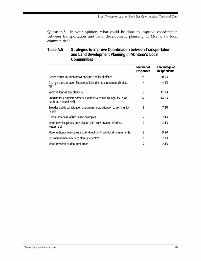
Local Transportation and Land Use Coordination: Tools and Gaps
Cambridge Systematics, Inc. 90
Question 5. In your opinion, what could be done to improve coordination between transportation and land development planning in Montana’s local communities?
Table A.5 Strategies to Improve Coordination between Transportation and Land Development Planning in Montana’s Local Communities
Number of Responses
Percentage of Respondents
Better communication between state and local offices 25 30.5%
Change transportation finance policies (i.e., tax increment districts, TIF)
4 4.9%
Improve long-range planning 9 11.0%
Funding for Complete Streets; Context-Sensitive Design; focus on public transit and NMT
12 14.6%
Broader public participation and awareness, attention to community needs
6 7.3%
Create database of best case examples 2 2.4%
More interdisciplinary consultation (i.e., conservation districts, watershed)
2 2.4%
More authority, resources and/or direct funding to local governments 8 9.8%
No improvement needed; already effective 6 7.3%
More attention paid to rural areas 2 2.4%

Local Transportation and Land Use Coordination: Tools and Gaps
Cambridge Systematics, Inc. 91
Question 6. In your opinion, how effective are LOCAL planning practices in Montana at addressing the impacts of land development decisions on each of the following non-transportation topics? (Select one box in each row)
Table A.6 Effectiveness of Local Planning Practices in Addressing Impacts of Land Development Decisions on the Following Non-Transportation Topics
Very
Effective
Some-what
Effective
Some-what
Ineffective Very
Ineffective Don’t Know
No Open-
ion
Wastewater 20 29 13 10 5 5
Storm Water 12 32 17 12 5 4
Drinking Water 19 26 11 10 7 6
Farmland Preservation 3 24 22 24 7 2
Open Space Preservation 12 26 20 20 3 1
Parks 12 40 17 11 1 1
Visual Resources and Aesthetics 6 27 22 20 4 3
Wetlands 7 36 22 11 5 1
Waterways 11 34 19 10 5 3
Wildlife Management 6 22 27 19 6 2
Energy Usage 1 18 26 28 5 4
Balance Between Housing and Jobs
2 16 28 21 6 8

Local Transportation and Land Use Coordination: Tools and Gaps
Cambridge Systematics, Inc. 92
Question 7. Please identify any specific examples of effective coordination between these non-transportation topics and land development planning in Montana’s local communities. (All responses are shown below. Responses are edited for grammar and spelling, but not content.)
• Development of growth policies that can better define goals and identify policies that will address these issues. Capital improvement programs that can direct what infrastructure is being developed.
• There is a desperate need to coordinate efforts to improve transportation and all infrastructure that is sustainable and not always creating more expense for the average taxpayer.
• I feel it’s up to the planner to coordinate all of these topics when reviewing a proposed development. That includes chasing down feedback from local “authorities” on any of the above topics and then implementing those thoughts into the review of the proposal.
• Need to have a way to address cumulative impacts.
• New subdivision proposals are sent to State and Health and Wildlife agencies, and this works well. Waterway developments are getting more closely scrutinized, and this good.
• Coordination with water/sewer services is excellent on a municipal level. It is very ineffective on a rural level.
• Gallatin County’s Growth Policy Implementation Plan does not seem to coordinate well with farmland protection and soil conservation, despite its best efforts to do so.
• There is no common sense in government. The main focus of government and planning authorities is more regulation rather than incentives. Government agencies only focus on how much regulation they can force on people rather than creating incentives that encourage people to do the right thing. Take for example the regulation that requires 1 residence per 160 acres without subdivision review. This in fact encourages sprawl but the government is too dense to realize this fact. Another example is the population of deer in the city of Helena is greater than the entire county of Lewis and Clark yet the government is still putting forth the notion that development is harmful to wildlife. Many of the planners and lawmakers we now have in Montana were not educated on a farm or ranch but in a school of city folks and are not aware of the importance of property rights and freedoms.
• FWP and MDT wildlife corridors and mechanisms to allow wildlife to migrate across major highways – i.e., tunnel near Bozeman Pass.
• There are none as DOT is incapable of completing a project.

Local Transportation and Land Use Coordination: Tools and Gaps
Cambridge Systematics, Inc. 93
• This answer goes beyond this 5 to 10 minute survey. Please contact local planning entities to learn more.
• The city council of Whitefish adopted a recommendation from the lake shore committee to set guidelines for lake and river side development. Establishing set back and slope angle criteria.
• Local services (water, wastewater, parks, etc.), agriculture, natural resources and wildlife management impacts are addressed at subdivision review level. There is no authority to regulate or mitigate the impact of energy usage or balance between housing and jobs. If local plans had more authority, local jurisdictions could define other areas of concerns for protection and enhancement. The lack of land use controls hampers local governments ability to achieve community objectives.
• Annually, local and regional planners have the ability to attend meetings/seminars where a sharing of information and ideas takes place.
• Again, equestrian needs have been left out of recreation planning and landowners with equines are becoming landlocked or forced to relocate out of town to have a place to ride. A little planning could help preserve this important part of Montana’s heritage and boost the economy by continuing to provide the “Montana Experience” tourists come here for. On another topic, Local planners need more cohesive scientific information on wastewater planning. We need better incentives like tax relief for farmers combined with retroactive taxes when land is taken out of production. I would add trails to this survey!
• The creation of “Living Watershed” by the Whitefish Lake Institute.
• The City of Whitefish recently tried to put together a policy that would preserve waterways, wetlands, and our drinking water and the way it was handled directly affected the outcome. It should’ve been more open with meetings on weekends and evenings instead of at 4pm, more of an educational forum (“this is how our drinking water system works, come take a tour”), and no hiring of local engineers who make a living in the valley, because ultimately concessions were made to the most vocal, heavily financially invested folks, and this was to the long-term detriment of water quality for our community. In my own neighborhood the public works dept tried to build a sewage treatment station right next to a river without public input. We almost lost a repaving project, which we were entitled to, if a comment hadn’t been made on a phone call from me to the engineer, and then a showing of neighborhood support. A development on the river in my neighborhood became a power play between a lumber company manager who was mad at the city for being noncompliant with stream protection laws multiple times…and because of that my neighborhood is at risk for water damages in the future, not to mention the covering of wetlands and building into a steep slope on an outside curve of a river. So…there is a perception that the city only wants to allow development to occur to increase their

Local Transportation and Land Use Coordination: Tools and Gaps
Cambridge Systematics, Inc. 94
budget…or that developers get what they want at the expense of locals-people who live here inherit mold in their basements, or adjacent property damage, and somehow the city (who approved this type of building), isn’t accountable, nor is the developer who has sold the property. The same probably goes for transportation planning-very few people show up at these meetings. Why? It’s important stuff. Anyways, you can tell I have an emotional investment in how this city grows-growing with inclusion allows the values of honesty and integrity to be maintained in our relations, and I am sick of these back alley deals and shady negotiations affecting long-term health and economics of those who don’t have the insight, access or resources to protect themselves. The city should be doing that, but in my experience heavy building periods don’t lead to that, and in a high-end resort like where I live, the pushiest people aren’t always even living here. They don’t have a long-term love of the place or people. I’m sure that this is a problem all across Montana. The only way out of it is to make sure the laws are fair to all, and that the process is transparent and easily accessible.
• Current local subdivision regulations require that many of the agencies that manage these issues above be notified when a land development may impact the area. However, there are limited regulatory tools to actually limit the development based on the impact. A lot of this has to do with the political will to preserve farmland, for example. If it isn’t there, then it doesn’t get preserved. Energy usage and efficiency is becoming a huge issue but Montana seems pretty far behind much of the nation when it comes to both recognizing and addressing energy efficiency and development practices.
• None come immediately to mind.
• Local FWP biologists and local planners regularly meet to discuss planning issues. Environmental health regularly meets with local planners to discuss wastewater issues. Even DNRC has begun communicating with us (and us with them). The point is that these entities RESPOND in a timely fashion (and if they don’t, you can call the people you need to talk with and they get on it rather than just referring you to many more people, none of whom really have responsibility for the project). The problem with MDT is when a project (or request or whatever) disappears into the black box of the machine and you never hear anything back. Or when you talk with the local guys and they look at you with that sense of complete helplessness that comes from working for large, unresponsive bureaucracies.
• Gallatin County’s Open Space Bond. City of Helena and Lewis and Clark County on providing municipal services.
• The City of Bozeman does a good job with some of these issues. The Gallatin County Open Lands program also addresses some of these. To quantify their success, talk with someone who understands them better than I do.
• Cities’ CIP process for Sewer and Water improvements are very effective tools for planning and managing growth.

Local Transportation and Land Use Coordination: Tools and Gaps
Cambridge Systematics, Inc. 95
• There is a distinct lack of clear development standards or zoning tied to local plans in Montana. There is a lack of funding for planning in Montana.
• Laurel, Montana has a combined planning jurisdiction with Yellowstone County, allowing Laurel to plan outside its border and orderly transition to rural area outside the town corporate limits.
• Local governments are limited to statutes – not given enough latitude to make decisions at the local level.
• Custer Avenue in Helena. The City of Helena is very proactive in working with developers and the State to insure that storm water is addressed.
• Education of elected officials and city staff re: DEQ regulations (Wastewater and Water); Outreach by Sonoran Institute and Trust for Public Lands (Farmland, Open Space, Parks, Aesthetics); Outreach by Nature Conservancy, Yellowstone River Conservation District, and DNRC (Wetlands, Waterways); Block Management Program (FWP); Affordable Housing Summits by Dept. of Commerce (Housing/Jobs); Public Finance outreach by WASACT (All).
• MT-FWP Recreational Trails Program focuses on connecting residential, business and recreational areas. Various grant programs that encourage comprehensive approach to providing water, WW, and other public services.
• UFDA in Missoula has made some strides.
• Too numerous…Design Review Board and Planning work hard to preserve parks and open space…Park Review Board works well with both Planning and Neighborhood Councils and Trail Committee.
• City of Bozeman does a good job of trying to ensure good quality parks in new subdivisions. City plan and ordinance language is pretty good.
• Local planning agencies rely on other agencies for input for relative topics and make planning recommendations accordingly.
• Missoula’s UFDA planning addresses most of these issues and sets specific geographic targets for accommodating growth while minimizing/optimizing impacts.
• Coordination is a word often used but seldom followed.
• Kalispell has mapped out its water, waste water and storm water needs for the next 50 years in an area within 3 miles of the city limits.
• Community planners are most effective when actively engaged in Capital Improvements Programming. Development review (of annexations, subdivisions, and site plans) needs to be interdisciplinary, involving all service providers early on in the review process. In our city we utilize a Development Review Committee to ensure all facility issues are addressed.

Local Transportation and Land Use Coordination: Tools and Gaps
Cambridge Systematics, Inc. 96
Question 8. How often do you use any of the following responses to assist you with your planning or policy-making responsibilities? (Select one per row)
Table A.7 Frequency in Using Certain Resources to Assist in Planning or Policy-Making Responsibilities
Frequently (More Than Two Times Per Year)
Occasionally (Two or Fewer
Times Per Year) Never
Nationwide Conferences 7 45 28
Statewide Conferences 18 58 6
Seminars 31 44 6
Professional Associations 37 35 10
Nonprofit organizations 26 42 14
Hardcopy Newsletters 39 30 11
Electronic Newsletters 42 32 8
Internet Search Engines 66 9 6
Internet-Based Training (i.e., webinars)
27 29 26
Other Internet Resources 45 26 9
Internal Agency Resources (e.g., prior studies)
47 25 8
CTAP 20 32 27
Reports from Other Cities or States
47 30 4
Other 6 15 8
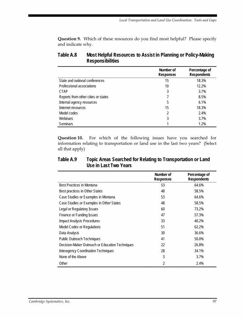
Local Transportation and Land Use Coordination: Tools and Gaps
Cambridge Systematics, Inc. 97
Question 9. Which of these resources do you find most helpful? Please specify and indicate why.
Table A.8 Most Helpful Resources to Assist in Planning or Policy-Making Responsibilities
Number of Responses
Percentage of Respondents
State and national conferences 15 18.3% Professional associations 10 12.2% CTAP 3 3.7% Reports from other cities or states 7 8.5% Internal agency resources 5 6.1% Internet resources 15 18.3% Model codes 2 2.4% Webinars 3 3.7% Seminars 1 1.2%
Question 10. For which of the following issues have you searched for information relating to transportation or land use in the last two years? (Select all that apply)
Table A.9 Topic Areas Searched for Relating to Transportation or Land Use in Last Two Years
Number of Responses
Percentage of Respondents
Best Practices in Montana 53 64.6% Best practices in Other States 48 58.5% Case Studies or Examples in Montana 53 64.6% Case Studies or Examples in Other States 48 58.5% Legal or Regulatory Issues 60 73.2% Finance or Funding Issues 47 57.3% Impact Analysis Procedures 33 40.2% Model Codes or Regulations 51 62.2% Data Analysis 30 36.6% Public Outreach Techniques 41 50.0% Decision-Maker Outreach or Education Techniques 22 26.8% Interagency Coordination Techniques 28 34.1% None of the Above 3 3.7% Other 2 2.4%

Local Transportation and Land Use Coordination: Tools and Gaps
Cambridge Systematics, Inc. 98
Question 11. Please identify your top THREE issues for which you would like to have more information available.
Table A.10 Top Three Issues Where More Information Would Be Helpful Number of Responses
Finance or funding issues 20
Legal or regulatory issues 13
Best practices in Montana 13
Impact analysis procedures 11
Model codes or regulations 8
Case studies or examples in Montana 7
Best practices in other states 6
Transit planning 5
Interagency coordination techniques 4
Wildlife corridors 3
Rural issues and zoning 3
Growth planning 3
Data analysis 3
Public outreach techniques 2
Effective wetlands mitigation 2
Decision-maker outreach or education techniques 1
Case studies or examples in other states 1

Local Transportation and Land Use Coordination: Tools and Gaps
Cambridge Systematics, Inc. 99
Question 12. Please indicate how much information and examples the toolkit should provide in each of the following topics. (Select one box in each row)
Table A.11 Relative Importance of Topics For Toolkit Content Development
Tool
kit S
houl
d Pr
ovid
e SUB
STAN
TIAL
In
form
atio
n on
Thi
s Top
ic
Tool
kit S
houl
d Pr
ovid
e SOM
E
Info
rmat
ion
on T
his T
opic
Curre
nt In
form
atio
n Is
Suffi
cient
. Too
lkit
Does
Not
Nee
d to
Add
ress
Thi
s Top
ic
This
Topi
c Is N
OT IM
PORT
ANT
to M
e
No O
pini
on
Techniques to Finance Improvements to State Highways 20 34 9 11 5
Techniques to Finance Improvements to Local and Regional Roads
50 23 6 1 1
Techniques to Finance Bicycle Facility and Sidewalk Construction
48 25 4 1 2
Strategies for Funding Ongoing Transit Operations 39 27 7 5 2
Strategies for Funding Maintenance and Preservation of Local Roads
46 23 8 2 1
Strategies to Coordinate Roads, Sidewalks and Bicycle Facilities Between Individual Developments
51 25 4 0 1
Strategies to Link Local Roads Between Cities or Counties 39 30 7 3 1
Techniques to Preserve Right-of Way for Future Transportation Projects
48 24 5 3 1
Methods to Identify Impacts of A New Development on Transportation Needs
55 23 3 0 0
Strategies to Mitigate Transportation Impacts of A New Development
53 23 5 0 0
Techniques to Coordinate Impact Analysis Process Across Multiple Development Proposals
47 28 2 1 1
Planning Communities for Pedestrian Travel 50 20 10 1 0
Planning Communities for Bicycle Travel 48 25 7 1 0

Local Transportation and Land Use Coordination: Tools and Gaps
Cambridge Systematics, Inc. 100
Question 13. Which of the above topic(s) has the greatest need for new information and examples?
Table A.12 Topic Area with Greatest Need for New Information and Examples
Number of Responses
Percentage of Respondents
Techniques to Finance Improvements to State Highways 3 3.7%
Techniques to Finance Improvements to Local and Regional Roads 12 14.6%
Techniques to Finance Bicycle Facility and Sidewalk Construction 5 6.1%
Strategies for Funding Ongoing Transit Operations 10 12.2%
Strategies for Funding Maintenance and Preservation of Local Roads 11 13.4%
Strategies to Coordinate Roads, Sidewalks and Bicycle Facilities Between Individual Developments 7 8.5%
Strategies to Link Local Roads Between Cities or Counties 1 1.2%
Techniques to Preserve Right-of-Way for Future Transportation Projects 4 4.9%
Methods to Identify Impacts of A New Development on Transportation Needs 6 7.3%
Strategies to Mitigate Transportation Impacts of A New Development 4 4.9%
Techniques to Coordinate Impact Analysis Process Across Multiple Development Proposals 4 4.9%
Planning Communities for Pedestrian Travel 7 8.5%
Planning Communities for Bicycle Travel 7 8.5%

Local Transportation and Land Use Coordination: Tools and Gaps
Cambridge Systematics, Inc. 101
Question 14. Please provide your title, organization, and location. (Optional)
Question 15. An in-depth follow up interview will be conducted with selected individuals. Would you be willing to be contacted by phone for a follow up interview on this subject? What are the best times to reach you?
Question 16. Would an Internet-based peer network be of assistance in your professional planning duties?
Table A.13 Support for an Internet-Based Peer Network in Professional Planning Duties
Number of Responses
Percentage of Respondents
Yes 38 46.3%
No 5 6.1%
Maybe 31 37.8%
I don’t know 7 8.5%
Question 17. Do you have other comments that you would like to share with the research team? (All responses are shown below. Responses are edited for grammar and spelling, but not content.)
• State government also needs to work on coordinating their efforts with local jurisdictions, their growth policies and the capital facilities plans
• Results of survey should be made publicly available.
• I hope this helps the City of Laurel and every City in Montana to build transportation systems that work, are cheaper (such as light rail) and are pleasant to use.
• Thanks for doing this!
• Thanks for the opportunity to comment, Ron.
• Thanks for asking and thanks for getting something going.
• As one of the least developed states in the lower 48, Montana has a great potential to learn from other communities nationally and internationally how the make the best of our opportunities.
• I would like to know how Montana people compare with other states on VMT for various uses such as commuting and what percentage use nonmotorized means of travel for work, etc.
• Survey too long.

Local Transportation and Land Use Coordination: Tools and Gaps
Cambridge Systematics, Inc. 102
• To learn more about the equestrian issues I’ve raised, visit a national organization www.elcr.org or our Bozeman nonprofit www.gallepmt.org. Thanks!
• I am not a planner, nor do I have a construction background, and I am admittedly an opinionated participant in the city process. That being said, what I have said is also a sentiment expressed by many of my neighbors and elders in the community. Communication through the growth process needs to be increasingly open and fair, and sometimes it feels like the lands of Montana are fair game and the vultures are circling. Breed fair and open and consistent practices throughout the policies within the state and we will save our neighbors from ultimate suffering and heartache. Thank you for doing this work.
• Well thought out and comprehensive survey. Thanks.
• We would love to see the MDT more engaged in the community goals and objectives. It often feels more like a battle.
• Thanks for trying. Good luck.
• We have to do a better job of funding for the cities in Montana
• This is a great start to some badly needed community outreach. Thank you. Keep it up!
• Thank you for seeking input from us!
• Thanks for doing this. Good luck.

Local Transportation and Land Use Coordination: Tools and Gaps
Cambridge Systematics, Inc. 103
Appendix B – Initial Stakeholder Interview Guide
This appendix provides the list of possible questions asked during follow-up interviews with planning professionals in the selected communities in Montana. The first category of questions is intended to explore how planning processes are conducted and coordinated within the communities and what obstacles planners face when conducting their duties. The remaining questions are arranged in categories corresponding to the focus areas for the project’s study objectives. It should be noted that some of these questions may not be appropriate in all communities.
1. General Questions • What type of planning processes are the responsibility of you and your staff?
• What kind of decisions do you and your staff have to make related to transportation and land use in your community? How are these decisions coordinated and communicated with elected officials, staff from other local government departments, the public, and other affected parties?
• What type of staffing/resource constraints do you face when conducting planning duties?
• What type of computer resources do you and your staff routinely use?
• Do you or your staff make use of GIS, GIS-based specialty software, or visualization software to conduct your planning projects? If not, are there obstacles within your community that inhibit your ability to implement GIS and incorporate it into your planning?
• Do you have ideas about what tools or process changes might help you conduct planning efforts better, cheaper, or faster?
• In your opinion, what is the biggest “disconnect” between land use and transportation planning in Montana?
2. Development and Extension of Local Street Networks • If your community has a transportation plan, how do local government staff
and elected officials use the document? (i.e., is the document just viewed as policy or does it have regulatory meaning in your community?)
• Does your community advocate context-sensitive solutions/context-sensitive design of transportation facilities? How do you provide guidance or direction on this topic to developers?

Local Transportation and Land Use Coordination: Tools and Gaps
Cambridge Systematics, Inc. 104
• Are there any unique or innovative methods or tools that your community uses to track developments and help plan for future transportation network improvements?
3. Local Transportation System Financing • Does your community make use of development impact fees as a means of
financing infrastructure improvements? If not, is your community considering implementing impact fees? (Why or why not?) If so, what infrastructure items does your community use impact fees to help fund?
• Are there any issues or controversy that has arisen with respect to the impact fee system in place or proposed in your community?
• Has your transportation plan been scrutinized by those opposing your impact fee system?
• Has your community implemented any unique programs or strategies to finance transportation system improvements?
4. Assessment of Development Impacts on Local and State Roads • How does your community use its growth policy and/or transportation plan
to evaluate the impacts of new developments on the local road network?
• Do you consult with MDT staff at the district or state level about pending development proposals and their potential impacts to the street network? If so, how?
5. Directions for Multimodal/Transit Development • Does your community advocate or require developers to do anything specific
to consider future multimodal transportation or transit needs (i.e., implement transit-oriented development or build appropriate pedestrian/bicyclist facilities)? How do you provide guidance or direction on this topic to developers?

Local Transportation and Land Use Coordination: Tools and Gaps
Cambridge Systematics, Inc. 105
Appendix C – Stakeholder Outreach (Round 1) Interview Guide
This appendix provides the list of possible questions asked during interviews with planning professionals who were invited to review the draft toolkit in July 2009.
• Are you familiar with other toolkits or on-line resources for land use and/or transportation planning? If so, how often do you use other toolkits or on-line resources?
• What are some of the strengths or weaknesses of on-line resources you routinely use?
• Are you and your peers likely to use this toolkit? If so, for what purpose, and how often would you expect to use the toolkit?
• In your opinion, does this toolkit address the issues currently being faced by local governments? If not, what is missing?
• Is the basic organization and entry portal system logical? Does it seem like it will be easy to find information?
• Does the toolkit seem to provide information in topics of interest to you or to the broader planning community? If not, what other topics should be included?
• What type of information should be in the case studies and examples to be of the most use to you?”
• Are you aware of any projects that should be included as examples or be considered for case studies?
• What do you see as the potential barriers to effective utilization of the transportation-land use tools presented in the toolkit?
• Do you have other comments you care to offer about this toolkit mock-up?

Local Transportation and Land Use Coordination: Tools and Gaps
Cambridge Systematics, Inc. 106
Appendix D – Research Problem Statements
Research Problem Statement
Title9
Funding Transportation in Small, Rapidly growing Communities
Background10
Many suburban and smaller growing communities across the nation face multiple challenges when it comes to generating revenues for infrastructure improvements and maintenance. These challenges include lack of taxing authority, a small tax base from which to generate new revenue, lack of programming authority for Federal funds, and increased travel demand that triggers a variety of needs for costly capital, operating, and maintenance improvements.
While long-term funding is the subject of extensive research and discussion at the national level, the focus tends to be on capital needs and larger urban areas. Research related to local transportation investments for smaller communities is not on the radar screen. There is clear gap in available tools for equitable, adequate, and sustainable long-term funding mechanisms for roadway maintenance at state and local levels. Similar gaps exist for building, operating, and maintaining transit system and nonmotorized facilities in communities of all sizes. The operation and maintenance of roadways, transit systems, and sidewalks or bicycle facilities is an ongoing need that is not necessarily contingent upon usage levels, especially in conditions of rough terrain and harsh weather.
Additional funding and finance tools, scaled for use in smaller western communities, are needed to allow near-term investments that take advantage of current flexibility, preserve future options, and avoid higher-cost retrofit projects in the future. These tools and examples may include locally generated revenues, as well as innovative leveraging of state and Federal funding sources.
9 This section corresponds to “Problem Title” in the MDT Research Topic Statement and
the TCRP Research Problem Statement. 10 This section corresponds to “Problem Statement” in the MDT Research Topic Statement,
and “Research Problem Statement” in the TCRP Research Problem Statement.

Local Transportation and Land Use Coordination: Tools and Gaps
Cambridge Systematics, Inc. 107
Objective The objective of the research is to develop additional examples and case studies for funding multimodal transportation construction, preservation, and maintenance in smaller, rapidly growing communities.
Potential Benefits11
There is a growing need to develop transferable funding tools tailored to smaller communities, particularly those in states without dedicated funding for non-roadway projects. Currently available tools do not provide enough mechanisms to be applied across all community types, nor are there sufficient examples of these funding tools being used to deploy, operate, and maintain multimodal investments. This lack of breadth may be exacerbated since some funding mechanisms used by larger communities may cost more to establish and operate than they can deliver in revenue for smaller communities.
Since local jurisdictions consistently report that funding gaps are a high priority, it would be helpful to have additional tool implementations, examples, and case studies for funding transportation construction, preservation, and maintenance in smaller, rapidly growing communities. While some successful examples exist of exactions and fee programs being used as one element in a comprehensive funding portfolio, additional examples are needed of how those comprehensive portfolios were developed, marketed, and sustained for smaller communities.
Relationships to the Existing Body of Knowledge12
The TRB Research in Progress (RIP) database was searched in December 2009
13,
and the Transportation Research Information Services (TRIS) database was searched in April 201014. One RIP citation was found relating to funding of transportation in smaller communities. Financing Tools for Rural and Small Urban Area Projects15
11 This section corresponds to “Urgency and Expected Benefits” in the MDT Research
Topic Statement, and “Urgency and Payoff Potential” in the TCRP Research Problem Statement.
focused on communities in Texas to determine appropriate financing tools for each type of project and to provide guidance on developing partnerships and packaging cost- and risk-sharing agreements involving the
12 This section corresponds to “Related Research” in the TCRP Research Problem Statement. This information is included in the “Problem Statement” section of the MDT Research Topic Statement.
13 RIP search terms: finance, funding, district. 14 TRIS keyword search string: “(finance or financing or funding) and (small or medium)” 15 Persad, K.R., C.M. Walton, and P. Franco. 2009.
http://www.utexas.edu/research/ctr/pdf_reports/0_6034_1.pdf.

Local Transportation and Land Use Coordination: Tools and Gaps
Cambridge Systematics, Inc. 108
Texas Department of Transportation (DOT), local entities, and/or private entities. The study reviewed recent and pending legislation in Texas on transportation financing tools available to rural and small urban areas. The majority of the case studies cited in the report utilized Pass-Through Tolling Agreements (PTA) as the alternative financing tool and thus not relevant to the stated research need.
The TRIS search returned 33 records from the last 10 years, of which seven specifically related to aviation. The report Feasibility of Mileage-Based User Fees: Application in Rural/Small Urban Areas of Northeast Texas describes a public acceptance framework for potential future applications of mileage-based fees rather than actionable examples. The report Innovative Financing at the Local Level: Project Funding for a Regional Transportation Agency explores the experience of the Ada County Highway Department (ACHD, Idaho) in fostering innovative financing partnerships to leverage Federal funding for large- and small-scale projects throughout this region of 400,000 people. The manuscript How the Public Can Help You Finance the Transportation System Plan describes use of public outreach techniques to identify and market broad-based transportation funding strategies; the manuscript’s focus is on the outreach element of a funding plan rather than the types of funding mechanisms that might be appropriate in some communities. The conference paper Dedicated Transit Funding in a Small County reports on the experience of St. Lucie County, Florida in investigating and implementing a countywide Municipal Service Taxing Unit (MSTU) specifically dedicated to funding public transportation services.
While the proposed research may reference some of the cases noted in the literature, a much broader research perspective is proposed that will provide greater guidance on identifying potentially relevant funding sources based on transportation needs and the regulatory and policy environment in a community.
Tasks16
The proposed research may include conducting an Internet survey of state DOT planners plus follow-up case studies and interviews at local, regional and state levels. Additional research is desired in these fields:
• Funding and planning tools available for rural and small urban area projects;
• Success stories for modest-sized investments in smaller, growing communities;
• Investments in preservation and maintenance of transportation facilities;
• Benefits and lessons learned in implementing funding, financing and associated planning tools;
16 This section corresponds to “Research Proposed” in the MDT Research Topic Statement
and the TCRP Research Problem Statement.
Local Transportation and Land Use Coordination: Tools and Gaps
Cambridge Systematics, Inc. 109
• Decision-making/guidance tools for funding transportation projects; and
• Guidelines for partnering with private and public investors.
Follow-on and Implementation Activities17
The end product of this research effort is anticipated to be tools and guidance for use in smaller communities. It is possible that this information could be integrated into existing on-line planning toolkits such as Montana Transportation and Land Use: Resources for Growing Communities.
18
Estimated Funding Requirements
19
The estimated funding needed for this research project is $115,000. Estimated labor needs for the research team are about 200 hours for a principal investigator, 150 hours of mid-level research support, and 400 hours of junior-level research support. A research period of 12 months, including review time for draft reports, is anticipated.
Relationship to FTA Strategic Research Goals and/or TCRP Strategic Priorities20
The proposed research supports FTA Strategic Research Area 2 (Support Improving the Performance of Transit Operations and Systems) by addressing techniques to generate local funding to support state of good repair. Similarly, the proposed research supports TCRP Strategic Priority 4 (Flourish in the Multimodal Environment) by providing transit operators actionable examples of funding mechanisms that can be matched to a community’s characteristics.
Person(s) Developing the Problem21
<<To be completed at time of submittal to the research program.>>
17 This section corresponds to “Implementation Plan” in the MDT Research Topic
Statement. There is no corresponding section in the TCRP Research Problem Statement. 18 http://www.mdt.mt.gov/research/toolkit/. 19 This section corresponds to “Estimate of the Problem Funding and Research Period” in
the TCRP Research Problem Statement. There is no corresponding section in the MDT Research Topic Statement.
20 This section only appears in the TCRP Research Problem Statement. 21 This section only appears in the TCRP Research Problem Statement.
Local Transportation and Land Use Coordination: Tools and Gaps
Cambridge Systematics, Inc. 110
Process Used to Develop Problem Statement22
This problem statement is the product of the Local Transportation and Land Use Coordination: Tools and Gaps research project sponsored by the Montana Department of Transportation.
23
IT Component
The research topic was one of six high-priority gaps in practice identified by the research team and confirmed by a research panel comprised of representatives from city, county and state government agencies as well as transportation stakeholder groups.
24
The necessary software applications are already resident within planning offices. No new software is anticipated to be developed as part of this research effort. It is anticipated that the research product may be incorporated in an existing database within the Montana Transportation and Land Use Toolkit.
Date and Submitted By25
<<To be completed at time of submittal to the research program.>>
22 This section only appears in the TCRP Research Problem Statement. 23 http://www.mdt.mt.gov/research/projects/planning/smart_trans.shtml. 24 This section only appears in the MDT Research Topic Statement. 25 This section corresponds to “Submitted by” in the MDT Research Topic Statement.
Local Transportation and Land Use Coordination: Tools and Gaps
Cambridge Systematics, Inc. 111
Research Problem Statement
Title26
Transferable Sketch Planning Tools, Processes and Data for Community-Level Transportation Analysis in Smaller Communities
Background27
A wide range of analysis tools have been developed to evaluate strategies to meet transportation needs. These analysis tools help local governments assess impacts and demands to local street networks. One such impact analysis tool, sketch planning, can especially be useful to planners in rural and growing urban areas. Sketch planning is often used as an alternative to developing complex models and procedures for assessing future travel demand and transportation performance at the facility and system levels. Sketch planning is generally easier and less costly to implement than sophisticated software packages used to conduct in-depth engineering and operational analysis. Sketch planning can employ spreadsheet, GIS and other widely available software platforms, and applies similar concepts to aggregated or generalized data. Due to the flexibility, these tools are often developed by agency staff or consultants for a specific project.
Many of the existing impact analysis examples identified in research recently conducted by the Montana Department of Transportation were developed as part of stand-alone planning projects that involved use of procedures, data, and tools (e.g., travel demand models) that may not be widely available in smaller communities, or were tailored to an analysis of individual roadways rather than a community-wide transportation network.
Objective The objective of the research is to develop specific transferable sketch planning tools, processes, and data for community-level transportation analysis in smaller communities.
26 This section corresponds to “Problem Title” in the MDT Research Topic Statement and
the TCRP Research Problem Statement. 27 This section corresponds to “Problem Statement” in the MDT Research Topic Statement,
and “Research Problem Statement” in the TCRP Research Problem Statement.

Local Transportation and Land Use Coordination: Tools and Gaps
Cambridge Systematics, Inc. 112
Potential Benefits28
Numerous national guidance documents and training sessions exist to assist transportation and land use planners in larger metropolitan areas. However, there is limited availability of transferable analytic tool for smaller communities, particularly those that face rapid growth or extreme seasonal peaking due to recreational travel. Further, many of the tools that are available require a minimum level of training and sustained usage that is difficult to achieve in communities that have limited planning and public works staff.
The proposed research products would facilitate more robust and consistent transportation and land use planning in smaller communities by providing easily adaptable default data and analytic procedures to assess community-wide transportation performance. The research supports technical capacity building for local agency staff of varying levels of background knowledge and day-to-day involvement with transportation planning. The products could serve as companions to material such as NCHRP Report 365 (Travel Estimation Techniques for Urban Planning) and TCRP Report 95 (Traveler Response to Transportation System Changes) that are oriented towards larger communities.
Relationships to the Existing Body of Knowledge29
The TRB Research in Progress database was searched, but no citations were found relating to development or synthesizing of sketch planning tools or procedures for smaller communities.
30 A subsequent TRIS title search on the work “sketch” in the “planning and forecasting” subject area returned 18 records, of which most records addressed large communities and/or freight planning. The paper Sketch Planning a Street Network in Transportation Research Record
28 This section corresponds to “Urgency and Expected Benefits” in the MDT Research
Topic Statement, and “Urgency and Payoff Potential” in the TCRP Research Problem Statement.
1722 proposes a method to determine the optimal spacing of through streets as a function of residential density, while accounting for changes in mode share, trip length, time of travel, and intersection capacity as residential density increases. The report Developing a Sketch-Planning Technique Relating Economic Activity and Urban Mobility in Small and Medium-Sized Urban Areas proposed prediction models to estimate future traffic congestion levels based on readily available socioeconomic, land use, and traffic congestion data from smaller communities in Texas.
29 This section corresponds to “Related Research” in the TCRP Research Problem Statement. This information is included in the “Problem Statement” section of the MDT Research Topic Statement.
30 RIP search terms: sketch, planning, process.

Local Transportation and Land Use Coordination: Tools and Gaps
Cambridge Systematics, Inc. 113
A second TRIS search on the title phrase “small OR medium” and keyword “analysis” in the “planning and forecasting” subject area returned 79 records. Two papers from the 10th National Conference on Transportation Planning for Small and Medium-Sized Communities reported on sketch-level tools and procedures to support transportation plan development for small communities in North Carolina; the focus of these tools is on long-range planning rather than impact analysis of land development proposals. Several other research papers address specific planning topics such as data collection, socioeconomic forecasts, and travel demand modeling, but none provide a comprehensive transportation planning guide oriented towards smaller communities.
Several research papers and reports describe the Georgia Department of Transportation’s Multimodal Transportation Planning Tool (MTPT), including several applications of this sketch planning tool at the statewide and county levels. However, the MTPT is not intended for application in urbanized areas, and the MTPT has a decidedly major highway orientation (in spite of its name) and is not able to explicitly analyze new land development proposals. Previous research products such as NCHRP 8-36, Task 32 (Tools, Techniques, and Methods for Rural Transportation Planning) are not structured in a way to facilitate transfer of procedures between communities, while NCHRP Report 582 (Best Practices to Enhance the Transportation-Land Use Connection in the Rural United States) does not provide detail on analysis procedures. More technical products like NCHRP Report 365 (Travel Estimation Techniques for Urban Planning) or TCRP Report 95 (Traveler Response to Transportation System Changes) report on technical tools and research findings from larger communities, especially ones with access to travel demand models.
In short, no current product provides simple, transferable, actionable procedures that a smaller community can apply to address community-level transportation and land use planning issues. While the proposed research may reference or adapt some of the specific tools and procedures noted in the literature, a much broader research perspective is proposed that will provide a more comprehensive transportation planning guide and, potentially, sample tools and procedures, oriented towards smaller communities.
Tasks31
The development of sketch-planning tools and parameters can be used to analyze cumulative transportation performance impacts at multiple scales in communities experiencing rapid growth. Sketch-planning approaches are typically the simplest, quickest, and least costly transportation analysis techniques. The relative low cost of sketch planning methodology and tool offers an alternative to traditional four-step travel demand models used in large urban
31 This section corresponds to “Research Proposed” in the MDT Research Topic Statement
and the TCRP Research Problem Statement.

Local Transportation and Land Use Coordination: Tools and Gaps
Cambridge Systematics, Inc. 114
areas. Local planners also need a tool to use at the planning and proposal evaluation stages of land development projects to assess impacts on local and state networks. These tools should encourage a transportation system that focuses local traffic on local and collector routes and long-distance traffic on arterials.
One potential research approach taken may include conducting an Internet survey of state, regional and local transportation planners plus follow-up case studies to uncover the keys to successful sketch planning analysis. Development of transferable sketch planning methodology and tools may want to consider the following:
• Tools need to be usable by planners who also fulfill other staffing obligations in their agency, and who may have little training and/or access to GIS-based analysis tools;
• Identify appropriate parameters and input data needed to develop a sketch planning tool using the ITE Trip Generation Manual and NCHRP Report 365 as guides;
• Allow for the evaluation of specific projects or alternatives without conducting an in-depth engineering analysis;
• Develop a spreadsheet- or GIS-based travel demand model to keep the development and maintenance cost for sketch planning affordable; and
• Explore the integration of these new tools for direct use within currently available on-line planning toolkits.
Follow-on and Implementation Activities32
The end product of this research effort is anticipated to be tools and guidance for use in smaller communities. These tools may include sample spreadsheets, data tables, or an interactive on-line sketch planning application. It is possible that this information could be integrated into existing on-line planning toolkits such as Montana Transportation and Land Use: Resources for Growing Communities.
33
Estimated Funding Requirements
34
The estimated funding needed for this research project is $300,000. Estimated labor needs for the research team are about 350 hours for a principal investigator,
32 This section corresponds to “Implementation Plan” in the MDT Research Topic
Statement. There is no corresponding section in the TCRP Research Problem Statement. 33 http://www.mdt.mt.gov/research/toolkit/. 34 This section corresponds to “Estimate of the Problem Funding and Research Period” in
the TCRP Research Problem Statement. There is no corresponding section in the MDT Research Topic Statement.

Local Transportation and Land Use Coordination: Tools and Gaps
Cambridge Systematics, Inc. 115
300 hours for senior-level research support, 600 hours of mid-level research support, and 600 hours of junior-level research support. A research period of 18 to 24 months, including review time for draft products, is anticipated.
Relationship to FTA Strategic Research Goals and/or TCRP Strategic Priorities35
The proposed research directly supports both FTA Strategic Research Areas. In terms of livability, the proposed research will provide tools for assessing the potential benefits that can accrue by virtue of increasing ridership in small communities. The proposed research will also identify tools to assist small communities in identifying transit investments that can support improved transportation system performance. Similarly, improved planning tools and data are fundamental for small communities to continuously improve public transportation (TCRP Strategic Priority 3).
Person(s) Developing the Problem36
<<To be completed at time of submittal to the research program.>>
Process Used to Develop Problem Statement37
This problem statement is the product of the Local Transportation and Land Use Coordination: Tools and Gaps research project sponsored by the Montana Department of Transportation.
38
IT Component
The research topics was one of six high-priority gaps in practice identified by the research team and confirmed by a research panel comprised of representatives from city, county and state government agencies as well as transportation stakeholder groups.
39
The necessary software applications to conduct the research are already resident within planning offices. It is possible that a product of this research effort might entail an on-line sketch planning tool for direct incorporation into the Montana Transportation and Land Use: Resources for Growing Communities (or a similar on-line planning toolkit). Development of such a product would require scripting and/or application development.
35 This section only appears in the TCRP Research Problem Statement. 36 This section only appears in the TCRP Research Problem Statement. 37 This section only appears in the TCRP Research Problem Statement. 38 http://www.mdt.mt.gov/research/projects/planning/smart_trans.shtml. 39 This section only appears in the MDT Research Topic Statement.
Local Transportation and Land Use Coordination: Tools and Gaps
Cambridge Systematics, Inc. 116
Date and Submitted By40
<<To be completed at time of submittal to the research program.>>
40 This section corresponds to “Submitted by” in the MDT Research Topic Statement.

Local Transportation and Land Use Coordination: Tools and Gaps
Cambridge Systematics, Inc. 117
Research Problem Statement
Title41
Approaches and Incentives for Smaller Communities to Promote Shared Development of Plans and Policies
Background42
Regional travel demand and economic growth do not confine themselves to jurisdictional boundaries. Decisions and activities from one community can have immediate, long-lasting and profound effects on neighboring communities. Therefore, neighboring communities of any size experiencing rapid growth and economic development may benefit from some level of coordination, though it is particularly beneficial to smaller communities that are often most in need of additional resources to handle growth. Demands for new services and fast-changing needs and problems associated with growth can often be more easily resolved by communities and agencies working together. A strong regionally supported approach toward the planning, design, and implementation of new development can also enable communities to mitigate impacts and gain improvements to local and regional transportation systems through public-private partnerships.
Sharing development of plans and policies depends on interjurisdictional coordination to develop comprehensive plans or growth policies that link transportation and land use. Many examples exist of metropolitan planning organizations (MPOs) and state departments of transportation (DOTs) providing assistance for integrating transportation considerations into local comprehensive planning and land use considerations into statewide transportation planning. For example the Illinois DOT provided funding to help local governments develop plans that integrate transportation and land use/development decision-making, and the Cheyenne MPO led a comprehensive development plan for the City of Cheyenne and Laramie County, Wyoming.
However there is a shortage of examples of the shared development of transportation plans and policies strategy in smaller urban areas. The existing multijurisdictional transportation and land use examples of shared development of plans and policies are not at the range of scales to assist smaller communities in developing local street networks, assessing development impacts, and developing multimodal and transit options. With coordinated transportation and land use planning being a key feature of livability, smaller communities 41 This section corresponds to “Problem Title” in the MDT Research Topic Statement and
the TCRP Research Problem Statement. 42 This section corresponds to “Problem Statement” in the MDT Research Topic Statement,
and “Research Problem Statement” in the TCRP Research Problem Statement.

Local Transportation and Land Use Coordination: Tools and Gaps
Cambridge Systematics, Inc. 118
could benefit from a thorough synthesis of current practice focused on tools used to establish and maintain multijurisdictional agreements and cooperative strategies that promote regional transportation system development, operation, and maintenance.
Objective The objective of the research is to identify appropriate multijurisdictional approaches and incentives for smaller communities to promote shared development of plans and policies.
Potential Benefits43
Irrespective of the tool or topic, one of the major gaps facing smaller communities is a relative lack of information on how to build and sustain regional coalitions for transportation and land use decision-making. Without incentives to maintain regional cooperation, each community’s transportation system suffers as developers jump between communities to win development approvals for minimum upfront cost. Smaller communities could benefit from a thorough synthesis of current practice focused on tools used to establish and maintain regional cooperation that benefits transportation system development, operation, and maintenance. The research product could serve as a vital resource as smaller communities learn to respond to sustainability and livability initiatives.
Relationships to the Existing Body of Knowledge44
The TRB Research in Progress database was searched in December 2009, and one citation was found relating to shared development of plans and policies.
45
43 This section corresponds to “Urgency and Expected Benefits” in the MDT Research
Topic Statement, and “Urgency and Payoff Potential” in the TCRP Research Problem Statement.
A report for the Oregon DOT and FHWA assessed options for improving coordination and increasing effectiveness of Area Commissions on Transportation (ACTs), formed by the Oregon Transportation Commission (OTC), to improve communication and interaction between the OTC and local stakeholders, to facilitate cooperation among local governmental jurisdictions, to help prioritize infrastructure investment, and to provide input on statewide
44 This section corresponds to “Related Research” in the TCRP Research Problem Statement. This information is included in the “Problem Statement” section of the MDT Research Topic Statement.
45 RIP search terms: multijurisdictional, agreements, regional, planning, development.

Local Transportation and Land Use Coordination: Tools and Gaps
Cambridge Systematics, Inc. 119
transportation issues.46
A TRIS search in April 2010 using the keywords of “(partnership or collaboration) and (small or medium)” plus an index term of “transportation planning” returned 34 records. The conference paper Synthesis of Transportation Planning and Economic Development in a Small City reported on a pilot project to improve coordination between transportation and economic development staff in one Texas city. The paper Arizona’s Small Area Transportation Study Program: A Model of State – Local Partnership from the 11th National Conference on Transportation Planning for Small and Medium-Sized Communities reports on a funding and technical assistance program overseen by the Arizona Department of Transportation (ADOT) to encourage periodic preparation of long-range transportation plans in Arizona’s small and medium sized urban areas; this ADOT program may provide a good example for the proposed research of how a state transportation agency can encourage multijurisdictional collaboration. The paper Florida Heartland Rural Mobility Planning Effort from the same conference reports on bottom-up process followed in one Florida region to better link economic development and transportation planning. The paper Technical Assistance: A Path to Better Interagency Cooperation presented at the 2006 TRB Annual Meeting reported on a pilot project in Virginia in which the state transportation department provided technical assistance to the local land development authority. The authors report that the pilot program confirmed many previously reported characteristics that are believed to be essential for agencies to successfully collaborate, and also identified other elements that are needed to overcome inertial tendencies in a multiagency environment.
However the study did not focus on transferable procedures for smaller communities.
Tasks47
The shared development of plans and policies strategy can be useful to effectively manage growth, develop local street networks, assess development impacts, and develop multimodal and transit options at multiple scales. The research proposed for shared development of plans and policies should consider using interviews, an on-line search, case studies, and comparative studies to identify best practices and options for smaller communities. Based on findings from the Local Transportation and Land Use Coordination: Tools and Gaps research project sponsored by the Montana Department of Transportation,
48
46 Brody, S. and Margerum, R.D. Oregon’s ACTs, Cross-Jurisdictional Collaboration,
and Improved Transportation Planning. 2009.
a potential focus area should be considered for non-transportation examples of
http://www.oregon.gov/ODOT/TD/TP_RES/docs/Reports/2009/ACT_Report.pdf. 47 This section corresponds to “Research Proposed” in the MDT Research Topic Statement
and the TCRP Research Problem Statement. 48 http://www.mdt.mt.gov/research/projects/planning/smart_trans.shtml.

Local Transportation and Land Use Coordination: Tools and Gaps
Cambridge Systematics, Inc. 120
multijurisdictional cooperation in topics such as water, farmland preservation, and open space conservation.
Follow-on and Implementation Activities49
The end product of this research effort is anticipated to be tools and guidance for use in smaller communities. It is possible that this information could be integrated into existing on-line planning toolkits such as Montana Transportation and Land Use: Resources for Growing Communities.
50
Estimated Funding Requirements
The research products will also be useful additions for existing training programs, conferences and guidebooks on outreach and coordination techniques.
51
The estimated funding needed for this research project is between $100,000 and $125,000. Estimated labor needs for the research team are about 200 hours for a principal investigator, 150 hours of mid-level research support, and 400 hours of junior-level research support. A research period of 12 months, including review time for draft products, is anticipated.
Relationship to FTA Strategic Research Goals and/or TCRP Strategic Priorities52
The proposed research directly supports FTA’s livability Strategic Research Area. Irrespective of income, age or disability status, people’s daily travel patterns are not confined to individual jurisdictions. Therefore, cross-jurisdictional planning is needed to increase ridership and maximize community-wide benefits. Effective multijurisdictional coordination is also a foundational activity to achieving all five of TCRP’s Strategic Priorities, particularly when it comes to institutionalizing the philosophy of putting the transit customer first.
Person(s) Developing the Problem53
<<To be completed at time of submittal to the research program.>>
49 This section corresponds to “Implementation Plan” in the MDT Research Topic
Statement. There is no corresponding section in the TCRP Research Problem Statement. 50 http://www.mdt.mt.gov/research/toolkit/. 51 This section corresponds to “Estimate of the Problem Funding and Research Period” in
the TCRP Research Problem Statement. There is no corresponding section in the MDT Research Topic Statement.
52 This section only appears in the TCRP Research Problem Statement. 53 This section only appears in the TCRP Research Problem Statement.

Local Transportation and Land Use Coordination: Tools and Gaps
Cambridge Systematics, Inc. 121
Process Used to Develop Problem Statement54
This problem statement is the product of the Local Transportation and Land Use Coordination: Tools and Gaps research project sponsored by the Montana Department of Transportation. The research topic was one of six high-priority gaps in practice identified by the research team and confirmed by a research panel comprised of representatives from city, county and state government agencies as well as transportation stakeholder groups.
IT Component55
The necessary software applications are already resident within planning offices. No new software is anticipated to be developed as part of this research effort. It is anticipated that the research product may be incorporated in an existing database within the Montana Transportation and Land Use Toolkit.
Date and Submitted By56
<<To be completed at time of submittal to the research program.>>
54 This section only appears in the TCRP Research Problem Statement. 55 This section only appears in the MDT Research Topic Statement. 56 This section corresponds to “Submitted by” in the MDT Research Topic Statement.

Local Transportation and Land Use Coordination: Tools and Gaps
Cambridge Systematics, Inc. 122
Research Problem Statement
Title57
Transferable Analysis Techniques and Data for Multimodal Assessment in Smaller Communities
Background58
A wide range of analysis tools have been developed to evaluate multimodal strategies to meet transportation needs. These tools tend to offer system-level approaches to transportation planning. Multimodal analysis tools can be especially useful to planners in rural and small but growing communities. For example, multimodal systems can be effective in areas with high levels of tourism or recreation (e.g., National Park shuttle systems and bicycle, pedestrian or transit access to trailheads can help relieve roadway capacity constraints).
Multimodal analysis tools can be used to assess and evaluate the performance of transit, bicycle, and pedestrian facilities, and can range from a question-and-answer checklist to detailed multimodal performance measures. As an example, multimodal level of service standards can be used to indicate problems and ways to improve each mode. Establishing transit, bicycle, or pedestrian level of service analysis methods and requirements allows for a systematic identification of impacts or benefits to alternative modes of transportation. Level of service criteria and target performance measures can be qualitative and quantitative, including measures of accessibility, connectivity, safety, and security. However the limitation is that multimodal level of service criteria and analysis methods have primarily been documented for larger urban areas, particularly ones with existing multimodal facilities and services.
A recently completed research project sponsored by the Montana Department of Transportation59
57 This section corresponds to “Problem Title” in the MDT Research Topic Statement and
the TCRP Research Problem Statement.
found much of current content related to multimodal analysis addresses either system-level planning or corridor/project analysis in areas with existing transit systems and nonmotorized facilities. The available analysis techniques and data for multimodal analysis are primarily geared for urban areas and the associated effectiveness measures and standards tend to be system-related.
58 This section corresponds to “Problem Statement” in the MDT Research Topic Statement, and “Research Problem Statement” in the TCRP Research Problem Statement.
59 Local Transportation and Land Use Coordination: Tools and Gaps, http://www.mdt.mt.gov/research/projects/planning/smart_trans.shtml.

Local Transportation and Land Use Coordination: Tools and Gaps
Cambridge Systematics, Inc. 123
There currently is a need for transferable analysis techniques and data for multimodal assessment for smaller communities, particularly those that face rapid growth and/or extreme seasonal peaking due to recreational travel. Content and tools are lacking to assist smaller communities identify location-specific transit and nonmotorized needs that arise from new development proposals. The resulting tools need to be usable by communities with limited background data and/or prior multimodal successes from which to draw comparisons.
Objective The objective of the research is to develop specific transferable analysis techniques and data for multimodal assessment in smaller communities.
Potential Benefits60
The national best-practice documents provide very few transferable processes or guidelines for smaller communities. This research will bring additional multimodal analysis tools tailored to smaller communities across the nation. While multimodal analysis techniques are generally well-developed, their usage in the planning profession still remains limited. As currently developed, this tool is best suited for larger urban areas since the effectiveness measures and standards tend to be system-related.
Research products, especially sample analytic procedures and best-practice applications from peer communities, are needed to assist small communities identify specific transit and nonmotorized needs and potential implementation opportunities, potentially including funding, that arise from new development proposals. These products may range from tailored checklists to detailed multimodal performance measures that can be used to identify needs and ways to improve each mode. The products need to be usable by communities with limited background data and/or prior multimodal successes from which to draw comparisons.
Relationships to the Existing Body of Knowledge61
The TRB Research in Progress database was searched in December 2009, and no citations were found relating to development or synthesizing of multimodal
60 This section corresponds to “Urgency and Expected Benefits” in the MDT Research
Topic Statement, and “Urgency and Payoff Potential” in the TCRP Research Problem Statement.
61 This section corresponds to “Related Research” in the TCRP Research Problem Statement. This information is included in the “Problem Statement” section of the MDT Research Topic Statement.

Local Transportation and Land Use Coordination: Tools and Gaps
Cambridge Systematics, Inc. 124
analysis tools or procedures for smaller communities.62
)A TRIS search in April 2010 using the keywords of “multimodal AND (analysis OR assess* OR tool*) and (small or medium)”; the search string was linked to subject areas of “public transportation,” “pedestrians and bicyclists,” and “planning and forecasting.” Eight relevant records were reviewed, most of which related to presentations or papers from the last several National Conference on Transportation Planning for Small and Medium-Sized Communities. The most relevant citation, Integrating Multimodal Transportation into the Development Review Process, describes a tool and process to develop, measure, and analyze the LOS and accessibility of a multimodal transportation system and the integration of this process into development review. However, this tool and process were developed in Rockville, Maryland, a mid-sized city in the Washington, D.C. metropolitan area that has a fairly long history with innovative planning procedures.
Previous research products such as NCHRP Report 616 (Multimodal Level of Service Analysis for Urban Streets) are not structured in a way to help small communities identify and prioritize specific facility-level or route-level multimodal opportunities. Technical products like the Introduction to Multimodal Transportation Planning Principles and Practices report on tools and research findings from larger communities.
Several research papers and reports describe the Georgia Department of Transportation’s Multimodal Transportation Planning Tool (MTPT), including several applications of this sketch planning tool at the statewide and county levels. However, the MTPT is not intended for application in urbanized areas, and the MTPT has a decidedly major highway orientation (in spite of its name) and is not able to explicitly analyze new land development proposals. Previous research products such as NCHRP 8-36, Task 32 (Tools, Techniques, and Methods for Rural Transportation Planning) are not structured in a way to facilitate transfer of procedures between communities, while NCHRP Report 582 (Best Practices to Enhance the Transportation-Land Use Connection in the Rural United States) does not provide detail on analysis procedures. More technical products like NCHRP Report 365 (Travel Estimation Techniques for Urban Planning) or TCRP Report 95 (Traveler Response to Transportation System Changes) report on technical tools and research findings from larger communities, especially ones with access to travel demand models.
In short, no current product provides simple, transferable, actionable procedures that a smaller community can apply to assess location-specific multimodal needs and opportunities. While the proposed research may reference or adapt some of the specific tools and procedures noted in the literature, a much broader research perspective is proposed that will provide a more comprehensive transportation
62 RIP search terms: multimodal, analysis.

Local Transportation and Land Use Coordination: Tools and Gaps
Cambridge Systematics, Inc. 125
planning guide and, potentially, sample tools and procedures, oriented towards smaller communities.
Tasks63
One potential research approach taken for the development of transferable analysis techniques and data for multimodal assessment in smaller communities may include outreach to local, regional and state transportation planners plus follow-up case studies of promising analytic approaches. The survey approach may consider the following to uncover the keys to successful multimodal analysis:
• Establishing appropriate multimodal level of service standards, methods and requirements to identify problems and ways to improve each mode;
• Evaluating transit, bicycle, and pedestrian facility performance in smaller communities;
• Developing a systematic identification of impacts and benefits from smaller-scale multimodal investments;
• Including measures of accessibility, connectivity, safety, and security in the level of service criteria; and
• Involving the community in identifying, assessing and implementing multimodal opportunities.
Follow-on and Implementation Activities64
The end product of this research effort is anticipated to be tools and guidance for use in smaller communities. It is possible that this information could be integrated into existing on-line planning toolkits such as Montana Transportation and Land Use: Resources for Growing Communities.
65
63 This section corresponds to “Research Proposed” in the MDT Research Topic Statement
and the TCRP Research Problem Statement.
The research products will also be useful additions for existing training programs, conferences and guidebooks related to general transportation planning.
64 This section corresponds to “Implementation Plan” in the MDT Research Topic Statement. There is no corresponding section in the TCRP Research Problem Statement.
65 http://www.mdt.mt.gov/research/toolkit/.

Local Transportation and Land Use Coordination: Tools and Gaps
Cambridge Systematics, Inc. 126
Estimated Funding Requirements66
The estimated funding needed for this research project is between $225,000 and $250,000. Estimated labor needs for a research team are about 350 hours for a principal investigator, 150 hours of senior-level research support, 400 hours of mid-level research support, and 600 hours of junior-level research support. A research period of about 15 to 18 months, including review time for draft products, is anticipated.
Relationship to FTA Strategic Research Goals and/or TCRP Strategic Priorities67
The proposed research directly supports both FTA Strategic Research Areas. In terms of livability, the proposed research will provide tools for assessing the potential benefits that can accrue by virtue of increasing ridership in small communities. The proposed research will also identify tools to assist small communities in identifying transit investments that can support improved transportation system performance. Similarly, improved planning tools and data are fundamental for small communities to continuously improve public transportation (TCRP Strategic Priority 3).
Person(s) Developing the Problem68
<<To be completed at time of submittal to the research program.>>
Process Used to Develop Problem Statement69
This problem statement is the product of the Local Transportation and Land Use Coordination: Tools and Gaps research project sponsored by the Montana Department of Transportation. The research topic was one of six high-priority gaps in practice identified by the research team and confirmed by a research panel comprised of representatives from city, county and state government agencies as well as transportation stakeholder groups.
66 This section corresponds to “Estimate of the Problem Funding and Research Period” in
the TCRP Research Problem Statement. There is no corresponding section in the MDT Research Topic Statement.
67 This section only appears in the TCRP Research Problem Statement. 68 This section only appears in the TCRP Research Problem Statement. 69 This section only appears in the TCRP Research Problem Statement.

Local Transportation and Land Use Coordination: Tools and Gaps
Cambridge Systematics, Inc. 127
IT Component70
The necessary software applications are already resident within planning offices. No new software is anticipated to be developed as part of this research effort. It is anticipated that the research product may be incorporated in an existing database within the Montana Transportation and Land Use Toolkit.
Date and Submitted By71
<<To be completed at time of submittal to the research program.>>
70 This section only appears in the MDT Research Topic Statement. 71 This section corresponds to “Submitted by” in the MDT Research Topic Statement.

Local Transportation and Land Use Coordination: Tools and Gaps
Cambridge Systematics, Inc. 128
Research Problem Statement
Title72
Develop staff-level training resources to improve community and interagency communication
Background73
Good communication is essential for staff to effectively engage with the community and coordinate with other agencies. This item is especially true for staff in communities where the demand for new services and fast-changing needs associated with growth can be more effectively resolved by working together with the public and other agencies. However, good communication skills are a prerequisite for achieving good communication.
Interagency coordination involves a process in which two or more organizations representing different agencies and/or disciplines come together to solve a specific problem or meet a specific need. These types of partnerships can be formed among all levels of public and private sector agencies, including Federal and state agencies, regional and local agencies, private and nonprofit organizations, and advocacy groups representing a variety of disciplines. Agencies that have participated in coordination efforts have observed increased effectiveness, resource availability, and decision-making capabilities, which thereby more effectively assist in the resolution of a community need or problem that could not be met by any single agency acting alone.
Interagency coordination comes in a variety of forms. At its most basic level, coordination simply involves familiarity with the personnel and programs of other local organizations and information communication and knowledge sharing. An example is membership in joint councils. Taken a step further, agencies can develop formal exchanges of information, resources, and personnel. In these instances, agencies participate in joint projects, although specific tasks and responsibilities will not have been clearly identified. The highest level of coordination involves joint budgeting of programs, joint agreements with clearly understood goals and policies, and representation on overlapping boards and councils. A few examples of successful interagency coordination efforts include the Urban Fringe Development Area project between the city and county governments in Missoula, Montana and Colorado’s Strategic Transportation, Environmental, and Planning Process for Urban Places (STEP-UP), a pilot project
72 This section corresponds to “Problem Title” in the MDT Research Topic Statement and
the TCRP Research Problem Statement. 73 This section corresponds to “Problem Statement” in the MDT Research Topic Statement,
and “Research Problem Statement” in the TCRP Research Problem Statement.

Local Transportation and Land Use Coordination: Tools and Gaps
Cambridge Systematics, Inc. 129
for interagency and multidisciplinary coordination to increase early consideration of environmental impacts in the transportation planning process.
Effective coordination and consensus building are common features in the more successful transportation and land use case studies that have been featured in recent national and regional toolkits. However, many communication tools seem to focus on large-scale outreach efforts, and miss the day-to-day interaction opportunities that exist between transportation planners and their “clients.” Frequently, the quality of these ongoing interactions can set the stage for trust-based relationships between an agency and the general public, decision-makers, and other agencies. In spite of all the focus in the last decades on collaboration and partnerships, very little training has been developed or undertaken to improve the capacity of transportation professionals to collaborate and partner.
Objective The objective of the research is to develop staff-level training resources to improve community and interagency communication.
Potential Benefits74
As noted above, effective coordination and consensus building is one of the common features in the more successful transportation and land use case studies. While many outreach and engagement tools are well-developed and generally widely disseminated in transportation literature, most of these examples relate to specialized or complex engagement procedures, and miss the day-to-day interaction opportunities that exist between transportation planners and their clients. Frequently, the quality of these ongoing interactions can set the stage for trust-based relationships between an agency and the general public, decision-makers, and other agencies. Open, ongoing interaction can be critical for identifying areas of common interest and solutions with mutual benefits to all parties. Additional tools focused on improving more routine, day-to-day coordination are needed.
Training programs, manuals, and on-line, do-it-yourself guides would be helpful in building staff capabilities to conduct effective outreach and facilitation on a day-in, day-out basis. The goal for this research product will be to open and sustain dialogue between agencies, as well as between agency staff and the general public.
74 This section corresponds to “Urgency and Expected Benefits” in the MDT Research
Topic Statement, and “Urgency and Payoff Potential” in the TCRP Research Problem Statement.

Local Transportation and Land Use Coordination: Tools and Gaps
Cambridge Systematics, Inc. 130
Relationships to the Existing Body of Knowledge75
The TRB Research in Progress (RIP) database was searched in December 2009, and three citations were found relating to community engagement and interagency coordination.
76
Previous research products include the
The first research project, Measuring the Effectiveness of Public Involvement, proposes to develop a methodology for evaluating public involvement programs. This research is primarily concerned with measures and not for developing training resources for public involvement. Another research project proposes to use the Language Action Framework, a tool set specifically geared toward producing effective and efficient collaboration and coordination among multiple actors, to design a process for developing an ecologically based transportation plan. However the key participants identified in this effort are not from smaller communities, instead are from a state transportation departments, metropolitan planning organizations, and other state and Federal agencies. Once the process is developed and tested, then it would be published as a model for use by other agencies. The third research project aims to develop a multi-agency change management framework and guidance to support the development of the collaborative decision-making framework. Not enough information is available yet to determine the transferability to this research statement.
Land Use and Economic Development in Statewide Transportation Planning, the Transportation Research Circular Number E-C100: Linking Transportation and Land Use a Peer Exchange, and Planning at the Edge: Communication, Coordination, Consultation to Address Common Issues across Regional Boundaries, which summarizes examples of successful formal, informal, and ad hoc interregional cooperation initiatives. These current products are not effective training resources for improving staff-level community and interagency coordination.
A TRIS search in April 2010 using the index term “(coordination OR cooperation OR collaboration) AND ‘technical assistance’”; the search string was linked to subject area of “planning and forecasting.” A second TRIS search combined the index term “(coordination OR cooperation OR collaboration) with the subject areas of “‘planning and forecasting’ AND ‘education and training.’” The two searches returned 61 records. Many of the citations, including ones for New Mexico, Texas and Virginia described successful practices for interagency coordination as part of transportation plan development, but none of the records fell into the category of training or guidance material for day-to-day agency interaction Nonetheless, the authors of Technical Assistance: A Path to Better Interagency Cooperation describe four key guidelines for interagency cooperation,
75 This section corresponds to “Related Research” in the TCRP Research Problem
Statement. This information is included in the “Problem Statement” section of the MDT Research Topic Statement.
76 RIP search terms: multi-agency, inter-agency, coordination, communication, training.

Local Transportation and Land Use Coordination: Tools and Gaps
Cambridge Systematics, Inc. 131
particularly for cases where “inertia is a risk.” In Training Professionals for Cross-Boundary Planning,” the authors describe a coordination training program for Dutch agencies based on the theories and practices of the learning organization and on a constructivist perspective on learning.
Tasks77
Training resources could be developed as programs and do-it-yourself guides for staff at public agencies to build capabilities to conduct effective outreach and facilitation on a day-in, day-out basis. The focus of these resources should be on basic skill such as listening, conflict resolution, and feedback that may not have been previously taught or developed in technically oriented staff.
For interagency communication, targeted skills should be developed to assist in opening and sustaining dialogue between different agencies by identifying areas of common interest and solutions with mutual benefits. Other essential keys to success include the fostering of working relationships and open communication among appropriate personnel across agencies, a clear understanding of project goals, desired outcomes, and agency roles. The proposed research tasks may consider using structured literature searches, interviews, case studies, and comparative studies from similar states to identify best practices and options for training resources.
Follow-on and Implementation Activities78
The end product of this research effort is anticipated to be tools and guidance for use in smaller communities. It is possible that this information could be integrated into existing on-line planning toolkits such as Montana Transportation and Land Use: Resources for Growing Communities.
79
77 This section corresponds to “Research Proposed” in the MDT Research Topic Statement
and the TCRP Research Problem Statement.
The research products will also be useful additions for existing training programs, conferences and guidebooks related to general transportation planning and public outreach. Follow-on activities may be warranted to integrate the research products into these existing training programs
78 This section corresponds to “Implementation Plan” in the MDT Research Topic Statement. There is no corresponding section in the TCRP Research Problem Statement.
79 http://www.mdt.mt.gov/research/toolkit/.

Local Transportation and Land Use Coordination: Tools and Gaps
Cambridge Systematics, Inc. 132
Estimated Funding Requirements80
The estimated funding needed for this research project is between $150,000 and $175,000. Estimated labor needs for a research team are about 300 hours for a principal investigator, 100 hours of senior-level research support, 100 hours of mid-level research support, and 400 hours of junior-level research support. A research period of about 12 to 18 months, including review time for draft products, is anticipated. The actual time range will depend upon the format of the resultant training resources, with software-based training potentially taking more time for thorough beta-testing.
Relationship to FTA Strategic Research Goals and/or TCRP Strategic Priorities81
The proposed research directly supports both FTA Strategic Research Areas. In terms of livability, the proposed research will improve the capacity of the transit work force and industry. The proposed research will also provide improved coordination processes for agency staff and managers that can contribute to better decision-making. Similarly, effective interpersonal and interagency coordination are necessary elements for revitalizing transit organizations (TCRP Strategic Priority 5).
Person(s) Developing the Problem82
<<To be completed at time of submittal to the research program.>>
Process Used to Develop Problem Statement83
This problem statement is the product of the Local Transportation and Land Use Coordination: Tools and Gaps research project sponsored by the Montana Department of Transportation.
84
80 This section corresponds to “Estimate of the Problem Funding and Research Period” in
the TCRP Research Problem Statement. There is no corresponding section in the MDT Research Topic Statement.
The research topic was one of six high-priority gaps in practice identified by the research team and confirmed by a research panel comprised of representatives from city, county and state government agencies as well as transportation stakeholder groups.
81 This section only appears in the TCRP Research Problem Statement. 82 This section only appears in the TCRP Research Problem Statement. 83 This section only appears in the TCRP Research Problem Statement. 84 http://www.mdt.mt.gov/research/projects/planning/smart_trans.shtml.
Local Transportation and Land Use Coordination: Tools and Gaps
Cambridge Systematics, Inc. 133
IT Component85
The necessary software applications are already resident within planning offices. No new software is anticipated to be developed as part of this research effort. The research product could possibly include interactive, on-line training modules that would be incorporated in the Montana Transportation and Land Use Toolkit. If created, these modules would entail scripting and application development, most likely using currently available commercial software. Decisions regarding packaging and dissemination of the research product will be made as part of the research effort.
Date and Submitted By86
<<To be completed at time of submittal to the research program.>>
85 This section only appears in the MDT Research Topic Statement. 86 This section corresponds to “Submitted by” in the MDT Research Topic Statement.

Local Transportation and Land Use Coordination: Tools and Gaps
Cambridge Systematics, Inc. 134
Research Problem Statement
Title87
Success Stories of Effective Growth Policies and Model Growth Policies for Small Communities
Background88
Many communities throughout the country continue to face population growth. To help guide the type, intensity, location, and timing of new development, growth management strategies are sometimes used by government agencies at all levels. These growth management strategies take many issues into consideration such as the compatibility of new growth with surrounding uses and the need to minimize the costs associated with supplying public services to support new development. One of the strategies that promotes growth management at the local level is the growth policy (also known as comprehensive plans in many states). As one example, a growth policy may serve as an advisory mechanism to guide decisions about future development and public investments. Growth policies can also provide a framework for guiding development of multimodal transportation systems and supportive land uses and providing adequate funding.
A growth policy defines a community’s long-term vision for how it would like to grow and spells out the steps that may be taken in order to achieve that vision. In many states, it is a nonbinding, non-regulatory document that serves as a general guide for decisions regarding the community’s physical development. Growth policies can be useful to planners in rural and fast growing areas, especially resort areas, for phasing public infrastructure and services to accommodate growth. Although many municipalities and counties across the country have growth policies of one form or another, there remain an insufficient number of examples on how growth policies can effectively influence local land use and transportation decisions, and deliver tangible benefits to communities. Common features of successful policies in the form of “model growth policies” would also be a beneficial addition to this tool implementation.
Objective The objective of the research is to identify smaller communities that have successfully used growth policies as one mechanism to improve transportation
87 This section corresponds to “Problem Title” in the MDT Research Topic Statement and
the TCRP Research Problem Statement. 88 This section corresponds to “Problem Statement” in the MDT Research Topic Statement,
and “Research Problem Statement” in the TCRP Research Problem Statement.

Local Transportation and Land Use Coordination: Tools and Gaps
Cambridge Systematics, Inc. 135
performance. A secondary objective is to identify any commonalities in these success, and suggest model growth policies for small communities.
Potential Benefits89
While growth policies are a foundational growth management tool in many communities, the extent of their usage in smaller, growing communities is still somewhat limited. A recent research project conducted by the Montana Department of Transportation
90
Relationships to the Existing Body of Knowledge
concluded that additional examples and case studies that detail specific benefits that peer communities have achieved through growth policies may help further their usage and deliver tangible benefits.
91
The TRB Research in Progress (RIP) database was searched in April 2010, and no citations were found relating to effective growth policies for small communities.
92
Tasks
A TRIS search in April 2010 using the index terms “smart growth” and “case studies” combined with keywords “policy* OR ordinance” returned 17 records. Several citations relate to the role of state transportation agencies in supporting smart growth efforts by local and state governments. Several other citations are specific to the experience of large cities and megaregions. Among other citations, Getting to Smart Growth II: 100 More Policies for Implementation from the International City/County Management Association provides specific information on financial and technical activities and emphasizes case studies to show where the various policies, programs, and projects have been successfully implemented.
93
Additional examples of growth polices implementation is needed to provide specific examples of how such policies can influence local transportation and land use decisions, and deliver tangible benefits. One potential research approach might include outreach to local, regional and state transportation
89 This section corresponds to “Urgency and Expected Benefits” in the MDT Research
Topic Statement, and “Urgency and Payoff Potential” in the TCRP Research Problem Statement.
90 Local Transportation and Land Use Coordination: Tools and Gaps; http://www.mdt.mt.gov/research/projects/planning/smart_trans.shtml.
91 This section corresponds to “Related Research” in the TCRP Research Problem Statement. This information is included in the “Problem Statement” section of the MDT Research Topic Statement.
92 RIP search terms: model, growth, policy. 93 This section corresponds to “Research Proposed” in the MDT Research Topic Statement
and the TCRP Research Problem Statement.

Local Transportation and Land Use Coordination: Tools and Gaps
Cambridge Systematics, Inc. 136
planners plus follow-up case studies to find the keys to successful implementation of growth policies.
Developing these examples and model policies will likely require focused investigation of growth policy usage in small and medium sized communities. Some topics to consider when conducting the research include (but are not limited to):
• Keys to successful implementation of the growth policy;
• Public involvement process used in formulating the growth policy;
• Level of outreach and education needed to win the support from the political body, landowners, developers, and the general public; and
• Level of stakeholder input and technical analysis required to implement the growth policy.
Follow-on and Implementation Activities94
The end product of this research effort is anticipated to be tools and guidance for use in smaller communities. It is possible that this information could be integrated into existing on-line planning toolkits such as Montana Transportation and Land Use: Resources for Growing Communities.
95
Estimated Funding Requirements
The research products will also be useful additions for existing training programs, conferences and guidebooks on general transportation planning.
96
The estimated funding needed for this research project is between $150,000 and $175,000. Estimated labor needs for a research team are about 250 hours for a principal investigator, 150 hours of senior-level research support, 300 hours of mid-level research support, and 300 hours of junior-level research support. A research period of about 12 to 15 months, including review time for draft products, is anticipated.
94 This section corresponds to “Implementation Plan” in the MDT Research Topic
Statement. There is no corresponding section in the TCRP Research Problem Statement. 95 http://www.mdt.mt.gov/research/toolkit/. 96 This section corresponds to “Estimate of the Problem Funding and Research Period” in
the TCRP Research Problem Statement. There is no corresponding section in the MDT Research Topic Statement.

Local Transportation and Land Use Coordination: Tools and Gaps
Cambridge Systematics, Inc. 137
Relationship to FTA Strategic Research Goals and/or TCRP Strategic Priorities97
The proposed research directly supports both FTA Strategic Research Areas. Many communities have found smart growth and livability to be strongly linked, and policies that improve transportation and land use coordination can also deliver increased transit ridership and in so doing help improve transit agency performance. Increased usage of growth policies and other community-based planning approaches by smaller communities can help transit systems become more competitive in the multimodal environment (TCRP Strategic Priority 4).
Person(s) Developing the Problem98
<<To be completed at time of submittal to the research program.>>
Process Used to Develop Problem Statement99
This problem statement is the product of the Local Transportation and Land Use Coordination: Tools and Gaps research project sponsored by the Montana Department of Transportation. The research topic was one of six high-priority gaps in practice identified by the research team and confirmed by a research panel comprised of representatives from city, county and state government agencies as well as transportation stakeholder groups.
IT Component100
The necessary software applications are already resident within planning offices. No new software is anticipated to be developed as part of this research effort. It is anticipated that the research product may be incorporated in an existing database within the Montana Transportation and Land Use Toolkit.
Date and Submitted By101
<<To be completed at time of submittal to the research program.>>
97 This section only appears in the TCRP Research Problem Statement. 98 This section only appears in the TCRP Research Problem Statement. 99 This section only appears in the TCRP Research Problem Statement. 100 This section only appears in the MDT Research Topic Statement. 101 This section corresponds to “Submitted by” in the MDT Research Topic
Statement.
Local Transportation and Land Use Coordination: Tools and Gaps
Cambridge Systematics, Inc. 138
Appendix E – Webinar Invitation

Local Transportation and Land Use Coordination: Tools and Gaps
Cambridge Systematics, Inc. 139
Figure E.1 Webinar Invitation

Local Transportation and Land Use Coordination: Tools and Gaps
Cambridge Systematics, Inc. 140
Appendix F – Informational Brochure

Local Transportation and Land Use Coordination: Tools and Gaps
Cambridge Systematics, Inc. 141
Figure F.1 Informational Brochure

Local Transportation and Land Use Coordination: Tools and Gaps
Cambridge Systematics, Inc. 142
Figure F.1 Informational Brochure (continued)