Embed Size (px)
DESCRIPTION
Research on Integrated Earth System Modeling at Global and Regional Scales. L. Ruby Leung Pacific Northwest National Laboratory, Richland, WA 2 nd RASM Workshop Monterey, CA, May 15 – 17, 2012. The needs for model coupling and new development. - PowerPoint PPT Presentation
Citation preview

1
Research on Integrated Earth System Modeling at Global and Regional Scales
L. Ruby LeungPacific Northwest National Laboratory, Richland,
WA
2nd RASM WorkshopMonterey, CA, May 15 – 17, 2012

The needs for model coupling and new development
Understand the role of biosphere-atmosphere feedbacks on droughts in the southwestern U.S.Asses the impacts of climate change in the southeastern U.S. (e.g., hurricanes)Impacts of land-atmosphere (Amazon) and atmosphere-ocean (Atlantic) interactions on the tropical Atlantic biases
• Develop an integrated model to represent human-earth system interactions for modeling and analysis of climate change mitigation and adaptation, with a focus on the nexus of energy, water, and land use
2

3
• A regional earth system model is being developed using WRF, CLM, and ROMS, following the flux coupling approach used in CESM
Regional Earth System Model (RESM)
Atmosphere and ocean boundary conditions
POP
Flux Coupler
Atmospheric conditions
Surface fluxes
CESMCAM
Glo
bal
ROMS
Flux Coupler
Atmospheric conditions
Surface fluxes
RESMWRF
Reg
ion
al
• Consistent representations of land processes at global and regional scales
• Flexibility to model land processes using resolution or grid different from the atmospheric model
• Integrate human systems in CLM
• Facilitate air-sea coupling at regional scale
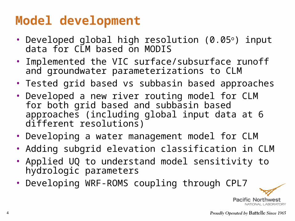
Model development
• Developed global high resolution (0.05o) input data for CLM based on MODIS
• Implemented the VIC surface/subsurface runoff and groundwater parameterizations to CLM
• Tested grid based vs subbasin based approaches• Developed a new river routing model for CLM for both
grid based and subbasin based approaches (including global input data at 6 different resolutions)
• Developing a water management model for CLM• Adding subgrid elevation classification in CLM• Applied UQ to understand model sensitivity to hydrologic
parameters• Developing WRF-ROMS coupling through CPL7
4
5
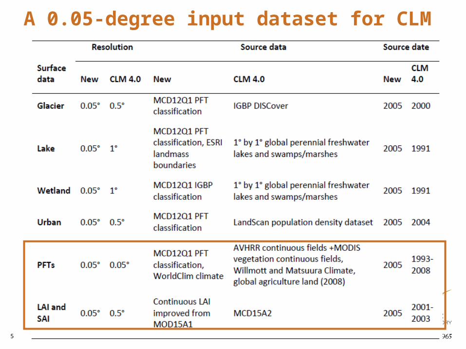
A 0.05-degree input dataset for CLM
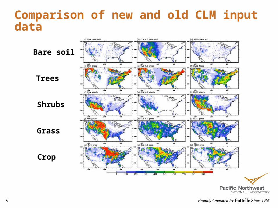
Comparison of new and old CLM input data
6
Bare soil
Trees
Shrubs
Grass
Crop

7
Introducing VIC soil hydrology to CLM
Saturation excess runoff
Infiltration excess runoff
ARNO baseflow curve
Surface- and groundwater interactions
Hydraulic redistributionInteractions of water
movement between the root system and soil porous
media

8
Dynamic representation of surface and groundwater interactions
dtEQRpttt
tnttt
tt
t
tb
es
)()(
)(
1)()(
z
K
zD
zt
)(
)(
Change of water table depth
Change of total soil moisture in the unsaturated
zone
Net water recharge to the groundwater body
s porosityne(t) effective porosity
Change of soil
moisture
Diffusion term
Drainage term
Liang et al., JGR, 2003

9
Implementation of VICGROUND to CLM
A runtime option activated through the namelist

10
Simulated water budget at Tonzi Ranch

11
Global testing of CLMVIC
• CLM4-SP– Forcing: Qian et al. 2004– Land cover: current (i.e., 2000)– Simulation period: 1995-2004 – Resolution: standard one-degree (i.e., 0.9 x 1.25)
• CLM-CN– Forcing: CRU-NCEP– Land cover: potential vegetation (pre-industrial)– Simulation period: 1800-1900 (by randomizing 1901-
1930)– Resolution: 0.5-degree grid

12
CLM4-SP: Summer LH, 1995-2004CLM4 CLM4VIC
CLM4VIC – CLM4CLM4VIC – CLM4, global mean

13
CLM4-CN: Summer LH CLM4CN CLM4VICCN
CLM4VICCN – CLM4CN CLM4VICCN – CLM4CNglobal mean, stabilized

14
Motivation for a new runoff routing model• To provide more accurate freshwater flux to the ocean from subdaily to daily
time scales
• To provide a linkage between the human (e.g., surface water withdrawal, reservoir operation) and natural systems
• For transport of nutrients and sediments
Features
• Consistent process representation across various scales (global, regional, local)
• Easy to be coupled with water management model
• Easy to be coupled with other fluxes

15
River Transport Model (RTM) in CLM 4.0
• Study area divided into cells
• Flow direction is determined by D8 algorithm
• Cell-to-cell routing with a linear advection model
Limitations
• Over-simplification of river network• Over-simplification of physical processes
• Global constant channel velocity (0.35m/s)• No account for sub-grid heterogeneity

16
Grid-based approach
This hierarchical dominant river tracing method preserves the baseline high resolution
hydrography (flow direction, flow length, upstream drainage area) at any coarse
resolution (Wu et al. 2011)
Subbasin representation preserves the natural boundaries of runoff
accumulation and river system organization
Model for Scale-Adaptive River Transport (MOSART)
Subbasin-based approach

17
Grid-based approach
Model for Scale-Adaptive River Transport (MOSART)
Subbasin-based approachConceptualized network
Hillslope routingSub-network routing
Main channel routing
• Hillslope routing to account for event dynamics and impacts of overland flow on soil erosion, nutrient loading, etc.
• Sub-network routing: scale adaptive across different resolutions to reduce scale dependence
• Main channel routing: explicit estimation of in-stream status (velocity, water depth, etc.)

18
Inputs and Parameters
• Daily runoff generation from UW VIC at 1/16o resolution for the Columbia River Basin
• Spatial delineation and network based on HydroSHEDS– DRT algorithm for grid-based representation 1/16, 1/8,
¼ and ½ degree resolutions (available globally)– ArcSWAT package for subbasin-based representation
(average size ~109km2)
• Manning’s roughness for hillslope and channel routing set to 0.4 and 0.05, respectively
• Evaluate against monthly naturalized streamflow data at selected major stations

Improved streamflow simulations
19 Large drainage area Small drainage area

20
Water Resource Management Model: Conceptual Design
• For full coupling in an earth system model:– Assume no knowledge of future inflow – Use generic operating rules
• Two components: – Regulation module: extraction of water at the reservoir
• Storage: stores water over extended period of time• Regulation: Follows monthly operating rules for flood
control, environmental flow, irrigation and hydropower• Constrained extraction: Daily partitioning of reservoir
releases for irrigation water supply, other consumptive uses and environmental constraints. It includes the distribution across demanding units.
– Local surface water extraction module: extracts water at the unit
• Hillslope surface runoff: represent irrigation retention ponds• Unit main stem if unpounded by an upstream reservoir

21
CLM-MOSART-WRM coupling
Loop over PFTs
Irrigated fraction found
Need irrigation
Routing + reservoir model (T- Δt )
YES YES
NO
End of loop
Updated ET, runoff, baseflow, irrigation demand
YES
CLM (t)
PFTs: vegetation types
Local surface water (t- Δt) contribution to irrigation demand (t). Remaining
demand?
Extraction from main stem if not impounded. Remaining demand?
Extraction from reservoir release to complement the local supply
NO
Aggregated demand (t- Δt)
Aggregated supply (t)
YES
NO
CLM Routing model
Natural flow in each units; irrigation demand
WRM
Generated runoff, Agg. irrigation demand
Regulated flow; Irrigation supply at each unit
Agg. irrigation supply

22
Data Preprocessing
Create a “unit-reservoir dependency database”:- Local approach: independent tributaries, elevation
constraint, constrained distance-based buffer- Global approach: elevation constraint and distance-based
buffer
Distribute the demand across the reservoir based on the dependency database and maximum storage capacity of each dependent dam

Downscaling CCSM Simulations
23
• WRF-CLM is being used to downscale CMIP5 CCSM historical, RCP4.5, and RCP8.5 simulations from 1975 - 2100

24
Uncertainty quantification framework
25
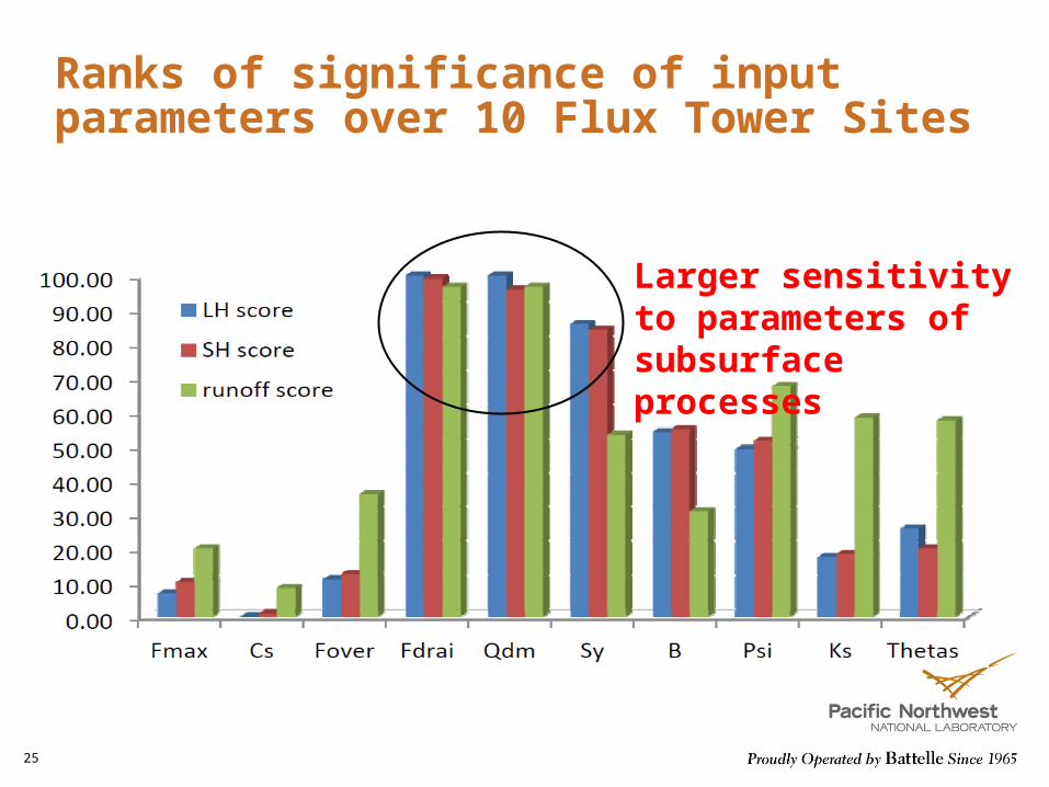
Ranks of significance of input parameters over 10 Flux Tower Sites
Larger sensitivity to parameters of subsurface processes
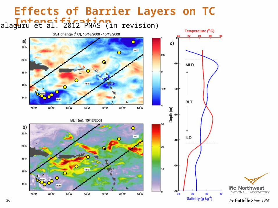
Effects of Barrier Layers on TC Intensification
26
Balaguru et al. 2012 PNAS (in revision)
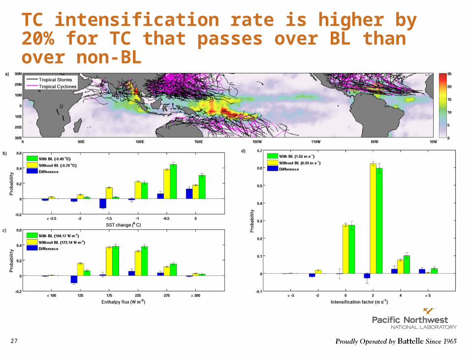
TC intensification rate is higher by 20% for TC that passes over BL than over non-BL
27


![Dynamical modeling of sub-grid scales in 2D turbulencemasbu/dynmod.pdf · Dynamical modeling of sub-grid scales in 2D turbulence ... turbulence [2]. Yet another related approach in](https://img.pdfslide.us/doc/110x75/5b5f9ff67f8b9a553d8e9223/dynamical-modeling-of-sub-grid-scales-in-2d-turbulence-masbudynmodpdf-dynamical.jpg)