Embed Size (px)
Citation preview
Research issues in image registration for remote sensing
Roger D. EastmanLoyola College in Maryland
Baltimore, [email protected]
Jacqueline Le MoigneNASA Goddard Space Flight Center
Greenbelt, [email protected]
Nathan S. NetanyahuBar-Ilan University
Ramat-Gan , Israel &University of MarylandCollege Park, [email protected]
Abstract
Image registration is an important element in data pro-cessing for remote sensing with many applications and awide range of solutions. Despite considerable investigationthe field has not settled on a definitive solution for most ap-plications and a number of questions remain open. Thisarticle looks at selected research issues by surveying the ex-perience of operational satellite teams, application-specificrequirements for Earth science, and our experiments in theevaluation of image registration algorithms with emphasison the comparison of algorithms for subpixel accuracy. Weconclude that remote sensing applications put particulardemands on image registration algorithms to take into ac-count domain-specific knowledge of geometric transforma-tions and image content.
1. Introduction
Image registration, the alignment of images and otherdata for comparison and fusion, is an important element indata processing for remote sensing. It finds many applica-tions, including but not limited to the operational productionof satellite image products, validation and precision correc-tion of satellite navigation data, radiometric validation ofnew sensors, data fusion for classification and thematic mapproduction, temporal image comparison for change detec-tion, atmospheric velocity computations, and land use anal-ysis and planning.
This varied set of application needs, as well as similarneeds in allied fields like medical imaging, have driven thedevelopment of a large number of approaches for image reg-istration (see Brown [5], Fonseca and Manjunath [12] andZitova and Flusser [35]). In an editorial on medical imageregistration Pluim and Fitzpatrick [22] note that since 1988the number of related articles per year has grown about 10-fold, from approximately 15 to over 140.
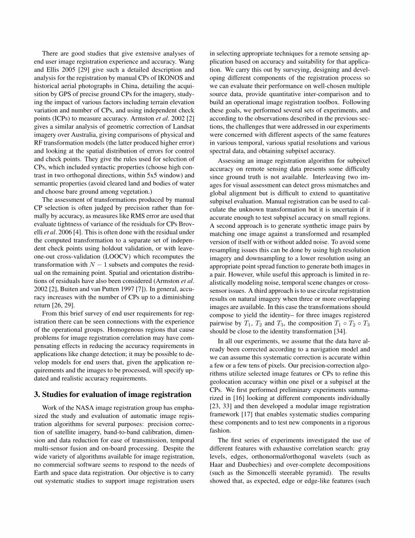
Figure 1. Mulitsensor registration of ETM+ at 30m (surround) toIKONOS at 1m (inset)
Image registration for remote sensing, particularly insupport of operational production of imagery products, canbe quite automatic, efficient and effective. However, manyend users still depend on labor-intensive manual selectionof control points (CPs) or, to quote one researcher, “reg-istration by graduate student,” with times cited from a fewhours to 4-5 days for registering a single image [8, 13]. Thisarticle explores this disparity in the use of advanced tech-niques, discusses selected issues in evaluating automaticmethods and fostering their greater adoption, and outlinesthe research program in image registration conducted by theimage registration working group at NASA Goddard SpaceFlight Center (GSFC).
In this article we describe image registration as a processthat aligns one image to another of the same area taken atthe same time or later, and with the same sensor or a dif-ferent one. An image registration method can be defined
1-4244-1180-7/07/$25.00 ©2007 IEEE
by three main steps: (1) extraction of features to be used tomatch the imagery; (2) feature matching strategy and met-rics, commonly the optimization of a similarity measure be-tween images; and (3) resampling or indexing of the data toa common coordinate system [5]. The transformations al-lowed for alignment can vary, from translation only in x andy, to rotation, scale and translation (RST), to fully-affine, tohomographic, or to a more complex model [32, 26]. Manycurrent systems use two levels of transformation as theymatch CPs as small image regions (chips) using only trans-lation or a low order transformation, and then use the CPs tocompute a more complex transformation. Some algorithmsuse Digital Elevation Models (DEMs) to correct for parallaxcaused by terrain relief.
2. Application requirements for image regis-tration
In part, the wide variation in image registration tech-niques in remote sensing is a result of the wide variation inapplications. Fonseca and Manjunath [12] noted this, pro-posed a rule-based system that would automatically selectan appropriate method for an application and reviewed theliterature to characterize the available methods to that end.Our own work [16] supports this goal. In particular, wehave implemented a number of methods to evaluate them ina consistent framework and to develop an online toolbox oftechniques for end users.
This program also requires understanding applicationneeds to get an end-to-end view of how image registrationfits into overall data processing. The literature on imageregistration is dominated by articles advancing or propos-ing a new technique, with far fewer articles that documentuser requirements or survey current practice. In this sectionwe look at issues in user requirements, dividing users intotwo groups: operational groups that use image registrationto produce image products, and Earth scientists (and others)who use the products.
2.1. Operational system requirements and practices
Operational satellite science teams that support remotesensing sensors rely on image registration for a number ofpurposes, including updating a geometric model that relatesa sensor to the navigation data (position and orientation)for a satellite; updating the navigation data; image by im-age geolocation; sensor-to-sensor and intra-sensor calibra-tion; and validation of model and data quality. Geolocat-ing a satellite image relative to a ground coordinate systemcan be done in two primary ways: systematic correction us-ing satellite navigation and calibration data, and precisioncorrection through registration of image features to previ-ously located ground features. Precision correction can bedone indirectly, by updating the camera models used for
systematic correction, or directly by relating a new imageto a ground coordinate system.
The teams have an end-to-end view of data processingrequirements for image production. From an early point insensor design they develop specifications that include im-age registration reliability and accuracy requirements, andthey typically implement in-house software to those re-quirements. Their knowledge of the satellite and sensorenables them to model the radiometric and geometric trans-formations between images so the image registration algo-rithms can be tuned and integrate satellite navigation data.Below we survey six representative operational systems tolook for characteristics and commonalities.
ASTER is a 14-band multispectral imager launched in1999 on the Terra (EOS-AM1) satellite. It has three sepa-rate image subsystems with individual telescopes that sam-ple at 15m, 30m and 90m. Iwasaki and Fujisada 2005[14] describe the image registration system. Image reg-istration was intended to improve geolocation of imageryto within 100m (nadir), adjust intratelescope band-to-bandposition to within 0.2 pixels and adjust intertelescope posi-tion to within 0.3 pixels. Registration is done to a databaseof about 300-600 CPs which were mapped on topographicmaps to to about 2-4 meters in x, y and z. The similar-ity measure is normalized correlation with transformationlimited to translation. Subpixel estimation is calculated byfitting a second-order polynomial to the correlation values.Matches are rejected for correlation less than 0.7 or whenclouds are detected. Validation of satellite performance wasdone in a retrospective study and the authors cite accuraciesof 50m, 0.2 pixels and 0.1 pixels, respectively. Problemswere noted with parallax errors in high-elevation areas dueto time delays between bands, with cross-track performancedue to satellite jitter, failures by the cloud detection algo-rithm, and cross-band matching in scenes with considerablevegetation.
GOES I-M is a series of weather satellites launchedfrom 1994 to 2001 with seven bands that sample at 1km,4km and 8km. Madani, Carr and Shoser 2004 [20] describethe AutoLandmark system for image registration. GOESgeolocation requirements vary from night to day, from 4kmto 10km, to accommodate solar heating. Registration isdone to a database of coastlines represented in vector for-mat which is used to avoid radiometric issues in correlation.A landmark of 24x24 or 96x96 pixels is extracted from asensed image and edges detected using the Sobel operator.This is matched to a binary image rasterized from the coast-line vector database, with a correlation measure of the sumof the edge strengths and transformations limited to transla-tion. Cloud areas are masked out. Bisection search is usedto find subpixel maximums. Matches are rejected when afuzzy logic quality metric (QM) falls below a threshold of0.9. The QM takes into account the quality of the edge cor-

Instrument Satellite Resolution Similarity Subpixel approachASTER Terra 15-90m Correlation to DEM corrected CPs Fit to correlation surfaceGOES GOES I-M 1-8km Correlation to vector coastline database Bi-section searchMISR Terra 275m Correlation to DEM corrected CPs Least squares optimizationMODIS Terra 250m – 1km Correlation to DEM corrected CPs Fixed regular samplingHRS SPOT 2.5 m Correlation to DEM corrected data Not describedETM+ Landsat-7 15-60m Correlation to arid region CPs* Fit to correlation surface*VEGETATION SPOT 1km Correlation to DEM corrected CPs Not described
Table 1. Operational Image Registration Systems. * ETM+ information in table refers to band-to-band registration
relation, the fraction of cloud contamination, and the con-trast and possibly total illumination in the image. In theinfrared bands the daily warming/cooling cycle means landand water can reverse in radiation, causing coastal edges toinvert, migrate and even disappear.
MISR is a second instrument on the Terra satellite. Jo-vanovic et al. 2002 [15] describe the geometric correctionsystem. It has 9 pushbroom cameras with four bands each,all sampling at 275m, intended to image atmospheric ele-ments from multiple angles for climate analysis. This repre-sents a particular challenge for geolocation of the multiplecameras with the objective of achieving better than 140muncertainty in absolute geolocation at nadir and betweencameras. Registration has been done to a database of 120ground CPs, each a collection of 9 co-located 64x64 imagechips from Landsat Thematic Mapper (TM) images of anidentifiable ground feature located to 30m. Each CP wasselected for seasonally invariant features and then mappedinto terrain-corrected imagery. A ray-casting algorithm isused to warp each chip to the appropriate geometry for theappropriate MISR camera. Chip matching is done to sub-pixel accuracy in translation, potentially to 1/8 pixel, byleast squares optimization [1]. Cloud masking is used andoutliers are rejected.
MODIS is a third instrument on the Terra satellite.Wolfe et al. 2002 [18] describe the geolocaton system (seealso [31]). MODIS has 36 spectral bands that sample at1km, 500m and 250m The MODIS Land Science Teamset a requirement of geolocation of 150m with an opera-tional goal of 50m Registration is done to a database of605 land CPs known to 15m in three dimensions. For eachCP, 24km2 chips of 30m sampling were constructed fromLandsat TM bands 3 and 4 taken from cloud-free imagespredominately along coastlines and waterways. The higher-resolution TM chips are resampled to MODIS resolution us-ing the MODIS point spread function and nominal MODISposition information. Area-based correlation is used formatching, with a 25m sampling interval to get subpixel ac-curacy and a threshold of 0.6. Matches are used to update acamera geometric model that accounts for internal and ex-ternal calibration and gives per pixel geometric corrections.
HRS, or High Resolution Stereoscopic with sampling at2.5m, is an instrument on the SPOT 5 satellite launched in2002. Baillarin et al. 2005 [3] describe the ANDORREsystem with the TARIFA core for image fusion and recti-fication. HRS requirements are 90% of points within 16mcircular accuracy and 10m elevation accuracy. ANDORREuses an extensive database of orthoimagery tiles integratedwith DEM data to generate, using ray tracing, a simulatedimage for matching. Matching is done using multresolutionsearch with the number of levels set to keep a 5x5 pixel sizesearch window. CPs are automatically found, matched bycorrelation and used to calibrate a parametric model. Ge-ometric outliers and CPs with correlation coefficient below0.80 are rejected. In the case of an inadequate number of tiepoints the correlation threshold is lowered to 0.70 and thenumber of points increased (”densification”); a subscene ofthe image still without a sufficient number is rejected. Theauthors cite a final circular error of 2m for 88% of the pointsin 100 test images. Problems occur due to seasonal changes,low intensity images and homogenous subscenes.
ETM+ is an instrument on the Landsat-7 satellitelaunched in 1999. Lee et al. [19] describe the extensive on-going set of assessment and calibration activities for ETM+including image registration for geolocation. ETM+ re-quirements are for 250m absolute geodetic accuracy, 0.28pixels band-to-band resolution and 0.4 pixels temporal reg-istration. The three requirements lead to multiple registra-tion approaches for calibration and assessment. Geodeticaccuracy is updated by correlating systematically correctedpanchromatic band regions against a database of CP imagechips extracted from USGS digital orthophoto quadrangleswith vertical information from USGS DEMs. About 75-100 CP chips are used for assessing accuracy. Band-to-bandregistration is used to update a parameter file with correctedoff-sets, so selected images in arid regions with little vege-tation and significant high spatial frequency content can im-prove cross-band correlation. Subpixel registration is doneby second-order fit to the correlation surface. Temporal res-olution is assessed by correlating a reference image witha precision and terrain corrected panchromatic band of thetest image. Success is reported for absolute geodetic accu-
racy as 99.9% of test CPs within 250m and a 54m RMSerror, while for band-to-band it is approximately 1/4 to 1/2of the operational requirement. Problems have been seen indecay of satellite attitude data due to aging gyros, and band-to-band calibration due to post-launch and seasonal operat-ing temperatures. Band-to-band correlation of band 6 (in-frared) has been problematic due to radiometric differencesincluding seasonal temperature variation in arid regions.
VEGETATION is an instrument on the SPOT seriesof satellites, operational since SPOT4 in 1999. Sylanderet al. 2000 [24] describe the geolocation system. The re-quirements are 1km in absolute location, 500m in multi-temporal registration with an operational objective of 300m, and multispectral registration of 300m Initial work in-dicated that existing coastline databases were not accurateenough, and reliance on systematic correction was not ad-equate so a database of approximately 3500 CPs was builtfrom VEGETATION images. Each CP has four image chipsfrom different seasons and orientations. Matching usingcorrelation is done under the control of human operatorswho insure there are 10 matched points per orbit to com-pute satellite position corrections. Absolute location wasmeasured to 300m RMS, multitemporal to 325m in RMS,and multispectral was reported as 0.11 pixels, which at thattime was slightly outside the requirements. Problems occurdue to seasonal changes, images with inadequate distribu-tion of CPs, rejection of images such as islands where CPscannot be uniformly distributed, and CPs that may have ter-rain features poorly suited for correlation.
From this survey we can see several common featuresand needs. The systems all share the use of pre-constructeddatabases, either of CPs or vector coastlines; the use of nor-malized intensity (or vector-edge) correlation as the similar-ity measure between features; DEM-correction of featuresbefore correlation; matching in local regions rather thanglobally; the use of translation since it dominates in smallregions; cloud masking or thresholds to eliminate cloudy re-gions. Most systems use subpixel estimation but vary in themethod used to compute it. The systems also vary in howlocal matches are used in precision correction – whetherthey are combined to estimate a global image transforma-tion or an update to the geometric camera model for sys-tematic correction. High-resolution sensors, on the orderof 1 m, face specific challenges in accounting for terrainelevation effects and temporal changes caused by humansand other Earth processes. The problems reported by thegroups show some differences but add up to the follow-ing picture of current registration issues: effectiveness ofnormalized correlation in cross-band registration; adaptionto thermal changes in satellite geometry and minor prob-lems in orbit data; uniform distribution of CPs adequate forfurther numerical computations; CPs that are poorly suitedfor correlation for a number of reasons, including seasonal
changes in temperature or vegetation or homogenous terrainfeatures, and properly modeling of satellite position varia-tions.
2.2. End user application requirements
In contrast to the operational teams, end users do not al-ways have the same resources such as intimate knowledgeof the sensor and data processing, the full set of sensor im-agery, the ability or need to maintain a large database ofCPs, access to navigation modeling and other correctiondata, or statistical models of geolocation error. In addition,they may need to register heterogeneous data sources suchas maps and older aerial images for which the supportinginformation is not available or complete. But, they do bringto image registration tasks knowledge of their applicationneeds, most specifically accuracy needs and application-specific models.
Accuracy needs of image registration for change detec-tion has been one of the most studied application needs [27,28, 6]. Townshend et al. 1992 [27] found that for four re-gions studied in Landsat TM imagery, to keep NDVI (Nor-malized Difference Vegetation Index) pixel-based changeestimations down to an error of 10% required subpixel reg-istration of 0.2 pixels. However, for three more homoge-nous, arid regions they found that registrations of 0.5 to 1.0pixels were adequate for 10% error. Dai and Khorram 1998[10] report similar results with about 0.2 pixels registrationrequired for 10% error on average in four test sites, with aslight but similar dependency on the spatial frequency con-tent of the imagery. Other confounding issues consideredfor misregistration impact on change detection has been thenumber of classes and region heterogeneity (Verbyla andBoles 2000 [28]), as well as change detection resolution andmore through measures of region heterogeneity in high res-olution imagery (Wang and Ellis 2005 [30]). Authors havealso considered how to adapt to misregistration errors byestimating them or lowering the resolution of change detec-tion [28, 30, 6].
Knowledge and use of appropriate transformation mod-els can assist in improving registration accuracy. Toutin2004 [26] extensively reviews transformation models usedfor satellite imagery ortho-rectification. Physical mod-els that take into account satellite geometry and the sen-sor imaging model, such as those used by the operationalgroups, can be the most accurate but are not always avail-able. Empirical models, such low order affine or RST,higher order polynomial, or piecewise transformations, donot require detailed sensor and satellite models but mayrequire more CPs. Three-dimensional rational functions(RFs), ratios of polynomials, can approach the accuracyof physical models and are distributed by some imageryproviders in meta-data but are not commonly used in au-tomatic registration algorithms.
There are good studies that give extensive analyses ofend user image registration experience and accuracy. Wangand Ellis 2005 [29] give such a detailed description andanalysis for the registration by manual CPs of IKONOS andhistorical aerial photographs in China, detailing the acqui-sition by GPS of precise ground CPs for the imagery, study-ing the impact of various factors including terrain elevationvariation and number of CPs, and using independent checkpoints (ICPs) to measure accuracy. Armston et al. 2002 [2]gives a similar analysis of geometric correction of Landsatimagery over Australia, giving comparisons of physical andRF transformation models (the latter produced higher error)and looking at the spatial distribution of errors for controland check points. They give the rules used for selection ofCPs, which included syntactic properties (choose high con-trast in two orthogonal directions, within 5x5 window) andsemantic properties (avoid cleared land and bodies of waterand choose bare ground among vegetation.)
The assessment of transformations produced by manualCP selection is often judged by precision rather than for-mally by accuracy, as measures like RMS error are used thatevaluate tightness of variance of the residuals for CPs Brov-elli et al. 2006 [4]. This is often done with the residual underthe computed transformation to a separate set of indepen-dent check points using holdout validation, or with leave-one-out cross-validation (LOOCV) which recomputes thetransformation with N − 1 subsets and computes the resid-ual on the remaining point. Spatial and orientation distribu-tions of residuals have also been considered (Armston et al.2002 [2], Buiten and van Putten 1997 [7]). In general, accu-racy increases with the number of CPs up to a diminishingreturn [26, 29].
From this brief survey of end user requirements for reg-istration there can be seen connections with the experienceof the operational groups. Homogenous regions that causeproblems for image registration correlation may have com-pensating effects in reducing the accuracy requirements inapplications like change detection; it may be possible to de-velop models for end users that, given the application re-quirements and the images to be processed, will specify up-dated and realistic accuracy requirements.
3. Studies for evaluation of image registrationWork of the NASA image registration group has empha-
sized the study and evaluation of automatic image regis-tration algorithms for several purposes: precision correc-tion of satellite imagery, band-to-band calibration, dimen-sion and data reduction for ease of transmission, temporalmulti-sensor fusion and on-board processing. Despite thewide variety of algorithms available for image registration,no commercial software seems to respond to the needs ofEarth and space data registration. Our objective is to carryout systematic studies to support image registration users
in selecting appropriate techniques for a remote sensing ap-plication based on accuracy and suitability for that applica-tion. We carry this out by surveying, designing and devel-oping different components of the registration process sowe can evaluate their performance on well-chosen multiplesource data, provide quantitative inter-comparison and tobuild an operational image registration toolbox. Followingthese goals, we performed several sets of experiments, andaccording to the observations described in the previous sec-tions, the challenges that were addressed in our experimentswere concerned with different aspects of the same featuresin various temporal, various spatial resolutions and variousspectral data, and obtaining subpixel accuracy.
Assessing an image registration algorithm for subpixelaccuracy on remote sensing data presents some difficultysince ground truth is not available. Interleaving two im-ages for visual assessment can detect gross mismatches andglobal alignment but is difficult to extend to quantitativesubpixel evaluation. Manual registration can be used to cal-culate the unknown transformation but it is uncertain if itaccurate enough to test subpixel accuracy on small regions.A second approach is to generate synthetic image pairs bymatching one image against a transformed and resampledversion of itself with or without added noise. To avoid someresampling issues this can be done by using high resolutionimagery and downsampling to a lower resolution using anappropriate point spread function to generate both images ina pair. However, while useful this approach is limited in re-alistically modeling noise, temporal scene changes or cross-sensor issues. A third approach is to use circular registrationresults on natural imagery when three or more overlappingimages are available. In this case the transformations shouldcompose to yield the identity– for three images registeredpairwise by T1, T2 and T3, the composition T1 ◦ T2 ◦ T3
should be close to the identity transformation [34].In all our experiments, we assume that the data have al-
ready been corrected according to a navigation model andwe can assume this systematic correction is accurate withina few or a few tens of pixels. Our precision-correction algo-rithms utilize selected image features or CPs to refine thisgeolocation accuracy within one pixel or a subpixel at theCPs. We first performed preliminary experiments summa-rized in [16] looking at different components individually[23, 33] and then developed a modular image registrationframework [17] that enables systematic studies comparingthese components and to test new components in a rigorousfashion.
The first series of experiments investigated the use ofdifferent features with exhaustive correlation search: graylevels, edges, orthonormal/orthogonal wavelets (such asHaar and Daubechies) and over-complete decompositions(such as the Simoncelli steerable pyramid). The resultsshowed that, as expected, edge or edge-like features (such
as wavelets) were more robust to noise and local intensityvariations than pure intensity values. In comparing edgesand wavelets, a full exhaustive search using edge featuresproved to be potentially more accurate but was also time-prohibitive compared to an approach based on features ex-tracted from an orthogonal wavelet.
The next series of experiments studied the potential lim-its of using wavelets, and particularly the effects of imagetranslation on wavelet-based image registration [23]. It iswell-known that wavelet representations are not translation-invariant since when a separable orthogonal wavelet trans-form is used, information about the signal changes withinor across sub-bands. Within these restrictions we quantita-tively assessed the usefulness of orthogonal wavelets. Themain result was that the normalized correlation coefficientsof low-pass orthogonal wavelet subbands are essentially in-sensitive to translations for features larger than twice thewavelet filter size. The third-level low-pass subbands pro-duce a correlation peak that varies with translation from 0.7to 1.0 with an average of 0.9. On the other hand, high-pass subbands are more sensitive to translation, althoughthis sensitivity is limited.
A follow-on series of experiments focused on evaluatingseveral wavelet-type pyramids that may be utilized both forinvariant feature extraction and for representing images atmultiple spatial resolutions to accelerate registration. Us-ing an optimization-based scheme, Daubechies orthogonalwavelets, spline wavelets and the Simoncelli steerable Pyra-mid were considered. We found that the band-pass waveletsobtained from the Steerable Pyramid due to Simoncelli per-form best in terms of accuracy and consistency, while thelow-pass wavelets obtained from the same pyramid give thebest results in terms of the radius of convergence. Althoughnot as reliable, spline wavelets show the best accuracy whenconvergence occurs.
A more general set of experiments investigated combina-tions of the major image registration components: features,similarity metrics and search strategy. We built a frameworkto selectively combine the components in order to reach op-timum registration on a given type of data and under givencircumstances. Another use of the framework is to test eachelement of registration independently (so we know the edgedetection implementation, for example, is the same in allexperiments.) The purpose of this framework is triple-fold:(1) assess various combinations of components as a func-tion of the application, (2) assess a new registration com-ponent compared to other known ones, and (3) serve as aregistration tool where a user can select components as afunction of the application at hand, the available computa-tional resources and the required accuracy.
In our current framework:
• features can be either gray levels, Low-Pass fea-tures from Simoncelli steerable filters decomposition
or from a Spline decomposition, or Simoncelli Band-Pass features, similarity metrics can be either cross-correlation, the L2 Norm, Mutual Information or anHausdorff distance,
• matching strategies are either based on a Fast FourierCorrelation, three different types of optimization -pure gradient Descent [11], a Marquard-Levenberg ap-proach [25] or a stocchastic gradient approach [9], anda Robust Feature Matching approach [21].
Studies using this framework are described in [17], andsome of the first results are the following:
• Fast Fourier correlation is very fast but limited to trans-formations with scales close to 1 (in the range [0.95,1.2]) and images containing very small amounts ofnoise.
• When using a Marquart-Levenberg approach, featuressuch as Simoncelli Band-Pass are more accurate andmore robust to noise, with errors in the range of [0.032,0.25] pixel. At the same time, Simoncelli-Low Passfeatures are less sensitive to the initial guess thanBand-Pass features.
• An approach using a stochastic gradient approach anda Mutual Information metrics is overall the most robustto initial conditions and the most accurate with errorsin the range of [0.12, 0.18] pixel.
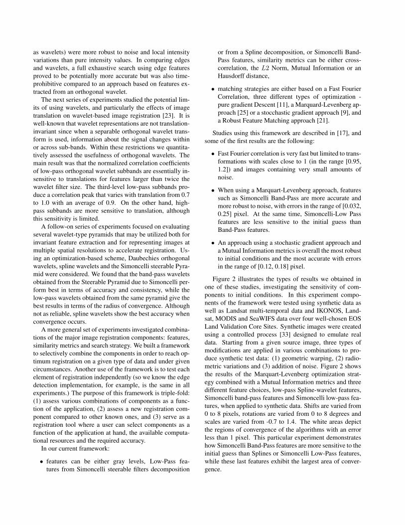
Figure 2 illustrates the types of results we obtained inone of these studies, investigating the sensitivity of com-ponents to initial conditions. In this experiment compo-nents of the framework were tested using synthetic data aswell as Landsat multi-temporal data and IKONOS, Land-sat, MODIS and SeaWIFS data over four well-chosen EOSLand Validation Core Sites. Synthetic images were createdusing a controlled process [33] designed to emulate realdata. Starting from a given source image, three types ofmodifications are applied in various combinations to pro-duce synthetic test data: (1) geometric warping, (2) radio-metric variations and (3) addition of noise. Figure 2 showsthe results of the Marquart-Levenberg optimization strat-egy combined with a Mutual Information metrics and threedifferent feature choices, low-pass Spline-wavelet features,Simoncelli band-pass features and Simoncelli low-pass fea-tures, when applied to synthetic data. Shifts are varied from0 to 8 pixels, rotations are varied from 0 to 8 degrees andscales are varied from -0.7 to 1.4. The white areas depictthe regions of convergence of the algorithms with an errorless than 1 pixel. This particular experiment demonstrateshow Simoncelli Band-Pass features are more sensitive to theinitial guess than Splines or Simoncelli Low-Pass features,while these last features exhibit the largest area of conver-gence.

Figure 2. Sensitivity to initial conditions
4. Conclusion
In order to better understand requirements for the devel-opment and evaluation of image registration algorithms, thisarticle has examined selected research issues by surveyingthe experience of operational satellite teams, application-specific requirements for Earth science, and our frameworkand experiments in the evaluation of image registration al-gorithms. From the experience and current practice of oper-ational groups, as well as documented requirements for enduser applications, we can see the importance of subpixelregistration for image subregions with increasing need toperform it robustly between sensors, particularly with theadvent of very high resolution and hyperspectral imageryand more demanding requirements for applications. Wealso see the need for image registration techniques that aretailored to the needs of remote sensing applications withspecific attention to sensor-related geometric transforma-tions and knowledge of accuracy requirements and imagecontent.
Acknowledgments
We would like to acknowledge the invaluable contri-butions of collaborators with the NASA image registra-tion group over the years: Arlene Cole-Rhodes and KishaJohnson of Morgan State University, Tarek El-Ghazawi ofGeorge Washington University, Peyush Jain, Amiee Joshua,Jeffrey Masek, Jeffery Morsisette, Nargess Memarsadeghiand Ezinne Uko-Ozoro of NASA/GSFC, and David Mountof the University of Maryland at College Park.
References[1] F. Ackerman. Digital image correlation: Performance and
potential application in photogrammetry. PhotogrammetricRecord, 11(64):429–439, 1984.
[2] J. D. Armston, T. J. Danaher, B. M. Goulevitch, and M. I.Byrne. Geometric correction of landsat mss, tm, and etm+imagery for mapping of woody vegetation cover and changedetection in queensland. In Proceedings of the 11th Aus-tralasian Remote Sensing and Photogrammetry Conference,pages 1–23, Brisbane, Australia, 2002.
[3] S. Baillarin, A. Bouillon, M. Bernard, and M. Chikhi. Usinga three dimensional spatial database to orthorectify automat-ically remote sensing images. In Proceedings of the ISPRSHangzhou 2005 Workshop, pages 89–94, Hangzhou, China,2005.
[4] M. A. Brovelli, M. Crespi, F. Fratarcangeli, F. Giannone,and E. Realin. Accuracy assessment of high resolution satel-lite imagery by leave-one-out method. In 7th InternationalSymposium on Spatial Accuracy Assessment in Natural Re-sources and Environmental Science, pages 533–542, 2006.
[5] L. G. Brown. A survey of image registration techniques.ACM Computing Surveys, 24(24):325–376, 1992.
[6] L. Bruzzone and R. Cossu. An adaptive approach to reduc-ing registration noise effects in unsupervised change detec-tion. IEEE Transactions on Geoscience and Remote Sensing,41(11):2455–2465, 2003.
[7] H. J. Buiten and B. v. Putten. Quality assessment of remotesensing image registration – analysis and testing of controlpoint residuals. ISPRS Journal of Photogrammetry and Re-mote Sensing, 52(2):57–73, 1997.
[8] D. Carrion, M. Gianinetto, and M. Scaioni. Georef: a soft-ware for improving the use of remote sensing images in envi-ronmental applications. In Proceedings of the First BiennialMeeting of the International Environmental Modelling andSoftware Society, pages 360–365, 2002.

[9] A. Cole-Rhodes, K. Johnson, and J. Le Moigne. Mul-tiresolution registration of remote sensing imagery by opti-mization of mutual information using a stocchastic gradient.IEEE Transactions on Image Processing, 12(12):1495–1511,2003.
[10] X. Dai and S. Khorram. The effects of image misregis-tration on the accuracy of remotely sensed change detec-tion. IEEE Transactions on Geoscience and Remote Sensing,36(5):1566–1577, 1998.
[11] R. D. Eastman and J. Le Moigne. Gradient-descent tech-niques for multi-temporal and multi-sensor image registra-tion of remotely sensed imagery. In Fourth InternationalConference on Information Fusion, Montreal, Canada, 2001.
[12] L. M. G. Fonseca and B. S. Manjunath. Registration tech-niques for multisensor remotely sensed imagery. Photogram-metric Engineering and Remote Sensing, 62(9):1049–1056,1996.
[13] A. Ganas and E. Athanassiou. A comparative study on theproduction of satellite orthoimagery for geological remotesensing. Geocarto International, 14:51–59, 2000.
[14] A. Iwasaki and H. Fujisada. Aster geometric performance.IEEE Transactions on Geoscience and Remote Sensing,43(12):2700–2706, 2005.
[15] V. M. Jovanovic, M. A. Bull, M. M. Smyth, and J. Zong.MISR in-flight camera geometric model calibration and geo-rectification performance. IEEE Transactions on Geoscienceand Remote Sensing, 40(7):1512–1519, 2002.
[16] J. Le Moigne, A. Cole-Rhodes, R. Eastman, P. Jain,A. Joshua, N. Memarsadeghi, D. Mount, N. S. Netanyahu,J. Morsisette, and E. Uko-Ozoro. Image registration andfusion studies for the integration of multiple remote sens-ing data. In International Conference on Acoustics, Speechand Signal Processing (ICASSP), pages 100–105, Toulouse,France, 2006.
[17] J. Le Moigne, H. S. Stone, A. Cole-Rhodes, R. D. Eastman,P. Jain, K. Johnson, J. T. Morisette, and N. S. Netanyahu.Registration of multiple sensor earth science data. In NASAEarth Science Technology Conference (ESTC), pages 100–105, Palo Alto, CA, 2004.
[18] D. S. Lee, J. C. Storey, M. J. Choate, and R. W. Hayes.Achieving sub-pixel geolocation accuracy in support ofmodis land science. Remote Sensing of Environment, 83(1–2):31–49, 2002.
[19] D. S. Lee, J. C. Storey, M. J. Choate, and R. W. Hayes. Fouryears of landsat-7 on-orbit geometric calibration and perfor-mance. IEEE Transactions on Geoscience and Remote Sens-ing, 42(12):2786–2795, 2004.
[20] H. Madani, J. L. Carr, and C. Schoeser. Image registrationusing autolandmark. In Proceedings of Fusion of Earth Data,pages 234–778, Sophia-Antipolis, France, 2004.
[21] N. S. Netanyahu, J. Le Moigne, and J. G. Masek. Georeg-istration of Landsat data via robust matching of multiresolu-tion features. IEEE Transactions on Geoscience and RemoteSensing, 42(7):1586–1600, 2004.
[22] J. P. W. Pluim and J. M. Fitzpatrick. Image registra-tion (editorial). IEEE Transactions on Medical Imaging,22(11):1341–1343, 2005.
[23] H. S. Stone, J. Le Moigne, and M. McGuire. Image regis-tration using wavelet techniques. IEEE Transactions on Pat-tern Analysis and Machine Intelligence, 21(10):1074–1081,1999.
[24] S. Sylvander, P. Henry, C. Bastien-Thiry, F. Meunier, andD. Fuster. Vegetation geometrical image quality. In Pro-ceedings of the VEGETATION 2000 Conference, Balgirate,Italy, 2000.
[25] P. Thevenaz, U. Ruttiman, and M. Unser. A pyramid ap-proach to sub-pixel registration based on intensity. IEEETransactions on Image Processing, 7(1):27–41, 1998.
[26] T. Toutin. Review article: Geometric processing of remotesensing images: models, algorithms and methods. Interna-tional Journal of Remote Sensing, 25(10):1893–1924, 2004.
[27] J. R. G. Townshend, C. O. Justice, C. Gurney, and J. Mc-Manus. The impact of misregistration on change detec-tion. IEEE Transactions on Geoscience and Remote Sensing,30(5):1054–1060, 1992.
[28] D. L. Verbyla and S. H. Boles. Bias in land cover changeestimates due to misregistration. International Journal ofRemote Sensing, 21(18):3553–3560, 2000.
[29] H. Wang and E. C. Ellis. Image misregistration error inchange measurements. Photogrammetric Engineering andRemote Sensing, 71(9):1037–1044, 2005.
[30] H. Wang and E. C. Ellis. Spatial accuracy of orthorecti-fied ikonos imagery and historical aerial photographs acrossfive sites in china. International Journal of Remote Sensing,26(9):1893–1911, 2005.
[31] X. Xiong, N. Che, and W. Barnes. Terra modis on-orbit spa-tial characterization and performance. IEEE Transactions onGeoscience and Remote Sensing, 43(2):355–365, 2005.
[32] L. Zagorchev and A. Goshtasby. A comparative studyof transformation functions for nonrigid image registration.IEEE Transactions on Image Processing, 15(3):529–538,2006.
[33] I. Zavorin and J. Le Moigne. Use of multiresolutionwavelet feature pyramids for automatic registration of mul-tisensor imagery. IEEE Transactions on Image Processing,14(6):770–782, 2005.
[34] I. Zavorin, H. S. Stone, and J. Le Moigne. Evaluating perfor-mance of automatic techniques for subpixel registration ofremotely sensed imagery. In Proceedings of SPIE – Volume5014 Image Processing: Algorithms and Systems II, pages306–316, 2003.
[35] B. Zitova and J. Flusser. Image registration methods: a sur-vey. Image and Vision Computing, 21(11):977–1000, 2003.