Embed Size (px)
Citation preview

Requirements, Capabilities and Analysis for Earth Observations (RCA-EO)
Project Update for the Landsat Science Team
July 26th, 2016
U.S. Department of the Interior U.S. Geological Survey

Outline
• Purpose of RCA-EO
• OSTP Earth Observation Assessment (EOA)
• User Requirement Examples
• What’s next
2

Purpose of RCA-EO
3
RCA-EO provides data and analyses to help optimize investments in Earth observing technology and products to better meet
user needs

Federal Earth Observation Assessment
– OSTP-led snapshot of Earth observation (EO) data use across Federal Civil Agencies
• Current portfolio of EO systems relied on by the Federal government organized by 13 societal benefit areas
• ~1750 key products surveyed
• Landsat is a direct ingredient in 174 products
– Identified user satisfaction and limitations for currently used data sources
– Working to analyze the breadth/depth of Landsat community covered by this data

5
Landsat use from EOA 2016
• Preliminary results based on current snapshot Federal civil Landsat
users
• 174 key products from multiple Federal agencies
• Most people use more than one type of Landsat data, and are
generally satisfied with Landsat data, but did identify some limitations
• Temporal revisit was the most often cited limitation
• Users also identified needs for higher spatial resolution, additional
processing, and mosaic products
Preliminary
3
13
179
48
Poor
Fair
Good
Fully satisfiedTemporal
revisit 36%
Spatial resolution
20%
Data processing and access
20%
Cloud cover 18%
Spectral coverage
6%
Landsat Optical
162
Landsat Archive
30
Landsat Thermal
27
Landsat Pan 17
User Satisfaction
Landsat Data Use
Cited Landsat
Data Limitations
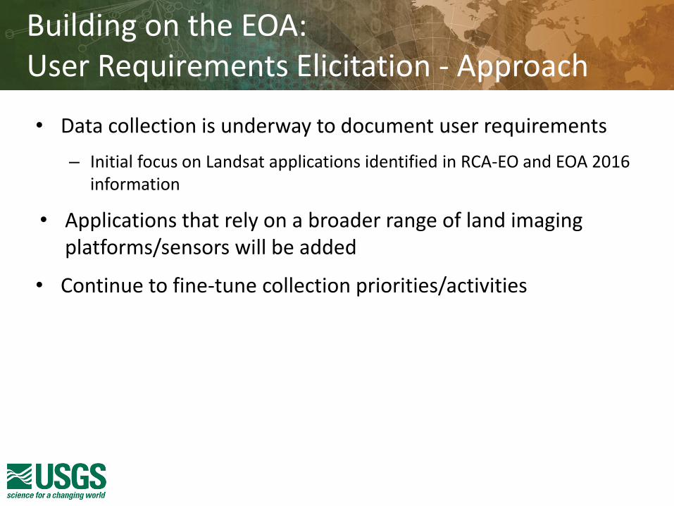
Building on the EOA: User Requirements Elicitation - Approach
• Data collection is underway to document user requirements
– Initial focus on Landsat applications identified in RCA-EO and EOA 2016 information
• Applications that rely on a broader range of land imaging platforms/sensors will be added
• Continue to fine-tune collection priorities/activities

7
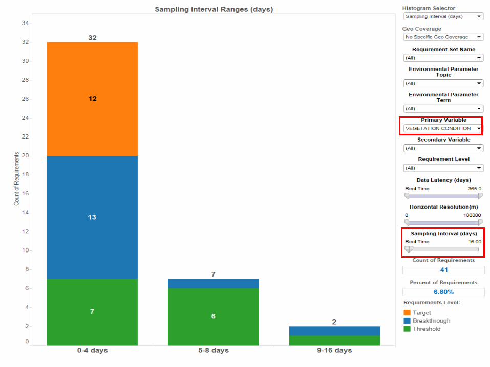
• Requirements captured by variable or “environmental parameter”
– The fundamental information being observed
– Some examples:
Requirements capture
Land Cover
Vegetation Condition
Burned Area Extent
Biomass: Vegetation
Terrain Elevation
Land Skin Temperature
Surface Reflectance
Surface Water Extent
More….

Requirement Attributes
8
• For each Environmental Parameter, a variety of attributes are captured: – Geographic Coverage
– Horizontal Resolution
– Vertical Resolution (if applicable)
– Sampling Interval
– Accuracy
– Data Latency
– Conditions for Sampling
– Length of the Data Record
– Spectral Characteristics
– Data Services, Access and Formats

User Requirements
• For each requirement there are 3 potential levels:
– Threshold
• The minimum specification to be met to ensure that an Earth observation dataset or service is useful
– Breakthrough
• An intermediate requirement level which, if achieved, would result in a significant improvement in capability against the targeted application
– Target
• The value above which further improvement of the EO dataset or service would provide only limited improvement in performance for the application in question
9

10
Initial Requirements Collection
DOI 56%
USDA 19%
Academia 11%
NASA 7%
Smithsonian 3%
Other (EPA, DOE, DOC, NSF)
4%
Percent of requirements collected by agency


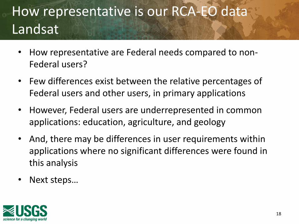
How representative is our RCA-EO data Landsat
• How representative are Federal needs compared to non-Federal users?
• Few differences exist between the relative percentages of Federal users and other users, in primary applications
• However, Federal users are underrepresented in common applications: education, agriculture, and geology
• And, there may be differences in user requirements within applications where no significant differences were found in this analysis
• Next steps…
18

Are their many unique non-Federal Landsat requirements?
• Is their existing research on or knowledge of requirements that indicates variations?
– If so, further requirements gathering outside of U.S. Federal users may be needed
• Potential sources of requirements information
– NGAC, AmericaView, Landsat Science Team
– RFI Process
– Other methods in concert with OMB collection rules
19
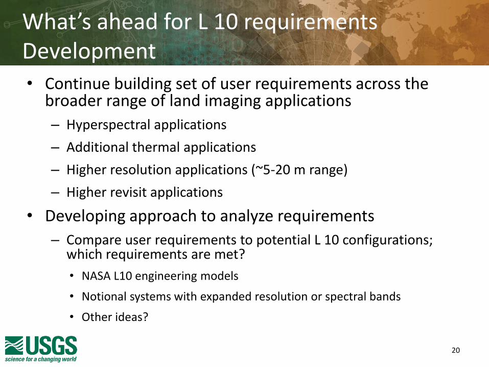
What’s ahead for L 10 requirements Development • Continue building set of user requirements across the
broader range of land imaging applications
– Hyperspectral applications
– Additional thermal applications
– Higher resolution applications (~5-20 m range)
– Higher revisit applications
• Developing approach to analyze requirements
– Compare user requirements to potential L 10 configurations; which requirements are met?
• NASA L10 engineering models
• Notional systems with expanded resolution or spectral bands
• Other ideas?
20

Comments?
21

Backup

Requirements Trend Animated Example
23 Illustrative Only

Key Products/Services SME Organization
Habitat Mapping Analysis DOI FWS
Refuge Wetland Mapping DOI FWS
Wildlife Refuge Landscape Management DOI FWS
National Park Landcover Change Monitoring DOI NPS
NPS Hydraulic Modeling and Monitoring DOI NPS
Arctic Boreal Vulnerability Experiment NASA
Carbon Dynamics NASA
Vegetation Structure and Function NASA
Surface Water Extent and Dynamics NASA
Permafrost and Hydrology NSIDC
ET Anomaly Maps (Coarse Scale) USDA ARS
ET Anomaly Maps (Fine Scale) USDA ARS
Crop Residue Monitoring USDA ARS
Global Crop Area Estimation USDA FAS
Global Crop Yield Estimation USDA FAS
Rapid Response to Global Agricultural Crises USDA FAS
Global Lake and Reservoir Levels USDA FAS
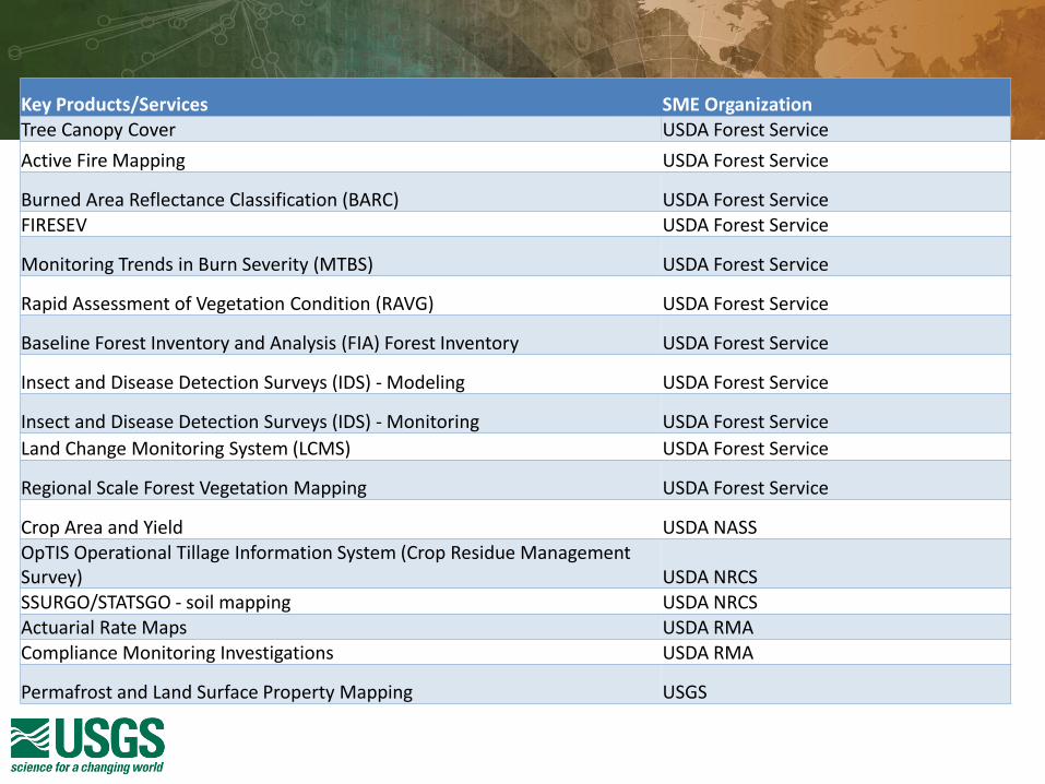
Key Products/Services SME Organization Tree Canopy Cover USDA Forest Service
Active Fire Mapping USDA Forest Service
Burned Area Reflectance Classification (BARC) USDA Forest Service FIRESEV USDA Forest Service
Monitoring Trends in Burn Severity (MTBS) USDA Forest Service
Rapid Assessment of Vegetation Condition (RAVG) USDA Forest Service
Baseline Forest Inventory and Analysis (FIA) Forest Inventory USDA Forest Service
Insect and Disease Detection Surveys (IDS) - Modeling USDA Forest Service
Insect and Disease Detection Surveys (IDS) - Monitoring USDA Forest Service
Land Change Monitoring System (LCMS) USDA Forest Service
Regional Scale Forest Vegetation Mapping USDA Forest Service
Crop Area and Yield USDA NASS OpTIS Operational Tillage Information System (Crop Residue Management Survey) USDA NRCS SSURGO/STATSGO - soil mapping USDA NRCS Actuarial Rate Maps USDA RMA Compliance Monitoring Investigations USDA RMA
Permafrost and Land Surface Property Mapping USGS

Key Products/Services SME Organization
Vegetation Dynamics and Distribution Academia, U of CA Irvine
Wildlife and Ecosystem Services (ABoVE - Animals on the Move) Academia; Columbia University, U of Idaho
Vegetation Structure and Function Academia; Montclair University
Lake Clarity Monitoring Academia; U of Minnesota
Forest Tundra Ecotone structure and function Academia; U of Idaho
Global Forest Cover Change Academia; U of MD
Tundra Fires Academia; U of MD
Carbon Dynamics Academia; U of MT
Inland Water Dissolved Organic Carbon, and CO2 CH4 emissions Academia; U of WA Emergency Stabilization and Rehabilitation Plans (BLM) - Also called BAER DOI BLM
Sage Grouse Conservation - Landscape Scale DOI BLM
Sage Grouse Conservation - Project Scale DOI BLM
Consumptive Water Use DOI BOR Estimates of Evapotranspiration and Evaporation (formerly LCRAS reports) DOI BOR
Conservation Regulations Compliance Monitoring DOI FWS
Bi-National Wetland Classification Mapping DOI FWS
Gulf Coast Joint Venture Habitat Map DOI FWS

Key Products/Services SME Organization
Permafrost and Hydrology USGS
Wetland Coastal Change Studies USGS CMGP
Marsh Equilibrium Model USGS EP
Salt Marsh Carbon Cycling Research USGS EP
Coastal Wetland Ecology USGS EP
Gulf Coast Marsh Classification Map USGS EP
Herbaceous Biomass USGS EP
Post-Fire Shrub Recovery USGS EP Remote sensing of oil on water - Littoral Zone USGS MRP Remote sensing of oil on water - Open Ocean USGS MRP
Chesapeake Bay Project Remote Sensing of Winter Ground Cover USGS LCS National-Scale Wildfire and Fire Management Impacts on Ecosystem Carbon Storage and Greenhouse Gas Emissions USGS LCS Global Irrigated and Rainfed Croplands USGS LRS
Irrigation Monitoring-ET and Remote Sensing USGS LRS Land Remote Sensing Environmental Applications - Color of Dissolved Organic Matter or Other Materials USGS LRS
Alaska Minerals Mapping USGS MRP
Surface Minerals Mapping USGS MRP
Mineral Mapping USGS MRP
Louisiana Coastwide Reference Monitoring System (CRMS) USGS S&T
Boreal Fires (Fire-Climate Forcings) Woods Hole
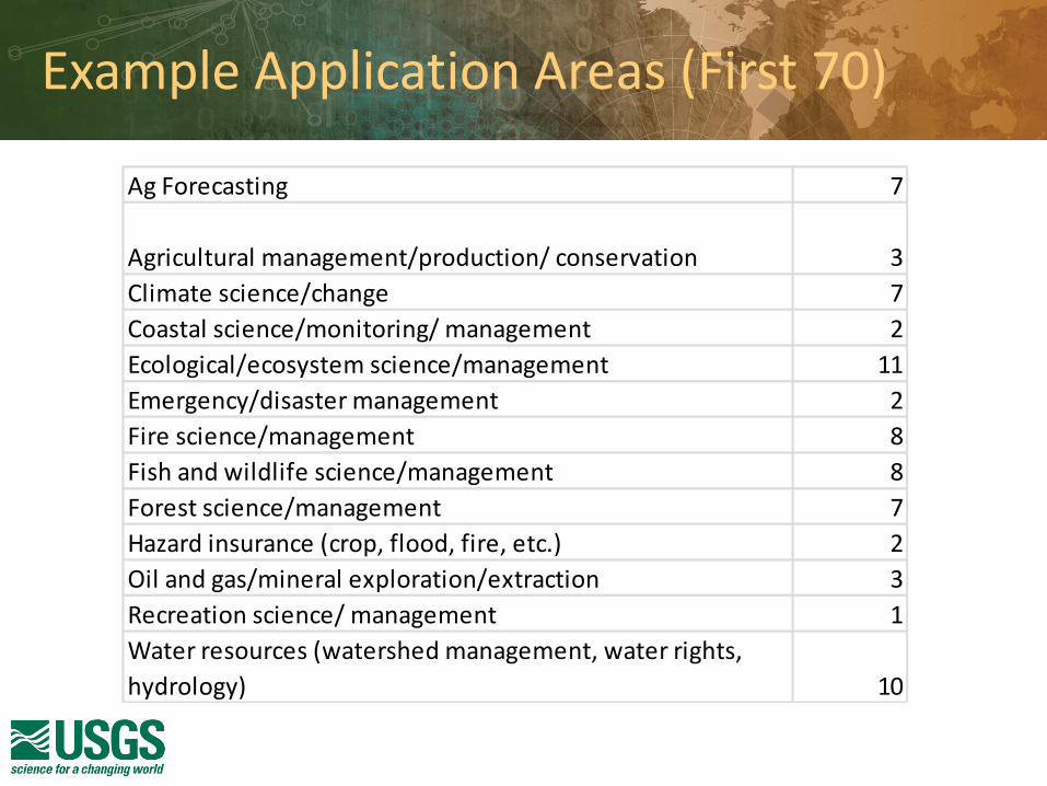
Example Application Areas (First 70)
Ag Forecasting 7
Agricultural management/production/ conservation 3
Climate science/change 7
Coastal science/monitoring/ management 2
Ecological/ecosystem science/management 11
Emergency/disaster management 2
Fire science/management 8
Fish and wildlife science/management 8
Forest science/management 7
Hazard insurance (crop, flood, fire, etc.) 2
Oil and gas/mineral exploration/extraction 3
Recreation science/ management 1
Water resources (watershed management, water rights,
hydrology) 10
2016 Requirements Collection Plans (example)
• FY16 Requirements collection to include key land imaging activities within:
– USGS, USDA, BLM, BOR, FWS, NPS, NASA and potentially other agencies
• USDA applications & subject matter experts to be surveyed (examples only):
– NRCS: Crop Residue Management Surveys, Soil Survey Interpretation Maps, National Resource Inventory
(NRI); Sample SMEs: Dorsey Plunk, Tony Kimmet, Dan Good, Dave Hoover
– FAS: Global Crop Area/Yield Estimation, Rapid Response to Global Agricultural Crises; Sample SMEs: Bob
Tetrault, Curt Reynolds, Glenn Bethel
– RMA: Actuarial Rate Maps, Compliance Monitoring Investigations; Sample SME: Jim Hipple
– NASS: National Crop Yield Forecasting Sample SMEs: Rick Mueller, David Johnson
– ARS: ET Anomaly Mapping, National Watershed Climate Change; Crop Residue Monitoring; Sample SMEs:
Martha Anderson, Craig Daughtry, Mark Walbridge
– Forest Service: Global Forest Resource Assessment, Fire Products (BAER/BARC, MTBS, RAVG, Active Fire Mapping, Spatial Fire Behavior Models, etc.), Forest Disturbance Assessment, National Insect and Disease Risk Mapping, Forest Inventory and Analysis; Sample SMEs: Brad Quayle, Greg Dillon, Jim Ellenwood, Frank Krist, Frank Sapio, Bob Ilgenfritz
29


Application Area DOI USDA EPA DOE DOC NASA NSF SI Academia
Agriculture
Cryosphere
Climate
Coastal
Ecology
Energy
Fire
Fish and Wildlife
Forests
Geology
Human Needs
Legal/Security
Planning and Development
Recreation
Water
Application Areas that use Landsat by Organization In-work
Covered thus far Expected by Nov 2016