Embed Size (px)
Citation preview
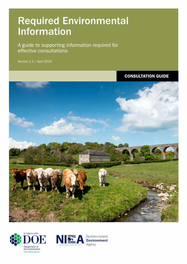
Required Environmental InformationA guide to supporting information required for effective consultations
Version 1.1 / April 2015
CONSULTATION GUIDE
CONSULTATION GUIDE
1 | P a g e
‘This good practice guide aims to assist applicants and planning authorities achieve a consistent approach
when considering the environmental information required for development management planning
applications & consents. Its correct application should help applicants and planning authorities identify the
information required by NIEA & Marine Division as statutory consultees, to provide a substantive
consultation response.
This checklist does not attempt to provide an authoritative account of the legislation and policy that underpin the validation of planning applications in Northern Ireland and is not intended to be a source of legal advice. This guide is not intended to replace the need for judgement by planning officers and those making planning applications. Reference should always be made to the relevant legislation and if any discrepancy or conflict exists between the contents of this guide and the relevant legislation, the provisions of the legislation will prevail. Further information can be obtained from the NIEA website www.doeni.gov.uk/niea. Links to external
sources of information have also been provided in the text, where appropriate.’
Required Environmental Information
REQUIRED ENVIRONMENTAL INFORMATION
2 | P a g e
Introduction
This good practice guide provides a checklist of the environmental information which should
accompany applications for planning permission and consents, where DOE (NIEA and Marine
Division) is a statutory consultee1. It also complements the requirements outlined in the DOE
Planning, Development Management Guidance Note 4 ‘Form and content of Planning Applications
and Other Types of Consents,’ which can be found on the planning website:
www.planningni.gov.uk.
Further information and guidance on our planning roles and responsibilities, can also be found on
the planning website www.planningni.gov.uk on our dedicated NIEA consultee web pages.
Who is this document for and when should it be used?
This document has been produced as a reference guide for applicants and agents when preparing a
planning submission. It also provides a checklist for planning authorities to be used prior to issuing a
consultation to the DOE Planning Response Team2.
The aim of this guide is to make sure all applications are accompanied by sufficient information to
enable NIEA & Marine Division to provide a full and substantive consultation response within agreed
timescales
Complete applications will assist decision making by providing a more streamlined consultation process
for planning authorities and statutory consultees.
In addition to planning permission, further environmental permits, licenses and consents may be
required for certain development proposals. Applicants and agents should also refer to the NIEA
Corporate Guide ‘Environmental Legislation’, guide for further information.
1 Schedule 3, The Planning (General Development Procedure) Order (Northern Ireland) 2015 & Regulation 6 The
Planning (Listed Buildings) Regulations (Northern Ireland) 2015 2 The NIEA & Marine Division Planning Response Team is a single point of contact for consultations and queries
related to planning. Tel no. 02890 569604
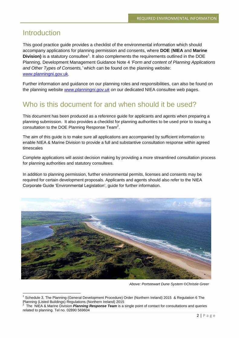
Above: Portstewart Dune System ©Christie Greer
CONSULTATION GUIDE
3 | P a g e
How has this document been structured?
This checklist has been categorised by development type. It provides detail on the environmental
information required by NIEA & Marine Division, to provide advice on the impacts of development
proposal on the environment. It also provides a checklist of information for other consents
administered through the planning process. Links to relevant existing NIEA guidance has also
been included for reference. The development types named within this guide are listed below:
1. Single Dwellings
2. Housing & Residential Developments
3. Single wind turbines
4. Wind Farms
5. Anaerobic Digesters
6. Combustion processes
7. Intensive Agriculture
8. Fish Farms
9. Waste Management
10. Extractive Industry
11. Infrastructure Projects (Roads & Bridges)
12. Cemeteries
13. Industrial Carwash/ Petrol Station
14. Other industrial processes
15. Redevelopment of land affected by contamination
16. Listed building Consent
17. Development in a Conservation Area
18. Advertisement Consent
19. Hazardous Substances Consent
To utilise this guide appropriately, applicants and planning authorities should consider where an
overlap may exist between development types, for example: a residential development on
contaminated land or an infrastructure project which requires mineral extraction. Cross referencing
between the appropriate development types, will help to identify the environmental information
required for your application.
If your development proposal does not fall within one of these categories or you are unsure what
environmental information should be submitted with your planning application, please contact the
Planning Response Team (PRT) on 028 90569604 for assistance.
As the level of detail required will be proportionate to the scale, stage, and complexity of the
proposal, the development type checklists have been subdivided, where applicable, to clarify the
information required for pre-application, outline and full stages of the application process.
Web links to other related NIEA and Marine Division guidance documents have also been
identified for reference.*
*Web references may be subject to change as a result of government wide website reconfiguration.
Applicants and local council planning authorities should contact PRT if documents referred to in
this guide are not accessible.
REQUIRED ENVIRONMENTAL INFORMATION
4 | P a g e
Will the required information be different for local and major
applications?
Planning applications will be categorised as local or major according to thresholds defined in The
Planning (Development Management) Regulations (NI) 2015. Where major applications are
considered to be of regional significance, they will be submitted to the DOE Planning team for
assessment and determination. Annex 1 sets out these thresholds.
Major and regionally significant applications tend to be larger in scale or more complex, and may
therefore require more detailed environmental information for NIEA and Marine Division to assess
the potential implications for our environment and heritage.
Requests for additional information will be considered on a case by case basis and will be
proportionate to the scale and complexity of the application.
How will planning applications be processed from April
2015?
From 1st April 2015, the majority of all local and major planning applications will be determined by
local councils. Planning officers in councils will consult with DOE to provide expert advice on
environmental issues. Local council planning authorities will use this advice to inform their
decision making.
Regionally significant applications will be determined by DOE Planning. This category accounts
for a small percentage of the total planning applications. DOE Planning will refer these
applications internally to NIEA and Marine Division for advice on environmental matters for which
we are responsible.
When is a pre-application consultation with NIEA & Marine
Division required?
Where a formal pre-application discussion process is required, this will be initiated by your local
council planning authority. For major and regionally significant planning applications, NIEA and
Marine Division welcome pre-application discussions with applicants and agents. To enable us to
provide advice on the type and detail of information required to fully assess the impact of a
development upon the natural and historic environment, applicants should provide sufficient detail
on the location, scale, scope and nature of the application.
Further guidance on the pre-application discussion procedure is provided within the DOE Planning
Development Management Planning Note 10: Pre-application Community Consultation
Process and Pre application discussions.
For local applications, applicants and agents should refer to their local council planning authority
and the NIEA guidance series, on our dedicated NIEA consultee web pages, accessible from
www.planningni.gov.uk.
CONSULTATION GUIDE
5 | P a g e
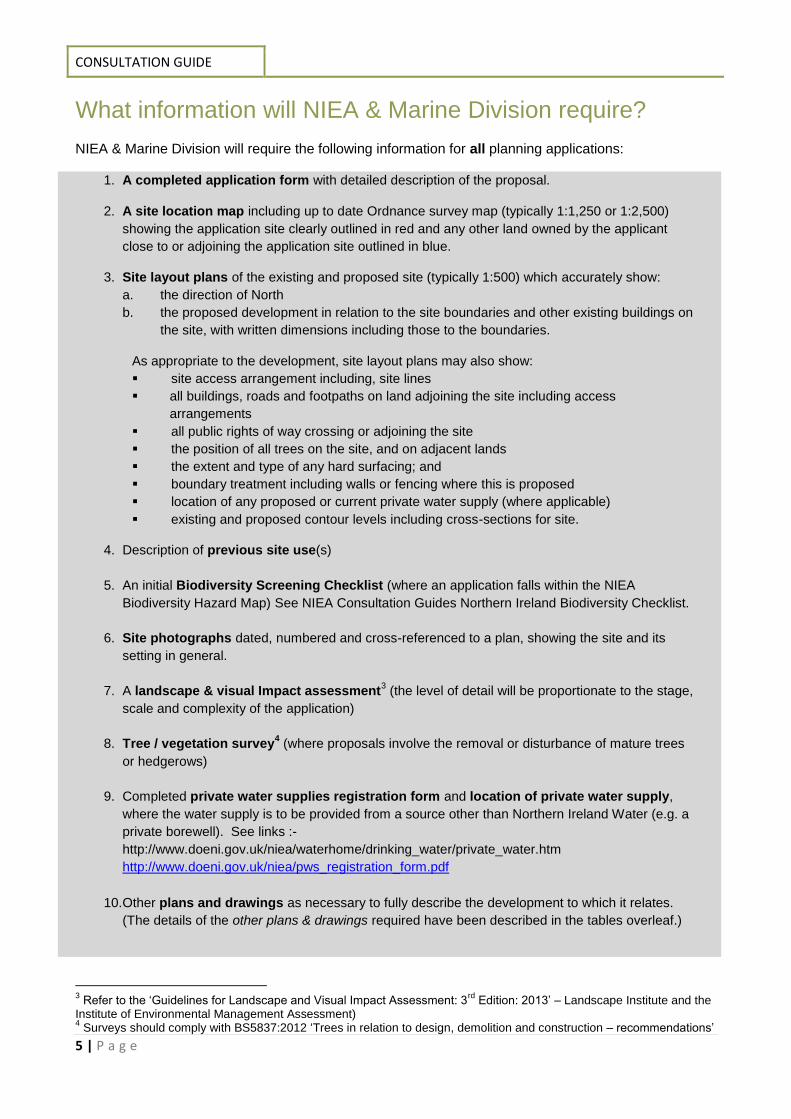
What information will NIEA & Marine Division require?
NIEA & Marine Division will require the following information for all planning applications:
1. A completed application form with detailed description of the proposal.
2. A site location map including up to date Ordnance survey map (typically 1:1,250 or 1:2,500)
showing the application site clearly outlined in red and any other land owned by the applicant
close to or adjoining the application site outlined in blue.
3. Site layout plans of the existing and proposed site (typically 1:500) which accurately show:
a. the direction of North
b. the proposed development in relation to the site boundaries and other existing buildings on
the site, with written dimensions including those to the boundaries.
As appropriate to the development, site layout plans may also show:
site access arrangement including, site lines
all buildings, roads and footpaths on land adjoining the site including access
arrangements
all public rights of way crossing or adjoining the site
the position of all trees on the site, and on adjacent lands
the extent and type of any hard surfacing; and
boundary treatment including walls or fencing where this is proposed
location of any proposed or current private water supply (where applicable)
existing and proposed contour levels including cross-sections for site.
4. Description of previous site use(s)
5. An initial Biodiversity Screening Checklist (where an application falls within the NIEA
Biodiversity Hazard Map) See NIEA Consultation Guides Northern Ireland Biodiversity Checklist.
6. Site photographs dated, numbered and cross-referenced to a plan, showing the site and its
setting in general.
7. A landscape & visual Impact assessment3 (the level of detail will be proportionate to the stage,
scale and complexity of the application)
8. Tree / vegetation survey4 (where proposals involve the removal or disturbance of mature trees
or hedgerows)
9. Completed private water supplies registration form and location of private water supply,
where the water supply is to be provided from a source other than Northern Ireland Water (e.g. a
private borewell). See links :-
http://www.doeni.gov.uk/niea/waterhome/drinking_water/private_water.htm
http://www.doeni.gov.uk/niea/pws_registration_form.pdf
10. Other plans and drawings as necessary to fully describe the development to which it relates.
(The details of the other plans & drawings required have been described in the tables overleaf.)
3 Refer to the ‘Guidelines for Landscape and Visual Impact Assessment: 3
rd Edition: 2013’ – Landscape Institute and the
Institute of Environmental Management Assessment) 4 Surveys should comply with BS5837:2012 ‘Trees in relation to design, demolition and construction – recommendations’
REQUIRED ENVIRONMENTAL INFORMATION
6 | P a g e
Note: Applicants and agents should refer to their local council planning authority for planning application
validation requirements. (Refer to the DOE Planning Development Management Planning Note 4 ‘Form and
content of Planning Applications and Other Types of Consents’ for further guidance on validation requirements.)
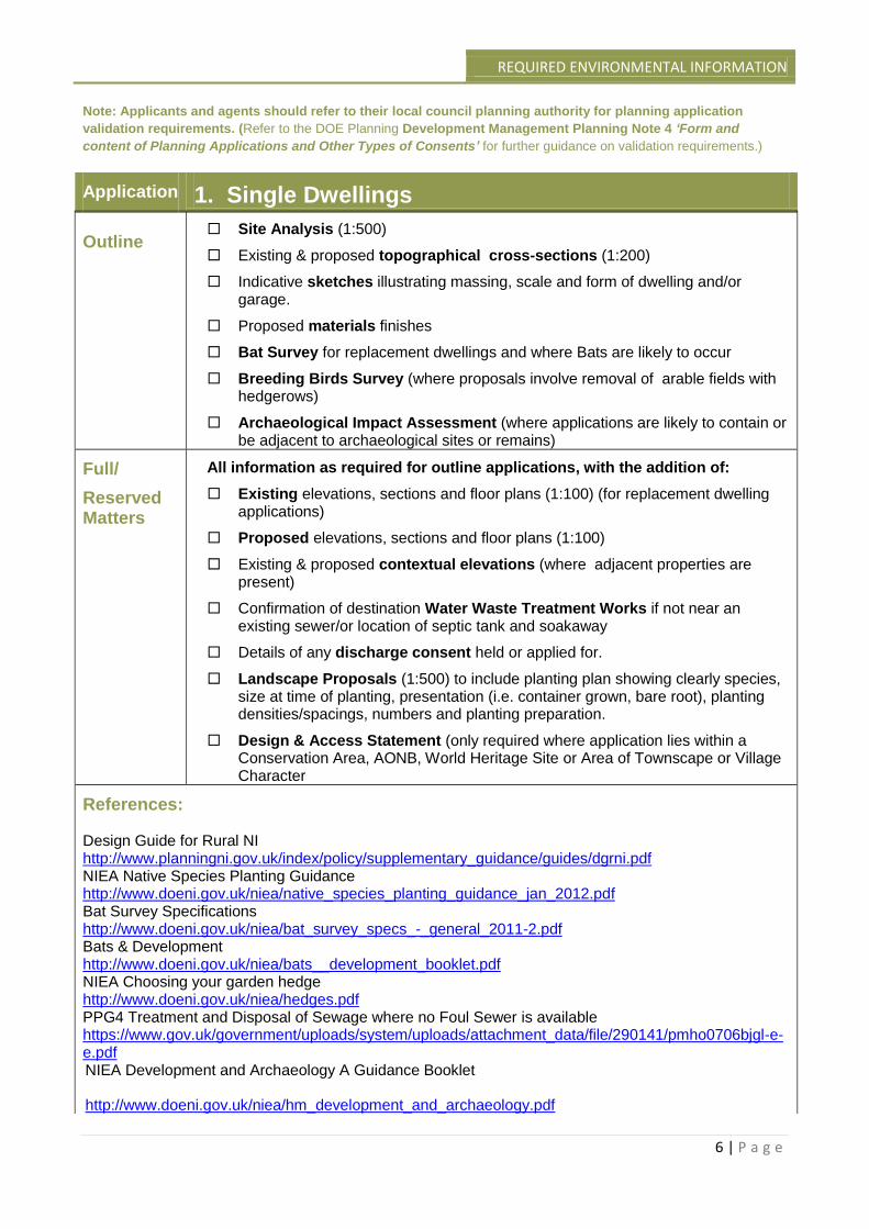
Application 1. Single Dwellings Outline
Site Analysis (1:500)
Existing & proposed topographical cross-sections (1:200)
Indicative sketches illustrating massing, scale and form of dwelling and/or garage.
Proposed materials finishes
Bat Survey for replacement dwellings and where Bats are likely to occur
Breeding Birds Survey (where proposals involve removal of arable fields with hedgerows)
Archaeological Impact Assessment (where applications are likely to contain or be adjacent to archaeological sites or remains)
Full/
Reserved Matters
All information as required for outline applications, with the addition of:
Existing elevations, sections and floor plans (1:100) (for replacement dwelling applications)
Proposed elevations, sections and floor plans (1:100)
Existing & proposed contextual elevations (where adjacent properties are present)
Confirmation of destination Water Waste Treatment Works if not near an existing sewer/or location of septic tank and soakaway
Details of any discharge consent held or applied for.
Landscape Proposals (1:500) to include planting plan showing clearly species, size at time of planting, presentation (i.e. container grown, bare root), planting densities/spacings, numbers and planting preparation.
Design & Access Statement (only required where application lies within a Conservation Area, AONB, World Heritage Site or Area of Townscape or Village Character
References: Design Guide for Rural NI http://www.planningni.gov.uk/index/policy/supplementary_guidance/guides/dgrni.pdf NIEA Native Species Planting Guidance http://www.doeni.gov.uk/niea/native_species_planting_guidance_jan_2012.pdf Bat Survey Specifications http://www.doeni.gov.uk/niea/bat_survey_specs_-_general_2011-2.pdf Bats & Development http://www.doeni.gov.uk/niea/bats__development_booklet.pdf NIEA Choosing your garden hedge http://www.doeni.gov.uk/niea/hedges.pdf PPG4 Treatment and Disposal of Sewage where no Foul Sewer is available https://www.gov.uk/government/uploads/system/uploads/attachment_data/file/290141/pmho0706bjgl-e-e.pdf NIEA Development and Archaeology A Guidance Booklet
http://www.doeni.gov.uk/niea/hm_development_and_archaeology.pdf
CONSULTATION GUIDE
7 | P a g e
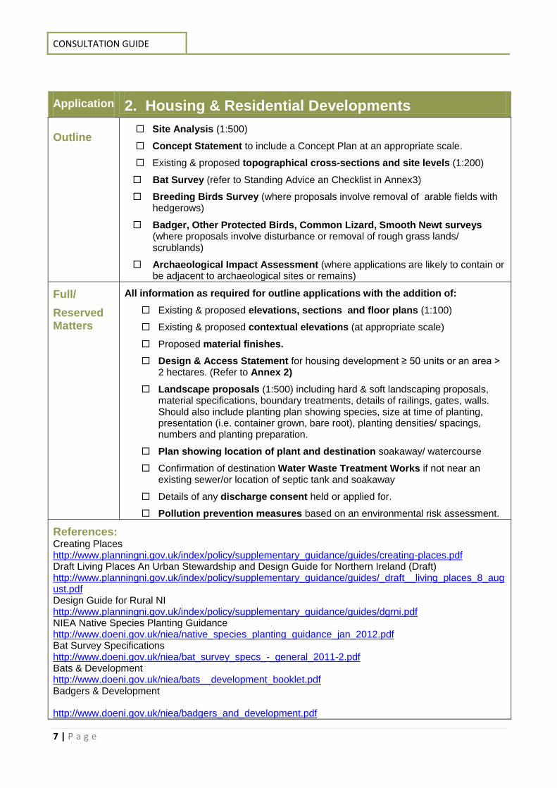
Application 2. Housing & Residential Developments Outline
Site Analysis (1:500)
Concept Statement to include a Concept Plan at an appropriate scale.
Existing & proposed topographical cross-sections and site levels (1:200)
Bat Survey (refer to Standing Advice an Checklist in Annex3)
Breeding Birds Survey (where proposals involve removal of arable fields with hedgerows)
Badger, Other Protected Birds, Common Lizard, Smooth Newt surveys (where proposals involve disturbance or removal of rough grass lands/ scrublands)
Archaeological Impact Assessment (where applications are likely to contain or be adjacent to archaeological sites or remains)
Full/
Reserved Matters
All information as required for outline applications with the addition of:
Existing & proposed elevations, sections and floor plans (1:100)
Existing & proposed contextual elevations (at appropriate scale)
Proposed material finishes.
Design & Access Statement for housing development ≥ 50 units or an area ˃ 2 hectares. (Refer to Annex 2)
Landscape proposals (1:500) including hard & soft landscaping proposals, material specifications, boundary treatments, details of railings, gates, walls. Should also include planting plan showing species, size at time of planting, presentation (i.e. container grown, bare root), planting densities/ spacings, numbers and planting preparation.
Plan showing location of plant and destination soakaway/ watercourse
Confirmation of destination Water Waste Treatment Works if not near an existing sewer/or location of septic tank and soakaway
Details of any discharge consent held or applied for.
Pollution prevention measures based on an environmental risk assessment.
References: Creating Places http://www.planningni.gov.uk/index/policy/supplementary_guidance/guides/creating-places.pdf Draft Living Places An Urban Stewardship and Design Guide for Northern Ireland (Draft) http://www.planningni.gov.uk/index/policy/supplementary_guidance/guides/_draft__living_places_8_august.pdf Design Guide for Rural NI http://www.planningni.gov.uk/index/policy/supplementary_guidance/guides/dgrni.pdf NIEA Native Species Planting Guidance http://www.doeni.gov.uk/niea/native_species_planting_guidance_jan_2012.pdf Bat Survey Specifications http://www.doeni.gov.uk/niea/bat_survey_specs_-_general_2011-2.pdf Bats & Development http://www.doeni.gov.uk/niea/bats__development_booklet.pdf Badgers & Development
http://www.doeni.gov.uk/niea/badgers_and_development.pdf

REQUIRED ENVIRONMENTAL INFORMATION
8 | P a g e
NIEA Choosing your garden hedge http://www.doeni.gov.uk/niea/hedges.pdf PPG4 Treatment and Disposal of Sewage where no Foul Sewer is available https://www.gov.uk/government/uploads/system/uploads/attachment_data/file/290141/pmho0706bjgl-e-e.pdf NIEA Development and Archaeology A Guidance Booklet
http://www.doeni.gov.uk/niea/hm_development_and_archaeology.pdf
CONSULTATION GUIDE
9 | P a g e
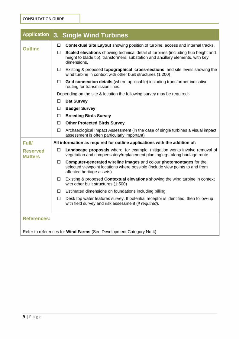
Application 3. Single Wind Turbines Outline
Contextual Site Layout showing position of turbine, access and internal tracks.
Scaled elevations showing technical detail of turbines (including hub height and height to blade tip), transformers, substation and ancillary elements, with key dimensions.
Existing & proposed topographical cross-sections and site levels showing the wind turbine in context with other built structures (1:200)
Grid connection details (where applicable) including transformer indicative routing for transmission lines.
Depending on the site & location the following survey may be required:-
Bat Survey
Badger Survey
Breeding Birds Survey
Other Protected Birds Survey
Archaeological Impact Assessment (in the case of single turbines a visual impact assessment is often particularly important)
Full/
Reserved Matters
All information as required for outline applications with the addition of:
Landscape proposals where, for example, mitigation works involve removal of vegetation and compensatory/replacement planting eg:- along haulage route
Computer-generated wireline images and colour photomontages for the selected viewpoint locations where possible (include view points to and from affected heritage assets)
Existing & proposed Contextual elevations showing the wind turbine in context with other built structures (1:500)
Estimated dimensions on foundations including pilling
Desk top water features survey. If potential receptor is identified, then follow-up with field survey and risk assessment (if required).
References:
Refer to references for Wind Farms (See Development Category No.4)
REQUIRED ENVIRONMENTAL INFORMATION
10 | P a g e
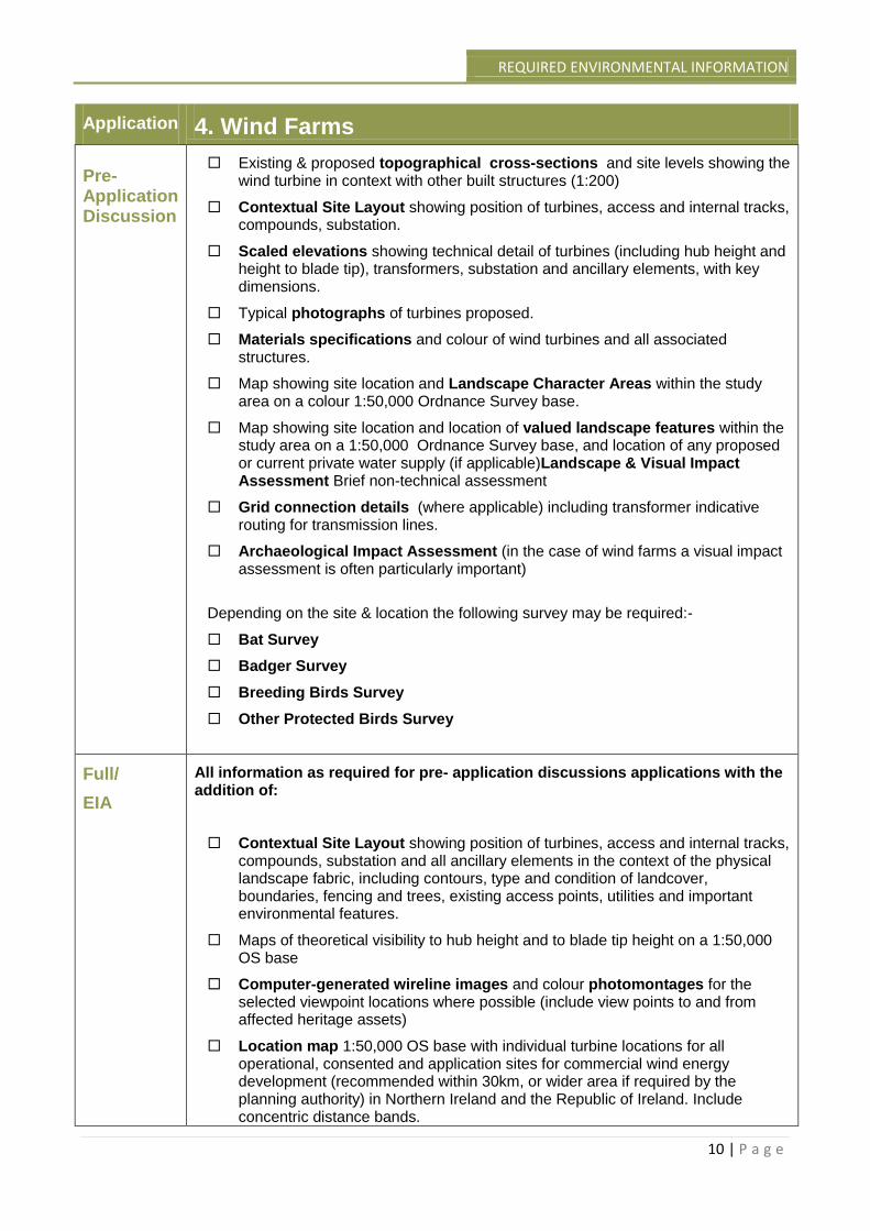
Application 4. Wind Farms Pre-Application Discussion
Existing & proposed topographical cross-sections and site levels showing the wind turbine in context with other built structures (1:200)
Contextual Site Layout showing position of turbines, access and internal tracks, compounds, substation.
Scaled elevations showing technical detail of turbines (including hub height and height to blade tip), transformers, substation and ancillary elements, with key dimensions.
Typical photographs of turbines proposed.
Materials specifications and colour of wind turbines and all associated structures.
Map showing site location and Landscape Character Areas within the study area on a colour 1:50,000 Ordnance Survey base.
Map showing site location and location of valued landscape features within the study area on a 1:50,000 Ordnance Survey base, and location of any proposed or current private water supply (if applicable)Landscape & Visual Impact Assessment Brief non-technical assessment
Grid connection details (where applicable) including transformer indicative routing for transmission lines.
Archaeological Impact Assessment (in the case of wind farms a visual impact assessment is often particularly important)
Depending on the site & location the following survey may be required:-
Bat Survey
Badger Survey
Breeding Birds Survey
Other Protected Birds Survey
Full/
EIA
All information as required for pre- application discussions applications with the addition of:
Contextual Site Layout showing position of turbines, access and internal tracks, compounds, substation and all ancillary elements in the context of the physical landscape fabric, including contours, type and condition of landcover, boundaries, fencing and trees, existing access points, utilities and important environmental features.
Maps of theoretical visibility to hub height and to blade tip height on a 1:50,000 OS base
Computer-generated wireline images and colour photomontages for the selected viewpoint locations where possible (include view points to and from affected heritage assets)
Location map 1:50,000 OS base with individual turbine locations for all operational, consented and application sites for commercial wind energy development (recommended within 30km, or wider area if required by the planning authority) in Northern Ireland and the Republic of Ireland. Include concentric distance bands.
CONSULTATION GUIDE
11 | P a g e
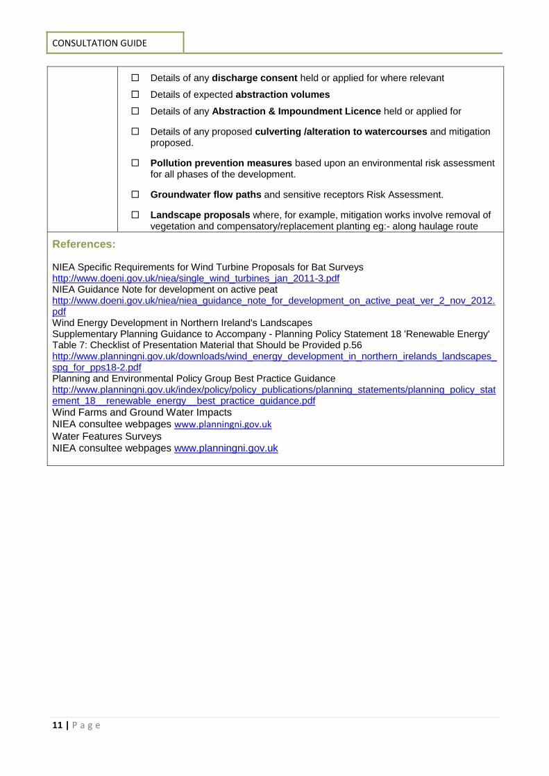
Details of any discharge consent held or applied for where relevant
Details of expected abstraction volumes
Details of any Abstraction & Impoundment Licence held or applied for
Details of any proposed culverting /alteration to watercourses and mitigation proposed.
Pollution prevention measures based upon an environmental risk assessment for all phases of the development.
Groundwater flow paths and sensitive receptors Risk Assessment.
Landscape proposals where, for example, mitigation works involve removal of vegetation and compensatory/replacement planting eg:- along haulage route
References: NIEA Specific Requirements for Wind Turbine Proposals for Bat Surveys http://www.doeni.gov.uk/niea/single_wind_turbines_jan_2011-3.pdf NIEA Guidance Note for development on active peat http://www.doeni.gov.uk/niea/niea_guidance_note_for_development_on_active_peat_ver_2_nov_2012.pdf Wind Energy Development in Northern Ireland's Landscapes Supplementary Planning Guidance to Accompany - Planning Policy Statement 18 'Renewable Energy' Table 7: Checklist of Presentation Material that Should be Provided p.56 http://www.planningni.gov.uk/downloads/wind_energy_development_in_northern_irelands_landscapes_spg_for_pps18-2.pdf Planning and Environmental Policy Group Best Practice Guidance http://www.planningni.gov.uk/index/policy/policy_publications/planning_statements/planning_policy_statement_18__renewable_energy__best_practice_guidance.pdf Wind Farms and Ground Water Impacts NIEA consultee webpages www.planningni.gov.uk Water Features Surveys NIEA consultee webpages www.planningni.gov.uk
REQUIRED ENVIRONMENTAL INFORMATION
12 | P a g e
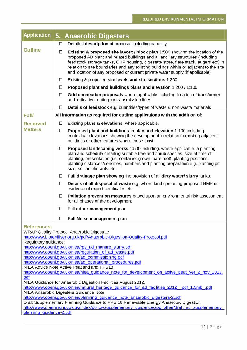
Application 5. Anaerobic Digesters Outline
Detailed description of proposal including capacity
Existing & proposed site layout / block plan 1:500 showing the location of the proposed AD plant and related buildings and all ancillary structures (including feedstock storage tanks, CHP housing, digestate store, flare stack, augers etc) in relation to site boundaries and any existing buildings within or adjacent to the site and location of any proposed or current private water supply (if applicable)
Existing & proposed site levels and site sections 1:200
Proposed plant and buildings plans and elevation 1:200 / 1:100
Grid connection proposals where applicable including location of transformer and indicative routing for transmission lines.
Details of feedstock e.g. quantities/types of waste & non-waste materials
Full/
Reserved Matters
All information as required for outline applications with the addition of:
Existing plans & elevations, where applicable.
Proposed plant and buildings in plan and elevation 1:100 including contextual elevations showing the development in relation to existing adjacent buildings or other features where these exist
Proposed landscaping works 1:500 including, where applicable, a planting plan and schedule detailing suitable tree and shrub species, size at time of planting, presentation (i.e. container grown, bare root), planting positions, planting distances/densities, numbers and planting preparation e.g. planting pit size, soil ameliorants etc.
Full drainage plan showing the provision of all dirty water/ slurry tanks.
Details of all disposal of waste e.g. where land spreading proposed NMP or evidence of export certificates etc.
Pollution prevention measures based upon an environmental risk assessment for all phases of the development
Full odour management plan
Full Noise management plan
References: WRAP Quality Protocol Anaerobic Digestate http://www.biofertiliser.org.uk/pdf/Anaerobic-Digestion-Quality-Protocol.pdf Regulatory guidance: http://www.doeni.gov.uk/niea/rps_ad_manure_slurry.pdf http://www.doeni.gov.uk/niea/regulation_of_ad_waste.pdf http://www.doeni.gov.uk/niea/ad_commissioning.pdf http://www.doeni.gov.uk/niea/ad_operational_procedures.pdf NIEA Advice Note Active Peatland and PPS18 http://www.doeni.gov.uk/niea/niea_guidance_note_for_development_on_active_peat_ver_2_nov_2012.pdf NIEA Guidance for Anaerobic Digestion Facilities August 2012. http://www.doeni.gov.uk/niea/natural_heritage_guidance_for_ad_facilities_2012__pdf_1.5mb_.pdf NIEA Anaerobic Digesters Guidance Note http://www.doeni.gov.uk/niea/planning_guidance_note_anaerobic_digesters-2.pdf Draft Supplementary Planning Guidance to PPS 18 Renewable Energy Anaerobic Digestion http://www.planningni.gov.uk/index/policy/supplementary_guidance/spg_other/draft_ad_supplementary_planning_guidance-2.pdf
CONSULTATION GUIDE
13 | P a g e
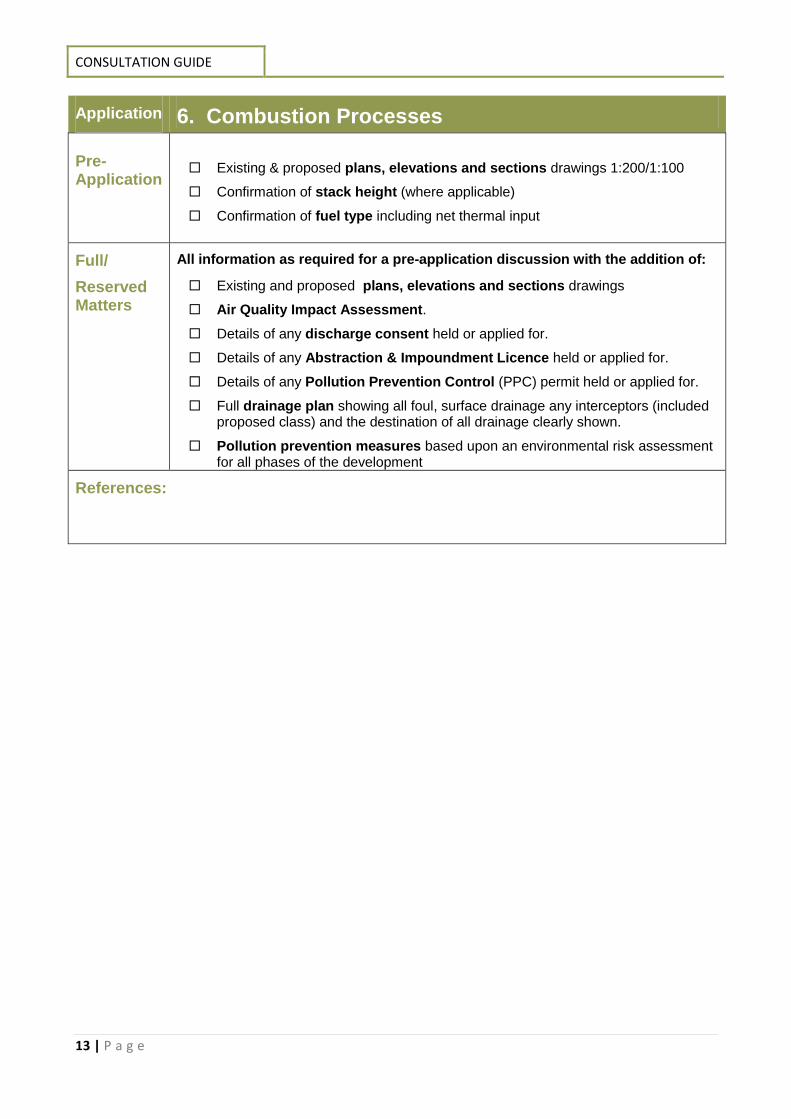
Application 6. Combustion Processes Pre-Application
Existing & proposed plans, elevations and sections drawings 1:200/1:100
Confirmation of stack height (where applicable)
Confirmation of fuel type including net thermal input
Full/
Reserved Matters
All information as required for a pre-application discussion with the addition of:
Existing and proposed plans, elevations and sections drawings
Air Quality Impact Assessment.
Details of any discharge consent held or applied for.
Details of any Abstraction & Impoundment Licence held or applied for.
Details of any Pollution Prevention Control (PPC) permit held or applied for.
Full drainage plan showing all foul, surface drainage any interceptors (included proposed class) and the destination of all drainage clearly shown.
Pollution prevention measures based upon an environmental risk assessment for all phases of the development
References:
REQUIRED ENVIRONMENTAL INFORMATION
14 | P a g e
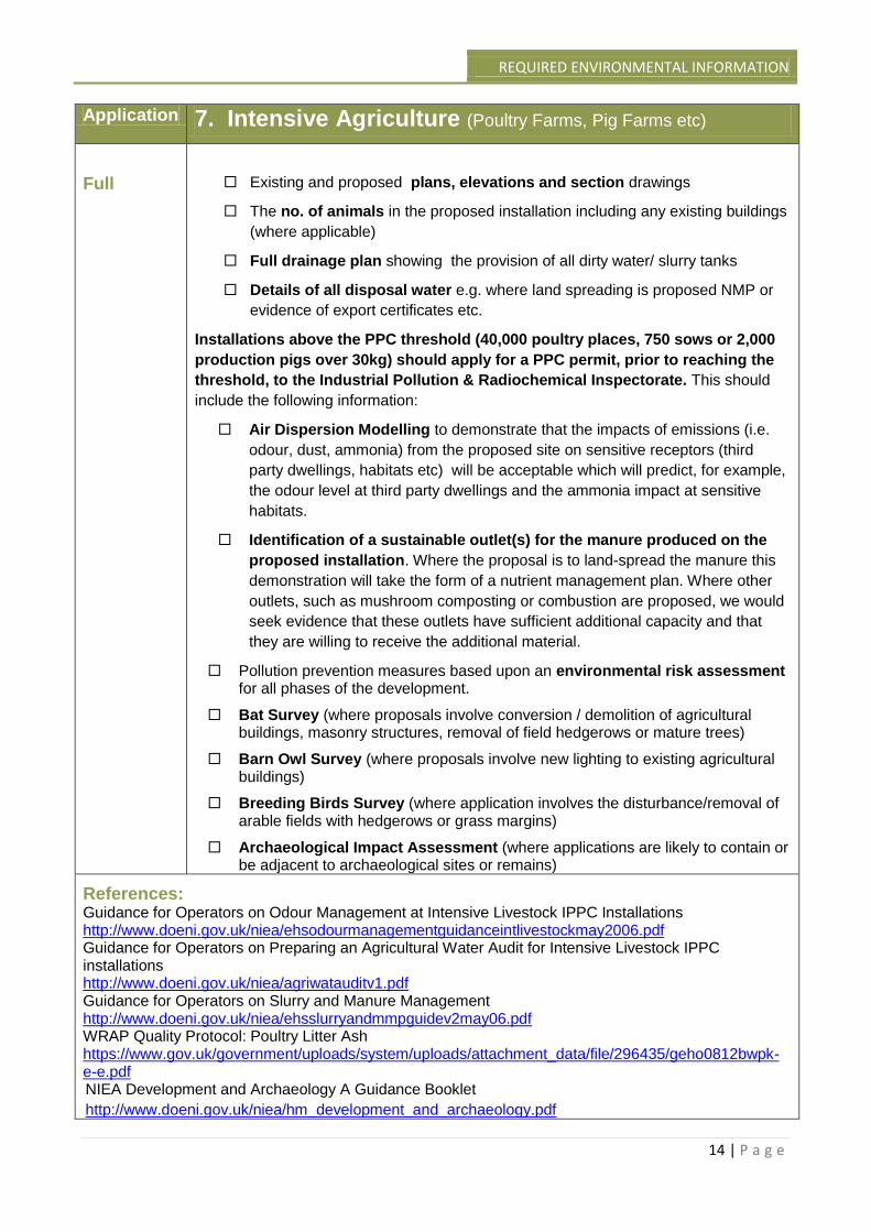
Application 7. Intensive Agriculture (Poultry Farms, Pig Farms etc)
Full
Existing and proposed plans, elevations and section drawings
The no. of animals in the proposed installation including any existing buildings
(where applicable)
Full drainage plan showing the provision of all dirty water/ slurry tanks
Details of all disposal water e.g. where land spreading is proposed NMP or
evidence of export certificates etc.
Installations above the PPC threshold (40,000 poultry places, 750 sows or 2,000
production pigs over 30kg) should apply for a PPC permit, prior to reaching the
threshold, to the Industrial Pollution & Radiochemical Inspectorate. This should
include the following information:
Air Dispersion Modelling to demonstrate that the impacts of emissions (i.e.
odour, dust, ammonia) from the proposed site on sensitive receptors (third
party dwellings, habitats etc) will be acceptable which will predict, for example,
the odour level at third party dwellings and the ammonia impact at sensitive
habitats.
Identification of a sustainable outlet(s) for the manure produced on the
proposed installation. Where the proposal is to land-spread the manure this
demonstration will take the form of a nutrient management plan. Where other
outlets, such as mushroom composting or combustion are proposed, we would
seek evidence that these outlets have sufficient additional capacity and that
they are willing to receive the additional material.
Pollution prevention measures based upon an environmental risk assessment for all phases of the development.
Bat Survey (where proposals involve conversion / demolition of agricultural buildings, masonry structures, removal of field hedgerows or mature trees)
Barn Owl Survey (where proposals involve new lighting to existing agricultural buildings)
Breeding Birds Survey (where application involves the disturbance/removal of arable fields with hedgerows or grass margins)
Archaeological Impact Assessment (where applications are likely to contain or be adjacent to archaeological sites or remains)
References: Guidance for Operators on Odour Management at Intensive Livestock IPPC Installations http://www.doeni.gov.uk/niea/ehsodourmanagementguidanceintlivestockmay2006.pdf Guidance for Operators on Preparing an Agricultural Water Audit for Intensive Livestock IPPC installations http://www.doeni.gov.uk/niea/agriwatauditv1.pdf Guidance for Operators on Slurry and Manure Management http://www.doeni.gov.uk/niea/ehsslurryandmmpguidev2may06.pdf WRAP Quality Protocol: Poultry Litter Ash https://www.gov.uk/government/uploads/system/uploads/attachment_data/file/296435/geho0812bwpk-e-e.pdf NIEA Development and Archaeology A Guidance Booklet
http://www.doeni.gov.uk/niea/hm_development_and_archaeology.pdf
CONSULTATION GUIDE
15 | P a g e
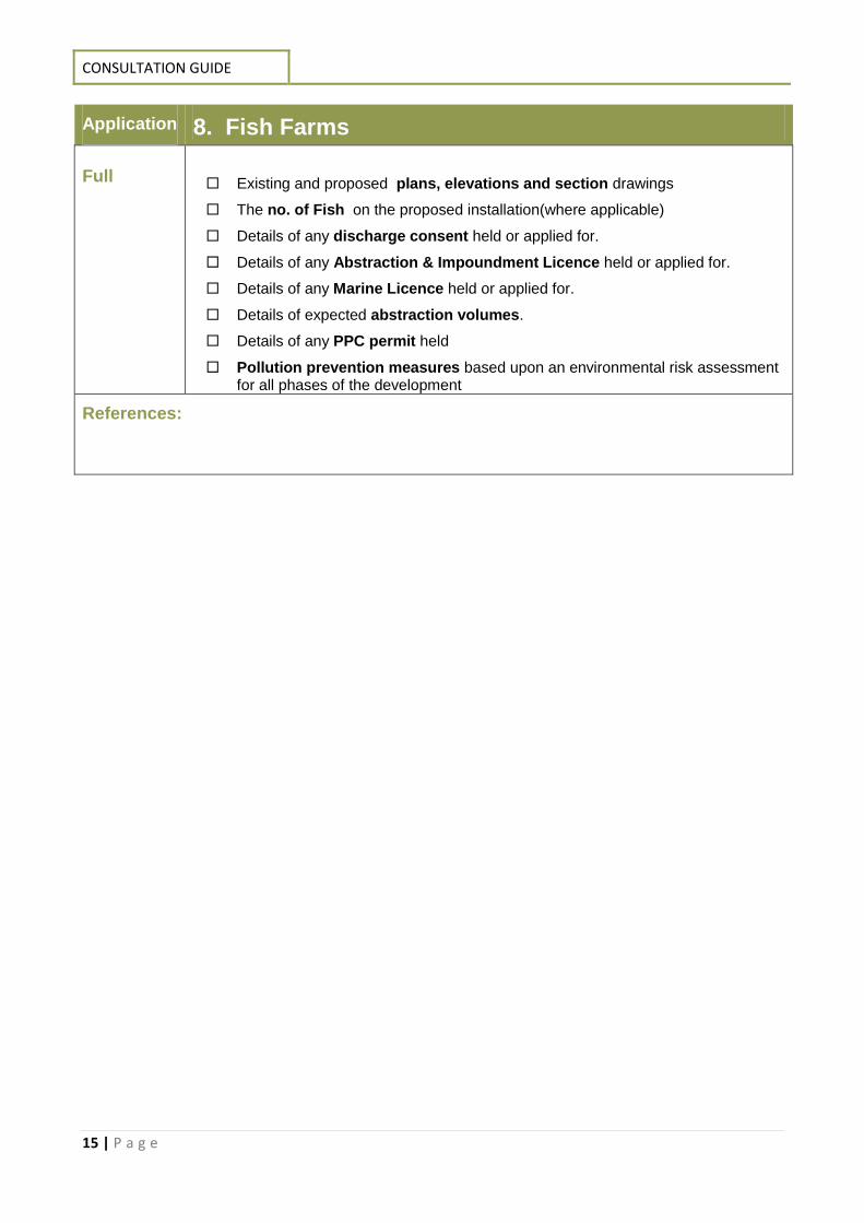
Application 8. Fish Farms Full
Existing and proposed plans, elevations and section drawings
The no. of Fish on the proposed installation(where applicable)
Details of any discharge consent held or applied for.
Details of any Abstraction & Impoundment Licence held or applied for.
Details of any Marine Licence held or applied for.
Details of expected abstraction volumes.
Details of any PPC permit held
Pollution prevention measures based upon an environmental risk assessment for all phases of the development
References:
REQUIRED ENVIRONMENTAL INFORMATION
16 | P a g e
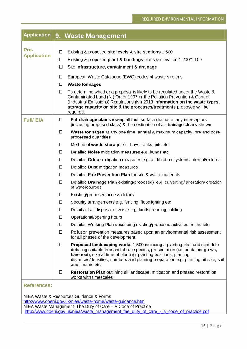
Application 9. Waste Management Pre-Application
Existing & proposed site levels & site sections 1:500
Existing & proposed plant & buildings plans & elevation 1:200/1:100
Site infrastructure, containment & drainage
European Waste Catalogue (EWC) codes of waste streams
Waste tonnages
To determine whether a proposal is likely to be regulated under the Waste & Contaminated Land (NI) Order 1997 or the Pollution Prevention & Control (Industrial Emissions) Regulations (NI) 2013 information on the waste types, storage capacity on site & the processes/treatments proposed will be required.
Full/ EIA Full drainage plan showing all foul, surface drainage, any interceptors (including proposed class) & the destination of all drainage clearly shown
Waste tonnages at any one time, annually, maximum capacity, pre and post-processed quantities
Method of waste storage e.g. bays, tanks, pits etc
Detailed Noise mitigation measures e.g. bunds etc
Detailed Odour mitigation measures e.g. air filtration systems internal/external
Detailed Dust mitigation measures
Detailed Fire Prevention Plan for site & waste materials
Detailed Drainage Plan existing/proposed) e.g. culverting/ alteration/ creation of watercourses
Existing/proposed access details
Security arrangements e.g. fencing, floodlighting etc
Details of all disposal of waste e.g. landspreading, infilling
Operational/opening hours
Detailed Working Plan describing existing/proposed activities on the site
Pollution prevention measures based upon an environmental risk assessment for all phases of the development
Proposed landscaping works 1:500 including a planting plan and schedule detailing suitable tree and shrub species, presentation (i.e. container grown, bare root), size at time of planting, planting positions, planting distances/densities, numbers and planting preparation e.g. planting pit size, soil ameliorants etc.
Restoration Plan outlining all landscape, mitigation and phased restoration works with timescales
References: NIEA Waste & Resources Guidance & Forms http://www.doeni.gov.uk/niea/waste-home/waste-guidance.htm NIEA Waste Management The Duty of Care – A Code of Practice http://www.doeni.gov.uk/niea/waste_management_the_duty_of_care_-_a_code_of_practice.pdf
CONSULTATION GUIDE
17 | P a g e
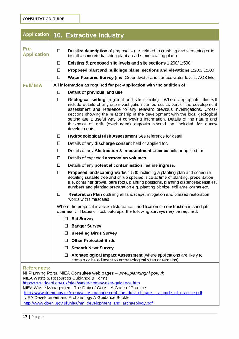
Application 10. Extractive Industry Pre-Application
Detailed description of proposal – (i.e. related to crushing and screening or to install a concrete batching plant / road stone coating plant)
Existing & proposed site levels and site sections 1:200/ 1:500;
Proposed plant and buildings plans, sections and elevations 1:200/ 1:100
Water Features Survey (inc. Groundwater and surface water levels, AOS Etc)
Full/ EIA All information as required for pre-application with the addition of:
Details of previous land use
Geological setting (regional and site specific): Where appropriate, this will include details of any site investigation carried out as part of the development assessment and reference to any relevant previous investigations. Cross-sections showing the relationship of the development with the local geological setting are a useful way of conveying information. Details of the nature and thickness of drift (overburden) deposits should be included for quarry developments.
Hydrogeological Risk Assessment See reference for detail
Details of any discharge consent held or applied for.
Details of any Abstraction & Impoundment Licence held or applied for.
Details of expected abstraction volumes.
Details of any potential contamination / saline ingress.
Proposed landscaping works 1:500 including a planting plan and schedule detailing suitable tree and shrub species, size at time of planting, presentation (i.e. container grown, bare root), planting positions, planting distances/densities, numbers and planting preparation e.g. planting pit size, soil ameliorants etc.
Restoration Plan outlining all landscape, mitigation and phased restoration works with timescales
Where the proposal involves disturbance, modification or construction in sand pits, quarries, cliff faces or rock outcrops, the following surveys may be required:
Bat Survey
Badger Survey
Breeding Birds Survey
Other Protected Birds
Smooth Newt Survey
Archaeological Impact Assessment (where applications are likely to contain or be adjacent to archaeological sites or remains)
References: NI Planning Portal NIEA Consultee web pages – www.planningni.gov.uk NIEA Waste & Resources Guidance & Forms http://www.doeni.gov.uk/niea/waste-home/waste-guidance.htm NIEA Waste Management The Duty of Care – A Code of Practice http://www.doeni.gov.uk/niea/waste_management_the_duty_of_care_-_a_code_of_practice.pdf NIEA Development and Archaeology A Guidance Booklet
http://www.doeni.gov.uk/niea/hm_development_and_archaeology.pdf
REQUIRED ENVIRONMENTAL INFORMATION
18 | P a g e
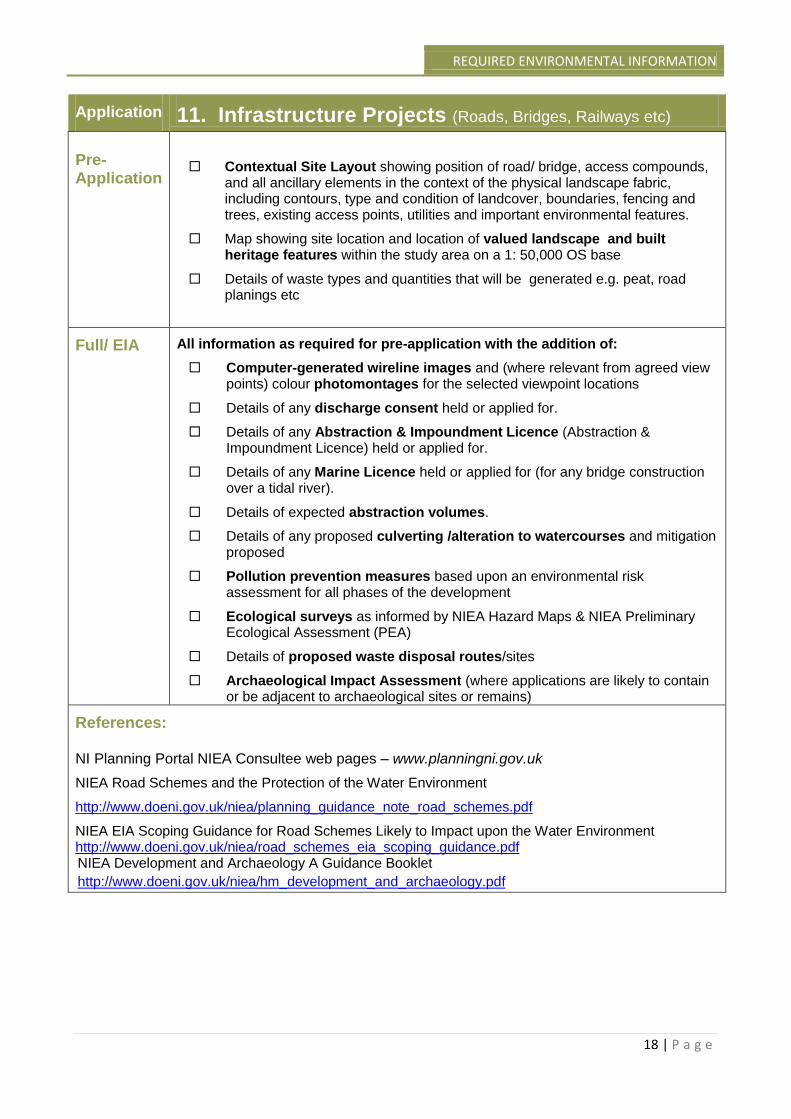
Application 11. Infrastructure Projects (Roads, Bridges, Railways etc) Pre-Application
Contextual Site Layout showing position of road/ bridge, access compounds, and all ancillary elements in the context of the physical landscape fabric, including contours, type and condition of landcover, boundaries, fencing and trees, existing access points, utilities and important environmental features.
Map showing site location and location of valued landscape and built heritage features within the study area on a 1: 50,000 OS base
Details of waste types and quantities that will be generated e.g. peat, road planings etc
Full/ EIA All information as required for pre-application with the addition of:
Computer-generated wireline images and (where relevant from agreed view points) colour photomontages for the selected viewpoint locations
Details of any discharge consent held or applied for.
Details of any Abstraction & Impoundment Licence (Abstraction & Impoundment Licence) held or applied for.
Details of any Marine Licence held or applied for (for any bridge construction over a tidal river).
Details of expected abstraction volumes.
Details of any proposed culverting /alteration to watercourses and mitigation proposed
Pollution prevention measures based upon an environmental risk assessment for all phases of the development
Ecological surveys as informed by NIEA Hazard Maps & NIEA Preliminary Ecological Assessment (PEA)
Details of proposed waste disposal routes/sites
Archaeological Impact Assessment (where applications are likely to contain or be adjacent to archaeological sites or remains)
References: NI Planning Portal NIEA Consultee web pages – www.planningni.gov.uk
NIEA Road Schemes and the Protection of the Water Environment
http://www.doeni.gov.uk/niea/planning_guidance_note_road_schemes.pdf
NIEA EIA Scoping Guidance for Road Schemes Likely to Impact upon the Water Environment http://www.doeni.gov.uk/niea/road_schemes_eia_scoping_guidance.pdf NIEA Development and Archaeology A Guidance Booklet
http://www.doeni.gov.uk/niea/hm_development_and_archaeology.pdf
CONSULTATION GUIDE
19 | P a g e
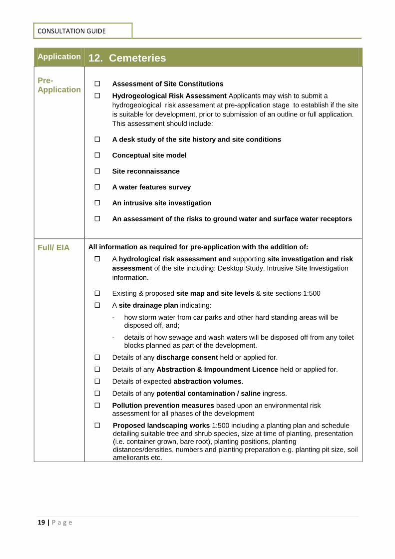
Application 12. Cemeteries Pre-Application
Assessment of Site Constitutions
Hydrogeological Risk Assessment Applicants may wish to submit a
hydrogeological risk assessment at pre-application stage to establish if the site
is suitable for development, prior to submission of an outline or full application.
This assessment should include:
A desk study of the site history and site conditions
Conceptual site model
Site reconnaissance
A water features survey
An intrusive site investigation
An assessment of the risks to ground water and surface water receptors
Full/ EIA All information as required for pre-application with the addition of:
A hydrological risk assessment and supporting site investigation and risk
assessment of the site including: Desktop Study, Intrusive Site Investigation
information.
Existing & proposed site map and site levels & site sections 1:500
A site drainage plan indicating:
- how storm water from car parks and other hard standing areas will be disposed off, and;
- details of how sewage and wash waters will be disposed off from any toilet blocks planned as part of the development.
Details of any discharge consent held or applied for.
Details of any Abstraction & Impoundment Licence held or applied for.
Details of expected abstraction volumes.
Details of any potential contamination / saline ingress.
Pollution prevention measures based upon an environmental risk assessment for all phases of the development
Proposed landscaping works 1:500 including a planting plan and schedule detailing suitable tree and shrub species, size at time of planting, presentation (i.e. container grown, bare root), planting positions, planting distances/densities, numbers and planting preparation e.g. planting pit size, soil ameliorants etc.
REQUIRED ENVIRONMENTAL INFORMATION
20 | P a g e
References: NIEA A Guidance Note for Planning Officers and Applicants Seeking Planning Permission for New Cemeteries and Extensions to Existing Cemeteries. http://www.doeni.gov.uk/niea/planning_guidance_note_cemeteries.pdf NIEA Cemeteries, Burials & The Water Environment http://www.doeni.gov.uk/niea/cemeteryguidance.pdf Environment Agency R&D Technical Report P223: Pollution Potential of Cemeteries – Draft guidance https://www.gov.uk/government/uploads/system/uploads/attachment_data/file/290605/str-p223-e-e.pdf Environment Agency: Amendment Pollution potential of cemeteries – R&D P223 https://www.gov.uk/government/uploads/system/uploads/attachment_data/file/290376/scho0205biph-e-e.pdf World Health Organization: The impact of cemeteries on the environment and public health http://whqlibdoc.who.int/euro/1998-99/eur_icp_ehna_01_04_01(a).pdf
CONSULTATION GUIDE
21 | P a g e
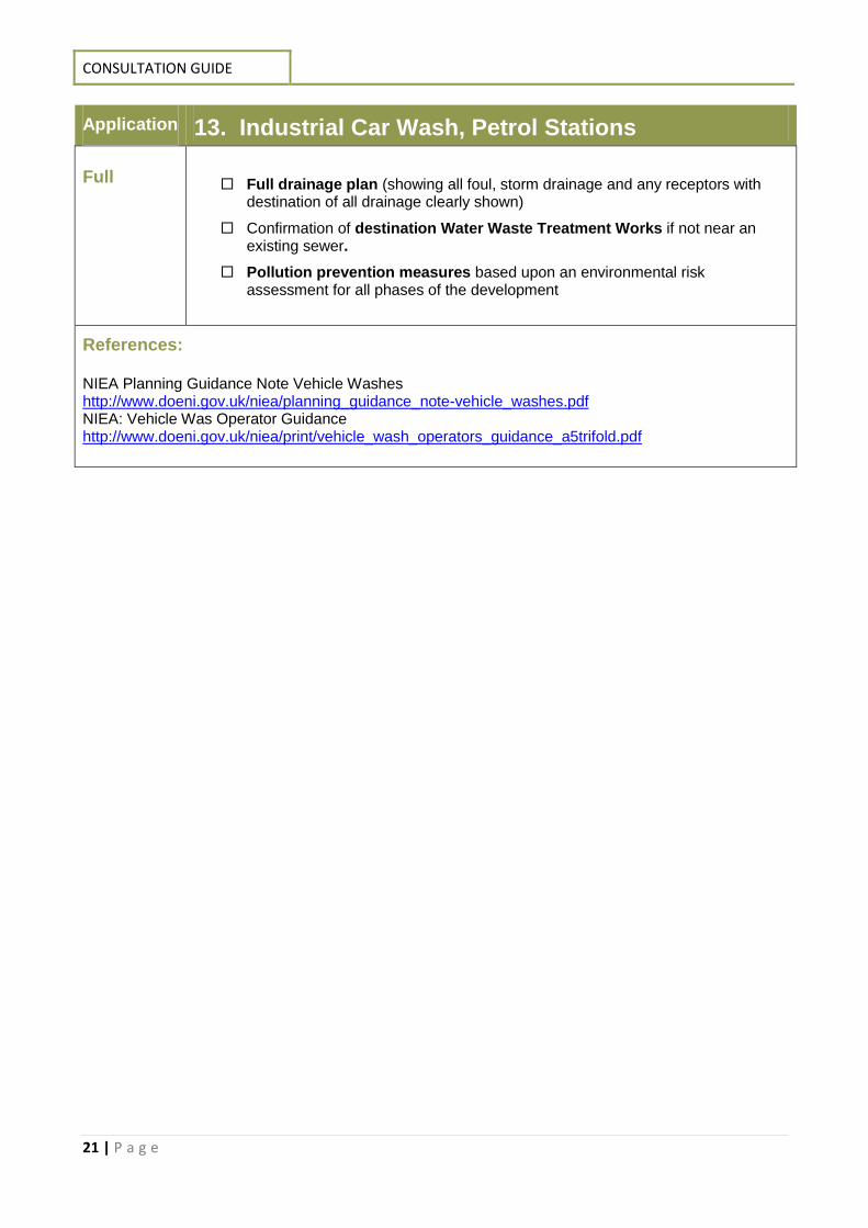
Application 13. Industrial Car Wash, Petrol Stations Full
Full drainage plan (showing all foul, storm drainage and any receptors with destination of all drainage clearly shown)
Confirmation of destination Water Waste Treatment Works if not near an existing sewer.
Pollution prevention measures based upon an environmental risk assessment for all phases of the development
References: NIEA Planning Guidance Note Vehicle Washes http://www.doeni.gov.uk/niea/planning_guidance_note-vehicle_washes.pdf NIEA: Vehicle Was Operator Guidance http://www.doeni.gov.uk/niea/print/vehicle_wash_operators_guidance_a5trifold.pdf
REQUIRED ENVIRONMENTAL INFORMATION
22 | P a g e
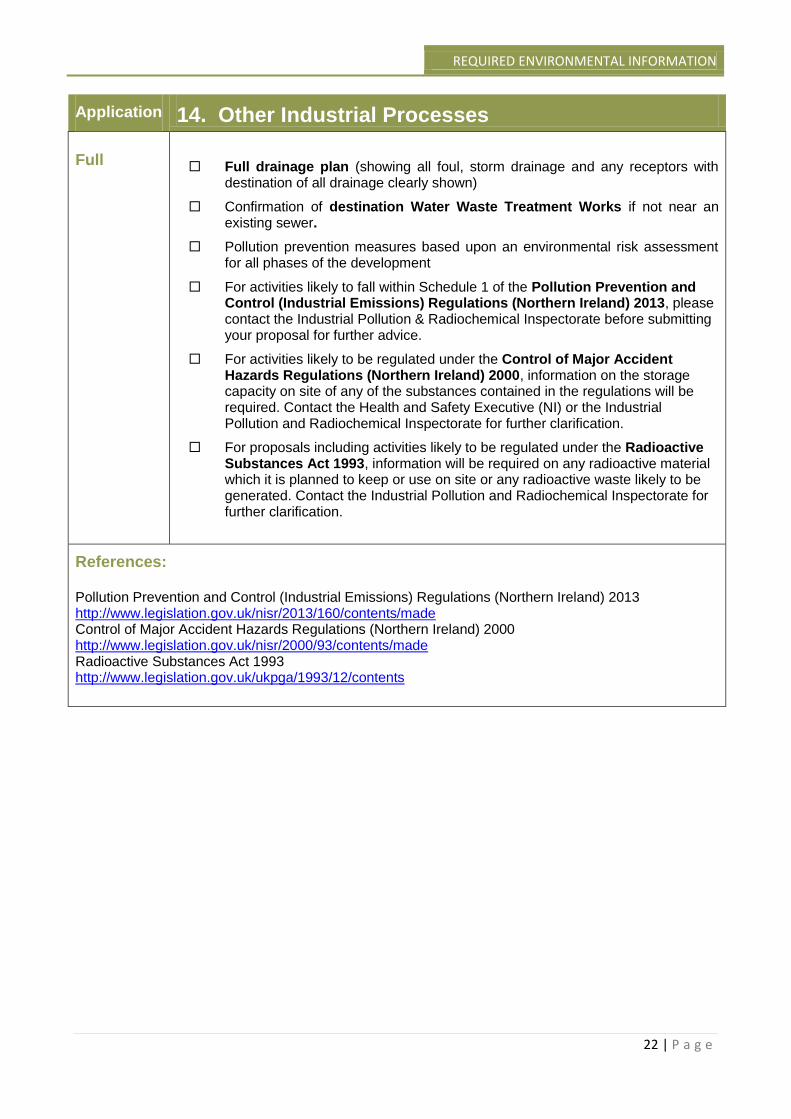
Application 14. Other Industrial Processes Full
Full drainage plan (showing all foul, storm drainage and any receptors with destination of all drainage clearly shown)
Confirmation of destination Water Waste Treatment Works if not near an existing sewer.
Pollution prevention measures based upon an environmental risk assessment for all phases of the development
For activities likely to fall within Schedule 1 of the Pollution Prevention and Control (Industrial Emissions) Regulations (Northern Ireland) 2013, please contact the Industrial Pollution & Radiochemical Inspectorate before submitting your proposal for further advice.
For activities likely to be regulated under the Control of Major Accident Hazards Regulations (Northern Ireland) 2000, information on the storage capacity on site of any of the substances contained in the regulations will be required. Contact the Health and Safety Executive (NI) or the Industrial Pollution and Radiochemical Inspectorate for further clarification.
For proposals including activities likely to be regulated under the Radioactive Substances Act 1993, information will be required on any radioactive material which it is planned to keep or use on site or any radioactive waste likely to be generated. Contact the Industrial Pollution and Radiochemical Inspectorate for further clarification.
References: Pollution Prevention and Control (Industrial Emissions) Regulations (Northern Ireland) 2013 http://www.legislation.gov.uk/nisr/2013/160/contents/made Control of Major Accident Hazards Regulations (Northern Ireland) 2000 http://www.legislation.gov.uk/nisr/2000/93/contents/made Radioactive Substances Act 1993 http://www.legislation.gov.uk/ukpga/1993/12/contents
CONSULTATION GUIDE
23 | P a g e
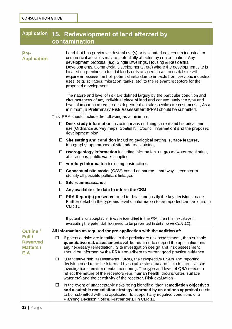
Application 15. Redevelopment of land affected by contamination
Pre-Application
Land that has previous industrial use(s) or is situated adjacent to industrial or commercial activities may be potentially affected by contamination. Any development proposal (e.g. Single Dwellings, Housing & Residential Developments, Commercial Developments, etc) where the development site is located on previous industrial lands or is adjacent to an industrial site will require an assessment of potential risks due to impacts from previous industrial uses (e.g. spillages, migration, tanks, etc) to the relevant receptors for the proposed development. The nature and level of risk are defined largely by the particular condition and circumstances of any individual piece of land and consequently the type and level of information required is dependent on site specific circumstances. , As a minimum, a Preliminary Risk Assessment (PRA) should be submitted.
This PRA should include the following as a minimum:
Desk study information including maps outlining current and historical land use (Ordnance survey maps, Spatial NI, Council information) and the proposed development plan.
Site setting and condition including geological setting, surface features, topography, appearance of site, odours, staining,
Hydrogeology information including information on groundwater monitoring, abstractions, public water supplies
ydrology information including abstractions
Conceptual site model (CSM) based on source – pathway – receptor to identify all possible pollutant linkages
Site reconnaissance
Any available site data to inform the CSM
PRA Report(s) presented need to detail and justify the key decisions made. Further detail on the type and level of information to be reported can be found in CLR 11
If potential unacceptable risks are identified in the PRA, then the next steps in evaluating the potential risks need to be presented in detail (see CLR 11).
Outline / Full / Reserved Matters / EIA
All information as required for pre-application with the addition of:
If potential risks are identified in the preliminary risk assessment , then suitable quantitative risk assessments will be required to support the application and any necessary remediation. Site investigation design and risk assessment should be informed by the PRA and adhere to current good practice guidance
Quantitative risk assessments (QRA), their respective CSMs and reporting decision need to be be informed by suitable site data and include intrusive site investigations, environmental monitoring. The type and level of QRA needs to reflect the nature of the receptors (e.g. human health, groundwater, surface water etc) and the sensitivity of the receptor. Risk evaluation .
In the event of unacceptable risks being identified, then remediation objectives and a suitable remediation strategy informed by an options appraisal needs to be submitted with the application to support any negative conditions of a Planning Decision Notice. Further detail in CLR 11
REQUIRED ENVIRONMENTAL INFORMATION
24 | P a g e
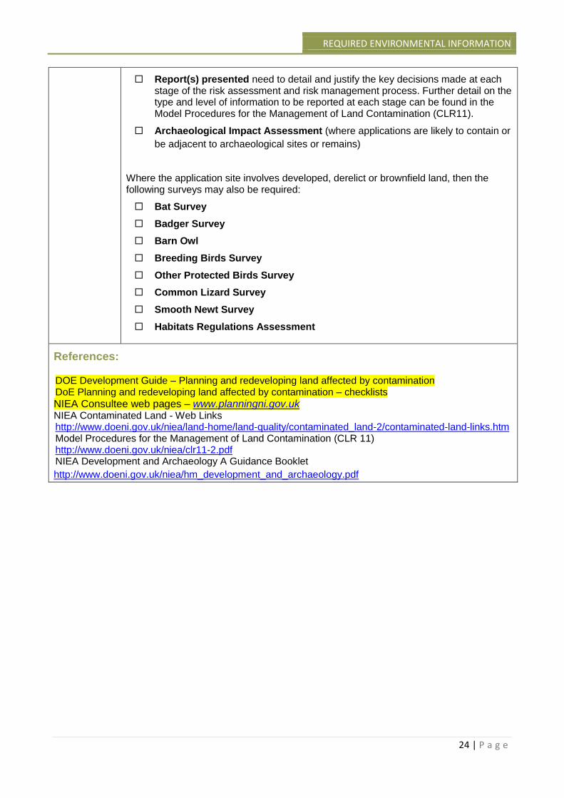
Report(s) presented need to detail and justify the key decisions made at each stage of the risk assessment and risk management process. Further detail on the type and level of information to be reported at each stage can be found in the Model Procedures for the Management of Land Contamination (CLR11).
Archaeological Impact Assessment (where applications are likely to contain or
be adjacent to archaeological sites or remains)
Where the application site involves developed, derelict or brownfield land, then the following surveys may also be required:
Bat Survey
Badger Survey
Barn Owl
Breeding Birds Survey
Other Protected Birds Survey
Common Lizard Survey
Smooth Newt Survey
Habitats Regulations Assessment
References: DOE Development Guide – Planning and redeveloping land affected by contamination DoE Planning and redeveloping land affected by contamination – checklists
NIEA Consultee web pages – www.planningni.gov.uk NIEA Contaminated Land - Web Links http://www.doeni.gov.uk/niea/land-home/land-quality/contaminated_land-2/contaminated-land-links.htm Model Procedures for the Management of Land Contamination (CLR 11) http://www.doeni.gov.uk/niea/clr11-2.pdf NIEA Development and Archaeology A Guidance Booklet
http://www.doeni.gov.uk/niea/hm_development_and_archaeology.pdf
CONSULTATION GUIDE
25 | P a g e
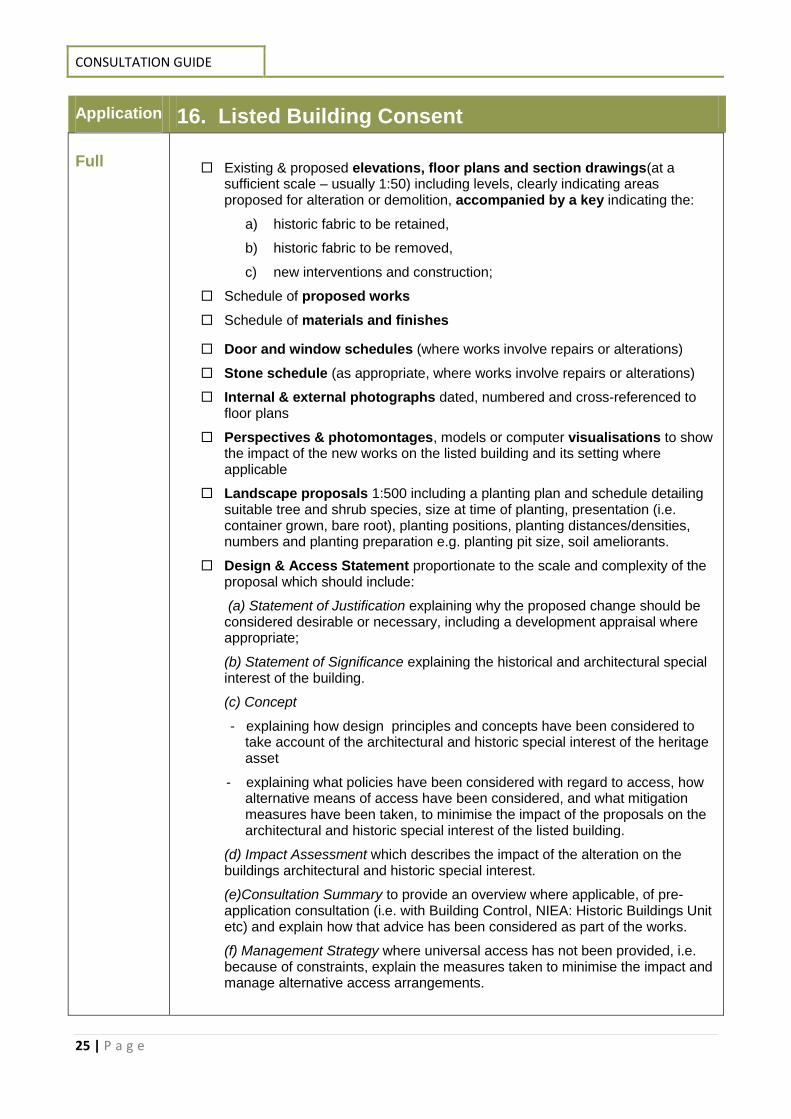
Application 16. Listed Building Consent Full
Existing & proposed elevations, floor plans and section drawings(at a sufficient scale – usually 1:50) including levels, clearly indicating areas proposed for alteration or demolition, accompanied by a key indicating the:
a) historic fabric to be retained,
b) historic fabric to be removed,
c) new interventions and construction;
Schedule of proposed works
Schedule of materials and finishes
Door and window schedules (where works involve repairs or alterations)
Stone schedule (as appropriate, where works involve repairs or alterations)
Internal & external photographs dated, numbered and cross-referenced to floor plans
Perspectives & photomontages, models or computer visualisations to show the impact of the new works on the listed building and its setting where applicable
Landscape proposals 1:500 including a planting plan and schedule detailing suitable tree and shrub species, size at time of planting, presentation (i.e. container grown, bare root), planting positions, planting distances/densities, numbers and planting preparation e.g. planting pit size, soil ameliorants.
Design & Access Statement proportionate to the scale and complexity of the proposal which should include:
(a) Statement of Justification explaining why the proposed change should be considered desirable or necessary, including a development appraisal where appropriate;
(b) Statement of Significance explaining the historical and architectural special interest of the building.
(c) Concept
- explaining how design principles and concepts have been considered to take account of the architectural and historic special interest of the heritage asset
- explaining what policies have been considered with regard to access, how alternative means of access have been considered, and what mitigation measures have been taken, to minimise the impact of the proposals on the architectural and historic special interest of the listed building.
(d) Impact Assessment which describes the impact of the alteration on the buildings architectural and historic special interest.
(e)Consultation Summary to provide an overview where applicable, of pre-application consultation (i.e. with Building Control, NIEA: Historic Buildings Unit etc) and explain how that advice has been considered as part of the works.
(f) Management Strategy where universal access has not been provided, i.e. because of constraints, explain the measures taken to minimise the impact and manage alternative access arrangements.
REQUIRED ENVIRONMENTAL INFORMATION
26 | P a g e
Where applications involve significant partial demolition or structural alterations, LBC applications should also be accompanied by a:
Structural survey and / or condition report by a structural or building engineer, experienced in working with listed buildings, which should identify:
a) structural defects
b) proposed conservation led remedial works,
c) a method statement demonstrating how the proposed structural works will be undertaken, also outlining how the listed building will be protected, during construction work.
References:
DOE Planning DM Guidance Note 12- Design & Access Statements
DOE Planning web pages– www.planningni.gov.uk PPS6 Planning Archaeology and the Built Heritage
http://www.planningni.gov.uk/index/policy/policy_publications/planning_statements/pps06-archaeology-
built-heritage.pdf
The Planning (Listed Buildings) Regulations (Northern Ireland) 2015
http://www.legislation.gov.uk/nisr/2015/108/contents/made
CONSULTATION GUIDE
27 | P a g e
Application 17. Development in a Conservation Area Full
NIEA is not a statutory consultee for Conservation Area Consent (CAC) but request notification of CAC applications which involve the demolition of a building, in a Conservation Area or Area of Townscape Character.
All applications for Conservation Area Consent should be accompanied with a full application for the redevelopment of the site, prohibiting demolition of the building until planning permission has been granted and contracts have been signed for the approved redevelopment of the site
; and requiring, where
appropriate, the recording of the building prior to its demolition.
Where a full planning application relates to development in a Conservation Area or Area of Townscape Character and directly affects the setting of a listed building, NIEA are a statutory consultee and will require the following information:
Existing & proposed elevations, floor plans and section drawings including
levels.
Where proposal relates to development in a CA or ATC, drawings should
clearly indicate areas proposed for alteration or demolition, accompanied by a
key indicating the:
a) historic fabric to be retained,
b) historic fabric to be removed,
c) new interventions and construction
Internal & external photographs dated, numbered and cross-referenced to floor plans
Schedule of proposed works
Schedule of materials and finishes
Design & Access Statement (where development in a CA involves,
i. One or more dwelling house; or
ii. A building or buildings where the floor space created by the development is 100 square metres or more)
For development which does not fall within the above thresholds the following written information should be provided:
- Statement of Justification which explains why the demolition is considered desirable or necessary (this should include a development appraisal where appropriate);
- Statement of Significance (explaining the historical or architectural interest of the building).
- Impact Assessment of the works on the significance of the Designated Area, along with a mitigation strategy explaining how harm to significance will be avoided or minimised, with any harm weighed against any public benefits;
Where applications involve significant partial demolition or structural alterations,
REQUIRED ENVIRONMENTAL INFORMATION
28 | P a g e
applications should also be accompanied by a:
A structural survey and / or condition report by a structural or building engineer, experienced in working with heritage assets, which identifies
a) structural defects
b) a method statement demonstrating how the proposed structural works will be undertaken.
References:
DOE Conservation Area Guides
www.planningni.gov.uk
DOE Planning DM Guidance Note 12- Design & Access Statements
DOE Planning web pages– www.planningni.gov.uk The Planning (Conservation Areas) (Demolition) Regulations (NI) 2015 http://www.legislation.gov.uk/nisr/2015/107/contents/made
CONSULTATION GUIDE
29 | P a g e
Application 18. Advertisement Consent Full
NIEA is not a statutory consultee for Advertising Consent applications. NIEA will
however be ‘notified’ where an application relates directly to a listed building or affects
the setting of a listed building.
In these circumstances, NIEA require the following information:
Existing & proposed scale 1:100/ 1:50 elevations and plans
Cross sections through shop fronts (where appropriate)
Details of awning material, positioning , signage (where applicable)
Details of any lighting proposals
Detailed signage/ advertisement drawings scale 1:20
Temporary applications should state required approval timescale in application description
References:
NIEA signs and signwriting Technical Note no. 350
http://www.doeni.gov.uk/niea/niea_technical_note_350_signs_signwriting.pdf
Application 18. Hazardous Substance Consent
Full
HSENI are responsible for Hazardous Substance Consents. If the activity is likely to be regulated under the Control of Major Accident Hazards Regulations (Northern Ireland) 2000, information on the storage capacity on site of any of the substances contained in the regulations will be required.

REQUIRED ENVIRONMENTAL INFORMATION
30 | P a g e
Further Information Sources
SpatialNI https://www.spatialni.gov.uk/geoportal/catalog/main/home.page#
NIEA Web Mapping http://maps.ehsni.gov.uk/MapViewer/
Guidelines for Landscape and Visual Impact Assessment 3rd Edition 2013 Best practice book
published by the Landscape Institute and the Institute of Environmental Management and
Assessment
BS5837:2012 Trees in relation to design, demolition and construction: Recommendations
Landscape Institute Advice Note 01/11 Photography and photomontage in landscape and visual
impact assessment 2011
CONSULTATION GUIDE
31 | P a g e
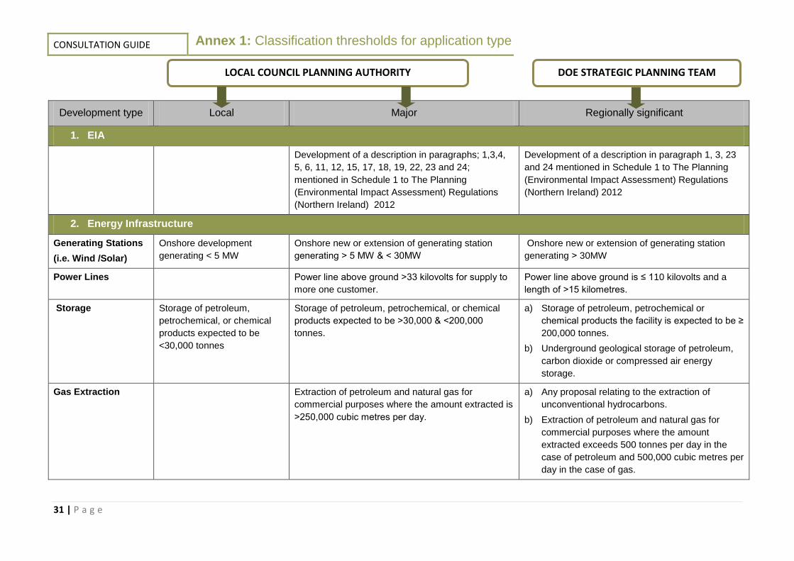
Development type Local Major Regionally significant
1. EIA
Development of a description in paragraphs; 1,3,4,
5, 6, 11, 12, 15, 17, 18, 19, 22, 23 and 24;
mentioned in Schedule 1 to The Planning
(Environmental Impact Assessment) Regulations
(Northern Ireland) 2012
Development of a description in paragraph 1, 3, 23
and 24 mentioned in Schedule 1 to The Planning
(Environmental Impact Assessment) Regulations
(Northern Ireland) 2012
2. Energy Infrastructure
Generating Stations
(i.e. Wind /Solar)
Onshore development
generating < 5 MW
Onshore new or extension of generating station
generating ˃ 5 MW & < 30MW
Onshore new or extension of generating station
generating ˃ 30MW
Power Lines Power line above ground ˃33 kilovolts for supply to
more one customer.
Power line above ground is ≤ 110 kilovolts and a
length of ˃15 kilometres.
Storage Storage of petroleum,
petrochemical, or chemical
products expected to be
<30,000 tonnes
Storage of petroleum, petrochemical, or chemical
products expected to be ˃30,000 & <200,000
tonnes.
a) Storage of petroleum, petrochemical or
chemical products the facility is expected to be ≥
200,000 tonnes.
b) Underground geological storage of petroleum,
carbon dioxide or compressed air energy
storage.
Gas Extraction Extraction of petroleum and natural gas for
commercial purposes where the amount extracted is
˃250,000 cubic metres per day.
a) Any proposal relating to the extraction of
unconventional hydrocarbons.
b) Extraction of petroleum and natural gas for
commercial purposes where the amount
extracted exceeds 500 tonnes per day in the
case of petroleum and 500,000 cubic metres per
day in the case of gas.
DOE STRATEGIC PLANNING TEAM LOCAL COUNCIL PLANNING AUTHORITY
Annex 1: Classification thresholds for application type
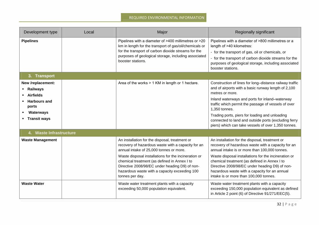
REQUIRED ENVIRONMENTAL INFORMATION
32 | P a g e
Development type Local Major Regionally significant
Pipelines Pipelines with a diameter of ˃400 millimetres or ˃20
km in length for the transport of gas/oil/chemicals or
for the transport of carbon dioxide streams for the
purposes of geological storage, including associated
booster stations.
Pipelines with a diameter of ˃800 millimetres or a
length of ˃40 kilometres:
- for the transport of gas, oil or chemicals, or
- for the transport of carbon dioxide streams for the
purposes of geological storage, including associated
booster stations.
3. Transport
New /replacement:
Railways
Airfields
Harbours and
ports
Waterways
Transit ways
Area of the works ˃ 1 KM in length or 1 hectare. Construction of lines for long–distance railway traffic
and of airports with a basic runway length of 2,100
metres or more.
Inland waterways and ports for inland–waterway
traffic which permit the passage of vessels of over
1,350 tonnes.
Trading ports, piers for loading and unloading
connected to land and outside ports (excluding ferry
piers) which can take vessels of over 1,350 tonnes.
4. Waste Infrastructure
Waste Management An installation for the disposal, treatment or
recovery of hazardous waste with a capacity for an
annual intake of 25,000 tonnes or more.
Waste disposal installations for the incineration or
chemical treatment (as defined in Annex I to
Directive 2008/98/EC under heading D9) of non-
hazardous waste with a capacity exceeding 100
tonnes per day.
An installation for the disposal, treatment or
recovery of hazardous waste with a capacity for an
annual intake is or more than 100,000 tonnes.
Waste disposal installations for the incineration or
chemical treatment (as defined in Annex I to
Directive 2008/98/EC under heading D9) of non-
hazardous waste with a capacity for an annual
intake is or more than 100,000 tonnes.
Waste Water Waste water treatment plants with a capacity
exceeding 50,000 population equivalent.
Waste water treatment plants with a capacity
exceeding 150,000 population equivalent as defined
in Article 2 point (6) of Directive 91/271/EEC(5).
CONSULTATION GUIDE
33 | P a g e
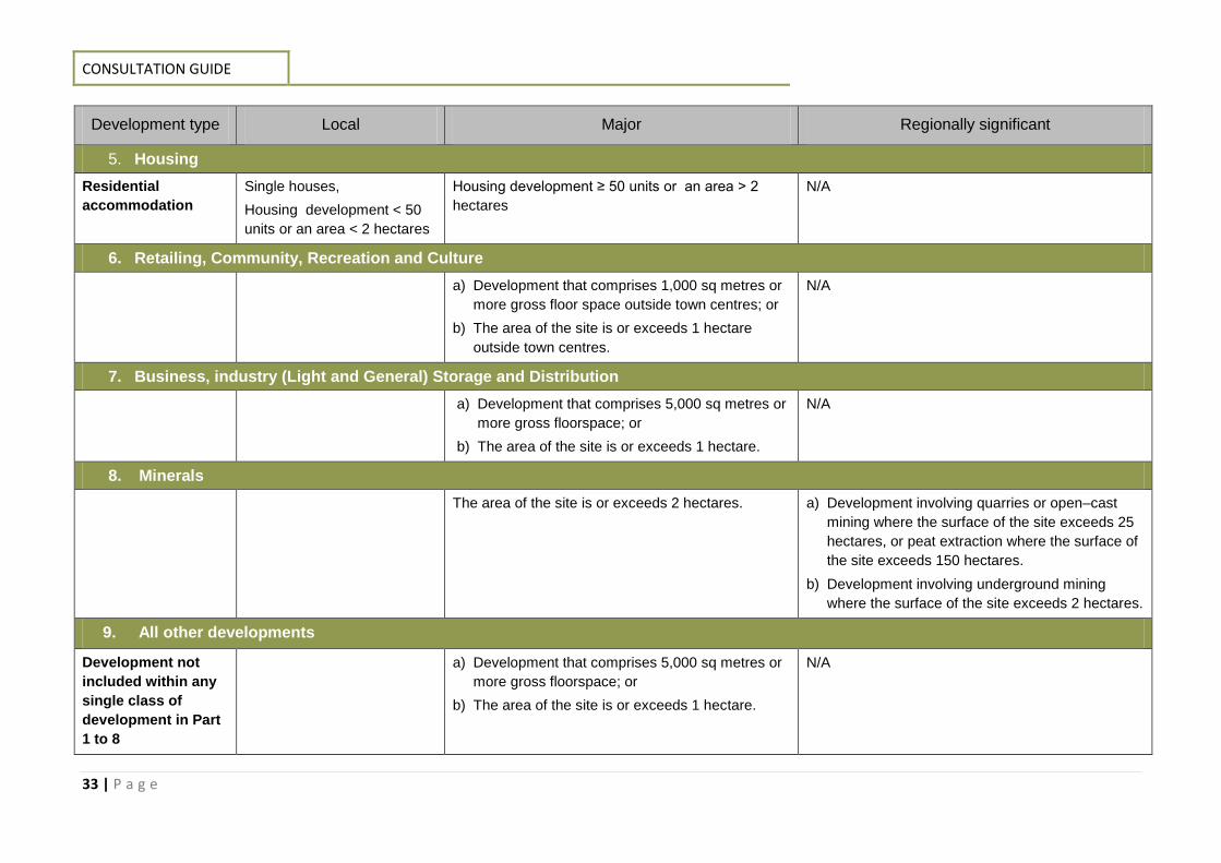
Development type Local Major Regionally significant
5. Housing
Residential
accommodation
Single houses,
Housing development < 50
units or an area < 2 hectares
Housing development ≥ 50 units or an area ˃ 2
hectares
N/A
6. Retailing, Community, Recreation and Culture
a) Development that comprises 1,000 sq metres or
more gross floor space outside town centres; or
b) The area of the site is or exceeds 1 hectare
outside town centres.
N/A
7. Business, industry (Light and General) Storage and Distribution
a) Development that comprises 5,000 sq metres or
more gross floorspace; or
b) The area of the site is or exceeds 1 hectare.
N/A
8. Minerals
The area of the site is or exceeds 2 hectares.
a) Development involving quarries or open–cast
mining where the surface of the site exceeds 25
hectares, or peat extraction where the surface of
the site exceeds 150 hectares.
b) Development involving underground mining
where the surface of the site exceeds 2 hectares.
9. All other developments
Development not
included within any
single class of
development in Part
1 to 8
a) Development that comprises 5,000 sq metres or
more gross floorspace; or
b) The area of the site is or exceeds 1 hectare.
N/A
REQUIRED ENVIRONMENTAL INFORMATION
34 | P a g e
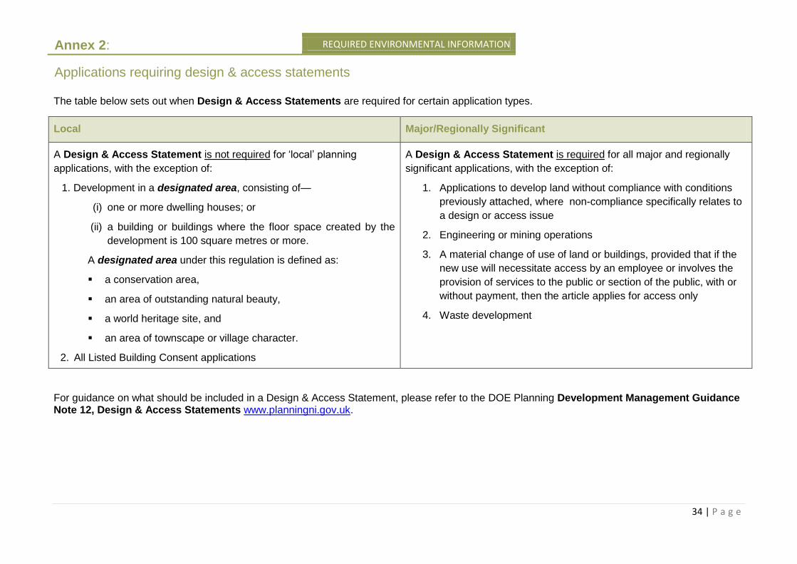
The table below sets out when Design & Access Statements are required for certain application types.
Local Major/Regionally Significant
A Design & Access Statement is not required for ‘local’ planning
applications, with the exception of:
1. Development in a designated area, consisting of—
(i) one or more dwelling houses; or
(ii) a building or buildings where the floor space created by the
development is 100 square metres or more.
A designated area under this regulation is defined as:
a conservation area,
an area of outstanding natural beauty,
a world heritage site, and
an area of townscape or village character.
2. All Listed Building Consent applications
A Design & Access Statement is required for all major and regionally
significant applications, with the exception of:
1. Applications to develop land without compliance with conditions
previously attached, where non-compliance specifically relates to
a design or access issue
2. Engineering or mining operations
3. A material change of use of land or buildings, provided that if the
new use will necessitate access by an employee or involves the
provision of services to the public or section of the public, with or
without payment, then the article applies for access only
4. Waste development
For guidance on what should be included in a Design & Access Statement, please refer to the DOE Planning Development Management Guidance Note 12, Design & Access Statements www.planningni.gov.uk.
Annex 2:
Applications requiring design & access statements

Planning Response TeamKlondyke BuildingCromac AvenueGasworks Business ParkLower Ormeau RoadBelfastBT7 2JA
Email: [email protected]: 028 90569604