Embed Size (px)
Citation preview
1
Franklin E. Hill, Director of Superfund Division
United States Environmental Protection Agency, Region 4
Sam Nunn Atlanta Federal Center
61 Forsyth Street, SW
Atlanta, GA 30303
Request for Preliminary Assessment for Areas Surrounding Alcoa Badin
Works Facility in Badin, North Carolina
2
Table of Contents BACKGROUND ..................................................................................................................... 5
A History of Environmental Injustice .............................................................................. 5
Spent Potliner Regulatory History .................................................................................. 6
Badin Works RCRA Permitting ....................................................................................... 7
Corrective Action ............................................................................................................ 7
AREA 1 - LITTLE MOUNTAIN CREEK, ADJACENT TO SWMU 2 ....................................... 9
Alcoa-Badin Landfill Geology and Hydrology ............................................................. 10
Little Mountain Creek Sampling and Testing ............................................................... 11
Bioclassification and Impairment of Little Mountain Creek ......................................... 18
NPDES Permit, Expiration and Continuation .............................................................. 20
AREA 2 - THE BALL FIELD ............................................................................................... 21
Rock Samples................................................................................................................. 21
TCLP Analysis ............................................................................................................... 23
FURTHER CONSIDERATIONS ............................................................................................ 26
Preliminary Assessment –New Monitoring Wells: SWMU 2 ........................................ 26
CONCLUSION AND REQUEST ............................................................................................ 27
APPENDIX ......................................................................................................................... 29
Table A-1. Summary of Previous K088 Rulemakings & Recent Litigation and Petitions
....................................................................................................................................... 29
Table A-2. Weather Conditions in Badin, NC 28009 before June 2014 Little Mountain
Creek Sampling ............................................................................................................. 30
Table A-3. SWMU 2 Monitoring Well and Piezometer Construction Details .............. 31
Figure A-1. Groundwater Hydrographs for SWMU 2/Badin Municipal Landfill ........ 32
Figure A-2. Map of Alcoa Badin Works and NPDES Permit Discharge Locations ..... 34
Figure A-3. SWMU 2 Soil and Groundwater Conductivity .......................................... 35
INDEX FOR ELECTRONIC APPENDIX ................................................................................ 36
3
Director Hill,
Under the authority of CERCLA Section 105(d), as amended, the Duke
Environmental Law and Policy Clinic (the Clinic), on behalf of the petitioner, Yadkin
Riverkeeper, Inc.,1 hereby requests that Region 4 of the United States Environmental
Protection Agency (EPA) conduct a Preliminary Assessment of the suspected presence
and release of hazardous substances in two areas in the immediate vicinity of the former
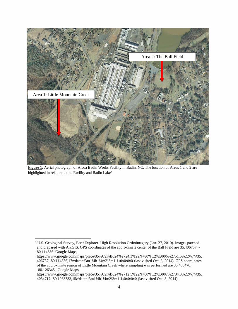
Alcoa Badin Works2 aluminum smelting facility in Badin, North Carolina.3
The Alcoa Badin Works facility has a long history of environmental degradation
and the two sites addressed in this petition are only two of many possible contaminated
sites in and around Badin Works. Area 1 abuts the Alcoa-Badin Landfill (SWMU 2) and
includes, but is not limited to, portions of Little Mountain Creek (Figure 1). Initial
testing results from Area 1 indicate that the Creek has been contaminated with fluoride,
sulfate, and a number of other chemicals associated with industrial processes conducted
at the nearby facility. Fluoride and sulfate are indicator compounds of hazardous waste
contamination associated with spent potliner, a listed hazardous waste also known as
K088. Evidence suggests that hazardous potliner has leached from the Alcoa-Badin
Landfill and contaminated the adjacent Little Mountain Creek, an impaired water of the
United States.
Area 2, referred to as the Ball Field, is the large field east of Alcoa’s smelting
plant and adjacent to Badin Lake (Figure 1). Preliminary testing by the Clinic has
produced results suggesting that this site also has been contaminated with industrial solid
wastes.
The Badin Works facility is currently undergoing the Corrective Action approval
process pursuant to the Resource Conservation and Recovery Act (RCRA) for a number
of identified areas within the facility’s boundaries; however, the Corrective Action plan
does not address the sites of interest in this petition. Alcoa and the Corrective Action plan
have not assessed the environmental contamination and degradation of the area around
the Alcoa Badin Works facility. Since Alcoa’s corrective measures and investigation
have not evaluated the areas we identified, we respectfully request that EPA conduct a
preliminary assessment of the two sites identified in this petition, as well as any other site
with suspected hazardous contamination. Both of these areas are down-gradient of Alcoa
Badin Works.
1 Yadkin Riverkeeper Inc., 308 Patterson Avenue, Winston-Salem, NC 27101, (336) 722-4949,
[email protected]. 2 Alcoa Badin Works, EPA/Handler ID: NCD003162542, FRS ID: 110017425614. 3 See 42 U.S.C. § 9605(d) (2012) (permitting any person to petition for a preliminary assessment and
requiring a response within twelve months).
4
Figure 1: Aerial photograph of Alcoa Badin Works Facility in Badin, NC. The location of Areas 1 and 2 are
highlighted in relation to the Facility and Badin Lake4
4 U.S. Geological Survey, EarthExplorer. High Resolution Orthoimagery (Jan. 27, 2010). Images patched
and prepared with ArcGIS. GPS coordinates of the approximate center of the Ball Field are 35.406757, -
80.114336. Google Maps,
https://www.google.com/maps/place/35%C2%B024%2724.3%22N+80%C2%B006%2751.6%22W/@35.
406757,-80.114336,17z/data=!3m1!4b1!4m2!3m1!1s0x0:0x0 (last visited Oct. 8, 2014). GPS coordinates
of the approximate region of Little Mountain Creek where sampling was performed are 35.403470,
-80.126345. Google Maps,
https://www.google.com/maps/place/35%C2%B024%2712.5%22N+80%C2%B007%2734.8%22W/@35.
4034717,-80.1263333,15z/data=!3m1!4b1!4m2!3m1!1s0x0:0x0 (last visited Oct. 8, 2014).
Area 2: Ball Field
Area 1: Little Mountain Creek Area 1: Little Mountain Creek
Area 2: The Ball Field
5
BACKGROUND
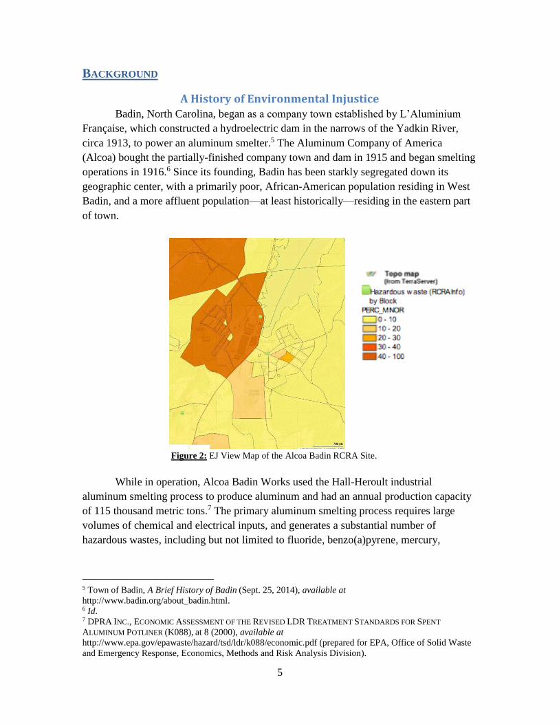
A History of Environmental Injustice Badin, North Carolina, began as a company town established by L’Aluminium
Française, which constructed a hydroelectric dam in the narrows of the Yadkin River,
circa 1913, to power an aluminum smelter.5 The Aluminum Company of America
(Alcoa) bought the partially-finished company town and dam in 1915 and began smelting
operations in 1916.6 Since its founding, Badin has been starkly segregated down its
geographic center, with a primarily poor, African-American population residing in West
Badin, and a more affluent population—at least historically—residing in the eastern part
of town.
Figure 2: EJ View Map of the Alcoa Badin RCRA Site.
While in operation, Alcoa Badin Works used the Hall-Heroult industrial
aluminum smelting process to produce aluminum and had an annual production capacity
of 115 thousand metric tons.7 The primary aluminum smelting process requires large
volumes of chemical and electrical inputs, and generates a substantial number of
hazardous wastes, including but not limited to fluoride, benzo(a)pyrene, mercury,
5 Town of Badin, A Brief History of Badin (Sept. 25, 2014), available at
http://www.badin.org/about_badin.html. 6 Id. 7 DPRA INC., ECONOMIC ASSESSMENT OF THE REVISED LDR TREATMENT STANDARDS FOR SPENT
ALUMINUM POTLINER (K088), at 8 (2000), available at
http://www.epa.gov/epawaste/hazard/tsd/ldr/k088/economic.pdf (prepared for EPA, Office of Solid Waste
and Emergency Response, Economics, Methods and Risk Analysis Division).
6
cyanide, lead, polycyclic aromatic hydrocarbons (PAHs), and spent potliner.8 Of
particular concern due to production volume is spent potliner, which contains leachable
cyanide and fluoride compounds.9 Cyanide is well known for its toxicity and can cause
health problems with long-term, low-concentration exposure. Fluoride, while considered
safe and even beneficial at low doses, can lead to an increased likelihood of bone
fractures and skeletal fluorosis with elevated exposure.10 Alcoa has been disposing of
hazardous wastes in Badin since the plant began operations in 1917, and for the nearly
sixty years before the passage of RCRA, this waste disposal was largely unregulated. It
was not until EPA finalized its rule for spent potliner disposal in September of 1988 that
the large amounts of spent potliner generated at Badin Works finally were covered by the
federal regulatory umbrella.
Following this action by EPA, Alcoa sought coverage for damages and cleanup
response costs from its insurers. In December of 1992, Alcoa filed a declaratory
judgment action in the King County Superior Court in Washington against 167 insurers,
seeking coverage for the cost of pollution damage, investigation, and remediation at
thirty-five of its sites around the United States.11 Based on the evidence presented, the
trial judge held that multiple Alcoa sites may need environmental remediation. Three
sites specifically were highlighted as warranting particularly high cleanup costs,
exceeding $50 million. The sites were Massena, New York; Point Comfort, Texas; and
Badin, North Carolina. While the New York and Texas sites have already been cleaned
up under both RCRA and CERCLA, the Badin Works RCRA cleanup has languished. A
CERCLA preliminary analysis is needed to protect the Badin community and speed the
RCRA cleanup process along.
Spent Potliner Regulatory History RCRA was enacted in 1976,12 but Alcoa’s handling, transportation, and disposal
of hazardous wastes did not fall under EPA’s RCRA guidelines until 1980. On May 19,
1980, the first RCRA regulations, “Hazardous Waste and Consolidated Permit
Regulations,” were published in the Federal Register and established the basic “cradle to
8 See EPA, PROPOSED BEST DEMONSTRATED AVAILABLE TECHNOLOGY (BDAT) BACKGROUND DOCUMENT
FOR SPENT ALUMINUM POTLINERS-K088, at iii (2000),
http://www.epa.gov/osw/hazard/tsd/ldr/k088/k088back.pdf; EPA ECHO, DETAILED FACILITY REPORT
(2013), available at http://echo.epa.gov/detailed_facility_report?fid=110017425614; see also, e.g., EPA,
TOXICS RELEASE INVENTORY REPORTING,
http://oaspub.epa.gov/enviro/trisquery.dcn_details?tris_id=28009LMNMCHWY74 (last visited Oct. 3,
2014). 9Id. 10 CDC, Community Water Fluoridation FAQs (Dec. 6, 2013), available at
http://www.cdc.gov/fluoridation/faqs/#overexposure1. 11 See Aluminum Co. of Am. v. Aetna, 998 P.2d 856, 30 Envtl. L. Rep. 20,536 (2000); Aug. 6, 2003 Order
of Hon. Sharon Armstrong in Alcoa, Inc. v. Accident & Casualty Company, Case No. 92-2-28065-SEA
(Sup. Ct. Wash. King Cnty. 2003). 12 Resource Conversation and Recovery Act, Pub. L. No. 94-580, 90 Stat. 2795 (1976).
7
grave” approach to hazardous waste management that exists today.13 On October 21,
1980, Congress enacted the Solid Waste Disposal Act Amendments of 1980,14 which
added, among other amendments, an exemption from RCRA regulation for “[s]olid waste
from the extraction, beneficiation, and processing of ores and minerals, including
phosphate rock and overburden from the mining of uranium ore.”15 The aluminum
smelting process involves the beneficiation and processing of aluminum ore.
EPA subsequently modified its hazardous waste regulations to reflect the October
1980 "mining waste exclusion," and issued a preliminary interpretation of the scope of
the exclusion.16 To be consistent with this interpretation, EPA suspended the listings of
“solid waste from the exploration, mining, milling, smelting and refining of ores and
minerals,” including spent potliner.17 On September 13, 1988, EPA published the final
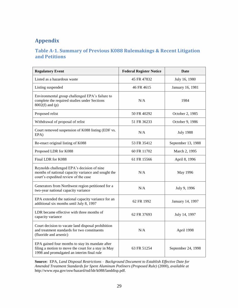
rule promulgating the hazardous listing for spent potliner (see Appendix, Table A-1).18
Badin Works RCRA Permitting
On November 19, 1980, Alcoa Badin Works submitted a RCRA Part A permit
application which indicated that it was storing spent potliner in waste piles, with an
estimated annual generation of 4800 tons of waste.19 Immediately following the relisting
of spent potliner, Alcoa Badin Works submitted a Notification of Hazardous Waste
Activity and a RCRA Part A permit application indicating the generation of spent
potliner.20 Alcoa buried spent potliner as a means of disposal long before the submission
of its Part B RCRA application in March 1990. A 1989 site assessment report prepared
by Law Environmental for Alcoa stated that the burying of [spent] potliner began in the
early 1900s and continued until the late 1970s. The disposal area locations are not
precisely known, although several areas are identified and others are suspected.21
Corrective Action
In 1989, cleanup of the Badin Works site was handed over to Alcoa, which would
manage the remediation under RCRA’s Corrective Action process. On December 23,
1996, CERCLA enforcement staff noted that further CERCLA activities at the site were
13 45 Fed. Reg. 33066, 33066–72 (May 19, 1980); see also EPA, History of RCRA, available at
http://www.epa.gov/osw/laws-regs/rcrahistory.htm. 14 Pub. L. No. 96-482, 94 Stat. 2334 (Oct. 21, 1980). 15 42 U.S.C. § 6921(b)(3)(A)(ii) (2012). 16 45 Fed. Reg. 76618, 76618 (Nov. 19, 1980); see also EPA, supra note 8. 17 45 Fed. Reg. 76618, 76619 (Nov. 19, 1980); see also EPA, supra note 8, at A-1. 18 53 Fed. Reg. 35412, 35414 tbl.1 (Sept. 13, 1988); see also EPA, supra note 16, at A-3. 19 A.T. KEARNEY, INC. & DPRA, INC., INTERIM RCRA FACILITY ASSESSMENT REPORT, at II-11 (1990)
(prepared for Ms. Rowena Sheffield of EPA Region 4). 20 Id. at II-12. 21 LAW ENVTL., PHASE II GROUND-WATER ASSESSMENT NORTHWEST VALLEY, ALCOA-BADIN WORKS,
BADIN, NORTH CAROLINA 1-1 (1990).
8
“[d]eferred to RCRA.”22 EPA’s online Superfund database lists the site as having
completed a Preliminary Assessment on November 20, 1985,23 after which no further
actions were taken. This 1985 Preliminary Assessment was conducted by an employee of
North Carolina’s Division of Health Services who relied only on files already available at
his Raleigh, North Carolina office, and on a single day’s communications with one
employee each from the Department of Environment and Natural Resources (DENR) and
from Alcoa.24 North Carolina conducted no sampling or testing.25 This 1985 Preliminary
Assessment does not meet the standard for a Preliminary Assessment and did not address
the issues we bring forward in this petition.
The RCRA Corrective Action procedures are implemented by the North Carolina
Department of Environment and Natural Resources Division of Waste Management and
consist of five phases. Phases 4 and 5 are currently ongoing.
Phase 1: RCRA Facility Assessment
Phase 2: RCRA Facility Investigation
Phase 3: Corrective Measures Study
Phase 4: Corrective Measures Implementation
Phase 5: Corrective Action Completed.
Areas 1 and 2 identified in this petition show evidence indicative of past disposal
and ongoing contamination with hazardous substances, but have not been identified as
SWMUs or AOCs under the ongoing RCRA work. Because these areas are not being
addressed by Alcoa or DENR under RCRA, the unclaimed contamination near Areas 1
and 2 qualifies for consideration under Superfund. EPA should conduct a Preliminary
Assessment that includes actual sampling of potentially-contaminated areas surrounding
Alcoa’s facility, and should proceed under CERCLA according to the results of that
assessment.
The following sections provide a detailed summation of field sampling, testing,
and lab results for the two areas, and identify various concerns for human and ecosystem
health.
22 EPA, Superfund Site Information – Actions (Sept. 30, 2014), available at
http://cumulis.epa.gov/supercpad/cursites/cactinfo.cfm?id=0402612; EPA, Superfund Site Information -
Site Info (Sept. 30, 2014), available at http://cumulis.epa.gov/supercpad/cursites/csitinfo.cfm?id=0402612. 23 EPA, Superfund Site Information – Actions (Sept. 30, 2014), available at
http://cumulis.epa.gov/supercpad/cursites/cactinfo.cfm?id=0402612. 24 See Cover Letter for 1985 RCRA Final Preliminary Assessment Report, infra note 26, at 2. 25 Id.
9
AREA 1 - LITTLE MOUNTAIN CREEK, ADJACENT TO SWMU 2
The Alcoa-Badin Landfill (SWMU 2) is an unlined landfill that was in operation
since the early twentieth century, long before the existence of RCRA. It occupies an area
roughly 1000 feet by 950 feet and is located southwest of the facility on the opposite side
of Wood Street, outside of the former plant’s fence. From the early 1900s into the 1970s,
both municipal and industrial wastes were disposed of in this landfill. During this time,
unknown quantities of spent potliner were placed in the landfill, especially during the
renovation of the smelting facility, circa 1965.26 Use of SWMU 2 was discontinued in the
mid-1970s.27 Since then, a cap was placed on the landfill to reduce surface water
infiltration and monitoring wells were installed. However, the landfill is unlined and
therefore offers no protection against groundwater contamination from hazardous
constituents such as spent potliner. It lies about 300 feet north and hydraulically up-
gradient of Little Mountain Creek, creating the potential for the flow of contaminants
down-gradient and into the creek; this relationship is discussed in more detail below.28
Nonetheless, the source of this pollution, despite a 2004 recommendation to do so
by HDR Engineering in a report addressing Little Mountain Creek’s impairment for
aquatic life.29 The HDR report, commissioned by the North Carolina Ecosystem
Enhancement Program under DENR, also recommended a monitoring plan under which
multiple points in the stream would be regularly monitored through chemical, physical,
benthos, and fish tests. Instead, the Division of Water Quality disregarded the HDR
report.
The HDR report identified activities associated with Badin Works as likely
having contributed to the impairment of Little Mountain Creek, based on reports that the
facility continued to discharge into the Little Mountain Creek hydrologic unit (HU) with
NPDES permit violations, even though Alcoa’s smelting facility closed in 2007.30 The
report concludes that further investigation into the water quality impacts from Alcoa
Badin Works should be conducted, yet none was undertaken by DWR.
26 N.C. DIV. OF HEALTH SERVS., FINAL PRELIMINARY ASSESSMENT REPORT (1985). 27 NUS CORP., PRELIMINARY REASSESSMENT 7 (1989); MFG, INC., RCRA FACILITY INVESTIGATION
REPORT, VOLUME I OF II, at 103 (2001) (prepared for Alcoa, Inc.). 28 Little Mountain Creek is a tributary of Mountain Creek, which in turn empties into Lake Tillery on the
Yadkin-Pee Dee River (south and downriver of Badin and the Yadkin Project). 29 HDR ENG’G, INC., PRELIMINARY FINDINGS & RECOMMENDATIONS REPORT - MOUNTAIN CREEK AND
LITTLE MOUNTAIN CREEK AND JACOBS CREEK 2-47 (2004) (prepared for the North Carolina Ecosystems
Enhancement Program). 30 Id.
10
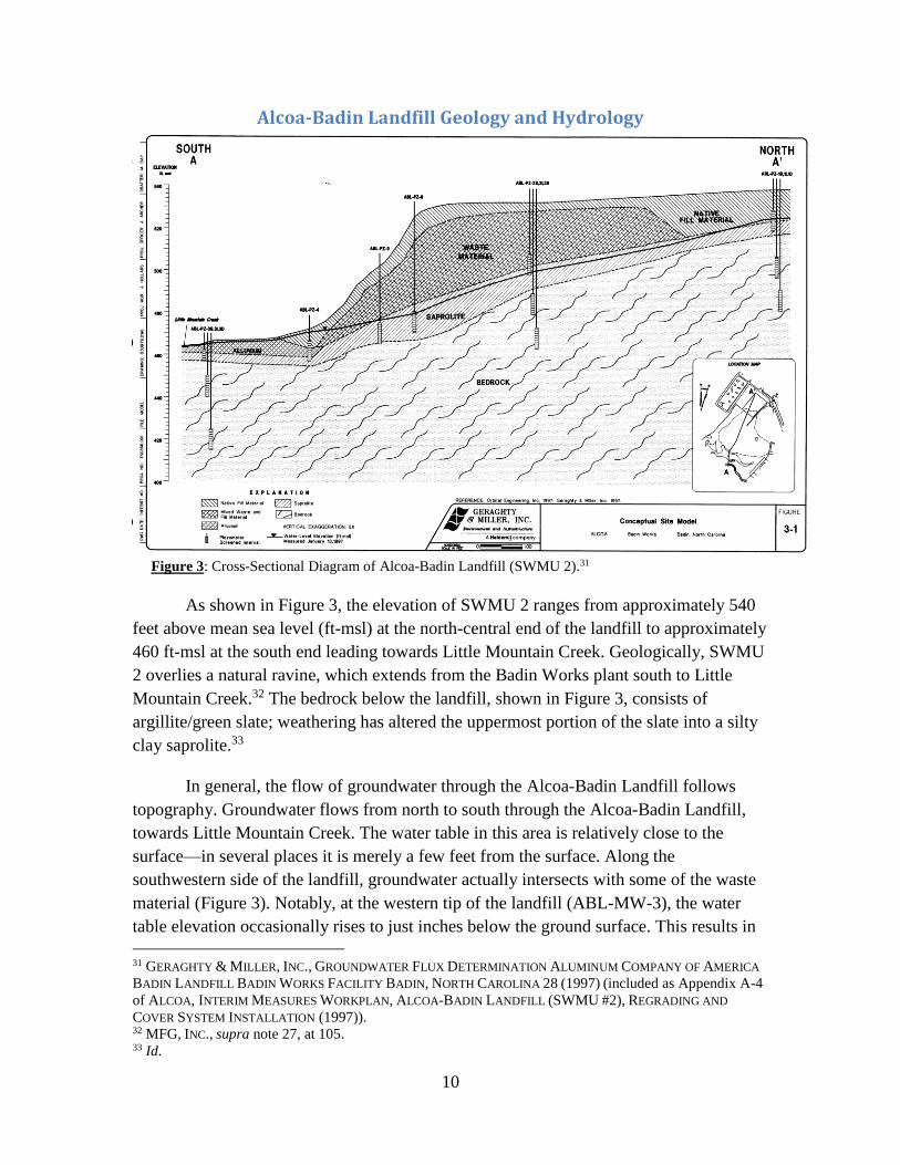
Alcoa-Badin Landfill Geology and Hydrology
Figure 3: Cross-Sectional Diagram of Alcoa-Badin Landfill (SWMU 2).31
As shown in Figure 3, the elevation of SWMU 2 ranges from approximately 540
feet above mean sea level (ft-msl) at the north-central end of the landfill to approximately
460 ft-msl at the south end leading towards Little Mountain Creek. Geologically, SWMU
2 overlies a natural ravine, which extends from the Badin Works plant south to Little
Mountain Creek.32 The bedrock below the landfill, shown in Figure 3, consists of
argillite/green slate; weathering has altered the uppermost portion of the slate into a silty
clay saprolite.33
In general, the flow of groundwater through the Alcoa-Badin Landfill follows
topography. Groundwater flows from north to south through the Alcoa-Badin Landfill,
towards Little Mountain Creek. The water table in this area is relatively close to the
surface—in several places it is merely a few feet from the surface. Along the
southwestern side of the landfill, groundwater actually intersects with some of the waste
material (Figure 3). Notably, at the western tip of the landfill (ABL-MW-3), the water
table elevation occasionally rises to just inches below the ground surface. This results in
31 GERAGHTY & MILLER, INC., GROUNDWATER FLUX DETERMINATION ALUMINUM COMPANY OF AMERICA
BADIN LANDFILL BADIN WORKS FACILITY BADIN, NORTH CAROLINA 28 (1997) (included as Appendix A-4
of ALCOA, INTERIM MEASURES WORKPLAN, ALCOA-BADIN LANDFILL (SWMU #2), REGRADING AND
COVER SYSTEM INSTALLATION (1997)). 32 MFG, INC., supra note 27, at 105. 33 Id.
11
an area of deep mud and some standing water. The average hydraulic gradient throughout
SWMU 2 is 0.05ft/ft.34 Hydraulic conductivity throughout the landfill is quite high due to
the presence of unconsolidated fill material underneath the compacted soil.
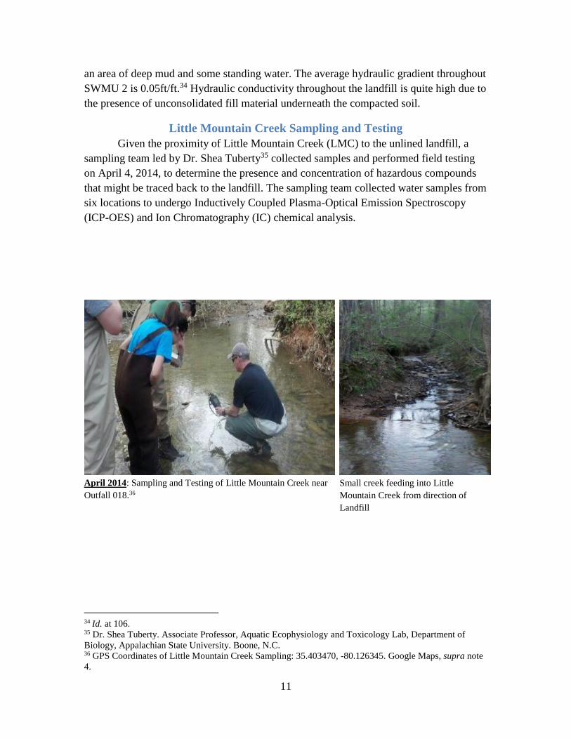
Little Mountain Creek Sampling and Testing
Given the proximity of Little Mountain Creek (LMC) to the unlined landfill, a
sampling team led by Dr. Shea Tuberty35 collected samples and performed field testing
on April 4, 2014, to determine the presence and concentration of hazardous compounds
that might be traced back to the landfill. The sampling team collected water samples from
six locations to undergo Inductively Coupled Plasma-Optical Emission Spectroscopy
(ICP-OES) and Ion Chromatography (IC) chemical analysis.
April 2014: Sampling and Testing of Little Mountain Creek near
Outfall 018.36
Small creek feeding into Little
Mountain Creek from direction of
Landfill
34 Id. at 106. 35 Dr. Shea Tuberty. Associate Professor, Aquatic Ecophysiology and Toxicology Lab, Department of
Biology, Appalachian State University. Boone, N.C. 36 GPS Coordinates of Little Mountain Creek Sampling: 35.403470, -80.126345. Google Maps, supra note
4.
12
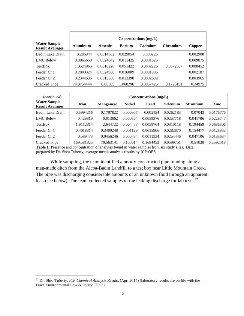
(continued) Concentrations (mg/L)
Water Sample
Result Averages Iron Manganese Nickel Lead Selenium Strontium Zinc
Badin Lake Drain 0.5994216 0.1797822 0.000907 0.005154 0.0262183 0.07043 0.0176776
LMC Below 0.429819 0.013662 0.000504 0.0059376 0.0257718 0.041786 0.0228747
TestBox 1.9112814 2.644722 0.004477 0.0058764 0.0310118 0.194459 0.0636306
Feeder Cr 1 0.4618314 0.3400248 0.001129 0.0015906 0.0282870 0.154477 0.0128333
Feeder Cr 2 0.589473 0.0456246 0.000734 0.0011334 0.0254446 0.047106 0.0138634
Cracked Pipe 169.581825 70.563141 0.100614 0.1684452 0.0599751 0.51028 0.5592018
Table 1: Presence and concentration of analytes found in water samples from six study sites. Data
prepared by Dr. Shea Tuberty, average metals analysis results by ICP-OES.
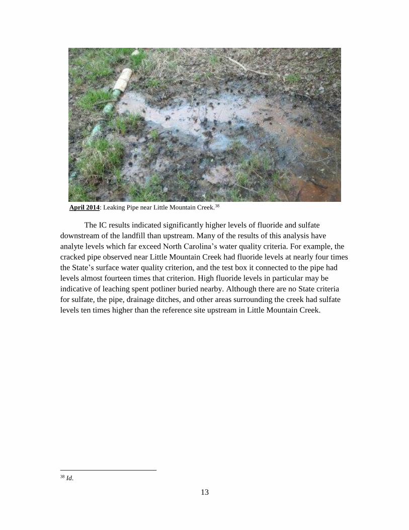
While sampling, the team identified a poorly-constructed pipe running along a
man-made ditch from the Alcoa-Badin Landfill to a test box near Little Mountain Creek.
The pipe was discharging considerable amounts of an unknown fluid through an apparent
leak (see below). The team collected samples of the leaking discharge for lab tests.37
37 Dr. Shea Tuberty, ICP Chemical Analysis Results (Apr. 2014) (laboratory results are on file with the
Duke Environmental Law & Policy Clinic).
Concentrations (mg/L)
Water Sample
Result Averages Aluminum Arsenic Barium Cadmium Chromium Copper
Badin Lake Drain 0.286944 0.0014082 0.029054 0.000225
0.002908
LMC Below 0.3065658 0.0024042 0.011425 0.0001626
0.009875
TestBox 1.0524966 0.0018228 0.051422 0.0002226 0.0372807 0.008452
Feeder Cr 1 0.2808324 0.0024966 0.016009 0.0001986
0.002187
Feeder Cr 2 0.2344536 0.0015666 0.013398 0.0002688
0.003965
Cracked Pipe 74.3754444 0.08505 1.060296 0.0057426 0.1723191 0.24975
13
April 2014: Leaking Pipe near Little Mountain Creek.38
The IC results indicated significantly higher levels of fluoride and sulfate
downstream of the landfill than upstream. Many of the results of this analysis have
analyte levels which far exceed North Carolina’s water quality criteria. For example, the
cracked pipe observed near Little Mountain Creek had fluoride levels at nearly four times
the State’s surface water quality criterion, and the test box it connected to the pipe had
levels almost fourteen times that criterion. High fluoride levels in particular may be
indicative of leaching spent potliner buried nearby. Although there are no State criteria
for sulfate, the pipe, drainage ditches, and other areas surrounding the creek had sulfate
levels ten times higher than the reference site upstream in Little Mountain Creek.
38 Id.
14
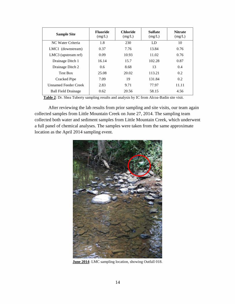
Sample Site Fluoride (mg/L)
Chloride (mg/L)
Sulfate (mg/L)
Nitrate (mg/L)
NC Water Criteria 1.8 230 LD 10
LMC1 (downstream) 0.37 7.76 13.84 0.76
LMC3 (upstream ref) 0.09 10.93 11.02 0.76
Drainage Ditch 1 16.14 15.7 102.28 0.87
Drainage Ditch 2 0.6 8.68 13 0.4
Test Box 25.08 20.02 113.21 0.2
Cracked Pipe 7.09 19 131.84 0.2
Unnamed Feeder Creek 2.83 9.71 77.97 11.11
Ball Field Drainage 0.62 20.56 58.15 4.56
Table 2: Dr. Shea Tuberty sampling results and analysis by IC from Alcoa-Badin site visit.
After reviewing the lab results from prior sampling and site visits, our team again
collected samples from Little Mountain Creek on June 27, 2014. The sampling team
collected both water and sediment samples from Little Mountain Creek, which underwent
a full panel of chemical analyses. The samples were taken from the same approximate
location as the April 2014 sampling event.
June 2014: LMC sampling location, showing Outfall 018.
15
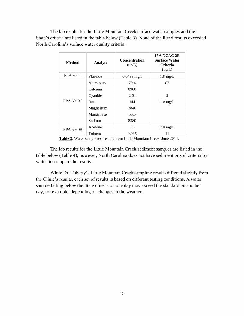
The lab results for the Little Mountain Creek surface water samples and the
State’s criteria are listed in the table below (Table 3). None of the listed results exceeded
North Carolina’s surface water quality criteria.
Method Analyte Concentration
(ug/L)
15A NCAC 2B
Surface Water
Criteria
(ug/L)
EPA 300.0 Fluoride 0.0488 mg/l 1.8 mg/L
EPA 6010C
Aluminum 79.4 87
Calcium 8900
Cyanide 2.64 5
Iron 144 1.0 mg/L
Magnesium 3840
Manganese 56.6
Sodium 8380
EPA 5030B
Acetone 1.5 2.0 mg/L
Toluene 0.035 11
Table 3: Water sample test results from Little Mountain Creek, June 2014.
The lab results for the Little Mountain Creek sediment samples are listed in the
table below (Table 4); however, North Carolina does not have sediment or soil criteria by
which to compare the results.
While Dr. Tuberty’s Little Mountain Creek sampling results differed slightly from
the Clinic’s results, each set of results is based on different testing conditions. A water
sample falling below the State criteria on one day may exceed the standard on another
day, for example, depending on changes in the weather.
16
Method Analyte Concentration
(mg/kg dry)
EPA 6010C
Aluminum 11700
Antimony 1.65
Arsenic 31.2
Barium 40.1
Beryllium 1.65
Calcium 534
Chromium 156
Cobalt 17.1
Copper 13.4
Iron 45200
Lead 1.08
Magnesium 1760
Manganese 1170
Nickel 18.4
Potassium 278
Sodium 140
Thallium 13.6
Vanadium 80.3
Zinc 59.5
EPA 7471B Mercury 0.00685
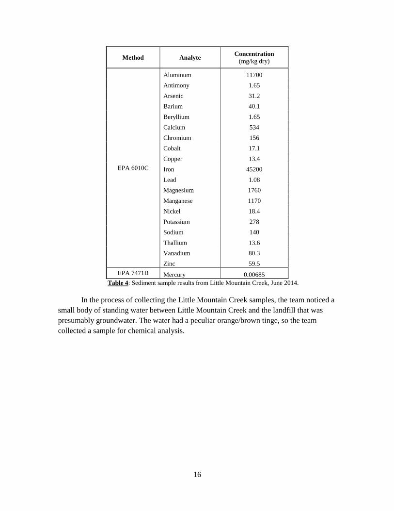
Table 4: Sediment sample results from Little Mountain Creek, June 2014.
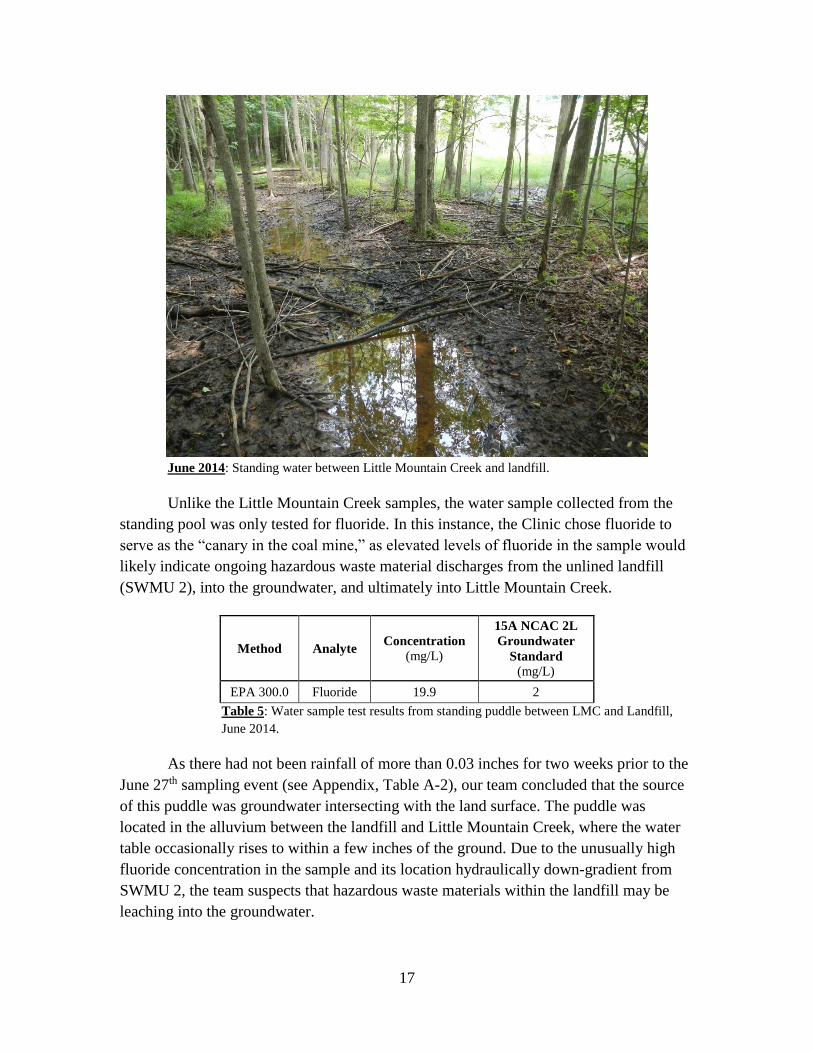
In the process of collecting the Little Mountain Creek samples, the team noticed a
small body of standing water between Little Mountain Creek and the landfill that was
presumably groundwater. The water had a peculiar orange/brown tinge, so the team
collected a sample for chemical analysis.
17
June 2014: Standing water between Little Mountain Creek and landfill.
Unlike the Little Mountain Creek samples, the water sample collected from the
standing pool was only tested for fluoride. In this instance, the Clinic chose fluoride to
serve as the “canary in the coal mine,” as elevated levels of fluoride in the sample would
likely indicate ongoing hazardous waste material discharges from the unlined landfill
(SWMU 2), into the groundwater, and ultimately into Little Mountain Creek.
Method Analyte Concentration
(mg/L)
15A NCAC 2L
Groundwater
Standard
(mg/L)
EPA 300.0 Fluoride 19.9 2
Table 5: Water sample test results from standing puddle between LMC and Landfill,
June 2014.
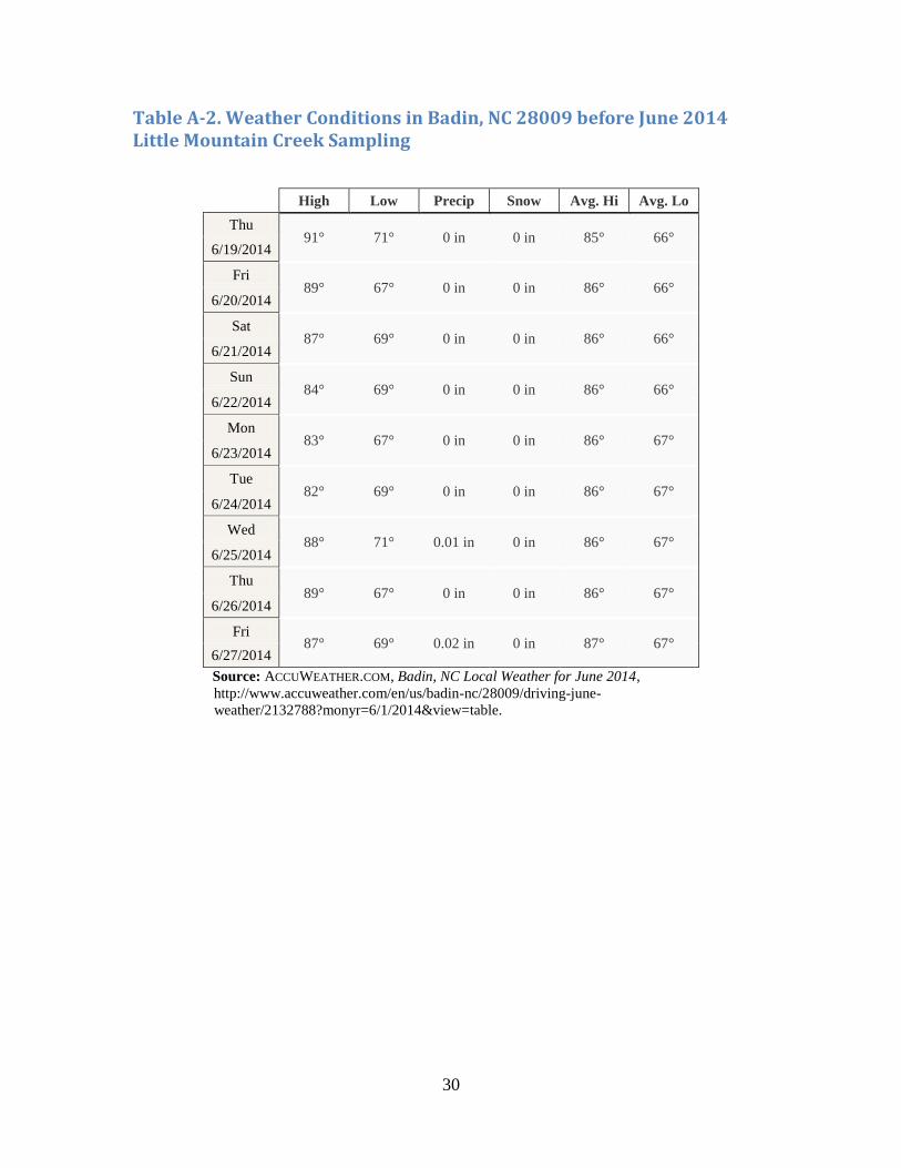
As there had not been rainfall of more than 0.03 inches for two weeks prior to the
June 27th sampling event (see Appendix, Table A-2), our team concluded that the source
of this puddle was groundwater intersecting with the land surface. The puddle was
located in the alluvium between the landfill and Little Mountain Creek, where the water
table occasionally rises to within a few inches of the ground. Due to the unusually high
fluoride concentration in the sample and its location hydraulically down-gradient from
SWMU 2, the team suspects that hazardous waste materials within the landfill may be
leaching into the groundwater.
18
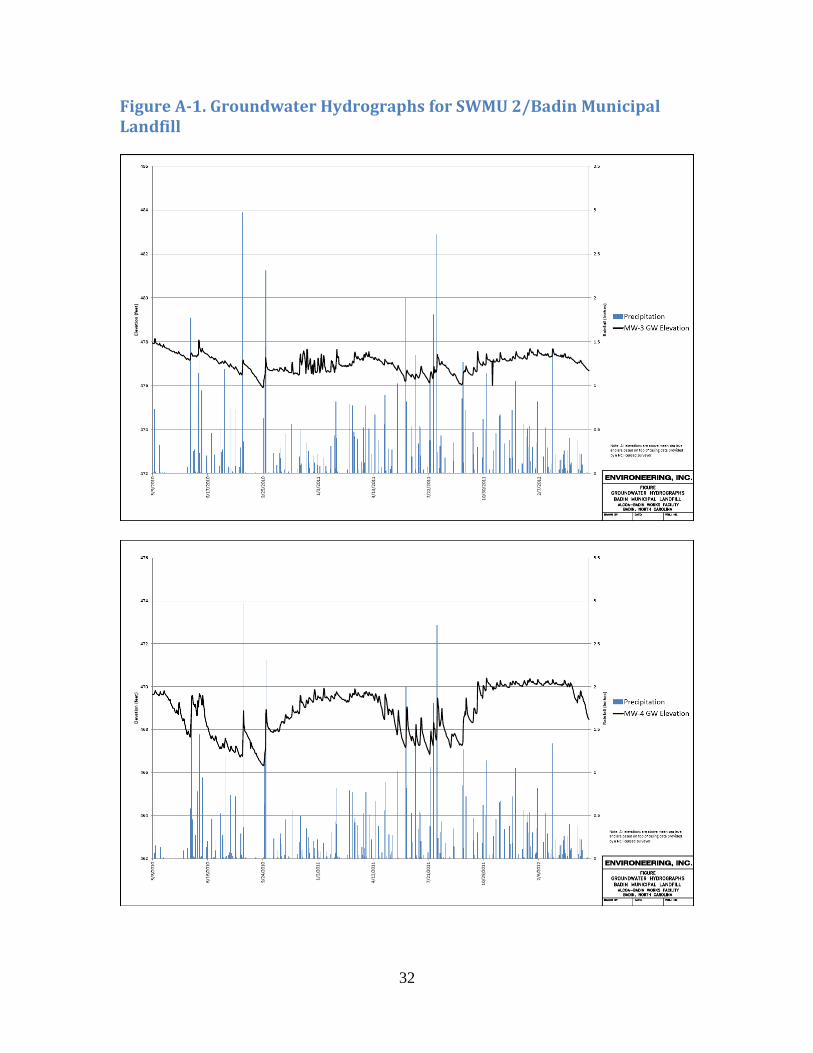
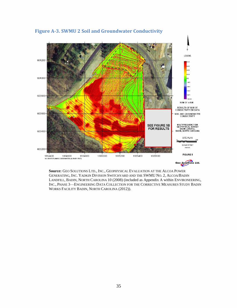
The presence and extent of SWMU 2 groundwater contamination may be
influenced by the amount of rainfall in a given timeframe and the subsequent
groundwater elevation. We have seen that the groundwater level is capable of intersecting
landfill waste material (Figure 3); however, it is unclear the degree to which rainfall
increases the exposure of landfill waste materials to groundwater. Alcoa’s Phase 3
Corrective Measures Study included groundwater hydrographs showing the correlation
between precipitation and groundwater elevation for SWMU 2 piezometers (PZ) and
monitoring wells (MW) over a two-year period (see Appendix, Figure A-1).39
MW-3, MW-4, and MW-5 are located near Little Mountain Creek in the alluvium
and show separate fluctuations in groundwater elevation resulting from precipitation (see
Appendix, Figure A-1).40 Groundwater elevations measured at MW-4 rose over two feet
with nearly three inches of rainfall.41 Groundwater elevations measured at MW-3 and
MW-5 generally exhibited fluctuations of lower magnitude compared to those of
MW-4.42 However, the average groundwater elevations were highest in MW-3 and
lowest in MW-5, presumably due to the subterranean geology and landfill composition.43
PZ-2S and PZ-2D are located up-gradient from MW-3, -4, and -5 and due north of
MW-5 (Figures 3 and 5). The hydrograph for these piezometers indicates a potential
intersection of the groundwater level and landfill waste material following moderate to
substantial rainfall (see Appendix, Table A-3, Figure A-3).44 The evidence of
contamination in Little Mountain Creek provided below further supports this possibility.
Bioclassification and Impairment of Little Mountain Creek
The North Carolina Division of Water Quality (now the Division of Water
Resources or DWR) has listed Little Mountain Creek as impaired on the Clean Water Act
303(d) list since 1998, yet the source of impairment is still listed as unknown.45 Though
agriculture is listed as a potential source of impairment in the 2002 Integrated 305(b) and
303(d) report,46 Alcoa’s activities have likely exacerbated the creek’s impairment.
39 TESTAMERICA, TESTAMERICA JOB ID: 680-71611-1, Appendix I (2011) (included as Appendix H of
ENVIRONEERING, INC., PHASE 3—ENGINEERING DATA COLLECTION FOR THE CORRECTIVE MEASURES
STUDY BADIN WORKS FACILITY BADIN, NORTH CAROLINA (2012)). 40 Id. 41 Id. Precipitation event occurred between June 16, 2010 and September 24, 2010. 42 Id. 43 Id. 44 Id. 45 HDR ENG’G, INC., supra note 29, at 2-25. 46 N.C. DEPT. OF ENV’T & NATURAL RES., WATER QUALITY ASSESSMENT AND IMPAIRED WATERS LIST
(2002 INTEGRATED 305(B) AND 303(D) REPORT) Appendix VI, at 99 of 101(2003), available at
http://portal.ncdenr.org/c/document_library/get_file?uuid=7cfe0f8a-bde3-4523-9e3e-
cdc44e323123&groupId=38364.
19
A 2013 report by the DWR listed a bioclassification of “Fair” for the creek based
on a sample from 2011, a meager improvement from a “Poor” bioclassification from
2004.47 When the 2011 sample was taken, the water had “a milky tint” and heightened
specific conductance.48 Water quality data collected from the creek between 1998 and
2002 reflected elevated nitrogen and fecal coliform bacteria levels and high conductivity,
but adequate dissolved oxygen levels.49 DWR did not investigate further.
A recent 2014 study by Professor Shea Tuberty of the fish and invertebrate
species found in Little Mountain Creek revealed the ecological impact of the creek’s
impairment. Although the testing was not conducted in accordance with State testing
procedures, the test results provided strong evidence of anthropogenic degradation of the
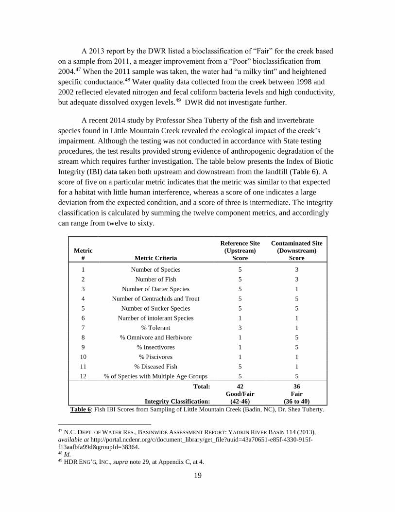
stream which requires further investigation. The table below presents the Index of Biotic
Integrity (IBI) data taken both upstream and downstream from the landfill (Table 6). A
score of five on a particular metric indicates that the metric was similar to that expected
for a habitat with little human interference, whereas a score of one indicates a large
deviation from the expected condition, and a score of three is intermediate. The integrity
classification is calculated by summing the twelve component metrics, and accordingly
can range from twelve to sixty.
Reference Site Contaminated Site
Metric
# Metric Criteria
(Upstream)
Score
(Downstream)
Score
1 Number of Species 5 3
2 Number of Fish 5 3
3 Number of Darter Species 5 1
4 Number of Centrachids and Trout 5 5
5 Number of Sucker Species 5 5
6 Number of intolerant Species 1 1
7 % Tolerant 3 1
8 % Omnivore and Herbivore 1 5
9 % Insectivores 1 5
10 % Piscivores 1 1
11 % Diseased Fish 5 1
12 % of Species with Multiple Age Groups 5 5
Total: 42 36
Integrity Classification:
Good/Fair
(42-46)
Fair
(36 to 40)
Table 6: Fish IBI Scores from Sampling of Little Mountain Creek (Badin, NC), Dr. Shea Tuberty.
47 N.C. DEPT. OF WATER RES., BASINWIDE ASSESSMENT REPORT: YADKIN RIVER BASIN 114 (2013),
available at http://portal.ncdenr.org/c/document_library/get_file?uuid=43a70651-e85f-4330-915f-
f13aafbfa99d&groupId=38364. 48 Id. 49 HDR ENG’G, INC., supra note 29, at Appendix C, at 4.
20
The scores for the upstream portion are generally good, showing a large, diverse
population of species with little disease. The downstream site, however, received an
integrity classification at the low end of the “Fair” designation, due to small, less diverse
populations and higher rates of disease; all of these factors indicate stream degradation.
In particular, a portion of the fish tested at the downstream site had obvious erosion on
the fins and fungal infections on the skin, neither of which were apparent at the upstream
site, which received a five for percentage of diseased fish. These results are highly
indicative of stream degradation downstream of the Alcoa-Badin Landfill. In addition,
the low score for the number of darter species indicates decreased oxygen levels and
increased silt, as these species are especially susceptible to both conditions.50 These
results indicate some form of contamination or impairment down-gradient from the plant
site.
NPDES Permit, Expiration and Continuation
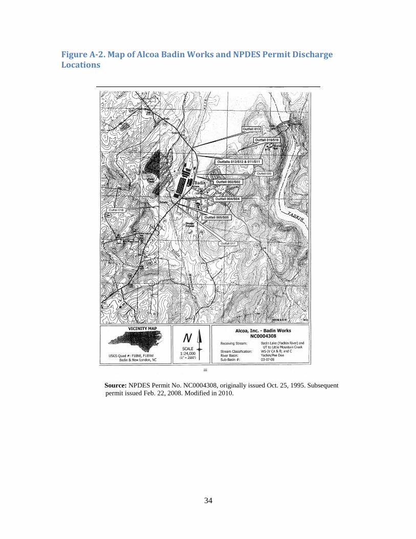
Alcoa has previously held a National Pollutant Discharge Elimination System
(NPDES) permit for numerous Outfalls across the Alcoa Badin Works site, including the
“stormwater” discharge from the Alcoa-Badin Landfill into Little Mountain Creek,
known as Outfall 018 (see Appendix, Figure A-2). The NPDES permit expired on
February 28, 2013;51 however, the facility must comply with the requirements of the
expired permit until a new permit is issued. The standing permit does not have any
effluent limitations for discharges from Outfall 018 into Little Mountain Creek.52
50 LYCOMING COLLEGE, CLEAN WATER INSTITUTE, IBI METRICS DESCRIPTIONS (2004), available at
https://www.lycoming.edu/cwi/pdfs/limestoneRun/ibiMetrics.pdf. 51 N.C. Div. of Water Quality, NPDES Permit No. NC0004308 (Feb. 22, 2008). 52 Id.
21
AREA 2 - THE BALL FIELD
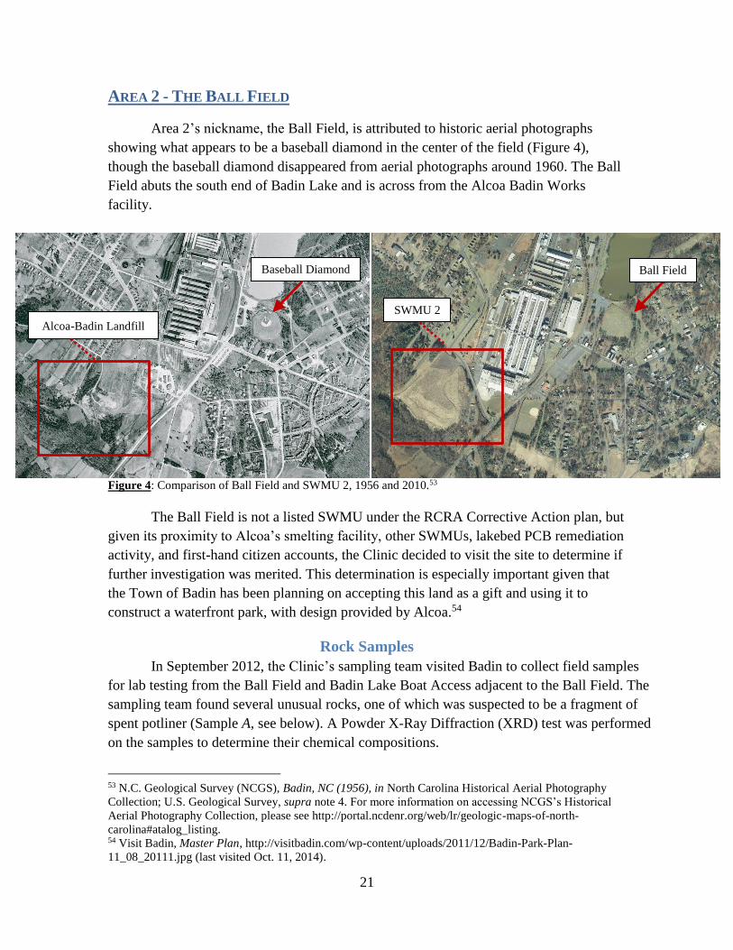
Area 2’s nickname, the Ball Field, is attributed to historic aerial photographs
showing what appears to be a baseball diamond in the center of the field (Figure 4),
though the baseball diamond disappeared from aerial photographs around 1960. The Ball
Field abuts the south end of Badin Lake and is across from the Alcoa Badin Works
facility.
Figure 4: Comparison of Ball Field and SWMU 2, 1956 and 2010.53
The Ball Field is not a listed SWMU under the RCRA Corrective Action plan, but
given its proximity to Alcoa’s smelting facility, other SWMUs, lakebed PCB remediation
activity, and first-hand citizen accounts, the Clinic decided to visit the site to determine if
further investigation was merited. This determination is especially important given that
the Town of Badin has been planning on accepting this land as a gift and using it to
construct a waterfront park, with design provided by Alcoa.54
Rock Samples
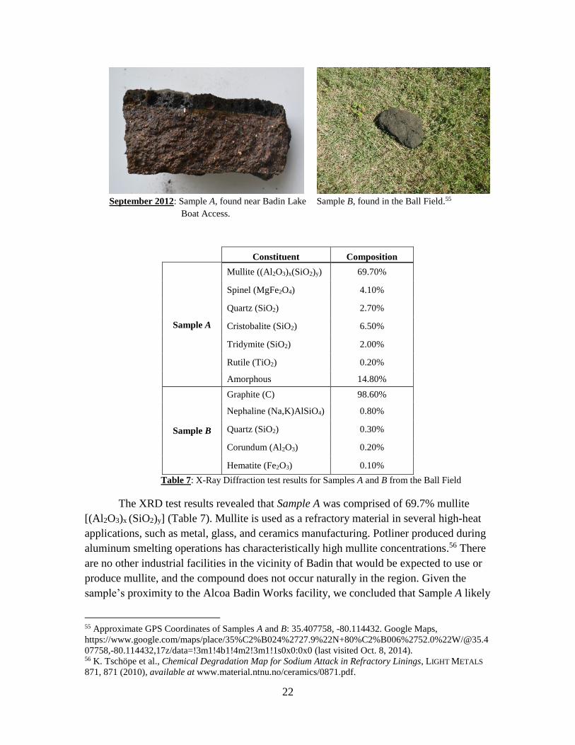
In September 2012, the Clinic’s sampling team visited Badin to collect field samples
for lab testing from the Ball Field and Badin Lake Boat Access adjacent to the Ball Field. The
sampling team found several unusual rocks, one of which was suspected to be a fragment of
spent potliner (Sample A, see below). A Powder X-Ray Diffraction (XRD) test was performed
on the samples to determine their chemical compositions.
53 N.C. Geological Survey (NCGS), Badin, NC (1956), in North Carolina Historical Aerial Photography
Collection; U.S. Geological Survey, supra note 4. For more information on accessing NCGS’s Historical
Aerial Photography Collection, please see http://portal.ncdenr.org/web/lr/geologic-maps-of-north-
carolina#atalog_listing. 54 Visit Badin, Master Plan, http://visitbadin.com/wp-content/uploads/2011/12/Badin-Park-Plan-
11_08_20111.jpg (last visited Oct. 11, 2014).
Alcoa-Badin Landfill
Baseball Diamond Ball Field
SWMU 2
22
September 2012: Sample A, found near Badin Lake
Boat Access.
Sample B, found in the Ball Field.55
Constituent Composition
Sample A
Mullite ((Al2O3)x(SiO2)y) 69.70%
Spinel (MgFe2O4) 4.10%
Quartz (SiO2) 2.70%
Cristobalite (SiO2) 6.50%
Tridymite (SiO2) 2.00%
Rutile (TiO2) 0.20%
Amorphous 14.80%
Sample B
Graphite (C) 98.60%
Nephaline (Na,K)AlSiO4) 0.80%
Quartz (SiO2) 0.30%
Corundum (Al2O3) 0.20%
Hematite (Fe2O3) 0.10%
Table 7: X-Ray Diffraction test results for Samples A and B from the Ball Field
The XRD test results revealed that Sample A was comprised of 69.7% mullite
[(Al2O3)x (SiO2)y] (Table 7). Mullite is used as a refractory material in several high-heat
applications, such as metal, glass, and ceramics manufacturing. Potliner produced during
aluminum smelting operations has characteristically high mullite concentrations.56 There
are no other industrial facilities in the vicinity of Badin that would be expected to use or
produce mullite, and the compound does not occur naturally in the region. Given the
sample’s proximity to the Alcoa Badin Works facility, we concluded that Sample A likely
55 Approximate GPS Coordinates of Samples A and B: 35.407758, -80.114432. Google Maps,
https://www.google.com/maps/place/35%C2%B024%2727.9%22N+80%C2%B006%2752.0%22W/@35.4
07758,-80.114432,17z/data=!3m1!4b1!4m2!3m1!1s0x0:0x0 (last visited Oct. 8, 2014). 56 K. Tschöpe et al., Chemical Degradation Map for Sodium Attack in Refractory Linings, LIGHT METALS
871, 871 (2010), available at www.material.ntnu.no/ceramics/0871.pdf.
23
is a fragment of spent potliner from the nearby smelting plant.
The XRD analysis showed that Sample B was composed of 98.6% graphite [C]
(Table 7). Like mullite, graphite has numerous industrial applications, especially as a
refractory material in the metals, glass, and ceramics industries.57 Apart from Alcoa
Badin Works, however, there are no nearby facilities that we would expect to be a source
of this graphite sample, and pure graphite does not naturally occur in the region. Based
on the sample’s composition and the geographic factors surrounding the sample’s
location, we believe that Sample B is a carbon anode fragment. Carbon anode is a
common waste product in smelting operations. Neither Sample A nor Sample B is
associated with the current use of the field. As such, the two rock samples may be
evidence of past solid waste dumping. None of these items would be associated with
baseball or fishing activities.
TCLP Analysis
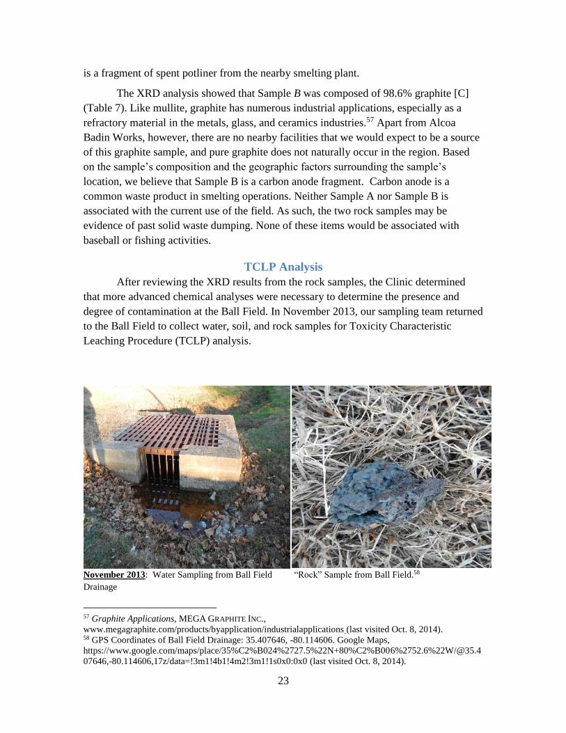
After reviewing the XRD results from the rock samples, the Clinic determined
that more advanced chemical analyses were necessary to determine the presence and
degree of contamination at the Ball Field. In November 2013, our sampling team returned
to the Ball Field to collect water, soil, and rock samples for Toxicity Characteristic
Leaching Procedure (TCLP) analysis.
November 2013: Water Sampling from Ball Field
Drainage
“Rock” Sample from Ball Field.58
57 Graphite Applications, MEGA GRAPHITE INC.,
www.megagraphite.com/products/byapplication/industrialapplications (last visited Oct. 8, 2014). 58 GPS Coordinates of Ball Field Drainage: 35.407646, -80.114606. Google Maps,
https://www.google.com/maps/place/35%C2%B024%2727.5%22N+80%C2%B006%2752.6%22W/@35.4
07646,-80.114606,17z/data=!3m1!4b1!4m2!3m1!1s0x0:0x0 (last visited Oct. 8, 2014).

24
The TCLP analyses of the Ball Field drainage water sample revealed the presence
of a number of hazardous compounds associated with industrial processes, rather than
baseball and fishing (Table 8).
Method Analyte Sample (ug/L)
15A NCAC 2L
Groundwater
Standard
(ug/L)
SVOC
8270D
2-Fluorophenol 58
Phenol-d5 34 30
Nitrobenzene-d5 81
2-Fluorobiphenyl 77
2,4,6 Tribromophenol 86
Terphenyl-d14 83
1,4-Dicholorobenzene-d4 158 6
Napthalene-d8 164 6
Acenaphthene-d10 182 80
Phenanthrene-d10 183 200
Chrysene-d12 176 5
Perylene-d12 182
VOA
8260B
Bibromofluoromethane 123
1,2 Dicholoroethane-d4 138 0.4
Toluene-d8 106 600
Bromofluorobenzene 105
Fluorobenzene 82
Chlorobenzene-d5 83 50
1,4-Dicholorobenzene-d4 78 6
EPA
300.0 Fluoride 0.0796 mg/l 2 mg/l
EPA
6010C
Aluminum 119
Calcium 5600
Iron 83.6 300
Magnesium 2070
Manganese 27.7 50
Potassium 2880
gamma-Chlordane 0.454
Methoxychlor 15.64
Table 8: TCLP test results for water sample from Ball Field drainage unit, November 2013.
We used State groundwater quality standards for this comparison although the
samples were taken from a surface drainage unit. We are aware that the content of this
sample might not accurately mirror the content of the groundwater; however, it serves as
25
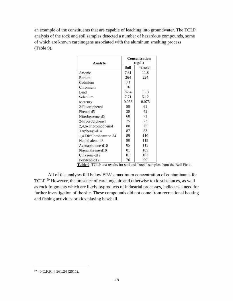
an example of the constituents that are capable of leaching into groundwater. The TCLP
analysis of the rock and soil samples detected a number of hazardous compounds, some
of which are known carcinogens associated with the aluminum smelting process
(Table 9).
Analyte
Concentration
(ug/L)
Soil "Rock"
Arsenic 7.81 11.8
Barium 264 224
Cadmium 3.1
Chromium 16
Lead 82.4 11.3
Selenium 7.71 5.12
Mercury 0.058 0.075
2-Fluorophenol 58 61
Phenol-d5 39 43
Nitrobenzene-d5 68 71
2-Fluorobiphenyl 75 73
2,4,6-Tribromophenol 80 75
Terphenyl-d14 87 83
1,4-Dichlorobenzene-d4 89 110
Naphthalene-d8 90 115
Acenaphthene-d10 85 115
Phenanthrene-d10 81 105
Chrysene-d12 81 103
Perylene-d12 76 99
Table 9: TCLP test results for soil and “rock” samples from the Ball Field.
All of the analytes fell below EPA’s maximum concentration of contaminants for
TCLP.59 However, the presence of carcinogenic and otherwise toxic substances, as well
as rock fragments which are likely byproducts of industrial processes, indicates a need for
further investigation of the site. These compounds did not come from recreational boating
and fishing activities or kids playing baseball.
59 40 C.F.R. § 261.24 (2011).
26
FURTHER CONSIDERATIONS
Due to limited testing site access and resources, only the two sites identified in
this petition were examined by the Clinic. Nonetheless, other sites within and around the
Badin Works site may also be contaminated. Alcoa and DENR records both suggest that
environmental contamination may be present in other areas not identified in the RCRA
Corrective Action plan or in this petition. Members of the Badin community have
likewise mentioned that waste from the plant had been deposited outside of the areas
identified by Alcoa for a number of years dating back to the early 1950s. We believe that
a number of sites beyond those identified in this petition warrant inclusion in the
requested Preliminary Assessment.
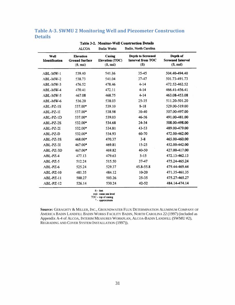
Preliminary Assessment –New Monitoring Wells: SWMU 2
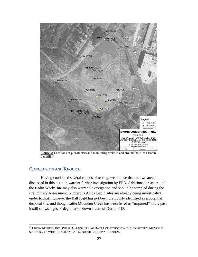
As part of the Preliminary Assessment, we recommend that EPA locate, install,
and monitor three additional monitoring wells to be placed south of the landfill (in the
alluvium) to determine whether the unlined landfill may be a source of the contamination
in Little Mountain Creek. Approximately forty wells actively monitor the groundwater
flowing into Badin Lake. However, we believe that the groundwater in the southern part
of the plant, flowing from beneath SWMU 2 into Little Mountain Creek, is insufficiently
monitored. Of the six monitoring wells around the perimeter of the landfill, only three
(ABL-MW03, ABL-MW04, and ABL-MW05) are located in positions that allow for
monitoring of water leaving the landfill (Figure 5).
27
Figure 5: Locations of piezometers and monitoring wells in and around the Alcoa-Badin
Landfill.60
CONCLUSION AND REQUEST
Having conducted several rounds of testing, we believe that the two areas
discussed in this petition warrant further investigation by EPA. Additional areas around
the Badin Works site may also warrant investigation and should be sampled during the
Preliminary Assessment. Numerous Alcoa Badin sites are already being investigated
under RCRA; however the Ball Field has not been previously identified as a potential
disposal site, and though Little Mountain Creek has been listed as “impaired” in the past,
it still shows signs of degradation downstream of Outfall 018.
60 ENVIRONEERING, INC., PHASE 3—ENGINEERING DATA COLLECTION FOR THE CORRECTIVE MEASURES
STUDY BADIN WORKS FACILITY BADIN, NORTH CAROLINA 11 (2012).
28
NC DENR has a history of dismissing the concerns of West Badin’s
environmental justice community and the Yadkin Riverkeeper without independent
investigation. Alcoa has a history of improperly disposing of hazardous wastes around its
facility. For these reasons, we request that EPA further investigate the areas discussed in
this petition in order to determine the presence, extent, and impact of hazardous
materials, and the eligibility of the areas to be listed as Superfund sites. Because Alcoa
and North Carolina have not investigated or addressed the presence of hazardous wastes
in surrounding areas during the RCRA process, EPA should now conduct a Preliminary
Assessment of the contamination under CERCLA. Please contact us if you have any
questions about this request. Thank you again for your attention.
Sincerely,
/s/
Ryke Longest, Director
Duke Environmental Law & Policy Clinic
(919) 613-7207
/s/
Shannon Arata, Legal Fellow
Duke Environmental Law & Policy Clinic
(919) 613-7251
cc:
Gina McCarthy, Administrator
United States Environmental Protection Agency
1200 Pennsylvania Avenue, N.W.
Washington, DC 20460
Heather McTeer Toney, Regional Administrator
United States Environmental Protection Agency, Region 4
Sam Nunn Atlanta Federal Center
61 Forsyth Street, SW
Atlanta, GA 30303
Mathy Stanislaus, Assistant Administrator
United States Environmental Protection Agency
Office of Solid Waste and Emergency Response
EPA West Building
1301 Constitution Avenue, NW
Washington, DC 20004
29
Appendix
Table A-1. Summary of Previous K088 Rulemakings & Recent Litigation and Petitions
Regulatory Event Federal Register Notice Date
Listed as a hazardous waste 45 FR 47832 July 16, 1980
Listing suspended 46 FR 4615 January 16, 1981
Environmental group challenged EPA’s failure to
complete the required studies under Sections
8002(f) and (p)
N/A 1984
Proposed relist 50 FR 40292 October 2, 1985
Withdrawal of proposal of relist 51 FR 36233 October 9, 1986
Court removed suspension of K088 listing (EDF vs.
EPA) N/A July 1988
Re-enact original listing of K088 53 FR 35412 September 13, 1988
Proposed LDR for K088 60 FR 11702 March 2, 1995
Final LDR for K088 61 FR 15566 April 8, 1996
Reynolds challenged EPA’s decision of nine
months of national capacity variance and sought the
court’s expedited review of the case
N/A May 1996
Generators from Northwest region petitioned for a
two-year national capacity variance N/A July 9, 1996
EPA extended the national capacity variance for an
additional six months until July 8, 1997 62 FR 1992 January 14, 1997
LDR became effective with three months of
capacity variance 62 FR 37693 July 14, 1997
Court decision to vacate land disposal prohibition
and treatment standards for two constituents
(fluoride and arsenic)
N/A April 1998
EPA gained four months to stay its mandate after
filing a motion to move the court for a stay in May
1998 and promulgated an interim final rule
63 FR 51254 September 24, 1998
Source: EPA, Land Disposal Restrictions – Background Document to Establish Effective Date for
Amended Treatment Standards for Spent Aluminum Potliners (Proposed Rule) (2000), available at
http://www.epa.gov/osw/hazard/tsd/ldr/k088/landdisp.pdf.
30
Table A-2. Weather Conditions in Badin, NC 28009 before June 2014 Little Mountain Creek Sampling
High Low Precip Snow Avg. Hi Avg. Lo
Thu 91° 71° 0 in 0 in 85° 66°
6/19/2014
Fri 89° 67° 0 in 0 in 86° 66°
6/20/2014
Sat 87° 69° 0 in 0 in 86° 66°
6/21/2014
Sun 84° 69° 0 in 0 in 86° 66°
6/22/2014
Mon 83° 67° 0 in 0 in 86° 67°
6/23/2014
Tue 82° 69° 0 in 0 in 86° 67°
6/24/2014
Wed 88° 71° 0.01 in 0 in 86° 67°
6/25/2014
Thu 89° 67° 0 in 0 in 86° 67°
6/26/2014
Fri 87° 69° 0.02 in 0 in 87° 67°
6/27/2014
Source: ACCUWEATHER.COM, Badin, NC Local Weather for June 2014,
http://www.accuweather.com/en/us/badin-nc/28009/driving-june-
weather/2132788?monyr=6/1/2014&view=table.
31
Table A-3. SWMU 2 Monitoring Well and Piezometer Construction Details
Source: GERAGHTY & MILLER, INC., GROUNDWATER FLUX DETERMINATION ALUMINUM COMPANY OF
AMERICA BADIN LANDFILL BADIN WORKS FACILITY BADIN, NORTH CAROLINA 22 (1997) (included as
Appendix A-4 of ALCOA, INTERIM MEASURES WORKPLAN, ALCOA-BADIN LANDFILL (SWMU #2),
REGRADING AND COVER SYSTEM INSTALLATION (1997)).
32
Figure A-1. Groundwater Hydrographs for SWMU 2/Badin Municipal Landfill
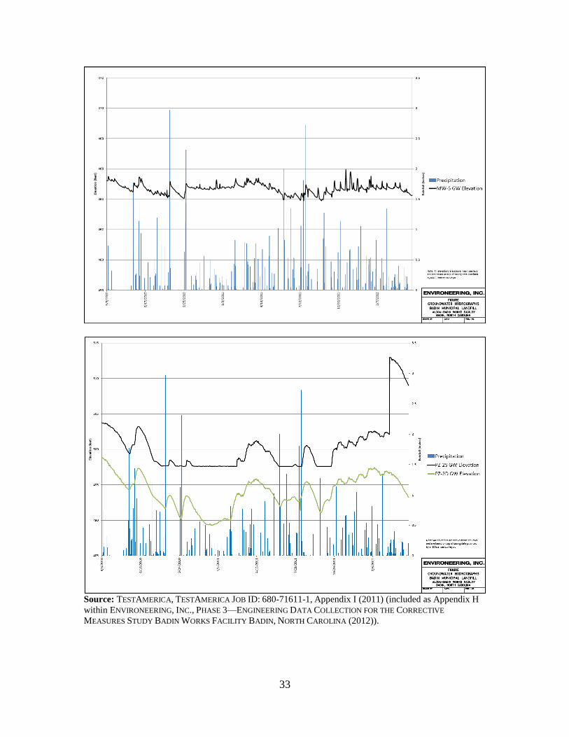
33
Source: TESTAMERICA, TESTAMERICA JOB ID: 680-71611-1, Appendix I (2011) (included as Appendix H
within ENVIRONEERING, INC., PHASE 3—ENGINEERING DATA COLLECTION FOR THE CORRECTIVE
MEASURES STUDY BADIN WORKS FACILITY BADIN, NORTH CAROLINA (2012)).
34
Figure A-2. Map of Alcoa Badin Works and NPDES Permit Discharge Locations
Source: NPDES Permit No. NC0004308, originally issued Oct. 25, 1995. Subsequent permit issued Feb. 22, 2008. Modified in 2010.
35
Figure A-3. SWMU 2 Soil and Groundwater Conductivity
Source: GEO SOLUTIONS LTD., INC., GEOPHYSICAL EVALUATION AT THE ALCOA POWER
GENERATING, INC. YADKIN DIVISION SWITCHYARD AND THE SWMU NO. 2, ALCOA/BADIN
LANDFILL, BADIN, NORTH CAROLINA 10 (2008) (included as Appendix A within ENVIRONEERING,
INC., PHASE 3—ENGINEERING DATA COLLECTION FOR THE CORRECTIVE MEASURES STUDY BADIN
WORKS FACILITY BADIN, NORTH CAROLINA (2012)).
36
Index for Electronic Appendix
1. Cover Letter & Report, N.C. Div. of Health Servs., Final Preliminary Assessment
Report (1985).
2. NUS Corp., Preliminary Reassessment (1989).
3. A.T. Kearney, Inc. & DPRA, Inc., Interim RCRA Facility Assessment Report (1990).
4. Law Envtl., Phase II Ground-water Assessment Northwest Valley, Alcoa-Badin
Works, Badin, North Carolina (1990).
5. Alcoa, Interim Measures Workplan, Alcoa-Badin Landfill (SWMU #2), Regrading
and Cover System Installation (1997).
6. MFG, Inc., RCRA Facility Investigation Report, Volume I of II (2001).
7. Order of Hon. Sharon Armstrong in Alcoa, Inc. v. Accident & Casualty Company,
Case No. 92-2-28065-SEA (Sup. Ct. Wash. King Cnty. 2003).
8. HDR Eng’g, Inc., Preliminary Findings & Recommendations Report - Mountain
Creek and Little Mountain Creek and Jacobs Creek (2004).
9. Environeering, Inc., Phase 3—Engineering Data Collection for the Corrective
Measures Study Badin Works Facility Badin, North Carolina (2012).