Embed Size (px)
Citation preview
1. SIGNIFICANT INFORMATION AND CHANGES
1.1 Singapore FIR
a) Termination of Repetitive Flight Plan (RPL) System within the Singapore FIR ENR 1.10-3 / ENR 1.10-4
1.2 Singapore Changi Airport (WSSS)
a) Update on parking restrictions for aircraft type B767 series at Cargo Stands WSSS AD 2-6.7
b) Update on runway capacity enhancement initiative to achieve maximum flow rate per hour for departures and arrivals
WSSS AD 2-23
1.3 Seletar Airport (WSSL)
a) Update on procedures for pushback and tow forward for aircraft types B757-200 and C130 from aircraft stands D1 and D2
WSSL AD 2-4-1 toWSSL AD 2-4-3
b) Availability of simple touchdown zone lights for both RWY 03 and RWY 21 approach
WSSL AD 2-5 andWSSL AD 2-9
2. INSERT THE ATTACHED REPLACEMENT PAGES WHICH ARE MARKED WITH ASTERISKS IN THE CHECKLIST OF PAGES - GEN 0.4-1 TO GEN 0.4-4.
3. NEW OR REVISED INFORMATION IS INDICATED EITHER BY A HORIZONTAL ARROW OR A VERTICAL LINE.
4. RECORD ENTRY OF AMENDMENT ON PAGE GEN 0.2-1.
5. THIS AMENDMENT INCORPORATES INFORMATION CONTAINED IN THE FOLLOWING WHICH ARE HEREBY SUPERSEDED:NOTAM:
AIP Supplement:331/14 dated 2 OCT 14
AIC:6/10 dated 9 SEP 104/14 dated 21 AUG 14
NOTAM:A1911/14 dated 29 SEP 14A1919/14 dated 30 SEP 14A1943/14 dated 1 OCT 14A1977/14 dated 7 OCT 14A1981/14 dated 7 OCT 14
AIPREPUBLIC OF SINGAPORE
AERONAUTICAL INFORMATION SERVICESCIVIL AVIATION AUTHORITY OF SINGAPORE
SINGAPORE CHANGI AIRPORT
P.O. BOX 1, SINGAPORE 918141
AMENDMENT NR 6/1413 NOVEMBER 2014
TEL : (65) 6595 6051
FAX : (65) 6441 0221
AFS : WSSSYNYX

AIP GEN 0.1-1SINGAPORE 13 NOV 14
PART 1 - GENERAL (GEN)
GEN 0.1 PREFACE
GEN 0
1. Name of the publishing authority
AIP Singapore is published by authority of the Civil Aviation Authority of Singapore.
2. Applicable ICAO documents
The AIP is prepared in accordance with the Standards and Recommended Practices (SARPs) of Annex 15 to the Convention on International Civil Aviation and the Aeronautical Information Services Manual(ICAO Doc 8126). Charts contained in the AIP are produced in accordance with Annex 4 to the Convention on International Civil Aviation and with the Aeronautical Chart Manual (ICAO Doc 8697). Differences from ICAO Standards, Recommended Practices and Procedures are given in subsection GEN 1.7.
3. The AIP structure and established regular amendment interval
3.1 The AIP structure
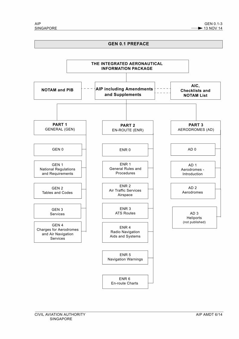
The AIP forms part of the Integrated Aeronautical Information Package, details of which are given in subsection GEN 3.1. The principal AIP structure is shown in graphic form on page GEN 0.1-3.
The AIP is made up of three parts, General (GEN), En-route (ENR) and Aerodromes (AD), each divided into sections and subsections as applicable, containing various types of information.
3.1.1 PART 1 - GENERAL (GEN)
Part 1 consists of five sections containing information briefly described hereafter.
GEN 0 - Preface; Record of AIP Amendments; Record of current AIP Supplements; Checklist of AIP pages; List of hand amendments to the AIP; and Table of Contents to Part 1.
GEN 1 - National regulations and requirements - Designated authorities; Entry, transit and departure of aircraft; Entry, transit and departure of passengers and crew; Entry, transit and departure of cargo; Aircraft instruments, equipment and flight documents; Summary of national regulations and international agreements/conventions; and Differences from ICAO Standards, Recommended Practices and Procedures.
GEN 2 - Tables and codes - Measuring system, aircraft markings, holidays; Abbreviations used in AIS publications; Chart symbols; Location indicators; List of radio navigation aids; Conversion tables; and Sunrise/Sunset tables.
GEN 3 - Services - Aeronautical Information Services; Aeronautical Charts; Air Traffic Services; Communication Services; Meteorological Services; and Search and Rescue.
GEN 4 - Charges for aerodromes and air navigation services - Aerodrome charges and Air navigation services charges.
3.1.2 PART 2 - EN-ROUTE (ENR)
Part 2 consists of seven sections containing information briefly described hereafter.
ENR 0 - Table of Contents to Part 2.ENR 1 - General rules and procedures - General rules; Visual flight rules; Instrument flight rules; ATS
airspace classification; Holding, approach and departure procedures; Radar services and procedures; Altimeter setting procedures; Regional supplementary procedures; Air traffic flow management; Flight planning; Addressing of flight plan messages; Interception of civil aircraft; Unlawful interference; and Air traffic incidents.
CIVIL AVIATION AUTHORITY AIP AMDT 6/14SINGAPORE
GEN 0.1-2 AIP13 NOV 14 SINGAPORE
ENR 2 - Air traffic services airspace - Detailed description of Flight Information Region (FIR); Terminal Control Areas (TMA); and other regulated airspace.
ENR 3 - ATS routes - Detailed description of ATS routes; Area Navigation Routes; Helicopter Routes; other routes; and en-route holding.Note - Other types of routes which are specified in connection with procedures for traffic to and from aerodromes are described in the relevant sections and subsections of Part 3 - Aerodromes.
ENR 4 - Radio navigation aids/systems - Radio navigation aids - en-route; special navigation systems; name-code designators for significant points; and aeronautical ground lights - en-route.
ENR 5 - Navigation warnings - Prohibited, restricted and danger areas; military exercise and training areas; other activities of a dangerous nature; air navigation obstacles - en-route; aerial sporting and recreational activities; and bird migration and areas with sensitive fauna.
ENR 6 - En-route charts - En-route Chart - ICAO.
3.1.3 PART 3 - AERODROMES (AD)
Part 3 consists of three sections containing information briefly described hereafter.
AD 0 - Table of Contents to Part 3.AD 1 - Aerodromes - Introduction - Aerodromes availability; Rescue and fire fighting services; Index
to aerodromes; and Grouping of aerodromes.AD 2 - Aerodromes - Detailed information about aerodromes listed under 24 sub-sections.AD 3 - This section has been omitted as there are no heliports in Singapore.
3.2 Regular Amendment Interval
Regular amendments to AIP Singapore will be issued once every two months. The publication dates will be on alternate AIRAC effective dates as follows:
Amendment NR Publication Date
1/15 8 January 2015
2/15 5 March 2015
3/15 30 April 2015
4/15 25 June 2015
5/15 20 August 2015
6/15 15 October 2015
7/15 10 December 2015
4. Service to contact in case of detected AIP errors or omissions
In the compilation of the AIP, care has been taken to ensure that the information contained therein is accurate and complete. Any errors and omissions which may nevertheless be detected, as well as any enquiries or suggestions concerning the Integrated Aeronautical Information Package, should be referred to:
Chief AISAeronautical Information ServicesCivil Aviation Authority of Singapore, Singapore Changi Airport, P. O. Box 1Singapore 918141
TEL : (65) 65956051FAX : (65) 64410221EMAIL : [email protected]
AIP AMDT 6/14 CIVIL AVIATION AUTHORITYSINGAPORE
AIP GEN 0.1-3SINGAPORE 13 NOV 14
GEN 0.1 PREFACE
CIVIL AVIATION AUTHORITY AIP AMDT 6/14 SINGAPORE
AD 3Heliports
(not published)
AIC, Checklists and
NOTAM List
ENR 5Navigation Warnings
ENR 6 En-route Charts
NOTAM and PIB AIP including Amendmentsand Supplements
PART 1GENERAL (GEN)
PART 2EN-ROUTE (ENR)
PART 3AERODROMES (AD)
GEN 0 ENR 0 AD 0
GEN 1National Regulations
and Requirements
AD 1Aerodromes -Introduction
GEN 2Tables and Codes
ENR 2Air Traffic Services
Airspace
AD 2Aerodromes
ENR 3ATS Routes
GEN 3Services
ENR 4Radio Navigation Aids and Systems
GEN 4Charges for Aerodromes
and Air Navigation Services
THE INTEGRATED AERONAUTICALINFORMATION PACKAGE
ENR 1General Rules and
Procedures

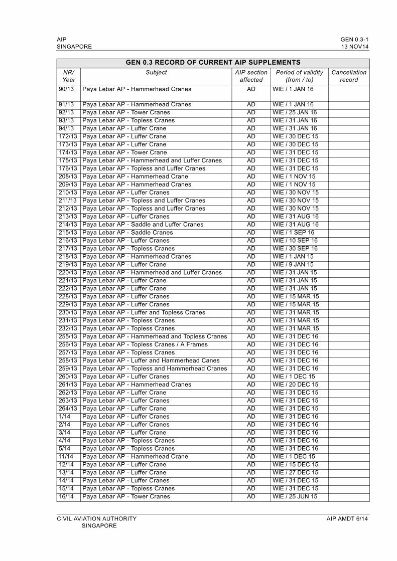
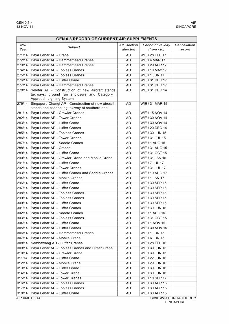
AIP GEN 0.3-1SINGAPORE 13 NOV14
GEN 0.3 RECORD OF CURRENT AIP SUPPLEMENTS
NR/Year
Subject AIP sectionaffected
Period of validity(from / to)
Cancellation record
90/13 Paya Lebar AP - Hammerhead Cranes AD WIE / 1 JAN 16
91/13 Paya Lebar AP - Hammerhead Cranes AD WIE / 1 JAN 1692/13 Paya Lebar AP - Tower Cranes AD WIE / 25 JAN 1693/13 Paya Lebar AP - Topless Cranes AD WIE / 31 JAN 1694/13 Paya Lebar AP - Luffer Crane AD WIE / 31 JAN 16172/13 Paya Lebar AP - Luffer Crane AD WIE / 30 DEC 15173/13 Paya Lebar AP - Luffer Crane AD WIE / 30 DEC 15174/13 Paya Lebar AP - Tower Crane AD WIE / 31 DEC 15175/13 Paya Lebar AP - Hammerhead and Luffer Cranes AD WIE / 31 DEC 15176/13 Paya Lebar AP - Topless and Luffer Cranes AD WIE / 31 DEC 15208/13 Paya Lebar AP - Hammerhead Crane AD WIE / 1 NOV 15209/13 Paya Lebar AP - Hammerhead Cranes AD WIE / 1 NOV 15210/13 Paya Lebar AP - Luffer Cranes AD WIE / 30 NOV 15211/13 Paya Lebar AP - Topless and Luffer Cranes AD WIE / 30 NOV 15212/13 Paya Lebar AP - Topless and Luffer Cranes AD WIE / 30 NOV 15213/13 Paya Lebar AP - Luffer Cranes AD WIE / 31 AUG 16214/13 Paya Lebar AP - Saddle and Luffer Cranes AD WIE / 31 AUG 16215/13 Paya Lebar AP - Saddle Cranes AD WIE / 1 SEP 16216/13 Paya Lebar AP - Luffer Cranes AD WIE / 10 SEP 16217/13 Paya Lebar AP - Topless Cranes AD WIE / 30 SEP 16218/13 Paya Lebar AP - Hammerhead Cranes AD WIE / 1 JAN 15219/13 Paya Lebar AP - Luffer Crane AD WIE / 9 JAN 15220/13 Paya Lebar AP - Hammerhead and Luffer Cranes AD WIE / 31 JAN 15 221/13 Paya Lebar AP - Luffer Crane AD WIE / 31 JAN 15222/13 Paya Lebar AP - Luffer Crane AD WIE / 31 JAN 15228/13 Paya Lebar AP - Luffer Cranes AD WIE / 15 MAR 15229/13 Paya Lebar AP - Luffer Cranes AD WIE / 15 MAR 15230/13 Paya Lebar AP - Luffer and Topless Cranes AD WIE / 31 MAR 15231/13 Paya Lebar AP - Topless Cranes AD WIE / 31 MAR 15232/13 Paya Lebar AP - Topless Cranes AD WIE / 31 MAR 15255/13 Paya Lebar AP - Hammerhead and Topless Cranes AD WIE / 31 DEC 16256/13 Paya Lebar AP - Topless Cranes / A Frames AD WIE / 31 DEC 16257/13 Paya Lebar AP - Topless Cranes AD WIE / 31 DEC 16258/13 Paya Lebar AP - Luffer and Hammerhead Canes AD WIE / 31 DEC 16259/13 Paya Lebar AP - Topless and Hammerhead Cranes AD WIE / 31 DEC 16260/13 Paya Lebar AP - Luffer Cranes AD WIE / 1 DEC 15261/13 Paya Lebar AP - Hammerhead Cranes AD WIE / 20 DEC 15262/13 Paya Lebar AP - Luffer Crane AD WIE / 31 DEC 15263/13 Paya Lebar AP - Luffer Cranes AD WIE / 31 DEC 15264/13 Paya Lebar AP - Luffer Crane AD WIE / 31 DEC 151/14 Paya Lebar AP - Luffer Cranes AD WIE / 31 DEC 162/14 Paya Lebar AP - Luffer Cranes AD WIE / 31 DEC 163/14 Paya Lebar AP - Luffer Crane AD WIE / 31 DEC 164/14 Paya Lebar AP - Topless Cranes AD WIE / 31 DEC 165/14 Paya Lebar AP - Topless Cranes AD WIE / 31 DEC 1611/14 Paya Lebar AP - Hammerhead Crane AD WIE / 1 DEC 1512/14 Paya Lebar AP - Luffer Crane AD WIE / 15 DEC 1513/14 Paya Lebar AP - Luffer Crane AD WIE / 27 DEC 1514/14 Paya Lebar AP - Luffer Cranes AD WIE / 31 DEC 1515/14 Paya Lebar AP - Topless Cranes AD WIE / 31 DEC 1516/14 Paya Lebar AP - Tower Cranes AD WIE / 25 JUN 15
CIVIL AVIATION AUTHORITY AIP AMDT 6/14SINGAPORE
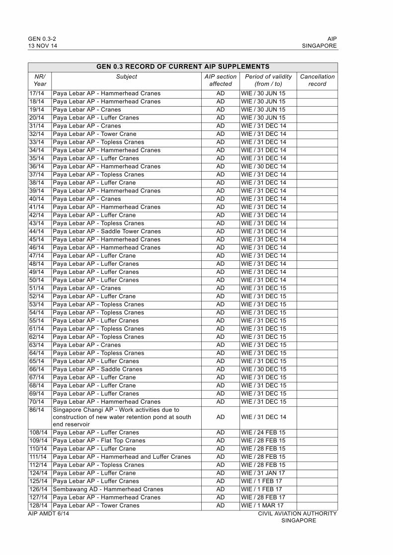
GEN 0.3-2 AIP13 NOV 14 SINGAPORE
GEN 0.3 RECORD OF CURRENT AIP SUPPLEMENTS
NR/Year
Subject AIP sectionaffected
Period of validity(from / to)
Cancellation record
17/14 Paya Lebar AP - Hammerhead Cranes AD WIE / 30 JUN 1518/14 Paya Lebar AP - Hammerhead Cranes AD WIE / 30 JUN 1519/14 Paya Lebar AP - Cranes AD WIE / 30 JUN 1520/14 Paya Lebar AP - Luffer Cranes AD WIE / 30 JUN 1531/14 Paya Lebar AP - Cranes AD WIE / 31 DEC 1432/14 Paya Lebar AP - Tower Crane AD WIE / 31 DEC 1433/14 Paya Lebar AP - Topless Cranes AD WIE / 31 DEC 1434/14 Paya Lebar AP - Hammerhead Cranes AD WIE / 31 DEC 1435/14 Paya Lebar AP - Luffer Cranes AD WIE / 31 DEC 1436/14 Paya Lebar AP - Hammerhead Cranes AD WIE / 30 DEC 1437/14 Paya Lebar AP - Topless Cranes AD WIE / 31 DEC 1438/14 Paya Lebar AP - Luffer Crane AD WIE / 31 DEC 1439/14 Paya Lebar AP - Hammerhead Cranes AD WIE / 31 DEC 1440/14 Paya Lebar AP - Cranes AD WIE / 31 DEC 1441/14 Paya Lebar AP - Hammerhead Cranes AD WIE / 31 DEC 1442/14 Paya Lebar AP - Luffer Crane AD WIE / 31 DEC 1443/14 Paya Lebar AP - Topless Cranes AD WIE / 31 DEC 1444/14 Paya Lebar AP - Saddle Tower Cranes AD WIE / 31 DEC 1445/14 Paya Lebar AP - Hammerhead Cranes AD WIE / 31 DEC 1446/14 Paya Lebar AP - Hammerhead Cranes AD WIE / 31 DEC 1447/14 Paya Lebar AP - Luffer Crane AD WIE / 31 DEC 1448/14 Paya Lebar AP - Luffer Cranes AD WIE / 31 DEC 1449/14 Paya Lebar AP - Luffer Cranes AD WIE / 31 DEC 1450/14 Paya Lebar AP - Luffer Cranes AD WIE / 31 DEC 1451/14 Paya Lebar AP - Cranes AD WIE / 31 DEC 1552/14 Paya Lebar AP - Luffer Crane AD WIE / 31 DEC 1553/14 Paya Lebar AP - Topless Cranes AD WIE / 31 DEC 1554/14 Paya Lebar AP - Topless Cranes AD WIE / 31 DEC 1555/14 Paya Lebar AP - Luffer Cranes AD WIE / 31 DEC 1561/14 Paya Lebar AP - Topless Cranes AD WIE / 31 DEC 1562/14 Paya Lebar AP - Topless Cranes AD WIE / 31 DEC 1563/14 Paya Lebar AP - Cranes AD WIE / 31 DEC 1564/14 Paya Lebar AP - Topless Cranes AD WIE / 31 DEC 1565/14 Paya Lebar AP - Luffer Cranes AD WIE / 31 DEC 1566/14 Paya Lebar AP - Saddle Cranes AD WIE / 30 DEC 1567/14 Paya Lebar AP - Luffer Crane AD WIE / 31 DEC 1568/14 Paya Lebar AP - Luffer Crane AD WIE / 31 DEC 1569/14 Paya Lebar AP - Luffer Cranes AD WIE / 31 DEC 1570/14 Paya Lebar AP - Hammerhead Cranes AD WIE / 31 DEC 1586/14 Singapore Changi AP - Work activities due to
construction of new water retention pond at south end reservoir
AD WIE / 31 DEC 14
108/14 Paya Lebar AP - Luffer Cranes AD WIE / 24 FEB 15109/14 Paya Lebar AP - Flat Top Cranes AD WIE / 28 FEB 15110/14 Paya Lebar AP - Luffer Crane AD WIE / 28 FEB 15111/14 Paya Lebar AP - Hammerhead and Luffer Cranes AD WIE / 28 FEB 15112/14 Paya Lebar AP - Topless Cranes AD WIE / 28 FEB 15124/14 Paya Lebar AP - Luffer Crane AD WIE / 31 JAN 17125/14 Paya Lebar AP - Luffer Cranes AD WIE / 1 FEB 17126/14 Sembawang AD - Hammerhead Cranes AD WIE / 1 FEB 17127/14 Paya Lebar AP - Hammerhead Cranes AD WIE / 28 FEB 17128/14 Paya Lebar AP - Tower Cranes AD WIE / 1 MAR 17AIP AMDT 6/14 CIVIL AVIATION AUTHORITY
SINGAPORE
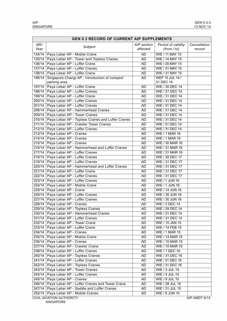
AIP GEN 0.3-3SINGAPORE 13 NOV 14
GEN 0.3 RECORD OF CURRENT AIP SUPPLEMENTS
NR/Year
SubjectAIP section
affectedPeriod of validity
(from / to)Cancellation
record
134/14 Paya Lebar AP - Mobile Crane AD WIE / 11 MAY 15135/14 Paya Lebar AP - Tower and Topless Cranes AD WIE / 14 MAY 15136/14 Paya Lebar AP - Luffer Crane AD WIE / 20 MAY 15137/14 Paya Lebar AP - Luffer Cranes AD WIE / 31 MAY 15138/14 Paya Lebar AP - Luffer Crane AD WIE / 31 MAY 15196/14 Singapore Changi AP - Introduction of compact
parking areaAD WEF 15 JUL 14 /
31 DEC 14197/14 Paya Lebar AP - Luffer Crane AD WIE / 30 DEC 14198/14 Paya Lebar AP - Luffer Cranes AD WIE / 31 DEC 14199/14 Paya Lebar AP - Luffer Crane AD WIE / 31 DEC 14200/14 Paya Lebar AP - Luffer Cranes AD WIE / 31 DEC 14201/14 Paya Lebar AP - Luffer Cranes AD WIE / 31 DEC 14208/14 Paya Lebar AP - Hammerhead Cranes AD WIE / 31 DEC 14209/14 Paya Lebar AP - Tower Cranes AD WIE / 31 DEC 14210/14 Paya Lebar AP - Topless Cranes and Luffer Cranes AD WIE / 31 DEC 14211/14 Paya Lebar AP - Crawler Tower Cranes AD WIE / 31 DEC 14212/14 Paya Lebar AP - Luffer Cranes AD WIE / 31 DEC 14213/14 Paya Lebar AP - Cranes AD WIE / 1 MAR 16214/14 Paya Lebar AP - Cranes AD WIE / 1 MAR 16215/14 Paya Lebar AP - Cranes AD WIE / 30 MAR 16216/14 Paya Lebar AP - Hammerhead and Luffer Cranes AD WIE / 31 MAR 16217/14 Paya Lebar AP - Luffer Cranes AD WIE / 31 MAR 16218/14 Paya Lebar AP - Luffer Cranes AD WIE / 30 DEC 17219/14 Paya Lebar AP - Luffer Cranes AD WIE / 31 DEC 17220/14 Paya Lebar AP - Hammerhead and Luffer Cranes AD WIE / 31 DEC 17221/14 Paya Lebar AP - Luffer Crane AD WIE / 31 DEC 17222/14 Paya Lebar AP - Luffer Cranes AD WIE / 31 DEC 17223/14 Paya Lebar AP - Luffer Cranes AD WIE / 1 JUN 16224/14 Paya Lebar AP - Mobile Crane AD WIE / 1 JUN 16225/14 Paya Lebar AP - Crane AD WIE / 14 JUN 16226/14 Paya Lebar AP - Luffer Cranes AD WIE / 30 JUN 16227/14 Paya Lebar AP - Luffer Cranes AD WIE / 30 JUN 16228/14 Paya Lebar AP - Cranes AD WIE / 2 DEC 14229/14 Paya Lebar AP - Topless Cranes AD WIE / 29 DEC 14230/14 Paya Lebar AP - Hammerhead Cranes AD WIE / 31 DEC 14231/14 Paya Lebar AP - Luffer Cranes AD WIE / 31 DEC 14232/14 Paya Lebar AP - Tower Crane AD WIE / 15 JAN 15233/14 Paya Lebar AP - Luffer Crane AD WIE / 14 FEB 15234/14 Paya Lebar AP - Cranes AD WIE / 1 MAR 15235/14 Paya Lebar AP - Mobile Crane AD WIE / 14 MAR 15236/14 Paya Lebar AP - Cranes AD WIE / 15 MAR 15237/14 Paya Lebar AP - Crawler Crane AD WIE / 15 MAR 15238/14 Paya Lebar AP - Luffer Cranes AD WIE / 1 DEC 16240/14 Paya Lebar AP - Topless Cranes AD WIE / 31 DEC 16241/14 Paya Lebar AP - Luffer Cranes AD WIE / 31 DEC 16242/14 Paya Lebar AP - Topless Cranes AD WIE / 31 DEC 16243/14 Paya Lebar AP - Tower Cranes AD WIE / 3 JUL 15244/14 Paya Lebar AP - Luffer Cranes AD WIE / 4 JUL 15245/14 Paya Lebar AP - Cranes AD WIE / 9 JUL 15246/14 Paya Lebar AP - Luffer Cranes and Tower Crane AD WIE / 28 JUL 15247/14 Paya Lebar AP - Saddle and Luffer Cranes AD WIE / 31 JUL 15252/14 Paya Lebar AP - Mobile Cranes AD WIE / 6 JUN 15
CIVIL AVIATION AUTHORITY AIP AMDT 6/14SINGAPORE
GEN 0.3-4 AIP13 NOV 14 SINGAPORE
GEN 0.3 RECORD OF CURRENT AIP SUPPLEMENTS
NR/Year
SubjectAIP section
affectedPeriod of validity
(from / to)Cancellation
record
271/14 Paya Lebar AP - Crane AD WIE / 28 FEB 17
272/14 Paya Lebar AP - Hammerhead Cranes AD WIE / 4 MAR 17
273/14 Paya Lebar AP - Hammerhead Cranes AD WIE / 29 APR 17
274/14 Paya Lebar AP - Topless Cranes AD WIE / 10 MAY 17
275/14 Paya Lebar AP - Topless Cranes AD WIE / 1 JUN 17
276/14 Paya Lebar AP - Luffer Crane AD WIE / 31 DEC 17
277/14 Paya Lebar AP - Hammerhead Cranes AD WIE / 31 DEC 17
278/14 Seletar AP - Construction of new aircraft stands, taxiways, ground run enclosure and Category I Approach Lighting System
AD WIE / 31 DEC 14
279/14 Singapore Changi AP - Construction of new aircraft stands and connecting taxiway at southern end
AD WIE / 31 MAR 15
281/14 Paya Lebar AP - Crawler Cranes AD WIE / 15 NOV 14
282/14 Paya Lebar AP - Tower Cranes AD WIE / 30 NOV 14
283/14 Paya Lebar AP - Luffer Crane AD WIE / 30 NOV 14
284/14 Paya Lebar AP - Luffer Cranes AD WIE / 20 DEC 14
285/14 Paya Lebar AP - Topless Cranes AD WIE / 30 JUN 15
286/14 Paya Lebar AP - Tower Cranes AD WIE / 31 JUL 15
287/14 Paya Lebar AP - Saddle Cranes AD WIE / 1 AUG 15
288/14 Paya Lebar AP - Cranes AD WIE / 31 AUG 15
289/14 Paya Lebar AP - Luffer Crane AD WIE / 31 OCT 15
290/14 Paya Lebar AP - Crawler Crane and Mobile Crane AD WIE / 31 JAN 16
291/14 Paya Lebar AP - Luffer Crane AD WIE / 7 JUL 17
292/14 Paya Lebar AP - Tower Cranes AD WIE / 31 JUL 17
293/14 Paya Lebar AP - Luffer Cranes and Saddle Cranes AD WIE / 19 AUG 17
294/14 Paya Lebar AP - Mobile Cranes AD WIE / 1 JAN 17
296/14 Paya Lebar AP - Luffer Crane AD WIE / 30 SEP 15
297/14 Paya Lebar AP - Luffer Crane AD WIE / 30 SEP 15
298/14 Paya Lebar AP - Topless Cranes AD WIE / 30 SEP 15
299/14 Paya Lebar AP - Topless Cranes AD WIE / 30 SEP 15
300/14 Paya Lebar AP - Luffer Cranes AD WIE / 30 SEP 15
301/14 Paya Lebar AP - Luffer Cranes AD WIE / 30 JUN 15
302/14 Paya Lebar AP - Saddle Cranes AD WIE / 1 AUG 15
303/14 Paya Lebar AP - Topless Cranes AD WIE / 31 OCT 15
304/14 Paya Lebar AP - Luffer Crane AD WIE / 1 NOV 15
305/14 Paya Lebar AP - Luffer Cranes AD WIE / 30 NOV 15
306/14 Paya Lebar AP - Hammerhead Cranes AD WIE / 1 JUN 15
307/14 Paya Lebar AP - Mobile Crane AD WIE / 6 JUN 15
308/14 Sembawang AD - Luffer Cranes AD WIE / 28 FEB 16
309/14 Paya Lebar AP - Topless Cranes and Luffer Crane AD WIE / 30 JUN 15
310/14 Paya Lebar AP - Crawler Crane AD WIE / 30 JUN 15
311/14 Paya Lebar AP - Luffer Crane AD WIE / 22 JUN 16
312/14 Paya Lebar AP - Mobile Crane AD WIE / 29 JUN 16
313/14 Paya Lebar AP - Luffer Crane AD WIE / 30 JUN 16
314/14 Paya Lebar AP - Tower Crane AD WIE / 30 JUN 16
315/14 Paya Lebar AP - Tower Cranes AD WIE / 10 SEP 17
316/14 Paya Lebar AP - Topless Cranes AD WIE / 30 APR 15
317/14 Paya Lebar AP - Topless Cranes AD WIE / 30 APR 15
318/14 Paya Lebar AP - Luffer Crane AD WIE / 30 APR 15
AIP AMDT 6/14 CIVIL AVIATION AUTHORITYSINGAPORE
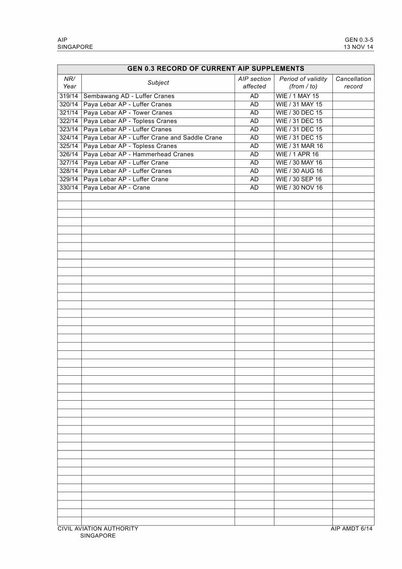
AIP GEN 0.3-5SINGAPORE 13 NOV 14
GEN 0.3 RECORD OF CURRENT AIP SUPPLEMENTS
NR/Year
SubjectAIP section
affectedPeriod of validity
(from / to)Cancellation
record
319/14 Sembawang AD - Luffer Cranes AD WIE / 1 MAY 15320/14 Paya Lebar AP - Luffer Cranes AD WIE / 31 MAY 15321/14 Paya Lebar AP - Tower Cranes AD WIE / 30 DEC 15322/14 Paya Lebar AP - Topless Cranes AD WIE / 31 DEC 15323/14 Paya Lebar AP - Luffer Cranes AD WIE / 31 DEC 15324/14 Paya Lebar AP - Luffer Crane and Saddle Crane AD WIE / 31 DEC 15325/14 Paya Lebar AP - Topless Cranes AD WIE / 31 MAR 16326/14 Paya Lebar AP - Hammerhead Cranes AD WIE / 1 APR 16327/14 Paya Lebar AP - Luffer Crane AD WIE / 30 MAY 16328/14 Paya Lebar AP - Luffer Cranes AD WIE / 30 AUG 16329/14 Paya Lebar AP - Luffer Crane AD WIE / 30 SEP 16330/14 Paya Lebar AP - Crane AD WIE / 30 NOV 16
CIVIL AVIATION AUTHORITY AIP AMDT 6/14SINGAPORE

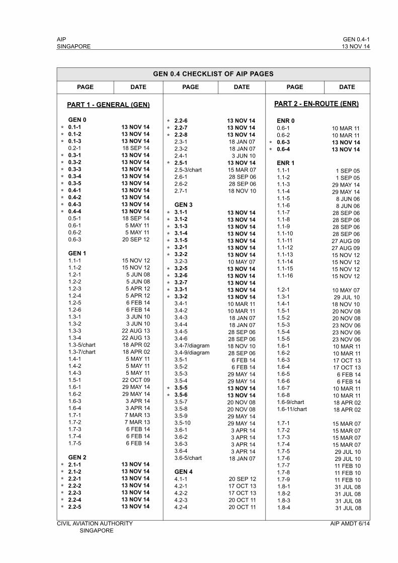
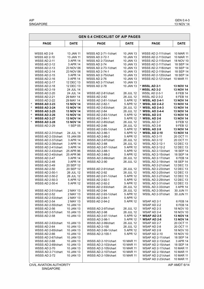
AIP GEN 0.4-1SINGAPORE 13 NOV 14
GEN 0.4 CHECKLIST OF AIP PAGES
PAGE DATE PAGE DATE PAGE DATE
GEN 00.1-10.1-20.1-30.2-10.3-10.3-20.3-30.3-40.3-50.4-10.4-20.4-30.4-40.5-10.6-10.6-20.6-3
GEN 11.1-11.1-21.2-11.2-21.2-31.2-41.2-51.2-61.3-11.3-21.3-31.3-41.3-5/chart1.3-7/chart1.4-11.4-21.4-31.5-11.6-11.6-21.6-31.6-41.7-11.7-21.7-31.7-41.7-5
GEN 22.1-12.1-22.2-12.2-22.2-32.2-42.2-5
13 NOV 1413 NOV 1413 NOV 1418 SEP 1413 NOV 1413 NOV 1413 NOV 1413 NOV 1413 NOV 1413 NOV 1413 NOV 1413 NOV 1413 NOV 1418 SEP 145 MAY 115 MAY 11
20 SEP 12
15 NOV 1215 NOV 12
5 JUN 085 JUN 085 APR 125 APR 126 FEB 146 FEB 143 JUN 103 JUN 10
22 AUG 1322 AUG 1318 APR 0218 APR 02
5 MAY 115 MAY 115 MAY 11
22 OCT 0929 MAY 1429 MAY 14
3 APR 143 APR 147 MAR 137 MAR 136 FEB 146 FEB 146 FEB 14
13 NOV 1413 NOV 1413 NOV 1413 NOV 1413 NOV 1413 NOV 1413 NOV 14
2.2-62.2-72.2-82.3-12.3-22.4-12.5-12.5-3/chart2.6-12.6-22.7-1
GEN 33.1-13.1-23.1-33.1-43.1-53.2-13.2-23.2-33.2-53.2-63.2-73.3-13.3-23.4-13.4-23.4-33.4-43.4-53.4-63.4-7/diagram3.4-9/diagram3.5-13.5-23.5-33.5-43.5-53.5-63.5-73.5-83.5-93.5-103.6-13.6-23.6-33.6-43.6-5/chart
GEN 44.1-14.2-14.2-24.2-34.2-4
13 NOV 1413 NOV 1413 NOV 1418 JAN 0718 JAN 073 JUN 10
13 NOV 1415 MAR 0728 SEP 0628 SEP 0618 NOV 10
13 NOV 1413 NOV 1413 NOV 1413 NOV 1413 NOV 1413 NOV 1413 NOV 1410 MAY 0713 NOV 1413 NOV 1413 NOV 1413 NOV 1413 NOV 1410 MAR 1110 MAR 1118 JAN 0718 JAN 0728 SEP 0628 SEP 0618 NOV 1028 SEP 06
6 FEB 146 FEB 14
29 MAY 1429 MAY 14 13 NOV 1413 NOV 1420 NOV 0820 NOV 0829 MAY 1429 MAY 14
3 APR 143 APR 143 APR 143 APR 14
18 JAN 07
20 SEP 1217 OCT 1317 OCT 1320 OCT 1120 OCT 11
ENR 00.6-10.6-20.6-30.6-4
ENR 11.1-11.1-21.1-31.1-41.1-51.1-61.1-71.1-81.1-91.1-101.1-111.1-121.1-131.1-141.1-151.1-16
1.2-11.3-11.4-11.5-11.5-21.5-31.5-41.5-51.6-11.6-21.6-31.6-41.6-51.6-61.6-71.6-81.6-9/chart1.6-11/chart
1.7-11.7-21.7-31.7-41.7-51.7-61.7-71.7-81.7-91.8-11.8-21.8-31.8-4
10 MAR 1110 MAR 1113 NOV 1413 NOV 14
1 SEP 051 SEP 05
29 MAY 1429 MAY 14
8 JUN 068 JUN 06
28 SEP 0628 SEP 0628 SEP 0628 SEP 0627 AUG 0927 AUG 0915 NOV 1215 NOV 1215 NOV 1215 NOV 12
10 MAY 0729 JUL 10
18 NOV 1020 NOV 0820 NOV 0823 NOV 0623 NOV 0623 NOV 0610 MAR 1110 MAR 1117 OCT 1317 OCT 13
6 FEB 146 FEB 14
10 MAR 1110 MAR 1118 APR 0218 APR 02
15 MAR 0715 MAR 0715 MAR 0715 MAR 0729 JUL 1029 JUL 1011 FEB 1011 FEB 1011 FEB 1031 JUL 0831 JUL 0831 JUL 0831 JUL 08
CIVIL AVIATION AUTHORITY AIP AMDT 6/14SINGAPORE
PART 1 - GENERAL (GEN) PART 2 - EN-ROUTE (ENR)
***
*********
*******
***
*
*******
*****
**
**
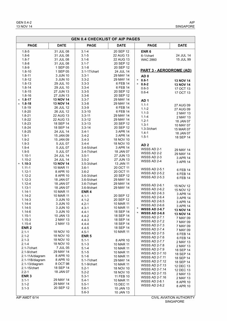
GEN 0.4-2 AIP13 NOV 14 SINGAPORE
GEN 0.4 CHECKLIST OF AIP PAGES
PAGE DATE PAGE DATE PAGE DATE
1.8-51.8-61.8-71.8-81.8-91.8-101.8-111.8-121.8-131.8-141.8-151.8-161.8-171.8-181.8-191.8-201.8-211.8-221.8-231.8-241.8-251.9-11.9-21.9-31.9-41.9-51.10-11.10-21.10-31.11-11.12-11.12-21.12-31.12-41.13-11.14-11.14-21.14-31.14-41.14-51.14-61.15-11.15-31.15-4ENR 22.1-12.1-22.1-32.1-42.1-7/chart2.1-9/chart2.1-11A/diagram2.1-11B/diagram2.1-13/diagram2.1-15/chart2.2-1ENR 33.1-13.1-23.1-3
31 JUL 0831 JUL 0831 JUL 0831 JUL 081 SEP 051 SEP 053 JUN 103 JUN 10
29 JUL 1029 JUL 1027 JUN 1327 JUN 1313 NOV 1413 NOV 1426 JUL 1226 JUL 12
22 AUG 1322 AUG 1318 SEP 1418 SEP 1424 JUL 1415 JAN 0915 JAN 09
5 JUL 075 JUL 075 JUL 07
24 JUL 1424 JUL 14
13 NOV 1410 MAR 11
8 APR 108 APR 10
18 JAN 0718 JAN 0718 JAN 0710 MAR 1110 MAR 11
3 JUN 103 JUN 103 JUN 103 JUN 10
10 JAN 132 MAY 132 MAY 13
18 NOV 1018 NOV 1018 NOV 1018 NOV 10
7 JUL 0529 MAY 14
8 APR 108 APR 108 OCT 98
18 SEP 1418 JAN 07
29 MAY 1429 MAY 1420 SEP 12
3.1-43.1-53.1-63.1-73.1-83.1-17/chart3.3-13.3-23.3-33.3-43.3-53.3-63.3-73.3-83.3-93.3-103.3-113.3-123.3-133.3-143.4-13.4-23.4-33.4-43.4-5/chart3.4-7/chart3.5-13.5-23.5-3/chart3.6-13.6-23.6-3/chart3.6-5/chart3.6-7/chart3.6-9/chartENR 44.1-14.1-24.2-14.3-14.4-14.4-24.4-34.4-44.4-54.5-1ENR 55.1-15.1-35.1-45.1-55.1-65.1-7/chart5.1-9/chart5.2-15.2-25.3-15.4-15.5-15.6-15.6-3
20 SEP 1222 AUG 1322 AUG 1320 SEP 1220 SEP 1224 JUL 14
29 MAY 1429 MAY 14
6 FEB 146 FEB 14
20 SEP 1220 SEP 1229 MAY 1429 MAY 14
6 FEB 146 FEB 14
29 MAY 1429 MAY 1420 SEP 1220 SEP 123 APR 143 APR 14
18 NOV 1018 NOV 10
3 APR 1418 JAN 0727 JUN 1327 JUN 1313 JAN 1120 OCT 1120 OCT 1120 SEP 1229 MAY 1429 MAY 1429 MAY 14
20 SEP 1220 SEP 1210 MAR 1110 MAR 1118 SEP 1418 SEP 1418 SEP 1418 SEP 1418 SEP 1410 MAR 11
8 APR 1010 MAR 1110 MAR 1110 MAR 1110 MAR 1129 MAY 1410 MAR 1118 NOV 1018 NOV 1011 FEB 1010 MAR 1115 DEC 1110 JAN 1310 JAN 13
ENR 66-1/chartWAC 2860
AD 00.6-10.6-20.6-30.6-4
AD 11.1-11.1-21.1-31.1-41.2-11.3-11.3-3/chart1.4-11.5-1
AD 2WSSS AD 2-1WSSS AD 2-2WSSS AD 2-3WSSS AD 2-4
WSSS AD 2-5.1WSSS AD 2-5.2WSSS AD 2-5.3
WSSS AD 2-6.1WSSS AD 2-6.2WSSS AD 2-6.3WSSS AD 2-6.4WSSS AD 2-6.5WSSS AD 2-6.6WSSS AD 2-6.7WSSS AD 2-6.8WSSS AD 2-7.1WSSS AD 2-7.2WSSS AD 2-7.3WSSS AD 2-7.4WSSS AD 2-7.5WSSS AD 2-7.6WSSS AD 2-7.7WSSS AD 2-7.8WSSS AD 2-7.9WSSS AD 2-7.10WSSS AD 2-7.11WSSS AD 2-7.12WSSS AD 2-7.13WSSS AD 2-7.14WSSS AD 2-7.15WSSS AD 2-7.16WSSS AD 2-8.1WSSS AD 2-8.2
24 JUL 1415 JUL 99
13 NOV 1413 NOV 1417 OCT 1317 OCT 13
27 AUG 0927 AUG 09
2 MAY 132 MAY 13
18 JAN 0710 MAY 0715 MAR 0718 JAN 0718 SEP 14
29 MAY 1429 MAY 14
3 APR 143 APR 14
6 FEB 146 FEB 146 FEB 14
15 NOV 1215 NOV 12
3 APR 143 APR 143 APR 143 APR 14
13 NOV 1413 NOV 14
7 MAY 097 MAY 097 MAY 097 MAY 096 FEB 146 FEB 142 MAY 132 MAY 13
18 SEP 1418 SEP 1418 SEP 1418 SEP 1412 DEC 1312 DEC 13
2 MAY 132 MAY 138 APR 108 APR 10
AIP AMDT 6/14 CIVIL AVIATION AUTHORITY SINGAPORE
**
*
**
*
*
PART 3 - AERODROME (AD)
AIP GEN 0.4-3SINGAPORE 13 NOV 14
GEN 0.4 CHECKLIST OF AIP PAGES
PAGE DATE PAGE DATE PAGE DATE
WSSS AD 2-9WSSS AD 2-10WSSS AD 2-11WSSS AD 2-12WSSS AD 2-13WSSS AD 2-14WSSS AD 2-15WSSS AD 2-16WSSS AD 2-17WSSS AD 2-18WSSS AD 2-19 WSSS AD 2-20WSSS AD 2-21WSSS AD 2-22WSSS AD 2-23WSSS AD 2-24WSSS AD 2-25WSSS AD 2-26WSSS AD 2-27WSSS AD 2-28WSSS AD 2-29
WSSS AD 2-31/chartWSSS AD 2-33/chartWSSS AD 2-37/chartWSSS AD 2-39/chartWSSS AD 2-41/chartWSSS AD 2-43/chartWSSS AD 2-45/chartWSSS AD 2-47WSSS AD 2-48WSSS AD 2-49WSSS AD 2-50WSSS AD 2-50-1WSSS AD 2-50-2WSSS AD 2-50-3WSSS AD 2-50-4
WSSS AD 2-51/chartWSSS AD 2-52 WSSS AD 2-53/chartWSSS AD 2-54 WSSS AD 2-55/chartWSSS AD 2-56 WSSS AD 2-57/chartWSSS AD 2-58
WSSS AD 2-63/chartWSSS AD 2-64 WSSS AD 2-65/chartWSSS AD 2-66 WSSS AD 2-67/chartWSSS AD 2-68 WSSS AD 2-69/chartWSSS AD 2-70 WSSS AD 2-71/chartWSSS AD 2-72
13 JAN 1113 JAN 113 APR 143 APR 14
23 NOV 0623 NOV 06
3 APR 143 APR 14
12 DEC 1312 DEC 1324 JUL 14 24 JUL 14
29 MAY 1429 MAY 1413 NOV 1413 NOV 1413 NOV 1413 NOV 1413 NOV 1413 NOV 14
1 SEP 05
24 JUL 1415 JAN 093 APR 143 APR 143 APR 14
25 APR 9625 APR 963 APR 143 APR 14
20 SEP 1220 SEP 1226 JUL 1226 JUL 125 APR 125 APR 12
2 MAY 132 MAY 132 MAY 132 MAY 13
10 JAN 1310 JAN 1310 JAN 1310 JAN 13
10 JAN 1310 JAN 1310 JAN 1310 JAN 1310 JAN 1310 JAN 1310 JAN 1310 JAN 1310 JAN 1310 JAN 13
WSSS AD 2-71-1/chartWSSS AD 2-72-1 WSSS AD 2-73/chartWSSS AD 2-74 WSSS AD 2-73-1/chartWSSS AD 2-74-1 WSSS AD 2-75/chartWSSS AD 2-76 WSSS AD 2-77/chartWSSS AD 2-78
WSSS AD 2-81/chartWSSS AD 2-82WSSS AD 2-81-1/chartWSSS AD 2-82-1WSSS AD 2-83/chartWSSS AD 2-84 WSSS AD 2-83-1/chartWSSS AD 2-84-1WSSS AD 2-85/chartWSSS AD 2-86 WSSS AD 2-85-1/chartWSSS AD 2-86-1WSSS AD 2-86-2WSSS AD 2-87/chartWSSS AD 2-88 WSSS AD 2-87-1/chartWSSS AD 2-88-1WSSS AD 2-88-2WSSS AD 2-89/chartWSSS AD 2-90
WSSS AD 2-91/chartWSSS AD 2-92 WSSS AD 2-91-1/chartWSSS AD 2-92-1WSSS AD 2-92-2WSSS AD 2-93/chartWSSS AD 2-94WSSS AD 2-93-1/chartWSSS AD 2-94-1WSSS AD 2-94-2
WSSS AD 2-97/chartWSSS AD 2-98WSSS AD 2-97-1/chartWSSS AD 2-98-1WSSS AD 2-99/chartWSSS AD 2-100 WSSS AD 2-99-1/chartWSSS AD 2-100-1
WSSS AD 2-101/chartWSSS AD 2-103/chartWSSS AD 2-105/chartWSSS AD 2-107/chartWSSS AD 2-109/chart
10 JAN 1310 JAN 1310 JAN 1310 JAN 1310 JAN 1310 JAN 1310 JAN 1310 JAN 1310 JAN 1310 JAN 13
26 JUL 1226 JUL 125 APR 125 APR 1226 JUL 1226 JUL 125 APR 125 APR 1226 JUL 1226 JUL 125 APR 125 APR 125 APR 1226 JUL 1226 JUL 125 APR 125 APR 125 APR 1226 JUL 1226 JUL 12
26 JUL 1226 JUL 125 APR 125 APR 125 APR 1226 JUL 1226 JUL 125 APR 125 APR 125 APR 12
26 JUL 1226 JUL 125 APR 125 APR 1226 JUL 1226 JUL 125 APR 125 APR 12
10 MAR 1110 MAR 1110 MAR 1110 MAR 1110 MAR 11
WSSS AD 2-111/chartWSSS AD 2-113/chartWSSS AD 2-115/chartWSSS AD 2-117/chartWSSS AD 2-118/chartWSSS AD 2-119/chartWSSS AD 2-120/chartWSSS AD 2-121/chart
WSSL AD 2-1WSSL AD 2-2WSSL AD 2-3-1WSSL AD 2-3-2WSSL AD 2-4-1WSSL AD 2-4-2WSSL AD 2-4-3WSSL AD 2-4-4WSSL AD 2-5WSSL AD 2-6WSSL AD 2-7WSSL AD 2-8WSSL AD 2-9WSSL AD 2-10WSSL AD 2-11WSSL AD 2-12WSSL AD 2-12-1WSSL AD 2-12-2WSSL AD 2-13/chartWSSL AD 2-15/chartWSSL AD 2-17/chartWSSL AD 2-19/chartWSSL AD 2-21/chartWSSL AD 2-23/chartWSSL AD 2-25/chartWSSL AD 2-27/chartWSSL AD 2-29/chartWSSL AD 2-31/chartWSSL AD 2-33/chartWSSL AD 2-35/chartWSSL AD 2-37/chart
WSAP AD 2-1WSAP AD 2-2WSAP AD 2-3WSAP AD 2-4WSAP AD 2-5WSAP AD 2-6WSAP AD 2-7WSAP AD 2-8WSAP AD 2-9WSAP AD 2-10WSAP AD 2-11/chartWSAP AD 2-13/chartWSAP AD 2-15/chartWSAP AD 2-17/chartWSAP AD 2-19/chartWSAP AD 2-21/chartWSAP AD 2-23/chart
10 MAR 1110 MAR 1118 NOV 1018 SEP 1418 SEP 1418 SEP 1418 SEP 14
10 MAR 11
13 NOV 1413 NOV 14
6 FEB 146 FEB 14
13 NOV 1413 NOV 1413 NOV 1413 NOV 1413 NOV 1413 NOV 14
9 FEB 129 FEB 12
13 NOV 1413 NOV 1420 OCT 1120 OCT 1112 DEC 1312 DEC 1318 SEP 1418 SEP 14
6 FEB 1418 SEP 1412 DEC 1312 DEC 1312 DEC 1312 DEC 1312 DEC 1312 DEC 13
3 APR 1430 JUN 1130 JUN 11
6 FEB 146 FEB 14
18 NOV 1018 NOV 1013 NOV 1413 NOV 1420 OCT 1120 OCT 1118 NOV 1018 NOV 1018 SEP 143 APR 14
18 SEP 1410 MAR 1110 MAR 1110 MAR 1110 MAR 11
CIVIL AVIATION AUTHORITY AIP AMDT 6/14 SINGAPORE
******
**
******
**
**
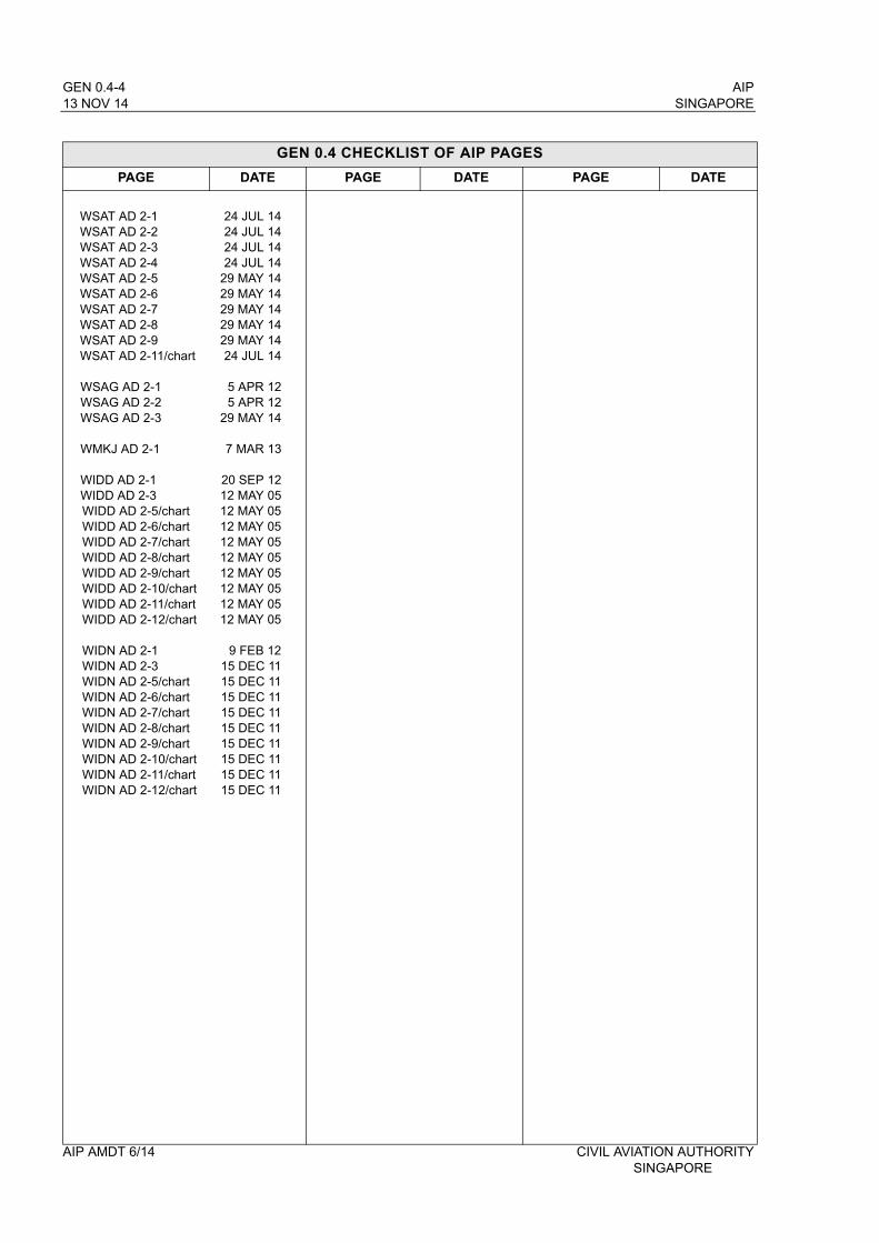
GEN 0.4-4 AIP13 NOV 14 SINGAPORE
GEN 0.4 CHECKLIST OF AIP PAGES
PAGE DATE PAGE DATE PAGE DATE
WSAT AD 2-1WSAT AD 2-2WSAT AD 2-3WSAT AD 2-4WSAT AD 2-5WSAT AD 2-6WSAT AD 2-7WSAT AD 2-8WSAT AD 2-9WSAT AD 2-11/chart
WSAG AD 2-1WSAG AD 2-2WSAG AD 2-3
WMKJ AD 2-1
WIDD AD 2-1WIDD AD 2-3WIDD AD 2-5/chartWIDD AD 2-6/chartWIDD AD 2-7/chartWIDD AD 2-8/chartWIDD AD 2-9/chartWIDD AD 2-10/chartWIDD AD 2-11/chartWIDD AD 2-12/chart
WIDN AD 2-1WIDN AD 2-3WIDN AD 2-5/chartWIDN AD 2-6/chartWIDN AD 2-7/chartWIDN AD 2-8/chartWIDN AD 2-9/chartWIDN AD 2-10/chartWIDN AD 2-11/chartWIDN AD 2-12/chart
24 JUL 1424 JUL 1424 JUL 1424 JUL 14
29 MAY 1429 MAY 1429 MAY 1429 MAY 1429 MAY 1424 JUL 14
5 APR 125 APR 12
29 MAY 14
7 MAR 13
20 SEP 1212 MAY 0512 MAY 0512 MAY 0512 MAY 0512 MAY 0512 MAY 0512 MAY 0512 MAY 0512 MAY 05
9 FEB 1215 DEC 1115 DEC 1115 DEC 1115 DEC 1115 DEC 1115 DEC 1115 DEC 1115 DEC 1115 DEC 11
AIP AMDT 6/14 CIVIL AVIATION AUTHORITY SINGAPORE
AIP GEN 2.1-1SINGAPORE 13 NOV 14
GEN 2. TABLES AND CODES
GEN 2.1 MEASURING SYSTEM, AIRCRAFT MARKINGS, HOLIDAYS
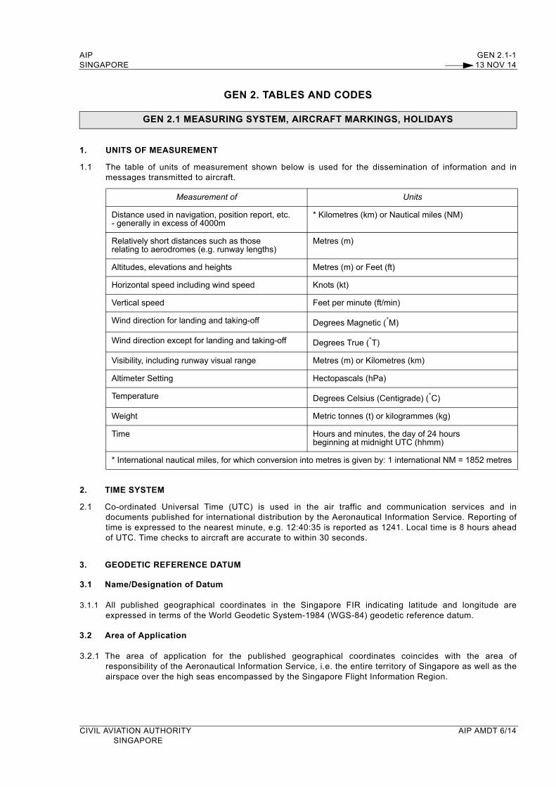
1. UNITS OF MEASUREMENT
1.1 The table of units of measurement shown below is used for the dissemination of information and in messages transmitted to aircraft.
Measurement of Units
Distance used in navigation, position report, etc.- generally in excess of 4000m
* Kilometres (km) or Nautical miles (NM)
Relatively short distances such as thoserelating to aerodromes (e.g. runway lengths)
Metres (m)
Altitudes, elevations and heights Metres (m) or Feet (ft)
Horizontal speed including wind speed Knots (kt)
Vertical speed Feet per minute (ft/min)
Wind direction for landing and taking-off Degrees Magnetic (°M)
Wind direction except for landing and taking-off Degrees True (°T)
Visibility, including runway visual range Metres (m) or Kilometres (km)
Altimeter Setting Hectopascals (hPa)
Temperature Degrees Celsius (Centigrade) (°C)
Weight Metric tonnes (t) or kilogrammes (kg)
Time Hours and minutes, the day of 24 hours beginning at midnight UTC (hhmm)
* International nautical miles, for which conversion into metres is given by: 1 international NM = 1852 metres
2. TIME SYSTEM
2.1 Co-ordinated Universal Time (UTC) is used in the air traffic and communication services and in documents published for international distribution by the Aeronautical Information Service. Reporting of time is expressed to the nearest minute, e.g. 12:40:35 is reported as 1241. Local time is 8 hours ahead of UTC. Time checks to aircraft are accurate to within 30 seconds.
3. GEODETIC REFERENCE DATUM
3.1 Name/Designation of Datum
3.1.1 All published geographical coordinates in the Singapore FIR indicating latitude and longitude are expressed in terms of the World Geodetic System-1984 (WGS-84) geodetic reference datum.
3.2 Area of Application
3.2.1 The area of application for the published geographical coordinates coincides with the area of responsibility of the Aeronautical Information Service, i.e. the entire territory of Singapore as well as the airspace over the high seas encompassed by the Singapore Flight Information Region.
CIVIL AVIATION AUTHORITY AIP AMDT 6/14SINGAPORE
GEN 2.1-2 AIP13 NOV 14 SINGAPORE
GEN 2.1 MEASURING SYSTEM, AIRCRAFT MARKINGS, HOLIDAYS
3.3 Use of asterisk
3.3.1 An asterisk (*) will be used to identify those published geographical coordinates which have been transformed into WGS-84 coordinates but whose accuracy of original field work does not meet the requirements in ICAO Annex 11, Chapter 2 and ICAO Annex 14, Volume I, Chapter 2. Specifications for determination and reporting of WGS-84 coordinates are given in ICAO Annex 11, Chapter 2 and ICAO Annex 14, Volume I, Chapter 2.
4. AIRCRAFT NATIONALITY AND REGISTRATION MARKS
4.1 The nationality mark for aircraft registered in Singapore is the figure 9, followed by the letter V, i.e. 9V. The nationality mark is followed by a hyphen and a registration mark consisting of a three letter group, e.g. 9V-BAA.
5. PUBLIC HOLIDAYS IN SINGAPORE
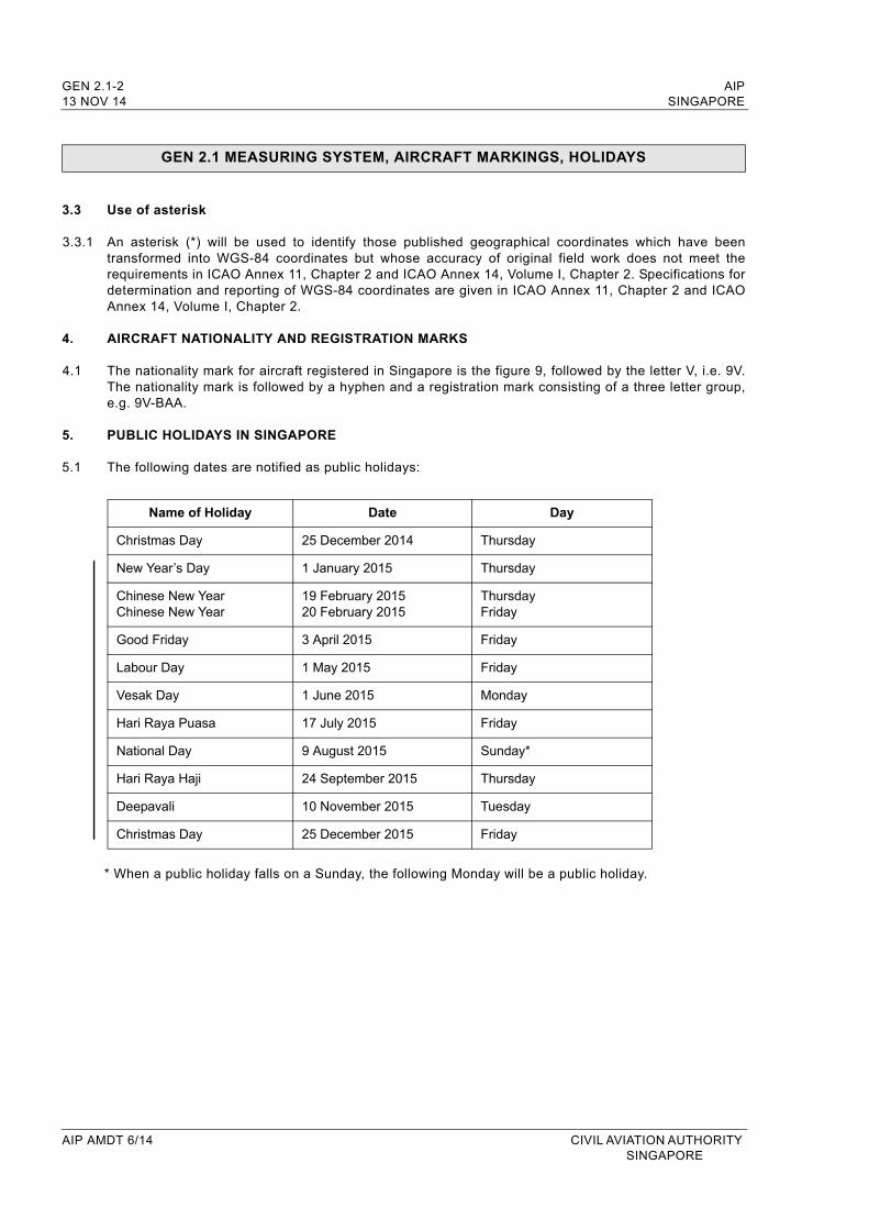
5.1 The following dates are notified as public holidays:
Name of Holiday Date Day
Christmas Day 25 December 2014 Thursday
New Year’s Day 1 January 2015 Thursday
Chinese New YearChinese New Year
19 February 201520 February 2015
ThursdayFriday
Good Friday 3 April 2015 Friday
Labour Day 1 May 2015 Friday
Vesak Day 1 June 2015 Monday
Hari Raya Puasa 17 July 2015 Friday
National Day 9 August 2015 Sunday*
Hari Raya Haji 24 September 2015 Thursday
Deepavali 10 November 2015 Tuesday
Christmas Day 25 December 2015 Friday
* When a public holiday falls on a Sunday, the following Monday will be a public holiday.
AIP AMDT 6/14 CIVIL AVIATION AUTHORITY SINGAPORE
AIP GEN 2.2-1
SINGAPORE 13 NOV 14
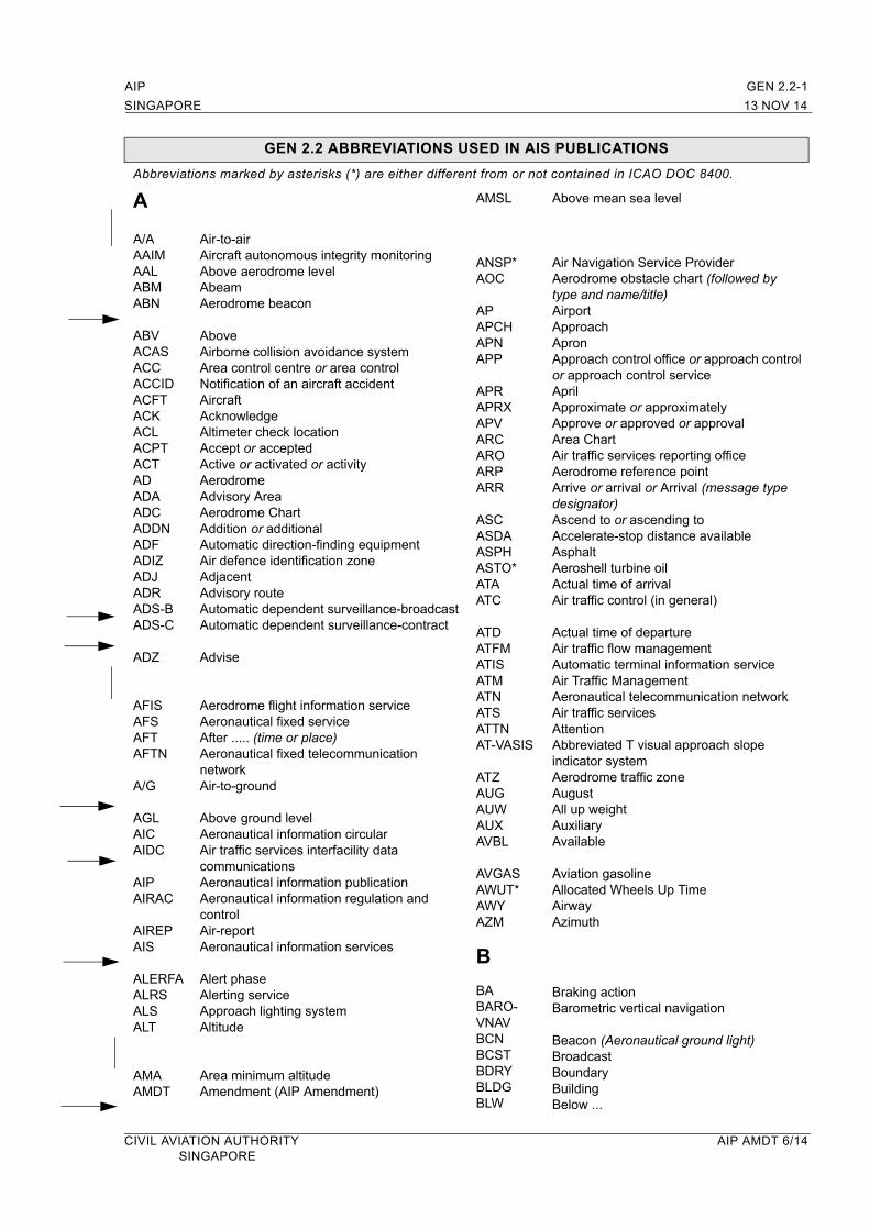
GEN 2.2 ABBREVIATIONS USED IN AIS PUBLICATIONS
Abbreviations marked by asterisks (*) are either different from or not contained in ICAO DOC 8400.
A
A/AAAIMAALABMABN
ABVACASACCACCIDACFTACKACLACPTACTADADAADCADDNADFADIZADJADRADS-B ADS-C
ADZ
AFISAFSAFTAFTN
A/G
AGLAICAIDC
AIPAIRAC
AIREPAIS
ALERFAALRSALSALT
AMAAMDT
Air-to-airAircraft autonomous integrity monitoringAbove aerodrome levelAbeamAerodrome beacon
AboveAirborne collision avoidance systemArea control centre or area controlNotification of an aircraft accidentAircraftAcknowledgeAltimeter check locationAccept or acceptedActive or activated or activityAerodromeAdvisory AreaAerodrome ChartAddition or additionalAutomatic direction-finding equipmentAir defence identification zoneAdjacentAdvisory routeAutomatic dependent surveillance-broadcastAutomatic dependent surveillance-contract
Advise
Aerodrome flight information serviceAeronautical fixed serviceAfter ..... (time or place)Aeronautical fixed telecommunication networkAir-to-ground
Above ground levelAeronautical information circularAir traffic services interfacility data communicationsAeronautical information publicationAeronautical information regulation and controlAir-reportAeronautical information services
Alert phaseAlerting serviceApproach lighting systemAltitude
Area minimum altitudeAmendment (AIP Amendment)
AMSL
ANSP*AOC
APAPCHAPNAPP
APRAPRXAPVARCAROARPARR
ASCASDAASPHASTO*ATAATC
ATDATFMATISATMATNATSATTNAT-VASIS
ATZAUGAUWAUXAVBL
AVGASAWUT*AWYAZM
B
BABARO-VNAVBCNBCSTBDRYBLDGBLW
Above mean sea level
Air Navigation Service ProviderAerodrome obstacle chart (followed by type and name/title)AirportApproachApronApproach control office or approach control or approach control serviceAprilApproximate or approximatelyApprove or approved or approvalArea ChartAir traffic services reporting officeAerodrome reference pointArrive or arrival or Arrival (message type designator)Ascend to or ascending toAccelerate-stop distance availableAsphaltAeroshell turbine oilActual time of arrivalAir traffic control (in general)
Actual time of departureAir traffic flow managementAutomatic terminal information serviceAir Traffic ManagementAeronautical telecommunication networkAir traffic servicesAttentionAbbreviated T visual approach slopeindicator systemAerodrome traffic zoneAugustAll up weightAuxiliaryAvailable
Aviation gasolineAllocated Wheels Up TimeAirwayAzimuth
Braking actionBarometric vertical navigation
Beacon (Aeronautical ground light)BroadcastBoundaryBuildingBelow ...
CIVIL AVIATION AUTHORITY AIP AMDT 6/14SINGAPORE
GEN 2.2-2 AIP13 NOV 14 SINGAPORE
GEN 2.2 ABBREVIATIONS USED IN AIS PUBLICATIONS
BOBCAT*
BRGBRKGBTN
C
... C
C
CAAS*
CATCAVOK
CAFHI*CHCHG
CIVCLCLBR
CLSD
CMBCMPLCNL
CNS
COMCONCCOND
CONSTCONTCOORCOORDCOPCPDLCCPL
CRCCSCTACTCCTLCTNCTRCUSTCWY
Bay of Bengal Cooperative Air Traffic Flow Management Advisory System
BearingBrakingBetween
Centre (preceded by runway designation number to identify a parallel runway)Degrees Celsius (Centigrade)
Civil Aviation Authority of Singapore
CategoryVisibility, cloud and present weather better than prescribed values or conditionsChangi Airport Fuel Hydrant InstallationChannelModification (message type designator)
CivilCentre lineCalibration
Close or closed or closing
Climb to or climbing toCompletion or completed or completeCancel or cancelled or flight plan cancellation (message type designator)Communications, Navigations andSurveillanceCommunicationsConcreteCondition
Construction or constructedContinue(s) or continuedCoordinate or coordinationCoordinatesChange-over pointController-pilot data link communicationsCurrent flight plan (message type design-ator)Cyclic redundancy checkCall signControl areaContactControlCautionControl zoneCustomsClearway
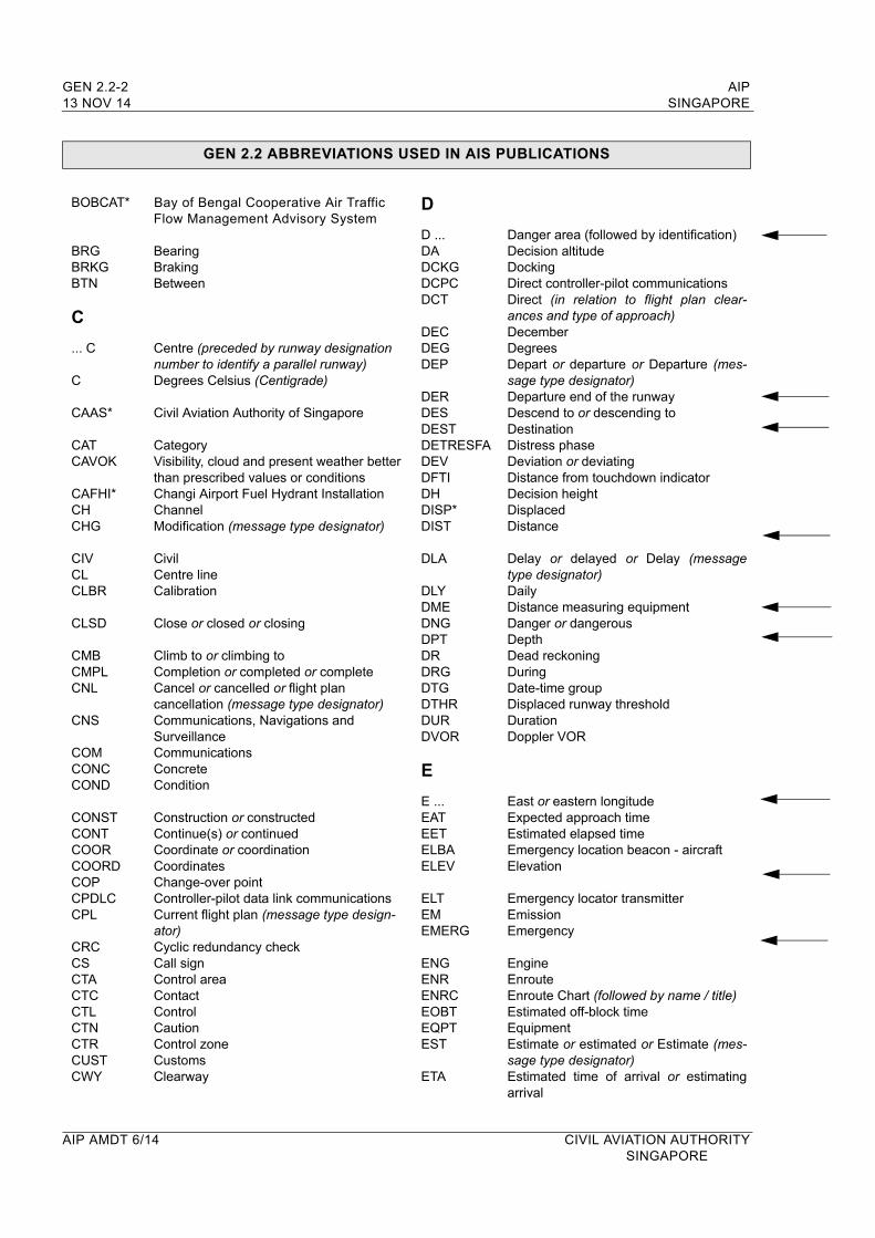
D
D ...DADCKGDCPCDCT
DECDEGDEP
DERDESDESTDETRESFADEVDFTIDHDISP*DIST
DLA
DLYDMEDNGDPTDRDRGDTGDTHRDURDVOR
E
E ...EATEETELBAELEV
ELTEMEMERG
ENGENRENRCEOBTEQPTEST
ETA
Danger area (followed by identification)Decision altitudeDockingDirect controller-pilot communicationsDirect (in relation to flight plan clear-ances and type of approach)DecemberDegreesDepart or departure or Departure (mes-sage type designator)Departure end of the runwayDescend to or descending toDestinationDistress phaseDeviation or deviatingDistance from touchdown indicatorDecision heightDisplacedDistance
Delay or delayed or Delay (message type designator)DailyDistance measuring equipmentDanger or dangerousDepthDead reckoningDuringDate-time groupDisplaced runway thresholdDurationDoppler VOR
East or eastern longitudeExpected approach timeEstimated elapsed timeEmergency location beacon - aircraftElevation
Emergency locator transmitterEmissionEmergency
EngineEnrouteEnroute Chart (followed by name / title)Estimated off-block timeEquipmentEstimate or estimated or Estimate (mes-sage type designator)Estimated time of arrival or estimating arrival
AIP AMDT 6/14 CIVIL AVIATION AUTHORITYSINGAPORE

AIP GEN 2.2-3SINGAPORE 13 NOV 14
GEN 2.2 ABBREVIATIONS USED IN AIS PUBLICATIONS
ETD
ETOEVEXCEXEREXPEXTD
F
FACFAF
FAPFATOFAXFCSTFCTFDPSFEBFICFIRFIS
FLFLGFLRFLTFLTCKFLUCFLWFLYFM
FMSFMUFNAFOD *FPL
FREQFRIFRNG
FSL
FSTFT
G
G/A
Estimated time of departure orestimating departureEstimated time over significant pointEveryExceptExercises or exercising or to exerciseExpect or expected or expectingExtend or extending
FacilitiesFinal approach fix
Final approach pointFinal approach and take-off areaFacsimile transmissionForecastFriction coefficientFlight data processing systemFebruaryFlight information centreFlight information regionFlight information service
Flight levelFlashingFlaresFlightFlight checkFluctuating or fluctuation or fluctuatedFollow(s) or followingFly or flyingCourse from a fix to manual termination (used in navigation database coding)
Flight management systemFlow management unitFinal approachForeign object damageFlight Plan
FrequencyFridayFiring
Full stop landing
FirstFeet (dimensional unit)
Ground-to-air
GCA
GENGEO
GLDGLONASS
GNDGNDCKGNSSGPGPAGPSGRASSGSGUND
H
H+ *H24HBNHDGHELHEL-L *
HEL-M *
HEL-H *
HFHGTHJHLDGHNHO
HOLHOSPHPAHQ *HRHS
HXHZ
I
IAC
IAF
Ground controlled approach system or ground controlled approachGeneralGeographic or true
GliderGlobal orbiting navigation satellite systemGroundGround checkGlobal navigation satellite systemGlide pathGlide path angleGlobal positioning systemGrass landing areaGround speedGeoid undulation
Hours plus..........minutes past the hourContinuous day and night serviceHazard beaconHeadingHelicopterLight helicopter (radius of action, for rescue purposes, up to 185km (100NM) and capacity of evacuating 1-5 persons)Medium helicopter (radius of action, for rescue purposes, 185-370km (100-200NM) and capacity of evacuating 6-15 persons)Heavy helicopter (radius of action, for rescue purposes, more than 370km (200NM) and capacity of evacuating more than 15 persons)High frequency (3 000 to 30 000kHz)Height or height aboveSunrise to sunsetHoldingSunset to sunriseService available to meet operational requirementsHolidayHospital aircraftHectopascalHeadquartersHoursService available during hours ofscheduled operationsNo specific working hoursHaze or Hertz (cycle per second)
Instrument approach chart (followed by name/title)Initial approach fix
CIVIL AVIATION AUTHORITY AIP AMDT 6/14SINGAPORE
GEN 2.2-4 AIP13 NOV 14 SINGAPORE
GEN 2.2 ABBREVIATIONS USED IN AIS PUBLICATIONS
IAPIARIASIBNIDIDENTIFIFR
ILSIMIMCINAINBDINCERFAINFOINOPINPRINSINSTLINSTRINTINTLINTRGINTRP
INTSTIRSISA
J
JANJULJUN
K
KGKHZKMKMHKPAKTKW
L
... L
LLATLDALDAHLDGLDILENLGT
Instrument approach procedureIntersection of air routesIndicated airspeedIdentification beaconIdentifier or identifyIdentificationIntermediate approach fixInstrument flight rules
Instrument landing systemInner markerInstrument meteorological conditionsInitial approach InboundUncertainty phaseInformationInoperativeIn progressInertial navigation systemInstall or installed or installationInstrumentIntersectionInternationalInterrogatorInterrupt or interruption or interrupted
IntensityInertial reference systemInternational standard atmosphere
JanuaryJulyJune
KilogramsKilohertzKilometresKilometres per hourKilopascalKnotsKilowatts
Left (preceded by runway designation number to identify a parallel runway)Locator (see LM, LO)LatitudeLanding distance availableLanding distance available, helicopterLandingLanding direction indicatorLengthLight or lighting
LGTDLIHLILLIMLLZLMLNAV
LO
LONGLORAN
LRGLT*LTDLTTLVLLVP
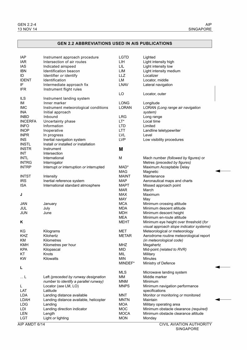
M
M
MAD*MAGMAINTMAPMAPTMARMAXMAYMCAMDAMDHMEAMEHT
METMETAR
MHZMIDMILMINMINDEF*
MLSMMMNMMNPS
MNTMNTNMOAMOCMOCAMON
LightedLight intensity highLight intensity lowLight intensity mediumLocalizerLocator, middleLateral navigation
Locator, outer
LongitudeLORAN (Long range air navigation system)Long rangeLocal timeLimitedLandline teletypewriterLevelLow visibility procedures
Mach number (followed by figures) orMetres (preceded by figures)Maximum Acceptable DelayMagneticMaintenanceAeronautical maps and chartsMissed approach pointMarchMaximumMayMinimum crossing altitudeMinimum descent altitudeMinimum descent heightMinimum en-route altitudeMinimum eye height over threshold (for visual approach slope indicator systems)Meteorological or meteorology Aerodrome routine meteorological report (in meteorological code)MegahertzMid-point (related to RVR)MilitaryMinutesMinistry of Defence
Microwave landing systemMiddle markerMinimumMinimum navigation performance specificationsMonitor or monitoring or monitored MaintainMilitary operating areaMinimum obstacle clearance (required)Minimum obstacle clearance altitudeMonday
AIP AMDT 6/14 CIVIL AVIATION AUTHORITYSINGAPORE
AIP GEN 2.2-5SINGAPORE 13 NOV 14
GEN 2.2 ABBREVIATIONS USED IN AIS PUBLICATIONS
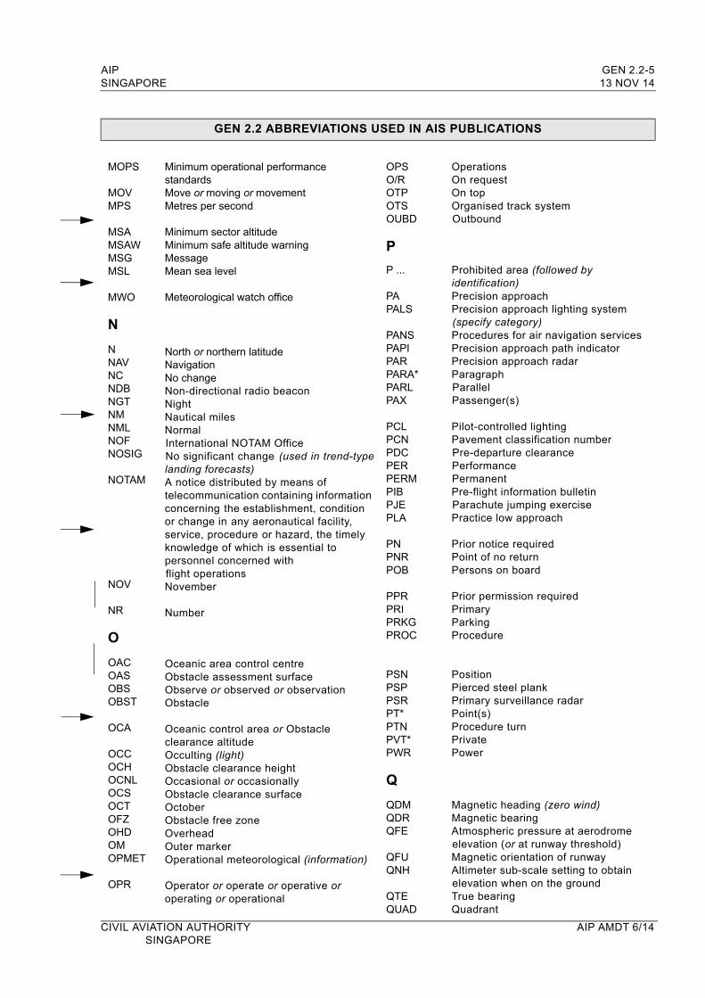
MOPS
MOVMPS
MSAMSAWMSGMSL
MWO
N
NNAVNCNDBNGTNMNMLNOFNOSIG
NOTAM
NOV
NR
O
OACOASOBSOBST
OCA
OCCOCHOCNLOCSOCTOFZOHDOMOPMET
OPR
Minimum operational performance standardsMove or moving or movementMetres per second
Minimum sector altitudeMinimum safe altitude warningMessage Mean sea level
Meteorological watch office
North or northern latitudeNavigation No changeNon-directional radio beaconNightNautical milesNormalInternational NOTAM OfficeNo significant change (used in trend-type landing forecasts)A notice distributed by means of telecommunication containing information concerning the establishment, condition or change in any aeronautical facility, service, procedure or hazard, the timely knowledge of which is essential to personnel concerned with flight operationsNovember
Number
Oceanic area control centreObstacle assessment surface Observe or observed or observationObstacle
Oceanic control area or Obstacle clearance altitudeOcculting (light)Obstacle clearance heightOccasional or occasionallyObstacle clearance surfaceOctoberObstacle free zoneOverheadOuter markerOperational meteorological (information)
Operator or operate or operative oroperating or operational
OPSO/ROTPOTSOUBD
P
P ...
PAPALS
PANSPAPIPARPARA*PARLPAX
PCLPCNPDCPERPERMPIBPJEPLA
PNPNRPOB
PPRPRIPRKGPROC
PSNPSPPSRPT*PTNPVT*PWR
Q
QDMQDRQFE
QFUQNH
QTEQUAD
OperationsOn requestOn topOrganised track systemOutbound
Prohibited area (followed by identification)Precision approachPrecision approach lighting system (specify category)Procedures for air navigation servicesPrecision approach path indicatorPrecision approach radarParagraphParallelPassenger(s)
Pilot-controlled lightingPavement classification numberPre-departure clearancePerformancePermanentPre-flight information bulletinParachute jumping exercisePractice low approach
Prior notice requiredPoint of no returnPersons on board
Prior permission requiredPrimaryParkingProcedure
PositionPierced steel plankPrimary surveillance radarPoint(s)Procedure turnPrivatePower
Magnetic heading (zero wind)Magnetic bearingAtmospheric pressure at aerodrome elevation (or at runway threshold)Magnetic orientation of runwayAltimeter sub-scale setting to obtainelevation when on the groundTrue bearingQuadrant
CIVIL AVIATION AUTHORITY AIP AMDT 6/14SINGAPORE
GEN 2.2-6 AIP13 NOV 14 SINGAPORE
GEN 2.2 ABBREVIATIONS USED IN AIS PUBLICATIONS
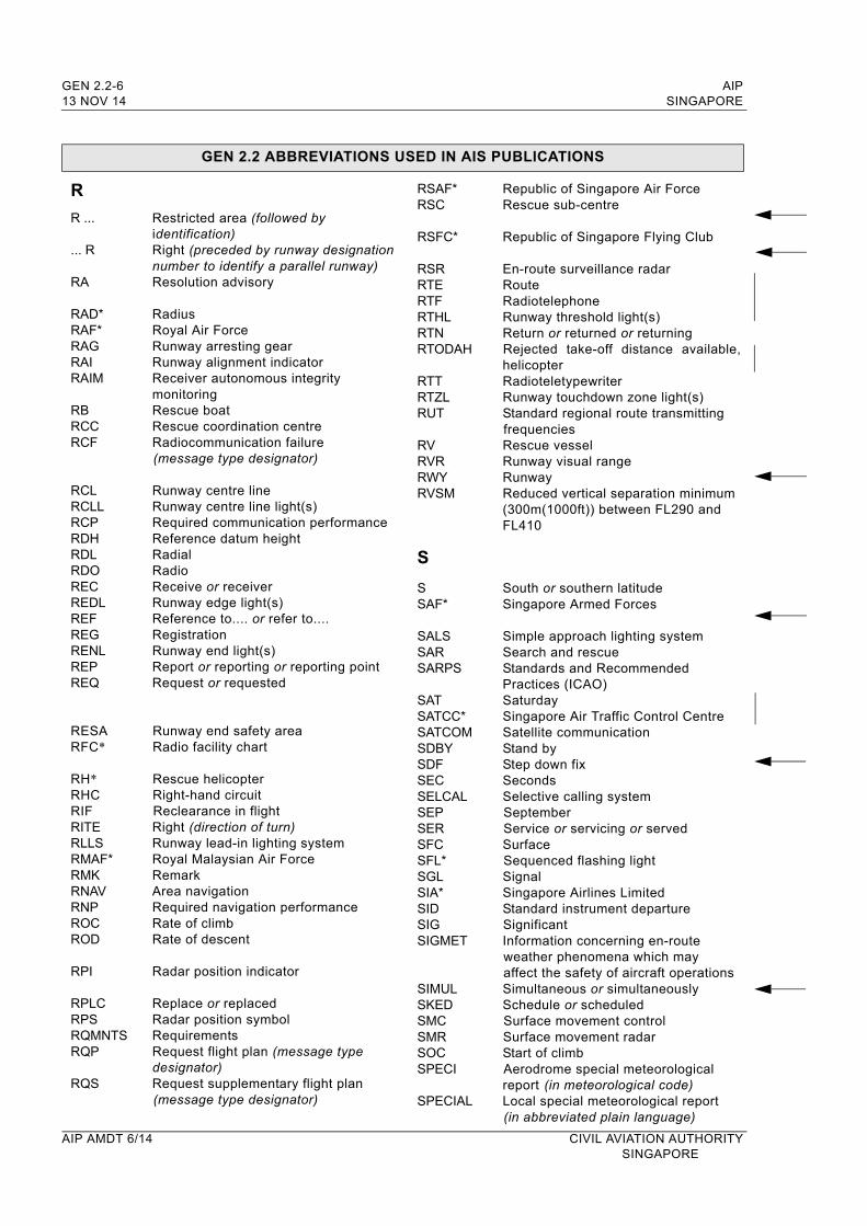
R
R ...
... R
RA
RAD*RAF*RAGRAIRAIM
RBRCCRCF
RCLRCLLRCPRDHRDLRDORECREDLREFREGRENLREPREQ
RESARFC*
RH*RHCRIFRITERLLSRMAF*RMKRNAVRNPROCROD
RPI
RPLCRPSRQMNTSRQP
RQS
Restricted area (followed by identification) Right (preceded by runway designation number to identify a parallel runway)Resolution advisory
RadiusRoyal Air ForceRunway arresting gearRunway alignment indicatorReceiver autonomous integrity monitoringRescue boatRescue coordination centreRadiocommunication failure (message type designator)
Runway centre lineRunway centre line light(s)Required communication performanceReference datum height RadialRadioReceive or receiverRunway edge light(s)Reference to.... or refer to....RegistrationRunway end light(s)Report or reporting or reporting point Request or requested
Runway end safety areaRadio facility chart
Rescue helicopterRight-hand circuitReclearance in flightRight (direction of turn)Runway lead-in lighting systemRoyal Malaysian Air ForceRemarkArea navigation Required navigation performanceRate of climbRate of descent
Radar position indicator
Replace or replacedRadar position symbolRequirementsRequest flight plan (message type designator)Request supplementary flight plan (message type designator)
RSAF*RSC
RSFC*
RSRRTERTFRTHLRTNRTODAH
RTTRTZLRUT
RVRVRRWYRVSM
S
SSAF*
SALSSARSARPS
SATSATCC*SATCOMSDBYSDFSECSELCALSEPSERSFCSFL*SGLSIA*SIDSIGSIGMET
SIMULSKEDSMCSMRSOCSPECI
SPECIAL
Republic of Singapore Air ForceRescue sub-centre
Republic of Singapore Flying Club
En-route surveillance radarRouteRadiotelephoneRunway threshold light(s)Return or returned or returning Rejected take-off distance available, helicopterRadioteletypewriterRunway touchdown zone light(s)Standard regional route transmitting frequenciesRescue vesselRunway visual rangeRunwayReduced vertical separation minimum (300m(1000ft)) between FL290 and FL410
South or southern latitudeSingapore Armed Forces
Simple approach lighting systemSearch and rescueStandards and Recommended Practices (ICAO)SaturdaySingapore Air Traffic Control CentreSatellite communicationStand byStep down fixSecondsSelective calling systemSeptemberService or servicing or servedSurfaceSequenced flashing lightSignalSingapore Airlines LimitedStandard instrument departureSignificantInformation concerning en-route weather phenomena which may affect the safety of aircraft operationsSimultaneous or simultaneouslySchedule or scheduledSurface movement controlSurface movement radarStart of climbAerodrome special meteorological report (in meteorological code)Local special meteorological report (in abbreviated plain language)
AIP AMDT 6/14 CIVIL AVIATION AUTHORITYSINGAPORE
AIP GEN 2.2-7SINGAPORE 13 NOV 14
GEN 2.2 ABBREVIATIONS USED IN AIS PUBLICATIONS
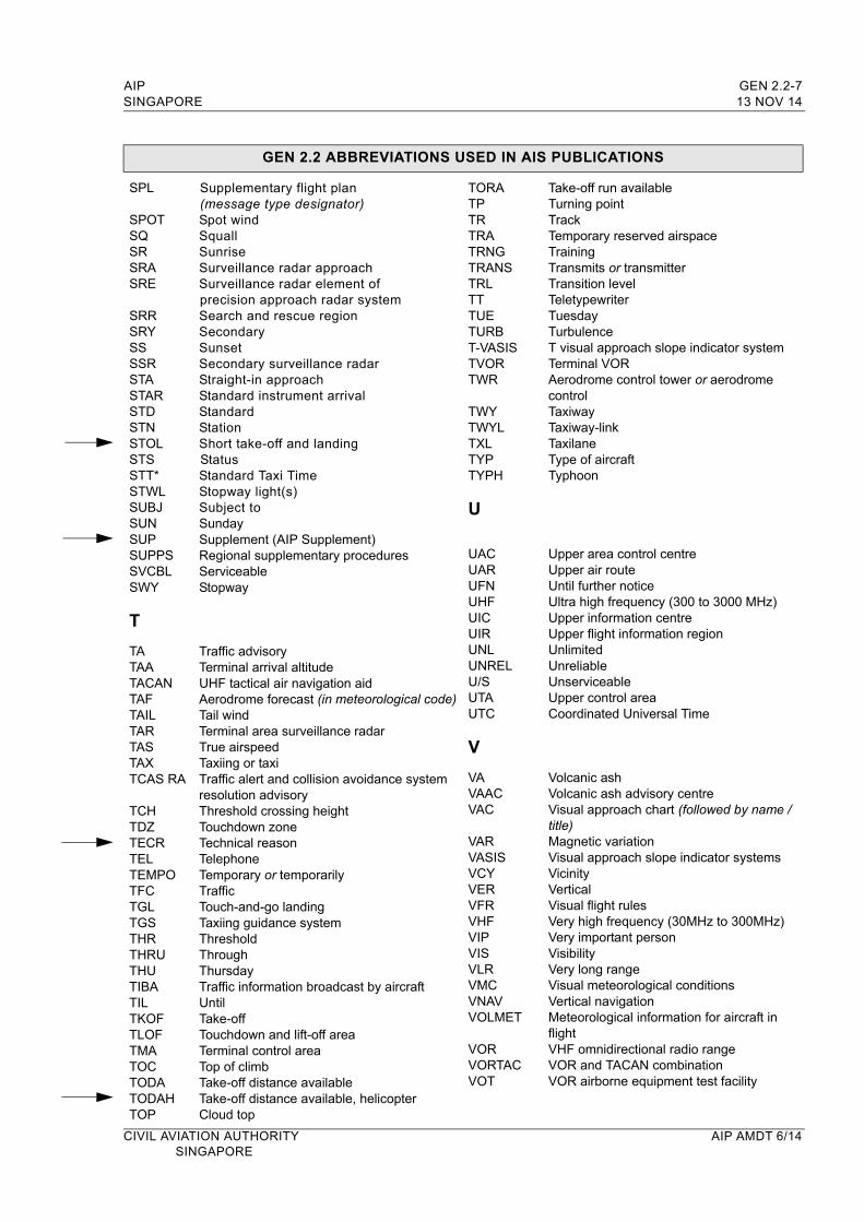
SPL
SPOTSQSRSRASRE
SRRSRYSSSSRSTASTARSTDSTNSTOLSTSSTT*STWLSUBJSUNSUPSUPPSSVCBLSWY
T
TATAATACANTAFTAILTARTASTAXTCAS RA
TCHTDZTECRTELTEMPOTFCTGLTGSTHRTHRUTHUTIBATILTKOFTLOFTMATOCTODATODAHTOP
Supplementary flight plan (message type designator)Spot windSquallSunriseSurveillance radar approachSurveillance radar element ofprecision approach radar systemSearch and rescue regionSecondarySunset Secondary surveillance radarStraight-in approachStandard instrument arrivalStandard StationShort take-off and landing StatusStandard Taxi TimeStopway light(s)Subject toSundaySupplement (AIP Supplement)Regional supplementary proceduresServiceableStopway
Traffic advisoryTerminal arrival altitudeUHF tactical air navigation aidAerodrome forecast (in meteorological code)Tail windTerminal area surveillance radarTrue airspeedTaxiing or taxiTraffic alert and collision avoidance system resolution advisoryThreshold crossing heightTouchdown zoneTechnical reasonTelephoneTemporary or temporarilyTrafficTouch-and-go landingTaxiing guidance systemThresholdThroughThursdayTraffic information broadcast by aircraftUntilTake-offTouchdown and lift-off areaTerminal control areaTop of climbTake-off distance availableTake-off distance available, helicopterCloud top
TORATPTRTRATRNG TRANSTRLTTTUETURBT-VASISTVORTWR
TWYTWYLTXLTYPTYPH
U
UACUARUFNUHFUICUIRUNLUNRELU/SUTAUTC
V
VAVAACVAC
VARVASISVCYVERVFRVHFVIPVISVLRVMCVNAVVOLMET
VORVORTACVOT
Take-off run availableTurning pointTrackTemporary reserved airspace Training Transmits or transmitterTransition levelTeletypewriterTuesdayTurbulenceT visual approach slope indicator systemTerminal VORAerodrome control tower or aerodrome controlTaxiwayTaxiway-linkTaxilaneType of aircraftTyphoon
Upper area control centreUpper air routeUntil further noticeUltra high frequency (300 to 3000 MHz)Upper information centreUpper flight information regionUnlimited UnreliableUnserviceableUpper control areaCoordinated Universal Time
Volcanic ashVolcanic ash advisory centreVisual approach chart (followed by name /title)Magnetic variationVisual approach slope indicator systemsVicinityVerticalVisual flight rulesVery high frequency (30MHz to 300MHz)Very important personVisibilityVery long rangeVisual meteorological conditionsVertical navigationMeteorological information for aircraft in flightVHF omnidirectional radio rangeVOR and TACAN combinationVOR airborne equipment test facility
CIVIL AVIATION AUTHORITY AIP AMDT 6/14SINGAPORE
GEN 2.2-8 AIP13 NOV 14 SINGAPORE
GEN 2.2 ABBREVIATIONS USED IN AIS PUBLICATIONS
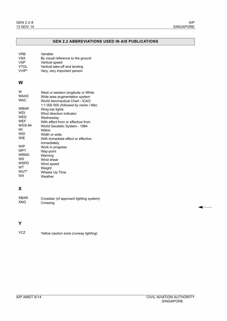
VRBVSAVSPVTOLVVIP*
VariableBy visual reference to the ground Vertical speedVertical take-off and landing Very, very important person
W
WWAASWAC
WBARWDIWEDWEFWGS-84WIWIDWIE
WIPWPTWRNGWSWSPDWTWUT*WX
X
XBARXNG
Y
YCZ
West or western longitude or WhiteWide area augmentation systemWorld Aeronautical Chart - ICAO 1:1 000 000 (followed by name / title)Wing bar lightsWind direction indicatorWednesdayWith effect from or effective from World Geodetic System - 1984WithinWidth or wideWith immediate effect or effective immediatelyWork in progressWay-pointWarningWind shearWind speedWeightWheels Up TimeWeather
Crossbar (of approach lighting system)Crossing
Yellow caution zone (runway lighting)
AIP AMDT 6/14 CIVIL AVIATION AUTHORITYSINGAPORE
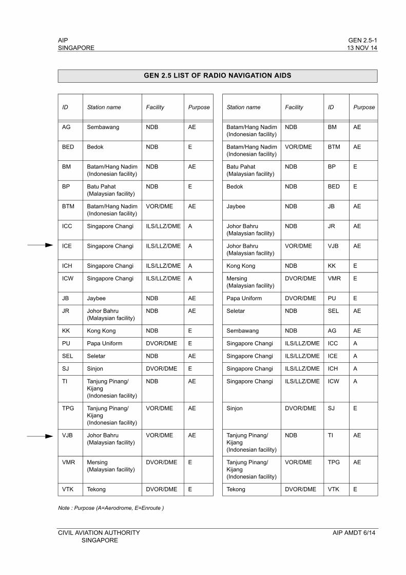
AIP GEN 2.5-1SINGAPORE 13 NOV 14
GEN 2.5 LIST OF RADIO NAVIGATION AIDS
ID Station name Facility Purpose Station name Facility ID Purpose
AG Sembawang NDB AE Batam/Hang Nadim(Indonesian facility)
NDB BM AE
BED Bedok NDB E Batam/Hang Nadim(Indonesian facility)
VOR/DME BTM AE
BM Batam/Hang Nadim(Indonesian facility)
NDB AE Batu Pahat(Malaysian facility)
NDB BP E
BP Batu Pahat(Malaysian facility)
NDB E Bedok NDB BED E
BTM Batam/Hang Nadim(Indonesian facility)
VOR/DME AE Jaybee NDB JB AE
ICC Singapore Changi ILS/LLZ/DME A Johor Bahru(Malaysian facility)
NDB JR AE
ICE Singapore Changi ILS/LLZ/DME A Johor Bahru(Malaysian facility)
VOR/DME VJB AE
ICH Singapore Changi ILS/LLZ/DME A Kong Kong NDB KK E
ICW Singapore Changi ILS/LLZ/DME A Mersing(Malaysian facility)
DVOR/DME VMR E
JB Jaybee NDB AE Papa Uniform DVOR/DME PU E
JR Johor Bahru(Malaysian facility)
NDB AE Seletar NDB SEL AE
KK Kong Kong NDB E Sembawang NDB AG AE
PU Papa Uniform DVOR/DME E Singapore Changi ILS/LLZ/DME ICC A
SEL Seletar NDB AE Singapore Changi ILS/LLZ/DME ICE A
SJ Sinjon DVOR/DME E Singapore Changi ILS/LLZ/DME ICH A
TI Tanjung Pinang/Kijang(Indonesian facility)
NDB AE Singapore Changi ILS/LLZ/DME ICW A
TPG Tanjung Pinang/Kijang(Indonesian facility)
VOR/DME AE Sinjon DVOR/DME SJ E
VJB Johor Bahru(Malaysian facility)
VOR/DME AE Tanjung Pinang/Kijang(Indonesian facility)
NDB TI AE
VMR Mersing(Malaysian facility)
DVOR/DME E Tanjung Pinang/Kijang(Indonesian facility)
VOR/DME TPG AE
VTK Tekong DVOR/DME E Tekong DVOR/DME VTK E
Note : Purpose (A=Aerodrome, E=Enroute )
CIVIL AVIATION AUTHORITY AIP AMDT 6/14SINGAPORE

AIP SINGAPORE
INTENTIONALLY
LEFT
BLANK
CIVIL AVIATION AUTHORITY SINGAPORE
AIP GEN 3.1-1SINGAPORE 13 NOV 14
GEN 3. SERVICES
GEN 3.1 AERONAUTICAL INFORMATION SERVICES
1. RESPONSIBLE SERVICE
1.1 The Aeronautical Information Services is a unit of the Air Traffic Services Division of the Civil Aviation Authority of Singapore which ensures the flow of information necessary for the safety, regularity and efficiency of international and national air navigation within the area of its responsibility as indicated under paragraph 2 below. It consists of the AIS headquarters and the International NOTAM Office (NOF). The AIS Changi and AIS Seletar Aerodrome units operate 24 hours at the same location.
1.2 AIS Headquarters
Aeronautical Information Services TEL: (65) 65956051Civil Aviation Authority of Singapore FAX: (65) 64410221Singapore Changi Airport Email: [email protected]. Box 1Singapore 918141
1.3 International NOTAM Office (NOF) and Changi and Seletar AIS Aerodrome Units
Singapore Air Traffic Control Centre (SATCC) TEL: (65) 65956056 (Duty Supervisor)60 Biggin Hill Road TEL: (65) 65956053 (NOF)Singapore 509950 AFS: WSSSYNYX (NOF)
TEL: (65) 65956052 (Changi FPL Officer)FAX: (65) 65431826 (Changi AIS)AFS: WSSSYOYX (Changi AIS)TEL: (65) 64812909 (Seletar FPL Officer)FAX: (65) 64833044 (Seletar AIS)AFS: WSSLYOYX (Seletar AIS)
The service is provided in accordance with the provisions contained in ICAO Annex 15 - Aeronautical Information Services and the guidance material in the Aeronautical Information Services Manual (Doc 8126 - AN/872).
2. AREA OF RESPONSIBILITY
2.1 The Aeronautical Information Services is responsible for the collection and dissemination of information for the entire territory of Singapore and for the airspace over the high seas encompassed by the Singapore Flight Information Region.
3. AERONAUTICAL PUBLICATIONS
3.1 Aeronautical information is provided in the form of the Integrated Aeronautical Information Package (IAIP) containing the following elements:
Aeronautical Information Publication (AIP) and its Amendment service;AIP Supplement (AIP SUP);NOTAM and Pre-flight Information Bulletins (PIB);Aeronautical Information Circulars (AIC); andChecklists and Monthly NOTAM Lists
NOTAM and monthly checklists are issued via the AFS. PIB can be retrieved from the automated AIM-SG system at Changi AIS or via the internet. All the other elements of the IAIP are distributed by mail. AIP SUP, AIC and the Monthly NOTAM Lists are also posted on the CAAS website at: http://www.caas.gov.sg or AIM-SG URL page at http://aim.caasaim.gov.sg
CIVIL AVIATION AUTHORITY AIP AMDT 6/14SINGAPORE
GEN 3.1-2 AIP13 NOV 14 SINGAPORE
3.2 Aeronautical Information Publication (AIP)
The AIP Singapore, issued in one volume, is the basic aeronautical information document published for the Republic of Singapore and contains information of a lasting character essential to air navigation. It is available in English only and is maintained up-to-date by an amendment service of reprinted pages and, in the case of minor amendments, by manuscript corrections.
3.3 Amendment service to the AIP (AIP AMDT)
Amendments to the AIP, together with checklists, are made by means of replacement sheets. Regular AIP AMDT is published in accordance with the established regular intervals (see GEN 0.1-2 para 3.2). It incorporates permanent changes to the AIP on the indicated publication date.
A brief description of the subjects affected by the AIP AMDT is given in the AIP AMDT cover sheet. New information included on the reprinted AIP pages is marked by either a vertical line or a horizontal arrow in the margin of the affected page to show the change or addition made.
Each AIP page and AIP replacement page introduced by an AIP AMDT, including the AIP AMDT cover sheet, is dated. The date consists of the day, month (by name) and year of publication. Each AIP AMDT cover sheet includes references to the serial numbers of those elements, if any, of the Integrated Aeronautical Information Package which have been incorporated into the AIP by the amendment and consequently cancelled.
Each AIP AMDT is allocated a serial number which is consecutive and based on the calendar year. The year, indicated by two digits, is a part of the serial number of the AIP AMDT.
A checklist of AIP pages containing the page numbers/chart titles and the publication date of the information is re-issued with each AIP AMDT and is an integral part of the AIP.
3.4 AIP Supplement (AIP SUP)
Temporary changes of long duration (3 months or more) and information of short duration which contains extensive text and/or graphics, supplementing the permanent information contained in the AIP, are published as AIP SUP. Operationally significant changes to the AIP are published in accordance with the AIRAC system and its established effective dates, and are identified clearly by the acronym AIRAC.
AIP SUP are placed at the beginning of the AIP. AIP SUP are published on yellow paper in order to be conspic-uous. Each AIP SUP (regular or AIRAC) is allocated a serial number which is consecutive and based on the calendar year.
An AIP SUP is kept in the AIP as long as all or some of its contents remain valid. The period of validity of the information contained in the AIP SUP will normally be given in the AIP SUP itself. Alternatively, NOTAM may be used to indicate changes to the period of validity or cancellation of the AIP SUP.
The checklist of current AIP SUP is published in the monthly plain-language NOTAM List.
3.5 NOTAM and Pre-flight Information Bulletins (PIB)
A NOTAM contains information concerning the establishment, condition or change in any aeronautical facility, service, procedure or hazard, the timely knowledge of which is essential to personnel engaged in flight operations. Each NOTAM contains information in the order shown in the ICAO NOTAM format and is composed of abbreviated phraseology assigned to the ICAO NOTAM code complemented by ICAO abbreviations, indicators, identifiers, designators, callsigns, frequencies, figures and plain language. NOTAM originated and issued for Singapore FIR are distributed in ‘A’ series.
AIP AMDT 6/14 CIVIL AVIATION AUTHORITYSINGAPORE
AIP GEN 3.1-3SINGAPORE 13 NOV 14
NOTAM are published as and when necessary to disseminate information of direct operational significance which:a) is of an ephemeral nature;b) requires advance distribution; orc) is appropriate to the AIP but needs immediate dissemination.
Each NOTAM is assigned a 4-digit serial number preceded by the letter ‘A’ indicating the series, followed by a stroke and 2 digits indicating the year of issue. The serial numbers begin with 0001 every year. A checklist of current NOTAM is issued every month via the AFS. Additionally, a printed plain-language NOTAM List is sent by airmail to those who had originally received the NOTAM via the AFS, as well as to others on request. The NOTAM list is also retrievable online at http://www.caas.gov.sg.
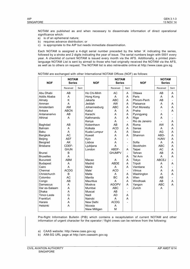
NOTAM are exchanged with other International NOTAM Offices (NOF) as follows:
NOFNOTAMSeries NOF
NOTAMSeries NOF
NOTAMSeries
Received Sent Received Sent Received Sent
Abu DhabiAddis Ababa AlmatyAmmanAmsterdamAnkaraAntananarivo Athinai
BaghdadBahrainBakuBangkokBeijing BeogradBrisbane
BruneiBruxellesBucurestiBudapestCairoChennaiChristchurchColomboCongoDamascusDar es-SalaamDhakaTimor-Leste FrankfurtHarareHelsinki
ABAKA
AMABCN
ABA
ABAA
ACAEFAK
CDEF-GHJN
BA
ABMAA
ACDGB
ACABAAAGAAA
Ho Chi-MinhHong KongJakartaJeddahJohannesburgKabulKarachiKathmanduKenyaKobenhavnKolkataKuala LumpurKuwaitKyivLisboa Ljubljana London
MacaoMadrid MahéMale’MaltaManilaMauritiusMoskvaMumbaiMuscatNadi NairobiNew DelhiNicosiaNiew Milligen
ACA
ABCAWABC
AAAA
ABACD
AA AAA
ABDF-GHJMPV
AABDE
AACD
ABCA
AGOPVABCABADA
ACDGAM
AAAAAAAA-AAAA---A-AAAA-AAAA--AA-
Ottawa ParisPhnom-PenhPlaisancePort MoresbyPrahaPyongyang Riga Rio de JaneiroRomaSanaaSeoulShannon
SofiaStockholmTaipeiTehranTel AvivTokyoTripoliVientianeVilnius WashingtonWienWindhoek YangonZurich
ABA
ABAA-AA-
AWA
AGABD-HJNV
AABCACABA
ABCEJAAAA
ABAB
ABCA
AA-AAA--AAAAAAAAAAA-A-AA-AA
Pre-flight Information Bulletin (PIB) which contains a recapitulation of current NOTAM and other information of urgent character for the operator / flight crews can be retrieve from the following:
a) CAAS website: http://www.caas.gov.sgb) AIM-SG URL page at http://aim.caasaim.gov.sg
CIVIL AVIATION AUTHORITY AIP AMDT 6/14SINGAPORE
GEN 3.1-4 AIP13 NOV 14 SINGAPORE
3.6 Aeronautical Information Circular (AIC)
Aeronautical Information Circular (AIC) contains information on the long-term forecast of major change in legislation, regulations, procedures or facilities; information of a purely explanatory or advisory nature liable to affect flight safety; and information or notification of an explanatory or advisory nature concerning technical, legislative or purely administrative matters which is inappropriate to the AIP or NOTAM, and is published as required.
Each AIC is numbered consecutively on a calendar year basis. The year, indicated by 2 digits, is a part of the serial number of the AIC. A checklist of current AIC is issued in the form of an AIC once a year.
3.7 Checklist and NOTAM List
A checklist of current NOTAM is issued monthly via the AFS. Subsequently, a printed NOTAM List is prepared and distributed by mail to all recipients of the Integrated Aeronautical Information Package. It contains the plain language presentation of current NOTAM, information on the serial numbers of the latest AIP AMDT, AIP SUP and AIC issued and also includes the checklist for AIP SUP.
3.8 Sale of publications
AIP Singapore may be purchased from the Aeronautical Information Services, Civil Aviation Authority of Singapore, Singapore Changi Airport at S$435.00 per copy of the AIP (excluding postage).
The fee for the AIP AMDT service is S$130.00 per year per copy of the AIP (excluding postage which is to be paid in advance).
Additional AIP covers may be purchased at $12.00 each.
4. AIRAC SYSTEM
4.1 In order to control and regulate operationally significant changes requiring amendments to charts, route manuals, etc., such changes, whenever possible, will be issued on predetermined dates according to the AIRAC SYSTEM. This type of information will be published in an AIRAC AIP SUP. If an AIRAC AIP SUP cannot be issued due to lack of time, an AIRAC NOTAM will be issued. Such NOTAM will immediately be followed by an AIP SUP.
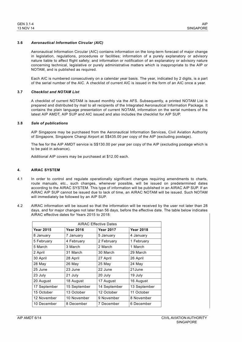
4.2 AIRAC information will be issued so that the information will be received by the user not later than 28 days, and for major changes not later than 56 days, before the effective date. The table below indicates AIRAC effective dates for Years 2015 to 2018:
AIRAC Effective Dates
Year 2015 Year 2016 Year 2017 Year 2018
8 January 7 January 5 January 4 January
5 February 4 February 2 February 1 February
5 March 3 March 2 March 1 March
2 April 31 March 30 March 29 March
30 April 28 April 27 April 26 April
28 May 26 May 25 May 24 May
25 June 23 June 22 June 21June
23 July 21 July 20 July 19 July
20 August 18 August 17 August 16 August
17 September 15 September 14 September 13 September
15 October 13 October 12 October 11 October
12 November 10 November 9 November 8 November
10 December 8 December 7 December 6 December
AIP AMDT 6/14 CIVIL AVIATION AUTHORITY SINGAPORE
AIP GEN 3.1-5SINGAPORE 13 NOV 14
4.3 A TRIGGER NOTAM will be issued 10 days before the effective date of the AIRAC AIP Supplement giving a brief description of the contents of the AIP SUP, the effective date and the reference number of the AIRAC AIP SUP. This trigger NOTAM will come into force on the same effective date as the AIRAC AIP SUP and will remain in force until 14 days after the effective date.
4.4 A NIL AIRAC NOTAM will be issued one cycle before the AIRAC effective date if no information is submitted for publication of an AIRAC AIP Supplement for an AIRAC effective date. The NIL AIRAC NOTAM will remain current until the next AIRAC effective date.
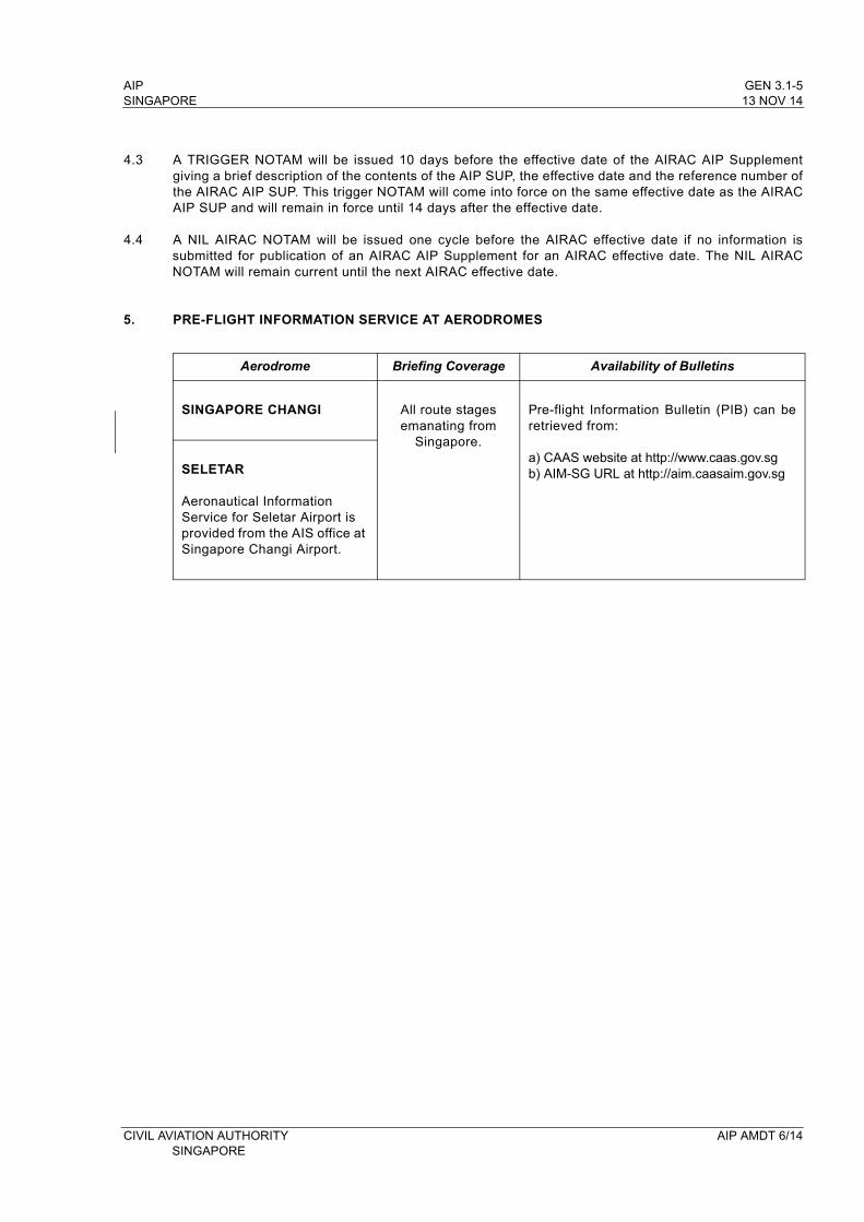
5. PRE-FLIGHT INFORMATION SERVICE AT AERODROMES
Aerodrome Briefing Coverage Availability of Bulletins
SINGAPORE CHANGI All route stages emanating from
Singapore.
Pre-flight Information Bulletin (PIB) can be retrieved from:
a) CAAS website at http://www.caas.gov.sg b) AIM-SG URL at http://aim.caasaim.gov.sgSELETAR
Aeronautical Information Service for Seletar Airport is provided from the AIS office at Singapore Changi Airport.
CIVIL AVIATION AUTHORITY AIP AMDT 6/14SINGAPORE

AIP SINGAPORE
INTENTIONALLY
LEFT
BLANK
CIVIL AVIATION AUTHORITY SINGAPORE
AIP GEN 3.2-1SINGAPORE 13 NOV 14
GEN 3.2 AERONAUTICAL CHARTS
1. RESPONSIBLE SERVICES
1.1 The Civil Aviation Authority of Singapore provides a range of aeronautical charts for use by all types of civil aviation. The Aeronautical Information Services produces some of the charts which are part of the AIP. Other charts, suitable for pre-flight planning and briefing, are available for reference at the AIS office at Singapore Changi Airport and the AIS Self-Briefing Office at Seletar Aerodrome. The charts published in the AIP are produced in accordance with the provisions contained in the ICAO documents listed in para 1.2. Differences to the provisions contained in ICAO Annex 4 - Aeronautical Charts are detailed in subsection GEN 1.7.
1.2 Applicable ICAO Documents
Annex 4 - Aeronautical Charts, Eleventh Edition 2009.Doc 8168-OPS/611 - Aircraft Operations, Volume II - Construction of Visual and Instrument Flight
Procedures, Fifth Edition 2006.
2. MAINTENANCE OF CHARTS
2.1 The aeronautical charts included in the AIP are kept up-to-date regularly by means of replacement sheets where necessary. Significant amendments or revisions in aeronautical information for other aeronautical charts are also included in the replacement sheets. Revisions of the aeronautical information on all charts is constantly in progress and amended reprints are published as regularly as production resources permit.
2.2 Information found to be incorrect after publication will be corrected by an AIC or NOTAM if they are of operational significance.
3. PURCHASE ARRANGEMENTS
3.1 The charts as listed under paragraph 4 of this sub-section may be obtained from:
Aeronautical Information ServicesCivil Aviation Authority of SingaporeSingapore Changi AirportP. O. Box 1Singapore 918141
TEL: (65) 65956051FAX: (65) 64410221AFS: WSSSYNYXEmail: [email protected]
4. AERONAUTICAL CHART SERIES AVAILABLE
4.1 The following series of aeronautical charts are produced:a) World Aeronautical Chart - ICAO;b) Aerodrome Chart - ICAO;c) Aerodrome Obstacle Chart - ICAO Type A (for each runway);d) Aerodrome Obstacle Chart - ICAO Type B;e) Precision Approach Terrain Chart - ICAO;f) Enroute Chart - ICAO;g) Area Chart - ICAO;h) Standard Departure Chart - Instrument (SID) - ICAO;i) Standard Arrival Chart - Instrument (STAR) - ICAO;j) Instrument Approach Chart - ICAO (for each runway and procedure type);k) Visual Approach Chart - ICAO
CIVIL AVIATION AUTHORITY AIP AMDT 6/14 SINGAPORE
GEN 3.2-2 AIP13 NOV 14 SINGAPORE
4.2 General description of each series
a) World Aeronautical Chart - ICAO 1: 1 000 000
This series is constructed on Lambert Conformal Conic Projection with two standard parallels at 0 degree 40 minutes and 3 degree 20 minutes. The spheroid is World Geodetic System 1984 (WGS84). The aeronautical data shown have been kept to a minimum, consistent with the use of the chart for visual air navigation. It includes a selection of aerodromes, significant obstacles, elements of the ATS system, prohibited, restricted and danger areas, and radio navigation aids. The chart provides information to satisfy visual air navigation and is also used as a pre-flight planning chart.
b) Aerodrome Chart - ICAO
This chart contains detailed aerodrome data to provide flight crews with information that will facilitate the ground movement of aircraft:
- from the aircraft stand to the runway; and- from the runway to the aircraft stand;
It also provides essential operational information at Singapore Changi Airport and Seletar Aerodrome.
c) Aerodrome Obstacle Chart - ICAO Type A (operating limitations)
This chart contains detailed information on obstacles in the take-off flight path areas of Singapore Changi Airport, Seletar Aerodrome and Paya Lebar Airport. It is shown in plan and profile view. This obstacle information provides the data necessary to enable an operator to comply with the operating limitations of ICAO Annex 6, Parts l and ll, Chapter 5.
d) Aerodrome Obstacle Chart - ICAO Type B
This chart is produced to assist in the determination of critical heights for Singapore Changi Airport and Seletar Aerodrome.
e) Precision Approach Terrain Chart - ICAO
This chart provides detailed terrain profile information within a defined portion of the final approach so as to enable aircraft operating agencies to assess the effects of the terrain on decision height determination by the use of radio altimeters. This chart is produced for the precision approach Cat II runways at Singapore Changi Airport.
f) Enroute Chart - ICAO
This chart is produced for the entire Singapore FIR. The aeronautical data include all aerodromes, prohibited, restricted and danger areas and the air traffic services system in detail. This chart provides the flight crew with information to facilitate navigation along ATS routes in compliance with air traffic services procedures.
AIP AMDT 6/14 CIVIL AVIATION AUTHORITY SINGAPORE
AIP GEN 3.2-5SINGAPORE 13 NOV 14
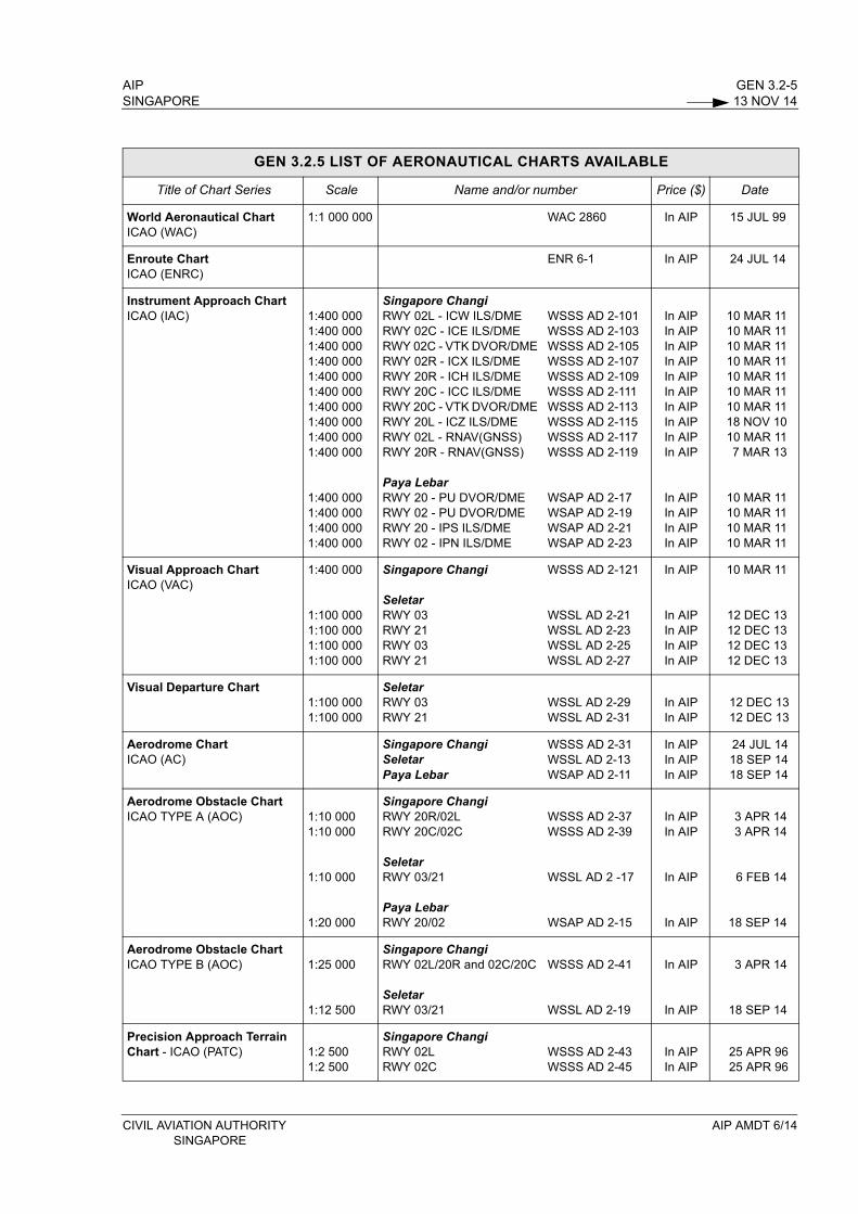
GEN 3.2.5 LIST OF AERONAUTICAL CHARTS AVAILABLE
Title of Chart Series Scale Name and/or number Price ($) Date
World Aeronautical Chart ICAO (WAC)
1:1 000 000 WAC 2860 In AIP 15 JUL 99
Enroute Chart ICAO (ENRC)
ENR 6-1 In AIP 24 JUL 14
Instrument Approach Chart ICAO (IAC) 1:400 000
1:400 0001:400 0001:400 0001:400 0001:400 0001:400 0001:400 0001:400 0001:400 000
1:400 0001:400 0001:400 0001:400 000
Singapore ChangiRWY 02L - ICW ILS/DME RWY 02C - ICE ILS/DME RWY 02C - VTK DVOR/DME RWY 02R - ICX ILS/DME RWY 20R - ICH ILS/DME RWY 20C - ICC ILS/DME RWY 20C - VTK DVOR/DME RWY 20L - ICZ ILS/DME RWY 02L - RNAV(GNSS) RWY 20R - RNAV(GNSS)
Paya LebarRWY 20 - PU DVOR/DME RWY 02 - PU DVOR/DME RWY 20 - IPS ILS/DME RWY 02 - IPN ILS/DME
WSSS AD 2-101WSSS AD 2-103WSSS AD 2-105WSSS AD 2-107WSSS AD 2-109WSSS AD 2-111WSSS AD 2-113WSSS AD 2-115WSSS AD 2-117WSSS AD 2-119
WSAP AD 2-17WSAP AD 2-19WSAP AD 2-21WSAP AD 2-23
In AIPIn AIPIn AIPIn AIPIn AIPIn AIPIn AIPIn AIPIn AIPIn AIP
In AIPIn AIPIn AIPIn AIP
10 MAR 1110 MAR 1110 MAR 1110 MAR 1110 MAR 1110 MAR 1110 MAR 1118 NOV 1010 MAR 117 MAR 13
10 MAR 1110 MAR 1110 MAR 1110 MAR 11
Visual Approach ChartICAO (VAC)
1:400 000
1:100 0001:100 0001:100 0001:100 000
Singapore Changi
SeletarRWY 03RWY 21RWY 03RWY 21
WSSS AD 2-121
WSSL AD 2-21WSSL AD 2-23WSSL AD 2-25WSSL AD 2-27
In AIP
In AIPIn AIPIn AIPIn AIP
10 MAR 11
12 DEC 1312 DEC 1312 DEC 1312 DEC 13
Visual Departure Chart1:100 0001:100 000
SeletarRWY 03RWY 21
WSSL AD 2-29WSSL AD 2-31
In AIPIn AIP
12 DEC 1312 DEC 13
Aerodrome Chart ICAO (AC)
Singapore ChangiSeletarPaya Lebar
WSSS AD 2-31WSSL AD 2-13WSAP AD 2-11
In AIPIn AIPIn AIP
24 JUL 1418 SEP 1418 SEP 14
Aerodrome Obstacle Chart ICAO TYPE A (AOC) 1:10 000
1:10 000
1:10 000
1:20 000
Singapore ChangiRWY 20R/02LRWY 20C/02C
SeletarRWY 03/21
Paya LebarRWY 20/02
WSSS AD 2-37WSSS AD 2-39
WSSL AD 2 -17
WSAP AD 2-15
In AIPIn AIP
In AIP
In AIP
3 APR 143 APR 14
6 FEB 14
18 SEP 14
Aerodrome Obstacle Chart ICAO TYPE B (AOC) 1:25 000
1:12 500
Singapore ChangiRWY 02L/20R and 02C/20C
SeletarRWY 03/21
WSSS AD 2-41
WSSL AD 2-19
In AIP
In AIP
3 APR 14
18 SEP 14
Precision Approach Terrain Chart - ICAO (PATC) 1:2 500
1:2 500
Singapore Changi RWY 02LRWY 02C
WSSS AD 2-43WSSS AD 2-45
In AIPIn AIP
25 APR 9625 APR 96
CIVIL AVIATION AUTHORITY AIP AMDT 6/14 SINGAPORE
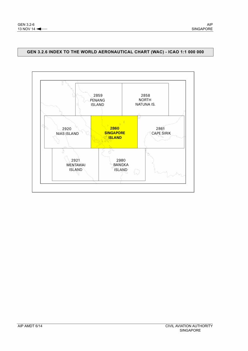
GEN 3.2-6 AIP13 NOV 14 SINGAPORE
GEN 3.2.6 INDEX TO THE WORLD AERONAUTICAL CHART (WAC) - ICAO 1:1 000 000
AIP AMDT 6/14 CIVIL AVIATION AUTHORITY SINGAPORE
AIP GEN 3.2-7SINGAPORE 13 NOV 14
GEN 3.2 AERONAUTICAL CHARTS
8. CORRECTIONS TO CHARTS NOT CONTAINED IN THE AIP
Identification of charts Location on the chart where the correction has to be made
Precise details of the corrections to be made
CIVIL AVIATION AUTHORITY AIP AMDT 6/14SINGAPORE

AIP SINGAPORE
INTENTIONALLY
LEFT
BLANK
CIVIL AVIATION AUTHORITY SINGAPORE
AIP GEN 3.3-1SINGAPORE 13 NOV 14
GEN 3.3 AIR TRAFFIC SERVICES
1. RESPONSIBLE SERVICE
1.1 The Chief Air Traffic Control Officer of the Air Traffic Services Division of the Civil Aviation Authority of Singapore (CAAS) acting under the authority of the Director-General of Civil Aviation is the authority responsible for the overall administration of air traffic services within the Singapore FIR.
Chief Air Traffic Control Officer TEL : (65) 65412405Air Traffic Services Division FAX : (65) 6441 0221Civil Aviation Authority of Singapore AFS : WSJCZQZXSingapore Changi AirportP. O. Box 1, Singapore 918141
1.2 The services are provided in accordance with the provisions contained in the following ICAO documents:Annex 2 - Rules of the AirAnnex 11 - Air Traffic ServicesDoc 4444 - Procedures for Air Navigation Services - Air Traffic Management (PANS-ATM)Doc 8168 - Procedures for Air Navigation Services - Aircraft Operations (PANS-OPS)Doc 7030 - Regional Supplementary Procedures
1.3 Differences to these provisions are detailed in subsection GEN 1.7.
2. AREA OF RESPONSIBILITY
2.1 Air traffic services are provided for the entire territory of Singapore, including its territorial waters as well as the airspace over the high seas within the Singapore FIR.
2.2 In some cases, in accordance with the regional air navigation agreement, air traffic services are provided, under the delegated authority, in the airspace within another bordering FIR. Details of such services are provided in section ENR 2.
3. TYPES OF SERVICES
3.1 The following types of services are provided:- Flight Information Service (FIS) and Alerting Service (ALRS);- Area Control (ACC); and- Radar
3.2 With the exception of services provided at military air bases, the following types of services are provided at aerodromes:- Aerodrome Control (TWR);- Aerodrome Flight Information Service (AFIS); and - Automatic Terminal Information Service (ATIS) at certain aerodromes
3.3 Air Traffic Control is exercised:a) on airways covering the main ATS routes;b) within the Singapore/Johor Airspace Complex and in control zones at controlled aerodromes
equipped with approach and/or landing aids.
3.4 Flight information service and alerting service within the Singapore FIR and air traffic control services in control areas are provided by one centre (ACC Singapore). There is no distinction between upper and lower controlled airspace. The axis of each airway is constituted by a line connecting reference points identified normally by radio navigational facilities.
CIVIL AVIATION AUTHORITY AIP AMDT 6/14SINGAPORE
GEN 3.3-2 AIP13 NOV 14 SINGAPORE
3.5 Air traffic control, flight information and alerting services are provided by:
a) ACC Singapore along the airways including those parts of the airways traversing the Singapore /Johor Airspace Complex;
b) the relevant aerodrome control tower in coordination with ACC Singapore as necessary, for arriving and departing aircraft.
3.6 Radar service is an integral part of the ATS system. A description of radar services and procedures is provided in subsection ENR 1.6. Additional procedures applicable within the Singapore / Johor Airspace Complex are contained in sub-section ENR 1.1.
3.7 The description of the airspace designated for air traffic services purpose is found in several tables, all forming part of sub-section ENR 2.1.
3.8 In general, the air traffic rules and procedures in force and the organisation of air traffic services are in conformity with ICAO Standards, Recommended Practices and Procedures. The regional supplementary procedures and altimeter setting procedures are set out in full. Differences between the national and international rules and procedures are given in sub-section GEN 1.7.
3.9 A few prohibited areas, restricted areas and danger areas are established within the Singapore / Johor Airspace Complex. These areas are shown in sub-section ENR 5.1. Activation of areas subject to intermittent activity is notified well in advance by NOTAM, giving reference to the area only by its identification.
4. CO-ORDINATION BETWEEN THE OPERATOR AND ATS
4.1 Co-ordination between the operator and air traffic services is effected in accordance with Chapter 2, paragraph 2.15 of ICAO Annex 11 - Air Traffic Services and Chapter II, paragraphs 11.2.1.1.4 and 11.2.1.1.5 ICAO Doc 4444 - Procedures for Air Navigation Services - Air Traffic Management (PANS-ATM).
5. MINIMUM FLIGHT ALTITUDE
5.1 The minimum flight altitudes on the ATS routes, as presented in section ENR 3, have been determined so as to ensure at least 1,000ft (300m) vertical clearance above the highest obstacle within 18km on each side of the centre line of the route. However, where the angular divergence of the navigational aid signal in combination with the distance between the navigational aids could result in the aircraft being more than 8km on either side of the centre line, the 18km protection limit is increased by the extent to which the divergence is more than 8km from the centre line.
Unit Name
Postal Address
Telephone Nr
Telefax Nr
Telex Nr
AFS Address
1 2 3 4 5 6
SINGAPORE ACC / APP
Singapore Air Traffic Control Centre (SATCC)60, Biggin Hill RoadSingapore 509950
(65) 65412668(65) 65412672
(65) 65456252 - WSJCZQZX
SINGAPORE TOWER
Singapore Changi Control TowerCivil Aviation Authority of Singapore P.O Box 1, Singapore Changi AirportSingapore 918141
(65) 65956057(65) 65412410(65) 65412416
(65) 65456224 - Nil
SELETARTOWER
Seletar Control TowerCivil Aviation Authority of Singapore Seletar AirportBuilding 1007, West Camp RoadSingapore 797794
(65) 64812893 (65) 64813510 - WSSLZTZX
6. ATS UNITS ADDRESS LIST
AIP AMDT 6/14 CIVIL AVIATION AUTHORITYSINGAPORE
AIP GEN 3.5-5SINGAPORE 13 NOV 14
4.8.1.3.4 The phraseology used by ATC to warn pilots of the presence of wind shear of intensity greater than 30 knots is:
“...........(callsign) WIND SHEAR WARNING SEVERE LOW LEVEL WIND SHEAR OBSERVED IN THE VICINITY OF CHANGI AIRPORT AT ........(time)”
4.8.1.3.5 The presence of wind shear will also be broadcast in the ATIS for the next half an hour.
4.8.2 SELETAR AERODROME
4.8.2.1 Surface wind is measured by cup anemometers and wind vanes at ends of runway. Surface wind report in METAR and SPECI is taken from measurements of cup anemometer and wind vane at RWY 03.
4.8.2.2 Wind Shear Observations (Seletar Aerodrome)
4.8.2.2.1 ATC will pass to all aircraft taking off or landing for the next 1/2 hour from the time of report
whenever microburst or windshear of intensity 10 knots or greater is observed/reported.
4.8.2.2.2 The phraseology used by ATC to warn pilots of the presence of wind shear of intensity between 10 and 30 knots is:
“...........(callsign) WIND SHEAR WARNING STRONG LOW LEVEL WIND SHEAR OBSERVED IN THE VICINITY OF SELETAR AIRPORT AT ........(time)”
4.8.2.2.3 The phraseology used by ATC to warn pilots of the presence of wind shear of intensity greater than 30 knots is:
“...........(callsign) WIND SHEAR WARNING SEVERE LOW LEVEL WIND SHEAR OBSERVED IN THE VICINITY OF SELETAR AIRPORT AT ........(time)”
5. NOTIFICATION REQUIRED FROM OPERATORS
5.1 It is the responsibility of the operator or the pilot-in-command to notify the meteorological office of any flight for which meteorological documentation is required (ref. ICAO Annex 3, paragraph 2.3). As much prior notice as possible should be given, and at least one hour notice at Singapore Changi Airport and two hours at Seletar Aerodrome would be required for non-scheduled flights.
6. AIRCRAFT REPORTS REQUIRED FROM OPERATORS
6.1 AIREP
6.1.1 Routine aircraft meteorological observations shall be made and the reports transmitted at ATS/MET reporting points listed on page GEN 3.5-6 and as indicated in subsection ENR 3.1 - ATS ROUTES.
6.1.2 Special aircraft observations and aircraft observations during climb-out and approach shall be made and the reports transmitted as necessary.
6.1.3 Special aircraft observations of pre-eruption volcanic activity, volcanic eruption or volcanic ash cloud shall be recorded on the special Air-Report of Volcanic Activity form which can be downloaded from URL https://fpl-1.caasaim.gov.sg/. A copy of the completed Volcanic Activity Report shall be delivered by the operator or a flight crew member, without delay, either personally or by telephone facsimile (TEL: 65425026 or 65429978) to the Meteorological Office, Singapore Changi Airport.
CIVIL AVIATION AUTHORITY AIP AMDT 6/14SINGAPORE
GEN 3.5-6 AIP13 NOV 14 SINGAPORE
6.2 REPORTING OF LOW LEVEL WIND SHEAR
6.2.1 Pilots encountering wind shear shall report to ATC as soon as possible.
6.2.2 When reporting wind shear on radiotelephony, the information should be transmitted in this order:
a) Aircraft callsign;b) WIND SHEAR report;c) Time (of wind shear occurrence);d) Position (of wind shear);e) Intensity (moderate, strong or severe);f) Average height of wind shear layer.
6.2.3 On receipt of a wind shear report from a pilot, ATC will pass it to other aircraft in the vicinity. The following phraseology will be used:
“WIND SHEAR WARNINGARRIVING (or DEPARTING) ........... (type of aircraft)REPORTED ...................... (moderate, strong, severe)WIND SHEAR IN APPROACH (or DEPARTURE)RUNWAY ................ (number) AT ..................... (time)HEIGHT OF WIND SHEAR LAYER ................... (feet)”
6.2.4 The presence of wind shear as reported by a pilot will also be broadcast in the ATIS for the next half an hour unless subsequent reports indicate that wind shear no longer exists.
6.3 AIRCRAFT ATS/MET REPORTING POINTS IN THE SINGAPORE FIR
6.3.1. Aircraft Meteorological Observations shall be made in relation to and transmitted in flight by all aircraft at the following selected Air Traffic Services position reporting points within the Singapore FIR except when:
a) The flight duration is less than 2 hours, or b) The altitude of the flight path is less than 5 000ft, orc) The aircraft is less than 1 hour’s flying time from the next intended point of landing.
6.3.2. The aircraft ATS/MET reporting points listed below are indicated in chart page ENR 3.1-17.
6.3.3. The position of the mean wind or spot wind, to the nearest whole degree latitude and longitude, shall be recorded and transmitted in flight.
ATS ROUTE
AIRCRAFT ATS/MET REPORTING POINTS IN THE SINGAPORE FIR
G580 NIMIX
L642 ESPOB
L644 KIKOR
M635 SURGA
M758/M767 TERIX
M767 TEGID
M774 KADAR
M774/L504 BAVUS
N875 ARUPA
N892 MELAS
AIP AMDT 6/14 CIVIL AVIATION AUTHORITYSINGAPORE
AIP ENR 0.6-3SINGAPORE 13 NOV 14
ENR 1.8 REGIONAL SUPPLEMENTARY PROCEDURES (DOC 7030) ENR 1.8-11. RVSM Procedures in the Singapore FIR ENR 1.8-1
Identification of RVSM Airspace ENR 1.8-1Airworthiness Operational Approval and Monitoring ENR 1.8-1ACAS II and Transponder Equipage ENR 1.8-2In-Flight Procedures within RVSM Airspace ENR 1.8-2/3Weather Deviation Procedures in the Singapore FIR ENR 1.8-3/5Procedures to mitigate wake turbulence encounters and distracting ENR 1.8-5aircraft system alerts in the Oceanic Airspace of Singapore FIRProcedures for OPR of Non-RVSM compliant aircraft in RVSM airspace ENR 1.8-6/7Contingency Scenarios ENR 1.8-8Expanded Equipment Failure and Turbulence Encounter Scenarios ENR 1.8-9/11Controller/Pilot Phraseology ENR 1.8-12
2. MNT and RNAV Procedures ENR 1.8-13 Longitudinal Separation on ATS Routes ENR 1.8-14Table - Appendix A - Application of MNT when the following ACFT is faster ENR 1.8-16
3. RNP10 Navigation Requirements ENR 1.8-17Operations by aircraft not meeting RNP 10 Requirements ENR 1.8-17Monitoring of aircraft Navigation Performance ENR 1.8-18Separation Minima ENR 1.8-18
4. No Pre-departure Coordination (No PDC) Procedures ENR 1.8-195. Strategic Lateral Offset Procedures ENR 1.8-216. Strategic Flow Management Procedures ENR 1.8-227. Automatic Dependent Surveillance Broadcast (ADS-B) Out Exclusive Airspace ENR 1.8-24
within parts of the Singapore FIR
ENR 1.9 AIR TRAFFIC FLOW MANAGEMENT (ATFM) ENR 1.9-1
ENR 1.10 FLIGHT PLANNING1. Procedures for submission of a Flight Plan ENR 1.10-1
ENR 1.11 ADDRESSING OF FLIGHT PLAN MESSAGES ENR 1.11-1
ENR 1.12 INTERCEPTION OF CIVIL AIRCRAFT ENR 1.12-11. Interception Procedures ENR 1.12-1/2
Table - Signals for use in the event of Interception ENR 1.12-3/4
ENR 1.13 UNLAWFUL INTERFERENCE ENR 1.13-1
ENR 1.14 AIR TRAFFIC INCIDENTS ENR 1.14-11. Definition of Air Traffic Incidents ENR 1.14-12. Use of Air Traffic Incident Report Forms ENR 1.14-13. Air Traffic Incident Reporting Procedures ENR 1.14-14. Investigation ENR 1.14-25. Co-ordination/Investigation Authority ENR 1.14-2
ENR 1.15 OTHER REPORTS UNDER ICAO INITIAITIVE ENR 1.15-11. Wake Vortex Encounter ENR 1.15-1
2. Wake Vortex Encounter Reporting Form for Pilots ENR 1.15-3
ENR 2. AIR TRAFFIC SERVICES AIRSPACE
ENR 2.1 FIR, UIR, TMA ENR 2.1-1Chart - Singapore and Adjacent Flight Information Regions ENR 2.1-7Chart - Airspace Division-Kuala Lumpur/Singapore ACCs ENR 2.1-9Diagram - Longitudinal Cross-Section of Sector 1 (SJ-REKOP/ARAMA) ENR 2.1-11ADiagram - Longitudinal Cross-Section of G579 from JB to SJ ENR 2.1-11BDiagram - Longitudinal Cross-Section of Sector 2 (PU-WSJC/WMFC FIR BDRY) ENR 2.1-13Chart - ATS Route Structure within Singapore and Adjacent FIRs ENR 2.1-15
ENR 2.2 OTHER REGULATED AIRSPACE ENR 2.2-1
CIVIL AVIATION AUTHORITY AIP AMDT 6/14SINGAPORE
ENR 0.6-4 AIP13 NOV 14 SINGAPORE
ENR 3. ATS ROUTES
ENR 3.1 ATS ROUTES ENR 3.1-1/8Chart - Air Traffic System Chart ENR 3.1-17
ENR 3.3 AREA NAVIGATION (RNAV) ROUTES ENR 3.3-1/14
ENR 3.4 HELICOPTER ROUTES ENR 3.4-11. Helicopter operations over Singapore Island ENR 3.4-1
Diagram - Heli-Route Alpha within vicinity of Changi Naval Base ENR 3.4-2Flights operating outside established routeings ENR 3.4-3
2. Procedures for the Control of Helicopter Operations - Singapore Changi AP ENR 3.4-4Chart - Helicopter Routes in VMC ENR 3.4-5Chart - Restricted Area - Single-Engine Helicopter Operations Restricted ENR 3.4-7
ENR 3.5 OTHER ROUTES ENR 3.5-11. SINJON VMC Crossing by Military aircraft ENR 3.5-12. Transit Channel ENR 3.5-2 3. Horsburgh Lighthouse ENR 3.5-2
Chart - VMC Crossing by Military Aircraft ENR 3.5-3
ENR 3.6 ENROUTE HOLDING ENR 3.6-1Chart - SINJON DVOR/DME Low Level Holding Area ENR 3.6-3Chart - REMES and LAVAX Low Level Holding Areas ENR 3.6-5Chart - Area Chart - Singapore/Johor Airspace Complex - Low Level ENR 3.6-7Chart - Area Chart - Singapore/Johor Airspace Complex - High Level ENR 3.6-9
ENR 4. RADIO NAVIGATION AIDS/SYSTEMS
ENR 4.1 RADIO NAVIGATION AIDS - ENROUTE ENR 4.1-1ENR 4.2 SPECIAL NAVIGATION SYSTEMS ENR 4.2-1ENR 4.3 GLOBAL NAVIGATION SATELLITE SYSTEM (GNSS) ENR 4.3-1ENR 4.4 NAME-CODE DESIGNATORS FOR SIGNIFICANT POINTS ENR 4.4-1/5ENR 4.5 AERONAUTICAL GROUND LIGHTS - ENROUTE ENR 4.5-1
ENR 5. NAVIGATION WARNINGS
ENR 5.1 PROHIBITED, RESTRICTED AND DANGER AREAS ENR 5.1-1/6Chart - Prohibited, Restricted and Danger Areas - Chart 1 ENR 5.1-7Chart - Prohibited, Restricted and Danger Areas - Chart 2 ENR 5.1-9
ENR 5.2 MILITARY EXERCISE AND TRAINING AREAS ENR 5.2-1/2
ENR 5.3 OTHER ACTIVITIES OF A DANGEROUS NATURE ENR 5.3-11. Weather Balloons ENR 5.3-1
ENR 5.4 AIR NAVIGATION OBSTACLES - ENROUTE ENR 5.4-1
ENR 5.5 AERIAL SPORTING AND RECREATIONAL ACTIVITIES ENR 5.5-11. Glider Flying- Tengah ATZ ENR 5.5-12. Aeromodelling and Kite Flying ENR 5.5-13. Aircraft Operations Prohibited over the territory of Singapore ENR 5.5-14. Searchlight Display / Laser shows - Paya Lebar CTR ENR 5.5-1
ENR 5.6 BIRD MIGRATION ENR 5.6-1Wildlife Strike Reporting Form ENR 5.6-3
ENR 6. ENROUTE CHARTS
ENR 6. Enroute Chart ENR 6-1World Aeronautical Chart (WAC) - ICAO 1:1 000 000 WAC 2860
AIP AMDT 6/14 CIVIL AVIATION AUTHORITY SINGAPORE
AIP ENR 1.8-17SINGAPORE 13 NOV 14
3. RNP 10 NAVIGATION REQUIREMENTS
3.1 INTRODUCTION
3.1.1 ATC will apply 50NM lateral separation minima to aircraft which are approved for RNP 10 operations on RNAV routes:
L625 - BTN TOMAN and MEVINL642 - BTN CHEUNG CHAU and MERSINGM767 - BTN JOMALIG and TOMANM771 - BTN MERSING and CHEUNG CHAUN884 - BTN MERSING and MANILAN892 - BTN HENGCHUN and MERSING
3.1.2 ATC will apply 60NM lateral separation minima to aircraft which are approved for RNP 10 operations on RNAV routes:
L644 - BTN DUDIS and KIKORM772 - BTN ASISU and LAXOR
3.1.3 Pilots shall inform ATC of any deterioration or failure of the navigation systems below the navigation requirements for RNP 10. ATC shall then provide alternative separation and / or alternative routing.
3.1.4 Pilots of aircraft meeting RNP 10 navigation requirements must indicate /R at Item 10 of the ICAO Flight Plan.
3.2 OPERATIONS BY AIRCRAFT NOT MEETING RNP 10 REQUIREMENTS
3.2.1 An aircraft that is unable to meet the minimum navigational requirements for RNP 10 must file flight plan at FL280 or below. Operations above FL280 for these aircraft will be subject to ATC approval, in accordance with the provisions of paragraph 3.2.3.
3.2.2 Pilots of such aircraft wishing to operate on ATS routes specified in paragraph 3.1.1, at or above FL290, must indicate their level requirements at Item 18 of the ICAO Flight Plan as RMK/REQ FL (insert level). Approval to operate at the preferred level will be subject to ATC co-ordination and clearance. Flights that are not approved will be required to operate at FL280 or below or via alternative routes.
3.2.3 ATC units receiving a request for a non-RNP 10 approved aircraft to operate on ATS routes specified in paragraph 3.1.1, at or above FL290, will co-ordinate with adjacent ATC units affected by the flight. In deciding whether or not to approve the flight, each ATC unit will take into consideration:
(a) traffic density;(b) communications, including the non-availability of normal communications facilities;(c) weather conditions en-route; and(d) any other factors pertinent at the time.
3.3 SAFETY ASSESSMENT CRITERIA
3.3.1 The safety criteria associated with the introduction of the reduced lateral separation minima of 60NM will be in accordance with the requirements for RNP 10 navigation performance, i.e. aircraft navigation performance shall be such that the standard deviation of lateral track errors shall be less than 8.7km (4.7NM).
CIVIL AVIATION AUTHORITY AIP AMDT 6/14SINGAPORE
ENR 1.8-18 AIP13 NOV 14 SINGAPORE
3.4 MONITORING OF AIRCRAFT NAVIGATION PERFORMANCE
3.4.1 Monitoring of aircraft navigation performance is a joint responsibility between operators, States of Registry or States of Operators (as applicable), regulatory authorities and the ATS providers. The detection and reporting of non-conformance with the navigation requirements against the following parameters will rely primarily on radar monitoring by ATC units:
Lateral Deviations
(i) a deviation of 15NM or more from track centreline based on radar observations;
Longitudinal Deviations
(i) where time separation is applied by ATC - when the reported separation based on ATC verified pilot estimates varies by 3 minutes or more from the expected separation at the reporting point; or
(ii) where a distance based standard is applied by ATC based on ADS, radar observation or RNAV distance reports - when the distance varies by 10NM or more from the expected distance.
3.4.2 ATC will advise the pilot-in-command when such deviations are observed and implement the required investigation procedures.
3.4.3 The ATC authority will investigate the causes of such deviations in conjunction with the aircraft operator and the State of Registry, or the State of the Operator, as applicable.
3.5 SEPARATION MINIMA
3.5.1 Lateral Separation Minima
(a) A lateral separation minima of 60NM will be applied between aircraft equipped in accordance with RNP 10 navigation requirements, operating at FL290 or above, on ATS routes L644 and M772 (see paragraph 3.1.2). 50NM lateral separation minima will be applied between aircraft which are approved for RNP10 operations on ATS routes L625, L642, M767, M771, N884 and N892 (see paragraph 3.1.1).
(b) When an aircraft not meeting the RNP 10 navigation requirements is approved to operate at or above FL290, on the ATS routes shown in paragraphs 3.1.1 and 3.1.2, vertical separation shall be applied with aircraft operating on adjacent routes.
3.5.2 Longitudinal Separation
3.5.2.1 80NM RNAV or 10 minutes (or less) Mach Number Technique (MNT) separation minima may be applied between aircraft.
3.5.2.2 50NM longitudinal separation may be applied between RNP10 approved aircraft on ATS routes L642, M767, M771 and N884 which either LOGON to CPDLC or are within VHF radio range.
3.5.3 Vertical Separation
3.5.3.1 A vertical separation minima of 2,000ft, including the use of non-standard levels, will be applied between aircraft operating at FL290 or above, on the ATS routes shown in paragraph 3.1.1.
3.6 OPERATORS’ PROCEDURES
3.6.1 The operator shall ensure in-flight procedures, crew manuals and training programmes are established in accordance with RNP 10 navigation requirements.
3.7 CONTINGENCY PROCEDURES (including WEATHER DEVIATION)
3.7.1 Contingency procedures, including weather deviation, shall be in accordance with the provisions contained in AIP Singapore pages ENR 1.8-3 to ENR 1.8-5.
AIP AMDT 6/14 CIVIL AVIATION AUTHORITY SINGAPORE
AIP ENR 1.10-3SINGAPORE 13 NOV 14
1.6.3 Operators of aircraft unable to meet the RNP 10 requirements (see page ENR 1.8-17) and wishing to operate at or above FL290 on RNAV routes specified in paragraph 1.6.2 shall annotate their flight plan as follows:Item 18 - insert “RMK/REQ FL (insert level)” where FL = the preferred flight level (subject to ATC co-ordination)
l
1.6.4 Operators of aircraft approved for RNP 1 (P-RNAV) operations shall also include the following information in their flight plan: Item 10 - “R” where R = PBN approvedItem 18 - PBN/O1 where O1 = Basic RNP1 all permitted sensors, or
PBN/O2 where O2 = Basic RNP1 GNSS, orPBN/O3 where O3 = Basic RNP1 DME/DME, or PBN/O4 where O4 = Basic RNP1 DME/DME/IRU
1.7 RVSM and NON-RVSM Approved Aircraft
1.7.1 Operators of RVSM approved or non-RVSM approved aircraft operating in RVSM airspace (see page
ENR 1.8-6) shall annotate their flight plan as follows:
Item 10 Item 18
RVSM approved aircraft W
Non-RVSM approved aircraft STS/NONRVSM
CIVIL AVIATION AUTHORITY AIP AMDT 6/14SINGAPORE

AIP SINGAPORE
INTENTIONALLY
LEFT
BLANK
CIVIL AVIATION AUTHORITY SINGAPORE
AIP AD 0.6-1SINGAPORE 13 NOV 14
AD 0
PART 3 - AERODROMES (AD)
AD 0.1 PREFACE - Not applicableAD 0.2 RECORD OF AIP AMENDMENTS - Not applicableAD 0.3 RECORD OF AIP SUPPLEMENTS - Not applicableAD 0.4 CHECKLIST OF AIP PAGES - Not applicableAD 0.5 LIST OF HAND AMENDMENTS TO THE AIP - Not applicable
AD 0.6 TABLE OF CONTENTS TO PART 3
AD 1. AERODROMES - INTRODUCTION
AD 1.1 AERODROME AVAILABILITY AD 1.1-11. Introduction AD 1.1-12. Applicable ICAO Documents AD 1.1-23. Civil Use of Military Air Bases AD 1.1-24. Cat II/III Operations at Aerodromes AD 1.1-35. Friction Measuring Device used and Friction Level below
which the Runway is declared slippery when it is wet AD 1.1-36. Dissemination of Information on Wet Runways AD 1.1-4
AD 1.2 RESCUE AND FIRE FIGHTING SERVICES AD 1.2-1
AD 1.3 INDEX TO AERODROMES AD 1.3-1Chart Aerodrome Index AD 1.3-3
AD 1.4 GROUPING OF AERODROMES AD 1.4-1
AD 1.5 STATUS OF CERTIFICATION OF AERODROMES AD 1.5-1
AD 2. AERODROMES
SINGAPORE CHANGI AIRPORT (WSSS)WSSS AD 2.1 Aerodrome Location Indicator and Name WSSS AD 2-1WSSS AD 2.2 Aerodrome Geographical and Administrative Data WSSS AD 2-1WSSS AD 2.3 Operational Hours WSSS AD 2-1WSSS AD 2.4 Handling Services and Facilities WSSS AD 2-2WSSS AD 2.5 Passenger Facilities WSSS AD 2-2WSSS AD 2.6 Rescue and Fire Fighting Services WSSS AD 2-3WSSS AD 2.7 Seasonal Availability - Clearing WSSS AD 2-3WSSS AD 2.8 Aprons, Taxiways and Check Locations/Positions Data WSSS AD 2-3WSSS AD 2.9 Surface Movement Guidance and Control System and Markings WSSS AD 2-4
Safegate Aircraft Docking Guidance System WSSS AD 2-5.1/3Aircraft Parking Restrictions WSSS AD 2-6.1/7Procedures for Start-up and Pushback of Aircraft WSSS AD 2-7.1/16Advanced-Multilateration System WSSS AD 2-8.1/2Taxiing Guidance System at Singapore Changi Airport WSSS AD 2-9
WSSS AD 2.10 Aerodrome Obstacles WSSS AD 2-10WSSS AD 2.11 Meteorological Information Provided WSSS AD 2-11WSSS AD 2.12 Runway Physical Characteristics WSSS AD 2-11/12WSSS AD 2.13 Declared Distances WSSS AD 2-13WSSS AD 2.14 Approach and Runway Lighting WSSS AD 2-14/15WSSS AD 2.15 Other Lighting, Secondary Power Supply WSSS AD 2-16WSSS AD 2.16 Helicopter Landing Area WSSS AD 2-16WSSS AD 2.17 ATS Airspace WSSS AD 2-16
CIVIL AVIATION AUTHORITY AIP AMDT 6/14SINGAPORE
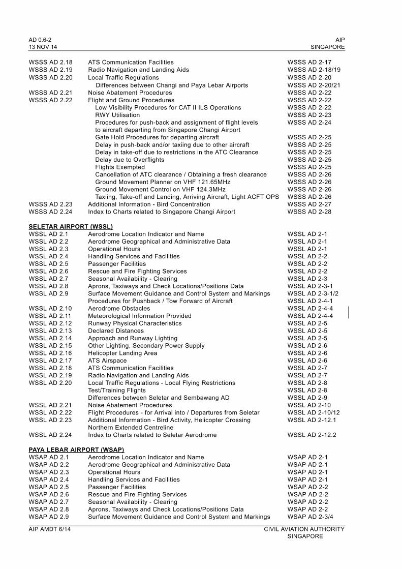
AD 0.6-2 AIP 13 NOV 14 SINGAPORE
WSSS AD 2.18 ATS Communication Facilities WSSS AD 2-17WSSS AD 2.19 Radio Navigation and Landing Aids WSSS AD 2-18/19WSSS AD 2.20 Local Traffic Regulations WSSS AD 2-20
Differences between Changi and Paya Lebar Airports WSSS AD 2-20/21WSSS AD 2.21 Noise Abatement Procedures WSSS AD 2-22WSSS AD 2.22 Flight and Ground Procedures WSSS AD 2-22
Low Visibility Procedures for CAT II ILS Operations WSSS AD 2-22RWY Utilisation WSSS AD 2-23Procedures for push-back and assignment of flight levels WSSS AD 2-24to aircraft departing from Singapore Changi AirportGate Hold Procedures for departing aircraft WSSS AD 2-25Delay in push-back and/or taxiing due to other aircraft WSSS AD 2-25Delay in take-off due to restrictions in the ATC Clearance WSSS AD 2-25Delay due to Overflights WSSS AD 2-25Flights Exempted WSSS AD 2-25Cancellation of ATC clearance / Obtaining a fresh clearance WSSS AD 2-26Ground Movement Planner on VHF 121.65MHz WSSS AD 2-26Ground Movement Control on VHF 124.3MHz WSSS AD 2-26Taxiing, Take-off and Landing, Arriving Aircraft, Light ACFT OPS WSSS AD 2-26
WSSS AD 2.23 Additional Information - Bird Concentration WSSS AD 2-27 WSSS AD 2.24 Index to Charts related to Singapore Changi Airport WSSS AD 2-28
SELETAR AIRPORT (WSSL)WSSL AD 2.1 Aerodrome Location Indicator and Name WSSL AD 2-1WSSL AD 2.2 Aerodrome Geographical and Administrative Data WSSL AD 2-1WSSL AD 2.3 Operational Hours WSSL AD 2-1WSSL AD 2.4 Handling Services and Facilities WSSL AD 2-2WSSL AD 2.5 Passenger Facilities WSSL AD 2-2WSSL AD 2.6 Rescue and Fire Fighting Services WSSL AD 2-2WSSL AD 2.7 Seasonal Availability - Clearing WSSL AD 2-3WSSL AD 2.8 Aprons, Taxiways and Check Locations/Positions Data WSSL AD 2-3-1WSSL AD 2.9 Surface Movement Guidance and Control System and Markings WSSL AD 2-3-1/2
Procedures for Pushback / Tow Forward of Aircraft WSSL AD 2-4-1WSSL AD 2.10 Aerodrome Obstacles WSSL AD 2-4-4WSSL AD 2.11 Meteorological Information Provided WSSL AD 2-4-4WSSL AD 2.12 Runway Physical Characteristics WSSL AD 2-5WSSL AD 2.13 Declared Distances WSSL AD 2-5WSSL AD 2.14 Approach and Runway Lighting WSSL AD 2-5WSSL AD 2.15 Other Lighting, Secondary Power Supply WSSL AD 2-6WSSL AD 2.16 Helicopter Landing Area WSSL AD 2-6WSSL AD 2.17 ATS Airspace WSSL AD 2-6WSSL AD 2.18 ATS Communication Facilities WSSL AD 2-7WSSL AD 2.19 Radio Navigation and Landing Aids WSSL AD 2-7WSSL AD 2.20 Local Traffic Regulations - Local Flying Restrictions WSSL AD 2-8
Test/Training Flights WSSL AD 2-8Differences between Seletar and Sembawang AD WSSL AD 2-9
WSSL AD 2.21 Noise Abatement Procedures WSSL AD 2-10WSSL AD 2.22 Flight Procedures - for Arrival into / Departures from Seletar WSSL AD 2-10/12WSSL AD 2.23 Additional Information - Bird Activity, Helicopter Crossing WSSL AD 2-12.1
Northern Extended CentrelineWSSL AD 2.24 Index to Charts related to Seletar Aerodrome WSSL AD 2-12.2
PAYA LEBAR AIRPORT (WSAP)WSAP AD 2.1 Aerodrome Location Indicator and Name WSAP AD 2-1WSAP AD 2.2 Aerodrome Geographical and Administrative Data WSAP AD 2-1WSAP AD 2.3 Operational Hours WSAP AD 2-1WSAP AD 2.4 Handling Services and Facilities WSAP AD 2-1WSAP AD 2.5 Passenger Facilities WSAP AD 2-2WSAP AD 2.6 Rescue and Fire Fighting Services WSAP AD 2-2WSAP AD 2.7 Seasonal Availability - Clearing WSAP AD 2-2WSAP AD 2.8 Aprons, Taxiways and Check Locations/Positions Data WSAP AD 2-2WSAP AD 2.9 Surface Movement Guidance and Control System and Markings WSAP AD 2-3/4
AIP AMDT 6/14 CIVIL AVIATION AUTHORITYSINGAPORE
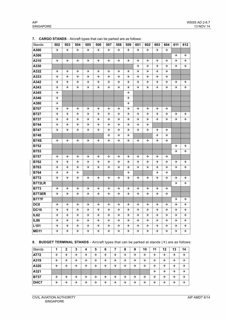
AIP WSSS AD 2-6.7SINGAPORE 13 NOV 14
Stands 502 503 504 505 506 507 508 509 601 602 603 604 611 612
A300
A306
A310
A330
A332
A333
A342
A343
A345
A346
A380
B707
B727
B737
B744
B747
B748
B74S
B752
B753
B757
B762
B763
B764
B772
B772LR
B773
B773ER
B777F
DC8
DC10
IL62
IL86
L101
MD11
7. CARGO STANDS - Aircraft types that can be parked are as follows:
8. BUDGET TERMINAL STANDS - Aircraft types that can be parked at stands () are as follows:
Stands 1 2 3 4 5 6 7 8 9 10 11 12 13 14
AT72
A319
A320
A321
B737
DHC7
CIVIL AVIATION AUTHORITY AIP AMDT 6/14SINGAPORE
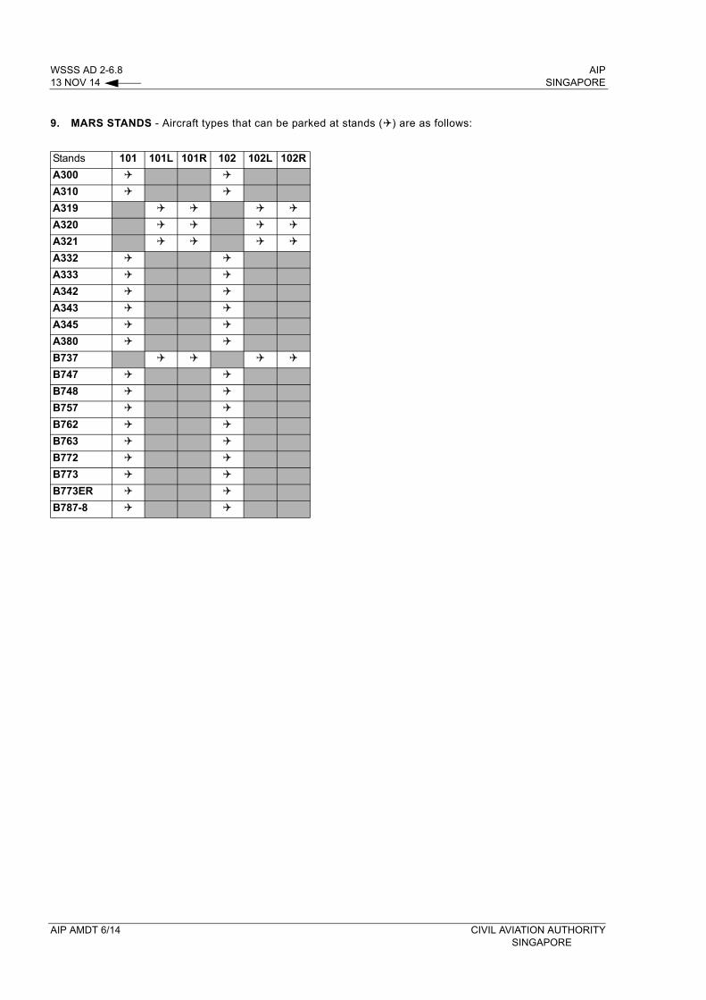
WSSS AD 2-6.8 AIP13 NOV 14 SINGAPORE
9. MARS STANDS - Aircraft types that can be parked at stands () are as follows:
Stands 101 101L 101R 102 102L 102R
A300
A310
A319
A320
A321
A332
A333
A342
A343
A345
A380
B737
B747
B748
B757
B762
B763
B772
B773
B773ER
B787-8
AIP AMDT 6/14 CIVIL AVIATION AUTHORITYSINGAPORE
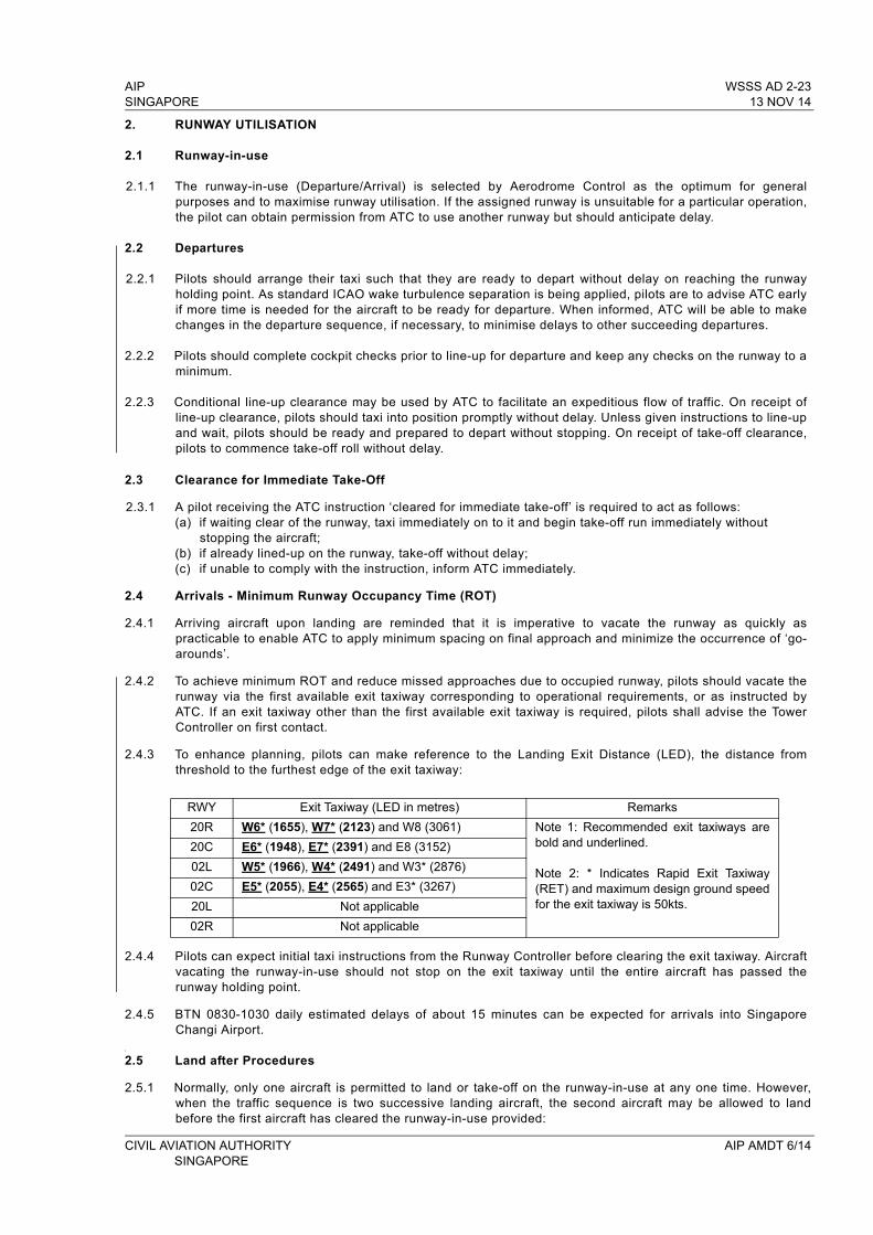
AIP WSSS AD 2-23SINGAPORE 13 NOV 14
2. RUNWAY UTILISATION
2.1 Runway-in-use
2.1.1 The runway-in-use (Departure/Arrival) is selected by Aerodrome Control as the optimum for general purposes and to maximise runway utilisation. If the assigned runway is unsuitable for a particular operation, the pilot can obtain permission from ATC to use another runway but should anticipate delay.
2.2 Departures
2.2.1 Pilots should arrange their taxi such that they are ready to depart without delay on reaching the runway holding point. As standard ICAO wake turbulence separation is being applied, pilots are to advise ATC early if more time is needed for the aircraft to be ready for departure. When informed, ATC will be able to make changes in the departure sequence, if necessary, to minimise delays to other succeeding departures.
2.2.2 Pilots should complete cockpit checks prior to line-up for departure and keep any checks on the runway to a minimum.
2.2.3 Conditional line-up clearance may be used by ATC to facilitate an expeditious flow of traffic. On receipt of line-up clearance, pilots should taxi into position promptly without delay. Unless given instructions to line-up and wait, pilots should be ready and prepared to depart without stopping. On receipt of take-off clearance, pilots to commence take-off roll without delay.
2.3 Clearance for Immediate Take-Off
2.3.1 A pilot receiving the ATC instruction ‘cleared for immediate take-off’ is required to act as follows:(a) if waiting clear of the runway, taxi immediately on to it and begin take-off run immediately without
stopping the aircraft;(b) if already lined-up on the runway, take-off without delay;(c) if unable to comply with the instruction, inform ATC immediately.
2.4 Arrivals - Minimum Runway Occupancy Time (ROT)
2.4.1 Arriving aircraft upon landing are reminded that it is imperative to vacate the runway as quickly as practicable to enable ATC to apply minimum spacing on final approach and minimize the occurrence of ‘go-arounds’.
2.4.2 To achieve minimum ROT and reduce missed approaches due to occupied runway, pilots should vacate the runway via the first available exit taxiway corresponding to operational requirements, or as instructed by ATC. If an exit taxiway other than the first available exit taxiway is required, pilots shall advise the Tower Controller on first contact.
2.4.3 To enhance planning, pilots can make reference to the Landing Exit Distance (LED), the distance from threshold to the furthest edge of the exit taxiway:
RWY Exit Taxiway (LED in metres) Remarks
20R W6* (1655), W7* (2123) and W8 (3061) Note 1: Recommended exit taxiways are bold and underlined.
Note 2: * Indicates Rapid Exit Taxiway (RET) and maximum design ground speed for the exit taxiway is 50kts.
20C E6* (1948), E7* (2391) and E8 (3152)
02L W5* (1966), W4* (2491) and W3* (2876)
02C E5* (2055), E4* (2565) and E3* (3267)
20L Not applicable
02R Not applicable
2.4.4 Pilots can expect initial taxi instructions from the Runway Controller before clearing the exit taxiway. Aircraft vacating the runway-in-use should not stop on the exit taxiway until the entire aircraft has passed the runway holding point.
2.4.5 BTN 0830-1030 daily estimated delays of about 15 minutes can be expected for arrivals into Singapore Changi Airport.
2.5 Land after Procedures
2.5.1 Normally, only one aircraft is permitted to land or take-off on the runway-in-use at any one time. However, when the traffic sequence is two successive landing aircraft, the second aircraft may be allowed to land before the first aircraft has cleared the runway-in-use provided:
CIVIL AVIATION AUTHORITY AIP AMDT 6/14 SINGAPORE
WSSS AD 2-24 AIP13 NOV 14 SINGAPORE
(a) the runway is long enough;(b) during daylight hours;(c) the second aircraft will be able to see the first aircraft clearly and continuously until it is clear of the
runway;(d) the second aircraft has been warned.
2.5.2 ATC will provide this warning in the landing clearance as shown in para 2.7.
2.5.3 Responsibility for ensuring adequate separation between the two aircraft rests with the pilot of the second aircraft.
2.6 Special Landing Procedures
2.6.1 Special landing procedures may be in force at Singapore Changi Airport in conditions shown as follows:(a) When the runway-in-use is temporarily occupied by other traffic, landing clearance may be issued to an
arriving aircraft provided that at the time the aircraft crosses the threshold of the runway-in-use the following separation distances will exist:
i) Landing following landingThe preceding landing aircraft will be clear of the runway-in-use or will be at least 2,500m from the threshold of the runway-in-use.
ii) Landing following departureThe departing aircraft will be airborne and at least 2,500m from the threshold of the runway-in-use, or if not airborne, will be at least 2,500m from the threshold of the runway-in-use.
2.6.2 These procedures will be used only under the following conditions:(a) during daylight hours;(b) visibility of at least 5km;(c) cloud ceiling of 1,500ft in the departure/missed approach area;(d) ATC is satisfied that the pilot of the next arriving aircraft will be able to observe continuously the relevant
traffic;(e) no unfavourable surface wind conditions (including significant tailwind, windshear, turbulence, etc.);(f) when the runway is dry and free of all precipitants such that there is no evidence that the braking action
may be adversely affected.
2.7 Phraseology
2.7.1 When issuing a landing clearance following the application of these procedures, ATC will issue the second aircraft with the following instructions:
.... (Callsign) ... after the landing / departing .... (Aircraft Type) Runway .....(Designator) cleared to land.
3. PROCEDURES FOR PUSH BACK AND ASSIGNMENT OF FLIGHT LEVELS TO AIRCRAFT DEPARTING FROM SINGAPORE CHANGI AIRPORT
3.1 Aircraft departing from Singapore Changi Airport shall adhere to the procedures for push back and assignment of flight levels.
3.2 Assignment of flight levels to departing aircraft is made on a first-come-first-served basis. Aircraft will normally be assigned the level requested unless an alternate level is offered after coordination with the adjacent ATC centres.
3.3 Departing flights from Singapore requesting FL280 or FL320 on L759, M770, N571, N571/N877 or P628 will be cleared as follows:a) aircraft departing Singapore will be cleared to FL280;b) succeeding aircraft on the same route will be cleared to FL280 with 10 min longitudinal separation
provided there is no closing speed with the preceding aircraft;c) additional longitudinal separation as appropriate shall be provided by ATC for the faster aircraft following
a slower aircraft on the same route;d) the first aircraft from either Singapore or Kuala Lumpur to be over GUNIP on N571 or N571/N877, the
Kuala Lumpur/Bangkok FIR boundary on M770 or L759 and VPL on P628 can expect its requested flight level.
3.4 To avoid confusion, pilots shall use the correct phraseology as detailed in para 3.5 when ready for push back.
AIP AMDT 6/14 CIVIL AVIATION AUTHORITY SINGAPORE
AIP WSSS AD 2-25SINGAPORE 13 NOV 14
3.5 The pilot shall notify ATC when the aircraft is ready to push back within 5 minutes using the following phraseology:- callsign- destination- proposed flight level and alternate level, if any- parking position
3.6 On receipt of the “ready to push back” call, ATC will advise the pilot whether the proposed flight level or other alternate flight level is available and an ATC clearance will be issued accordingly. If pre-departure coordination with an adjacent unit or centre is required, the pilot will be instructed to standby.
3.7 Once the flight level is accepted by the pilot and an ATC clearance issued, the aircraft must be pushed back within 5 minutes from the time the ATC clearance is accepted unless other ATC restrictions are imposed. The ATC clearance will be cancelled on expiry of the 5 minutes grace period.
3.8 At the end of the push back, the departing aircraft must have all engines started and be ready to taxi immediately, unless otherwise instructed by ATC.
Note: The first aircraft to taxi may not necessarily be the first aircraft to take-off as distances between aircraft stands and the departure runway vary.
4. GATE HOLD PROCEDURES FOR DEPARTING AIRCRAFT
4.1 Whenever there are about five to seven departing aircraft at the RWY holding point, subsequent push-backs of departures will be regulated such that the Ground Movement Planner (GMP) on VHF frequency 121.65MHz will start to issue pilots with Expected Pushback Time (EPT). The determination of EPT will take into account an aircraft’s parking stand as well as taxi time to the RWY-in-use holding point.
4.2 When an EPT is issued, pilots will be instructed to either remain on GMP frequency or to monitor Singapore Ground Control (frequencies 124.3MHz or 121.725MHz). It should be noted that when instructed to monitor Singapore Ground frequencies, pilots shall not establish contact with the Singapore Ground Control, rather, pilots shall maintain a listening watch on the assigned Singapore Ground Control frequency and wait for pushback instruction. This is to prevent unnecessary frequency congestion.
4.3 A flight issued with an EPT but chooses to commence pushback before the assigned time will be allowed to do so. However, the flight should not expect an earlier departure time as the planned departure sequences will be maintained.
4.4 In a situation when a departing aircraft is occupying a gate that has been assigned to an arriving aircraft, the departing aircraft will be instructed by the GMP to contact Singapore Ground for pushback for the purpose of better gate utilization.
4.5 To maximize runway utilization, departure sequence will be planned on the basis of increasing runway throughput so as to enhance overall efficiency.
5. DELAY IN PUSH BACK AND/OR TAXIING DUE TO OTHER AIRCRAFT
5.1 Delays may be expected for the second aircraft to push back and to taxi when two or more aircraft are parked either adjacent to one another or close together. However, it will retain its ATC clearance even if the 5 minutes grace period allowed for under para 3.7 is exceeded.
6. DELAY IN TAKE-OFF DUE TO RESTRICTIONS IN THE ATC CLEARANCE
6.1 The ATC clearance may require an aircraft to arrive at a reporting point at a specified time and level or to depart a number of minutes behind a preceding traffic to establish longitudinal separation. Such a delay will not deprive a departing aircraft of its ATC clearance even though the 5 minutes grace period would have been exceeded.
7. DELAY DUE TO OVERFLIGHTS
7.1 These are flights operating through Singapore FIR without landing at Singapore Changi Airport. Depending on their positions, a departing aircraft requesting the same level may have to accept an alternate level or may have to delay its departure in order to establish the prescribed separation.
CIVIL AVIATION AUTHORITY AIP AMDT 6/14SINGAPORE
WSSS AD 2-26 AIP13 NOV 14 SINGAPORE
8. FLIGHTS EXEMPTED
8.1 The above procedures are not applicable to VIP, CASEVAC, SAR and other special tasks aircraft. ATC shall have full discretion in the conduct of such operations.
9. CANCELLATION OF ATC CLEARANCE / OBTAINING A FRESH CLEARANCE
9.1 A departing aircraft may have its ATC clearance cancelled under the following circumstances:a) on expiry of the 5 minutes grace period under para 3.7, it is still unable to push back; or b) after pushing back, the pilot advises that it is returning to blocks; or c) it develops a technical problem and is unable to continue taxiing.
9.2 ATC will inform the aircraft when a clearance is cancelled using the phraseology;“(Callsign of aircraft) your ATC clearance is cancelled (reason)”
9.3 Pilots who are ready to depart following the cancellation of an ATC clearance will adopt the normal procedures as if it is the first time they are ready to depart.
10. GROUND MOVEMENT PLANNER ON VHF 121.65MHz
10.1 The frequency shall be used for aircraft pre-flight checks and ATC clearances. Pilot-in-command to make his initial call from the parked position on this frequency.
11. GROUND MOVEMENT CONTROL ON VHF 124.3MHz
11.1 This frequency shall be used for aircraft start-up/push-back clearance.
11.2 Unless otherwise instructed by ATC, the pilot-in-command shall prior to starting engines listen out on the Ground Movement Control frequency on 124.3MHz.
11.3 The pilot-in-command shall:
a) Request and obtain taxi instructions prior to taxiing;Note: ATC clearance, including the assigned SSR code will normally be issued prior to push back. Pilot shall squawk the SSR code immediately when airborne.
b) Change from Ground Movement Control frequency to the Runway Control frequency (118.6MHz) when nearing the taxiway holding position;
c) Request for take-off clearance on 118.6MHz.
11.4 The pilot-in-command stopping for a pre-flight check at the taxiway holding position shall change over from 124.3MHz to 118.6MHz and request for further clearance before recommencing taxiing.
11.5 Departing aircraft will be instructed when to change from 118.6MHz to Singapore Approach frequency of 120.3MHz.
11.6 In the case of the aircraft having landed, the pilot-in-command shall change from 118.6MHz to 124.3MHz immediately after clearing the runway. He shall maintain watch on 124.3MHz for taxiing and parking instructions until he arrives at his aircraft stand.
12. TAXIING
12.1 Taxi clearance given by Ground Movement Control will relate to movement on the manoeuvring area, but excluding the marshalling area.
12.2 Aircraft taxiing on the manoeuvring area will be regulated by ATC to avoid or reduce possible conflict and will be provided with traffic information and alerting service. ATC shall apply taxiing clearance limits whenever necessary.
12.3 The taxiway routes to be used by aircraft after landing or when taxiing for departure will be specified by ATC. The issuance by ATC of a taxi route to an aircraft does not relieve the pilot-in-command of the responsibility to maintain separation with other aircraft on the manoeuvring area or to comply with ATC directions intended to regulate aircraft on the manoeuvring area.
AIP AMDT 6/14 CIVIL AVIATION AUTHORITY SINGAPORE
AIP WSSS AD 2-27SINGAPORE 13 NOV 14
12.4 Pilots are reminded to always use minimum power when starting engines, when manoeuvring within the apron area or when manoeuvring from apron taxiways to other parts of the aerodrome. It is especially critical when commencing to taxi that break-away thrusts are kept to an absolute minimum and then be reduced to idle thrusts as soon as possible.
13. TAKE-OFF AND LANDING
13.1 Departing aircraft will normally be directed by ATC to use the full length of the runway for take-off. On obtaining an ATC clearance the aircraft shall enter the runway via designated taxiways:
RWY 02C - TWY E10 or E11RWY 02L - TWY W8, W9 or W10RWY 20C - TWY E1, E2RWY 20R - TWY W1, W2
13.2 The pilot-in-command shall not take-off or land without a clearance from Aerodrome Control.
13.3 The pilot-in-command shall not run-up on the runway in use unless authorised by Aerodrome Control. Engine run-ups in the holding pan or taxiway holding point clear of the runway in use may be carried out subject to approval by Aerodrome Control.
13.4 After landing, the pilot-in-command shall vacate the runway by the shortest suitable route and to contact Ground Control who will issue specific taxi route instructions to its assigned aircraft stand.
13.5 Aircraft with radio communication failure shall vacate the runway and stop on the taxiway and watch for light signals from Aerodrome Control.
14. ARRIVING AIRCRAFT
14.1 The pilot-in-command of an arriving aircraft shall contact the appropriate Approach Control Unit 10 minutes before entering the CTR or ATZ.
15. LIGHT AIRCRAFT OPERATIONS
15.1 Light aircraft operations into and out of Singapore Changi Airport may be approved subject to the following conditions:
a) Prior permission has been granted;b) Aircraft is suitably equipped;c) Pilot is appropriately rated;d) Subject to ATC.
15.2 Flight notification shall be given by filing a flight plan.
15.3 All such operations will be regulated in accordance with IFR procedures.
WSSS AD 2.23 ADDITIONAL INFORMATION
1. BIRD CONCENTRATION IN THE VICINITY OF THE AIRPORT
1.1 A number of varieties of birds are found in Singapore throughout the year. The larger birds commonly found in Singapore Changi Airport include the following:
- cattle egrets (weighing approximately 300g each)- grey herons (weighing approximately 500g each)- brahminy kites (weighing approximately 600g each)
1.2 There could be an increase in bird activities during the migratory months of September to April. During this period, migratory birds may use the airport as their feeding ground.
CIVIL AVIATION AUTHORITY AIP AMDT 6/14SINGAPORE
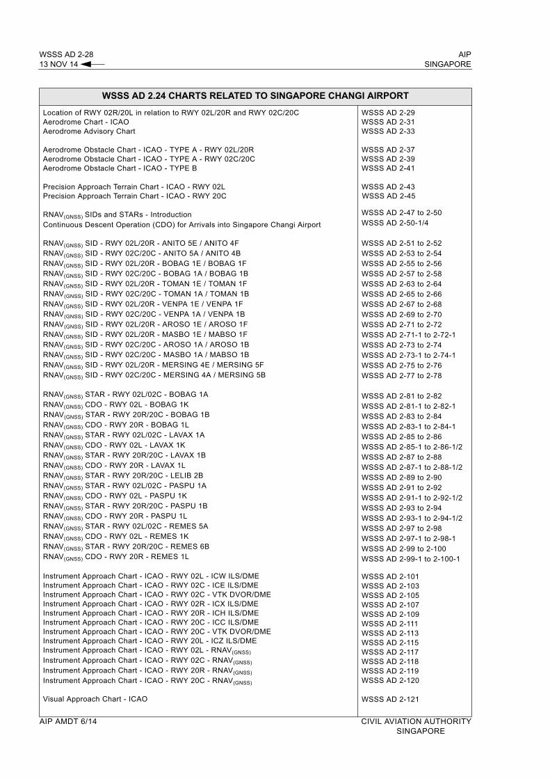
WSSS AD 2-28 AIP13 NOV 14 SINGAPORE
WSSS AD 2.24 CHARTS RELATED TO SINGAPORE CHANGI AIRPORT
Location of RWY 02R/20L in relation to RWY 02L/20R and RWY 02C/20CAerodrome Chart - ICAOAerodrome Advisory Chart
Aerodrome Obstacle Chart - ICAO - TYPE A - RWY 02L/20RAerodrome Obstacle Chart - ICAO - TYPE A - RWY 02C/20CAerodrome Obstacle Chart - ICAO - TYPE B
Precision Approach Terrain Chart - ICAO - RWY 02LPrecision Approach Terrain Chart - ICAO - RWY 20C
RNAV(GNSS) SIDs and STARs - IntroductionContinuous Descent Operation (CDO) for Arrivals into Singapore Changi Airport
RNAV(GNSS) SID - RWY 02L/20R - ANITO 5E / ANITO 4FRNAV(GNSS) SID - RWY 02C/20C - ANITO 5A / ANITO 4BRNAV(GNSS) SID - RWY 02L/20R - BOBAG 1E / BOBAG 1FRNAV(GNSS) SID - RWY 02C/20C - BOBAG 1A / BOBAG 1BRNAV(GNSS) SID - RWY 02L/20R - TOMAN 1E / TOMAN 1FRNAV(GNSS) SID - RWY 02C/20C - TOMAN 1A / TOMAN 1BRNAV(GNSS) SID - RWY 02L/20R - VENPA 1E / VENPA 1FRNAV(GNSS) SID - RWY 02C/20C - VENPA 1A / VENPA 1BRNAV(GNSS) SID - RWY 02L/20R - AROSO 1E / AROSO 1FRNAV(GNSS) SID - RWY 02L/20R - MASBO 1E / MABSO 1FRNAV(GNSS) SID - RWY 02C/20C - AROSO 1A / AROSO 1BRNAV(GNSS) SID - RWY 02C/20C - MASBO 1A / MABSO 1BRNAV(GNSS) SID - RWY 02L/20R - MERSING 4E / MERSING 5FRNAV(GNSS) SID - RWY 02C/20C - MERSING 4A / MERSING 5B
RNAV(GNSS) STAR - RWY 02L/02C - BOBAG 1A RNAV(GNSS) CDO - RWY 02L - BOBAG 1KRNAV(GNSS) STAR - RWY 20R/20C - BOBAG 1B RNAV(GNSS) CDO - RWY 20R - BOBAG 1LRNAV(GNSS) STAR - RWY 02L/02C - LAVAX 1A RNAV(GNSS) CDO - RWY 02L - LAVAX 1KRNAV(GNSS) STAR - RWY 20R/20C - LAVAX 1BRNAV(GNSS) CDO - RWY 20R - LAVAX 1LRNAV(GNSS) STAR - RWY 20R/20C - LELIB 2BRNAV(GNSS) STAR - RWY 02L/02C - PASPU 1A RNAV(GNSS) CDO - RWY 02L - PASPU 1KRNAV(GNSS) STAR - RWY 20R/20C - PASPU 1BRNAV(GNSS) CDO - RWY 20R - PASPU 1L RNAV(GNSS) STAR - RWY 02L/02C - REMES 5ARNAV(GNSS) CDO - RWY 02L - REMES 1K RNAV(GNSS) STAR - RWY 20R/20C - REMES 6BRNAV(GNSS) CDO - RWY 20R - REMES 1L
Instrument Approach Chart - ICAO - RWY 02L - ICW ILS/DMEInstrument Approach Chart - ICAO - RWY 02C - ICE ILS/DMEInstrument Approach Chart - ICAO - RWY 02C - VTK DVOR/DMEInstrument Approach Chart - ICAO - RWY 02R - ICX ILS/DMEInstrument Approach Chart - ICAO - RWY 20R - ICH ILS/DMEInstrument Approach Chart - ICAO - RWY 20C - ICC ILS/DMEInstrument Approach Chart - ICAO - RWY 20C - VTK DVOR/DMEInstrument Approach Chart - ICAO - RWY 20L - ICZ ILS/DMEInstrument Approach Chart - ICAO - RWY 02L - RNAV(GNSS)
Instrument Approach Chart - ICAO - RWY 02C - RNAV(GNSS)
Instrument Approach Chart - ICAO - RWY 20R - RNAV(GNSS)
Instrument Approach Chart - ICAO - RWY 20C - RNAV(GNSS)
Visual Approach Chart - ICAO
WSSS AD 2-29WSSS AD 2-31WSSS AD 2-33
WSSS AD 2-37WSSS AD 2-39WSSS AD 2-41
WSSS AD 2-43WSSS AD 2-45
WSSS AD 2-47 to 2-50WSSS AD 2-50-1/4
WSSS AD 2-51 to 2-52WSSS AD 2-53 to 2-54WSSS AD 2-55 to 2-56WSSS AD 2-57 to 2-58WSSS AD 2-63 to 2-64WSSS AD 2-65 to 2-66WSSS AD 2-67 to 2-68WSSS AD 2-69 to 2-70WSSS AD 2-71 to 2-72WSSS AD 2-71-1 to 2-72-1WSSS AD 2-73 to 2-74WSSS AD 2-73-1 to 2-74-1WSSS AD 2-75 to 2-76WSSS AD 2-77 to 2-78
WSSS AD 2-81 to 2-82WSSS AD 2-81-1 to 2-82-1WSSS AD 2-83 to 2-84WSSS AD 2-83-1 to 2-84-1WSSS AD 2-85 to 2-86WSSS AD 2-85-1 to 2-86-1/2WSSS AD 2-87 to 2-88WSSS AD 2-87-1 to 2-88-1/2WSSS AD 2-89 to 2-90WSSS AD 2-91 to 2-92WSSS AD 2-91-1 to 2-92-1/2WSSS AD 2-93 to 2-94WSSS AD 2-93-1 to 2-94-1/2WSSS AD 2-97 to 2-98WSSS AD 2-97-1 to 2-98-1WSSS AD 2-99 to 2-100WSSS AD 2-99-1 to 2-100-1
WSSS AD 2-101WSSS AD 2-103WSSS AD 2-105WSSS AD 2-107WSSS AD 2-109WSSS AD 2-111WSSS AD 2-113WSSS AD 2-115WSSS AD 2-117WSSS AD 2-118WSSS AD 2-119WSSS AD 2-120
WSSS AD 2-121
AIP AMDT 6/14 CIVIL AVIATION AUTHORITY SINGAPORE
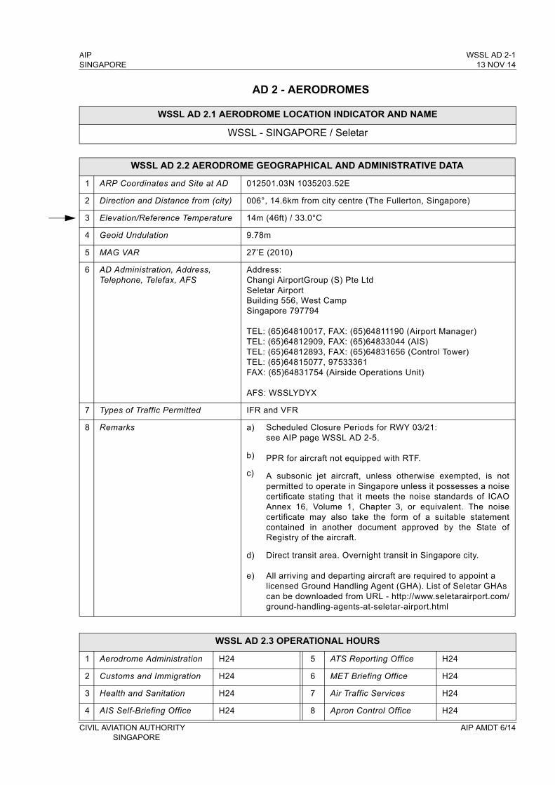
AIP WSSL AD 2-1SINGAPORE 13 NOV 14
AD 2 - AERODROMES
WSSL AD 2.1 AERODROME LOCATION INDICATOR AND NAME
WSSL - SINGAPORE / Seletar
WSSL AD 2.2 AERODROME GEOGRAPHICAL AND ADMINISTRATIVE DATA
1 ARP Coordinates and Site at AD 012501.03N 1035203.52E
2 Direction and Distance from (city) 006°, 14.6km from city centre (The Fullerton, Singapore)
3 Elevation/Reference Temperature 14m (46ft) / 33.0°C
4 Geoid Undulation 9.78m
5 MAG VAR 27’E (2010)
6 AD Administration, Address, Telephone, Telefax, AFS
Address:Changi AirportGroup (S) Pte LtdSeletar AirportBuilding 556, West CampSingapore 797794
TEL: (65)64810017, FAX: (65)64811190 (Airport Manager)TEL: (65)64812909, FAX: (65)64833044 (AIS)TEL: (65)64812893, FAX: (65)64831656 (Control Tower)TEL: (65)64815077, 97533361FAX: (65)64831754 (Airside Operations Unit)
AFS: WSSLYDYX
7 Types of Traffic Permitted IFR and VFR
8 Remarks a)
b)
c)
d)
e)
Scheduled Closure Periods for RWY 03/21: see AIP page WSSL AD 2-5.
PPR for aircraft not equipped with RTF.
A subsonic jet aircraft, unless otherwise exempted, is not permitted to operate in Singapore unless it possesses a noise certificate stating that it meets the noise standards of ICAO Annex 16, Volume 1, Chapter 3, or equivalent. The noise certificate may also take the form of a suitable statement contained in another document approved by the State of Registry of the aircraft.
Direct transit area. Overnight transit in Singapore city.
All arriving and departing aircraft are required to appoint a licensed Ground Handling Agent (GHA). List of Seletar GHAs can be downloaded from URL - http://www.seletarairport.com/ground-handling-agents-at-seletar-airport.html
WSSL AD 2.3 OPERATIONAL HOURS
1 Aerodrome Administration H24 5 ATS Reporting Office H24
2 Customs and Immigration H24 6 MET Briefing Office H24
3 Health and Sanitation H24 7 Air Traffic Services H24
4 AIS Self-Briefing Office H24 8 Apron Control Office H24
CIVIL AVIATION AUTHORITY AIP AMDT 6/14 SINGAPORE
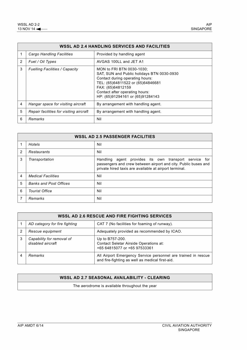
WSSL AD 2-2 AIP13 NOV 14 SINGAPORE
WSSL AD 2.4 HANDLING SERVICES AND FACILITIES
1 Cargo Handling Facilities Provided by handling agent
2 Fuel / Oil Types AVGAS 100LL and JET A1
3 Fuelling Facilities / Capacity MON to FRI BTN 0030-1030; SAT, SUN and Public holidays BTN 0030-0930Contact during operating hours:TEL: (65)64811522 or (65)64846681FAX: (65)64812159Contact after operating hours:HP: (65)91294161 or (65)91284143
4 Hangar space for visiting aircraft By arrangement with handling agent.
5 Repair facilities for visiting aircraft By arrangement with handling agent.
6 Remarks Nil
WSSL AD 2.5 PASSENGER FACILITIES
1 Hotels Nil
2 Restaurants Nil
3 Transportation Handling agent provides its own transport service for passengers and crew between airport and city. Public buses and private hired taxis are available at airport terminal.
4 Medical Facilities Nil
5 Banks and Post Offices Nil
6 Tourist Office Nil
7 Remarks Nil
WSSL AD 2.6 RESCUE AND FIRE FIGHTING SERVICES
1 AD category for fire fighting CAT 7 (No facilities for foaming of runway).
2 Rescue equipment Adequately provided as recommended by ICAO.
3 Capability for removal of disabled aircraft
Up to B757-200.Contact Seletar Airside Operations at:+65 64815077 or +65 97533361
4 Remarks All Airport Emergency Service personnel are trained in rescue and fire-fighting as well as medical first-aid.
WSSL AD 2.7 SEASONAL AVAILABILITY - CLEARING
The aerodrome is available throughout the year
AIP AMDT 6/14 CIVIL AVIATION AUTHORITYSINGAPORE
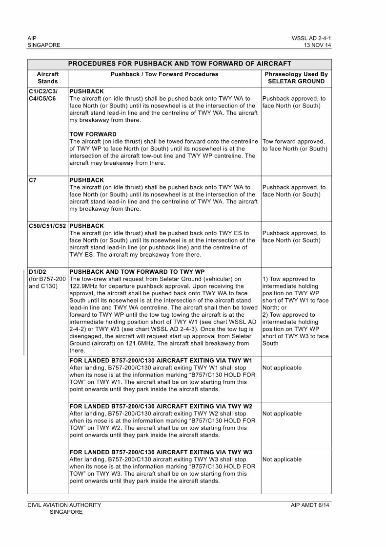
AIP WSSL AD 2-4-1SINGAPORE 13 NOV 14
PROCEDURES FOR PUSHBACK AND TOW FORWARD OF AIRCRAFT
AircraftStands
Pushback / Tow Forward Procedures Phraseology Used By SELETAR GROUND
C1/C2/C3/C4/C5/C6
PUSHBACKThe aircraft (on idle thrust) shall be pushed back onto TWY WA to face North (or South) until its nosewheel is at the intersection of the aircraft stand lead-in line and the centreline of TWY WA. The aircraft my breakaway from there.
TOW FORWARDThe aircraft (on idle thrust) shall be towed forward onto the centreline of TWY WP to face North (or South) until its nosewheel is at the intersection of the aircraft tow-out line and TWY WP centreline. The aircraft may breakaway from there.
Pushback approved, to face North (or South)
Tow forward approved, to face North (or South)
C7 PUSHBACKThe aircraft (on idle thrust) shall be pushed back onto TWY WA to face North (or South) until its nosewheel is at the intersection of the aircraft stand lead-in line and the centreline of TWY WA. The aircraft my breakaway from there.
Pushback approved, to face North (or South)
C50/C51/C52 PUSHBACKThe aircraft (on idle thrust) shall be pushed back onto TWY ES to face North (or South) until its nosewheel is at the intersection of the aircraft stand lead-in line (or pushback line) and the centreline of TWY ES. The aircraft my breakaway from there.
Pushback approved, to face North (or South)
D1/D2(for B757-200 and C130)
PUSHBACK AND TOW FORWARD TO TWY WPThe tow-crew shall request from Seletar Ground (vehicular) on 122.9MHz for departure pushback approval. Upon receiving the approval, the aircraft shall be pushed back onto TWY WA to face South until its nosewheel is at the intersection of the aircraft stand lead-in line and TWY WA centreline. The aircraft shall then be towed forward to TWY WP until the tow tug towing the aircraft is at the intermediate holding position short of TWY W1 (see chart WSSL AD 2-4-2) or TWY W3 (see chart WSSL AD 2-4-3). Once the tow tug is disengaged, the aircraft will request start up approval from Seletar Ground (aircraft) on 121.6MHz. The aircraft shall breakaway from there.
1) Tow approved to intermediate holding position on TWY WP short of TWY W1 to face North; or2) Tow approved to intermediate holding position on TWY WP short of TWY W3 to face South
FOR LANDED B757-200/C130 AIRCRAFT EXITING VIA TWY W1After landing, B757-200/C130 aircraft exiting TWY W1 shall stop when its nose is at the information marking “B757/C130 HOLD FOR TOW” on TWY W1. The aircraft shall be on tow starting from this point onwards until they park inside the aircraft stands.
Not applicable
FOR LANDED B757-200/C130 AIRCRAFT EXITING VIA TWY W2After landing, B757-200/C130 aircraft exiting TWY W2 shall stop when its nose is at the information marking “B757/C130 HOLD FOR TOW” on TWY W2. The aircraft shall be on tow starting from this point onwards until they park inside the aircraft stands.
Not applicable
FOR LANDED B757-200/C130 AIRCRAFT EXITING VIA TWY W3After landing, B757-200/C130 aircraft exiting TWY W3 shall stop when its nose is at the information marking “B757/C130 HOLD FOR TOW” on TWY W3. The aircraft shall be on tow starting from this point onwards until they park inside the aircraft stands.
Not applicable
CIVIL AVIATION AUTHORITY AIP AMDT 6/14SINGAPORE
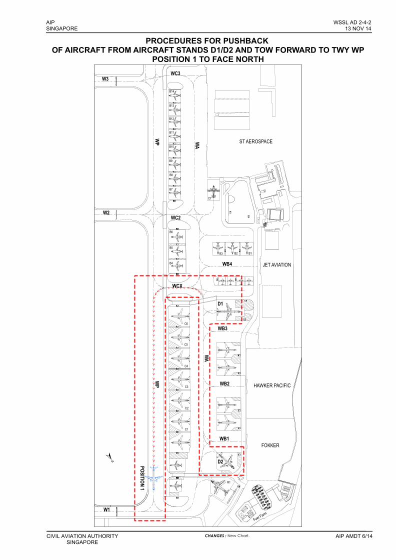
WC3
WC2
W3
W2
WB4
WB3
WB2
WCX
WB1
W1
D1
C6
C5
C4
C3
C2
C1
D2
R1
POSITION 1
HAWKER PACIFIC
FOKKER
JET AVIATION
ST AEROSPACE
WA
WP
WA
WP
Fuel Farm
B4
B5
B6
B7
B8
B9
B10
B11
B14
B13
B12
C7
B3 B2 B1
CIVIL AVIATION AUTHORITYSINGAPORE
AIP AMDT 6/14
AIPSINGAPORE
WSSL AD 2-4-213 NOV 14
CHANGES : New Chart.
PROCEDURES FOR PUSHBACK OF AIRCRAFT FROM AIRCRAFT STANDS D1/D2 AND TOW FORWARD TO TWY WP
POSITION 1 TO FACE NORTH
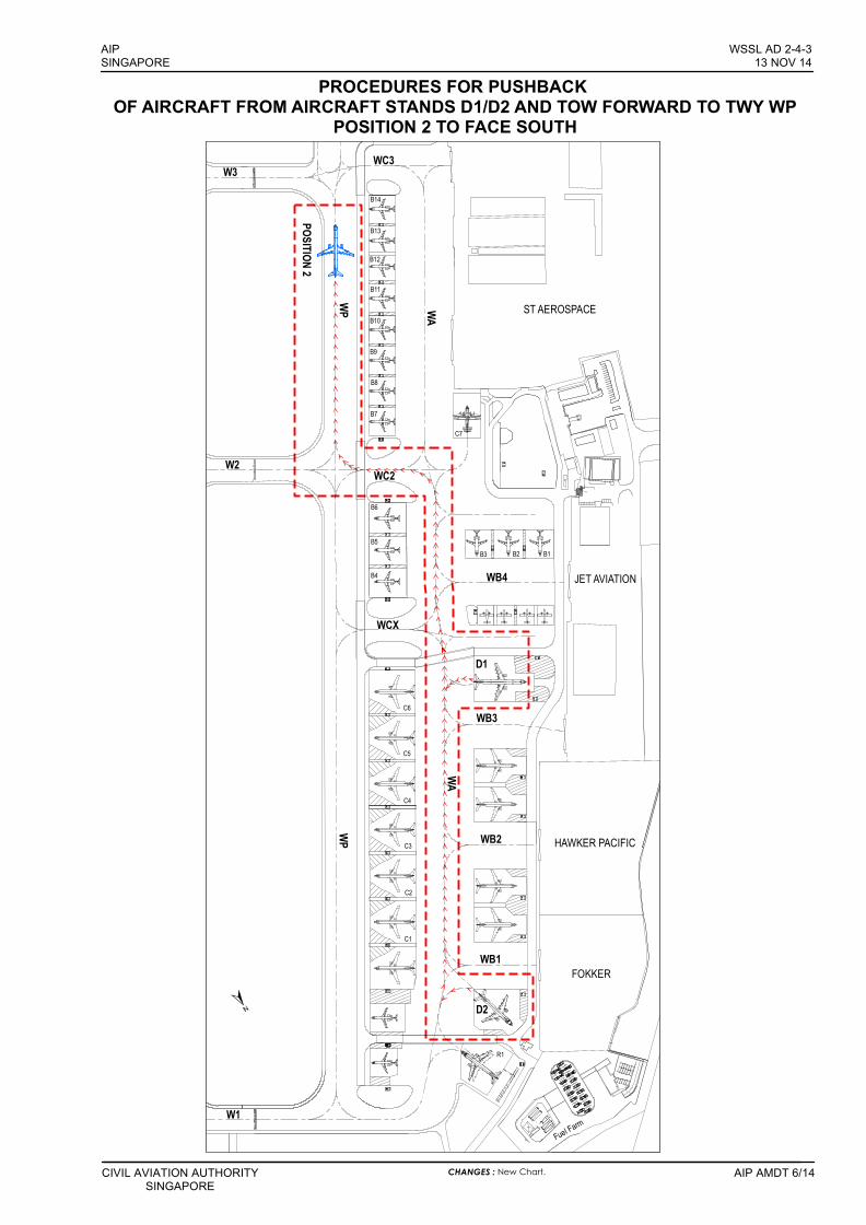
WC3
WC2
W3
W2
WB4
WB3
WB2
WCX
WB1
W1
D1
C6
C5
C4
C3
C2
C1
D2
R1
POSITION 2
HAWKER PACIFIC
FOKKER
JET AVIATION
ST AEROSPACE
WA
WP
WA
WP
Fuel Farm
B4
B5
B6
B7
B8
B9
B10
B11
B14
B13
B12
C7
B3 B2 B1
CIVIL AVIATION AUTHORITYSINGAPORE
AIP AMDT 6/14
AIPSINGAPORE
WSSL AD 2-4-313 NOV 14
CHANGES : New Chart.
PROCEDURES FOR PUSHBACK OF AIRCRAFT FROM AIRCRAFT STANDS D1/D2 AND TOW FORWARD TO TWY WP
POSITION 2 TO FACE SOUTH
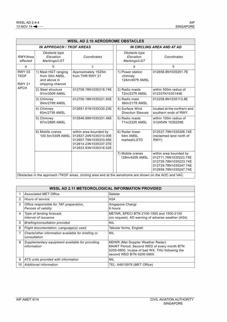
WSSL AD 2-4-4 AIP13 NOV 14 SINGAPORE
WSSL AD 2.10 AERODROME OBSTACLES
IN APPROACH / TKOF AREAS IN CIRCLING AREA AND AT AD
RWY/Area affected
Obstacle typeElevation
Markings/LGTCoordinates
Obstacle typeElevation
Markings/LGTCoordinates
a b c a b
RWY 03 TKOF
RWY 21 APCH
1) Mast HGT ranging from 30m AMSL and above in shipping channel
Approximately 1525m from THR RWY 21
1) Power station chimney124m/407ft AMSL
012656.8N1035251.7E
2) Steel structure 91m/300ft AMSL
012709.78N1035318.74E 2) Radio masts72m/237ft AMSL
within 500m radius of 012337N1035144E
3) Chimney 84m/276ft AMSL
012700.18N1035321.93E 3) Radio mast66m/217ft AMSL
012258.8N1035113.8E
4) Chimney 83m/273ft AMSL
012651.81N1035330.23E 4) Surface Wind Direction Sleeves
located at the northern and southern ends of RWY.
5) Chimney 87m/286ft AMSL
012646.99N1035331.46E 5) Radio masts71m/232ft AMSL
within 100m radius of 012454N 1035259E
6) Mobile cranes 100.5m/330ft AMSL
within area bounded by 012627.24N1035313.00E012607.79N1035333.95E012614.23N1035337.07E012623.93N1035316.02E
6) Radar tower54m AMSLmarked/LGTD
012537.79N1035306.74E (reclaimed land north of RWY)
7) Mobile cranes128m/420ft AMSL
within area bounded by012711.78N1035223.74E012729.78N1035223.74E012729.78N1035247.74E012656.78N1035247.74E
Obstacles in the approach /TKOF areas, circling area and at the aerodrome are shown on the AOC and VAC.
WSSL AD 2.11 METEOROLOGICAL INFORMATION PROVIDED
1 Associated MET Office Seletar
2 Hours of service H24
3 Office responsible for TAF preparation, Periods of validity
Singapore Changi9 hours
4 Type of landing forecast, Interval of issuance
METAR, SPECI BTN 2100-1500 and 1500-2100 (on request). AD warning of adverse weather (H24)
5 Briefing/consultation provided NIL
6 Flight documentation, Language(s) used Tabular forms, English
7 Charts/other information available for briefing or consultation
NIL
8 Supplementary equipment available for providing information
MDWR (Met Doppler Weather Radar) MAINT Period: Second WED of every month BTN 0200-0900. Incase of bad WX, THU following the second WED BTN 0200-0900.
9 ATS units provided with information NIL
10 Additional information TEL: 64815978 (MET Office)
AIP AMDT 6/14 CIVIL AVIATION AUTHORITYSINGAPORE
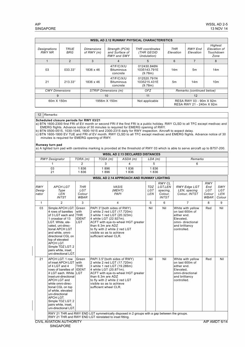
AIP WSSL AD 2-5SINGAPORE 13 NOV 14
WSSL AD 2.12 RUNWAY PHYSICAL CHARACTERISTICS
DesignationsRWY NR
TRUE BRG
Dimensions of RWY (m)
Strength (PCN) and Surface of RWY and SWY
THR coordinates (THR GEOID Undulation)
THR Elevation
RWY End Elevation
Highest Elevation of Touchdown
Zone
1 2 3 4 5 6 7 8
03 033.33° 1836 x 4647/F/C/X/UBituminous
concrete
012430.846N1035143.791E
(9.78m)14m 5m 14m
21 213.33° 1836 x 4647/F/C/X/UBituminous
concrete
012520.791N1035215.431E
(9.78m)5m 14m 10m
CWY Dimensions STRIP Dimensions (m) OFZ Remarks (continued below)
9 10 11 12
60m X 150m 1956m X 150m Not applicable RESA RWY 03 - 90m X 92m RESA RWY 21 - 240m X 92m
12 Remarks:
Scheduled closure periods for RWY 03/21a) BTN 1600-2300 first FRI of EV month or second FRI if the first FRI is a public holiday. RWY CLSD to all TFC except medivac and
EMERG flights. Advance notice of 30 minutes is required for EMERG opening of RWY.b) BTN 0500-0515, 1030-1045, 1600-1615 and 2300-2315 daily for RWY inspection. Aircraft to expect delay.c) BTN 1600-1800 EV TUE and FRI of EV month. RWY CLSD to all TFC except medivac and EMERG flights. Advance notice of 30
minutes is required for EMERG opening of RWY.
Runway turn pada) A lighted turn pad with centreline marking is provided at the threshold of RWY 03 which is able to serve aircraft up to B757-200.
WSSL AD 2.13 DECLARED DISTANCES
RWY Designator TORA (m) TODA (m) ASDA (m) LDA (m) Remarks
1 2 3 4 5 6
0321
1 8361 836
1 8961 896
1 8361 836
1 8361 836
WSSL AD 2.14 APPROACH AND RUNWAY LIGHTING
RWYDesig-nator
APCH LGTTypeLEN
INTST
THRLGT
ColourWBAR
VASIS(MEHT)
PAPI
TDZLGTLEN
RWY CLLGT,LENspacing,Colour, INTST
RWY Edge LGTLEN, spacingColour, INTST
RWYEndLGT
ColourWBAR
SWYLGTLEN
Colour
1 2 3 4 5 6 7 8 9
03 Simple APCH LGT: 4 rows of barettes of 3 LGT each and 1 crossbar of 13 LGT. White, ele-vated, uni-direc-tional APCH LGT and white, omni-directional CGL on top of elevated APCH LGT. Simple TDZ LGT: 2 pairs white, inset, uni-directional LGT.
Greenwith THR IDENT LGT
PAPI 3°(both sides of RWY)2 white 2 red LGT (17.720m)3 white 1 red LGT (20.323m)4 white LGT (22.927m).ACFT with eye-to-wheel HGT greater than 6.3m are ADZ to fly with 2 white 2 red LGT visible so as to achieve sufficient wheel CLR.
Nil Nil White with yellow on last 600m of either end. Elevated, omni- directional and brilliancy controlled.
Red Nil
21 APCH LGT: 1 row of inset APCH LGT of 4 LGT and 4 rows of barettes of 4 LGT each. White inset uni-directional APCH LGT and white omni-direc-tional CGL on top of white, elevated uni-directional APCH LGT.Simple TDZ LGT: 2 pairs white, inset, uni-directional LGT.
Green with THR IDENT LGT
PAPI 3.5°(both sides of RWY)2 white 2 red LGT (17.720m)3 white 1 red LGT (19.286m)4 white LGT (20.871m).ACFT with eye-to-wheel HGT greater than 6.3m are ADZ to fly with 2 white 2 red LGT visible so as to achieve sufficient wheel CLR.
Nil Nil White with yellow on last 600m of either end. Elevated, omni-directional and brilliancy controlled.
Red Nil
RWY 21 THR and RWY END LGT symmetrically disposed in 2 groups with a gap between the groups. RWY 21 THR and RWY END LGT reinstated to inset fitting.
CIVIL AVIATION AUTHORITY AIP AMDT 6/14SINGAPORE
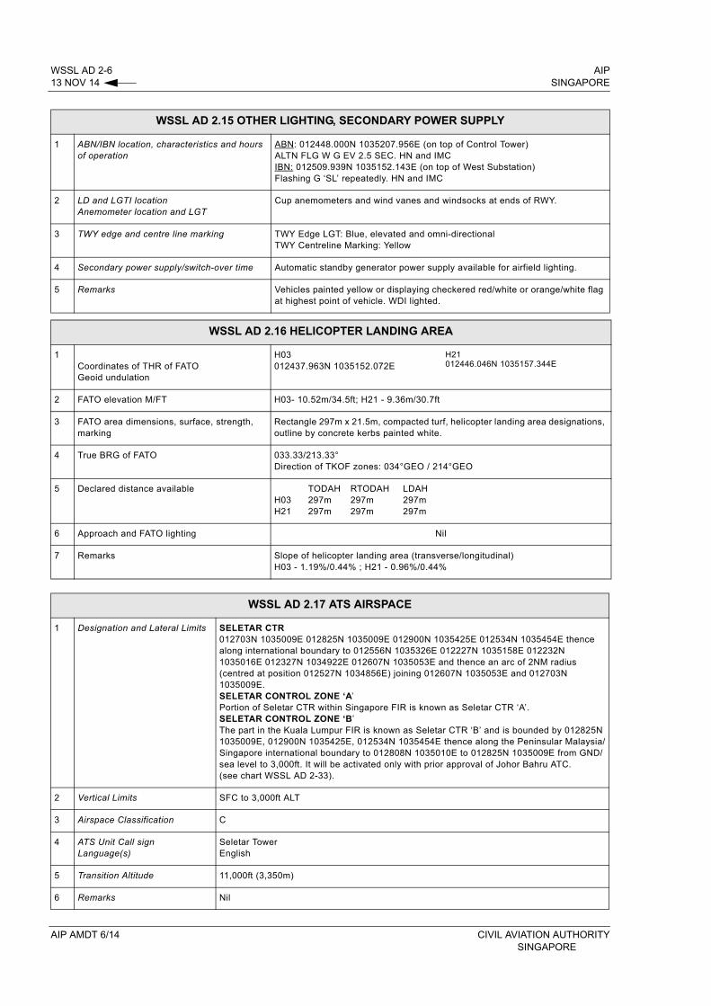
WSSL AD 2-6 AIP13 NOV 14 SINGAPORE
WSSL AD 2.15 OTHER LIGHTING, SECONDARY POWER SUPPLY
1 ABN/IBN location, characteristics and hours of operation
ABN: 012448.000N 1035207.956E (on top of Control Tower) ALTN FLG W G EV 2.5 SEC. HN and IMCIBN: 012509.939N 1035152.143E (on top of West Substation)Flashing G ‘SL’ repeatedly. HN and IMC
2 LD and LGTI locationAnemometer location and LGT
Cup anemometers and wind vanes and windsocks at ends of RWY.
3 TWY edge and centre line marking TWY Edge LGT: Blue, elevated and omni-directionalTWY Centreline Marking: Yellow
4 Secondary power supply/switch-over time Automatic standby generator power supply available for airfield lighting.
5 Remarks Vehicles painted yellow or displaying checkered red/white or orange/white flag at highest point of vehicle. WDI lighted.
WSSL AD 2.16 HELICOPTER LANDING AREA
1Coordinates of THR of FATOGeoid undulation
H03012437.963N 1035152.072E
H21012446.046N 1035157.344E
2 FATO elevation M/FT H03- 10.52m/34.5ft; H21 - 9.36m/30.7ft
3 FATO area dimensions, surface, strength, marking
Rectangle 297m x 21.5m, compacted turf, helicopter landing area designations, outline by concrete kerbs painted white.
4 True BRG of FATO 033.33/213.33°Direction of TKOF zones: 034°GEO / 214°GEO
5 Declared distance availableH03 H21
TODAH297m297m
RTODAH297m297m
LDAH297m297m
6 Approach and FATO lighting Nil
7 Remarks Slope of helicopter landing area (transverse/longitudinal)H03 - 1.19%/0.44% ; H21 - 0.96%/0.44%
WSSL AD 2.17 ATS AIRSPACE
1 Designation and Lateral Limits SELETAR CTR012703N 1035009E 012825N 1035009E 012900N 1035425E 012534N 1035454E thence along international boundary to 012556N 1035326E 012227N 1035158E 012232N 1035016E 012327N 1034922E 012607N 1035053E and thence an arc of 2NM radius (centred at position 012527N 1034856E) joining 012607N 1035053E and 012703N 1035009E.SELETAR CONTROL ZONE ‘A’Portion of Seletar CTR within Singapore FIR is known as Seletar CTR ‘A’. SELETAR CONTROL ZONE ‘B’The part in the Kuala Lumpur FIR is known as Seletar CTR ‘B’ and is bounded by 012825N 1035009E, 012900N 1035425E, 012534N 1035454E thence along the Peninsular Malaysia/Singapore international boundary to 012808N 1035010E to 012825N 1035009E from GND/sea level to 3,000ft. It will be activated only with prior approval of Johor Bahru ATC.(see chart WSSL AD 2-33).
2 Vertical Limits SFC to 3,000ft ALT
3 Airspace Classification C
4 ATS Unit Call signLanguage(s)
Seletar TowerEnglish
5 Transition Altitude 11,000ft (3,350m)
6 Remarks Nil
AIP AMDT 6/14 CIVIL AVIATION AUTHORITYSINGAPORE
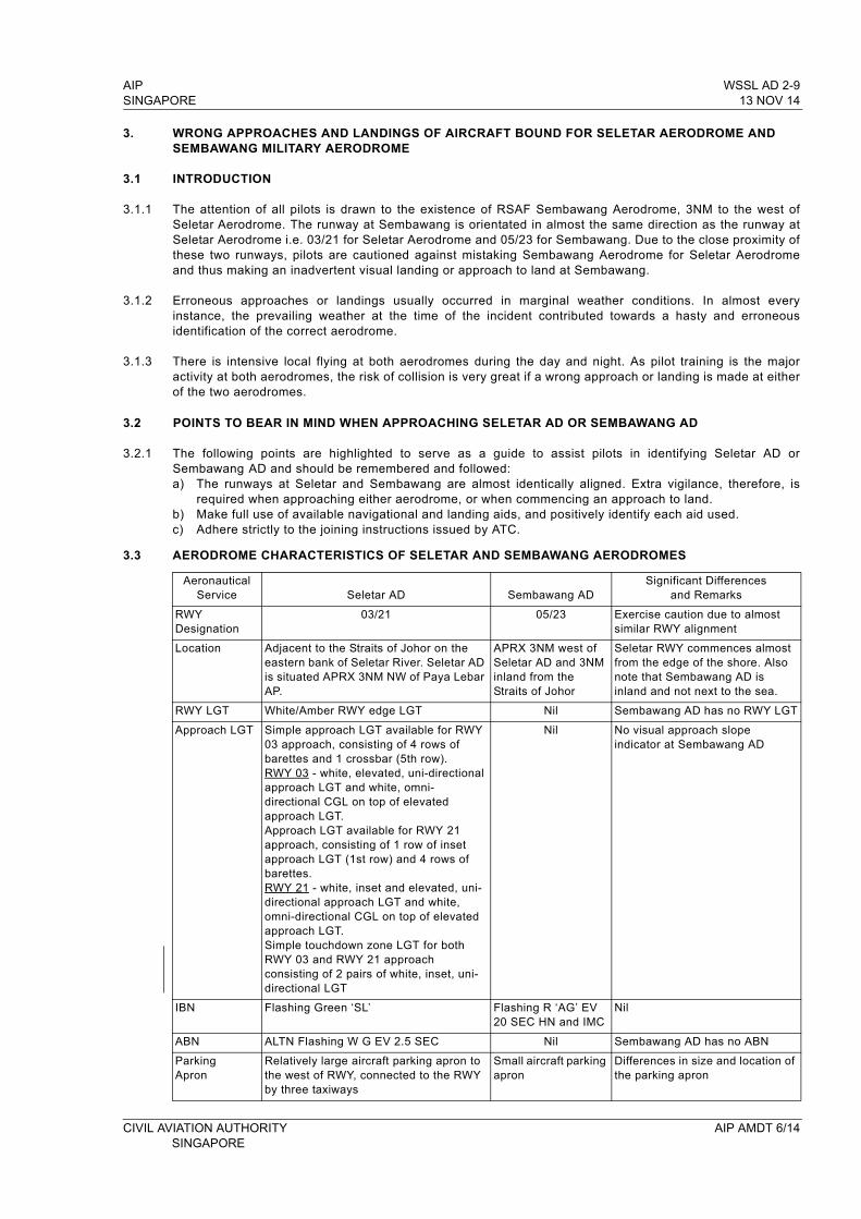
AIP WSSL AD 2-9SINGAPORE 13 NOV 14
3. WRONG APPROACHES AND LANDINGS OF AIRCRAFT BOUND FOR SELETAR AERODROME AND SEMBAWANG MILITARY AERODROME
3.1 INTRODUCTION
3.1.1 The attention of all pilots is drawn to the existence of RSAF Sembawang Aerodrome, 3NM to the west of Seletar Aerodrome. The runway at Sembawang is orientated in almost the same direction as the runway at Seletar Aerodrome i.e. 03/21 for Seletar Aerodrome and 05/23 for Sembawang. Due to the close proximity of these two runways, pilots are cautioned against mistaking Sembawang Aerodrome for Seletar Aerodrome and thus making an inadvertent visual landing or approach to land at Sembawang.
3.1.2 Erroneous approaches or landings usually occurred in marginal weather conditions. In almost every instance, the prevailing weather at the time of the incident contributed towards a hasty and erroneous identification of the correct aerodrome.
3.1.3 There is intensive local flying at both aerodromes during the day and night. As pilot training is the major activity at both aerodromes, the risk of collision is very great if a wrong approach or landing is made at either of the two aerodromes.
3.2 POINTS TO BEAR IN MIND WHEN APPROACHING SELETAR AD OR SEMBAWANG AD
3.2.1 The following points are highlighted to serve as a guide to assist pilots in identifying Seletar AD or Sembawang AD and should be remembered and followed:a) The runways at Seletar and Sembawang are almost identically aligned. Extra vigilance, therefore, is
required when approaching either aerodrome, or when commencing an approach to land.b) Make full use of available navigational and landing aids, and positively identify each aid used.c) Adhere strictly to the joining instructions issued by ATC.
3.3 AERODROME CHARACTERISTICS OF SELETAR AND SEMBAWANG AERODROMES
Aeronautical Service Seletar AD Sembawang AD
Significant Differences and Remarks
RWYDesignation
03/21 05/23 Exercise caution due to almost similar RWY alignment
Location Adjacent to the Straits of Johor on the eastern bank of Seletar River. Seletar AD is situated APRX 3NM NW of Paya Lebar AP.
APRX 3NM west of Seletar AD and 3NM inland from the Straits of Johor
Seletar RWY commences almost from the edge of the shore. Also note that Sembawang AD is inland and not next to the sea.
RWY LGT White/Amber RWY edge LGT Nil Sembawang AD has no RWY LGT
Approach LGT Simple approach LGT available for RWY 03 approach, consisting of 4 rows of barettes and 1 crossbar (5th row). RWY 03 - white, elevated, uni-directional approach LGT and white, omni-directional CGL on top of elevated approach LGT.Approach LGT available for RWY 21 approach, consisting of 1 row of inset approach LGT (1st row) and 4 rows of barettes.RWY 21 - white, inset and elevated, uni-directional approach LGT and white, omni-directional CGL on top of elevated approach LGT.Simple touchdown zone LGT for both RWY 03 and RWY 21 approach consisting of 2 pairs of white, inset, uni-directional LGT
Nil No visual approach slope indicator at Sembawang AD
IBN Flashing Green ‘SL’ Flashing R ‘AG’ EV 20 SEC HN and IMC
Nil
ABN ALTN Flashing W G EV 2.5 SEC Nil Sembawang AD has no ABN
Parking Apron
Relatively large aircraft parking apron to the west of RWY, connected to the RWY by three taxiways
Small aircraft parking apron
Differences in size and location of the parking apron
CIVIL AVIATION AUTHORITY AIP AMDT 6/14SINGAPORE
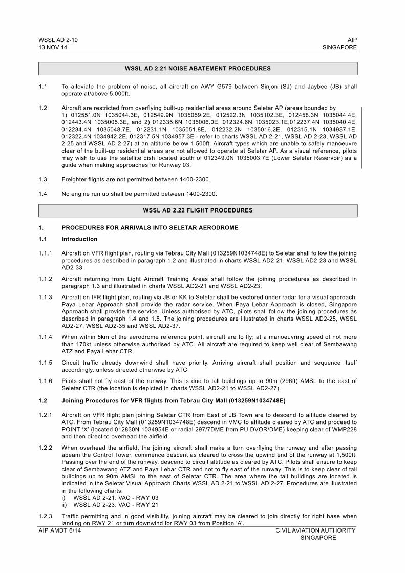
WSSL AD 2-10 AIP13 NOV 14 SINGAPORE
WSSL AD 2.21 NOISE ABATEMENT PROCEDURES
1.1 To alleviate the problem of noise, all aircraft on AWY G579 between Sinjon (SJ) and Jaybee (JB) shall operate at/above 5,000ft.
1.2 Aircraft are restricted from overflying built-up residential areas around Seletar AP (areas bounded by 1) 012551.0N 1035044.3E, 012549.9N 1035059.2E, 012522.3N 1035102.3E, 012458.3N 1035044.4E, 012443.4N 1035005.3E, and 2) 012335.6N 1035006.0E, 012324.6N 1035023.1E,012237.4N 1035040.4E, 012234.4N 1035048.7E, 012231.1N 1035051.8E, 012232.2N 1035016.2E, 012315.1N 1034937.1E, 012322.4N 1034942.2E, 012317.5N 1034957.3E - refer to charts WSSL AD 2-21, WSSL AD 2-23, WSSL AD 2-25 and WSSL AD 2-27) at an altitude below 1,500ft. Aircraft types which are unable to safely manoeuvre clear of the built-up residential areas are not allowed to operate at Seletar AP. As a visual reference, pilots may wish to use the satellite dish located south of 012349.0N 1035003.7E (Lower Seletar Reservoir) as a guide when making approaches for Runway 03.
1.3 Freighter flights are not permitted between 1400-2300.
1.4 No engine run up shall be permitted between 1400-2300.
WSSL AD 2.22 FLIGHT PROCEDURES
1. PROCEDURES FOR ARRIVALS INTO SELETAR AERODROME
1.1 Introduction
1.1.1 Aircraft on VFR flight plan, routing via Tebrau City Mall (013259N1034748E) to Seletar shall follow the joining procedures as described in paragraph 1.2 and illustrated in charts WSSL AD2-21, WSSL AD2-23 and WSSL AD2-33.
1.1.2 Aircraft returning from Light Aircraft Training Areas shall follow the joining procedures as described in paragraph 1.3 and illustrated in charts WSSL AD2-21 and WSSL AD2-23.
1.1.3 Aircraft on IFR flight plan, routing via JB or KK to Seletar shall be vectored under radar for a visual approach. Paya Lebar Approach shall provide the radar service. When Paya Lebar Approach is closed, Singapore Approach shall provide the service. Unless authorised by ATC, pilots shall follow the joining procedures as described in paragraph 1.4 and 1.5. The joining procedures are illustrated in charts WSSL AD2-25, WSSL AD2-27, WSSL AD2-35 and WSSL AD2-37.
1.1.4 When within 5km of the aerodrome reference point, aircraft are to fly; at a manoeuvring speed of not more than 170kt unless otherwise authorised by ATC. All aircraft are required to keep well clear of Sembawang ATZ and Paya Lebar CTR.
1.1.5 Circuit traffic already downwind shall have priority. Arriving aircraft shall position and sequence itself accordingly, unless directed otherwise by ATC.
1.1.6 Pilots shall not fly east of the runway. This is due to tall buildings up to 90m (296ft) AMSL to the east of Seletar CTR (the location is depicted in charts WSSL AD2-21 to WSSL AD2-27).
1.2 Joining Procedures for VFR flights from Tebrau City Mall (013259N1034748E)
1.2.1 Aircraft on VFR flight plan joining Seletar CTR from East of JB Town are to descend to altitude cleared by ATC. From Tebrau City Mall (013259N1034748E) descend in VMC to altitude cleared by ATC and proceed to POINT ‘X’ (located 012830N 1034954E or radial 297/7DME from PU DVOR/DME) keeping clear of WMP228 and then direct to overhead the airfield.
1.2.2 When overhead the airfield, the joining aircraft shall make a turn overflying the runway and after passing abeam the Control Tower, commence descent as cleared to cross the upwind end of the runway at 1,500ft. Passing over the end of the runway, descend to circuit altitude as cleared by ATC. Pilots shall ensure to keep clear of Sembawang ATZ and Paya Lebar CTR and not to fly east of the runway. This is to keep clear of tall buildings up to 90m AMSL to the east of Seletar CTR. The area where the tall buildings are located is indicated in the Seletar Visual Approach Charts WSSL AD 2-21 to WSSL AD 2-27. Procedures are illustrated in the following charts:i) WSSL AD 2-21: VAC - RWY 03ii) WSSL AD 2-23: VAC - RWY 21
1.2.3 Traffic permitting and in good visibility, joining aircraft may be cleared to join directly for right base when landing on RWY 21 or turn downwind for RWY 03 from Position ‘A’.
AIP AMDT 6/14 CIVIL AVIATION AUTHORITY SINGAPORE
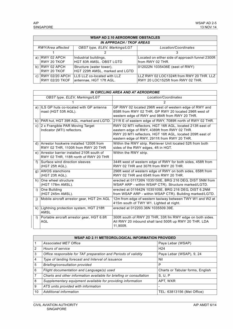
AIP WSAP AD 2-5SINGAPORE 13 NOV 14
WSAP AD 2.10 AERODROME OBSTACLES
IN APPROACH / TKOF AREAS
RWY/Area affected OBST type, ELEV, Markings/LGT Location/Coordinates
1 2 3
a) RWY 02 APCHRWY 20 TKOF
Industrial buildings, HGT 83ft AMSL. OBST LGTD
Located on either side of approach funnel 2300ft from RWY 02 THR.
b) RWY 02 APCHRWY 20 TKOF
Structure (water tower), HGT 229ft AMSL, marked and LGTD
012022N 1035436E (east of RWY)
c) RWY 02/20 APCHRWY 02/20 TKOF
LLS LLZ co-located with LLZ antennae, HGT 17ft AGL.
LLZ RWY 02 LOC1324ft from RWY 20 THR. LLZ RWY 20 LOC1525ft from RWY 02 THR.
IN CIRCLING AREA AND AT AERODROME
OBST type, ELEV, Markings/LGT Location/Coordinates
1 2
a) ILS GP huts co-located with GP antenna mast (HGT 53ft AGL).
GP RWY 02 located 296ft west of western edge of RWY and 858ft from RWY 02 THR. GP RWY 20 located 296ft west of western edge of RWY and 984ft from RWY 20 THR.
b) PAR hut, HGT 39ft AGL, marked and LGTD. 211ft E of eastern edge of RWY, 7089ft north of RWY 02 THR.
c) 2 x Frangible PAR Moving Target Indicator (MTI) reflectors.
RWY 02 MTI reflectors, HGT 16ft AGL, located 213ft east of eastern edge of RWY, 4389ft from RWY 02 THR. RWY 20 MTI reflectors, HGT 16ft AGL, located 209ft east of eastern edge of RWY, 2911ft from RWY 20 THR.
d) Arrestor hookwire installed 1200ft from RWY 02 THR, 1100ft from RWY 20 THR
Within the RWY strip. Retriever Unit located 52ft from both sides of the RWY edges, 4ft in HGT.
e) Arrestor barrier installed 210ft south of RWY 02 THR, 118ft north of RWY 20 THR
Within the RWY strip.
f) Surface wind direction sleeves (HGT 25ft AGL).
344ft west of western edge of RWY for both sides, 458ft from RWY 02 THR and 307ft from RWY 20 THR.
g) AWOS stanchions (HGT 23ft AGL).
296ft west of western edge of RWY on both sides, 658ft from RWY 02 THR and 654ft from RWY 20 THR.
h) One wheel structure (HGT 178m AMSL).
erected at 011726N 1035150E, BRG 216 DEG, DIST 5NM from WSAP ARP - within WSAP CTR). Structure marked/LGTD.
i) One Building (HGT 245m AMSL).
erected at 011642N 1035105E, BRG 216 DEG, DIST 6.2NMfrom WSAP ARP - within WSAP CTR). Building marked/LGTD.
j) Mobile aircraft arrestor gear, HGT 2m AGL 12m from edge of western taxiway between TWY W1 and W2 at 415m south of TWY W1. Lighted at night.
k) Lightning protection system, HGT 218ft AMSL
erected at 012203.36N 1035509.39E.
l) Portable aircraft arrestor gear, HGT 6.6ft AGL
300ft south of RWY 20 THR, 33ft fm RWY edge on both sides. All RWY 20 inbound shall land 500ft up RWY 20 THR. LDA 11,900ft.
WSAP AD 2.11 METEOROLOGICAL INFORMATION PROVIDED
1 Associated MET Office Paya Lebar (WSAP)
2 Hours of service H24
3 Office responsible for TAF preparation and Periods of validity Paya Lebar (WSAP), 9, 24
4 Type of landing forecast and Interval of issuance Nil
5 Briefing/consultation provided P
6 Flight documentation and Language(s) used Charts or Tabular forms, English
7 Charts and other information available for briefing or consultation S, U, P
8 Supplementary equipment available for providing information APT, WXR
9 ATS units provided with information -
10 Additional information TEL: 63813156 (Met Office)
CIVIL AVIATION AUTHORITY AIP AMDT 6/14SINGAPORE
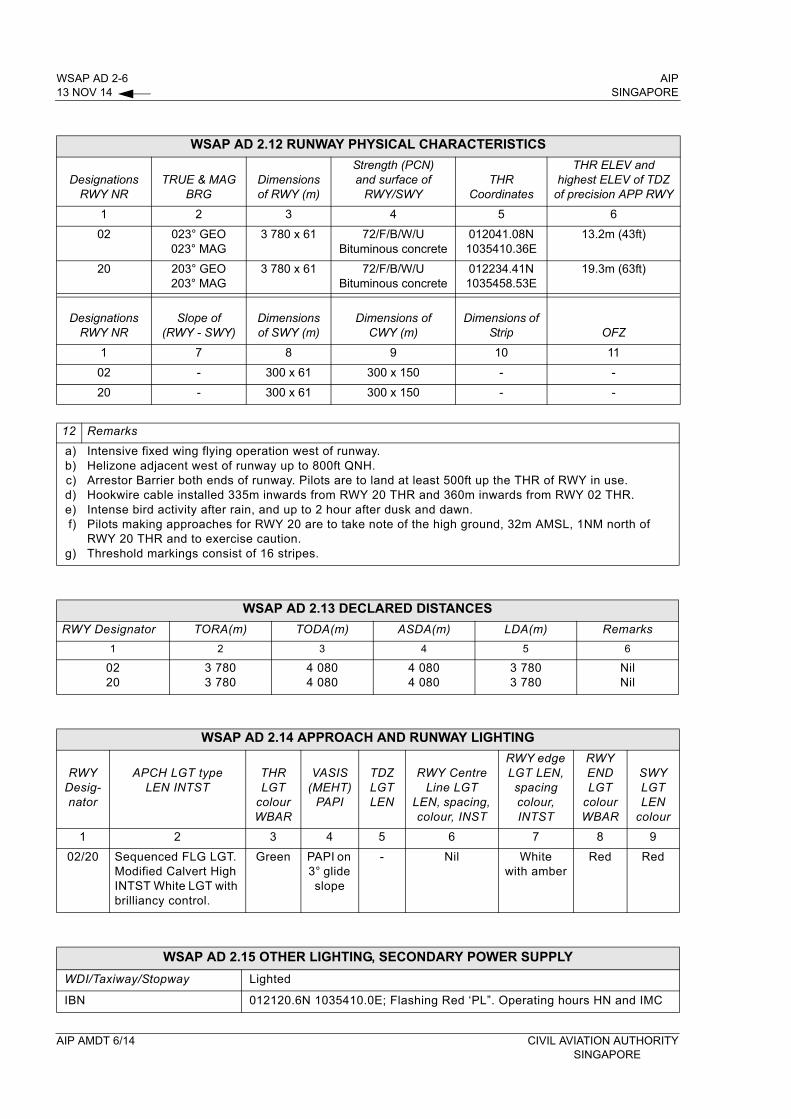
WSAP AD 2-6 AIP13 NOV 14 SINGAPORE
WSAP AD 2.12 RUNWAY PHYSICAL CHARACTERISTICS
DesignationsRWY NR
TRUE & MAG BRG
Dimensions of RWY (m)
Strength (PCN) and surface of
RWY/SWYTHR
Coordinates
THR ELEV and highest ELEV of TDZ
of precision APP RWY
1 2 3 4 5 6
02 023° GEO023° MAG
3 780 x 61 72/F/B/W/UBituminous concrete
012041.08N1035410.36E
13.2m (43ft)
20 203° GEO203° MAG
3 780 x 61 72/F/B/W/UBituminous concrete
012234.41N1035458.53E
19.3m (63ft)
DesignationsRWY NR
Slope of (RWY - SWY)
Dimensions of SWY (m)
Dimensions of CWY (m)
Dimensions of Strip OFZ
1 7 8 9 10 11
02 - 300 x 61 300 x 150 - -
20 - 300 x 61 300 x 150 - -
12 Remarks
a)b)c)d)e)f)
g)
Intensive fixed wing flying operation west of runway.Helizone adjacent west of runway up to 800ft QNH.Arrestor Barrier both ends of runway. Pilots are to land at least 500ft up the THR of RWY in use.Hookwire cable installed 335m inwards from RWY 20 THR and 360m inwards from RWY 02 THR.Intense bird activity after rain, and up to 2 hour after dusk and dawn.Pilots making approaches for RWY 20 are to take note of the high ground, 32m AMSL, 1NM north of RWY 20 THR and to exercise caution.Threshold markings consist of 16 stripes.
WSAP AD 2.13 DECLARED DISTANCES
RWY Designator TORA(m) TODA(m) ASDA(m) LDA(m) Remarks
1 2 3 4 5 6
0220
3 7803 780
4 0804 080
4 0804 080
3 7803 780
NilNil
WSAP AD 2.14 APPROACH AND RUNWAY LIGHTING
RWYDesig-nator
APCH LGT type LEN INTST
THR LGT
colour WBAR
VASIS (MEHT)
PAPI
TDZ LGT LEN
RWY Centre Line LGT
LEN, spacing, colour, INST
RWY edge LGT LEN, spacing colour, INTST
RWY END LGT
colour WBAR
SWY LGT LEN
colour
1 2 3 4 5 6 7 8 9
02/20 Sequenced FLG LGT. Modified Calvert High INTST White LGT with brilliancy control.
Green PAPI on 3° glide slope
- Nil White with amber
Red Red
WSAP AD 2.15 OTHER LIGHTING, SECONDARY POWER SUPPLY
WDI/Taxiway/Stopway Lighted
IBN 012120.6N 1035410.0E; Flashing Red ‘PL”. Operating hours HN and IMC
AIP AMDT 6/14 CIVIL AVIATION AUTHORITYSINGAPORE