Embed Size (px)
Citation preview
REPUBLIC OF SIERRA LEONE
MINISTRY OF ENERGY AND WATER RESOURCES
FEASIBILITY STUDY FOR MANUAL DRILLING
MAPPING OF FAVOURABLE ZONES

Page 2 of 22

Page 3 of 22
TABLE OF CONTENTS
Introduction _________________________________________________________________________ 4
General context ______________________________________________________________________ 5 Geography __________________________________________________________________________________ 5 Climate _____________________________________________________________________________________ 6 Hydrography ________________________________________________________________________________ 6 Hydrogeology ________________________________________________________________________________ 6 Population and drinking water coverage __________________________________________________________ 6
Methodology for the estimation of suitability for manual drilling _____________________________ 10 Geological suitability _________________________________________________________________________ 10 Suitability according to depth of water __________________________________________________________ 15 Morphological suitability ______________________________________________________________________ 17 Final aptitude _______________________________________________________________________________ 18
Conclusion and recommendations ______________________________________________________ 22 LIST OF FIGURES District divisions ___________________________________________________________________________________ 5Map of population per district _______________________________________________________________________ 8Map of population without access to safe water _________________________________________________________ 9LIthology of geological formations ___________________________________________________________________ 11Map of geological suitability ________________________________________________________________________ 14Map of static water level in boreholes and wells ________________________________________________________ 16Morphological zones ______________________________________________________________________________ 18Map of suitability to manual drilling _________________________________________________________________ 20Legend of map of suitability to manual drilling _________________________________________________________ 21

Page 4 of 22
Introduction In the framework of its programme focused in supporting the application of low cost techniques of manual drilling in Africa, UNICEF promoted a study having as main purpose the analysys of the existing information at national level for in order to have an initial knowledge of areas where environmental and hydrogeological situation could make hand drilling techniques a potentially suitable low cost and sustainable solution to increase the availability of water for the population. The study has been carried out through the analysis wit support of GIS systems of a set of data collected from public source of data (mainly web) and the collection of data available in different institutions at national level by a local consultant. The present study aims to give a general idea and it is extend to the whole country; the results of this study must be used to target specific ares where more detailed analysis are required in order to have a detailed idea of the best strategy and location to support manual drilling

Page 5 of 22
General context
Geography Sierra Leone has an area of 72.000 Kmq, with a coastline of about 400 Km on the Atlantic and shares boundaries with Guinea and Liberia. It is boarded on the north-east by mountain ranges rising to a peak of about 1950 m.
District divisions

Page 6 of 22
Climate The country lies in the hot humid area of West Africa with wet and dry seasons
• The mean annual temperature is 26°C ranging from a minimum of 22°C in August to a maximum of 35°C in February. Mean
• Annual rainfall is a high 5.000 mm in the Freetown peninsular to 1800 mm in the north east. The dry season is from November to April. About 5-20% of the annual rainfall occurs during this season. The wet season occurs during the months from May to October.
Hydrography The country is drained by nine major rivers. These are the Rokel/Seli, Pampana/Jong, Sewa, Waanje and the Coastal Streams and Creeks which originate inside the country. The rest are the Great and Little Scarcies and Moa Rivers which originate from the Fouta Jallon Plataeu in the Republic of Guinea, and the Mano River which originates from the Republic of Liberia. These rivers range in length from 160 km for the Great Scarcies to 430 km for the Sewa River and in area from 2,530 kmq for the coastal streams and creeks to 14,140 kmq for the Sewa River.
Hydrogeology Most of the country is underlain by Precambrian crystalline formations which have no primary porosity. Groundwater accumulation therefore occurs in fractures, joints and fissures. The aquifers are therefore discontinuous.
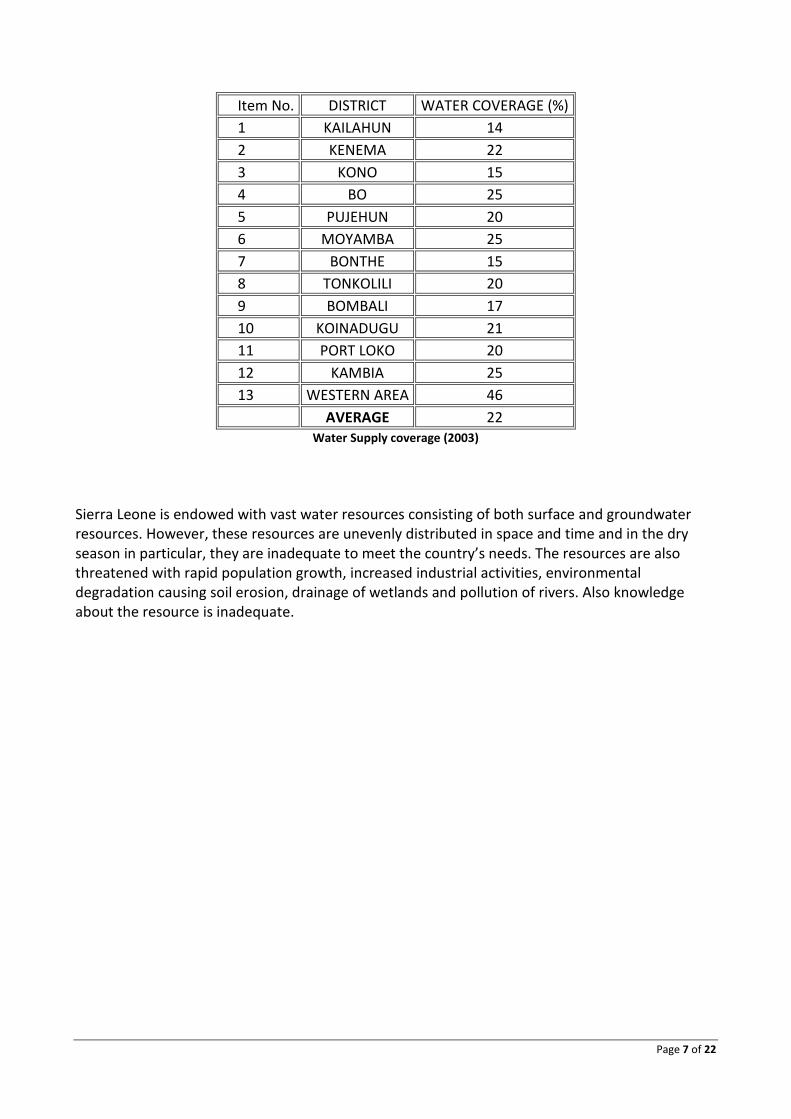
Population and drinking water coverage Despite these vast resources, the country currently faces severe constraints in the availability of water for domestic and agricultural purposes. National and District coverage of water and sanitation are presented in Table. The national average water supply coverage is 22% and ranged from 14% for Kailahun to 46% for the Western Area, while sanitation ranged from 6% in Kailahun to 15% in the Western Area. The present national coverage of 22% % for water supply compares unfavourably with 35% achieved at the end of the IDWSSD in 1990.
Page 7 of 22
Item No. DISTRICT WATER COVERAGE (%) 1 KAILAHUN 14 2 KENEMA 22 3 KONO 15 4 BO 25 5 PUJEHUN 20 6 MOYAMBA 25 7 BONTHE 15 8 TONKOLILI 20 9 BOMBALI 17 10 KOINADUGU 21 11 PORT LOKO 20 12 KAMBIA 25 13 WESTERN AREA 46 AVERAGE 22
Water Supply coverage (2003) Sierra Leone is endowed with vast water resources consisting of both surface and groundwater resources. However, these resources are unevenly distributed in space and time and in the dry season in particular, they are inadequate to meet the country’s needs. The resources are also threatened with rapid population growth, increased industrial activities, environmental degradation causing soil erosion, drainage of wetlands and pollution of rivers. Also knowledge about the resource is inadequate.

Page 8 of 22
Map of population per district

Page 9 of 22
Map of population without access to safe water

Page 10 of 22
Methodology for the estimation of suitability for manual drilling To estimate the suitability for manual drilling and identify those areas having the best potential we have adopted a methodology based on a cross analysis of the following criteria
• Geological suitability • Suitability according to water level • Morphological suitability
Geological suitability It means identifying the areas where geological formations have hardness and permeability conditions favorable for manual drilling, or identify areas of hard rock where there is likely to exist a weathered unconsolidated layer on top of the main hard rock. These weathered layers are not shown in the geological map, and their existence must be estimated on the basis of other sources of information such as:
• not systematized information based on the direct experience of local technicians who know the context of different regions of the country; their perception allows to estimate the probability that a geological formation in a selected zone was covered by exploitable weathered layer
• borehole logs, giving detailed information about shallow layers covering the main rock aquifer
• database of water points: the existence of a large number of wells dug by hand in areas characterized by hard geological formations may indicate the presence of soft surface layers not marked on the map
Sources of information Main sources of information used are:
• 1: 250,000 geological map, it was available only in hard copy. Therefore it was required to scan the map, georeference it and finally digitized as a polygon layer
• Database of water points; this layer of information is still incomplete, and there are information only for 421water points (291 water points approximately with coordinates, 90 water points without coordinates but with the name of the chiefdom, and 40 water points without sufficient geographic definition), scattered in different departments but mainly covering the central part of the country.

Page 11 of 22
LIthology of geological formations
Page 12 of 22
Method of interpretation For each geological formation in the vector geological map (the result of digitizing the original paper map) the following parameters were estimated:
• The main lithology • The expected resistance to drilling • The expected intensity of weathering in the surface layer • The expected permeability of the weathered zone
Expected resistance, weathering and permeability of weathered layer were given on the basis of the following assumption:
• Only soft lithological formations are fully favorable to manual drilling • In case of hard or moderately hard lithological formation, it is possible to find a surface
weathered layer with low resistance to drilling; in case this layer is thick enough, it could be a suitable aquifer for manual boreholes supplying waster to small group of people.
• Drilling in weathered layers could produce manual drilled wells with low yield because of the low permeability of the sediments; therefore it is also important to estimate the degree of permeability of the weathered zone
Considering the lack of hydrogeological study in Sierra Leone and the unavailability of a sufficient and homogeneously distributed database of water points, the existence and characteristics of the weathered layer has been done mainly on the basis of the following assumption:
• Degree of weathering decrease moving from mafic intrusive to felsic and quartzitic rocks
• Rocks with mixed mineralogical composition and different size of components are likely to have deeper weathering than massive and homogeneous rocks
• Porphyroblastic and coarse-grained rocks are likely to be more weathered; furthermore the weathered layer will be more permeable.
• Degree of weathering in metamorphic rocks is similar or less than the corresponding intrusive or effusive rock
Combining the parameters of hardness and permeability of the mains rock, together wth the existenece and nature of weaterhed layer, a classification of geological suitability organized in 6 classes has been defined
• Very high: it is associated with unconsolidated sediments with good permeability • High (on weathered layer): associated with hard crystalline rocks with strong attitude to
develop important weathered layers with good permeability • Moderate: associated with unconsolidated sediments (or soft rock) with moderate
permeability or partially resistant that could make more complex to drill

Page 13 of 22
• Moderate (on weathered layer) associated with hard crystalline rocks with moderate attitude to develop important weathered layers, or developing thick weathered layers with moderate permeability
• Weak: associated with unconsolidated sediment (or soft rocks) of low permeability and not easy to perforate
• Low (on weathered layer): associated with hard rocks with low tendency to develop important weathered layers, or they develop weathered layer with low permeability
As we can observe in the map, most of the territory of Sierra Leone shows favorable or partially favorable geological conditions to manual drilling. All the eastern part is covered by crystalline basement with good potential to develop exploitable aquifers, particularly in the eastern part where high fracturing of the rocks is indicated in the original geological map

Page 14 of 22
Map of geological suitability

Page 15 of 22
Suitability according to depth of water It means estimating the average depth in each zone where it is possible to find exploitable water. While in unconfined water table, this correspond to the static water level, in case we are in a confined aquifer the real water intake could be deeper than the static water level. Since static water level is generally the only parameter regarding water level that is registered in the water point database. Once the average and most likely depth of water is determined, it must be classified taking into consideration that manual drilling has to be considered not feasible for ore than 35-40 metres in optimal condition; therefore it is considered not favorable an area having water level deeper than 25 m (considering that the difference between water level and total depth is required to maintain in good condition the pump and not to get dry. Water point’s data don’t cover all the country; therefore it results difficult to estimate the static water level on the basis of these data for the different zones. However, we can see that almost everywhere static water level is quite shallow. For this reason it is likely that in the whole country water can be found and exploited with manual drilling at a suitable depth (probably selecting the proper position according to the topography). It is also important that boreholes and wells recorded in the database are generally less deep than 30 m, and the static water level indicated corresponds to quite shallow water table that can be exploited with manual drilling (in other words, it is not referred to deep and confined aquifers) Although the interpretation is based only on a limited set of water points, we consider that water is generally shallow enough for manual drilling, and no specific areas with limitation for this reason can be defined

Page 16 of 22
Map of static water level in boreholes and wells

Page 17 of 22
Morphological suitability Morphological suitability search for those zones where morphological aspect facilitate the accumulation of unconsolidated weathered sediments (as a consequence of depositional process and transport of surface water) and shallow groundwater level. These zones are generally associated with depressed areas (bottom of valley) and partially flat areas. To carry out this analysis the digital elevation model available internet and delivered by SRTM programme was used (90 m pixel resolution, obtained from radar images). This DTM was processed, obtaining a slope map; later the TPI (Topographic Position Index) extension available in Arcview was used; this algorithm compare the position of each pixel with the surrounding area, and determine if the pixel is in lower position, higher position, or ina slope gradient. Finally comparing the relative position of the pixel with the surrounding area and the absolute slope, it calculates a slope position classification; the study area is divided in the following classes:
• Bottom areas • Flat or gentle slope • Steep slope • Elevated areas
Crossing the results of the automatic procedure of slope position classification and slope maps, the territory was divided in 4 classes of morphological suitability
• Favorable: Bottom areas, with slope < 5 degrees • Moderately favorable: gentle slope with slope less than 5 degrees • Little favorable: bottom areas with slope > 5 degrees • Not favorable: all areas with slope > 5 degrees or classified as “elevated areas” in slope
position classification)
Page 18 of 22
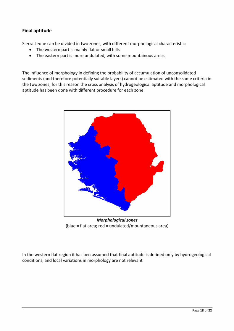
Final aptitude Sierra Leone can be divided in two zones, with different morphological characteristic:
• The western part is mainly flat or small hills • The eastern part is more undulated, with some mountainous areas
The influence of morphology in defining the probability of accumulation of unconsolidated sediments (and therefore potentially suitable layers) cannot be estimated with the same criteria in the two zones; for this reason the cross analysis of hydrogeological aptitude and morphological aptitude has been done with different procedure for each zone:
Morphological zones
(blue = flat area; red = undulated/mountaneous area) In the western flat region it has ben assumed that final aptitude is defined only by hydrogeological conditions, and local variations in morphology are not relevant

Page 19 of 22
Geological Aptitude Final Aptitude High Very good High (on weathered layer) Good (weath) Medium Moderate Medium (on weathered layer) Moderate Weak Low Weak (on weatherd layer) Low
Classification of final suitability in the western flat area (depending only on geological aptitude)
On the other hand, in the eastern undulated area the final aptitude derives form a cross analysis of geological aptitude and morphological aptitude, as topography can influence locally the processes of weathering /sedimentation / erosion
Morphological Aptitude
Favorable Moderately favorable
Little favorable
Not favorable
Geological Aptitude High Very good Very good Very good Very good
High (on weathered layer) Good (weath)
Good (weath) Moderate Unsuitable
Medium Moderate Moderate Moderate Moderate Medium (on weathered layer)
Good (weath) Moderate Low Unsuitable
Weak Low Low Low Low Weak (on weatherd layer) Low Low Unsuitable Unsuitable FINAL SUITABILITY TO MANUAL DRILLING
Cross analysis and final suitability classification in the eastern part (ondulated/nountaineous area) The final result is the map of suitability to manual drilling; in this map the same classification is adopted in the whole country, but the procedure to assign to each area a specific value of suitability is different in western or eastern area, as explained above

Page 20 of 22
Map of suitability to manual drilling

Page 21 of 22
Legend of map of suitability to manual drilling
Page 22 of 22
Conclusion and recommendations Sierra Leone has wide zones suitable to this technique, and manual drilling can be implemented and support the increase of water coverage, particularly in rural areas. At the moment a quantitative estimate of the number of people who can be supported with manual drilling can’t be complete, since it seems important to have more information regarding the type of water sources used in those areas where we have limited data about existing wells and boreholes. However we can observe that we can estimate a good level of suitability in some districts where the present safe drinking water coverage is quite low. For example the north and northeastern part of the country (Bombali, Koinadugu and Kono districts) has more than 50% of population without access to safe water, and is considered generally suitable to manual drilling. The interpretation and classification of geological data has been done with general criteria that must be cross-checked with the evidence of distribution of hand dug well and manual drilling in the country, as well as the local context of water supply in each zone. Furthermore, a more precise zonification of the potential presence of weathered layers must be done observing the relation that this factor has with topography and drainage pattern. Due to the lack of systematized information and previous study, it is recommended to carry out a field survey in the areas potentially more favorable, in order to observe directly the water points and discuss with local technicians and population about the characteristics and eventual problems they face to use the present water points.


![arXiv:1807.01232v2 [cs.CV] 25 Sep 2018 · Unclassified 1138. km 95.4 km 1750.8 km 164.5 km 3148.7 km Total 3685.0 km 425.3 km 3536.9 km 1029.5 km 8676.6 km 2.5 Challenge 3 - Las](https://img.pdfslide.us/doc/110x75/5f107f837e708231d44967c4/arxiv180701232v2-cscv-25-sep-2018-unclassiied-1138-km-954-km-17508-km.jpg)