Embed Size (px)
Citation preview

i
REPUBLIC OF KENYAMINISTRY OF ENVIRONMENT AND MINERAL RESOURCES
IJARA DISTRICTENVIRONMENT ACTION PLAN
2009-2013

ii
EXECUTIVE SUMMARYThe Environmental Management and Coordination Act (EMCA) 1999 provides for thepreparation of District Environment Action Plans every five years. This is the first DistrictEnvironment Action Plan (DEAP) for Ijara district. Preparation of this DEAP was done througha participatory process involving the civil society, private and public sectors. The document hasincorporated salient issues from the divisions and it highlights priority themes and activities for thedistrict towards attaining sustainable development. It is divided into eight chapters.
Chapter one covers the preamble that highlights provisions for environmental planning asprovided for under EMCA, Environmental Acton Planning process that discusses themethodology used in preparation of the DEAP. It also stipulates objectives, scope of this DEAPand challenges for environmental management in the district. It further describes district profile,climate and physical features, population size and distribution and social economic characteristics.
Chapter two discusses the district’s environment and natural resources such as soils; land and landuse changes; agriculture, livestock and fisheries; water sources; forest and wildlife resources andBiodiversity conservation.
Chapter three addresses the human settlements and infrastructure. It covers human settlementsand planning; human and environmental health; pollution and wastes generated from humansettlements; communication networks; social economic services and infrastructure and energysupply.
Chapter four discusses industry trade and services in the district. It highlights major industrialsector that covers agro-based industries, engineering, chemical and mineral industries; trade;service sector; tourism sector; mining and quarrying.
Chapter five discusses environmental hazards and disasters. It gives a definition of hazard anddisaster, the extent and trend of environment hazards and disasters. The major hazards anddisasters covered include; drought and floods.
Chapter six covers environmental information, networking and technology. Issues discussedinclude status of formal and non-formal environmental education; public awareness andparticipation; technologies; environmental information systems and indigenous knowledge. Thechapter thus highlights the need for sustainable environmental management throughenvironmental education and information, awareness raising and enhancing public participation atall levels.Chapter seven covers environmental governance and institutional framework. It discusses status ofenvironmental governance and institutional arrangements, regulatory and management tools andmultilateral environmental agreements. The key issue addressed is the need for strengthenedcollaboration among lead agencies and stakeholders in environmental management.

iii
Chapter eight provides an implementation strategy in a matrix form for addressing keyenvironmental issues and proposed actions highlighted in chapters’ two to seven. Theimplementation matrix is divided into issue category, problem statement, action needed,stakeholders involved and the time frame.
The respective lead agencies and stakeholders are expected to be involved at all stages in theimplementation of the district environmental action plan. Secondly, they are required to monitorand evaluate environmental management indicators identified in the matrix for the annualreporting for the district state of environment report.
iv
FOREWORDThe 1992 Earth Summit held in Rio de Janeiro came up with various recommendations, among
them Agenda 21, a Global Environmental Action Plan. The theme of the Summit focused on
how nations could attain sustainable development. The Government of Kenya embraced this idea
by developing the first National Environment Action Plan (NEAP) in 1994.
Since independence, Kenya has continued to demonstrate her commitment to environmental
management through various initiatives, among them the National Development Plans of 1974
and the National Environment Action Plan of 1994. Further, there have been a number of sectoral
policies on environment in fields such as Agriculture, Livestock, Water, Energy, Food, Land,
Wildlife, Forest, Industry, Trade, Arid Lands, Disaster Management and the Draft Sessional Paper
No. 6 of 1999 on Environment and Development.
The Environmental Management and Coordination Act (EMCA, 1999) provides for the
integration of environmental concerns in national policies, plans, programmes and projects. In this
regard, EMCA 1999 provides for the formulation of National, Provincial and District
Environment Action Plans every five years.
Environmental Action Planning is a tool that aims at integrating environmental concerns into
development planning. The process followed in preparing this DEAP was participatory, involving
various stakeholders from institutions and sectors, including the public, private, NGOs and local
communities at District and Provincial levels. These consultative meetings provided the basis also
for formulation of the PEAP and finally the National Environment Action Plan.
The DEAP addresses environmental issues from various sectors in an integrated manner and
discusses their significance in development planning. It proposes a strategy for achieving
sustainable development in line with Kenya’s quest to meet the Millennium Development Goals
(MDGs) Vision 2030 and Medium Term Plan (MTP). The Plan has brought out a number of
proposed interventions, legal and institutional framework to be incorporated into sectoral
development plans and programmes. Its implementation will be monitored by the DEC and will
be reflected in the State of the Environment Reports.
The preparation of the DEAPs for Nyanza Province owes much to the technical and financial
assistance provided by the European Commission under the Community Development for
Environment Management Programme. This support, which included innovative community and
civil society consultations, facilitation of DEC meetings, as well as final publication costs, is

v
gratefully acknowledged. I also commend the assistance provided by UNDP under the Poverty
Environment for supporting the development of the EAP Manual and supporting the preparation
of the DEAP for Ijara.
I wish to underscore that the 2009-2013 DEAP report is a broad-based strategy that will enable
the District attain sustainable development as envisaged in the Vision 2030.
Dr. Ayub Macharia (PhD),DIRECTOR GENERAL (Ag),NATIONAL ENVIRONMENT MANAGEMENT AUTHORITY

vi
ACKNOWLEDGEMENTOn behalf of the National Environment Management Authority (NEMA), I would like to thank
the Ijara District Commissioner, Mr. A. A., who is also the Chairman of the District Environment
inputs and approval of this Committee (DEC) for spearheading the preparation process for this
District Environment Action Plan,(2009-2013). I also wish to thank most sincerely the District
Environment Committee and the District Environmental Action Plan Technical Committee for
their invaluable environmental action plan.
NEMA also acknowledges the contribution of the members of the local communities, who
actively participated in the identification and prioritization of the environmental issues in their
location which formed part of this document. These members were sampled by the Community
Development Environmental Management Programme (CDEMP) that financially supported
NEMA to enrich the District Environmental Action Plan. Our sincere thanks goes to the District
Officers (DOs), Chiefs and Assistant Chiefs who were instrumental in mobilizing the local
communities and civil society organizations. Special thanks go to the civil society organizations
that were drawn from entire Ijara district who were instrumental in the identification of the
environmental issues across the district.
I also acknowledge the European Union (EU) for the financial and technical support in the
preparation of this action plan. We particularly appreciate the technical support provided by Dr.
Robert Olivier (Chief Technical Advisor), Mrs. Esther Mugure Aoko (Environmental Planning
Advisor), Provincial Director of Environment (Nyanza), District Environment Officer, Mr. Daniel
K. Omwanza for their insights and dedication to this process.
Last but not least, I extend my gratitude to all those who contributed towards the finalization of
this District Environmental Action Plan.
Dr. Kennedy I. OndimuDIRECTOR, DEPARTMENT OF ENVIRONMENTALPLANNING AND RESEARCH CO-ORDINATION

vii
ACRONYMSAIDS Acquired Imunno-Deficiency SyndromeASAL Arid and Semi-arid LandsCACC Constituency AIDS Control CommitteeCAP Community Action PlansCBOs Community Based OrganizationsCEA Cumulative Environment AssessmentCEO Chief Executive OfficerDACC District AIDS control CommitteeDAO District Agriculture OfficerDC District CommissionerDDOs District Development OfficersDDPs District Development PlansDEAPs District Environment Action PlansDEO District Education OfficerDEOs District Environment OfficersDFID Department for International DevelopmentDFO District Forest OfficerDHMT District Health Management TeamsDIDC District Information and Documentation CentreDIMS District Information Management SystemDMOH District Medical Officer of HealthDPHO District Public health officerDPT District Planning TeamDPU District Planning UnitDVO District veterinary officerEMCA Environment Management and Coordination ActEMS Environment Management SystemERSW&EC Economic Recovery Strategy for Wealth and Employment CreationGDP Gross Domestic ProductGIS Geographical Information SystemGMOs Genetically Modified OrganismsGOK Government of KenyaGOK Government of KenyaGTZ Germany Technical AssistanceHIV Human Immune Deficiency VirusICE Information Communication and EducationICIPE International Centre of Insect Physiology and EcologyICRAF International Centre for Research in Agro forestryICT Information Communication TechnologyIDA International Development AgencyIEC Information Education and communicationIIRR International Institute of Rural ReconstructionIT Information TechnologyJICA Japan International Cooperation Agency

viii
KARI Kenya Agricultural Research InstituteKEMFRI Kenya Marine and Fisheries Research InstituteKIFCON Kenya Indigenous Forests Conservation ProgramKP&LC Kenya Power and Lighting CompanyKWS Kenya Wildlife ServiceLBDA lake Basin Development AuthorityLDP Livestock Development ProgramLIS Status of Land Information SystemLPG Liquefied Petroleum GasMCH/FP Maternal Child Health/Family planningMDGs Millennium Development GoalsMEAs Multilateral Environmental AgreementsMOEST Ministry of Education, Science and TechnologyMOFP Ministry of Finance and planningMSE Medium small EnterprisesMTEF Medium term expenditure FrameworkNACC National AIDS control CouncilNALEP National Agricultural and Livestock Extension ProgramNCPD National Council for Population and DevelopmentNDP National Development PlanNDPs National Development PlansNEAP National Environment Action PlanNEAPC National Environment Action plan CommitteeNEMA National Environment Management AuthorityNEMA National Environment Management AuthorityNEPAD New Partnership for Africa DevelopmentNGOs Non-Governmental OrganizationsNII National Information InfrastructureNPEP National Poverty Eradication ProgramPAEO Provincial Adult Education OfficerPC Provincial CommissionerPDA Provincial Director of AgriculturePDE Provincial Director of EducationPDE Provincial Directors of EnvironmentPDLP Provincial Director of Livestock ProductionPDPs Part Development PlanPDSS Provincial Director of Social ServicesPDVS Provincial Director of Veterinary ServicesPEAPs Provincial Environment Action PlansPFO Provincial Fisheries OfficerPFO Provincial Forest OfficerPHC Primary Health CarePHT Public Health TechnicianPLGO Provincial Local Government OfficerPLWA Persons Living with AIDSPMEC Provincial Monitoring and Evaluation Committee

ix
PMO Provincial Medical OfficerPPHO Provincial Public Health OfficerPPO Provincial Planning OfficerPPPO Provincial Physical Planning OfficerPRA Participatory Rural AppraisalPRSP Poverty Reduction Strategy PapersPSO Provincial Statistical OfficerREFIP Research Farmers Interaction programRHTC Rural Health Training CentreRM Regional ManagerSACCOs Saving and Credit Co-operative SocietiesSEAs Strategic Environment AssessmentsSIDA Swedish International Development AgencySTIs Sexually Transmitted DiseasesTAC Technical Advisory CommitteeUNCED United Nation Conference on Environmental and DevelopmentUNDP United Nations Development programUNESCO United Nations Educational, Scientific and cultural OrganizationUNIDO United Nations Industrial Development OrganizationUSAIDUnited States Agency for International DevelopmentVCT Voluntary counseling and testingVIP Ventilated Improved Pit latrineWSSD World Summit on Sustainable DevelopmentYFCK Young Farmers Club of Kenya

x
TABLE OF CONTENTSEXECUTIVE SUMMARY ................................................................................................... II
FOREWORD....................................................................................................................... IV
ACKNOWLEDGEMENT .................................................................................................. VI
ACRONYMS.......................................................................................................................VII
LIST OF TABLES..............................................................................................................XII
CHAPTER ONE.................................................................................................................. 13
1.0 INTRODUCTION ................................................................................................................................. 131.1 PREAMBLE .......................................................................................................................................... 131.2 EMCA 1999 PROVISION ON ENVIRONMENT PLANNING ............................................................ 141.3 SCOPE OF THE IJARA DEAP ............................................................................................................ 151.4 CHALLENGES TO SUSTAINABLE DEVELOPMENT.......................................................................... 151.5 IJARA DISTRICT PROFILE ................................................................................................................... 15
1.5.1 Geographical Location, Size and Administrative Units .............................................. 151.5.2 Climate and Physical Features ........................................................................................... 161.5.3 Population Size and Distribution....................................................................................... 171.5.4 Social Cultural and Economic Characteristics .............................................................. 18
CHAPTER TWO..................................................................................................................20
2.0 ENVIRONMENT AND NATURAL RESOURCES .................................................................................. 202.1 SOILS AND LAND USE ........................................................................................................................ 20
2.1.1 Soil ............................................................................................................................................... 202.1.2 Land & Land Use Changes ................................................................................................. 21
2.2 AGRICULTURE, LIVESTOCK & FISHERIES........................................................................................ 222.2.1 Agriculture ................................................................................................................................ 222.2.2 Livestock ................................................................................................................................... 23
2.3 WATER RESOURCES ........................................................................................................................... 242.4 FORESTRY AND WILDLIFE RESOURCES ........................................................................................... 26
2.4.1 Forestry ...................................................................................................................................... 262.4.2 Wildlife ...................................................................................................................................... 27
2.5 BIODIVERSITY CONSERVATION ....................................................................................................... 282.6 ENERGY SECTOR................................................................................................................................ 29
CHAPTER THREE............................................................................................................. 31
3.0 HUMAN SETTLEMENTS AND INFRASTRUCTURE ............................................................................. 313.1 HUMAN SETTLEMENTS AND PLANNING ........................................................................................ 313.2 HUMAN AND ENVIRONMENT HEALTH .......................................................................................... 333.3 POLLUTION/WASTE GENERATED FROM HUMAN SETTLEMENT .............................................. 33

xi
3.4 COMMUNICATION NETWORK.......................................................................................................... 34
CHAPTER FOUR................................................................................................................35
4.0 TOURISM, INDUSTRY, TRADE AND SERVICES ................................................................................. 354.1 TOURISM ............................................................................................................................................. 354.2 INDUSTRIAL SECTOR.......................................................................................................................... 354.3 TRADE SECTOR .................................................................................................................................. 364.4 SERVICE SECTOR ................................................................................................................................ 364.5 MINING AND QUARRYING ................................................................................................................ 37
4.5.1 Mining........................................................................................................................................ 374.5.2 Quarrying.................................................................................................................................. 374.5.3 Sand Harvesting ..................................................................................................................... 37
CHAPTER FIVE..................................................................................................................39
5.0 ENVIRONMENTAL HAZARDS AND DISASTERS................................................................................ 395.1 EXTEND AND TRENDS OF ENVIRONMENTAL HAZARDS AND DISASTERS............................... 395.2 STATUS OF EARLY WARNING AND PREPAREDNESS ..................................................................... 40
CHAPTER SIX.....................................................................................................................42
6.0 ENVIRONMENTAL INFORMATION, NETWORKING AND TECHNOLOGY ..................................... 426.1 STATUS OF ENVIRONMENT EDUCATION ....................................................................................... 426.2 PUBLIC AWARENESS AND PARTICIPATION .................................................................................... 436.3 ENVIRONMENTAL INFORMATION SYSTEMS ................................................................................... 446.4 STATUS OF ENVIRONMENTAL INFORMATION MANAGEMENT SYSTEMS .................................. 456.5 INDIGENOUS KNOWLEDGE ............................................................................................................. 45
CHAPTER SEVEN..............................................................................................................47
7.0 ENVIRONMENTAL GOVERNANCE AND INSTITUTIONAL ARRANGEMENTS ................................ 477.1 STATUS OF ENVIRONMENTAL GOVERNANCE AND INSTITUTIONAL ARRANGEMENTS .......... 477.2 REGULATORY AND MANAGEMENT TOOLS ................................................................................... 47
CHAPTER EIGHT..............................................................................................................49
8.0 IMPLEMENTATION STRATEGY.......................................................................................................... 49

xii
LIST OF TABLES
TABLE1DISTRICT ADMINISTRATIVE UNITS............................................................................................. 16TABLE 2 INDICATES POPULATION DISTRIBUTIONS, GENDER AND DENSITY ..................................... 17TABLE 3: MORTALITY TRENDS (INFANTS AND CHILDREN BELOW 5 YEARS)..................................... 17TABLE 4: SOIL TYPE DISTRIBUTION AND DEGRADATION STATUS OF THE MAJOR SOILS TYPES IN
IJARA DISTRICT .................................................................................................................................... 20TABLE 5: LAND USE SYSTEMS ................................................................................................................... 21TABLE 6: TYPES AND STATUS OF FARMING SYSTEMS ............................................................................ 22TABLE 7 INDICATES STATUS AND TREND OF FOREST AREA................................................................. 26TABLE 8 SHOWS THE LIST OF INVASIVE ALIEN SPECIES .......................................................................... 29TABLE 9 TYPE OF TRADE AND IMPACT ON ENVIRONMENT................................................................. 36TABLE 10: METHODS OF EXTRACTION ................................................................................................... 38TABLE 11 TYPE OF DISASTER AND THEIR IMPACTS............................................................................... 40TABLE 12: SECTOR CAPACITIES FOR DISASTER PREPAREDNESS AND RESPONSE .............................. 40TABLE 13: STATUS OF ENVIRONMENTAL PROGRAMMES IN SCHOOLS ............................................... 42TABLE 14: STATUS OF ENVIRONMENTAL PROGRAMMES IN THE DISTRICT ....................................... 42TABLE 15 TYPES AND SOURCES OF ENVIRONMENT INFORMATION................................................... 44TABLE 16: IMPLEMENTATION MATRICES ............................................................................................... 49TABLE 17: MONITORING AND EVALUATION MATRIX .......................................................................... 62

13
CHAPTER ONE
1.0 Introduction
1.1 Preamble
The United Nations Conference on Environment and Development (UNCED) commonly
known as the Earth Summit held in Rio de Janeiro in 1992 aimed at improving the global
environment, while ensuring that economic and social concerns are integrated into development
planning. The Conference underscored the need to plan for sustainable socio-economic
development by integrating environmental concerns into development through adopting and
preparing appropriate policies, plans, programmes and projects. The Conference agreed on the
guiding principles and a global plan of action (Global Environmental Action Plan) for sustainable
development commonly called Agenda 21.
Sustainable development is commonly defined as “development that meets the needs of the present
generation without compromising the ability of future generations to meet their own needs”. Development is
also said to be sustainable if it meets ecological, economic and equity needs. The process of
attaining sustainable development calls for the integration of environmental considerations at all
levels of decision making in development planning and implementation of programmes and
projects
The theme of the Summit was on how nations could attain the sustainable development
objective. The Government of Kenya embraced this noble idea when it developed the first
National Environment Action Plan (NEAP) in 1994. The country also prepared the National
Development Plan (1994-97) that ensured that there was not only a chapter on Environment
and Natural Resources but also that environmental concerns were integrated in all the chapters
of the Development Plan. Environmental Planning was thereafter well anchored in the
Environment Management and Coordination Act (EMCA, 1999). (EMCA, 1999) provides for
the integration of environmental concerns in national policies, plans, programmes and projects.
In this regard, EMCA provides for the formulation of National, Provincial and District
Environment Action Plans every five years.

14
1.2 EMCA 1999 Provision on Environment planningThe EMCA provides that every District` Environment Committee shall every five years prepare
a District Environment Action Plan in respect of the district for which it’s appointed and shall
submit such plan to the chairman of the provincial environment action plan committee for
incorporation into provincial environment action plan as proposed under section 39.
The Environmental Action Planning ProcessDEAP MethodologyThe process started by holding regional workshops, which the DEAP Secretariat was appointed
by the Director General in 2004. That comprised of a District Water Officer, District
Development Officer (DDO) and District Environment Officer (DEO) to attend an induction
course on the DEAP methodology. The District Environment Committee (DEC) members
gazetted in 2003 were further requested to form a District Environment Action Planning
Committee (Technical Committee comprising lead agencies and representatives from other
stakeholders), chaired by the DDO and the DEO is the secretary. Once the draft DEAP is
prepared, the DEC approves and submits to the Provincial Environment Committee for
inclusion in the Provincial Environment Action Plan.
Objectives of District Environment Action Plans
The objectives of District Environment Action Planning include the following:
To determine the major environmental issues and challenges facing the districts
To identify environmental management opportunities
To create synergy and harmony in environmental planning
To integrate environmental concerns into social, economic planning and development of
the district
To formulate appropriate environmental management strategies specific to the district.

15
1.3 Scope of the Ijara DEAPThe preparation of the Ijara DEAP has been realigned with Vision 2030, Midterm Plan 2008-
2012 as directed by the government. The current DEAP covers the period of 2009-2013 and as
per EMCA shall be revised after every five years. The DEAP will be monitored by the annual
preparation of the State of Environment Reports. The environmental indicators that have been
developed in the implementation matrix will be monitored by the respective lead agencies on an
annual basis and incorporated in the annual State of Environment Report. The National
Steering Committee and the National Environment Action Planning Committee have approved
the indicators.
1.4 Challenges to Sustainable DevelopmentThe economy of Ijara district solely depends on natural resources, especially pasture and water.
The local community practice pastoralism as a way of life and the lack of diversification has
resulted to excessive utilization of natural resources. This in turn has led to degradation of land
thus the ever-declining returns in animal production. Land degradation has resulted to poor
quality of pasture thus weakened and sickly animals.
1.5 Ijara district profile1.5.1 Geographical Location, Size and Administrative UnitsIjara district is the southern most of the four districts that constitutes North Eastern Province
of Kenya. It borders Lamu, Garissa and Tana River districts. Ijara district was curved out of
Garissa district and took effect on the 20th May 2000. The district is located at the South East of
Garissa district and lies approximately between latitude 1071 S and Longitude 40041 E and
410321 E. The area cover of the district is 11332 square kilometers.
Administratively the district has 4 divisions, 18 locations and 31 sub locations, which are shown
in table 1 below.

16
TABLE1District administrative units
Division Area Location Sub locationMasalani 2470 4 8Hulugho 1380 5 8Sangailu 5134 2 5Ijara 2348 7 10Total 11332 18 31
1.5.2 Climate and Physical FeaturesThe district is characterized by low undulating plains with low-lying altitude ranging between 0
meters and 90 meters above sea level. The district falls in ecological zone VVi with a small patch
of ecological zone IV towards the coastal strip. The district is characterized by black cotton soil
with small patches of sandy soil towards the coastal border. The black cotton soil that is
common in the district is characterized by poor drainage, cracks and high rate of expansion.
The vegetation in the district is generally acacia species of shrubs and grass (star grass, elephant
grass and). The district has a big chunk of coastal rainforest generally referred to as Boni forest,
which has lakes Hadhi and Jerrei. The Mighty Tana River passes on one side of the district and is
the main source of water supply in Masalani Division of Ijara district.

17
Ijara district has a total forest cover of 2484 Km2 of which 1 339km2 is gazette as Boni National
Reserve under the management of Kenya Wildlife Service (to conserve biological diversity).
Given the semi aridity of the district and the low altitude, the district temperatures are high most
of the year ranging from 15°C to 38°C. However there are relatively cooler months between
April and August. The mean annual rainfall ranges from 75 0mm to 1000mm, due to the
influence of the coastal winds. The area bordering the coastal zone receives more rainfall than
the other areas in the district. Changes of temperature over time could not be obtained as the
area lacks a meteorological station.
1.5.3 Population Size and DistributionAs per the 1999 census, Ijara district is sparsely populated with a population of 62,642 people,
consisting of 11,445 households with an average household size of 5 persons. This year (2006)
the population is estimated to be 81,161 persons. The table below outlines population
distribution, gender and density as per the 1999 census:
TABLE 2 indicates population distributions, gender and density
Division Males Females TotalDensity
(Persons/Km2)
Hulugho 10694 10137 20831 4
Ijara 8969 8267 17236 6
Masalani 7019 6339 13358 9
Sangailu 5565 5652 11217 5
Total 32247 30395 62642 6
Source: District Strategic Development Plan 2002-2008 (Ijara)
The major factor influencing population distribution is availability of watering points or tap
water, schools, health facilities and administration posts because of security. The district has a
population growth rate of 3.7% per annum, total fertility rate of 7 children per woman and a
crude death rate of 10 per 1000 of population.
TABLE 3: Mortality trends (infants and Children below 5 years)

18
District 1999 2005
Ijara Infants Under 5 yrs Infants Under 5yrs
1.5.4 Social Cultural and Economic CharacteristicsThe residents of Ijara district are predominantly the Abdalla sub clan of the Ogaden clan of the
Somali tribe. The Somali are a Cushite speaking people who inhabit four different countries,
namely: Somalia, Kenya, Ethiopia and Djibouti. They speak the Somali language and Islam that
is the predominant religion in the district largely influences their culture. After the district was
hived off the larger Garissa district in the year 2000, people from other ethnic group especially
the Akamba migrated to the area. This migrant population is largely civil servants and small-scale
businessmen.
The most significant artifacts among the Abdaila clan are the Herb (traditional huts) and Disso
(a traditional dance).
The main economic activity of the residents of the district is livestock rearing. Nomadic
pastoralism is the way of life for most members of this community. The main types of livestock
kept are: Boran cattle, Maasai sheep and goats. The area residents practice subsistence farming
usually on the fringes of the Boni forest. Trading is also picking up as an economic activity in the
district.
Nomadic pastoralism has significantly affected the environment significantly. This is largely so
because pasture is utilized without any control thus resulting to overgrazing which in turn result
to land degradation. The end product of this environmental degradation is the poor health of
livestock, high prevalence of animal diseases, death of animals and finally increasing poverty
among the residents of Ijara district.
The district has a poverty level of 59% as per the 1999 census and this contributes about 0.3%
of the total national poverty rate. The segments of the population largely affected by poverty are
women, the youth and the elderly. This high level of poverty has resulted to over reliance on
natural resources to meet the residents demand for basic needs and energy.

19

20
CHAPTER TWO
2.0 Environment and natural resources
2.1 Soils and land use
2.1.1 SoilIjara is strategically positioned between the lower Tana belt on one hand and the vast Boni
forest on the other. These two physical features have influenced the types and use of the soils of
Ijara. Along the Tana Belt, soils are mostly alluvial while areas close to the Bone forest consist of
sand rich forest soils. Between these two types of soils are the black cotton soils that dominate.
TABLE 4: Soil Type Distribution and degradation status of the major soils types in IjaraDistrict
Types OfSoil
Characteristics Potential Use Current Use
AlluvialSoils
High silt content
-Freely- draining
-Suitable for agric. Use
Large scale
irrigation
Subsistence farming
Grazing pastures
Sandyloams
-High sand content
Agriculturally rich
-Good drainage High
content of organic matter
Agricultural use Farming
Grazing Fallow
Blackcottonsoils
High clay content
Poor drainage Low
content organic matter
Grazing Rice
arming
Ranching
Game parks
Grazing
Key Environmental issues: Erosion
Indigenous land tenure systems
Poor farming techniques
Proposed Interventions:
Change of land tenure system from communal to individual
Modem dry land farming methods.
Communal land tenure to group/individual

21
2.1.2 Land & Land Use ChangesThe district occupies AEZ IV to VI. Adjacent areas and close to the Boni forest! Occupies AEZ
IV and gradually changes to V and VI as one move away from that forest niche which enjoys
coastal influence. The river line belt is an entity on its own but it does not come under Ijara
district legally at the moment
Farming occupies pocket areas close of within the AEZ IV, which has few livestock due to high
tsetse fly infestation. Pastoralists occupy the rest of the areas but occasionally opportunistic
subsistence farming can be sported here and there. Wildlife is found all over the district. The
major causes of land degradation are over grazing/overstocking, irresponsible farming,
deforestation for logging and charcoal burning and occasionally forest fires.
TABLE 5: Land use systems
AEZ Land Tenure Land use Type
IV Communal
Forest farming
settlement
occasional
grazing
V&IV
Communal
Forest Farming
Grazing
Settlement
Key environmental issues: Tsetse fly infestation Shifting cultivation Poor infrastructure Irresponsible deforestation Low knowledge of exploitation of existing opportunities Over grazing
Proposed interventions:
Start Dry land farming schemes
Preserve existing forest
Improved infrastructure
Control tsetse fly infestation

22
Afforestation
Sustainable stocking rates
Sustainable grazing
2.2 Agriculture, livestock & fisheries
2.2.1 AgricultureCrop farming is practiced within AEZ IV and V. This consists of subsistence farming:
growing maize, sorghum, cowpeas, citrus, guavas, bananas, papaw mangoes and others. These
are grown under rain fed conditions and their production levels are low for a
number of reasons. Among the major constraints are use of poor seed materials, poor
production practices, high pest incidences, wildlife destruction and poor infrastructure. There
are two cropping seasons in a year which following the bimodal rainfall pattern in the district.
The district being new in crop farming currently there is insignificant pollution associated with
this sector. Agro-chemicals are rarely used.
TABLE 6: Types and status of farming systemsTypes of farmingsystem
Extentdistribution(Ha) %
Location Agric.products
Status Currentproductionlevels (kg/ha)
Maize/cow peas/Simsim
1000 71%
2000
Hulugho
& Ijara
divisions
Maize
Simsim
Cowpeas
oil
1100 kg/ha
300kg/ha
Sorghum/cowpeas 1000 71% Hulugho/
Masalani/
Sangailul
Ijara
Sorghum
Cowpeas
900kg/ha
300kg/ha
Mango/ Citrus/Bananas/paw paw
50 >1% Ijara Fruits

23
Key Environmental issues: Poor seed quality Pest incidence Wildlife destruction Poor production methods Poor varieties Low production
Pest incidence
Proposed interventions:
Dry land farming schemes
Intensity of farmer training
Agro forestry
Use of improved seed quality
Irrigation
Use of Integrated pest management practices
2.2.2 LivestockThe district is arid! Semi- arid and the dominant economic activity system is pastoralism.
Pastoralism practiced is either nomadic or semi-nomadic in nature, but it is carried out
extensively throughout the district. There is the cattle production pattern, cattle-shoat pattern
and the shoats’ only pattern. Animals are kept for wealth.
The dominant production system is extensively classified into dry and wet grazing patterns.
Production is at its peak during the wet season and lowest during dry spells.
The current status of rangeland condition is highly degraded and the trend is worsening as the
population increase due to the high birth rates and high immigration the number of livestock is
increasing. This has resulted to pressure on land resulting to degradation of rangeland.
The ministry of livestock and fisheries is the authority in livestock production. At the local level
there exists informal grazing system where each clan grazes in a particular area.

24
Key environmental issues:
Conversion of bush land to traditional grazing fields.
Declining quality of breed thus declining production.
The tsetse fly menace that has resulted to sky rocketing expenditure on animal drugs
Proliferation of unpalatable species of vegetation e.g. acacia ruficiens (rig)
The ever-deteriorating rangeland condition.
Proposed interventions:
Rangeland assessment to access the exact damage and recommend way forward.
Development and implementation of rangeland management systems.
Integration of traditional/indigenous knowledge into rangeland management systems.
Conservation of indigenous species
2.3 Water resourcesThe key water sources are natural and manmade water sources are dug water pans and shallow
wells and natural water sources in Ijara district are; River Tana, Lake Jerrei and Lake Hadi.
Types and status of water sourcesThe main water catchments areas are River Tana and Boni forest where Lajes, Hadhi and Jerrei
are located. The major drainage system is the River Tana, which is permanent throughout the
year. The status of water sources in the district is environmentally good, as they are not
threatened currently. The northern water services board regulates and manages the utilization of
water in the district.
The main water uses are domestic and agricultural (livestock consumption). Statistics on
percentage of households with safe portable drinking water is not available but Ijara district is
strategic development plan (2002-2008) states that out of 11555 households only 818 and 11112
have access to piped and portable water respectively. This is about 15% of the total population.
Table 7 shows sources and status of water sources
Source Status Usage

25
Quantity Quality
River Tana - Good Domestic and
livestock
Non
Water pans Over 20
(10000m3)
Fair (Livestock)
Lakes Jerrei& Hadhi
Not
known
Good Wild animals &
livestock during
drought
Non
The negative environmental impacts as a result of water sources utilization is the proliferation of
watering points in the districts, as a result of the foregoing the rangeland condition is getting
worse year in year out, though no regularly conflicts have arisen between the farmers who live
and farm along River Tana and pastoralists.
Key environmental issues:
Conflicts between farmers and pastoralists
Rangeland degradation as a result of unplanned watering point
Degradation of water pans due to poor or lack of a management system
Underutilization of lakes
Low coverage of household by piped water Siltation
Proposed interventions:
Demarcation of water corridors along river Tana.
EIA to be undertaken before scooping of water pans
Formation &training of water users association to manage water pans in the district.
Improved rangeland management systems
Fencing of water pans
Installation of Silt traps
Avail Piped water to more people from rangelands
Developments of tourism activities as the lakes are rich in biodiversity
Increase the no. of household with water to 50% by 2013

26
2.4 Forestry and wildlife resources2.4.1 ForestryIjara District is the only district in North Eastern province with a forest cover. The area is
covered by a coastal tropical rainforest covering over 2000 km2. 1,339 km2 of the forest has
been gazetted as Boni National Reserve while 1145 km2 is classified as trust land. The Boni
forest has been intact over the years due to insecurity in the area and the presence of tsetse fly.
Currently, the forest is under threat from loggers, farmers and high demand for firewood.
The Boni National Reserve is managed by the Kenya Wildlife service, while the un-gazetted part
is under this authority of the county council of Ijara. The forest department plays a surveillance
and educative role in management of the forest. Though exploitation of the forest is minimal
and ad hoc, the area residents use poles from the forest, for building purposes. The forest has
acted as dry period grazing reserve. The current drought being experienced in North Eastern has
not been felt much in Ijara due to the forest.
TABLE 7 indicates status and trend of forest areaType ofForest
Location Forest uses Status
Gazetted Trustland
Tropical
coastal rain
forest
(2484
Krn2)
Eastern side of
the district
towards the sea
Timber, poles
firewood,
grazing of
animals
1339 Km2
(Boni National
Reserve)
145 Km2
Key environmental issues: Forest fires lighted by pastoralists to encourage pasture growth and wild honey
harvesters.
Inadequate capacity of Ibrest Department and the County Council of Ijara to manage the
forest.
Forest destruction by illegal loggers.
Proposed interventions: Creation of fire breaks in the forests.

27
To build the capacity of local institution to manage the forest both financially and
technically.
There is urgent need to demarcate and gazette the Ibrest.
Creation of awareness and sensitization should be boosted
Promotion of PFM
Enforcement of existing legislations
2.4.2 WildlifeIjara is a district rich in wildlife; there are thousands of plants and animal species Data on these
is almost non-existent as the area is green in terms of research. But there are significant species
in this district, these include: The Hero/a, Columbus monkey, Giraffes, Elephants, Hippos,
Water bulk, various types of snakes, Warthogs, Hyenas, various species include: Moe Vera, baba
kofi (AfzeIEa quansesis) Garaas (Dobena dobrina) Acacia ruficiens.
The wildlife is evenly distributed in the district; the Boni National Reserve is also home to
wildlife. The wildlife is managed by the Kenya wildlife service but generally the regulatory and
management arrangements are very weak. Exploitation of wildlife is just for domestic use
though consumption of wild animals in this area is a taboo and thus the animals are safe.
Key Environmental Issues:
Insecurity is a major handicap to the development of tourism in the district. It is enhanced
by competition for resources and collapsing traditional and modern law enforcement
structures.
Poor infrastructure: The general inaccessibility of the area due to poor communication and
telecommunication networks impacts negatively on the sector.
Under marketing of tourism despite its obvious potential, the district’s visitor attraction sites
have been grossly under-marketed.
Low local capacity to leverage resource rampant poverty has compounded local incapacity to
develop this sector
Human-wildlife conflict: As pressure for land grows, competition for resources between
wildlife and humans has exacerbated. A long Tana River, where irrigation agriculture is
practiced, the damage to crops by wildlife is significant given the arid nature of the area. It is
also along the same crocodile infested river that attacks mainly on children and livestock is
experience

28
Proposed Interventions
Ensure proper security measures are employed for the wildlife, community and
stakeholders by increasing the number wardens and frequent patrols.
Improve infrastructure by constructing of proper roads to improve accessibility and
improve communication.
Advertising tourism potential through the media, internet etc.
There is need for focused growth of appropriate local and social capital.
Improve management and utilization policies
2.5 Biodiversity conservationBiodiversity Data InformationIjara district is rich in times of biodiversity especially in 2484 km2 Boni forest. Little data exist
both at the district and national level on biodiversity in Ijara District.
Some significant biodiversity areas are:
Boni forest
Lake Hadhi ecosystem.
Lake Jerrei ecosystem.
The Northern rangeland ecosystem.
The species that are endangered or threatened include:
Bamba Koffi (Afzelia quansesis).
Herola antelope.
Elephants.
Indigenous knowledge on medicinal plant
Currently the utilization of various biodiversity components is for domestic
consumption; though Aloe Vera is currently generating interest is a commercial crop.
The institution arrangement in place is the KWS, the forest department and NEMA.

29
Table 8 shows the list of invasive alien species
No Name ofEcosystemaffected
Size of areaaffected
Environmentimpact
Proposedintervention
1.Prosopis
juliflora
(mathenge)
Masalani and
Ijara townSmall
- Loss of other
species of plants
- Ways to be devised
to eradicate this
species
2,Water
hyacinth
Hulugho water
pans
Half of the
water pan
closed
-Foul smell from
the pan
- Declining depth
of the path
- Mechanical removal
of the weed
Key Environmental Issues:
Inadequate information on existing biodiversity
Occurrence of Invasive species e.g. prosopis juliflora
Loss of indigenous knowledge on medicinal plants
Over utilization of tree species
Deforestation
Proposed Interventions:
Adequate research and publication of findings
Protection of existing indigenous species
Preservation of indigenous knowledge e.g. through incorporation into school curriculum
Enforcement of forest Act and existing legislations
Creation of awareness on the importance of tree species on the existing population
2.6 Energy sectorKenya relies on two forms of energy namely: renewable and non- renewable. Ijara district relies
largely on wood fuel (99%) while the remaining 1% relies on solar, fossil fuel and generators.
Types and Statues of Energy Sources

30
The major source of energy in Ijara district is wood fuel, but currently other forms of energy
such as solar and fossil fuel is gaining acceptance. Wood fuel is currently abundant in the district
due to the bush encroachment on the district but with increasing population it may turn out to
be unsustainable in the future. The district doesn’t have electricity currently.
Trend in Energy Production, Consumption, Costs, and ProjectorsWood fuel that is the major source of energy in the district is in abundance though with the
increasing population it is declining around urban centers. The potential for solar and wind
energy generation is very high in the district and these is an area that requires further research.
Key environmental issues:
Over reliance on wood fuel due to lack of diversification.
Devegetation/Deforestation due to overdependence on fuel wood
Lack of small and large scale industries that are dependent on electricity hence people
indulge in agriculture leading to deforestation
Proposed interventions:
Encourage tree planting for energy sourcing
Provision of electricity solar and wind
Creation of awareness on energy exploitation and diversification

31
CHAPTER THREE
3.0 human settlements and infrastructure
3.1 Human Settlements and PlanningThe overall land tenure system in Ijara district is trust land. The county council of Garissa usedto hold the land in trust for the people of Ijara but after the creation of Ijara county council, theland is now under its jurisdiction. Some small paved of land usually as parcel of 1/8 acre areleased to residents for residential and commercial purposes especially Masalani town which is thedistrict headquarter of Ijara district. The Kenya wildlife service is in charge of 1339 km2 Boninational reserved for protection of biodiversity.
Data is only available as from the year 2000 onwards when the district was created. The majorland use types are: urban areas gazetted/protected area and rangelands. The protected area isused as grazing land especially during times of drought.
TABLE 11: Land use types
Land use Area % Of total land area
Total land area 11,332km2 100
Protected/gazetted area 1,339km2 11.2
Non gazetted forest l,145km2 10.1
Urban area Range land 336km2 2.96
Source: District Strategic Development plan 2002-2008 (Ijara)
The district lacked physical development plans until 2002 when a local plan part development
pan was prepared for Masalani town the district headquarters for Ijara district. In rural areas the
common housing types are the temporary traditional Somali huts (Herio). This houses are
circular in shape, are made of poles, mats made of grass and the roof is grass.
In most urban areas in Ijara there are three main housing types depending on the income of the
particular individuals, these are namely: temporary, semi-permanent and permanent houses. The
semi-permanent houses are constructed using gravel/Murram for Wales; timber and corrugated
iron sheets are used for roofing. The permanent houses are constructed using blocks from
quarries that are mainly obtained from Kilili district at a distance of 250 km from Masalani.

32
Permanent and semi- permanent houses usually have smooth cemented floor. Water pans serve
the major proportion of the district and 1000 households based in Masalani town have tapped
water from River Tana. The district has two livestock markets at Ijara trading Centre and at
Kotile location. A market for foodstuffs and other household goods has been constructed in
Masalani town but is yet to be opened and the district has a total of 32 primary schools and 2
secondary schools, which is fairly adequate.
Regarding settlement schemes the district is fairly new and land adjudication has yet to be done.
TABLE 12: Average distance for service
Source: District strategic Development Plan 2002-2008 (Ijara)
Hulugho division of Ijara district was once highly affected due to the impacts of displaced
persons as a result of insecurity in neighboring Somali republic. The refuges were later moved to
Dadaab refugee camp in Garissa district.
The factors influencing shelter and settlement patterns are; the type of economic activity (i.e.
pastoralists prefer temporary houses and are nomadic in nature) business people prefer semi
permanent or permanent houses depending on level of income. Watering points influence
settlement patterns, as population are more around areas with watering points.
Key Environmental Issues:
Deforestation as areas are cleared for settlements and trees is cut for poles.
Land scars as a result of quarrying without rehabilitation.
There is degradation of riverbanks especially through sand harvesting.
The increase in number of watering points has resulted in rangeland degradation
Area Water Schools Health
Ijara district 40km 40km

33
Proposed Interventions:
Afforestation and re-Afforestation Agro forestry Rehabilitation of quarries Control of sand harvesting activities Environmental Audit Creation of awareness Controlled grazing Regarding of degraded area
3.2 Human and Environment HealthThe common diseases influenced by environmental factors in the district are; Malaria,
pneumonia.
Key environmental Issues
Malaria cases are high. It is endemic though highest during two rainy seasons
annually i.e. March to May and September to November during the short rains and
long rains respectively.
Diarrhea diseases are second in prevalence then respiratory tract infections and
finally tuberculosis. The rest occur almost at the same level and percentages are
almost equal.
Proposed interventions
Intensification of vector control for malaria
Promoting environmental hygiene to control food and water quality
Advocating for behavior change through health education e.g. some households acquire
mosquito nets but do not make use of them hence putting them at risk of contracting
malaria and therefore advocacy on the same should change such behavior.
3.3 Pollution/Waste Generated From Human SettlementIjara is a scarcely populated district and the waste generated is insignificant. But in the last three
years polythene menace has been a major eye sore in urban centers. Though there are several
activities by local CBOs to address this issue the problem has not been solved. The district
headquarters where the population is growing at high rate due to immigration lacks a dumpsite.
Solid waste management in Masalani town is wanting as the town.

34
Key Environmental Issues:
Polythene bags litter the environment posing danger to domestic animals and harbordiseases e.g. malaria
Lack of a proper waste disposal mechanisms Lack of waste management policies
Proposed interventions: Construction of a dumpsite
Creation of awareness in proper waste disposal.
Enactment of by-laws by the county council of Ijara.
3.4 Communication NetworkThe district has a total of 435 km of earth roads, 65km of gravel road and 2 airstrips. The roads
are impassable during wet seasons and this has hampered the movement of people and goods.
There are in the district total telephone collections of 27 landlines and I post offices in Masalani
town. The rest of the district is not covered. Social Economic Services and Infrastructure
Water: The major sources of water are; water pans, River and shallow wells. The Tana River
passes along the eastern border of the district and serves Masalani town and four other
locations.
Key environmental issues
Inaccessible roads
Poor road condition
Inadequate communication systems
Dry weather induces air pollution from the dust associate with the untarmacked roads
Proposed interventions
Rehabilitation of existing roads
Encourage community participation in road maintenance
Addition of post offices
Addition of landlines and mobile phone transmitters

35
CHAPTER FOUR
4.0 Tourism, industry, trade and services
4.1 TourismThough Ijara district is endowed with abundant wildlife and other natural resource the tourism
industry is non-existent in the district. Tourism as an economic activity has not been exploited
even though Ijara district is only 100km from both Lamu and Malindi major tourism towns.
Key Environmental issue Feasibility study on the potential of Ijara district as a tourist attraction area
Proposed Interventions Establishment of an eco-tourism centre
An initiative to create a conservancy
4.2 Industrial sectorIjara district has only the construction/building and mining industry. The construction industry
is very small while in the mining industry; the district has only one quarry (Duban Dubesa
quany). The raw materials in these two industries are sand, building stones, timber, poles and
cement. Cement is brought from Mombassa. Building blocks are mostly brought from Kilifi
district. Industrial development in Ijara district is at its infancy stage as there are only building
and quarrying industries that exists. Apart from quarrying at Duban, Dubesa quarry and building
of residential houses there are no other industrial activities that are present.
Key environmental issue in the industrial sector;
Generation of dust
Soil degradation is at an accelerated rate
Type of Industry Raw materials Product No. employed Waste
1. Murram
Murram for road
& house
construction
30 Earth scars
De-vegetation Threat to
people life & livestock
Dents on land surface.
2. Blocks/Murram
/ sandHouses 200 Debris
Poor acetic of land de-
vegetation

36
Loss of biodiversity
Deforestation
Depreciating aesthetic value
Proposed Interventions
Afforestation
Protecting the biodiversity
Implementation of proper policies on mining and quarrying
4.3 Trade SectorThe types of trade in Ijara district are retail and wholesale enterprises. This enterprises
deal in foodstuffs and other home appliance, there are a few hardware shops and hotels.
Livestock products such as milk and meat are also sold within the district.
The environmental impacts as a result of these enterprises are waste that they generate which
result to degradation of land. The major challenge is the polythene bag menace and this is a
result of their use as packaging materials by this enterprises.
TABLE 9 Type of trade and impact on environment
No. Type of - trade ProductNo. of peopleemployed
RetailFood stuff
Detergents Clothes
Ready food
Over 200-Polythene bags
-Food left over
4.4 Service sectorThe service sector in Ijara district is yet to pick up. There are only some few small hotels and
several government offices. Thus the impact on the environment by this sector is not negligible.

37
Key environmental issues Foul smell in town Land degradation Poor aesthetic quality in most urban centers
Proposed interventions Creation of awareness in proper waste management Proper waste management
4.5 Mining and quarrying
4.5.1 MiningCurrently there is no mining in the district.
4.5.2 QuarryingIjara has one quarry which is just 10km from Masalani town, the district headquarters of Ijara
district. The products from the mine are building stone and Murram. The quarry has been
operational for over 20 years and little data exists on the quarry. The county council of Ijara is
currently in the process of undertaking environmental audit for Duban Dubesa Quarry. Though
the mine is still operational there is need to fence it in order to protect passersby and herders
from injury.Type ofquarry
Method ofquarryingand
purification
Geographic allocationname of quarry
Size ofquarry
Regulationagency
Environmental impact
1. Open cast
in the
Rangeland
Mechanical Masalaxii Division
(Ijara District)
Duban Dubesa
Quarty
Quarried
area is 5 Ha
-Mines & geologic
al department
-NEMA
-County Council
of Ijara
The trend in development of quarries over the few years is that only one quarry exists but
utilization has been increasing over the last 3 years.
4.5.3 Sand HarvestingSand harvesting is done on a small-scale basis mostly on areas bordering River Tana.
This is not of good quality and thus its low demand. Due to the low demand the threats
on the environment is almost insignificant.

38
TABLE 10: Methods of extraction
NoSourceofsand
Method ofsandharvesting
Location/name of site
Size(Ha)
Quantityextracted
RegulatoryAgency
1.River
Tana
Manual
scoopingOld Masalani I Not known
County
Council of
Ijara
Key environmental issues Earth scars River bank erosion Destruction of scenic beauty
Dust being associated with respiratory problems
Noise pollution
Land degradation especially soil surrounding the mining area is left loose and is
likely to fall over when wet or easily eroded by run off
Occupational health hazards. No safety requirements are adhered to.
Proposed Interventions Formation of one organized group/CBO to run and manage the sand harvesting in
each and every beach through consultation with relevant government agencies such
as Social Services
Development of sand harvesting plans. The plan allows harvesting to be done in
one area (Site A) as the other (Site B) piles up, when site A is cleared, the group
moves to B as the A heals up and piles. This activity is done rotating from one site
to the next.
Regulation of sand harvesting through proper enforcement of EMCA that allows
mining in required sites. Prohibiting scooping of sand along the shores, and
subjecting such activities to Environmental Audit.
Rehabilitation of the damaged sites by planting the appropriate tree species and
establishing the appropriate soil conservation measures

39
CHAPTER FIVE
5.0 Environmental hazards and disasters
5.1 Extend and Trends Of Environmental Hazards and DisastersHazard: A potentially damaging physical event, human activity or phenomenon with a potentialto cause loss of life or injury, property damage, social and economic disruption of life,environmental degradation among other effects.
Disaster: a calamitous event, esp. one occurring suddenly and causing great loss of life, damage,or hardship, as a flood, airplane crash, or business failure.
Ijara is prone to drought and floods caused by natural and manmade activities. The floods and
droughts have impacts on the socio, economic, public health and environment sectors. They
include; loss of life, destruction of property, famine, hunger and starvation, outbreak of diseases
and the destruction of infrastructure facilities
The most recent flooding; the El Nino phenomenon (1997/1998) was so severe that most
residents of the district lost their entire livestock. The El Nino floods occurred due to the heavy
and continuous rainfall that fell throughout the county. The government had to seek assistance
to cater for the El- Nino emergency and economic recovery. The emergency assistance in Ijara
district involved the dropping of relief supplies using planes, as the roads were impassable.
Among the reconstruction was the repairing of Masalani water supply.
Seasonal floods occur along the Tana River though it has more benefits than loses. Most farmers
depend on the floodwaters for their farming. The district has black cotton soil and due to its
poor water absorption, small rains cause water flooding.
Droughts are a more common phenomenon in Ijara district and these has hugely contributed to
the high poverty levels. Currently, the district is experiencing drought and various emergency
programmes are ongoing. The programmes include; scooping of pans, water tinkering,
emergency take off for annual and relief food distribution.

40
TABLE 11 Type of disaster and their impactsYear 1960 1970 1980 1990 2000 2005 Remarks
DisasterType
Drought Drought Drought Floods Drought Drought
The
Periods
Between
Severity(No. ofPeopleAffected)
The whole
Population
Affected
The whole
Population
Affected
The whole
Population
Affected
The whole
Population
Affected
The whole
Population
Affected
The whole
Population
Affected
Disaster
Continue
to shorten
PropertyDamaged
Loss of
Livestock
Loss of
Livestock
Loss of
Livestock
-Loss of
Livestock &
human life
- damage of
infrastructure
Loss of
Livestock
Loss of
Livestock
5.2 Status of Early Warning and PreparednessThe Arid Lands Resource Management Programme, which is a project under the ministry of
special programmes, has developed drought monitoring and preparedness plan. The
Project has employed drought monitors whose findings are published monthly. Members of the
district steering group frequently undertake rapid drought assessment. Though monitoring is
ongoing, the district still lacks the capacity to deal with disasters as evidenced by the current
drought.
TABLE 12: Sector capacities for disaster preparedness and response
SectorType ofdisaster
HumanResource
Technicalequipment
FinancialCoordinatingmechanism
Leadagency
Office of
The
President
DroughtEnough
Man
Power (both
skilled and
unskilled)
- I water Tanker
- 1 lorry - Plastic
-water reservoirs
(over 50) 20,000m3
Emergency
Funds with
ALRMP II
Project, water
department and
DC’s office
District Steering
Group (DSG)
consist of key
departments and
civil society
ALRMP
II Office

41
Key Environmental issues: Low level of awareness on disaster management Low enforcement of relevant legislations Deforestation Poor land use practices
Proposed Interventions: Reliable sources of water required like bore holes and dams Awareness creation on disasters and disaster management Flood preparedness and early warning systems Afforestation Practice conservation farming More technical equipment should be provided for district such as water tankers.

42
CHAPTER SIX
6.0 Environmental information, networking and technology
6.1 Status of Environment EducationThe types of environmental education programmes in Ijara District are both formal and
informal. Several schools have school based environment related clubs such as 4k clubs and
wildlife clubs. Currently, the district environment office has boosted environmental education in
schools and soon the number of schools with registered environmental clubs will increase
significantly.
TABLE 13: status of Environmental Programmes in schoolsNo. No. of Schools Types of environmental programmes
Primary Secondary
8 1 4k clubs (The clubs have a total
membership of 242)
Source: District Agriculture office Annual Report 2005
TABLE 14: Status of Environmental Programmes in the districtEnvironment
ProgrammesKey players Challenges
NRM
component of
ALRMP 11
Project
ALRMP,
Communities
-
School based
awareness
programmed
- District Environment
Officers
- Department of Agric.
-
Key Environmental issues Poor articulation of activities
The project lacks technical personnel on environmental issues
Low funding

43
Proposed interventions
The NRM component ALRMP II project should be led by District EnvironmentOfficers
The project should employ qualified personnel Funding to the district environmental office to be increased
6.2 Public Awareness and ParticipationEnvironmental awareness has improved office, the forest department KWS Office, Public
Health Department, Terra * (an international NGO), CBO’s such as IWICET, CIRU and
ALRMP II project are the key stakeholders in promoting public awareness programmes in
environmental conservation. ALRMP TI Project and the district environment office have
collaborated in public awareness in environment especially on protection of watering points
through fencing and construction of silt traps.
The forest department has related awareness on participatory forest management approach in
the district. Various posters brochures and magazines have been and continue to be distributed
in the district. Those publication include; posters on oceans and seas; posters on EMCA (1999);
Posters on polythene bag menace; NEMA quarterly magazine and brochures on NEMA and
EIA.
Key Environmental issues:
Low funding for environmental conservation Programmes.
The high illiteracy level among area residents.
The long distances between settlements in the district which has increased the cost of
creating public awareness
Proposed Interventions
More funds should be availed towards enhancing environmental conservation
programmes
Approaching awareness creation as a team not as an individual department
Educating the community

44
6.3 Environmental information systemsThe types of environment data available in the district are; state of environment report for
2003 and 2005 for national and 2004 SOE report on Ijara District; NEMA Quarterly
Magazine- 5 publications, brochures on the Institutional framework created by EMCA
(1999); copy of EMCA (1999) and EIAIEA regulations 2003; Drought assessment
reports by ALRMP 11 projects among others and EIA reports.
These data is available on the following offices based in Masalani town; the headquarters of Ijara
District; ALRMP II offices, DC office, District Environment office. These data are available
either electronic or paper form. The data is available free of charge to all stakeholders in the
district.
TABLE 15 Types and sources of Environment information
Typeinformation types
Form InstitutionsAccesscondition
UsersSystem ofupdating
SOE 2004 reportElectronic
Hard copyNEMA Freely All stakeholders Prepared yearly
NEMA Quarterly
magazineBooklet NEMA Freely All stakeholders
Published
quarterly
Drought
Assessment
Reports
BookletALRMP II
ProjectFreely All stakeholders
Prepared
monthly
EIA/EA Reports Booklet
Project
Proponents
EIA/EA
experts
FreelyAll interested
parties
Source: District Environment Office — Ijara
45
6.4 Status of Environmental Information Management SystemsEnvironment information in possession of various sectors and it has been a challenge to obtain
it. The data is stored manually and retrieving it has been a challenge. The environmental
information system in the district is extremely weak as the district lacks documentation Centre,
library and archive.
Due to the inaccessibility of the district there are no circulating newspapers though on few
occasions the standard newspaper is sold on the street in only one urban center.
The challenge facing storing and dissemination environmental information is lack of libraries
and documentation Centre in the district. The poor communication infrastructure is also a
hindrance.
Key environmental issues
Inaccessibility of the information
Lack of basic facilities e.g. computers
Lack of publications
Proposed interventions
Need to establish a library
Provision of basic office facilities
More publications to ease information sharing
6.5 Indigenous KnowledgeThe Somali community, which is the majority in the district, has important indigenous
knowledge, which has never been documented. With the dying of the elderly this information
may be lost forever as lifestyles continue to change. It is important to note that the local
community has sustainable rangeland utilization system that was disrupted with changes in
leadership from elders to central government. Knowledge on medicinal plant exists but the
custodians are slowly disappearing into graves.
Key environmental issues
Indigenous knowledge documentation Documentation and dissemination of environment
information

46
Proposed interventions Research on 1K and its documentation Building of a documentation centre and library Improving radio reception through booster Extension education to make people realize the value of it and the need not to leave it
diminish Putting up responsible institutions Relevant government departments, NGO’s AND CBO’s

47
CHAPTER SEVEN
7.0 Environmental governance and institutional arrangements
7.1 Status of Environmental Governance and Institutional Arrangements
In Ijara district, the district environment committee coordinates governance whose chairman isthe district commissioner. The district environment officer is the secretary to the committee andunder takes the day to day running of the office. The district environment office was establishedin Ijara district in October 2004 when the national environment management authority recruitedand posted district environment officers. The district environment committee was gazetted inDecember 2005.
There are various government departments that contribute to environment management or arein charge of several aspects of the environment. They include; Agriculture (soil conservation andmanagement); Livestock (range land management); forestry (forest management; Kenya WildlifeService (wildlife management); Water (water resources management) just to name but a few.
There are several civil society groups that contribute towards environment management. TerraNuova an international NGO is implementing a Trans-boundary environment programme inthree district of Kenya and some in Somali Republic. Woman Kind Kenya a local NGO fundsgroups to implement environmental projects such as tree planting and sometimes carries outcreation of awareness on environmental issues. Several community based organizations areactive in environmental management issues among them are IWICET, CIRU and ICE.
7.2 Regulatory and Management Tools
In Ijara district environmental impact assessment and environment audit is the major that areused to enforce environment regulations. Currently there are only four enterprises in the districtthat require environmental audit two of which have presented their reports to NEMA forapproval.
48
Key Environmental Issues: Lack of resources such as means of transport and the low financial allocations to the
district environment offices
Delay in formulation of the various environmental standards, regulations and
gazettement of environmental inspectors
Training on compliance and enforcement for district environment offices has not yet
been done
Proposed Interventions: Capacity building for environmental agencies
Development of environmental standards
Capacity building of district environmental committees
Training on compliance and enforcement
Training on investigative skills of environmental offences
Sensitization of legal departments on environmental law
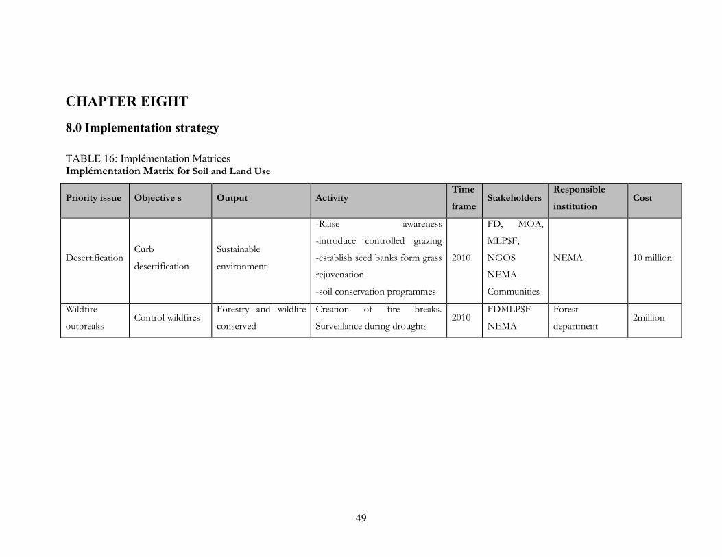
49
CHAPTER EIGHT
8.0 Implementation strategy
TABLE 16: Implémentation MatricesImplémentation Matrix for Soil and Land Use
Priority issue Objective s Output ActivityTimeframe
StakeholdersResponsibleinstitution
Cost
DesertificationCurb
desertification
Sustainable
environment
-Raise awareness
-introduce controlled grazing
-establish seed banks form grass
rejuvenation
-soil conservation programmes
2010
FD, MOA,
MLP$F,
NGOS
NEMA
Communities
NEMA 10 million
Wildfire
outbreaksControl wildfires
Forestry and wildlife
conserved
Creation of fire breaks.
Surveillance during droughts2010
FDMLP$F
NEMA
Forest
department2million

50
Implementation Matrix for Livestock and fisheriesPriorityissue
Objective s Output ActivityTimeframe
StakeholdersResponsibleinstitution
Cost
Breed
quality
Better livestock
production
Superior breeds are
introduced
Provide all services introduce
grade bulls
2006-
2010
MLP$f
DVS, KLMC
ALRMPII
MLP$F 50M
PastureHave better and
more pasturePasture improved
Introduce grazing patterns
Pasture reseeding
2006-
2010
Production
Services
Better market
access, introduce
emergency
livestock (poultry,
fish)
Market for livestock
established
Extension provided
Lobby for better marketing
Established Tsetse fly control
Vaccinations treatments
2006-
2010

51
Implementation Matrix for Agriculture
Priority issue Objective s Output ActivityTimeframe
StakeholdersResponsibleinstitution
Cost
IMPROVEFOODSECURITY
Create
alternatives for
pastoralists
drop outs
2000 ha under
food irrigation
on rain fed
Prospective train farmers on rain
fed farming
Crop husbandry and better
farming technique
-Establish trial demonstration
plots and farmers field days
-Provision of extension services
-Provide certified seeds and farm
implements
-soil and water conservation
2006-2007
2006-2007
2009-2010
2009-2010
MOA
MWI
NEMA
PROVINCIAL
ADMINSTRATION
COA
MOA
Implementation Matrix for Water Resources
Priority issue Objective s Output Activity Time frame StakeholdersResponsibleinstitution
Cost
Increase
acreage under
irrigation
Increased
food
production
10,000 ha under
irrigation
-Carry out soil and topographic surveys
-design irrigation systems
-construction of irrigation structure
-procure pumping sets
-train farmers on land use and management
2006-2007 MWI
ALRMP
NEMA
FAQ
DONORS
MWI MOA 200
million

52
Provision of
safe water 50% of Ijara50% population
by piped water-Expand cured treatment works 2006-2007
MWI
NWSBNWSB 200M
Water
Residents
have access
to drinking
water by
2010
-Tanks and booster stations
-design, provide and lay pipes along Masalani
safe, Ijara, Hulugho proposed pipeline
-provision of pumping, equipment’s,
desilting of pans, -design construction of
new water pans, carryout complete,
hydrological surveys (district wide)
2010
ALRMP
NEMA50 M
3M

53
Implementation Matrix for Wildlife and Forest ResourcesPRIORITYISSUE OBJECTIVES OUTPUT ACTIVITY
TIMEFRAME
STAKEHOLDERS
RESPONSIBLEINSTITUTION
COST
1.Gazettement
of Boni forest
Protection of the
forest
Secure and
sustainable
forest
Training and sensitization
Demarcation of forest area
Ongoing by
2010
- FD, CCI, DDC,
DEC
- Communities
- FD , - CCI3M
1M
2.
Management
plan
To come up with a
sustainable
management plan of
the forest
Sustainable
management
of forest
Involves community in
drawing the management plan
Prepare forest management
agreement with communities
Train communities on MPFM
By 2010
- FD,
- Communities
- DEC, CCI
- agriculture
- Livestock
- Civil Society
- FD, CCI 2M
3.Utilization of
forest
Sustainable
utilization of non-
wood forest
resources
Economically
empowered
communities
Sustainable
forest
Promote modern bee keeping
production targeted of 10
tonnes for year
Organize beekeepers into
society to market their
products
2010 - RPT - FD, Livestock 5m
Formation of range
management
Communities living along
border
By 2010 -FD, -CCI
-Livestock
-Communities
-Civil societies
-FD, CCI 1M
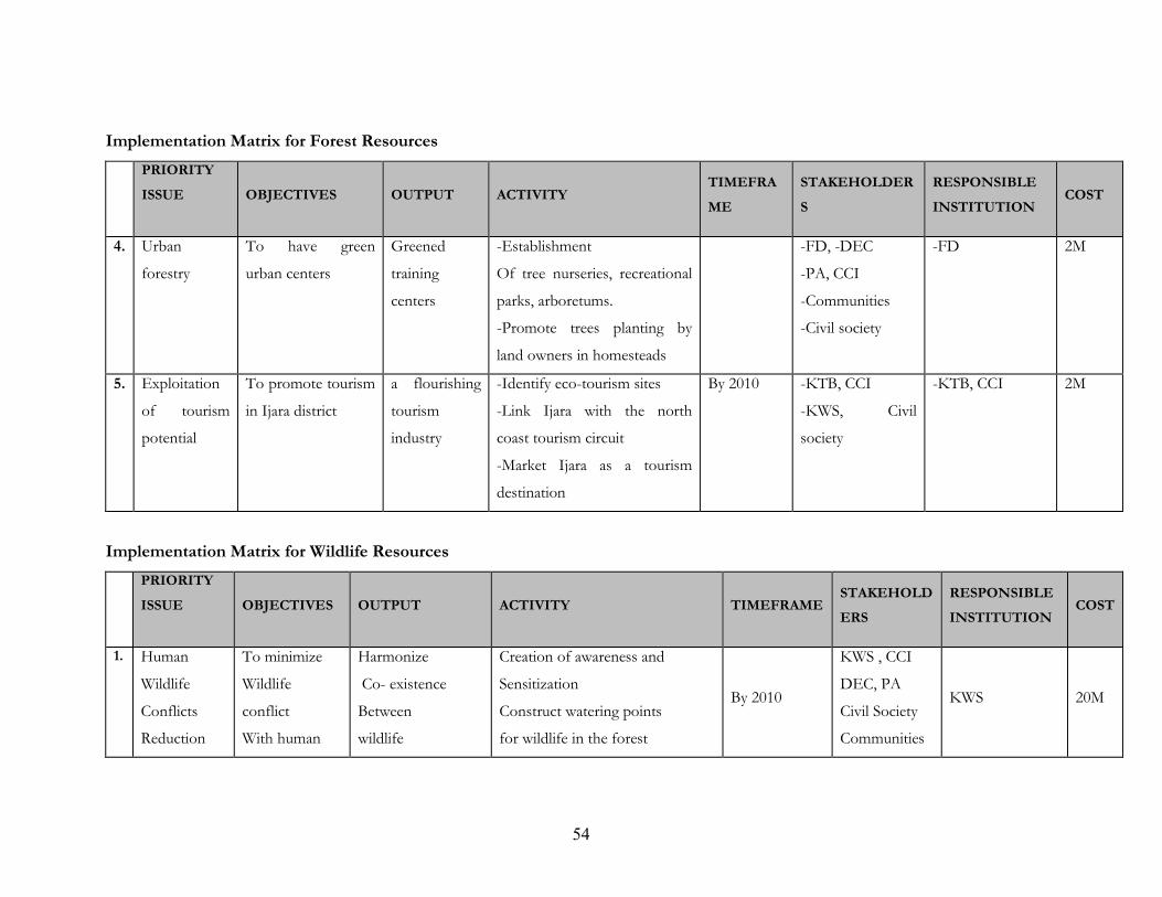
54
Implementation Matrix for Forest ResourcesPRIORITYISSUE OBJECTIVES OUTPUT ACTIVITY
TIMEFRAME
STAKEHOLDERS
RESPONSIBLEINSTITUTION
COST
4. 2.Urban
forestry
To have green
urban centers
Greened
training
centers
-Establishment
Of tree nurseries, recreational
parks, arboretums.
-Promote trees planting by
land owners in homesteads
-FD, -DEC
-PA, CCI
-Communities
-Civil society
-FD 2M
5. 3.Exploitation
of tourism
potential
To promote tourism
in Ijara district
a flourishing
tourism
industry
-Identify eco-tourism sites
-Link Ijara with the north
coast tourism circuit
-Market Ijara as a tourism
destination
By 2010 -KTB, CCI
-KWS, Civil
society
-KTB, CCI 2M
Implementation Matrix for Wildlife ResourcesPRIORITYISSUE OBJECTIVES OUTPUT ACTIVITY TIMEFRAME
STAKEHOLDERS
RESPONSIBLEINSTITUTION
COST
1. Human
Wildlife
Conflicts
Reduction
To minimize
Wildlife
conflict
With human
Harmonize
Co- existence
Between
wildlife
Creation of awareness and
Sensitization
Construct watering points
for wildlife in the forest
By 2010
KWS , CCI
DEC, PA
Civil Society
Communities
KWS 20M

55
and mankind Create wildlife Sanctuaries FD
2.
Awareness
on
endangered
wildlife
To Create
awareness on
endangered
wildlife species
Endangered
Species protected
Sensitization of communities
on endangered species Promotion
of environmental conservation
programmes to protect
Promotes continuous production
of wildlife species e.g. Aloe Vera
By 2010
KWS
KEPHIS
FD
DEC
Civil society
KWS
FD2M

56
Implementation Matrix for Tourism
Priority issue Objective s Output Activity Time frame StakeholdersResponsibleinstitution
Cost
Develop
tourism
Income from
tourism is
increased by
connection to
coast tourist
circuit
Number of
tourists increased
by 30%
Improve tourism infrastructure
(roads, campsites)
-train tour guides establish
observation
-construct tourist lodges
-establish community
conservation
2006-2010
2008-2010
-MT
-KWS
-County
Council
-Investors
-NGOs
-Investors
-50 million
-10 million
-5 million
Implementation Matrix for BiodiversityPRIORITYISSUE OBJECTIVES OUTPUT ACTIVITY
TIMEFRAME
STAKEHOLDERS
RESPONSIBLEINSTITUTION
COST
1.
Biodiversity
Conservation
To conserve
biodiversity
Biodiversity
conserved
- Sensitization and awareness
on importance of biodiversity
- Research on medicinal
values of plants
- Research and documentation
of 1K
2010
NMK,KWS,
KEPHIS,NEMA
FD, Communities
Civil Society
Institution of
higher learning
NMK KWS 3M

57
2.Promote
environmenta
l education
and creation
of awareness
- To increase
the level of
awareness on
environmental
issues
Environmental
issues
comprehended by
communities and
environment
- Implementation of ESD.
- Promotion of school based
environment education item,
eco- school, clubs
- Environmental barazas at
sub- location level
2008
- NEMA
- KWS
- Agriculture
- Education
- CMI society
- ALRMP - FD-
NEMA 5M
3.Promotion of
environment
grandly
technologies
- To increase
the use of
environmental
friendly
technologies
Pollutions
minimize
- Creation of awareness on
available environmental
friendly technologies
2010
- ITDG
- NEMA
- UNED
NEMA 1M

58
Implementation Matrix for Energy
Priority issue Objective s Output Activity Time frame StakeholdersResponsibleinstitution
Cost
ENERGYRESOURCEUTILIZATION
Connection to
national grid
District
connected to
national grid
Lobby for connection 2006-2007
KPLC
KENGEN
M&E
NEMA
ALRMP
M&.E
NEMA
2MIL
LION
Development
renewable
energy
resource
Exploit energy
potential
Solar and wind
power exploited
Awareness Virtues of renewable
energy sources2006-2010
Charcoal
burning
Reduce
charcoal
burning
Charcoal
burning reduced
Awareness raising in need to
reduce charcoal burning
Awareness raising on alternative
and improved stoves and ovens
2006-2009
NEMA
ALRMP
FOREST
Departments.
Community
NEMA
FOREST
Department
.
1
MILLI
ON

59
Implementation Matrix for Mining and Quarries
Priority issue Objective s Output ActivityTimeframe
StakeholdersResponsibleinstitution
Cost
Reclamation and
restoration of
quarries arid sand
harvested areas
Reclamation and
restoring and land
scrapping
Land reclaimed Land scrapping
Planting of
appropriate species of
trees
5 years NEMA, County
councils
NEMA
county
councils
1 M
EIA audits Fencing
provision of
protective clothes
1year NEMA county
councils
NEMA
County
councils

60
Implementation Matrix for Biodiversity Environmental Information SystemsPRIORITYISSUE OBJECTIVES OUTPUT ACTIVITY
TIMEFRAME
STAKEHOLDERS
RESPONSIBLEINSTITUTION
COST
Documentatio
n and
environmental
information
To improve access
to documents and
environmental
information
Accessible
environment
information
- Construction of a district
information documentation
center
By 2010
NEMA, FD,
DDC, KLS,
CDF
EDUCATION
NEMA 6M
Information
access and
sharing
To improve access
and sharing of
information
- Improved
sharing and
access of
information
Legislation on access and
sharing of information should
be to club bureaucracy Right
to environmental information
be guaranteed Information to
be disseminated, should be
accurate and timely
2010
Parliament
NEMA
AG
NEMA

61
Implementation Matrix for Environmental Governance and Institutional FrameworkPRIORITYISSUE OBJECTIVES OUTPUT ACTIVITY
TIMEFRAME
STAKEHOLDERSRESPONSIBLEINSTITUTION
COST
Strengthen
environmental
governance
To strengthen
environment al
governance at
district level
Improved
environmental
governance
Capacity building for D&C
members and civil society
Provision of means of
transport
Improve on funding for DEC
2007NEMA
Ministry of financeNEMA 6M
Improve on
compliance with
environment
regulation and
standards
To improve
compliances with
environment
regulations and
standards
- Improve
environment
-Training of environment
officers on compliances and
enforcements Appointment
and gazettement of
environmental inspectors
- Formulation of gazettement
of various environment
standards
2007
2007
2008
NEMA
FD, KEPHIS
JUDICIARY
NEMA 5M

62
TABLE 17: Monitoring and Evaluation matrixMonitoring and Evaluation for Energy Resources
Monitoring and Evaluation for Soil and Land Use
ActivityOVIs
MOV ReportingSchedule
Implementers ResponsibleInstitution
Cost
Lobby for Connection
to the National grid
District Connected Existence Annual Kengen, KPLC,
Politicians
Ministry of
Energy
Awareness Raising on
Renewable Energy
Sources
Awareness raised No. of workshop held Annually NEMA, Forest
Department, Civil
Society
Ministry of
Energy
1m
Awareness Raising on
The effects of charcoal
burning
Awareness raised No. of awareness raising
forums held and reports
Annually Forest Department,
NEMA
Forest
department,
1m
ActivityOVIs
MOV ReportingSchedule
Implementers ResponsibleInstitution
Cost
Awareness Creation on
Sustainable Range Management
Awareness Forums No. Held and Reports Quarterly MLP$D,PA,
NEMA,DRSRS
NEMA
Establish Seed banks Bulk plots in use No. of plots Quarterly MOA, MLP$F, NEMA
Monitor soil Erosion
$ Land Degradation
% of soil loss Monitoring reports Quarterly MOA, DRSRS NEMA

63
Monitoring and Evaluation for Agriculture
Monitoring and Evaluation for Livestock and fisheries
Activity OVJ - MOVReportingSchedule
ImplementersResponsibleinstitution for M$E
Reseeding of degraded
LandArea Reseeded
Size of area
ReseededAnnually MLP$F and MLP$F
Creation on Sustainable
Range land UseAwareness raised
No. of awareness
forums heldAnnually
MLP$F, NEMA MOA, Civil
SocietyNEMA,
Carrying capacity analysisAnalysis
undertakenAnnually DRSRS, MLP$F MLP$F
ActivityOVIs
MOV ReportingSchedule
Implementers ResponsibleInstitution
Cost
Training of prospective farmers Farmers trained No. Trained and
reportsQuarterly MOA MOA
Establishment of
Demonstration PlotsPlots established
No. of plots
Established
QuarterlyMOA MOA
Soil and water
Conservation Training
Communities
Trained
No. Trained and
reports
Quarterly MOA MOA

64
Monitoring and Evaluation for Environmental Hazards and Disasters
Activity OVJ - MOVReportingSchedule
ImplementersResponsibleinstitution for M$E
Drought Mitigation
Response Measures
No. of
mitigation
measures
undertaken
Work tickets for water buster No. of
livestock No. of vaccinated
No of beneficiaries given relief food
waybills
No. of kit supplied to health facilities
No. of therapeutic centers established
Quarterly ALRMP, M.O.H
Ministry of
Water Provincial
Administration
Flood preparedness
Measures put in
place
No. of
preparedness
put in place
Constructed dykes,
Water Harvesting
Constructed deck dams and diversion of
ditches
No. of H2O spreading structures
construction
Quarterly M.O.W, ALRMP
Provincial
Administration
M.O.R.P.W
M.O.W
ALRMP
Provincial
Administration
M.O.R.P.W
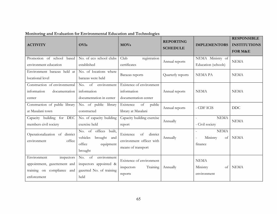
65
Monitoring and Evaluation for Environmental Education and Technologies
ACTIVITY OVIs MOVsREPORTINGSCHEDULE
IMPLEMENTORSRESPONSIBLEINSTITUTIONSFOR M&E
Promotion of school based
environment education
No. of eco school clubs
established
Club registration
certificatesAnnual reports
NEMA Ministry of
Education (schools)NEMA
Environment barazas held at
locational level
No. of locations where
barazas were heldBarazas reports Quarterly reports NEMA PA NEMA
Construction of environmental
information documentation
center
No. of environment
information
documentation in center
Existence of environment
information
documentation center
Annual reports NEMA NEMA
Construction of public library
at Masalani town
No. of public library
constructed
Existence of public
library at MasalaniAnnual reports - CDF ICIS DDC
Capacity building for DEC
members civil society
No. of capacity building
exercise held
Capacity building exercise
reportAnnually
- NEMA
- Civil societyNEMA
Operationalization of district
environment office
No. of offices built,
vehicles brought and
office equipment
brought
Existence of district
environment officer with
means of transport
Annually
- NEMA
- Ministry of
finance
NEMA
Environment inspectors
appointment, gazettement and
training on compliance and
enforcement
No. of environment
inspectors appointed &
gazetted No. of training
held
Existence of environment
inspectors Training
reports
Annually
NEMA
Ministry of
environment
NEMA
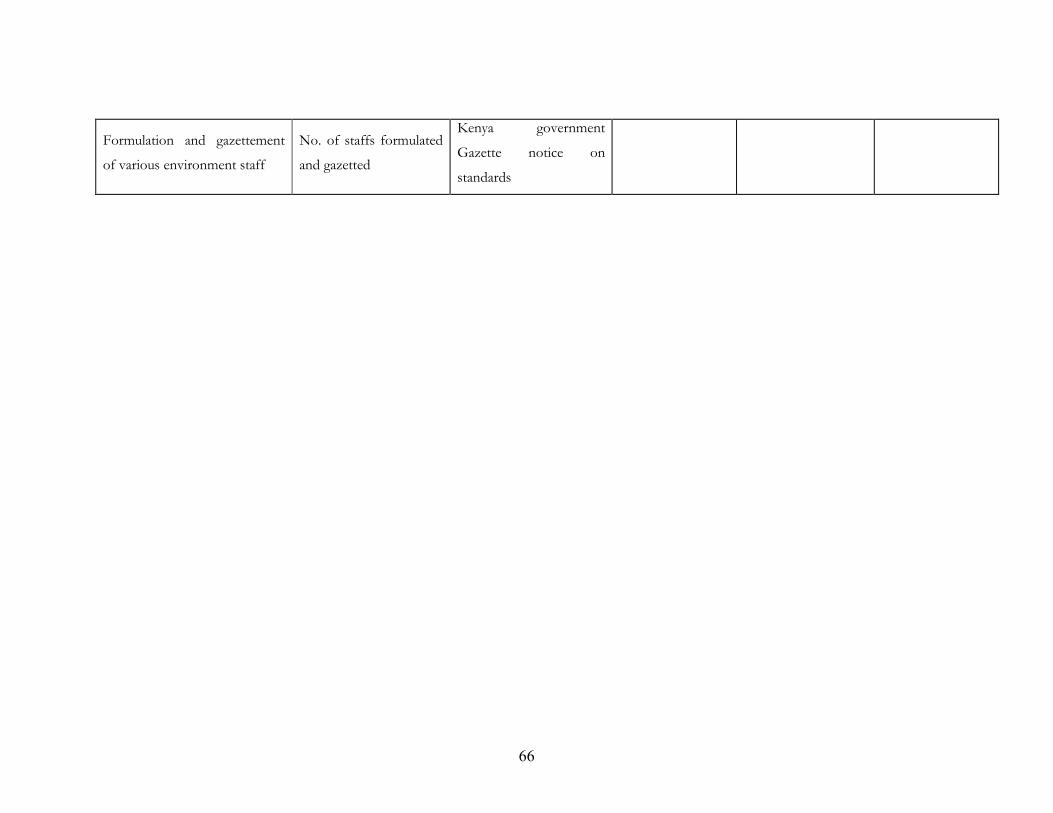
66
Formulation and gazettement
of various environment staff
No. of staffs formulated
and gazetted
Kenya government
Gazette notice on
standards
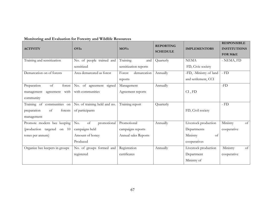
67
Monitoring and Evaluation for Forestry and Wildlife Resources
ACTIVITY OVIs MOVsREPORTINGSCHEDULE
IMPLEMENTORSRESPONSIBLEINSTITUTIONSFOR M&E
Training and sensitization No. of people trained and
sensitized
Training and
sensitization reports
Quarterly NEMA
FD, Civic society
- NEMA, FD
Demarcation on of forests Area demarcated as forest Forest demarcation
reports
Annually -FD, -Ministry of land
and settlement, CCI
- FD
Preparation of forest
management agreement with
community
No. of agreement signed
with communities
Management
Agreement reports
Annually
CI , FD
-FD
Training of communities on
preparation of forests
management
No. of training held and no.
of participants
Training report Quarterly
FD, Civil society
- FD
Promote modern bee keeping
(production targeted on 10
tones per annum)
No. of promotional
campaigns held
Amount of honey
Produced
Promotional
campaigns reports
Annual sales Reports
Annually Livestock production
Departments
Ministry of
cooperatives
Ministry of
cooperative
Organize bee keepers in groups No. of groups formed and
registered
Registration
certificates
Annually Livestock production
Department
Ministry of
Ministry of
cooperative

68
Formation of range
management committees for
communities living along the
forest
No. of communities formed Registration certificate Annually Livestock production
department
FD
Establishment of tree
nurseries, parks and arboretum
No. of tree nurseries parks
and arboretums established
Existing tree nurseries
parks and arboretum
Annually FD CCI Community,
civil society
- FD
Identification and establishment
of eco- tourism sites
No. of eco- tourism site
established
Existing eco- tourism
sites No. of license
(saved for eco-
tourism site)
Annually KWS, KTB
CCI , Communities
KTB

69
Monitoring and Evaluation for Forestry and Wildlife Resources Ctd.
ACTIVITY OVIs MOVsREPORTINGSCHEDULE
IMPLEMENTORSRESPONSIBLEINSTITUTIONSFOR M&E
Linking Ijara with North Coast
tourism circuit
No. of tourism arrivals in
Ijara district
Tourism arrival
reports
Annually KTB, KWS , CCI KTB
Construction of water points
for wild life in the forest
No. of watering points
constructed
Existence of wildlife
watering points
Annually KWS, CCI KWS
Creation of wildlife sanctuaries No. of wildlife sanctuaries Presence of
sanctuaries in the
district & registration
certificate for
sanctuaries
Annually KWS, Civil society
CCI
KWS
Promotion of environmental
conservation programmes to
protect endangered species
No. of promotional
undertaken
Promotion reports Annually CCI, KWS, KEPHCS
NEMA, FD
NEMA
Sensitization of communities
Endangered wildlife
No. of Sensitization
Exercise
carried out
Sensitization
Reports
Quarterly NEMA, KEPHICS
FD, NEMA
NEMA
Sensitization and Creation
of Awareness on the
Importance of Biodiversity
No. of Sensitization
Exercise Carried out
Sensitization reports Quarterly NEMA, KEPHCS
FD, NEMA
NEMA
Research on wildlife No. of Research Carried out Research Publications Annually Research institutions NEMA

70
of Medicinal Value on Medicinal Value of w/life
Research and dissemination of
IK
No. of Research
Carried out on 1K
Research Publications Annually Research institutions NEMA
Restocking of 40% of
H/H in the district
-No. of Households
Restocked in Masalani, Ijara,
Hulugho
Branded animals
Progress reports
Quotations
Beneficiaries
Names/ID/No
Quarterly - Community -DSG/DDC
- Specific
Dept e.g.
ALRMP

71
Monitoring and Evaluation for Industry, Trade and Services
ACTIVITY OVIs MOVsREPORTINGSCHEDULE
IMPLEMENTORSRESPONSIBLEINSTITUTIONSFOR M&E
Building partnership and
entrepreneurship
No. of
Communities
Trained
W/shop reports
List of participants
Quarterly G.O.K, NGO’s
CBO’s
DSG, NGO’s
CBO’s
Silting of Dumping
Sites and Provision of
a tractor for Collection of
Refuse
- No. of dumping
Sites sited and
Provision of
Tractors
No. of dumping
Sites constructed
Tractor provided
Work ticket in place
Quarterly CCI, DPHI CCI, DPHO
Desilting of 4 no. of h2o
pans for livestock trade
no. of constructed
pans
Desilted water pans in
use
Quarterly CCI, NGO,s
Ministry of livestock
And fisheries
CCI, NGOs
Ministry of water
Ministry of livestock
and fisheries
Provision of loans to
cooperatives societies in
Masalani, Ijara, Hulugho and
Sangailu
No of cooperative
group supported
M.O.U Financial
agreement
Bank statement
Certificate of registration
Quarterly Ministry of cooperative
society, (D.S.D.O)
D.D.O, ALRMP
Ministry of
Cooperative
DSDO, DDO
ALMRP
Provision of TBA training No. of TBAs Training reports
No. of participants
No. of delivery kits
provided photos/video
Quarterly M.O.H, NGOs
CBOs
NGOs, CBOs

72
taken
Training of communities on
safe clean water
No. of communities
trained
List of participants
Training reports
Quarterly Ministry Of Water Ministry Of Water