Embed Size (px)
Citation preview
1
Republic of Indonesia
FY2016 Ex-Post Evaluation of Japanese ODA Loan Project
“Urgent Disaster Reduction Project for Mt. Merapi/Progo River Basin and Mt. Bawakaraeng”
External Evaluator: Masami Sugimoto, SHINKO Overseas Management Consulting Inc.
0.Summary
This project consists of two sub-projects that conduct both the structural and nonstructural
disaster countermeasures against the eruption of volcanic Mt. Merapi at its foot and the Progo
River Basin in Jogjakarta Special Region Province, as well as the large-scale landslide of Mt.
Bawakaraeng at the Jeneberang River basin and the Bili-Bili Dam in South Sulawesi Province.
The Mt. Merapi/Progo River Basin component was implemented to promote protection of
human lives, public and private properties and to establish sustainable disaster protection
systems, thereby contributing to the promotion of regional development. The Mt. Bawakaraeng
component was conducted to protect human lives, public and private property including
farmlands from debris flow and improve the dam function downstream by preventing sediment
discharge from the landslide stricken area, thereby contributing to sustained social and
economic activities in and around Makassar City by maintaining stable supply of water and
other utility services.
This project is highly relevant corresponding to the Indonesia’s development policy, the
international framework to cope with natural disaster prevention, people’s development needs
and also to the Japan’s ODA policy at the time of appraisal. On the other hand, the efficiency is
fair with its implementation period longer than planned due to the prolonged procurement
process, while the project cost is lower than the plan.
For the Mt. Merapi/Progo River Basin component, the preset quantitative indicator “Sediment
Control Ratio” became unusable due to the occurrence of unexpected violent eruption during
the project implementation, however, the project effect on disaster prevention and promotion of
regional development has been confirmed by reviewing past disaster statistics, result of the
beneficiary survey and other evidential facts. For the Mt. Bawakaraeng component, the effect on
disaster prevention and regional development has been identified as well by the achievement of
preset quantitative indicators, result of the beneficiary survey and so forth. The project has been
thus mostly producing planned effects, therefore effectiveness and impact of the project can be
judged high.
Basically no problems were identified in the maintenance system for the developed sabo
facilities as well as the technical and financial capacity of both of the River Basin Organizations
(Balai Besar Wilayah Sungai, hereinafter referred to as BBWS) which are responsible under the
Ministry of Public Works and Housing. However, unrealized optimal sand mining control
system without the planned establishment of the Sand Mining Management Institution (SMMI)
2
(Project Location)
and prevailing incomplete operation and management practices on the installed monitoring,
forecasting and warning systems show some concern on the sustainability. Due to those minor
problems in maintenance and prevailing conditions of the operation and maintenance practices,
the sustainability of the project effects is fair.
In light of the above, this project is evaluated to be satisfactory.
1. Project Description
1.1 Background
<Mt. Merapi/Progo River Basin>
Mt. Merapi with the height above sea level 2,986 m is one of the most prominent active
volcanos in the world which is located 30 km north-northwest of the historical city Jogjakarta. It
has erupted more than 40 times repeatedly since 1800 on record. Even after the 1990s, it
continues erupting every two or three years in which debris flow is in increasing danger due to
the large amount of accumulated unstable sediment. Additionally, sand mining was prevailing
in the surrounding areas, and problems of uncontrolled acts causing damage on existing sabo
facilities, change in river course, river bed degradation downstream, environmental deterioration
by noise and dust and road damages by overloaded vehicles were urging comprehensive counter
measures to prevent volcanic and sediment disasters and to develop effective sand mining
management systems.
<Mt. Bawakaraeng>
A gigantic caldera-wall collapse occurred at Mt. Bawakaraeng located at the headstream
region of Jeneberang River in the south of Sulawesi Island on March 26, 2004. The landslide
sediment that reached villages 2.5 km downstream claimed 32 people dead and missing and
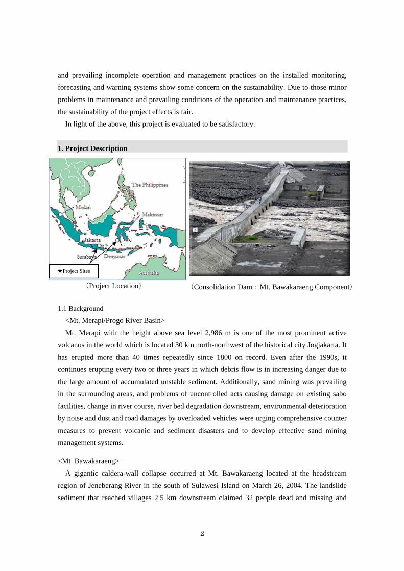
(Consolidation Dam:Mt. Bawakaraeng Component)
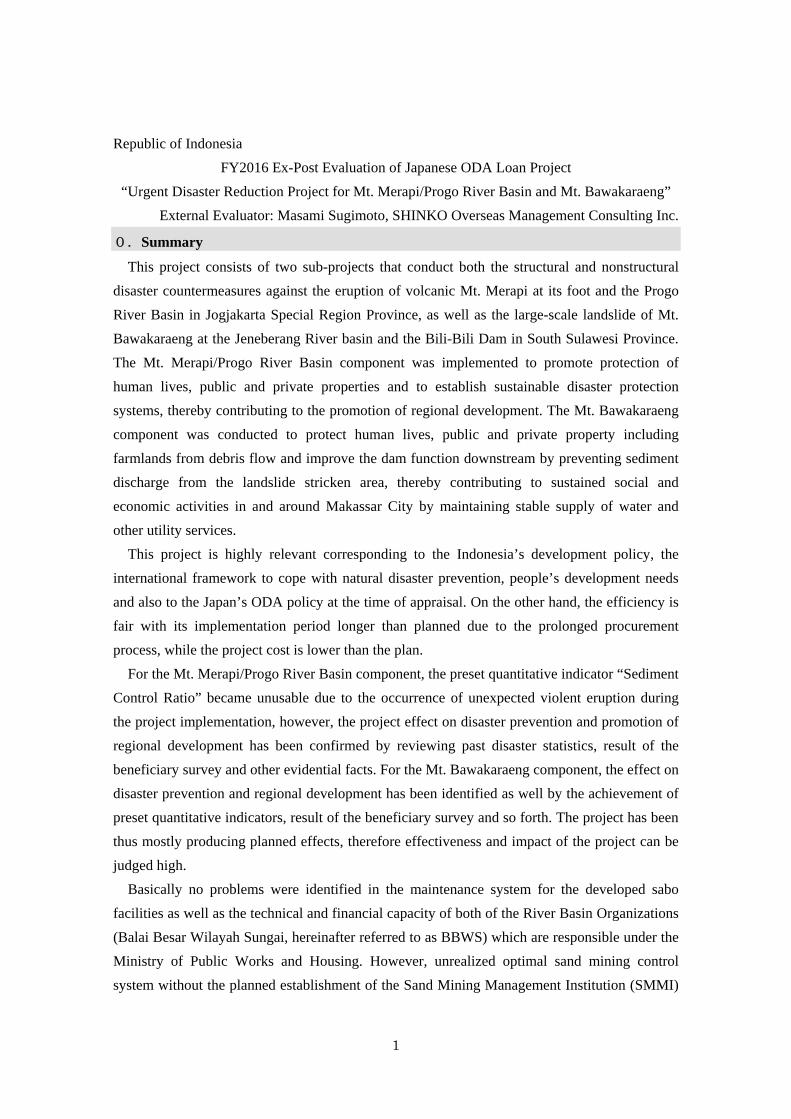
★Project Sites
3
damage of totally 22 billion rupiahs in value (approximately 300 million yen <exchange rate at
the appraisal: 0.012 yen/rupiah>. The total volume of sediment having being accumulated in the
collapsed caldera was estimated at 200 - 300 million tons, and rainfall after the collapse brought
sediment outflow estimated at about 14 million m3 during three months until June 2004. The
debris flow completely buried a sabo dam 5km downstream, further, brought damages burying
farmlands along the Jeneberang River basin and river-crossing traffic obstruction and others.
Thirty-five km downstream the collapsed location, there exists the Bili-Bili Multipurpose Dam
constructed under the Japanese ODA Loan which is supplying clean water and electricity to
Makassar City, and providing irrigation water to areas in and around the city. The sediment
inflow from the collapse and consequent water quality degradation threaten those dam functions.
Those situations called for countermeasures to eliminate factors that hinder social and economic
activities in and around Makassar City with 1.2 million population, and to secure the safety of
the local residents.
1.2 Project Outline
<Mt. Merapi/Progo River Basin>
The object of this component of the project is to promote protection of human lives, public
and private properties and to establish sustainable disaster protection systems by conducting
both the structural and nonstructural disaster countermeasures at the foot of Mt. Merapi and
Progo River basin located 30 km north-northwest of Jogjakarta City such as provision of sabo
facilities, prevention of riverbed degradation, installation of monitoring, forecasting and
warning systems, improvement of sand mining management and so forth, thereby contributing
to the promotion of regional development.
<Mt. Bawakaraeng>
The object of this component of the project is to protect lives, public and private properties
including farmlands from sediment flow and improve the dam function downstream arresting
sediment discharge from the landslide stricken area by rehabilitating existing infrastructures
including bridges as well as developing sabo facilities and monitoring, forecasting and warning
systems at the Jeneberang river basin that has encountered sediment disasters from the great
landslide of the Mt. Bawakaraeng in South Sulawesi Province in March 2004, thereby
contributing to sustained social and economic activities in and around Makassar City by
maintaining stable supply of water and other utility services.
4
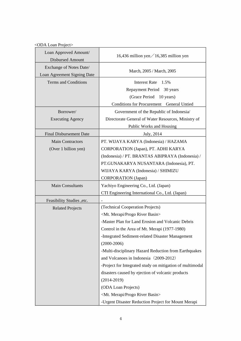
<ODA Loan Project>
Loan Approved Amount/
Disbursed Amount 16,436 million yen/16,385 million yen
Exchange of Notes Date/
Loan Agreement Signing Date March, 2005 / March, 2005
Terms and Conditions Interest Rate 1.5%
Repayment Period 30 years
(Grace Period 10 years)
Conditions for Procurement General Untied
Borrower/
Executing Agency
Government of the Republic of Indonesia/
Directorate General of Water Resources, Ministry of
Public Works and Housing
Final Disbursement Date July, 2014
Main Contractors
(Over 1 billion yen)
PT. WIJAYA KARYA (Indonesia) / HAZAMA
CORPORATION (Japan), PT. ADHI KARYA
(Indonesia) / PT. BRANTAS ABIPRAYA (Indonesia) /
PT.GUNAKARYA NUSANTARA (Indonesia), PT.
WIJAYA KARYA (Indonesia) / SHIMIZU
CORPORATION (Japan)
Main Consultants Yachiyo Engineering Co., Ltd. (Japan)
CTI Engineering International Co., Ltd. (Japan)
Feasibility Studies ,etc. -
Related Projects (Technical Cooperation Projects)
<Mt. Merapi/Progo River Basin>
-Master Plan for Land Erosion and Volcanic Debris
Control in the Area of Mt. Merapi (1977-1980)
-Integrated Sediment-related Disaster Management
(2000-2006)
-Multi-disciplinary Hazard Reduction from Earthquakes
and Volcanoes in Indonesia(2009-2012)
-Project for Integrated study on mitigation of multimodal
disasters caused by ejection of volcanic products
(2014-2019)
(ODA Loan Projects)
<Mt. Merapi/Progo River Basin>
-Urgent Disaster Reduction Project for Mount Merapi
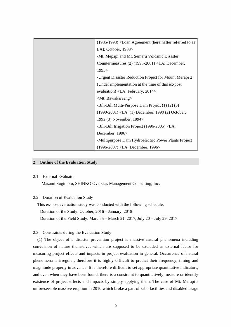
5
(1985-1993) <Loan Agreement (hereinafter referred to as
LA): October, 1983>
-Mt. Mepapi and Mt. Semeru Volcanic Disaster
Countermeasures (2) (1995-2001) <LA: December,
1995>
-Urgent Disaster Reduction Project for Mount Merapi 2
(Under implementation at the time of this ex-post
evaluation) <LA: February, 2014>
<Mt. Bawakaraeng>
-Bili-Bili Multi-Purpose Dam Project (1) (2) (3)
(1990-2001) <LA: (1) December, 1990 (2) October,
1992 (3) November, 1994>
-Bili-Bili Irrigation Project (1996-2005) <LA:
December, 1996>
-Multipurpose Dam Hydroelectric Power Plants Project
(1996-2007) <LA: December, 1996>
2.Outline of the Evaluation Study
2.1 External Evaluator
Masami Sugimoto, SHINKO Overseas Management Consulting, Inc.
2.2 Duration of Evaluation Study
This ex-post evaluation study was conducted with the following schedule.
Duration of the Study: October, 2016 – January, 2018
Duration of the Field Study: March 5 – March 21, 2017, July 20 – July 29, 2017
2.3 Constraints during the Evaluation Study
(1) The object of a disaster prevention project is massive natural phenomena including
convulsion of nature themselves which are supposed to be excluded as external factor for
measuring project effects and impacts in project evaluation in general. Occurrence of natural
phenomena is irregular, therefore it is highly difficult to predict their frequency, timing and
magnitude properly in advance. It is therefore difficult to set appropriate quantitative indicators,
and even when they have been found, there is a constraint to quantitatively measure or identify
existence of project effects and impacts by simply applying them. The case of Mt. Merapi’s
unforeseeable massive eruption in 2010 which broke a part of sabo facilities and disabled usage
6
of “Sediment Control Ratio” as a preset single quantitative indicator is an extreme example. So
is the case of Mt. Bawakaraeng. In the light of that constraint, this ex-post evaluation made
much of such other kinds of evidence as findings from the beneficiary survey, field observation,
interview to related institutions and the result of reviewing past statistic records of disaster
damages.
(2) Substance of this project is a package of two separate sub-projects under the Directorate
General of the Ministry of Public Works and Housing respective implementation of which is
independently managed by each River Basin Management Organization (Balai Besar Wilayah
Sungai <BBWS>, hereinafter referred to as BBWS). However, they were not totally managed in
an integrated way as a single ODA loan project. Therefore the information on total Man-months
of the consulting services and project costs expended from the government budget was not
available which limited the evidence for the efficiency judgement.
(3) Technical training for operation and maintenance of sabo facilities is mainly conducted by
the Sabo Technical Center comprehensively. Because the record of the training practices was
not submitted by the Center, there was a constraint in evidence partly to objectively support
technical sustainability of the project.
3.Results of the Evaluation (Overall rating: B1)
3.1 Relevance (Rating: ③2)
3.1.1 Consistency with the Development Plan of Indonesia
The Indonesian Government designated the peripheral area of Mt. Merapi as the most critical
area in the National Disaster Management Program after the violent eruption in 1969. The
Master Plan for Land Erosion and Volcanic Debris Control in the Area of Mt. Merapi was
developed under the JICA Development Study Scheme in 1980, and additionally two phases of
sabo projects were implemented from 1985 until 2001 under Japanese ODA Loans. The
assistance for the Mt. Bawakaraeng component was requested by strong needs to urgently
control the debris-avalanche and sediment outflow caused by the landslide. The National
Medium-term Development Plan (RPJMN: Rencana Pembangunan Jangka Menengah
Nasional) 2005-2009 at the time of the appraisal also laid stress on infrastructure development
to promote regional development.
The National Medium-term Development Plan (RPJMN) 2015-2019 at the time of the
Ex-post evaluation incorporates nine priorities called “Nawa Cita” proposed by the republic’s
1 A: Highly satisfactory, B: Satisfactory, C: Partially satisfactory, D: Unsatisfactory 2 ③: High, ②: Fair:①: Low
7
president Joko Widodo inaugurated on October 10, 2014. One of the nine priorities is
“promotion of economic independence by developing each strategic sector in domestic
economy” in which “countermeasures against disaster and reduction of disaster risks” are placed
in a priority area. Thus, the relevance to the development plan of Indonesia is consistently high.
The Hyogo Framework for Action 2005-2015 adopted at the 2nd World Conference on
Disaster Reduction of the United Nations in 2005 announces five priority actions; namely, (1)
Ensure that disaster risk reduction is a national and a local priority with a strong institutional
basis for implementation, (2) Identify, assess and monitor disaster risks and enhance early
warning, (3) Use knowledge, innovation and education to build a culture of safety and resilience
at all levels, (4) Reduce the underlying risk factors and (5) Strengthen disaster preparedness for
effective response at all levels. On the other hand, the 3rd World Conference on Disaster
Reduction of the United Nations in 2015 addressed four priorities for action in its Sendai
Framework for Disaster Risk Reduction 2015-2030; (1) Understanding disaster risk, (2)
Strengthening disaster risk governance to manage disaster risk, (3) Investing in disaster risk
reduction for resilience and (4) Enhancing disaster preparedness for effective response and to
“Build Back Better” in recovery, rehabilitation and reconstruction. It may be pronounced that
this project is in accordance with prevailing international frameworks to tackle natural disasters.
3.1.2 Relevance to the Development Needs of Indonesia
<Mt. Merapi/Progo River Basin>
Peripheral area of Mt. Merapi is a prominent tourist spot having historical Borobudur and
Prambanan Temples, and the Jogjakarta district is the center holding population of 2.7 million
people. At the time of the appraisal when the risks of pyroclastic and debris flow were
increasing due to the intermittent eruptions of Mt. Merapi, it was therefore necessary for
eliminating factors that hinder regional economic development to take structural
countermeasures by constructing sabo facilities and developing such nonstructural measures as
monitoring, forecasting and early warning devices and evacuation systems. In addition, it was
also needed to improve sand mining systems to control excessive and improper mining activities
under ineffective management which destabilize sabo facilities’ conditions and cause
degradation of riverbeds. Urgent countermeasures were also needed for stabilizing riverbeds at
two bridges downstream of Progo River that was in danger of collapse due to the riverbed
degradation.
In the circumstance that the eruption activity of Mt. Merapi will not cease in predictable
future, needs for this project continues to be high. This project was implemented as the third
phase following the preceding first (1985-1992) and the second (1995-2001) phase projects, and
the fourth phase (Urgent Disaster Reduction Project for Mount Merapi 2, LA: February 2014
8
<IP-566>) is under implementation. Mt. Merapi repeated eruptions in 2006 and 2010, therefore
the project needs are increasingly high.
<Mt. Bawakaraeng>
A risk of debris flow at the Jeneberang River basin was increasing at the time of appraisal due
to the occurrence of massive landslide at Mt. Bawakaraeng. Existing infrastructure like bridges
and sabo facilities had been damaged by already occurred debris flow, which necessitated their
rehabilitation. If no countermeasures had not been taken, mass of soil might have flown into the
Bili-Bili Dam downstream, which was expected to remarkably reduce its water supply function
to irrigation, hydraulic power generation and production of clean water, consequently to
seriously affect the social and economic activities in and around Makassar City which has a
population of 1.2 million people. To cope with that situation, in addition to urgently removing
the accumulated sediment, both the structural and nonstructural devices as long-run
countermeasures were to be taken; namely sediment control by constructing sabo facilities
(structural) and monitoring of sediment conditions, trend, etc. early warning, improvement of
people’s consciousness on disaster prevention and evacuation arrangements (non-structural).
Different from the Mt. Merapi component, this component is caused by the massive landslide
of the caldera wall occurred on March 26, 2004. However, accumulation of enormous volume
of surplus collapsed soil, possibility of extended collapse in future, necessity for continuous
countermeasures against inflow of minute floating soil avalanche (Wash Load) into Bili-Bili
Dam uncapturable by sabo facilities made this project in high need. Based on the proposal made
in this project, the succeeding project is under preparation. No collapse has been occurred after
2004 yet, however, sediment by the 2004 landslide is still accumulated upstream and
continuously flowing out by rainfall in the rainy season. Further, the additional study during this
project warns possible landslide in future.
Thus, disaster risks that hinders development continues to exist at both the Mt. Merapi and
Mt. Bawakaraeng regions, therefore it is judged that the needs of this project to alleviate and
prevent them are consistently high.
3.1.3 Relevance to Japan’s ODA Policy
3.1.3.1 Country Assistance Program for the Republic of Indonesia
The “Country Assistance Program for the Republic of Indonesia” (November 2004) of the
Japanese government addressed assistance for “creation of a democratic and fair society,” as a
priority issue and area, and in its improvement of fundamental public services, it intended to
assist in preparing preventive measures against high frequency of flood, sediment and other
natural disasters. The Program also identified “sustainable growth driven by private sector” as
one of the priority areas and emphasized the importance of “development of economic
9
infrastructure necessary for improving the investment environment” among others. This project
aims to prevent volcanic and sediment disasters in Jogjakarta region which is a major economic
area of Indonesia, and also to protect the area centering around Makassar from sedimentary
disaster which harms regional social activities and avoid sediment inflow into the Bili-Bili Dam.
This project is thus judged to correspond to the policy for aiming the “creation of a democratic
and fair society” and “development of economic infrastructure necessary for improving the
investment environment.”
3.1.3.2 Strategy for Overseas Economic Cooperation Operations
As a priority assistance area for Indonesia, JICA’s “Strategy for Overseas Economic
Cooperation Operations” (April, 2002) identified “economic infrastructure development”
necessary for endeavoring for the recovery path to sustainable growth through economic reform
as well as “assistance for environmental improvement and antipollution.” It can be judged that
this project corresponds to the JICA’s strategy above in terms of “economic infrastructure
development.” For the Mt. Bawakaraeng component particularly, alleviation of environmental
destruction in the Jeneberang river basin and the ill effect of urban environment worsening in
Makassar City caused by the water quality degradation comply with the policy at the time of
appraisal, “assistance to environmental improvement and antipollution.”
3.1.3.3 Country Assistance Strategy
JICA’s country assistance strategy (September, 2004) in the overseas economic cooperation
works nominates “development of growth environment driven by private sector” as one of the
key issues that includes “intensive assistance to develop disaster prevention infrastructure for
major economic regions.” This project prevents volcanic and sediment disasters in Jogjakarta
region which is one of the main economic areas in Indonesia and protect the area centering
around Makassar City from sedimentary disaster which harms regional social activities and
avoid sediment inflow into the Bili-Bili Dam. Therefore, the project is judged to correspond to
the policy of “intensive assistance to develop disaster prevention infrastructure for major
economic regions” at the time of appraisal.
Thus, this project is highly relevant to the Japan’s ODA policy at the time of appraisal.
In light of the above, this project has been highly relevant to the country’s development plan,
international frameworks to tackle natural disasters and development needs at both appraisal and
ex-post evaluation times. It is also relevant to the Japan’s ODA Policy at the time of appraisal.
Therefore its relevance is high.
10
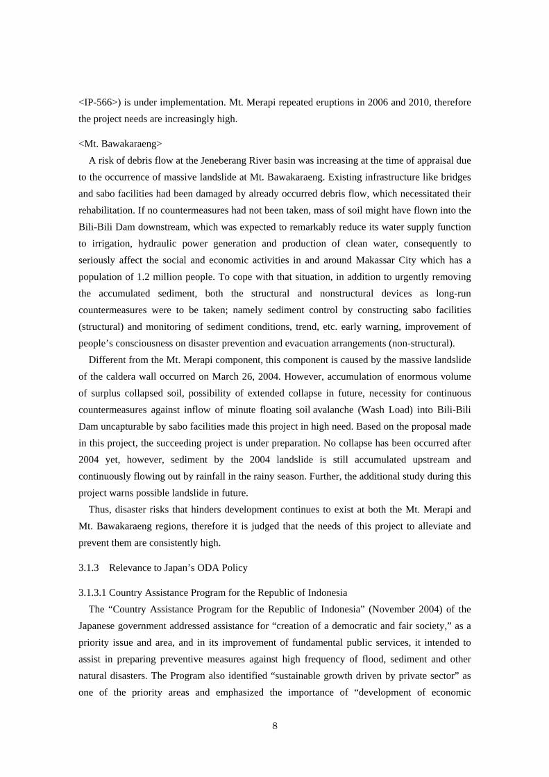
Figure 1: Mt. Merapi and Jogjakarta City
3.2 Efficiency (Rating ②)
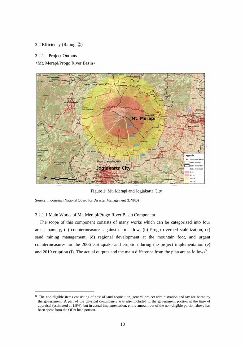
3.2.1 Project Outputs
<Mt. Merapi/Progo River Basin>
Source: Indonesian National Board for Disaster Management (BNPB)
3.2.1.1 Main Works of Mt. Merapi/Progo River Basin Component
The scope of this component consists of many works which can be categorized into four
areas; namely, (a) countermeasures against debris flow, (b) Progo riverbed stabilization, (c)
sand mining management, (d) regional development at the mountain foot, and urgent
countermeasures for the 2006 earthquake and eruption during the project implementation (e)
and 2010 eruption (f). The actual outputs and the main difference from the plan are as follows3.
3 The non-eligible items consisting of cost of land acquisition, general project administration and tax are borne by
the government. A part of the physical contingency was also included in the government portion at the time of appraisal (estimated at 1.9%), but in actual implementation, entire amount out of the non-eligible portion above has been spent from the ODA loan portion.
11
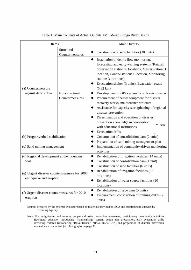
Table 1: Main Contents of Actual Outputs <Mt. Merapi/Progo River Basin>
Items Main Outputs
(a) Countermeasure against debris flow
Structural Countermeasures
Construction of sabo facilities (30 units)
Non-structural Countermeasures
Installation of debris flow monitoring, forecasting and early warning systems (Rainfall observation station: 6 locations, Master station: 1 location, Control station: 1 location, Monitoring station: 3 locations)
Evacuation shelter (3 units), Evacuation roads (5.82 km)
Development of GIS system for volcanic disaster Procurement of heavy equipment for disaster
recovery works, maintenance structure Assistance for capacity strengthening of regional
disaster prevention Dissemination and education of disaster
prevention knowledge in cooperation with educational institutions
Evacuation drills
(b) Progo riverbed stabilization Construction of consolidation dam (2 units)
(c) Sand mining management Preparation of sand mining management plan Implementation of community-driven monitoring
activities
(d) Regional development at the mountain foot
Rehabilitation of irrigation facilities (14 units) Construction of consolidation dam (1 unit)
(e) Urgent disaster countermeasures for 2006 earthquake and eruption
Construction of sabo facilities (6 units) Rehabilitation of irrigation facilities (35
locations) Rehabilitation of water source facilities (20
locations)
(f) Urgent disaster countermeasures for 2010 eruption
Rehabilitation of sabo dam (5 units) Embankment, construction of training dykes (2
units)
Source: Prepared by the external evaluator based on materials provided by JICA and questionnaire answers by Executing Agency
Note: For enlightening and training people’s disaster prevention awareness, participatory community activities (facilitator education introducing “Yonmenkaigi” system, action plan preparation, etc.), evacuation drills involving children (introducing “Bosai Dance,” “Bosai Duck,” etc.) and preparation of disaster prevention manual were conducted. (cf. photographs on page 30)
Note
12
3.2.1.2 Consulting Services for Mt. Merapi/Progo River Basin Component
Following consulting services were provided for project implementation assistance and
others.
1. Project implementation assistance (detailed design tender assistance, implementation
supervision, operation and maintenance assistance)
2. Preparatory studies and assistance for establishing “Sand Mining Management Institution”
(hereinafter referred to as “SMMI”)
3. Assistance for establishing sabo communities, enlightenment of people’s disaster
awareness and establishment of evacuation system
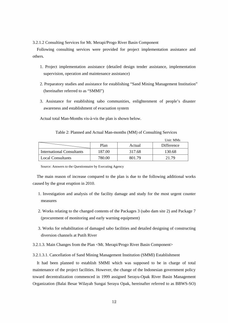
Actual total Man-Months vis-à-vis the plan is shown below.
Table 2: Planned and Actual Man-months (MM) of Consulting Services
Unit: MMs
Plan Actual Difference
International Consultants 187.00 317.68 130.68
Local Consultants 780.00 801.79 21.79
Source: Answers to the Questionnaire by Executing Agency
The main reason of increase compared to the plan is due to the following additional works
caused by the great eruption in 2010.
1. Investigation and analysis of the facility damage and study for the most urgent counter
measures
2. Works relating to the changed contents of the Packages 3 (sabo dam site 2) and Package 7
(procurement of monitoring and early warning equipment)
3. Works for rehabilitation of damaged sabo facilities and detailed designing of constructing
diversion channels at Putih River
3.2.1.3. Main Changes from the Plan <Mt. Merapi/Progo River Basin Component>
3.2.1.3.1. Cancellation of Sand Mining Management Institution (SMMI) Establishment
It had been planned to establish SMMI which was supposed to be in charge of total
maintenance of the project facilities. However, the change of the Indonesian government policy
toward decentralization commenced in 1999 assigned Serayu-Opak River Basin Management
Organization (Balai Besar Wilayah Sungai Serayu Opak, hereinafter referred to as BBWS-SO)
13
and sabo communities4 for facility maintenance and management, which consequently put
more attention to community development instead of establishing SMMI. As the establishment
of SMMI was obstructed, although all the planned preparation works had been completed for
the establishment, BBWS-SO intended to internally organize the Public Service Board (BLU:
Badan Layanan Umum) . Chronologically, after submitting application to organize BLU to the
Ministry of Finance, BBWS-SO sent a notice to JICA that they would organize BLU which has
the same function as SMMI and assign it to deal with sand mining management. In response to
that proposal, JICA eventually agreed, after procuring additional information regarding
preparation of the BLU establishment, to start detailed design of the office building construction
subject to the realization of the creation of BLU in January 2010. However, the BLU has not
been organized either up to the present time. Prevailing local opinion says that it is mainly due
to the difficulty in coordinating various conflicting interests. In spite of that consequence, all the
preparation works including public consultation meetings, provision of frameworks of SMMI
and sabo communities based on the participatory rural appraisal, decision on operational rules
and regulations and preparation of the sand mining management manual were all performed as
planned.
3.2.1.3.2 Addition to the Original Scope
(1) Undertakings coping with the Bantul earthquake
Soon after the implementation has started, a great earthquake attacked the Bantul area and
heavily damaged the local infrastructure facilities. Due to this unexpected disaster, the following
most urgent works have been added to the original scope, and implemented.
Rehabilitation of irrigation facilities at Bantul, Gunung Kidul, Kulon Progo and
Jogjakarta City (35 locations)
Rehabilitation of water source facilities at Sleman, Bantul, Kulon Progo and Jogjakarta
City (20 locations)
(2) Measures against Mt. Merapi eruptions
① Eruption on June 3, 2006
The project took measures to cope with the volcanic disaster (additional package: DCME
<Disaster Countermeasures for Mt. Merapi Eruption>) in which three units of sabo dams each
were installed at the Gendol and Opak rivers by urgent works within three months.
4 Cleaning around sabo facilities, repair of minor physical damages and other light maintenance works which are
within the people’s capacity are conducted by the local community by themselves.
14
② Eruption in October- November, 2010 (100 year great eruption)
Sabo and other facilities which needed urgent rehabilitation reached 150 units (including
irrigation: 42 units and water intake: 2 units). Though the physical construction works were
mostly executed within the government budget, detailed designing for 16 facilities’
rehabilitation/construction were implemented under this project. Detailed designing of both the
water course repair of the Putih River and the construction of the sand pocket now under
implementation in the succeeding “Urgent Disaster Reduction Project for Mount Merapi 2” was
also made in this project. In addition, additional heavy equipment was procured for this massive
eruption in 2010 utilizing unused loan balance of this project. The following are the added
works.
(a) Study of damaged facilities and detailed designing of sabo dam rehabilitation (consulting
services)
(cf. Section 3.2.1.2 above for detailed contents)
(b) Additional procurement of heavy equipment
Vibratory roller compactor for embankment: 1 unit
Mobile water tank truck for transporting potable water: 1 unit
Pickup truck with double cabin for urgent works: 6 units
③ Capacity building of local governments
Capacity building on participatory development and others were provided to local
governments including provincial water resource offices.
Implementation of volcanic disaster recovery and prevention projects requires flexible
measures taking such steps as the occasion demands according to the progress of the affairs
and occurrence of additional calamity. Added works in the expanded scope were judged
appropriate to flexibly tackle disaster attacks during the project implementation which were
not foreseeable at the time of project planning.
15
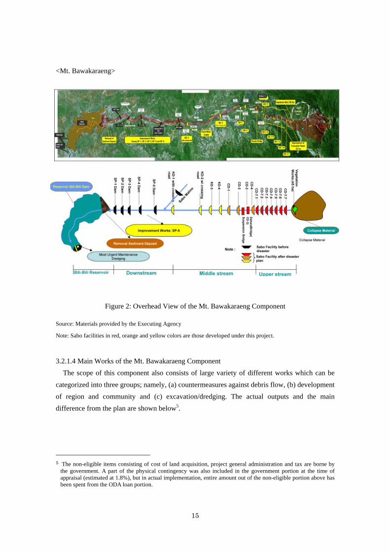
<Mt. Bawakaraeng>
Figure 2: Overhead View of the Mt. Bawakaraeng Component
Source: Materials provided by the Executing Agency
Note: Sabo facilities in red, orange and yellow colors are those developed under this project.
3.2.1.4 Main Works of the Mt. Bawakaraeng Component
The scope of this component also consists of large variety of different works which can be
categorized into three groups; namely, (a) countermeasures against debris flow, (b) development
of region and community and (c) excavation/dredging. The actual outputs and the main
difference from the plan are shown below5.
5 The non-eligible items consisting of cost of land acquisition, project general administration and tax are borne by
the government. A part of the physical contingency was also included in the government portion at the time of appraisal (estimated at 1.8%), but in actual implementation, entire amount out of the non-eligible portion above has been spent from the ODA loan portion.
16
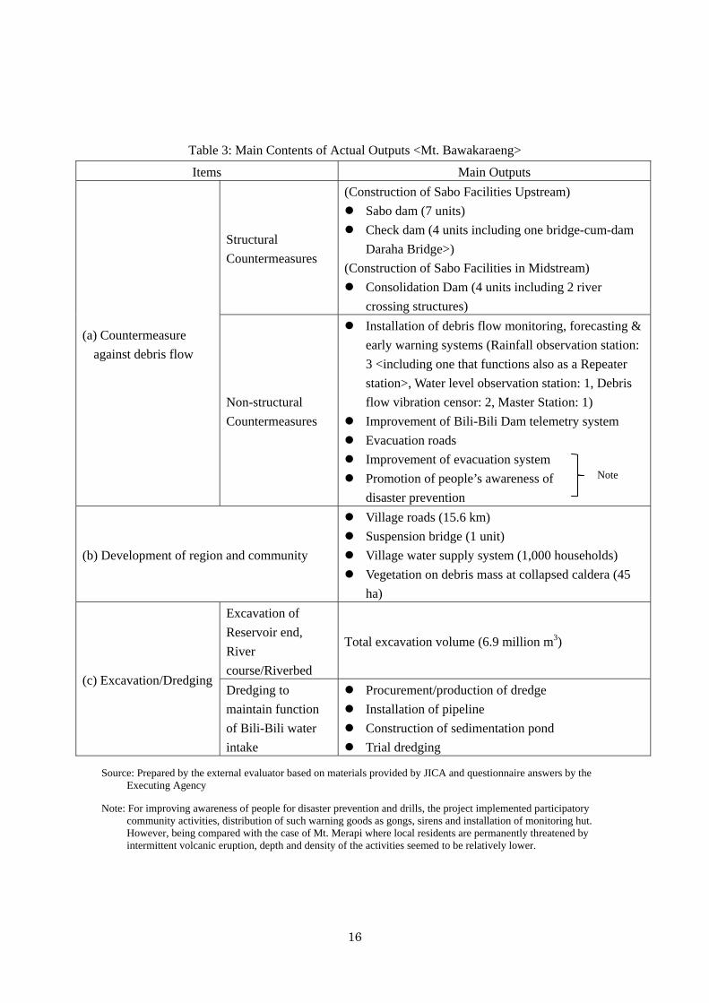
Table 3: Main Contents of Actual Outputs <Mt. Bawakaraeng>
Items Main Outputs
(a) Countermeasure
against debris flow
Structural
Countermeasures
(Construction of Sabo Facilities Upstream)
Sabo dam (7 units)
Check dam (4 units including one bridge-cum-dam
Daraha Bridge>)
(Construction of Sabo Facilities in Midstream)
Consolidation Dam (4 units including 2 river
crossing structures)
Non-structural
Countermeasures
Installation of debris flow monitoring, forecasting &
early warning systems (Rainfall observation station:
3 <including one that functions also as a Repeater
station>, Water level observation station: 1, Debris
flow vibration censor: 2, Master Station: 1)
Improvement of Bili-Bili Dam telemetry system
Evacuation roads
Improvement of evacuation system
Promotion of people’s awareness of
disaster prevention
(b) Development of region and community
Village roads (15.6 km)
Suspension bridge (1 unit)
Village water supply system (1,000 households)
Vegetation on debris mass at collapsed caldera (45
ha)
(c) Excavation/Dredging
Excavation of
Reservoir end,
River
course/Riverbed
Total excavation volume (6.9 million m3)
Dredging to
maintain function
of Bili-Bili water
intake
Procurement/production of dredge
Installation of pipeline
Construction of sedimentation pond
Trial dredging
Source: Prepared by the external evaluator based on materials provided by JICA and questionnaire answers by the Executing Agency
Note: For improving awareness of people for disaster prevention and drills, the project implemented participatory community activities, distribution of such warning goods as gongs, sirens and installation of monitoring hut. However, being compared with the case of Mt. Merapi where local residents are permanently threatened by intermittent volcanic eruption, depth and density of the activities seemed to be relatively lower.
Note
17
3.2.1.5 Consulting Services for Mt. Bawakaraeng Component
Following consulting services were provided for project implementation assistance and
others.
1. Project implementation assistance (detailed design, tender assistance, implementation
supervision, operation & maintenance assistance).
2. Promotion of people’s awareness of disaster prevention by assisting sabo community
operation, establishment of evacuation system.
3. Promotion of regional and community development
As pointed out earlier at the Section 2.3 Constraints during the Evaluation Study, respective
project implementation management of both the Mt. Merapi/Progo River Basin and Mt.
Bawakaraeng components were independently conducted by each BBWS, but they were not
comprehensively managed by the Directorate General of Water Resources as Executing Agency.
Especially, in case of the Mt. Bawakaraeng component whose consulting services were
provided by two different consulting firms separately, no integrated record of total Man-Months
was available, therefore it is unknown how many man-months have been actually devoted
against the planned total man-months of 1,227 MM (International: 179 MM, Local: 1,048 MM).
However it is known that additionally 143.5 MM for the feasibility study on countermeasures
for Bili-Bili Dam sedimentation, and 30MM for the implementation supervision of the dredging
were consumed for this component.
This component also consists of variety of works and each item is subject to minor changes
in implementation volume according to the changes in conditions during the implementation,
however, basically no significant modification was made from the plan except the followings.
3.2.1.6 Main Changes from the Plan <Mt. Bawakaraeng Component>
3.2.1.6.1 Countermeasure against Debris Flow
(1) Addition of dredging works at the Bili-Bili Reservoir edge and nearby riverbed excavation
replacing the construction of the sand pocket dams No.4 and 5 which had been transferred
to the JICA grant aid scheme.
(2) Addition of four consolidation dams
(3) Urgent dredging at the Bili-Bili Reservoir near the water intake
18
3.2.1.6.2 Development of Region and Community
(1) Construction of municipal water intake and water treatment facilities
(2) Rehabilitation of existing access roads
(3) Construction of primary school building at Sepakat
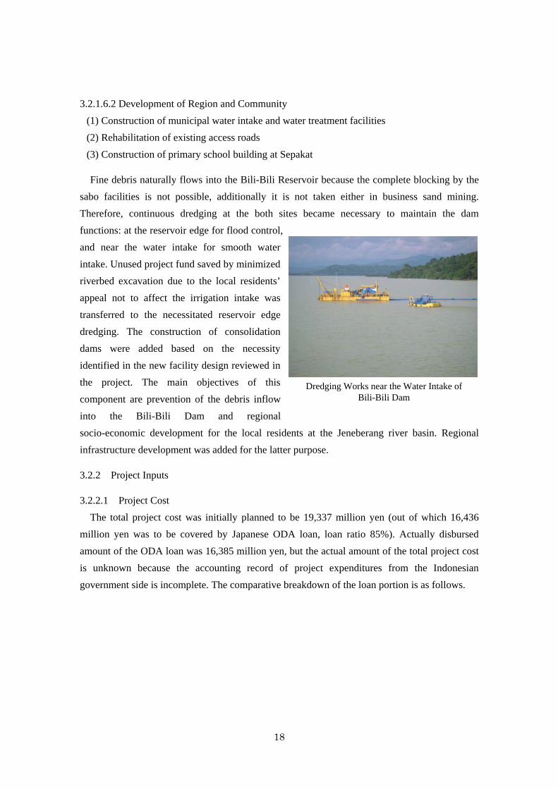
Fine debris naturally flows into the Bili-Bili Reservoir because the complete blocking by the
sabo facilities is not possible, additionally it is not taken either in business sand mining.
Therefore, continuous dredging at the both sites became necessary to maintain the dam
functions: at the reservoir edge for flood control,
and near the water intake for smooth water
intake. Unused project fund saved by minimized
riverbed excavation due to the local residents’
appeal not to affect the irrigation intake was
transferred to the necessitated reservoir edge
dredging. The construction of consolidation
dams were added based on the necessity
identified in the new facility design reviewed in
the project. The main objectives of this
component are prevention of the debris inflow
into the Bili-Bili Dam and regional
socio-economic development for the local residents at the Jeneberang river basin. Regional
infrastructure development was added for the latter purpose.
3.2.2 Project Inputs
3.2.2.1 Project Cost
The total project cost was initially planned to be 19,337 million yen (out of which 16,436
million yen was to be covered by Japanese ODA loan, loan ratio 85%). Actually disbursed
amount of the ODA loan was 16,385 million yen, but the actual amount of the total project cost
is unknown because the accounting record of project expenditures from the Indonesian
government side is incomplete. The comparative breakdown of the loan portion is as follows.
Dredging Works near the Water Intake of Bili-Bili Dam
19
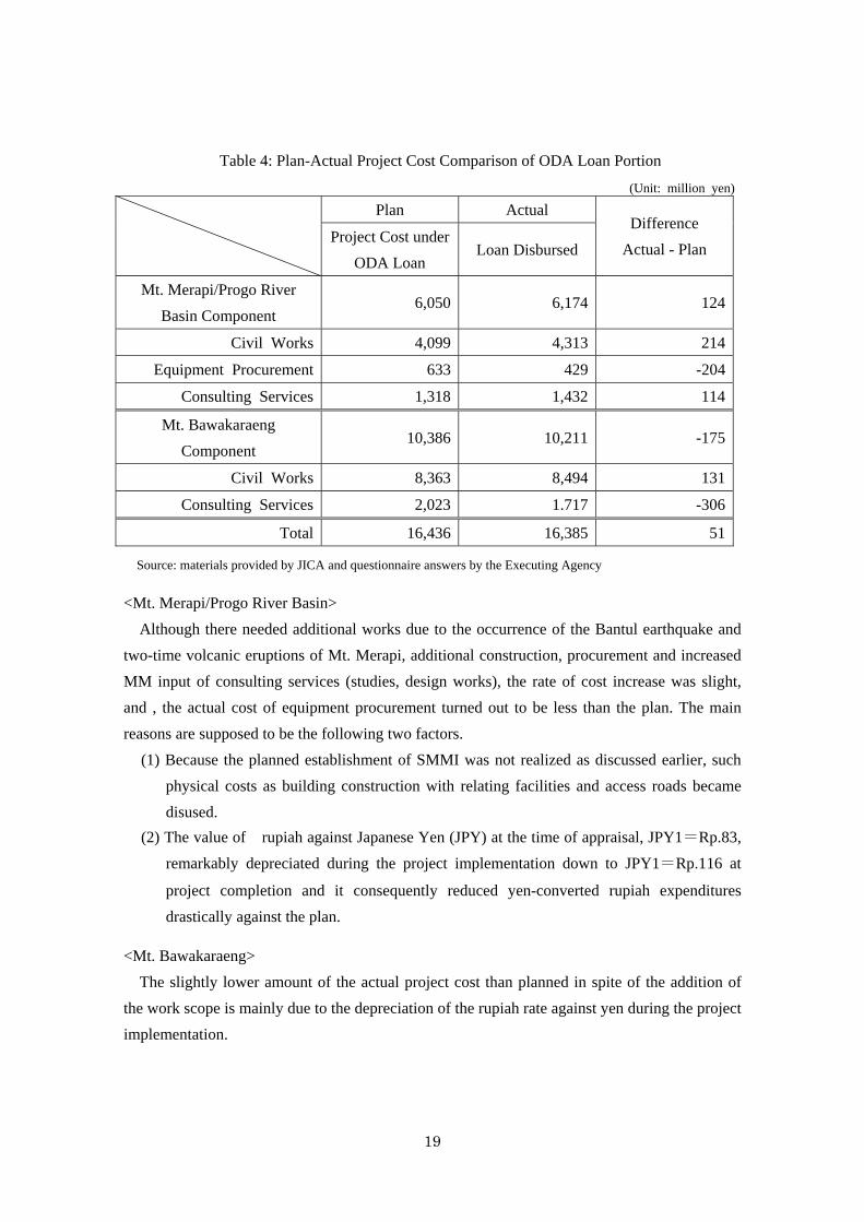
Table 4: Plan-Actual Project Cost Comparison of ODA Loan Portion
(Unit: million yen)
Plan Actual Difference
Actual - Plan Project Cost under
ODA Loan Loan Disbursed
Mt. Merapi/Progo River
Basin Component 6,050 6,174 124
Civil Works 4,099 4,313 214
Equipment Procurement 633 429 -204
Consulting Services 1,318 1,432 114
Mt. Bawakaraeng
Component 10,386 10,211 -175
Civil Works 8,363 8,494 131
Consulting Services 2,023 1.717 -306
Total 16,436 16,385 51
Source: materials provided by JICA and questionnaire answers by the Executing Agency
<Mt. Merapi/Progo River Basin>
Although there needed additional works due to the occurrence of the Bantul earthquake and
two-time volcanic eruptions of Mt. Merapi, additional construction, procurement and increased
MM input of consulting services (studies, design works), the rate of cost increase was slight,
and , the actual cost of equipment procurement turned out to be less than the plan. The main
reasons are supposed to be the following two factors.
(1) Because the planned establishment of SMMI was not realized as discussed earlier, such
physical costs as building construction with relating facilities and access roads became
disused.
(2) The value of rupiah against Japanese Yen (JPY) at the time of appraisal, JPY1=Rp.83,
remarkably depreciated during the project implementation down to JPY1=Rp.116 at
project completion and it consequently reduced yen-converted rupiah expenditures
drastically against the plan.
<Mt. Bawakaraeng>
The slightly lower amount of the actual project cost than planned in spite of the addition of
the work scope is mainly due to the depreciation of the rupiah rate against yen during the project
implementation.
20
Overall, the total project expenditure of the ODA loan portion reached 99.7% of the planned
(loan approved amount). As discussed in Section 3.1.2 Relevance to the Development Needs of
Indonesia, the disaster prevention needs of the project areas are constantly high, and succeeding
projects are under implementation (Merapi) or in preparation (Bawakaraeng). Almost maximum
use of the loan approved amount has been made successively checking current unused balance
from time to time and applying it to add necessary works.
From what has been discussed above, it can be concluded, although the actual project cost in
total is unknown6, the ODA cost portion is lower than planned. Incidentally, this project consists
of two separate sub-projects being respectively comprised of a large number of components.
They are subject to minor modification in implementation volume to fit individual requirement.
Therefore it is difficult to consider the modified volume in the judgement of project cost.
3.2.2.2 Project Period
<Mt. Merapi/Progo River Basin>
The overall project period was planned from March 2005 to December 2011 (82 months).
The actual period was from March 2005 up to October 2013 (104 months), which is 127% of
the plan. The major reasons of the delay are the following. However, factors (2) and (3) below
caused by convulsions of nature were not counted in the actual implementation period. All the
works under the Mt. Merapi/Progo River Basin Component have been completed within the
planned period until November 20137.
(1) Selection of consultant
A procedure for consultant selection was supposed to be started before signing of LA in the
plan. However it did not take place as planned. In addition, the preparation period was
prolonged due to the protracted organization of the selection committee, coordination between
the internal public procurement regulations and the JICA consultant employment guideline,
Pre-Qualification (PO) for preparing the short list and so on. (commencement of selection: 16
months delay, completion of selection procedures: 6 months delay)
(2) Implementation of consulting services
Due to the following reasons, the period of consulting services was prolonged 31 months
against the plan.
6 As reminded in the preceding footnotes 3 and 5, what has been actually expended from the government budget is
only the non-eligible portion consisting of land acquisition, general project administration and tax, all of the main works and consulting services were financed from the ODA loan.
7 The completion of the implementation is defined as the time of facilities’ handover, including the warranty period,
to the Executing Agency.
21
・ Remarkable changes required in the detailed designing, procurement plan and construction
supervision works due to the earthquake and eruption in 2006 before the service
commencement.
・ Addition of investigation, evaluation and detailed designing for rehabilitation of the
stricken sabo facilities and detailed designing for the rehabilitation of diversion channel of
Putih River due to the 2010 violent eruption.
・ Additions of procurement supervision of heavy equipment urgently needed.
(3) Implementation of construction
Construction period was prolonged for 26 months due to the addition of four contract
packages to the original scope caused by the Batul earthquake and Mt. Merapi eruptions during
the project implementation.
<Mt. Bawakaraeng>
The overall project period was planned from March 2005 to November 2013 (105 months).
The actual period was from March 2005 up to June 2014 (112 months), which is 107% of the
plan. However, urgent undertaking of countermeasures having been required against the giant
collapse occurred on March 26, 2004, this component basically took speedy actions as follows.
・ Project preparation and succeeding decision making to provide ODA loan were conducted
in quite a speedy manner, and formulated in such a way to be incorporated into the
forerunning Mt. Merapi/Progo River Basin Project which had already been designed.
・ Removal of debris by dredging at Jeneberang River, construction of one sabo dam and
consulting services that were most urgent were implemented in 2005 and 2006 ahead of the
schedule at the time of appraisal, which produced earlier effect than expected.
Seven-month delay in project completion is mainly due to the constant dredging works near
the water intake of Bili-Bili Reservoir among the additional works having become necessitated
during the project implementation against the debris flow listed in the previous Section 3.2.1.6.1
Countermeasure against debris flow. All other work components were completed no later than
November 2013 which was the planned time of completion.
From the results above, although the project cost was within the plan, the project period
exceeded the plan. Therefore, efficiency of the project is fair8.
8 In rating efficiency, individual sub-rating of both the Mt. Mearapi & Progo River Basin and Mt. Bawakaraeng
components was made respectively on project cost and period first, then combined them evenly weighing the sub-rating results.
22
3.3 Effectiveness9 (Rating: ③)
3.3.1 Quantitative Effects (Operation and Effect Indicators)
<Mt. Merapi/Progo River Basin>
At the time of appraisal, an operation and effect indicator, “Sediment Control Ratio” was set
for two different cases; namely, Case 1: sediment control by sabo facilities and Case 2:
sediment control by sabo facilities and sand mining management. Against the baseline at 26%
(Case 1, 2004), the targets at two years after the planned facilities completion (2012) were set at
50% for Case 1 and 75% for Case 2. However, it turned out inappropriate for the effect
measurement to use this indicator because of the following three occurrences.
1. As stated in Section 3.2.1.3.1 regarding “output,” the planned establishment of the Sand
Mining Management Institution (SMMI) was not realized, so Case 2 became inapplicable.
2. In 2010 during the project implementation, the greatest eruption on record since 1872
occurred. It discharged volcanic ejecta of 140 million m3, twenty eight times the volume of
5 million m3 targeted to be tackled as the pyroclastic outflow under the probability of once
in 10 years in the “Masterplan for Land Erosion and Volcanic Debris Control in the Area
of Mt. Merapi” revised in 2001. Seventy seven units of sabo facility were damaged out of
the total 250 structures. Urgent rehabilitation of the damaged facilities was added in this
project implementation. The fact that the extremely larger scale in the disaster-stricken
area compared to previous cases (cf. Table 5 below) occurred in the past indicates its
unprecedented magnitude. The occurrence of such critical cases (violent eruption once in
100 years and consequent destruction of sabo facilities) was unexpected in the indicator
setting at the appraisal, accordingly the premise of the estimation became inapplicable,
which made the calculation of actual Sediment Control Ratio that can be reasonably
comparable with the estimated figure difficult.
3. Since the sabo facilities had been developed by the government budget as well as under the
1st and 2nd Japan’s ODA loans (this project is regarded as the 3rd phase), it is difficult to
measure the separate effect of the facilities developed under this project.
In light of the above, effects of a series of sabo facilities including ones under this project are
estimated based on a review of the past records of eruption damages of Mt. Merapi and official
views by the Indonesian Government about the 2010 great eruption.
9 Sub-rating for Effectiveness is to be put with consideration of Impact.
23
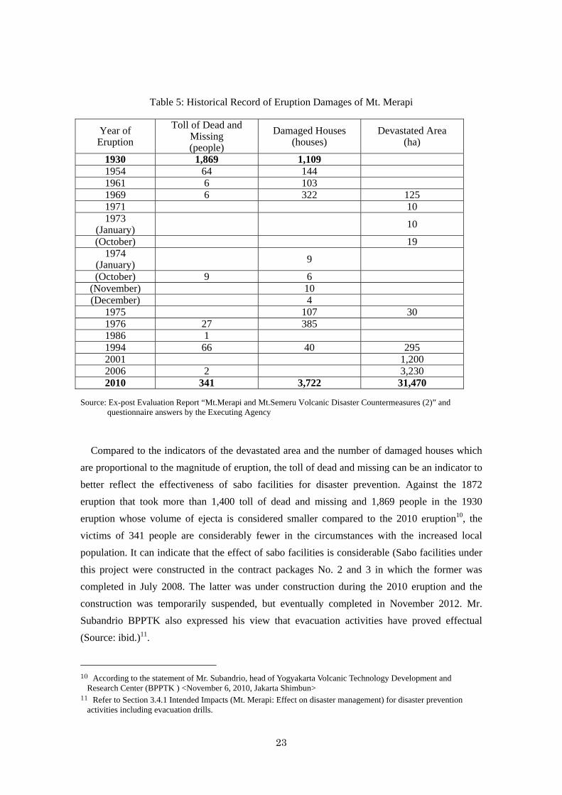
Table 5: Historical Record of Eruption Damages of Mt. Merapi
Year of Eruption
Toll of Dead and Missing (people)
Damaged Houses (houses)
Devastated Area (ha)
1930 1,869 1,109 1954 64 144 1961 6 103 1969 6 322 125 1971 10 1973
(January) 10
(October) 19 1974
(January) 9
(October) 9 6 (November) 10 (December) 4
1975 107 30 1976 27 385 1986 1 1994 66 40 295 2001 1,200 2006 2 3,230 2010 341 3,722 31,470
Source: Ex-post Evaluation Report “Mt.Merapi and Mt.Semeru Volcanic Disaster Countermeasures (2)” and questionnaire answers by the Executing Agency
Compared to the indicators of the devastated area and the number of damaged houses which
are proportional to the magnitude of eruption, the toll of dead and missing can be an indicator to
better reflect the effectiveness of sabo facilities for disaster prevention. Against the 1872
eruption that took more than 1,400 toll of dead and missing and 1,869 people in the 1930
eruption whose volume of ejecta is considered smaller compared to the 2010 eruption10, the
victims of 341 people are considerably fewer in the circumstances with the increased local
population. It can indicate that the effect of sabo facilities is considerable (Sabo facilities under
this project were constructed in the contract packages No. 2 and 3 in which the former was
completed in July 2008. The latter was under construction during the 2010 eruption and the
construction was temporarily suspended, but eventually completed in November 2012. Mr.
Subandrio BPPTK also expressed his view that evacuation activities have proved effectual
(Source: ibid.)11.
10 According to the statement of Mr. Subandrio, head of Yogyakarta Volcanic Technology Development and
Research Center (BPPTK ) <November 6, 2010, Jakarta Shimbun> 11 Refer to Section 3.4.1 Intended Impacts (Mt. Merapi: Effect on disaster management) for disaster prevention
activities including evacuation drills.
24
<Mt. Bawakaraeng>
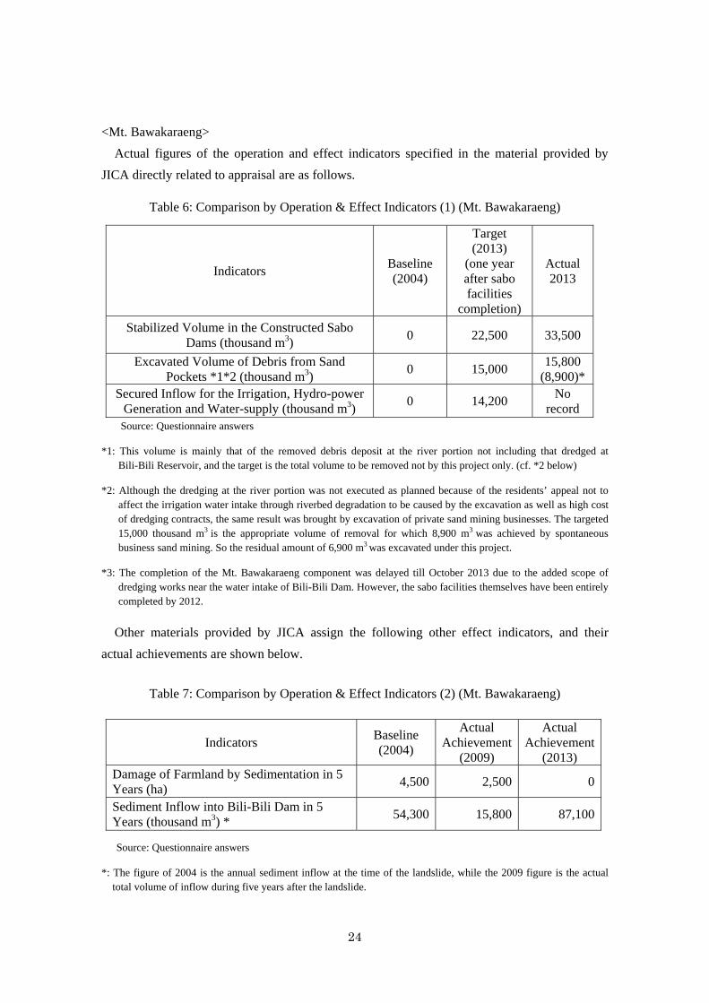
Actual figures of the operation and effect indicators specified in the material provided by
JICA directly related to appraisal are as follows.
Table 6: Comparison by Operation & Effect Indicators (1) (Mt. Bawakaraeng)
Indicators Baseline (2004)
Target (2013)
(one year after sabo facilities
completion)
Actual 2013
Stabilized Volume in the Constructed Sabo Dams (thousand m3)
0 22,500 33,500
Excavated Volume of Debris from Sand Pockets *1*2 (thousand m3)
0 15,000 15,800
(8,900)* Secured Inflow for the Irrigation, Hydro-power
Generation and Water-supply (thousand m3) 0 14,200
No record
Source: Questionnaire answers
*1: This volume is mainly that of the removed debris deposit at the river portion not including that dredged at Bili-Bili Reservoir, and the target is the total volume to be removed not by this project only. (cf. *2 below)
*2: Although the dredging at the river portion was not executed as planned because of the residents’ appeal not to affect the irrigation water intake through riverbed degradation to be caused by the excavation as well as high cost of dredging contracts, the same result was brought by excavation of private sand mining businesses. The targeted 15,000 thousand m3 is the appropriate volume of removal for which 8,900 m3 was achieved by spontaneous business sand mining. So the residual amount of 6,900 m3 was excavated under this project.
*3: The completion of the Mt. Bawakaraeng component was delayed till October 2013 due to the added scope of dredging works near the water intake of Bili-Bili Dam. However, the sabo facilities themselves have been entirely completed by 2012.
Other materials provided by JICA assign the following other effect indicators, and their
actual achievements are shown below.
Table 7: Comparison by Operation & Effect Indicators (2) (Mt. Bawakaraeng)
Indicators Baseline (2004)
Actual Achievement
(2009)
Actual Achievement
(2013) Damage of Farmland by Sedimentation in 5 Years (ha)
4,500 2,500 0
Sediment Inflow into Bili-Bili Dam in 5 Years (thousand m3) *
54,300 15,800 87,100
Source: Questionnaire answers
*: The figure of 2004 is the annual sediment inflow at the time of the landslide, while the 2009 figure is the actual total volume of inflow during five years after the landslide.
25
If the same volume of inflow as the note * has lasted annually, the estimated cumulative
inflow would be 82,740 thousand m3 (54,300 + 15,800 x 9/5). Although the targeted volume of
sediment flow itself is fluid affected by rainfall and other natural phenomena, actual result
(cumulative volume up to 2013) a little bit exceeded the target. This is due to the considerable
sediment flowed temporarily into Bili-Bili Dam through the sand pocket No.1 damaged
(restored in 2012) by illegal sand mining. However, the excess rate is only 5% (87,100-
82,740)/82,740) showing that the target has been almost achieved, and therefore that the sabo
facilities of this project demonstrate their expected effect in principle.
Besides, although quantitative record to directly show secured inflow for the irrigation,
hydro-power generation and water-supply is not available as indicated above, the management
record of Bili-Bili Dam shows that its actual volume of water discharge from the reservoir to
irrigation, hydro-power generation and water-supply in the latest year 2016 was 22.6 m3 per
second, which is more than 33% higher than the planned volume of 16.9 m3 per second. It
indirectly indicates that conservation of water capacity is being carried out enough to maintain
the dam function to reach each service supply by the sabo facilities and sediment dredging.
Thus, although the quantitative effects on conserved water capacity for irrigation, hydropower
generation and water-supply are unknown, the targets of other indicators have been achieved.
Therefore it is judged that the effect of this project is demonstrated.
3.3.2 Qualitative Effects
<Mt. Merapi/Progo River Basin>
(1) Protection of human lives, public and private property and establishment of sustainable
disaster protection system
① Structural aspect
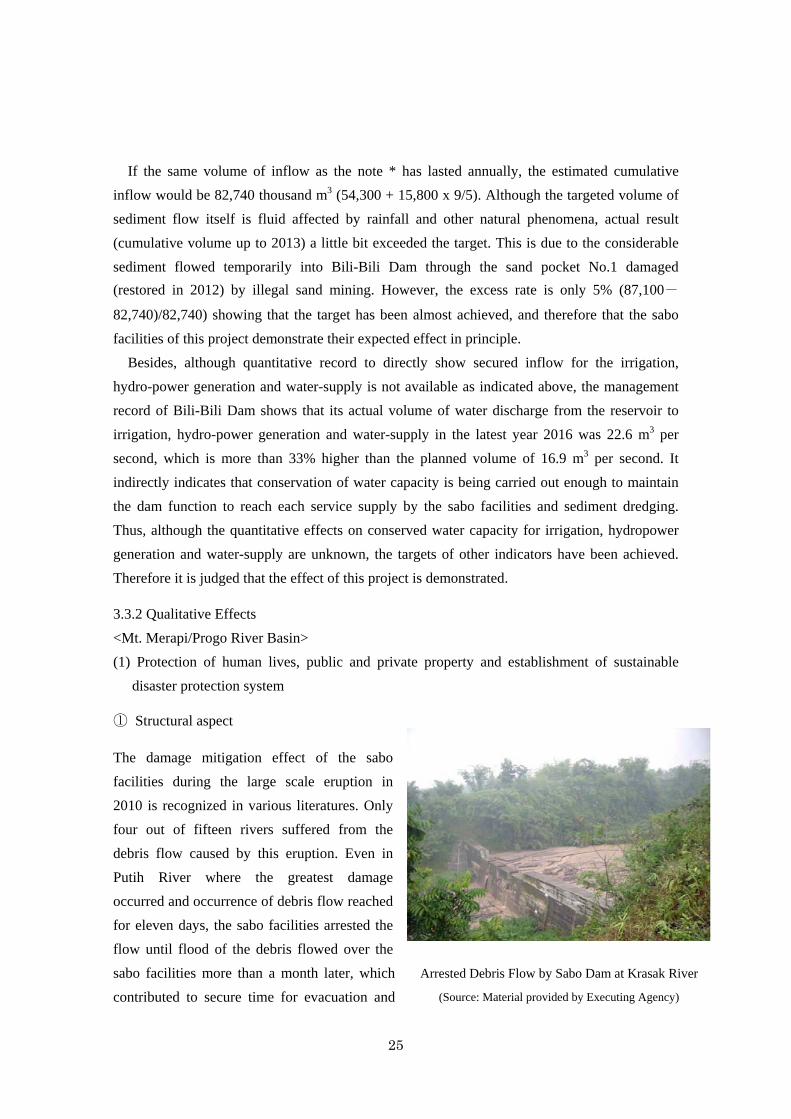
The damage mitigation effect of the sabo
facilities during the large scale eruption in
2010 is recognized in various literatures. Only
four out of fifteen rivers suffered from the
debris flow caused by this eruption. Even in
Putih River where the greatest damage
occurred and occurrence of debris flow reached
for eleven days, the sabo facilities arrested the
flow until flood of the debris flowed over the
sabo facilities more than a month later, which
contributed to secure time for evacuation and
Arrested Debris Flow by Sabo Dam at Krasak River
(Source: Material provided by Executing Agency)
26
emergency measures12. However, since the demonstrated effect has been achieved by a series of
sabo facilities including ones developed under preceding ODA loan projects as well as by the
government budget as a whole, it is difficult to measure individual contribution of this project
separately from the others. Additionally, the temporary evacuation shelter constructed in this
project played a remarkable role attracting special attention as the project’s unique effect.
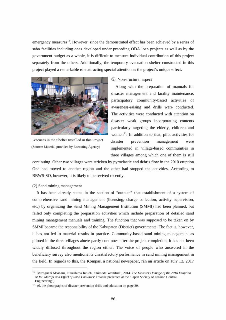
② Nonstructural aspect
Along with the preparation of manuals for
disaster management and facility maintenance,
participatory community-based activities of
awareness-raising and drills were conducted.
The activities were conducted with attention on
disaster weak groups incorporating contents
particularly targeting the elderly, children and
women13. In addition to that, pilot activities for
disaster prevention management were
implemented in village-based communities in
three villages among which one of them is still
continuing. Other two villages were stricken by pyroclastic and debris flow in the 2010 eruption.
One had moved to another region and the other had stopped the activities. According to
BBWS-SO, however, it is likely to be revived recently.
(2) Sand mining management
It has been already stated in the section of “outputs” that establishment of a system of
comprehensive sand mining management (licensing, charge collection, activity supervision,
etc.) by organizing the Sand Mining Management Institution (SMMI) had been planned, but
failed only completing the preparation activities which include preparation of detailed sand
mining management manuals and training. The function that was supposed to be taken on by
SMMI became the responsibility of the Kabupaten (District) governments. The fact is, however,
it has not led to material results in practice. Community-based sand mining management as
piloted in the three villages above partly continues after the project completion, it has not been
widely diffused throughout the region either. The voice of people who answered in the
beneficiary survey also mentions its unsatisfactory performance in sand mining management in
the field. In regards to this, the Kompas, a national newspaper, ran an article on July 13, 2017
12 Mizoguchi Msaharu, Fukushima Junichi, Shimoda Yoshifumi, 2014. The Disaster Damage of the 2010 Eruption
of Mt. Merapi and Effect of Sabo Facilities: Treatise presented at the “Japan Society of Erosion Control Engineering”)
13 cf. the photographs of disaster prevention drills and education on page 30.
Evacuees in the Shelter Installed in this Project
(Source: Material provided by Executing Agency)
27
on a warning of the governor Prawono of Central Java Province that urged immediate
termination of illegal unlicensed sand mining and removal to permitted areas, because that had
been damaging the sabo facilities developed by JICA assistance. However, residents’ voice to
expect its effect has not been heard much.
3. Regional development at region on the foot of Mt. Merapi
This project performed rehabilitation of irrigation and sabo facilities’ multiuse development
(bridge, road and water intake), and the effect of both on regional economic development is
considerable (cf. Sections on impacts below).
<Mt. Bawakaraeng>
(1) Protection of human lives and public and private property
In addition to the strengthened measures against future possible collapse disaster by
implementing disaster management activities at Lengkese Village, the disaster victim of the
giant collapse of the caldera wall in 2004, and at regions nearby, the following project effects
were identified individually.
・ Disaster prevention effect at the flood-prone area which had been often stricken by river
backflow previously in the rainy season (Salo Malino area) by constructing training
dykes <contribution to the no “damage on farmland,” an indicator on Table 7 above>
・ Effect on preventing river bank collapse by construction of a consolidation dam and
slope protection works downstream
(2) Maintenance of sustained dam function of Bili-Bili Dam controlling sediment inflow into
the reservoir
The following are the results of the field studies to respective operation bodies of water
supply, hydraulic power generation and irrigation which depend on the Bili-Bili Reservoir as
their water source.
① Water supply
Functional disorder brought by the sedimentation inflow is on both “quantity of water intake”
and “water quality,” but it is not seriously affecting both of the aspects maintaining smooth
operation being protected by the controlled sediment inflow by the sabo facilities as well as the
constant dredging works near the water intake meeting 60% of the total water supply demand of
Makassar City without a hitch. The raw water from the reservoir which used to be transparent
before the collapse has become muddy, but the quality of the processed clean water is
maintained due to the effort of strengthened purification and a close water quality monitoring by
the water supply institution; Penjernihan Air V Somba Opu Water Treatment Plant.
28
② Hydraulic power generation
As the power station commenced in 2005 after the giant collapse, the operational condition
cannot be compared with that before the incident. Adverse influence of the sediment inflow into
the reservoir on the power plant function can be on both quantity and quality aspects of water,
same as the water supply. There is no particular problem in the quantity aspect, while, in the
aspect of the water quality, there are some cases to cause damages on the blades of turbines and
some worries to affect the cooling system by the sediment inclusion. However, they can be dealt
with and preventable by the station’s routine operation and maintenance works. This hydraulic
power plant is constructed under the Japanese ODA loan, and additional spare generators had
been planned and installed to address this raw water pollution problem as well as equipped a
cyclone separator as a part of the cooling system to remove underwater soil sedimentation.
These self-efforts by the station have also contributed to the coping with this problem.
③ Irrigation
Reduction in the amount of water reserved in the dam due to the sedimentation does not
directly affect the irrigation water supply. It is said that the volume of water intake is influenced
by the water use of the power station. As water intake channel exclusively for irrigation is also
available in case of need. Different from the water supply, the problem of water quality is not so
influential for its operation.
(3) Establishment of sustainable disaster management system
The “countermeasure against sediment outflow” of the project includes improvement of the
evacuation system and raising people’s awareness of disaster prevention, and they have been
implemented. However, according to the impression on the discussions with the Executing
Agency and the interviews with the local residents, the activities being implemented seemed not
as deep and extensive as the ones being carried out in the Mt. Merapi region where people are
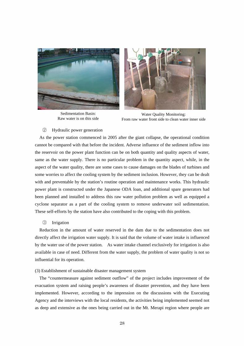
Sedimentation Basin: Raw water is on this side
Water Quality Monitoring: From raw water front side to clean water inner side
29
faced with almost permanent threat of eruption damage and potentially having higher
consciousness for disaster prevention. Incidentally, this region is as one of its model districts of
the JICA’s technical assistance project “Integrated Sediment-related Disaster Management
(ISDM)”, and receiving comprehensive technical assistance in nonstructural aspect.
3.4 Impacts
3.4.1 Intended Impacts
Impacts of this project are mainly evaluated by means of beneficiary surveys.
(Method of Beneficiary Survey)
Since the expected impacts of this project extends over a wide range including disaster
prevention by sabo and other facilities as well as preventive activities, economic activation by
regional infrastructure development (roads, bridges, water resource supply facilities,
vegetation ), each of which has different beneficiaries. Therefore, the survey was carried out by
means of focused group discussions (FGD) and direct interviews visiting households in
combination at respective benefited districts. Due to the difficulty to specify each statistical
population for respective project facilities of various kinds and absence of reliable residents
register, random sampling was not applicable, and judgement sampling was applied instead
eliminating the bias in terms of gender, age and region as much as possible.
(Benefited Areas Surveyed by Facilities Developed)
(1) Disaster Prevention (Sabo) Facilities
(2) Roads, Bridges
(3) Water Resource (Supply) Facilities
(4) Irrigation Facilities
(Number of People Interviewed) <including both FGD and visiting interviews>
Mt. Merapi: 100 people (two villages) (Proportion of the respondents <Age: 20-30s (20%),
40-50s (80%) Gender: Male (59%), Female (41%)>)
Mt. Bawakaraeng: 125 people (three villages), (Proportion of the respondents <Age: 20-30s
(17%), 40-50s and over (83%) Gender:
Male (59%), Female (41%)>)14
Incidentally, the project carried out a survey on people’s awareness (entrusted to Gajamada
University) by Participatory Rural Appraisal (PRA) in 20 villages located at the hillslope of Mt.
Merapi (hereinafter referred to as 20-village PRA) in 2008 separately from this beneficiary
survey.
14 As the proportions of the participants in terms of age and gender were not recorded, the figures show only the
percentages of the direct interviewees.
30
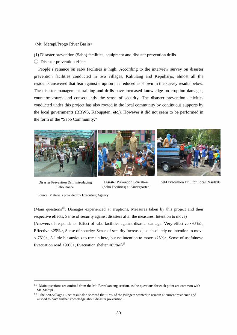
Disaster Prevention Education (Sabo Facilities) at Kindergarten
Disaster Prevention Drill introducing Sabo Dance
Field Evacuation Drill for Local Residents
<Mt. Merapi/Progo River Basin>
(1) Disaster prevention (Sabo) facilities, equipment and disaster prevention drills
① Disaster prevention effect
People’s reliance on sabo facilities is high. According to the interview survey on disaster
prevention facilities conducted in two villages, Kaliulang and Kepuharjo, almost all the
residents answered that fear against eruption has reduced as shown in the survey results below.
The disaster management training and drills have increased knowledge on eruption damages,
countermeasures and consequently the sense of security. The disaster prevention activities
conducted under this project has also rooted in the local community by continuous supports by
the local governments (BBWS, Kabupaten, etc.). However it did not seem to be performed in
the form of the “Sabo Community.”
Source: Materials provided by Executing Agency
(Main questions15: Damages experienced at eruptions, Measures taken by this project and their
respective effects, Sense of security against disasters after the measures, Intention to move)
(Answers of respondents: Effect of sabo facilities against disaster damage: Very effective <65%>,
Effective <25%>, Sense of security: Sense of security increased, so absolutely no intention to move
< 75%>, A little bit anxious to remain here, but no intention to move <25%>, Sense of usefulness:
Evacuation road <90%>, Evacuation shelter <85%>)16
15 Main questions are omitted from the Mt. Bawakaraeng section, as the questions for each point are common with
Mt. Merapi. 16 The “20-Village PRA” result also showed that 67% of the villagers wanted to remain at current residence and
wished to have further knowledge about disaster prevention.
31
② Income generation effect
Sedimented sand and gravel arrested by sabo facilities are valuable as the materials for
building construction and as sources of income (sales, wage earning by mining works) for local
people.
However, such an attractive income effect has been on the other side of the coin, which is the
improper sand mining management by Kabupaten governments to curb illegal activities. There
is thus a dilemma among the locals between the advantage as the income source and the damage
on the sabo facilities*.
*: If riverbeds near sabo facilities have been mined, even a small scale freshet can scour the
facility basement that may cause damage on the facilities and collapse in extreme cases.
(Main questions: Relationship between sand mining at sabo facilities and family income,
Recognition of adverse influence of illegal sand mining upon sabo facilities, Behavior when
observing illegal sand mining)
(Answers of respondents: Family income has increased through sand mining works created by
installation of sabo facilities <85%>, Already recognize adverse influence of illegal mining on
sabo facilities and surrounding environment <99%>, Warn and advise to stop illegal acts and
report to the authorities <61%>, Warn them only <23%>), Leave them because in vain
<16%>)17
(2) Access roads, bridges
Varied and considerable regional economic and social development effects were observed in
access roads as a part of the sabo facilities and the sabo facilities functioning as a crossing
bridge over the river.
(Main questions: Whether sabo facilities functioning as a crossing bridge are effective for daily
life and economic activities, Case examples when they are useful)
(Answers of respondents: Highly useful <100%>, Useful for attending school, clinics, daily life
activities <all 100%>) Additionally, tourism business has been created for incoming people
from outside18.
(3) Irrigation, water resource facilities
The project implemented rehabilitation of water resource including irrigation facilities
damaged by the earthquake and eruption occurred during the project implementation. They have
17 The result of the “20-Village PRA” also indicates that sand mining constitutes an additional income source, and
on the other hand, locals recognize adverse effect of uncontrolled sand mining as a damage risk on sabo facilities and surrounding environment and desire establishment of a control system by governments and community.
18 The result of the “20-Village PRA” also shows that the development of the multi-use infrastructures like sabo dams that concurrently function as roads is contributing to the regional economic activation.
32
impacted on family health and children education brought by income increase effect through
agricultural production increase (including aquaculture).
(Main questions: Kinds of facilities rehabilitated and concrete positive effect induced from the
rehabilitation.)
(Answers from respondents: Positive effect on children education and family health through
income increase in irrigated agriculture <100%>)
Thus, disaster prevention effect of constructed sabo facilities under the Mt. Merapi
component has been confirmed, and the arrested sediment at sabo facilities led to a creation of
sand mining businesses which also have brought impacts of creation of income sources.
However, considering the current situation where establishment of the planned sand mining
management institution had been frustrated and the management of the Kabupaten government
is not conducted optimally, occurrence of damages by illegal mining is a matter of concern. On
the other hand, it was confirmed that the positive impact of the rehabilitation of irrigation and
water resource facilities implemented along the construction of sabo facilities is remarkable on
regional economic activation and improvement of regional social life.
<Mt. Bawakaraeng>
Since the project effects and impacts of the Mt. Bawakaraeng component grasped by the
beneficiary survey are mostly common to the Mt. Merapi component, only characteristic points
are presented below.
(1) Disaster prevention (sabo) facilities, equipment, disaster prevention drills
① Effects on disaster prevention
Different from the Mt. Merapi where its wide area is exposed to danger of intermittent
volcanic eruptions, the disaster of Mt. Bawakaeang was caused by a collapse of the caldera wall
in March 2004 whose stricken area is restricted within a region around Lengkese Village at the
mountain foot where 33 lives were claimed. According to the survey result in Lengkese Village,
reliability to sabo facilities was also high. Village people who used to be too sensitive from fear
even against sounds of wind and thunder increased their sense of security after the completion
of the sabo facilities. It was proved by the fact that no respondents replied that they wanted to
move to other location from anxiety against disaster. Further, the effect of disaster prevention
education and drills are rooted (“Sabo Communities” have been established), and people’s
awareness of disaster management is high being equipped with alarming tools (siren, gong radio,
etc.). However, some of the respondents expressed their concern whether this consciousness can
be succeeded long after the disaster to the next generation who did not experience the disaster.
(Answers of respondents: Sense of security increased, so absolutely no intention to move < 80%>,
A little bit anxious to remain here, but no intention to move <20%>)
33
② Income generation effect
The income source generation effect by sand mining businesses is also prevailing, but the
activities are not as active as in the Mt. Merapi area not leading to the big concern for damages
on the sabo facilities. The vegetation on debris mass at the collapsed slope started under this
project has not only brought collapse protection effect but also provided local population who
lost previous income source due to the debris flow into their farmlands with extraordinary
income opportunity from engagement in planting works. Further, the plants are contributing to
the protection of local coffee trees.
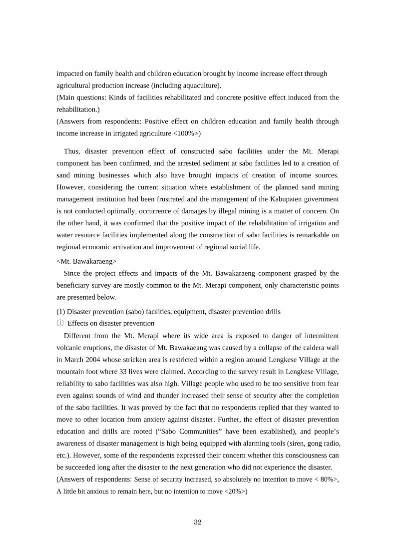
2. Access roads, bridges
Roads improvement was performed in disaster-damaged Lengkese Village. In addition to the
bridge function prepared by the sabo facilities themselves, a new iron bridge was installed at
Daraha area. Those transport infrastructures have been producing remarkable effect for regional
economic activation as the Mt. Merapi component also did.
(Answers of respondents: Highly useful <100%>,
Improvement in attending school, clinics, daily life
activities <100%>)
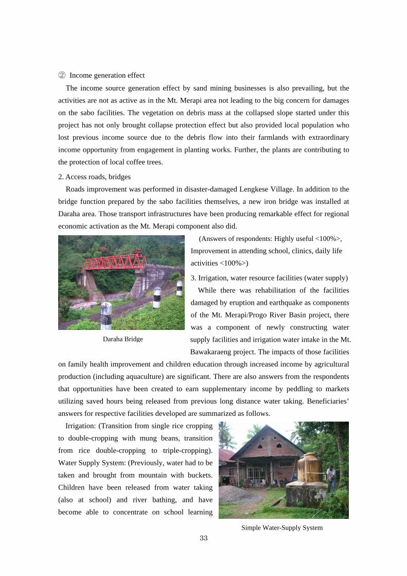
3. Irrigation, water resource facilities (water supply)
While there was rehabilitation of the facilities
damaged by eruption and earthquake as components
of the Mt. Merapi/Progo River Basin project, there
was a component of newly constructing water
supply facilities and irrigation water intake in the Mt.
Bawakaraeng project. The impacts of those facilities
on family health improvement and children education through increased income by agricultural
production (including aquaculture) are significant. There are also answers from the respondents
that opportunities have been created to earn supplementary income by peddling to markets
utilizing saved hours being released from previous long distance water taking. Beneficiaries’
answers for respective facilities developed are summarized as follows.
Irrigation: (Transition from single rice cropping
to double-cropping with mung beans, transition
from rice double-cropping to triple-cropping).
Water Supply System: (Previously, water had to be
taken and brought from mountain with buckets.
Children have been released from water taking
(also at school) and river bathing, and have
become able to concentrate on school learning
Daraha Bridge
Simple Water-Supply System
34
<education effect>). Stomachache and itch previously caused by pruritus and other diseases
have been alleviated <health effect>.
Summary: 100 % of respondents at every facility stated certain effects on children’s
education and family health including above mentioned statements. 70% of the respondents
affirmed the income effect brought by the facilities.
3.4.2 Other Impacts
3.4.2.1 Impacts on the Natural Environment
<Mt. Merapi/Progo River Basin>
It was confirmed that this project carried no particular negative impacts on natural
environment, rather brought on its preservation by preventing or alleviating environmental
disruption. Environmental monitoring was carried out based on the environmental monitoring
plan prepared in the Environmental Impact Assessment (AMDAL: Analisis Mengenai Dampak
Lingkungan) during the project implementation, and the results were reported semiannually to
the environmental department of the provincial government for which no particular problem had
been raised. Various measures were attempted to alleviate environmental impacts including
monitoring water flow into the intakes for irrigation and domestic water, measures to prevent
inflow of muddy water and so forth. Monitoring of flora and fauna was also conducted to
minimize destabilizing factor of the dredging. In the construction of the consolidation dams at
the Progo River Basin, fish ways were installed to allow fish to ascend as well. The crest area of
Mt. Merapi is a part of the national park, but the project area is not included, and the area does
not fall under a habitat of rare species of wild animals.
<Mt. Bawakaraeng>
As with the case of Mt. Merapi, this component was confirmed to have carried no particular
negative impacts either upon natural environment, bringing on its preservation preventing or
alleviating environmental disruption. Environmental monitoring was executed based on the
environmental monitoring plan prepared in AMDAL during the project implementation, and the
results were reported semiannually to the environmental department of the provincial
government for which no particular problem had been raised. For the dredging of riverbeds as
well as at the Bili-Bili Reservoir, environmental impacts alleviation was attempted by dumping
dredged sediment onto the stockyard prepared by the reservoir and growing plants on it. The
project area is not located neither in a wilderness area nor a national park, and does not fall
under a habitat of rare species of wild animals either.
35
3.4.2.2 Land Acquisition and Resettlement
<Mt. Merapi/Progo River Basin>
Total area of 254,000 m2 was acquired with the total cost of 9,927 million rupiah. Acquisition
of the land 150,000 m2 planned to be used for the stockyard of the Sand Mining Management
Institution (SMMI) became unnecessary because of its cancellation. According to the
questionnaire answers, explanation of BBWS-SO and relating documents provided, the process
was conducted based on the President Regulation No. 65, 2006 regarding land acquisition
organizing land acquisition committee known as “Committee 9” led by the regional secretary
(Sekretaris Daerah) with no particular problems during the course. Compensation was also
made in accordance with related domestic regulations and the JBIC Guidelines for Confirmation
of Environmental and Social Considerations (2002) without any significant problem. In
accordance with the Water Resources Act (Law No.7, 2004) at the time, public consultation
meetings were held several times at the detailed designing, before the commencement of
construction works and other relevant occasions. No particular complaints or objections were
manifested in the discussion and the constructions basically went smoothly without significant
trouble. People’s requests expressed during the discussions were reflected in the designing and
implementation if deemed necessary. No resettlement was executed.
<Mt. Bawakaraeng>
The planned land acquisition for the stockyard of dredged soil and sand turned out
unnecessary because pieces of government-owned land could be used, instead, land acquisition
and compensation for all the new sabo facility sites became necessary partly because of the
change in river flow affected by debris from the land slide of caldera wall. That also went for
the access roads construction. The record on total area of acquisition and its cost was not
available. According to the questionnaire answers, explanation of BBWS-PJ and relating
documents provided, all the procedures were processed following the regulation above with no
particular problem. Compensation was also conducted in accordance with related domestic
regulations and the JBIC Guidelines for Confirmation of Environmental and Social
Considerations (2002) without any significant problem. The public consultation meetings were
also held in the same way as the Mt. Merapi practice. Particular complaints or objections were
not expressed either, and the construction works proceeded without any significant trouble also
reflecting people’s requests in the designing and implementation as needed. No resettlement
was executed.
36
3.4.3 Summary of Effects and Impacts
<Mt. Merapi/Progo River Basin>
Under the condition of the violent eruption occurred during the project implementation in
2010 with twenty eight times the volume of pyroclastic outflow assumed in the project plan and
resultant damages on many sabo facilities including ones constructed under this project, the
performance using “Sediment Control Ratio,” the quantitative indicator introduced at the
appraisal, cannot be quantitatively measured properly. Alternative data such as statistics on past
records of eruption damages and the result of academic studies does not show a strict
quantitative effect. However, the beneficiary survey result directly indicates that the effect of
disaster prevention is high. On the other hand, the beneficiary survey confirmed project’s
satisfactory effects and impacts of such infrastructures as access roads, sabo facilities which also
function as bridges as well developed under this project, rehabilitated irrigation and water
resource upon economic and social activation of the region. Therefore, effectiveness and impact
of this component is judged high.
<Mt. Bawakaraeng>
Although no performance record is available on “Secured water for the irrigation,
hydro-power generation and water supply” which is one of the three operation and effect
indicators set at the appraisal, it was confirmed that the water for respective operation in terms
of quantity and quality has been maintained according to the results of direct field surveys to the
three operating institutions. Quantitative targets of such other indicators taken at appraisal as
“Stabilized Volume in the Constructed Sabo Dams” and “Excavated Volume of Debris from
Sand Pockets” have been achieved. Among the supplemental two indicators, “Damage of
Farmland by Sedimentation in 5 Years” was completely and “Sediment Inflow into the Bili-Bili
Dam in 5 Years” was mostly achieved. Further, it was confirmed that the effects and impacts of
access roads, bridges and water supply facilities developed in this project on economic and
social activation of the region were satisfactory. Therefore, effectiveness and impact of this
component is judged high.
From the results above, this project has largely achieved its objectives. Therefore,
effectiveness and impact of the project are high.
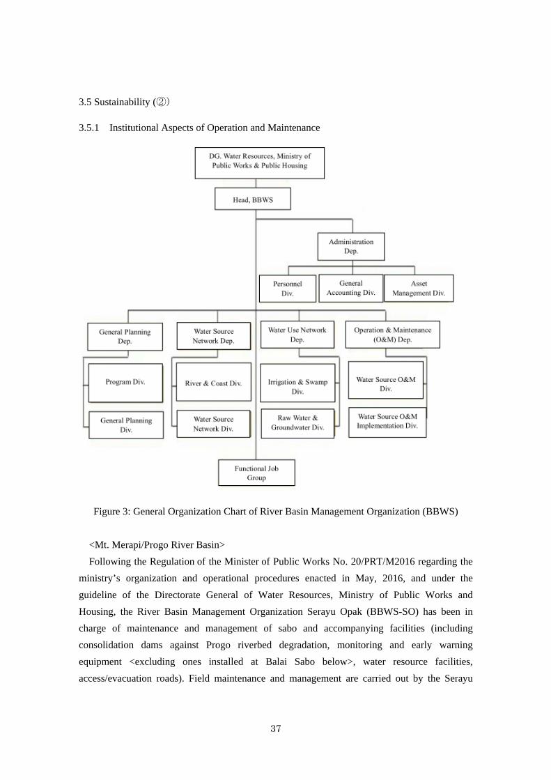
37
3.5 Sustainability (②)
3.5.1 Institutional Aspects of Operation and Maintenance
Figure 3: General Organization Chart of River Basin Management Organization (BBWS)
<Mt. Merapi/Progo River Basin>
Following the Regulation of the Minister of Public Works No. 20/PRT/M2016 regarding the
ministry’s organization and operational procedures enacted in May, 2016, and under the
guideline of the Directorate General of Water Resources, Ministry of Public Works and
Housing, the River Basin Management Organization Serayu Opak (BBWS-SO) has been in
charge of maintenance and management of sabo and accompanying facilities (including
consolidation dams against Progo riverbed degradation, monitoring and early warning
equipment <excluding ones installed at Balai Sabo below>, water resource facilities,
access/evacuation roads). Field maintenance and management are carried out by the Serayu
38
Opak Special Working Unit for Operation and Maintenance (Satuan Kerja Non Vertikal
Tertentu Operasi & Pemeliharaan Serayu Opak).
The equipment for forecasting and early warning is installed at the Experimental Station for
Sabo (Balai Sabo) and operated and maintained there. Balai Sabo is an institution constructively
reorganized from the Sabo Technical Center (STC) established under JICA technical assistance
(renamed from VSTC: Volcanic Sabo Technical Center in 1992) under the Research and
Development Center for Water Resources of the Ministry of Public Works and Housing, and its
responsible area extends throughout the country.
Sand mining management, and operation and maintenance of the regional infrastructures are
performed under the responsibility of each Kabupaten government.
<Mt. Bawakaraeng>
Same as the Mt. Merapi component, the River Basin Management Organization (BBWS-PJ)
basically maintains and manages the facilities development in this project. BBWS-PJ constantly
examines conditions of sedimentation and the caldera wall, and based on the result, takes
disaster prevention measures including rehabilitation of existing sabo dams and consolidation
dams, etc. The maintenance of bridges and roads developed under this project are also under the
responsibility of BBWS-PJ. As for the small-scale water supply and irrigation facilities, they are
being self-maintained by Gotong Royong (Regional Reciprocity) system of local communities.
Thus, the operation and maintenance systems of sabo and other facilities of both Mt. Merapi
and Bawakaraeng components of the project are basically prepared. However, since the planned
establishment of SMMI was cancelled as pointed out in Section 3.2.1.3.1 Cancellation of SMMI
Establishment and 3.3.2 Qualitative Effects, and consequently a unified management of sand
mining is not performed under the present system, it should be said that the institutional aspect
of the project sustainability is partly insufficient.
3.5.2 Technical Aspects of Operation and Maintenance
<Mt. Merapi/Progo River Basin>
BBWS-SO has collaborated with the consultants in every area in the project implementation
and developed into a capable organization equipped with technical and managerial capacity.
The technical level for maintenance of the Serayu Opak Special Working Unit for Operation
and Maintenance of BBWS-SO is satisfactory judging from the fact that sufficient technical
staffs in terms of quantity and quality including 24 college graduate engineers (including five
staffs with master’s degree) are assigned. However, continued training in such area as property
ledger management of existing facilities, GIS database and needs-based costing are further
required, according to the organization. Detailed maintenance manual has also been prepared in
this project and used in practice.
39
<Mt. Bawakaraeng>
Same as the Mt. Merapi component, BBWS-PJ has collaborated with the consultants in every
area in the project implementation and developed into a capable organization equipped with
technical and managerial capacity. The questionnaire answers also respond that the capacity
strengthening of BBWS-PJ by the consulting services has achieved fruitful results. BBWS-PJ is
also benefited by the technically leveled up competence grown by the education activities for
engineers conducted as a part of the “Integrated Sediment-related Disaster Management (ISDM)”
technical assistance project. Among the 20 staffs of the Serayu Opak Special Working Unit for
Operation and Maintenance includes only one college graduate engineer. However BBWS-PJ is
outsourcing rehabilitation works of sabo facilities except simple ones to outside contractors in
principle.
Thus, no problems in sustainability of the both components in technical aspect was
recognized.
3.5.3 Financial Aspects of Operation and Maintenance
<Mt. Merapi/Progo River Basin>
The BBWS-SO’s annual budget and cost of operation and maintenance are shown in the
following table.
Table 8: Annual Required Rehabilitation Cost of Sabo Facilities and Budget Allocated
(Mt. Merapi/Progo River Basin)
(Unit: million rupiah)
Year Budget Allocated Required
Rehabilitation Cost
2013 393 300
2014 97 103
2015 140 128
2016 20 20
2017* 148 *
(Source: Materials provided by JICA (Until 2016), Questionnaire answers (2017)
* The amount of required rehabilitation cost in 2017 was not included in the questionnaire answers.
Main works of maintenance of sabo facilities are removal of stones and rocks using heavy
equipment, rehabilitation of damaged sabo dams and addition of supporting dams when deep
erosion of rivers has occurred and so on. Maintenance budget is estimated by the Special
Working Unit for Operation and Maintenance on required cost and requested by BBWS-SO to
the central Ministry of Public Works and Housing. As shown above, almost the required
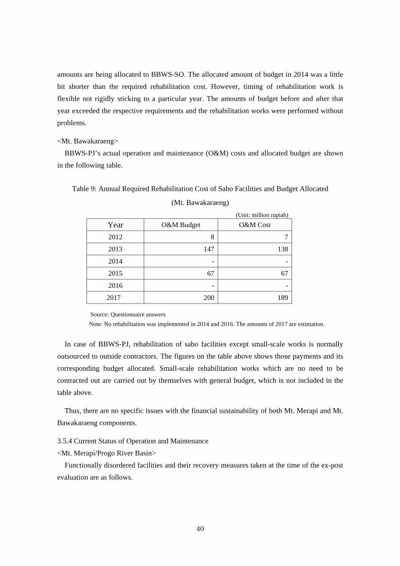
40
amounts are being allocated to BBWS-SO. The allocated amount of budget in 2014 was a little
bit shorter than the required rehabilitation cost. However, timing of rehabilitation work is
flexible not rigidly sticking to a particular year. The amounts of budget before and after that
year exceeded the respective requirements and the rehabilitation works were performed without
problems.
<Mt. Bawakaraeng>
BBWS-PJ’s actual operation and maintenance (O&M) costs and allocated budget are shown
in the following table.
Table 9: Annual Required Rehabilitation Cost of Sabo Facilities and Budget Allocated
(Mt. Bawakaraeng)
(Unit: million rupiah)
Year O&M Budget O&M Cost
2012 8 7
2013 147 138
2014 - -
2015 67 67
2016 - -
2017 200 189
Source: Questionnaire answers
Note: No rehabilitation was implemented in 2014 and 2016. The amounts of 2017 are estimation.
In case of BBWS-PJ, rehabilitation of sabo facilities except small-scale works is normally
outsourced to outside contractors. The figures on the table above shows those payments and its
corresponding budget allocated. Small-scale rehabilitation works which are no need to be
contracted out are carried out by themselves with general budget, which is not included in the
table above.
Thus, there are no specific issues with the financial sustainability of both Mt. Merapi and Mt.
Bawakaraeng components.
3.5.4 Current Status of Operation and Maintenance
<Mt. Merapi/Progo River Basin>
Functionally disordered facilities and their recovery measures taken at the time of the ex-post
evaluation are as follows.
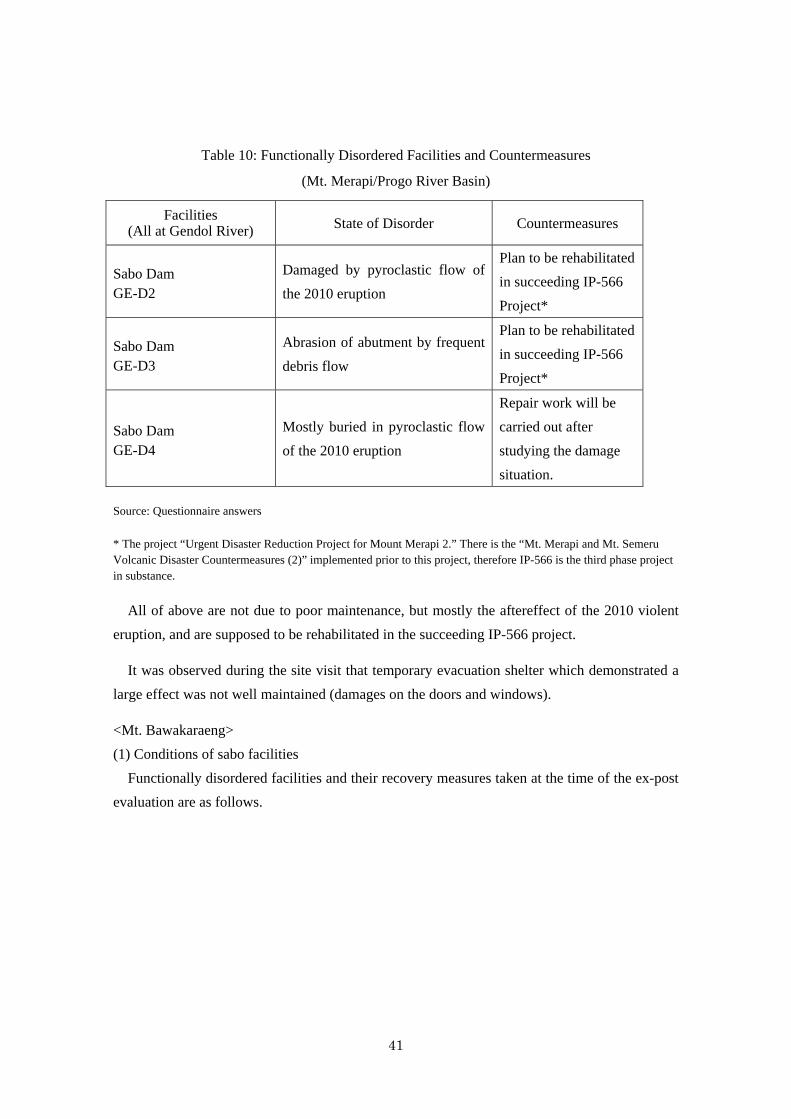
41
Table 10: Functionally Disordered Facilities and Countermeasures
(Mt. Merapi/Progo River Basin)
Facilities (All at Gendol River) State of Disorder Countermeasures
Sabo Dam GE-D2
Damaged by pyroclastic flow of
the 2010 eruption
Plan to be rehabilitated
in succeeding IP-566
Project*
Sabo Dam GE-D3
Abrasion of abutment by frequent
debris flow
Plan to be rehabilitated
in succeeding IP-566
Project*
Sabo Dam GE-D4
Mostly buried in pyroclastic flow
of the 2010 eruption
Repair work will be
carried out after
studying the damage
situation.
Source: Questionnaire answers
* The project “Urgent Disaster Reduction Project for Mount Merapi 2.” There is the “Mt. Merapi and Mt. Semeru Volcanic Disaster Countermeasures (2)” implemented prior to this project, therefore IP-566 is the third phase project in substance.
All of above are not due to poor maintenance, but mostly the aftereffect of the 2010 violent
eruption, and are supposed to be rehabilitated in the succeeding IP-566 project.
It was observed during the site visit that temporary evacuation shelter which demonstrated a
large effect was not well maintained (damages on the doors and windows).
<Mt. Bawakaraeng>
(1) Conditions of sabo facilities
Functionally disordered facilities and their recovery measures taken at the time of the ex-post
evaluation are as follows.
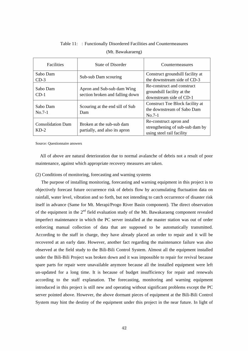
42
Table 11: :Functionally Disordered Facilities and Countermeasures
(Mt. Bawakaraeng)
Facilities State of Disorder Countermeasures
Sabo Dam CD-3
Sub-sub Dam scouring Construct groundsill facility at the downstream side of CD-3
Sabo Dam CD-1
Apron and Sub-sub dam Wing section broken and falling down
Re-construct and construct groundsill facility at the downstream side of CD-1
Sabo Dam No.7-1
Scouring at the end sill of Sub Dam
Construct Toe Block facility at the downstream of Sabo Dam No.7-1
Consolidation Dam KD-2
Broken at the sub-sub dam partially, and also its apron
Re-construct apron and strengthening of sub-sub dam by using steel rail facility
Source: Questionnaire answers
All of above are natural deterioration due to normal avalanche of debris not a result of poor
maintenance, against which appropriate recovery measures are taken.
(2) Conditions of monitoring, forecasting and warning systems
The purpose of installing monitoring, forecasting and warning equipment in this project is to
objectively forecast future occurrence risk of debris flow by accumulating fluctuation data on
rainfall, water level, vibration and so forth, but not intending to catch occurrence of disaster risk
itself in advance (Same for Mt. Merapi/Progo River Basin component). The direct observation
of the equipment in the 2nd field evaluation study of the Mt. Bawakaraeng component revealed
imperfect maintenance in which the PC server installed at the master station was out of order
enforcing manual collection of data that are supposed to be automatically transmitted.
According to the staff in charge, they have already placed an order to repair and it will be
recovered at an early date. However, another fact regarding the maintenance failure was also
observed at the field study to the Bili-Bili Control System. Almost all the equipment installed
under the Bili-Bili Project was broken down and it was impossible to repair for revival because
spare parts for repair were unavailable anymore because all the installed equipment were left
un-updated for a long time. It is because of budget insufficiency for repair and renewals
according to the staff explanation. The forecasting, monitoring and warning equipment
introduced in this project is still new and operating without significant problems except the PC
server pointed above. However, the above dormant pieces of equipment at the Bili-Bili Control
System may hint the destiny of the equipment under this project in the near future. In light of
43
that, the sustainability particularly of the monitoring, forecasting and warning of this project is a
matter of concern.
3.5.5 Summary
The maintenance of sabo facilities of this project is conducted under the responsibility of the
River Basin Management Organizations (BBWS) of the Directorate General of Water
Resources, the Ministry of Public Works and Housing having jurisdiction of respective regions.
Basically, no significant problems were found in the institutional, technical and financial
aspects of project sustainability. However, total sustainability is not completely free from
concern due to the following points.
(1) Under the conditions that the establishment of the planned Sand Mining Management
Institution (SMMI) hit a setback and the alternative management by Kabupaten
governments in charge has not been conducted sufficiently, illegal mining is still
prevailing. There is a concern over the damage on sabo facilities caused by those actions.
(2) Although there is such instability above, maintenance of sabo facilities is conducted
properly in principle. However, it was observed in the field evaluation study at the site
that a part of monitoring, forecasting and warning equipment was out of order and not
timely repaired, and most of the equipment installed at the Bili-Bili Control Center under
the preceding ODA loan project was left un-operated currently under improper
maintenance. This fact implies as a possibility future lack of thorough implementation of
proper maintenance for the monitoring, forecasting and warning equipment of this
project.
(3) Also in the field evaluation study, insufficient maintenance (broken doors and windows)
of the temporary evacuation shelter of the Mt. Merapi component which had produced a
large effect at the 2010 big eruption was confirmed.
Thus, although the institutional, technical and financial aspects of the operation and
maintenance of the project has no major problems basically, there exists some concern in the
future on sand mining management and conditions of the monitoring, forecasting and warning
equipment. Therefore, sustainability of the project effects is fair.
4.Conclusion, Lessons Learned and Recommendations
4.1 Conclusion
This project consists of two sub-projects that conduct both the structural and nonstructural
disaster countermeasures against the eruption of volcanic Mt. Merapi at its foot and the Progo
River Basin in Jogjakarta Special Region Province, as well as the large-scale landslide of Mt.
Bawakaraeng at the Jeneberang River basin and the Bili-Bili Dam in South Sulawesi Province.
44
The Mt. Merapi/Progo River Basin component was implemented to promote protection of
human lives, public and private properties and to establish sustainable disaster protection
systems, thereby contributing to the promotion of regional development. The Mt. Bawakaraeng
component was conducted to protect human lives, public and private property including
farmlands from debris flow and improve the dam function downstream by preventing sediment
discharge from the landslide stricken area, thereby contributing to sustained social and
economic activities in and around Makassar City by maintaining stable supply of water and
other utility services.
This project is highly relevant corresponding to the Indonesia’s development policy, the
international framework to cope with natural disaster prevention, people’s development needs
and also to the Japan’s ODA policy at the time of appraisal. On the other hand, the efficiency is
fair with its implementation period longer than planned due to the prolonged procurement
process, while the project cost is lower than the plan.
For the Mt. Merapi/Progo River Basin component, the preset quantitative indicator “Sediment
Control Ratio” became unusable due to the occurrence of unexpected violent eruption during
the project implementation, however, the project effect on disaster prevention and promotion of
regional development has been confirmed by reviewing past disaster statistics, result of the
beneficiary survey and other evidential facts. For the Mt. Bawakaraeng component, the effect on
disaster prevention and regional development has been identified as well by the achievement of
preset quantitative indicators, result of the beneficiary survey and so forth. The project has been
thus mostly producing planned effects, therefore effectiveness and impact of the project can be
judged high.
Basically no problems were identified in the maintenance system for the developed sabo
facilities as well as the technical and financial capacity of both of the River Basin Organizations
(Balai Besar Wilayah Sungai, hereinafter referred to as BBWS) which are responsible under the
Ministry of Public Works and Housing. However, unrealized optimal sand mining control
system without the planned establishment of the Sand Mining Management Institution (SMMI)
and prevailing incomplete operation and management practices on the installed monitoring,
forecasting and warning systems show some concern on the sustainability. Due to those minor
problems in maintenance and prevailing conditions of the operation and maintenance practices,
the sustainability of the project effects is fair.
In light of the above, this project is evaluated to be satisfactory.
45
4.2 Recommendations
4.2.1 Recommendations to the Executing Agency
4.2.1.1 Continued Endeavor to Establish Sand Mining Management System
Because establishment of the Sand Mining Management Institution (SMMI) which was
planned in the Mt. Merapi/Progo River Basin component has failed, field sand mining
management is not properly operated currently in a systematic manner. While sand mining has
been contributing to the regional economy and society by providing a source of income earning
opportunity to the local people, activities without proper management may cause physical
damages on sabo facilities. To prevent it, the Executing Agency should promptly come to grips
with establishment of an effective sand mining management system.
4.2.1.2 Thorough Execution of Maintenance of the Project Facilities
For both the Mt. Merapi/Progo River Basin and Mt. Bawakaraeng components, sabo,
infrastructure and other main facilities are basically well maintained, however, some problems
Role and Contribution
Generally, disaster prevention projects are required to make a prompt restoration from
disaster damage already occurred or countermeasures against disasters that are occurring
or will occur in the future, therefore the executing and assisting agencies must start the
preparation and implementation as soon as they have recognized the necessity.
Additionally, as the objective to be tackled is unpredictable changing natural phenomena,
the contents and process of implementation need to be flexible to take such steps as the
occasion demands. Those actions were properly taken in the Mt. Bawakaraeng project
component making prompt preparation to quickly cope with the giant landslide of the
caldera wall occurred in March 2004, formulating the project incorporating with the
foregoing Mt. Merapi/Progo River Basin project under preparation succeeding to the
preceding undertakings. After the commencement, it added such additional contents as
construction of consolidation dams, additional dredging of the Bili-Bili Reservoir both at
the edge and near the water intake based on appropriate review of the facility designing.
Also in the Mt. Merapi/Progo River Basin component, proper supplemental
countermeasures were promptly taken to cope with the damages caused by the unforeseen
earthquake and eruptions occurred during the project implementation. To maximally
implement those actions, the ODA loan fund was effectively used over the two
components within the project. Since actions taken by the Executing Agency and JICA
have thus fulfilled the requirement above, the project has successfully brought its effects
46
were observed in the maintenance of temporary evacuation shelter of the Mt. Merapi/Progo
River Basin, the monitoring lodge and a part of monitoring, forecasting and warning equipment
(Mt. Bawakaraeng). Both BBWS are requested to conduct thorough maintenance of all the
facilities.
4.2.2 Recommendations to JICA
4.2.2.1 Encouragement of Establishing and Implementation of Sand Mining Management
System
Considering that the problem involves local conflicts of interests, external pressure and
encouragement is required to urge action taking. In addition to the expected role of the
Executing Agency, JICA should strengthen the request to realize the establishment also in the
course of implementing the succeeding project.
4.3 Lessons Learned
4.3.1 Quick and Flexible Measures for Disaster Recovery and Prevention Projects
To deal with projects that need prompt actions to cope with changing conditions like disaster
recovery and prevention undertakings, the Executing Agency and JICA should immediately
start mutual communications with related institutions after recognizing the needs and endeavor
to make preparations and start implementation as soon as possible applying procedures
elastically. The project implementation also needs flexibility to suit the occasion with
adjustment of methods and contents as necessary.
4.3.2 Project Management during Implementation
Project management has to be conducted integrally by a project implementation unit or
relevant institution charged with the project implementation management. This project was not
comprehensively managed in a sufficient manner by the Executing Agency. Project accounting
was not systematically maintained either, which gave constraint on the evaluation failing to
provide information of the total project cost. Particularly for the management of a project
consisting of multiple independent sub-projects like this project, a project management unit
should be organized at the central Executing Agency to comprehensively manage whole of the
project implementation. Individual management systems at respective sub-project sites and
regular reporting systems to the central management unit must be organized at the stage of
project formulation. JICA should monitor and supervise that the said two-layered management
be working as expected.
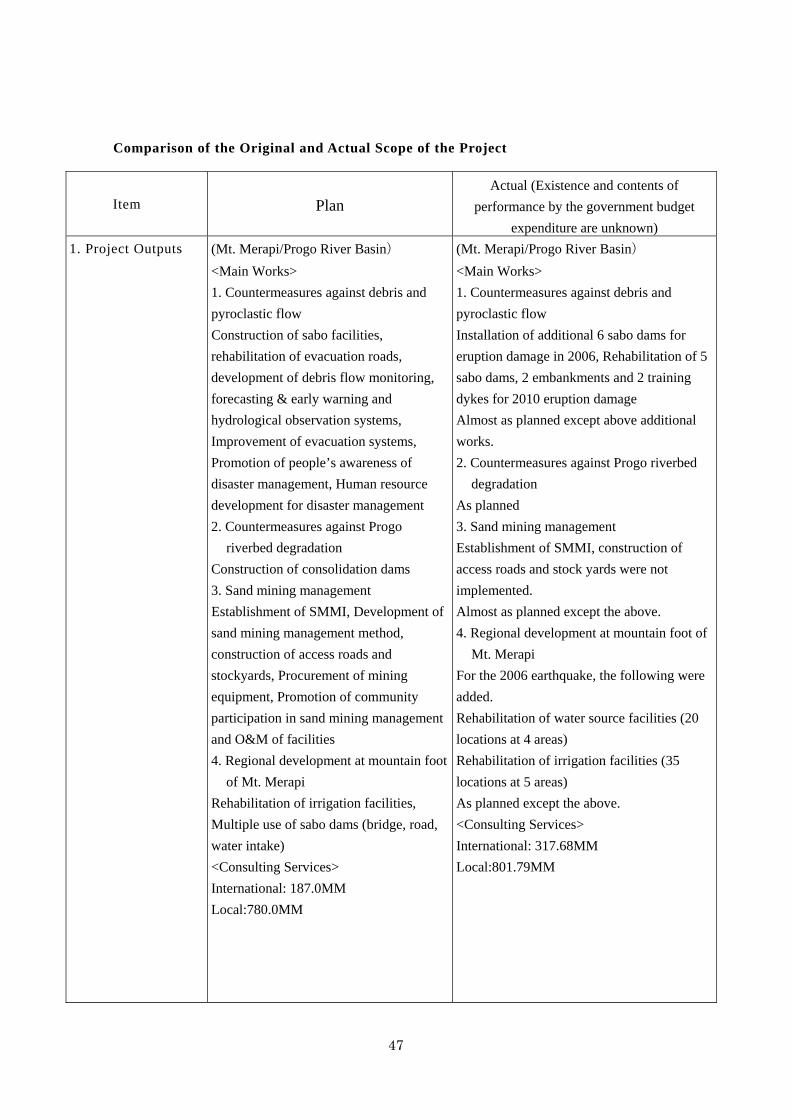
47
Comparison of the Original and Actual Scope of the Project
Item Plan Actual (Existence and contents of
performance by the government budget
expenditure are unknown)
1. Project Outputs
(Mt. Merapi/Progo River Basin)
<Main Works> 1. Countermeasures against debris and
pyroclastic flow Construction of sabo facilities,
rehabilitation of evacuation roads,
development of debris flow monitoring,
forecasting & early warning and
hydrological observation systems,
Improvement of evacuation systems,
Promotion of people’s awareness of
disaster management, Human resource
development for disaster management
2. Countermeasures against Progo
riverbed degradation
Construction of consolidation dams
3. Sand mining management Establishment of SMMI, Development of
sand mining management method,
construction of access roads and
stockyards, Procurement of mining
equipment, Promotion of community
participation in sand mining management
and O&M of facilities 4. Regional development at mountain foot
of Mt. Merapi Rehabilitation of irrigation facilities,
Multiple use of sabo dams (bridge, road,
water intake)
<Consulting Services> International: 187.0MM Local:780.0MM
(Mt. Merapi/Progo River Basin)
<Main Works> 1. Countermeasures against debris and
pyroclastic flow Installation of additional 6 sabo dams for
eruption damage in 2006, Rehabilitation of 5
sabo dams, 2 embankments and 2 training
dykes for 2010 eruption damage
Almost as planned except above additional
works.
2. Countermeasures against Progo riverbed
degradation
As planned
3. Sand mining management Establishment of SMMI, construction of
access roads and stock yards were not
implemented.
Almost as planned except the above.
4. Regional development at mountain foot of
Mt. Merapi For the 2006 earthquake, the following were
added.
Rehabilitation of water source facilities (20
locations at 4 areas)
Rehabilitation of irrigation facilities (35
locations at 5 areas)
As planned except the above.
<Consulting Services> International: 317.68MM Local:801.79MM
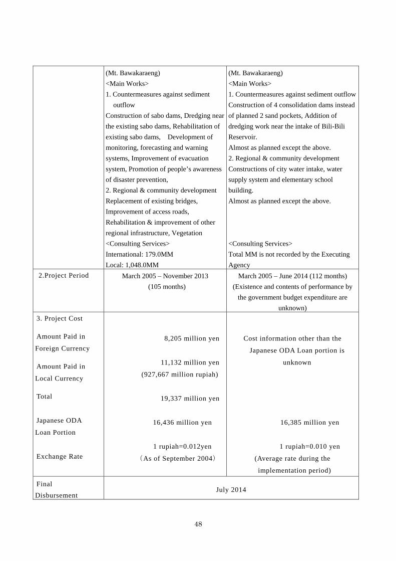
48
(Mt. Bawakaraeng) <Main Works> 1. Countermeasures against sediment
outflow Construction of sabo dams, Dredging near
the existing sabo dams, Rehabilitation of
existing sabo dams, Development of
monitoring, forecasting and warning
systems, Improvement of evacuation
system, Promotion of people’s awareness
of disaster prevention,
2. Regional & community development Replacement of existing bridges,
Improvement of access roads,
Rehabilitation & improvement of other
regional infrastructure, Vegetation
<Consulting Services> International: 179.0MM Local: 1,048.0MM
(Mt. Bawakaraeng) <Main Works> 1. Countermeasures against sediment outflow
Construction of 4 consolidation dams instead
of planned 2 sand pockets, Addition of
dredging work near the intake of Bili-Bili
Reservoir.
Almost as planned except the above.
2. Regional & community development Constructions of city water intake, water
supply system and elementary school
building.
Almost as planned except the above.
<Consulting Services> Total MM is not recorded by the Executing
Agency
2.Project Period March 2005 – November 2013
(105 months)
March 2005 – June 2014 (112 months)
(Existence and contents of performance by
the government budget expenditure are
unknown)
3. Project Cost
Amount Paid in
Foreign Currency
Amount Paid in
Local Currency
Total
Japanese ODA
Loan Portion
Exchange Rate
8,205 million yen
11,132 million yen
(927,667 million rupiah)
19,337 million yen
16,436 million yen
1 rupiah=0.012yen
(As of September 2004)
Cost information other than the
Japanese ODA Loan portion is
unknown
16,385 million yen
1 rupiah=0.010 yen
(Average rate during the
implementation period)
Final
Disbursement July 2014