Embed Size (px)
Citation preview
REPTILE CWCS SPECIES (27 SPECIES)
Common name Scientific name
Alligator Snapping Turtle Macrochelys temminckii
Broad-banded Water Snake Nerodia fasciata confluens
Coal Skink Eumeces anthracinus
Copperbelly Watersnake Nerodia erythrogaster neglecta
Corn Snake Elaphe guttata guttata
Diamondback Water Snake Nerodia rhombifer rhombifer
Eastern Coachwhip Masticophis flagellum flagellum
Eastern Mud Turtle Kinosternon subrubrum
Eastern Ribbon Snake Thamnophis sauritus sauritus
Eastern Slender Glass Lizard Ophisaurus attenuatus longicaudus
False Map Turtle Graptemys pseudogeographica pseudogeographica
Green Water Snake Nerodia cyclopion
Kirtland's Snake Clonophis kirtlandii
Midland Smooth Softshell Apalone mutica mutica
Mississippi Map Turtle Graptemys pseudogeographica kohnii
Northern Pine Snake Pituophis melanoleucus melanoleucus
Northern Scarlet Snake Cemophora coccinea copei
Scarlet Kingsnake Lampropeltis triangulum elapsoides
Six-lined Racerunner Cnemidophorus sexlineatus
Southeastern Crowned Snake Tantilla coronata
Southeastern Five-lined Skink Eumeces inexpectatus
Southern Painted Turtle Chrysemys picta dorsalis
Timber Rattlesnake Crotalus horridus
Western Cottonmouth Agkistrodon piscivorus leucostoma
Western Mud Snake Farancia abacura reinwardtii
Western Pygmy Rattlesnake Sistrurus miliarius streckeri
Western Ribbon Snake Thamnophis proximus proximus
CLASS REPTILIA
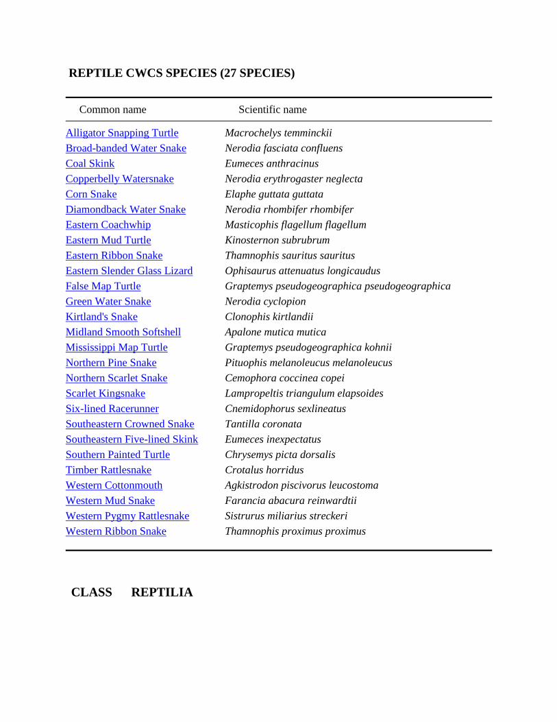
Alligator Snapping Turtle Macrochelys temminckii
Federal Heritage GRank SRank GRank SRank
Status Status (Simplified) (Simplified)
N T G3G4 S2 G3 S2
G-Trend Decreasing
G-Trend The alligator snapping turtle inhabits river systems draining into Gulf of
Comment Mexico in the south-central U.S. and ranges northward in the Mississippi River
system into western Kentucky, Missouri, Illinois, and Iowa (Conant and
Collins 1991). This turtle has been reported from specific, mappable localities
in only 6 Kentucky counties (Ballard, Caldwell, Calloway, Carlisle, Livingston,
and McCracken) but likely occurs in low numbers in and along the Mississippi,
lower Ohio, and lower Tennessee and Cumberland Rivers including Kentucky
Lake and Lake Barkley (Kentucky Herpetology Database 2004, Kentucky State
Nature Preserves Commission Database 2004). Some reported occurrences
(i.e., those in Breckinridge and Knox counties) have been based on the recovery
of large captive specimens that had been released; others (i.e., the "Monster of
Maple Lake") are based on media reports and require some sort of
substantiation before they can be accepted.
S-Trend Unknown
S-Trend The alligator snapping turtle is thought to be rare and declining throughout its
Comment range, but this species is so difficult to sample that very little recent
population/abundance data is available. No population information is available
for Kentucky. An ongoing graduate student project to sample for alligator
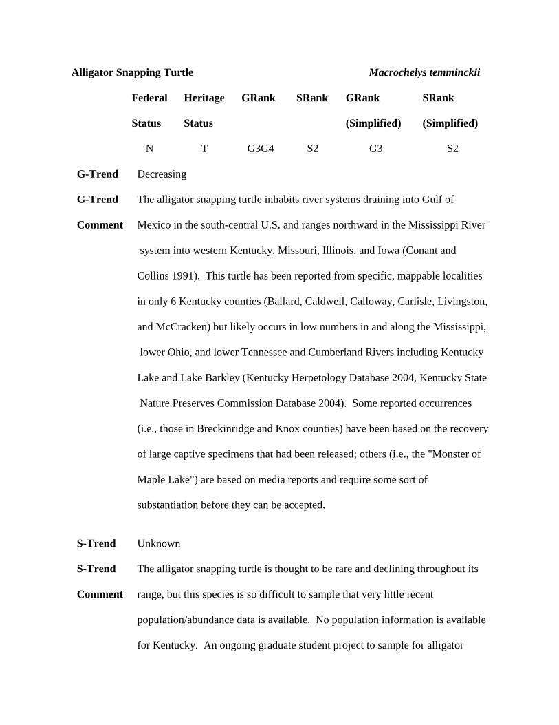
snappers in the western part of the state was funded by Kentucky Department
of Fish and Wildlife Resources but none have thus far been captured. Recent
records (1984-2004) in Kentucky are available from 4 counties (Ballard,
Livingston, Caldwell, and Calloway) (Kentucky State Nature Preserves
Commission Database 2004, J.R. MacGregor Data). Dams, commercial harvest
for human consumption, and general habitat degradation have adversely
impacted this species throughout its range (NatureServe 2004).
Habitat / Habitat characteristics for this turtle in Kentucky are largely unknown. The
Life History Laketon specimen was found in a cypress slough along the Mississippi River
floodplain, the Princeton specimen was dug from a large urban spring that is the
head of a tributary flowing into Lake Barkley, the Blood River juvenile was
found in a tire rut after a flood event, the Panther Creek animal was found dead
after having been hooked on an abandoned limb line, and the Paducah specimen
was found at a water intake plant. Locality data is a bit vague for 1-2
specimens that have been captured by fishermen along the lower Tennessee
River in Livingston County. There are a few old literature records and one
CLASS REPTILIA
Alligator Snapping Turtle Macrochelys temminckii
recent record from the Ohio River (Ballard County). The species can be said to
have occurred in habitats ranging from headwater springs and tire ruts to large
rivers, but we still have little or no idea how or where to search for it in
Kentucky.
Key Habitat condition is completely UNKNOWN as no key habitat locations have
Habitat been identified for this species in Kentucky.
Guilds Emergent and shrub-dominated wetlands, forested wetland, running water,
standing water.
Statewide AlligatorSnappingTurtle.pdf
Map
CLASS REPTILIA
Alligator Snapping Turtle Macrochelys temminckii
Conservation Issues
Aquatic habitat degradation
2C Construction/Operation of impoundments (migration barrier). Dams (loss
of natural river channel character).
2E Stream channelization/ditching. Loss of oxbows, sloughs, braided channels.
2H Wetland loss/drainage/alteration . Loss of natural and man made wetlands
and loss of herbaceous vegetation in ponds/sloughs.
Biological/ consumptive uses
5B Predation from native species. Nest predation (skunks, raccoons, foxes,
coyotes, etc.).
5F Low population densities
5H Isolated populations (low gene flow)
5I Commercial collecting for pet trade (overharvest). Commercial collection
(human food, pet trade).
5J Incidental mortality due to commercial fishing/musseling (mortality and
overharvest). Commercial fishing (trot lines et al). Fishing (troutline, limb
lines, bank lines).
5K Lack of suitable habitat for spawning, nesting, or breeding. Reforestation of
open sandy soil areas near ponds (loss of suitable nesting habitat).
5P Market hunting for human consumption. Commercial collection (human
food, pet trade).
Siltation and increased turbidity
1B Agriculture. Extensive agricultural development along waterways.
Terrestrial habitat degradation
3F Urban/residential development
3R Habitat and/or Population Fragmentation
3T Suppression of disturbance regimes. Reforestation of open sandy soil areas
near ponds (loss of suitable nesting habitat).
3U Loss, lack and degradation of special and unique microhabitats
CLASS REPTILIA
Broad-banded Water Snake Nerodia fasciata confluens
Federal Heritage GRank SRank GRank SRank
Status Status (Simplified) (Simplified)
N E G5T5 S1 G5 S1
G-Trend Unknown
G-Trend Gulf Coast region and Mississippi River drainage from Texas and Louisiana
Comment northward to extreme southeastern Missouri, extreme southern Illinois, and the
western tip of Kentucky (Conant and Collins 1991) known in Kentucky only
from Fish Lake and from the vicinity of Reelfoot National Wildlife Refuge in
Fulton County (Kentucky Herpetology Database 2004, Kentucky State Nature
Preserves Commission Database 2004).
S-Trend Decreasing
S-Trend Known historically and recently from the lowlands of southwestern Fulton
Comment County (Kentucky State Nature Preserve Commission 2004, J.R. MacGregor
2004, W. Bird and P. Peak, pers. obs.); listed here as declining due to heavy
past and recent impacts associated with agricultural development in the
bottoms located north of Reelfoot Lake.
Habitat / Usually found in sloughs, sluggish streams, bayous, oxbows, and other slow-
Life History moving or standing water habitats; often found in areas that are at least partly
wooded (Wright and Wright 1957, J.R. MacGregor data). Also reported in the
literature from marshes and wet prairies (Ernst and Ernst 2003); several adults
have been found in open wet meadow habitats in Kentucky both at Reelfoot
National Wildlife Refuge (B. Palmer-Ball, Jr., pers. comm.) and at Fish Lake
(W. Bird and P. Peak, pers. comm.). Often occurs in clear water areas with
some emergent or aquatic vegetation and mud bottoms. Although past
population data is generally lacking for this species in Kentucky, the author
(J.R. MacGregor) believes that the broad-banded water snake has declined in far
western Kentucky as a result of heavy past/recent impacts associated with
agricultural development in the bottoms located north of Reelfoot Lake. Key
habitat loss factors here have included wetland drainage and sedimentation,
channelization, tree cutting/removal and land conversion (J.R. MacGregor, pers.
obs.).
Key Habitat condition is FAIR at best, although the habitat within Reelfoot National
Habitat Wildlife Refuge has to be considered as GOOD (J.R. MacGregor, pers. obs.).
Following Key Habitats (good):
1. Fulton County
CLASS REPTILIA
Broad-banded Water Snake Nerodia fasciata confluens
Guilds Emergent and shrub-dominated wetlands, forested wetland, standing water.
Statewide Broad-bandedWaterSnake.pdf
Map
Conservation Issues
Aquatic habitat degradation
2E Stream channelization/ditching
2H Wetland loss/drainage/alteration . Loss of wetland connectivity and
wetland drainage/conversion.
Biological/ consumptive uses
5F Low population densities. Always rare/local.
5H Isolated populations (low gene flow)
Terrestrial habitat degradation
3A Row-crop agriculture (conversion to, annual reuse of fields, etc)
3R Habitat and/or Population Fragmentation. Loss of wetland connectivity.
3U Loss, lack and degradation of special and unique microhabitats
CLASS REPTILIA
Coal Skink Eumeces anthracinus
Federal Heritage GRank SRank GRank SRank
Status Status (Simplified) (Simplified)
N T G5 S2 G5 S2
G-Trend Unknown
G-Trend The species occurs over a relatively large area that extends from eastern Texas,
Comment Oklahoma , and Kansas eastward into northern Florida and northward into New
York; the range is quite fragmented toward the east and northeast (Conant and
Collins 1991). In our state, the coal skink is known from scattered locations in
16 counties; most records are from eastern Kentucky, but an isolated
population once occurred (and still may occur) in the Mammoth Cave area
(Edmonson County) and an extant population is present in the Jackson
Purchase in southeastern Calloway County (Kentucky Herpetology Database
2004, Kentucky State Nature Preserves Commission Database 2004).
S-Trend Decreasing
S-Trend The coal skink is probably declining in Kentucky; recent records (1984-2004)
Comment are available from only 9 counties (Calloway, McCreary, Whitley, Laurel, Clay,
Rockcastle, Madison, Garrard, and Greenup) (Kentucky State Nature Preserve
Commission 2004, East Kentucky Power Cooperative data, J.R. MacGregor
data). Coal skinks occur in fair numbers in abandoned gravel pits and other
open habitats in Calloway County, in sunny open shale oak-pine woods in and
around Berea College Forest, and along open powerline and roadside rights-of-
way in McCreary, Whitley, and Laurel counties in southeastern Kentucky.
Elsewhere, most records are for single animals that were found a number of
years ago, and many colonies have likely been extirpated (J.R. MacGregor
data).
Habitat / Coal skinks occur primarily in fairly dry rocky open woodlands, remnant glades
Life History and prairies, old quarries and gravel pits, rocky fields, and utility line corridors
with some bare ground and scattered areas of cover including rocks, sunny
outcrops, old railroad ties, and/or discarded tree limbs and general household
rubbish. Although some of the literature indicates that coal skinks are most
often found in mesic habitats, nearly all Kentucky sites are quite dry and open
(as are those in West Virginia and several other eastern states).
Key For this species, habitat condition here is generally POOR.
Habitat
Following Key Habitats (good):
1. Calloway County
2. McCreary County
3. Madison County
CLASS REPTILIA
Coal Skink Eumeces anthracinus
Guilds grassland/agricultural, savanna/ shrub-scrub, upland forest.
Statewide CoalSkink.pdf
Map
Conservation Issues
Biological/ consumptive uses
5A Predation from introduced species. Predation by domestic pets (primarily
house cats).
5K Lack of suitable habitat for spawning, nesting, or breeding
Miscellaneous Mortality Factors
6G Stochastic events (droughts, unusual weather, pine beetle damage, flooding
etc.)
Terrestrial habitat degradation
3A Row-crop agriculture (conversion to, annual reuse of fields, etc).
Conversion of open/rocky habitats to pasture.
3I Conversion of native forest to short-rotation crop trees (pine, sycamore,
cottonwood, etc.). Plantation forestry.
3Q Invasive/exotic plants (including fescue). Planting crown vetch and fescue
along roadsides.

3R Habitat and/or Population Fragmentation
3S Fire suppression/fire regime management. Loss of fire in the ecosystem.
3T Suppression of disturbance regimes. natural reforestation of rocky, gravelly
old fields, of abandoned gravel pits/quarries and go glades/rock outcrop
3U Loss, lack and degradation of special and unique microhabitats
CLASS REPTILIA
Copperbelly Watersnake Nerodia erythrogaster neglecta
Federal Heritage GRank SRank GRank SRank
Status Status (Simplified) (Simplified)
PS:LT S G5T2 S3 G2 S3
T3
G-Trend Decreasing
G-Trend Southeastern Illinois, southwestern Indiana, and western Kentucky northward
Comment in isolated colonies to northwestern Ohio, northeastern Indiana, and adjacent
southern Michigan; intergrades westward with additional subspecies (Conant
and Collins 1991). Known from a total of 16 counties in Kentucky (Kentucky
State Nature Preserves Commission 2004, Kentucky Herpetology Database
2004).
S-Trend Decreasing
S-Trend Recent and extant populations (1984-2004) occur in 15 counties located within
Comment and adjacent to the Western Coal Field (Livingston County to Hancock
County); also known historically from wetland habitats in southwestern
Jefferson County (Louisville) but probably extirpated there (Kentucky
Herpetology Database 2004, Kentucky State Nature Preserve Commission
2004).
Habitat / Less aquatic than other Kentucky Nerodia; tends to be more common in
Life History bottomland forest and tannic seasonally flooded pools but also found regularly
in sloughs, sluggish stream margins, bayous, oxbows, and other slow-moving or
standing water habitats. The copperbelly watersnake generally prefers areas
that are at least partly wooded, and prefers clear water areas with some
emergent or aquatic vegetation and mud bottoms (Ernst and Ernst 2003) and
sometimes occurs in low to moderate numbers in man-made lakes and ponds
(J.R. MacGregor data). Often associated with buttonbush ponds and isolated
woodland pools with good populations of breeding salamanders and frogs and
with water that becomes stained with tannin (Wright and Wright 1957). Gravid
females often use highway and railroad fill slopes and other open upland
habitat basking sites. Generally (but not always) requires adjacent upland
habitat with suitable rock crevices, mammal burrows, or old root channels for
winter hibernation but may also use crayfish or muskrat holes and spend at
least part of the winter submerged (J.R. MacGregor, pers. obs.).
Key Habitat condition is only FAIR overall.
Habitat
Following Key Habitats (good):
1. Henderson County
2. Daviess and Hancock counties
3. Hopkins County
CLASS REPTILIA
Copperbelly Watersnake Nerodia erythrogaster neglecta
Guilds Emergent and shrub-dominated wetlands, forested wetland, standing water.
Statewide CopperbellyWatersnake.pdf
Map
Conservation Issues
Aquatic habitat degradation
2E Stream channelization/ditching
2H Wetland loss/drainage/alteration . Loss of wetland connectivity, wetland
drainage/conversion and surface mining in wetlands.
Biological/ consumptive uses
5F Low population densities
5H Isolated populations (low gene flow)
5Q Declining prey base. Reduction of amphibian prey base.
Miscellaneous Mortality Factors
6A Traffic/road kills
6E Illegal killing
6F Wanton shooting/killing and unregulated take. Shooting (mostly from
bridges) and just wanton killing.
Terrestrial habitat degradation

3A Row-crop agriculture (conversion to, annual reuse of fields, etc)
3K Surface mining. Surface mining in wetlands, surface mining fragmentation
and water quality.
3R Habitat and/or Population Fragmentation. Loss of wetland connectivity
and surface mining fragmentation.
3U Loss, lack and degradation of special and unique microhabitats
CLASS REPTILIA
Corn Snake Elaphe guttata guttata
Federal Heritage GRank SRank GRank SRank
Status Status (Simplified) (Simplified)
N S G5T5 S3 G5 S3
G-Trend Stable
G-Trend Southeastern U.S., ranging northward into Tennessee, Virginia, DelMarVa
Comment Peninsula, and New Jersey with isolated colonies in central and eastern
Kentucky (Conant and Collins 1991). Known to occur in 5 counties in west-
central Kentucky (Barren, Edmonson, Hart, Grayson, and Hardin) and 4
counties in eastern Kentucky (Powell, Wolfe, Menifee, and Morgan) (Kentucky
Herpetology Database 2004, Kentucky State Nature Preserves Commission
Database 2004).
S-Trend Decreasing
S-Trend The corn snake in Kentucky is somewhat of an enigma. Populations in west-
Comment central Kentucky seem to be doing quite well; Bird and Peak (pers. comm.)
found nearly 60 corn snakes in Hart County during the 2003 field season, and
an ongoing field study at Mammoth Cave National Park in Edmonson County
yielded 25 or more corn snakes during the 2004 field season (J.R. MacGregor
data). The eastern Kentucky population, on the other hand, appears to have
declined greatly since the early 1980’s; it has all but disappeared from the Red
River Gorge area (Daniel Boone National Forest) and Natural Bridge State
Resort Park where very few have been found there during the past 20 years
despite much searching (J.R. MacGregor, U.S. Forest Service, and Kentucky
State Nature Preserves Commission data). At the present time there are recent
(1984-2004) records from 8 counties.
Habitat / Terrestrial and at least partly fossorial; occurs in/near sparsely to moderately
Life History dense forested uplands dominated by oak and/or pine with well-drained sandy
or loamy soils. Sites offering a mix of prairie patches and forest stands with
numerous to scattered grassy or weedy openings seem to be preferred. The
corn snake probably does best in fire-maintained and fire-managed habitats; it
also does well in farm country where cropland and pasture alternate with large
chunks of native forest. Most of the corn snakes in the Red River
Gorge/Natural Bridge area that were found during the 1960’s and 1970’s were in
and around old farmsteads and pastures in the bottomlands along the Red River
and its major tributaries. Nearly all of these sites have subsequently been
purchased by the U.S. Forest Service and have either been converted into visitor
facilities or allowed to revert to young second-growth forest. It is quite likely
that natural succession is one of the factors responsible for the decline of the
corn snake in this section of eastern Kentucky (J.R. MacGregor, pers. obs).
Throughout its range, the corn snake is noted for being less arboreal than the
members of the black rat snake complex and for favoring habitats like brushy
CLASS REPTILIA
Corn Snake Elaphe guttata guttata
fields, glades and prairie remnants, scrublands, pine barrens, roadsides, open
forests, and various types of outbuildings (Ernst and Ernst 2003, Wright and
Wright 1957).
Key Habitat condition is overall GOOD in west-central Kentucky in upland areas
Habitat but is POOR in eastern Kentucky where much formerly open habitat appears
to have reverted to closed-canopy forest (J.R. MacGregor, pers. obs.).
Following Key Habitats (good):
1. Edmonson County
2. Hart County
Guilds grassland/agricultural, savanna/ shrub-scrub, upland forest.
Statewide CornSnake.pdf
Map
Conservation Issues
Biological/ consumptive uses
5F Low population densities. Becoming rare/local.
5H Isolated populations (low gene flow)

5I Commercial collecting for pet trade (overharvest)
Miscellaneous Mortality Factors
6A Traffic/road kills
6F Wanton shooting/killing and unregulated take
Terrestrial habitat degradation
3R Habitat and/or Population Fragmentation. Loss of glade connectivity.
3S Fire suppression/fire regime management. Loss of fire in ecosystem.
3T Suppression of disturbance regimes. Reforestation of open rocky habitats.
3U Loss, lack and degradation of special and unique microhabitats
CLASS REPTILIA
Diamondback Water Snake Nerodia rhombifer rhombifer
Federal Heritage GRank SRank GRank SRank
Status Status (Simplified) (Simplified)
N N G5T5 S5 G5 S5
G-Trend Unknown
G-Trend South-central U.S. from Texas to Alabama, northward into Kansas, Missouri,
Comment Iowa, Illinois, southwest Indiana, and western Kentucky (Conant and Collins
1991). Currently known from 17 counties in the Jackson Purchase, Land
Between The Lakes National Recreation Area, and the Western Coal Field
(Kentucky Herpetology Database 2004).
S-Trend Unknown
S-Trend Apparently stable in the Jackson Purchase, but populations have been
Comment fragmented by impacts associated with mining and agriculture in the Western
Coal Field (J.R. MacGregor, pers. obs.). This species is not tracked by
Kentucky State Nature Preserves Commission.
Habitat / Usually found in sloughs, sluggish streams, bayous, oxbows, and other slow-
Life History moving or standing water habitats; also associated frequently with river
backwaters and the lower sections of tributary streams. Diamondback water
snakes prefer areas that are at least partly wooded and are well-supplied with
logjams, fallen trees, and similar basking sites that overhang deep water. They
have also been found in low numbers in some reservoir backwater coves - and
upland ponds - in the Land Between The Lakes National Recreation Area (J.R.
MacGregor, pers. obs.).
Key Habitat condition is GOOD in the wetlands that border the Mississippi River
Habitat and portions of the lower Ohio River, and in the wetland complexes that have
redeveloped in the Jackson Purchase along some of the larger stream systems
(Bayou du Chein, Obion Creek, Mayfield Creek); only FAIR to POOR in most
of the Western Coal Field (J.R. MacGregor, pers. obs.).
Following Key Habitats (good):
1. Fulton County
2. Ballard County
3. Carlisle County
Guilds Emergent and shrub-dominated wetlands, forested wetland, running water,
standing water.
Statewide DiamondbackWaterSnake.pdf
Map
CLASS REPTILIA
Diamondback Water Snake Nerodia rhombifer rhombifer
Conservation Issues
Aquatic habitat degradation
2E Stream channelization/ditching
2H Wetland loss/drainage/alteration . Loss of wetland connectivity, wetland
drainage/conversion and surface mining in wetlands.
Miscellaneous Mortality Factors
6A Traffic/road kills
6F Wanton shooting/killing and unregulated take. Shooting (mostly from
bridges) and wanton killing.
Terrestrial habitat degradation
3F Urban/residential development
3K Surface mining. Surface mining in wetlands, fragmentation and water
3R Habitat and/or Population Fragmentation. Surface mining fragmentation of
habitat and water quality.
3U Loss, lack and degradation of special and unique microhabitats
CLASS REPTILIA
Eastern Coachwhip Masticophis flagellum flagellum
Federal Heritage GRank SRank GRank SRank
Status Status (Simplified) (Simplified)
N X G5T5 SX G5 N
G-Trend Decreasing
G-Trend Southeastern U.S., northward to southeastern North Carolina and southwestern
Comment Tennessee; also occurs west of the Mississippi River lowlands from Louisiana
and Texas northward to Missouri (Conant and Collins 1991). Reported from 4
Kentucky counties (Barren, Edmonson, Hart, and Pulaski) but all of the
records are suspect; it is the opinion of J.R. MacGregor that the eastern
coachwhip is not native to the state and that the specimens reported were
escaped or released captives.
S-Trend Unknown
S-Trend Apparently declining at least in some areas rangewide due to habitat loss
Comment (succession, development, conversion of native habitat to agriculture or
plantation forestry, fire suppression, etc.) and direct mortality (i.e., entrapment
in plastic erosion control netting, highway mortality, mowing) (NatureServe
2004). Probably an introduced species in Kentucky but apparently now
extirpated; last documented in the 1960’s near the site of the Kentucky Reptile
Gardens (a roadside reptile zoo that closed for good in the early 1970’s). This
species is not tracked by Kentucky State Nature Preserves Commission.
Habitat / If native, the eastern coachwhip would likely have occurred only in the area
Life History formerly known as “The Barrens” - a region of native prairie that occupied the
northern and western sections of the Mississippian Plateau and most upland
section of the Jackson Purchase prior to human settlement (Mengel 1965).
Several native reptiles and amphibians including the prairie kingsnake, six-lined
racerunner, and (to some degree) western slender glass lizard, northern crawfish
frog, and eastern narrowmouth toad have ranges that appear to reflect the
original native prairie regions of Kentucky (J.R. MacGregor, pers. obs.). The
eastern coachwhip probably would have done best in fire-maintained and fire-
managed habitats.
Key Habitat condition overall is POOR.
Habitat
Following Key Habitats (good):
None identified - probably introduced; now apparently extirpated
Guilds grassland/agricultural, savanna/ shrub-scrub.

CLASS REPTILIA
Eastern Coachwhip Masticophis flagellum flagellum
Statewide EasternCoachwhip.pdf
Map
Conservation Issues
Biological/ consumptive uses
5K Lack of suitable habitat for spawning, nesting, or breeding. Loss of open
gravelly/sandy nesting/egg-laying habitat.
Terrestrial habitat degradation
3R Habitat and/or Population Fragmentation. Loss of glade connectivity.
3S Fire suppression/fire regime management. Loss of fire in ecosystem.
3T Suppression of disturbance regimes. Reforestation of open rocky habitat.
3U Loss, lack and degradation of special and unique microhabitats
CLASS REPTILIA
Eastern Mud Turtle Kinosternon subrubrum
Federal Heritage GRank SRank GRank SRank
Status Status (Simplified) (Simplified)
N N G5 S3S4 G5 S3
G-Trend Unknown
G-Trend The mud turtle has a widespread distribution in the southeastern U.S. with a
Comment range that extends northward into Illinois in the midwest and New Jersey and
Long Island in the northeast (Conant and Collins 1991). This species has been
recorded from about 20 Kentucky counties in the Jackson Purchase, Land
Between The Lakes National Recreation Area, and Mississippian Plateau and a
single county (Union) in the western Coal Field (Kentucky Herpetology
Database 2004).
S-Trend Decreasing
S-Trend Population trends for the mud turtle are unknown rangewide, but this species is
Comment almost certainly declining in Kentucky. The mud turtle has a spotty and
discontinuous range in the state, and the habitat has been heavily impacted
and/or fragmented by agriculture and mineral extraction. Some decent colonies
occur in the Jackson Purchase region (Reelfoot Lake area, Obion Wildlife
Management Area, Ballard Wildlife Management Area, and Bypass Road);
elsewhere in western Kentucky the species is rare. Mud turtle populations that
once inhabited the sinkhole ponds and upland swamps of central Kentucky are
probably on the verge of extirpation since much of the habitat there has been
eliminated by the plow and tractor and by impacts associated with oil
extraction. Recent (1984-2004) records exist for 13 of the 20 mud turtle
counties in Kentucky; this figure may be misleadingly high since most of these
counties have yielded only single observations. The mud turtle is not tracked
by Kentucky State Nature Preserves Commission.
Habitat / The mud turtle is associated with wetland habitats throughout its range in
Life History Kentucky. In the western part of the state, west of Dawson Springs, it is/was
most common in areas with extensive shallow swamps and abundant emergent
vegetation adjacent to wet meadows and bottomland hardwood forest. Further
east, in the Mississippian Plateau region of central and southern Kentucky,
mud turtles are still present but becoming rare in permanent and/or seasonal
shallow sinkhole swamps.
Key Habitat condition is generally POOR, but there are a few good areas left, most
Habitat of which (Reelfoot Lake area, Obion Wildlife Management Area, Ballard
Wildlife Management Area, and Clarks River National Wildlife Refuge/Bypass
Road) are located in the Jackson Purchase region.
Following Key Habitats (good):
CLASS REPTILIA
Eastern Mud Turtle Kinosternon subrubrum
1. McCracken County and Marshall County
2. Ballard County
3. Fulton County
4. Hickman County
Guilds Emergent and shrub-dominated wetlands, forested wetland, standing water.
Statewide EasternMudTurtle.pdf
Map
Conservation Issues
Aquatic habitat degradation
2E Stream channelization/ditching. Loss of oxbows, sloughs, braided channels.
2H Wetland loss/drainage/alteration . Loss of natural and man made wetlands.
Loss of herbaceous vegetation in ponds/sloughs.
Biological/ consumptive uses
5K Lack of suitable habitat for spawning, nesting, or breeding. Reservoirs
(fluctuating water levels/poor nest habitat).
Miscellaneous Mortality Factors
6A Traffic/road kills
Siltation and increased turbidity
1B Agriculture. Extensive agricultural development along waterways.

Terrestrial habitat degradation
3R Habitat and/or Population Fragmentation
3T Suppression of disturbance regimes. Reforestation of open sandy soil areas
near ponds (loss of suitable nesting habitat) and wet meadows.
3U Loss, lack and degradation of special and unique microhabitats
CLASS REPTILIA
Eastern Ribbon Snake Thamnophis sauritus sauritus
Federal Heritage GRank SRank GRank SRank
Status Status (Simplified) (Simplified)
N S G5T5 S3 G5 S3
G-Trend Unknown
G-Trend Widespread in eastern, southeastern, and central U.S. from New England south
Comment to Georgia, Alabama, and Mississippi; northward on the east side of the
Mississippi River lowlands to southern Illinois, southwestern Indiana, and
western Kentucky with scattered colonies elsewhere (Conant and Collins
1991). Scattered in wetland habitats with records from 20 counties in the
western half of Kentucky; also known historically from lowland swamps along
the Licking River (locations now submerged under Cave Run Lake) (Kentucky
Herpetology Database 2004, Kentucky State Nature Preserves Commission
Database 2004, C.H. Ernst, pers. comm.).
S-Trend Unknown
S-Trend Rangewide and state population trends are unknown, but several herpetologists
Comment have mentioned that eastern ribbon snakes seem to be in decline in some parts
of their range. There are recent records from 16 Kentucky counties (Kentucky
State Nature Preserve Commission 2004).
Habitat / Eastern ribbon snakes are usually associated with wetland habitats that harbor
Life History good populations of prey species including amphibians, mosquito fish
(Gambusia), and/or topminnows (Fundulus). These snakes typically inhabit
wet meadows and sunny openings with low herbaceous vegetation along the
margins of sloughs, sluggish streams, bayous, oxbows, and other slow-moving
or standing water habitats. Some individuals - particularly gravid females -
regularly climb up into shrubs such as buttonbush or willow in search of
basking sites. Eastern ribbon snakes are sometimes present in large numbers on
grassy dikes and highway/railroad fill slopes bordered by shallow wetlands;
they are especially abundant on the water control structures that form the moist
soil management units at Sloughs Wildlife Management Area in Henderson
County. Mammal and crayfish burrows are often used both as hiding retreats
from predators and as sites for winter hibernation (J.R. MacGregor, pers. obs.).
Although eastern ribbon snakes are associated primarily with riparian wetland
habitat complexes in western Kentucky (Jackson Purchase, Land Between The
Lakes National Recreation Area, Western Coal Field) and (formerly) along the
Licking River near Morehead, the isolated populations that have been found on
the Mississippian Plateau in Hardin, Larue, and southern Logan counties occur
in and around isolated shallow sinkhole swamps in Karst terrain (J.R.
MacGregor, pers. obs.).
CLASS REPTILIA
Eastern Ribbon Snake Thamnophis sauritus sauritus
Key Habitat condition is FAIR overall; several large tracts of GOOD habitat occur in
Habitat a few areas (Sloughs Wildlife Management Area in Henderson/Union counties,
Terrapin Creek in Graves/Calloway counties, and portions of Obion Wildlife
Management Area in Hickman/Carlisle counties).
Following Key Habitats (good):
1. Henderson County
2. Graves County
Guilds Emergent and shrub-dominated wetlands, forested wetland, standing water.
Statewide EasternRibbonSnake.pdf
Map
Conservation Issues
Aquatic habitat degradation
2E Stream channelization/ditching
2H Wetland loss/drainage/alteration . Loss of wetland connectivity, wetland
drainage/conversion and surface mining in wetlands.
Biological/ consumptive uses
5Q Declining prey base. Reduction in amphibian prey base.
Terrestrial habitat degradation
3A Row-crop agriculture (conversion to, annual reuse of fields, etc)
3K Surface mining. Surface mining in wetlands, surface mining water quality
and surface mining fragmentation.
3R Habitat and/or Population Fragmentation. Loss of wetland connectivity,
surface mining in wetlands.
3U Loss, lack and degradation of special and unique microhabitats
CLASS REPTILIA
Eastern Slender Glass Lizard Ophisaurus attenuatus longicaudus
Federal Heritage GRank SRank GRank SRank
Status Status (Simplified) (Simplified)
N T G5T5 S2 G5 S2
G-Trend Unknown
G-Trend The slender glass lizard can be found throughout much of the southeastern U.S.;
Comment its range extends northward into southeastern Virginia and west-central
Kentucky (Conant and Collins 1991). In Kentucky, this lizard has been
reported from 9 counties in 2 distinctly different regions; 7 counties lie within
what was once the "Barrens of Kentucky" in the Mississippian Plateau region;
the remaining 2 are located on the Cumberland Plateau in southeastern
Kentucky (Kentucky Herpetology Database 2004, Kentucky State Nature
Preserves Commission Database 2004).
S-Trend Decreasing
S-Trend Slender glass lizards are probably declining in Kentucky; recent records (1984-
Comment 2004) have come from 7 counties (McCreary, Whitley, Edmonson, Barren,
Hart, Hardin, and Todd) but the species can be found regularly only at a
handful of sites. The current known range and dependence upon open habitat
suggest that glass lizards once foraged silently among the grasses throughout the
native prairie regions of the state but have largely disappeared now that this
habitat is now essentially gone. Slender glass lizards still occur in good numbers
along open rights-of-way in McCreary and Whitley counties in southeastern
Kentucky. In addition, several have recently been found in remnant open areas
at Mammoth Cave National Park, and a few have turned up in old fields, glades,
and prairies in Hart and Hardin counties. Elsewhere, most records are for
single animals that were found a number of years ago, and many colonies have
likely been extirpated as a result of farming, development, fire suppression, and
natural succession (J.R. MacGregor and R.E. Todd data, Kentucky State Nature
Preserves Commission Database 2004).
Habitat / As indicated above, the slender glass lizard occurs primarily in fairly dry rocky
Life History open woodlands, remnant glades and prairies, rocky fields, and utility line
corridors with some bare ground. Sandy soils are often a prerequisite as well
but some individuals have been found in other loose soil types if enough
suitable cover is present.
Key Overall habitat condition in Kentucky is POOR.
Habitat
Following Key Habitats (good):
1. Edmonson County
2. McCreary County
3. Whitley County
CLASS REPTILIA
Eastern Slender Glass Lizard Ophisaurus attenuatus longicaudus
Guilds grassland/agricultural, savanna/ shrub-scrub.
Statewide EasternSlenderGlassLizard.pdf
Map
Conservation Issues
Biological/ consumptive uses
5K Lack of suitable habitat for spawning, nesting, or breeding
Miscellaneous Mortality Factors
6A Traffic/road kills
6F Wanton shooting/killing and unregulated take. Direct killing (mistaken for
snake).
Terrestrial habitat degradation
3A Row-crop agriculture (conversion to, annual reuse of fields, etc).
Conversion of open/rocky habitats to pasture.
3Q Invasive/exotic plants (including fescue). Planting crown vetch and fescue
along roadsides.
3R Habitat and/or Population Fragmentation
3S Fire suppression/fire regime management. Loss of fire in the ecosystem.
3T Suppression of disturbance regimes. Natural reforestation of rocky/gravelly

old fields, abandoned gravel pits/quarries, and glades/rock outcrop areas.
3U Loss, lack and degradation of special and unique microhabitats
CLASS REPTILIA
False Map Turtle Graptemys pseudogeographica
Federal Heritage GRank SRank GRank SRank
Status Status (Simplified) (Simplified)
N N G5T5 S3S4 G5 S3
G-Trend Unknown
G-Trend The false map turtle (subspecies, not including G. ouachitensis - see below)
Comment occurs through much of the midwestern U.S. from the Reelfoot Lake area (J.R.
MacGregor data) northward along the Mississippi River into Minnesota and
Wisconsin, westward in the Missouri River through Missouri and Iowa into
South Dakota, and eastward in the lower Ohio River and up the Wabash River
into western Indiana (Conant and Collins 1991). This species is currently
known from 10 Kentucky counties bordering the state’s major rivers
(Mississippi, Ohio, and the lowest sections of the Tennessee, Cumberland, and
Green) from the Tennessee border to Union and McLean counties; it was
common at least through the 1980’s in Reelfoot Lake and is also present in Lake
No. 9 in western Fulton County. This turtle apparently does not occur in
either Kentucky Lake or Lake Barkley (J.R. MacGregor data, BPB data,
Lindeman data, Kentucky Herpetology Database 2004) even though the three
remaining Graptemys known from the state (Mississippi, Ouachita, and
common map turtles) all can be found in both of these reservoirs. The
taxonomy of the false map turtle group (G. ouachitensis, G. kohnii, and G.
pseudogeographica) is unsettled; some authorities recognize each at the species
level while others list them in various combinations as subspecies. In
Kentucky, each appears to function as a full species; populations that occur
sympatrically in various combinations in different rivers show little or no
evidence of intergradation; all are treated at the species level by this author (J.R.
MacGregor).
S-Trend Decreasing
S-Trend False map turtle numbers appear to be fairly stable in the Mississippi River
Comment (where the species is most common). However, this species, like the
Mississippi map turtle, appears to have declined dramatically in the Reelfoot
Lake area in recent years. This species is not tracked by Kentucky State Nature
Preserves Commission.
Habitat / The false map turtle occurs primarily in sand-bottomed sections of the
Life History Mississippi River and at scattered similar locations in the Ohio River with
moderate current; it is relatively intolerant of silt and organic/industrial
pollution; like the smooth softshell it typically nests in open habitat on beaches
and sand bars. Human disturbance and periodic summer flooding of beach and
sandbar nesting habitat are major problems (Ernst et al. 1994, NatureServe
2004).
CLASS REPTILIA
False Map Turtle Graptemys pseudogeographica
Key Habitat conditions is FAIR in Kentucky.
Habitat
Following Key Habitats (good):
1. Fulton County
Guilds running water.
Statewide FalseMapTurtle.pdf
Map
Conservation Issues
Aquatic habitat degradation
2C Construction/Operation of impoundments (migration barrier). Dams (loss
of natural river channel character). Loss of natural sandbars and gravel bars
(for nesting).
2E Stream channelization/ditching. Loss of oxbows, sloughs, braided channels.
2H Wetland loss/drainage/alteration . Loss of natural and man made wetlands.
Loss of herbaceous vegetation in ponds/sloughs.
Biological/ consumptive uses
5B Predation from native species. Nest predation (skunks, raccoons, foxes,
coyotes, etc).
5K Lack of suitable habitat for spawning, nesting, or breeding. Reservoirs
(fluctuating water levels/poor nest habitat). Reforestation of open sandy
soil areas near ponds (loss of suitable nesting habitat).
Miscellaneous Mortality Factors
6F Wanton shooting/killing and unregulated take. Turtle shooting for
recreation/target practice.
6G Stochastic events (droughts, unusual weather, pine beetle damage, flooding
etc.)
Siltation and increased turbidity
1B Agriculture. Extensive agricultural development along waterways.
Terrestrial habitat degradation
3F Urban/residential development
3R Habitat and/or Population Fragmentation
3T Suppression of disturbance regimes. Reforestation of open sandy soil areas
near ponds (loss of suitable nesting habitat).
3U Loss, lack and degradation of special and unique microhabitats
CLASS REPTILIA
Green Water Snake Nerodia cyclopion
Federal Heritage GRank SRank GRank SRank
Status Status (Simplified) (Simplified)
N E G5 S1 G5 S1
G-Trend Unknown
G-Trend The Mississippi green water snake occurs along the Gulf Coast from Texas to
Comment Alabama, northward in the Mississippi River valley to extreme western
Kentucky, southern Illinois, and southeastern Missouri (Conant and Collins
1991). This snake is known in Kentucky only from the Long Point area of
Reelfoot Lake within Reelfoot National Wildlife Refuge in Fulton County
(Kentucky Herpetology Database 2004, Kentucky State Nature Preserves
Commission Database 2004).
S-Trend Stable
S-Trend Population trends are unknown rangewide, but this snake still occurs in low
Comment numbers at the only Kentucky location where it was originally found in 1938;
at least one gravid female was captured and released there as recently as 2001
(J.R. MacGregor data).
Habitat / Usually found in shallow lakes, sloughs, bayous, oxbows, and sluggish swamps;
Life History most often associated with slow-moving or standing water; prefers areas that
are at least partly wooded. Generally requires adjacent upland habitat with
mammal burrows, rock crevices, or old root channels for winter hibernation

(Wright and Wright 1957, Ernst and Ernst 2003, J.R. MacGregor data).
Key Habitat condition is probably GOOD.
Habitat
Following Key Habitats (good):
1. Fulton County
Guilds Emergent and shrub-dominated wetlands, forested wetland, standing water.
Statewide GreenWaterSnake.pdf
Map
CLASS REPTILIA
Green Water Snake Nerodia cyclopion
Conservation Issues
Aquatic habitat degradation
2H Wetland loss/drainage/alteration . Loss of wetland connectivity, wetland
drainage/conversion.
Biological/ consumptive uses
5F Low population densities. Always rare/local
Terrestrial habitat degradation
3A Row-crop agriculture (conversion to, annual reuse of fields, etc)
3R Habitat and/or Population Fragmentation. Loss of wetland connectivity.
3U Loss, lack and degradation of special and unique microhabitats
CLASS REPTILIA
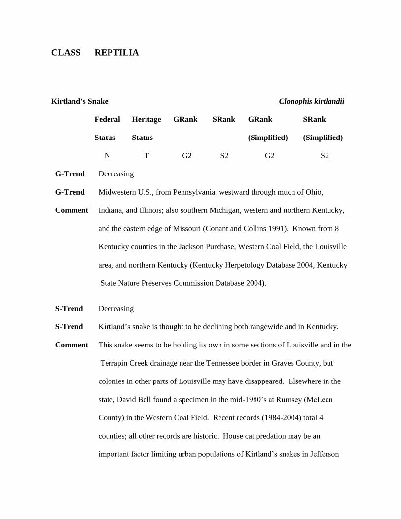
Kirtland's Snake Clonophis kirtlandii
Federal Heritage GRank SRank GRank SRank
Status Status (Simplified) (Simplified)
N T G2 S2 G2 S2
G-Trend Decreasing
G-Trend Midwestern U.S., from Pennsylvania westward through much of Ohio,
Comment Indiana, and Illinois; also southern Michigan, western and northern Kentucky,
and the eastern edge of Missouri (Conant and Collins 1991). Known from 8
Kentucky counties in the Jackson Purchase, Western Coal Field, the Louisville
area, and northern Kentucky (Kentucky Herpetology Database 2004, Kentucky
State Nature Preserves Commission Database 2004).
S-Trend Decreasing
S-Trend Kirtland’s snake is thought to be declining both rangewide and in Kentucky.
Comment This snake seems to be holding its own in some sections of Louisville and in the
Terrapin Creek drainage near the Tennessee border in Graves County, but
colonies in other parts of Louisville may have disappeared. Elsewhere in the
state, David Bell found a specimen in the mid-1980’s at Rumsey (McLean
County) in the Western Coal Field. Recent records (1984-2004) total 4
counties; all other records are historic. House cat predation may be an
important factor limiting urban populations of Kirtland’s snakes in Jefferson
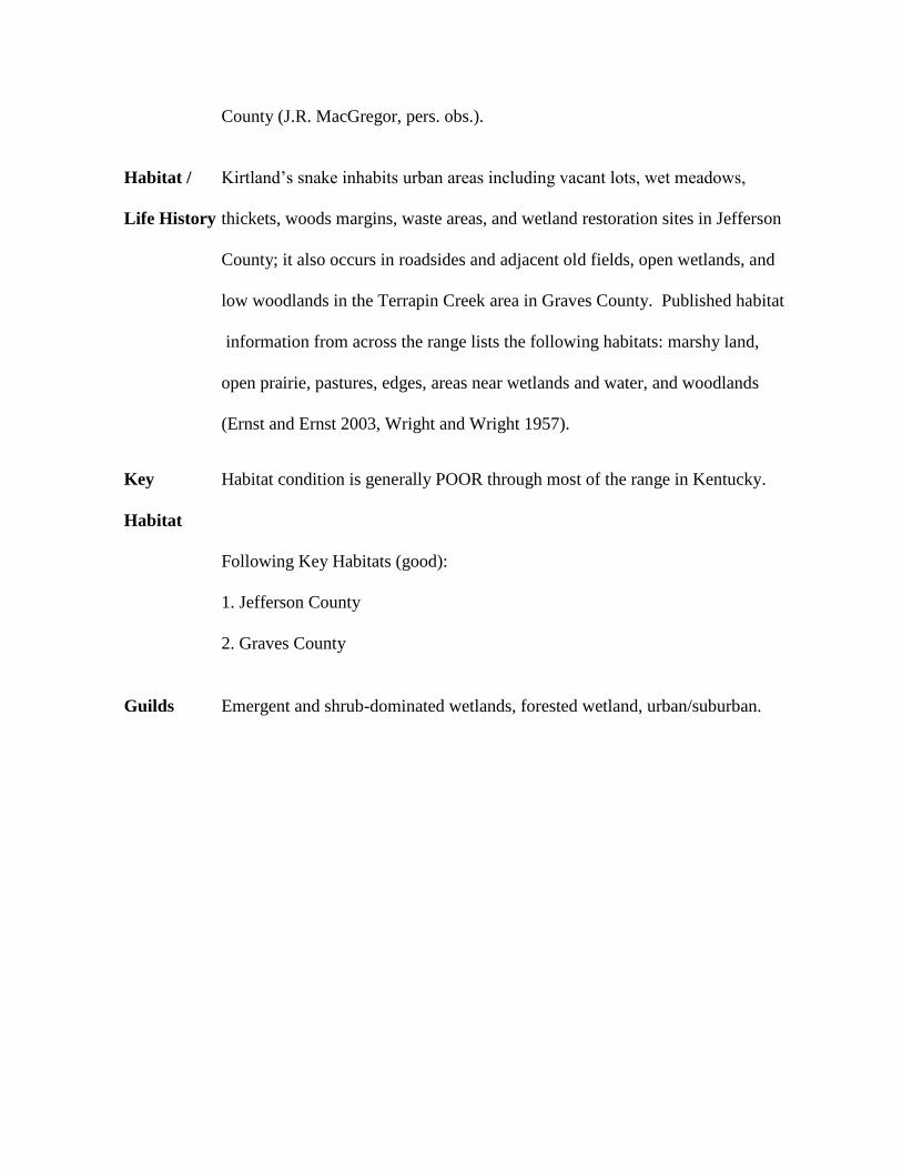
County (J.R. MacGregor, pers. obs.).
Habitat / Kirtland’s snake inhabits urban areas including vacant lots, wet meadows,
Life History thickets, woods margins, waste areas, and wetland restoration sites in Jefferson
County; it also occurs in roadsides and adjacent old fields, open wetlands, and
low woodlands in the Terrapin Creek area in Graves County. Published habitat
information from across the range lists the following habitats: marshy land,
open prairie, pastures, edges, areas near wetlands and water, and woodlands
(Ernst and Ernst 2003, Wright and Wright 1957).
Key Habitat condition is generally POOR through most of the range in Kentucky.
Habitat
Following Key Habitats (good):
1. Jefferson County
2. Graves County
Guilds Emergent and shrub-dominated wetlands, forested wetland, urban/suburban.

CLASS REPTILIA
Kirtland's Snake Clonophis kirtlandii
Statewide Kirtland'sSnake.pdf
Map
Conservation Issues
Aquatic habitat degradation
2E Stream channelization/ditching
2H Wetland loss/drainage/alteration . Loss of wetland connectivity and
wetland drainage/conversion. Surface mining in wetlands.
Biological/ consumptive uses
5F Low population densities. Always rare/local and becoming rare/local.
Miscellaneous Mortality Factors
6A Traffic/road kills
6F Wanton shooting/killing and unregulated take
Terrestrial habitat degradation
3A Row-crop agriculture (conversion to, annual reuse of fields, etc)
3F Urban/residential development
3K Surface mining. Causing habitat fragmentation and mining (surface) in
wetlands.
3R Habitat and/or Population Fragmentation. Loss of wetland connectivity
and surface mining fragmentation.

3U Loss, lack and degradation of special and unique microhabitats
CLASS REPTILIA
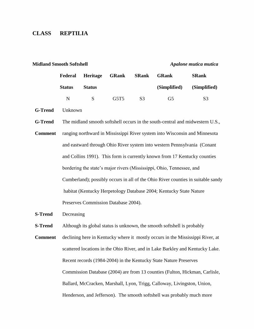
Midland Smooth Softshell Apalone mutica mutica
Federal Heritage GRank SRank GRank SRank
Status Status (Simplified) (Simplified)
N S G5T5 S3 G5 S3
G-Trend Unknown
G-Trend The midland smooth softshell occurs in the south-central and midwestern U.S.,
Comment ranging northward in Mississippi River system into Wisconsin and Minnesota
and eastward through Ohio River system into western Pennsylvania (Conant
and Collins 1991). This form is currently known from 17 Kentucky counties
bordering the state’s major rivers (Mississippi, Ohio, Tennessee, and
Cumberland); possibly occurs in all of the Ohio River counties in suitable sandy
habitat (Kentucky Herpetology Database 2004; Kentucky State Nature
Preserves Commission Database 2004).
S-Trend Decreasing
S-Trend Although its global status is unknown, the smooth softshell is probably
Comment declining here in Kentucky where it mostly occurs in the Mississippi River, at
scattered locations in the Ohio River, and in Lake Barkley and Kentucky Lake.
Recent records (1984-2004) in the Kentucky State Nature Preserves
Commission Database (2004) are from 13 counties (Fulton, Hickman, Carlisle,
Ballard, McCracken, Marshall, Lyon, Trigg, Calloway, Livingston, Union,
Henderson, and Jefferson). The smooth softshell was probably much more
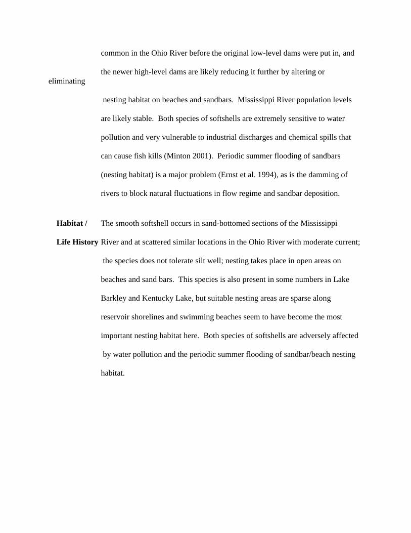
common in the Ohio River before the original low-level dams were put in, and
the newer high-level dams are likely reducing it further by altering or
eliminating
nesting habitat on beaches and sandbars. Mississippi River population levels
are likely stable. Both species of softshells are extremely sensitive to water
pollution and very vulnerable to industrial discharges and chemical spills that
can cause fish kills (Minton 2001). Periodic summer flooding of sandbars
(nesting habitat) is a major problem (Ernst et al. 1994), as is the damming of
rivers to block natural fluctuations in flow regime and sandbar deposition.
Habitat / The smooth softshell occurs in sand-bottomed sections of the Mississippi
Life History River and at scattered similar locations in the Ohio River with moderate current;
the species does not tolerate silt well; nesting takes place in open areas on
beaches and sand bars. This species is also present in some numbers in Lake
Barkley and Kentucky Lake, but suitable nesting areas are sparse along
reservoir shorelines and swimming beaches seem to have become the most
important nesting habitat here. Both species of softshells are adversely affected
by water pollution and the periodic summer flooding of sandbar/beach nesting
habitat.
CLASS REPTILIA
Midland Smooth Softshell Apalone mutica mutica
Key Habitat condition is GOOD along the Mississippi River, FAIR along the lower
Habitat Ohio, and FAIR to POOR elsewhere.
Following Key Habitats (good):
1. Fulton County
2. Lyon County
Guilds running water, standing water.
Statewide MidlandSmoothSoftshell.pdf
Map
Conservation Issues
Aquatic habitat degradation
2C Construction/Operation of impoundments (migration barrier). Dams (loss
of natural river channel character). Loss of natural sandbars and gravel bars
(for nesting).
Biological/ consumptive uses
5B Predation from native species. Nest predation (skunks, raccoons, foxes,
coyotes, etc.).
5J Incidental mortality due to commercial fishing/musseling (mortality and
overharvest). Commercial fishing (trot lines et al).

5K Lack of suitable habitat for spawning, nesting, or breeding. Reservoirs
(fluctuation water levels/poor nest habitat).
Miscellaneous Mortality Factors
6D Human disturbance (spelunking, destruction/disturbance of nest sites).
Human disturbance of nesting females in beaches.
6G Stochastic events (droughts, unusual weather, pine beetle damage, flooding
etc.)
Siltation and increased turbidity
1B Agriculture. Silt (replacing clean sand as river substrate).
Terrestrial habitat degradation
3F Urban/residential development
3R Habitat and/or Population Fragmentation
3T Suppression of disturbance regimes
3U Loss, lack and degradation of special and unique microhabitats
CLASS REPTILIA
Mississippi Map Turtle Graptemys pseudogeographica kohnii
Federal Heritage GRank SRank GRank SRank
Status Status (Simplified) (Simplified)
N N G5G4 S3S4 G4 S3
G-Trend Unknown
G-Trend The Mississippi map turtle occurs in the south-central U.S. from eastern Texas
Comment to Louisiana, ranging northward in the lower Ohio, Missouri, and Mississippi
River systems into Kansas, Missouri, Illinois, extreme southwestern Indiana,
and western Kentucky (Conant and Collins 1991). It is currently known from
at least 12 Kentucky counties bordering the state’s major rivers (Mississippi,
Ohio, Tennessee, and Cumberland including Kentucky Lake and Lake Barkley)
and is also found in Reelfoot Lake. This species in known to occur as far east
as Henderson County along the Ohio River, and it may extend even further to
the east since there is also a sight record available from Greenup County
(Kentucky Herpetology Database 2004). However, head pattern features are
the primary characters used by biologists to differentiate Kentucky’s four (see
below) Graptemys species from one another, and some individual Ouachita
map turtles (G. ouachitensis) have kohnii-like head markings and must be
captured and examined closely for definitive species determination. The
taxonomy of the false map turtle group (G. ouachitensis, G. kohnii, and G.
pseudogeographica) is unsettled; some authorities recognize each at the species
level while others list them in various combinations as subspecies. In
Kentucky, each of these forms appears to function as a full species;
populations that occur sympatrically in various combinations in different rivers
show little or no evidence of intergradation or hybridization (J.R. MacGregor,
pers. obs.).
S-Trend Decreasing
S-Trend The Mississippi map turtle seems to be fairly stable in numbers in riverine
Comment habitats within its limited range in Kentucky, but there is really no hard data to
back this up. Observations made on recent excursions into west Tennessee
indicate that the Mississippi map turtle is declining rather sharply in the
Reelfoot Lake area. This species is not tracked by Kentucky State Nature
Preserves Commission.
Habitat / Habitats occupied by Mississippi map turtles in Kentucky are quite variable;
Life History the species occurs in various permanent aquatic habitats ranging from extensive
wetland complexes, large mud-bottomed ponds and sloughs to reservoirs
(Kentucky Lake and Barkley Lake), and from sluggish streams and bayous
(Obion Creek and Bayou du Chien) to large rivers (Ohio River and Mississippi
River).
CLASS REPTILIA
Mississippi Map Turtle Graptemys pseudogeographica kohnii
Key Habitat condition is FAIR in Kentucky.
Habitat
Following Key Habitats (good):
1. Fulton County
2. Carlisle County
3. Calloway County
Guilds Emergent and shrub-dominated wetlands, running water, standing water.
Statewide MississippiMapTurtle.pdf
Map
Conservation Issues
Aquatic habitat degradation
2C Construction/Operation of impoundments (migration barrier). Dams (loss
of natural river channel character). Loss of natural sandbars and gravel bars
(for nesting).
2E Stream channelization/ditching. Loss of oxbows, sloughs, braided channels.
2H Wetland loss/drainage/alteration . Loss of natural and man made wetlands
and loss of herbaceous vegetation in ponds/sloughs.
Biological/ consumptive uses
5B Predation from native species. Nest predation (skunks, raccoons, foxes,
coyotes, etc).
5K Lack of suitable habitat for spawning, nesting, or breeding. Reservoirs
(fluctuating water levels/poor nest habitat) and loss of natural sandbars and
gravel bars for nesting.
Miscellaneous Mortality Factors
6F Wanton shooting/killing and unregulated take. Turtle shooting for
recreation/target practice.
6G Stochastic events (droughts, unusual weather, pine beetle damage, flooding
etc.)
Siltation and increased turbidity
1B Agriculture. Extensive agricultural development along waterways and water
quality problems impacting snail/mussel prey.
Terrestrial habitat degradation
3F Urban/residential development
3R Habitat and/or Population Fragmentation
3T Suppression of disturbance regimes. Reforestation of open sandy soil areas
near ponds (loss of suitable nesting habitat).
3U Loss, lack and degradation of special and unique microhabitats
CLASS REPTILIA
Northern Pine Snake Pituophis melanoleucus melanoleucus
Federal Heritage GRank SRank GRank SRank
Status Status (Simplified) (Simplified)
N T G4T4 S2 G4 S2
G-Trend Decreasing
G-Trend Range extremely fragmented with isolated populations in the following states:
Comment Alabama, Georgiam Kentucky, North Carolina, New Jersey, South Carolina,
Tennessee, Virginia, West Virginia (Conant and Collins 1991, Ernst and Ernst
2003). Reported historically from about 11 counties in southeastern Kentucky
(Harlan, Letcher, Whitley, McCreary counties), the Mammoth Cave region
(Edmonson, Barren, Hart counties), and the vicinity of Land Between The
Lakes National Recreation Area (Lyon, Trigg, Marshall, Calloway counties);
the only recent records are from Edmonson, Hart, Lyon, Trigg, and Calloway
counties (Kentucky Herpetology Database 2004, Kentucky State Nature
Preserves Commission Database 2004).
S-Trend Decreasing
S-Trend Declining rangewide due to a combination of factors that includes the loss of
Comment open habitat from natural succession and/or fire suppression, collecting for the
pet trade, wanton killing, road mortality, and habitat conversion via urban and
suburban development and agriculture (NatureServe 2004). Declining in
Kentucky, with recent records (1984-2004) from only 6 counties; most are
from Land Between The Lakes and nearby areas but northern pine snakes are
still being reported in low numbers from counties near Mammoth Cave.
Despite a considerable trapping effort in recent years, this species has not been
seen in southeastern Kentucky (including the southern half of the Daniel Boone
National Forest) since to mid-1970’s and may be gone from that section of
Kentucky.
Habitat / Occurs primarily in well-drained upland habitats with sandy to loamy soils
Life History with patchy open pine- and/or oak-dominated forest cover; prefers old fields,
broomsedge fields, large forest openings, and cutover areas, and nests in large
clearings in burrows constructed by the females (the only known nesting site in
Kentucky had been dug in an abandoned gravel pit in Calloway County). The
species is largely fossorial (Wright and Wright 1957, Ernst and Ernst 2003, J.R.
MacGregor data) and probably does well in fire-maintained and fire-managed
habitats.
Key Habitat condition is generally POOR.
Habitat
Following Key Habitats (good):
1. Calloway County
2. Trigg County
CLASS REPTILIA
Northern Pine Snake Pituophis melanoleucus melanoleucus
Guilds grassland/agricultural, savanna/ shrub-scrub, upland forest.
Statewide NorthernPineSnake.pdf
Map
Conservation Issues
Biological/ consumptive uses
5F Low population densities. Becoming rare/local.
5H Isolated populations (low gene flow)
5I Commercial collecting for pet trade (overharvest)
5K Lack of suitable habitat for spawning, nesting, or breeding. Loss of open
gravelly/sandy nesting/egg-laying habitat.
Miscellaneous Mortality Factors
6A Traffic/road kills
6F Wanton shooting/killing and unregulated take
6G Stochastic events (droughts, unusual weather, pine beetle damage, flooding
etc.)
Terrestrial habitat degradation
3F Urban/residential development
3I Conversion of native forest to short-rotation crop trees (pine, sycamore,

cottonwood, etc.)
3Q Invasive/exotic plants (including fescue)
3R Habitat and/or Population Fragmentation. Loss of glade connectivity.
3S Fire suppression/fire regime management. Loss of fire in ecosystem.
3T Suppression of disturbance regimes. Reforestation of open rocky habitat.
3U Loss, lack and degradation of special and unique microhabitats
CLASS REPTILIA
Northern Scarlet Snake Cemophora coccinea copei
Federal Heritage GRank SRank GRank SRank
Status Status (Simplified) (Simplified)
N N G5T5 S3S4 G5 S3
G-Trend Unknown
G-Trend Widely distributed in southeastern U.S., ranging northward into central
Comment Missouri, southern Illinois and Indiana, and western and southern Kentucky
(Conant and Collins 1991). Known historically from about 21 Kentucky
counties in the Jackson Purchase, Cretaceous Hills, Western Coal Field, Knobs,
and Cumberland Plateau; most counties are represented by only single
specimens and colonies are likely small and widely disjunct ( Fuller and Barbour
1962, J.R. MacGregor Herpetology Maps 2004, Meade 2005).
S-Trend Decreasing
S-Trend Population trends for the scarlet snake are unknown rangewide but seem to be
Comment sharply declining in Kentucky. It is known only historically (pre-1984) from
14 counties; there are only 7 recent county records and 5 of these (Calloway,
Marshall, Lyon, Trigg, and Caldwell) are from Land Between The Lakes and
nearby areas [the remaining 2 are from Hardin and Powell]. It is nearly
incomprehensible that the scarlet snake would have disappeared from the
shortleaf pine and pine-oak ridgetop forests on the southern half of the Daniel
Boone National Forest, but none have been found there for many years despite
much searching. This species may persist in low numbers in the Knobs region
of the state (J.R. MacGregor, pers. obs). This species is not tracked by
Kentucky State Nature Preserves Commission.
Habitat / Largely fossorial; occurs primarily in sparsely to moderately dense forested
Life History areas dominated by oak and/or pine with well-drained sandy or loamy soils;
stands with scattered grassy or weedy openings are preferred (this is not
surprising since the scarlet snake feeds largely on reptile eggs and lizards);
probably does best in fire-maintained and fire-managed habitats (J.R.
MacGregor, pers. obs).
Key Habitat condition is apparently POOR, although it certainly appears at least
Habitat FAIR to most of us (J.R. MacGregor, pers. obs.).
Following Key Habitats (good):
1. Lyon County
2. Trigg County
Guilds savanna/ shrub-scrub, upland forest.
CLASS REPTILIA
Northern Scarlet Snake Cemophora coccinea copei
Statewide NorthernScarletSnake.pdf
Map
Conservation Issues
Biological/ consumptive uses
5K Lack of suitable habitat for spawning, nesting, or breeding. Loss of open
gravelly/sandy nesting/egg-laying habitat.
Terrestrial habitat degradation
3F Urban/residential development
3I Conversion of native forest to short-rotation crop trees (pine, sycamore,
cottonwood, etc.)
3K Surface mining. Cause habitat fragmentation.
3R Habitat and/or Population Fragmentation. Loss of open gravelly/sandy
nesting/egg-laying habitat. Surface mining fragmentation.
3S Fire suppression/fire regime management. Loss of fire in ecosystem.
3T Suppression of disturbance regimes. Reforestation of open rocky habitat.
3U Loss, lack and degradation of special and unique microhabitats
CLASS REPTILIA
Scarlet Kingsnake Lampropeltis triangulum elapsoides
Federal Heritage GRank SRank GRank SRank
Status Status (Simplified) (Simplified)
N S G5T5 S3 G5 S3
G-Trend Stable
G-Trend Southeastern U.S., northward into Kentucky, North Carolina, and Virginia. The
Comment scarlet kingsnake is listed as a subspecies of the milk snake (Lampropeltis
triangulum) by NatureServe (2004) and Conant and Collins (1991) but is now
considered monotypic by J.R. MacGregor and many others. It is historically
known from 9 Kentucky counties including 5 (Rowan, Johnson, Floyd,
Whitley, and McCreary) in eastern Kentucky; also from Mammoth Cave
National Park (Edmonson). It is also known from 3 counties (Lyon, Trigg,
Calloway) located in and around Land Between The Lakes National Recreation
Area, and it is likely that only the Land Between The Lakes National
Recreation Area population remains extant (Kentucky Herpetology Database
2004, Kentucky State Nature Preserves Commission Database 2004).
S-Trend Decreasing
S-Trend Little information is available rangewide, but Ernst and Ernst (2003) note that
Comment populations have apparently declined noticeably in Florida. This attractive
little reptile is apparently declining in Kentucky; all recent records (1984-2004)
are from just 2 counties (Trigg, Lyon) at Land Between The Lakes but this
snake seems to be doing well there. It is difficult to understand why the scarlet
kingsnake (like the scarlet snake) would have disappeared from the shortleaf
pine and pine-oak ridgetop forests on the southern half of the Daniel Boone
National Forest, but none have been found there for many years.
Habitat / Largely fossorial; occurs primarily in sparsely to moderately dense forested
Life History areas dominated by oak and/or pine with well-drained sandy or loamy soils.
The species probably does best in fire-maintained and fire-managed habitats.
Key Habitat condition is apparently POOR, although it certainly appears at least
Habitat FAIR (J.R. MacGregor, pers. obs.).
Following Key Habitats (good):
1. Lyon County
2. Trigg County
Guilds savanna/ shrub-scrub, upland forest.
CLASS REPTILIA
Scarlet Kingsnake Lampropeltis triangulum elapsoides
Statewide ScarletKingsnake.pdf
Map
Conservation Issues
Biological/ consumptive uses
5F Low population densities. Becoming rare/local
(Wetland/semiaquatic/Swamps/Lowlands).
5H Isolated populations (low gene flow)
5K Lack of suitable habitat for spawning, nesting, or breeding. Loss of
gravelly/sandy nesting/egg-laying habitat.
Terrestrial habitat degradation
3F Urban/residential development
3I Conversion of native forest to short-rotation crop trees (pine, sycamore,
cottonwood, etc.)
3R Habitat and/or Population Fragmentation. Loss of glade connectivity.
3S Fire suppression/fire regime management. Loss of fire in ecosystem.
3T Suppression of disturbance regimes. Reforestation of open rocky habitat.
3U Loss, lack and degradation of special and unique microhabitats
CLASS REPTILIA
Six-lined Racerunner Cnemidophorus sexlineatus
Federal Heritage GRank SRank GRank SRank
Status Status (Simplified) (Simplified)
N N G5 S3S4 G5 S3
G-Trend Unknown
G-Trend The six-lined racerunner occurs throughout the southeastern U.S., northward to
Comment southern Illinois, southern Indiana, western Kentucky, and southern Maryland
(Conant and Collins 1991). It is known from about 22 counties in western
Kentucky including locations in the northern and western Mississippian
Plateau, Land Between The Lakes National Recreation Area, and the Jackson
Purchase (Kentucky Herpetology Database 2004).
S-Trend Decreasing
S-Trend This lizard is apparently declining in Kentucky. Its present distribution and
Comment general habitat requirements indicate that the racerunner once roamed
throughout the native prairie regions of the state, but this habitat is now
essentially gone. Racerunners now occur only in small isolated colonies that are
gradually disappearing as suitable sites are reduced in size or eliminated by
farming, development, reclamation, and natural succession (J.R. MacGregor
data). This species has vanished completely from Mammoth Cave National
Park - an area where it was quite abundant in the 1930’s (Hibbard 1936) - and
appears to be decreasing quite rapidly at Land Between The Lakes National
Recreation Area (J.R. MacGregor data). Current (1984-2004) records are
available from only 13 of the 22 counties from which it has been reported
historically. The six-lined racerunner is not tracked by Kentucky State Nature
Preserves Commission.
Habitat / Occurs in small colonies in rocky or sandy open habitats including remnant
Life History glades and prairies, abandoned quarries and gravel pits, overgrazed rocky
pastures, and certain reservoir shorelines, utility line corridors and railroad and
highway rights-of-way that feature moderate to large amounts of bare ground
and scattered cover in the form of small trees/shrubs, rocks/outcrops, old
railroad ties, and/or discarded household rubbish.
Key Habitat condition is generally POOR.
Habitat
Following Key Habitats (good):
1. Calloway County
2. Lyon County
3. Hardin County
CLASS REPTILIA
Six-lined Racerunner Cnemidophorus sexlineatus
Guilds grassland/agricultural, savanna/ shrub-scrub.
Statewide Six-linedRacerunner.pdf
Map
Conservation Issues
Biological/ consumptive uses
5A Predation from introduced species. Predation by domestic pets (primarily
house cats).
5K Lack of suitable habitat for spawning, nesting, or breeding
Miscellaneous Mortality Factors
6G Stochastic events (droughts, unusual weather, pine beetle damage, flooding
etc.)
Terrestrial habitat degradation
3A Row-crop agriculture (conversion to, annual reuse of fields, etc).
Conversion of open/rocky habitats to pasture.
3F Urban/residential development. Urban expansion (counties around
Louisville/Jefferson County).
3I Conversion of native forest to short-rotation crop trees (pine, sycamore,
cottonwood, etc.). Plantation forestry.
3Q Invasive/exotic plants (including fescue). Planting crown vetch and fescue

along roadsides.
3R Habitat and/or Population Fragmentation
3S Fire suppression/fire regime management. Loss of fire in the ecosystem.
3T Suppression of disturbance regimes. Natural reforestation of glades/rock
outcrop areas, abandoned gravel pits/quarries and rocky/gravelly old fields.
3U Loss, lack and degradation of special and unique microhabitats
CLASS REPTILIA
Southeastern Crowned Snake Tantilla coronata
Federal Heritage GRank SRank GRank SRank
Status Status (Simplified) (Simplified)
N N G5 S3S4 G5 S3
G-Trend Unknown
G-Trend The southeastern crowned snake ranges through much of the southeastern U.S.
Comment and extends northward into Kentucky, Virginia, and extreme southern Indiana
(Conant and Collins 1991). It has been reported from about 17 counties in
Kentucky; most records are from upland habitats in western and west-central
Kentucky but 1 adult (preserved at University of Michigan Museum of
Zoology) was also found near Cumberland Falls in southeastern Kentucky
(Kentucky Herpetology Database 2004).
S-Trend Decreasing
S-Trend Population trends for the southeastern crowned snake are unknown rangewide,
Comment but the lack of recent records indicate a precipitous decline over the past 30-40
years in Kentucky. All recent (1984-2004) reports are from Land Between The
Lakes National Recreation Area (Lyon and Trigg counties) except for a single
individual that was found in Hart County (B. Palmer-Ball, pers. comm.). It is
hard to imagine how a small, burrowing snake that occurs in dry rocky areas and
eats spiders and centipedes could suddenly become so rare here, but similar
tendencies are being noted in other reptiles that tend to favor dry open habitats
(racerunner, glass lizard, southeastern five-lined skink, scarlet kingsnake, scarlet
snake, northern pine snake) (J.R. MacGregor, pers. obs.). This species is not
tracked by Kentucky State Nature Preserves Commission.
Habitat / The southeastern crowned snake is largely fossorial and occurs primarily in
Life History xeric (dry) rocky habitats. Most individuals are found in mounds of old bark
debris, around old logs and stumps, or under flat stones and other cover on
south-facing rocky hillsides (Minton 2001, Minton 1949, Wright and Wright
1957, Ernst and Ernst 2003, J.R. MacGregor data); several have been found
under partly-imbedded flagstones and fallen gravestones in old ridgetop
cemeteries at Land Between The Lakes National Recreation Area (D. Frymire
and E. Zimmerer, pers. comm.). Crowned snakes are often found in close
association with six-lined racerunners (Minton 2001, J.R. MacGregor, pers.
obs.).
Key Habitat condition for the crowned snake in Kentucky is apparently POOR,
Habitat although it certainly looks at least FAIR to most of us.
Following Key Habitats (good):
1. Trigg County
CLASS REPTILIA
Southeastern Crowned Snake Tantilla coronata
Guilds grassland/agricultural, savanna/ shrub-scrub, upland forest.
Statewide SoutheasternCrownedSnake.pdf
Map
Conservation Issues
Biological/ consumptive uses
5F Low population densities. Becoming rare/local
(Wetland/semiaquatic/Swamps/Lowlands).
5H Isolated populations (low gene flow)
5K Lack of suitable habitat for spawning, nesting, or breeding. Loss of
gravelly/sandy nesting/egg-laying habitats.
Miscellaneous Mortality Factors
6G Stochastic events (droughts, unusual weather, pine beetle damage, flooding
etc.)
Terrestrial habitat degradation
3I Conversion of native forest to short-rotation crop trees (pine, sycamore,
cottonwood, etc.)
3R Habitat and/or Population Fragmentation. Loss of glade connectivity.
3S Fire suppression/fire regime management. Loss of fire in ecosystem.
3T Suppression of disturbance regimes. Reforestation of open rocky habitat.

3U Loss, lack and degradation of special and unique microhabitats
CLASS REPTILIA
Southeastern Five-lined Skink Eumeces inexpectatus
Federal Heritage GRank SRank GRank SRank
Status Status (Simplified) (Simplified)
N S G5 S3 G5 S3
G-Trend Unknown
G-Trend This species occurs throughout the southeastern U.S., extending northward into
Comment Virginia and Kentucky (Conant and Collins 1991). In Kentucky, it is known
from three general areas and a total of 10 counties. The three areas include Land
Between The Lakes National Recreation Area (Lyon and Trigg counties), the
Park Mammoth region (Edmonson, Hart, and Barren counties), and
southeastern Kentucky (McCreary, Pulaski, Whitley, Laurel, and Bell counties)
(Kentucky Herpetology Database 2004, Kentucky State Nature Preserves
Commission Database 2004).
S-Trend Unknown
S-Trend Almost certainly declining in Kentucky; there are recent records (1984-2004)
Comment from only 6 counties (Trigg, Edmonson, Laurel, Pulaski, McCreary, and
Whitley) (Kentucky State Nature Preserve Commission 2004, East Kentucky
Power Cooperative data, J.R. MacGregor Data). Southeastern five-lined skinks
are known to occur in good numbers only along open roadsides bordered by
powerline rights-of-way in McCreary, Whitley, and Laurel counties in
southeastern Kentucky. Elsewhere, most records are for only 1-2 animals (e.g.,
Park Mammoth) or sites that were found a number of years ago (Bell County).
In the early 1970’s, these lizards were fairly common at old house sites near
Golden Pond on Land Between The Lakes National Recreation Area, but most
colonies have apparently disappeared as the upland old fields with bare ground
have reverted to young oak forest (J.R. MacGregor data). This species was
observed in an abandoned gravel pit at Land Between The Lakes National
Recreation Area in 2002 by James Kiser (pers. comm.).
Habitat / Southeastern five-lined skinks occur primarily in fairly dry rocky open
Life History woodlands, remnant glades and prairies, old quarries and gravel pits, rocky
weedfields, and railroad and utility line corridors that feature some bare ground
and a fair amount of scattered cover (rocks, ledges, outcrops, old railroad ties,
discarded rubbish, etc.). Like the coal skink and the six-lined racerunner, this
species seems to occur only at sites are quite dry and open (J.R. MacGregor
data).
Key Habitat condition for this lizard in Kentucky is generally POOR.
Habitat
Following Key Habitats (good):
1. McCreary County
CLASS REPTILIA
Southeastern Five-lined Skink Eumeces inexpectatus
2. Whitley County
Guilds grassland/agricultural, savanna/ shrub-scrub, upland forest.
Statewide SoutheasternFive-linedSkink.pdf
Map
Conservation Issues
Biological/ consumptive uses
5A Predation from introduced species. Predation by domestic pets (primarily
house cats).
5K Lack of suitable habitat for spawning, nesting, or breeding
Miscellaneous Mortality Factors
6G Stochastic events (droughts, unusual weather, pine beetle damage, flooding
etc.)
Terrestrial habitat degradation
3A Row-crop agriculture (conversion to, annual reuse of fields, etc).
Conversion of open/rocky habitats to pasture.
3I Conversion of native forest to short-rotation crop trees (pine, sycamore,
cottonwood, etc.). Plantation forestry.
3Q Invasive/exotic plants (including fescue). Planting crown vetch and fescue
along roadsides.

3R Habitat and/or Population Fragmentation
3S Fire suppression/fire regime management. Loss of fire in the ecosystem.
3T Suppression of disturbance regimes. natural reforestation of rocky/gravelly
old fields, abandoned gravel pits/quarries and glades/rock outcrop areas.
3U Loss, lack and degradation of special and unique microhabitats
CLASS REPTILIA
Southern Painted Turtle Chrysemys picta dorsalis
Federal Heritage GRank SRank GRank SRank
Status Status (Simplified) (Simplified)
N T G5T5 S2 G5 S2
G-Trend Unknown
G-Trend The southern painted turtle occurs in the south-central U.S. from Louisiana
Comment north to extreme southeastern Missouri and southwestern Kentucky (Conant
and Collins 1991). It intergrades with both the midland painted turtle and
eastern painted turtle in eastern Alabama (ibid), and with the midland painted
turtle in western Kentucky (J.R. MacGregor data) and southern Illinois (Smith
1961). Some authorities regard the southern painted turtle as a full species
(Chrysemys dorsalis) and consider the intergrade populations listed both above
and below to be hybrids. Pure populations occur only in western Fulton and
Hickman counties in the Reelfoot Lake area and in the lower Hickman Bottoms;
intergrades between southern and midland painted turtles can be found in a
number of locations in the Jackson Purchase (J.R. MacGregor data, Kentucky
Herpetology Database 2004, Kentucky State Nature Preserves Commission
Database 2004).
S-Trend Stable
S-Trend Southern painted turtle populations are low in Kentucky but are probably
Comment stable or only slightly declining; all recent records are from Fulton County
(Kentucky State Nature Preserves Commission Database 2004, J.R. MacGregor
Data). The southern painted turtle was likely never a common species
anywhere in Kentucky except for the lowlands between Reelfoot Lake and the
City of Hickman.
Habitat / In Kentucky, the southern painted turtle is usually found in sloughs, sluggish
Life History streams, bayous, oxbows, and other slow-moving or standing water habitats
(J.R. MacGregor data); it prefers clear water areas with much aquatic vegetation
and mud bottoms (J.R. MacGregor data, Dundee and Rossman 1989).
Key Habitat condition is FAIR, in my opinion.
Habitat
Following Key Habitats (good):
1. Fulton County
Guilds Emergent and shrub-dominated wetlands, standing water.
Statewide SouthernPaintedTurtle.pdf
Map
CLASS REPTILIA
Southern Painted Turtle Chrysemys picta dorsalis
Conservation Issues
Aquatic habitat degradation
2E Stream channelization/ditching. Loss of oxbows, sloughs, braided channels.
2H Wetland loss/drainage/alteration . Loss of natural and man made wetlands.
Loss of herbaceous vegetation in ponds/sloughs.
Biological/ consumptive uses
5B Predation from native species. Nest predation (skunks, raccoons, foxes,
coyotes, etc.).
5F Low population densities
5H Isolated populations (low gene flow)
Miscellaneous Mortality Factors
6A Traffic/road kills
6F Wanton shooting/killing and unregulated take. Turtle shooting for
recreation/target practice.
Siltation and increased turbidity
1B Agriculture. Extensive agricultural development along waterways.
Terrestrial habitat degradation
3R Habitat and/or Population Fragmentation
3T Suppression of disturbance regimes. Reforestation of open sandy soil areas

near ponds (loss of suitable nesting habitat).
3U Loss, lack and degradation of special and unique microhabitats
CLASS REPTILIA
Timber Rattlesnake Crotalus horridus
Federal Heritage GRank SRank GRank SRank
Status Status (Simplified) (Simplified)
N N G4 S4 G4 S4
G-Trend Decreasing
G-Trend Widespread in much of the eastern and central U.S. from central Texas eastward
Comment to northern Florida, northward to Vermont, New Hampshire, New York,
Pennsylvania , Ohio, Indiana, Illinois, Wisconsic, Minnesota, and southern
Iowa and Nebraska (Conant and Collins 1991). Recorded from nearly 90
Kentucky counties including all sections of the state except the Bluegrass
Region (J.R. MacGregor Herpetology Maps 2004); least common in the
Jackson Purchase, the lowlands of the Western Coal Field, and the flat and
largely deforested parts of the Mississippian Plateau. About 8 county records
have had no reports of timber rattlesnakes since prior to 1925 (Funkhouser
1925, 1945 and Meade 2000).
S-Trend Stable
S-Trend Rangewide, the timber rattlesnake is still common in some mountainous regions,
Comment but now completely extirpated in many areas where it once was common
(Conant and Collins 1991). The timber rattlesnake seems to be holding its own
in the state; recent reports and observations indicate that good populations
remain in many sections of eastern Kentucky and in the Knobs region (Bullitt,
Nelson, Marion, Boyle, Casey counties), the Mammoth Cave area (Edmonson
County), and the Land Between The Lakes National Recreation Area (Lyon and
Trigg counties) (J.R. MacGregor data). There are recent (1984-2004) records
from at least 60 Kentucky counties. This species is not tracked by Kentucky
State Nature Preserves Commission.
Habitat / Found primarily in forested areas with hilly or mountainous terrain (J.R.
Life History MacGregor data). Wright and Wright (1957) list preferred habitat as including
mountains, bluffs, and ledges, rocky points, broken slopes, wastelands,
clearings, huckleberry patches [in] oak and oak-pine forest - this provides a
decent synopsis of where timber rattlesnakes are most likely to occur in
Kentucky. Open sites such as tree fall gaps, powerline corridors, cutover areas,
rock outcrops, rock talus slopes, old quarries, strip mines, and wildlife
openings are often used as basking sites (J.R. MacGregor data).
Key Habitat condition in Kentucky is GOOD, for the most part.
Habitat
Following Key Habitats (good):
1. Edmonson County
2. Boyle County, Casey County, and Marion County
CLASS REPTILIA
Timber Rattlesnake Crotalus horridus
3. Bullitt County and Nelson County
Guilds Cumberland highland forest, savanna/ shrub-scrub, upland forest.
Statewide TimberRattlesnake.pdf
Map
Conservation Issues
Biological/ consumptive uses
5I Commercial collecting for pet trade (overharvest)
Miscellaneous Mortality Factors
6A Traffic/road kills
6F Wanton shooting/killing and unregulated take
Terrestrial habitat degradation
3I Conversion of native forest to short-rotation crop trees (pine, sycamore,
cottonwood, etc.)
3K Surface mining. Surface mining fragmentation.
3R Habitat and/or Population Fragmentation. Surface mining causing
fragmentation.
3T Suppression of disturbance regimes. Reforestation of open rocky habitats.
3U Loss, lack and degradation of special and unique microhabitats
CLASS REPTILIA
Western Cottonmouth Agkistrodon piscivorus leucostoma
Federal Heritage GRank SRank GRank SRank
Status Status (Simplified) (Simplified)
N N G5T5 S3S4 G5 S3
G-Trend Unknown
G-Trend Central and eastern Texas to Mississippi, northward to southern Illinois,
Comment southwestern Indiana, and western Kentucky (Conant and Collins 1991).
Currently and historically known from about 16 Kentucky counties in the
Jackson Purchase, Cretaceous Hills, and Western Coal Field; most populations
are small and widely disjoint (J.R. MacGregor Herpetology Maps 2004).
S-Trend Decreasing
S-Trend Population trends for the cottonmouth are unknown rangewide but probably
Comment declining in Kentucky, in my opinion, primarily due to the loss of high quality
forested wetland habitat that has been degraded by surface mining and
conversion to cropland. Despite the overall decline, there are recent (1984-
2004) records from 15 of the 16 counties from which the species has been
documented (J.R. MacGregor data); the remaining record is from Ohio County
and lacks precise location data (Von Allman 1976, Meade 2005). The
cottonmouth tends to be a conspicuous element of the fauna in areas where it
occurs in good numbers and is often persecuted relentlessly (J.R. MacGregor,
pers. obs). This species is not tracked by Kentucky State Nature Preserves
Commission.
Habitat / Usually found in sloughs, sluggish streams, bayous, oxbows, and other slow-
Life History moving or standing water habitats and prefers areas that are at least partly
wooded; prefers clear water areas with some emergent or aquatic vegetation and
mud bottoms. Occurs in low numbers in some reservoir backwater coves in the
Land Between The Lakes National Recreation Area area. Gravid females may
use highway and railroad fill slopes and other upland habitat with open sunny
exposures as birthing rookeries; generally requires adjacent upland habitat with
suitable rock crevices, mammal burrows, or old root channels for winter
hibernation (J.R. MacGregor, pers. obs).
Key Habitat condition is FAIR overall, but ranges from GOOD in some sections of
Habitat the Jackson Purchase to POOR in many parts of the Western Coal Field.
Following Key Habitats (good):
1. Daviess County
2. Hickman County
3. Hopkins County
CLASS REPTILIA
Western Cottonmouth Agkistrodon piscivorus leucostoma
Guilds Emergent and shrub-dominated wetlands, forested wetland, standing water.
Statewide WesternCottonmouth.pdf
Map
Conservation Issues
Aquatic habitat degradation
2E Stream channelization/ditching
2H Wetland loss/drainage/alteration . Loss of wetland connectivity, wetland
drainage/conversion and surface mining in wetlands.
Biological/ consumptive uses
5F Low population densities. Becoming rare/local.
5H Isolated populations (low gene flow)
5I Commercial collecting for pet trade (overharvest)
5Q Declining prey base. Reduction of amphibian prey base.
Miscellaneous Mortality Factors
6A Traffic/road kills
6F Wanton shooting/killing and unregulated take. Shooting (mostly from
bridges) and wanton killing.
Terrestrial habitat degradation
3A Row-crop agriculture (conversion to, annual reuse of fields, etc)
3F Urban/residential development
3K Surface mining. Surface mining water quality and mining in wetlands as
well as causing fragmentation.
3R Habitat and/or Population Fragmentation. Loss of wetland connectivity
and surface mining causing habitat fragmentation.
3U Loss, lack and degradation of special and unique microhabitats
CLASS REPTILIA
Western Mud Snake Farancia abacura reinwardtii
Federal Heritage GRank SRank GRank SRank
Status Status (Simplified) (Simplified)
N S G5T5 S3 G5 S3
G-Trend Unknown
G-Trend Gulf Coast drainage from Alabama to Texas, northward in lowland habitats to
Comment western Kentucky, southwestern Indiana, southern Illinois, and southeastern
Missouri (Conant and Collins 1991). Known from about 12 Kentucky
counties, mostly in the Jackson Purchase region but also from a few isolated
areas in the Western Coal Field (possibly extirpated there) (Kentucky
Herpetology Database 2004, Kentucky State Nature Preserves Commission
Database 2004).
S-Trend Decreasing
S-Trend Recent (1984-2004) records exist from 7 counties in the Jackson Purchase
Comment region of western Kentucky (Ballard, Carlisle, Fulton, Graves, Hickman,
Marshall, and McCracken counties); the most recent dates for the 5 more
eastern counties date back to the early 1970’s and before. There may still be a
few mud snakes in the swamps near the Ohio and Tennessee Rivers in
Livingston County and in the Tradewater River drainage in Caldwell and
Hopkins counties.
Habitat / Usually found in sloughs, sluggish streams, bayous, oxbows, and other slow-
Life History moving or standing water habitats; prefers areas that are at least partly wooded;
prefers clear water areas with some emergent or aquatic vegetation and mud
bottoms, usually with large amounts of woody debris in and near the water
(Wright and Wright 1957, Ernst and Ernst 2003, J.R. MacGregor).
Key Habitat condition is only FAIR in many areas, but GOOD habitat remains in
Habitat isolated locations in the Jackson Purchase region (J.R. MacGregor, pers. obs.).
Following Key Habitats (good):
1. Fulton County
2. Ballard County
3. Hickman County
4. Marshall County
5. Graves County
Guilds Emergent and shrub-dominated wetlands, forested wetland, standing water.
CLASS REPTILIA
Western Mud Snake Farancia abacura reinwardtii
Statewide WesternMudSnake.pdf
Map
Conservation Issues
Aquatic habitat degradation
2E Stream channelization/ditching
2H Wetland loss/drainage/alteration . Loss of wetland connectivity, wetland
drainage/conversion, surface mining in wetlands.
Biological/ consumptive uses
5F Low population densities. Becoming rare/local.
5H Isolated populations (low gene flow)
5Q Declining prey base. Reduction of amphibian prey base.
Miscellaneous Mortality Factors
6A Traffic/road kills
Terrestrial habitat degradation
3A Row-crop agriculture (conversion to, annual reuse of fields, etc)
3F Urban/residential development
3K Surface mining. Surface mining in wetlands, fragmentation, water quality.
3R Habitat and/or Population Fragmentation. Surface mining fragmentation,
loss of wetland connectivity.

3U Loss, lack and degradation of special and unique microhabitats
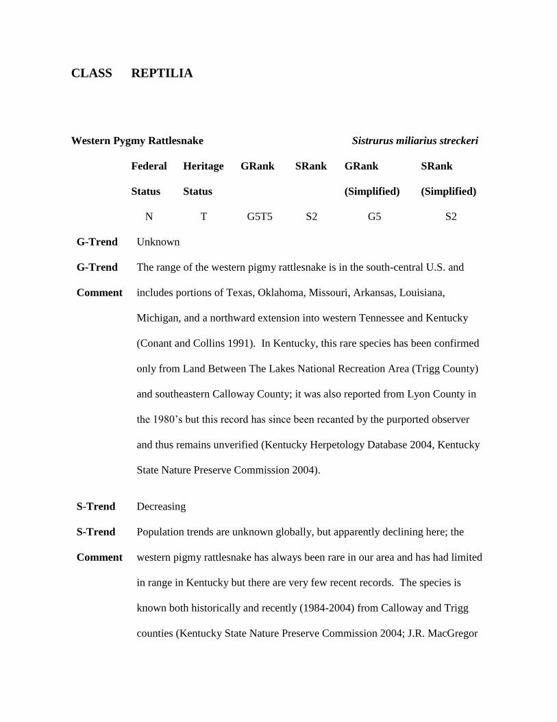
CLASS REPTILIA
Western Pygmy Rattlesnake Sistrurus miliarius streckeri
Federal Heritage GRank SRank GRank SRank
Status Status (Simplified) (Simplified)
N T G5T5 S2 G5 S2
G-Trend Unknown
G-Trend The range of the western pigmy rattlesnake is in the south-central U.S. and
Comment includes portions of Texas, Oklahoma, Missouri, Arkansas, Louisiana,
Michigan, and a northward extension into western Tennessee and Kentucky
(Conant and Collins 1991). In Kentucky, this rare species has been confirmed
only from Land Between The Lakes National Recreation Area (Trigg County)
and southeastern Calloway County; it was also reported from Lyon County in
the 1980’s but this record has since been recanted by the purported observer
and thus remains unverified (Kentucky Herpetology Database 2004, Kentucky
State Nature Preserve Commission 2004).
S-Trend Decreasing
S-Trend Population trends are unknown globally, but apparently declining here; the
Comment western pigmy rattlesnake has always been rare in our area and has had limited
in range in Kentucky but there are very few recent records. The species is
known both historically and recently (1984-2004) from Calloway and Trigg
counties (Kentucky State Nature Preserve Commission 2004; J.R. MacGregor
data; E. Zimmerer, pers. comm.).
Habitat / Although most subspecies of the pigmy rattlesnakes occur in wet habitats, the
Life History western race has been recorded in relatively dry areas including open grassy
prairie areas and various types of glades (Wright and Wright 1957, Anderson
1965) and is often found hiding among dead leaves and rubbish. In Kentucky, it
has been found in rocky areas and barren shorelines with scattered grasses
and/or weeds, in a large abandoned quarry with much bare ground, and (at night)
crossing gravel roads bordering dry open fields (J.R. MacGregor data; Tom C.
Fuller, pers. comm.; Ed Zimmerer, pers. comm.).
Key Habitat condition is POOR in Kentucky.
Habitat
Following Key Habitats (good):
1. Calloway County
Guilds grassland/agricultural, savanna/ shrub-scrub.
Statewide WesternPygmyRattlesnake.pdf
Map
CLASS REPTILIA
Western Pygmy Rattlesnake Sistrurus miliarius streckeri
Conservation Issues
Biological/ consumptive uses
5F Low population densities. Always rare/local
(Wetland/semiaquatic/Swamps/Lowlands) or becoming rare/local.
5H Isolated populations (low gene flow)
Terrestrial habitat degradation
3F Urban/residential development
3Q Invasive/exotic plants (including fescue)
3R Habitat and/or Population Fragmentation. Loss of glade connectivity.
3S Fire suppression/fire regime management. Loss of fire in ecosystem.
3T Suppression of disturbance regimes. Reforestation of open rocky habitat.
3U Loss, lack and degradation of special and unique microhabitats
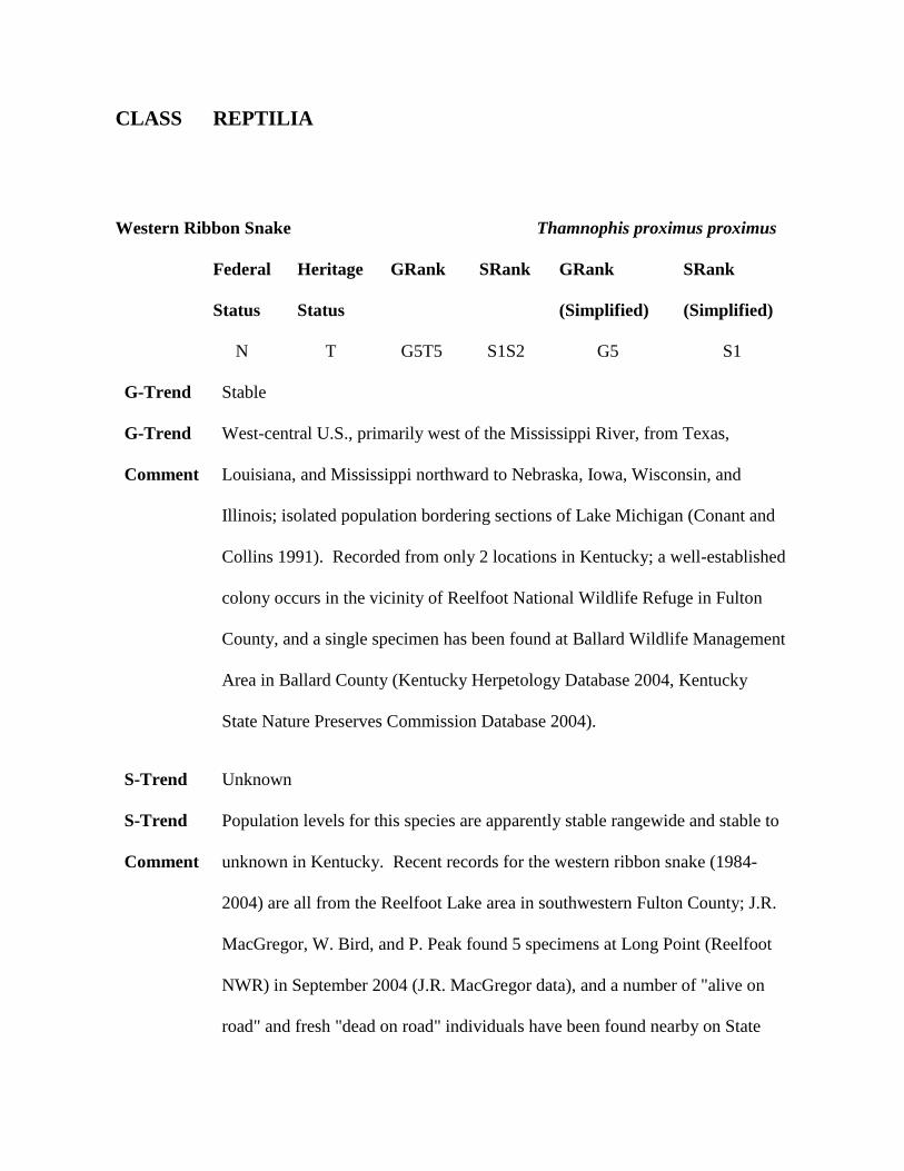
CLASS REPTILIA
Western Ribbon Snake Thamnophis proximus proximus
Federal Heritage GRank SRank GRank SRank
Status Status (Simplified) (Simplified)
N T G5T5 S1S2 G5 S1
G-Trend Stable
G-Trend West-central U.S., primarily west of the Mississippi River, from Texas,
Comment Louisiana, and Mississippi northward to Nebraska, Iowa, Wisconsin, and
Illinois; isolated population bordering sections of Lake Michigan (Conant and
Collins 1991). Recorded from only 2 locations in Kentucky; a well-established
colony occurs in the vicinity of Reelfoot National Wildlife Refuge in Fulton
County, and a single specimen has been found at Ballard Wildlife Management
Area in Ballard County (Kentucky Herpetology Database 2004, Kentucky
State Nature Preserves Commission Database 2004).
S-Trend Unknown
S-Trend Population levels for this species are apparently stable rangewide and stable to
Comment unknown in Kentucky. Recent records for the western ribbon snake (1984-
2004) are all from the Reelfoot Lake area in southwestern Fulton County; J.R.
MacGregor, W. Bird, and P. Peak found 5 specimens at Long Point (Reelfoot
NWR) in September 2004 (J.R. MacGregor data), and a number of "alive on
road" and fresh "dead on road" individuals have been found nearby on State
Route 94 and State Route 1282 during the 2000’s. The natural range of the
western ribbon snake was likely never very extensive in this state; the eastern
ribbon snake seems to replace it in suitable habitat to the north and east of
Hickman in the Obion Creek and Bayou du Chien drainages. No attempt has
been made to locate additional specimens at Ballard Wildlife Management Area.
Habitat / Like the Eastern ribbon snake, this species is usually associated with wetland
Life History habitats that harbor good populations of amphibians, mosquito fish
(Gambusia), and/or topminnows (Fundulus). These snakes typically inhabit
old fields, wet meadows and sunny openings with low herbaceous vegetation
along the margins of sloughs, bayous, oxbows, and other slow-moving or
standing water habitats. Some individuals may be present in fair numbers on
grassy dikes and highway/railroad fill slopes bordered by shallow wetlands
(J.R. MacGregor, pers. obs.).
Key Habitat condition is only FAIR at best, although the habitat condition for the
Habitat western ribbon snake is GOOD around the north end of Reelfoot Lake in
Fulton County.
Following Key Habitats (good):
1. Fulton County
CLASS REPTILIA
Western Ribbon Snake Thamnophis proximus proximus
Guilds Emergent and shrub-dominated wetlands, forested wetland, standing water.
Statewide WesternRibbonSnake.pdf
Map
Conservation Issues
Aquatic habitat degradation
2E Stream channelization/ditching
2H Wetland loss/drainage/alteration . Loss of wetland connectivity and
wetland drainage/conversion.
Biological/ consumptive uses
5F Low population densities. Always rare/local.
5H Isolated populations (low gene flow)
5Q Declining prey base. Reduction in amphibian prey base.
Miscellaneous Mortality Factors
6A Traffic/road kills
Terrestrial habitat degradation
3A Row-crop agriculture (conversion to, annual reuse of fields, etc)
3R Habitat and/or Population Fragmentation. Loss of wetland connectivity.
3U Loss, lack and degradation of special and unique microhabitats
REPTILE LITERATURE CITED
Anderson, P.K.. The Reptiles of Missouri. 1965. Columbia, MO., University of
Missouri Press.
Barbour, R.W., 1971. Amphibians & reptiles of Kentucky. University Press of
Kentucky, Lexington, Kentucky.
Conant, R., Collins J.T.. A field guide to reptiles and amphibians. Eastern and Central
North America. 450 . 1991. Boston, MA, Houghton Mifflin Company.
DeLorme. Kentucky Atlas and Gazetteer. 1997. DeLorme.
Dundee, H.A., Rossman, D.A.. The Amphibians and Reptiles of Louisiana. 1989.
Baton Rouge, LA., Louisiana State University Press.
Ernst, C.H., Ernst, E.M.. Snakes of the United States and Canada. 668 pp. 2003.
Washington and London, Smithsonian Books.
Ernst, C.H., Lovich J.E, Barbour, R.W.. Turtles of the United States and Canada. 578
pp. 1994. Washington and London, Smithsonian Institution Press.
Fuller, T.C., Barbour, R.W.. The distribution of Cemophora coccinea (Blumenbach)
in Kentucky. Copeia [ 3], 637-638. 1962.
Funkhouser, W.D.. Wild Life in Kentucky. 1925. Frankfort, KY. Kentucky
Geological Survey .
Hendricks, W.D., McKinney, L.E., Palmer-Ball Jr, B.L., Eans. M.. Biological
inventory of the Jackson Purchase Region of Kentucky. Final Report. 1991. Frankfort,
KY., Kentucky State Nature Preserves Commission.
Hibbard, C.W.. The amphibians and reptiles of Mammoth Cave National Park
proposed. Transactions Kansas Academy of Sciences 39, 277-281. 1936.
Kentucky Herpetology Database. Kentucky Herpetology Database. 2004. East
Kentucky Power Cooperative. 2004.
Kentucky State Nature Preserves Commission . Kentucky State Nature Preserves
Commission Database. 2004. Kentucky State Nature Preserve Commission . 2004.
Notes: Data printouts
MacGregor, J.. 2004. Notes: Personal field notes and maps
Meade, L.E.. Kentucky Snakes: Their Identification, Variation and Distribution.
322pp. 2005. Frankfort, Kentucky State Nature Preserves Commission.
Mengel, R.M.. The birds of Kentucky. Mengel, R. M. American Ornithologists' Union
Monograph No. 3. 1965. Lawrence, Kansas, The Allen Press.
Minton, S.A.. The black-headed snake in southern Indiana. Copeia , 146-147. 1949.
Minton, S.A.. Amphibians and Reptiles of Indiana. 404 pp. 2001. Indianapolis, IN.,
Indiana Academy of Science.
NatureServe. NatureServe Explorer: An online encyclopedia of life. World Wide Web
. 2004. NatureServe, Arlington, Virginia. October 27th, 2004.
Smith, P.W.. The Amphibians and Reptiles of Illinois. Illinois Natural History Survey
Bulletin 28[1], 1-298. 1961.
U.S. Environmental Protection Agency. Level III ecoregions of the continental United
States (revision of Omernik, 1987). 2002. Corvallis, Oregon, USEPA–National Health
and Environmental Effects Research Laboratory. Notes: Map M-1, various scales.
Von Allman, G.A.. Snakes of Breckinridge County, Kentucky. The Kentucky
Herpetologist 7[1], 4-7. 1976.
Woods, A.J., Omernik, J.M., Martin, W.H., Pond, G.J., Andrews, W.M., Call, S.M.,
Comstock, J.A., Taylor, D.D.. Ecoregions of Kentucky (color poster with map,
descriptive text, summary tables, and photographs): (map scale 1:1,000,000). 2002.
Reston, VA, U.S. Geological Survey.
Wright, A.H., Wright, A.A.. Handbook of Snakes of the United States and Canada.
1105 pp. 1957. Ithaca, Comstock Publisher Associates.