Embed Size (px)
Citation preview

REPRESENTATIVE EXPERIENCE SUMMARY
21300 RIdgEToP CIRClE STERlINg, VA 20166 www.SUTRoN.CoM (703)406-2800 (703)406-2801 fAX [email protected] 09/25/08
PAgE 1
CUSToMER EqUIPMENT CoNTRACT # AwARd dATE PRojECT dESCRIPTIoN
IRAqI MINISTRY of wATER RESoURCES (end user)wAShINgToN gRoUP INTERNATIoNAl (purchaser)720 Park Blvd, Po Box 73Boise, Id 83729Tel: (208) 386-6913fax: (208) 386-7050Email: [email protected]
56 Bubbler water level Measuring •Stations28 Radar water level Measuring Stations•7 water Velocity Measuring Stations•50 water quality Measuring Stations•8 Snow level Monitoring Stations•7 Current Profiling Instruments•5 well level Measuring Instruments•
w914NS-04-d-0007 2007
Sutron Corporation supplied over 100 Satellite Measuring Stations. These were a combination of water level and water quality Measuring Stations. 58 Sutron Bubblers were supplied, as well as 94 of Sutron’s MeteoSat Satellite Transmitters. In coordination with the USgS, Sutron also trained 20 engineers from the Iraqi Ministry of water Resources,attheUSGS’sofficeinBoiseIdaho.Thetrainingcovered, installtion, operation, troubleshooting and maintenance of each piece of equipment and the system as a whole. The project was completed and delivered in a timely manner.
KENYA METEoRologICAl dEPARTMENT SAwS3 Airport weather Systems including
cloud height and RVR/Visibility for 2 runways 2007State-of-the-art, turn-key Airporto weather System to provide information at wilson Airport as per new ICAo and wMo recommendations
SoUThERN AIRPoRT AUThoRITY of ThE REPUBlIC of VIETNAM
SAwS3 Airport weather Systems including cloud height and RVR/Visibility for 2 runways 2007
State-of-the-art, turn-key Airporto weather System to provide information at 7 airports as per new ICAo and wMo recommendations.Systemusesfiberopticandwirelesscommunications.operation is for CAT3.
dgCA dIRECCIoN gENERAl dE AVIACIoN CIVIlColoMBIA
SAwS3 Airport weather Systems including cloud height and RVR/Visibility for all domestic and international airports
Awarded in 2005Completed 2006
State-of-the-art, turn-key Airporto weather System to provide information at 7 Airports as per new ICAo and wMo recommendations.The system provides voice transmission, English and Spanish, to aircraft and to the PSTN.
CENTRAl wATER CoMMISSIoNUPPER godAVARI dIVISIoNB.V. RAo, EXECUTIVE ENgINEER 115/382/396 III floor Red hillshyderabad, 500004India040-23391654 - phone
30 Rainfall only Stations127 River water level & Rain gauge Stations6 Reservoir water level & Rain gauge5 River water level & Rain gauge & Meteorological sensors (Air Temperature, Relative humidity, Evaporation, Sun Shine duration & wind Speed/wind direction)2 ddRgSXConnect SoftwareINSAT Satellite Transmitters
No. Ugd/Telemetry/ff/7998-8002
Ugd/Telemetry/IV (A)/ff/8358-84
2006/20074 year Maintenance Contract
Supply, Installation, Testing, Commissioning & Maintenance of Real-Time data Acquisition Network for Collection, Transmission & Processing of hydro Meteorological data, gauging Equipment, Satellite Telemetry & Associated Systems.INSAT Satellite Communications for Stations. VSAT Communications between Existing digital direct Readout ground Station facilities located at Burla & jaipur & various locations in Krishna & godavari Basin, Brahmaputra & Barak Basin organization, Mahanadi & Eastern Rivers, lower ganga Basin & Yamuna Basin.Maintenance for 4 Years
REPRESENTATIVE EXPERIENCE SUMMARY
21300 RIdgEToP CIRClE STERlINg, VA 20166 www.SUTRoN.CoM (703)406-2800 (703)406-2801 fAX [email protected] 09/25/08
PAgE 2
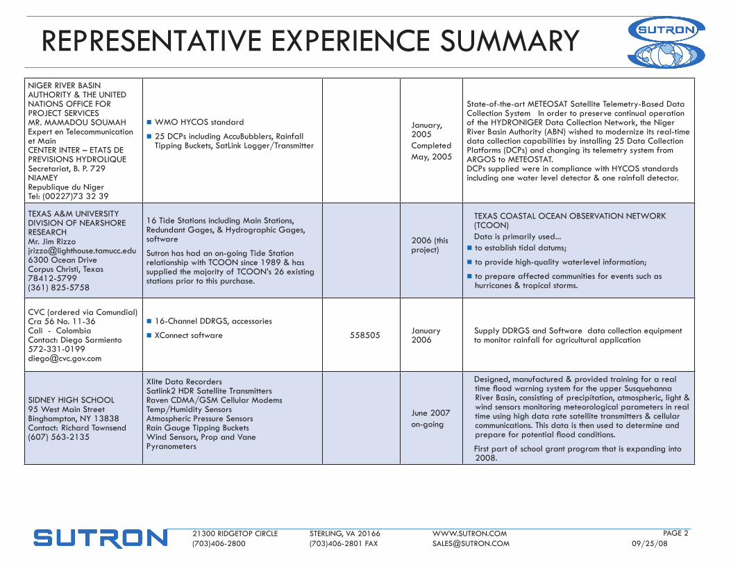
NIgER RIVER BASIN AUThoRITY & ThE UNITEd NATIoNS offICE foR PRojECT SERVICESMR. MAMAdoU SoUMAhExpert en Telecommunication et MainCENTER INTER – ETATS dE PREVISIoNS hYdRolIqUESecretariat, B. P. 729NIAMEYRepublique du NigerTel: (00227)73 32 39
n wMo hYCoS standard
n 25 dCPs including AccuBubblers, Rainfall Tipping Buckets, Satlink logger/Transmitter
january, 2005CompletedMay, 2005
State-of-the-art METEoSAT Satellite Telemetry-Based data Collection System In order to preserve continual operation of the hYdRoNIgER data Collection Network, the Niger River Basin Authority (ABN) wished to modernize its real-time data collection capabilities by installing 25 data Collection Platforms (dCPs) and changing its telemetry system from ARgoS to METEoSTAT. dCPs supplied were in compliance with hYCoS standards including one water level detector & one rainfall detector.
TEXAS A&M UNIVERSITYdIVISIoN of NEARShoRE RESEARChMr. jim [email protected] ocean driveCorpus Christi, Texas 78412-5799(361) 825-5758
16 Tide Stations including Main Stations, Redundant gages, & hydrographic gages, software
Sutron has had an on-going Tide Station relationship with TCooN since 1989 & has supplied the majority of TCooN’s 26 existing stations prior to this purchase.
2006 (this project)
TEXAS CoASTAl oCEAN oBSERVATIoN NETwoRK (TCooN)data is primarily used...
n to establish tidal datums;
n to provide high-quality waterlevel information;
n to prepare affected communities for events such as hurricanes & tropical storms.
CVC (ordered via Comundial)Cra 56 No. 11-36Cali - ColombiaContact: diego [email protected]
n 16-Channel ddRgS, accessories
n XConnect software 558505 january 2006
Supply ddRgS and Software data collection equipment to monitor rainfall for agricultural application
SIdNEY hIgh SChool95 west Main StreetBinghampton, NY 13838Contact: Richard Townsend(607) 563-2135
Xlite data RecordersSatlink2 hdR Satellite TransmittersRaven CdMA/gSM Cellular ModemsTemp/humidity SensorsAtmospheric Pressure SensorsRain gauge Tipping Bucketswind Sensors, Prop and VanePyranometers
june 2007on-going
designed, manufactured & provided training for a real timefloodwarningsystemfortheupperSusquehannaRiver Basin, consisting of precipitation, atmospheric, light & wind sensors monitoring meteorological parameters in real time using high data rate satellite transmitters & cellular communications. This data is then used to determine and prepareforpotentialfloodconditions.
first part of school grant program that is expanding into 2008.
REPRESENTATIVE EXPERIENCE SUMMARY
21300 RIdgEToP CIRClE STERlINg, VA 20166 www.SUTRoN.CoM (703)406-2800 (703)406-2801 fAX [email protected] 09/25/08
PAgE 3
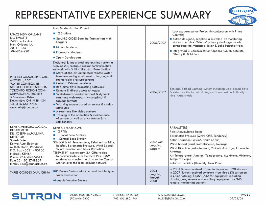
USACE NEw oRlEANSBIll EMMETT7400 leake Ave.New orleans, lA 70118-3651504-862-2201
lock Modernization Project
n 12 Stations
n Satlink2 goES Satellite Transmitters with loggers
n Iridium Modems
n fiberoptic Modems
n Xpert dataloggers
2006/2007
lock Modernization Project (in conjunction with Prime Controls)
n Sutron designed, supplied & installed 12 monitoring stations on New orleans’ primary drainage canals connecting the Mississippi River & lake Pontchartrain.
n Integrated 3 Communication options: goES Satellite, fiberoptic & Iridium
PRojECT MANAgER: CRAIg MITChEll, B.SCwATER CoNTRol, RE-SoURCE SCIENCE SECTIoNToRoNTo REgIoN CoN-SERVATIoN AUThoRITY5 Shoreham drivedownsview, oN M3N 1S4Tel. [email protected]
designed & integrated into existing system a web-based, scalable celluar communication network with 5 Pilot Sites & a Base Station n State-of-the-art automated remote water
level measuring equipment, rain gauges & submersible pressure sensors
n Cellular IP-based modemsn Real-time data-processing softwaren Remote & direct access to loggern web-based decision support & dynamic
real-time web-reports w/graphical & tabular formats
n warning system based on sensor & station attributes
n A real-time live video camera n Training in the operation & maintenance
of system as well as each station & its components.
2006/2007Scaleablefloodwarningsystemincludingweb-baseddata& video for the toronto & Region Conservation Authority’s nine watersheds
KENYA METEoRologICAl dEPARTMENTdR. joSEPh MUKABANAdIRECToRSuresh PatelKenya Auto ElectricalMuthithi Road, ParklandsP.o. Box 46631 - 00100Nairobi, KENYAPhone: 254-20-3746113fax: 254-20-3748969E-mail: [email protected]
KENYA SYNoP AwSn 12 RTUsn 11 local Base Stationsn 1 Central Base StationSENSoRS: Air Temperature, Relative humidity,
Rainfall, Barometric Pressure, wind Speed, wind direction and Solar Radiation
TElEMETRY: Maxstream 2.4 ghz radios to communicate with the local PCs. gSM modems to transfer the data to the Central Station over the local cellular network.
2007 with on-going support
PARAMETERS: Rain (Accumulated Rain)Barometric Pressure (qNh, qfE, Tendency)Solar Radiation (w/m², hours of Sun)wind Speed (gust, Instantaneous, Average) wind direction (Instantaneous, 2minute Average, 10 minute Average)Air Temperature (Ambient Temperature, Maximum, Minimum, Temp. of Evap.) Relative humidity (humidity, dew Point)
ThREE goRgES dAM, ChINA
n80 Remote Stations with Xpert and bubbler type water level sensor
nPortable weather Stations
2004 - on-going through 2008
In 2004 Sutron received orders to implement 120 stations. In 2007 Sutron received contracts from three (3) customers in China totaling $1,020,742 for equipment including dataloggers, sensors and ancillary equipment for 345 remote monitoring stations.
REPRESENTATIVE EXPERIENCE SUMMARY
21300 RIdgEToP CIRClE STERlINg, VA 20166 www.SUTRoN.CoM (703)406-2800 (703)406-2801 fAX [email protected] 09/25/08
PAgE 4
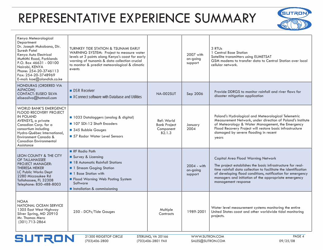
Kenya Meteorological departmentdr. joseph Mukabana, dir.Suresh PatelKenya Auto ElectricalMuthithi Road, ParklandsP.o. Box 46631 - 00100Nairobi, KENYAPhone: 254-20-3746113fax: 254-20-3748969E-mail: [email protected]
TURNKEY TIdE STATIoN & TSUNAMI EARlY wARNINg SYSTEM: Project to measure water levels at 3 points along Kenya’s coast for early warning of tsunamis & data collection crucial to monitor & predict meteorological & climatic events
2007 with on-going support
3 RTUs1 Central Base StationSatellite transmitters using EUMETSAT gSM modems to transfer data to Central Station over local cellular network.
hoNdURAS (oRdEREd VIA AlfACoM)CoNTACT: ElISEo [email protected]
n DSR Receivern XConnect software with Database and Utilities
NA-002SUT Sep 2006 ProvideDDRGStomonitorrainfallandriverflowsfordisaster mitigation application
woRld BANK’S EMERgENCY flood RECoVERY PRojECT IN PolANdAVENSYS, a private Canadian Corp. for a consortium includinghydro-québec International, Environment Canada & Canadian Environmental Assistance
n 1033 dataloggers (analog & digital)
n 107 SdI-12 Shaft Encoders
n 345 Bubble gauges
n 57 Radar water level Sensors
Ref: world Bank Project Component
B2.1.3
january 2004
Poland’s hydrological and Meteorological Telemetric Measurement Network, under direction of Poland’s Institute of Meteorology & water Management, the Emergency flood Recovery Project will restore basic infrastructure damagedbyseverefloodinginrecentyears
lEoN CoUNTY & ThE CITY of TAllAhASSEE PRojECT MANAgER: ThERESA hEIKER lC Public works dept2280 Miccosukee RdTallahassee, fl 32308 Telephone: 850-488-8003
n Rf Radio Pathn Survey & licensingn 18 Automatic Rainfall Stationsn 1 Stream gaging Stationn 1 Base Station withn flood warning web Posting System
Softwaren Installation & commissioning
2004 - with on-going support
Capital Area flood warning Network
The project establishes the basic infrastructure for real-timerainfalldatacollectiontofacilitatetheidentificationofdevelopingfloodconditions,notificationforemergencymanagers and initiation of the appropriate emergency management response
NoAA NATIoNAl oCEAN SERVICE 1305 East west highway Silver Spring, Md 20910 Mr. Thomas Mero (301) 713-2864
250 - dCPs/Tide gauges Multiple Contracts 1989-2001
water level measurement systems monitoring the entire United States coast and other worldwide tidal monitoring projects.
REPRESENTATIVE EXPERIENCE SUMMARY
21300 RIdgEToP CIRClE STERlINg, VA 20166 www.SUTRoN.CoM (703)406-2800 (703)406-2801 fAX [email protected] 09/25/08
PAgE 5
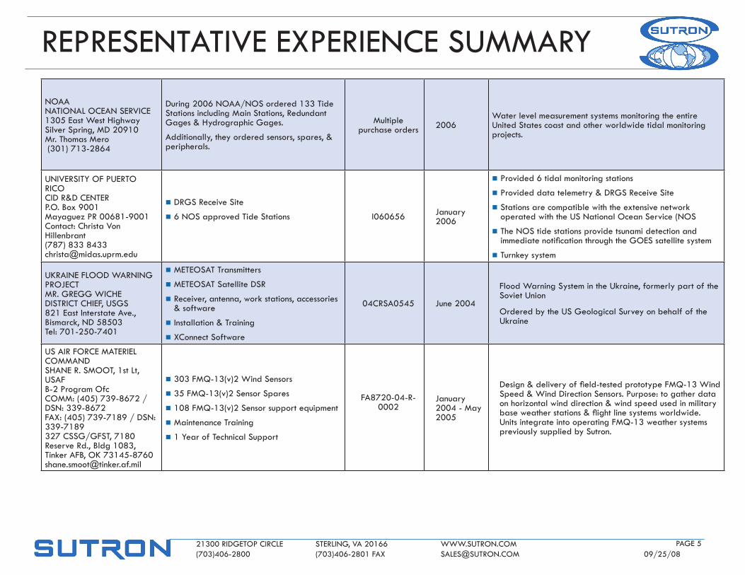
NoAA NATIoNAl oCEAN SERVICE 1305 East west highway Silver Spring, Md 20910 Mr. Thomas Mero (301) 713-2864
during 2006 NoAA/NoS ordered 133 Tide Stations including Main Stations, Redundant gages & hydrographic gages.
Additionally, they ordered sensors, spares, & peripherals.
Multiple purchase orders 2006
water level measurement systems monitoring the entire United States coast and other worldwide tidal monitoring projects.
UNIVERSITY of PUERTo RICoCId R&d CENTERP.o. Box 9001Mayaguez PR 00681-9001Contact: Christa Von hillenbrant(787) 833 [email protected]
n dRgS Receive Site
n 6 NoS approved Tide Stations I060656 january 2006
n Provided 6 tidal monitoring stations
n Provided data telemetry & dRgS Receive Site
n Stations are compatible with the extensive network operated with the US National ocean Service (NoS
n The NoS tide stations provide tsunami detection and immediatenotificationthroughtheGOESsatellitesystem
n Turnkey system
UKRAINE flood wARNINg PRojECTMR. gREgg wIChEdISTRICT ChIEf, USgS821 East Interstate Ave.,Bismarck, Nd 58503Tel: 701-250-7401
n METEoSAT Transmitters
n METEoSAT Satellite dSR
n Receiver, antenna, work stations, accessories & software
n Installation & Training
n XConnect Software
04CRSA0545 june 2004
flood warning System in the Ukraine, formerly part of the Soviet Union
ordered by the US geological Survey on behalf of the Ukraine
US AIR foRCE MATERIEl CoMMANdShANE R. SMooT, 1st lt, USAf B-2 Program ofcCoMM: (405) 739-8672 / dSN: 339-8672 fAX: (405) 739-7189 / dSN: 339-7189 327 CSSg/gfST, 7180 Reserve Rd., Bldg 1083, Tinker AfB, oK 73145-8760 [email protected]
n 303 fMq-13(v)2 wind Sensors
n 35 fMq-13(v)2 Sensor Spares
n 108 fMq-13(v)2 Sensor support equipment
n Maintenance Training
n 1 Year of Technical Support
fA8720-04-R-0002
january 2004 - May 2005
Design&deliveryoffield-testedprototypeFMQ-13WindSpeed & wind direction Sensors. Purpose: to gather data on horizontal wind direction & wind speed used in military baseweatherstations&flightlinesystemsworldwide.Units integrate into operating fMq-13 weather systems previously supplied by Sutron.
REPRESENTATIVE EXPERIENCE SUMMARY
21300 RIdgEToP CIRClE STERlINg, VA 20166 www.SUTRoN.CoM (703)406-2800 (703)406-2801 fAX [email protected] 09/25/08
PAgE 6
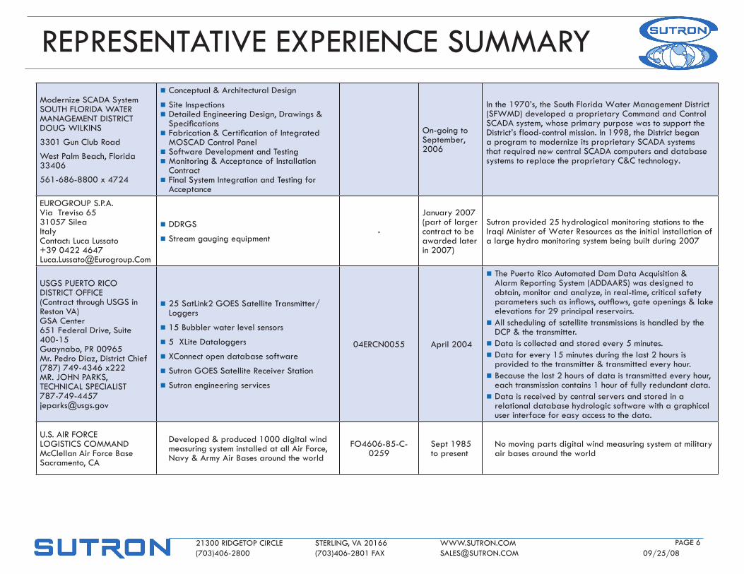
Modernize SCAdA SystemSoUTh floRIdA wATER MANAgEMENT dISTRICTdoUg wIlKINS
3301 gun Club Road
west Palm Beach, florida 33406
561-686-8800 x 4724
n Conceptual & Architectural design
n Site Inspectionsn detailed Engineering design, drawings & Specifications
n Fabrication&CertificationofIntegratedMoSCAd Control Panel
n Software development and Testingn Monitoring & Acceptance of Installation
Contractn final System Integration and Testing for
Acceptance
on-going to September, 2006
In the 1970’s, the South florida water Management district (SfwMd) developed a proprietary Command and Control SCAdA system, whose primary purpose was to support the district’s flood-control mission. In 1998, the district began a program to modernize its proprietary SCAdA systems that required new central SCAdA computers and database systems to replace the proprietary C&C technology.
EURogRoUP S.P.A.Via Treviso 6531057 SileaItalyContact: luca lussato+39 0422 [email protected]
n ddRgS
n Stream gauging equipment-
january 2007 (part of larger contract to be awarded later in 2007)
Sutron provided 25 hydrological monitoring stations to the Iraqi Minister of water Resources as the initial installation of a large hydro monitoring system being built during 2007
USgS PUERTo RICo dISTRICT offICE(Contract through USgS in Reston VA)gSA Center651 federal drive, Suite 400-15guaynabo, PR 00965Mr. Pedro diaz, district Chief(787) 749-4346 x222MR. johN PARKS, TEChNICAl [email protected]
n 25 Satlink2 goES Satellite Transmitter/loggers
n 15 Bubbler water level sensors
n 5 Xlite dataloggers
n XConnect open database software
n Sutron goES Satellite Receiver Station
n Sutron engineering services
04ERCN0055 April 2004
n The Puerto Rico Automated dam data Acquisition & Alarm Reporting System (AddAARS) was designed to obtain, monitor and analyze, in real-time, critical safety parameterssuchasinflows,outflows,gateopenings&lakeelevations for 29 principal reservoirs.
n All scheduling of satellite transmissions is handled by the dCP & the transmitter.
n data is collected and stored every 5 minutes.n data for every 15 minutes during the last 2 hours is
provided to the transmitter & transmitted every hour.n Because the last 2 hours of data is transmitted every hour,
each transmission contains 1 hour of fully redundant data.n data is received by central servers and stored in a
relational database hydrologic software with a graphical user interface for easy access to the data.
U.S. AIR foRCE logISTICS CoMMANdMcClellan Air force BaseSacramento, CA
developed & produced 1000 digital wind measuring system installed at all Air force, Navy & Army Air Bases around the world
fo4606-85-C-0259
Sept 1985 to present
No moving parts digital wind measuring system at military air bases around the world
REPRESENTATIVE EXPERIENCE SUMMARY
21300 RIdgEToP CIRClE STERlINg, VA 20166 www.SUTRoN.CoM (703)406-2800 (703)406-2801 fAX [email protected] 09/25/08
PAgE 7
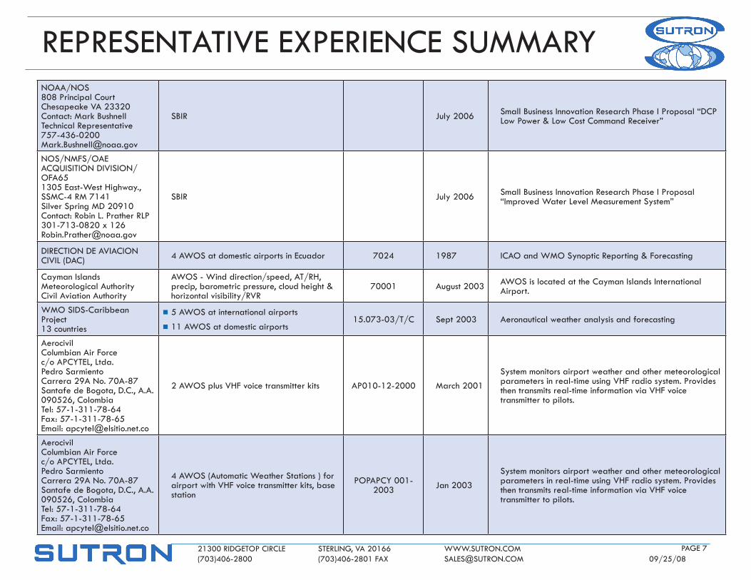
NoAA/NoS 808 Principal CourtChesapeake VA 23320Contact: Mark Bushnell Technical [email protected]
SBIR july 2006 Small Business Innovation Research Phase I Proposal “dCP low Power & low Cost Command Receiver”
NoS/NMfS/oAE ACqUISITIoN dIVISIoN/ofA651305 East-west highway., SSMC-4 RM 7141Silver Spring Md 20910Contact: Robin l. Prather RlP301-713-0820 x [email protected]
SBIR july 2006 Small Business Innovation Research Phase I Proposal “Improved water level Measurement System”
dIRECTIoN dE AVIACIoN CIVIl (dAC) 4 AwoS at domestic airports in Ecuador 7024 1987 ICAo and wMo Synoptic Reporting & forecasting
Cayman Islands Meteorological AuthorityCivil Aviation Authority
AwoS - wind direction/speed, AT/Rh, precip, barometric pressure, cloud height & horizontal visibility/RVR
70001 August 2003 AwoS is located at the Cayman Islands International Airport.
wMo SIdS-Caribbean Project13 countries
n 5 AwoS at international airports
n 11 AwoS at domestic airports 15.073-03/T/C Sept 2003 Aeronautical weather analysis and forecasting
AerocivilColumbian Air forcec/o APCYTEl, ltda.Pedro Sarmiento Carrera 29A No. 70A-87 Santafe de Bogota, d.C., A.A. 090526, Colombia Tel: 57-1-311-78-64 fax: 57-1-311-78-65 Email: [email protected]
2 AwoS plus Vhf voice transmitter kits AP010-12-2000 March 2001
System monitors airport weather and other meteorological parameters in real-time using Vhf radio system. Provides then transmits real-time information via Vhf voice transmitter to pilots.
AerocivilColumbian Air forcec/o APCYTEl, ltda.Pedro Sarmiento Carrera 29A No. 70A-87 Santafe de Bogota, d.C., A.A. 090526, Colombia Tel: 57-1-311-78-64 fax: 57-1-311-78-65 Email: [email protected]
4 AwoS (Automatic weather Stations ) for airport with Vhf voice transmitter kits, base station
PoPAPCY 001-2003 jan 2003
System monitors airport weather and other meteorological parameters in real-time using Vhf radio system. Provides then transmits real-time information via Vhf voice transmitter to pilots.
REPRESENTATIVE EXPERIENCE SUMMARY
21300 RIdgEToP CIRClE STERlINg, VA 20166 www.SUTRoN.CoM (703)406-2800 (703)406-2801 fAX [email protected] 09/25/08
PAgE 8
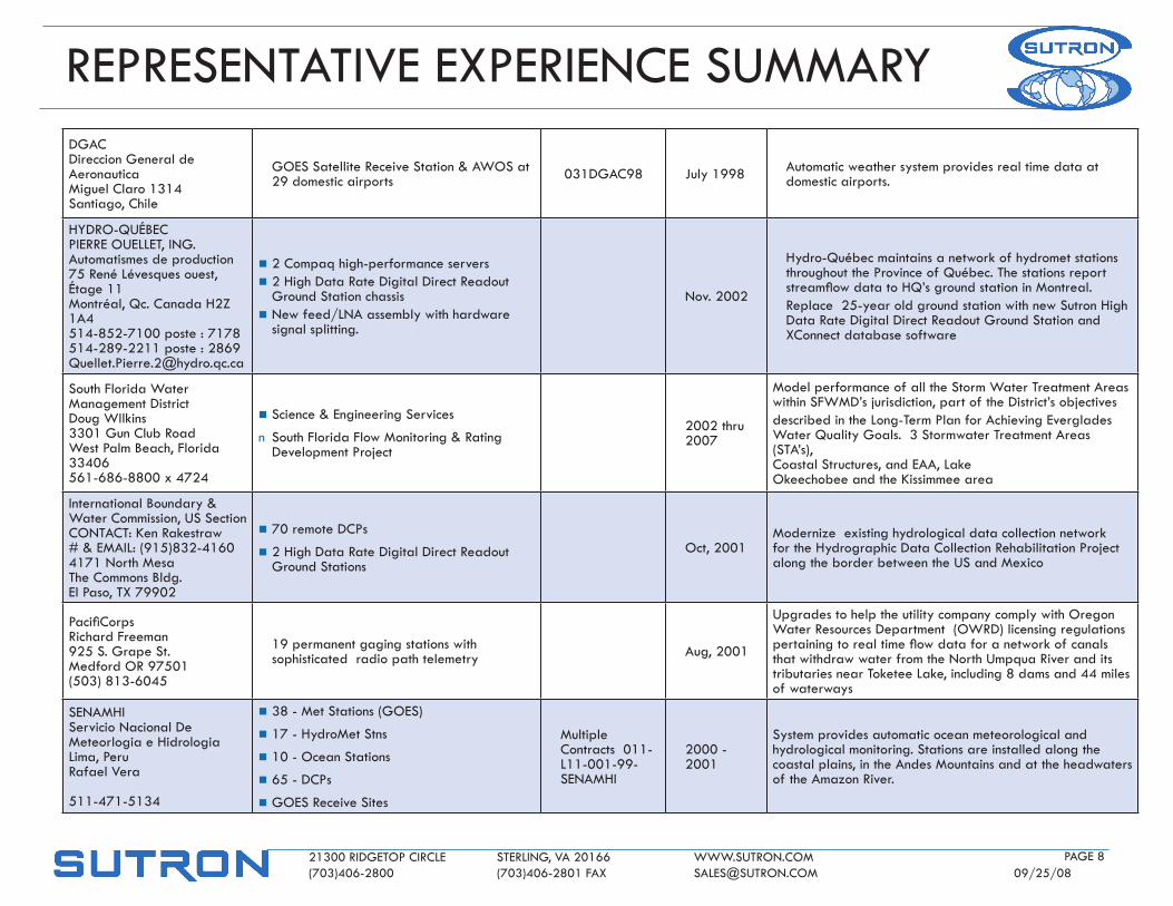
dgAC direccion general de Aeronautica Miguel Claro 1314 Santiago, Chile
goES Satellite Receive Station & AwoS at 29 domestic airports 031dgAC98 july 1998 Automatic weather system provides real time data at
domestic airports.
hYdRo-qUéBECPIERRE oUEllET, INg. Automatismes de production 75 René lévesques ouest, étage 11 Montréal, qc. Canada h2Z 1A4 514-852-7100 poste : 7178 514-289-2211 poste : [email protected]
n 2 Compaq high-performance serversn 2 high data Rate digital direct Readout
ground Station chassis n New feed/lNA assembly with hardware
signal splitting.
Nov. 2002
hydro-québec maintains a network of hydromet stations throughout the Province of québec. The stations report streamflowdatatoHQ’sgroundstationinMontreal.Replace 25-year old ground station with new Sutron high data Rate digital direct Readout ground Station and XConnect database software
South florida water Management districtdoug wIlkins3301 gun Club Roadwest Palm Beach, florida 33406561-686-8800 x 4724
n Science & Engineering Services
n South florida flow Monitoring & Rating development Project
2002 thru 2007
Model performance of all the Storm water Treatment Areas within SfwMd’s jurisdiction, part of the district’s objectivesdescribed in the long-Term Plan for Achieving Everglades water quality goals. 3 Stormwater Treatment Areas (STA’s), Coastal Structures, and EAA, lake okeechobee and the Kissimmee area
International Boundary & water Commission, US SectionCoNTACT: Ken Rakestraw# & EMAIl: (915)832-4160 4171 North Mesa The Commons Bldg. El Paso, TX 79902
n 70 remote dCPs
n 2 high data Rate digital direct Readout ground Stations
oct, 2001Modernize existing hydrological data collection network for the hydrographic data Collection Rehabilitation Project along the border between the US and Mexico
PacifiCorps Richard freeman 925 S. grape St. Medford oR 97501 (503) 813-6045
19 permanent gaging stations with sophisticated radio path telemetry Aug, 2001
Upgrades to help the utility company comply with oregon water Resources department (owRd) licensing regulations pertainingtorealtimeflowdataforanetworkofcanalsthat withdraw water from the North Umpqua River and its tributaries near Toketee lake, including 8 dams and 44 miles of waterways
SENAMhI Servicio Nacional de Meteorlogia e hidrologia lima, Peru Rafael Vera 511-471-5134
n 38 - Met Stations (goES)
n 17 - hydroMet Stns
n 10 - ocean Stations
n 65 - dCPs
n goES Receive Sites
Multiple Contracts 011-l11-001-99-SENAMhI
2000 - 2001
System provides automatic ocean meteorological and hydrological monitoring. Stations are installed along the coastal plains, in the Andes Mountains and at the headwaters of the Amazon River.
REPRESENTATIVE EXPERIENCE SUMMARY
21300 RIdgEToP CIRClE STERlINg, VA 20166 www.SUTRoN.CoM (703)406-2800 (703)406-2801 fAX [email protected] 09/25/08
PAgE 9
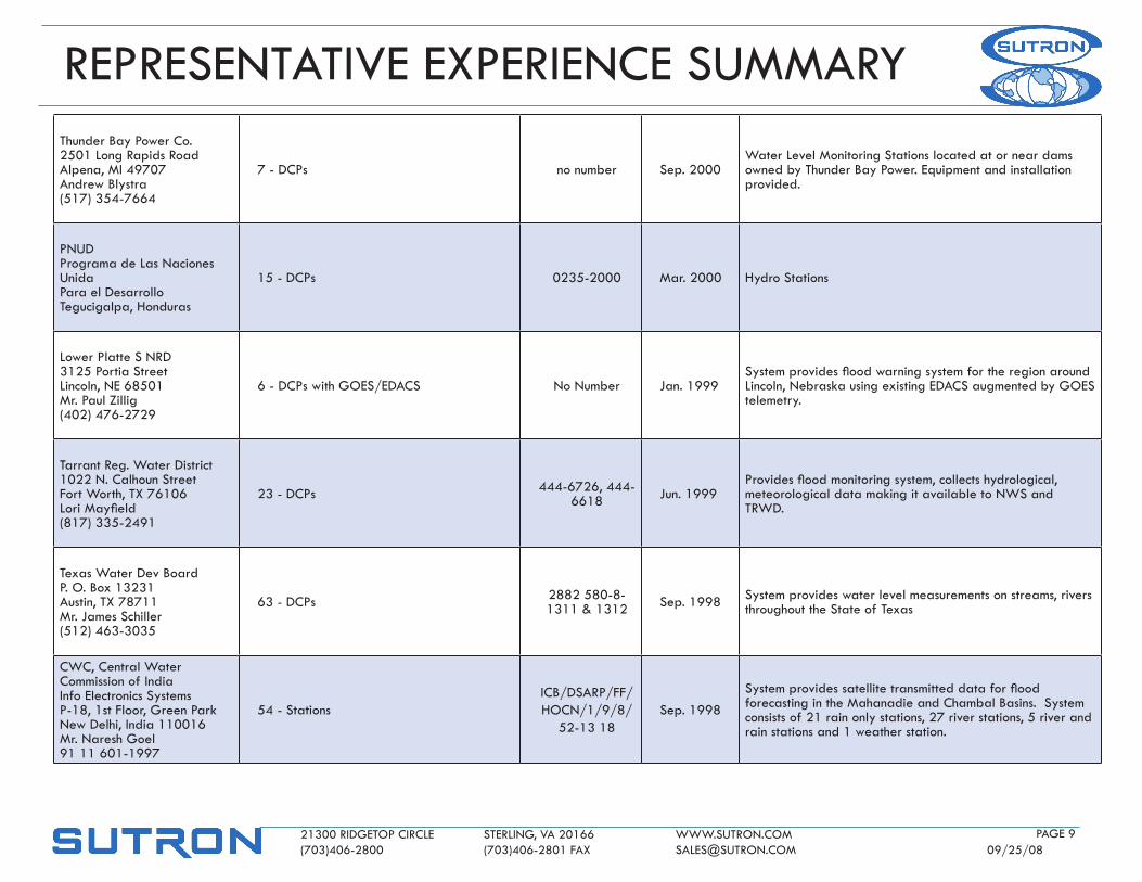
Thunder Bay Power Co. 2501 long Rapids Road Alpena, MI 49707 Andrew Blystra (517) 354-7664
7 - dCPs no number Sep. 2000water level Monitoring Stations located at or near dams owned by Thunder Bay Power. Equipment and installation provided.
PNUd Programa de las Naciones Unida Para el desarrollo Tegucigalpa, honduras
15 - dCPs 0235-2000 Mar. 2000 hydro Stations
lower Platte S NRd 3125 Portia Street lincoln, NE 68501 Mr. Paul Zillig (402) 476-2729
6 - dCPs with goES/EdACS No Number jan. 1999Systemprovidesfloodwarningsystemfortheregionaroundlincoln, Nebraska using existing EdACS augmented by goES telemetry.
Tarrant Reg. water district 1022 N. Calhoun Street fort worth, TX 76106 LoriMayfield(817) 335-2491
23 - dCPs 444-6726, 444-6618 jun. 1999
Providesfloodmonitoringsystem,collectshydrological,meteorological data making it available to NwS and TRwd.
Texas water dev Board P. o. Box 13231 Austin, TX 78711 Mr. james Schiller (512) 463-3035
63 - dCPs 2882 580-8-1311 & 1312 Sep. 1998 System provides water level measurements on streams, rivers
throughout the State of Texas
CwC, Central water Commission of India Info Electronics Systems P-18, 1st floor, green Park New delhi, India 110016 Mr. Naresh goel 91 11 601-1997
54 - StationsICB/dSARP/ff/hoCN/1/9/8/
52-13 18Sep. 1998
Systemprovidessatellitetransmitteddataforfloodforecasting in the Mahanadie and Chambal Basins. System consists of 21 rain only stations, 27 river stations, 5 river and rain stations and 1 weather station.
REPRESENTATIVE EXPERIENCE SUMMARY
21300 RIdgEToP CIRClE STERlINg, VA 20166 www.SUTRoN.CoM (703)406-2800 (703)406-2801 fAX [email protected] 09/25/08
PAgE 10
India Meteorological dept.,government of Indiadirector general of MeteorologyMausam Bhavan, lodi RoadNew delhi-110003INdIAContact: dr. R.d. [email protected]
n 100 Automatic weather Station Remote Terminal Units (RTU)
n INSAT satellite transmitter with antenna, cabling and mounting hardware
n datalogger, Solar Equipment, Voltage Regulator, other electronic peripherals
n AwS equipment: sensors, signal conditioning, interfacing, data conversion, formatting, storage and transmission sub-system
CPU/54/0903/4042/129f dec 2005
n Provide extensive Met System including 100 Automatic weather Stations
n Provide Receive Site to replace existing monitoring and warning system
n Uplinking AwS data to the satellite compatible with INSAT/KAlPANA-1 dRT’s (Annexure-II).
n Procuring AwS data reception (Earth Station) & processing equipment for installation at Pune.
n Installation,finalcheckout&commissioningofallfieldsitesn Providing necessary spares, testing & measuring
equipmentn Providing the data Conversion, Storage & Transmission
System (dCSTS for unattended operation for at least one year at remote places using a 12V single-sealed battery.
n System has a built-in memory capable of storing data for at least 12 months, retrievable on a PCMCIA card (or any suitable compact solid state memory device).
n System has a built-in test facility for monitoring & displaying functions of various sub-systems.
US geological Survey, Iowa Perry Creek flood warning System woodbury County Comm. Center 601 douglas Sioux City, IA 51101 Mr. glenn Sedivy (712) 279-6959
3 - dCPs Base Stations 1434 CR 98 8A 00391 Mar. 1998 System integrated existing USgS and USACE stream
gaugingstationsintoasingle,unifiedfloodwarningsystem
GreenfieldsIrrigationDist. P o Box 157 Fairfield,MT59436 Ed Everaert (800) 775-2864
8- dCPs Apr. 2001 Monitoring water level and gate position
US geological Survey 12201 Sunrise Valley dr. Reston, VA 22092 frank henry
7,369 - dCPs & dataloggers w/ Satellite/loS/Phone/Telemetry
Multiple Contracts and
locations1995-2001 SystemsmonitorstreamflowthroughoutthecontinentalUnited
States for design purposes.
REPRESENTATIVE EXPERIENCE SUMMARY
21300 RIdgEToP CIRClE STERlINg, VA 20166 www.SUTRoN.CoM (703)406-2800 (703)406-2801 fAX [email protected] 09/25/08
PAgE 11
US Bureau of Reclamation 1150 N. Curtis Road Boise, Idaho 83706 Mr. jim doty (208) 378-5272
1000 - dCPs goES Receive Site locations and System Sw
Multiple Contracts and
locations1980-2001
Systemsprovidereal-timedataforfloodcontrol,hydropower production and irrigation distribution. Installed in all western States.
US Army Corps of Engineers 9501 john j. Pershing dr. omaha, NE 68112 Mr. larry Murphy (402) 697-2685
1,435 dCPs with Satellite Telemetry, 3 goES Rec Sites, System Software
Multiple Contracts and
locations1980-2001
Systemsproviderealtimedataforfloodcontrolpurposesand basic data for design purposes. Covers all United States.
lower Colorado River Authority P o Box 220 Austin, TX 78767 Ms. Anne Bolden (512) 473-3200
75 - dCPs with goES, Phone & EdACS, 1 Base Station
Multiple Contracts 1997-2001 System provides rainfall and water level monitoring stations
employing multiple communication paths from each sensor.
US fish and wildlife wichita Mt. wildlife Refuge lawton, oK Mr. Sam waldstein, (580) 429-3221
6 - dCPs with loS Radio, 1 Base Station Sep. 1997System provides rainfall and water level monitoring stations linked to master base station for purpose of data collection, realtimesystemmonitoringandearlyfloodwarningalerts.
SIMEPAR Centro Politecnico da UfPR Caixa Postal 318 80001-970 Curitiba-PR-Brazil luis Carciso de Moraes 55 41 366 2122
98 - dCPs goES Receive Site Multiple Contracts 1996-2001 HydrometStationsforhydropowerproductionandflood
control purposes.
CVC Colombia Pedro Sarmiento 571 311-7864
40 - dCPs with Satellite Telemetry, goES Receive Site and System Software May-96 Hydrometstationsforhydropowerproductionandflood
control purposes.
fresno Metro flood Control district 215 w. dakota Avenue Clovis, CA 93612
4 - Radio/Cellular Mar. 1996 Monitoringstormwaterininflowbasinsandoutflowbasins
REPRESENTATIVE EXPERIENCE SUMMARY
21300 RIdgEToP CIRClE STERlINg, VA 20166 www.SUTRoN.CoM (703)406-2800 (703)406-2801 fAX [email protected] 09/25/08
PAgE 12
Meteorological Service Singapore P o Box 8 Singapore Changi Airport Singapore 9181 RoS
50 - dCPs jun. 1993 Rainfall stations, Meteorological stations, domestic and Military Airports
U S Bureau of Reclamation 10900 highway 60 East Alamosa, Co 81101 Ms. Ella Mae herrera (719) 589-5855
n 280 RTUs
n System Software
n Monitor/Control
Multiple Contracts 1986-2001
System provides real time monitoring and control of pumps, gate control structure and monitoring ground water.
State of Colorado 1300 Sherman denver, Co 80203 Mr. james Mcdonald (303) 866-3585
n 250 dCPs with Satellite Telemetry
n goES Receive Site, System SoftwareMultiple Contracts 1984-2001 System provides real time data for managing all of the
State of Colorado’s water resources
Computer Sciences Corporation 15245 Shady grove Road Rockville, Md 20850 jim McNitt 301-794-24367
n dCPs/Vhf
n Automatic weather Stations
n System Software
S800850 Nov. 2000Automatic weather stations with satellite & Vhf, water and weather Monitoring Stations for flood forecasting including System Software
litton PRC, Inc. 1500 PRC drive Mclean, VA 22102 jason Tuell 703-556-1000
dCPs/Vhf, Automatic weather Stations, System Software 38803 May 2000
Automatic weather stations with satellite & Vhf, water and weather Monitoring Stations for flood forecasting including System Software
Ministry of defenseSnow & Avalanche Study Est. (SASE)Research & development CenterhIMPARISAR Sector 37-AChandigarh – 160 036INdIAContact: R.K. [email protected]
29 - dCPs, Automatic weather Stations Multiple Contracts
1998 - 2001
Automatic weather Stations in the himalayas, System Software and Services, INSAT Satellite
REPRESENTATIVE EXPERIENCE SUMMARY
21300 RIdgEToP CIRClE STERlINg, VA 20166 www.SUTRoN.CoM (703)406-2800 (703)406-2801 fAX [email protected] 09/25/08
PAgE 13
IMd India Meteorological dept. New delhi, India Naresh goel 91-11-6011997
15 - dCPs, Automatic weather Stations jul. 1996 Automatic weather Stations, INSAT Satellite
SMN Mexico Receive Site jul. 1991 goES, dRgS, System Software & Services
digitec S.A. P. o. Box 17-03-408A El heraldo 121 Y El dia quito, Ecuador jaime 593 2 430373
dataloggers & System SoftwareMultiple
including dS-1008
1989-2000 Airport Automatic weather Station & flood warning Stations
Bytown Marine ltd. Michel BaronTel: (613) 723-8424fax: (613) [email protected]
562 - dataloggers Multiple 1989-2001 Satellite water and weather Monitoring Stations
Swiss Meteorological Service Krahbuhlstrasse 58 Ch8044 Zurich, Switzerland Swiss Meteorological Service Krahbuhlstrasse 58 Ch8044 Zurich, Switzerland Peter Mueller
50 - dataloggers (9000) and System Software
Multiple including
86000640-6421990-1999 Primary Automatic weather Stations in Switzerland including
System Software
Meteorological Service of New Zealand Tahi Road Paraparaumu Beach 6450 New Zealand gordon Saggers 64 4 297 0129
43 - dataloggers (9000) Multiple including 9120 1990-1999 gMS Satellite, Automaticweather Stations
REPRESENTATIVE EXPERIENCE SUMMARY
21300 RIdgEToP CIRClE STERlINg, VA 20166 www.SUTRoN.CoM (703)406-2800 (703)406-2801 fAX [email protected] 09/25/08
PAgE 14
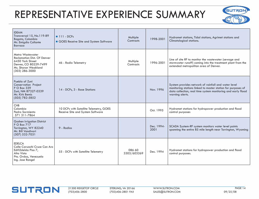
IdEAM Transversal 15, No.119-89 Bogota, Colombia Mr. Emigdio Collante Barraza
n 111 - dCPs
n goES Receive Site and System SoftwareMultiple Contracts 1998-2001 hydromet stations, Tidal stations, Agrimet stations and
Climatological stations.
Metro wastewater Reclamation dist. of denver 6450 York Street denver, Co 80229-7499 Ms. Sharon weakland (303) 286-3000
46 - Radio Telemetry Multiple Contracts 1996-2001
line of site Rf to monitor the wastewater (sewage and stormwater runoff) coming into the treatment plant from the extended metropolitan area of denver.
Pueblo of Zuni Conservation Project P o Box 339 Zuni, NM 87327-0339 Mr. Kirk Bemis (505) 782-5852
14 - dCPs, 3 - Base Stations Nov. 1996
System provides network of rainfall and water level monitoring stations linked to master station for purposes of datacollection,realtimesystemmonitoringandearlyfloodwarning alerts.
ChB Colombia Pedro Sarmiento 571 311-7864
10 dCPs with Satellite Telemetry, goES Receive Site and System Software oct. 1995 Hydrometstationsforhydropowerproductionandflood
control purposes
goshen Irrigation district P o Box 717 Torrington, wY 82240 Mr. Bill Vandivort (307) 532-7031
9 - Radios dec. 1994-2001
SCAdA System-Rf system monitors water level points spanning the entire 85 mile length near Torrington, wyoming
EdElCA Calle Caruachi Cruce Con Aro Edif.Edelda Piso 7, Alta Vista Pto. ordaz, Venezuela Ing. jose Rangel
55 - dCPs with Satellite Telemetry 086 60 3303/603269 dec. 1994 Hydrometstationsforhydropowerproductionandflood
control purposes.