Embed Size (px)
Citation preview

'D-R14O 693 ROSEAU RIVER SUBBASIN RED RIVER OF THE NORTH 112RECONNAISSANCE REPORT(U) GULF SOUTH RESEARCH INST BATONROUGE LA DEC 89 DACW37-89-C-00e
UNCLASSIFIED F/G 8/8 N
EEEEmhEEEEEmhEsmEEEEohmhEmhEEEEEEEohEmhEEsmEohEEmhEmhhsmEEEEEmhEEEEEE1-hhhEEmhEmhE

o |o,. -.
.P. .4 . 9 ,- -
,-1 .1111I1 2 1111 -
NATION L BRA OFSN 1%3 A

AD-A 140 693
C4

UNCLASSIFIEDSECURITY CLASSIFICATION OF THIS PAGE (Won Dat. Entered).4i
READ INSTRUCTIONSREPORT DOCUMENTATION PAGE BEFORE COMPLETING FORM1. REPORT NUMBER 2. GOVT ACCESSION NO. 3. RECIPIENT'S CATALOG NUMBER
4. TITLE (and Subtitle) 5. TYPE OF REPORT & PERIOD COVERED
RED RIVER OF THE NORTH, RECONNAISSANCE REPORT:
ROSEAU RIVER SUBBASIN Final Report
6. PERFORMING ORG. REPORT NUMBER
"-'________-'.__ GSRI Project No. 955 717. AUTHOR(*) 8. CONTRACT OR GRANT NUMBER(#)
DACW37-80-C-0017
9. PERFORMING ORGANIZATION NAME AND ADDRESS 10. PROGRAM ELEMENT. PROJECT, TASK
AREA & WORK UNIT NUMBERS
GSRI/Gulf South Research Institute
P.O. Box 14787, Baton Rouge, LA 70898
If. CONTROLLING OFFICE NAME AND ADDRESS 12. REPORT DATE
U.S. Army Engineer District, St. Paul
1135 USPO & Custom House 13. NUMBER OF PAGES
St. Paul, MN 55101 I1 pages14. MONITORING AGENCY NAME & ADDRESS(if different from Controlling Office) I5. SECURITY CLASS. (of this report)
Unclassified
15s. OECLASSIFICATION/DOWNGRAOINGSCHEDULE
1. DISTRIBUTION STATEMENT (of thie Report)
Approved for public release; distribution unlimited.
17. DISTRIBUTION STATEMENT (of the abstract entered in Block 20, If different from Report)
III. SUPPLEMENTARY NOTES Bois de Sious-Mustinka Rivers; Buffalo River; Devils Lake;
Elm River; Forest River; Goose River; Maple River; Middle River; Main Stem;
.. Ottertail River; Park River; Pembina River; Red Lake; Roseau River; Sand Hill
River; Sheyenne River; Rush River; Snake River; Tamarac River; Two Rivers;
Turtle River; Wild Rice-Marsh Rivers, Wild Rice River ,(N.D.) & Summary Report.19. KEY WORDS (Continue on reverse side it necessary nd identify by block number)
FLOOD CONTROL
FLOODINGWATER RESOURCESRED RIVER BASIN
20, ABSlRACr (Couisue - rever" ee'd if nlce..awv And Identify by block number)
,-.. This report is one of 23 subbasin reports produced by the St. Paul District
.r' - Corps of Engineers in connection with a reconnaissance report for the whole
of the Red River Basin. The reconnaissance report is itself part of the over-
all Red River of the North study, which was initiated by Congress in 1957 in
order to develop solutions for flooding problems within the basin.
The purpose of a reconnaissance study is to provide an overview of the water
and related land resource problems and needs within a particular geographic
area, to identify planning objectives, to assess potential solutions and
, . ~~UNCLAS SITFIED"-°.14 7 O F 0 NO 6SECURITY CLASSIFICATION OF THIS PAjE (When ),Of Vnerp d)
I'M o , o 3 2
05- 01.032...S.L. . . . ' *Ip.%,.* p ,* ' ~. * *. **'~p. ~ p ~ * '. * p .-
Z-: -. - -. -°"
UNCLASSIFIEDSECURITY CLASSIFICATION OF THIS PAGE(Whui Data Entered)
problems, to determine priorities for immediate and longrange action, and toidentify the capabilities of various governmental units for implementingthe actions.
The information developed in this report has been combined with information "developed in the other subbasin reports to produce a main report coveringthe basin as a whole. The various flood control measures discussed in thisand in other subbasin reports are combined in the main report to develop theoutline of an integrated flood control plan for the basin within the context ...of a comprehensive plan.
,s.7
The Roseau River Subbasin occupies 1,128 square miles of the northernMinnesota portion of the Red River Basin and an additional 929 square milesin Canada. Altogether, it is one of the larger subbasins, including portions -
of Kittson, Roseau, Marshall, Beltrami, and Lake of the Woods counties inthe United States and Manitoba Province in Canada. It is bordered on thesoutheast by the Red Lake River Subbasin and on the southwest by the TwoRivers and Main Stem subbasins. The area is unique because it is one ofthe two subbasins that reaches into Canada. The United States portion of
the subbasin has achieved a legal status through the formation of the RoseauRiver Watershed District. Because of the geographic location of thesubbasin, much of the water resource planning for the subbasin has beendone under the auspices of the International Joint Commission.
:- ,,
S C. "I OD
....-.,
* ....
V ~ *. ~ *.. -U *..- -]
-. - *. -.2..-....* ,..

M fl
GULF SOUTH RESEARCH INSTITUTEP.O. Box 14787 Telephone Area Code 504 766-3300 Baton Rouge, Louisiana 70898
December 1980
-Final Report
Contract No. DACW37-80-C-0017GSRI Project No. 955
.
,.~.'. -~ RECONNAISSANCE REPORT:RED RIVER OF THE NORTH BASIN,ROSEAU RIVER SUBBASIN
Accession For
NTIS GRA&IDT14 DTIC TAB' ' ". Unannounzced
, Justification
Prepared for: By_ Di stribut ion/
U.S. Army Corps of Engineers Availbui o de
St. Paul DistrictAvalabilit Codes--., Avail and/orSt. Paul, Minnesota ist Special
._

TABLE OF CONTENTS
Section Page
I THE STUDY AND REPORT. .. ......... ........... 1
II DESCRIPTION OF STUDY AREA. .. ................. 3
III PROBLEMS, NEEDS, AND DESIRES .. .. ............... 6
Flooding Problems. .. ........... ........ 6Nature of the Problems .. .. ............... 6
4.Location and Extent. .. ................. 7Flood Damages. .. .... ................ 9
-'Environmental Concerns .. ............ ..... 11
Recreational Problems .. .. ............... 12
J~.,Water Quality Problems .. ............ ..... 13
Water Supply Problems. .. ........... ...... 13
Erosion Problems. .. ........ .. .. .. .. .. 13
Irrigation .. ....... .. .. .. .. .. .. .. .. 14
Wastewater Management. .. .......... .. .. ... 14
Hydropower . . . . . .. .. .. .. .. .. .. .. .. 16
Public Perception of Problems and Solutions .. . . . . 16
IV DESCRIPTION OF SUBBASIN RESOURCES .. .............. 18
Social Characteristics .. ........... ...... 18
Economic Characteristics. .. .......... .... 19
Employment . . . . . . .. .. .. .. .. .. .. .. 1
Income . . . . .. .. .. .. .. .. .. .. .. .... 19Business and Industrial Activity .. . . .. .. .. .. 20Transportation Network. .. .... .. .. .. . .. 22Land Use. .. ... .................... 22
Environmental Characteristics . . . . . . .. .. .. .... 22
Climate .. .......... .. .. .. .. .. ... 22Geol ogy. . .. .. .. .. .......... ..... 23Biolo gy. . .. .. .. .. ............. 23Water Sup ply. . .. .. .. .............. 29Water Quality . . . . . . . . .. .. .. .. .. . .31
A esthetics .. .. ..................... 34Cultural Elements .. .. .. .. .. .. .. .. .... 34
Recreational Resources . . . . . .. .. .. .. .. . .36
S "Significant Environmental Elements .. ......... 37
4.Social . . . . . . . . . . . .. .. .. .. .. .. .. 37
Cultural . . . .. .. .. .. .. .. .. .. .. .... 39
So l .- . . . . . . . . ... . . .

TABLE OF CONTENTS (Cont'd)
Section Page
Water .. ............ ............ 39Woodlands .. ............. ......... 39Wetlands. . . . . . . . . . . 41Waterfowl Production*Areas...............41Wildlife Management Areas. ..... .......... 41Threatened or Endangered Species .. .... ....... 42Other Important Species. ..... ........... 42Natural Areas .. ............. ....... 44
V FUTURE CONDITIONS .. ............. ........ 45
Most Probable Economic Conditions .. .... ........ 45
Most Probable Agricultural Conditions. .. ......... 47
Evaluation of Flood Damages--Future Conditions .. ..... 47
Most Probable Environmental Conditions . . . .. .. .... 50
Without Project Conditions. ..... ...... .. .. 50
VI EXISTING FLOODPLAIN MANAGEMENT PROGRAMS .. .......... 51
Institutions .. .......... . . . . . . . . . . . 51
Structural Measures ... . . . . . .. .. . . . . . 51
Nonstructural Measures . .. .. .. .. .. .. .. .. 52
Adequacy of Existing Measures . .. .. .. .. ... . 55
-'VII CRITERIA AND PLANNING OBJECTIVES .. .. .. .. .. .. . .56
Floodplain Management Criteria . .. .. .. .. .. . .56
Planning Objectives ... . . . . . . . . . .. .. . .56
9.Vill FORMULATION OF ALTERNATIVE MEASURES . . .. .. .. .. .... 58
Authorized Measures . . . . *.. .. .. .. .. .. .. .. 58
Alternative Measures. .... .......... ..... b
Nonstructural Measures. ..... .... .. .. ..... 61
'p.IX ASSESSMENT OF ALTERNATIVES . . . . . . . . .. .. . . . . . 63Economic Assessment . . . . . .. .. .. .. .. .. .... 63
Impact Assessment. .. ............. ..... 63
Channel Improvements and Levees . . . . .. .. .. . 63
Farmstead Levees .. . . . .. .. .. . .. . . . . . 67
.,X EVALUATION .. .. .. ...... .. .. .. .. . .. . . 68
XI ADDITIONAL STUDY NEEDS..... ... . .. .. .. .. . ... 69

p NTABLE OF CONTENTS (Cont'd)
• Section Page
BIBLIOGRAPHY ........... .. ........................ 72
* Appendix A: FLOODPLAIN DELINEATION .... ............ .. A-1
Appendix B: INVENTORY OF OUTDOOR RECREATIONAL FACILITIES(WILDLIFE MANAGEMENT AREAS) ROSEAU RIVER
SUBBASIN ....... .................. .B-i
Appendix C: COMMENTS ....... ................... . C-I
9iv
I
\4
o,
.4.,-
' ;, .- -,,,,-,- ',.',: . ,: , . ,,,. , .. ,. , .-,. . .,.-,. . . . .. . . .. - -. . . -. ., . . . .. - ..

3 LIST OF TABLES
Table1 'Number Page
1 Roseau River Subbasin, Estimated 1979 and Average AnnualUrban Flood Damages . .. .. .. .. .. .. .. .. . .. 10
2 Roseau River Subbasin, Estimated 1975, 1979 and Average
Annual Rural Flood Damages ...... ................ . I. 11
3Problems and Needs of Point Source Discharges in theRoseau River Subbasin ...... ................... .... 15
4 4 1978 Crop Statistics, Roseau River Subbasin .. ......... ... 205 Manufacturing Establishments, Roseau River Subbasin .. ..... 21
6 Fish and Game Lakes Resources, by Lake Type, in Three ofthe Four Counties included in the Roseau River Subbasin. 30
-. 7 Surface Water Quality Data for the Roseau River Near Malung" From 1967-1968 .......... .......... .. 32
- "8 Surface Water Quality for the Roseau River Near Roseau andCaribou, November 1977 to August 1978 ..... ........... 33
9 Groundwater uality for Six Wells in Roseau County ........ 35
10 Comparison of County Percentages of Woodland VegetationBetween 1969 and 1977 ...... ................... .... 40
': * Roseau River Subbasin, Population, Employment, and Per CapitaIncome Projections, 1980-2030 ... . ........ .. .
12 Roseau River Subbasin, Principal Crops and ProjectedProduction, 1980-2030. ................... 47
. 13 Roseau River Subbasin, Summary of Present and Future AverageAnnual Damages, Urban, Agricultural, and Transportation. 48
14 Economic Evaluation of Alternatives ... ............. 64
15 Assessment of Measures, by Resource Element, Roseau River' Subbasin . . . . . . . . . . . . . . . . . . . .. . . . .. 65
i ;g v

. %
..
LIST OF ILLUSTRATIONS
FigureNumber Page
I Roseau River Subbasin ......... ................... 4
II 100-Year Flood Plain ......... ................... 8
III Recreational Resources ...... .................. ... 38
IV Existing Flood Control Measures ..... .............. ... 53
vii
V Alternative Flood Control Measures................... 59
:-. ..
'4.
% %
:.; .-
8
.

- 'p..-.,. -.., , ,. , .*- 'S o- .. ,, , .' . L' , ,' .' J- , '-. .io ., ., .+. m . w 5 . -. J
' ' " . V
U,
I"".. .,
#, *4 ,
Ue j ' " c ' " w °: ''z ' - ' 'L " c '" '' F :" ' " " " " ' : " ' " = " " '" " ,

I. THE STUDY AND REPORT
This report is one of 23 sdbbasin reports produced by the St. Paul
*-' District Corps of Engineers in connection with a reconnaissance report
for the whole of the Red River Basin. The reconnaissance report is itself
* part of the overall Red River of the North Study, which was initiated
by Congress in 1957 in order to develop solutions for flooding problems
within the basin.
The purpose of a reconnaissance study is to provide an overview
of the water and related land resource problems and needs within a particular
geographic area, to identify planning objectives, to assess potential
solutions and problems, to determine priorities for immediate and long-
" range action, and to identify the capabilities of various governmental
units for implementing the actions.
," "The Roseau River Subbasin is a water resource planning unit located
in the northern Minnesota portion of the Red River Basin that reaches
into Canada. This report describes the social, economic, and environmental
resources of the subbasin, identifies the water-related problems, needs,
and desires, and suggests measures for meeting the needs, particularly
S•"in the area of flood control.
The report was prepared almost entirely on the basis of secondary
3information. However, some telephone contacts were made to verify informationand to acquire a more complete picture of local conditions. Comprehensive
reports available on the subbasin include the following: Joint Studies
for Co-ordinated Water Use and Control in the Roseau River Basin, Main
Report and Appendices A-F, which was published by the International Roseau
River Engineering Board in 1975; Final Environmental Impact Statement,
Flood Control, Roseau River, which was published by the St. Paul District,
Corps of Engineers in 1976; and Coordinated Water Use and Control in
the Roseau River Basin, which was published by the International Joint
* r Commission in 1976. Other published sources on the subbasin include:
, 1. Application for Assistance in Planning and Carrying Out
k4 Works of Improvement Under tV- Watershed Protection anFlood Prevention Act, Duxby Watershed, Roseau County, Minnesota,which was prepared by the Roseau County Soil and WaterConservation District in 1964 and is an application forFederal assistance.
. * * . * . % . - : - .2 : . ; .... . . ... o .. . . . . *.. . . . . . . . . . . . . .
4'
S". *j"
2. Fish and Wildlife Resources of the Roseau River, whichwas published by the Minnesota Department of Natural Resources,Division of Fish and Wildlife, Ecological Services Sectionin 1978 and is a report on resources.
3. Investigation of the Roseau River Fish Population, whichwas prepared in 1978 by Paul C. Marsh and Ira R. Adelmanof the Department of Entomology, Fisheries, and Wildlife,University of Minnesota and is an inventory of fish populationsin the river.
4. Environmental Impact Assessment of the Roseau River, Minnesota,Flood Control Project, which was prepared by the Institutefor Ecological Studies, University of North Dakota, GrandForks in 1974 and is a report of environmental aspectsand plan impacts in the subbasin.
: 5. Final Report, Intensive Survey and Testing of Two Sitesalong the Roseau River, which was published by the St.Paul District Corps of Engineers in 1975 and reports ontwo sites in the subbasin.
6. Final Report, Intensive Archaeological Testing of theLins Site, which was prepared by Bemidji State Universityin 1977 and contains information on the Lins Site in thesubbasin.
7. U.S. Fish and Wildlife Service, Roseau River Flood ControlProject, Roseau County, Minnesota, Special Report, EcologicalServices Office, St. Paul, Minnesota, which was publishedin 1977 and discusses flood control measures in RoseauCounty.
8. Correspondence to Colonel Forrest T. Gay III, from Charles A.Hughlett, U.S. Fish and Wildlife Service, Twin Cities,Minnesota, which was published in 1977 and introducedthe report mentioned above.
l-
.%
... ...S . . . . . . . SS SS - * .. . . . . . . S S S. 5 - . .

U
-I-
>~-
t~*
V%' .'
P...
V*%**.* ..*
-P'
II. DESCRIPTION OF STUDY AREA
'F.4
* 4**.
I-
'-pA /
~ ~d-A -
'**
a'
%' '4
a'
.4.,..-I.
* .1.
J
1'
i~2Li9 C:~ >X~c1~K~ iQ. * -* -.
II. DESCRIPTION OF STUDY AREA
The Roseau River Subbasin (Figure I) occupies 1,128 square miles
-" of the northern Minnesota portion of the Red River Basin and an additional
929 square miles in Canada. Altogether, it is one of the larger subbasins,
including portions of Kittson, Roseau, Marshall, Beltrami, and Lake of
the Woods counties in the United States and Manitoba Province in Canada.
It is bordered on the southeast by the Red Lake River Subbasin and on
the southwest by the Two Rivers and Main Stem subbasins. The area is
S~-.. unique because it is one of the two subbasins that reaches into Canada.
,"- - The United States portion of the subbasin has achieved a legal status
through the formation of the Roseau River Watershed District. Because
of the geographic location of the subbasin, much of the water resource
planning for the subbasin has been done under the auspices of the International
Joint Commission.
The entire area was once covered by glacial Lake Agassiz, which
j left behind a rather level plain broken occasionally by beach ridges,
sandy outwash deposits, and remnant lakes. The terrain is gently sloping,
with elevations ranging from a maximum of about 1,250 feet above mean
..-,, sea level at the headwaters of the Roseau River to about 780 feet above
mean sea level at the mouth of the Roseau River. About 50 percent of
' '"the entire subbasin lies between elevations 1,100 and 1,000 feet. Underlying
-j much of the surface are thick sequences of lake silts and clays. Because
of the low relief and relative impermeability of the sediments, particularly
the clays, the water table is normally high. As a result, peat bogs
are a common surface occurrence in localized depressions where they
may be as much as 20 feet thick.
The dominant water feature of the area is the Roseau River. The
river follows a general northwesterly course over its entire length of
about 180 miles. It crosses the border at about the midpoint of its
course and enters the Red River at a point about 15 miles downstream from
the intersection of the latter stream with the border. In its natural
" 7 4 state, Roseau River was characterized by a tortuous alignment over its
entire length. However, the river between Roseau Lake and the border-%4 3"j 4 %
* . • ° .,. ' . * •. •-. . . • o ° ° %* * * . . - •. . 4 -. • •° = °- . . ° • . . .° * •- *•• ... 4 * • . . - .

4 --
.04PCAaz;o0(r
do.
'-'A
SS
Ccn
46
-t. 0
4~.4
Z. 00.
0J 0
*- 00
4~ ~ ~0
44-4 0

- %
has been straightened. Principal tributaries of the river and their
respective drainage areas in square miles are the South Fork (312), Hay
Creek (81), Sprague Creek (220), and Pine Creek (90). All enter the
main stem within the United States, but Sprague and Pine creeks have
their origin and the greater portion of their drainage areas in Canada.
Two other significant features of the subbasin are Roseau Lake and
. Big Swamp. Roseau Lake lies in an area of peat soils at the focus of
the tributary fan just downstream from Roseau. In its natural state,
- . ~ Roseau Lake was a shallow, permanent body of water. Under existing
conditions, following construction of lateral ditches and channel enlargementdownstream from the lake, Roseau Lake holds water only during flood periods,
Thus most of the lake bed is now cropped in nonflood years. During flood
* "-periods, the lake has been known to encompass an area of about 40 square
miles and serves as a natural retarding basin that regulates runoff from
the headwaters tributaries.
Big Swamp, which begins about 10 miles west of the outlet of Roseau
Lake, occupies a large portion of the subbasin. The land in this area
slopes generally to the southwest; consequently, the portion of the swamp
lying north of Roseau River drains into the river, while the area south
of the stream, before being modified by ditching, drained away from Roseau
River. Lateral ditches in the area have modified natural drainage characteristics
14 to a limited extent; but, nevertheless, during high-flow periods, parts
* of the flow overtops the south banks of Roseau River within Big Swamp
"> .\ and finds its way overland and through ditches into the several branchesof Two Rivers to the south.
Roseau River exhibits a wide range of stream gradients. In the
reach above the city of Roseau, a slope of about 17 feet per mile is
indicated. Downstream from the village through Roseau Lake and Big Swamp
'% . the slope flattens markedly. The minimum slope of the entire stream
(about 0.2 foot per mile) is located in Big Swamp. Maximum slope, about
48 feet per mile, occurs in Canada in a reach known as the Roseau River
Rapids. At the village of Roseau, the river channel has a depth of about
20 feet and a width of about 125 feet. Between Roseau and the border,*74
chat.ael widths increase gradually to about 170 feet and channel depths
range between 10 and 20 feet, except through Big Swamp where the depthreduces to about seven feet. During low flows, water depths can be significantly
lower than channel depths.-. ,,.5

-'..4 ...
-..-;h
.'.'.-21Ill. PROBLEMS, NEEDS, AND DESIRES
..-
.4" -
o .4."
J..
-%,,.
"
.4.°.,'p... . . ., . % ., . , ., . .- , ., ,w , ' ' . " - % . ., . ,. ", ".. z - - .• " - " - - . . " " - "

- . '
III. PROBLEMS, NEEDS, AND DESIRES
The primary water-related problems, needs, and desires in the Red
River Basin are flood control, fish and wildlife conservation and enhancement,
recreation, water supply, water quality, erosion control, irrigation,
- wastewater management, and hydropower. Various water-related problems,
needs, and desires have been identified for the Roseau River Subbasin
in previous planning reports on the basis of analysis of conditions and
public and agency comments. The list of problems, needs, and desires
for the subbasin is the same as the list for the Red River Basin as aj whole with the exception of water supply and hydropower. In addition,
erosion is not as serious a problem in this subbasin as in most other
.-,? subbasins. Each problem is discussed separately below, with an emphasis
on flooding problems. The discussion centers on the U.S. portion of
the subbasin.
Flooding Problems
Nature of the Problems
Periodic flooding within the subbasin is almost an annual event.
Beginning about the second week in April, most spring floods are the
result of a combination of heavy winter snowfall and rapid spring melting.
These floods force delays in planting operations that are reflected in
reduced crop yields. In addition, given the short growing season, water
standing on the land too long may make it impossible to engage in planting
'. -. operations.
Flood damage also occurs from high-intensity summer storms. Although
* " they occur less often than spring snowmelt floods, these summer floods
are characterized by high peak flows causing damage to maturing crops
or hindering crop harvest. The condition of the soil is an important
factor relative to the degree of flooding in that high soil moisture
or frozen soil conditions prior to heavy rains and/or snowmelt result
". in greater runoff.
Two separate types of flooding occur: the most damaging type associated
with river bank overflow (overbank flooding) and another type caused
'.
6
. --
by runoff from snowmelt or heavy rainfall impounded by plugged culverts
and ditches within sections of land bounded by roadways on earthern fill
(overland flooding). In overland flooding, the trapped water slowly accumulates
until it overflows the roadways and inundates section after section of
land as it moves overland in the direction of the regional slope until
reaching river or stream channels.
The topography of the subbasin, and particularly that of the United
States portion, strongly influences flooding problems. Two physicalfeatures, Roseau Lake and Big Swamp, are noteworthy. The former, a shallow,
:: . permanent water body in its natural state, is now drained by lateral
" ditches and channel improvements and holds water only during flood periods.
Big Swamp begins about 10 miles west of Roseau Lake and occupies the
*major portion of the subbasin. During high-flow periods, part of the
flow that overtops the south banks within the Big Swamp finds its way
overland and through ditches into several branches of Two Rivers.
The tributary area above Roseau Lake contains notably steeper slopesthan the remainder of the subbasin. The general flatness of the topography
is accentuated by the fact that approximately half of the area within
the United States portion of the subbasin is under cultivation. The
."remainder is either swampland or state-owned wildlife habitat.
Location and Extent
Figure II depicts the 100-year floodplain for the United States portion of
the subbasin. Prior to this study, no attempt had been made to publish
-. even a generalized delineation. A number of sources were investigated
in order to produce the present delineation. Among these were: (1) U.S.
Geological Survey (USGS) Flood Prone Area Maps at 1:24,000 scale; (2) Federal
Insurance Administration flood maps (various scales); (3) published secondary
N_, _ sources describing flooded areas; and (4) USGS 7 1/2 minute topographic
maps.
The map is thus a composite of available sources supplemented byinferences where necessary. Because the sources were incomplete and
based on surveys differing in purpose and accuracy, it should be understoodS -- that Figure II constitutes a generalized delineation intended only for
-. ,. .- planning purposes. A more complete description of sources and limitations
-" is given in Appendix A.
- 7

CL
IL
iti
4..,-
441
.ttsom o
4.'
104,
4CjZ

.9-
According to this initial delineation, the U.S. portion of the Roseau
River floodplain comprises approximately 170,000 acres. Some 72,000
acres of this amount is wetlands. Another 114,000 acres of wetlands
? d i" not identified with the 100-year flood level is also indicated. Major
floodplain components by tributary and segment include: the South Fork
of the Roseau-12,000 acres; Hay Creek--10,000 acres; Roseau River headwaters
to the city of Roseau-12,000 acres; and Roseau River from Roseau to
the Canadian border--136,000 acres.
The U.S. portion of the subbasin lies almost entirely in the gentlyrolling uplands. The South Fork of the Roseau extends from the northwest
* .* %'
corner of Beltrami County to its confluence with the Roseau some four
.miles above the !ity of the same name and is approximately one-half mile
in width. Altogether, this accounts for 24,000 acres centered on a broad
area south of the town of Malung. The floodplain measures some three
,:* .. : ~ miles in width (Figure II) at this point.The Hay Creek floodplain branches eastward from that of the Roseau
several miles northeast of the city of Roseau. The portion north of
State Highway 11 is I to 2k miles in width, but the remainder narrows
to an average of one mile or less. Some 2,000 acres of wetland northof Highway 11 are included in the 10,000-acre total for this tributary
area.
The floodplain of the Roseau River north of the city of Roseau offers
a strong contrast to the other segments discussed in that it is character-I "ized by extensive wetland and non-wetland areas. The former accounts
for some 70,000 acres of the 136,000-acre total. The principal portion
averages five miles in width and extends westward 30 miles (Figure II).
The delineation, based primarily on flood insurance maps, is in general
agreement with descriptions and acreage estimates in descriptive sources.
Flood DamagesThe primary areas affected by flooding throughout the subbasin's
floodplain are agricultural, and environmental in nature and to a lesser
" extent, urban. Roseau is the only urban area in the subbasin that is• - subject to flooding. The only damage categories taken into account in
the computation of average annual damages are urban and rural.
''4 9' - 5__.*5 . ,.

*_. . .
Present average annual damages in the subbasin are estimated at
$2.7 million. This is quite a sizable figure, accounting for eight percent
of the Red River of the North basinwide average annual flood damage total.
, -, Average annual damages are divided into two basic classifications: urban
and rural. Urban damages include damages to residences, businesses (co-mmercial
and industrial), and public facilities (streets, utilities, sewers, etc.).
Rural damages include damages to crops, other agricultural assets (fences,
machinery, farm buildings, etc.) and transportation facilities. Rural
damages account for 92 percent of the total average annual damages in
- the subbasin, and urban damages account for the remaining eight percent.
There were no urban damages reported for the subbasin as a result
• "of the 1975 flood event. Average annual urban flood damages in the subbasin
are estimated at $217,400. Urban flood damages sustained during the
" . 1979 flood event amounted to $39,000. A more detailed breakdown of these
urban flood damage figures appears in Table 1. Urban damages resulting
from the 1979 flood event included $19,500 in residential damages, $15,600
in damages to businesses, and $3,900 in public damages. Average annual
"" urban flood damages included $108,700 in residential damages, 87,000 in
business damages, and 21,700 in public damages.
Table 1
- TROSEAU RIVER SUBBASIN, ESTIMATED 1979 AND AVERAGEANNUAL URBAN FLOOD DAMAGES(Thousands of 1979 Dollars)
a.
AverageCategory 1979 Annual
Residential $19.5 $108.7
Business 15.6 87.0
Public 3.9 21.7
Total $39.0 $217.4
i. Sources: Red River of the North Basin Plan of Study,
April, 1977; Post Flood Report 1979; and Gulfa a South Research Institute.
Average annual rural flood damages along with the rural flood damages
sustained in the 1975 and 1979 flood events appear in Table 2. The 1975
flood event resulted in $21.7 million in crop damages, $11.4 million in other
10
,0 °,.
• . . . ..,. . . . .. .,, .. . . .. , .. . .... . . .,. .,.. ....P..,:.: ., ,. . ., :. . ., ,-,-,-.-.,. . . -..

*. • * . -. .
... .- %
Table 2
.. TROSEAU RIVER SUBBASIN, ESTIMATED 1975, 1979 ANDAVERAGE ANNUAL RURAL FLOOD DAMAGES
S..(Thousands of 1979 Dollars)
0 Yedr
AverageCategory 1975 1979 Annual
Crop $21,658.0 $1,096.0 $1,832.6
Other Agricultural 11,422.0 672.0 610.9. Transportation 347.6 250.0 39.1
TOTAL $33,427.6 $2,018.0 $2,482.6
Sources: Red River of the North Basin Plan of Study, April, 1977;Post Flood Reports 1975, 1979; and Gulf South Research Institute.
agricultural damages, and $347,600 in transportation damages. Total
rural flood damages sustained in the 1975 flood event were $33.4 million.
The $33.4 million figure for the 1975 flood event is 13 times greater
than the average annual rural flood damage figure for the subbasin.
-The 1979 flood event resulted in $1.1 million in crop damages, $672,000
in other agricultural damages, and $250,000 in transportation damages.
Total rural flood damages from the 1979 flood event were $2.0 million,
slightly less than the average annual damage figure in the subbasin.
Average annual rural flood damages are estimated at $1.8 million in crop
damages, $610,900 in other agricultural damages, and $39,100 in transportation
damages. Total average annual rural flood damages are $2.5 million.
(It is noteworthy that a reanalysis of Roseau River Subbasin average
annual damages has been completed. The estiamtes, prepared by the Economics
Section of the St. Paul District appear as part of Appendix C to this report.)
Environmental Concerns
Numbers of large mammals and upland game birds have been reduced
... as the result of the elimination of forest and grassland cover. A total
.. ~: of 150,000 acres are considered to be excellent wildlife habitat in the
subbasin, which need to be conserved and enhanced where possille. Data
* tfrom the 1975 Minnesota Land Management Information Service indicate
*.-"that more than half of the subbasin's total area is presently in cultivated
q . •. . . . . . . . . o . . , " . " . " -. " . - ' . - , -o - .. ' . . ,• . . ' . - . .' '. . , '. . , . - . - - . . . - . - . . -4.. " . - - . , ' .. . . . ".,)' ' - " * ,- , - * ".- -

3 n(37.9 percent), urban residential (0.1 percent), pasture and open (12.4
percent), urban non-residential (0.1 percent), and transportation (0.0 percent)
uses. The most significant potential problem for waterfowl and semi-
aquatic wildlife is the loss of wetlands (International Roseau River
am Engineering Board, 1975). Wetlands in the subbasin also need to be protected,
conserved, and enhanced to the extent possible because of the many beneficial
functions that they serve which will be discussed later.
Problems and needs related to aquatic life include the prevention
of fish kills by excessive pollution from municipal, industrial, and
agricultural waste discharges, and maintenance of productive habitats.
The latter is concerned with the provision of adequate water depths during
S-. low flows adequate water quality, and stream bottom conditions conducive
* for perpetuation of a normal food chain. Additionally, the low head
*.. dam at Roseau limits upstream migration of some fish species during flows
other than high water (International Roseau River Engineering Board,
1975).
In addition to the problems described above, concern has been expressed
over the Roseau River Flood Control Project. These concerns have been
related to the effects of this project on the loss of aquatic and terrestrial
habitats as a result of land use changes, loss of significant amounts
and types of wetlands, increase in peak flood flows in neighboring Canada,
reduction in populations of aquatic and terrestrial biota, degradation
-- of high-quality game fishery habitat, etc. (U.S. Fish and Wildlife Service,
1977; Peterson and Enblom, 1978; International Roseau River Engineering
Board, 1975; U.S. Army Corps of Engineers, 1976).
Recreational Problems
The major recreational problems in the subbasin relate to the lack
of lakes in the Roseau River Subbasin. The development of Hayes
Lake in 1973 has contributed substantially to the water-based recreational
resources in the subbasin; however, sailing, boating, and water skiing
opportunities are limited. The lake has been stocked with catfish, but
%" % the program's success remains uncertain.
.12.- ,.:,'12
:...:-...................... ..........................-....... * . . ., .. . . ., . . ., . , , , , . ,,.. ,, ,, ,,, ',,

Hunting opportunities are abundant in the subbasin because of the
large areas of wildlife habitat. Continued drainage of wetlands for
cultivation would seriously impair wildlife habitat and recreational
activities. The resources of the subbasin are particularly valuable
because they are scarce in the northern Minnesota portion of the Red
• . River Basin. Frequent low flows and associated water quality problemsin the Roseau River diminish its recreational and aesthetic potentials.
k. :- Water Quality Problems
According to the Upper Mississippi River Basin Commission (1977),.*. "" the main water quality problem areas of the subbasin are: (1) insufficient
flows, (2) municipal and agricultural water pollution, (3) limited water
surface, and (4) high iron concentrations in the groundwater. The inadequate
stream flows reduce the river's capacity for assimilating the municipal,
industrial and agricultural effluents. This results in reduced recreation
and environmental quality. The low flow also creates a low dissolved
oxygen problem. Better treatment facilities for the identified point
source problem areas need to be constructed. These areas will be discussed
under Wastewater Management in this section of the report. Also, there...v'. " "is a definite need to acquire more information concerning the water quality
of the river.
Water Supply Problems
There are few problems with water supply in the subbasin. The groundwater
is suitable for domestic and stock use at most places, although the wateris very hard (largely between 200 and 400 ppm up to a maximum hardness
of 930 ppm). The iron content is high, and most well owners report "rusty
water". Well drillers report a few areas where "dry holes" existed below
the water table. Dry holes result when saturated materials lack sufficient
permeability to yield water to wells. There has been no widespread decline
in water levels in the subbasin. Groundwater is available over a large
,.. area, and yields are adequate for anticipated needs.
Erosion Problems
i.O ', Soil erosion is not as prevalent a prob-ium in the Roseau Subbasin
as it is in the other subbasins because there are large areas of peat13...4l,
e2.'..134' , ' ."

.% -.
II and low gradient. Some sheet erosion occurs when water flows across
plowed fields, causing loss of valuable topsoil. This may also result
in increased maintenance costs for natural drainageways and drainage
ditches. The land gradient (slope) is not high, so erosion from runoff
is not a serious problem.
Irrigation
Irrigation practices in Minnesota have been increasing for forty
years. Many farmers use irrigation to obtain a greater crop yield and
to improve the quality of their crops.
In the subbasin, irrigation is not being practiced to a great extent.
In 1975, no irrigated acreage was reported for the major portion
(Roseau County) of the subbasin. A small amount of acreage (4,091 acres)
in the western part of the subbasin (Marshall and Kittson counties) was
being irrigated.
The region in which the subbasin is located is only moderately suitable
for irrigation on the basis of soil composition. The potential for irrigation
is unknown because there has not been an adequate investigation and documentation
of the area's surficial sand aquifers."'."',,. .).*
Wastewater Management
Only two point sources were identified by the Minnesota Pollution
Control Agency (1975) for the Roseau River. The existing treatment systems
.... -appear to be adequate in that no gross violations are consistently occurring.
Table 3 lists the problems and needs of these two dischargers. In the
early 1970's, Wannaska Creamery Association was considered to be in need
% of a new treatme.t facility. The facility was completed in 1975. The
system at Roseau was adequately treating its wastewater.
A number of unsewered communities are located within the subbasin.
- It is assumed that no sewer and treatment systems will be required as
long as individual septic tanks continue to be properly constructed and
maintained (Minnesota Pollution Control Agency, 1975). The Upper Mississippi
"*. River Basin Commission (1977), on the other hand, reports inadequate
SO. '4 treatment at the communities of BadgeL, Humboldt, and St. Vincent, which
creates excessive coliform concentrations during low-flow periods.
14

-"7--'- - -..
La0 .
.4-4"-r
-
Cl) ... 0"
U, I-.-- I°" C-41
.""1.:.: -0
. 0.
U,,
.4N0-.
[..' - - ., ,., .. ,-. -. - - . -. . . . -. -.,- . -. . . . .. . . . .

Hydropower
There are no hydroelectirc facilities located in the subbasin, and
the topography is too flat to warrant further development. Most of the
future large-scale hydropower developments in Minnesota are expectedto occur in the Minneapolis-St. Paul area, which is southeast of the
Red River Basin.
Public Perception of Problems and Solutions
The public's perception of problems and solutions in the subbasin
is adequately defined because the International Joint Co.mission and
16 uthe Corps of Engineers have conducted numerous public meetings in connection
with the Roseau River Flood Control Project and because the subbasin
has been organized into a watershed district.
The primary documents for the identification of public perceptions
are the multi-volume Joint Studies for Co-ordinated Water Use and Control
in the Roseau River Basin, published in September 1975 by the International
Roseau River Engineering Board (and subsequently in 1976 by the International
Joint Comission) and the Final EIS for Flood Control on the Roseau River,
published in December 1976.
During the course of the international investigation by the IJC,
attitude surveys, public meetings, and information bulletins were used
-I to effect coseaunication between study personnel and subbasin residents.
Separate attitude surveys conducted in the Manitoba and Minnesota portions
of the subbasin in 1973 revealed that Manitoba respondents found the
problem of draining floodwaters to be of greater urgency than spring
flooding itself. With respect to the impact of the Corps proposed channel-
ization project, there was found to be overwhelming support for flood
control, particularly with regard to increased cultivated land in small
farms.
In March 1974, four public meetings were held in Manitoba, during
which many of the issues raised in the attitudinal survey were discussed.
In February 1975, the Corps of Engineers met with officials of the Roseau
River Watershed District and others in Minnesota to report on study progress
and discuss project requirements. Public concern was expressed about
• ~.1°•' .16
l local effects of possible future drainage works in the Pine and Sprague
creeks tributaries in Canada. Officials were also made aware of Canadian
concerns about the possible raising of County Road 7 and the blocking
of natural overflows into the Two Rivers Subbasin.
_ Following the distribution of the 1975 International Roseau River
Engineering Board report, public hearings were held at Roseau and Dominion
City on January 13 and 14, 1976. The IJC also accepted written submissions
and correspondence, including statements made by elected officials, individuals,
citizen groups, and municipal and watershed district representatives, and
officials from Federal, state, provincial, and municipal agencies. Transcripts
and written submissions are available for examination at the Commission
offices in Ottawa and Washington, D.C. Transcripts of the 1976 hearings
were also distributed to local libraries and municipal offices in the
subbasin.
The essence and salient points of the testimony and written submissions
are sumarized in Chapter V of the 1976 IJC Report. Roseau witnesses
_ generally spoke in favor of the proposed Corps of Engineers project,
emphasizing the importance of drainage and flood control in Minnesota.
.. Flood control was also stressed. Many farmers requested that existing
drainage be maintained. Views on both sides of the issue of raising
P County Road 7 were expressed. Residents along the Red River objected
to the Roseau River drainage project.
in-.Additional evidence for interest in flood control measures is contained
"in public hearings held in East Grand Forks in 1978 and 1979 before subcommittees
of the Committee on Public Works and Transportation of the U.S. House
of Representatives. From these documents, it is evident that most residents
of the Red River Basin consider flood control to be the primary water
related need for the area and that they are interested in whatever solutions
may be proposed by Federal, state, of local agencies.
17
:.::, . ;. .,... .. .. . . ,... . .* . . ... : .. . .*, ,

- .4 .
I
U.4
%
.'~
N.
IV. DESCRIPTION OF SUBBASIN RESOURCES
5.4
.4
m-94%
4.,
4.?
4*44
4,
-. 4.s4.
6"
-4
* -'4
.4.,
hf
.....................................................-..
[4..,.
IV. DESCRIPTION OF SUBBASIN RESOURCES
This section of the report discusses the primary resource conditions
within the United States portion of the subbasin that are water-related
and that would be affected by a comprehensive water and related land
resources plan centering on flood control measures.
Social Characteristics
Between 1930 and 1970, each of the five counties within the subbasin,
except Beltrami, experienced a decline in population. During this same
".% ". period, the state of Minnesota registered a significant increase in population.
The major cause of the decrease in population was the outflux of people
4- -from the rural areas to more urban areas.
WThe number of farms in Roseau County decreased by more than 25 percent
* ebetween 1959 and 1970. The consolidation of farms and the lack of industrial
employment opportunities were responsible for the outmigration of about
4.. ~ 20 percent of the people between 1960 and 1970. Between 1970 and 1977,
3 jhowever, farm consolidation decreased and employment opportunities increased,
which caused a reversal of the outmigration rate.
During the 1970's, the subbasin's population increased 8.7 percent
(from 7,158 to 7,779). Preliminary figures for 1978 indicate that the
subbasin will continue to increase in population, primarily because
of inmigration. Increases in inmigration are occurring in the rural
S-.. sector, which accounts for 67 percent of the population.
The subbasin is a sparsely populated area with only a few small
towns. The population density increased from 6.3 persons per square
mile in 1970 to 6.9 persons per square mile in 1977. The largest town
is Roseau, with a 1977 population of 2,496. This constituted a 2.2 percent
4 -. decrease from 1970.
Communities in the subbasin are close-knit, as can be partially
'- *illustrated by the length of residence. Ninety-one percent of the population4..-'i resides in Roseau County. Census data for 1970 indicate that 84.2 percent
*,'. of Roseau County residents own their homes. Sixty-five percent occupiedthe same residence in 1965, and 84 percent lived within the same county.
Almost 94 percent of the work force also lived in the county.
18

4'..
.IMost of the population is of Scandinavian background, with Norwegian
elements concentrated in Marshall, Roseau, and Beltrami counties and
persons of Swedish descent primarily in Kittson and Lake of the Woods
counties. The minority population is too small to be identified.
if Economic Characteristics
Employment
Thirty years ago, the subbasin's economy was based primarily on
-- .. agriculture. In 1950, more than 63 percent of the employed persons
in Roseau County worked in agriculture. By 1960, less than 50 percent
of the labor force was in farming; and in 1970, the number engaged in
* agricultural employment had fallen to less than 25 percent.
Agriculture is still an important part of the subbasin's economy,
but other employment sectors have increased in importance. Services
and manufacturing employment each account for approximately 25 percent
of the total employment. Total employment in the subbasin increased
from 2,577 in 1970 to 3,189 in 1977, which was a 24 percent increase.
.- " Unemployment in the subbasin averaged about 8 percent between 1970
• . and 1977. With the exception of Marshall County in 1960, each of the
--. five counties within the subbasin experienced higher rates of unemployment
* than the state did between 1950 and 1970.
Income
to Total personal income for the subbasin increased from $32 million
to $54 million between 1969 and 1977 (as expressed in 1979 dollars).
Farm income in Roseau County accounts for about 50 percent of the total4 .. personal income, and cash grain sales amount to more than one-half of
the total farm income. Average per capita income during the same years
increased from $4,419 to $6,892, which was more than 20 percent below
I "the 1979 average income figure of $8,314 for the state. Although there
N has been an upward trend in both total personal and per capita income,
" fluctuating farm prices are the primary determinants of income changes
from year-to-year. Also, severe flooding can cause sharp declines in
*.' income, as in 1975.
4.1
,, 19
"'"".4, " ".." " ".'" . """""" '" ,""" ,. " . . . """ ,. .," ,,'J .- '''' ,.' .. ",

Business and Industrial Activity
Agriculture
Although a relatively small portion (20 percent) of the population
.- of the subbasin is actively engaged in farming, the economy is heavily
dependent on agriculture. In general, small grains such as .4heat, barley,
oats, and flax are grown in the subbasin. Large acreages are devoted
to hay, and some corn and potatoes are grown. Corn is usually cut before
it matures and is fed to livestock. There is some dairying in the subbasin,
and significant amounts of cattle and sheep are raised. In 1978, Roseau
County was the leading producer among all counties in Minnesota in sheep
and lambs, and it was sixth in the production of beef cows.
The major crops grown in the subbasin are identified in Table 4.
Wheat is the leading crop, accounting for almost 40 percent of the harvested
: ,'acreage, followed by hay, oats, and barley, which collectively account
,o .for 44 percent of the harvested acreage. There are also minor acreages
of flax, sunflowers, rye, potatoes, and sugarbeets. In 1978, the counties
of Kittson, Marshall, and Roseau were among the top ten counties in Minnesota
in the production of wheat, oats, barley, potatoes, sugarbeets, and sunflowers.
Table 4
1978 CROP STATISTICS, ROSEAU RIVER SUBBASIN
Harvested Yield Per TotalCrop Acres Acre Production
Wheat 103,000 33.7 bushels 3,471,100
Hay 46,500 1.9 tons 88,350
Oats 41,200 55.3 bushels 2,278,360
-. Barley 31,700 46.9 bushels 1,486,730
Source: Gulf South Research Institute.
The western and north-central portions of the subbasin are
the most productive areas for growing crops. Livestock production is
prevalent throughout Roseau County, which constitutes the central portion
-'. - of the subbasin. Cropping patterns within the floodplain are similar
to those mentioned for the subbasin as a whole. Small grains and hay
" LI 20* . ..
V. .- ''" ' . . . *".-'. . -

- . •
are important floodplain crops, and sugarbeets, potatoes, and sunflowers
have grown in importance in the western part of the subbasin.
. Manu fac tur ing
*.f There are six manufacturing establishments located in the town
of Roseau. The two major types of products manufactured in the subbasin
are wood products and recreational vehicles. Manufacturing has emerged
as a very significant factor in the economy of Roseau County. Between
-. 1958 and 1972, the number of people employed by manufacturers in Roseau
County increased from 307 to 1,500, an increase of more than 800 percent.
X Within the subbasin, the major manufacturer is the Polaris Division
of Textron, Incorporated, which is located in the town of Roseau and
I "manufactures snowmobiles, snowmobile trailers, and small utility vehicles.
The rest of the manufacturing establishments employ a small number of
people. The types of establishments and number of employees in the subbasin
are identified in Table 5.
Table 5
MANUFACTURING ESTABLISHMENTS, ROSEAU RIVER SUBBASIN
Estimated
SIC Description Employees
20 Food and Kindred Products 20
24 Lumber and Wood Products 8
27 Printing and Publishing 8f 28 Chemicals and Allied Products 8
-. 35 Machinery, except Electrical 8
, 37 Transportation Equipment 600----------------------------------------------------
. TOTAL 652
Source: 1979-80 Minnesota Directory of Manufacturers.
Trade
In 1977, total trade receipts for the subbasin exceeded $53 million
(expressed in 1979 dollars). Nearly 55 percent (or $28.9 million) of
S -- the receipts were wholesale trade. Retail trade and selected service
receipts were $24.3 million and $3.5 million, respectively, in 1977.
21
f t tft f t f .ft'"';*"'" t . . . . ."" ' o - ""' : "" /?: ,-L -; , ft ft . ~ .-=. ft--. ' " """ """ " """ : """""" '' ''€ ft . ' --.-" "" ...'-

Transportation Network
The subbasin is one of the least populated areas in the entire
Red River Basin. The city of Roseau is the transportation center of
" the subbasin, since it is situated at the junction of State Highways 11
and 89. State Highway 11 provides access to Federal Highways 59 andUS.'. 75 west of the subbasin. These highways intersect Interstate 94 to the
.' south, which travels to Fargo-Moorhead and Minneapolis-St. Paul. Highway
59 also intersects Federal Highway 2, which travels to the port of Duluth.
The city of Roseau is on the Burlington Northern Railway, which provides
freight service every other day. Roseau also has a secondary airport,
which offers charter air service. No pipelines cross the subbasin.
Land Use
Approximately 37.9 percent of the subbasin is under cultivation,
30.2 percent is forest, 19.2 percent is water and marsh, and 12.4 percent
- .is pasture. The water and marsh areas are located primarily in the northern
part of the subbasin, and there are some small areas in the southeastern
part. The largest concentrations of forest are also in the southeastern
part, but there are forested areas near the Canadian border and along
stream banks. Cultivated land and pasture are common throughout the
subbasin, except in the southeastern part.
3 Land use in the floodplain of the Roseau River does not differ significantly
from land use in the subbasin. The floodplain is an important agricultural
area, and there are significant forest acreages along the river in the
' southeastern and northern parts of the subbasin.
Environmental Characteristics
Climate
Climatological data can be obtained from the U.S. Weather Bureau
Station at Roseau.
The climate of the subbasin is characterized by wide temperature
variations, moderate to heavy snowfall, and summer rainfall generally
- ample for crop growth. Average annual temperature in the subbasin is
1ii about 370F, with extremes from a high of 107°F to a low of -520F. The
frost-free period extends from about May 20 through the end of August
422
p,,,
[ . . ...S

and averages 102 days. Annual precipitation averages 20 inches, 70 percent
of which normally occurs during the frost-free period. Rainfall in the
area is heaviest during June and July. Poor drainage and low gradients
create a natural environment leading to high evapotranspiration losses.
Annual actual evapotranspiration at Roseau equals approximately the annual
precipitation during years of normal precipitation. Snowfall averages
about 35 inches annually. Storms affecting the Roseau subbasin generally
travel southeast and occur both as snow and rain. Winter snowstorms
are frequently accompanied by high winds that create blizzard conditions.
Geology
The subbasin lies within the Western Lake Section in the Central
Lowland Province of the Interior Plains. Bedrock in the northern section is
predominantly undifferentiated Precambrian igneous and metamorphic rock
overlain by Ordovician limestone and dolomite and a small section of
.'. .-.
Cretaceous deposits. The southern portion of the area consists of a
small area of Precambrian sediment overlain by undifferentiated Cretaceous
sandstone and interbedded shale.
Surficial characteristics are the result of glaciation during the
Pleistocene. The retreat of glaciers left behind a mantle of glacial
till and outwash deposits. Lake Agossiz was formed during the retreat
of the last glacier. Silts and clays from the deeper parts of former
Lake Aggasiz are present in the western Canadian portion of the subbasin.
Former lake shorelines, marked by sand and gravel ridges, are eviident
in the western portion of the subbasin in the United States. The Beltrami
Island Uplands in the southeastern portion of the subbasin form a prominent
outwash area consisting of sand and gravel interspersed with large areas
of till. Peat bogs are common surface expressions of high water table
, r,4. areas such as Big Swamp between Caribou and Duxby. In localized areas,
peat bogs may be as much as 20 feet thick.
% * BiologyThe major forest types occurring in the subbasin consi t of elm-
- 1 ash-cottonwood, aspen-birch, spruce-fir, pine, and unproductive forest
land. The elm-ash-cottonwood type is found between Caribou and Ross
23
- " ~ ~ ~ ~ ~ ~ ~ ~ ~ ~ ~ ~ ~ ~ ~ ~ ~ . .2oeli yOdvcanlmsoeaddlmteadasalscino

-.6-
and east of Pine Creek, generally away from the Roseau River. This community
. ,reaches its best development in the floodplains of both the Roseau and
South Fork Roseau River south of Malung in the headwaters region. The
aspen-birch type is most abundant in the vicinity of Caribou near the
Canadian border and in the headwaters area. The spruce-fir type is situated
west and east of Pine Creek along the Minnesota-Canada border and in
the headwaters of the Roseau River north and northeast of Skinner. The
pine type is also found in the headwaters northeast of Skinner, as is
most of the unproductive forest land or poorly-drained areas with swamp
conifers. These lowland conifers are also scattered within the spruce-
fir type around Pine Creek (North Central Forest Experiment Station and
Minnesota State Planning Agency, no date).
Some vegetation studies have been conducted within the subbasin
in association with the U.S. Army Corps of Engineers' Roseau River Flood
Control Project. Peterson and Enblom (1978), in a preliminary report
subject to revision, investigated the area between Malung and the Canadian
border along the river. It was found that much of the area was used
-,- .for agricultural purposes (cropland and pasture). A narrow corridor
€ .of woodlands, sometimes only 50-100 feet wide, occurred along most of
the river. Typical tree species included black and green ash, boxelder,
basswood, elm, and bur oak. Red-osier dogwood was the principal shrub
species, and the poorly developed herbaceous layer was composed of ferns,
nettles, horsetail, goldenrod, smartweed, fleabane, and asparagus.
'- The International Roseau River Engineering Board (1975) described
the results of a study conducted by the University of North Dakota Institute
for Ecological Studies entitled "Environmental Impact Assessment of the
Roseau River, Minnesota, Flood Control Project." Eight community types
were reported:.-a
- 1. Black ash-basswood community--generally occurs from Roseaunorth to the Old Roseau Lake region within the floodplain.Apart from the trees, dominant plants are wood nettle,bloodroot, St. John's wort, thimbleweed, and nodding trillium.
2. Aspen-balsam-poplar community--common throughout theSI ' Roseau River Basin. Typical shrubs include American hazlenut,
beaked hazlenut, nannyberry, downy arrowwood, and highbushcranberry. Principal herbs are red baneberry, wild rye,
,'. and vetchling.
24
Io .A.

3. Bur oak-green ash community--found on high ground alongthe river between old Roseau Lake area and Roseau Riverchannel cutoffs west of Duxby. Characteristic plantsare hawthorne, stinging nettle, and thimbleweed.
4. Green ash-elm community--Common on old spoils of channelsand along river banks for region described for bur oak-green ash community. Grasses consist of reed canary-grass,Kentucky bluegrass, and sedges.
5. Jack pine community--found in Roseau River WMA, constitutingthe northern and western most stand of jack pine in RoseauCounty. Characteristic vegetation includes jack pine,common bearberry, strawberry, and low sweet blueberry.
6. Tamarack community--occurs in northern peatlands of Roseau- County. Common plants are common burdock, marsh marigold,
leatherleaf, dwarf come, bedstraw, labrador tea, pitcherplant, and sphagnum mosses.
* 7. Altered fen community--common in western part of subbasin,
particularly in Big Swamp area. Characteristic speciesare marsh bluebell, silverweed, hard-stem bulrush, and
.~ .%~cattail.
8. Grassland community--common in the western part of RoseauCounty. Typical plants include smooth homegrass, timothy,goldenrod, and fringed gentian.
The subbasin is located within the Glacial Lake Agassiz Lowlands
and Aspen Parklands wetland zones, as defined by Mann (1979). The Glacial
Lowlands zone is typified by extensive peatlands, some having tree covered,
"4 raised bogs and sedge mats and aquatic emergents. The Aspen Parklands
zone forms the dynamic transitional area between grassland and coniferous
-. .." formations and is comprised of potholes and shallow marshes interspersed
with aspen groves. Significant wetlands within the subbasin include
Big Swamp, Pine Creek Watershed, Sprague Creek Watershed, Hay Creek Watershed,
and other areas. Big Swamp is a large, flat peaty area composed of extensive
sedge, cattail, willow, and alder swamps traversed by many old silt-filled
- drainage ditches. The Pine Creek wetland consists of tamarck peatlands
and other wetlands. Sprague Creek and Hay Creek are similar. Wetland
. . types found in these important areas, as well as in other parts of the
'- subbasin include Types 3-6 and Type 8 (U.S. Fish and Wildlife Service,
1977).
25
..- ' ........... ............... . ..... ,.,,.,.,,.-.........,,

Important wildlife habitats in the subbasin are the remaining grasslands,
-MT woodlands, and wetlands. The prairie remnants are valuable habitats
for those species that utilize grassland ecosystems wholly or in part.
The woodlands and brushy areas are significant as breeding, nesting,
feeding, and resting areas for both migratory and resident wildlife.
Where they are contiguous in a linear fashion along streams, they provide
a travel corridor through disturbed (e.g. cropland) areas. The forested
areas afford habitats for a greater variety of wildlife than any other
major habitat type in the subbasin. Wetlands, including potholes, marshes,
and open waterbodies, provide excellent habitats for aquatic and terrestrial
biota. Organisms utilizing these areas include fishes, various aquatic
invertebrates, waterfowl, big and small game, furbearers, some rodents,
Wwading birds, and many species of songbirds (U. S. Fish and Wildlife
Service, 1980).
The U.S. Fish and Wildlife Service (1977) stated that exceptionally
high quality habitats and wildlife populations are present in the subbasin.
[ They are valuable because they are "a vestige or remnant of originalconditions once widespread across northwestern Minnesota and Southern
-''.. , Manitoba." Many species of fish and wildlife are considered significant
on an international, national, and regional scale.
The white-tailed deer is the most abundant big-game animal in the
subbasin. In the 1978 season, the following figures represent the combined
firearm and archery harvest for the three counties included by the
subbasin's limits: Kittson--722; Roseau--l,093; and Beltrami--l,794.
Along the Roseau River, deer populations have been estimated at 20/square
mile, and moose at 1-2/square mile. These are some of the highest densities
in the state. Black bear occasionally occur in the more heavily wooded
areas; 1978 harvest data indicated that eight were taken from Roseau
' - County and 22 from Beltrami.
Small-game mammals and upland game birds of the region include the
jackrabbit, Hungarian partridge (<5-20/100 miles), ruffed grouse, woodcocks,
and sharp-tailed grouse (1-6 adult .ales/square mile). The major furbearing
species are the mink, beaver, muskrat, red fox, and coyote. The raccoon,
weasel, lynx, and bobcat are also harvested in smaller numbers. Some
26
U .. : f .... ,": , ' ,'. , , ,- /./.,' J 'k.;',¢:,,''.':', ''. .,'-,,,?.-...; ... .. '.-k, . . . - .... .. . .... 5. ; . ..- ..?.. ..-.-...

sq
gf timber wolves were represented in the catch prior to their listing as
a Federally protected species (U.S. Army Corps of Engineers, 1975; U.S.
Fish and Wildife Service, 1980; International Roseau River Engineering
Board, 1975).
Waterfowl production is significant in the wetlands of the subbasin
in areas such as Big Swamp and around Pine Creek. The Roseau River Waterfowl
Management Area (WMA) produces about 10,000 ducks and 300 Canada geese.
Woodcocks and common snipe production are also important, and uncommon
wildlife such as the Canada warbler, Connecticut warbler, and brown-capped
chickadee, which are boreal birds, utilize the area. The subbasin lies
mainly within the Minnesota Department of Natural Resources Region IN,
which has had a total of 101 species of breeding birds reported. These
include: non-native pest birds--three species; non-native game birds-
-one species; native game birds--10 species; and native nongame birds-
-87 species. Common nongame birds in the subbasin include yellow warbler,
veery, Baltimore oriole, and warbling vireo (U.S. Fish and Wildlife Service,
S 1977; International Roseau River Engineering Board, 1975; Henderson,
1978). In the University of North Dakota Institute for Ecological Studies
report previously mentioned, a total of 162 bird species were recorded
along the Roseau River; it was believed that 62 avian species were breeding
during a censusing survey in this study. Peterson and Enblom (1978)
"- reported 57 species along the river, including 12 species of waterfowl,
seven species of raptors and shorebirds, and 19 species of perching birds.
. .Thirty-three species of nongame mammals have been identified from
the counties included by the subbasin--Kittson, Roseau, Lake of the Woods,
and Beitrami. In the University of North Dakota Institute for Ecological
. Studies investigation, eight species of small mammals were trapped from
the major habitats/forest communities previously described. It was found
* -- that the Bur Oak-Green Ash and Green Ash-Elm communities had the greatest
*. diversity and density of animals. Common nongame mammals in the project
area include Gapper's red-backed vole, meadow jumping mouse, masked
shrews, meadow vole, eastern chipmunks, and striped skunk (Henderson
.* and Reitter, 1979; International Roseau River Engineering Board, 1975;
U.S. Army Corps of Engineers, 1976).
S..27
,? - ., ..... .. .,, ,,- -. ... .,,- .-., -... **-. .. . 2......... .......- ,-.-,,. .. ... . * .... ,.* , -. .- -.

SI Approximately 17 species or subspecies of amphibians and reptiles
" have been reported from the counties encompassed by the subbasin. Typical
herpetofauna include the western plains garter snake, eastern tiger salamander,
and northern leopard frog (Henderson, 1979).
The Roseau River has been designated by the Minnesota Department
-, of Natural Resources as a warm water game fish (Class II) stream, which
means that it is a small permanent stream that is too warm for trout
S". but has a substantial population of forage and game fishes (U.S. Fish
and Wildlife Service, 1979). The Department of Natural Resources has
also stated that the Roseau River has "one of the best game fish populations
.* of all warm water streams in Minnesota" (U.S. Fish and Wildlife Service,
1977).
The Corps of Engineers (1978) conducted an investigation of thefish populations in the Roseau River and found that walleyes and northern
pike were the most abundant game species and that white suckers were
the most abundant rough fish. During the sumer of 1970, an accidental
Ipesticide spill occurred on the Roseau River just below the town of
- Roseau. Five thousand fish were killed as a result of the spill. Ninety
percent of these were northern pike, and the remaining 10 percent were
walleye, suckers, and other species (U.S. Fish and Wildlife Service,
1977). The northern pike is so abundant in the Roseau River that several
thousand fingerlings are captured each year for stocking in other streams.
Sauger and rock bass are other commonly found game fishes. Rough and
forage fish that frequently occur along the Roseau River include silver
red horse, chestnut lamprey, common shiner, sand shiner, Johnny Darter,
burbot, stone cat, carp, and fathead minnow (U.S. Fish and Wildlife Service,
1979; Marsh and Adelman, 1978). Only one trout stream, Bemis Hill Creek
(Roseau County), is located in the subbasin. The Hayes Lake impoundment
has been stocked with catfish fingerlings on an experimental basis since
its inclosure in 1973, but the ability to maintain this fishery resource
is uncertain (U.S. Army, Corps of Engineers, 1976).
Mayflies, caddisflies, beetles, and fly larvae are insects considered
intermediate to con-on in the invertebrate community whereas stoneflies
and alderflies are considered to have a rare occurrence along the Roseau
4..
28

i River. Snails and true worms (Oligochaetes) are also common. Clams
and crustaceans (mostly crayfish) are in an intermediate abundance class.
Daphnia, voluox, mougeotia, and spirogyra are common representatives
C. of the microscopic plankton communities (U.S. Army Corps of Engineers,
1976).
Aquatic vascular plants are important to the river's ecosystem
for numerous reasons such as production of oxygen, food, cover, and
place of attachment for periphytic organisms. Emergent plants of the
subbasin are located primarily near the Oxbow Lakes and along the point
bars of the river. Rushes (Eleocharis spp.), arrowheads, cattails, water
smartweed, sedges (Carex spp.), and bulrushes are abundant emergent species.
Giant burweed, sweetflag, and water plantain are emergent species found
in the Oxbow Lakes but not along the river channel. Submerged plants
are fairly abundant throughout the river basin, except in scattered reaches
where there is no favorable substrate for vegetative growth. Common
submergent species include Canada waterweed, wild celery, coontail, bladderwort,
Sand lesser duckweed. Additionally, within the Oxbow Lakes, common submerged
vegetation include water milfoil, marestail, and sago pondweed.
The game and fish lake resources are listed, by lake type, in Table 6.
Roseau County comprises most of the subbasin's drainage area within the
United States. Only small portions of Kittson, Beltrami, and Lake of
the Woods counties are in the subbasin.
" "Water Supply
Surface water is not used for municipal purposes in the U.S. portion
of the subbasin, and only a small amount is used for watering stock.
Moderate supplies of groundwater for domestic and small industrial and
community supplies are available at most places in the subbasin.
Groundwater development is confined largely to a 470 square mile
agricultural area around Roseau and provides water for domestic and stock
usage. Roseau, which is the largest city in the subbasin, obtains its
water supply from three municipal wells and has one standby well. All
four wells are approximately 150 leet deep. The most current figures
(1978-1979) from the Minnesota Department of Health show Roseau's annual
water consumption to be approximately 127,750,000 gallons.
29-. . . . . . . . *..* .* p:- t. .

. .1% K.,.
Table 6
41 TFISH AND GAME LAKE RESOURCES, BY LAKE TYPE, IN THREE*
OF THE FOUR COUNTIES INCLUDED IN THE ROSEAU RIVER SUBBASIN
Countv
" - Kittson Beltrami Lake ot the 4ood,
Type Nunher Acres Nosber Acres Number Acre,
' Dry Lake Basins1
-0- -0- I 90 -1_
Came Lakes2
3 494 64. 5,660 I IFI:
Marginal Lakes3
-0- -0- 25 4,373 -0- -J-
Fish and Came Lakes4
-0- -0- -0- 3- -3-
Fish Lakes5
I -- 103 -- 1
Unclassified Lakes6
-0- -0- 40 5.086 -0-
Centrarchid Lakes7
-0- -0- 32 6,837 -0- --
Walleve Lakes8
1 313 17 349,460 1 407, i,
Trout Lakes9
-0- -0- 2 48 -0-
Roseau County has no significant lakes.
IDry lakes as reported here include those basins that do not have standing water throughout the
year. This includes drained lake basins, dry basins with emergent vegetation such as cattails,
and shrub swamps.2
Game lakes are those lakes shallower than six feet which ordinarily contain water throughout
the years. They are ordinarily designated as being Type III or Type IV marshes.
3Hrginal lakes are those that range from six to 20 feet deep. .dnterklll, and frequently haverough fish populations. Lakes with inlets are moat likely to have rough fish populations.
4 Fish and game lakes are defined as lakes in which both the game and fish resources are of major
importance. These are lakes with several distinct connected basins, some river lakes,
impoundments (especially the navigation pools on the Mississippi River), and the northern
pike--wild rice--waterfowl lakes.
5 Fish lakes are those that do not interkill and have maximum depths that are ordinarily more
than 20 feet and average depths that are 10 feet or more. Some soft water lakes, however,
have average depths less than 10 feet and do not vaterkill, and some fertile shallow lakes have
inflows of water that add sufficient oxygen to prevent vinterkill.
6 Unclassified fish lakes are those where sufficient information is available to determine that
they do not winterkill and are definitely fish lakes, but data available does not justify further
c assification. This category also includes a few lakes that do not readily fall into the remaining
categories. For example, rough fish lakes that do not vtnterkill.7Centrarchid lakes are those having fish populations that are primarily composed of bluegills,
. -. pumpkinseed, crappies, rock bass, largemouth bass, and/or smallmouth bass. These lakes frequently
have gc id populatlons of northern pike. Some of these lakes contain populations of walleye that
are either artificially maintained or are a natural population that is a small fraction of the
total fish population. In the northeastern part of the state smallmouth bass and rock bass tend
to be the most important segments of a centrarchid population in a lake. Crappies and green sunfish
are the centrarchids that occur most comonly in very eutrophic southern lakes.
" alleye lakes are those having walleyes, yellow perch. common suckers, northern pike, and frequently
tullibee as the min constituents of the fish population. Sometimes these lakes have fair sized
populations of centrarchids, but they tend to be restricted to protected areas such as shallower
weedy bays.
4'. "'" 9Trout lakes are those containing known populations of trout, either naturally or maintained by stocking.
Source: Peterson (1971).
30*.5- .
, ,~...% . . . . •..•. .. .. ,,., ,,,'--,.,,,,'. ,...%....... ... "...
*5 , S - ' .. . . . . . . . . - . --

r .% %j
" F Most wells in the subbasin must be drilled through hard pan clay
.....- and gravel. Beginning in the southeast section below Roseau and travelling
in a northwesterly direction, natural artesian flows are frequently used
A>; by farmers in the rural areas.
Water Quality
Although the water quality of the Roseau River is good, the
Minnesota Pollution Control Agency (1975) classified the U.S. Reach as
Water Quality Limited. This evaluation means that the river does not
meet applicable water standards and/or is not expected to meet these
standards even though secondary treatment for municipalities, or best
practicable treatment for industrial effluent, may be applied. This
rating was given to the Roseau River for two reasons: (1) periodically
the stream flows are not sufficient to provide enough dilution to maintain
water quality standards after introduction of secondarily (or best practicably)
treated effluents, and (2) nonpoint sources are expected to cause violations
or water quality standards (Minnesota Pollution Control Agency, 1975).
Table 7 presents water quality data for the Roseau River near Malung.
Only eight samples were taken at this recording station, and these were collected
during 1967 and 1968. The water quality of the river at this recording
station was very good. The only parameter that was in violation of the
standards was turbidity (25 percent of the samples), which could have
occurred naturally or could have been the result of either point or nonpoint
... * sources.
Table 8 presents the water quality data of two points along the
... Roseau River from November, 1977 to August, 1978. In slight contrast
to Table 7, this data shows that there are other violations of standards.
The concentration of ammonia at the Caribou Station was generally (75 percent:... 4..
of the time) in violation of the standard. Most of the time iron concentrations
were well below the standard, with the one exception at Caribou. Similarly,
fecal coliform counts were normally well within the acceptable limits.
The low dissolved oxygen occurred during February and March, as a result
* e .of low flows and i:- and snow. The condition will probably continue to
occur; however, with improved treatment facilities, all other parameters.. -, d
31
.- . •
,,.-

'TRFAC: WAT"i'1 (VATL T
NEFAR N1AI'V:
PecalDescription Vlow Temperature DO. 0 NIl3 Coliforum
_______ C)Og, _________ /) ()tPN/IOC u1)
Mater Quality 6-4/1-5/31Standards is this mazuja 86, 5-ethr --- .200
Seut diaar Stimes
Average Averages Averagle Averse ~ Average Averame A
lmmitoviaq 7-DayStationa 10-Tear Percent of Percent of Percent of Percent of, Percent of
Low MMld Violatimt Mlinimum Violetito taziuwm Violation KaIiumm Violtion Kaim" Violation !L&
G-2i 52 2.6 O.LO 31 2ArIdge C"SB-2 at m18 'I 0--- 0a reports 1967-45 76 4.5 0.32 s0 0
Source: Ktummoots Pollution Control Agency. 1975.
'. • /
"............

71 ole 7
l TI Y rIATA FOR T I I FL .!' ,r-.'l\I,*';' k FR .! ] '7- I' "
TOS 7;rbidlry Oil Noiosphorus TSS, " .- m l ) ( u pl l ) H( T U ( ( rl nl I ) ( .t / ' ) )n I )( I
( q / l P H -_,u
S. 100 6.5-9.C 25 0.5 .....
Averalt Average Averae AveragAipe Average Avers&*
rceut of Percent of Percent of Percent of Percent of Percent of Percent of hr,
*.-i~ inntjafL jg- violtioa leone violation maximam Violation ei ViljgMimmVoti. u iptrn 1n to-
261 7.7 21 0.40 0.06 2l0 7.2- 0 25 - -- -
0 -- 8.2 50 0.64 0.16 72
::..1:
- 32
I.:-:
L." .:-- .

q~34
000
.0 to 000N~0cc~~ a 0 90
E-4 ON0 0 0
0 -Z
0 i
z a
~0 rM N O0
e - - 0 0 0A cr I
IIS3 0 0 4 Q a 0 C ' .0~
330 0
-- 7;
should be within the allowable limits. Surface water and bottom sediment
analyses for pesticides were performed during this same period near
Caribou. Some of the major pesticides tested included aldrin; DDT; diazon;
endrin; heptachlor; methoxychlor; lindane; toxaphene; 2, 4-D; and 2, 4, 5-T.
None of the pesticides tested had detectable levels in either the surface
... ,water or sediment samples.
The groundwater in the subbasin is normally suitable for domestic. and stock use, although the water is very hard. Hardness usually ranges
between 200 to 400 ppm, but occasionally these concentrations occur at
maximums up to 930 ppm. Dissolved solids range largely between 200 and
500 ppm, but are sometimes as high as 1,800 ppm. Iron is also very high
(maximum of 4.1 ppm), and residents frequently report "rusty" water.
Table 9 lists water quality data from six different wells located within
Roseau County.
Aesthetics
The subbasin is predominantly agricultural, but there are several
areas of aesthetic appeal. The major aesthetic resources of the subbasin
include a portion of Beltrami Island State Forest and Hayes Lake State
Park. Beltrami Island State Forest, comprising 505,954 acres, is partially
located in the extreme eastern portion of the'subbasin and provides a
large forested area with associated aesthetic opportunities. Hayes Lake
State Park (29,600 acres) is located 22 miles southeast of Roseau. The park provides
., a variety of water-based and water related recreational activities, including
swimming, camping, and picnicking and is located in a wooded area bordering
Tthe prairie that provides ideal terrain for hiking and snowmobile trails.
Cultural Elements
Glacial Lake Agassiz prohibited continual prehistoric occupation
of the subbasin until sometime after 9000 B.C. As in other parts of
the Red River Valley, the beach ridges (strandlines) of Glacial Lake
Agassiz have played significant roles in the prehistoric settlement patterns
of the Roseau River region (Johnson, 1962:126; Saylor, 1975:251). The
oi l earliest documented archeological remains from the subbasin are associated
I.i with archaic hunter-gatherers who occupied the area until approximately
'000 B.C. (see Brew and Yourd, 1977; Johnson, 1975). For example,
" 34
I-e Ie._-

i.j °
Table 9
GROUNDWATER QUALITY FOR SIX WELLS IN ROSEAU COUNTY
Well Number 1 2 3 4 5 6
Depth in feet 114 120 135 140 180 230
Suspended matter - - - 246 - -
Total Fe 0.6 0.2 tr* 1.9 tr 4.6
SiO 2 12.0 15.0 13.0 11.0 9.0 12.0
Fe 0.6 0.2 tr 1.9 tr 4.6
Al 0.9 0.3 2.1 tr 2.1 -
Ca 60.0 50.0 70.0 24.0 27.0 23.0
Mg 38.0 20.0 60.0 23.0 27.0 14.0
S Na 60.0 33.0 75.0 123.0 97.0 99.0K 10.0 9.0 12.0 14.0 25.0 8.0
'. * 003 - 2.4 tr 9.6 4.8 2.4
. HCO3 464.0 298.0 451.0 310.0 307.0 288.0
s04 23.0 4.0 168.0 118.0 104.0 47.0
Cl 5.3 3.5 10.0 10.0 18.0 25.0
N3 - tr tr tr - tr
H3P0 tr 3.9 tr tr 1.4 2.8
Volatile andorganic matter 96.0 60.0 80.0 112.0 86.0 56.0
Total dissolved solids 454.0 280.0 646.0 512.0 490.0 400.0
V ;-Total hardness(calculated) 305.8 207.0 421.0 154.3 178.2 114.9
Note: Unless otherwise noted, all units are in milligrams per liter (mg/1).
*tr = trace
1. Flowing well at Warroad School. 4. Roseau creamery well.2. Well of Ed Grill in Roosevelt. 5. Greenbush creamery well.
6 3. Badger creamery well. 6. Well of Ebert Lundemo,SE Sec. 6, Nereson Twp.(T.160 N., R. 41 W.).
Source: International Roseau River Engineering Board, Appendix B, 1975.
35
-' 4'' ' ' ", .W /," ", ' ' ' ' , , ", " ' ' ' , - - . - "- " . - . " . " - - - " " , - . " ." ' " , " - • • • . " - " - " . ' " - " . " . " . , . ' '

44
.1*
3 12 of 16 recorded archeological sites are either aceramic or Archaic in
cultural context. It has been suggested that kill, food processing,
and habitation sites may well be located near the glacial beach ridges
(St. Paul District Corps of Engineers, 1976:41). Other high probability
areas for prehistoric habitation are along stream banks and lake shores.
In fact, all of the recorded sites of the subbasin are located along
the Roseau River. This apparent association of archeological resources
with major streams could have significant impacts upon implementation
of proposed flood control measures.
In addition to Archaic habitation sites, the Roseau River region
is characterized by late Woodland cultures such as the Blackduck focus.
With systematic investigation, the subbasin might provide valuable information
-"on Archaic settlement in the Red River Valley as well as elucidate the
diffusion of the Blackduck focus from northeastern Minnesota to southern
Manitoba, Canada.
In late prehistoric times, the Cree, Assiniboine, and other Siouan
tribes may have traversed the plains (and marshes) of the subbasin.
The first white explorers in the area were French Canadians associated
.:"' with the trader-explorer Pierre Gaultier de Varennes (Reid, et al., 1974:65).
."_ By the mid 19th century, the Hudson's Bay Company had expanded its fur
trade to the Roseau River region and established a port in the vicinity
of Roseau Lake (Reid, et al. 1974:65). Settlement of the subbasin was
intensified during the late 1800's after Indian land cessions by the
S treaties of 1863 and 1889 (Blegen, 1963:172-173). There is a known and
recorded Ojibwa cemetery at river station 1600+00. Systematic surveys
" " throughout the subbasin should substantially improve the inventory of
cultural resources.
Recreational Resources
Recreational resources within the subbasin are significant because
a substantial portion of the land is publicly owned and managed as wildlife
habitat for forestry and recreational purposes. A total of 123,281 acres
are designated as recreational lands, excluding Beltrami Island State
Forest. Most of these lands are in wildlife management areas. In addition
e 36

to these areas, the most important recreational resource is the Hayes
Lake State Park. There are only two additional state parks in the Minnesota
portion of the Red River Basin. The state park and other recreational areas
over 15 acres in size are illustrated in Figure III. An inventory of
facilities at these sites, which comprise 99 percent of the total recreational
lands in the subbasin, is included in Appendix B of this report.
As is illustrated by the large number of acres included in the five
wildlife management areas (93,261) and Beltrami Island State Forest (121,680 total
S'.acres), hunting is an important recreational activity in the subbasin.
Game species include white-tailed deer, moose, bear, sharp-tailed and
ruffed groase, woodcock, rabbits and waterfowl. A report by the Institute
for Ecological Studies in 1969 indicated that the Roseau River Wildlife
Management Area is used 20,000 man-days by the public. Fishery resources
in the subbasin are generally limited to the Roseau River downstream from
the city of Roseau and the impoundments in the Roseau River Wildlife
% Management Area. Northern pike, walleye, and various other species of
game and forage fish are present in these locations. Hayes Lake has
been stocked with catfish.
of .Snowmobiling is a popular sport in the subbasin. The frozen waters
of Roseau River and tributaries are in many ways ideal areas for this
growing sport. There are over 1,000 acres of recreational sites in private
*. or municipal parks, campgrounds, and school athletic fields providing
subbasin residents with a variety of water-related and non-water-based
:*,. -. recreational opportunities. No proposed recreational sites have been
identified.
Significant Environmental Elements
Social
Roseau is the major population center of the subbasin and has recently
experienced significant industrial growth. Most of the smaller towns
are agricultural service centers. Flooding problems primarily affect
Roseau, the town of Hallock, and the agricultural tands located in the
valley. Damages as a result of flooding in the towns are related to the
disruption of commercial activity, water supply and sewage problems, and
"m . increased maintenance cost to repair roads and bridges. Farmers in the
4
37
2. - 7.-* -

t12
4 *.j .y
S.S
4j C-4 0
00'00- wc
0oeuCoto~
Oil
1-4
U
U) CI $
14 00L-0 0 0) -0
QzV)"4 U cz 4
PLs- V) .8 za ) <1., 0-
4C ) W 0 ,
) 0 0 v
XI cd cc .- NU) 0 .- es
38

-i' . 'V rVJ V r 4rr...
area are affected by loss of valuable topsoil, damages to crops, farm
equipment, and structures, and delays in planting. Agricultural service
.. centers and the town of Roseau may experience secondary effects of flooding
S:"through economic losses in the agricultural sector.
Cultural
Sixteen archeological sites are recorded in the subbasin. Most
of the inventoried archeological sites have woodland cultural components,
:.V-. -:but Archaic sites are also well represented. An Ojibwa cemetery at river
station 1600+00 has been recorded. A more complete identification of
potentially significant cultural resources is not possible at this time.
" . Soils
The entire subbasin lies within the plain of former Glacial Lake
* Agassiz. Thinly bedded silts and clays form the foundation for most
of the soils. These relatively impermeable sediments have prevented
water from infiltrating to lower levels. The resulting high water table
has produced vast areas of peat and gleyed silts and clays.
Peat comprises the bulk of the surface soil in the northern portion
of the subbasin, and any wet areas have been drained to create pasture.
In the headwaters area, sand is the primary soil type north of the river
and peat to the south. Sandy soils prevail next to the river north of
the headwaters and adjacent to the river westward. Glacial till becomes
the predominant soil type in the central region of the subbasin. Much
of the peat land in the western section is unsuitable for agriculture
because of the low river gradient.
Water
Except for the Roseau River and Hayes Lake, the subbasin does not
have any large bodies of water. The water areas amount to only four percent
O "of the total land area. Both lake and river are important for recreation
and fish and wildlife.
Woodlands
The woodlands and brushy areas of the subbasin are important because
of their value as habitats for wildlife. Additionally, they can be conside-ed
39e -p2" .-.- 5-
9-* o°° t
• '.° ,o, - °.° ° . - • - , ° •. , o -" , . . . . . . .. . . . . . . . . . . .-.. . . . .•.... . .-.. . . . . . . . .,.. . . . ,. . . . ." ' .

4/
significant because the subbasin has the second largest percentage of
U wooded acreage among the Minnesota subbas ins of the Red River of the North
Basin. Data from the Minnesota Land Management Information Service (MLMIS)
show that 220,840 acres, or 30.2 percent, of the total subbasin area
(730,200 acres) is forested, which is second only to the Red Lake River
* Subbasin. Because of their importance for wildlife and their relatively
large area, the woodland habitats of the subbasin should be protected, conserved
and enhanced whenever possible.
Table 10 shows a comparison of the percentage of woodland vegetation
* in each county of the subbasin between 1969 and 1977. Each county showed
an increase during this eight-ya peid hch can probably be attributed
to the following conditions: (1) plantings of windbreaks and shelterbelts
by local landowners around homnes~teads and streams; and (2) reestablishment
of vegetation in the lower reaches of stream flooplaiis in lands formerly
cultivated (U.S. Fish and Wildlife Service, 1980).
--U
Table 10
COMPARISON OF COUNTY PERCENTAGES OF WOODLANDVEGETATION BETWEEN 1969 AND 1977
Percentage of County ContainingWoodland Vegetation
Change in Percent
County 1969 1977 Composition
Kittson 9.6 15.5 +5.9
Roseau 28.8 34.0 +5.4
.2..
Lake of the Woods 42.6 53.9 +11.3
*-Beltrami 48.4 62.4 +14.0
Source: Minnesota Land Management Information Service in U.S.Fish and Wildlife Service, 1980.
40

- -. . -% . --. , .- ---. -a.....- * . .- . . , . - . -
V-.-"
Wetlands
The wetlands of the subbasin are important because of their many
'.-. . beneficial functions and values such as waterfowl production areas,
2.f& . nutrient entrapment, floodwater retention, habitats for flora and fauna,
and groundwater recharge (Cernohous, 1979; U.S. Fish and Wildlife Service,
1980; E.O. 11990, dated 24 May 1977). Although wetland inventory data.from the 1964 and 1974 census were not collected for the counties of
the subbasin, some information is available. Data supplied by the MLMIS
indicate that 137,360 acres (or 18.8 percent) of the subbasin are marshlands.
3>. As indicated earlier in the Problems and Needs section, drainage
- -. - of wetlands is a major problem in the subbasin. Efforts are needed to
conserve, protect, and enhance these sensitive and valuable habitats.ti Of particular importance are those areas described above as significant.
These wetlands, and those on the Roseau River WMA, provide excellent
habitats for game and nongame wildlife, rare or otherwise unique faunal
species, and aquatic vertebrate and invertebrate populations.
| Waterfowl Production Areas
Waterfowl Production Areas (WPAs) are wetland areas that the United
States Fish and Wildlife Service has either acquired through fee title
or obtained an easement interest on to preserve valuable breeding, nesting
_, "and feeding habitat for migratory waterfowl. There are no WPA's (fee
and easement) presently located within the Roseau River Subbasin.
-7
,, :.. -Wildlife Management Areas
Five wildlife management areas are located within the subbasin.
A list of these areas and their acreage and location were presented in
the Existing Conditions section for recreation. These areas are considered
significant because of the opportunities provided for outdoor recreation
and the protection and management given to biological resources within
their confines. Of particular importance is the Roseau River Wildlife
Management Area. This 62,000-acre area is located in a region of extensive
peatland and contains three waterfowl impoundments with about 10,600
0.- - a acres of water. It is an important waterfowl production area and provides
habitat for moose, deer, sharp-tailed grouse, bobcat, bear, coyote, and
41
Al °,
* , %.-'- " ." , . .4"-'..'.%.-..-,, -",-". .*- " . "' -" . -.,.-,. '..' -*-•••-" - -"-" ."-" . -"-. . -""- "-. """..-.. "-

77"" 1.. - J7'V"V7-
3 Itimber wolf (U.S. Fish and Wildlife Service, 1977; Peterson and Enblom,
* 1978).
Threatened or Endangered Species
Threatened or endangered species that are known or presumed to occur
within the subbasin include the Arctic peregrine falcon, bald eagle,
and eastern timber wolf. The Arctic peregrine falcon does not breed
or nest in this area. It does, however, include all of the subbasin
in its wintering range. The Arctic peregrine falcon has experienced
a drastic reduction in population in recent years because of the "thinning"
effects that chlorinated pesticides (especially DDT) have on the falcon's
egg shells. These pesticides are also one of the reasons for the decline
of the bald eagle. The loss of habitat is another major reason the baldt. eagle is now endangered. In contrast to the Arctic peregrine falcon,
the bald eagle breeds in this region and winters elsewhere. Active and
*. -'.abandoned nesting sites have been reported from Beltrami, Lake of the
Woods, and Roseau counties. The eastern timber wolf's primary range
includes portions of Beltrami, Lake of the Woods, and Roseau counties.
Kittson and Marshall counties are within the timber wolf's peripheral
range. Pressures from civilization such as bounties are the main reasons
for the reductions of the wolf populations.
Other Importart Species
" Several mammal species of special interest have been reported from
the counties included in the subbasin. The long-tailed weasel, northern
flying squirrel, northern pocket gopher, and northern bog lemming are
peripheral species that require additional studies to determine their
exact distributions and relative abundance. The American elk is a peripheral
species also, but it is one of the rarest mammals in Minnesota. The least
weasel is another mammal of special interest because it is uncommon or
rare throughout its range in Minnesota. The woodland caribou has been" .. reported from Lake of the Woods County in the past but has been eliminated
from its original range in Minnesota.
The eastern greater sandhill crane is considertU threatened in the state
of Minnesota (Moyle, 1974) and was reported to be nesting in this region
42

I.- . -
(Department of Natural Resources Region IN) during the 1978 breeding
bird survey. Approximately 700 cranes were reported from the Roseau
River area in 1976 (U.S. Fish and Wildlife Service, 1977). No colonial
bird nesting sites were reported from the subbasin by the Minnesota
Department of Natural Resources in 1978.
Marsh hawks and Franklin's gulls were also reported from this region
in 1978. These two bird species bave an uncertain or changing status
that could be improved or threatened depending on human interference
with their habitats. The marsh hawk, however, has shown a slight increase
in recent years. The great blue heron also inhabits the subbasin and
is a species of special interest because of the presently limited coniferous
swamps that it uses for nesting and feeding (Henderson, 1979). The last
B confirmed report of the prairie chicken in the Roseau area was over 13
years ago. Other uncommon or rare birds that have been reported nesting
within the subbasin include the Philadelphia vireo, scarlet tanager,
blackpoll warbler, Connecticut warbler, Wilson's warbler, Le Conte's
_ isparrow, Boreal chickadee, great gray owl, sharp-tailed sparrow, and
short-billed marsh wren (U.S. Fish and Wildlife Service, 1977).
The Canadian toad and great plains toad are two amphibians of special
interest because they are western species in the eastern extreme of their
- ranges in the subbasin. The smooth green snake is a reptile species
of special interest because, although its range is extensive in Minnesota,
it requires a very limited habitat of moist, grassy areas usually found
2' .in meadows or plains. These areas are currently being used for agricultural
purposes.
Carex conoidea, Carex obtusata, Juncus gerardii, Eleocharis halophila,
meadow grass, Scottish asphodel, starwort, and small yellow water buttercup
are plants found in the wet meadow areas of the subbasin. These plants
* are classified as rare species by the Minnesota Natural Heritage Program
S'.(1980). Orobanche fasiculata is a rare plant that is parasitic on the roots
of members of the composite family. This species has been reported from
*.[. Kittson County. Arabis holboellii var. retrofracta, Helianthus nuttallii,
. and cat's paws are rare plants indigenous to the dry plains and hills
43
°..

~ of the area (Rydberg, 1932; Lakela, 1965; MacMillan, 1898).
Natural Areas
As yet, no scientific or natural areas have been established within
the subbasin (the Nature Conservancy, no date).
.44

* .- - ' ~ - - - - - -
SW,. -.
WA,
.1~
A,,.
5
V. FUTURE CONDITIONS
I
I
A,.
A,.
R....~.-. VK.
'4
'a
V. FUTURE CONDITIONS
The subbasin's (United States portion only) "most probable" and
.*., ""without" project future conditions and resources are presented below
and focus primarily on economic trends, population forecasts, and generalized
2P mstatements of environmental conditions and resources.
Most Probable Economic Conditions
Projections of general economic and demographic indicators for the
non-SMSA portion of the Grand Forks area appear to underestimate growth
trends that have been noticeable in this vicinity since the early 1970s.
OBERS Series E and E' projections have in fact predicted steady decreases
in these indicators during the course of the study period. It was thus
judged that state, regional, and Gulf South Research Institute (GSRI)
developed figures be adopted as the most probable. The Principles and
Standards allow for such a deviation if conditions unique to the study
area indicate that OBERS may not be totally satisfactory.
Table 11 presents population, employment, and per capita income
(in 1979 dollars) figures for the subbasin for the 1980-2030 study period.
These figures indicate a stabilization and slow reversal of the population
and employment declines that preceded the 1970's, which were a result
of mechanization and increased efficiencies of farm processes and the
accompanying losses of relatively small farmsteads and the associated
-' employment. Pre-1970 outmigration and natural population decreases inRoseau County were offset primarily by inmigration and, to a lesser extent,
by births. Beltrami County, which also encompasses part of the subbasin,
. *% will continue to contribute to the population totals, although few
people reside in that portion of the county that is within the subbasin.
Agriculture will continue to play an important role in the economy
as will the manufacturing and services. The larger communities in the
subbasin, particularly Roseau, will experience gains in population as
. S their importance to the area's services and trade sectors increases.
. .. The Northwest Regional Development Commission anticipates the town of
Roseau to maintain iLs role as a secondary growth center and notes the
need for a number of infrastructure-type projects for the community.
45°o o %

0 00a0 4J(N ( 0 C13
00
0.40
00 100 @300 0 0
'. c a".
o-40 0
00 0~.. 0
.4O -Co 0%4 uN .
-al C'*t (i C.
~~0 0000
- -4 0 CAe~ v~
=) -4 a u
Go r- 0%
54 ad041
~~c U) 0% 0
% 0-4u414@
0% 4 1 .
-o to a W
111 N 0
4 0 , i
(*2 014
-46

p BThe recurring flooding that affects some 90,000 acres of rural floodplain
and Roseau will remain as the single most important subject of concern
to the planners and leaders involved with subbasin activities.. 1
Most Probable Agricultural Conditions
* Approximately 274,300 acres within the subbasin are currently under
cultivation, and wheat, oats, barley, and hay are the principal crops.
The estimated value of production in 1980 of these principal crops, using
October 1979 Current Normalized Prices for Minnesota, is $19.9 million.
Projections of total production through 2030 for the principal crops
is presented in Table 12. The projected total production for 2030 represents
a value of $33.4 million, using October 1979 Current Normalized Prices
for Minnesota.
Evaluation of Flood Damages--Future Conditions
A summary of present and future average annual flood damages is
presented in Table 13. Assuming a discount rate of 7 1/8 percent, average
annual damages throughoLt the projection period are expected to be $3.2 million,
of which 91 percent is agricultural damages.
Table 12
- ROSEAU RIVER SUBBASIN, PRINCIPAL CROPS ANDPROJECTED PRODUCTION, 1980-2030
(Production in Thousands)
Wheat Hay Oats Barley
Year (Bushels) (Tons) (Bushels) (Bushels)
1980 3,575 91 2,347 1,531
1990 4,147 106 2,722 1,776
2000 4,719 120 3,098 2,021
2010 5,077 129 3,332 2,174
2020 5,434 138 3,567 2,328
2030 6,006 153 3,942 2,573
I Sourcc: OBERS Series E'; and Gulf South Research Institute.
47
".i.'
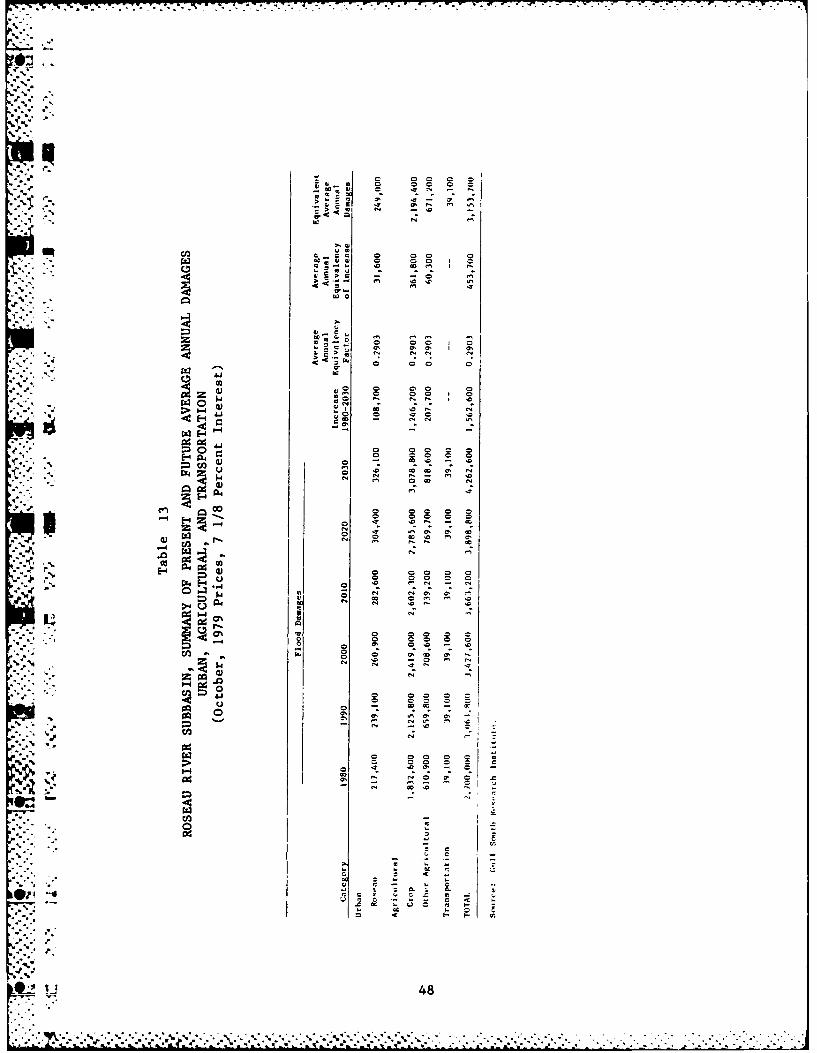
. 11 . I, . I 1 m §.. .0 0 0 0
-2- 4--
- - - - , 3% 5) _
,,0,0 0m I _
~JJ )3w 00
__ . .0 .
4 4 uI~
.. ..N" 4 .
_.,-, -
I -% .. u 3 IN-N N N
- 0-0 0 I 0
. ' 2 2 . ° N N
'.00'-I 0
• *;,/. N - 4 "
" -- N.-

J,. . ', , ', ,, . , .- ,. , . , , ,. . . . . -. ., -.. - -. -. _ -, , - - -. -. . .. - - . , - -. ° . .-
I.
Flood damages to residences, businesses, industrial structures,L- -i..mchurches, schools, automobiles, house trailers, public property and contents
are included in the urban damages category. Damages to streets and utilities
(including water, gas, electricity, sanitary sewers, storm sewers, and
*6 .* * -. telephone systems) are also taken into consideration. This category
also includes loss of wages, loss of profits, expenditures for temporary
housing, cleanup costs, and extra expenses for additional fire and police
protection and flood relief.
Agricultural flood damages consist of crop and pasture damage, which
may include costs of replanting, refertilizing, additional spraying,
reduced crop yields, loss of animal pasture days, and other related flood
losses.
Other agricultural damages consist of land damage from scour and
gully erosion and deposition of flood debris; livestock and poultry losses;
damages to machinery and equipment, fences, and farm buildings and contents
(excluding residences); and damages to irrigation and drainage facilities.
Transportation damages include all damages to railroads, highways,
3 roads, airports, bridges, culverts, and waterways not included in urban
damages. In addition, all added operational costs for railroads and
airlines and vehicle detours are included.
Future growth of urban flood damages was estimated to be an uncompounded
(straight-line) rate of one percent per year for a 50-year period beginning
in the base year, with no growth thereafter.
Agricultural crop flood damages were projected to increase at the
same rate as crop income projections published in the 1972 OBERS Series
E projection report. These crop income projections were prepared by the
_ .. U.S. Economic Research Service (ERS) for the Red River of the North region.
Other agricultural flood damages were projected to increase at one-half
of this rate.
Transportation damages are not expected to change throughout the
project life because of the long-term economic life associated with such
structures as bridges, railways, roads, and culverts. In addition, it
has been found that repairs to these types of structures rarely exceed
* ~the cost of a new structure, even with frequent flooding.
49
.d ..'
Most Probable Environmental Conditions
-n Improvements in water quality should occur with successful implementation
of point and nonpoint source pollution abatement plans. Those measures
directed toward the nonpoint sources are expected to take considerably
longer to be implemented. Woodland wildlife habitats are expected to
increase, based on land use trends from 1969 to 1977; however, wetlands
will decrease in both number and total acreage, with resultant decreases
in plants and animals dependent upon these important environments. Water
- quality improvements will create improved conditions for both aquatic
biota and wildlife utilizing surface waters.
The above statements assume that the proposed alternatives, specifically
the channel modifications to 43.9 miles of the Roseau River and its associated
"- measures, will not occur. However, the Roseau River Flood Control Project
has been authorized and is presently in preconstruction planning. Thus
the statements above will not necessarily reflect future conditions,
particularly since much concern has been expressed over the effects of
- -this project on the environmental resources of the subbasin. These
- effects include those related directly to the construction of the project
- ..* and, more significantly, to the indirect effects brought about by accelerated
,,,', ., land use changes. Generally, major adverse impacts associated with the
project that would affect fish and wildlife resources include the degradation
, . of the quality of the Roseau River, alteration or elimination of significant
terrestrial habitats for wildlife, and potential loss of significant
, .. amounts of wetland through increased drainage indirectly associated !'ith
the project. Concern has also been expressed relative to the mitigation
. of the induced wetland drainage processes that may occur (U.S. Army Corpi
of Engineers, 1976; U.S. Fish and Wildlife Service, 1977; International
Roseau River Engineering Board, 1975).
* -Without Project Conditions
It is likely that the scenario set forth as the most probable future
of the subbasin will prevail during the 50-year planning period.
-.' 50
BCt.J

to
VI. EXISTING FLOODPLAIN MANAGEMENT PROGRAMS

V * - C , . W
VI. EXISTING FLOODPLAIN MANAGEMENT PROGRAMS
Institutions
The development of effective water resources management practices
in the subbasin is affected by the large number of international, Federal,
--state, and local agencies involved in project planning and implementation.
A portion of the subbasin lies within Canada. For the U.S. portion of
the subbasin, there are 44 Federal agencies with various types of jurisdiction
and 14 directly involved in the water and related land resource planning
process. At the state level, 27 agencies are involved. There are also
regional commissions, county agencies, and municipal entities. Differences
in perspective and problems of coordination hamper the effective and
speedy resolution of problems.
The subbasin is aided in water resources development by the inclusion
of the area in the Roseau River Watershed District. The Roseau and Kittson
soil and water conservation districts also have jurisdiction within the
p subbasin. No flood control projects have been constructed in the subbasin
by the Corps of Engineers or the Soil Conservation Service.
The Corps of Engineers, the Roseau River Watershed District, the
Soil Conservation Service, the soil and water conservation districts,
and the towns of Hallock and Roseau are the main entities that should
be consulted in flood control planning for the subbasin. It should be
', noted that the Northwest Regional Development Commission has prepared an overall
development plan that includes the subbasin.
Structural Measures
Between 1904 and 1918, a network of drainage ditches was contructed
adjacent to reaches of the Roseau River between Roseau and Caribou.
In addition, a series of channel enlargements, modifications, and diversions
O -was undertaken. These facilities were constructed to reduce flooding
-.- .- and to accelerate drainage in the fertile flatlands northeast of Roseau
and around Ross. A bypass channel was excavated to convey a large portion
of the Roseau River flow past Roseau Lake on the south side, and a ditch
. -draining the lake was connected to the modified channel, thereby opening
9 51
this area for agricultural activity. Further downstream of Ross, major
I achannel modifications in the Big Swamp reach of the Roseau River reduced
upstream flooding by providing a more effective exit for floodwaters.
Drainage facilities constructed in Big Swamp parallel to the Roseau River
also reduced upstream flooding. Additional drainage works have been
constructed in the Roseau-to-Caribou reach since 1920, but on a smaller
scale than the primary network built between 1904 and 1918.-' An earthen dam constructed in 1953 on Pine Creek diverts flows from
. the main channel into the Pine Creek Diversion channel (Figure IV).
An 18-inch gate-controlled culvert through the dam permits low flows
to pass down the natural channel of Pine Creek if desirable or necessary.
Operating plans provide for diverting flows up to 450 cfs into the Roseau
River Wildlife Refuge. The Pine Creek diversion system reduces flows
in the natural channel, while increasing the flows along the diversion
channel. The diversion channel is designed for a maximum flow of 600 cfs,
which has about a one-in-15 year recurrence interval.
Three dams are located in the subbasin: Roseau Dam, Hayes Lake
Dam, and wildlife impoundments. However, these dams were not constructed
for flood control purposes and, as such, have little impact on the flooding
problems in the subbasin.
40 Emergency levees were built in 1965 on both the east and west banks
of the Roseau River throughout the city of Roseau. These levees have
only provided localized flood protection.
Nonstructural Measures
Nonstructural flood control measures are measures that reduce or
eliminate flood damages through procedures that involve little if any
construction efforts. The major types are flood warning, floodplain
zoning, flood insurance, flood proofing, and floodplain evacuation.
- These measures are primarily applicable to urban areas.. .The city of Roseau participates in the Federal Flood Insurance Program
and has a floodplain zoning ordinance, building codes, and subdivision
-..- regulations for floodplain areas. Roseau also participates in the Red
River Valley flood warning system. The flood warning system for the
*... Red River Valley is a cooperative network organized by the National Weather
52
N-.'

~% -- I-
VV
(D
-4 0.
/ 0
~ I 0
00
0. 01 z 0
-, 24.- ~ -4eu oT~z~o~cc.)
ILC-C .~4
4 - -
53 J i
p Service in Fargo, North Dakota. Fifty volunteers throughout the basin
report to the National Weather Service on a weekly basis during winter
and fall and on a daily basis during spring and summer. The reportage
covers all precipitation of 0.1 inch or more, including amounts of snow
and water equivalent. This information is transmitted to the River Forecast
Center in Minneapolis where it is run through a computer system to determine
probable flood stages. The predictions are then transmitted to the National
Weather Service in Fargo, which releases them to the public through the
news media. Communities are then able to engage in emergency actions
S."to protect themselves from flood damages. Contacts with local officials
indicate that the flood warning system generally works quite well in
the subbasin.
. The subbasin is located in Kittson and Roseau counties, both of
which participate in the flood insurance program. In addition, Roseau
County has a floodplain zoning ordinance, a building code, and subdivision
regulations for floodplain areas.
* !There are other types of measures that could be implemented in the
-- subbasin to reduce flood damages but that are not directly applicable
to urban areas. These measures would include such things as land treatment
programs, use of present drainage ditches for floodwater storage, and
* nuse of natural areas for reversion to water retention use. Land treatment
i .is used by some farmers in the subbasin, but the SCS has not been called
upon to undertake a large-scale program. Present drainage ditches are
not used for floodwater storage, and no plans have been developed for
fur-ire use.
Information on natural storage areas and potentialities for increased
storage is limited. Indications are, however, that wetlands play a sub-
stantial role in controlling runoff, especially in combination with good
land treatment practices. Values on stroage have averaged about 12 inches
per surface-acre of wetlands, and have ranged to four times that amount
(Cernohous, 1979). The amount of wetland habitat within the watershed
area (or subbasin) is important: studies indicate that in certain situations
if a watershed has 15 percent of its area in wetlands or lakes, peak
floods will be 60 to 65 percent lower than they would be in the absence
* 54• .. .,--.•

.... . .. .. .. .. .. .. .
477
" 3 of the wetland/lake area; if wetlands or lakes occupy 30 percent of the
watershed, there will be a further reduction in flood peaks up to about
75 to 80 percent (Scientists' Report, National Symposium on Wetlands, 1978).
Adequacy of Existing Measuies
The principal natural drains are Hay Creek, Sprague (Mud) Creek,
Pine Creek, and Badger Creek. Most of these natural drains have been
modified and incorporated as part of a legal drainage organization.
The channels of these tributaries, both natural and modified, have
inadequate capacities to provide good drainage for their watersheds, and
lack of maintenance of some of these channels aggravates the situation.
Consequently, most of the existing ditches cannot function satisfactorily
because of poor outlet conditions along with inadequate maintenance.
The Pine Creek Diversion was created for the purpose of supplying
• -. .. water to three wildlife pools in the Roseau River Wildlife Refuge; however,
.. " even though this channel is designed for a flow equivalent to a 6.6 percent
(15-year) recurrence interval, its effect on flood reduction in the subbasin
.K has been negligible. Emergency levees in Roseau do not meet the Corps
of Engineers design criteria and do not provide effective protection
. }for a 100-year flood.
. .
* 55.
0'
,'- '.. .-..-,--;.. - .,.-. • ... .-. ... ..-a -... - . . . ...,•. -..-- . . . '. . . ... .. .•.- ... .* . . -.-, ,,,. - ,.

kVII. CRITERIA AND PLANNING OBJECTIVES
4:-

21. y ' ~ ~ . * . w~ *. - . - - . - . , . •
IA.
VII. CRITERIA AND PLANNING OBJECTIVES
Floodplain Management Criteria
Technical, economic, and environmental criteria must be considered
when formulating and evaluating alternative floodplain management measures
for the subbasin.
The technical criteria used in formulating and evaluating alternatives
" :' for this report consisted of the application of appropriate engineering.standards, regulations, and guidelines.
Economic criteria entailed the identification and comparison of
benefits and costs of each measure. Tangible economic benefits or appropriate
gains in environmental quality must exceed costs; however, in certain
instances, considerations of appropriate gains in the other accounts
(environmental quality, social well-being and regional development) could
alter this requirement. All alternatives considered are scaled to a
design which optimizes benefits. Annual costs and benefits are based
on an interest rate of 7 1/8 percent and price levels and conditions
existing in October 1979. A 50-year amortization schedule is used for
S".'" - the features considered.
" Environmental considerations call for the formulation of measures
that minimize objectionable or adverse environmental effects and maximize
environmental benefits. Also, limited consideration was given to modifications
based on coordination with state and Federal agencies, local interests,
and citizen groups.
Planning Objectives
The primary planning objective of this study was to contribute to
flood reduction needs in the subbasin and thereby provide protection
from or reduction of flood losses. In conjunction with this economic
S -objective, the study attempted to develop contributions to the environmental
quality of the subbasin.
The development of planning objectives involved a broad-range analysis
of the needs, opportunities, co,.cerns, and constraints of the subbasin
from the information that was available. On the basis of this analysis
of the problems, needs, and desires that could be identified, the following
,'" ""objectives were established:
56

1. Contribute to protection from and prevention, reduction,or compensation of flood losses for the flood prone areas
of the subbasin during the period of analysis.
* . 2. Contribute, to the maximum extent possible, to the preservationof the quality of the existing riverine environment and
enhance the environmental potential of the subbasin asa whole.
3. Contribute to the enhancement of recreational opportunitiesthroughout the subbasin.
4. Contribute to the improvement of water quality in theRiver.
" 5. Contribute to the reduction of wind and water erosionthroughout the subbasin.
*.. 6. Contribute to the developing trend toward increased irrigationthroughout the subbasin.
_ " 7. Contribute to the reduction of wastewater management problems,
particularly insofar as they relate to water quality.
.:
4.p
.'.57 -,A
' .....-*. .---- .;.-;.:.1. .;..-.- -,::......;?-';;?---"'-?;:.1 """" " ; " ' " " :" ." ,".','/ '- .- :',' -: ", " ""-

VIII. FORMULATION OF ALTERNATIVE MEASURES
. . . ,... .. .. . . .,.. .*i* , . .r , . . . . .. . . . . ,. . .C . ,.. . . -.* W' . .
-- IF
VIII. FORMULATION OF ALTERNATIVE MEASURES
• .This section contains a discussion of management measures that
have been identified to meet the resource management objectives. In
the formulation of measures, prime consideration was given to the resolution
of flooding problems. Measures to satisfy the other planning objectives
-.'.:. were considered exclusively as components of the flood control measures.
.... Authorized Measures
9 Congress has authorized a flood control project in the subbasin
consisting of the following: (1) 43.9 miles of channel improvements
on the Roseau River, extending downstream from the dam at Roseau to a
point near the International Boundary; (2) Construction of three short
% reaches (about 9 miles in length) of paralleling levee on the left bank;
and (3) channel improvement of about 10.2 miles of the Roseau River in
Canada. This latter improvement is required because the upstream improvements
" iwill cause a small increase in peak flows at the boundary for all peaks
not exceeding 6,000 cfs. These measures are shown in Figure V.
Improvements in this project will reduce flooding on approximately
- "55,000 acres of agricultural land along the Roseau River in Minnesota
between the city of Roseau and Big Swamp, and would decrease the frequency
and duration of flooding on an additional 22,000 acres of floodplain
below Big Swamp. Within Big Swamp and along the reach of river downstream
to the boundary, little or no reduction in peak flood levels will result
from the project, since the modified channel will be designed to minimize
the increase in magnitude of flood peaks at the international border.
"". "Roseau River channelization maintains the overflow into Two Rivers Subbasin
at preconstruction levels. Flows L Canada are altered which necessitates
mitigation payment to that country. Reduction of Roseau River flood flows
into the Two Rivers area would increase flood flows to Canada.
Upstream from Big Swamp, the degree of protection afforded by thei.* . . project wll vary as follows:
58

E-
*z -
ol C)
Rt~ S1
%/
V)
a -.1
J. -- 7

From Big Swamp upstream through Roseau Lake: 10-year frequency
Roseau Lake to Roseau Dam: 10-year frequency to 50-year frequency
Roseau Dam to upstream limit of city of Roseau: 50-year frequency
decreasind to 30-year frequency
• The Corps of Engineers investigated several other alternatives along
- with the previous authorized project in a general design memorandum completed
" "- in 1971. Aside from the authorized project, other structural alternatives
that were considered included:
" ' 1. Reservoir Storage: Reservoirs were considered at RoseauLake and in the Big Swamp area. Because of local opposition
and unfavorable benefit-cost ratios, this alternativewas eliminated.
2. 100-Year Protection at Roseau: The construction of floodbarriers, levees, and interior drainage facilities wasinvestigated to eliminate flood damage at Roseau. However,
annual costs were far greater than the annual benefits
that would be derived.
3. 50-Year Protection at Roseau: This alternative entailed
the construction of an 80-foot wide channel upstream of
the dam at Roseau and appropriate enlargement of the channel
downstream of Roseau to Richardson's Bridge. This projectalso lacked economic feasibility.
4. Levees: Construction of a complete system of levees alongthe Roseau River that would provide a significant level
of flood protection to portions of the subbasin was considered.Because of adverse environmental factors and an unfavorablebenefit-cost ratio, this alternative was not considered
viable.
5. Reservoir Storage Plus Channel Modifications: This alternative
consisted of a combination of reservoir storage in BigSwamp (Alternative 1) and the authorized channel modificationsfrom the upstream limits of Big Swamp to the city of Roseau.
These facilities would provide the upstream protectionafforded by the authorized project and would reduce theneed for the authorized downstream channel work. This
would eliminate the impacts of downstream channel modification.
, In addition, on the average, flooding downstream fromBig Swamp would be reduced, overflows into the Two Rivers
Subbasin would be reduced, Canadian mitigation would probablybe less extensive, and fish and wildlife benefits would
accrue in the Big Swamp area. An unfavorable benefit-
cost ratio also eliminated this alternative from further
* consideration.
60*" °"

3 IAlternative Measures
Upon construction of the authorized project, no serious flood problem
areas should remain in the Roseau River Subbasin as it will protect against
(except rare floods) 10-percent chance floods in rural areas and 50-percent
chance floods in Roseau. However, localized areas will still be subject
to some flooding during snowmelt and severe rainfall periods, especially
- rural areas in poorly drained sections. Construction of levees around
farmsteads averaging 5.0 acres in size situated in these flood-prone
areas would provide protection against a 1.0 percent (100-year) frequency
* "flood and could be constructed by private individuals, the Corps, or
the SCS.
Nonstructural Measures
Nonstructural measures can often effectively reduce flood damages
and were considered for flood-prone areas along the Roseau River in planning
* .'.. reports for the authorized project. Nonstructural measures considered
include floodplain evacuation, emergency protection, and flood proofing.
These measures are most effective in reducing flood damages to urban
areas and, in general, are ineffective in reducing damages to large agri-
cultural areas.
According to the planning reports, biological impacts resulting
from implementation would be minimal and localized. Permanent evacuation
of the floodplain area is totally unacceptable to local interests.
The emergency flood protection plan would be dependent on an effective
flood warning system to provide the lead time necessary for implementation
of emergency protection measures. Given the existing flood warning system
' -' and time and funding constraints, emergency protection measures would
probably be unsatisfactory in regard to safety, degree of protection,
* .and aesthetic appearance. In addition, emergency local protection, consisting
-* of levees, channel work, and similar efforts, would reduce flood losses
" in the protected areas, but could also increase flood stages in other
I. unprotected areas downstream.
61

'_0,
3 Because of the unacceptable social impacts and the probable limited
reduction of flood damages, nonstructural measures alone could not beconsidered viable flood control alternatives. Some of these measures, however,
in combination with other nonstructural measures, could provide an alternativewhich might afford a more permanent solution to many of the floodiag problems
| .- within the subbasin.
62
9..

'I.
UN
4...
'4
IX. ASSESSMENT OF ALTERNATIVES
*1
* , .4,,
U..4
*.4~! ~
~.- '4
4S
4,,
-. 4.
.......................................... *' . b .

IX. ASSESSMENT OF ALTERNATIVES
Economic Assessment
Economic evaluation of the proposed flood control measures for the
subbasin is summarized in Table I-A. Alternative one consists of: (1) 43.9
miles of channel improvements on the Roseau River, extending downstream
from the dam at Roseau to a point near the International Boundary; (2) constructionl
of three short reaches (a total of nine miles in length) of paralleling
levee on the left bank; and (3) channel improvements of about 10.2 miles
of the Roseau River in Canada. This latter improvement is required because
the upstream improvements will cause a small increase in peak flows at
the International Boundary.
Alternative two consists of the construction of levees around individual
farmsteads as previously discussed. Economic evaluation of this alternative
yielded a benefit/cost ratio of 2.10.
Impact Assessment
Table 15 provides a generalizeQ assessment of anticipated impacts
on various key elements of the United States portion of the subbasin
that would result from the alternative measures considered. The rationale
used in developing the ratings is also presented below. A brief discussion
I_. of the effect of these flood control measures on Canada is also presented.
Channel Improvements and Levees
The St. Paul District Corps of Engineers' document and supplement
entitled Final Environmental Impact Statement, Flood Control, Roseau
River, Roseau and Kittson Counties, Minnesota provides the basis for
discussion of anticipated impacts of 43.9 miles of channel improvements
. on the Roseau River plus construction of three short reaches of paralleling
levees. This alternative would result in maximally beneficial social
O and economic effects; maximally adverse biological impacts; moderately
adverse land use, water quality, and recreatioi effects; minimal negative
impacts on cultural resources; and no effects on water supply.
Social and economic benefits would accrue from the flood protection
L and flooding reduction that would stem from the measures. Maximum direct
social impact of the measures would involve rural residents along that
63
A -,7%

• 0
• -- -
*1~'. (N
'-.5. -
-
t&~0
.
It
~~00+
. 0 . . .- ,,.n,., , - e ,.,.,an . .. ,,,m ~ lllit m adn lnm

w- 0 1
4)
-4- 0 C
-4U
IJ *,r- 4 4
ca1 -4-4 (U
4) 0 0 0
C/3 r-4 -
pq r-4 4J C
0r >4 .z 4J
-
r4 0
'44
rj4)
0 9Q p 4.j
nt4-4 C
Co Co Q) -440 Co Mj~~.
.,- ca -4 w
0 0 a o-'',coj
-4-4 -4 >~4
*-4 Cc
Q) -4 4 a - 4 z
Q) 4) 0 M En
> Q) z~~
e' %
Z) ( CO Z.
4% 4)) 2Q 4ca ~ w . .
a4 Co 0
.. e. 65

portion of the Roseau River to be modified as well as the inhabitants
-fof the town of Roseau. Public health benefits and reduced safety hazards
from flooding conditions would also be experienced. No displacement
of people or farms is anticipated.
Some 55,000 acres of Roseau River floodplain would experience reduced
Sflood stages, and average urban benefits of approximately $300,000 (particularly
to the community of Roseau) would take place. Other beneficial economic
effects include increased agricultural output and incomes, reduced unemployment
due to construction, and enhancement of the area's agricultural base.
Severe adverse biological and moderately adverse water quality effects
can be anticipated. Streambank clearing and snagging operations and/or
channelization would be maximally adverse to the Roseau River. These
measures would result in: (1) greater extremes of water temperature;
(2) loss of aquatic and riparian habitat; (3) water quality degradation;
(4) increased siltation; (5) increased velocity; and (6) reduced flows
in summer months. Several threatened, endangered or otherwise important
species inhabit the subbasin and use the Roseau's riparian community
as a traveling corridor.
Land use and recreation elements would also be moderately adversely
affected. The conversion of floodplain land to agriculture and the encouragement
of development in the floodplain would create negative land use impacts.
Recreational use of the river during boating season would decrease because
,- " of diminished low-flow depths. The realignment and enlargement of the
channel would be detrimental to aesthetics. Area hunting and fishing
would undergo long-term changes that would negatively affect both local
residents and visitors.
During the development of flood control alternatives for the project,
three archaeological sites were identified within proposed construction
areas. Adjustments to specifications can, however, insure that impacts
can be avoided at one of the two sites. The third site has been tested,
and no further work on it is recommended.
The channel modifications planned for the Minnesota section of the
Roseau River would result in increased flooding Anwnstream from the international
border. Several mitigation measures have been determined and negotiations
are pending. It is anticipated that Canada would experience several
66
0

moderately detrimental riverine environment effects. In addition, the
Minnesota channel modifications would have a small detrimental effect
on Canada's terrestrial wildlife. Mitigation projects in Canada might
result in habitat losses.
Farmstead Levees
Minimally beneficial economic and social effects would result from
S"the protection of several farmsteads in the 100-year floodplain. Allother resource elements would not be significantly affected, although
consideration must be given to public health and aesthetic factors prior
to their construction.
67
. . .

J 9
~ *,
3
**I. C -
ftC.. ~
X. EVALUATION
U
*0~ C.~
J
'p
.J..
C,',
"p
Ii,
'C
C * * * * . C -
C.. p*-Pg.?., -......- C - - . . ~. CC. C,, ** - * . - . . C * **C *~ * * ** *~ * C- *-------. . . . . . C
C C . C ~C ~

X. EVALUATION
Two alternative structural measures considered for the subbasin".
4\ i have benefit/cost ratios that exceed unity. They are Roseau River channel
improvements and associated levees and the farmstead levees.
M The authorized Roseau River project would meet the flood protection
needs of the subbasin and would best meet National Economic Development (NED)
S""objectives. Total project benefits are greater than costs, and substantial
.K flood damage reductions would result. The social well-being (SWB) account
would be enhanced by public health and safety improvements and flood
damage reductions, but would be detrimentally affected by recreational
opportunity losses. The Environmental Quality (EQ) account would receive
basic changes, most of which are negative.
Of the many alternatives considered in previous reports on the Roseau
River, the one that appeared to be the most likely to aid in "preserving,
creating, and enhancing environmental quality" was reservoir storage
within the limits of the Roseau River. Although this alternative was
not considered for further investigation in this study because of a previously
computed benefit/cost ratio below unity, it should be noted that wildlife
benefits accounted for more than 90 percent of the total estimated reservoir
benefits.
The farmstead ring levees also exceed the above unity criteria but
do not benefit the overall resolution of subbasin flooding problems.
National Economic Development and Environmental Quality plans will be
tentatively formulated in association with the Red River of the North
Basin's main reconnaissance report.
468
..
1%4"
: . -'-"68
• *' ,,, _- ' .. - _.-,-.-.-'.,. .< _ ,"- ."-"-. :"- .. -". .... . " - - '"-''' "" -" "-" " ' "' "". . . ... . .. .. , , . . . . . . . . . . . ., L .: . . ,4. q|| -%:mi :--.- . . . . . . . . . . . . . . . .**-*p.* *. --

S
S
XI. ADDITIONAL STUDY NEEDS4-
I
2"
F

XI. ADDITIONAL STUDY NEEDS
This report was developed almost entirely on the basis of secondary
information from readily available planning documents. Data available
from state and Federal agencies was not fully canvassed, and only a limited
number of calls were made to the area. In particular, state university
libraries and department resources could not be fully utilized. Thus,
the document aims only at a broad-brush perspective. In order to provide
a more detailed and in-depth analysis of subbasin resources, problems,
and potential solutions, the following additional study needs would have
to be fulfilled:
1. Information pertaining to wastewater management needs to
be updated.
2. The secondary, or indirect, impacts of the proposed channel
modification need to be ascertained, especially with regard
to potential wetland losses described by the U.S. Fish
-.- and Wildlife Service (1977).
3. The potential of wetland restoration for use in floodwaterstorage needs to be determined, as has been indicated by
Cernohous (1979). This is particularly significant in
those areas where the peat soils of drained wetlands are
too wet during some years to be cultivated for production
of crops.
P. 4. Nonstructural flood damage reduction measures should bethoroughly explored such as those listed below.
Establishment of buffer areas and curtailment of inappropriate
residential, commercial, and other development in flood-
plains.
Maintenance and enhancement of existing riparian vegetation
along the Roseau River and tributaries to conserve
and restore wildlife habitats, help control wind andstreambank erosion, retain soil on the land, and reduce
... the amount of sediment, nutrients, and other pollutants
entering waterways.
Maintenance of grassed waterways to reduce erosion.
Establishment of vegetation in areas of critical erosion.
Determination of the feasibility of installing water
control structures at existing culverts to retain waterin drainage ditches for longer periods of time during
critical runoff periods to minimize flooding in downstream
areas.
69$'o
... ,,,......l, .,.~~~~~~~~~~~~~~.................... '-",. . ..... -,:.-..." . . . .. .-...-.... - ,...-.-

* . *. *. a o. . S .
*'Determination of the feasibility of utilizing "on-farm3 storage" to control runoff through such means as naturalstorage areas and control structures on existing culverts.
*"Prevention of overgrazing on grasslands and utilization
of sound agricultural land use practices.
Provision for strict enforcement of floodplain managementprograms within the subbasin.
5. The potentiality for land treatment measures (e.g. erosion
control measures such as cover crops, green belts, reductionin fall tillage, etc.) needs to be thoroughly investigated.
6. Determination of existence of wetlands in areas proposedfor implementation of farmstead levees.
7. The people of the subbasin need to be included in furtherwater resource planning efforts. A public involvementprogram would provide more complete information on water
resource problems and opportunities than is presently available.
8. Studies are needed to determine additional demand for recreationalfacilities, usage of existing facilities, and potential
sites.
9. A review of secondary sources and systematic field reconnaissance
is needed to identify archaeological and historical sitesand to determine their eligibility for nomination to the
National Register of Historic Places.
10. A detailed social profile of the subbasin is needed.
11. A detailed institutional analysis of the subbasin is needed.
12. Subbasin boundaries need to be better defined on the basis
1.. of hydrologic conditions, and total acreage in the subbasinneeds to be precisely measured.
13. An adequate 100-year floodplain map needs to be developed.
- * * Also, the extent of floodplains for smaller frequency stormsneeds to be delineated.
*. 14. Land use within the floodplain needs to be precisely identified." 15. The irrigation potentials of the subbain soils need to
be investigated.
16. The effect of drainage works on flood discharges and stages" "is unknown at present. It would take additional, more
detailed studies to determine the extent and effect of
reduced natural storage, and the relationships with levee
and channel measures.5,..
.'p
5%!
-•'.J70
S* S °* S -

.1
3 17. Whether forested acreages in the floodplain are increasingor declining needs to be precisely determined.
18. More study is needed to determine the precise nature ofthe water supply problems and potential solutions.
19. More gauging stations need to be developed to provide hydrologic4data for establishing flood frequencies and rating curves.
20. Channel cross-sections of the various streams need to beprepared for flood control planning purposes.
.-1. .°
0
.7
4-

BIBLIOGRAPHY

•.1q
-S.. BIBLIOGRAPHY
.1Blegen, Theodore C. 1963. Minnesota: A History of the State. University
of Minnesota Press, Minneapolis, M1'tN. 688 pp.
Borchert, John R. 1970. Minnesota Settlement and Land Use-1985. Minnesota
State Planning Agency, St. Paul, MN. 43 pp.
• ,.- .__ 1974. Perspective on Minnesota Land Use-1974. MinnesotaState Planning Agency, St. Paul, MN. 56 pp.
Brew, Aian P. and William J. Yourd. 1977. Intensive Archaeological Testingof the Lins Site, Final Report. Prepared for the U. S. Army Corps ofEngineers, St. Paul, MN. by Bemidji State University, Bemidji, MN. 71 pp.
Bureau of the Census. 1977. Census of Retail Trade for Minnesota. U. S.Department of Commerce, Washington, D. C.
__________ 1977. Census of Selected Services. U. S. Departmentof Commerce, Washington, D. C.
• 1977. Census of Wholesale Trade for Minnesota. U. S.
Department of Commerce, Washington, D. C.
____" __ 1972. County and City Data Book. U. S. Department of
U _Commerce, Washington, D. C.
-... ,." _1979. Population Estimates and Projections, Series P-25and P-26, No. 78-23 and No. 836. U. S. Department of Commerce,
Washington, D. C.
Bureau of Economic Analysis. 1979. Survey of Current Business. Vol. 59,No. 4 (April, 1979). U. S. Department of Commerce, Washington, D. C.
Bureau of Environmental Planning and Protection. 1979. Minnesota State
Comprehensive Outdoor Recreation Plan (Draft). Minnesota Departmentof Natural Resources: St. Paul, MN.
Cernohous, L. 1979. The Value of Wetlands for Flood Control. U. S. Fish
and Wildlife Service, Bismarck Area Office, Bismarck, ND. 7 pp.
Conant, R. 1975. A Field Guide to Reptiles and Amphibians of Eastern and*: - Central North America. Houghton Mifflin Company, Boston, Mass. 429 pp.
Cvancara, A. M. 1970. "Mussels (Unionidae) of the Red River Valley in NorthDakota and Minnesota, U. S. A.", Malacologia. 10(l):57-92.
Division of Parks and Recreation. 1980. SCORP Maps - Kittson County, Roseau
S.County. Department of Natural Resources: St. Paul, MN.
72

Ir
Henderson, C. 1979. Guide to the Herpetofauna of Northwest Minnesota-Region
IN. Minnesota Department of Natural Resources, St. Paul, MN. 5 pp.
__.___.- 1979. Guide to the Reptiles and Amphibians of NorthwestMinnesota - Region IS. Minnesota Department of Natural Resources,
* -. St. Paul, MN. 20 pp.
_ _ _ 1978b. An Inventory of Colonial Water Bird Nesting Sites in- Minnesota. Appendix. Minnesota Department of Natural Resources,
St. Paul, MN. 20 pp.
__""_ 1978a. Minnesota Breeding Birds: Relative Abundance andDistribution. Minnesota Department of Natural Resources, St. Paul,MN. 33 pp.
__________, and J. Reitter. 1979a. Guide to the Non-Game Mammals ofNorthwest Minnesota - Region IS. Minnesota Department of Natural
Resources, St. Paul, MN. 6 pp.
-____.__, and J. Reitter. 1979b. Guide to the Non-Game Mammals ofNorthwest Minnesota - Region IN. Minnesota Department of Natural
Resources, St. Paul, MN. 7 pp.
" *. Hewes, Gordon. 1948. "Early Tribal Migrations in the Northern Great Plains",
Plains Archeological Conference Newsletter. 1(4):49-61 (July 15, 1948).
International Joint Commission, Canada and United States. 1976. CoordinatedWater Use and Control in the Roseau River Basin. Department of State,Washinton, D. C. 74 pp.
International Roseau River Engineering Board. 1975. Joint Studies forCo-ordinated Water Use and Control in the Roseau River Basin. Report
- to The International Joint Commission. Main Report and Five Appendices(A-F). Regina, Saskatchewan, Canada; St. Paul, Minnesota, United States.
45 pp.
Johnson, Elden. 1973. The Arvilla Complex. Minnesota Prehistoric Archeology
Series No. 9. Minnesota Historical Societv, St. Paul, MN.
___- ____ 1975. Final Report on Intensive Survey and Testing of TwoSites Along the Roseau River. Prepared for the U. S. Corps of Engineers,
St. Paul, MN. by the University of Minnesota, St. Paul, MN. 34 pp.
. 1962. "The Prehistory of the Red River Valley", MinnesotaS..History. 38(4):157-165.
Lakela, Olga. 1965. A Flora of Northeastern Minnesota. University of
Minnesota Press, Minneapolis, MN.
MacMillan, Conway (editor). 1898. Minnesota Botanical Studies, Vol. I,
Minneapolis, MN.
73

Mann, G. E. 1979. Major Minnesota Wetland Zones. Bureau of Planning and
Research, Minnesota Department of Natural Resources, St. Paul, MN.
Marsh, Paul C., and Ira R. Adelman. 1978. Investigation of the Roseau
River Fish Population. Department of Entomology, Fisheries, andWildlife, University of Minnesota. 54 pp.
Miles, Catherine H. and Donald P. Yaeger. 1979. Minnesota Outdoo- Atlas:
A Guide to State and National Recreation Lands in Minnesota. 232 pp.
Minnesota Department of Agriculture. 1979. Minnesota Agricultural Statistics.
Minnesota Department of Agriculture, St. Paul, MN.
Minnesota Department of Economic Development. 1979. Minnesota Directory of
Manufacturers, 1979-1980. Minnesota Department of Economic Development,
St. Paul, MN.
Minnesota Department of Economic Security. 1979. Labor Force Estimates,
1970-1978. Minnesota Department of Economic Security, St. Paul, MN.
Minnesota Department of Natural Resources. 1978. Fish and Wildlife Resources
of the Roseau River. Division of Fish and Wildlife, Ecological Services
Section. 75 pp.
Minnesota Department of Transportation. 1978. Minnesota Aeronautical Chart.
Minnesota Department of Transportation, St. Paul, MN.
1979. Minnesota Airport Directory.
Minnesota Department of Transportation, St. Paul, MN.
" _ __1979. Minnesota Railroad Map.
Minnesota Department of Transportation, St. Paul, MN.
Minnesota Natural Heritage Program. 1980. "Rare Elements of Natural Diversity
Found in Twenty-one Counties of the Minnesota Red River Basin". A Report
Submitted to GSRI. Minnesota Department of Natural Resources, St. Paul,MN. 26 pp.
Minnesota Pollution Control Agency. 1975. Red River of the North Basin
Water Quality Management Basin Plan. Division of Water Oualitv,St. Paul, MN.
r- ".. " - ° 1979. Agriculture Package 1, 208 WaterQuality Management Planning. Division of Water Oualitv, Planning Section,
St. Paul, MN. 34 pp.
Minnesota Soil Conservation Service. 1979. Minnesota Watershed - River
- Basin Status Report, October 1979. Minnesota Soil Conservation Service,
St. Paul, MN. 34 pp.
Minnesota State Planning Agency. 1979. Climate Zones, Minnesota State
Planning Agency, St. Paul, MN. (Map).
74
.. . . . . . . . . ..•

R-I4B6RS ER IE UBSNRDRVRO H OTRECONNAISSANCE REPORT(U) GULF SOUTH RESEARCH INST BATONROUGE LA DEC 8 DRC-9-C-8i
UNCLASSIFIED F/G 8/9 N
EEEEEE'EEmoiEEEEEEEEEEEEEEI

_L511 .0.6_o
1366
iiiMAO ___
.9|,,
MICROCOPY RESOLUTION TEST CHARTq~jNATAONAL BURE'AU Of STANOARDS l*3 A
.

li
~ Minnesota State Planning Agency. 1978. Minnesota's Land Use Planning
Process. Minnesota State Planning Agency, St. Paul, MN.
_________________________ 1978. Population Estimates for MinnesotaCounties. Minnesota State Planning Agency, St. Paul, MN.
"Minnesota's Transportation Network". Minnesota Economic Development News,Vol. 6, No. 3, March 1979.
J Moyle, J. B. 1974. Minnesota Animals and Plants in Need of SpecialConsideration, with Suggestions for Management. Minnesota Departmentof Natural Resources, Division of Fish and Wildlife. Special Publication
~ No. 104. 26 pp.
The Nature Conservancy. No date. Minnesota's Preserved Tracts and TheirUse. Minnesota Chapter. 6 pp. (mimeo.).
North Central Forest Experiment Station and Minnesota State Planning Agency.No date. Major Forest Types - Minnesota 1977 Inventory. U. S. Forest
. W Service and Minnesota Land Management Information Center, St. Paul, MN. Map.
-. * .. National Wetlands Technical Council. 1978. Scientists' Report. National
Symposium on Wetlands. 129 pp.
Northwest Regional Development Commission. 1978. Land Use Component.
S Part II: Support Documentation.
_______________________________. 1977. Overall Economic Development4 .* Program. 146 pp. plus appendices.
Peterson, A. R. 1971. Fish and ame Lake Resources in Minnesota. MinnesotaDepartment of Natural Resourtes, Division of Game and Fish, Section ofTechnical Services, Special Publication 89. 51 pp.
Roseu ,and J. Enblom. 1978. Fish and Wildlife Resources of theRoea River. Minnesota Department of Natural Resources, Division ofFish and Wildlife, Ecological Services Section, St. Paul, MN. 75 pp.
~-.* *- ~ Reid, John R., et al. 1974. Environmental Impact Assessment of the RoseauRiver, Minnesota, Flood Control Project. Research Report No. 6,Institute for Ecological Studies, University of North Dakota, Grand Forks.
Roseau County Soil and Water Conservation District. 1964. Application forAssistance in Planning and Carrying Out Works of Improvement Under Water-
... .-. shed Protection and Flood Prevention Act. Duxby Watershed, Roseau County,
.:. Minnesota. 5 pp.
Ryberg, Per Axel. 1932. Flora of the Prairies and Plains of Central NorthAmerica. New York Botanical Gardens. Science Press Printing Co.,Lancaster, Pennsylvania.
Saylor, Stanley. 1975. "DhLb-1: Early Period Occupation near Glacial Lake
,~ . ~ Agassiz, Southeastern Manitoba", Plains Anthropologist. 20(70):241-252.
75

" "Souris-Red-Rainy River Basins Commission. 1972. Souris-Red-Rainy RiverBasins Comprehensive Study. Souris-Red-Rainy River Basins Commission,
Moorhead, MN. 8 vols.
Strong, William D. 1941. "From History to Prehistory in the Great NorthernPlains", Smithsonian Miscellaneous Collections. 199:353-394.
SSt. Paul District Corps of Engineers. 1979. The Development of Nonstructural
Alternatives. St. Paul District Corps of Engineers, St. Paul, MN. 83 pp.
. ._ _ 1976. Final Environmental Impact
Statement, Flood Control, Roseau River, Roseau and Kittson Counties,Minnesota. St. Paul District Corps of Engineers, St. Paul, MN. 200 pp.
_ __. 1980. Future Growth of Other (Noncrop)
Agricultural, Urban, and Transportation Damages, Red River Basin. (Memo).St. Paul District Corps of Engineers, St. Paul, MN. 2 pp.
_ 1978. Minnesota Emergency Levee
Inventory. St. Paul District Corps of Engineers, St. Paul, MN.
. 1975. Mississippi, Souris, Red Ri,Basin Post Flood Report, 1975. St. Paul District Corps of Engineers,St. Paul, MN. 90 pp.
• 1973. Red River of the North Basin
Plan of Study. St. Paul District Corps of Engineers, St. Paul, MN.224 pp.
" ._ _ 1979. Red River of the North and
S"Souris River Post Flood Report, 1979. St. Paul District Corps ofEngineers, St. Paul, MN. 100 pp.
____. 1979. Water Resources Planning and-. Development in Minnesota. St. Paul District Corps of Engineers,
. *St. Paul, MN. 2 pp.
University of Minnesota, Department of Soil Service in Cooperation with
Minnesota Geological Survey and U. S. Soil Conservation Service. 1978." &-Soil Landscapes and Geomorphic Regions - Roseau Sheet. (Map).
Upper Mississippi River Basin Commission. 1977. 1975 National WaterAssessment, Specific Problem Analysis Report, Vols. 1 and 2, Upper
.. Mississippi and Souris-Red-Rainy River Regions. Upper MississippiRiver Basin Commission, Twin Cities, MN.
. U. S. Department of Housing and Urban Development. 1979. Flood Insuranced ." Study, City of Warroad, Minnesota. Federal Insurance Administration
Washington, D. C.
_. 1979. Flood InsuranceStudy, County of Roseau, Minnesota. Federal Insurance Administration,Washington, D. C.
76
-% -" -

_______________________________________ 1978. Flood Insurance
Study, City of Roseau, Minnesota. Federal Insurance Administration,Washington, D. C.
U. S. Environmental Protection Agency. 1976. Quality Criteria For Water.Washington, D. C. 501 pp.
4. U. S. Fish and Wildlife Service. 1979a. Aquatic Resources Package for
Minnesota Tributaries to the Red River of the North. EcologicalService Office, St. Paul, MN.
__________________________ 1977. Correspondence to Colonel Forrest
T. Gay, III, from Charles A. Hughlett. Twin Cities, MN.
V~4 , .1977. Roseau River, Flood Control Project,Roseau County, Minnesota. Special Report. St. Paul, MN. 41 pp.
~ . 1977b. Species Accounts for Threatenedand Endangered Species in the Great Lakes Region. Regional Office,
4. Twin Cities, MN.
~ ______________________ .1980. Terrestrial Resources Package for
Minnesota Tributaries to the Red River of the North. Ecological
I Services Office, St. Paul, MN.
U. S. Geological Survey. 1979. Water Resources Data for Minnesota: Volume 1.
Great Lakes and Souris-Red-Rainy River Basins. U. S. Geological Survey
Wedel, Waldo. 1961. Prehistoric Man on the Great Plains. University ofOklahoma Press, Norman, OK.
V?*

a'.
I:
.A
.5.
,. ,.
U..Apni

-, ,, , - , _, , : , I . . I - . = • . ..
Appendix A
FLOODPLAIN DELINEATION
. Prior to this study, no attempt was made to publish even a generalized
delineation of the entire Roseau River floodplain. In undertaking this
*task, the present study utilized all known sources to provide the best
available data for generalized delineation of the U.S. portion of the
subbasin at a scale of 1:250,000. Principal sources were: USGS Flood
S"-Prone Area Maps (scale 1:24,000), Federal Insurance Administration flood
*. ' maps (various scales), published secondary sources, U.S. Geological Survey
(USGS) 7 1/2 minute topographic maps, and other sources, including derived
data where necessary.
The Flood Prone Area Maps published by the USGS provided detailed
and highly accurate information for the area mapped. Two sheets covering
_ the area near the city of Roseau represent the available coverage. Since
this particular area is the only major urban area within the U.S. portion
of the subbasin, the delineated 100-year flood zone proved extremely
helpful.
Federal Insurance Administration Flood Hazard Boundary Maps and
Flood Insurance Rate Maps provide important coverage of the Minnesota
portion of the Red River Basin. The former are designed only to delineate
v the 100-year floodplain. The latter are much more detailed and usually
more accurate. A Rate Map for Roseau County provided most of the detail
in the Figure II delineation. Boundary Maps for Kittson and Beltrami
counties were consulted, although the area involved is relatively small.
Marshall and Lake of the Woods counties also involvd small areas, but
are peripheral to the Roseau River and do not contain floodplain areas.
Secondary sources, such as the Souris-Red-Rainy River Basins Type II
Study were also utilized. Published floodplain descriptions and acreage
estimates in the 1976 Final EIS, Flood Control-Roseau River and the 1976
International Joint Commission, Coordinated Water Use and Control Study
contained helpful information regarding the location and extent of the
Sfloodplain. USGS 7 1/2 minute topographic maps of relevant areas were
also available for consideration.
A-1
"". . ..I. . " " " " ' ' " ' " ' . ., . . .X - ,.' . .. . -. .. .- -,.-. . . .. .-?.' . ' z ." ,' " , ,-.-:''" " / -"- ' " """ < '"" ""' " "" '"' "" '" """°

Because of the general availability of data for the U.S. portion3. of the subbasin, inferences were minimal. Data from the sources identified
was compiled and delineated on USGS 250,O00-scale maps. The floodplain
, indicated was then planimetered with figures in square inches converted
to land measure and rounded to the nearest. 2,000 acres.
N.J
.
°',
S"°°
4-, 2 2 . .,. . '"o Z " ''2 I 2 ''''"" 2 """"''' , 2 '.'J , 'J '2€ ' D , .2 "" 2 ' .. " "" "" ,2,., .. .. ' . .'' .. ... "-

i
I'4
*% ' :w4.q .
• - . . . ,.. -'-'- ..'-'. ; "-; , ,-... - . -,. , , -4 , , , .,, ',' .,, .. .,, - . -. .. .,. . .

..-.
Appendix B
5. INVENTORY OF OUTDOOR RECREATIONAL FACILITIES (WILDLIFE MANAGEMENT AREAS)ROSEAU RIVER SUBBASIN
Boundary WMANumber Name Location Acres Managed Acres Date1
Joe River WMA Kittson Co. 80.0 80.0 7116449W34Joe River
Li Roseau River Roseau Co. 86,000.0 71WMA 16444W35
DuxbyEl Roseau WMA Roseau Co. 6,865.0 71
16340W17Ross
E_ RC 3 WMA Roseau Co. 80.0 80.0 7116338W22Salol
F: Enstrom WMA Roseau Co. 236.1 7616238W05Salol
Total Acres: 93,261.1 160.0
9- IDate of latest information.
. Source: Minnesota Department of Natural Resources, Division of Parks andRecreation.
%1B-1
"-.' B-I
', ' ... "-,.. *% - -' *. . '," • ... -•" " ." "-". . ,

~Appendix B
INVENTORY OF OUTDOOR RECREATi"..... ROSEAU RTVER SuBr.r..
.
,o.,
, € Campground
aa
a boundary tZ.0~ ae a
umiber UN Own -- Location Acres 0
Roseau Park and' Municipal Roseau Co. 40,3 10 10fRecreatlon Area 1624W124
Roseau
Beltrami Island State DNR6 Roeeau Co. 121,680.0State Forest 16137W35
5" Pencer
Mayes Lake State DNR Roseau Co. 29,600.0State Park 15938W12
Fencer
Q Roseau School Forest School Roseau Co. 320.016240W0Roseau
Ri) Ioseau Municipal municipal Roseau Co. 60.0Golf Course 16240L,24
Roseau1Facilities included are limited to those vith 15 or more acres.2 Boat rental.35at storage.
C1 Parking spaces.5Date of latest facility information.
6 Department of Natural Resources.
* Source: Minnesota Department of-Natural Resources,. Dtvi-tien of Parks and Recreation.
-B.-S.
, *
, /
.U~ _ . ..... . . • ..**~ , ,_ .. ., , . ... . .. . . . , ,

Appendix B
OF OUTDOOR RECREATIONAL FACILITIKS1
ROSEAU RIVER SUBBASIN
.' Camparound Marina Trail. INiles)
a
a a0e.4 4. A w 04
% 7610 10
5 3 '6
t0 4 1.76
1 76
-'S9 76
.r4
* -'402,

4.,
.f
'. ..]
> Appendix C
." "'COMMENTS
4 .. .
*' . %o
,..
...',, .
,, V ,T," ,,.",., • .. "..":,--, ,.. ..' . . . . . , - . . . . , , ' _ . . , - , ,,4. , ...-. - - ,, '

-. - -. -p - . - .7 - .
Appendix C
P COMMENTS
The purpose of this subbasin report was to provide an overview of
the water and related resource problems and needs and to assess potential
% solutions. Toward this end, draft copies of this report were circulated
4 to Federal, State, and local agencies and comments were sought.*~*; 'This review resulted in complete and factual documentation. Thus,
the study should serve as a building block for the timely completion
of future water resource efforts within the subbasin. Further cooperative
efforts are, however, needed to evaluate these tentative results and
to develop potential solutions.
N A distribution list and copies of the comments made with respect
to the draft report are included as part of this appendix. Comments
thtresulted inspecific modifications tothe dattext aemarked
by an asterisk.
---

p,--
DEPARTMENT OF THE ARMYST PAUL DISTRICT CORPS OF ENGINEERS
'~ 1135 U S POST OFFICE & CUSTOM HOUSEA ST PAUL. MINNESOTA 55101
*i REPLY TOATTENTION OF:
NCSED-PB 13 August 1980
Mr. Mike Liffmann
Project Manager
Gulf South Research Institute
8000 GSRI Avenue
Baton Rouge, Louisiana 70808
Dear Mr. Liffmann:
The draft Roseau River subbasin report was distributed for review and comment.Most of the reviewers have sent their comments to us.
a. Inclosure 1 includes letters from various Federal and State agencies.
S b. Inclosure 2 is the general office comments that need to be consideredwhen preparing the final Roseau River subbasin report and the remainingsubbasin reports.
. c. Inclosure 3 identifies specific office concerns that are applicable to'0 1 the final Roseau River subbasin report.
If you have any questions on our comments or proposed modifications, please
* "contact us.
S""Sincerely,
- e.'4$ Z4
3 Incl LOUIS E. KOWALSKIAs stated Chief, Planning Branch
Engineering Division
C-2
.S : -

~~~~~~~~~... ,..'..,.,,..'.."....."......-...... ' .. ....-. •.......r.- .C V .
UNITED STATES DEPARTMENT OF AGRICULTURE
SOIL CONSERVATION SERVICE
316 North Robert Street, St. Paul, Minnesota 55101
June 20, 1980
Colonel William W. BadgerDistrict EngineerU. S. Army Corps of Engineers1135 U. S. Post Office & Custom HouseSt. Paul, MN 55101
Attention: NCSED-PB
Dear Colonel Badger:
The Soil Conservation Service has reviewed the draft reports
1." " for the Roseau River and Two Rivers Subbasins, prepared byGSRI. The following comments are offered for your considera-tion:
Roseau River Subbasin
*1. Page 9, ist paragraph - Do the figures given in thelast sentence refer to wetland acreage or flood plainacreage?
*2. Page 10 - Insert "million" after $21.7 on the lastline of the page.
'4
3. Page 11, last full sentence on page - Page 22 and
this sentence indicate that 37.9% of the land iscultivated. What does the 50.5% figure refer to?
4. Page 59, 2nd paragraph, item (2- Suggest reording
as foIlows , . xis t i n 1tc r:3 dIt F.h\vst asidentified in the Duxbv Watershcd .-ppl icatio) foru-P-66 assistance, to be constructed b)" otiers;
.5 Page 64, 2nd paragraph, item 3) - Suggest reword"i
as follows, "(3) improvements to thie existing lateralditch systems as identified in the Duxby Watershedapplication for PL-5S6 .ssi:...ne; and .,."
6. Pages 70 and 71, item 4 Maintenance of grassedwaterways, establishment of vegetation, preventionof ovegrazing do not need additional study. Theseare items that need to be carried out. This wouldapply to item S also.
°". .- 4.
S. .

. -ColIonel1 I iJ I i m . Bhur 2
7. Page 71, item 6 - Su , e',st this be deleted. It ispnot likely thait fairmsteads w..ould' be built in
wetlands. %Also, this would be determined on acase by case basis as plans are developed.
* Two Rivers Subbasin
*1. Pa ge 12 - The last paragraph mentions the Joe River.Since this is the first mention of this tributary,it should be identified as to its location, size,
-. etc.
2. Page 54 - The Badger- Skunk Creek Subwatershed shouldbe located on the map on page 55.
Thank you for the opportunity to review these draft documents.
Sincerely,
Jon V. DeGrootAsst. State Conservationist
* c-4

\ Un itecd Sta*tes D~epartm ent of the Interior
....,- . . .. . . SS::-.S -
• .. "%7'-"V " m -arty atu,.m To:
S" " .. .. H.S;I I1 ) W 11 I SI 'IRVI( I
-~ St. Paul Field Office. Ecological Services.- 538 Federal Building and U.S. Court House
316 North Robert StreetSt. Paul. Minnesota 55101
July 28, 1980
' Colonel William W. BadgerDistrict Engineer, St. Paul DistrictU.S. Army Corps of Engineers1135 U.S. Post Office and Custom HouseSt. Paul, Minnesota 55101
Dear Colonel Badger:
This provides U.S. Fish and Wildlife Service comments on the DraftA Reconnaissance Report recently compiled by Gulf South Research Insti-
tute for the Roseau River Subbasin in Kittson, Roseau, Marshall,Beltrami, and Lake of the Woods Counties in Minnesota and ManitobaProvince in Canada.
."' As expressed in our comments on previous Subbasin Reports, our concernsare associated with the woodland, grassland, wetland, riverine andriparian floodplain habitats that remain within the Roseau River Sub-basin. The Report indicated that appr9ximately 150,000 acres of except-ionally high quality wildlife habitat #till exists within the Subbasin.
I,. The heaviest woodland areas are located near the Canadian Boarder,'I along the Roseau River and other tributary streams, and in the scutheastern*' part of the Subbasin. However, along the Roseau River oetween the
,. .' city of Malung and the Canadian Boarder, the woodland vegetation hasbeen reduced in some areas to a narrow band only 50 to 100 feet wide.We agree with the statements on pages 11, 39 and 40 of the Report thatthese woodlands are important because of their value for wildlife andshould be protected, -served, and enhanced within the Subbasin.
A significant amouii stland habitat also still exists within thenorthern and sout ie, rt of the Subbasin, in the Big Swamp area,and within the Pit-- et;- prague Creek, and Hay Creek watersheds.We agree with the state i on page 12 and 41 of the Report that thedrainage of wetlands iv, agricultural uses is a major problem withinthe Subbasin and that measures should be undertaken to conserve, protect,and enhance these extremely important wetland areas because of theirwildlife habitat value and the many other beneficial functions they
d perform.
C-5
, Z .,: X . ,>, .... .5, ,. ......... 5 ._.. . ... . . .
,$.0_' -%-,_ .1=. -% -, . " , - , ,, ,, , - . ... ,•. --

2
= UThe Roseau River is also of major concern because of its importantfishery value. This river has been identified by the Minnesota De-partment of Natural Resources as having one of the best game fishpopulations (particularly walleye and northern pike) of all warm waterstreams in Minnesota. As such, no measures should be undertaken thatwould inappropriately degrade this important riverine resource.
Other important wildlife and recreational resource areas of concerninclude the Big Swamp Area, Roseau Lake, Hays Lake, Hay Creek, Sprague
-~ Creek, Pine Creek, Badger Creek, Bemis Hill Creek, Hayes Lake StatePark, Beltrami Island State Forest and the five State Wildlife Manage-ment Areas within the Roseau River Subbasin.
The Report addressed seven structural alternative measures'that havebeen considered to reduce the flooding problems within the Subbasin.The Report indicated, however, that only two of these measures (theauthorized Roseau River flood control project and farmstead levees)had favorable benefit/cost ratios and appeared to be economicallyfeasible. Our comments relative to each of these measures are asfollows:
Alternative 1 (Authorized Roseau River Flood Control Project)
I This project would involve the construction of levees, channel cutoffs,side-ditch inlet structures and about 54 miles of channel improvementson the Roseau River. Our remaining concern with this project is thepotential loss of a significant amount of wetland habitat due to wet-land drainage directly or indirectly associated with the project.This project would be considered acceptable to the U.S. Fish and Wild-
, .life Service only if adequate measures are taken to ensure that inducedwetland drainage does not occur.
Alternative 2 (Farmstead Levees)
This alternative would involve the construction of levees around farmsteadsin flood-prone areas to provide protection against a 1.0% (100-year)frequency flood. We do not anticipate any significant adverse environ-mental impacts due to this alternative provided that the dikes arenot constructed through wetland areas and impacts to existing woodlandand grassland vegetation are avoided to the extent possible.
Our comments relative to the other structural measures (channel improve-ments, agricultural levees, reservoirs) addressed in the Report aresimilar to those provided on previous Subbasin Reports. We believea plan involving a combination of structural and nonstructural measures(as provided on page 4 of our May 8, 1980 letter on the Draft Reconna-
S issance Report for the Tamarac River Subbasin) should be implemented.
C-6
F-
.. . . S P . - * * * * .*:-' -

LS7 7
3
We also believe that additional studies (particularly numbers 2, 3,4, 5, 6, 16, and 19 identified on pages 70-72 of the Report) need tobe undertaken to provide a more detailed and in-depth analysis of exist-
*1~ " p eing Subbasin problem.s and the potential solutions to many of theseproblems.
In addition, we suggest that the following changes be made in the FinalReport:
.l. Page 41, last paragraph under the heading Waterfowl Production
Areas - change this paragraph to read as follows:
\Waterfowl Production Areas (WPA's) are wetland areas that
-, the U.S. Fish and Wildlife Service has either acquired throughfee title or obtained an easement interest on to preserve
. " -*-valuable breeding, nesting, and feeding habitat for migratorywaterfowl. There are no WPA's (fee or easement) presently
'- located within the Roseau River Subbasin.
*2. Page 55, 2nd paragraph, last sentence - we suggest this sentence
be changed and the following statements be included in this* - paragraph:
Information on natural storage areas and potentialities for
increased storage is limited. Indications are, however,.' that wetlands play a substantial role in controlling runoff,
especially in combination with good land treatment practices.Values on storage have averaged about twelve inches per surface-
acre of wetlands, and have ranged to four times that amountp(Cernohous, 1979). The amount of wetland habitat within
the watershed area (or Subbasin) is important:studies indi-cate that in certain situations if a watershed has 15 percentof its area in wetlands or lakes, peak floods will be 60to 65 percent lower than they would be in the absence ofthe wetland/lake area; if wetlands or lakes occupy 30 percentof the watershed, there will be a further reduction in floodpeaks up to about 75 to 80 percent (Scientists' Report, NationalSymposium on Wetlands, 1978).
3. Page 51, 59, 60, 64, 66, and 69 - various statements madeon these pages with respect to the Roseau River Flood ControlProject are inaccurate and we suggest these sections be revisedto more accurately reflect only those measures which areauthorized and would be undertaken if this project is implemented.
*4, Page 63, 1st paragraph - we suggest that this paragraph be
changed to read as follows:
-' [Because of the unacceptable social impacts and the probablelimited reduction of flood damages, these nonstructural measures
C-7
, -" "." %° e . % -

4
alone would not be considered viable flood damage reduction,. alternatives.
However, some of these measures, in combination with other
nonstructural measures (such as those previously addressedon page 55), could provide an alternative which could providea more permanent and long-term solution to many of the flood-ing problems within the Subbasin.
4., ,.
4, *5. Page 67, Table 16 - the letter symbols designating the impacts"V of channe] improvements and levees on land use and biology
should be MoA (Moderately Adverse) and MaA (Maximally Adverie),respectively, and not MoB and MaB as indicated in the Table(see page 66).
*6. Page 76, BIBLIOGRAPHY - include the following reference on* this page:
National Wetlands Technical Council, 1978. Scientists' Report,National Symposium on Wetlands. 129 pp.
These comments have been prepared under the authority of and in accordancewith provisions of the Fish and Wildlife Coordination Act (48 Stat.401, as amended; 16 U.S.C. 661 et. seq.) and are consistent with theintent of the National Environmental Policy Act of 1969.
Sincerely,
Richard F. Berry
Field Office Supervisor
cc: Minn. DNR, St. Paul*-. S. Bittner, Gulf South Res. Inst., New Iberia
.%c .8
"4,,*' 4-

U.S. Army Corps of Engineers
* North Central Division
Comments on the
Draft Roseau River Subbasin
June 1980
Cmt.No. Comment
1. Figure II is a poor map cartographically. There needs to
be a legend which clearly describes the patterning used todelineate the 100-year floodplain, marshy areas, etc.
2. Would suggest modifying the explanation of nonstructural
measures. Would suggest incorporating the following thoughts.
SNonstructural measures modify the susceptibility ofland, people, and property to damage and losses. In
'" addition, they modify the impact of flooding upon peoplpZ i and communities. Nonstructural measures do not attempt
to modify the behavior of floodwaters.
3. Add a discussion of the National Objectives (NED & EQ) asestablished by P & S.
4. The list of objectives is basically good but awkwardlyJ. " written. Would suggest rewriting such as below.
Enhance the recreational opportunities in the RoseauRiver subbasin for the benefit of the local people.
5. The assessment and evaluation sections need to emphasize howeach alternative meets or doesn't meet each objective--both
" " study objectives and National Objectives.
6. Pages 6-11. Flood Damages. Since the writer went to the
trouble of explaining the two types of flooding-overbankand overland - this discussion of flooding should stipulatewhich type caused the majority of the flooding. Also, if
% . due to rainfall (and not snowmelt), the amount of rainfallshould be disclosed. Add.
* 7. Pages 18-19. Social Characteristics. The discussion of
social characteristics should go beyond mere numbers andbegin describing the social environment in terms of trendy,
•. .." quality of life, and specific problems. A good social rectrd
II of community are the newspapers. Suggest a diachronicanalysis of newspaper contents. Add no later than Stage 2.
Add.
C-9
F .. *"

SUBJECT: Comments on the Draft Roseau River Subbasin June 1980
Cmt.No. Comment
8. Page 74. Evaluation. This section should be retitled"Recommendations" and include a definite statement whetherto terminate or proceed. The present discussion simplyis not clear. Finally, remember that the nonstructuralanalysis must be carried beyond Stage 1. Add.
*9. Page 64. There are current updates to the 1971 RoseauRiver subbasin report (two supplements to the GDM) whichshould be included in this assessment. The B/C ratio hasalso been revised to 1.20 under the 3!t% interest rate.Include as reference and discussion these recent updatesand supplements.
'to. Page 14. Wastewater Management. Has the treatment facil-ity at Wonnaska been placed in operation? The reportshould be updated to 1980.
11. Page 28. What is the status of the catfish fishery inHayes Lake?
"12. Page 71, "Additional Studies Needed", comment 16. Froma hydrologic-hydraulic standpoint the need for adequatestudies to answer this question cannot be overstated.This should include impacts on discharge-frequency rela-tionships due to levee or channel work.
.5-1

* * * .. . . . . . .... * ,* r-VZ'..
STATE OF
StDEPARVAENT OF NATURAL RESOURCES.144 Lafayettc Road, Space Center 111dg., St. Paul, LN 55101
PHONE -612/296-4800 .FeNo
;- *~July 10, 1930
Colonel William V. BadgerSt. Paul District EngineerCorps of Engineers1135 U.S. Post Office & Custom House
.S St. Paul, N 55101
Dear Colonel Badger:
COMMENTS ON ROSEAU AND TWO RIVERS SUBBASIN REPORTS
The Department of Natural Resources, Divison of Waters, has reviewed theabove referenced documents. Both docuements provide a good overview of theflooding problems and some of the other problems and needs in the basins.
During the review process several problems were identified. On page 56 ofthe Two Rivers Subbasin Report the discussion of the channel improvementsmeasure states that the backwater effects of the Red River and the ,cross-over flow from the Roseau Subbasin were not considered in the developrnntof costs and benefits for the alternative. Since these are both significanteffects in the Two Rivers Subbasin it would seem to be necessary to evaluateboth of these factors before the construction costs and the level of protection
.. * provided by the measure could be determined. If this same proceedure was usedin the evaluation of channel improvements in other subbasins, these measuresshould be checked again to determine whether or not the benefits and costsassigned to the channel improvement measures are still valid.
We note with interest that on page 64 of the Roseau River Subbasin Report, itstates that the updated benefit cost ratio of the authorized project on theRoseau River is now .89. Does this updated figure assume a higher interest
rate than was used for project authorization or have costs actually risenenough to reduce the B/C ratio from 1.25 to .89 ? What are the implications
." for project implementation ?
My last comment is with regard to the additional study needs on pages 70-72.It is quite surprising to see all of the data deficiencies listed for theRoseau River Subbasin. One would intuitively suspect that this subbasinwould have a greater quantity of high quality data because of all the planning
-*. .that has been done for the authorized project on the Roseau River.
While it seems probable that the authorized project on the Roseau River will
-" ' .be constructed, it does not appear as though most other subbasir!: will be.34 similarly protected. Because of the apparent lack of feasible &deral projects,
and the general lack of data, it seems that the Corps could best direct it's
,, C-11AL' T..
AN EOUAL OPPORTUNITY EMPLOYER
, .- ., , . - ,.'.- ,- .. . .. . . . .*-. .. . . . . . . . . . .

Colonel William W. Badger- . P a g e' 2
Ju 10, 1980
future efforts to the collection of hydrologic and hydraulic data; damage.-data; and data on storage potential in small reservoirs, drainage ditchesand wetlands as well as an overall modelling effort. The provision of datasuch as this might allow state and local governments and individuals tobegin to identify appropriate measures for localized protection in caseswhere no substantial federal interest is apparent.
Thank you for the opportunity to comment on these documents. If you haveany further questions, please contact Joe Gibson at 296-0438 or Ron flarnackat 296-0440.
Sincerely,
~4Direc o o
LS/JG :ph
- cc: Joe GibsonRon HarnackGerry PaulRoseau River Watershed District
"4.
,,-C-1
.5-¢ .i € < 1 . . , ;,..,,% . - ,.... ...--.-.- ,; ........ ,-,-.., . ..."-...,, ...... ,....--. . ..," , .-... .-. . a t a ml -~~~~[rrJ.J a ti . " , ,"= r , " " ! . t % c.o r '_

.~* ~General CommentsRoseau River Subbasin Draft Report
(April 1980)
(These comments apply to the entire report and all subsequent subbasin documents.)
1. As indicated in the specific comments, this document needs additional detailedinformation concerning nonstructural alternatives. The overall report shouldaddress and clarify this aspect of flood damage reduction planning.
2. Coments from Federal, State, and local agencies and a letter from the St.
Paul District will be included in an appendix in each final subbasin and in the
~ overall report. The format for the appendix will be:
a. Introduction - This section should stress:
-(l) The importance of completing the study on time.
-~(2) That the purpose of the study is to advise other agencies and~ ~. interests.
(3) The need for a selected review by various interests to provide
::~ :kcomplete and factual documentation.(4) The use of the study as a building block for future water resource
efforts.
(5) That cooperative efforts to evaluate results and develop solutions
()to remaining problems will be incorporated.
()A complete public involvement program when the study is finished.
F b. The distribution list.
c. Copies of letters of comment.
Only comments that identify significant errors or need specific attention will be-~ addressed in the final subbasin report. However, all comments incorporated should
be identified with a marking system. The distribution list for the Roseau RiverSubbasin Report is given below:
Date-. Agencies receiving Date comments
~ *draft report sent received
:~Z: Federal
***Soil Conservation Service 17 Jun 80 20 Jun 80Fish and Wildlife Service 17 Jun 80 29 Jul 80
Corps of Engineers, North Central Div. 17 Jun 80 18 Jul 80Corps of Engineers, St. Paul District 17 Jun 80 20 Jun 80
Incl 2 C1

~ State
Water Planning Board 17 Jun 80Department of Natural Resources 17 Jun 80 7 Jul 80Planning Agency 17 Jun 80Water Resources Board 17 Jun 80
.1~.~ ~ Local
Civil Defense Director 17 Jun 80Roseau River Watershed District 17 Jun 80
3. The source for most information identified in the majority of the tables isGulf South Research Institute. If other sources were used, an appropriate
* reference should be made.
~ 4. The evaluation section of each report is primarily the recommendations of the-, document. Generally, only the structural alternatives which have a benefit-cost
4 ratio greater than 1.0 are presented. Little attention is given to the otherstructural and nonstructural alternatives. These alternatives may be an important
i~ aspect of future flood damage reduction planning for either the subbasin or the* overall basin. Some of these alternatives may provide the necessary environmental
conditions to warrant further study. Therefore, this section should be expanded
to provide the appropriate discussions.
5. Rather than stating in each report and for each alternative evaluated thatthere will be little or no effect on cultural resources, the report should indicatethat it is not possible to identify effects on cultural resources until a systematiccultural resource survey has been completed in the subbasin. Such statements aremisleading because the report implies that no signficant sites are in the subbasin.In reality, there are simply no known sites, and the document and tables should bemodified, as appropriate.
6. The supporting information for alternatives including technical, economic, andany environmental data should be provided (at least under separate cover). Thiswould simplify matters when questions are asked during review or in the future.
-. ~.7. The maps should have more detail. Often information in the text is not clearlyillustrated in the maps. The maps would be improved if reproductions were of better
quality and included township lines or relationships of the subbasin to county or
2
C-14

Specific Comments* Draft Roseau River Subbasin Report
June 1980
*1. Page 2 -Reference 3 introduced "the preliminary report mentioned inNo. 8." It is not "the preliminary report mentioned above."
*2. Page 2, references 2 and 3 - Delete the word "preliminary."
-. * 3. Page 2, reference 5 - Although the Environmental Impact Assessment includesa section on archeological sites, its primary objective is to include all
environmental aspects of the subbasin.
*4. Page 3, first paragraph - Because of the sentence "The area is unique be-cause it is one of the two subbasins that reaches into Canada," the following
~., ,**statement sounds as if the formation of the Roseau River Watershed District wasalso unique. This is not the case.
*5. Page 3, 1st paragraph, last sentence - Replace "on" with "the" before Inter-national Joint Commission.
IU
*6. Page 5, last paragraph - Roseau is referred to as a village. It should be* referred to as a city.
*7. Page 5, last paragraph - Perhaps some mention should be made regardingchannel depth versus discharge. For example: "Water depths can be significantly5 lower than channel depths during low flows."
- * 8. Page 7, 2nd paragraph - Second sentence should read: "... half of the areawithin the United States portion of the subbasin is under cultivation."
*9. Page 9, last paragraph - Should the first sentence state that the primaryj areas are urban, agricultural, and environmental if there is only one urban area
in the subbasin that is subject to flooding and it accounts for only 8 percentof the total average annual damages in the subbasin?
*10. Page 10, last paragraph - Insert "million" after $21.7.
*11. Pages 10 and 11, Tables 1 and 2 and the paragraphs related to these tables-The data concerning average annual damages are outdated. A reanalysis of theeconomics of the Roseau River project was done in January 1979 by our EconomicsSection. Data from this unpublished report supercede the data in the 1977 RedRiver Basin Plan of Study. The following summarizes present condition (1980)
Lmi average annual damages, expressed at an October 1979 price level:
C-15Incl 3

Category Average annual damages
* UUrban $230,000
*Residential (103,500)Comercial (103,800)
-Public (22,700)
n Rural 1,068,000
Crop (759, 300)Other agricultural (269,400)Transportation (39,300)
Total 1,298,000
> \(1) Gives no credit to existing emergency levee sources: 1978 EconomicReanalyses of Roseau River Project (unpublished), Post Flood Report...
*12. Page 11, last paragraph - En the discussion of the data from the MinnesotaLand Management Information Service, what the 50.5 percent represents has beenleft out.
*13. Page 11, last paragraph - Because land use changes in the subbasin are rapidand MLMIS is not frequently updated, the date of the information should be included.
N *14. Page 12, first sentence -Replace the word "save" with "serve."
*15. Page 12, first paragraph -The statement: "(high augmentation of flows would.j~ ~*assist)" assumes that augmentation would be feasible. This is highly unlikely.
Delete the statement.
*16. Page 12, Recreational Problems - Water quality does not limit recreation inthe Roseau River.
17. Page 12, Recreation al Problems - A statement on recreational demand should beincluded. If demand is low, there may not be a problem.
- 18. Page 12, Recreational Problems -The current information on fishery conditionsfor Hayes Lake should be included if possible. DNR fisheries people should havethat information. (Also page 37.)
*19. Page 13, top - Low flows occur frequently in the Roseau River, but flows are* not intermittent.
*20. Page 13, Erosion Problems -Add at the end of the first sentence "and lowgradient."
S21. Page 13, Erosion Problenab - Omit the reference to sandy areas or quantify* ' ~ the amount. As written,, it bunds like a major problem and that is not the case.
/ C-1 6
2

22. Page 14, 5th paragraph -Badger is the only community that discharges intothe Roseau River. Should the other two communities be mentioned?
I * 23. Page 16, 1st paragraph - Public perception of problems and solutions maybe adequately defined for a reconnaissance report for the subbasin, but "well
A defined" may be too strong a statement. It appears to contradict No. 7 underadditional study needs.
*24. Page 17, last paragraph - Change sentence "...it is evident that residentsof the Red River Basin consider flood control...," to read "...it is evident thatmost residents of the..."
25. Page 18, last paragraph - "Almost 94% of the work force...," Page 21, firstparagraph - "...manufacturers in Roseau County... employ... 1,500 people." Table5 -Transportation equipment - 600. Since Polaris Division of Textron, Inc., inRoseau has laid off half of its work force and will not be reemploying anyoneuntil after sales pick up, this factor should be mentioned in one of the above
'5- sections. Also, the term "close knit" should be explained.
26. Page 19, Income - Comparing the 1977 per capita income of $6,892 as being"20 percent below" average State figures for 1979 is not adequate. The comparison
S should be made between the percent increase of per capita income for the subbasinfrom 1969 to 1977 (of 40 percent) and the percent increase of per capita income
- for the State from 1969 to 1977 (36 percent).
27. Page 19, Income - The distribution of income (such as percentage of population- . below the poverty level, etc.) should be included.
*28. Page 20, Agriculture - Several additional facts would aid in better under-- standing the relative importance of each crop. These include: gross income per
.4 acre for particular crops, the differential in susceptibilities of crops to flooddamages, and the differential in costs per acre to plant particular crops.
*29. Page 21, Table 5, Estimated Employment - Do the numbers given indicate people,'~ percent of employment market, or what?
*30. Page 27, 1st paragraph - WMA should be defined.
* * 31. Page 28, 3rd paragraph - Marsh and Adelman (1978) is an improper citation.This report was prepared under a Corps of Engineers contract and should be referred.o as such. Also, there is no 1979 reference to the U.S. Fish and Wildlife Service.
*32. Page 28, 3rd paragraph - Sauger and rock bass are not common in the RoseauRiver.
*33. Page 28, last paragraph - Delete first sentence and insert "in the invertebratecommunity" after "common" in the second sentence.
4' .43
iCs.

*34. Page 31, 2nd paragraph -"Quite good" water quality should be defined.
*35 Page 31, 3rd paragraph -Turbidity has not been identified as a limiting
I factor to the sport fishery resources in the river.
*36. Page 34, Cultural Elements - Should be consistent in use of BP versus BCor one could be construed as a typing error.
* 37. Page 35 - Table 9 would be more meaningful with allowable limit valuesgiven.
*38. Page 36, 2nd paragraph, and page 39, Cultural - There is a known and recordedhistoric Ojibwa cemetary at river station 1600+00.
*39. Page 36, 2nd paragraph - The need for systematic cultural resources surveysin the subbasin could be more strongly stated. Only the area immediately adjacentto the Roseau River has been surveyed.
40. Page 37, Social - In addition to the information presented, a discussion of* of social consequences or implications of flood events should be presented,
particularly those concerning behavioral damages that may occur.
*k41. Page 39, Cultural - This section states that there are 16 recorded archeologicalsites; on page 36, 12 sites are referred to.
p * 42. Page 41, Wetlands - The assessment of wetlands in the report of the U.S. Fishand Wildlife Service (1977) is misleading and contains erroneous data. PublicationC of this discredited data could raise unnecessary questions and should thereforebe deleted here and from table 11 on page 42.
43. Page 43, Threatened or Endngred Species - The peregrine falcon has beenextirpated from Minnesota and may be seen in the subbapin only during its migration.
*44. Page 43, Threatened or Endangered Species - Insert "Active and abandoned"1. before the words "nesting sites" in reference to bald eagles.
J. iuj.*. *45. Page 44, 2nd paragraph - A clear distinction between the State and Federal"A endangered species lists should be made. The greater sandhill crane is not on the~* Federal list but is on the Minnesota list.
*46. Page 44, 3rd paragraph - Reference to sharp-tailed and ruffed grouse should.sN* %~*
be deleted from this paragraph. It implies that they are rare or uncommon which is-. not the case.
*47. Page 46, 2nd paragraph - ".*.predicted steady increases..." not "study. it
*48. Page 46, 3rd paragraph - Very few people reside in the portion of Beltrami- '- County that is within the subbasin. Perhaps this should be clarified.
*49. Page 46, last paragraph - The statement "...manufacturing will continue its*~' * ~ predominant LlUe" contradicts statements on page 19 where 50 percent of total
personal income is farm income. Also, agriculture accounts for 25 percent of% 4 total employment, and services and manufacturing account for another 25 percent.
4C- 18

* -*50. Page 51, 2nd paragraph -As of 17 June 1980 the Roseau River flood control* project was not under construction but was in preconstruction planning.
*51. Page 51, 2nd paragraph - The statement "one of the best warm water fisheries* in the state" is not accurate and should be deleted. This comment also applies
- to page 66, last paragraph. Under the Without Project Condition Section, thelast part of the sentence after ''Period' should be deleted.
G 52. Page 52, 2nd paragraph - Although there still may be some concern regardingwetland drainage it appears that conflicts on the project's effects on wetICAndshave finally been resolved. The Corps recently submitted a Draft SupplementEnvironmental Impact Statement which discusses project modifications that shouldprevent induced wetland drainage.
*53. Page 53, 3rd paragraph - What is meant by "...a minimum amount of floodprotection."
*54. Page 55, 2nd paragraph, last sentence - "Natural" is misspelled.
*-~. 55. Page 55, Nonstructural Measures - Do the other towns in the subbasin also-a have floodplain zoning ordinances, building codes, and subdivision regulations forfloodplain areas? Some explanation of the existing situation in these towns wouldbe helpful.
56. Page 57, 3rd paragraph - The second sentence should read "Tangible economicbenefits or appropriate gains in environmental quality must exceed overall costs."
*57. Page 57, Planning Objectives - The second paragraph seems to be too strong.The following rewrite is suggested: "The development of planning objectivesinvolved a broad-range analysis of the needs, opportunities, concerns, and con-straints of the subbasin from the information that was available. On the basis ofthis analysis of the problems, needs, and desires that could be identified, the
L. following objectives were established."
*58. Page 59, 2nd paragraph - Ditches will not be improved as part of the project.4 References to this feature should be deleted.
*59. Page 59, last paragraph - Any decrease in flood damages on the 22,000 acresbelow Big Swamp is because the floods are reduced in that portion of the area.
* .Also, the remainder of the paragraph is not correct. Roseau River channelizationmaintains the overflow into the Two Rivers basin at preconstruction levels. Flowsto Canada are altered which necessitates mitigation payment to Canada. Reductionof Roseau River flood flows into the Two Rivers basin would increase flood flowsto Canada.
60. Page 61, Reservoir Storage - The brief discussion of the two reservoir alter-natives should include the principal reasons the benefit-cost ratio is unfavorable.
61. Page 62, Alternative Measures - Although the project protects against 10-*~ .* ~ percent chance floods in rural areas and 50-percent chance floods in Roseau, rare
floods could cause serious problems. The same comment pertains to page 64, firstparagraph.
C-19
-%

r. v. * .*
* *62. Page 62, Alternative Measures -Replace "...no serious flood problem areas* will remain..." with "...no serious flood problem areas should remain..."
*63. Page 64 - The first paragraph is identical to Alternative Measures, page 62.
*64. Page 64, 2nd paragraph - Delete (3). See coimment 58.
*65. Page 64, 3rd paragraph - Elaborate on the basis of updating costs and benefits.According to one Corps resource, the project has a B/C of 1.23 with current costsand benefits and the authorized interest rate which is 3 4 percent but has a B/Cof 0.89 if the current interest rate is used. Actually the sentence on the benef it-cost ratio being 0.89 and the next sentence do not add anything to the report.
-- 66. Page 65, last paragraph - Would farmstead levees have such a high benefit-costratio in view of the channelization project? It seems this should be different
-. * -. than in other reports.
*67. Page 66, 2nd paragraph - Reference to improving ditches should be deleted.See comment 58.
*68. Page 67, Table 16 - Several of the assessments in this table do not agreewith verbal statements on the previous page. For example, is biology maximally
2.1 beneficial (Table 16) or maximally adverse (last paragraph, page 66)?
- *69. Page 68, top of page - No connection between the Roseau and Red River fisherieshas been definitely established. This sentence should be deleted.
* *70. Page 68, 2nd paragraph - Adjustments have been made to avoid one of the twosites left in the construction zone; however, the Olson Mound Group will still beaffected by the proposed construction.
*71. Page 68, 3rd paragraph - Mitigation measures for Canada have been determinedbut have not been negotiated.
*72. Page 68, Farmstead Levees - With 12 (16?) archeological sites already identifiedalong the Roseau River, farm levees will probably affect some sites.
*73. Page 69, 3rd paragraph - Should it be said that reservoir storage would be- "1most adequate" in "preserving, creating, and enhancing environmental quality?"
* Reservoirs are typically considered environmental disasters. What makes thisreservoir so different?
74. Page 71, Items 10 and 11 - Each subbasin report should state that the pro-bability of institutional and social boundaries being the same as subbasin boundariesis remote. Because these boundaries overlap, integrated basin-wide social and
-institutional analyses are desirable.
*75. Page 71, Items 17 and 18 -These two tasks have already been accomplished.See comment 11.
6C-20

. *76. Page 79, last paragraph - Information is misspelled.
INOTE: Comuents 11, 42 and 50 must be incorporated into the final Roseau subbasin... "report. These involve recent actions or reports which significantly alter state-J'-'. ments made in this subbasin report. The report should reflect these changes.
." .o.;. ] .
4..
a
'
4*44
%*4"" i;N ') -;'°,°' "'''''"---; -'- € ', '' °"' ,.. . .""". - -2 ':""''' - .... ' , -' -. o ''' ' ' ' -N '' ' .,- '"- .

V4V
irkt
it G
~~~1%~I 4>4W4, t
4' Ak
zIV's4~ , ' 4 1t :t~ t~I
r ~ r 4 '0 ' a ." tipi
* tr s.i.$1
0U