Embed Size (px)
Citation preview
Gravity Field and Internal Structure ofMercury from MESSENGERDavid E. Smith,1 Maria T. Zuber,1* Roger J. Phillips,2 Sean C. Solomon,3 Steven A. Hauck II,4
Frank G. Lemoine,5 Erwan Mazarico,1,5 Gregory A. Neumann,5 Stanton J. Peale,6
Jean-Luc Margot,7 Catherine L. Johnson,8,9 Mark H. Torrence,10,5 Mark E. Perry,11
David D. Rowlands,5 Sander Goossens,12 James W. Head,13 Anthony H. Taylor14
Radio tracking of the MESSENGER spacecraft has provided a model of Mercury’s gravity field. In thenorthern hemisphere, several large gravity anomalies, including candidate mass concentrations(mascons), exceed 100 milli-Galileos (mgal). Mercury’s northern hemisphere crust is thicker at lowlatitudes and thinner in the polar region and shows evidence for thinning beneath some impactbasins. The low-degree gravity field, combined with planetary spin parameters, yields the moment ofinertia C/MR2 = 0.353 T 0.017, where M and R are Mercury’s mass and radius, and a ratio of themoment of inertia of Mercury’s solid outer shell to that of the planet of Cm/C = 0.452 T 0.035. Amodel for Mercury’s radial density distribution consistent with these results includes a solid silicatecrust and mantle overlying a solid iron-sulfide layer and an iron-rich liquid outer core and perhapsa solid inner core.
The internal structure of a planet preservessubstantial information regarding processesthat have influenced thermal and tectonic
evolution, and measuring a planet’s gravity fieldprovides fundamental information for under-standing that body’s internal mass distribution.Mapping Mercury’s gravity field is consequent-ly a primary objective of the MErcury Surface,Space ENvironment, GEochemistry, and Rang-ing (MESSENGER) mission (1).
On 18March 2011, theMESSENGER space-craft was inserted into a ~12-hour, near-polar orbitaround Mercury, with an initial periapsis altitudeof 200 km, initial periapsis longitude of 60°N,and apoapsis at ~15,200 km altitude in the south-ern hemisphere. This highly eccentric orbit permitsthe mapping of regional gravitational structure
in the northern hemisphere at the maximum res-olution of a spherical harmonic model near peri-apsis but limits the recoverability of the gravityfield to long wavelengths at southern latitudes.At the ascending and descending nodes of the or-bit (on the equator), the altitude of MESSENGERis about 4900 and 1200 km, respectively.
During the first few weeks after orbit inser-tion, MESSENGER was tracked extensively atX-band (8 GHz) by stations of NASA’s DeepSpace Network (DSN). After this initial period ofnearly continuous tracking, the typical coveragewas less frequent, limiting the number of directperiapsis passages that were observed. We haveprocessed data from 18March through 23 August2011, a tracking period that spans more thantwo Mercury sidereal days (2) (fig. S1). We lim-
ited our analysis to 1-day arcs to reduce the mod-eling errors from the nonconservative forces,which grow quadratically with time. The aggre-gated normal equations developed from dailyarcs were used to develop solutions of the gravityfield of Mercury (2) to degree (l ) and order (m) inspherical harmonics, a compromise between datasensitivity and global resolution.
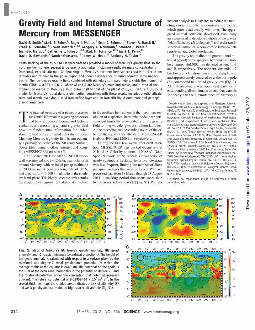
The gravity anomalies and gravitational po-tential (geoid) of the spherical harmonic solution,here termed HgM002, are depicted in Fig. 1, Aand B, respectively. The northern lowlands, ~2km lower in elevation than surrounding terrainand approximately centered over the north pole(3), correspond to a broad gravity low (Fig. 2).At mid-latitudes, a west-southwest–east-north-east–trending, discontinuous upland that extendsfor nearly half the circumference of Mercury is
A B
CFig. 1. Maps of Mercury’s (A) free-air gravity anomaly, (B) geoidanomaly, and (C) crustal thickness (cylindrical projections). The height ofthe geoid anomaly is calculated with respect to a surface given by therotational and degree-2 zonal gravitational potential for which theaverage radius at the equator is 2440 km. The potential on the geoid isthe sum of the even zonal harmonics in the potential to degree 20 andthe rotational potential, under the convention that potential increasesoutward. The reference potential is 9.02956464 ! 106 m2 s!2. In thecrustal thickness map, the shaded area indicates a lack of altimetry (3)and weak gravity anomalies due to high spacecraft altitude (fig. S1).
1Department of Earth, Atmospheric and Planetary Sciences,Massachusetts Institute of Technology, Cambridge, MA 02139–4307, USA. 2Planetary Science Directorate, Southwest ResearchInstitute, Boulder, CO 80302, USA. 3Department of TerrestrialMagnetism, Carnegie Institution of Washington, Washington,DC 20015, USA. 4Department of Earth, Environmental, and Plan-etary Sciences, CaseWestern Reserve University, Cleveland, OH44106, USA. 5NASA Goddard Space Flight Center, Greenbelt,MD 20771, USA. 6Department of Physics, University of Cali-fornia, Santa Barbara, CA 93106, USA. 7Department of Earthand Space Sciences, University of California, Los Angeles, CA90095, USA. 8Department of Earth and Ocean Sciences, Uni-versity of British Columbia, Vancouver, BC, V6T 1Z4 Canada.9Planetary Science Institute, 1700 East Fort Lowell, Suite 106,Tucson, AZ 85719, USA. 10Stinger Ghaffarian Technologies, Inc.,7701Greenbelt Rd., Greenbelt, MD 20770, USA. 11Johns HopkinsUniversity, Applied Physics Laboratory, Laurel, MD 20723,USA. 12University of Maryland, Baltimore County, Baltimore,MD 21250, USA. 13Department of Geological Sciences, BrownUniversity, Providence, RI 02912, USA. 14KinetX, Inc., Tempe, AZ85284, USA.
*To whom correspondence should be addressed. E-mail:[email protected]
13 APRIL 2012 VOL 336 SCIENCE www.sciencemag.org214
REPORTS
on
Oct
ober
25,
201
2w
ww
.sci
ence
mag
.org
Dow
nloa
ded
from
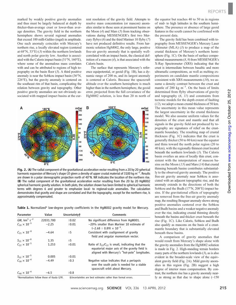
marked by weakly positive gravity anomaliesand thus must be largely balanced at depth bythicker-than-average crust or lower-than aver-age densities. The gravity field in the northernhemisphere shows several regional anomaliesthat exceed 100 milli-Galileo (mgal) in amplitude.One such anomaly coincides with Mercury’snorthern rise, a locally elevated region (centeredat 68°N, 33°E) (3) within the northern lowlandsand north polar gravity low. Another is associ-atedwith the Caloris impact basin (31°N, 160°E),where some of the anomalous mass correlateswith and can be attributed to regions of high to-pography on the basin floor (3). A third positiveanomaly is near the Sobkou impact basin (36°N,226°E), but the gravity anomaly is centered onthe southeast rim of that basin, complicating therelation between gravity and topography. Otherpositive gravity anomalies are not obviously as-sociated with mapped impact basins at the cur-
rent resolution of the gravity field. Attempts toresolve mass concentration (or mascon) anom-alies similar to those seen at prominent basins onthe Moon (4) and Mars (5) from tracking obser-vations during MESSENGER’s first two Mer-cury flybys (6) and the third Mariner 10 flyby (7)have not produced definitive results. From har-monic solution HgM002, the only large, positivefree-air gravity anomaly that is spatially well-correlated with an impact basin, the classical def-inition of a mascon (4), is that associated with theCaloris basin.
The surface that represents Mercury’s refer-ence equipotential, or geoid (Fig. 1B), has a dy-namic range of 200 m, and its largest anomalyis centered at Caloris. Because the spacecraftaltitude over the southern hemisphere is muchhigher than in the northern hemisphere, the geoiderror, projected from the full covariance of theHgM002 solution, is less than 20 m north of
the equator but reaches 40 to 50 m in regionsof mid- to high latitudes in the southern hemi-sphere. The presence or absence of large geoidfeatures in the south cannot be confirmed withthe present data.
The gravity field has been combined with to-pography from MESSENGER’s Mercury LaserAltimeter (MLA) (3) to produce a map of thecrustal thickness of Mercury’s northern hemi-sphere (Fig. 1C). On the basis of surface compo-sitionalmeasurements (8, 9) fromMESSENGER’sX-Ray Spectrometer (XRS) indicating that thecrust is intermediate between basaltic and moreultramafic compositions, as well as melting ex-periments on candidate mantle compositionsconsistent with XRS measurements (10), we as-sume a density contrast between the crust andmantle of 200 kg m!3. On the basis of limitsdetermined from flyby observations of gravityand topography (6, 11) and constraints fromtectonic models for the depth extent of faulting(12), we adopt amean crustal thickness of 50 km.The uncertainty in this mean value representsthe largest uncertainty in the crustal thicknessmodel. We also assume uniform values for thedensities of the crust and mantle and that allsignals in the gravity field not produced by to-pography are signatures of relief on the crust-mantle boundary. The resulting map of crustalthickness (Fig. 1C) indicates that the crust isgenerally thicker (50 to 80 km) near the equatorand thins toward the north polar region (20 to40 km), with the regionally thinnest crust locatedbeneath the northern lowlands (3). The Calorisbasin overlies an area of locally thin crust, con-sistent with the interpretation of mascon ba-sins on the Moon (13) andMars (14) that crustalthinning beneath basins contributes substantial-ly to the observed gravity anomaly. The positivefree-air gravity anomaly near Sobkou is asso-ciated with an adjacent topographic rise, and theanomaly extends in the directions of both theSobkou and the Budh (17°N, 208°E) impact ba-sins. If the gravitational effects of topographyare removed from the free-air gravity anomalymap, the resulting Bouguer anomaly shows strongpositive anomalies centered over the Sobkouand Budh basins and a weaker negative anomalyover the rise, indicating crustal thinning directlybeneath the basins and thicker crust beneath therise (Fig. 1C). Like Caloris, Sobkou and Budhalso qualify as mascons on the basis of a crust-mantle boundary that is substantially elevatedbeneath these basins.
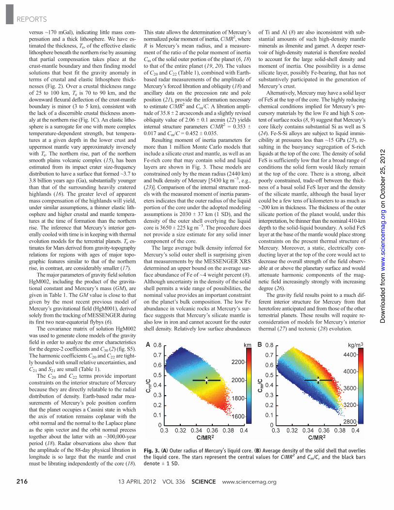
A comparison of gravity anomalies thatwould result from Mercury’s shape alone withthe gravity anomalies from the HgM002 solutionis made in Fig. 2. High-standing terrain bordersmany parts of the northern lowlands (3), as is alsoevident in the broader-scale view of the equiv-alent gravity field (Fig. 2A). Mild gravity anom-alies in this region (Fig. 2B) suggest a highdegree of interior mass compensation. By con-trast, the northern rise has a gravity anomaly near-ly as strong as that due to shape alone (~150
Fig. 2. (A) The radial component of the gravitational acceleration vector resulting from a 20 by 20 sphericalharmonic expansion of Mercury’s shape (3) given a density of upper crustal material of 3100 kgm!3. Resultsare shown in a polar stereographic projection north of 40°N. NR indicates the location of the northern rise.(B) The radial component of the gravitational acceleration vector resulting from the 20 by 20 HgM002spherical harmonic gravity solution. In both plots, the solution shown has been limited to spherical harmonicterms with degrees 6 and greater to emphasize local- to regional-scale anomalies. The calculationdemonstrates that gravity and shape are correlated and that the topography, except for the northern rise, isapproximately compensated.
Table 1. Normalized* low-degree gravity coefficients in the HgM002 gravity model for Mercury.
Parameter Value Uncertainty† Comments
GM, km3 s!2 22031.780 T0.02 No significant difference from HgM001.C20 ! 10!5 –2.25 T0.01 ~20% smaller than Mariner 10 estimate of
(–2.68 T 0.89) ! 10!5.C21 ! 10!8 –4.64 T5 Consistent with coalignment of gravity
field and angular momentum vector.S21 ! 10!8 1.35 T5C22 ! 10!5 1.253 T0.01 Ratio of S22/C22 is small, indicating that the
equatorial major axis of the gravity field isaligned with Mercury’s “hot-pole” longitudes.
S22 ! 10!5 0.005 T0.01C30 ! 10!6 –4.49 T0.3 Negative value indicates that a periapsis
over the south pole is needed for a stablespacecraft orbit about Mercury.
C40 ! 10!6 –6.5 T0.8*Normalizations follow those of Kaula (29). †Uncertainties are best estimates rather than formal errors.
www.sciencemag.org SCIENCE VOL 336 13 APRIL 2012 215
REPORTS
on
Oct
ober
25,
201
2w
ww
.sci
ence
mag
.org
Dow
nloa
ded
from
versus ~170 mGal), indicating little mass com-pensation and a thick lithosphere. We have es-timated the thickness, Te, of the effective elasticlithosphere beneath the northern rise by assumingthat partial compensation takes place at thecrust-mantle boundary and then finding modelsolutions that best fit the gravity anomaly interms of crustal and elastic lithosphere thick-nesses (Fig. 2). Over a crustal thickness rangeof 25 to 100 km, Te is 70 to 90 km, and thedownward flexural deflection of the crust-mantleboundary is minor (3 to 5 km), consistent withthe lack of a discernible crustal thickness anom-aly at the northern rise (Fig. 1C). An elastic litho-sphere is a surrogate for one with more complextemperature-dependent strength, but tempera-tures at a given depth in the lower crust anduppermost mantle vary approximately inverselywith Te. The northern rise, part of the northernsmooth plains volcanic complex (15), has beenestimated from its impact crater size-frequencydistribution to have a surface that formed ~3.7 to3.8 billion years ago (Ga), substantially youngerthan that of the surrounding heavily crateredhighlands (16). The greater level of apparentmass compensation of the highlands will yield,under similar assumptions, a thinner elastic lith-osphere and higher crustal and mantle tempera-tures at the time of formation than the northernrise. The inference that Mercury’s interior gen-erally cooled with time is in keeping with thermalevolution models for the terrestrial planets. Te es-timates for Mars derived from gravity-topographyrelations for regions with ages of major topo-graphic features similar to that of the northernrise, in contrast, are considerably smaller (17).
Themajor parameters of gravity field solutionHgM002, including the product of the gravita-tional constant and Mercury’s mass (GM), aregiven in Table 1. The GM value is close to thatgiven by the most recent previous model ofMercury’s gravitational field (HgM001), derivedsolely from the tracking ofMESSENGER duringits first two near-equatorial flybys (6).
The covariance matrix of solution HgM002was used to generate clone models of the gravityfield in order to analyze the error characteristicsfor the degree-2 coefficients andC30 (2) (fig. S5).The harmonic coefficientsC20 and C22 are tight-ly boundedwith small relative uncertainties, andC21 and S21 are small (Table 1).
The C20 and C22 terms provide importantconstraints on the interior structure of Mercurybecause they are directly relatable to the radialdistribution of density. Earth-based radar mea-surements of Mercury’s pole position confirmthat the planet occupies a Cassini state in whichthe axis of rotation remains coplanar with theorbit normal and the normal to the Laplace planeas the spin vector and the orbit normal precesstogether about the latter with an ~300,000-yearperiod (18). Radar observations also show thatthe amplitude of the 88-day physical libration inlongitude is so large that the mantle and crustmust be librating independently of the core (18).
This state allows the determination of Mercury’snormalized polar moment of inertia,C/MR2, whereR is Mercury’s mean radius, and a measure-ment of the ratio of the polar moment of inertiaCm of the solid outer portion of the planet (6, 18)to that of the entire planet (19, 20). The valuesof C20 and C22 (Table 1), combined with Earth-based radar measurements of the amplitude ofMercury’s forced libration and obliquity (18) andancillary data on the precession rate and poleposition (21), provide the information necessaryto estimate C/MR2 and Cm/C. A libration ampli-tude of 35.8 T 2 arcseconds and a slightly revisedobliquity value of 2.06 T 0.1 arcmin (22) yieldsinternal structure parameters C/MR2 = 0.353 T0.017 and Cm/C = 0.452 T 0.035.
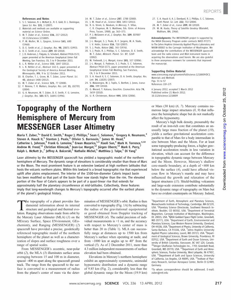
Resulting moment of inertia parameters formore than 1 million Monte Carlo models thatinclude a silicate crust and mantle, as well as anFe-rich core that may contain solid and liquidlayers are shown in Fig. 3. These models areconstrained only by the mean radius (2440 km)and bulk density of Mercury [5430 kg m!3, e.g.,(23)]. Comparison of the internal structure mod-els with the measured moment of inertia param-eters indicates that the outer radius of the liquidportion of the core under the adopted modelingassumptions is 2030 T 37 km (1 SD), and thedensity of the outer shell overlying the liquidcore is 3650 T 225 kg m!3. The procedure doesnot provide a size estimate for any solid innercomponent of the core.
The large average bulk density inferred forMercury’s solid outer shell is surprising giventhat measurements by the MESSENGER XRSdetermined an upper bound on the average sur-face abundance of Fe of ~4 weight percent (8).Although uncertainty in the density of the solidshell permits a wide range of possibilities, thenominal value provides an important constrainton the planet’s bulk composition. The low Feabundance in volcanic rocks at Mercury’s sur-face suggests that Mercury’s silicate mantle isalso low in iron and cannot account for the outershell density. Relatively low surface abundances
of Ti and Al (8) are also inconsistent with sub-stantial amounts of such high-density mantleminerals as ilmenite and garnet. A deeper reser-voir of high-density material is therefore neededto account for the large solid-shell density andmoment of inertia. One possibility is a densesilicate layer, possibly Fe-bearing, that has notsubstantively participated in the generation ofMercury’s crust.
Alternatively, Mercurymay have a solid layerof FeS at the top of the core. The highly reducingchemical conditions implied for Mercury’s pre-cursory materials by the low Fe and high S con-tent of surface rocks (8, 9) suggest that Mercury’score likely contains substantial Si as well as S(24). Fe-S-Si alloys are subject to liquid immis-cibility at pressures less than ~15 GPa (25), re-sulting in the buoyancy segregation of S-richliquids at the top of the core. The density of solidFeS is sufficiently low that for a broad range ofconditions the solid form would likely remainat the top of the core. There is a strong, albeitpoorly constrained, trade-off between the thick-ness of a basal solid FeS layer and the densityof the silicate mantle, although the basal layercould be a few tens of kilometers to as much as~200 km in thickness. The thickness of the outersilicate portion of the planet would, under thisinterpretation, be thinner than the nominal 410-kmdepth to the solid-liquid boundary. A solid FeSlayer at the base of the mantle would place strongconstraints on the present thermal structure ofMercury. Moreover, a static, electrically con-ducting layer at the top of the core would act todecrease the overall strength of the field observ-able at or above the planetary surface and wouldattenuate harmonic components of the mag-netic field increasingly strongly with increasingdegree (26).
The gravity field results point to a much dif-ferent interior structure for Mercury from thatheretofore anticipated and from those of the otherterrestrial planets. These results will require re-consideration of models for Mercury’s interiorthermal (27) and tectonic (28) evolution.
Fig. 3. (A) Outer radius of Mercury’s liquid core. (B) Average density of the solid shell that overliesthe liquid core. The stars represent the central values for C/MR2 and Cm/C, and the black barsdenote T 1 SD.
13 APRIL 2012 VOL 336 SCIENCE www.sciencemag.org216
REPORTS
on
Oct
ober
25,
201
2w
ww
.sci
ence
mag
.org
Dow
nloa
ded
from
References and Notes1. S. C. Solomon, R. L. McNutt Jr., R. E. Gold, D. L. Domingue,
Space Sci. Rev. 131, 3 (2007).2. Materials and methods are available as supporting
material on Science Online.3. M. T. Zuber et al., Science 336, 217 (2012);
10.1126/science.1218805.4. P. M. Muller, W. L. Sjogren, Science 161, 680
(1968).5. D. E. Smith et al., J. Geophys. Res. 98, 20871 (1993).6. D. E. Smith et al., Icarus 209, 88 (2010).7. J. D. Anderson, J. Palguta, G. Schubert, Abstract P41A-1572,
paper presented at the American Geophysical Union FallMeeting, San Francisco, CA, 5 to 9 December 2011.
8. L. R. Nittler et al., Science 333, 1847 (2011).9. L. R. Nittler et al., Abstract 142-3, paper presented at
the Geological Society of America Annual Meeting,Minneapolis, MN, 9 to 12 October 2011.
10. B. Charlier, T. L. Grove, M. T. Zuber, Lunar Planet. Sci.43, abstract 1400 (2012).
11. M. T. Zuber et al., Science 321, 77 (2008).12. F. Nimmo, T. R. Watters, Geophys. Res. Lett. 31, L02701
(2004).13. G. A. Neumann, M. T. Zuber, D. E. Smith, F. G. Lemoine,
J. Geophys. Res. 101 (E7), 16841 (1996).
14. M. T. Zuber et al., Science 287, 1788 (2000).15. J. W. Head et al., Science 333, 1853 (2011).16. R. G. Strom, G. Neukum, in Mercury, F. Villas,
C. R. Chapman, M. S. Matthews, Eds. (Univ. of ArizonaPress, Tucson, 1988), pp. 363–373.
17. P. J. McGovern et al., J. Geophys. Res. 109, E07007(2004).
18. J.-L. Margot, S. J. Peale, R. F. Jurgens, M. A. Slade,I. V. Holin, Science 316, 710 (2007).
19. S. J. Peale, Nature 262, 765 (1976).20. S. J. Peale, R. J. Phillips, S. C. Solomon, D. E. Smith,
M. T. Zuber, Meteorit. Planet. Sci. 37, 1269(2002).
21. M. Yseboodt, J.-L. Margot, Icarus 181, 327 (2006).22. J.-L. Margot, S. Padovan, S. J. Peale, S. C. Solomon,
Abstract P41A-1573, paper presented at the AmericanGeophysical Union Fall Meeting, San Francisco,CA, 5 to 9 December 2011.
23. S. A. Hauck II, S. C. Solomon, D. A. Smith, Geophys. Res.Lett. 34, L18201 (2007).
24. V. Malavergne, M. J. Toplis, S. Berthet, J. Jones, Icarus206, 199 (2010).
25. G. Morard, T. Katsura, Geochim. Cosmochim. Acta 74,3659 (2010).
26. U. R. Christensen, Nature 444, 1056 (2006).
27. S. A. Hauck II, A. J. Dombard, R. J. Phillips, S. C. Solomon,Earth Planet. Sci. Lett. 222, 713 (2004).
28. M. T. Zuber et al., Icarus 209, 88 (2010).29. W. M. Kaula, Theory of Satellite Geodesy (Blaisdell,
Waltham, MA, 1966).
Acknowledgments: The MESSENGER project is supported bythe NASA Discovery Program under contracts NAS5-97271to The Johns Hopkins University Applied Physics Laboratory andNASW-00002 to the Carnegie Institution of Washington. Weacknowledge the contributions of the MESSENGER spacecraftteam and the radio science and MLA instrument teams inacquiring the observations used herein. We are also gratefulto three anonymous reviewers for comments that improvedthe manuscript.
Supporting Online Materialwww.sciencemag.org/cgi/content/full/science.1218809/DC1Materials and MethodsFigs. S1 to S7References (30–37)
6 January 2012; accepted 5 March 2012Published online 21 March 2012;10.1126/science.1218809
Topography of the NorthernHemisphere of Mercury fromMESSENGER Laser AltimetryMaria T. Zuber,1* David E. Smith,1 Roger J. Phillips,2 Sean C. Solomon,3 Gregory A. Neumann,4
Steven A. Hauck II,5 Stanton J. Peale,6 Olivier S. Barnouin,7 James W. Head,8
Catherine L. Johnson,9 Frank G. Lemoine,4 Erwan Mazarico,1,4 Xiaoli Sun,4 Mark H. Torrence,4,10
Andrew M. Freed,11 Christian Klimczak,3 Jean-Luc Margot,12 Jürgen Oberst,13 Mark E. Perry,7
Ralph L. McNutt Jr.,7 Jeffrey A. Balcerski,5 Nathalie Michel,5 Matthieu J. Talpe,1 Di Yang1
Laser altimetry by the MESSENGER spacecraft has yielded a topographic model of the northernhemisphere of Mercury. The dynamic range of elevations is considerably smaller than those of Marsor the Moon. The most prominent feature is an extensive lowland at high northern latitudes thathosts the volcanic northern plains. Within this lowland is a broad topographic rise that experienceduplift after plains emplacement. The interior of the 1500-km-diameter Caloris impact basinhas been modified so that part of the basin floor now stands higher than the rim. The elevatedportion of the floor of Caloris appears to be part of a quasi-linear rise that extends forapproximately half the planetary circumference at mid-latitudes. Collectively, these featuresimply that long-wavelength changes to Mercury’s topography occurred after the earliest phasesof the planet’s geological history.
The topography of a planet provides fun-damental information about its internalstructure and geological and thermal evo-
lution. Ranging observations made from orbit bythe Mercury Laser Altimeter (MLA) (1) on theMErcury Surface, Space ENvironment, GEo-chemistry, and Ranging (MESSENGER) (2)spacecraft have provided a precise, geodeticallyreferenced topographic model of the northernhemisphere of the planet as well as a character-ization of slopes and surface roughness over arange of spatial scales.
From MESSENGER’s eccentric, near-polarorbit (2), the MLA (3) illuminates surface areasaveraging between 15 and 100 m in diameter,spaced ~400 m apart along the spacecraft groundtrack. The range from the spacecraft to the sur-face is converted to a measurement of radiusfrom the planet’s center of mass via the deter-
mination of MESSENGER’s orbit. Radius is thenconverted to topography (Fig. 1A) by subtractingthe radius of the gravitational equipotentialor geoid obtained from Doppler tracking ofMESSENGER (4). The radial precision of indi-vidual measurements is <1 m, and the accuracywith respect to Mercury’s center of mass isbetter than 20 m (Table 1). MLA can success-fully range at distances up to 1500 km fromMercury’s surface when operating at nadir, andfrom ~1000 km at angles up to 40° from thevertical (5). As of 2 December 2011, more than4.3 million independent measurements of surfaceelevation had been obtained.
Elevations in Mercury’s northern hemisphereexhibit an approximately symmetric, unimodalhypsometric distribution and a dynamic rangeof 9.85 km (Fig. 2), considerably less than theglobal dynamic range for the Moon (19.9 km)
or Mars (30 km) (6, 7). Mercury contains nu-merous large impact structures (8, 9) that influ-ence the hemispheric shape but do not markedlyaffect the hypsometry.
Mercury’s high bulk density, presumably theresult of an iron-rich core that constitutes an un-usually large mass fraction of the planet (10),yields a surface gravitational acceleration com-parable to that of Mars for a body intermediate insize between Mars and the Moon. For at leastsome topography-producing forces, a higher grav-itational acceleration results in less variation inelevation, which can account for the differencein topographic dynamic range between Mercuryand the Moon. However, Mercury’s shallowcore-mantle boundary, at a depth of <400 kmbelow the surface (4), could have affected vis-cous flow in Mercury’s mantle and may haveinfluenced the growth and relaxation of thelargest structures (11). Shield-building volcanismand large-scale extension contribute substantiallyto the dynamic range of topography on Mars buthave no evident counterparts on Mercury. Indeed,
1Department of Earth, Atmospheric and Planetary Sciences,Massachusetts Institute of Technology, Cambridge, MA 02139,USA. 2Planetary Science Directorate, Southwest Research In-stitute, Boulder, CO 80302, USA. 3Department of TerrestrialMagnetism, Carnegie Institution of Washington, Washington,DC 20015, USA. 4NASA Goddard Space Flight Center, Greenbelt,MD 20771, USA. 5Department of Earth, Environmental andPlanetary Sciences, Case Western Reserve University, Cleveland,OH 44106, USA. 6Department of Physics, University of California,Santa Barbara, CA 93106, USA. 7Johns Hopkins UniversityApplied Physics Laboratory, Laurel, MD 20723, USA. 8Depart-ment of Geological Sciences, Brown University, Providence, RI02912, USA. 9Department of Earth and Ocean Sciences, Uni-versity of British Columbia, Vancouver, BC V6T 1Z4, Canada.10Stinger Ghaffarian Technologies Inc., 7701 Greenbelt Road,Greenbelt, MD 20770, USA. 11Department of Earth and Atmo-spheric Sciences, Purdue University, West Lafayette, IN 47907,USA. 12Department of Earth and Space Sciences, Universityof California, Los Angeles, CA 90095, USA. 13Institute of Plan-etary Research, German Aerospace Center, Berlin D-12489,Germany.
*To whom correspondence should be addressed. E-mail:[email protected]
www.sciencemag.org SCIENCE VOL 336 13 APRIL 2012 217
REPORTS
on
Oct
ober
25,
201
2w
ww
.sci
ence
mag
.org
Dow
nloa
ded
from


![[XLS]sabr.orgsabr.org/cmsFiles/Files/PictoralHistCommitteePlayerImage... · Web viewSheet3 Sheet2 Sheet1 PlayerIndex2 zuberbi01 Zuber, Bill "Goober" Zuber, Jon zuberjo01 1993 Classic](https://img.pdfslide.us/doc/110x75/5ad4aaf17f8b9a1a028c266b/xlssabr-viewsheet3-sheet2-sheet1-playerindex2-zuberbi01-zuber-bill-goober-zuber.jpg)