Embed Size (px)
Citation preview

PLANNING JUSTIFICATION REPORT PLAN OF SUBDIVISION & ZONING BY-LAW AMENDMENT 807801 Ontario Inc. (Greenwood Acres) Village of Coldwater, Township of Severn Date:
March 27, 2017 Prepared by: Jamie Robinson, BES, MCIP, RPP Partner MacNaughton Hermsen Britton Clarkson Planning Limited (MHBC) 113 Collier Street Barrie ON L4M 1H2 T: 705 728 0045 Ext. 222 F: 705 728 2010 Our File 16240A
807801 Ontario Inc. – Plan of Subdivision & Zoning By-law Amendment
Planning Report March 27, 2017
TABLE OF CONTENTS
1.0 INTRODUCTION .................................................................................................................................................................................................... 1 2.0 SITE DESCRIPTION AND SURROUNDING LAND USES ................................................................................................................ 2 3.0 PROPOSED DEVELOPMENT .......................................................................................................................................................................... 4
3.1 Single Detached Dwellings ................................................................................................................................................................... 4 3.2 Townhouse Dwellings .............................................................................................................................................................................. 5 3.3 Future Development Blocks ................................................................................................................................................................. 5 3.4 Pedestrian Connections .......................................................................................................................................................................... 5
4.0 PLANNING ACT ..................................................................................................................................................................................................... 6 5.0 POLICY & REGULATORY FRAMEWORK .............................................................................................................................................. 10
5.1 Provincial Policy Statement (2014) ............................................................................................................................................... 10 5.2 Growth Plan for the Greater Golden Horseshoe (2006) ................................................................................................. 14 5.3 County of Simcoe Official Plan (2016) ........................................................................................................................................ 15 5.4 Township of Severn Official Plan (2006) .................................................................................................................................... 18 5.5 Township of Severn Zoning By-law (2010-65) ...................................................................................................................... 21
6.0 SUPPORTING STUDIES .................................................................................................................................................................................. 24 6.1 Archaeological Report ........................................................................................................................................................................... 24 6.2 Geotechnical Report ............................................................................................................................................................................... 24 6.3 Environmental Report ............................................................................................................................................................................ 26 6.4 Functional Servicing Report .............................................................................................................................................................. 27
7.0 SUMMARY & FINDINGS ................................................................................................................................................................................ 28
Figures Figure 1: Site Location Figure 2: Simcoe County Official Plan Schedule Figure 3: Township of Severn Official Plan Schedule A1 Figure 4: Township of Severn Zoning By-law Figure 5: Coldwater Flood Proofing Map
807801 Ontario Inc. – Plan of Subdivision & Zoning By-law Amendment
Planning Report March 27, 2017
1
1.0 INTRODUCTION McNaughton Hermsen Britton Clarkson Planning Limited (“MHBC”) has been retained by 807801 Ontario Inc. (the “Owner”) to seek approvals and to provide planning rationale for a proposed Plan of Subdivision and Zoning By-law Amendment on the property located at Part of Lot 21, Concession 12, Plan 1328, Geographic Township of Medonte, Township of Severn within the County of Simcoe. The property is locally known as 27 Gill Street in the Village of Coldwater (“the Site”). The location of the Site is identified on Figure 1. The effect of the application is to permit the development of a subdivision with 76 lots for single detached dwellings and 14 Blocks that are capable of accommodating between 56 and 70 townhouse dwelling units. Two additional blocks are provided for potential medium or high density housing options in the future. In addition to the Plan of Subdivision application, the Zoning By-law Amendment application is to permit a reduced minimum required lot area for single detached dwelling units and to facilitate the development of the townhouse dwelling units. It is intended that the development will occur in phases commencing at Gill Street. The following studies have also been prepared in support of the applications:
• Environmental Impact Study • Functional Servicing Study • Archeological Study • Geotechnical Study • Planning Justification Report
807801 Ontario Inc. – Plan of Subdivision & Zoning By-law Amendment
Planning Report March 27, 2017
2
2.0 SITE DESCRIPTION AND SURROUNDING LAND USES
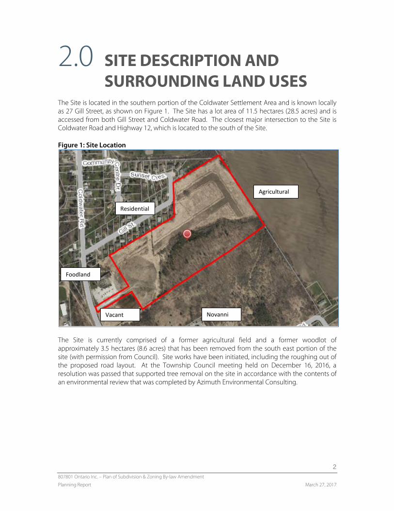
The Site is located in the southern portion of the Coldwater Settlement Area and is known locally as 27 Gill Street, as shown on Figure 1. The Site has a lot area of 11.5 hectares (28.5 acres) and is accessed from both Gill Street and Coldwater Road. The closest major intersection to the Site is Coldwater Road and Highway 12, which is located to the south of the Site. Figure 1: Site Location
The Site is currently comprised of a former agricultural field and a former woodlot of approximately 3.5 hectares (8.6 acres) that has been removed from the south east portion of the site (with permission from Council). Site works have been initiated, including the roughing out of the proposed road layout. At the Township Council meeting held on December 16, 2016, a resolution was passed that supported tree removal on the site in accordance with the contents of an environmental review that was completed by Azimuth Environmental Consulting.
Novanni
Residential
Agricultural
Foodland
Vacant
807801 Ontario Inc. – Plan of Subdivision & Zoning By-law Amendment
Planning Report March 27, 2017
3
The surrounding land uses that exist within the immediate area of the Site as shown on Figure 1 include the following:
North: Residential single detached dwellings and the Coldwater Fairgrounds; South: A vacant forested property, a manufacturing facility (Novanni) and the Boat
Warehouse; West: A grocery store (Foodland) and vacant lands; and, East: An agricultural field.
The Site is located to the east of Coldwater Road and the Foodland; and south of Gill Street and Sunset Crescent. The Uhthoff Trans Canada Trail is located to the north-east of the Site and the Coldwater River is located to the west. The Site is designated as Settlement Living Area in the Official Plan; and is located within the Residential One (R1) Zone in the Zoning By-law.
807801 Ontario Inc. – Plan of Subdivision & Zoning By-law Amendment
Planning Report March 27, 2017
4
3.0 PROPOSED DEVELOPMENT The proposed development consists of 76 lots for detached residential development;14 Blocks that are capable of accommodating between 56 and 70 townhouse units; and two future development blocks that could accommodate medium or high density residential uses. The proposed development is shown on the Draft Plan of Subdivision. For the purposes of this application submission, the townhouse dwellings have been divided into 14 Blocks (Block 77 to Block 90). The single detached dwellings (Block 1 to 76) are generally proposed on the northern portion of the Site and along the eastern boundary of the Site. The townhouse dwellings are proposed on the southern portion of the Site on Street ‘B’. Block 91 and 92 are reserved for future development, which could include a medium or higher density apartment dwelling. It is being recommended that these blocks be zoned with a Holding Symbol “H” to require a Site Plan Agreement prior to development proceeding. The proposed development will serve as an extension to the existing residential subdivision to the north and west of the Site. In addition to the access point from Coldwater Road located adjacent to Foodland, an access point is also provided from Gill Street through the existing residential subdivision. The proposed development consists of two internal roads, Street ‘A’ and Street ‘B’. A 20 metre road allowance is provided for all internal streets. Please refer to the Draft Plan of Subdivision for the proposed road locations. The proposed development contains two storm water management (SWM) ponds. The SWM pond located on the western portion of the Site (Block 93) will provide a separation between the proposed development and the Foodland; and the other SWM pond will be located on the northeastern portion of the Site (Block 94). There is also a walkway (Block 95) proposed adjacent to the SWM pond on the northeastern portion of the Site to provide pedestrian access to the Coldwater Fairgrounds as shown on the Draft Plan of Subdivision. The supporting Functional Servicing Report and Section 6.4 of this Report addresses aspects of the work involved in the operation of the SWM ponds. The Coldwater Fairgrounds is located to the north of the site and will provide functional parkland for the proposed development. The Coldwater Fairgrounds provide existing and future residents with access to an open grassed field, baseball diamonds, a track, the community centre (arena) and curling club. The proposed development will be serviced by municipal water and sanitary services. The supporting Functional Servicing Report and Section 6.4 of this Report addresses aspects of the work involved to implement these services into the proposed development. In order to facilitate the proposed development, a Plan of Subdivision and Zoning By-law Amendment is required.
3.1 Single Detached Dwellings The Plan of Subdivision includes a total of 76 single detached dwellings. The proposed lot areas, lot depths and lot frontages vary throughout the proposed development. Single detached
807801 Ontario Inc. – Plan of Subdivision & Zoning By-law Amendment
Planning Report March 27, 2017
5
dwellings are included as a permitted use in the Residential One (R1) Zone. A Zoning By-law Amendment is required to permit the proposed lots comply to the Residential R1 Zone standards in the Zoning By-law. Section 5.5 of this Report provides a detailed review of the Zoning By-law compliance.
3.2 Townhouse Dwellings The Plan of Subdivision includes 14 Blocks that can accommodate between 56 and 70 lots for townhouse dwelling units. The proposed lot areas, lot depths, and lot frontages vary between the exterior and interior townhouse lots. Section 5.5 of this Report provides a detailed review of the Zoning By-law compliance. Townhouse dwellings are not included as a permitted use in the Residential One (R1) Zone. A Zoning By-law Amendment is required to rezone the 14 Townhouse Blocks to the Residential Multiple One (RM1) Zone to permit the townhouse units on the Site. Each Block can accommodate either 4 or 5 townhouse units and will comply to the Residential Multiple One (RM1) Zone standards in the Zoning By-law. The Townhouse blocks have been designed to facilitate single-storey townhouses (similar to those found in the Riverwalk development). These single-storey townhouses would exceed the minimum required lot frontage provided in the RM1 Zone. Should the market be more appropriate for traditional two-storey townhouses, the number of units in each block could be increased to five units, and still comply to the zone standards of the RM1 Zone.
3.3 Future Development Blocks The proposed development includes two additional Blocks reserved for future development. The two additional Blocks could be developed with a medium or higher density form of housing such as an apartment style building. The Zoning By-law Amendment proposes to rezone these lands to the RM1 Exception Zone to add an apartment development as an additional permitted use. A holding provision will also be included to require a Site Plan Control Agreement prior to the development of the Blocks.
3.4 Pedestrian Connections Pedestrian connections are important to ensure connection between residential areas and destinations in the community. A walkway is proposed in the proposed development to provide residents with direct pedestrian access to the Coldwater Fairgrounds and more direct connections to the Uhthoff Trail and public school. A walkway to the property to the south of the Site is also provided to enable future connections to be developed between the sink factory property and the residential areas to the south of the Site.
807801 Ontario Inc. – Plan of Subdivision & Zoning By-law Amendment
Planning Report March 27, 2017
6
4.0 PLANNING ACT The Planning Act establishes the foundation for land use planning in Ontario and describes how land uses may be controlled. With respect to Draft Plans of Subdivision, Section 51 (24) of the Planning Act outlines specific criteria to be considered by an approval authority including:
a) The effect of the proposal on matters of Provincial Interest – The proposed development will
have no undue negative impact on matters of Provincial Interest as outlined in Section 2 of the Planning Act.
(a) the protection of ecological systems, including natural areas, features and functions; - In accordance with the EIS that has been completed, the development protects ecological systems, natural areas and their functions.
(b) the protection of the agricultural resources of the Province; - the Site is within a
settlement area, and does not impact agricultural resources. (c) the conservation and management of natural resources and the mineral resource base; -
There are no natural resources or mineral resources. (d) the conservation of features of significant architectural, cultural, historical, archaeological
or scientific interest; - An archeological study has been completed and there are no features of interest.
(e) the supply, efficient use and conservation of energy and water; - The proposed
development will use municipal water and waste water. The technical requirements of the site design have been developed in accordance with MOECC requirements.
(f) the adequate provision and efficient use of communication, transportation, sewage and
water services and waste management systems; - The proposed development will use municipal water and waste water. The technical requirements of the site design have been developed in accordance with MOECC requirements.
(g) the minimization of waste; - The waste generated from the Site is anticipated to be
typical of residential development in a settlement area. (h) the orderly development of safe and healthy communities; - The proposed development
represents the logical rounding out of the settlement area. (h.1) the accessibility for persons with disabilities to all facilities, services and matters to which
this Act applies; - Sidewalks will be designed in accordance with Accessibility requirements.
(i) the adequate provision and distribution of educational, health, social, cultural and
recreational facilities; - The Site is in proximity to a school, health facility and recreational facilities of the community.
807801 Ontario Inc. – Plan of Subdivision & Zoning By-law Amendment
Planning Report March 27, 2017
7
(j) the adequate provision of a full range of housing, including affordable housing; - The Draft Plan proposes areas for low, medium and high density housing. It is anticipated that many of the units will fall within the PPS definition of “affordable”.
(k) the adequate provision of employment opportunities; - The proposed development is a
residential subdivision. (l) the protection of the financial and economic well-being of the Province and its
municipalities; - The proposed development is orderly and within a settlement area and will protect the financial and economic well-being of the Province.
(m) the co-ordination of planning activities of public bodies; - The proposed development is
within the growth allocation provided by the County. (n) the resolution of planning conflicts involving public and private interests; - There do not
appear to be any conflicts between public and private interests. (o) the protection of public health and safety; - There are no hazard lands on the property
and the design of the Site has been based on good planning principles. (p) the appropriate location of growth and development; - The development is within a
serviced settlement area which is the location where growth is to be focused. (q) the promotion of development that is designed to be sustainable, to support public transit
and to be oriented to pedestrians; - Pedestrian linkages have been considered throughout the Site.
(r) the promotion of built form that, (i) is well-designed, - It is believed that the built form is well designed. (ii) encourages a sense of place, and – The development has been integrated into the fabric
of the community. (iii) provide for public spaces that are of high quality, safe, accessible, attractive and vibrant -
The proposal is adjacent to the Coldwater Fairgrounds, which are a key recreational feature of the community.
b) Whether the subdivision is premature or in the public interest – The Site is located in the
Coldwater Settlement Area and is zoned for residential uses. The development of the site provides a logical expansion of the built boundary within the settlement area and is within the growth allocation provided to the Township by the County. The Site is located adjacent to the Coldwater Fairgrounds which provides ample amenity space for future residents. The proposed development is consistent with Provincial Policy, and it is submitted that the proposal is not premature and represents the type of development that is in the public interest.
c) Whether the plan conforms to the official plan and adjacent plans of subdivision (if any) – The
Site has been designated for residential development in the Township Official Plan; and is located within a Settlement Area. The proposed development represents a logical extension
807801 Ontario Inc. – Plan of Subdivision & Zoning By-law Amendment
Planning Report March 27, 2017
8
to an existing residential subdivision to the north in an area planned for residential units. The proposed development includes a range of housing types (single detached dwellings and townhouse dwellings) and it is anticipated that many of the units will fall within the PPS definition for affordable housing.
d) The suitability of the land for the purposes for which it is to be subdivided – The soil conditions have been studied as part of the Geotechnical Study, and it has been determined that the lands are capable of supporting the proposed development.
e) The number, width, location and proposed grades and elevations of highway, and the adequacy
of them, and the highways linking the highways in the proposed subdivision with the established highway system in the vicinity and the adequacy of them – The Site is accessed from two locations. The Site is accessed from Coldwater Road to the west, and through the extension of Gill Street. Both existing roads can accommodate the projected increased traffic that will result from the proposed development. The roads within the proposed development are to be developed to a full municipal standard.
f) The dimensions and shapes of the proposed lots – The proposed lots and blocks are appropriate in size to accommodate the intended uses, and comply to the requirements of the respective zones in the Zoning By-law.
g) The restriction on the lands to be subdivided or the buildings and structures proposed to be erected
on it and the restrictions, if any, on adjoining land – There are no known restrictions affecting the Site, with the exception of the access easement to the south of the Foodland property. It is intended that this easement will be removed when the internal road is dedicated to the Township. The proponent will work with the owners of the abutting lands to prepare the necessary documents to have the easements removed upon assumption of the internal road.
h) Conservation of natural resources and flood control – The Site is not located within a floodplain area or other known hazards. A stormwater management plan has been developed by C.C. Tatham and it is included in the application submission.
i) The adequacy of utilities and municipal services – The Site can be fully serviced with an
extension to the existing municipal infrastructure as confirmed in the Functional Servicing Report.
j) The adequacy of school sites – There is an elementary school located in the Settlement Area.
A condition of draft approval will require a clearance letter from the local School Boards confirming that the students within the proposed development will have adequate school capacity.
k) The area of land, if any, exclusive of highways, to be conveyed or dedicated for public purposes –
The Coldwater Fairgrounds contains open amenity areas in the immediate vicinity of the Site. An access walkway is included in the Plan of Subdivision which will provide future and current residents access to this area. The Fairgrounds provide parkland that is sufficient for the development, if additional parkland is required, dedication should be considered through cash-in-lieu.
807801 Ontario Inc. – Plan of Subdivision & Zoning By-law Amendment
Planning Report March 27, 2017
9
l) The extent to which the plans’ design optimizes the efficient use and conservation of energy – The Subdivision Plan utilizes a development density that makes efficient use of land while balancing residential densities within the context of the communities existing character. The Site is located within the Village of Coldwater and will be able to optimize the use of existing infrastructure. The downtown area, arena, curling club, school and grocery store are all located within walking distance and will enable forms of active transportation to be used as an alternative to automobile dependency for the access of community amenities.
m) The interrelationship between the design and site plan control matters – The proposed
development includes single detached dwellings and townhouse dwellings. Sufficient land has been provided on the proposed parcels and blocks for the proper development of the planned uses. The road pattern and block layout includes 20 metre wide roads and provides two accesses; one from Coldwater Road and a second from Gill Street.
The Planning Act also requires that development is to have regard for the health, safety, convenience, accessibility for persons with disabilities, and welfare of the present and future inhabitants of the Township. The proposed Plan of Subdivision and implementing Zoning By-law Amendment has regard for the matters of provincial interest that are outlined in the Planning Act.
807801 Ontario Inc. – Plan of Subdivision & Zoning By-law Amendment
Planning Report March 27, 2017
10
5.0 POLICY & REGULATORY FRAMEWORK
The following is a review of the land use policy framework related to the proposed development and the potential implications for the subject Site. The planning documents discussed within this Section of the Report have been reviewed in their entirety as it relates to the proposed development. A summary of each planning document and relevant goals, objectives and policies are included herein.
5.1 Provincial Policy Statement (2014) The Provincial Policy Statement 2014 (hereinafter referred to as the “PPS”) was approved by the Ministry of Municipal Affairs and Housing on April 30, 2014 and is applicable to the Site. Planning Authorities are to be consistent with the PPS when exercising any authority. Section 1.0 provides policies with respect to building strong communities and states that:
Ontario’s long term prosperity, environmental health and social well-being depend on wisely managing change and promoting efficient land use and development patterns. Efficient land use and development patterns support strong, liveable and healthy communities, protect the environment and public health and safety, and facilitate economic growth.
Section 1.1 also contains policies that provide direction on the location of growth and land uses in the Province. Section 1.1.1 states:
Healthy, livable and safe communities are sustained by: a) promoting efficient development and land use patterns which sustain the financial
well-being of the Province and municipalities over the long term; b) accommodating an appropriate range and mix of residential (including second units,
affordable housing and housing for older persons), employment (including industrial and commercial), institutional (including places of worship, cemeteries and long-term care homes), recreation, park and open space, and other uses to meet long-term needs;
c) avoiding development and land use patterns which may cause environmental or public health and safety concerns;
e) promoting cost-effective development patterns and standards to minimize land consumption and servicing costs;
The proposed development promotes efficient development and land use patterns as it makes use of existing designated lands in a settlement area, at a density that achieves the density targets established in the County Official Plan. This promotes cost-effective development standards and minimizes land consumption and servicing cost. A mix of housing types, (single detached and
807801 Ontario Inc. – Plan of Subdivision & Zoning By-law Amendment
Planning Report March 27, 2017
11
townhouse) are proposed. The EIS and Functional Servicing Report submitted in support of the applications ensure that the development avoids environmental or public safety concerns.
Section 1.1.3 of the PPS provides policies that apply to settlement areas. These policies recognize settlement areas as the focus of growth and require the efficient use of land, a mix of land uses and a variety of housing styles to be developed. Section 1.1.3.1 identified settlement areas as being the focus of growth and states:
Settlement areas shall be the focus of growth and development, and their vitality and regeneration shall be promoted.
The proposed development is within a settlement area and will add to the population which will support the existing businesses of Coldwater. Section 1.1.3.2 outlines how land use patterns in settlement areas are to be based and states:
Land use patterns within settlement areas shall be based on: a) densities and a mix of land uses which:
1. efficiently use land and resources;
2. are appropriate for, and efficiently use, the infrastructure and public service facilities which are planned or available, and avoid the need for their unjustified and/or uneconomical expansion;
3. minimize negative impacts to air quality and climate change, and promote energy efficiency;
4. support active transportation;
5. are transit-supportive, where transit is planned, exists or may be developed; and
6. are freight-supportive;
b) a range of uses and opportunities for intensification and redevelopment in accordance with the criteria in policy 1.1.3.3, where this can be accommodated.
The proposed development is located on land that are designated and zoned for residential purposes. The Draft Plan of Subdivision and Zoning By-law Amendment propose a mix of single detached dwelling and townhouses which will improved housing mix in the community, which is dominated by single detached units. The Township as a whole has had very limited amounts of medium density development, such as townhouses, in recent history. Additionally, future blocks are reserved for medium or higher density development. Section 1.4 contains the housing policies that direct new applications for development and require planning authorities to plan for a range and mix of housing styles. Section 1.4.1 states:
807801 Ontario Inc. – Plan of Subdivision & Zoning By-law Amendment
Planning Report March 27, 2017
12
To provide for an appropriate range and mix of housing types and densities required to meet projected requirements of current and future residents of the regional market area, planning authorities shall:
a) maintain at all times the ability to accommodate residential growth for a minimum of 10 years
through residential intensification and redevelopment and, if necessary, lands which are designated and available for residential development; and
b) maintain at all times where new development is to occur, land with servicing capacity sufficient to provide at least a three-year supply of residential units available through lands suitably zoned to facilitate residential intensification and redevelopment, and land in draft approved and registered plans.
The Plan of Subdivision and Zoning By-law Amendment would add diversity to the housing stock of the area and would assist the Township to achieve a high mix of medium density housing types. Section 1.4.3 requires planning authorities to provide an appropriate range and mix of housing types and states:
Planning authorities shall provide for an appropriate range and mix of housing types and densities to meet projected requirements of current and future residents of the regional market area by: c) directing the development of new housing towards locations where appropriate levels of
infrastructure and public service facilities are or will be available to support current and projected needs;
d) promoting densities for new housing which efficiently use land, resources, infrastructure and public service facilities, and support the use of active transportation and transit in areas where it exists or is to be developed; and
e) establishing development standards for residential intensification, redevelopment and new residential development which minimize the cost of housing and facilitate compact form, while maintaining appropriate levels of public health and safety.
The proposed development includes a mix of single detached dwellings and townhouse dwellings. In addition to the single detached dwellings and townhouse dwellings, there are future development Blocks reserved for higher density development. The site design and mechanics for the future development blocks would be detailed though a Site Plan Control Agreements. The density of development that is proposed balances the minimum density requirements of the County Official Plan with the character of the area and proposes a density of development that achieves the minimum density requirements, while creating a development that is reflective of the character of the area. Section 1.6.6.1 of the PPS provides policies for sewage and water services and directs expected growth to promote the efficient use and optimization of existing municipal sewage and municipal water services. Section 1.8.1 outlines the policies for energy conservation, air quality and climate change and states:
807801 Ontario Inc. – Plan of Subdivision & Zoning By-law Amendment
Planning Report March 27, 2017
13
Planning authorities shall support energy conservation and efficiency, improved air quality, reduced greenhouse gas emissions, and climate change adaptation through land use and development patterns which: b) promote the use of active transportation and transit in and between residential, employment
(including commercial and industrial) and institutional uses and other areas; e) improve the mix of employment and housing uses to shorten commute journeys and decrease
transportation congestion; g) maximize vegetation within settlement areas, where feasible.
The Site is located within the Coldwater Settlement Area. The downtown includes a variety of uses including retail, an arena and curling club that are all located within walking distance. The Site is also located in proximity to the Foodland, Coldwater Fairgrounds, school and the Uhthoff Trail. Section 2.1 sets policies for natural heritage and the long term protection of natural heritage. Section 2.1.2 states:
The diversity and connectivity of natural features in an area, and the long-term ecological function and biodiversity of natural heritage systems, should be maintained, restored or, where possible, improved, recognizing linkages between and among natural heritage features and areas, surface water features and ground water features.
Section 2.1.7 provides policies related to endangered and threatened species and states:
Development and site alteration shall not be permitted in habitat of endangered species and threatened species, except in accordance with provincial and federal requirements.
An EIS was completed on the Site and concluded there were no natural heritage features present. A tree cutting permit was granted by the Township to remove the trees on the Site prior to approval of the proposed development. Section 2.2 provides policies that apply to Water. Section 2.2.1 h) states,
Planning authorities shall protect, improve or restore the quality and quantity of water by: h) Ensuring stormwater management practices minimize stormwater volumes and
contaminant loads, and maintain or increase the extent of vegetative and pervious surfaces.
There are two management ponds located on the Site and as discussed in Section 6.4 of this Report, the stormwater ponds function to the required standards in an attempt to protect, improve and restore the quality and quantity of water. The proposals are for residential uses and there are no anticipated impacts to groundwater. The site is within a settlement area and is not considered to be part of a prime agricultural area and does not contain any other resource features referenced in the PPS. Based on the above, it is concluded that the Draft Plan of Subdivision and Zoning By-law Amendment would facilitate development that is consistent with the PPS.
807801 Ontario Inc. – Plan of Subdivision & Zoning By-law Amendment
Planning Report March 27, 2017
14
5.2 Growth Plan for the Greater Golden Horseshoe (2006)
Places To Grow - The Growth Plan for the Greater Golden Horseshoe (hereinafter referred to as the “Growth Plan”) was approved by the Province of Ontario on June 16, 2006; there have been two amendments to the Growth Plan since its approval. Generally, the Growth Plan seeks to ensure Ontario’s long-term prosperity by promoting efficient land use and development patterns.
The guiding principles and vision of Section 1.2.2 for the Greater Golden Horseshoe (GGH) provides the basis for the guiding of land use planning. Generally, these principles support growth in compact and complete communities which protect environmental features, and optimize the use of existing and new infrastructure to support a strong economy. The Growth Plan requires that growth be focused in settlement areas. The Site is located within a settlement area in the Township of Severn, and is designated within the Township Official Plan for residential development. Section 2.2.7 of the Growth Plan contains specific policies for Designated Greenfield Areas. Amongst other matters, these policies speak to new development in Designated Greenfield Areas being planned to contribute to creating complete communities and to create densities and an urban form to support walking, cycling and an integration to transit services, as well as diverse mix of land uses and high quality public open spaces. The County of Simcoe Official Plan established a specific Designated Greenfield Area minimum density target for the Township of Severn. The minimum density target for the Township of Severn is 32 residents and jobs per hectare. The developable area of the Site is 11.5 hectares, however, for the purposes of the density calculations, the area of the future density blocks have been excluded as the density of these blocks is not known. The remainder of the development site has an area of 10.19 hectares. The proposed development consists of 76 single detached dwellings and between 56 and 70 townhouse dwellings (assume 56 for the purpose of the density calculations). In calculating the anticipated density for the site, the household sizes were obtained from the 2014 Development Charges Background Study. This Study provided an average household size for single detached dwellings of 2.76 persons per household and an average household size of 2.49 persons per household for medium density development, such as townhouses. The density calculation is as follows:
• 76 single detached units at 2.76 persons per unit - 209 persons • 56 townhouse units at 2.49 persons per unit – 139 persons • Total number of persons – 348 • Site area minus future development blocks – 10.19 hectares • Calculated density of development - 34 units per hectare
807801 Ontario Inc. – Plan of Subdivision & Zoning By-law Amendment
Planning Report March 27, 2017
15
The proposed development conforms to the minimum Greenfield density target established in the County of Simcoe Official Plan and as a result, conforms to the minimum density target requirements of the Growth Plan. The Infrastructure policies are contained within Section 3 of the Growth Plan. Generally, these policies require a coordinated approach between infrastructure planning, land use planning and infrastructure investment, in addition to providing specific policies regarding transportation and water and wastewater systems. The proposed development is accessed from Coldwater Road which is identified as a Collector Road, and is also accessed through Gill Street from the existing residential subdivision to the west. The proposed development can also be appropriately serviced with municipal water and municipal wastewater services as detailed in the supporting Functional Servicing Study. Section 4 of the Growth Plan contains policies that apply to natural heritage and protecting natural heritage systems. The EIS completed as part of the review has identified that the proposal will not impact environmental features. As referenced in the PPS Section of this Report, the site is within a settlement area and is not within a prime agricultural area. The Township of Severn is included in the Simcoe Sub-area and therefore the policies of Section 6 apply to the Site. Section 6 of the Growth Plan provides for additional policies regarding the allocation and management of growth for Simcoe County. The proposed development is located within a settlement area of the Township and is located in an area where existing municipal servicing and infrastructure exist. Existing roads are to be extended in a logical manner and the use of existing infrastructure will be optimized. The Township of Severn has been allocated a population of 17,000 by the year 2031. According to Statistics Canada in 2011, the population within the Township was 12,377. The proposed development is within the population allocation for the Township. Based on this review, the proposed development conforms to the Growth Plan.
5.3 County of Simcoe Official Plan (2016) The County of Simcoe Official Plan (County OP) was adopted by the County of Simcoe Council on November 25, 2008, and has been approved, in sections, by the Ontario Municipal Board with the last major portion being approved in December 2016. There are several site specific appeals still pending however, none affect the subject lands. The County OP is a document designed to play a critical role for growth management in the County of Simcoe over the next 20 years. The County OP strives to achieve a balance between the demands for economic development, community building, and environmental conservation and provides a framework for coordinated planning with adjacent municipalities, agencies and other levels of government.
807801 Ontario Inc. – Plan of Subdivision & Zoning By-law Amendment
Planning Report March 27, 2017
16
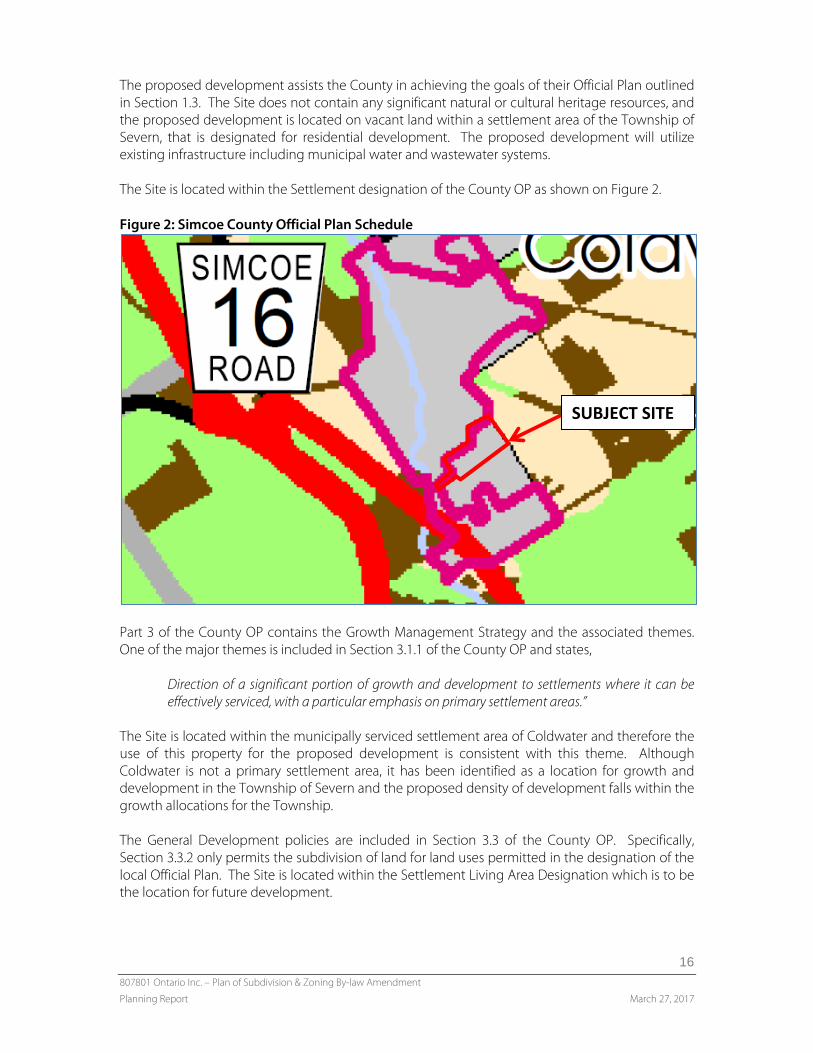
The proposed development assists the County in achieving the goals of their Official Plan outlined in Section 1.3. The Site does not contain any significant natural or cultural heritage resources, and the proposed development is located on vacant land within a settlement area of the Township of Severn, that is designated for residential development. The proposed development will utilize existing infrastructure including municipal water and wastewater systems. The Site is located within the Settlement designation of the County OP as shown on Figure 2. Figure 2: Simcoe County Official Plan Schedule
Part 3 of the County OP contains the Growth Management Strategy and the associated themes. One of the major themes is included in Section 3.1.1 of the County OP and states,
Direction of a significant portion of growth and development to settlements where it can be effectively serviced, with a particular emphasis on primary settlement areas.”
The Site is located within the municipally serviced settlement area of Coldwater and therefore the use of this property for the proposed development is consistent with this theme. Although Coldwater is not a primary settlement area, it has been identified as a location for growth and development in the Township of Severn and the proposed density of development falls within the growth allocations for the Township. The General Development policies are included in Section 3.3 of the County OP. Specifically, Section 3.3.2 only permits the subdivision of land for land uses permitted in the designation of the local Official Plan. The Site is located within the Settlement Living Area Designation which is to be the location for future development.
SUBJECT SITE
807801 Ontario Inc. – Plan of Subdivision & Zoning By-law Amendment
Planning Report March 27, 2017
17
Section 3.3.15 includes the Natural Heritage policies of the County OP. These policies protect natural heritage features including but not limited to wetlands. An EIS was completed on the Site and concluded there were no natural heritage features present. The County OP contains policies regarding stormwater management in Section 3.3.19. There are two stormwater management ponds proposed, and as discussed in Section 6.4 of this Report, the stormwater ponds are designed to ensure stormwater quality and quantity of water complies with MOECC standards. The proposal is for residential uses and there are no anticipated impacts to groundwater. Section 3.5 of the County OP contains policies regarding Settlements. The Site is located within the Coldwater settlement area and in accordance with Section 3.5.7, settlement areas are to be the focus of growth within the Municipality. The Site is currently designated for residential development and the proposed development makes efficient use of lands within the settlement area. Section 3.5.14 of the County OP includes policies regarding the Phasing of Development. The Site is located within the Designated Greenfield Area of the Coldwater settlement area and is located immediately adjacent to the built-up area. The existing residential subdivision to the west is located within the built-up area of the settlement area, and the proposed development occurs in a continuous manner from the existing development. The development lands represent a logical extension to the existing built-up area. The County OP outlines a minimum density target for Designated Greenfield Areas in the Township. The minimum density target is 32 residents and jobs per hectare. The proposed development (excluding the future development blocks) has a forecasted density of 34 persons per hectare based on a build out of 76 single detached dwellings and 56 townhouses. Section 3.5.29 of the County OP recognizes that development of Greenfield areas may be higher than existing development, but should be compatible with adjacent residential uses. The proposed subdivision provides for single detached dwellings adjacent to the existing low density residential development on Gill Street. Section 3.5.30 requires that development in settlement areas contain a range of housing types, and a mix of affordable housing. The proposed development contains both single detached dwellings and townhouse dwellings with the opportunity for apartments to be constructed on the future development blocks. Section 4.3 of the County OP contains policies that promote the development of affordable housing. Based on the definition of affordable housing contained in the County OP, it is anticipated that all of the townhouse dwelling units will qualify as affordable housing. The proposed single detached dwellings may also qualify as affordable. The Resource Conservation policies are included in Section 4.5 of the County OP. The EIS prepared in support of the development proposal indicated that the proposed development of the site can proceed in accordance with provincial and federal regulations and will be consistent with the PPS and conform to the Growth Plan, County OP and Township OP. Section 4.6 of the County OP contains policies pertaining to Cultural Heritage Conservation. In accordance with the Study prepared by Amick Archelogy Consultants, there are no archaeological
807801 Ontario Inc. – Plan of Subdivision & Zoning By-law Amendment
Planning Report March 27, 2017
18
features on the property. The proposed development will be consistent with the PPS and conform to the Growth Plan, County OP and Township OP. Section 4.7 provides the Infrastructure policies of the County OP. The Site is located within a settlement area and is proposed to be serviced with full municipal water services and municipal sewage services, which is promoted by the County OP. The Functional Servicing Report is discussed in Section 6.4 of this Report and identifies where the existing services exist and how they will be extended to the proposed development. The proposed development conforms to the servicing policies of the County OP. Section 4.8 of the County OP contains policies related to Transportation. These policies are generally County and community-wide policies. The proposed development includes two accesses, one from Coldwater Road to the west and another from Gill Street. The proposed roads on the Site represent a logical extension to municipal roads to provide efficient traffic movements for the Site. Additionally, the Uhthoff Trans Canada Trail is located north-east of the Site and the downtown area of Coldwater is located within walking distance. A walkway is proposed in the proposed development to provide residents with direct pedestrian access to the Coldwater Fairgrounds. Sidewalks will also be provided on the internal roads within the subdivision. Based on the above review, the proposed development conforms to the County OP.
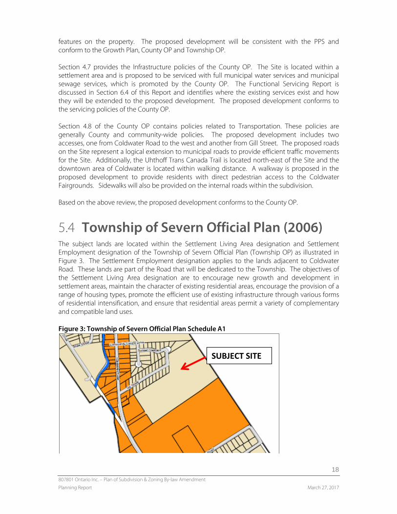
5.4 Township of Severn Official Plan (2006) The subject lands are located within the Settlement Living Area designation and Settlement Employment designation of the Township of Severn Official Plan (Township OP) as illustrated in Figure 3. The Settlement Employment designation applies to the lands adjacent to Coldwater Road. These lands are part of the Road that will be dedicated to the Township. The objectives of the Settlement Living Area designation are to encourage new growth and development in settlement areas, maintain the character of existing residential areas, encourage the provision of a range of housing types, promote the efficient use of existing infrastructure through various forms of residential intensification, and ensure that residential areas permit a variety of complementary and compatible land uses. Figure 3: Township of Severn Official Plan Schedule A1
SUBJECT SITE
807801 Ontario Inc. – Plan of Subdivision & Zoning By-law Amendment
Planning Report March 27, 2017
19
Single-detached dwellings, townhouses and other multi-unit residential development are permitted uses within the Settlement Living Area designation. Section C2.3.1 of the Township OP contains density and height policies for development within the Settlement Living Area. Section C2.3.1 states, The maximum permitted density for low-density development shall not exceed 20 units per
residential hectare in the full serviced Settlement Areas as described in Section F to this Plan. Section C2.3.7 of the Township OP contains policies that apply to medium density development. The main permitted medium density uses in the Settlement Living Area designation are included in Section C2.3.7.1 and street or block townhouse dwellings are included. Section C2.3.7.2 states,
New medium density residential areas shall be established by way of Amendment to the Zoning By-law in accordance with Section C2.3.7.3 and shall not exceed 37 units per residential hectare in the fully serviced Settlement Areas as described in Section F to this Plan.
The calculation for density for the site in this Section of the Report does not include the roads, only the residential lots and blocks.
• The density of single detached dwellings is – 16.6 units per hectare. • The density of townhouses based on 56 townhouses is – 24.7 units per hectare. • The density of townhouses based 70 townhouses is – 30.8 units per hectare
Both the low and medium density development that is proposed for the site would conform to the density policies of the Official Plan. Section C2.3.7.3 of the Official Plan contains criteria for medium density uses, and states,
In considering the development of new medium density residential development by way of Amendment to the Zoning By-law, Council shall be satisfied that the proposal:
a) is located on and has direct access to a collector or arterial road unless it can be
demonstrated to the satisfaction of the township to an alternative road frontage and access is appropriate and acceptable;
b) respects the character of adjacent residential neighbourhoods, in terms of height, bulk and massing;
c) can be easily integrated with surrounding land uses; d) will not cause traffic hazards or an unacceptable level of congestion on surrounding
roads; e) is located in close proximity to community facilities, such as parks, schools and open
spaces; f) is located on a site that has adequate land area to incorporate the required parking,
recreational facilities, landscaping and buffering on-site; and, g) can be serviced by municipal water and wastewater services.
The proposed townhouse units conform to the medium density policies as the proposed development:
807801 Ontario Inc. – Plan of Subdivision & Zoning By-law Amendment
Planning Report March 27, 2017
20
• The proposal is a new development and not a redevelopment site. The Site is accessed from Coldwater Road (collector road) by a new local road with a 20 metres right-of-way and through the existing subdivision to the west. In accordance with the Functional Servicing Report, the roads can accommodate the proposed uses.
• Is compatible with other development in the area. The townhouses in the subdivision are separated from the existing single detached dwellings on Gill Street.
• Will not cause traffic hazards or an unacceptable level of congestion on surrounding roads as confirmed by the Functional Servicing Report.
• Is located in proximity to amenities of the community, including the downtown, Fairgrounds, and schools.
• Is located on lands designated for residential development and can be appropriately designed based on the standards of the implementing Zoning By-law.
• Is serviced by municipal water and wastewater services. • Has a proposed density of 24.7-30.8 which is less than the maximum permitted density of
37 units per residential hectare. It is the intent of the Official Plan to encourage the development of a full range of housing types, tenures and costs throughout the Township. Section C2.3.10 of the Official Plan states that the optimum balance of housing in the Township is established between 80% to 90% for low density, and 10% to 20% for medium density. The townhouses proposed by this development will increase the supply of medium density housing and will assist the Township in achieving the medium density targets of the Official Plan. The two additional Blocks (Blocks 91 and 92) are reserved for future development. It is anticipated that these Blocks will be used for a medium or higher density form of development. By utilizing a holding provision in the implementing Zoning By-law Amendment, development of these Blocks will only be permitted following completion of Site Plan Control Agreement. The two Blocks also conform to the criteria for medium density uses in the Township OP. If a greater density than 37 units per residential hectare is contemplated for these Blocks, a subsequent Zoning By-law Amendment application would be required. Section B8.3 of the Official Plan contains subdivision development policies. "Prior to the consideration of an application for Plan of Subdivision, Council shall be satisfied
that:
a) the approval of the development is not premature and is in the public interest; b) the lands will be appropriately serviced with infrastructure, schools, parkland and open
space, community facilities and other amenities; c) the density for the development is appropriate for the area; d) the subdivision, when developed will be easily integrated with other developments in
the area; e) the subdivision conforms to the environmental protection and management policies
of this plan; and, f) the proposal conforms to Section 51 (24) of the Planning Act, as amended."
The proposed development is in conformity with these subdivision development policies. It is our opinion that the proposed development:
807801 Ontario Inc. – Plan of Subdivision & Zoning By-law Amendment
Planning Report March 27, 2017
21
• is in the public interest; • improves the efficiency of infrastructure that is in place; • has an appropriate density; • can be easily integrated into the area: • conforms to the environmental protection policies of the Official Plan; and, • conforms to Section 51(24) of the Planning Act as identified in Section 4 of this Report.
The Township recently approved policies in its Official Plan related to Source Protection that implement the South Georgian Bay Lake Simcoe Source Protection Plan. The Site is located close to the Coldwater Well Supply, and therefore located partially within the Wellhead Protection Area B. The Site is also located in an Issues Contributing Area where an existing threat to water has been identified. The proposed development will not have a negative effect on drinking water, and the proposed residential use will not cause a significant threat to the Township’s drinking water. There are two stormwater management ponds located on the Site and as discussed in Section 6.4 of this Report, the stormwater ponds are designed in accordance with MOECC requirements for water quality and quantity. The proposals are for residential uses and there are no anticipated impacts to groundwater. The proposed Draft Plan of Subdivision and Zoning By-law Amendment conform to the Township of Severn Official Plan and implement the Official Plan by providing a mix of housing styles within an area that is designated for residential development.
5.5 Township of Severn Zoning By-law (2010-65)
The Site is currently zoned Residential Type One (R1) by Schedule D-1 of Zoning By-law 2010-65, as illustrated in Figure 4. In addition to the R1 Zoning, the Site is also partially located within Flood Proofing Area 2 as detailed in brown on Figure 5. The flood proofing requirements for Flood Proofing Area 2 restrict minimum opening elevations from being below the elevation of 180.8 metres Canadian Geodetic data. Specifics related to site grading is found in the Functional Servicing Report The Zoning By-law Amendment application proposes to rezone the townhouse Blocks, Blocks 77 to 84, to the Residential Multiple One (RM1) Zone. Townhouse dwellings are not permitted within the R1 Zone, therefore a rezoning to the RM1 Zone is required to permit the townhouse dwellings. Furthermore, Blocks 1 to 76 are to be rezoned to the Residential Type One Exception (R1-XX) Zone to permit a reduction to the minimum required lot area. The minimum required lot area for the R1 Zone is 600 square metres and selected detached lots do not meet this minimum requirement.

807801 Ontario Inc. – Plan of Subdivision & Zoning By-law Amendment
Planning Report March 27, 2017
22
Figure 4: Township of Severn Zoning By-law
Figure 5: Coldwater Flood Proofing Map
Table 1 provides a breakdown of the proposed lot requirements in the Zoning By-law for the R1 Zone compared to the minimum lot sizes in the proposed development. Table 1: R1 Zone Requirements Zone Provision R1 Standard (Minimum) Proposed (Minimum) Lot Area 600 square metres 450 square metres Lot Frontage 14 metres 15 metres Table 2 provides a breakdown of the proposed lot requirements in the Zoning By-law for the RM1 Zone compared to the minimum lot sizes in the proposed development.
SUBJECT SITE
SUBJECT SITE
807801 Ontario Inc. – Plan of Subdivision & Zoning By-law Amendment
Planning Report March 27, 2017
23
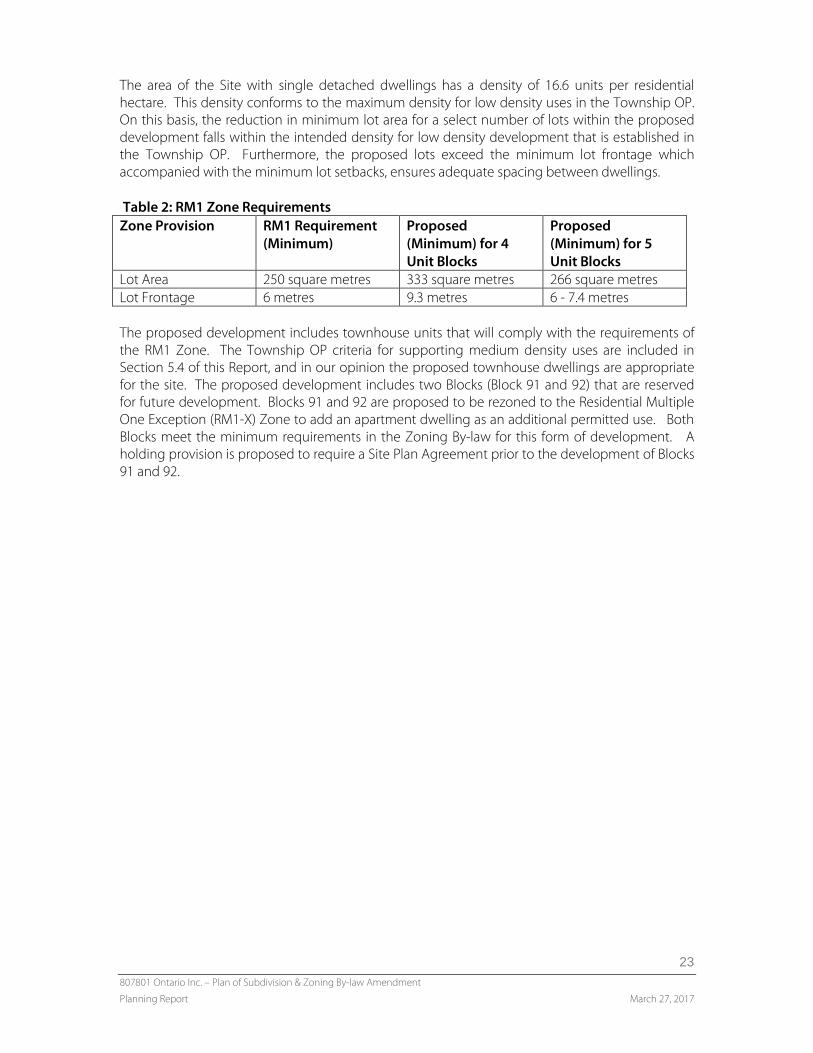
The area of the Site with single detached dwellings has a density of 16.6 units per residential hectare. This density conforms to the maximum density for low density uses in the Township OP. On this basis, the reduction in minimum lot area for a select number of lots within the proposed development falls within the intended density for low density development that is established in the Township OP. Furthermore, the proposed lots exceed the minimum lot frontage which accompanied with the minimum lot setbacks, ensures adequate spacing between dwellings. Table 2: RM1 Zone Requirements Zone Provision RM1 Requirement
(Minimum) Proposed (Minimum) for 4 Unit Blocks
Proposed (Minimum) for 5 Unit Blocks
Lot Area 250 square metres 333 square metres 266 square metres Lot Frontage 6 metres 9.3 metres 6 - 7.4 metres The proposed development includes townhouse units that will comply with the requirements of the RM1 Zone. The Township OP criteria for supporting medium density uses are included in Section 5.4 of this Report, and in our opinion the proposed townhouse dwellings are appropriate for the site. The proposed development includes two Blocks (Block 91 and 92) that are reserved for future development. Blocks 91 and 92 are proposed to be rezoned to the Residential Multiple One Exception (RM1-X) Zone to add an apartment dwelling as an additional permitted use. Both Blocks meet the minimum requirements in the Zoning By-law for this form of development. A holding provision is proposed to require a Site Plan Agreement prior to the development of Blocks 91 and 92.
807801 Ontario Inc. – Plan of Subdivision & Zoning By-law Amendment
Planning Report March 27, 2017
24
6.0 SUPPORTING STUDIES The following studies were undertaken to support the application for Plan of Subdivision and the application for Zoning By-law Amendment.
6.1 Archaeological Report A Stage 1-2 Archaeological Assessment was conducted by AMICK Consultants Limited. The fieldwork began in May 2009, with test-pit surveying conducted in June 2009 for the woodland located in the southern portion of the Site. As a result of this work, no archaeological resources were encountered on the Site and no further testing is required. The key findings of the Report are summarized as follows:
• No archaeological resources were encountered;
• No archaeological sites relating to First Nations or Euro- Canadian habitation/activity had been formally documented;
• Environmental and historical factors suggest that there is high potential for archaeological resources of Native origin and medium potential for archaeological resources of Euro-Canadian origins that are not documented;
• No further archaeological fieldwork required.
Based on review of the Archaeological Report, the Site does not contain any known archaeological resources and does not require any additional archaeological work.
6.2 Geotechnical Report Jacques Whitford Limited completed a geotechnical investigation on the Site with fieldwork through May and June 2008. The scope of work was developed in conjunction with C.C. Tatham and Associates Limited. Eight (8) boreholes were established on May 31, 2008 to conduct soil sampling and install standpipes. Groundwater levels were measured upon the completion of borehole drilling and later through the standpipes on June 16, 2008. The boreholes determined that the soil stratigraphy was made up of top soil or sand and gravel fill at the ground surface, followed by finer organic materials, and fine to medium coarse sand below. Groundwater was encountered in all boreholes, with the exception of the second borehole, at depths varying between one (1) and four (4) metres. There is consistent evidence showing that the groundwater depth was shallower when measured through the standpipes at a later date, between zero (0) and one (1) metre. Overall, the groundwater is at a shallow depth in the majority of the boreholes.
Based on the observations made through the fieldwork, the following is recommended by the Geotechnical Report:
807801 Ontario Inc. – Plan of Subdivision & Zoning By-law Amendment
Planning Report March 27, 2017
25
• To facilitate construction, surficial vegetation, topsoil, and sand and gravel fill should be removed;
• Organic clayey silt soil found in boreholes one (1) and seven (7) should be sub-excavated and removed through the earthworks program;
• Where silty clay soil is found a pre-load/surcharge program should be implemented to mitigate potential settlements;
• Foundations for the proposed residential dwellings can consist of conventional spread and strip footings, compacted fill, or pre-loaded/surcharge silty clay soil; and,
• Excavation below the groundwater level will require temporary dewatering.
The following steps are recommended to prepare the Site for development:
• Stripping: should involve removal of all ground surface cover at varying depths based on the material present across the Site;
• Cut and Fill Earthworks: will be implemented for the roads to design grades and elevations consistent with the proposed development using existing and imported material;
• Reuse of Materials: The sand soils, along with soils that have low moisture content are suitable for reuse on the Site to stabilize or fill. The soils that have a higher moisture content may be used if dried or mixed with another material;
• Foundations: Conventional strip footings are preferred for the foundations of the residential dwellings. Varying degrees of “Serviceability or Ultimate Limits State” are provided based on the underlying material of the foundations;
• Floor Slabs: Conventional slab-on-grade floor slabs are satisfactory for the proposed development with moisture break installed beneath. All dwellings that have basements must include a perimeter drainage system with a positive, frost free discharge;
• Stormwater Management Facility: is to be located in the northwest portion of the Site, separating the proposed development from the adjacent grocery store. It is recommended that the pond be established at a higher elevation, requiring the placement of engineered fill after the stripping and removal of existing silty sand and organic clayey silt;
• Excavations: required for the site servicing construction may extend below the groundwater level with the likelihood of requiring a limited dewatering program. A Permit to Take Water may be required for the installation of the underground services;
• Backfill: Pipe bedding and granular bedding material may be used on the Site. Backfill should be placed in 200 to 300 mm thick loose lifts to a minimum of 98 to 100% of materials based on depth and material; and,
• Pavement Design: Pavement shall be constructed over the compacted native silty clay and graded to direct runoff water away from the roadway and associated infrastructure. Sub-drains will be used under the pavement.
807801 Ontario Inc. – Plan of Subdivision & Zoning By-law Amendment
Planning Report March 27, 2017
26
6.3 Environmental Report Azimuth Environmental Consulting Inc. completed a Preliminary Natural Heritage Analysis (November 2016) and a scoped Environmental Impact Study (December 2016), while Envision Tatham completed the Butternut Study (October 2016). The Preliminary Natural Heritage Analysis was completed to assess the potential presence of natural heritage features and recommend additional work where necessary to determine the significance of features. The information was obtained through a site visit conducted on November 10, 2016 and through a records search from the Township of Severn (the Township), County of Simcoe (the County), and Ministry of Natural Resources and Forestry (MNRF). The Township has not identified any natural heritage areas on the property. The southern portion of the Site consists of a woodland that is approximately 3.5 hectares and extends beyond the boundary to encompass a total area of 19 hectares. Based on the results of the Preliminary Natural Heritage Analysis, additional review is required. The Scoped Environmental Impact Study was performed after the Preliminary Natural Heritage Analysis to support the findings made and further determine the status of the natural heritage features located on the Site with particular attention to the woodlands potential to act as a habitat for endangered bat species. The assessment of the woodland was synchronized with the preliminary analysis in determining that it is not significant and is not likely to be considered a constraint to the Proposed Development. Removal of the woodland is not expected to have negative ecological impacts. Further to the recommendations of the Preliminary Analysis, this Report analyzed the density of snag trees within the woodland and determined that the snag tree occurrence is less than the threshold of ten (10) trees per hectare. Therefore, the proposed development is not expected to have a negative ecological impacts on the endangered bat species. Subsequent to this Study, Township Council provided permission to remove the trees from the site in accordance with the recommendations of Azimuth Environmental. The Butternut Study was completed to determine if any Butternut species were located on the Site as they are endangered and may not be removed without permission from the MNRF. The fieldwork was conducted on October 18, 2016 and determined that no Butternut Trees were observed. A Final EIS was competed in March of 2017, this Study concluded:
• There is no expectation that the proposed development would result in negative ecological impact, provided that the recommended mitigation measures are implemented.
• Wildlife in the area will continue to utilize the natural habitat in the area.
• No contraventions of the Endangered Species Act are expected to occur as a result of the proposed development. The proposed development is consistent with the policies the Provincial Policy Statement, 2014, and the regulations set out within Ontario’s Endangered Species Act, 2007.

807801 Ontario Inc. – Plan of Subdivision & Zoning By-law Amendment
Planning Report March 27, 2017
27
6.4 Functional Servicing Report C. C. Tatham & Associates Ltd., completed a Functional Servicing Report (March 21, 2017) to review how the Site and proposed development would be serviced. Details regarding traffic, water distribution, sanitary sewers, stormwater management (SWM), floodplain protection, utilities, and erosion and sediment control are discussed in the Report. The Traffic Assessment was based on the maximum unit count, being 76 single detached units and 70 townhouse units. For the purposes of the future development blocks, an additional 58 apartment units were provided for in the review. The proposed development is expected to generate 134 trips during the weekday AM peak hour and 167 trips during the weekday PM peak hour. These trips when distributed to the north and south on Coldwater Road will result in overall increase of approximately 30 to 70 vehicles per hour. Coldwater Road currently operates at 30% capacity or less during peak hours, and the additional traffic from the proposed development is expected to increase to 42% capacity or less. Considering the existing reserve capacity on Coldwater Road, no improvements are required to accommodate the projected volumes. The water supply for the proposed development will be provided by a watermain located within the road allowance. The initial phase of the proposed development will occur off of Gill Street and will connect to the 150 mm diameter watermain at this location. Following full build-out, the internal 150 mm watermain will be looped to the 200 mm watermain on Coldwater Road with a 200 mm watermain section extending to the intersection of Street ‘A’ and Street ‘B’. The maximum day flow for the proposed development will be approximately 494 m3 per day. Modelling was also completed to ensure that the minimum required fire flow of 38 L/s is attainable. The Township minimum watermain diameter of 150 mm will be adequate to provide the daily and emergency water supply demands within the proposed development, and with recent upgrades to the Village of Coldwater water supply system, it is anticipated that there is adequate water supply available. Sanitary services will be provided by connecting to the existing sanitary maintenance hole via the sanitary sewer stub located within an easement south of Gill Street and by extending the sewer in an east direction from the east end of Gill Street. All sewage will drain by gravity through the adjacent Gill Street subdivision to the sewage pumping station located on Community Centre Drive. A 200 mm diameter pipe at a minimum slope of 0.4% has a flow capacity of 20.7 L/s which is adequate to convey the flows on the Site which will be 14.08 L/s. It was also confirmed that the Coldwater Sewage Treatment Facility has adequate existing pump capacity. It was determined that the Site has no single defined outlet for surface water drainage. All surface water currently is conveyed as overland flow across the Site to outlet in a variety of different ways. Because Outlet #1 is known to have experienced flooding in the past, an analysis was conducted that determined that it has insufficient capacity to convey existing condition flows, and therefore does not represent an ideal outlet for significant flows from the proposed development. An alternate outlet option is proposed that would direct flow from the proposed development to the west through the road right-of-way adjacent to the Foodland property (Outlet #3) then to Coldwater Road. This will require improvements to the existing 500 mm diameter culvert crossing Coldwater Road to accommodate the additional flow that will need to be conveyed. It is also recommended that the culvert under Coldwater Road be designed to convey the 100-year flow at the detailed design stage.
807801 Ontario Inc. – Plan of Subdivision & Zoning By-law Amendment
Planning Report March 27, 2017
28
In order to manage minor storm runoff, storm sewers and catch basins will be designed as per Township standards to convey peak flows from the 5-year storm event underground. Major storm runoff will be conveyed via overland flow routes contained in the primary right-of-way, and will discharge overland to the SWM facilities. Flows to Outlet #1 will be minimized as much as possible by diverting flows to Outlet #2 and Outlet #3 to the controlled pre-development levels or less. The SWM facility has been designed in accordance with MOECC Guidelines for Enhanced Level water quality protection. Both quality and quantity control measures can be provided by the proposed SWM facility. Post-development peaks flows can be attenuated to pre-development rates while achieving Level ‘1’ protection for quality control. All utilities can provide adequate service to the proposed development and construction activities will be monitored to ensure proper siltation and erosion control measures are used.
7.0 SUMMARY & FINDINGS Based on a detailed review of all applicable Provincial, County and local policy, as well as considering the location of the Site, and surrounding land uses, it my professional opinion that the proposed Plan of Subdivision and Zoning By-law Amendment are in the public interest and represent good planning. Respectfully submitted,
MHBC Jamie Robinson, BES, MCIP, RPP Partner