Embed Size (px)
Citation preview
•
t
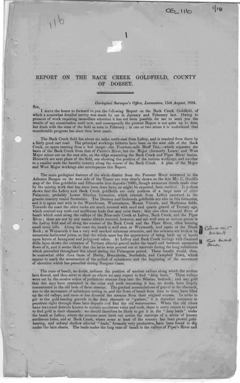
REPORT ON THE BACK OF
\
CREEK GOLDFIELD, DORSET.
COUNTY
SIR, Geological Su",~or's Office, Launcelton, 15t4 .-tugust, 1894.
I BA.VK tbe honor to forward to you the following Report on the Back Creek G"ldfield, of which a somewhat detailed survey was made by 1I1e in January and February last. Owing to p ...... ure of work requiring immediate attention it has not been possible for me to send you the results of my examination until now, and consequently the present Report i. not quite up to date, but deals with the .tate of the field as seen in February; in one or two mine. it is uuderstood that considerable progress has since then been made. '
The Back Creek field lies about six miles north.east from Lefroy, and is reached from there by a fairly good cart road. The principal workings hitherto have been on the we.t side of the Back Creek, on spurs TUnning from a low range-the Fourteen·mile Blull' '!'ier,-wbich separstes the basin of the Back Creek from that of ~urrie's River. but the Major (formerly Leura) and West Major mines are on the east side, on the ridge separating the Back Creek and Piper River basins. Herewith are sent plans of tbe field, one showing the position of tbe various workinw;. and anotber to a smaller ..,ale the basaltic country along the course of the Back Creek. A plan of the Major and West M",jor workings also accompanies this Report.
The main geological features of the whole district from the Forester River westward to the Asbestos Ranges on the west side of the Tamar are very clearly shown on the late Mr. C. Gould's map of the Den goldfields and Ilfracombe iron deposits (1866), though numeruus details made clear hy the mining work that has since been done have, as might be expected, been omitted. It is there shown tbat the Lefroy and Back Creek goldfields are only portions of a large area of older PalOlozoic, probably Lower Silurian furmation, which extends from Lefroy eastward to tbe granite country round Scottsdale. The Denison and Golconda goldfields are also in this form ation, and it is again met with in the Waterhouse, Warrentinna, Mount Victoria, and Mathinna fields. Towards the coast the older rO<'ks are much covered with sand and quartz gravel of Tertiary age, which conceal any reefs and auriferous leads that may exist there; they also often conceal flows of basalt which exist along the valleys of the Nine-mile Creek at Lerroy, Back Creek, and the Piper River; these are not by any meanA always covered, however, and are weU seen at various points in the Lefroy field and all along tbe courses of the Back Creek and the Piper River, often forming small stony hills. Along the coast the basalt is well seen at Weymouth, and again at the BlackD GJ)UM r,e...r' Rock; at Weymouth it has a very well marked columnar structure, and the columns are broken by :b 'l«-II numerous horizontal joints, SO that the whole mass has the appearance of being built up of layers D-
upon layers of hexagonal and ;'07\\ooal cakes. At Lefroy and Back Creek borings with diamond " --.... 0 ~c.Jl drills have shown the existence 0 fertiary alluvial gravel under the basalt and between successive ~ '""'" HOW8 of it, and it seems likely that the lavas were pOll red out at intervals during the long subsidence 0- ~ which prevailed throughout this island dQnnl( the PalOlogene period. These basalts would, then, be some"hat older than those of Derby, Branxholm, Scottsdale, and Campbell Town, which appear to mark the termination of the period of subsidence and the beginning of the movement of elevation whicb has prevailed during Neogene times.
The runs of basalt, no doubt, indicate the position of ancient valleys along which the molten lava flowed, and thus serve to show us where we may expect to find ., deep leads." These Talleys were cut by the erosive action of prehistoric streams deep into the Silurian bedrock; and any gold that this may have contained in the ,'eios and reefs traversing it has, no doubt. been largely concentrated in the old beds of these streams. The gradual accumulatiuns of gravel in the cbannels, due to the movement of subsidence setting in. and the flows of basalt from time to time, have filled op the old valleys, and more or less diverted the streams from their original COllrseS. In order to get to the gold.bearing gravels in the deep channels or "gutters," it is therefore necessary to penetrate right through these later deposits and find the old watercourses. When the old rivers have traversed districts known to contain auriferous veins and reefs, there is every reason to expect to find gold in their channels: we should therefore be likely to get it in the "deep leads" under the basalt at Leli-oy, where the .!reams must have cut across tbe outcrops of a series of known anriferous lodes, and at Back Creek, where some at least of the country has been proved gold. bearing, and seteral shallow alluvial "leads," formerly very productive, have been found to dip under the lava sheets. The leads nnder the long runs of basalt in tbe valleys of Piper's River and
Piper's Brook do not seem quite so promising for gold; for, except an alluvial deposit derived from the Leura reef, which falls towards the Piper, there have been no important discoveries of gold made along their courses; and the presumption is, according to present knowledge of the count7., that the region traversed by them is not richly auriferous. As the Silurian formation prevaIls throughout their basins, however, it is not at all unlikely that good reefs may yet be discovered in them, in which case these leads also would be worth attention from miners.
The run of basalt in the Back Creek Valley commences. almost at the head of the stream, being seen on the road from Lefroy to the Piper, near Batten's saw-lllill. In the Den Ranges, close to this point, gold has been foulld on both sides of the watershed between Back Creek and the Fourteen-mile Creek; and ri)(ht on the head of Back Creek, near tbe old Native Industry mine, there is a hill deeply covered on one slope with alluvial matter, in which some gold is obtainable. Between this point alld the Back Creek Goldfield proper 1 have not heard of allY quantity of gold being found, though the whole country seems very favourable. From Batten'. mill the basalt run follows the course of the creek pretty closely, passing through Horne's and Gille<pie's freeholds. A bout a mile north of Gillespie's, two narrow branch runs of basalt join the main one on opposite sides, no doubt indicating ancient branch creeks joinillg the principal stream. Still lower down we find ~everal other branche:s: one very wide run coming ill on tbe west side being that in which the diamond drill horings of 1882-83 were situated, and under whicb the "Old ~. or H Back Creek" and the" Cardigan" 1eads disappear: anothf>r smaller one further north being that which covers the contilluatious of the '" Red" and" White" leads, and which was bored thl'ough with No.2 Diamond Drill in 1889. On the eastside a branch is crossed by the road from Back Creek to the Piper, and andthel" \vider one heads from near the Major Mine. These two flows are somewhat different in character from those on the west side. in that the latter occl1py quite low ground, while these run fr011i the top of the watershed down the hill slopes to tlte bottom of the valley. It ~ems probable that the basalt is:Slled originally near the watershed, and that these two runs on the east side of Back Creek are simply lava fluws poured down the sides of the hills, in which case it would not necessarily happen that any alluvial matter would be covered by them. Under these, thel'efore, we cannot feel at ail certain whether we should find old watercourses likely to contain alluvial gold. From the point near the Major Mine, on the watershed whence, as just said, one of these runs commence., another flow of basalt can be traced towards the Piper River, and the alluvial gold found in some quantity in the Major Company's eastern section seems to become covered by this. As the run of basalt is quite narrow naar the watershed, with the Silurian strata visible on each side of it, I cannot agree with Mr. Thureau's opinion (Report on the Back Creek Goldfield, 1882) that this" would most probably constitute the outlet for the Back Creek ancient river, or diluvial gravel system." A very much wider outlet wouln be required for a valley so deep as the Back Creek one has been pl'o\'eo by boring tu have been. It is much more likely that the basalt has issued from a Inuall cone on tbe watershed and has poured down the slopes on each side towards tbe Back Creek and the Piper River. From this point northwards a ridge of Silurian strata can be traced to the head of the estuary of the Piper River, making it clear that the ancient valleys of the Back Creek and Piper River could not have sooner joined one another. Not having examined the country on the east side of the Piper, I am unable to say with confidence where the old junction was, but from the information leceived fi-oUi resident!, it seems probable that the old Piper channel runs off'to the
•
eastward hom Hear the junction of the present stream with Yarrow Creek to join with Piper's .;-, Brook instead of Back Creek. In Mr. Gould's map the Piper basalt is shown as Joining tbe Back Creek run to the north west from the Yarrow Creek junction; but, a!>l above melltioned, there is an intervening ridge of the bed-rock'. On the plan herewith the position of the Back Creek basaltic run is shown as accurately as I can lay it down without actually surveying the boundaries, and it is pretty certain that it does not unite with the Piper basalt further south than the head of the estuary. l'he large!-.t area of basalt is ~en to be in the vicinity of Thos. Adams' 99-acre section, and from the "esicular nature of the stone there, and the shape of the ground, it seems rather likely that this was a central poiut of eruption. Opposite to this, on tbe west side of the creek, there is a brancu run of basalt for some di,tance up Paddy's Creek.
The Back Creek Goldfield was at one time one of the most important in the Colony, affording employment to some hundreds of men. Accurate returns of the gold obtained are not procurable, but, according to the best information I have been able to get, it may be estimated that some 9000 ounces of gold were taken from the alluvial workings on the several leads. 'l'he gold being of high finene$s, sold for 82 to 83 shillings an ounce as a rule. The dep()sit~, being shallow, were soon worked out, and the field has for many years past been almost deserted by alluvial miners, only a few working Oil it now and then, going over the old ground. Several companies, however, have done a. good deal of work from time to time endeavouring to discovel· reefs f!'om which the alluvial gold may have been derived. These will be dealt with later on, the allu vial deposits being first considered.
On the map of the field herewith the leads are shown iu their true positions, having been each traversed and surveyed. They are known as-(l) the White lead, (2) the Red or Albion lead, (3) the Old or Back Creek lead, and (4) the Cardigan or Prince of Wales lead. There is also a sUlall lead on the ridge between tbe Leura and Piper roads,
• •
'-~=-__________________________ ~ __ ~ __________ ~ __________ ~~--_____ '~ __ -J7'~"~ ____ __
I
•
\
The White Lead lies on the northern slope of a small spur running south-easterly from the Union Company's section. For as much as three chains in width in parts the ground is riddled with diggers' shafts, from 10 to 14 feet deep; from these the gravel was taken out and washed in boxes. The upper wash is mostly sandy clay with a go<ll!jeal of angular and sub-angular quartz . througb it; the lower gold-bearing layer seems also, from th~tones thrown out of tbe boxes, to have been largely made up of angular quartz. Tbe name of" White" lead is due to the fact that there was much white clay in this wash. The gold obtained was very angular, and often attached to quartz, so it does not appear to have come far from the original "matrix. At the boundary of Sections 628-87G amI 931-87G the lead is cut through by a small modern water-course, and has not been found any higher. It i~ noticeable that this water-course has cut a new channel in the bedrock parallel wit.h the old lead, and has not scoured out the old one, as might have been thought likely. At the east end of the lead the ground rapidly gets deeper, and basaltic clay and basalt begin to be met witb, and in the low-lying flat ground the continuation of the lead is deeply covered with lava flows.
The Red Lead gets its name from a reddish colour in the wash due to much oxide of iron. The gold in tbis also often had much oxide of iron attached to it. Like the White Lead it consists of a strip of clayey alluvial drift, lying for the most part on the northern slope of a low spur running soutb-easterly, but towards the eastern end it crosses the spur; it is generally from 2 to 3 chains wide, and has been worked by innumerable holes 10 to 15 feet deep. About half-way up it a small branch lead joins it from the head of the Old Lead; tbis looks to me like a more modern deposit consisting of material re-sluiced from the bead of the Old Lead. At the eastern end, like tbe other leads, this plunges under the basalt, and the bed must get very suddenly steeper, for we find that in the Grand Junction Company'. working shaft the slate bed-J"Ock was met with at about 15 feet, while 110 feet E.N.E. from it anotber shaft went down 80 feet without reaching bottom.
The Old Lead runs a more southerlv course tha.n the above-mentioned, and is a somewhat deeper and larger deposit; the upper poriion has been worked by shallow pils, but lower down a large open excavation has been sluiced out, and the ground is seen to be from 18 to 25 feet deep. The bottom is a softish slate; on tbis was found from three to seven feet of a layer of heavy well waterworn quartz boulders and waterworn lumps of slate and sandstone containing waterworn gold ~ on this again we find sand and clay in horizontal layers, succeeded by 3 to 6 feet of sandy drift with much angular quartz. Owing to want of fall for the tail-race it is only ill the upper part of the excavation that the gutter has been accessible; in the lower parts it dips rapidly unde .. foot under a false bottom made up of large lumps of waterworn slate and sandstolle with occasional quartz boulders, .11 set in sandy clay. A good deal of gold was got on this false bottom by the old Back Creek Company. In later years Mr. L. Schade has worked here a great deal, and ill tak ing up the old tramway he cut down through tbe false bottom at tbe top edge where it rests on the bed-rock and got a nice patch of gold on the latter, thus sbowing that the gold goes below the false bottom as well as over it. In the lower part of the excavation a shaft, known as 1t-Ioore's, was sunk 50 feet through the false bottom before reaching the slate bed-rock. "Colours" of gold are said to have been obtained through the false bottom and a little gold on the slate, but no driving was done. About 380 feet south of this, near the junction of the Lefroy and Piper roads, a shalt was sunk 100 feet; Mr. Thureau mentions this in his Report of 1882 on the district, and says: " A new shaft could not reach bottom whilst sinking on account of a heavy influx of water, but in the last five feet of gravel very good prospects of gold were obtained, and the following strata were passed through, viz :-c1ay, with heavy round gold; white and black slate, lying" flat; and th en the wash, furnishing good prospects of gold ill the pan ." As there is shallow ground to the east of this shaft it is clear that the lead mllst run southward into the basaltic flat ill which are the 1882-83 diamond-drill bores .
The Cardigan Lead is a very short one, right on the top of a small spur. The working., which have honeycombed tbe top of the spur, are quite shallow until we come near the Leti-oy road, where th~y rapidly become deeper, and begin to show layers of basa.ltic clay (volcanic ashes). The principal shalt was that of the Cardigan Company, which was 52 feet in depth, and reached sandstone bottom. The bottom was found to dip 1 in 2 to S. 300 E. The wash on the bottom was much cemented with oxide of iron, and cuntained a good many smooth sandstone boulders: it yielded about I dwt. of gold to the load, which was not payable. The gold is reported to hav~ been very shotty and rounded. On the east side of the road, opposite the end of the Cardigan spur, we find two shafts 30 and 34 feet deep, which came upon solid basalt, and were abandoned; and further north one 80 feet deep, bottomed on blue slate. In this tbere were about 12 feet of basaltic clay. Tbe wash contained round sandstone boulders, but I could get no information as to whether there had been any gold found.
In the Cardigan Lead, especially on the north side of it, there i. a great deal of hard quartz breccia, or rather angular conglomerate. often in heavy well-rounded blocks, some of them several tons in weight. They are very bard, but appear to me to be formed in situ, not mechanically transported, as they are composed of exactly similar material to the surrounding and often underlying loose wasb. A little of this conglomerate is seen at the edge of the deep ground at the
'l\\ 16
eastern end of the White Lead also, on the spur west of the 70-feet .haft shown on the plan; and it is also seen every here and there along the boundaries of the basaltic country. Mr. Thureau, in his report on the Goldfield in 1882, noticed this rock, and drew from it a conclusion which seems to me unwarranted, and which might be miSleading to anyone wishful of opening up the deep leads. He says :-" All these auriferous runs of diluvial gravels demonstrate an immense force of water running in swift torrents in self-eroded channels ill prehistoric times, as evidenced by the rounded and semi-angular boulders of a hard silicious breccia, one of which was found imbedded in a reddish clay, and which.measured 15 feet across by a thickness exceeding four feet, having evidentlr travelled over a considerable distance, as I could not discover auy similar rock in the district.' While agreeing with Mr. Tbureau in believing that the streams whicb laid down these gravels were much larger and more powerful in carrying stones than the existing watercourses, I do not think that there is. ~ny necessity to 3'1SUme tbe exil;Otence of rivers powerful enough to move such a huge rock as that quoted. Tbe explanation of the occurrence is well shown in a section
fat the west end of the beach at the mouth of the Piper River, where a sheet of this same conglomerate is seen lying between a weathered basalt stream and the Silurian rocks. It is evident that the conglomerate is a quartz gravel cemented together by silieious roatter,-the result being most prohably brought about by the hot water and steam from the lava flows. The occurrence of the conglomerate only along the edges of the basaltic areas seems to me to bear out this view. Tbe rounding of the boulders of conglomerate was probably due to a later water-action, perhaps during the erosion of the existing water-channels, which must be all much younger than the leads on the spurs.
While on the subject of the alluvial gold deposits of this district, mention may be made of two otber occurrences which have some .significance. Un the western edge of the basaltic country in the flat N .E. from Mr. W. L. Parrr.'s house there is some quartz wash containing" colours" of gold; and perhaps a quarter of a lIllie further north, in the same flat and on the same edge of the hasalt, a small shaft has been sunk in wash 10 feet to slate bottom, and in this a large speck of gold weighing 10 or 12 grains was found. From tWs it i. to he gathered that here too we bave auriferous gravels dipping under the basalt. The other case is that of the alluvial workings on the eastern block of the Major Company's ground. Here several sballow shafts have been sunk, and a good deal of gold has been obtained; but going northward the ground becomes deeper, and gets covered with basaltic clay and ha.alt. The gold her. seems evidently derived from tbe Leura or Major reef, and the fall is to the Piper River; but if the reef is shedding gold on tWs side' of the hill, it is also likely somewhere to yield gold to the Back Creek lead also, as it runs across the dividing ridge. Sbould it continue westward any distance, it must have been greatly broken away during the erosion of the Back Creek Valley. This case is probably not singular either, as there is a strong probability that the old lead running about north and south must have cut numerous reefs, as tbese in this district seem to have a somewhat east-and-west course.
As the shallow leads dip under the basalt it is plain that they must be older than it, and belong to the system of watercourses existing before the volcanic disturbances. Their peculiar position on the tops and slopes of spurs may be accounted for as follows :-When the streams that laid down the auriferous gravels were running the present leads were in the bottoms of their valleys; these, during the long period of sUDsidence which can be shown to have prevailed in Pal",ogene times in Northern Tasmania, became filled with drift deposits; later on the streams cut down again through these upper drifts, but not exactly in the old channels, and have now cut fresh beds in wbat were formerly tbe ,ides of the old valleys, leaving the old gravel deposits on the slopes and tops of the spurs.
The borin!,s made in 1882-83 and in 1889 with diamond drills gave very important information as to the deep ground in the Back Creek Valley. Tha positions of the bores of the first series are mark.d on the gold-field plan A I, A3, A4, A5, A6, and A7, and oftbe second series, BI, B2, B3, and B4, the figures being tbe progressive numbers of each set. Unfortunately, no record can be found of the relative positions of'the first lot of bores, and in assigning numbers to them I had to go by the information given to me by Mr. W. L. Parry, who has resided in the district for a long time. The positions of Nos. 1, 4, and 7 bores are pretty oortainly correct, but it is not cprtain if the right !lumbers have been assigned to Nos. 3, 5, and 6, ood no trace at all could be found of No.2 bore, though Messrs. Parry, Schade, and myself searched very thoroughly for it for half a day. The sites of the bores are easily recognisable by the pits sunk for water for the engine, piles of cores, and so all, but there is nothing to show the order in which they were put down, the posts left to mark them having beeu burned by ~ras. fires. The following sections are compiled from the foremen's weekly reports:-
-
. .
(
1-.
•
,
,
•
•
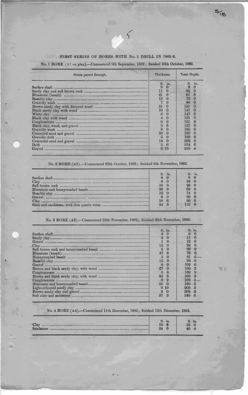
FIRST SERIES OF BORES WITH No.1 DRILL IN 1882--3.
No.1 BORE (A 1 on plan).-Commenced 9th September, 1882; finished 10th October, 1882.
Strata pti.ssed through. Thickness. Total Depth.
ft. in. ft. in. Surface shaft .......................................................................... . 9 0 9 0 Sand y clay and 60ft brown rock ................••........•.........•.............. Bluestone (basalt) .................................................................. . Basaltic clay ....•...•••.................................•.......... . ................... Gravelly wash ...................................................................... . Brown sandy clay with decayed wood .......•.•....•.•......................... Black sandy clay with wood .....................................•....••.....•.... White clay ........................................................................... . Black clay with wood .................... , ......................................... . Conglomerate ........................................................................ . Black clay, wood, and gravel ..................................................... . Gravelly wash ....................................................................... . Cemented sand and gravel ................................................ . ....... . Gravelly drift ........................................................................ . Cemented sand and gravel ................................... .................... .. Drift ................................................................................... .
11 0 2Q 0 41 0 61 0 12 0 73 0
7 0 80 0 61 0 lSI 0 10 0 141 0 6 0 147 0 4 0 1.'51 0 0 6 151 6 5 6 157 0 8 0 165 0
2i'i 0 190 0 ' 6 0 196 0 14 0 209 0 5 6 214 6
Gravel ....................... .............. . ........................................... . 310 218 4
No.2 BORE (A2).-Commenced 27th October, 1882; fini.hed 6th November, 1882.
ft. in. ft. in. Surface shaft ................................................................ ... ...... . 8 0 8 0 Clay .................................................................................. . Soft brown rock ........................................................... . ........ ..
8 0 16 0 10 0 26 0
Bluestone and honeycombed basalt ............................................... . Basaltic clay ........................................................................ .. Gravel' ................................................................................ .
36 0 62 0 12 0 74 0
6 0 80 0 Clay .................................................................................... . Slate and sandstone, with thin quartz veins ................................... ..
10 6 90 6 24 6 115 0
No.3 BORE (A3).-Commenced 18th November, 1882.; finished 29th November, 1882.
ft. in. ft. in. Surface shaft .......................................................................... . 8 0 8 0 Sandy clay ............................................................................. . Gravel ................................................................................ ..
3 0 11 0 1 0 12 0
Clay .................................................................................... . Soft bl'own rock and honeycombed basalt .................................... .. Bluestone (basalt) ........................................... . .............•........... Honeycombed basalt .............................................................. .. Basaltic clay .......................................................................... . Gravel ................................................................................. .
12 0 24 0 5 0 29 0
47 6 76 6 5 0 81 6-
15 0 96 6 6 0 10-2 6
Brown and black sandy cIay, with wood ....................................... . Conglomerate ........................................................................ . Brown and black sandy clay, with wood ...................................... .. Conglomerate ........................................................................ . Bluestone and honeycombed basalt ............................................... . Light-coloured sandy clay ... .... .................... . ............................. . Brown sandy clay and gravel ................................. ' ................... . Soft slate and sandstone .... , ........................... . ........................... .
27 9 130 3 0 6 130 9
36·6 166 3 3 2 169 5_
21 0 190 5 9 10 200 3 3 0 203 3
37 3 240 6
No.4 BORE (A4).-Commenced 11th December, 1882; finished 12th December, 1882.
Clay ................................................................................... . Sandlitone ........................................................................... ..
. .
ft. in. 16 /I 24 0
ft. ill. 16 0 40 0
'6&
•
~I
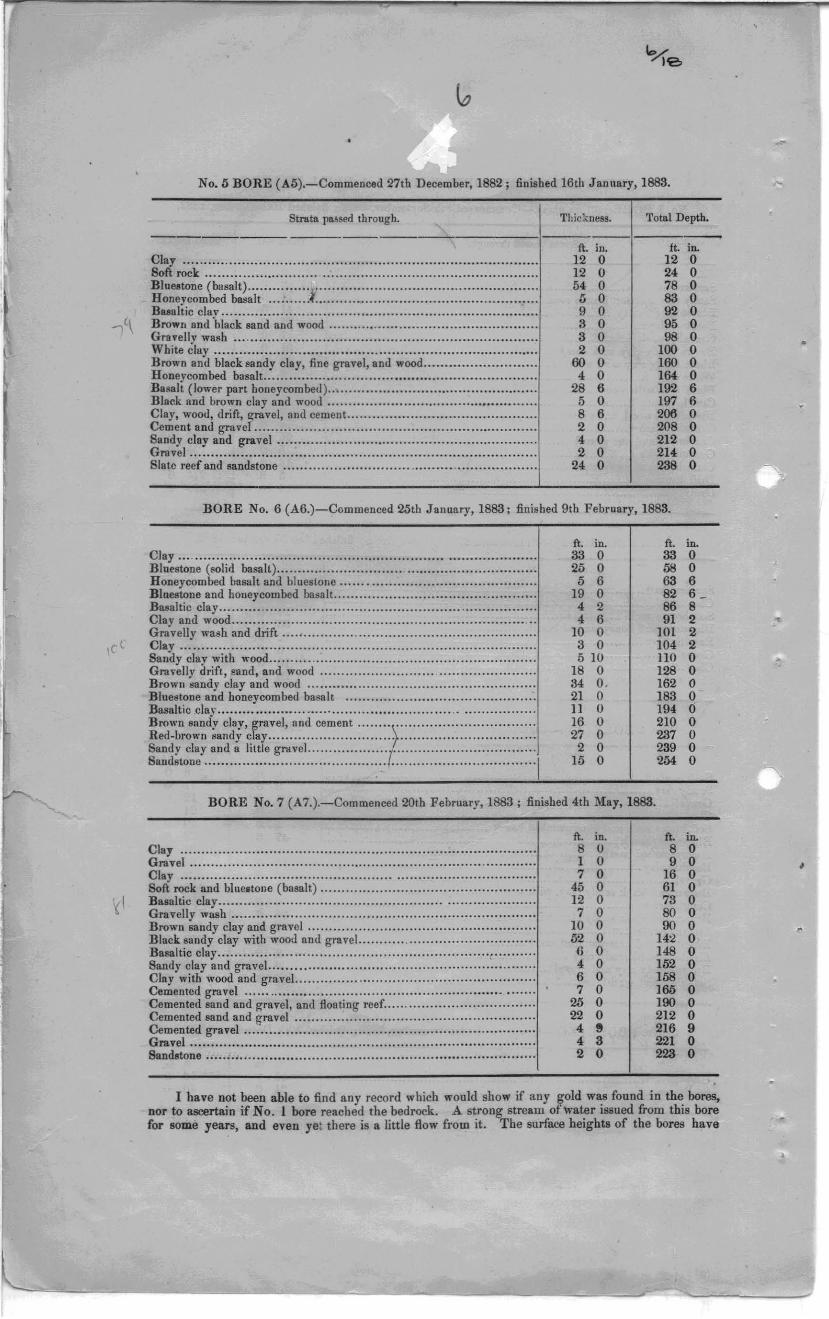
No.5 BORE (A5).-Commenced 27th December, 1882; finished 16th Jannary, 1883.
Strata passed through. Thickness. Total Depth.
, ft. in. ft. in.
Clay ............................................ . ...................................... . Soft rock ............................................................................ ..
12 0 12 0 12 0 24 0
Blue.tone (basalt) ............... r ................................................... . Honeycombed basalt .............................................................. . Baealtic cla,v ..................................•....•............................. , .. , .. Brown find black sand and wood ......•..•............... , ....................... .
54 0 78 0 I) 0 83 0 9 0 92 0 3 0 95 0
Gravelly wash ....................................................................... . Wbite clay ........................................................................... .. Brown and black sandy clay, fine gravel, and wood .......................... . Honeycombed basalt .. . ......... ....... ... .. .. ......... ............................. .
3 0 9S 0 2 0 100 0
60 0 160 0 4 0 164 0
B.salt (lower part honeycombeu ) ... ............................................. .. Black and brown clay and wood ................................................. . Clay, wood, drift, gravel, and cement. ........................................... . Cement and graver .................................................................. . Sandy clay and gravel ............................................................ .. Gravel ............................. ................................................. .. ..
28 6 192 6 5 0 197 6 8 6 206 0 2 0 208 0 4 0 212 0 2 0 214 0
Slate reef and sandstone .............................. ............................ . 24 0 23S 0
BORE No.6 (A6.)-Commenced 25tb January, 1883; finished 9th February, 1883.
ft. in. ft. in. Clay ... . .............................................................................. .. Bluestone (,olid basalt) ............................................................ . Honeycombed basalt and bluestone ............................ ................. . Bluestone and honeycombed baaalt. ...... ... ................... .............. .... . B .. altic clay .......... .................. .......................... ... ..... ............ . Clay and wood ..................................................................... . .. Gravelly wash and drift ........................................................... . Clay .................................................................................. ..
33 0 33 0 2.5 0 68 0 5 6 63 6
19 0 82 6 _ 4 2 86 8 4 6 91 2
10 0 JOl 2 3 0 104 2
Saudy clay with wood .............................................................. . Gra\'elly drift, p.aud, and wood ................................................. . Brown sandy clay and wood ..................................................... . Bluest.one and honeycombed basalt ........................................... .. Basaltic clay ....................................................... .................. . Brown sandy clay, gravel, and cement ....... ( .......... ...... ................ . Red-brown .andy clay ............................................................ .. Sandy clay and a little gl"'dvel ................... . ................................ .. Sandstone ................................. ........ .......... ....................... "'1
5 10 no 0 18 0 128 0 34 O. 162 0 21 0 183 0 II 0 194 0 16 0 210 0 27 0 237 0 2 0 239 0
15 0 2M 0
BORE No.7 (A7.).-Commenced 20tb February, 1883 ; finished 4th May, 1883.
ft. in. ft. in. Clay ................................ . .................................................. . Gravel ................................................................................ ..
8 0 8 0 1 0 9 0
Clay ................................................................................. .. Soft rock and blueatone (basalt) .................................................. . Basaltic clay ......................................................................... . Gravelly wash ........................ ........................................ ....... . Brown sandy clay and gravel ..................................................... . Black sandy clay with wood and gravel. .......... . ............................ .. Basaltic clay .......................................................................... . Sandy clay and gravel. ..................................... . ....................... . Clay with wood and graveL ....................................................... . Cemented gravel ..................... ......... ............................. h . ...... .
Cemented sand and gravel, and floating reef .................................. .. Cemented sand and I!ravel ....................................................... ..
7 0 16 0 45 0 61 0 12 0 73 0 7 0 80 0
10 0 90 0 52 0 142 0 6 0 148 0 4 0 162 0 6 0 168 0 7 0 J65 0
25 0 190 0 22 0 212 0
ge:v:l~~.~~~~.~~.:·.::::::::::::::::::::::::::::::::::::::::::::::::::::::::::::::::::: 4 8 216 9 4 3 221 0
Sandstone .................•••••.•....•.........................••.••.........•......... 2 0 223 0
I have not been able to find any record which would show if any gold was found in the bores, nor to asoortain if No. I bore reached the bedrock. A strong stream oflvater issued from this bore for 80me years, and even yet tbere is a little How from it. The surface heights of the bores have
•
•
c
II
1
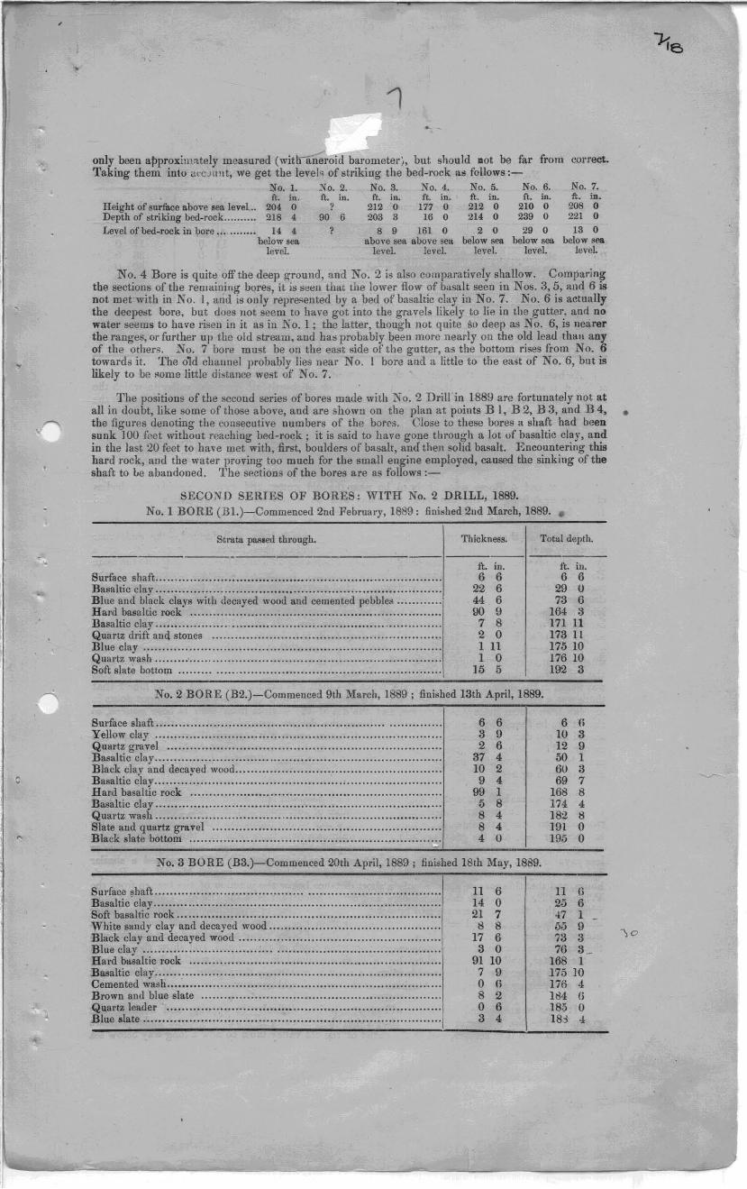
only been approxim;ttely measured (witnaneroid barometer), but should aot be far from Taking them into tH'C.JIIlIt, we g~t the level'! of striking the bed-rock as follows:-
correct.
No.1. No.2. No.8. No.4. No.5. No.6. ft. in. ft. in. ft. in. ft. in. ft. in. n. in.
Height of surface a.bove sea level... 204 0 ? 212 0 177 0 212 0 210 0 Depth of .striking bed-rock.......... 218 4 90 6 203 3 16 0 214 0 239 0 Level of bed-rock in bore ... ........ 14 4 ? 8 9 161 0 2 0 29 0
below sea. above sea a.bove selt below sea below sea level. level. level. level. level.
No.7. ft. in.
20B 0 221 0
13 0 below toea
leveL
No.4 Bore is quite offtbe deep ground, and No.2 is also comparatively shallow. Comparing the sections of the remaining bores, it is seen that the lower flow of basalt seen in Nos. 3,5, and 6 is not met with in No. I, and is only represented by a bed of basaltic clay in No.7. No.6 is actually the deepest bore, but does not seem to have got into the gr<wels likely to lie in the gutter, ann no water seems to have risen in it as in No.1; the latter, though not quite Sl} deep as No.6, is nearer the ranges, or further up the old stream, and has probably beeu more nearly on the old lead than any of the others. No.7 bore must be on the east side of the gutter, as the bottom rises from No.6 towards it. The o1d channel probably lies ne .. · No. I bore and a little to the east of No.6, but is likely to be "orne little distance west of' No.7.
The positions of the second series of bores maue with K o. 2 Drill in 1889 are fortunately not at all in doubt, like some of those above, and are shown on the plan at points B I, B 2, B 3, and B 4, • the figures denoting the consecutive numbers of the bores. Close to these bores a shaft had been sunk 100 feet without reaching bed-rock; it is said to have gone through a lot of basaltic clay, and in the last 20 feet to have met with, first, boulders of basalt, and then solid basalt. Encountering this hard Tock, and the water proving too much for the small engine employed, caused the sinking of tbe shaft to Le abandoned. The sp.ctions of the bores are as follows :-
SECOND SERIES OF BORES: WITH No.2 DRILL, 1889. No. I BORE (Bl.)-Commenced 2nd February, 1889: finished 2nd March, 1889 . •
Strata pas.ed through. Thickness. Totlll depth.
Surface shaft .......................................................................... . Basaltic clay .......................................................................... . Blue and black clays with decayed wood and cemented pebbles ........... . Hal'd basaltic rock ................................................................. . Basaltic clay .......................................................................... . Quartz drift and stones .......................................................... .. Blue clay ........................................ ,. ......... ,. ........................ . Quartz wash .................................................................. . ....... . Soft slate bottom ................................................................... .
1t. in. 6 6
22 6 44 6 90 9 7 8 2 0 III 1 0
15 5
No.2 BORE (B2.)-Commenced 9th March, 1889 ; finished 13th April, 1889.
Surface shaft ................................. .. ...................................... . 6 6 Yellow clay ..................... ,. ............... ., .................................. . Quartz gravel ....................................................................... . Basaltic clay .............................. " .......................................... . Black clay and decayed wood ..................................................... .
3 9 2 6
37 4 10 2
Basaltic clay ..................................................... . .................... . 9 4 Hard basaltic rock ................................................................. . 99 1 Basaltic clay ........................... ............................................... . 5 8 Quartz ,vash .......................................................................... . 8 4 Slate aud quartz gravel ........................................................... . Black slate bottom ................................................................. .
8 4 4 U
= No.3 BORE (B3.)-Comrnenced 20th April, 1889 ; finished 18th May, 1889.
Surface :;;haft ......................................................................... . 11 6 Basaltic clay .......................................................................... . 14 0 Soft basaltic rock ................................................................... .. 21 7 White sandy clay and decayed wood ........................................... .. Black clay and decayed wood ......................................... ., ......... .
8 8 17 6
Blue clay ........................................................ ., ................. .. 3 0 Hard basaltic rock ................................................................ .. 9l 10 Basaltic clay ............................... , .......................................... . 7 9 Cemented wash .................. ..................................................... . 0 H Brown and blue slate .............................................................. . 8 2
~~~rt~~::~~.~ .. ::::::::: :::: :.:::::::::: :::::::::::: :::::: ::: ::::::: :::::::::::::: :::::: 0 6 3 4
ft. in. 6 6
29 U 73 G
164 3 171 11 173 11 17510 176 10 192 3
6 (i
!O 3 12 9 50 1 6U 3 69 7
168 8 174 4 182 8 191 0 195 0
11 (l
25 6 47 1 55 9 73 3 76 3 _
168 1 175 10 176 4 184 r; 185 0 183 4
)0
I fl
I
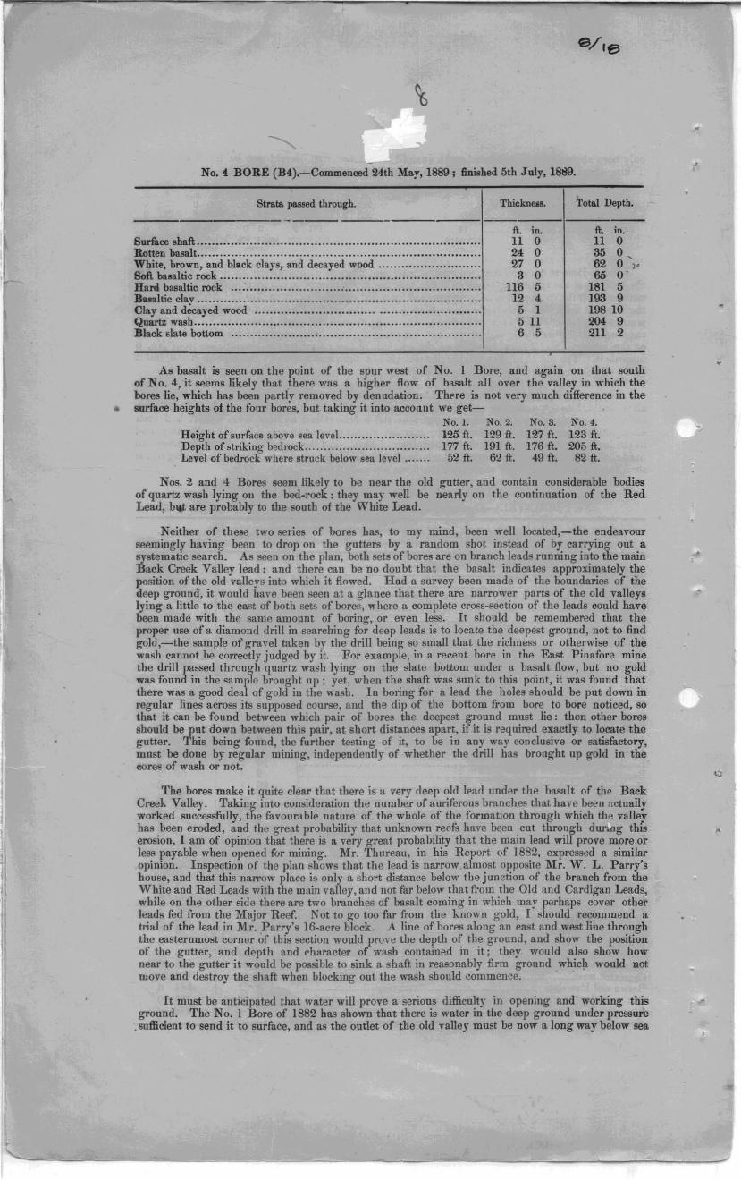
No .• BORE (B4).-Commenced 24th May, 1889; finished 5th July, 1889.
Strata JlO8sed through.
8urfuce shaft ............ .............................................................. . Rotten basalt .......................................................................... . White, brown, and bla.ck clays, and decayed wood ......................... .. Soft basaltic rock .................................................................... . Hard basaltic rock ................................................................. . Basaltic clay .......................................................................... . Clay and decayed wood .......................................................... . Quartz wash ....................••...........................•.......................... Black ,late bottom ................................................................. .
Thickn ....
ft. in. 11 0 24 0 Z7 0 3 0
116 :; 12 4 5 1 511 6 5
Total Depth.
ft. in. 11 0 35 0 , 62 0 ,. 60 O·
181 5 193 9 19810 2049 211 2
As basalt is seen on the point of the spur west of No. I Bore, and again on that south of No. 4, it ,",ems likely that there was a higher flow of basalt all over the valley in whicb the bores lie, which has been partly removed by denudation. There is not very much difference in the
• surface heights of the four bores, but taking it into account we get-No.1. No.2. No.8. No.4.
Height of surface above sea level........................ 125 ft. 129 ft. 127 ft. 123 ft. Depth of striking bedrock................................. 177 ft. 191 ft. 176 ft. 205 ft. Level of bedrock where struck below sea level....... 52 ft. 62 ft. 49 ft. 82 ft.
Nos. 2 and 4 Bores seem likely to be near the old gutter, and contain considerable bodies of quartz wash lying 011 the bed-rock: they may well be nearly on the continuation of the Red Lead, bltt are prohably to the south of the White Lead.
Neither of these two series of bores has, to my mind, heen well located,-the endeavour seemingly having heen to drop on the gutters by a random shot instead of by carrying out a systematIC search. As seen on the plan, both sets of bores are on branch leads running into the main Back Creek Valley lead, and there can be no doubt that the basalt indicates approximately the position of the old valleys into which it flowed. Had a survey been made of the boundaries of the deep grouud, it would have been seen at a glance that there are narrower parts of the old valleys lying a little to the east of hoth sets of bores, wbere a complete cross-section of the leads could have been made with the same amount of boring, or even less. It should be remembered that the proper use of a diamond drill in searching for deep leads is to locate the deepest ground, not to find gold,-the sample of gravel taken by the drill being so small that the richness or otherwise of the wash cannot be correctly judged by it. For example, in a recent bore in the East Pinafore mine the drill passed through quartz wash lying on the slate bottom under a basalt flow, but no gold was found in the sample brought up; yet, when the shaft was sunk to this point, it was found that there was a good deal of gold in the wash. In boring for a lead the holes should be put down in regular lines across its supposed course, and the dip of the bottom from bore to bore noticed, so that it can be found between which pair of bores the deepest ground must lie: then other bores should be put down between this pair, at short distances apart, ifit is required exactly to locate the gutter. This being found, the further testiug of it, to be in any way conclusive or satisfactory, must be done by regular mining, independently of whether the drill has brought up gold in the COTes of wash or not.
The bores make it quite clear that there is a very deep old lead under the basalt of tbe Back Creek Valley. Taking into consideration the number of auriferous branches that have been actually worked successfully, the favourable nature of the wbole of the formation through which the valley has been eroded, and the great probability that unknown reefs have been cut throllgh du g this erosion, I am of opinion that there is a very great probability that the main lead will prove more or less payable when opened for mining. Mr. Thureau, in his Report of 1882, expressed a similar opinion. Inspection of the plan shows that the lead is narrow almost opposite Mr. W. L. Parry's house, and that this narrow place i. only a short distance below the junction of the branch from the White and Red Leads with the main valley, and not far below that from the Old and Cardigan Leads, while on the other side there are two branches of basalt coming in which may perhaps cover other leads fed from the Major Reef. Not to go too far from the known gold, I should recommend a trial of the lead in Mr. 'parry's 16-acre block. A line of bores along an east and west line through the easternmost corner of this section would prove the depth of tbe ground, and show the position of the gutter, and depth and character of wash contained in it; they would also show how near to the gutter it would be possible to sink a shaft in reasonably firm ground which would not ruove and destroy tbe shaft when blocking out the wash should commence.
It must be anticipated that water will prove a serious difficulty in opening and working this ground. The No. I Bore of 1882 has shown that there is water in the deep ground under pressure
. sufficient to send it to surface, and as the oudet of the old valley must be now a long way below sea
•
sea-Ie,oel, it must Le expected that it practically forms an underground reservoir whicll will have to' be pumped dry. It is shown above that the deepest g-round teached by the bore. i. already below sea-level on what are only branches of the main lead, and it is quite conceinl.ble that at the point
. recommended for trial the gutter may lie from 150 to 200 feet below the sea. This is quite in accordance with the evidence obtained in recent borings at Lefroy, which show that ther~ too the bottoms of the deep leads run a Jong WH.V below sea-level, with that of the Beaconsfield deep lead, which lirs some 270 feet below tide-marks, and with the fact that Ihe old channels of the Ringal'oorna and George's Rivers are much deeper than the existing- ones. There has b~en a great subsidence of tIle land since the times when the streams ran which eruded these channels.
As the deeper parts of the Back Creek lead !lIust be full of water, it will be necessary f,'r any ('ompany attempting to work it to provide very powerful pumps, and to be prepared to go on pumping steadily for a long time until the underground reservoir is emptied: after that the influx of water could probably be controlled easily enough. If there is much of the dayey tight material seen in the bores in the main lead also, the water may not be a very formidable difficulty after all, as it will be mainly confined to the gravel layers. The proposed diamond-drill bores wouH gi,oe very useful information on this point.
Turning now to consideratirm of the sources of the alluvial gold in the various leads that have been worked, we find that though a great deal of search has been made, and a good many gold-bearing veins of qua.rtz discovered, no really well-defined and permanent-looking reefs have yet been laid bare. III saying this, however, I do not J'efer t.o the ~rajor or Leura reef, on the east side of the field, which, th01lgh small, is persistent on a straight coul'se for quite a quarter of a mile, and has every appearance of permanency. In the workings of the \~j7hite and Red Leads a great. deal of the gold had qua.rtz attached to it, and was angular and crystalline, showing little <lurasion by being transported along the beds of the streams. Though nUlllel'OUS veins of' quartz were found in the bedrock, they l'Ul'ely carried gold j and it has long been a matter of much concern to those ini"prested in the district that no reefs capaLle of supplying the leads have yet been discovered. When we have described the discoveries made up to the present, we shall be in a better position to discuss the matter, and form an opinion as to whether it is 1ikely that the alluvial gold has been shed frolll sources now known, or whether the parent reef has yet to be found.
All over the field we come upon considerable outcrops of barren quartz, usn ally loose and broken from the solid reef, which no doubt lies close b" under tbe soil. In some cases tJ'enches aud holes ha.ve beell sunk on these outcrops, and tLe solid" reefs been fonnd. None of these large bod ips have as yet been found to contain paya.ble golJ, and the qnartz is generally of a ver'y hal'd and" unkindly" nature. They no doubt supply a larg-e quantity of' the ba.rren quartz foulid ~o plentifully in the alluvial deposits. One of the largest of' these reets is found on the top of the high hill to the north of the .Australasian Slate Quarry, running sout.h-east€"rly, but gradually bPlldlllg down to a southerly COUr5(i, There i~ a great amount of quartz about' the surface, but no milling work has been done that I could find traces of. Possibly this reef is connected with another one seen rUllnin1! along the top of a ~pllr in Sections 931-87G and 628-870 on the north side of the head of the White Lead. Here, too, there is much loose quartz similar tu t.hat on the first-named occurrence. A number of trenches have revealed the underlying reef~ and shown it to be a large borly of quartz, up to 6 feet in width, much mixed with count.ry rock: I have not heard of any gold having been found in it. On the next parallel high spllr to the north east there is again some very similar quartz. On the tops of two other spurs running from the hill to the south of the saddle on the road te, the slate quarry, we again find large quantities of barren qnartz, and in Section 635-H7G a trench shows a big reef. In this same ~ect.ion there is an old tunnel, now fallen in, which is said to have been driven about 150 feet to cut this nef, but without finding it, though several large bodies of quartz were met with. The reef alon.!! this ~pur is pretty well parallel to tilat on the hill north of the slate quarry, aud to the one that traverses Section 931-87G, and all three are not far from paral1el with the strike of the country strata. The reef coming southerly tow?~rds the northernmost corner of Section 840-87G, is <lgain pretty parallel to the branch running south iTom the hilI to the south of the saddle on the rondo \Vbere tbis southern branch meets the south-easterly one which runs towal·ds Section 635-87G, a big outcrop of mixed ironstone, country slate, and quartz is met with, which can be traced. to the north west along the spur, as sbown on the plan. ~jmilar ironstone i~ found close to the westernmost corner of Section 83-87G, and in the old Sir John Franklin mine (Section 840-8JG.) In the north corner of Section 83-87G there is a .trong outcrop of quartz, which has been taken to be part of the Hidden Treasure reef worked in Section 1022-87G: as seen on the plan it strikes nearly straight for the old HidJen Treasure shafts. Two trenches cut across it show a mass of quartz from 3 to 4 feet wide, not knovlfn to contain gold .
.A t the time of my visit to the field, the only mines that were being worked were the Union and the Major, but I was also able to inspect some of the old wurkings in Section 840-87G. The · information I have been able to gather as to the other old mines has been mostly given to me by Mr. W. L. Parry, whose long residence ill the district has given him every opportunity of watching itsJ'rogress. It is not to be supposed, however, that figures as to depths of shafts, lengths of drives,.. an results of ('rushings, from memory, however good, can always be strictly accurate; and in
•

•
\"l.' 1'2>
reading the following description of the work that has been done, it must he borne in mind that II' the information given is from hearsay to a great extent; and, while correct in the main, cannot be guaranteed to be free from occasional errol's. As particulars of the old workings must become from year to year more and more difficult to obtain, I shall place on record such as I ha,"e been able to ~et, in as brief n form as possible, in the hope that by doing so the necessity for repeating old work In the future may be as far as possible avoided.
Tr1J-again Shaft.-On 'Vhite I,ead, about 6t cl",ins east of southernmost comer of 628-87G. Sunk 50 feet in black slate: drives from bottom 70 feet to south and 20 feet to north: nothing of value found.
Hold-fast Shaft.-About lj; chains east of southern corner of 628-87G: sunk 45 feet: abo" t 70 feet ofdri\'ing done from the bottom, in which a number of small leaders were cut, but no gold obtained.
Hold-fast Shaft.-On north side of 'Vhite Lead ill Section 628-87G: 70 feet deep: about 3.5 feet driveu north and 35 feet south: leaders cut, but no gold.
Union Mine. Section 643-87G.-The workings of th'l Union Company are situated at the head ofttle gully in which the White Lead lies. The main shafl at the time of my visit was 88 feet deep, and levels had been opened at SO, 63, and :30 feet. To the Ilorth east of the main shaft are three small ones, from which older \yorkings were made: these communicatp with an old northeasterly drive from the main shaft at the highest level. There is 110 regular lode in the mine,-the gold hf>ing- found in a white sandstone traversed by nuruerous small quartz veins. At 1\"0. 1 and ;\0. 2 levels this auriferous rock forms the han2'ing wall of a vein of quartz from 010]2 inches wide, accompanied by from 18 inches to 2 feet ~f broken wall-rock or "mullock:" this vein strikes abollt N. 6.50 W. and dips to the S."Y. Aller passing through it no gold is found. At the bottom level the same vein is again met with, but. smaller, and towards the south-east end much broken into leaders: here, too, the gold is found mostly on the hanging wall of the quartz vein. At this level, however, a drive to the north east towards the old shaft got SOllle gold almust under the old workings. The gold in these appears to have been in white sandstone. with fine quartz veins through it, lying 011 the hanging wall uf a ~roup of smalJ quartz yeins stl;king to the north east. In the Lottol1l level there are numerous smull leaders running auout east and west, as if the two sets of veins seen funlling towards une another ill the top level were coming: iuto one course down below. Throughout the mine there are sndden changes of' country from white clayey sandstolle to black soft slate and soft. white slate; and these lattpr bpds, which appear often to lie in flattish layers, do not appear to carry golJ like the more porous while sand~tone. As will be seen later 011,
there is reason to believe that the strata of the Countnr jn thi:; district have a north-westerly strike and a rather high angle of dip; and this mnkes it pro'bable that these nppal'ent be us of' bl;ck and white slate and sand:-:.tone are not true meulbel's of the series of stratified rocks forming the general conntry rock, but Hre altered parts of one or more of these strata, differently acted upon by the solutions that have deposited the gold. The more permeable sandstone strata would have a better chance of being impregnated with gold than thp- less pcniOiJS slates. Be this as it may, we have in this llline a.n instance of the country rock in the vicinity of a quartz vein containing enough gold to be worth crushing. The \yidth of the gold-bearing zOlle seems to vary ill the different levels/being about] 0 feet ,,"ide in the No. :l, and over 15 feet in the top and bottolll levels, but not by any means all of it is worth crushing j and in t he present state of development of' the mine, it is hard to say whet"e tu look for the best portions. }'{,Olll the old workings near the sUlface gold is reported to haye been obtained by roughly crusiling- and cradlillg" the auriferous sandstone: from ~o. ] level a cruslling is said to have yielded about l;5 dwts. to the ton. Samples taken by me from the bottom level gave very little gold, but :o.mall prospects were obtainable from the paddock of stuff' that had beell !;uved. According to The Daily Tek91'aph of l\iarch 4th, 1894, a crushing of' 6 tons )'ielded I oz. ]6 d,~t 5. uf gold, or at the rate of 6 dwts. to the ton. . --
Since my visit a smull battery offive stamps has been put on the mine, so that it will be ossible to test it thoroughly, The auriferous sandstone is easily crushed, alld the zone of rock containing gold seems pretty ,vide, so there seems some hope that a very low retul'n Illay be made to pay, say 1~ to ;) dwts. to the ton. It w(luld of' course be Ilece~sary to crush large quantities of stone in order to be able to make any profit out of rock of such low Yalue, and at present it caunot be said that there is material in sight that would justi(v the erection of a large crushing-plant. N evertheJet's, the formation is auriferous, and sutiiciently promising to deserre continued pro!Specting, the small battery being used to ascertain the value of the rock coming to hand from time to time. There is a possibility of a more defined body of quartz bpillg found at gl'eater depth, and I should recommend :-linking a fhir-sized rnain shaft instead of the small prospecting one now used, to try for • gold at lower le,'els.
Section 840-87G (f"rmerly Sir John Franklin Mine).-This old mine is at the head of t.he guny in which the Red Lead iies. lIa\'!ng a similar relation to this lead to that held uy rhe Union Mine with respect to the WLite Lead. There is al::,o a considerable similarity in the occurrence of
•
•
"
, ( I
the gold in the two mines, it being found in connection with groups of quartz veins in sandstonecountry rather than in re~Hlar reefs. The workings from the :;ir John FJ"ankJin engine-shaft are not now accessible, being full of water, but the tunnel and eastern shaft may stiH be entered. The engine-shaft is said to have been 170 feet deep, ann at that level a. cross-cut was put in to the westward u. distance of 50 feet, fj'om the ends of which Jrives were muue north and south, each 15 feet. the southern one connecting with a winze fl'om another level at 100 feet, which in turn was conneeted with the tunnel by a winze. ~ome gold-bearing I('aders and lmnches (If quartz are said to have been cut in the shaft between 90 feet and 130 feet. The positions of the tunnel and variolls shafts are shown on the plan of the field. The 60-feet shaft to the west of the mouth of the tunllel is ~<tid to have at the bottom a drive 12 feet to the south, which cuts a likely-looking' lune-wall running east and west and underlying to the north, hut with only a little rubble and fillcan upon it. The SO-teet shaft north-west from this has in the bottom a leader of quartz, some 10 inches thick, striking about N. SOO E., which has been followed 30 feet east and the same distance to the west. It is said to have carried gold a.ll the way. but to have become small when followed. Ab1ut 15 tons of quartz are reported to have been rai"E'd and roughly ('rushed by hand, as much as 3* ounces ha\'ing bpen got from specimen~. North·ea~t from this shaft is one 35 feet depp. which cut a small vein carrying gold some ten feet from the surface. No dri\"ing has beell dLlne on this. Between it and the engine-shaft a lode of quartz, ironstone, and EOlate is cut in a trench, which agrees in position and direction with a similar vein met with in the tunnel, and picked up again close to the 70-feet eastern shaft. No gold is known to have been got from this. The tunnel is 233 ft:>ct in length, and runs a little to the west of north. For the first 140 feet yellowish sandstone is passed through without noteworthy features, but the remainder of the distance is remarka.ble for the very large number of small parallel quartz voins which are cut through. These strike N. 450 to 500 E., and underlay to the north 1 in 5. Some short drives have been made along the course of soHle of the lnrgest veins. The quartz is much ironstained; 10 tons (,f it from this level are S'lid to hQve yielded gold at the rate of 6 dwts . .t.lLiha-ton. The winze to the 1 ()O-ft. Ic,-el of the ellgilw-shaft IS about 55 feet deep, and is connected with it by a crooked drive. The winze from the lOO-f!. level to the 170-ft. is some 30 or 40 feet nearer the engine-shaft than the bottom of the upper winze. T.bir~y~w$ ..lYmze a.re stated to have yielded 22 Qunl'p'S pf aold UII crushing (equal to 14 dwt. 16 grs. per ton). About 38 leet from the end of the tlilinel the ironstone lode seen on surface is cut through, striking N. 50°'''. and dipping 700 to the N.E. It is from olle to two feet thick, but is said not to have Leen met with at the lower level. It runs almost square across the group of small gold-bearing vein~. The eastern shaft has two levels, one at 70 feet the other at 43 feet, only the upper one being now arcesl<.ible. In this we see a number of veins. quite ~imilar to those in the tunnel, running about N. 600 E.; in ]:2 feet driven to the south-east 110 less than 13 of these little vpins are cut through. 'rhe (·ountr.y is a soft clayey sandstone, much iron stained, and the qnartz veins are also usually brown from oxide of iron. A drive runs to the north-east 3:3 feet along a group of six "mallleaders, half an inch to three iuches thick. which have been stoped Ollt aboye the level for about 15 feet in beight, 0 tOUR of the mixed t5and~tone and ~ being reptJrted to have yielded gQhJ. at the rute of 6 dwts. to 011. At the end of the d"ive the ironstone lode is met with, running about S. 60° E.,and underlaying I in 3 to the north-east; it i~ about two lect in width, and consi~ts of quartz, oxide of iron, and ironstained ~late. It does 1I0t fault the Htlle north-easterly veins, which continue on the other side of it without dislocation. A winze has been slwk on the iron .. stone lode to the 70-feet level, and continued below it some 35 or 40 feet, and at the lower level this lode has been driven upon 35 feet to the north-west and 40 reet to tbe south-east.
The run of gold-bearing veins seen in this shaft cannot be tbe same as is seen in the tunnel. but must be a nearly parallel set. In the stuffpaddocked at the mouth of the shaft small prospect. of loose gold can be obtained, and in bulk it is probably worth 5 to 6 dwts. to the ton. If this returll could be relied on to continue a payable mine might be opened up. but furtber pro!§pecting must be done before a reliable opinion can be formed. Both this set of veins and the one in the tunnel might be mined very cueaply, and if explored and laid open by orives so as to expose large quantities of auriferous material it llIight be worth while to erect a large battery for crushing. As in the case of the Union mine, the probability i. that the bulk of the stuff is too poor to pay for crushing on a small scale, but might perhaps yield a profit if handled in large quantities: it is therefore necessary to find out if the mine can supply the amount of material required to k!ep a large battery steadily at work. At the same time it would be advisable to sink a deep shaft to try jf the veins come together in depth: should they do so there seems to be a good chance of a payable lode being found.
Never Mind MiTlP..-(Australasian Slate Quarry Company's Freehold, Lot 6879, 15 acres.) On the opposite side of the head of the Hed Lead gully are a number of shafts and workings belonging to the old Albion and present N e"cr Mind mines. The most easterly shalt shown on the plan is the new one not long ago put down by the Never Mind Company: it i. 100 feet deep. At the bottom a drive put in 15 feet to the southward cut som.e quartz near where the Albion reef was expected, but men familiar with the character of the stone say that it is not the same. The shaft was inaccessible at the time of my visit, so I am un3ule to give any opinion of my own on thispoint. The two shafts close to~ether near the centre of the sp.ction were pnt down many years ago by the Albion COlJlpany: the more southerly is vertical for about 15 feet, then follows the
-underlay of the reef on which it wal' sunk. This appears to have been very irregular, being -vertical for about ]5 feet at surface-, then with an underlay to the north-east for some distance, then again vertical, and in the bottom of the shaft once more uuderlaying to the north~east. The more northerly shaft is a vertical one 100 feet deep which broke into the bottom of the underlay shaft. The reef as far as can now be learned ran a south-easterly course, and at times contained good gold, but appears to have been broken and irregular: it would probably be best to sink still deeper in the new shaft before making much seareh for it. To the north-west from tbe Albion shafts there is another old shaft, 70 feet deep, on a somewhat broken quartz vein rnnning east and west: some gold is said to have been got in the surface workings for a short distan"e each side of the shaft. At the bottom of the shaft a drive was put in to the south 150 feet, and at 20 feet this cut a brokeIl'-up body of quartz without walls. From its position the gold-bearing reef found here on sllrface may have something to do with the run of auriferous veins seen in the Franklin eastern shaft.
New Hidden r"asllre.-(Section 1022-87G). In the north-eastern portion of this section there are several old shafts in which gold-bearing stone is said to have been found: they were not able to be entered at the time of my visit. The reef is said to have been somewhat flat at surface and about thl'ee feet in thickness, running a more or less east and west course and underlaying to the north. The middle one of the three shafts marked on the plan as lying close together was the principal one: it was 45 feet deep. The quartz in it is said to have averaged from 6 to 8 inches in thickness, but been at times as much as 18 inches; it became thinner at each end when driven on. In tIre bottom of the shaft the stone was one foot thick, but barren. ~ven tons from these workings yielded 280z. ]~dwts. of gold on crushing, or at the rate of -loz. :!dwts. 14grs. to the ton: the shoot of gold, however, appea.rs to have been quite short. About 17 feet north-west of this shaft another one 40 feet deep was sunk to cut the reef on its underlay: some leaders and bunches of qual'tz were found, but no gold: a drive connects this with the main shaft. Fourteen feet to the south-east of the main shaft is anothel' shaft sunk 45 feet, in whieh some bunches of quartz eontaiuing some gold were found: the water became so heavy in this that sinking had to be discontinued. The country snnk throllgh in these three shafts was white clayey sandstone like that in thE' Union mine, but is more likely til be a parallel belt than the sa me onE'. Still another shaft has been sunk 59 feet south-east from the main shaft: its depth is about '22 feet: ii'om the bottom drives were made both to north and south, about 50 feet in all: several leaders were cut, underlaying to the north, a.nd containing occasional traces of gold. To the westward from the above workings sp-vel'al shafts have been put down, prospecting fo'r the westward continuation of the reef, bht without success: they show the belt of white sancistotle to have a north-westerly course, with reddish shaly sandstone and slate ou the western "ide of it. Some leaders running east and west, and with a little goold, were fillllJd in a ~haft 18 fp,et Jeep lying about 160 feet nort.h of the northeast corner of Section 635-870.
Nearly two chains ea!!-t of the I-lidden Treasure: shaft are some old workings on a small reef rllnning N .E. and S. \V. This was stoped from surface for from 12 to 15 feet in depth, and fiJr a len~th of two chains. There was about 18 inches in thickness of broken rubbly quartz, 10 tons of which gave 25 ounces of gold on crushing, but going dowllwards the stone became barren. East of this place on the boundary of the section is all old shaft about 22 feet deep, in which leaders of quartz were found, but no gold, and about a chain further east uO'ain is another 25 feet deep, from which a dl'ive went S. 200 E. sOllie -10 or 50 feet: ~ome quartz "='Jeaders werB pas5cu through, but no gold got. Thi" shaft seems to be auout the eastern siue of the belt of white sandstone country, hard slate being found in the creek to the east of it. It would seem, then, that in the Hidden Treal-'ure ground two small reefs ha.ve been founu, both cOlltaining good gold at sl1l'faee. one running about east and west, the other a,bout ~.E. anli O.\V. Though good stone was a.t fil'st found in them, they appear to have oecome pOOl' going downwards; still the working~ have been only very shaliow. It see-ms quite worth trying tlJe ground at greater depth to see if the reefs improve in siz~ aud quality. The water, which pre\'cnted sinking by manual labour a!one, would probably be eaSIly overcome by a small engine.
Sections I 57-8iG and 190-87G.-In these we find a large nu,nber of old shaf", close t o the head of the Old Lead, wl,ich belonged in past years to the Lady Emily, All Nations, and Moonlight mines. Most of these shafts are in white sand~tone COllllt]'y, like that in the Hidden Treasure and Union mines. The shaft furthest west on the plan in Section 157-87G is one of the old Lady Emily shafts, sunk in white sandstone; it does not appear to have strllck the reef. E,ast of it a little more than a chain is another of the same Company's shafts, 50 feet deep, on a reef 18 incbes to two feet wide, running apparently eastedy, and underlayino" north. This was followed sOllle 25 or 30 feet to the westward, and 55 to 50 feet eastwal'd, hut th~ugh some gold ·was found it was not payable. The same reef is again cnt in the All Nations shaft, wldeh lies about 40 feei south-east from the S.E. corner of section 1022.870, and in another one about a chain south-east fi·om it. The latter is 80me 22 reet deep, in soft whitish sandy slate; the reef in it was about 12 inches thick, but barren. The .-\1\ Nations shaft was 60 feet deep, in soft micaceous sandy slate. A C1"OSS
-cut was put in 30 feet to the southward and cut the reef, 18 inches thick, but with no gold. In ~his shaft there was a very heavy inflow of water, apparently from the north ..
•
•
)
About a chain and a half from the north-east comer peg tbe eastern boundary of Section 157-87G i~ crossed by another line of reef, running ahout E.S.E., on which there are seven small shafts. Numbering these from west to east will serve to make the following particulars more easily uuderstood :-No. 1, sunk 30 feet in bluish sandy slate; 15 feet driven to south, and 5 feet to north; reef a mass of small leaders. No.2, about 30 feet deep; quartz 6 inches thick; no gold. No. 3, about 30 feet deep; reef split up; no gold. No.4, 20 feet deep; quartz 12 inches; reef cut 12 feet from sbaft; no gold in the stone, a ' trace in the rubble. No.5, 20 feet deep; reef 2 feet, b"'ren; drives put in 50 feet to north and 30 or 40 teet to south. No.6, 25 feet deep, in white sandstone; reef' 18 inches to 2 feet wide; no gold. No.7, 25 feet deep, in white sandstone; quartz over a foot in thickness, poor or barren. In.N o. 7 shaft we have the intersection of tbis line of lode with" north-easterly one, the Moonlight reef; the latter is heaved about a foot by the passage throug-h it of the easterly lode. To the south of tbe aboTe seven sbafts is anotber one, about 60 feet deep, in dark sandy slate. In tbis there is an east and west reef 3 feet wide at surface, but with no gold; at the bottom drives were made 40 feet north and 40 feet south. This reef is probably really part of the ,same line as the parallel vein to tbe no,·tn of it, and may also be connected with an east and west vein of stone 10 incbes wide, which carries a trace of gold, found in a 25-feet shaft three chains further west. This vein, however, doe::; not seem to have been cut in a shaft 30 feet deep, half a chain east of tbe last-named, or in the d"ive from it towards anotber 20 feet deep lying t,) tbe south.
The Moonlight line of reef has been traced about 200 feet to the soutb-west frolU tbe main whip-sbaft, marked on the plan. Tbis was 70 feet deep. and at the 60-feet level a crosscut was put in to the reef 20 feet, and this was followed for 60 feet. The reef con,isted of about m incbe, of loose rubbly quartz and broken country rock. witbout gold. A good deal of water was met with, and proved troublesome. A little east of the whip-,hatt a shaft went down 30 feet on the reef, and fi'om this a drive went north 15 feet. Some very rich gold was got here, as much as 7 dwts. having been washed out in one dish of stuff, but th ere does not appear to ha"e been any quantity of payable stone. Another east-and-we,t reef is said to come in at tbe bottom of tbis shaft. Between this point and the shaft above called No.7 there is another shaft 40 feet deep on the reef, which is here 15 inches thick; no gold was found in the bottom, but there was a little at a depth of 20 feet. Going southward another reef running south-easterly is Ulet with, and after passing thruugh tbis the reef has not been further traced. The cross reef is barren, and runs some distance down the spur to the south-east as a large outcrop of quartz. It seems likely that this reef and the otber cross~reef further north may be connected with the big barren reef seen on the top of the spur in Section 635-87G. It may be noted tbat the Moonlight reef, the eastern one of the llidden Treasure reefs, the Franklin veins, and some of the Union leaders, all have a more or less llorth~easterly course. Kennet and Hackett's reef, next to be mentioned, and the Leura reef, also run between north-east. and east, and it would therefore seem throughout the district that a strike between east and nort h-east is rather characteristic of the gold-bearing veins. The gold-bearing veins of the Lefl'oy district al~o mostly run much this same course.
Kennet and Hackett's Neef.-Tbis crops out on the spur between the Leura and Piper roads, and a shaft was ,unk on it many years ago to a depth of 34 feet. The size of the reef cannot be now 8een, but from the stone thrown out it seems likely to be over a foot in thickness. A little gold is said to have been got ill it. the stone being estimated to be worth 2 dwts. to the ton. Two 01' three trenches bave beell put across the line of tbe lode to the west of tbe shaft, and show it to have a north-easterly course, but really very little has been done on it . The stone is striated and laminated, and ha~ Ulany crystal cavities in it, very closely resembling the quartz from the Leura south reef. It is very unlikp.ly, however, that the two are identical, as this olle lies a good deal to the north of the Leura line.
J,laj01' 111ine (formerly known as the Leura l\line).-To save verbal description a plan shvwing the snrface working:ol of this ulloe is attached to this Report. The l\lajor Gold l\Iining Company, No Liability, have secured a lease for mining purposes of' two ten-acre ~ections of ground ill ~1r. '''m. Ritchie's freebold, lot 970. (This lot bears the name of Keith Jackson King, purcbaser, lO()C) acres, on the county roap.) On the eastern one Hre the old workings of the Leura mine, which has been abandoned o'for many veal'S past, but the recent richer stone found by the ~I ajar Company is 011 the western block: 'The old shaft; at the east end of the main lode were mostly sunk fi)r allnvial gold. The folluwing notes give such particulars as 1 have been able to obtain about them :-
A. Abollt 70 feet deep; white slate bottom; wash on slate bottom at about 50 feet, under basaltic clay.
B. About 50 feet deep to bottom of alluvial stuff; said to be about on the cap of tbe reef:
c. Alluvial stuff probably over ao feet deep; bottom dipping to north-east, wbite slate; quartz conglomerate, as on Cardigan lead, lying about surface.
D. Alluvial shaft over 30 feet deep down to wbite slate bottom. E. Said to be from four to five feet of wasb-dirt in this shaft, including r:ch gold -bearing
stone. .
I~ I~
h
,,"\,
F. This is a deep old shaft, timbered, probably going down 50 OJ' 60 feet; there is whiteslate on the tip, and also big blocks of quartz similar to that from th~ Leura reef. w hieh has ll() doubt been cut by h cross-cut from the bottom.
G. Is a fairly deep shaft, from which fair dirt is said to have been worked. H. About 12 feet deep, through basaltic clay; white slate bottom. K. 22 feet 6 inches deep, mostly through basaltic clay. A bout 18 inches of cemented quartz
rubble 011 the slate bottom, which gave 3 to 4 dwts. of gold to the ton on crushing. L. 32 feet deep; similar to k. M. A shallow shaft 6 feet ueep; white slate bottom with a little angular qual'tz~wash upon it
covered by basaltic clay. v. About 32 feet deep, through alluvial matter. w. About 23 feet deep, tbrough alluvial matter; white slate bottom x. About 20 feet deep, through basaltic clay and wash.
The alluvial matter raised from the shafts was puddled, and some of the quartz from it also crushed. It seems pretty certain that all this quartz must have come from the adjacent reef. Close to Shaft G there were some open workings in the alluvial right on the outcrop of the loue;the stuff from these anu from E was taken thl"Ough the old tunnel shown 011 the plan by a tramway to the puddling machines. There seems a good deal of reason for hoping that in the bottom of the sub-basaltic channel to the north-east of all these alluvial workings some good alluvial gold should be found.
From the open workings the outcrop of the main lode has been followed ,vesh\'ard by a trench along it nearly to the boundary of the section, and then further tracp,d through the next section by a number of shafts and trenches. It is said also to have lately been found in the adjoining section. I2-93G, just south of the shaft marked b on the plan. Thel'e is also, as shown on the plan, another reef, the south reef, which towards the west seems likely to unite with the main one. It has not been traced very far into the east section with any certainty, but it seems likely that the quartz reef seen in Shaft T belongs to it, in which case the lode would appear to have a tendency to run back towards the north reef at this end. In the alluvial workings the main reef is said to have shown two branches, diverging to the westward . •
I have not been able to get allY good information as to the work done by the old Leura Company. Mr. P. C. Rasmussen in a private report to the shareholders of the Major P.A., which has been kindly placed at my disposal by Mr. \V. G. Barker, says that he found good gold going west in the old whip-shaft (N on plan), that this shaft was 50 feet deep, and that a drive was made from it along the reef for 147 feet west, from which it was stoped to surface, and" all prl) yed payable." The main shaft was 100 feet deep, aud a c'ross-cut from it reached the reef, but I have not been able to ascertain what work was done on this. 1flr. Rasmussen avers that no stone was taken to the battery from this level, but that he himself saw gold in the solid quartz and got gold by hand-crushing. Others who saw the lode have told me that it contained sume gold, and ought to have been more thoroughly tested. While we calinot place much reliance on such hearsay evidence, there is reason to believe that the mine was abandoned prematurely. Within the last two years some very promising discoveries have been made on this reef to the west of the Leura workings. The shaft marked Q on plan yielded some good golden stone, 9 tons returning gold at the rate of 3 oz. 8 dwts. to the ton. From here to the shaft R a little gold may be got where the reef is cut by trenches, but there does not appear to be much stone. In R the reef is 14 inches wide, but rather poor, and underlays to the north. From tbis shaft to the next one, S, most of the ground has been stoped Qut, and a crushing of 2 tons gave 7 ounces to the ton. S is an underlay shaft, 22 feet deep, from the bottom of whicb the re'ef had been driven on 20 feet to the eastward and. 28 feet to the westward at the time of my visit. In this level the quartz vein is small, averaging from 4 to 6 inches in thickness: it is laminated and often much striat.ed, the striations running almost horizontally instead of vertically, a8 is more usual. 1'his is a very peculiar feature of' this reef: both here and in the next shaft, T, where the reef is again sunk on to a depth of 12 fee , and is a little larger. In both shafts there was excellent gold-bearin~ quartz, the gold being both through the solid stone and in seams along the planes of lamination. Very good prospects could be got from the stuff extracted, and numerous very fine specimens had been picked out during the progress of the work. One dish of stuff from the heap gave me quite half an ounce of gold on washing, some of the pieces of metal being very coarse in size. Since my visit Mr. Barker informs me that 2 tons of the stuff taken from shaft T, which is now rather deeper than when I saw it, yielded on crushing, 18 oz •. 15 dwts. of gold, or at the rate of 9 ozs. 7k dwts. to the ton. The gold sells for 828. 6d. to 838. an ounce, being therefure of very bigh quality. N urth of shaft T is a whip-shaft, 56 feet feet deep, from which a cross-cut has beell made to the reef at the 50-feet level. Here the lode is larger, being from 2 feet to 2 feet 6 inches thick at the eastern end. The amount of water met with prevented much work being done, and the reef was followed for only some 30 feet or so. 30 tons of stone from it yielded gold at the rate of 19 dwts. to the ton on crushing. The shaft being full of water I did not see the workings, but was informed that some very rich gold-bearing stone was still in sight when work stopped. To the west of shaft '1' is another shallow one, marked U on
•
•
'-________________________________ ~ ____ ~ ____ ~~~ ____________ _r. _____________ J
r-, •
... , ,.-
r )
I~ IS
plan, in wbich the reef is again seen, still small, ana westward of this it has been traced a COll siuera ble distance by trenche.::, with a little gold in it all along.
The south reef, where seen in the eastern section at shaft T, appears to be a big body of stone over two feet in width, showing laminated structure and striations like the quartz of the main reef, and also containing numerous crystal cavities. The shaft is said by Mr. Rasmussen to be 60 feet deep, and he states tbat the stone H all carries gold more or less, but not any of it was ever taken to the batterv," from which we may infer that it was not at all rich. In the western section this reef has been traced a g-ood distance by trenches and holes, in which some nice looking quartz occasionally showing gold, is to be seen. A prospecting dishful of the stuff from an old shaft (Z on plan), gave me u nice prospect of gold on was;hing.
In the adjoining West Major Company's section, 12-93G, we find a main sllaft 50 feet deep, (" 011 pian), from which drives have been put in 50 feet to the south-east and 60 feet to the northwest without cutting the reet'. 'ro the nortb~west of this are an old 30 feet shaft, b, now £lled up, and another, c, 47 feet deep, from which a. cross-cut has been put in to the south-east. At the end of thi~ driv~ a reef of quartz 15 inches thick was cut and driven on for about six feet: it contained g-old, but not payable, and had an underlay to the south, that is in the opposite direction to the Major reef, which always underl.)·s to the north. Since my visit I have been informed that the small space between the ends of the cro<s-cuts from shafts a and c has been cut througb and the main Terf found in it containing payable gold. The reef must bend to the northward from where it is last seen in the Major ground to get to this place, the cause of the deviation probably being a 1mI'd belt of blue slate in which shaft a is sunk . [t seems likely that the north and south reefs of the 1\-Iajor have rUIl together before getting to these ,,,"orkings.
According to the information gi'f"en to me,.j2 tons in all have been crushed from diHerent portions of the lI1ajor workings for a yield of @ o~ 9 dwls. of gold, or, sayan average of 2 ounces to the ton. Though the reef is 8mall at sur a e it seems to be widenin:; out goin rr downwards, and in the east end, in the Lem'a w.Jrkinh,'S, it is a fair size. Very good stone has been got ill shaft!; fr. and 0., and in !';haft Q., whilf' good quartz is reported from the 'Ye:;t l\Iajor workings, shaft Z. on the south reef, hud the whip-shaft, abo from the old whip-shaft of the Leura, N . 'fhe gold in the allu"ial workings at the ea5t end makes it probable that there is another auriferous Elhoot in the reef in this direction also. Gold having been traced o\'er such a distallce along the strike of the reef there is every expectation that, when opened up extensively, numerOUS goldbearing shoots will be found in it, and if these are nearly as gQod as the parts crushed by the l\lnj~r Company the mine should have a very su('ces8ful future. The reef as shown on the plan preserves a fairly straig-bt well defined courSf>, and cuts across the strata of the country, so there is .a great likelihood of its proving a permanent fissure in depth. -""Vith the exception of some hardish bllle slate seen in the old Lelll'a tips and the hard belt existing in the " 'est Major shaft the country is soft and" kindly" for the exili'tence of the reef. Both north and sOL,th reets deserve attention, and in my opinion there is \-ery great hope that both will prove valuable mines. As there is a good I
deal of water to be overcome, as seen in the Leura mr.in shaft and ~Iajor whip-shaft, it will be necessary to sink a new main engine shaft in order to work the lodes to au\'antage; the water raised from the mine will probably be all required for the battery.
The laminated quartz found in this mine is noteworthy from the point of view of the student of mineral deposit..:.; and their mode of formation. The raef is often made up of a number of small curved aud corrugated slabs of quartz,-the ridges of one piece fitting into the hollows of the next ·OJ1P. The surfaces of the slabs are much smoothed and striated, but both t1w striations and the main corrugations of the slabs lie horizontally in the reet. A downward movement of either waU of the fi!'snre could not produce these markings,-on the contrary, it would obliterate them, and tend to 8hear off the interlocking corrugations. The disposition of the stone may be coutpared to that of the sheets of corrugated iron as packed for trans)Jort,-the case being supposed to rest on its longer edge. On the theory of the striations having been produced by movement of the walls, it would be llece::3Sary to suppose that there had been a movement in a horizontal plane. At prpseut 't is best to wait foJ' more light to ue thrown on the subject by future mining work thou to attempt an explanation.
Having now described the various reefs thut have been found throughout th~ Back Creek district, VIe Ulay revert to the question us to whether they account fur the gold foulld in the leadtl, or whether it is likely that the maiu SOurces of this are yet undiscovered. Though the Union, Franklin, Never ~lind,and Hidden Treasure reefs are much broken and irregular, it is possible that higher portions of them now worn away were richer than those we see, and that they may have supplied most of the gold". 'Ye do not, however, know of any reef from which the Cardigan lead might have been fed. It seems to me most probable that there are many gold-bearing reefs yet to be discovered, and that those at present known are not likely to be the main sources of the gold. From what is known of the gold-hearing veins along the courses of the leads there is a certain amount of fear that the unknown veins will prove to be similar irregular bunches of auriferous leaders, very rich in parts, but often dying out in quite short distances: a great deal of gold might
--
1,b/.' 18
be shed trom such yeins. The example of tlie Major reef, however, encourages us to hope fol' more defined lines of lode to be yet discovered, and thougb, with all the wOI·k that has been done on the field, it might seem difficult for any extensive lode to have remained hidden, still num erous instances are on record which show this to be quite possible. Continued prospecting of the goldfield is therefore to be recommended. If the deep lead. ever come to be extensively worked there is much hope that, as at Ballarat, 8w,iferous veins will be found in the bedrock beneath the wash.
Stri"e of Slmta.-The beds of the Silurian country rock throughout the gold-field consist of slates and sandstones "arying in colour and hardness. It is probable that it will be found that some of the strata are more fa\'ourable for gold than others, and consequently it becomes a matter of some importance to the miller to know the direction in which the various belts of country are running. This is not so easily made out as 1.1sl1al. for the strata, especially the slates, show very frequently a distinct lamination, probably the result of former crust-pressnres, alon:! apP"oximately horizontal planes, wbereby the original bedding planes are obliterated. The struta therefore appear at first sight to be lying almost horizontal, a feature also seen in the Lefroy field. On the coast at the mouth of the River Piper, and in tbe splendid section afforded by the Australasian Slate Quarry, however, it is clearly lOeen that the lamination is transverse to the tflle stratification. and that the strata really are inclined at higb angles of dip. In the exposure on the sea beach to the west of the Piper mouth the strata are seen to vary somewhat in their strike, but average about N. 52° \V. and dip to tbe N.E.: jn·the Australasian Slate Quarry they run N. 400 to 55° W. and dip N.E. about 55°: and on tbe .. ast side of the Piper River 1111'. Gould bas marked on his map the strike N. 35° W. On the whole, therefore. the strata of the Silurian formation may be take~1 as striking N .'~T. and S.E. in this part ()f the rountry. This is much the same as the strike of the auriferous series at Beaconsfield. The principal spurs on the Back Creek field run south-easterly from the main range, and probably indicate the outcrops of harder belts of country: the spur in which the slate quarry is situated, for example, may be tmced south-easterly through Section 91S-87G in which is an old tunnel made for getting slate, and down between the Red and White I,eads. The ridge to tbe nortb of the White Lead also seems to be hard slate, and it seellls quite possible that the hard country in the West :Major ,baft is part of tbe same belt. In the excavation on the Old Lead the stratification is very indistinctly 8eeD, but is to the west of north somewhat. The belts of suft white sandstone country that haye hitherto proved the most favourable for gold througbout tho field may therefore be expected to Tnn a more or less north-west and south-east course.
Australasian Slate Quarry.-No description of the Back Creek district "-Quld be complete without some mention of this quarry, th011 ..... h no work has been done in it for many years. It is a huge excavation, and is shown to scale on ~he plan, and all round it the ground is covered with thp spoil banks wbere the wa,te material has been tipped. The Lest slate "cPpears to bave been confined to one or two comparatively thin beds, dipping ar an angle of about 55 . consequently a great, d,eal of useless rock had to be removed to get at it. In the bottom of the quarry undcrgroUl,d lIlllllng
was resorted to, bllt a great slip of the hanging wall covered up the workings, and operations have never been resumed. A very large capital was sunk in opening this qunlTY, making a tramway to Tam 0' Sf1anter Bay, and constructing n. jetty there, but the enterprise never became profitable, the slate costing more to raise tb'an it was worth. The slates obtained were of very fair quality, dressing and working well, but the larger ones show a tendency to curve, and are somewhat twisted, which is a serious defect. It seems just possible that by undprgronTIu mining,. the slate in the best beds could be extracted at a less cost than by open working, but in the absence of figures as to percentage of marketable slate obtainable from a given mass of tbe rock. I can express no opinion as to wbetber it is likely that work could ever be profitably resumed. The fact that good slate has been found in the district should, however, be borne in mind, as it is quite possible that someone may yet discover it under more favourable conditions for workinO', _ 0
. In the. old quarry tunnel in Section 9l8-87G there i, a good deal of sulphate of copper found as mcrustahons on the walls, and seams and veins of copper pyrites are ~aid to ha\'e been cut through while driving it. MI'. Thureau also figures a section in the main quarry showing nodules of copper pyrites.
Another interesting mineral occurrence at this quarry is tbat of the mineral Wa,·.llite (phosphate of alumina), which is found in radiated bunches in some of the joints of the slate.
Basalt Quarry.-Near the mouth of the Piper River a quarry bas been opened in the basalt rock, ~nd some very fair stone obtained. The place is not very easy of access, or this stone would most hkely be used a good deal for building and paving purposes.
I have the honour to be, Sir,
'Tlte Secretary of Mines, Hobart.
Your ohedient Servant,
A. MONTGOMERY, M.A., Geological Surveyor.
WILLIAM ORAHAHE, J'DN., OOVERN!tIBNT PRIN'!'RR, T A.SMA.XIA.
" ,
LULWORTH
)
Lot "'80 /~oo oc
H Nt/loT Lc.rset!
ALFORD
.... " .
Soiut; : H . /h/IJ
/'vJ' ('~:
POSITION OF" SHOWING
E COURSE COUNTRY ALONG TH
OF THE
BACK CREEK J
scm ~I
)

( Ie,)
• '1'
\
PLAN or SUIIFA C£ WORKINGS ON THE
•
• 10
I()no I'TC ·
Scm
lIEFEIIENCE
A I, A2.A3.t:DiCl ... .on.d IJriI.1 B"ra 188]~ &~.
8 1. 8 2. B3.. .do ,{(> 18$9.
C .......... [)nr I. r:rul sl",/i J(l()i flu!,
D , D. O... . Al-{ldlm,q .I{(uHin ,...: [
F. G .. .
@)H
· 70' '~9lWl Shali $O/i dup IM{d fut S/Ulfl I.,'; deejl
l)v 1.10 rO/i. r/wp
llnioH SIIIIH' 88/i'. rlt'fP
· Gmnd .Jundu)I/.- Slu.Ii.'ri!OfIISL:iJup
A'tstm/"SIO-" Sf{(lt' (It"!,,,), 'ihnnd
KJ.K2 . L . _ ..
@MI .. @)M2 ..
. ........ Nnu Jlmd .}.MlJI> J'JUt/i .
M,J.. 8 #1 ..
~:0 Z' 143 0
3
"p Q R ..... S r.
@-- -
..Old Al/JrWtl Ulu/(rlay sh(t£ ~-r{£rF'
1)<>· 1't:rf.iC/l.l /10 kJO,( tI".p
.slrJohn Fnmhfin fh)Sl't.'ct(l!'1,r:;III1Jf-1~dul' ,)., liulIId.
IN ,lIaill .. $ludi 11oft'derf-'
Hidden 7rcastuY'. Sha lis .
.... .All JV(lliolls Sludr: 60£: dup
.lfocmlijlu . .l/mJl .. Sho...£ 7'ofi.:dup.
. ..... J~ SI,ali S()L:aup '
C{mllgan Slw£ 6'21.. d~q' .
j{nmct ({7<d IIfaktlls SliM 34ft',rr",,?
J.~w<£.s y" o~k.r dtrwu. IW:1Jds ,,b" C ~.~<t len!l J.dtrl1wud- wilivA'I./VQ',v 7J(Y(.Hnd;~.r
· Qu..ar'3 Tal}
-"
" """''''''''~/''\\\'~'''''''
'r·~"'>.·>
;'[1'
' . '"1'\\" -;;/I,i,,-;,ji\\'''.';
". )
"", \\
j
"""Iili""r'j~\\:/ ,~(: ,
'j,.!'! :'f
BASALT
/ /
/'
"
i /"
BIRK CTT
6 PURCHASi~
"BARN
~~ ",,'
\ SILUR IAN
2,1
L
2'
L . PARRY
~\~ . ~ ~i.·~ ~!,
, , " J
/
'-. ~-'" ~~, '-
.~. BA SALT
L
f' ~V
PARRY, PURC.HASE,R.
, 2B
.- "
• o
\ yc... _'/
MARTIN
scm
BACK CREEK GOLDFIELD SCAL [
cH~t.'''''''''>=~~''''''~'~''='7"=< .. ==o=''b; .. ~~ .. =''"!=-.... o=,;'.f== .... >=""~~c~
/
/ /'
/'
PURCJI"
f ... l •
\ \ \ ,
\
:{ ;;;",;
~J
'"
~ ~,"i
~ 1/
K J KINe
<.l
JOOOACRCS
~. • ~ ...
. "'''It"..
.---: