Embed Size (px)
Citation preview
.. ..
COMMONWEALTH OF AUSTRALIA
DEPARTMENT OF NATIONAL DEVELOPMENT
BUREAU OF MINERAL RESOURCES, <-
GEOLOGY AND GEOPHYSICS .. ·~:-.'."!'l ~r'v • • '< \; I. l C fl. i:'J
..... . ~ -'.'
REPORT ON SEISMIC REFLECTION
TRAVERSE " " C
GIRALIA ANTICLiNE
WESTERN AUSTRALIA
by
E. R. 8MITH
-)- '. . ~
I i "
l )r'
COMMONWEALTH OF AUSTRALIA
DEPARTMENT OF NATIONAL DEVELOPMENT .. .. ~~ '.
BUREAU OF MINERAL RESOURCES; «', •
GEOLOGY AND GEOPHYSlcsL ~»}~/'
RECORDS 1954. N°· 67
REPORT ON SEISMIC REFLECTION
TRAVERSE H "
C
GIRALIA ANTICLINE·
WESTERN AUSTRALIA
by
E. R. SMITH
...
..
~
C ON+2_NT S
Pag~
ABSTRACT (j.ii)
1 • INTRODUCTIO}: 1
2. POSITION OF TRAVEHSE 1
3. WORK DONE AND RESULTS OBTAINED 1
40 DISCUSSION OF RESULTS 1
5. CONCLUSIONS 2
6 0 REFERENCES 3
PLATE 1$ Locality Map and Geological Features 0
2~ Reflection Cross Section.
(ii)

01
A refleotion traverse was shot across
the centre part of the Giralia Anticline in the
Carnarvon Basin of Western Australia, in an
attempt to verify the unconformity between
Mesozoic and Palaeozoic sediments shown by a
previous traverse across the northern part of
the anticline.
Shallow seismic events recorded were of
good quality and correlated very well with sur-
face geology .. They also indicated two faults
in places where steep dips in surface beds
might, by anaJogy with the northern end, be
expected~
Deep events were in general of poor
quality and inconsistent. However, over approx-
imately a mile of the traverse, they were of
good quality and indicated nonconformity with
the shallow events.
(iii)

.. ~,
1. INTRODUCTION
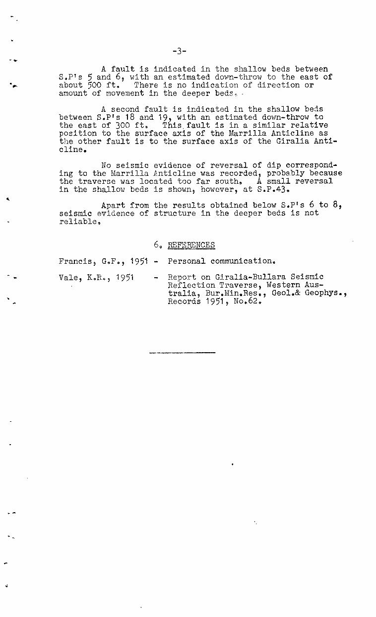
The Gi~alia Anticline extends for about 65 miles from the head of the Exmouth Gulf sou-chwards to the Lyndon River, in the Carnarvon Basin, Western Australia (see locality map, plate iL, During September, 1951? a seismi.c party of the Bu:::-eau of Mineral Resources completed a reflection traverse (Traverse IIAl!) across the northern part of the anticline.. The major conclusion from this survey was that an angular unconformity exists between the Mesozoic sediments in '\,'/hich the anticline had been mapped, and the underlying Palaeozoic sediments.. The structure at depth below the axis of the surface anticline and beneath the unconformity was shown to be synclinal (Vale, 1951). To verify the existence of this unconfol"'mity, reflection Traverse lICn was shot during October and November, 1951, at Cardabia, about 22 miles south of Traverse HAIl.
20 POSITION OF TRA~pSE
The apex of the Giralia Anticline is at approximately 114°10' East, 230 00 t South, and Traverse IIC" was almost due east along the 23° parallel. Plate 1 shows the lucation of the traverse, its position relative to Traverse IIAIt, and the geological features of the Giralia Anticline.
s .. P .. 55, at the ,,'estern extremity of the traverse, is well down the \vest flal1.l{ of the anticline, and SoP.24, near the centre of the traverse, is approximately on the apex. The structure on the eastern £lank of the anticline near Traverse "CII is complicated by the Marrilla Anticline, a subsidiary of the Giralia Anticline, and the traverse crosses tile two structures near their junction. Steep east dip which exists in the Tertiary-Mesozoic sediments on the eastern side of the Giralin Anticline at its northern end, would 1 if present, be expected approximately between SoP's 5 and 6, along Traverse IICH o
3 .. WORK DONE AND RESULTS OBTAI~
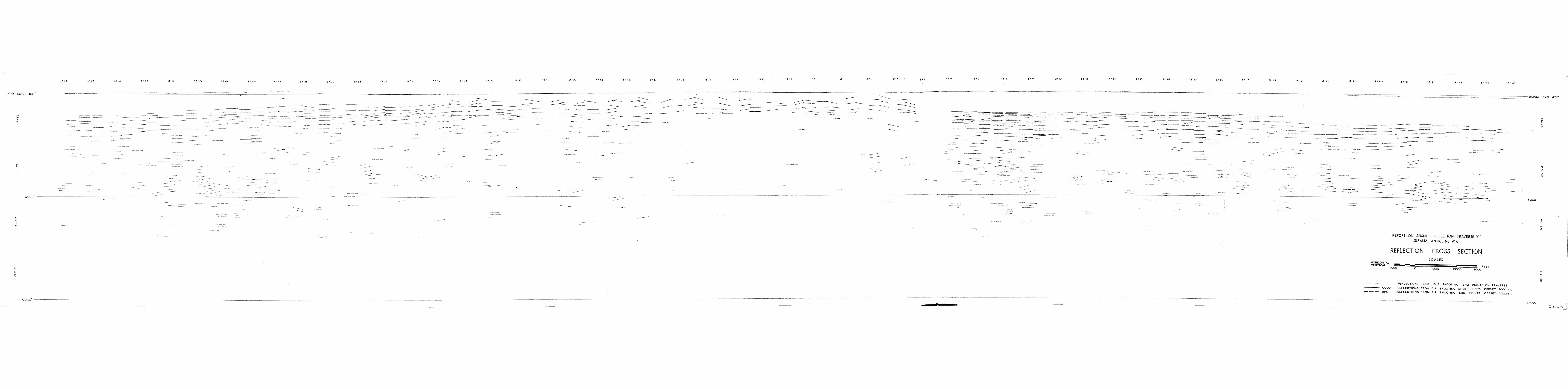
The air-shooting technique, which proved successful along Traverse "All, was used, but the offset of the shot-points was increased from 2,400 ft. to 3~000 ft. This allowed more time to elapse (approx. 2~ sec.) before the sound blast from the explosion swamped the seismic energy received at the geophones, and allowed deeper reflections to be observed than was possible on Traverse "Alt. Some parts of the line, namely S.pis 1 to 9, 15 to 17 and 30 to 33, were duplicated with hole shooting.. Reflections recorded from these shots are shown by dotted lines on the crosssection. A general discussion of the technical matters involved in the production of the cross-section (Plate 2) has been given by Vale (1951).
4. DISCUSSION OF RESULTS
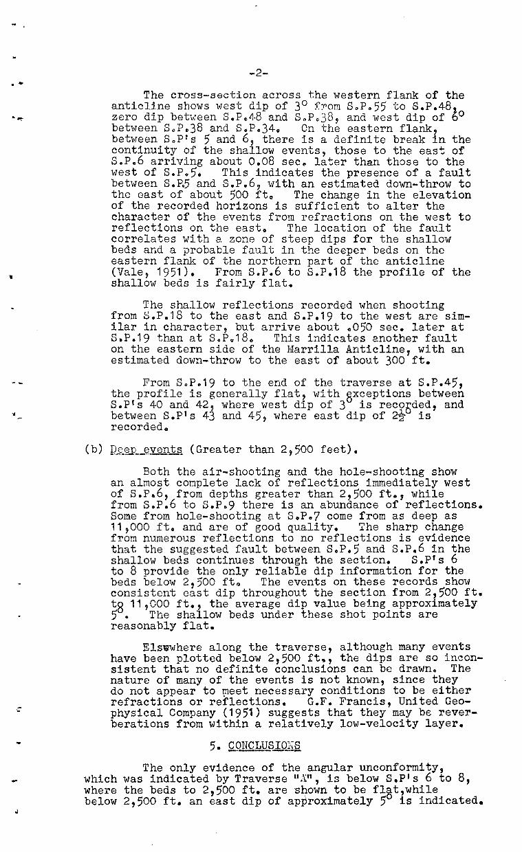
(a) Shallow events (Less than 2,500 feet).
Seismic events returning from less than 2,500 ft. are in general strong and clear. They include both reflections and refractions and the classification of an event is not always clear at first. Refractions usually show a "wash boardl1 effect when plotted on the cross-section as reflections. Individual events of this type are of no use for indicating the value of the dip of the strata they represent, but when several form a continuous sequence they have qualitative value in that they then indicate the direction of dip. This is so between s.pts 33 and 5.
. -
,
-...
...
-2-
The cross-section across the western fla~~ of the anticline shows west dip of 30 fTom SoP o 55 to S.P.48 zero dip between S.Ps48 and SoP Q 38, and west dip of lo between SoPo38 and SoPe34~ On the eastern flank, between Sop?s 5 and 6, there is a definite break in the continuity of the shallow events, those to the eas~ of s.p.6 arriving about 0.08 sec~ later than those to the west of S.Po5o This indicates the presence of a fault between S.R5 and S.P.6, with an estimated down-throw to the east of about 500 fta The change in the elevation of the recorded horizons is sufficient to alter the character of the events from refractions on the west to reflections on the east. The location of the fault correlates with a zone of steep dips for the shallow beds and a probable fault in the deeper beds on the eastern flank of the northern part of the anticline (Vale, 1951). From S.P.6 to s.P.18 the profile of the shallow beds is fairly flat.
The shallow reflections recorded when shooting from 8.P o18 to the east and S.P.19 to the west are similar in character, but arrive about .050 sec. later at S.P.19 than at S.P.18. This indicates another fault on the eastern side of the Marrilla Anticline, with an estimated down-throw to the east of about 300 ft.
From SoP~19 to the end of the traverse at SoP.45, the profile is generally flat, with @xceptions between SoP's 40 and 42, where west dip of 3 is recooded, and between S.pts 43 and 45, where east dip of ~ is recorded.
(b) ~eep ~vents (Greater than 2,500 feet).
Both the air-shooting and the hole-shooting show an almost complete lack of reflections immediately west of s.p.6, from depths greater than 2,500 ft., while from Sop.6 to S.Po9 there is an abundance of reflections. Some from hole-shooting at S.P.7 come from as deep as 11,000 ft. and are of good quality. The sharp change from numerous reflections to no reflections is evidence that the suggested fault between S.P.5 and S.P.6 in the shallow beds continues through the section. S.P's 6 to 8 provide the only reliable dip information for the beds below 2,500 fto The events on these records show consistent east dip throughout the section from 2,500 ft. tg 11,000 ft., the average dip value being approximately 5. The shallow beds under these shot points are reasonably flat.
Elswwhere along the traverse, although many events have been plotted below 2,500 ft., the dips are so inconsistent that no definite conclusions can be drawn. The nature of many of the events is not known, since they do not appear to ~eet necessary conditions to be either refractions or reflections. G.F. Francis, United Geophysical Company (1951) suggests that they may be reverberations from within a relatively low-velocity layer.
5. CONCLUSI01~S - -The only evidence of the angular unconformity,
which was indicated by Traverse "AU, is below S.P's 6 to 8, where the beds to 2,500 ft. are 'shown to be flat?wh~le below 2,500 ft. an east dip of approximately 50 1S 1nd1cated.
"
-3-
A fault is indicated in the shallow beds between Sop!s 5 and 6, with an estimated dov-rn-throw to the east of about 500 ft. There is no indication of direction or amount of movement in the deeper beds ~ -
A second fault is indicated in the shallow beas between S.P's 18 and 19, with an estimated down-throw to the east of 300 ft& This. fault is in a similar relative position to the surface axis of the Marrilla Anticline as the other fault is to the surface axis of the Giralia Anticline.
No seismic evidence of reversal of dip corresponding to the Marrilla P..nticline was recorded, proba.bly because the traverse was located too far southo A small reversal in the sha.llm" beds is shown, however, at S.P.43.
Apart from the results obtained below S.P's 6 to 8, seismic evidence of structure in the deeper beds is not reliable o
6 0 FEI:ERENCES
Francis, G.F., 1951 - Personal communication.
Vale, KeR", 1951 Renort on Giralia-Bullara Seismic Reflection Traverse, Western Australia, Bur.Min.Res., Geol.& Geophys., Records 1951, N0 0 62.

•
I I
I c'
l~
GEOPHYSICAL SURVEY, GIRALIA RANGE, W.A.
LOCALITY MAP AND GEOLOGICAL FEATURES
GEOLOGICAL DATA SUPPLIED BY GEOLOGICAL SECTION , BUREAU OF M INERAL RESOURCES
SCALE IN MILES
5 2 o 2 4 6 8 10
LEGEND
QUATERNARY ? PROBABLE FAULT POSITION APPROX .
I I
I I
I I
I I =
= TERTIARY
.. I ESTABLISHED ANTICLINAL CREST
SHOWING PLUNGE OF FOLD I CRE TACEOUS TERT IARY
CRETACEOUS
RADIOLARI TE
LOCALITY
WESTERN I
A USi RAL1A
\ I I
- --\--
-25'
.', ,I ~. I
-.J
• CA RDABIA H.S.
o·
-.-j---
•
•
MAPS
ESTABL ISH ED SYNCLINAL TROUGH
SHOW IN C PLUNGE OF FOLD
POSIT ION APPROX.
BORE
HIGHWAY
HOME STEAD
!5,,'
.0'
-30
I I
I I
I I
I I
I I
I I ~ I
I I
I I
-'I I
I
• BULLARA H.S. I
I I
I I
(~.-L __ ~--rL-+-~.......,--- I i r •
~ I " Y,--,
. 4 Q ~- ~ 101j'
'-J-
I I , I
-t-
I f
I f
f I
I I
I
1-f
f f
I
: ~-,.BORE \...--...JBORE No. IO
-:=. •
: :\~
~ )\~~ I V
CENTENARY I BORE • I
,BORE
I
I ,.J... I
I I
I I I·BORE
I I
I I I I
I I I I
MAUD I LANDING
BORE. I , I , I I
-r , I I I I I \ I , , ,
I I
J I I I I I J I J I I I I I I ,
--1-. , I , I I I , I I I , , , , I , \ \ \
r
-rJ
l
t
.J
) !
I
)
, ,
I I
I
I
1 /
o
, . ,
l~,
, \
I
I , Ir
No. 1 ........ ·, I "'- ~ ( (
DEEP '0 _..---- BORE
)
\
I I
I I
I
\
I I
)
CO ASTA L TANK
>
I I
I I
I I
\
fo
/ ( \.
f I
--l f
I I
I I
I I
f .CENTIPEDE I
BOR E
/ I
I I
I I I I
I I
I I
I I
I I
I I
I I
I I
I
-Y... I I
I
I I
I
I
\ -l I /
I I I ,
I
+ , I
t I I , I
I
I I \ I
\ I
\ , I , /
I I
PLATE I
• GIRALIA H.S.
I I
I I
I I
I I
I
- \ / \ \
j
/ I
/
I
I I
I
I I
I I
~ I
I I
I I
I , .L
) )
/
\ ,
\
I (
(
\ ~ . ( I
I I .1 , .... '. I
t c...J'
\ \ \
,
/
Cecphy:,/cal 5[ '" ) BtlN?(JU or M '/era! !;uources, Geoloqy and Geoph':f:5lcs G 98- 21