Embed Size (px)
Citation preview
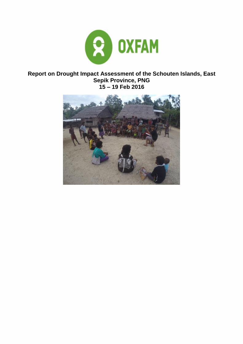
Report on Drought Impact Assessment of the Schouten Islands, East Sepik Province, PNG
15 – 19 Feb 2016
Executive Summary
The Schouten Islands are a group of small volcanic islands, located 50 to 60 km off the northern coast of
Papua New Guinea in East Sepik Province. Covering approximately 50 km2, the islands have a total
population of approximately 6,000 people. In late January whilst preparing its East Sepik drought response,
Oxfam received reports about food and water shortages in the islands from Wewak based church groups,
local NGO’s and government officials. These reports indicated the impact of the drought was greater in the
islands than areas in the mainland that had previously been assessed. In response a team undertook multi
sector impact assessments in 5 of the 6 Schouten Islands from 15th to 19th February.
The current drought continues to have a significant impact on all the islands. Despite the return of rain in late
2015, the amount of rainfall is significantly less than normal. In the more remote, difficult to access rocky
islands of Wei, Kadovar and Blup Blup in the eastern part of the group access to fresh water is severely
restricted, food is in very short supply and cases of malnutrition are increasing. Based on the PNG
government drought severity categories the islands are assessed as being category 4.
Unless action is taken to address the issues being faced by the populations of these islands the situation will
continue to worsen and is likely to reach drought severity category 5. An integrated package of WASH, food
security and health interventions is necessary to minimise the ongoing impacts of the current El Nino
drought, to halt the decline in the health of the population and to facilitate medium to long term recovery from
the combined effects of the current drought and the next dry season.
Contents
Introduction……………………………………………………………………………………………………………1
Impact of El Nino Drought and Response to Date………………………………………………..………………2
Assessment Overview……………………………………………………………………….………………………2
Assessment Methodology……………………………………………………………………………………………3
Assessment Findings…………………………………………………………………………………………………4
Conclusions ……………………………………………………………………………………………………………8
Annexes
A. Summary of Assessment Findings – Vokeo Island
B. Summary of Assessment Findings – Koil Island
C. Summary of Assessment Findings – Wei Island.
D. Summary of Assessment Findings – Blup Blup Island.
E. Summary of Assessment Findings – Kadovar Island.
F. Breakdown of Recommended Follow Up Actions.
1
Introduction
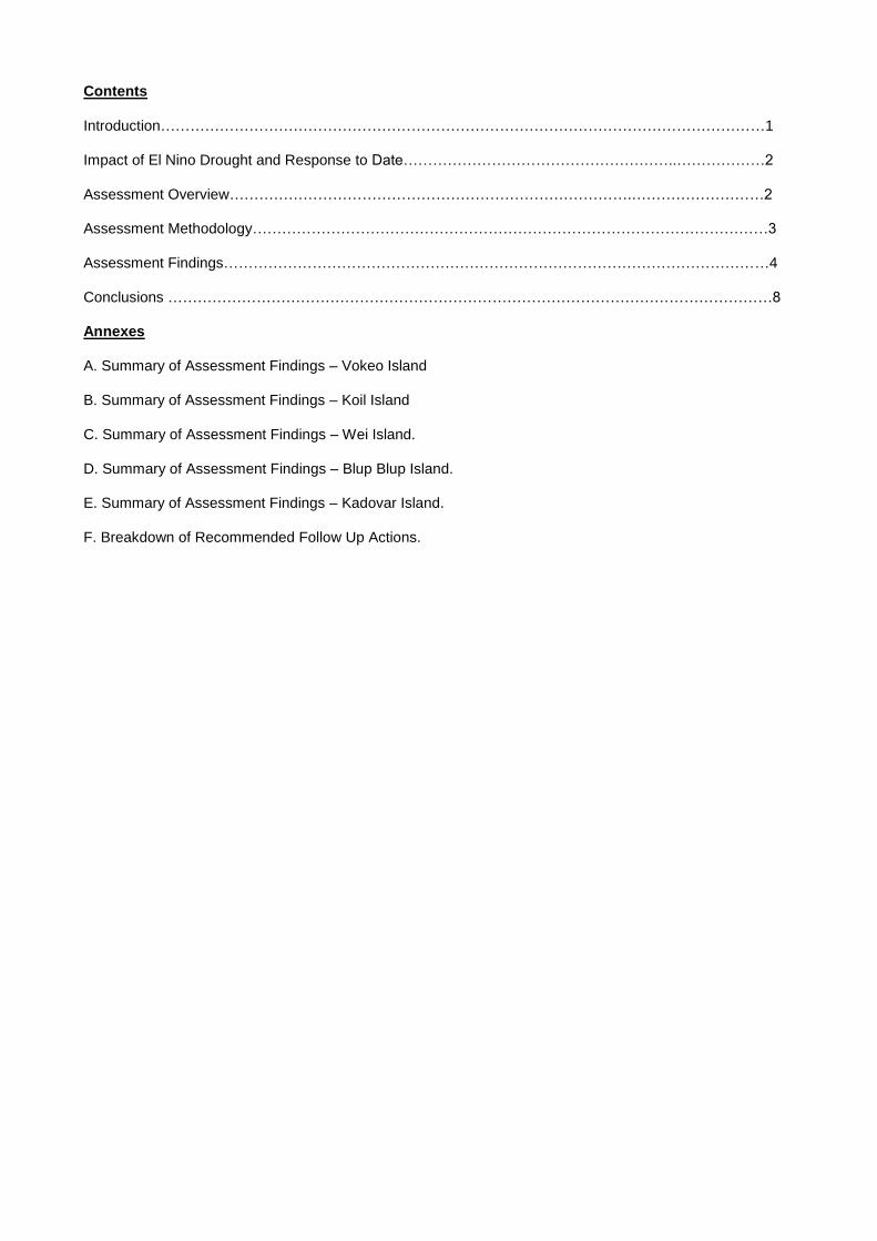
The Schouten Islands are a group of small volcanic islands in the province of East Sepik in Papua New
Guinea, The islands are located between 50 to 60 km off the northern coast of PNG (Figure 1). There are 6
inhabited islands in the group. These are from east to west
Biem
Kadovar,
Blup Blup,
Koil
Vokeo
Wei or Vial
The combined land area is approximately 50 km2 and total population is approximately 6000 people. The
islands are administrated by Wewak and Islands District Administration and are split into 10 Wards. Biem is
one of the most one of the most active volcanoes in Papua New Guinea with its most recent eruption in
1960. Kadovar is believed to have erupted last in 1700 but is still thermally active.
Figure 1 Location of the Schouten Islands Group
The islands can be separated into 2 types
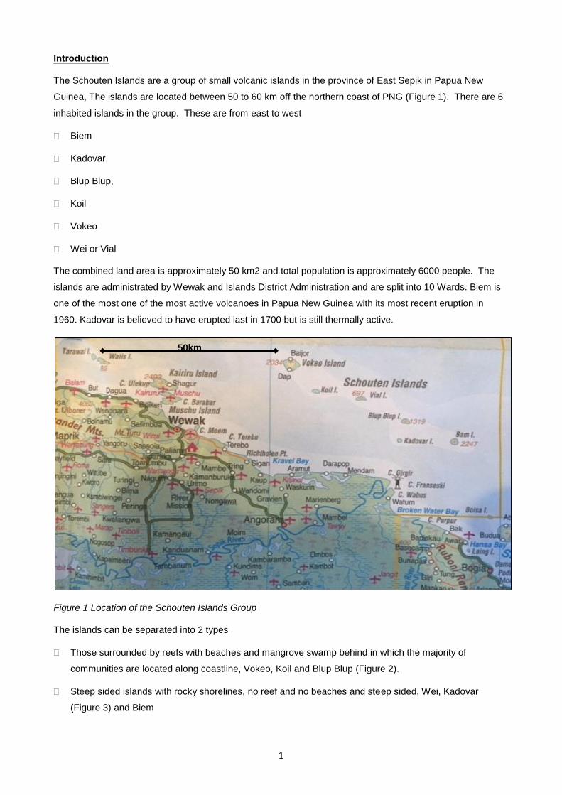
Those surrounded by reefs with beaches and mangrove swamp behind in which the majority of
communities are located along coastline, Vokeo, Koil and Blup Blup (Figure 2).
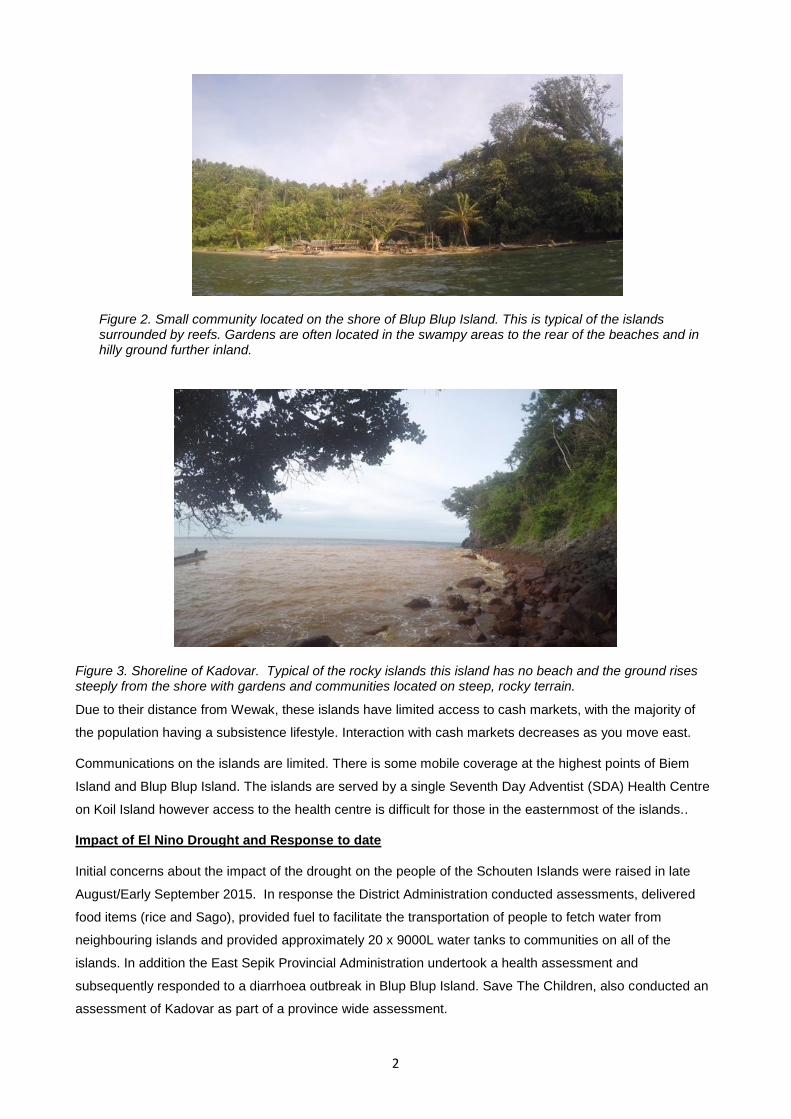
Steep sided islands with rocky shorelines, no reef and no beaches and steep sided, Wei, Kadovar
(Figure 3) and Biem
50km
2
Figure 2. Small community located on the shore of Blup Blup Island. This is typical of the islands surrounded by reefs. Gardens are often located in the swampy areas to the rear of the beaches and in hilly ground further inland.
Figure 3. Shoreline of Kadovar. Typical of the rocky islands this island has no beach and the ground rises steeply from the shore with gardens and communities located on steep, rocky terrain.
Due to their distance from Wewak, these islands have limited access to cash markets, with the majority of
the population having a subsistence lifestyle. Interaction with cash markets decreases as you move east.
Communications on the islands are limited. There is some mobile coverage at the highest points of Biem
Island and Blup Blup Island. The islands are served by a single Seventh Day Adventist (SDA) Health Centre
on Koil Island however access to the health centre is difficult for those in the easternmost of the islands..
Impact of El Nino Drought and Response to date
Initial concerns about the impact of the drought on the people of the Schouten Islands were raised in late
August/Early September 2015. In response the District Administration conducted assessments, delivered
food items (rice and Sago), provided fuel to facilitate the transportation of people to fetch water from
neighbouring islands and provided approximately 20 x 9000L water tanks to communities on all of the
islands. In addition the East Sepik Provincial Administration undertook a health assessment and
subsequently responded to a diarrhoea outbreak in Blup Blup Island. Save The Children, also conducted an
assessment of Kadovar as part of a province wide assessment.
3
Assessment Overview
In response to reports of continued food and water shortages in the islands received by Oxfam in PNG in
late January 2016, a team from the Wewak office undertook multi sector impact assessments in 5 of the 6
Schouten Islands from Monday 15 February to Friday 19 February. The team comprised 6 Oxfam staff
(including WASH technical experts and the National Drought Response Coordinator) plus and staff from
Oxfam partner Turubu Ecoforestry and the Provincial Health Department.
The aim of the assessments was to establish the impact of the drought on the communities living on the
islands, and to identify their needs in order to inform response planning and advocacy campaigns. As part of
the assessments the team carried out Mid Upper Arm Circumference (MUAC) measurements of children
aged 5 and under, to identify cases of malnutrition.
The team was supported by the Wewak and Islands District Administration who provided the Wewak District
Sea Ambulance and a 2 man crew to the team for the duration of the assessment. Separate motor dinghies
(Banana boats) were hired to move fuel drums from Wewak to caches at Koil and Blup Blup and provided
support to the team when the Sea Ambulance could not moor close to the shore or when conditions were too
rough for the Sea Ambulance to be used.
The initial plan was to base the team in Blup Blup for 3 days whist conducting assessments in neighbouring
islands and then to move to Koil in order to conduct assessments on the island and in neighbouring Vokeo.
Due to poor weather conditions on 15 Feb the decision was taken to reverse the planned order. The
assessment was undertaken as follows.
15 Feb - Wewak to Koil, overnight at Koil Health Centre.
16 Feb – Koil to Vokeo and return, overnight at Koil health Centre.
17 Feb – Koil to Blup Blup via Wei, overnight camp at Blup Blup.
18 Feb – Blup Blup to Kadovar and return.
19 Feb – Blup Blup to Wewak via Koil.
All of the islands Ward Councilors had been informed of the visit in advance and at least one village in each
of the Wards was visited. Due to difficult sea conditions the decision was taken on safety grounds to not go
to Biem Island. As New Tribes Mission have a base on Biem Island it is hoped they will be able to carry out
an initial assessment for us. If required a follow up visit will be scheduled.
Total cost of the assessment was 15,000 Kina ($7500 AUD). This compares favourably with the cost of using
helicopters to conduct assessments in the area as they charge approximately 8000 Kina per hour of flying
time.
Assessment Methodology
The assessments were conducted by holding focus group discussions with separate mens and womens
groups. Where possible additional groups for men and women under approximately 20 years old were also
interviewed. MUAC testing of all children between 6 months and 5 years was undertaken, led by the
representative of the Provincial Health Department. Inspections of water sources and existing water systems
were completed by WASH experts in the team.
4
Assessment Findings
A breakdown of the findings in each location visited are at Annexes A to E. A summary of key findings by
sector are below.
Water
All the islands have critical shortages of fresh water. Despite the return of rain in November/December, there
is still considerably less rainfall than normal. The majority of rainwater catchment systems are empty and the
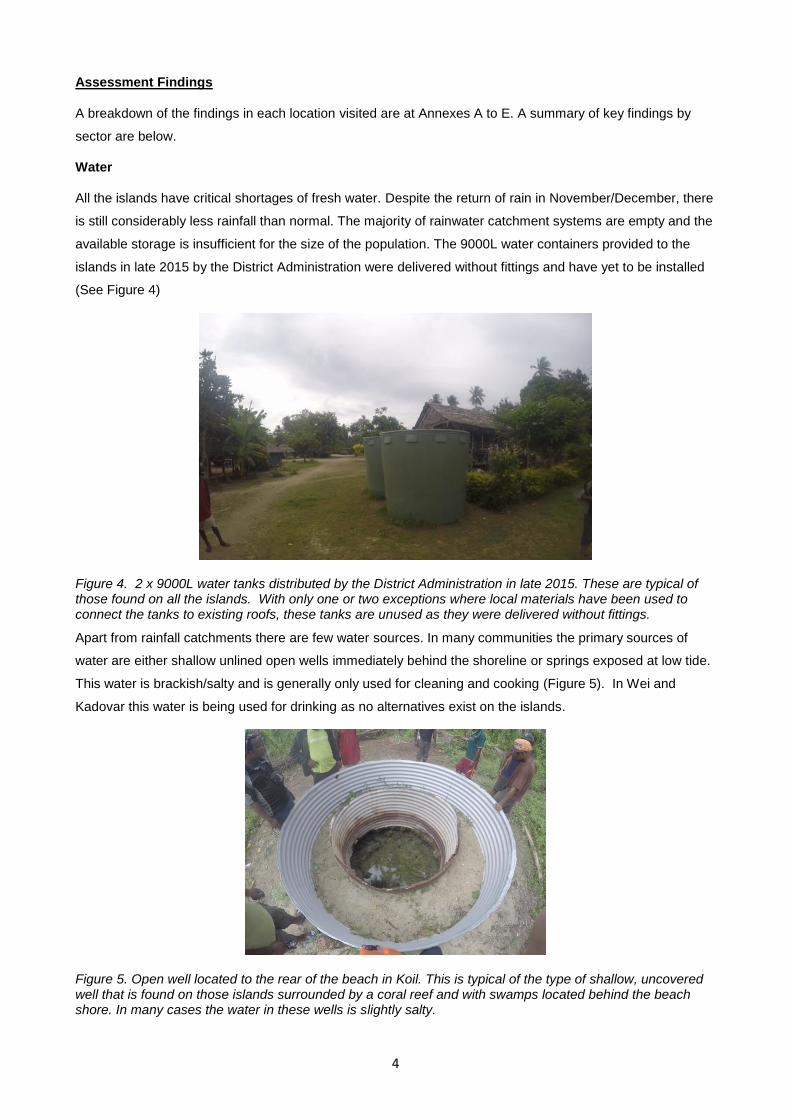
available storage is insufficient for the size of the population. The 9000L water containers provided to the
islands in late 2015 by the District Administration were delivered without fittings and have yet to be installed
(See Figure 4)
Figure 4. 2 x 9000L water tanks distributed by the District Administration in late 2015. These are typical of those found on all the islands. With only one or two exceptions where local materials have been used to connect the tanks to existing roofs, these tanks are unused as they were delivered without fittings.
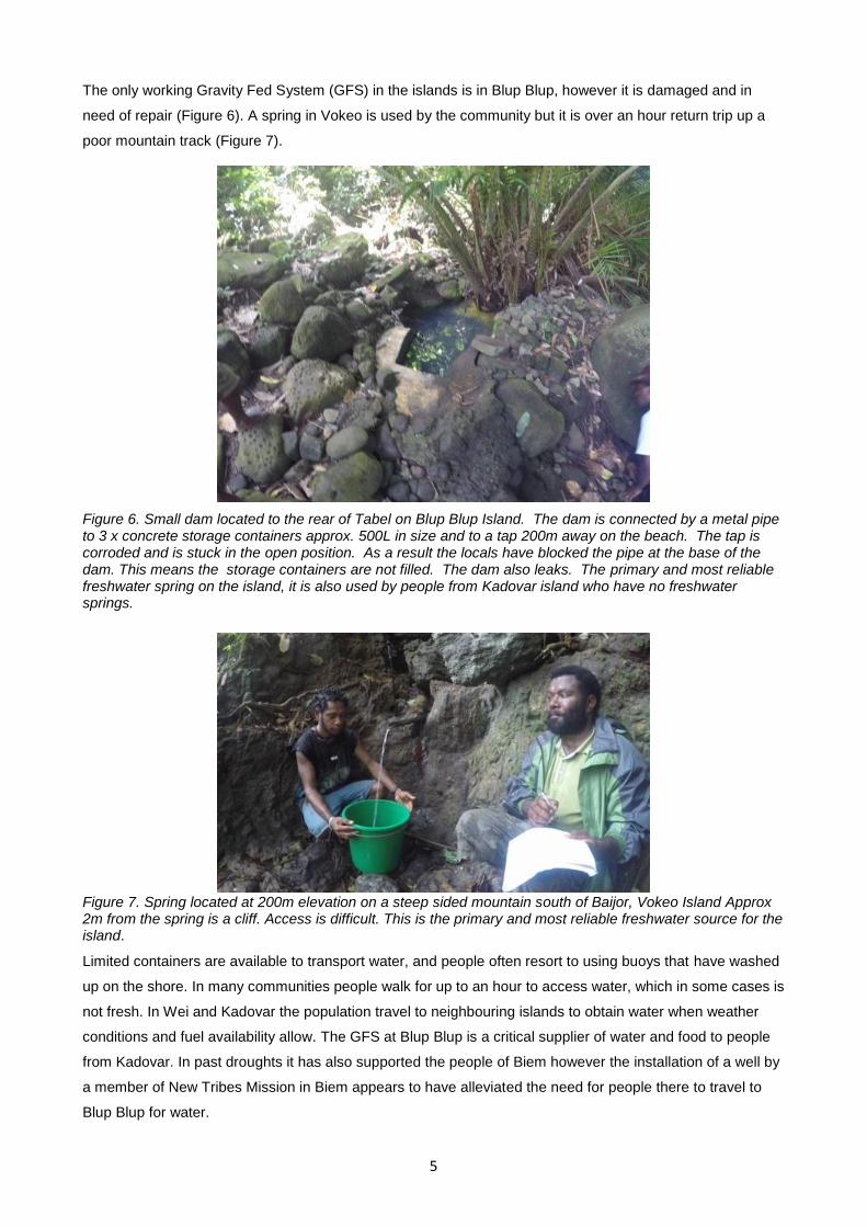
Apart from rainfall catchments there are few water sources. In many communities the primary sources of
water are either shallow unlined open wells immediately behind the shoreline or springs exposed at low tide.
This water is brackish/salty and is generally only used for cleaning and cooking (Figure 5). In Wei and
Kadovar this water is being used for drinking as no alternatives exist on the islands.
Figure 5. Open well located to the rear of the beach in Koil. This is typical of the type of shallow, uncovered well that is found on those islands surrounded by a coral reef and with swamps located behind the beach shore. In many cases the water in these wells is slightly salty.
5
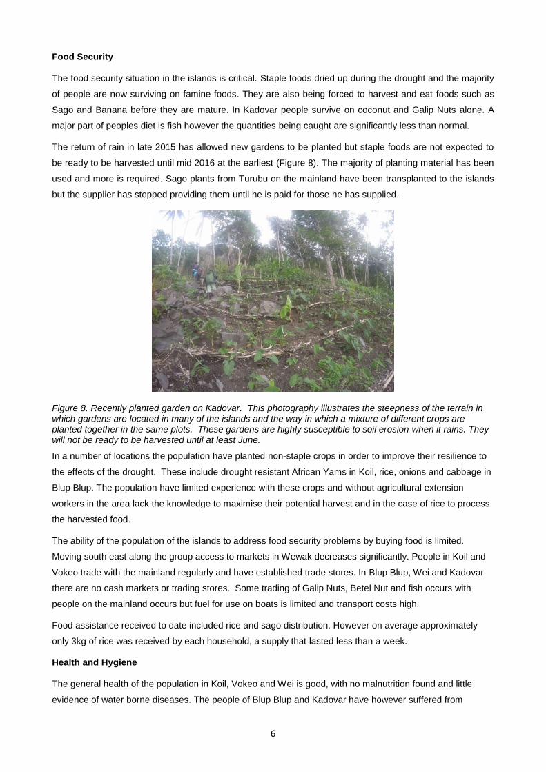
The only working Gravity Fed System (GFS) in the islands is in Blup Blup, however it is damaged and in
need of repair (Figure 6). A spring in Vokeo is used by the community but it is over an hour return trip up a
poor mountain track (Figure 7).
Figure 6. Small dam located to the rear of Tabel on Blup Blup Island. The dam is connected by a metal pipe to 3 x concrete storage containers approx. 500L in size and to a tap 200m away on the beach. The tap is corroded and is stuck in the open position. As a result the locals have blocked the pipe at the base of the dam. This means the storage containers are not filled. The dam also leaks. The primary and most reliable freshwater spring on the island, it is also used by people from Kadovar island who have no freshwater springs.
Figure 7. Spring located at 200m elevation on a steep sided mountain south of Baijor, Vokeo Island Approx 2m from the spring is a cliff. Access is difficult. This is the primary and most reliable freshwater source for the island.
Limited containers are available to transport water, and people often resort to using buoys that have washed
up on the shore. In many communities people walk for up to an hour to access water, which in some cases is
not fresh. In Wei and Kadovar the population travel to neighbouring islands to obtain water when weather
conditions and fuel availability allow. The GFS at Blup Blup is a critical supplier of water and food to people
from Kadovar. In past droughts it has also supported the people of Biem however the installation of a well by
a member of New Tribes Mission in Biem appears to have alleviated the need for people there to travel to
Blup Blup for water.
6
Food Security
The food security situation in the islands is critical. Staple foods dried up during the drought and the majority
of people are now surviving on famine foods. They are also being forced to harvest and eat foods such as
Sago and Banana before they are mature. In Kadovar people survive on coconut and Galip Nuts alone. A
major part of peoples diet is fish however the quantities being caught are significantly less than normal.
The return of rain in late 2015 has allowed new gardens to be planted but staple foods are not expected to
be ready to be harvested until mid 2016 at the earliest (Figure 8). The majority of planting material has been
used and more is required. Sago plants from Turubu on the mainland have been transplanted to the islands
but the supplier has stopped providing them until he is paid for those he has supplied.
Figure 8. Recently planted garden on Kadovar. This photography illustrates the steepness of the terrain in which gardens are located in many of the islands and the way in which a mixture of different crops are planted together in the same plots. These gardens are highly susceptible to soil erosion when it rains. They will not be ready to be harvested until at least June.
In a number of locations the population have planted non-staple crops in order to improve their resilience to
the effects of the drought. These include drought resistant African Yams in Koil, rice, onions and cabbage in
Blup Blup. The population have limited experience with these crops and without agricultural extension
workers in the area lack the knowledge to maximise their potential harvest and in the case of rice to process
the harvested food.
The ability of the population of the islands to address food security problems by buying food is limited.
Moving south east along the group access to markets in Wewak decreases significantly. People in Koil and
Vokeo trade with the mainland regularly and have established trade stores. In Blup Blup, Wei and Kadovar
there are no cash markets or trading stores. Some trading of Galip Nuts, Betel Nut and fish occurs with
people on the mainland occurs but fuel for use on boats is limited and transport costs high.
Food assistance received to date included rice and sago distribution. However on average approximately
only 3kg of rice was received by each household, a supply that lasted less than a week.
Health and Hygiene
The general health of the population in Koil, Vokeo and Wei is good, with no malnutrition found and little
evidence of water borne diseases. The people of Blup Blup and Kadovar have however suffered from
7
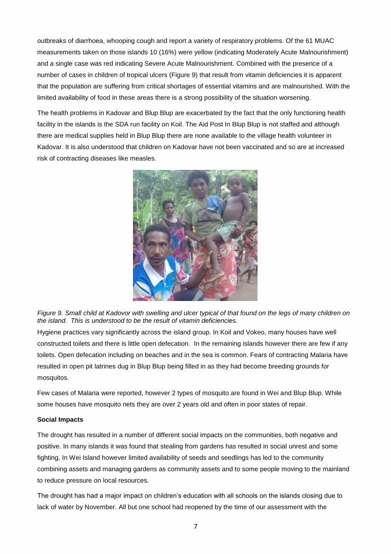
outbreaks of diarrhoea, whooping cough and report a variety of respiratory problems. Of the 61 MUAC
measurements taken on those islands 10 (16%) were yellow (indicating Moderately Acute Malnourishment)
and a single case was red indicating Severe Acute Malnourishment. Combined with the presence of a
number of cases in children of tropical ulcers (Figure 9) that result from vitamin deficiencies it is apparent
that the population are suffering from critical shortages of essential vitamins and are malnourished. With the
limited availability of food in these areas there is a strong possibility of the situation worsening.
The health problems in Kadovar and Blup Blup are exacerbated by the fact that the only functioning health
facility in the islands is the SDA run facility on Koil. The Aid Post In Blup Blup is not staffed and although
there are medical supplies held in Blup Blup there are none available to the village health volunteer in
Kadovar. It is also understood that children on Kadovar have not been vaccinated and so are at increased
risk of contracting diseases like measles.
Figure 9. Small child at Kadovor with swelling and ulcer typical of that found on the legs of many children on the island. This is understood to be the result of vitamin deficiencies.
Hygiene practices vary significantly across the island group. In Koil and Vokeo, many houses have well
constructed toilets and there is little open defecation. In the remaining islands however there are few if any
toilets. Open defecation including on beaches and in the sea is common. Fears of contracting Malaria have
resulted in open pit latrines dug in Blup Blup being filled in as they had become breeding grounds for
mosquitos.
Few cases of Malaria were reported, however 2 types of mosquito are found in Wei and Blup Blup. While
some houses have mosquito nets they are over 2 years old and often in poor states of repair.
Social Impacts
The drought has resulted in a number of different social impacts on the communities, both negative and
positive. In many islands it was found that stealing from gardens has resulted in social unrest and some
fighting, In Wei Island however limited availability of seeds and seedlings has led to the community
combining assets and managing gardens as community assets and to some people moving to the mainland
to reduce pressure on local resources.
The drought has had a major impact on children’s education with all schools on the islands closing due to
lack of water by November. All but one school had reopened by the time of our assessment with the
8
remaining one due to open by end February, however supplies of water and food at these facilities remained
limited.
The need to travel greater distances to collect water due to the lack of available rainwater has resulted in an
increased burden for women in the islands. It was consistently reported that despite this additional demand
on them, women were still expected to fetch water, plant and tend to gardens, look after children and
manage the home.
Conclusion
Comparison with Previous Assessments
Compared with previous assessments in the Islands since the start of the drought, our findings indicate that
the water and food security situation is worsening. Although rain has returned it has been insufficient to meet
the need for water and to improve access to water. Furthermore, while the population has been able to plant
new crops, these will not be available to harvest for many months and so already small food stocks will
continue to dwindle. Of serious concern is the significant increase in malnutrition found in Blup Blup and
Kadovar. If as predicted in the latest 3 monthly weather forecast issued by the government, the rain
continues to fall in quantities significantly less than normal, It is reasonable to expect that the situation will
continue to worsen, and that the number of people suffering from malnutrition will continue to increase.
Addressing the worsening situation in the Schouten Islands is therefore considered to be a high priority.
Recommended Actions
It is recommended that a range of response actions be undertaken in the islands to limit the impact of the
current drought and to enable the population to recover from it as effectively and quickly as possible. These
actions should focus on improving access to fresh water, meeting short term food security and nutrition
needs and addressing immediate heath concerns. In doing so they will also support the communities of the
islands to improve their long term resilience by reducing risk to and increasing preparedness for disasters of
this type.
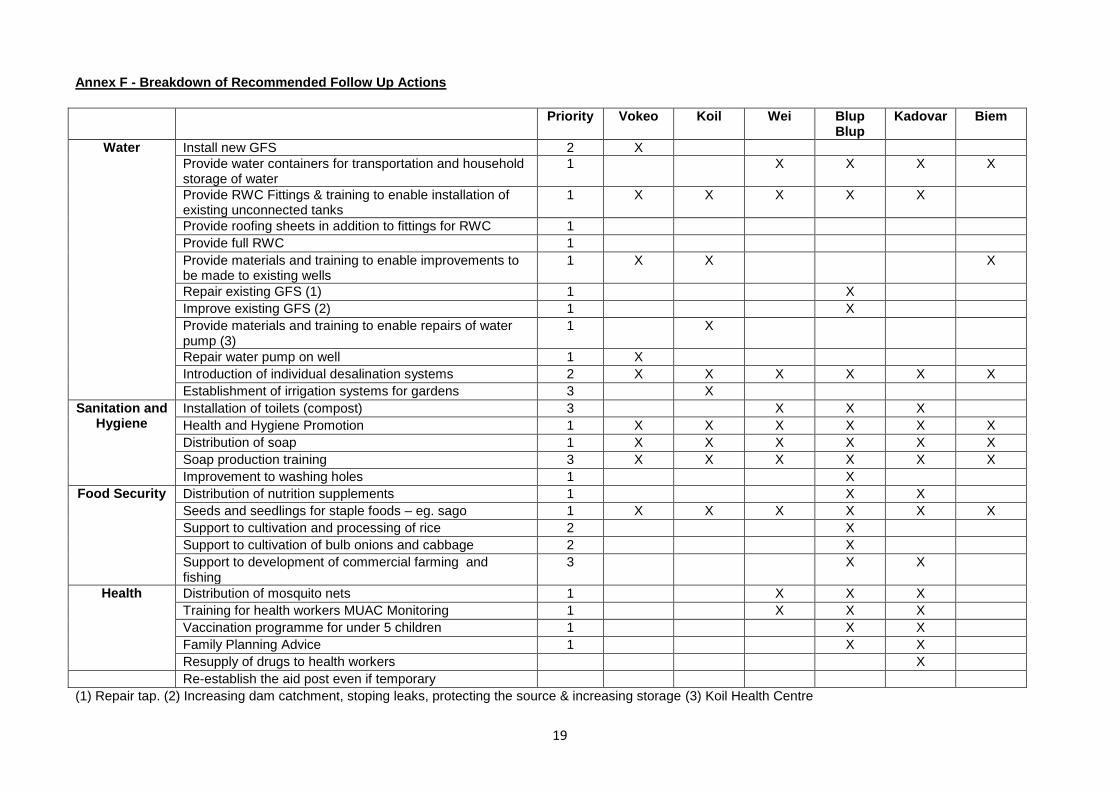
A detailed breakdown of recommended short and medium term response and recovery actions is at Annex
F. A summary is as follows:
Distribution of water containers to improve water carrying and storage capacity
Distribution of fittings and construction materials (eg. roofing materials) to enable community Rain Water
Catchment (RWC) systems to be built using existing 9000L water tanks
Distribution of materials to enable the improvement of existing and construction of new wells, including
fitting of easy to maintain pumps.
Delivery of technical training for community artisans to enable them to:
o Build RWCs.
o Build new wells and improve existing ones, including installing covers and easy to maintain pumps.
o Rebuild and improve existing the GFS in Blup Blup Island to secure, expand and protect the source
and increase available storage capacity.
Installation of Gravity Fed System in Vokeo Island.
9
Distribution of seeds and seedlings to communities to supplement existing planting materials including
distribution of varieties that have a short germination period.
Delivery of drought adaptation training to farmers.
Distribution of soap and health and hygiene messages and materials to improve personal hygiene
practices and prevent water borne disease.
Distribution of nutrition supplements.
Distribution of food to worst affected islands.
Vaccination of all unvaccinated children.
Distribution of medical supplies to village heath workers.
A critical component of implementing a response of this nature will be the availability of suitable shipping to
distribute materials and support the movement of response team members. A rapid logistics feasibility study
will thus be critical to the development of a response plan.
Support from local Government, INGO’s, local partners organisations and the communities on the islands
was critical to enabling this assessment to be undertaken. Similar support will be crucial to enabling a
response of this nature to be planned and implemented. Based on the excellent support received to date it
is however considered realistic that an integrated response of this nature could be implemented by end April
2016. This would maximise the potential to address short term water, food security and health concerns and
potentially enable reserves of fresh water to be built up prior to commencement of the next dry season in
May/June.
10
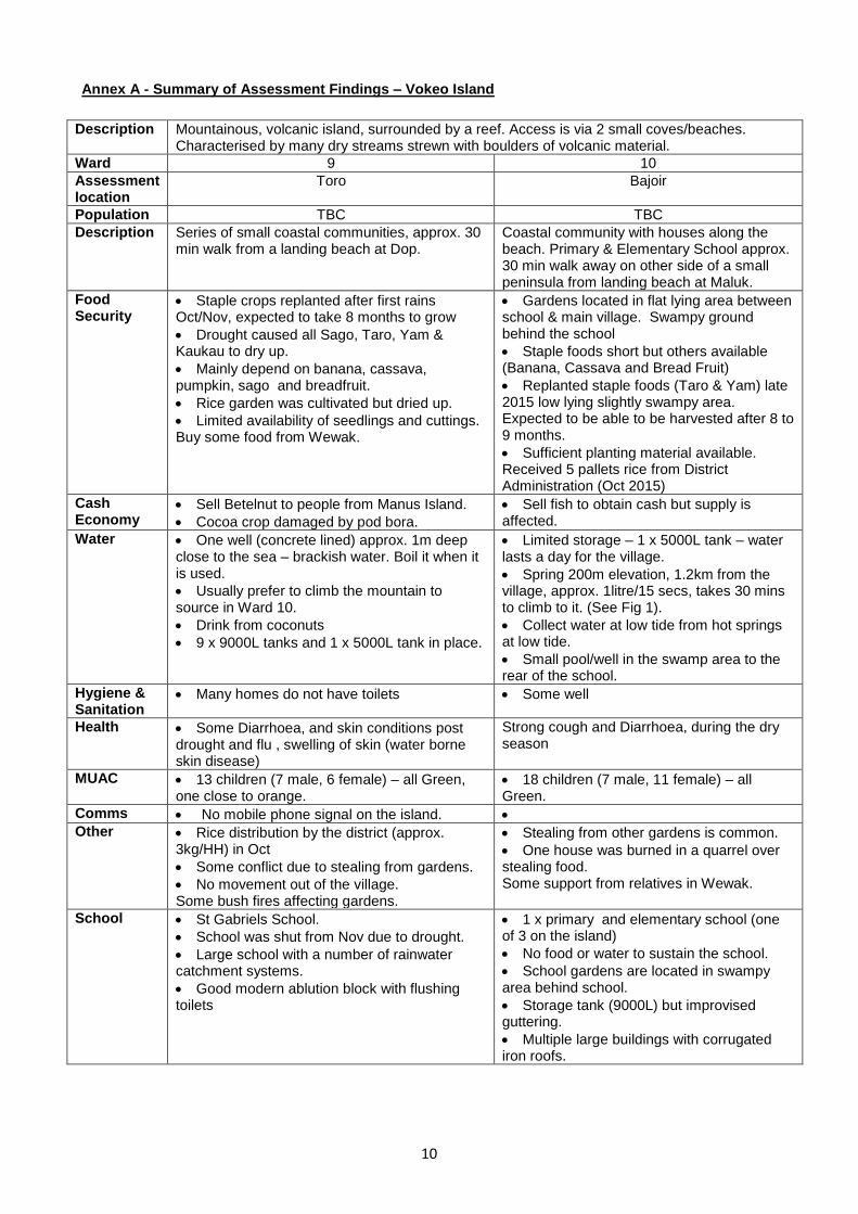
Annex A - Summary of Assessment Findings – Vokeo Island
Description Mountainous, volcanic island, surrounded by a reef. Access is via 2 small coves/beaches. Characterised by many dry streams strewn with boulders of volcanic material.
Ward 9 10
Assessment location
Toro Bajoir
Population TBC TBC
Description Series of small coastal communities, approx. 30 min walk from a landing beach at Dop.
Coastal community with houses along the beach. Primary & Elementary School approx. 30 min walk away on other side of a small peninsula from landing beach at Maluk.
Food Security
Staple crops replanted after first rains Oct/Nov, expected to take 8 months to grow
Drought caused all Sago, Taro, Yam & Kaukau to dry up.
Mainly depend on banana, cassava, pumpkin, sago and breadfruit.
Rice garden was cultivated but dried up.
Limited availability of seedlings and cuttings. Buy some food from Wewak.
Gardens located in flat lying area between school & main village. Swampy ground behind the school
Staple foods short but others available (Banana, Cassava and Bread Fruit)
Replanted staple foods (Taro & Yam) late 2015 low lying slightly swampy area. Expected to be able to be harvested after 8 to 9 months.
Sufficient planting material available. Received 5 pallets rice from District Administration (Oct 2015)
Cash Economy
Sell Betelnut to people from Manus Island.
Cocoa crop damaged by pod bora.
Sell fish to obtain cash but supply is affected.
Water One well (concrete lined) approx. 1m deep close to the sea – brackish water. Boil it when it is used.
Usually prefer to climb the mountain to source in Ward 10.
Drink from coconuts
9 x 9000L tanks and 1 x 5000L tank in place.
Limited storage – 1 x 5000L tank – water lasts a day for the village.
Spring 200m elevation, 1.2km from the village, approx. 1litre/15 secs, takes 30 mins to climb to it. (See Fig 1).
Collect water at low tide from hot springs at low tide.
Small pool/well in the swamp area to the rear of the school.
Hygiene & Sanitation
Many homes do not have toilets Some well
Health Some Diarrhoea, and skin conditions post drought and flu , swelling of skin (water borne skin disease)
Strong cough and Diarrhoea, during the dry season
MUAC 13 children (7 male, 6 female) – all Green, one close to orange.
18 children (7 male, 11 female) – all Green.
Comms No mobile phone signal on the island.
Other Rice distribution by the district (approx. 3kg/HH) in Oct
Some conflict due to stealing from gardens.
No movement out of the village. Some bush fires affecting gardens.
Stealing from other gardens is common.
One house was burned in a quarrel over stealing food. Some support from relatives in Wewak.
School St Gabriels School.
School was shut from Nov due to drought.
Large school with a number of rainwater catchment systems.
Good modern ablution block with flushing toilets
1 x primary and elementary school (one of 3 on the island)
No food or water to sustain the school.
School gardens are located in swampy area behind school.
Storage tank (9000L) but improvised guttering.
Multiple large buildings with corrugated iron roofs.
11
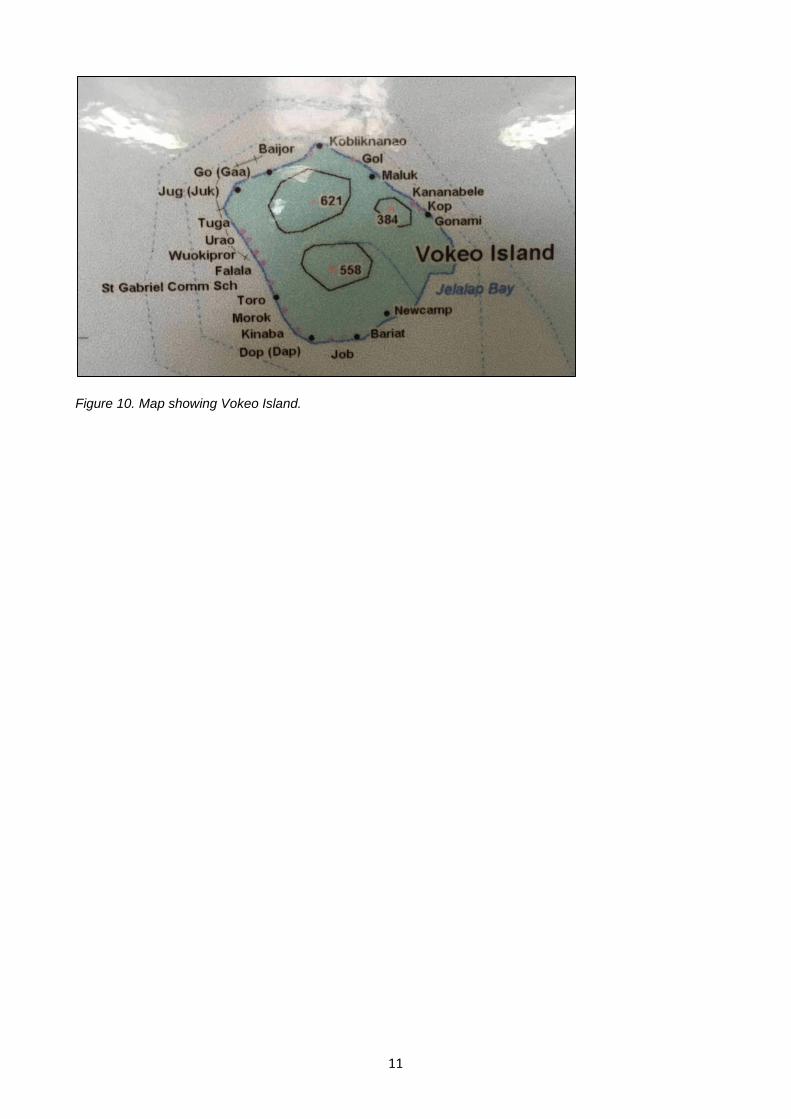
Figure 10. Map showing Vokeo Island.
12
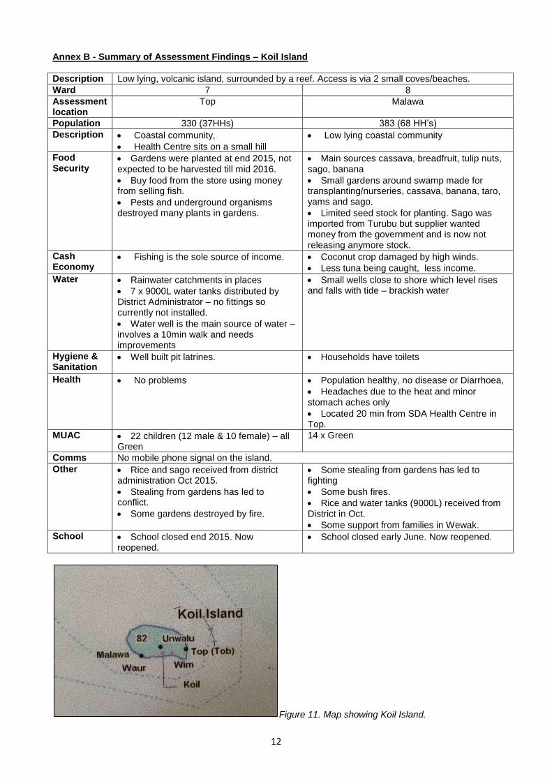
Annex B - Summary of Assessment Findings – Koil Island
Description Low lying, volcanic island, surrounded by a reef. Access is via 2 small coves/beaches.
Ward 7 8
Assessment location
Top Malawa
Population 330 (37HHs) 383 (68 HH’s)
Description Coastal community,
Health Centre sits on a small hill
Low lying coastal community
Food Security
Gardens were planted at end 2015, not expected to be harvested till mid 2016.
Buy food from the store using money from selling fish.
Pests and underground organisms destroyed many plants in gardens.
Main sources cassava, breadfruit, tulip nuts, sago, banana
Small gardens around swamp made for transplanting/nurseries, cassava, banana, taro, yams and sago.
Limited seed stock for planting. Sago was imported from Turubu but supplier wanted money from the government and is now not releasing anymore stock.
Cash Economy
Fishing is the sole source of income. Coconut crop damaged by high winds.
Less tuna being caught, less income.
Water Rainwater catchments in places
7 x 9000L water tanks distributed by District Administrator – no fittings so currently not installed.
Water well is the main source of water – involves a 10min walk and needs improvements
Small wells close to shore which level rises and falls with tide – brackish water
Hygiene & Sanitation
Well built pit latrines. Households have toilets
Health No problems Population healthy, no disease or Diarrhoea,
Headaches due to the heat and minor stomach aches only
Located 20 min from SDA Health Centre in Top.
MUAC 22 children (12 male & 10 female) – all Green
14 x Green
Comms No mobile phone signal on the island.
Other Rice and sago received from district administration Oct 2015.
Stealing from gardens has led to conflict.
Some gardens destroyed by fire.
Some stealing from gardens has led to fighting
Some bush fires.
Rice and water tanks (9000L) received from District in Oct.
Some support from families in Wewak.
School School closed end 2015. Now reopened.
School closed early June. Now reopened.
Figure 11. Map showing Koil Island.
13
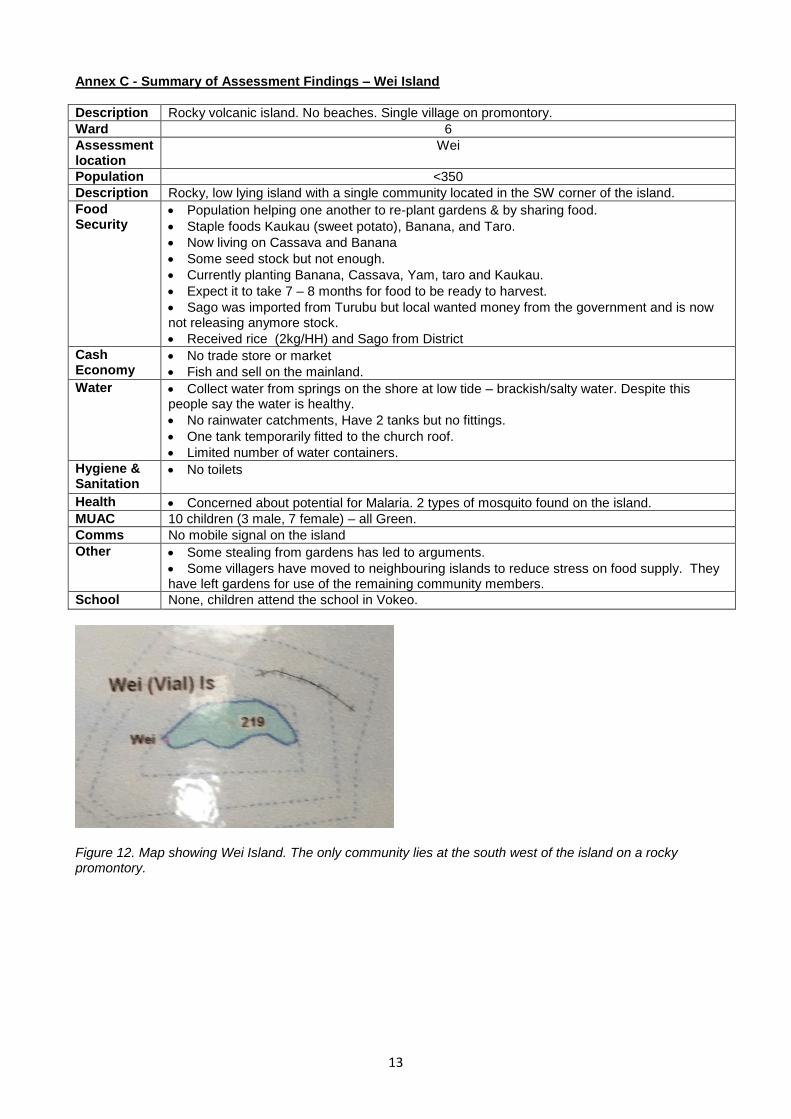
Annex C - Summary of Assessment Findings – Wei Island
Description Rocky volcanic island. No beaches. Single village on promontory.
Ward 6
Assessment location
Wei
Population <350
Description Rocky, low lying island with a single community located in the SW corner of the island.
Food Security
Population helping one another to re-plant gardens & by sharing food.
Staple foods Kaukau (sweet potato), Banana, and Taro.
Now living on Cassava and Banana
Some seed stock but not enough.
Currently planting Banana, Cassava, Yam, taro and Kaukau.
Expect it to take 7 – 8 months for food to be ready to harvest.
Sago was imported from Turubu but local wanted money from the government and is now not releasing anymore stock.
Received rice (2kg/HH) and Sago from District
Cash Economy
No trade store or market
Fish and sell on the mainland.
Water Collect water from springs on the shore at low tide – brackish/salty water. Despite this people say the water is healthy.
No rainwater catchments, Have 2 tanks but no fittings.
One tank temporarily fitted to the church roof.
Limited number of water containers.
Hygiene & Sanitation
No toilets
Health Concerned about potential for Malaria. 2 types of mosquito found on the island.
MUAC 10 children (3 male, 7 female) – all Green.
Comms No mobile signal on the island
Other Some stealing from gardens has led to arguments.
Some villagers have moved to neighbouring islands to reduce stress on food supply. They have left gardens for use of the remaining community members.
School None, children attend the school in Vokeo.
Figure 12. Map showing Wei Island. The only community lies at the south west of the island on a rocky promontory.
14
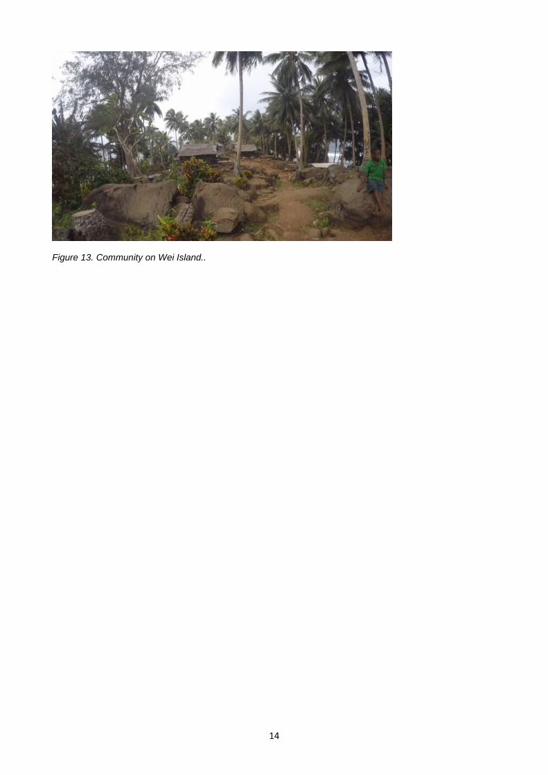
Figure 13. Community on Wei Island..
15
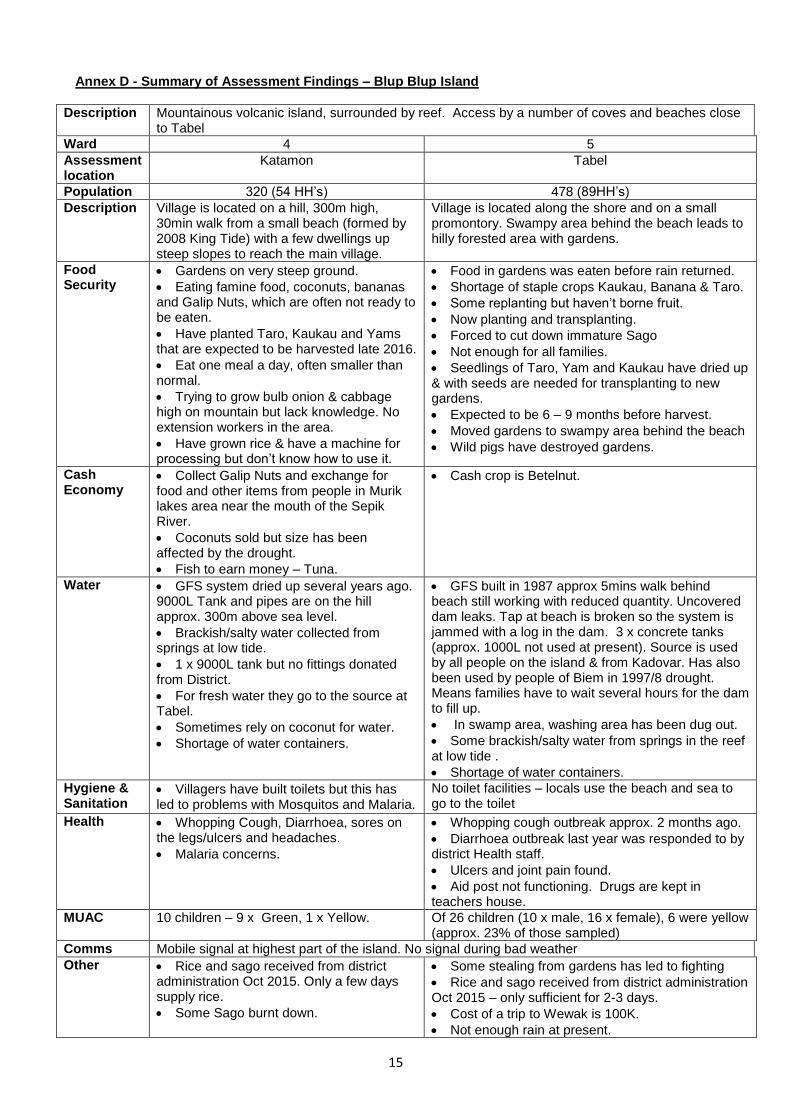
Annex D - Summary of Assessment Findings – Blup Blup Island
Description Mountainous volcanic island, surrounded by reef. Access by a number of coves and beaches close to Tabel
Ward 4 5
Assessment location
Katamon Tabel
Population 320 (54 HH’s) 478 (89HH’s)
Description Village is located on a hill, 300m high, 30min walk from a small beach (formed by 2008 King Tide) with a few dwellings up steep slopes to reach the main village.
Village is located along the shore and on a small promontory. Swampy area behind the beach leads to hilly forested area with gardens.
Food Security
Gardens on very steep ground.
Eating famine food, coconuts, bananas and Galip Nuts, which are often not ready to be eaten.
Have planted Taro, Kaukau and Yams that are expected to be harvested late 2016.
Eat one meal a day, often smaller than normal.
Trying to grow bulb onion & cabbage high on mountain but lack knowledge. No extension workers in the area.
Have grown rice & have a machine for processing but don’t know how to use it.
Food in gardens was eaten before rain returned.
Shortage of staple crops Kaukau, Banana & Taro.
Some replanting but haven’t borne fruit.
Now planting and transplanting.
Forced to cut down immature Sago
Not enough for all families.
Seedlings of Taro, Yam and Kaukau have dried up & with seeds are needed for transplanting to new gardens.
Expected to be 6 – 9 months before harvest.
Moved gardens to swampy area behind the beach
Wild pigs have destroyed gardens.
Cash Economy
Collect Galip Nuts and exchange for food and other items from people in Murik lakes area near the mouth of the Sepik River.
Coconuts sold but size has been affected by the drought.
Fish to earn money – Tuna.
Cash crop is Betelnut.
Water GFS system dried up several years ago. 9000L Tank and pipes are on the hill approx. 300m above sea level.
Brackish/salty water collected from springs at low tide.
1 x 9000L tank but no fittings donated from District.
For fresh water they go to the source at Tabel.
Sometimes rely on coconut for water.
Shortage of water containers.
GFS built in 1987 approx 5mins walk behind beach still working with reduced quantity. Uncovered dam leaks. Tap at beach is broken so the system is jammed with a log in the dam. 3 x concrete tanks (approx. 1000L not used at present). Source is used by all people on the island & from Kadovar. Has also been used by people of Biem in 1997/8 drought. Means families have to wait several hours for the dam to fill up.
In swamp area, washing area has been dug out.
Some brackish/salty water from springs in the reef at low tide .
Shortage of water containers.
Hygiene & Sanitation
Villagers have built toilets but this has led to problems with Mosquitos and Malaria.
No toilet facilities – locals use the beach and sea to go to the toilet
Health Whopping Cough, Diarrhoea, sores on the legs/ulcers and headaches.
Malaria concerns.
Whopping cough outbreak approx. 2 months ago.
Diarrhoea outbreak last year was responded to by district Health staff.
Ulcers and joint pain found.
Aid post not functioning. Drugs are kept in teachers house.
MUAC 10 children – 9 x Green, 1 x Yellow. Of 26 children (10 x male, 16 x female), 6 were yellow (approx. 23% of those sampled)
Comms Mobile signal at highest part of the island. No signal during bad weather
Other Rice and sago received from district administration Oct 2015. Only a few days supply rice.
Some Sago burnt down.
Some stealing from gardens has led to fighting
Rice and sago received from district administration Oct 2015 – only sufficient for 2-3 days.
Cost of a trip to Wewak is 100K.
Not enough rain at present.
16
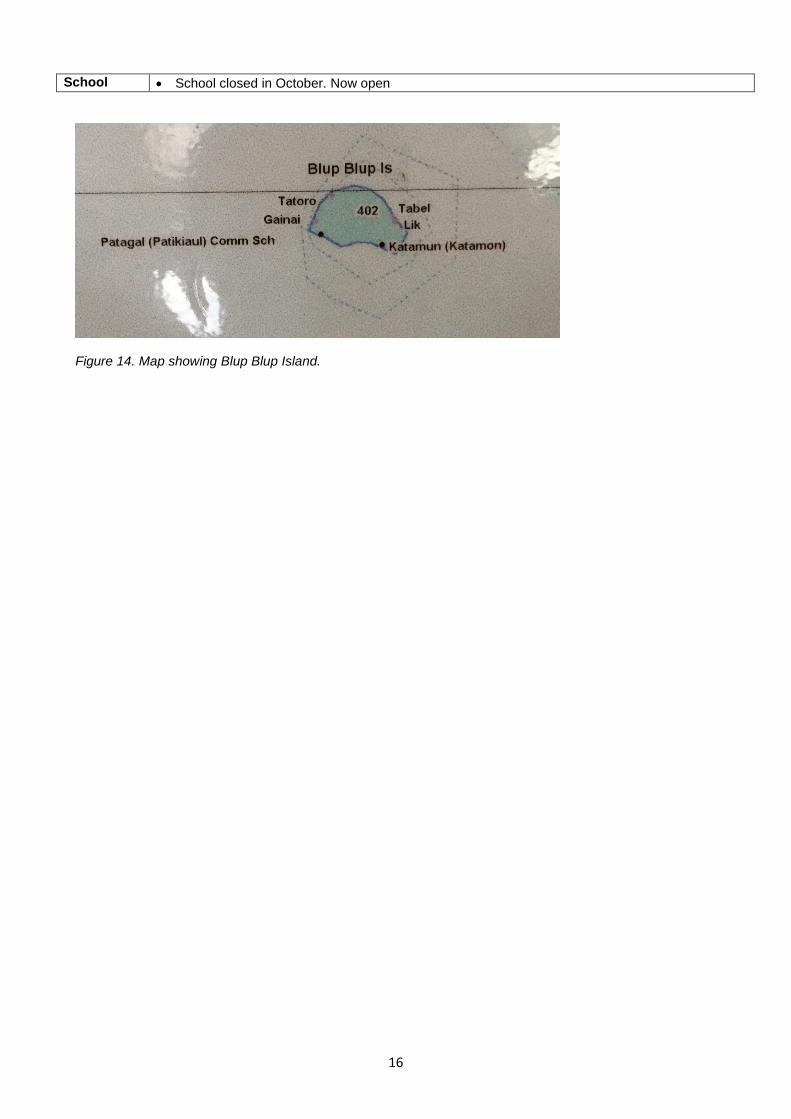
School School closed in October. Now open
Figure 14. Map showing Blup Blup Island.
17
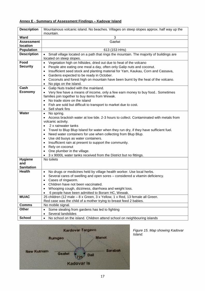
Annex E - Summary of Assessment Findings – Kadovar Island
Description Mountainous volcanic island. No beaches. Villages on steep slopes approx. half way up the mountain.
Ward 3
Assessment location
Gaelwi
Population 613 (153 HHs)
Description Small village located on a path that rings the mountain. The majority of buildings are located on steep slopes.
Food Security
Vegetation high on hillsides, dried out due to heat of the volcano
People atre eating one meal a day, often only Galip nuts and coconut.
Insufficient seed stock and planting material for Yam, Kaukau, Corn and Cassava,
Gardens expected to be ready in October.
Coconuts and forest high on mountain have been burnt by the heat of the volcano.
No pigs on the island.
Cash Economy
Galip Nuts traded with the mainland.
Very few have a means of income, only a few earn money to buy food.. Sometimes families join together to buy items from Wewak.
No trade store on the island
Fish are sold but difficult to transport to market due to cost.
Sell shark fins
Water No spring.
Access brackish water at low tide. 2-3 hours to collect. Contaminated with metals from volcanic activity.
2 x rainwater tanks
Travel to Blup Blup Island for water when they run dry, if they have sufficient fuel.
Need water containers for use when collecting from Blup Blup.
Use old buoys as water containers.
Insufficient rain at present to support the community.
Rely on coconut
One plumber in the village.
3 x 9000L water tanks received from the District but no fittings.
Hygiene and Sanitation
No toilets
Health No drugs or medicines held by village health worker. Use local herbs.
Several cares of swelling and open sores – considered a vitamin deficiency.
Cases of ringworm.
Children have not been vaccinated.
Whooping cough, dizziness, diarrhoea and weight loss.
6 people have been admitted to Boram HC, Wewak.
MUAC 25 children (12 male – 8 x Green, 3 x Yellow, 1 x Red, 13 female all Green. Red case was the child of a mother trying to breast feed 2 babies.
Comms No mobile signal.
Other Some stealing from gardens has led to fighting
Several landslides
School No school on the island. Children attend school on neighbouring islands
Figure 15. Map showing Kadovar Island.
18
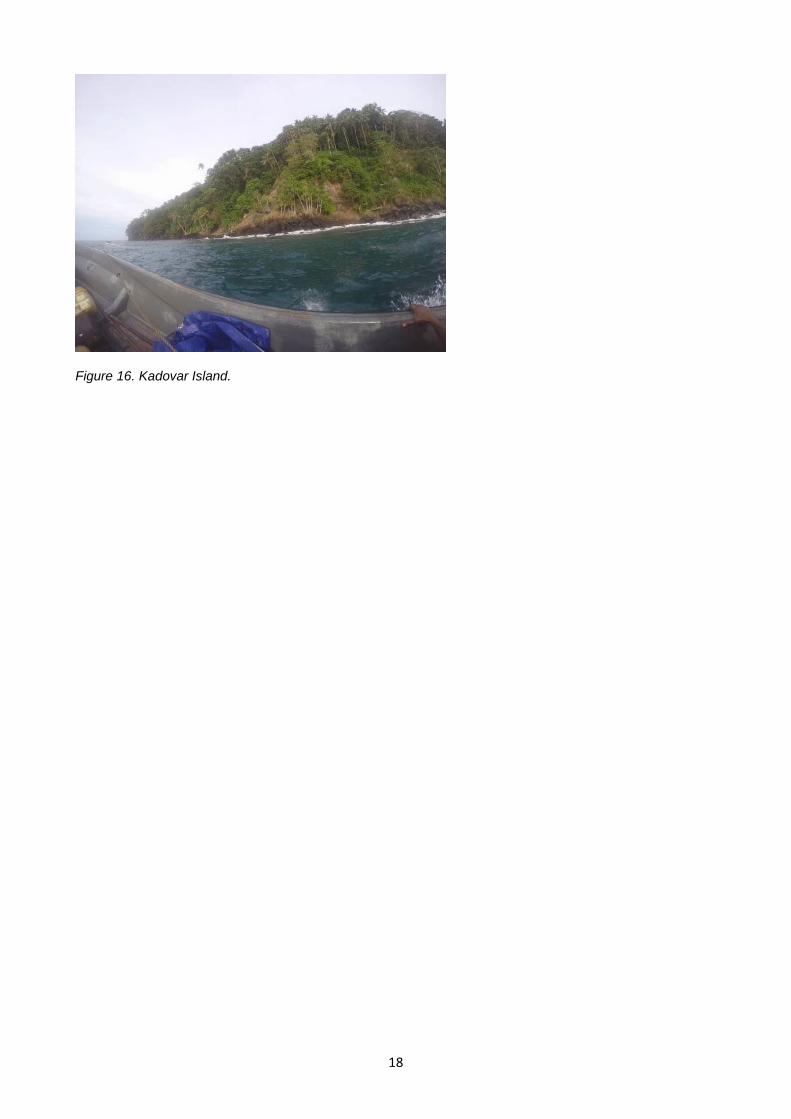
Figure 16. Kadovar Island.
19
Annex F - Breakdown of Recommended Follow Up Actions
Priority Vokeo Koil Wei Blup
Blup Kadovar Biem
Water Install new GFS 2 X
Provide water containers for transportation and household storage of water
1 X X X X
Provide RWC Fittings & training to enable installation of existing unconnected tanks
1 X X X X X
Provide roofing sheets in addition to fittings for RWC 1
Provide full RWC 1
Provide materials and training to enable improvements to be made to existing wells
1 X X X
Repair existing GFS (1) 1 X
Improve existing GFS (2) 1 X
Provide materials and training to enable repairs of water pump (3)
1 X
Repair water pump on well 1 X
Introduction of individual desalination systems 2 X X X X X X
Establishment of irrigation systems for gardens 3 X
Sanitation and Hygiene
Installation of toilets (compost) 3 X X X
Health and Hygiene Promotion 1 X X X X X X
Distribution of soap 1 X X X X X X
Soap production training 3 X X X X X X
Improvement to washing holes 1 X
Food Security Distribution of nutrition supplements 1 X X
Seeds and seedlings for staple foods – eg. sago 1 X X X X X X
Support to cultivation and processing of rice 2 X
Support to cultivation of bulb onions and cabbage 2 X
Support to development of commercial farming and fishing
3 X X
Health Distribution of mosquito nets 1 X X X
Training for health workers MUAC Monitoring 1 X X X
Vaccination programme for under 5 children 1 X X
Family Planning Advice 1 X X
Resupply of drugs to health workers X
Re-establish the aid post even if temporary
(1) Repair tap. (2) Increasing dam catchment, stoping leaks, protecting the source & increasing storage (3) Koil Health Centre