Embed Size (px)
Citation preview
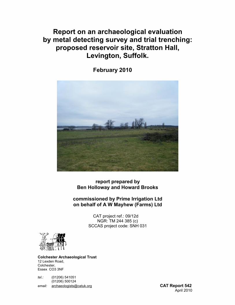
Report on an archaeological evaluation by metal detecting survey and trial trenching:
proposed reservoir site, Stratton Hall, Levington, Suffolk.
February 2010
report prepared by Ben Holloway and Howard Brooks
commissioned by Prime Irrigation Ltdon behalf of A W Mayhew (Farms) Ltd
CAT project ref.: 09/12dNGR: TM 244 385 (c)
SCCAS project code: SNH 031
Colchester Archaeological Trust12 Lexden Road, Colchester, Essex CO3 3NF
tel.: (01206) 541051(01206) 500124
email: [email protected] CAT Report 542 April 2010
Contents1 Summary 12 Introduction 13 Archaeological background 24 Aim 25 Results
5.1 Metal-detecting survey 2 5.2 Trial-trenching evaluation 36 Finds 6.1 Metal-detecting survey 9
6.2 Trail-trenching evaluation 9 6.3 Plant macrofossils and other remains, by Val Fryer 9
7 Discussion 118 Archive deposition 129 Acknowledgements 1210 References 1211 Glossary 1312 Appendix: SCCSAS Brief after p 14
Figures after Appendix
List of figuresFig 1 Site location.Fig 2 Site location, showing proposed reservoirFig 3 Results of metal-detecting survey.Fig 4 Overview of trial-trenching evaluationFig 5 Results of trial-trenching evaluation.Fig 6 Sections.
List of platesCover View south over site with Orwell in background.Plate 1 T4, view east, showing typical ground conditionsPlate 2 View west over site, T22 in foreground.Plate 3 T4, view south, showing position of alluvial deposit L4
CAT Report 542: Report on an archaeological evaluation by metal detecting survey and trial trenching: proposed reservoir site, Stratton Hall, Levington, Suffolk: February 2010.
1 SummaryA two-part archaeological evaluation was carried out in February 2010 in advance of the construction of an agricultural reservoir on a 2.5ha site at Stratton Hall, Levington, Suffolk.
A metal-detecting survey produced a single find - a small lead musket ball, probably from a fowling gun.
An evaluation by 21 trial trenches (combined length 694m) gave a 5% coverage of the site. Fifteen features were revealed. Three of these were of modern date, and twelve were undated. Although the undated features are presumed to be of post-medieval or modern date, the presence of prehistoric cropmarks on higher ground to the north of this site means some of them may be of prehistoric origin. Five of the (undated) features were ‘natural’, either pits, linears, or tree-throw pits. Whether human agency was involved in the creation of the tree-throw pits is unclear, but charcoal in their fills may indicate that this was so.
Sampling of an undated organic alluvial deposit in trenches in the south-eastern corner of the site showed that the deposit had formed naturally, probably as a result of one or more closely-associated flood events.
2 Introduction (Fig 1)2.1 This is the archive report on an archaeological evaluation by trial-trenching and
metal-detecting survey carried out by Colchester Archaeological Trust (CAT) between the 17th February and the 23rd February 2010 on the site of a proposed agricultural reservoir at Stratton Hall, Levington, Suffolk. The archaeological work was commissioned by Prime Irrigation Ltd and funded by A W Mayhew (Farms) Ltd.
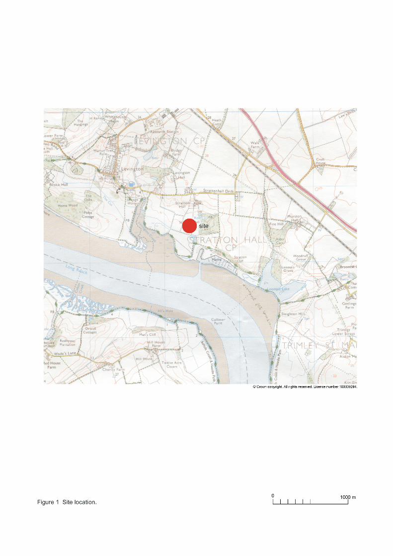
2.2 The proposed development area measures c 2.50ha. It lies on the north side of, and above, the estuary of the River Orwell and to the south-east of Stratton Hall (see Figs 1, 2). The site is currently pasture used for stock grazing. There is a reed bed in the south-eastern corner of the site, where the ground has become waterlogged. Natural geology is sand and gravel and sandy clay. The site slopes down from north (where ground level is approximately 4.3m AOD) to south (2.3m AOD).
2.3 Site centre is NGR TM 244 385.
2.4 A planning enquiry has been made for the construction of a farm reservoir at Stratton Hall. The Planning Authority (Suffolk Coastal District Council) will be advised by Suffolk County Council Archaeology Service that this proposal lies in an area of high archaeological importance.
2.5 Prior to consideration of the application, and in order to inform any necessary archaeological mitigation strategy (as suggested in paragraph 21 of Planning Policy Guidance 16: archaeology & planning: DoE 1990), the applicant was required to commission and cause to be carried out the following archaeological work:
• non-intrusive field-walking and metal-detecting survey,• a linear trenched evaluation.
2.6 The required archaeological work was set out in a document titled Proposed reservoir site, Stratton Hall, Levington, Suffolk: Brief and Specification for Archaeological Evaluation, written by Dr Jess Tipper (SCCAS 2009). In response to the SCCAS Brief, CAT prepared a Written Scheme of Investigation (WSI) which was agreed with SCCAS (CAT 2010).
2.7 Owing to conditions placed on the land as part of an environment protection scheme, the land could not be ploughed. Therefore the archaeological work, and the subject of this report consisted of a metal-detecting survey followed by a trial trenching evaluation.
CAT Report 542: Report on an archaeological evaluation by metal detecting survey and trial trenching: proposed reservoir site, Stratton Hall, Levington, Suffolk: February 2010.
2.6 This report mirrors standards and practices contained in the Institute for Archaeologists’ Standard and guidance for an archaeological field evaluation (IfA 2008a) and Standard and guidance for the collection, documentation, conservation and research of archaeological materials (IfA 2008b). Other sources used are English Heritage’s Management of Archaeological Projects (MAP 2), and Standards for field archaeology in the East of England (EAA 14).
3 Archaeological background This section is based on records held by the Suffolk County Council Archaeological Service’s Historic Environment Record (SHER). The site of the proposed reservoir lies in an area of high archaeological importance, recorded in the SHER within a known area of extensive archaeological activity. It is situated to the north-west of known Anglo-Saxon activity (HER SNH 013) and to the west and south of extensive cropmark remains recorded by aerial reconnaissance (SNH 005 and LVT 047) that are indicative of late prehistoric settlement. However, this site has not been the subject of previous systematic investigation. The site has good potential for the discovery of important hitherto unknown archaeological sites and features in view of its proximity to known sites and also its topographic location overlooking the Orwell estuary. There is high potential for archaeological deposits to be disturbed by this large development and, in particular, the reservoir will cause total destruction to a large area.
4 AimThe aim of the evaluation was to :
Establish whether any archaeological deposit exists in the area, with particular regard to any which are of sufficient importance to merit preservation in situ.
Identify the date, approximate form and purpose of any archaeological deposit within the application area, together with its probably extent, localised depth and quality of preservation.
Evaluate the probably impact of past land uses, and the possible presence of masking colluvial/alluvial deposits.
Establish the potential for the survival of environmental evidence.
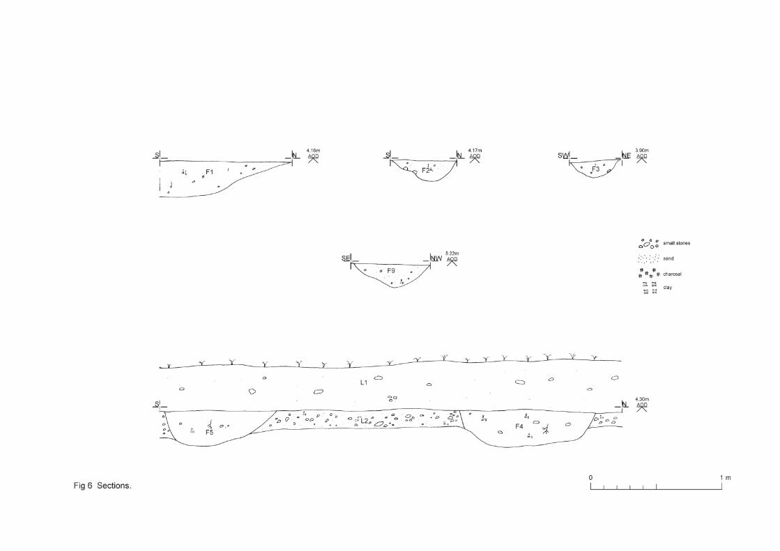
5 Results (Figs 2-6)
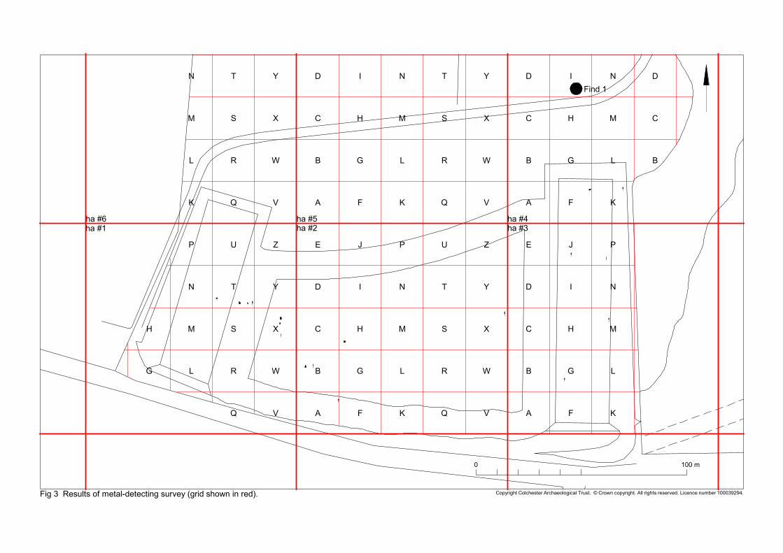
5.1 Metal-detecting survey (Fig 3)5.1 The survey was carried out to the same methodology as is used in fieldwalking
survey, i.e., by searching 2m-wide corridors at 20m-spacing, thus giving a 10% coverage of the site. The recording system is based on the hectare block (hectares were numbered 1-6 in this survey). Within each hectare, there are 25 separate collection boxes labelled A-Z (but missing ”I”). Finds are therefore referenced to the hectare and box, for instance “Hectare 2, box K”, or “Hectare 4, box B”. The metal-detecting survey grid is shown on Fig 2.
5.2 There was only one find, a 6g lead shot, probably from a small fowling piece. The find-spot is shown as Find 1 on Fig 3.
5.3 The conclusions of the metal detecting survey are that there has been little human activity on this site. The clearest reason for this is the wetness of the site, which has
CAT Report 542: Report on an archaeological evaluation by metal detecting survey and trial trenching: proposed reservoir site, Stratton Hall, Levington, Suffolk: February 2010.
probably made it unsuitable for habitation. The lead shot shows that someone was fowling here, probably in the 18th or 19th century.
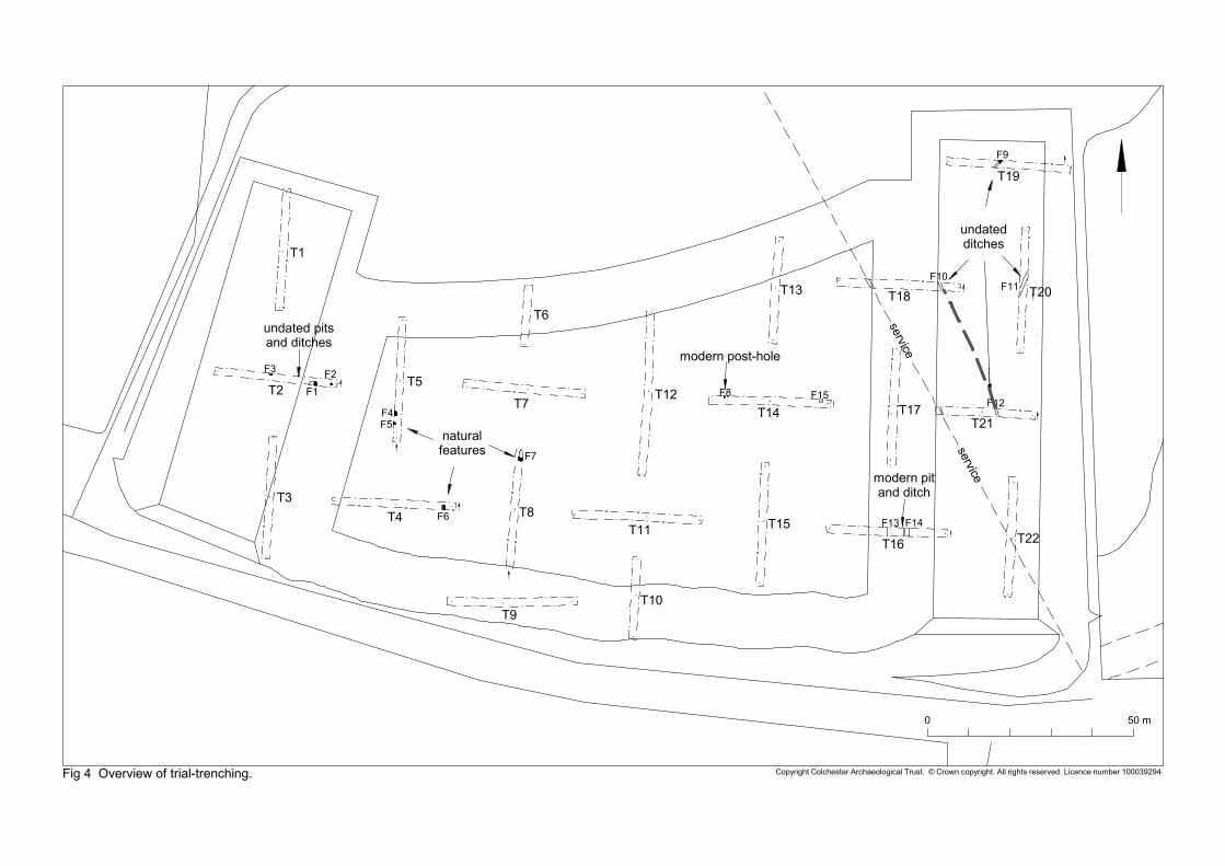
5.2 Trial-trenching evaluation (Figs 2, 4-6)
Summary of archaeological fieldworkThe specified 5% evaluation required trenches with a combined length of 694m. However, 54m of trenching was lost in the south-eastern corner of the site due to unworkable ground conditions. This reduction was discussed and approved by the Suffolk County Council monitor at the time of the evaluation.
Using a mechanical excavator with a toothless bucket and under archaeological supervision, the following horizons were removed:
Topsoil L1: a soft medium brown sandy silt with common stones: 360-400mm thick, L2: light brown/cream clay with common stones: 120-180mm thick.
This revealed the ‘natural’ ground of coarse gravels within a clay matrix (L3). In two trenches (T16 and T22) in the south east corner of the site an alluvial deposit L4 (a dark grey silty clay 0.35m thick, sealed by L2) was identified and sampled (see section 6.3 for report). L4 was sealed by L2 and sealed natural L3.
Fifteen features were revealed (F1-F15). Three of these were of modern date, and twelve were undated and presumed to be post-medieval or modern (F1-3, F8-14). Five of the undated features were ‘natural’ pits or linears (F4-5, F7), or tree-throw pits (F6, F15).
An archaeological summary of each evaluation trench with a tabulation of context and finds dating information follows below. In the identification of archaeological contexts, the context number is prefixed by either ‘F’ indicating a feature, or ‘L’ indicting a layer.
Trench 1: summaryLocated in the north-western corner of the site, T1 contained no archaeological features.
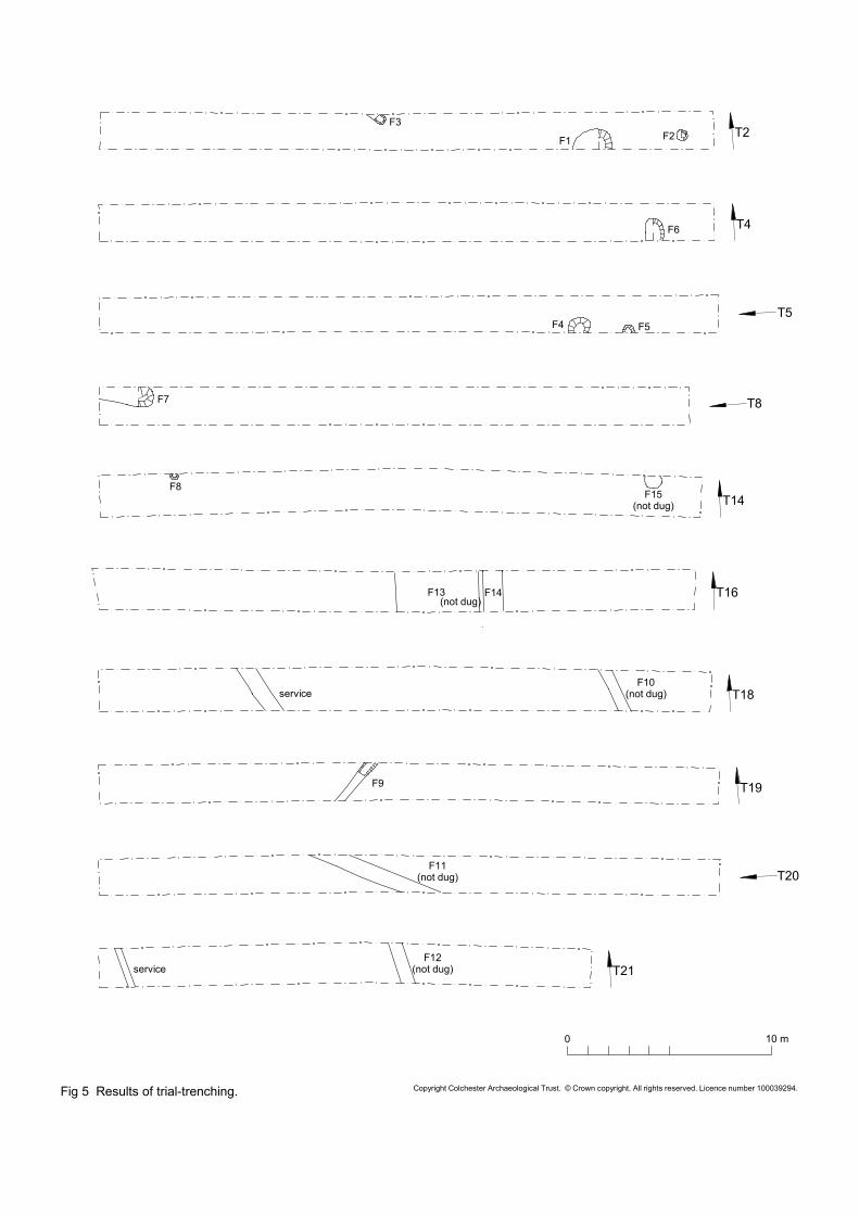
Trench 2: summaryLocated on the western edge of the site, T2 contained three archaeological features. These were pits (F1, F2) and the terminal end of a linear feature (F3). None of the features contained datable material, but they are presumed to be post-medieval or modern in date. Charcoal inclusions may indicate an agricultural function.
Trench 2 – archaeological contexts and dating.context number
context type
dimensions fill description dated finds
period
F1 undated pit
2m diameter (east-west), 0.28m deep
medium grey/brown silt with charcoal flecks. leached-out appearance.
- post-medieval or modern?
F2 undated pit
0.5m diameter, 0.16m deep
mid grey/brown silty clay with occasional small stones.
- post-medieval or modern?
F3 undated ditch
0.8m length in trench (continues into north section), 0.38m wide, 0.12m deep
mid grey/brown silty clay with occasional small stones.
- post-medieval or modern?
CAT Report 542: Report on an archaeological evaluation by metal detecting survey and trial trenching: proposed reservoir site, Stratton Hall, Levington, Suffolk: February 2010.
Trench 3: summaryLocated in the south-western corner of the site, T3 contained no archaeological features.
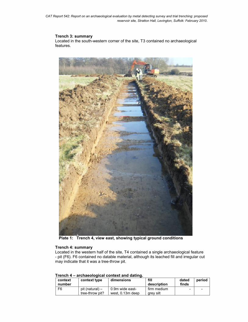
Plate 1: Trench 4, view east, showing typical ground conditions
Trench 4: summaryLocated in the western half of the site, T4 contained a single archaeological feature - pit (F6). F6 contained no datable material, although its leached fill and irregular cut may indicate that it was a tree-throw pit.
Trench 4 – archaeological context and dating.context number
context type dimensions fill description
dated finds
period
F6 pit (natural) –tree-throw pit?
0.9m wide east-west, 0.13m deep
firm medium grey silt
- -
CAT Report 542: Report on an archaeological evaluation by metal detecting survey and trial trenching: proposed reservoir site, Stratton Hall, Levington, Suffolk: February 2010.
Trench 5: summaryLocated in the western side of the site, T5 contained two archaeological features –pits F4 and F5. Neither contained datable material, and their fills and profiles indicate a natural (geological) origin.
Trench 5 – archaeological contexts and dating.context number
context type
dimensions fill description dated finds
period
F4 pit (natural)
1.04m wide, 0.28m deep
light brown/cream sandy clay with small/medium stones
-- -
F5 pit (natural)
0.84m wide, 0.27m deep
light brown/cream sandy clay with small/medium stones
-- -
Trenches 6, 7: summaryLocated in the centre of the site, T6 and T7 contained no archaeological features.
Trench 8: summaryLocated central part of the evaluation area, T8 contained a single linear archaeological feature (F7). It contained no datable finds, but its leached fill and irregular cut may indicate a natural (geological) origin.
Trench 8 – archaeological context and dating.context number
context type
dimensions fill description dated finds
period
F7 linear (natural)
1.0m wide, 0.22m deep, 2.6m long in trench (and continuing into north section)
homogenous soft light brown silty clay with common small/medium stones
-- -
Trenches 9, 10, 11, 12, 13: summaryT9, T10 (located on the southern edge of the site), and T11, T12, T13 (located in the centre of the site), contained no archaeological features.
Trench 14: summaryLocated central area of the evaluation, T14 contained two features: post-hole F8 and pit F15. F8 is the remains of the south portion of a modern fence that can still be seen in the northern half of the meadow. F15 had no datable finds, although its leached fill and irregular cut may indicate that it was a tree-throw pit.
Trench 14 – archaeological contexts and dating.context number
context type dimensions fill description dated finds
period
F8 post-hole 0.8m diameter, 0.15m deep
mid brown silty clay, occasional stones
-- modern
F15 pit (natural) –tree-throw pit?
0.35m diameter firm medium grey silt
-- -
CAT Report 542: Report on an archaeological evaluation by metal detecting survey and trial trenching: proposed reservoir site, Stratton Hall, Levington, Suffolk: February 2010.
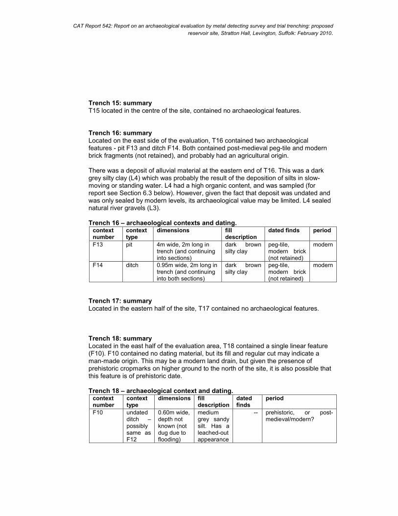
Trench 15: summaryT15 located in the centre of the site, contained no archaeological features.
Trench 16: summaryLocated on the east side of the evaluation, T16 contained two archaeological features - pit F13 and ditch F14. Both contained post-medieval peg-tile and modern brick fragments (not retained), and probably had an agricultural origin.
There was a deposit of alluvial material at the eastern end of T16. This was a dark grey silty clay (L4) which was probably the result of the deposition of silts in slow-moving or standing water. L4 had a high organic content, and was sampled (for report see Section 6.3 below). However, given the fact that deposit was undated and was only sealed by modern levels, its archaeological value may be limited. L4 sealed natural river gravels (L3).
Trench 16 – archaeological contexts and dating.context number
context type
dimensions fill description
dated finds period
F13 pit 4m wide, 2m long in trench (and continuing into sections)
dark brown silty clay
peg-tile, modern brick (not retained)
modern
F14 ditch 0.95m wide, 2m long in trench (and continuing into both sections)
dark brown silty clay
peg-tile, modern brick (not retained)
modern
Trench 17: summaryLocated in the eastern half of the site, T17 contained no archaeological features.
Trench 18: summaryLocated in the east half of the evaluation area, T18 contained a single linear feature (F10). F10 contained no dating material, but its fill and regular cut may indicate a man-made origin. This may be a modern land drain, but given the presence of prehistoric cropmarks on higher ground to the north of the site, it is also possible that this feature is of prehistoric date.
Trench 18 – archaeological context and dating.context number
context type
dimensions fill description
dated finds
period
F10 undated ditch –possibly same as F12
0.60m wide, depth not known (not dug due to flooding)
medium grey sandy silt. Has a leached-out appearance
-- prehistoric, or post-medieval/modern?
CAT Report 542: Report on an archaeological evaluation by metal detecting survey and trial trenching: proposed reservoir site, Stratton Hall, Levington, Suffolk: February 2010.
Trench 19: summaryLocated in the north east corner of the evaluation area, T19 contained a single undated ditch (F9). F9 contained no dating material, but its fill and regular cut may indicate a man-made origin. This may be a modern land drain, but given the presence of prehistoric cropmarks on higher ground to the north of the site, it is also possible that this feature is of prehistoric date.
Trench 19 – archaeological context and dating.context number
context type
dimensions fill description dated finds
period
F9 undated ditch
0.56m wide, 0.38m deep. 2.4m long in trench (and continuing into both sections)
medium grey sandy silt with occasional small/medium stones. Has a leached-out appearance
--
prehistoric, or post-medieval/modern?
Trench 20: summaryLocated in the north east corner of the evaluation area, T20 contained a single linear feature (F11). F11 contained no dating material, but its fill and regular cut may indicate a man-made origin. This may be a modern land drain, but given the presence of prehistoric cropmarks on higher ground to the north of the site, it is also possible that this feature is of prehistoric date.
Trench 20 – archaeological context and dating.context number
context type
dimensions fill description
dated finds
period
F11 undated ditch
0.80m wide, 4.8m long in trench (and continuing into both sections), depth not known (not dug due to flooding)
medium grey sandy silt. Has a leached-out appearance
-- prehistoric, or post-medieval/modern?
Trench 21: summaryLocated in the east half of the evaluation area, T21 contained a single linear feature (F12). F12 contained no dating material but its fill and regular cut may indicate a man-made origin. This may be a modern land drain, but given the presence of prehistoric cropmarks on higher ground to the north of the site, it is also possible that this feature is of prehistoric date.
Trench 21 – archaeological context and dating.context number
context type
dimensions fill description
dated finds
period
F12 undated ditch –possible same as F10
0.60m wide, 2m long in trench (and continuing into both sections), depth not known (not dug due to flooding)
medium grey sandy silt. Has a leached-out appearance
-- prehistoric, or post-medieval/modern?
CAT Report 542: Report on an archaeological evaluation by metal detecting survey and trial trenching: proposed reservoir site, Stratton Hall, Levington, Suffolk: February 2010.
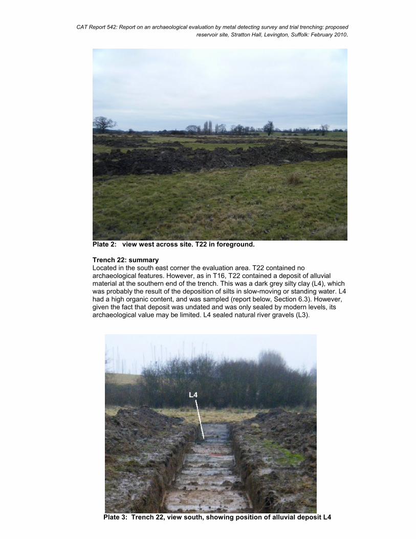
Plate 2: view west across site. T22 in foreground.
Trench 22: summaryLocated in the south east corner the evaluation area. T22 contained no archaeological features. However, as in T16, T22 contained a deposit of alluvial material at the southern end of the trench. This was a dark grey silty clay (L4), which was probably the result of the deposition of silts in slow-moving or standing water. L4 had a high organic content, and was sampled (report below, Section 6.3). However, given the fact that deposit was undated and was only sealed by modern levels, its archaeological value may be limited. L4 sealed natural river gravels (L3).
Plate 3: Trench 22, view south, showing position of alluvial deposit L4
CAT Report 542: Report on an archaeological evaluation by metal detecting survey and trial trenching: proposed reservoir site, Stratton Hall, Levington, Suffolk: February 2010.
6 Finds (Fig 3)
6.1 Metal-detecting survey
Hectare 4, box IFind 11 small lead musket ball, 10mm in diameter, 6.1g. Too small to be a musket ball. This is probably a lead shot from a small 18th or 19th-century fowling piece (which would be appropriate for this location).
(Pieces of modern agricultural ironwork such as nuts, chain fragments and nails were identified in these locations (but not retained): Hectare 1, boxes U, N; hectare 3, boxes N, M, L; hectare 4, boxes F, L; hectare 6, box K).
6.2 Trial- trenching evaluation There were no retained finds.
6.3 An evaluation of the plant macrofossils and other remainsby Val Fryer(Church Farm, Sisland, Loddon, Norwich, Norfolk, NR14 6EF).
Introduction and method statementThe evaluation recorded an organic alluvial deposit sealed within a sequence of sands and gravels. Although the deposit was not closely dated, a single sample was taken to evaluate the content and preservation of the plant macrofossil assemblage. A four litre sub-sample of the alluvium was processed by manual water flotation/washover and the flot was collected in a 250 micron mesh sieve. As the flot was seen to contain a high density of waterlogged plant remains, it was stored in water prior to sorting. The wet retents were scanned under a binocular microscope at magnifications up to x 16 and the plant macrofossils and other remains noted are listed in Table 1. Nomenclature within the table follows Stace (1997). With the exception of a single charred seed and rare fragments of charcoal/charred wood, all plant remains were preserved in a waterlogged state. The non-floating residue was collected in a 1mm mesh sieve and sorted when dry. Artefacts/ecofacts were not recorded and the residue consisted entirely of sand and gravel.
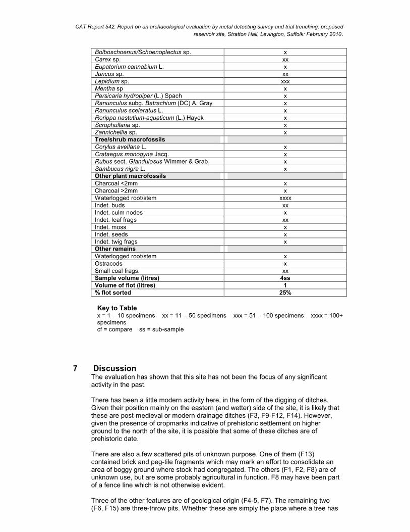
ResultsAlthough the assemblage was largely composed of waterlogged root/stem fragments, seeds of common grassland herbs, ruderal weeds and wetland/aquatic plants were also recorded at a low to moderate density. Preservation was moderately good although the remains were somewhat comminuted and some seeds had become crushed and distorted, probably as a result of the compression of the deposit. Seeds of dry land plants were moderately common, with those of rough grassland herbs occurring most frequently. Taxa noted included musk thistle (Carduus sp.), fig-leaved goosefoot (Chenopodium ficifolium), thistle (Cirsium sp.), grasses (Poaceae), persicaria (Persicaria maculosa/lapathifolia), buttercup (Ranunculus sp.), dock (Rumex sp.) and stinging nettles (Urtica dioica). Some seeds of annual weeds commonly found on disturbed or cultivated land were also noted and included orache (Atriplex sp.) and fat hen (Chenopodium album). Seeds of wetland and aquatic plants were recorded at a moderate to high density, with the species noted most frequently including wild celery (Apium graveolens), bur-marigold (Bidens tripartita), sedge (Carex sp.), rush (Juncus sp.), pepperwort (Lepidium sp.) and water cress (Rorippa nasturtium-aquaticum). Tree/shrub macrofossils occurred less
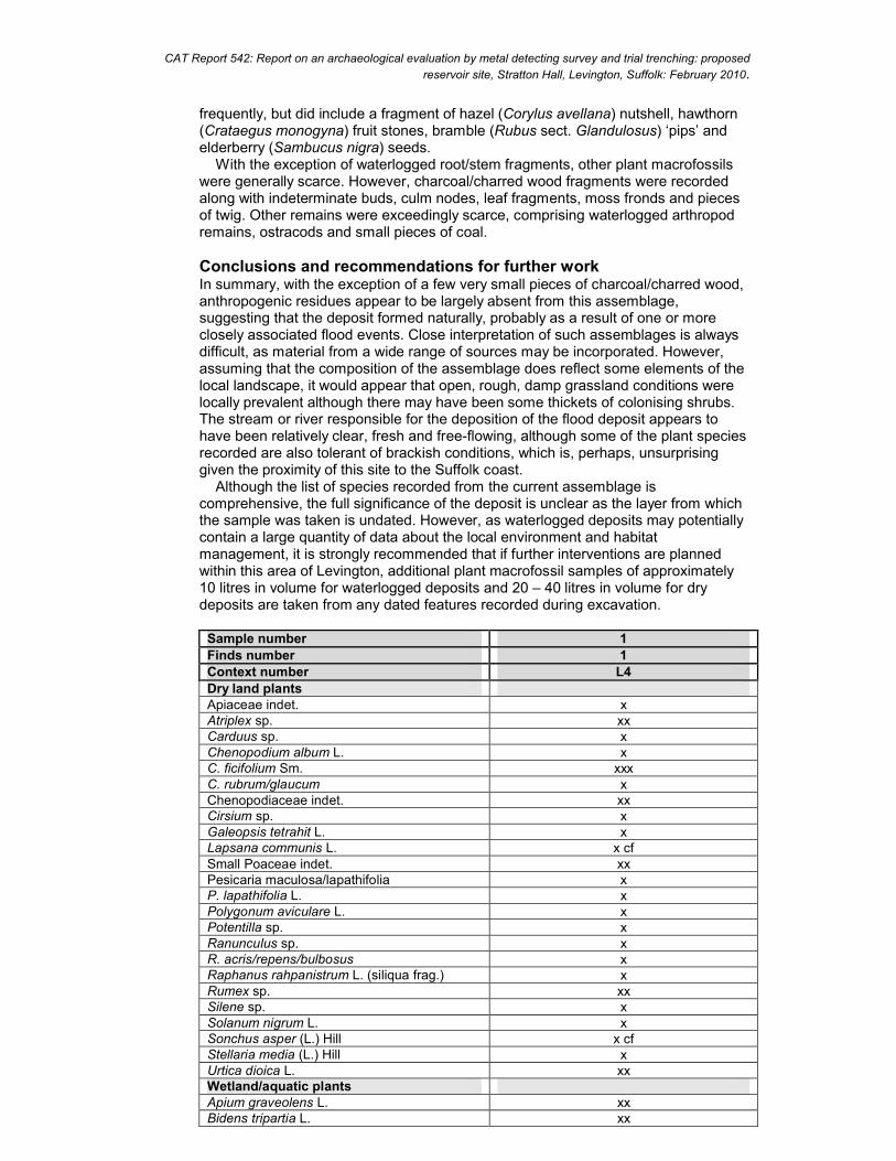
CAT Report 542: Report on an archaeological evaluation by metal detecting survey and trial trenching: proposed reservoir site, Stratton Hall, Levington, Suffolk: February 2010.
frequently, but did include a fragment of hazel (Corylus avellana) nutshell, hawthorn (Crataegus monogyna) fruit stones, bramble (Rubus sect. Glandulosus) ‘pips’ and elderberry (Sambucus nigra) seeds. With the exception of waterlogged root/stem fragments, other plant macrofossils were generally scarce. However, charcoal/charred wood fragments were recorded along with indeterminate buds, culm nodes, leaf fragments, moss fronds and pieces of twig. Other remains were exceedingly scarce, comprising waterlogged arthropod remains, ostracods and small pieces of coal.
Conclusions and recommendations for further workIn summary, with the exception of a few very small pieces of charcoal/charred wood, anthropogenic residues appear to be largely absent from this assemblage, suggesting that the deposit formed naturally, probably as a result of one or more closely associated flood events. Close interpretation of such assemblages is always difficult, as material from a wide range of sources may be incorporated. However, assuming that the composition of the assemblage does reflect some elements of the local landscape, it would appear that open, rough, damp grassland conditions were locally prevalent although there may have been some thickets of colonising shrubs. The stream or river responsible for the deposition of the flood deposit appears to have been relatively clear, fresh and free-flowing, although some of the plant species recorded are also tolerant of brackish conditions, which is, perhaps, unsurprising given the proximity of this site to the Suffolk coast. Although the list of species recorded from the current assemblage is comprehensive, the full significance of the deposit is unclear as the layer from which the sample was taken is undated. However, as waterlogged deposits may potentially contain a large quantity of data about the local environment and habitat management, it is strongly recommended that if further interventions are planned within this area of Levington, additional plant macrofossil samples of approximately 10 litres in volume for waterlogged deposits and 20 – 40 litres in volume for dry deposits are taken from any dated features recorded during excavation.
Sample number 1Finds number 1Context number L4Dry land plants Apiaceae indet. xAtriplex sp. xxCarduus sp. xChenopodium album L. xC. ficifolium Sm. xxxC. rubrum/glaucum xChenopodiaceae indet. xxCirsium sp. xGaleopsis tetrahit L. xLapsana communis L. x cfSmall Poaceae indet. xxPesicaria maculosa/lapathifolia xP. lapathifolia L. xPolygonum aviculare L. xPotentilla sp. xRanunculus sp. xR. acris/repens/bulbosus xRaphanus rahpanistrum L. (siliqua frag.) xRumex sp. xxSilene sp. xSolanum nigrum L. xSonchus asper (L.) Hill x cfStellaria media (L.) Hill xUrtica dioica L. xxWetland/aquatic plantsApium graveolens L. xxBidens tripartia L. xx
CAT Report 542: Report on an archaeological evaluation by metal detecting survey and trial trenching: proposed reservoir site, Stratton Hall, Levington, Suffolk: February 2010.
Bolboschoenus/Schoenoplectus sp. xCarex sp. xxEupatorium cannabium L. xJuncus sp. xxLepidium sp. xxxMentha sp xPersicaria hydropiper (L.) Spach xRanunculus subg. Batrachium (DC) A. Gray xRanunculus sceleratus L. xRorippa nastutium-aquaticum (L.) Hayek xScrophullaria sp. xZannichellia sp. xTree/shrub macrofossilsCorylus avellana L. xCrataegus monogyna Jacq. xRubus sect. Glandulosus Wimmer & Grab xSambucus nigra L. xOther plant macrofossilsCharcoal <2mm xCharcoal >2mm xWaterlogged root/stem xxxxIndet. buds xxIndet. culm nodes xIndet. leaf frags xxIndet. moss xIndet. seeds xIndet. twig frags xOther remainsWaterlogged root/stem xOstracods xSmall coal frags. xxSample volume (litres) 4ssVolume of flot (litres) 1% flot sorted 25%
Key to Tablex = 1 – 10 specimens xx = 11 – 50 specimens xxx = 51 – 100 specimens xxxx = 100+ specimenscf = compare ss = sub-sample
7 DiscussionThe evaluation has shown that this site has not been the focus of any significant activity in the past.
There has been a little modern activity here, in the form of the digging of ditches. Given their position mainly on the eastern (and wetter) side of the site, it is likely that these are post-medieval or modern drainage ditches (F3, F9-F12, F14). However, given the presence of cropmarks indicative of prehistoric settlement on higher ground to the north of the site, it is possible that some of these ditches are of prehistoric date.
There are also a few scattered pits of unknown purpose. One of them (F13) contained brick and peg-tile fragments which may mark an effort to consolidate an area of boggy ground where stock had congregated. The others (F1, F2, F8) are of unknown use, but are some probably agricultural in function. F8 may have been part of a fence line which is not otherwise evident.
Three of the other features are of geological origin (F4-5, F7). The remaining two (F6, F15) are three-throw pits. Whether these are simply the place where a tree has
CAT Report 542: Report on an archaeological evaluation by metal detecting survey and trial trenching: proposed reservoir site, Stratton Hall, Levington, Suffolk: February 2010.
fallen over in the past, or whether humans were involved in the process is unknown, but charcoal flecking in the fills of these features probably indicates human activity.
The sampling of an undated alluvial deposit (L4) showed that the deposit formed naturally, probably as a result of one or more closely associated flood events. The local landscape appeared to be open, rough, damp grassland. The stream or river responsible for the deposition of the flood deposit appears to have been relatively clear, fresh and free-flowing, although some of the plant species recorded are also tolerant of brackish conditions, which is, perhaps, unsurprising given the proximity of this site to the Suffolk coast.
The site is on a down-slope to wet ground close to the Orwell, and may always have been marginal. The nearest significant archaeological site is marked by areas of cropmarks on higher ground to the north and west (SNH 005 and LVT 047), and it may be that other foci of archaeological activity are to be found on higher and potentially drier ground than is afforded by this site.
8 Archive depositionThe paper archive and find are currently held by CAT at 12 Lexden Road, Colchester, Essex, but will be permanently deposited with Suffolk County Council Archaeology Service (reference SNH 031).
9 AcknowledgementsThis project was commissioned by Prime Irrigation Ltd, and funded by A W Mayhew (Farms) Ltd, to whom we are grateful. Site work directed by B Holloway, assisted by M Baister, R Crocket, B Hurrell, C Lister, N Rayner, A Wightman. EDM plots by A Wightman and C Lister. Illustrations by CL. The project was monitored by Dr Jess Tipper for Suffolk County Council.
10 ReferencesCAT 2010 Written Scheme of Investigation for a field-walking and metal-
detecting survey, and a linear trenched evaluation on the proposed reservoir site, Stratton Hall, Levington, Suffolk. January 2010
DoE 1990 Planning Policy Guidance 16: Archaeology and Planning
EAA 14 2003 Standards for field archaeology in the East of England, East Anglian Archaeology, Occasional Papers, 14, ed by D Gurney
IfA 2008a Standard and guidance for an archaeological field evaluation
IfA 2008b Standard and guidance for the collection, documentation, conservation and research of archaeological materials
MAP 2 1991 Management of archaeological projects, second edition (English Heritage)
SCCAS 2009 Proposed reservoir site, Stratton Hall, Levington, Suffolk: Brief and Specification for Archaeological Evaluation, written by Dr Jess Tipper, 1 May 2009
Stace, C
1997 New Flora of the British Isles. Second edition. Cambridge University Press
CAT Report 542: Report on an archaeological evaluation by metal detecting survey and trial trenching: proposed reservoir site, Stratton Hall, Levington, Suffolk: February 2010.
11 Glossary AOD above ordnance datumcontext on an excavation site, a specific location (especially of finds)feature something excavated, ie a wall, a floor, a pit, a ditch, etc IfA Institute for Archaeologistsmedieval period from AD 1066 to c AD 1500modern period from c AD 1800 to the presentnatural geological deposit undisturbed by human activityNGR National grid referencepost-medieval after c AD 1500 to c AD 1800prehistoric the years BCSCCAS Suffolk County Council Archaeological ServiceSHER Suffolk Historic Environment Record (Suffolk CC Archaeological Service)
Colchester Archaeological Trust 2010
Distribution list:A W Mayhew (Farms) LtdPrime Irrigation Ltd (Mr Graham Hall)Dr Jess Tipper, SCCAS Monitor Suffolk Historic Environment Record
Colchester Archaeological Trust12 Lexden Road,Colchester,Essex CO3 3NF
tel.: (01206) 541051 (01206) 500124email: [email protected]
checked by: Philip Crummydate: 06.04.10
PC c:/2010 projects/StrattonHall Levington/report542.doc

CAT Report 542: Report on an archaeological evaluation by metal detecting survey and trial trenching: proposed reservoir site, Stratton Hall, Levington, Suffolk: February 2010.
Appendix: SCCAS Brief
(following pages)
The Archaeological Service _________________________________________________ Environment and Transport Service Delivery 9-10 The Churchyard, Shire Hall Bury St Edmunds Suffolk IP33 2AR
Brief and Specification for Archaeological Evaluation
PROPOSED RESERVOIR, STRATTON HALL, LEVINGTON, SUFFOLK
The commissioning body should be aware that it may have Health & Safety responsibilities.
1. The nature of the development and archaeological requirements 1.1 A planning enquiry has been made for the construction of a farm reservoir at Stratton Hall,
Levington, Suffolk (TM 244 385). 1.2 The Planning Authority (Suffolk Coastal District Council) will be advised by Suffolk County
Council Archaeology Service that this proposal lies in an area of high archaeological importance. In order to establish the archaeological implications of this application, the applicant should be required, prior to consideration of the application, to provide an archaeological impact assessment of the proposed site as suggested in DoE Planning Policy Guidance 16 (November 1990), para 21.
1.3 The proposed development area measures c. 2.50ha. in area, on the north side of, and above,
the estuary of the River Orwell and to the south-east of Stratton Hall (see accompanying plan). It is situated on sand and gravel and sandy clay at c. 5.00m AOD.
1.4 The site of the proposed reservoir lies in an area of high archaeological importance, recorded
in the County Historic Environment Record, within a known area of extensive archaeological activity. It is situated to the north-west of known Anglo-Saxon activity (HER no. SNH 013) and to the west and south of extensive cropmark remains recorded by aerial reconnaissance (SNH 005 and LVT 047) that are indicative of late prehistoric settlement. However, this site has not been the subject of previous systematic investigation. The site has good potential for the discovery of important hitherto unknown archaeological sites and features in view of its proximity to known sites and also its topographic location overlooking the Orwell estuary. There is high potential for archaeological deposits to be disturbed by this large development and, in particular, the reservoir will cause total destruction to a large area.
1.5 In order to inform the archaeological mitigation strategy, and as a first part of a staged scheme
of archaeological evaluation work, the following work is required:
• non-intrusive field-walking and metal-detecting survey. • A linear trenched evaluation is required of the development area.
1.6 The results of this evaluation will enable the archaeological resource, both in quality and extent, to be accurately quantified, informing both development methodologies and mitigation measures. Decisions on the suitably of the area for development, and also the need for, and scope of, any further work should there be any archaeological finds of significance, will be based upon the results of the evaluation and will be the subject of an additional specification.
1.7 All arrangements for the field evaluation of the site, the timing of the work, access to the site,
the definition of the precise area of landholding and area for proposed development are to be defined and negotiated with the commissioning body.
2
1.8 Detailed standards, information and advice to supplement this brief are to be found in Standards for Field Archaeology in the East of England, East Anglian Archaeology Occasional Papers 14, 2003.
1.9 In accordance with the standards and guidance produced by the Institute of Field
Archaeologists this brief should not be considered sufficient to enable the total execution of the project. A Written Scheme of Investigation (WSI) based upon this brief and the accompanying outline specification of minimum requirements, is an essential requirement. This must be submitted by the developers, or their agent, to the Conservation Team of the Archaeological Service of Suffolk County Council (Shire Hall, Bury St Edmunds IP33 2AR; telephone/fax: 01284 352443) for approval. The work must not commence until this office has approved both the archaeological contractor as suitable to undertake the work, and the WSI as satisfactory. The WSI will provide the basis for measurable standards and will be used to satisfy the requirements of the planning condition.
1.10 Before any archaeological site work can commence it is the responsibility of the developer to
provide the archaeological contractor with either the contaminated land report for the site or a written statement that there is no contamination. The developer should be aware that investigative sampling to test for contamination is likely to have an impact on any archaeological deposit which exists; proposals for sampling should be discussed with the Conservation Team of the Archaeological Service of SCC (SCCAS/CT) before execution.
1.11 The responsibility for identifying any constraints on field-work, e.g. Scheduled Monument
status, Listed Building status, public utilities or other services, tree preservation orders, SSSIs, wildlife sites &c., ecological considerations rests with the commissioning body and its archaeological contractor. The existence and content of the archaeological brief does not over-ride such constraints or imply that the target area is freely available.
1.12 Any changes to the specifications that the project archaeologist may wish to make after
approval by this office should be communicated directly to SCCAS/CT and the client for approval.
2. Brief for the Archaeological Evaluation 2.1 Establish whether any archaeological deposit exists in the area, with particular regard to any
which are of sufficient importance to merit preservation in situ. 2.2 Identify the date, approximate form and purpose of any archaeological deposit within the
application area, together with its likely extent, localised depth and quality of preservation. 2.3 Evaluate the likely impact of past land uses, and the possible presence of masking
colluvial/alluvial deposits. 2.4 Establish the potential for the survival of environmental evidence. 2.5 Provide sufficient information to construct an archaeological conservation strategy, dealing
with preservation, the recording of archaeological deposits, working practices, timetables and orders of cost.
2.6 This project will be carried through in a manner broadly consistent with English Heritage's
Management of Archaeological Projects, 1991 (MAP2), all stages will follow a process of assessment and justification before proceeding to the next phase of the project. Field evaluation is to be followed by the preparation of a full archive, and an assessment of potential. Any further excavation required as mitigation is to be followed by the preparation of a full archive, and an assessment of potential, analysis and final report preparation may follow. Each stage will be the subject of a further brief and updated project design; this document covers only the evaluation stage.

3
2.7 The developer or his archaeologist will give SCCAS/CT (address as above) five working days
notice of the commencement of ground works on the site, in order that the work of the archaeological contractor may be monitored.
2.8 If the approved evaluation design is not carried through in its entirety (particularly in the
instance of trenching being incomplete) the evaluation report may be rejected. Alternatively the presence of an archaeological deposit may be presumed, and untested areas included on this basis when defining the final mitigation strategy.
2.9 An outline specification, which defines certain minimum criteria, is set out below. 3. Specification: Non-destructive Field Survey 3.1 A systematic field-walking and non-ferrous metal-detecting survey is to be undertaken across
the entire area marked on the accompanying plan (2.50 ha. in extent). The strategy for assessing the artefact content of the topsoil must be presented in the WSI.
4. Specification: Trenched Evaluation 4.1 Trial trenches are to be excavated to cover 5% by area, which is c. 1,250.00m2. These shall
be positioned to sample all parts of the site. Linear trenches are thought to be the most appropriate sampling method. Trenches are to be a minimum of 1.80m wide unless special circumstances can be demonstrated; this will result in a minimum of 694.00m of trenching at 1.80m in width.
4.2 If excavation is mechanised a toothless ‘ditching bucket’ at least 1.80m wide must be used. A
scale plan showing the proposed locations of the trial trenches should be included in the WSI and the detailed trench design must be approved by SCCAS/CT before field work begins.
4.3 The topsoil may be mechanically removed using an appropriate machine with a back-acting
arm and fitted with a toothless bucket, down to the interface layer between topsoil and subsoil or other visible archaeological surface. All machine excavation is to be under the direct control and supervision of an archaeologist. The topsoil should be examined for archaeological material.
4.4 The top of the first archaeological deposit may be cleared by machine, but must then be
cleaned off by hand. There is a presumption that excavation of all archaeological deposits will be done by hand unless it can be shown there will not be a loss of evidence by using a machine. The decision as to the proper method of excavation will be made by the senior project archaeologist with regard to the nature of the deposit.
4.5 In all evaluation excavation there is a presumption of the need to cause the minimum
disturbance to the site consistent with adequate evaluation; that significant archaeological features, e.g. solid or bonded structural remains, building slots or post-holes, should be preserved intact even if fills are sampled. For guidance: For linear features, 1.00m wide slots (min.) should be excavated across their width;
For discrete features, such as pits, 50% of their fills should be sampled (in some instances 100% may be requested).
4.6 There must be sufficient excavation to give clear evidence for the period, depth and nature of
any archaeological deposit. The depth and nature of colluvial or other masking deposits must be established across the site.
4
4.7 Archaeological contexts should, where possible, be sampled for palaeoenvironmental remains. Best practice should allow for sampling of interpretable and datable archaeological deposits and provision should be made for this. The contractor shall show what provision has been made for environmental assessment of the site and must provide details of the sampling strategies for retrieving artefacts, biological remains (for palaeoenvironmental and palaeoeconomic investigations), and samples of sediments and/or soils (for micromorphological and other pedological/sedimentological analyses. Advice on the appropriateness of the proposed strategies will be sought from J. Heathcote, English Heritage Regional Adviser for Archaeological Science (East of England). A guide to sampling archaeological deposits (Murphy, P.L. and Wiltshire, P.E.J., 1994, A guide to sampling archaeological deposits for environmental analysis) is available for viewing from SCCAS.
4.8 Any natural subsoil surface revealed should be hand cleaned and examined for archaeological
deposits and artefacts. Sample excavation of any archaeological features revealed may be necessary in order to gauge their date and character.
4.9 Metal detector searches must take place at all stages of the excavation by an experienced
metal detector user. 4.10 All finds will be collected and processed (unless variations in this principle are agreed
SCCAS/CT during the course of the evaluation). 4.11 Human remains must be left in situ except in those cases where damage or desecration are to
be expected, or in the event that analysis of the remains is shown to be a requirement of satisfactory evaluation of the site. However, the excavator should be aware of, and comply with, the provisions of Section 25 of the Burial Act 1857.
4.12 Plans of any archaeological features on the site are to be drawn at 1:20 or 1:50, depending on
the complexity of the data to be recorded. Sections should be drawn at 1:10 or 1:20 again depending on the complexity to be recorded. All levels should relate to Ordnance Datum. Any variations from this must be agreed with SCCAS/CT.
4.13 A photographic record of the work is to be made, consisting of both monochrome photographs
and colour transparencies and/or high resolution digital images. 4.14 Topsoil, subsoil and archaeological deposit to be kept separate during excavation to allow
sequential backfilling of excavations. 4.15 Trenches should not be backfilled without the approval of SCCAS/CT. 5. General Management 5.1 A timetable for all stages of the project must be agreed before the first stage of work
commences, including monitoring by SCCAS/CT. The archaeological contractor will give not less than five days written notice of the commencement of the work so that arrangements for monitoring the project can be made.
5.2 The composition of the archaeology contractor staff must be detailed and agreed by this
office, including any subcontractors/specialists. For the site director and other staff likely to have a major responsibility for the post-excavation processing of this evaluation there must also be a statement of their responsibilities or a CV for post-excavation work on other archaeological sites and publication record. Ceramic specialists, in particular, must have relevant experience from this region, including knowledge of local ceramic sequences.
5.3 It is the archaeological contractor’s responsibility to ensure that adequate resources are
available to fulfill the Brief.
5
5.4 A detailed risk assessment must be provided for this particular site. 5.5 No initial survey to detect public utility or other services has taken place. The responsibility for
this rests with the archaeological contractor. 5.6 The Institute of Field Archaeologists’ Standard and Guidance for archaeological field
evaluation (revised 2001) should be used for additional guidance in the execution of the project and in drawing up the report.
6. Report Requirements 6.1 An archive of all records and finds must be prepared consistent with the principles of English
Heritage's Management of Archaeological Projects, 1991 (particularly Appendix 3.1 and Appendix 4.1).
6.2 The report should reflect the aims of the WSI. 6.3 The objective account of the archaeological evidence must be clearly distinguished from its
archaeological interpretation. 6.4 An opinion as to the necessity for further evaluation and its scope may be given. No further
site work should be embarked upon until the primary fieldwork results are assessed and the need for further work is established.
6.5 Reports on specific areas of specialist study must include sufficient detail to permit
assessment of potential for analysis, including tabulation of data by context, and must include non-technical summaries.
6.6 The Report must include a discussion and an assessment of the archaeological evidence,
including an assessment of palaeoenvironmental remains recovered from palaeosols and cut features. Its conclusions must include a clear statement of the archaeological potential of the site, and the significance of that potential in the context of the Regional Research Framework (East Anglian Archaeology, Occasional Papers 3 & 8, 1997 and 2000).
6.7 The results of the surveys should be related to the relevant known archaeological information
held in the County Historic Environment Record (HER). 6.8 A copy of the Specification should be included as an appendix to the report. 6.9 The project manager must consult the County HER Officer (Dr Colin Pendleton) to obtain an
HER number for the work. This number will be unique for each project or site and must be clearly marked on any documentation relating to the work.
6.10 Finds must be appropriately conserved and stored in accordance with UK Institute of
Conservators Guidelines. 6.11 The project manager should consult the SCC Archive Guidelines 2008 and also the County
HER Officer regarding the requirements for the deposition of the archive (conservation, ordering, organisation, labelling, marking and storage) of excavated material and the archive.
6.12 The WSI should state proposals for the deposition of the digital archive relating to this project
with the Archaeology Data Service (ADS), and allowance should be made for costs incurred to ensure the proper deposition (http://ads.ahds.ac.uk/project/policy.html).
6.13 Every effort must be made to get the agreement of the landowner/developer to the deposition
of the finds with the County HER or a museum in Suffolk which satisfies Museum and Galleries Commission requirements, as an indissoluble part of the full site archive. If this is
6
not achievable for all or parts of the finds archive then provision must be made for additional recording (e.g. photography, illustration, analysis) as appropriate. If the County HER is the repository for finds there will be a charge made for storage, and it is presumed that this will also be true for storage of the archive in a museum.
6.14 The site archive is to be deposited with the County HER within three months of the completion
of fieldwork. It will then become publicly accessible. 6.15 Where positive conclusions are drawn from a project (whether it be evaluation or excavation)
a summary report, in the established format, suitable for inclusion in the annual ‘Archaeology in Suffolk’ section of the Proceedings of the Suffolk Institute for Archaeology, must be prepared. It should be included in the project report, or submitted to SCCAS/CT, by the end of the calendar year in which the evaluation work takes place, whichever is the sooner.
6.16 County HER sheets must be completed, as per the County HER manual, for all sites where
archaeological finds and/or features are located. 6.17 Where appropriate, a digital vector trench plan should be included with the report, which must
be compatible with MapInfo GIS software, for integration in the County HER. AutoCAD files should be also exported and saved into a format that can be can be imported into MapInfo (for example, as a Drawing Interchange File or .dxf) or already transferred to .TAB files.
6.18 At the start of work (immediately before fieldwork commences) an OASIS online record
http://ads.ahds.ac.uk/project/oasis/ must be initiated and key fields completed on Details, Location and Creators forms.
6.19 All parts of the OASIS online form must be completed for submission to the County HER. This
should include an uploaded .pdf version of the entire report (a paper copy should also be included with the archive).
7
Specification by: Dr Jess Tipper Suffolk County Council Archaeological Service Conservation Team Environment and Transport Service Delivery 9-10 The Churchyard, Shire Hall Bury St Edmunds Suffolk IP33 2AR Tel: 01284 352197 Email: [email protected] Date: 1 May 2009 Reference: / StrattonHall-Levington2009 This brief and specification remains valid for six months from the above date. If work is not carried out in full within that time this document will lapse; the authority should be notified and a revised brief and specification may be issued. If the work defined by this brief forms a part of a programme of archaeological work required by a Planning Condition, the results must be considered by the Conservation Team of the Archaeological Service of Suffolk County Council, who have the responsibility for advising the appropriate Planning Authority.
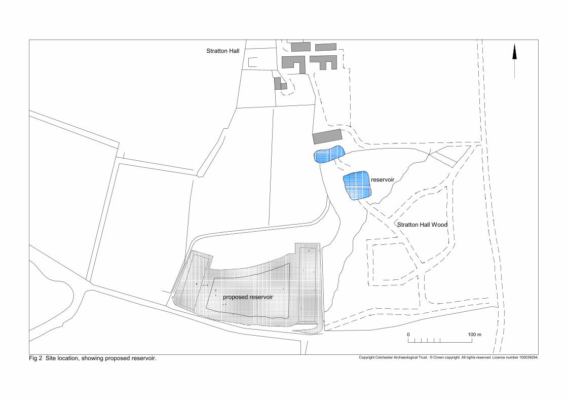
Copyright Colchester Archaeological Trust. © Crown copyright. All rights reserved. Licence number 100039294.Fig 2 Site location, showing proposed reservoir.
proposed reservoir
reservoir
Stratton Hall Wood
Stratton Hall
0 100 m
Copyright Colchester Archaeological Trust. © Crown copyright. All rights reserved. Licence number 100039294.Fig 3 Results of metal-detecting survey (grid shown in red).
0 100 m
A
B
C
D
E
F
G
H
I
J
K
L
M
N
P
Q
R
S
T
U
V
W
X
Y
Z
V
W
X
Y
Z
Q
R
S
T
U
L
M
N
P
G
H
A
B
C
D
E
F
G
H
I
J
K
L
M
N
P
A
B
C
D
F
G
H
I
K
L
M
N
Q
R
S
T
V
W
X
Y
A
B
C
D
F
G
H
I
K
L
M
N
V
W
X
Y
Q
R
S
T
K
L
M
N
B
C
D
ha #1 ha #2 ha #3ha #6 ha #5 ha #4
Find 1
Copyright Colchester Archaeological Trust. © Crown copyright. All rights reserved. Licence number 100039294.Fig 4 Overview of trial-trenching.
T1
T2
F3
F1
F2
T3
T4 F6
F5F4
T5
T6
T7
F7
T8
T9T10
T11
T12 F8
T14
F15
T13
T15
T16
F13 F14
T17
T18
F10
F9
T19
T20F11
T21
T22
service
service
0 50 m
undated pitsand ditches
naturalfeatures
modern post-hole
modern pitand ditch
undatedditches
F12
Copyright Colchester Archaeological Trust. © Crown copyright. All rights reserved. Licence number 100039294.Fig 5 Results of trial-trenching.
T2F3
F1F2
T4F6
F5F4
F7 T8
F8
T14F15
(not dug)
T16F13 F14
T18F10
(not dug)
F9 T19
T20F11
(not dug)
T21F12
(not dug)service
service
(not dug)
T5
0 10 m