Embed Size (px)
Citation preview

Report of Work
On the
Triton Property
MacMurchy Township, Ontario
NTS 41P
Larder Lake Mining Division
Claim Nos. 504544, 504578
For
World Ventures Inc.
May 26, 2004 Timmins, Ontario
Matthew Johnston Consulting Geophysicist 1226 Gatineau Blvd. Timmins, Ont. P4R 1E3
41P11SE2061 2.27753 MACMURCHY 010

Table of Contents
Page No. 1.0 Introduction 2
2.0 Location and Access 2
3.0 Summary of 2004 Geophysical and Line Cutting Program 2
4.0 Discussion of Results 5
5.0 Conclusions and Recommendations 5
Statement of Qualifications
Appendices
Appendix A Geophysical Instruments and Survey Methods
List of Maps Map Scale
Total Field Magnetic Survey - Contours and Posted Data l :2500 Total Field Magnetic Survey - Posted Data l :2500

-2-
1.0 INTRODUCTION
The Triton property of World Ventures Inc. consists of 2 unpatented mining
claims numbered 504578 and 504544, located in MacMurchy Township; Larder Lake
mining division. During early May 2004, a program of line-cutting and geophysical
surveys was conducted over this claim group. The geophysical program consisted of total
field magnetic surveying. M.C. Exploration Services Inc., of Timmins Ontario, carried
out the line-cutting and geophysical surveys.
2.0 Location And Access
The Triton property is located approximately 14 kilometers east of the village of
Shining Tree, Ontario. Shining Tree is located approximately 150 kilometers south of the
city of Timmins. Access to Shining tree is achieved by driving south from Timmins for
approximately 150 kilometers along highway 144 to the junction of highway 560. Travel
east along highway 560 for approximately 60 kilometers to reach the village of Shining
Tree. The claim group is located immediately west of Pat Lake in MacMurchy Township.
Access to the grid is via highway 560 east from Shining Tree for approximately 14
kilometers; then south for approximately 5 kilometers on Bay road to the center of the
claim group (See figures l 8c 2).
3.0 Summary of 2004 Geophysical and Line Cutting Program
The line cutting on the Triton grid totaled 4.0 kilometers, which consisted of a
0.4-kilometer long baseline striking at 090 degrees. The grid lines were cut every 100
meters along this baseline and ranged in length between 400 and 800 meters. The grid
lines were cut every 100 meters with pickets chained at 25-meter intervals along all lines.

^•-:-.*--- -~ ;
I^B^TRITON CLAIMS
E MiSwakr if-. *;,4 i * rI^^F^-C,''!' ^Wl,".
* * * Wfc ' "'•- 'fi/ '^^*#stf^*3fr?f±
• ^; ivtwr K Gogama 41-P, 3a^S2004, 4:11:22 PM

TOWNSHIP}MACMURCHY
xHMMTt ^ (TWWTrW l
x l 1229034 ———IjWflf!!
114664^114726 1jl47
g ^j_______l——————JWB
l 1211835 f14t1 * \-*—-l- — "* *-l . —*HL*fF' y
f^JsRir^ *i2308.f fF |GURE 2^MW4jl770

-5-
The geophysical program consisted of total field magnetic surveying. The total
magnetic field survey, using a GEM GSM-19 magnetometer, totaled 4 kilometers with
readings collected every 12.5 meters along all lines.
A description of the instrument and survey methods can be found in appendix A.
4.0 Discussion of Results
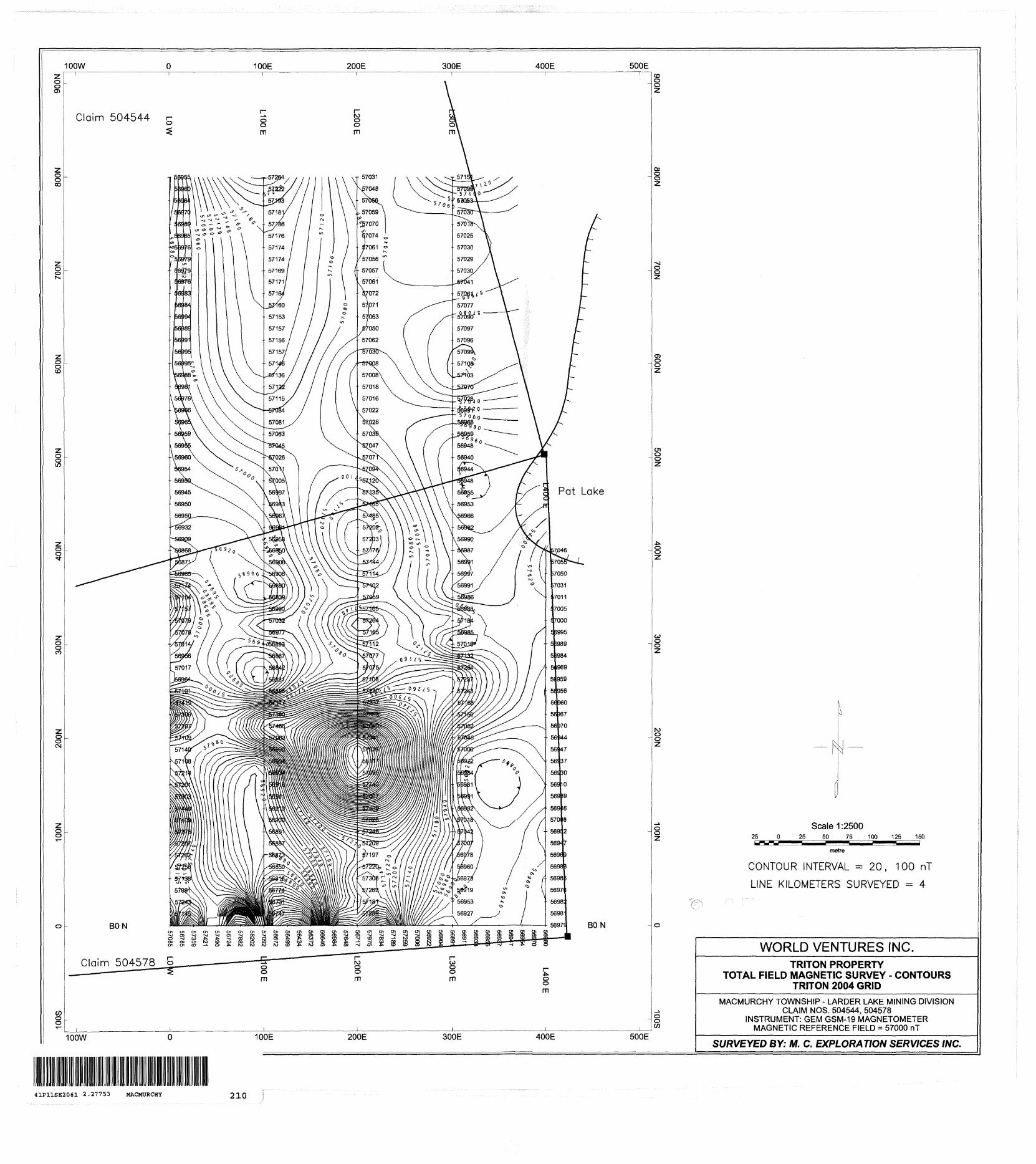
The magnetic survey on the Triton grid indicates a relatively quiescent
magnetic background, with magnetic values ranging between 56372 and 58201 nT. The
background magnetic field strength is 57072 nT. The isomagnetic contour pattern is
dominated by strong linear magnetic anomaly trending north south through the grid area.
This anomaly is clearly evident on the magnetic contour map. This linear magnetic high
is disrupted by a highly anomalous circular 'bulls-eye' magnetic high approximately
1100 nT above background. This magnetic anomaly is centered at grid coordinates
200E/175N and is approximately 150 metres in diameter. The linear magnetic anomaly
trending through the grid area may reflect a diabase dike, common to this area. The high
amplitude circular magnetic anomaly is of unknown lithological origin. No other
significant magnetic anomalies were mapped over the Triton grid during this survey.
5.0 Conclusions and Recommendations
The magnetic survey over the Triton grid located one significant geophysical
anomaly, which would be prospective for further follow-up mineral exploration. A
program of more detailed magnetic surveying would aid in better defining this magnetic
anomaly and its areal extent. In addition, this anomaly should be investigated by ground
prospecting or geological mapping in order to determine its geological origin and
significance. It is possible that a program of induced polarization surveying would aid in
revealing any mineralized zones, which may have disseminated accumulations of

-6-
sulphkJe or grapfiftic minerals that may be associated with this magnetic anomaly. These
zones are often prospective for gold deposits.
Any existing geological or geochemical information for the surveyed grid will aid in further assessing any geophysical anomalies.
Respectively Submitted,
latthew Johnston Consulting Geophysicist

Statement of Qualifications
This is to certify that: MATTHEW JOHNSTON
l am a resident of Timmins; province of Ontario since June 1, 1995.
l am self-employed as a Consulting Geophysicist, based in Timmins, Ontario.
l have received a B. Se. in geophysics from the University of Saskatchewan; Saskatoon, Saskatchewan in 1986.
l have been employed as a professional geophysicist in mining exploration, environmental and other consulting geophysical techniques since 1986.
Signed in Timmins, Ontario, this May 28, 2004

Appendix A

Survey Theory - Total Field Magnetics
Magnetic Survey
Theory:
The magnetic method is based on measuring alteration in the shape and magnitude of the earth's naturally occurring magnetic field caused by changes in the magnetization of the rocks in the earth. These changes in magnetization are due mainly to the presence of the magnetic minerals, of which the most common is magnetite, and to a lesser extent illuminate, pyrrhotite, and some less common minerals. Magnetic anomalies in the earth's filed are caused by changes in two types of magnetization: (1) Induced, caused by the magnetic field being altered and enhanced by increases in the magnetic susceptibility of the rocks, which is a function of the concentration of the magnetic minerals. (2) Remanent magnetism is independent of the earth's magnetic field, and is the permanent magnetization of the magnetic particles (magnetite, etc.) in the rocks. This is created when these particles orient themselves parallel to the ambient field when cooling. This magnetization may not be in the same direction as the present earth's field, due to changes in the orientation of the rock or the field. The unit of measurement (variations in intensity) is commonly known as the Gamma which is equivalent to the nanotesla (nT).
Method:
The magnetometer, GSM-19 with an Overhauser sensor measures the Total Magnetic Field (TFM) perpendicular to the earth's field (horizontal position in the polar region). The unit has no moving parts, produces an absolute and relatively high resolution measurement of the field and displays the measurement on a digital lighted display and is recorded (to memory). Initially, the tuning of the instrument should agree with the nominal value of the magnetic field for each particular area. The Overhauser procession magnetometer collected the data with a 0.2 nanoTesla accuracy. The operator read each and every line at a 12.5 m interval with the sensor attached to the top of four (56cm), aluminum tubing sections. The readings were corrected for changes in the earth's magnetic field (diurnal drift) with a similar GSM-19 magnetometer, acting as a stationary base station which automatically read and stored the readings at every 15 seconds. The data from both units was then downloaded to PC and base corrected values were computed.

ONTARIO MINISTRY OF NORTHERN DEVELOPMENT AND MINES
Transaction No:
Recording Date:
Approval Date:
Client(s):
200408
Survey Type(s):
W0480.00816
2004-JUN-01
2004-JUN-07
Work Report Summary
Status: APPROVED
Work Done from: 2004-MAY-05
to: 2004-MAY-28
TECK COMINCO LIMITED
LC MAG
Work Report Details:
Claim# Perform
L 452375 SO
L 504544 31,457
L 504574 SO
L 504578 81,918
L 504579 SO
S3.375
External Credits:
Reserve:
Perform Approve Applied
SO S400
S1.457 S800
SO S400
S1,918 S800
SO S400
S3, 375 S2.800
SO
S575 Reserve of Work
S575 Total Remaining
Applied Approve
S400
S800
S400
S800
S400
S2.800
Assign Assign Approve Reserve
so o soS400 400 S257
so o soS800 800 S3 18
SO 0 SO
S1.200 S1.200 S575
Reserve Approve Due Date
SO 2005-JUN-01
S257 2006-JUN-01
SO 2005-JUN-01
S318 2006-JUN-01
SO 2005-JUN-01
S575
Report*: W0480.00816
Status of claim is based on information currently on record.
41P11SE2061 2.27753 MACMURCHY 900
2004-Jun-17 16:35 armstrongjd Page 1 of 1

Ministry ofNorthern Developmentand Mines
Date: 2004-JUN-09
Ministere du Developpement du Nord et des Mines Ontario
GEOSCIENCE ASSESSMENT OFFICE 933 RAMSEY LAKE ROAD, 6th FLOOR SUDBURY, ONTARIO P3E 6B5
TECK COMINCO LIMITED SUITE 600, 200 BURRARD STREET VANCOUVER, BRITISH COLUMBIA V6C 3L9 CANADA
Tel: (888)415-9845 Fax:(877)670-1555
Dear Sir or Madam
Submission Number: 2.27753 Transaction Number(s): W0480.00816
Subject: Approval of Assessment Work
We have approved your Assessment Work Submission with the above noted Transaction Number(s). The attached Work Report Summary indicates the results of the approval.
At the discretion of the Ministry, the assessment work performed on the mining lands noted in this work report may be subject to inspection and/or investigation at any time.
If you have any question regarding this correspondence, please contact STEVEN BENETEAU by email at [email protected] or by phone at (705) 670-5855.
Yours Sincerely,
/f,Ron C. GashinskiSenior Manager, Mining Lands Section
Cc: Resident Geologist
Teck Cominco Limited (Claim Holder)
Assessment File Library
Teck Cominco Limited (Assessment Office)
Visit our website at http://www.gov.on.ca/MNDM/LANDS/mlsmnpge.htm Page: 1 Correspondence 10:19489

ONTMUOCANADA
MM*Tfty Of NOflTHiHN Mining Land Tenure Map
o o
tJ
HCOH HDiH 1"
General Information and Limitations
nvy #leo ta 4ti(*hwl Ittwuan Itw fcn*f Und T*tm o( Rv^Miy 041 M, vi Ilw unfeby at Nattnl nttfiutHBt.
Tm mie. nwy r*
DWM. Aha uu
;KKhHH1 Mirt HnWtt *M M^Knw In Mud Nttiritw CBnflM pi edttlq rigMH, HrMBMll, wcnmi Wfrrw of 4n^olftMn ot Itjftwi 'Wuand lin) uvfflt *B1 mWct w DKMMfnro wit^ lusWw
Date ^ Time of Issue: Wed Jun 30 11:03:37 EOT 2004
TOWNSHIP ; AREA PLAN MACMURCHY 6-0988
ADMINISTRATIVE DISTRICTS l DIVISIONS
Mining Division Larder LakeLand Titles/Registry Division SUDBURYMinistry of Natural Resources District TIMMINS
TOPOGRAPHIC Land Tenure
Cfl MlU MVMng HlflNt*
H -rjj'j Saturn Anfi Mj(*ia Ri
LsJi'i i MlnWfl Rnjpb QrWy
loiel '-"J"' l" Cowicii Wat i
LAND TENURE WITHDRAWALS
IMPORTANT NOTICES
LAND TENURE WITHDRAWAL DESCRIPTIONS
W-LL-PtCRt W*m rod iK. 2CKD
2.27753LGMAG
100W 100E 200E 300E 400E 500E
Claim 504578 b
25Scale 1:2500
25 50 75 100 125 150
metre
CONTOUR INTERVAL ^ 20, 100 nT
LINE KILOMETERS SURVEYED = 4
100W 100E 200E 300E 400E 500E
WORLD VENTURES INC.TRITON PROPERTY
TOTAL FIELD MAGNETIC SURVEY - CONTOURS TRITON 2004 GRID
MACMURCHY TOWNSHIP - LARDER LAKE MINING DIVISIONCLAIM NOS. 504544, 504578
INSTRUMENT: GEM GSM-19 MAGNETOMETERMAGNETIC REFERENCE FIELD * 57000 nT
SURVEYED BY: M. C. EXPLORATION SERVICES INC.
41P11SE2061 2.27753 MACMURCHY 210

100W
Claim 504544
o - BON
T 56955
56960
56964
56970
56989
56965
56976
56979
- 56979
56976
56983
56984
56994
56989
56991
56995
-- 56995
56988
56981
56976
56966
56965
56959
56955
- 56960
56954
56950
56945
56950
56950
56932
56909
-j o -*j -jo -^ w -fc"oo Co en roen 01 to -*
Claim 504578 S
100E
m
56958
Cn Ol Cn
200E
m
57185
5720257203
300E
56955
- 56953
56966
56982
56990- 56868^*-""^
56871
56985
57174
57154
57157
57079
57078
' 57014
56956
57017
56964
57101
57419
57306
57207
57109
57140
57108
57214
57201
57303
57440
57409
57375
57207
57262
57258
57138
57091
57243
57145
- 56950
56908
56908
56890
56839
56990
57032
56977
- 56893
56867
56842
56931
56896
57117
57390
57486
- 57063
56990
56954
56934
56916
56911
56910
56900
- 56891
56887
56873
56850
56816
56774
56731
56747
- 57176
57144
57114
57102
57059
57165
57264
57165
- 57112
57077
57075
57108
57230
57337
57593
57860
- 57941
57836
58117
57995
57740
57607
57439
57328
- 57246
57209
57197
57220
57308
57269
57181
57289
- 56987 ^
56991
56997
56991
56986
56983
57184
56985
- 57016
57132
57264
57237
57243
57168
57150
57052
- 57045
57000
56972
56984
56981
56991
56992
57018
- 57042
57007
56978
56960
56973
56919
56953
56927
————————— i ————————— i ————————— *-~ ——————
en en en en-vj -sg -^ -HjtO CD -i tO
N
rn m m
100W 100E 200E 300E
400E 500E
Pat Lake
BON
m
25Scale 1:2500
25 50 75 100 125 150
metre
LINE KILOMETERS SURVEYED = 4
400E 500E
WORLD VENTURES INC.TRITON PROPERTY
TOTAL FIELD MAGNETIC SURVEY - POSTED DATA TRITON 2004 GRID
MACMURCHY TOWNSHIP - LARDER LAKE MINING DIVISIONCLAIM NOS. 504544, 504578
INSTRUMENT: GEM GSM-19 MAGNETOMETERMAGNETIC REFERENCE FIELD = 57000 nT
SURVEYED BY: M, C. EXPLORATION SERVICES INC.
41P11SE2061 2.27753 MACMURCHY 220